
Maitland City Zoning Code
ARTICLE 3
ZONE DISTRICTS
3.1.1. - Compliance with Zone District Standards.
Land in the City shall not be developed except in accordance with the zone district regulations of this article and all other regulations of this LDC.
3.1.2. - Establishment of Zone Districts.
This LDC establishes the zone districts identified in Table 3.1.2: Establishment of Zone Districts. The boundaries of each zone district are identified on the Official Zone District Map (see Section 1.7, Official Zone District Map).
3.2.1. - General Purpose of Residential Districts.
The purpose and intent of Residential zone districts are to:
(a)
Provide appropriately located lands for residential development that are consistent with the goals, policies, and objectives of the comprehensive development plan and other adopted City plans;
(b)
Support and preserve the development patterns and character of established residential neighborhoods;
(c)
Provide a range and diversity of housing choices, with varying densities, residential uses, and development form, to meet the needs of the City's citizens;
(d)
Provide for safe and efficient pedestrian, bicycle, and vehicular access and circulation through neighborhoods that promote multiple forms of mobility;
(e)
Protect the character of residential neighborhoods from incompatible development;
(f)
Protect residential zone districts from flooding and other adverse environmental impacts;
(g)
Provide for the public services and facilities needed to serve residential development;
(h)
Maintain the City's neighborhoods as safe and convenient places to live;
(i)
Ensure compatible infill development; and
(j)
Promote sustainable development practices in terms of energy efficiency and conservation, the use of alternative energy, greenhouse gas reduction, water supply and water quality protection, food security, materials recycling, and similar goals.
3.2.2. - Established Residential Districts.
The residential zone districts established by this LDC are identified in Table 3.2.2: Established Residential Districts.
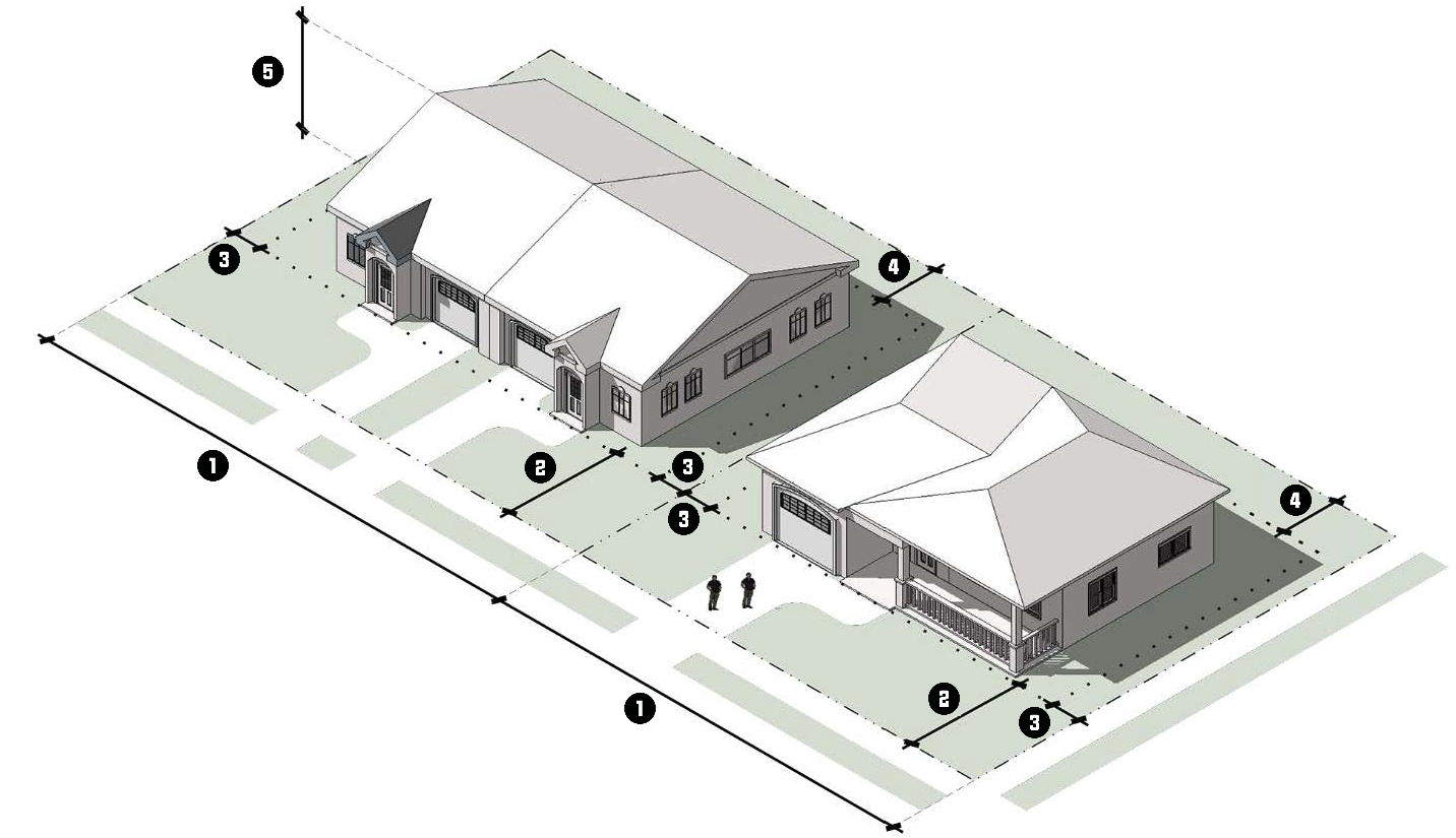
3.2.3. - RSF-1: Residential Single Family 1 District.
| (a) Purpose | ||
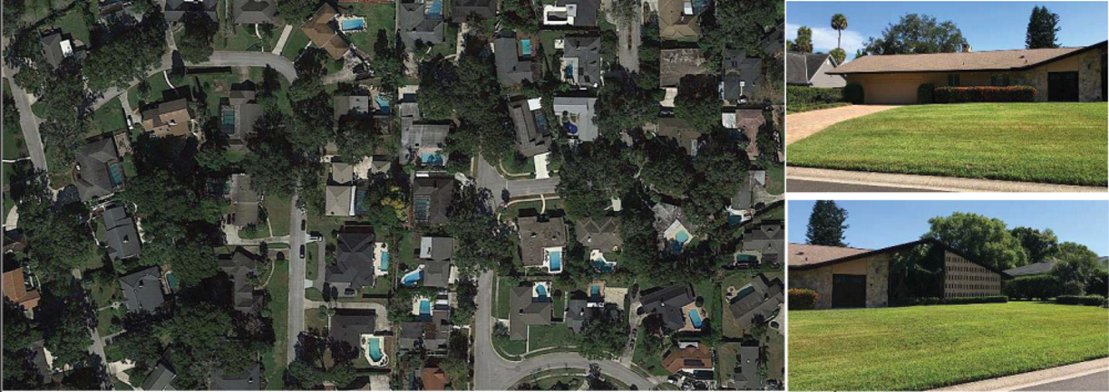
| The purpose of the RSF-1: Residential Single Family 1 District is to provide lands that accommodate low-density, single-family detached dwellings on lots with a minimum lot area of 12,500 square feet. The district also accommodates certain group living arrangements as conditional uses, accessory uses such as home occupations and home-based child care, and other compatible uses. District regulations discourage development that negatively impacts the quiet residential nature of the district. | ||
 | ||
| (b) Use Standards | ||
| Allowed uses and use-specific standards for principal, accessory, and temporary uses are established in Article 4: Use Regulations. | ||
| (c) Intensity and Dimensional Standards | ||
| Standard | All Uses | |
| Lot area, min. (sf) | 12,500 | |
| Lot width, min. (ft) [1] | 90 | |
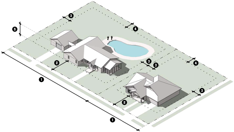
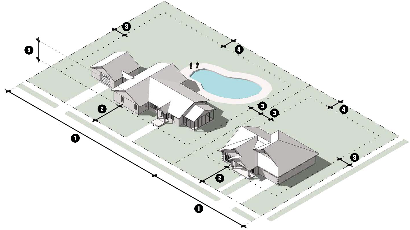
| Front yard setback, min. (ft) | 25 | |
| Side yard setback, min. (ft) | 10 | |
| Rear yard setback, min. (ft) | 10 | |
| Building height, max. (ft) | 35 | |
| Living area, min. (sf) | 1,800 | |
| Impervious coverage, max. (percent) | 70 | |
|
NOTES: sf = square feet; ft = feet; min. = minimum; max. = maximum
[1] Minimum lot width is measured along the road frontage as well as along property fronting a lake, canal, or creek, if applicable. | ||
 | ||
| (d) Reference to Other Standards | ||
| Section 5.1 Mobility and Connectivity Standards | Section 5.10 Residential Compatibility Standards | |
| Section 5.2 Off-Street Parking, Bicycle, and Loading Standards | Section 5.11 Architectural, Form, and Design Standards | |
| Section 5.3 Landscape, Buffer, and Tree Protection Standards | Section 5.12 Sustainable Development Standards | |
| Section 5.4 Open Space Set-Aside Standards | Section 5.13 Sustainable Development Incentives | |
| Section 5.5 Vegetation Removal | Section 5.14 Signs | |
| Section 5.6 Residential Tree Protection | Section 5.15 Building Numbering and Street Naming | |
| Section 5.7 Flood Damage Prevention | Article 6 Subdivision Standards | |
| Section 5.8 Fence and Wall Standards | Article 7 Public Facility Funding | |
| Section 5.9 Exterior Lighting Standards | Appendix A Engineering and Design Manual | |
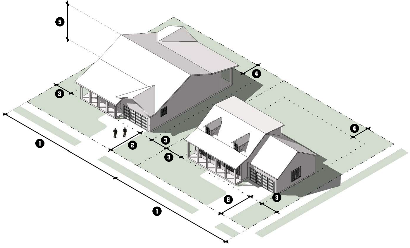
3.2.4. - RSF-2: Residential Single Family 2 District.
| (a) Purpose | ||
| The purpose of the RSF-2: Residential Single Family 2 District is to provide lands that accommodate low-density single-family detached dwellings on lots with a minimum lot area of seven thousand five hundred (7,500) square feet. The district also accommodates certain group living arrangements as conditional uses, accessory uses such as home occupations and home-based child care, and other compatible uses. District regulations discourage development that negatively impacts the quiet residential nature of the district. | ||
 | ||
| (b) Use Standards | ||
| Allowed uses and use-specific standards for principal, accessory, and temporary uses are established in Article 4: Use Regulations. | ||
| (c) Intensity and Dimensional Standards | ||
| Standard | All Uses | |
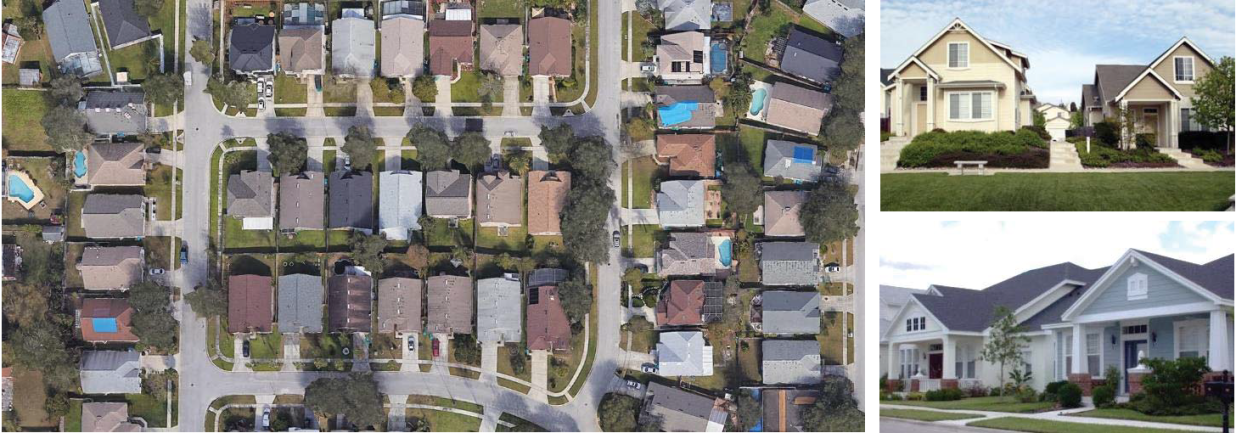
| Lot area, min. (sf) | 7,500 | |
| Lot width, min. (ft) [1] | 75 | |
| Front yard setback, min. (ft) | 20 | |
| Side yard setback, min. (ft) | 7.5 | |
| Rear yard setback, min. (ft) | 10 | |
| Building height, max. (ft) | 35 | |
| Living area, min. (sf) | 950 | |
| Impervious coverage, max. (percent) | 70 [2] | |
|
NOTES: sf = square feet; ft = feet; min.= minimum; max.= maximum
[1] Minimum lot width is measured along the road frontage as well as along property fronting a lake, canal, or creek, if applicable. [2] Any buildings in the Mayo Avenue Area Annexation (defined in Ordinance No. 799), the Druid Annexation Area (defined in Ordinance No. 859), and the Dommerich Hills Annexation Area (defined in Ordinance No. 1023) that were constructed before June 27, 2005, that exceed the maximum impervious coverage standard of the district may be rebuilt up to the impervious coverage of the destroyed structure. | ||
 | ||
| (d) Reference to Other Standards | ||
| Section 5.1 Mobility and Connectivity Standards | Section 5.10 Residential Compatibility Standards | |
| Section 5.2 Off-Street Parking, Bicycle, and Loading Standards | Section 5.11 Architectural, Form, and Design Standards | |
| Section 5.3 Landscape, Buffer, and Tree Protection Standards | Section 5.12 Sustainable Development Standards | |
| Section 5.4 Open Space Set-Aside Standards | Section 5.13 Sustainable Development Incentives | |
| Section 5.5 Vegetation Removal | Section 5.14 Signs | |
| Section 5.6 Residential Tree Protection | Section 5.15 Building Numbering and Street Naming | |
| Section 5.7 Flood Damage Prevention | Article 6 Subdivision Standards | |
| Section 5.8 Fence and Wall Standards | Article 7 Public Facility Funding | |
| Section 5.9 Exterior Lighting Standards | Appendix A Engineering and Design Manual | |
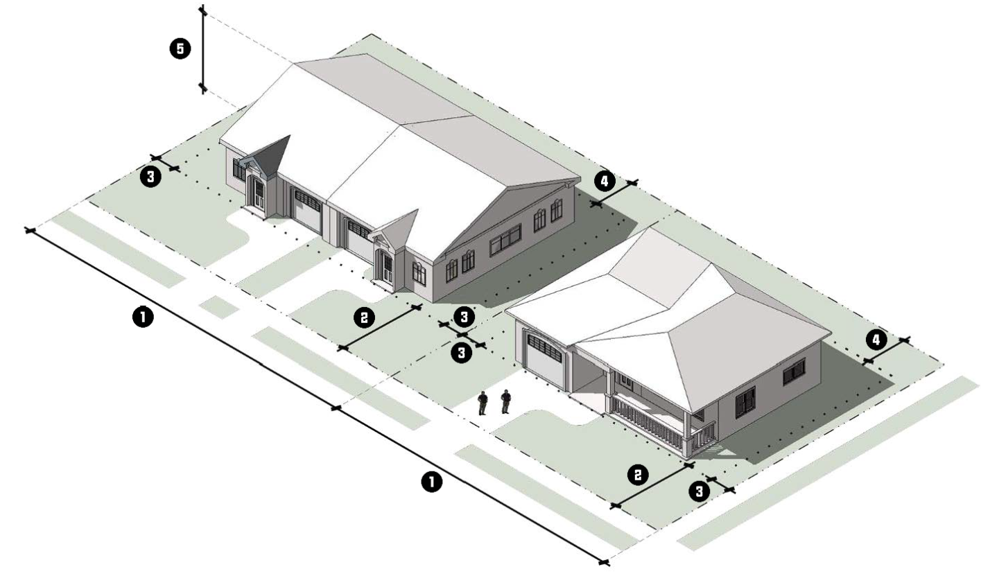
3.2.5. - RSF-3: Residential Single Family 3 District.
| (a) Purpose | ||
| The purpose of the RSF-3: Residential Single Family 3 District is to provide lands that accommodate moderate-density, single-family detached dwellings on lots with a minimum lot area of four thousand five hundred (4,500) square feet. The district also accommodates certain group living arrangements as conditional uses, accessory uses such as home occupations and home-based child care, and other compatible uses. District regulations discourage development that negatively impacts the quiet residential nature of the district. It is the intent of the City Council that this zone district classification shall not be applied to any lands other than those classified RSF-3 on March 1, 2022. | ||
 | ||
| (b) Use Standards | ||
| Allowed uses and use-specific standards for principal, accessory, and temporary uses are established in Article 4: Use Regulations. | ||
| (c) Intensity and Dimensional Standards | ||
| Standard | All Uses | |
| Lot area, min. (sf) | 4,500 | |
| Lot width, min. (ft) | 45 | |
| Front yard setback, min. (ft) | 25 | |
| Side yard setback, min. (ft) | 5 | |
| Street-side yard setback, min. (ft) | 15 | |
| Rear yard setback, min. (ft) | 25 | |
| Building height, max. (ft) | 35 | |
| Living area, min. (sf) | 900 | |
| Impervious coverage, max. (percent) | 70 | |
| NOTES: sf = square feet; ft = feet; min.= minimum; max.= maximum | ||
 | ||
| (d) Reference to Other Standards | ||
| Section 5.1 Mobility and Connectivity Standards | Section 5.10 Residential Compatibility Standards | |
| Section 5.2 Off-Street Parking, Bicycle, and Loading Standards | Section 5.11 Architectural, Form, and Design Standards | |
| Section 5.3 Landscape, Buffer, and Tree Protection Standards | Section 5.12 Sustainable Development Standards | |
| Section 5.4 Open Space Set-Aside Standards | Section 5.13 Sustainable Development Incentives | |
| Section 5.5 Vegetation Removal | Section 5.14 Signs | |
| Section 5.6 Residential Tree Protection | Section 5.15 Building Numbering and Street Naming | |
| Section 5.7 Flood Damage Prevention | Article 6 Subdivision Standards | |
| Section 5.8 Fence and Wall Standards | Article 7 Public Facility Funding | |
| Section 5.9 Exterior Lighting Standards | Appendix A Engineering and Design Manual | |
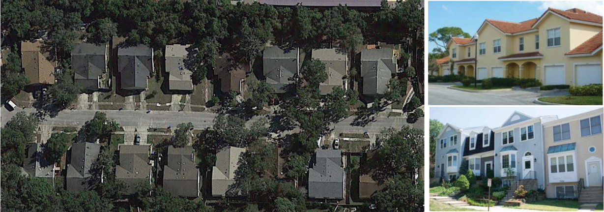
3.2.6. - RSF-D: Residential Single Family and Duplex District.
| (a) Purpose | |||
| The purpose of the RSF-D: Residential Single Family and Duplex District is to provide lands that accommodate single-family detached and two-family (duplex) dwellings of moderate density on lots with a minimum lot area of four thousand five hundred (4,500) square feet. The district also accommodates certain group living arrangements as conditional uses, accessory uses such as home occupations and home-based child care, and other compatible uses. District regulations discourage development that negatively impacts the quiet residential nature of the district. | |||
 | |||
| (b) Use Standards | |||
| Allowed uses and use-specific standards for principal, accessory, and temporary uses are established in Article 4: Use Regulations. | |||
| (c) Intensity and Dimensional Standards | |||
| Standard | Single-Family or Two-Family Residence | Townhouse | |
| Lot area, min. (sf) | 4,500 | 3,000 | |
| Density, max. (du/acre) | [1] | ||
| Lot width, min. (ft) | 50 [2] | 50 [3] | |
| Front yard setback, min. (ft) | 20 | 20 | |
| Side yard setback, min. (ft) | 5 | 5 [4] | |
| Rear yard setback, min. (ft) | 10 | 10 | |
| Building height, max. (ft) | 35 | 35 | |
| Living area, min. (sf) | 900 (single-family detached residence) 700 (townhouse or two-family residence) | ||
| Impervious coverage, max. (percent) | 70 | 70 [3] | |
|
NOTES: sf = square feet; ft = feet; min.= minimum; max.= maximum
[1] Development is allowed up to the maximum residential density permitted for the property in accordance with the comprehensive development plan. [2] Minimum lot width is measured along the road frontage as well as along property fronting a lake, canal, or creek, if applicable. [3] Applicable to the development lot as a whole rather than individual lots under townhouse units [4] Townhouse side-yard setback only applies to the exterior units. | |||
 | |||
| (d) Reference to Other Standards | |||
| Section 5.1 Mobility and Connectivity Standards | Section 5.10 Residential Compatibility Standards | ||
| Section 5.2 Off-Street Parking, Bicycle, and Loading Standards | Section 5.11 Architectural, Form, and Design Standards | ||
| Section 5.3 Landscape, Buffer, and Tree Protection Standards | Section 5.12 Sustainable Development Standards | ||
| Section 5.4 Open Space Set-Aside Standards | Section 5.13 Sustainable Development Incentives | ||
| Section 5.5 Vegetation Removal | Section 5.14 Signs | ||
| Section 5.6 Residential Tree Protection | Section 5.15 Building Numbering and Street Naming | ||
| Section 5.7 Flood Damage Prevention | Article 6 Subdivision Standards | ||
| Section 5.8 Fence and Wall Standards | Article 7 Public Facility Funding | ||
| Section 5.9 Exterior Lighting Standards | Appendix A Engineering and Design Manual | ||
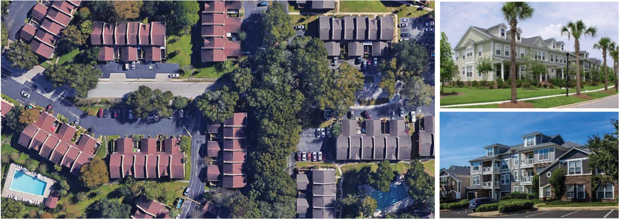
3.2.7. - R-MF: Residential Multifamily District.
| (a) Purpose | ||
| The purpose of the R-MF: Residential Multifamily District is to provide lands that support multifamily residential development of moderate to high density. The district also accommodates limited and small-scale professional office and personal services uses that are compatible with the residential nature of the district, and other compatible uses. | ||
 | ||
| (b) Use Standards | ||
| Allowed uses and use-specific standards for principal, accessory, and temporary uses are established in Article 4: Use Regulations. | ||
| (c) Intensity and Dimensional Standards | ||
| Standard | All Uses | |
| Lot area, min. (sf) | 43,560 | |
| Density, max. (du/acre) | [1] | |
| Lot width, min. (ft) | 150 | |
| Front yard setback, min. (ft) | 35 | |
| Side yard setback, min. (ft) | 15 | |
| Rear yard setback, min. (ft) | 25 | |
| Building height, max. (ft) | 55 | |
| Living area, min. (sf) | 500 (studio apartment) 725 (one-bedroom du) 925 (two-bedroom du) + 150 for each additional bedroom above two | |
| Impervious coverage, max. (percent) | 70 | |
| Open space, min. (percent) | 20 | |
|
NOTES: sf = square feet; ft = feet; du = dwelling unit; min.= minimum; max.= maximum
[1] Development is allowed up to the maximum residential density permitted for the property in accordance with the comprehensive development plan. | ||
 | ||
| (d) Reference to Other Standards | ||
| Section 5.1 Mobility and Connectivity Standards | Section 5.10 Residential Compatibility Standards | |
| Section 5.2 Off-Street Parking, Bicycle, and Loading Standards | Section 5.11 Architectural, Form, and Design Standards | |
| Section 5.3 Landscape, Buffer, and Tree Protection Standards | Section 5.12 Sustainable Development Standards | |
| Section 5.4 Open Space Set-Aside Standards | Section 5.13 Sustainable Development Incentives | |
| Section 5.5 Vegetation Removal | Section 5.14 Signs | |
| Section 5.6 Residential Tree Protection | Section 5.15 Building Numbering and Street Naming | |
| Section 5.7 Flood Damage Prevention | Article 6 Subdivision Standards | |
| Section 5.8 Fence and Wall Standards | Article 7 Public Facility Funding | |
| Section 5.9 Exterior Lighting Standards | Appendix A Engineering and Design Manual | |
3.3.1. - General Purpose of Mixed-Use Districts.
The base mixed-use zone districts are established for the general purpose of ensuring there are lands in the City that provide a wide range of retail, office, service, employment, and related development to meet the needs of the City's residents and attract large-scale regional employers, in conjunction with supportive, higher-density residential uses. More specifically, the purpose of the mixed-use zone districts is to:
(a)
Strengthen the City's economic base and provide employment opportunities close to home for City residents;
(b)
Provide appropriately located lands for a full range of business and commercial uses needed by the City's residents, businesses, and workers, consistent with the goals, objectives, and policies of the comprehensive development plan and other adopted City plans;
(c)
Sustain and support the redevelopment of existing office parks into revitalized office space with supportive ancillary uses such as commercial and multifamily residential development to improve the City's reputation as a key destination within the Greater Orlando office park market;
(d)
Create suitable environments for various types of mixed-use development designed to integrate business, office, retail, and residential development in compatible ways;
(e)
Encourage and support high-quality design in retail, office, service, employment, and mixed-use development in the City;
(f)
Accommodate new infill development and redevelopment that is consistent with the goals, objectives, and policies of the comprehensive development plan and other adopted City plans, especially along the Maitland Avenue corridor and near existing single-family neighborhoods; and
(g)
Ensure commercial development is located and designed to protect and preserve the character of single-family neighborhoods.
3.3.2. - Established Mixed-Use Districts.
The base mixed-use zone districts established by this LDC are identified in Table 3.3.2: Established Mixed-Use Districts.
3.3.3. - MX: Mixed Multifamily District.
| (a) Purpose | ||||||
| The purpose of the MX: Mixed Multifamily District is to provide lands that support a range of moderate-density residential uses, including single-family detached, townhouse, two-family (duplex), and multifamily dwellings, as well as community-serving professional and business office development and small-scale retail that is compatible in size and scale with the residential uses in the district, and that is located adjacent to residential neighborhoods. | ||||||
 | ||||||
| (b) Use Standards | ||||||
| Allowed uses and use-specific standards for principal, accessory, and temporary uses are established in Article 4: Use Regulations. | ||||||
| (c) Intensity and Dimensional Standards | ||||||
| Standard | Single- & Two-Family | Townhouse | Multifamily |
Non-
residential [1] | Maitland Ave. Multifamily & Non-Residential. | |
| Lot area, min. (sf) | 7,500 | 3,000 | 43,560 | 7,500 | ||
| Density, max. (du/acre) | [2] | [2] | 9.1 | [2] | 12 | |
| Floor Area Ratio (FAR), max. | — | — | — | — | 0.5 | |
| Lot width, min. (ft) | 70 | 75 [3] | 150 | 60 | 100 | |
| Front yard setback, min. (ft) | 10 | 35 | 35 | 25 | N/A | |
| Build-to-zone, min. | max. (ft.) [4] | N/A | N/A | N/A | N/A | 10 | 30 | |
| Building width in build-to zone, min. (% of lot width) | N/A | N/A | N/A | N/A | 65 | |
| Side yard setback, min. (ft) | 10 | 15 [5] | 15 | 15 | 5 | |
| Rear yard setback, min. (ft) | 10 | 25 | 25 | 10 | 10 | |
| Building height, max. (ft) | 35 | 35 | 45 | 45 | 45 | |
| Living area, min. (sf) | 950 | 900 |
725 (1-br du)
925 (2-br du) + 150 each add'l br | N/A |
725 (1-br du)
925 (2-br du) + 150 each add'l br | |
| Impervious coverage, max. (%) | 70 | |||||
| Open Space, min. (%) | — | 20 | 20 | 40 | 25 | |
| Buffer/yard building separation, min. (ft) | — | — | 15 | 15 | — | |
|
NOTES: sf = square feet; ft = feet; min.= minimum; max.= maximum
[1] Personal Service or Retail Sales uses as a principal use are allowed only on lots along Maitland Avenue. [2] Development is allowed up to the maximum residential density permitted for the property in accordance with the comprehensive development plan. [3] Applicable to the development lot as a whole rather than individual lots under townhouse units. [4] The area between the minimum and maximum build-to lines that extends the width of the lot constitutes the build-to zone. The minimum and maximum build-to lines are measured from back of curb. [5] Required side-yard setback is 25 when property abuts the RSF-1, RSF-2, or RSF-3 districts. Side-yard setback requirement for townhouses only applies to the exterior units. | ||||||
 | ||||||
| (d) Reference to Other Standards | ||||||
| Section 5.1 Mobility and Connectivity Standards | Section 5.10 Residential Compatibility Standards | |||||
| Section 5.2 Off-Street Parking, Bicycle, and Loading Standards | Section 5.11 Architectural, Form, and Design
Standards | |||||
| Section 5.3 Landscape, Buffer, and Tree Protection Standards | Section 5.12 Sustainable Development Standards | |||||
| Section 5.4 Open Space Set-Aside Standards | Section 5.13 Sustainable Development Incentives | |||||
| Section 5.5 Vegetation Removal | Section 5.14 Signs | |||||
| Section 5.6 Residential Tree Protection | Section 5.15 Building Numbering and Street
Naming | |||||
| Section 5.7 Flood Damage Prevention | Article 6 Subdivision Standards | |||||
| Section 5.8 Fence and Wall Standards | Article 7 Public Facility Funding | |||||
| Section 5.9 Exterior Lighting Standards | Appendix A Engineering and Design Manual | |||||
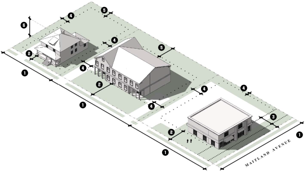
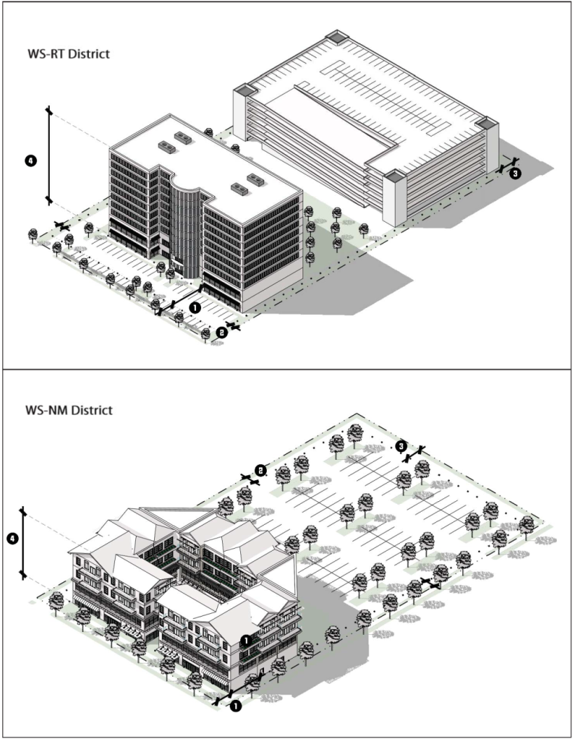
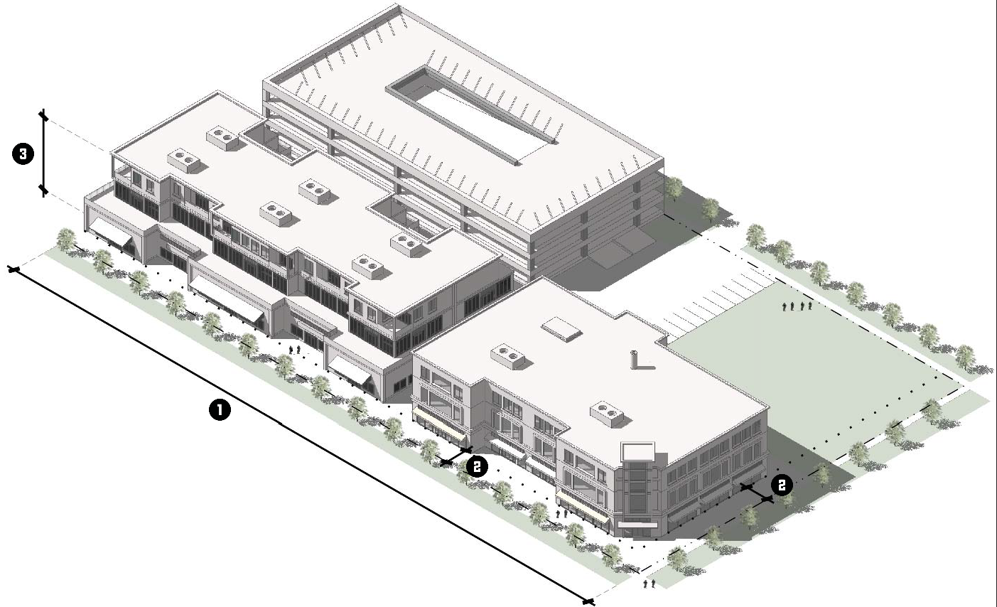
3.3.4. - WS: West Side District.
| (a) Purpose | |||
|
The purpose of the WS: West Side District is to provide lands that support an economically
vibrant mix of well-connected, walkable, and high intensity/density employment, retail,
and residential uses, both in a redevelopment and new development context, in a form
that is consistent with the development goals of the City as expressed in the comprehensive
development plan and other adopted plans.
The WS District consists of two subdistricts. The West Side Research Technology (WS-RT) subdistrict provides for a high intensity/density mix of office and other employment uses primarily in an office park setting, with supporting retail and residential uses. The West Side New Market (WS-NM) subdistrict supports a high intensity/density mix of office, research and development, other employment, and residential uses with a strong pedestrian form. |  | ||
|
Generally, the intent of the district is that development and redevelopment:
(1) Include an Economically Vibrant Mix of Uses with Sufficient Flexibility to Adapt to Market Demands Include a vibrant mix of uses that allow sufficient flexibility to adapt to future market demands in ways that maintain the form and character of development that is consistent with the development goals of the district. (2) Adopt a Diverse Approach to Mobility To the maximum extent practicable, establish a well connected, accessible place with diverse options for mobility including strong pedestrian, bicycle, transit, and automotive connections. (3) Provide Housing Choices in Close Proximity to Employment Provide housing choices that are reasonably attainable to the workforce employed in the district, within close proximity to the places of employment. (4) Provide Neighborhood Serving Commercial Uses that are Proximate to Housing and Employment Provide neighborhood serving commercial uses in close proximity and that preferably are within walking distance from housing and employment uses, and to the maximum extent practicable, are located at mixed-use nodes that are accessible to transit. (5) Maintain a High Quality of Development that Establishes the Westside District as a Unique and Special Place Maintain a high quality of development that establishes the West Side District as a unique and special place for high density/intensity, walkable, mixed-use development. | |||
| (b) Use Standards | |||
| Allowed uses and use-specific standards for principal, accessory, and temporary uses are established in Article 4: Use Regulations. | |||
| (c) Intensity and Dimensional Standards | |||
| Standard | WS-RT | WS-NM | |
| Density, max. (du/acre) [1] | 65 | ||
| Floor Area Ratio, max. | 3.0 | ||
| Build-to zone, min. | max. (ft) [2] | |||
| Main Street | [3] | 15 | 50 | |
| Primary Street | 25 | 80 | 15 | 50 | |
| Secondary Street | 50 | —- | 15 | 50 | |
| Side yard setback, min. (ft) | 10 | ||
| Rear yard setback, min (ft) | 25 | 15 | |
|
Building width in front yard setback, min.
(% of lot width) | 40 | 75 | |
| Building height, max. (ft) | No maximum | 150 | |
| Living area, min. (sf) |
500 (studio apartment)
725 (1-br du) 925 (2-br du) + 150 for each additional br above two |
500 (studio apartment)
725 (one-br du) 925 (two-br du) + 150 for each additional br above two | |
| Impervious Coverage, max. (%) | 75 | 85 | |
| Open Space set aside, min. (%) | 30 [4] | ||
|
NOTES: sf = square feet; ft = feet; min.= minimum; max.= maximum br= bedroom
[1] Residential units do not count against the Floor Area Ratio maximum. They can be developed in addition to the Floor Area Ratio maximum. [2] See Sec. 10.2.1(d), Build-to Zone. The applicant may request modifications from the Community Development Director for the purpose of preserving existing tree canopy or easements. [3] Main Street is only located in the WS-NM district. [4] Up to 50 percent of the land credited towards meeting the open space set-aside requirements may be used as a solar energy collection facility, provided that the facility is installed in such a way that at least 85 percent of the land underneath is permeable. | |||
 | |||
| (d) Reference to Other Standards | |||
| Section 5.1 Mobility and Connectivity Standards | Section 5.10 Residential Compatibility Standards | ||
| Section 5.2 Off-Street Parking, Bicycle, and Loading Standards | Section 5.11 Architectural, Form, and Design Standards | ||
| Section 5.3 Landscape, Buffer, and Tree Protection Standards | Section 5.12 Sustainable Development Standards | ||
| Section 5.4 Open Space Set-Aside Standards | Section 5.13 Sustainable Development Incentives | ||
| Section 5.5 Vegetation Removal | Section 5.14 Signs | ||
| Section 5.6 Residential Tree Protection | Section 5.15 Building Numbering and Street Naming | ||
| Section 5.7 Flood Damage Prevention | Article 6 Subdivision Standards | ||
| Section 5.8 Fence and Wall Standards | Article 7 Public Facility Funding | ||
| Section 5.9 Exterior Lighting Standards | Appendix A Engineering and Design Manual | ||
(e)
Design and Form Standards.
(1)
Applicability.
(A)
General. Unless exempted in part, in accordance with subsection (B) below, all development in the WS district shall comply with the standards of this subsection.
(B)
Existing Development. The following development that is not part of an approved planned development existing prior to March 1, 2022 is exempt from some of the requirements of this section, as noted below:
1.
The expansion or alteration of development existing prior to March 1, 2022, if the development increases the building's floor area by fifty (50) percent or more, or the alteration involves fifty (50) percent or more of the building's gross floor area over the five years prior to the submission of an application, is only required to comply with the following subsections (compliance with the other subsections is encouraged, where practicable):
a.
Subsection (4), Parking Lot Location, to the maximum extent practicable;
b.
Subsection (6), Public Frontage Standards;
c.
Subsection (7), Circulation Network, to the maximum extent practicable;
d.
Subsection (8), Street Design;
e.
Subsection (9), Perimeter Buffers;
f.
Subsection (11), Parking Lot Landscaping and Screening; and
g.
Subsection (15), Signs.
2.
The expansion or alteration of development existing prior to March 1, 2022, if the development increases the building's floor area by less than fifty (50) percent, or the alteration involves less than fifty (50) percent of the building's gross floor area, over the five years prior to the submission of an application, is only required to comply with the following subsections (compliance with the other subsections is encouraged, where practicable):
a.
Subsection (4), Parking Lot Location, to the maximum extent practicable;
b.
Subsection (8), Street Design, regarding street trees, to the maximum extent practicable;
c.
Subsection (9), Perimeter Buffers, to the maximum extent practicable;
d.
Subsection (11), Parking Lot Landscaping and Screening, to the maximum extent practicable; and
e.
Subsection (15), Signs.
3.
To the extent any design and form standards in this subsection conflict with standards elsewhere in this LDC, the standards in this subsection control.
4.
To the extent any design and form standards in this subsection conflict with standards in an approved Development of Regional Impact (DRI), the standards in the DRI control.
(2)
Building Placement and Orientation. Building orientation refers to the location of the building wall facing a public right-of-way and entrances to a building (including a building located on an outparcel).
(A)
Buildings shall orient toward the public right-of-way.
(B)
If a site fronts on more than one public right-of-way, such as a corner or double frontage lot, the buildings shall be designed to comply with the setbacks and frontage requirements on all rights-of-way. If the Community Development Director determines this is not feasible, the buildings shall front the public right-of-way which is located on the highest-level street type (e.g., Main Street versus a Primary Street or a Primary Street versus a Secondary street).
(3)
Building Width. Buildings shall comply with the building width within the front yard setback requirements in Sec. 3.3.4(c), Intensity and Dimensional Standards, above. (The standards are stated as a percentage of lot width.) Up to one-third (⅓)of the required percentage may consist of arcades or frontage walls. A frontage wall shall be a minimum height of eighteen (18) inches with a maximum height of twenty-four (24) inches, with a minimum width of eight inches. The wall shall be constructed of stone, brick, decorative metal, or stucco. If the knee wall is constructed with decorative metal, the minimum width standards shall not apply. The material shall complement the primary building's architecture. No portion of any building or wall shall interfere with the sight triangle.
(4)
Parking Lot Location.
(A)
To the maximum extent practicable, the placement of a new parking lot shall avoid conflicts between vehicular and pedestrian activities.
(B)
A parking lot in the WS-NM subdistrict shall be located at the side or rear of the building. Parking is prohibited when located between the front façade of the building and the street and pull-off, or as parallel parking directly off a road except in properly designated public parking spaces.
(C)
A parking lot in the WS-RT subdistrict shall be located at the side or rear of the building, except a maximum of two rows of parking served by a single drive aisle is permitted in the front of the building between the front façade of the building and the street.
(5)
Building Standards Specific to WS-NM Subdistrict.
(A)
Building Façade. A building façade shall not exceed 20 horizontal feet and ten vertical feet without including at least one of the following elements to establish clearly defined, highly visible, primary building entrances: canopies, recesses, arcades, raised parapets, roof forms, or adjacent display windows. Building façades along public streets shall maintain a pedestrian scale and integrate the public and private spaces in a harmonious way using architectural elements.
(B)
Building Massing and Façade Articulation. Building façades shall not exceed sixty (60) feet along a street frontage without providing a substantial volume break such as a volume recess, a tower or bay, or an architecturally prominent public entrance. The recesses and projections shall have a minimum depth of three feet.
(C)
Building Entrances. All primary pedestrian entrances into principal buildings shall be clearly defined and emphasized using changes in the wall plane or façade material, pilasters, awnings, canopies, porches, or other architectural elements. Where the building façade of a principal building abuts or faces a street, at least one operable pedestrian entrance providing both ingress and egress shall be provided. If the façade includes multiple tenant spaces, at least one (1) such entrance shall be provided for each street-level tenant space. These required pedestrian entrances shall open directly to the street sidewalk without requiring pedestrians to pass through a garage, parking lot, or other non-pedestrian area located between the entrance and the street.
(D)
Transparency.
1.
Where the façade of a building abuts or faces a street or an adjoining public gathering space, a minimum of sixty-five (65) percent of the street-level façade area along local streets and a minimum of 50 percent along all other streets shall be comprised of transparent window or door openings to allow views of interior spaces and merchandise so as to enhance safety and create a more inviting environment for pedestrians.
2.
Window and door openings counting toward meeting this transparency requirement shall consist of glass that is relatively clear and nonreflective, with a visible light transmittance measured between 0.2 and 0.65.
(6)
Public Frontage Standards.
(A)
Outdoor Dining. Any outdoor dining facilities included within the development shall comply with the following:
1.
Outdoor dining shall be immediately adjacent to the façade of the dining establishment with which it is associated. See Figure 3.3.4(e)(6)(A): Outdoor Dining.
2.
Alterations to or the covering of sidewalks in outdoor dining areas is prohibited (including but not limited to the use of paint, carpet, turf, platforms, etc.).
3.
Menu boards, planters, booths, and other associated furniture shall be placed within the outdoor seating envelope.
4.
Outdoor seating for all establishments serving alcohol shall be surrounded by a 36-inch high free-standing, removable barrier, if required by law or license, and shall not impede pedestrian access and circulation.
5.
If required, barriers shall not include chain link, chain rail, rope rail, or any material not specifically designed for fencing.
6.
Outdoor dining and associated furniture and barriers may encroach into City-maintained right-of-way upon execution of a right-of-way encroachment agreement approved by the DRC.
Figure 3.3.4(e)(6)(A): Outdoor Dining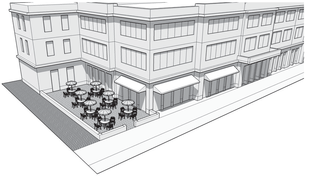
(B)
Activity Area. The activity area is intended to serve as a transition between the sidewalk and a building. Structures and activities allowed within the activity area include balconies, canopies, awnings, overhangs, arcades, porches, stoops, outdoor dining/sitting areas, and public plazas. An activity area that includes an arcade/gallery or an awning or canopy shall comply with the following:
1.
Arcade and Galleries.
a.
Arcades and galleries shall provide a 12-foot vertical clearance on the first floor and have a minimum depth of eight feet (see Figure 3.3.4(e)(6)(B)1: Arcade).
b.
Floors above an arcade or gallery are allowed to encroach into the activity area for the entire depth of the arcade.
Figure 3.3.4(e)(6)(B)1: Arcade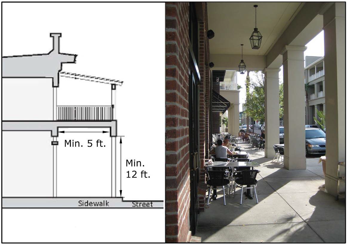
2.
Awnings and Canopies. Awnings and canopies shall:
a.
Have a minimum depth of five (5) feet.
b.
Have a minimum vertical clearance of twelve (12) feet from the lowest point of the awning to the sidewalk.
c.
Be made of fabric (high-gloss or fabrics that resemble plastic are prohibited).
d.
Not cover architectural elements such as cornices or ornamental features.
e.
Not be back-lit.
f.
Be sized to match the corresponding window openings.
g.
If in a multi-story building, have the highest point of a first-floor awning or canopy be no higher than the midpoint between the top of the first story window and the bottom of the second story windowsill.
(7)
Circulation Network.
(A)
Street Types. Certain streets existing on March 1, 2022 are designated Main Streets or Primary Streets as set forth in Table 3.3.4(e)(7)(A): Existing Street Designations. Streets existing on March 1, 2022 that are not identified in Table 3.3.4(e)(7)(A) shall be considered Secondary Streets. The Community Development Director shall assign each new street created as part of a development as a Primary Street or Secondary Street in accordance with the criteria below.
1.
Primary Street. A primary street is a street that is designed as part of the loop system designed to connect the four quadrants of the WS district (north and south of Maitland Boulevard and east and west of Keller Road). A primary street shall generally be designed as a minor arterial (see Table 3.3.4(e)(8): WS District Street Standards).
2.
Secondary Street. All other new streets within the WS district that are not primary streets shall be designated as secondary streets. A secondary street shall generally be designed as a collector road (see Table 3.3.4(e)(8): WS District Street Standards).
(B)
Block Configuration. Any new development, including additional buildings that are constructed on an existing parcel with existing constructed buildings, shall provide a continuous drive aisle that complies with the standards in subsection (C) below for connections to adjacent parcels.
(C)
Vehicular Access.
1.
General.
a.
Development sites under the same ownership or that are consolidated for the purposes of development, and that are comprised of more than one building site, shall not be considered separate properties for purposes of the vehicular access standards of this LDC.
b.
The number of connections permitted shall be the minimum number necessary to provide reasonable access to the site and comply with subsection 2 below. This shall also apply to phased development plans.
c.
Vehicular access to outparcels shall be internalized using the shared circulation system of the principal development. Access to outparcels shall be designed to avoid excessive movement across parking aisles and queuing across surrounding parking and driving aisles.
2.
Joint-Use Driveways and Cross-Access Easements. A system of joint-use driveways and cross-access connections to adjacent parcels shall be established on the development site and shall incorporate the following:
a.
A unified access and circulation system plan that includes coordinated or shared parking areas, wherever feasible.
b.
A continuous service drive and cross access to adjacent sites. Where adjacent parcels are vacant, stub-outs and other design features shall be used to make it visually obvious where the cross-access/service drive connections will be connected when development occurs on the adjacent parcel(s). Where development already exists on the adjacent parcel, the cross-access connection(s) shall be made at a location where it is most practicable to make cross connections. Cross-access connections are not required where they are infeasible to establish due to environmental factors like wetlands, lakes, the location of environmentally sensitive lands, protected trees, or similar features.
(D)
Pedestrian Connectivity.
1.
General. The pedestrian network shall provide direct pedestrian and bicycle pathways to surrounding buildings, adjacent parcels, surrounding streets, external sidewalks, adjacent trails, transit stops, parking areas, and future phases of development.
2.
Design. The design of pedestrian facilities shall comply with the following standards:
a.
Sidewalks or pedestrian pathways shall be well lit and physically separated from driveways and parking spaces by landscaping, other vegetative barriers, grade separations, or other methods to protect pedestrians from vehicular traffic.
b.
A crosswalk shall be required at all points where a sidewalk crosses a lane of vehicular travel, including a street, public driveway, cross access, or paved area accessible to vehicles. Crosswalks shall be designed and coordinated to move people safely across the vehicular path.
c.
Sidewalks shall be a minimum of eight (8) feet wide in the WS-RT Subdistrict, and a minimum of six (6) feet wide in the WS-NM Subdistrict.
(8)
Street Design. New streets shall comply with the standards in Table 3.3.4(e)(8): WS District Street Standards. The street designations are adapted to meet the context of the WS District and modify the standards in Section 3, Roads, in Appendix A: Engineering and Design Manual.
(9)
Perimeter Buffers. The standards and requirements of Sec 5.3.4(c), Perimeter Buffer Standards, including Table 5.3.4(c)(3): Buffer Types, apply to development in the WS District except that proposed Commercial or Office Uses (either new development or redevelopment) are not required to provide a buffer next to existing Public/Semi-Public or Institutional Uses.
(10)
Large Parking Lots. The standards of Sec. 5.2.4(h), Large Parking Lots, apply.
(11)
Parking Lot Landscaping and Screening. Parking lots shall be designed to minimize direct views of parked vehicles from streets and sidewalks and avoid spill-over light, glare, noise, and exhaust fumes onto adjacent properties through layout, landscaping, buffering, and screening.
(A)
Landscape Strips Between Parking Aisles. The standards of Sec. 3.3.5(e)(8)(A), Landscape Strips Between Parking Aisles, apply within the WS district except trees within the landscape strip shall comply with Table 3.3.4(e)(11)(A): Parking Lot Landscape Strip Tree Standards.
(B)
Landscape Islands. The standards of Sec. 3.3.5(e)(8)(B), Landscape Islands, apply within the WS district.
(C)
Parking Lot Perimeter Screening. The standards of Sec. 3.3.5(e)(8)(C), Parking Lot Perimeter Screening, apply within the WS district except the use of cast stone squares is not encouraged.
(12)
Parking Structures. The following standards apply to parking structure façades:
(A)
Vehicle entrances to a parking structure shall be distinct and separate from and coordinated with safe design for pedestrian access.
(B)
Pedestrian access to a parking structure shall be provided directly from adjacent streets.
(C)
Those areas of the building that do not include ground floor active uses shall provide landscaping instead of paved activity areas.
(D)
Parking structures shall comply with all building design standards for building façade, scale, building features, and lighting, compatibility, and placement on the site. The architectural design of a parking structure façade shall be consistent with neighboring structures and all buildings it is intended to serve. See Figure 3.3.4(e)(12): Parking Structure Façade Examples.
Figure 3.3.4(e)(12): Parking Structure Façade Examples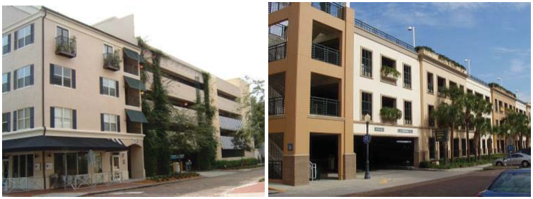
(13)
Service Areas/Utilities. The following standards apply to all utility and service areas:
(A)
Outdoor storage, trash collection, and loading areas shall not be located adjacent to land in a residential development or Residential zone district. If site constraints exist, outdoor storage, trash collection, and loading areas may be located adjacent to lands in a residential development or Residential zone district if:
1.
The service areas are screened from view by a wall that is at least one (1) foot higher than the largest object being screened, but no more than eight (8) feet high, on all sides where access is not needed. Where access is needed, an opaque gate of the same height as the wall shall be provided;
2.
The wall shall be obscured by landscaping. Sufficient planting materials shall be used such that no more than two-thirds (⅔) of the surface area of the screening wall is visible from the street within three (3) years of the wall's erection. Plant materials used to fulfill these requirements shall be a minimum of four (4) feet in height when planted, and planted so that there is no gap greater than two (2) feet between plant foliage. Alternatively, the required landscape screening may be provided by a natural evergreen plant material which can be expected to reach six (6) feet or greater within two (2) years of planting;
3.
Deliveries and collections are prohibited between 10:00 p.m. and 7:00 a.m.; and
4.
Commercial vehicular idling is prohibited.
(B)
Loading areas or docks, outdoor storage, waste disposal, mechanical equipment, satellite dishes, truck parking, and other service support equipment shall be located behind the building line and shall be fully screened from the view of adjacent properties.
(C)
Areas for outdoor storage, trash collection, and loading areas shall be incorporated into the primary building design, and construction for these areas shall be of materials of comparable quality and appearance as that of the primary building.
(D)
Shopping cart storage shall be located inside the building or shall be screened by a wall at least four (4) feet in height consistent with the building architecture and materials.
(14)
Stormwater Design.
(A)
The preferred method of accommodating stormwater impacts is through use of regional stormwater facilities in-lieu of accommodating stormwater on site.
(B)
All stormwater management areas should be incorporated into the overall design of the project.
(C)
Ponds are encouraged to not be located adjacent to public rights-of-way, but to the side or rear of a development.
(D)
Wet stormwater areas shall be designed as amenities. Features such as fountains or aerators shall be required to accent the ponds and provide adequate aeration to prevent stagnation and fish kills.
(E)
Landscaping is required to soften the visual appearance of a pond's edges. Florida friendly trees and shrubs shall be used for landscaping. No exotic invasive plants are permitted.
(F)
Subject to the requirements of the St. Johns River Water Management District, other governmental agencies, and a consideration of safety related issues, stormwater facilities shall be prohibited from having fencing unless it is demonstrated it is necessary due to the configuration and topography of the lot. Any fence shall be designed in accordance with Sec. 2.9(e)(7), Fencing, in Appendix A: Engineering and Design Manual.
(G)
Whether stormwater is provided onsite or offsite, low-impact design concepts such as rainwater harvesting, green roofs, bio-swales, rain gardens, parking lot water capture, and pervious pavement are encouraged to be used. The goal of encouraging the use of these mechanisms is to reduce stormwater runoff, capture contaminants closer to the source, and reduce the use of potable water for irrigation and grey water activities.
(15)
Signs. The following standards apply in the WS-NM district:
(A)
Signs Erected on Buildings. Building signs refer to any sign physically attached to the building. In addition to the requirements of Section 5.14, Signs, the following apply to all development within the WS district:
1.
The maximum allowable sign copy area for signs erected on a building (including on a canopy or awning) on a particular street frontage shall not exceed one (1) square foot per every linear foot of street frontage up to eighty (80) square feet per sign. This maximum allowable copy area may be increased by ten (10) percent for any building higher than thirty-five (35) feet. Specific requirements apply for different types of signs as follows:
a.
Projecting or Blade Signs. The area of a projecting sign shall be no more than six (6) square feet, with a maximum width of thirty-six (36) inches and a maximum height of thirty-six (36) inches. The minimum clearance of the base of the sign shall be eight (8) feet above the sidewalk. See Figure 3.3.4(e)(15)(A)1.a: Projecting Sign.
b.
Wall or Arcade Signs. The maximum width of a wall or arcade sign shall be the width of the shopfront; the minimum copy area height shall be one (1) foot and the maximum shall be three (3) feet. The minimum clearance of the base of the sign shall be eight (8) feet above the sidewalk. See Figure 3.3.4(e)(15)(A)1.b: Wall Sign.
c.
Canopy or Awning Signs. The maximum area of a sign on a canopy or awning shall not exceed thirty (30) percent of the canopy or awning face area. The minimum copy area shall be one (1) foot and the maximum shall be three (3) feet.
Figure 3.3.4(e)(15)(A)1.a: Projecting Sign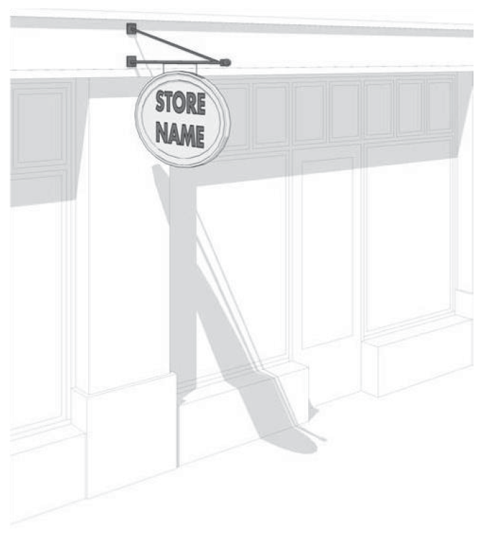
Figure 3.3.4(e)(15)(A)1.b: Wall Sign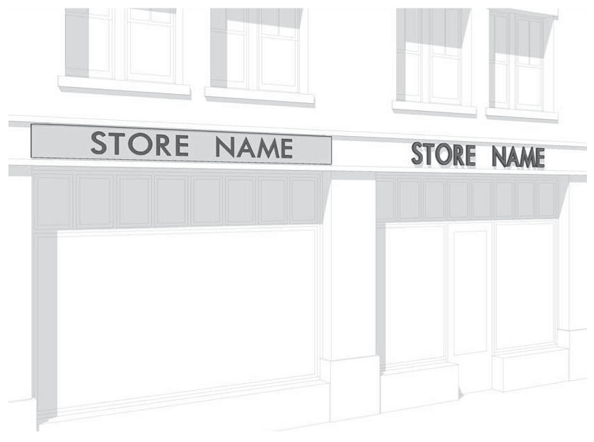
2.
Window signs may not cover more than twenty-five (25) percent of the minimum amount of area required to be provided by subsection (5)(D), Transparency, above. One (1) window sign per storefront is permitted. Each such window sign shall be no larger than five (5) feet in width and three (3) feet in height and shall consist of individual letters and designs that are not made of temporary materials and are part of the overall design of the signage. Gold leaf, professional painting, and decals are permitted materials.
3.3.5. - DM: Downtown Maitland District.
| (a) Purpose | |||
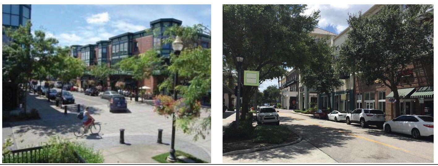
| The purpose of the DM: Downtown Maitland zone district is to implement the comprehensive development plan and Downtown Maitland Master Plan by providing lands that accommodate downtown Maitland as the center of commerce, government, entertainment, and culture in the City. Principal types of development include higher intensity government, commercial, entertainment, and employment uses, as well as higher density residential and mixed use development, all in a form that is pedestrian friendly, architecturally attractive, consistent with the desired character of the city, supportive of multiple modes of mobility, and protective of the character of adjacent residential lands. Allowed uses include retail services, personal services, recreation/entertainment, offices, hotels and motels, restaurants, microbreweries, health care, multifamily and townhome dwellings, and mixed-use development. |  | ||
| The Downtown Maitland (DM) zone district consists of two subdistricts. The Downtown Maitland (DM) subdistrict supports pedestrian-friendly, mixed-use development at the greatest intensities and densities in the City. The Downtown Maitland Edge (DM-EDGE) Subdistrict, which is located on lands adjacent and proximate to existing residential neighborhoods is supportive of pedestrian-friendly, mixed use, and other similar types of development as the DM subdistrict, but at less intense densities/intensities, and in a form that ensures the character of the adjacent residential neighborhoods is maintained. |  | ||
 | |||
| (b) Use Standards | |||
| Allowed uses and use-specific standards for principal, accessory, and temporary uses are established in Article 4: Use Regulations. In a PD located in the DM district, an ongoing use that existed prior to June 22, 2020 may continue. However, any change to a use in a planned development that existed prior to June 22, 2020 shall only be to a use allowed in the DM-PD district in accordance with Table 4.2.2: Principal Use Table. | |||
| (c) Intensity and Dimensional Standards | |||
|
(1) Unless exempted in subsections (2) or (3) below, all development in the DM zone
district shall comply with the following intensity and density standards.
(2) The expansion or alteration of development existing prior to June 22, 2020 that is not approved as a planned development, that increases the building's floor area by less than 50 percent or alterations that involve less than 50 percent of the building's gross floor area, over the five years prior to the submission of an application, is exempt from the requirements of this section, except for the following: (A) The existing building that is expanded or altered is first expanded or altered toward the street frontage if it does not comply with the build-to-zone standards of this section, to bring the building into greater compliance with those standards; (B) The expansion or alteration makes reasonable efforts to comply with the building width in build-to zone and building façade fenestration/transparency standards of this section; and (C) The expansion or alteration complies with the maximum density and maximum FAR standards. (3) A planned development existing prior to June 22, 2020 may continue to develop consistent with the terms and conditions of approval of the approved planned development, except that any expansion or alteration that increases the building's floor area by less than 30 percent or alterations that involve less than 30 percent of the building's gross floor area over the five years prior to the submission of an application, shall comply with the following: (A) The existing building that is expanded or altered shall first be expanded or altered toward the street frontage, to the maximum extent practicable, if it does not comply with the build-to-zone standards of this section, to bring the building into greater compliance with those standards; (B) The expansion or alteration shall make reasonable efforts to comply with the building width in the build-to zone and building façade fenestration/transparency standards of this section; and (C) The expansion or alteration shall comply with the maximum density/intensity requirements of the approved planned development, but under no circumstances shall exceed the maximum density and maximum FAR standards of this section. (4) A planned development existing prior to June 22, 2020 that expands or is altered in a way that increases the building's floor area by 30 percent or more, or alters the building's gross floor areas by 30 percent or more over the five years prior to the submission of an application, shall comply with all of the following intensity and dimensional standards. | |||
| Standard | DM | DM-EDGE | |
| Block length, min. | max. (ft.) | 330 | 660 | ||
| Build-to zone (ft.) [1] | |||
| Type I Street | 26 | 41 | ||
| Type II Street | 25 | 40 | ||
| Type III Street | 18 | 33 | ||
| Front yard setback, min. (ft.) | — | ||
| Side yard setback, min. (ft.) | — | ||
| Rear yard setback, min (ft.) | — | ||
| Building width in build-to zone, min. (% of lot width) [2] | 75 | 60 | |
| Building façade fenestration/transparency, min. (percentage of street-level façade area) [3] | 50 |
40 for non-residential and mixed use
25 for residential | |
| Density, min. | max. (du/acre of net lot area) [4] [5] | |||
| Parcels less than 2 acres | 10 | 20 | 5 | 14 | |
| Parcels 2 acres or greater and less than 3 acres | 12 | 30 | 8 | 21 | |
| Parcels 3 acres or greater | 16 | 40 | 12 | 28 | |
| Floor Area Ratio (FAR), min. | max. [6] | |||
| Parcels less than 2 acres | 0.60 | 1.20 | 0.40 | 0.85 | |
| Parcels 2 acres or greater and less than 3 acres | 0.70 | 1.40 | 0.50 | 1.00 | |
| Parcels 3 acres or greater | 1.00 | 2.00 | 0.70 | 1.40 | |
| Building height, max. (ft) | 78 (6 stories) [7] | 48 (3 stories) [7] | |
| Open space set-aside, min. (%) | 10 | 15 | |
| Impervious surface, min. | max. (%) | 50 | 90 | 40 | 80 | |
|
NOTES: sf = square feet; ft = feet; min.= minimum; max.= maximum
[1] The area between the minimum and maximum build-to lines that extends the width of the lot constitutes the build-to zone. The minimum and maximum build-to lines are measured from back of curb. They differ based on the street type on which the building fronts. The area between the minimum build-to-line and curb shall include the parkway, the sidewalk, and the activity area. See Table 3.3.5(e)(4)(B): Public Frontage Standards. If the minimum required parkway and/or activity area width is reduced in accordance with Sec. 3.3.5(e)(4)(B), Public Frontage Standards, the minimum build-to line shall be reduced accordingly. [2] The remaining build-to zone width may be occupied by outdoor gathering spaces, walkways, landscaped areas, stormwater management facilities that use environmental site design techniques. [3] Window and door openings counting toward meeting this transparency requirement shall consist of glass that is relatively clear and non-reflective, with a minimum visible light transmittance of 0.65 and maximum visible light reflectance of 0.2. [4] Maximum density varies based on parcel size as outlined in the comprehensive development plan. [5] A development can potentially achieve maximum residential densities and maximum nonresidential FARs. For purposes of calculating permitted density, a group home use shall be considered as a nonresidential use subject to the FAR requirements. [6] Maximum FAR varies based on parcel size as outlined in the comprehensive development plan. [7] The first floor of all buildings shall be a minimum of 14 feet in height. | |||
 | |||
| (d) Reference to Other Standards | |||
| Section 5.1 Mobility and Connectivity Standards | Section 5.10 Residential Compatibility Standards | ||
| Section 5.2 Off-Street Parking, Bicycle, and Loading Standards | Section 5.11 Architectural, Form, and Design Standards | ||
| Section 5.3 Landscape, Buffer, and Tree Protection Standards | Section 5.12 Sustainable Development Standards | ||
| Section 5.4 Open Space Set-Aside Standards | Section 5.13 Sustainable Development Incentives | ||
| Section 5.5 Vegetation Removal | Section 5.14 Signs | ||
| Section 5.6 Residential Tree Protection | Section 5.15 Building Numbering and Street Naming | ||
| Section 5.7 Flood Damage Prevention | Article 6 Subdivision Standards | ||
| Section 5.8 Fence and Wall Standards | Article 7 Public Facility Funding | ||
| Section 5.9 Exterior Lighting Standards | Appendix A Engineering and Design Manual | ||
(e)
Design and Form Standards.
(1)
Applicability.
(A)
General. Unless exempted in part, in accordance with subsections (B) or (C) below, all development in the DM district shall comply with the standards of this Sec. 3.3.5(e).
(B)
Existing Development. The following development that is not part of an approved planned development existing prior to June 22, 2020 is exempt from some of the requirements of this section, as noted below:
1.
The expansion or alteration of development existing prior to June 22, 2020, if the development increases the building's floor area by fifty (50) percent or more, or the alteration involves fifty (50) percent or more of the building's gross floor area over the five (5) years prior to the submission of an application, is only required to comply with the following subsections (compliance with the other subsections is encouraged, where practicable):
a.
Subsection (4), Public Frontage Standards;
b.
Subsection (6), Pedestrian and Bicycle Circulation and Access;
c.
Subsection (7), Parking Lot Location;
d.
Subsection (8), Parking Lot Landscaping and Screening, to the maximum extent practicable;
e.
Subsection (9), Exterior Lighting;
f.
Subsection (10), Landscaping and Screening;
g.
Subsection (19), Signs;
h.
Subsection (20), Parking; and
i.
Subsection (21), Stormwater Design, to the maximum extent practicable.
2.
The expansion or alteration of development existing prior to June 22, 2020, if the development increases the building's floor area by less than fifty (50) percent, or the alteration involves less than fifty (50) percent of the building's gross floor area, over the five (5) years prior to the submission of an application, is only required to comply with the following subsections (compliance with the other subsections is encouraged, where practicable):
a.
Subsection (7), Parking Lot Location;
b.
Subsection (8), Parking Lot Landscaping and Screening, to the maximum extent practicable;
c.
Subsection (9), Exterior Lighting;
d.
Subsection (10), Landscaping and Screening, to the maximum extent practicable;
e.
Subsection (19), Signs;
(C)
Existing Planned Development. The following development that is part of an approved planned development existing prior to June 22, 2020 and is located within the Main Street designation on the Future Land Use Map shall be exempt from some of the requirements of this section, subject to the following:
1.
The expansion or alteration of development that increases the building's floor area by thirty (30) percent or less, or alterations that involve thirty (30) percent or less of the building's gross floor area, over the five (5) years prior to the submission of an application, is exempt from the requirements of this section.
2.
The expansion or alteration of development that increases the building's floor area by more than thirty (30) percent, or alteration that involves more than thirty (30) percent of the building's gross floor area, over the five (5) years prior to the submission of an application, is required to comply with the following subsections (compliance with the other subsections is encouraged, where practicable):
a.
Subsection (7), Parking Lot Location;
b.
Subsection (8), Parking Lot Landscaping and Screening, to the maximum extent practicable;
c.
Subsection (9), Exterior Lighting;
d.
Subsection (10), Landscaping and Screening, to the maximum extent practicable;
e.
Subsection (19), Signs;
3.
To the extent any design and form standards in this subsection conflict with standards elsewhere in this LDC or the City Code, the standards in this subsection control.
(2)
Building Placement and Orientation. Building orientation refers to the location of the primary and secondary façades and entrances to a building.
(A)
Buildings pads shall comply with the public frontage requirements to reinforce street edges along all public rights-of-way.
(B)
Buildings shall orient toward the public right-of-way.
(C)
If a site fronts on more than one public right-of-way, such as a corner or double frontage lot, the development shall be designed to comply with the setbacks and frontage requirements on all rights-of-way. If the Community Development Director determines this is not feasible, the development shall front the public right-of-way which is located on the highest-level street type (e.g., the Type I street versus the Type II street).
(D)
Outparcels are not exempt from these requirements.
(3)
Building Along Frontage. Buildings shall comply with the building width within the build-to zone requirements in Sec. 3.3.5(c), Intensity and Dimensional Standards. (The standards are stated as a percentage of lot width.)
(4)
Public Frontage Standards. Public frontage standards are generally referred to as the area from the back-of-curb to building face, also known as the build-to line within the build-to zone. See Figure 3.3.5(e)(4): Public Frontage Standards and Table 3.3.5(e)(4): Public Frontage Standards Key.
Figure 3.3.5(e)(4): Public Frontage Standards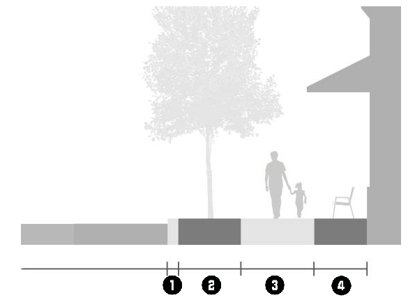
Table 3.3.5(e)(4): Public Frontage Standards Key | |
|---|---|
| Key | Portion of Public Frontage |
| Curb | |
| Parkway | |
| Sidewalk | |
| Activity Area | |
(A)
Street Types. Existing streets within the DM district are assigned the following street types. The Community Development Director shall assign each new street created as part of a development in accordance with the criteria below.
1.
Type I Street. A Type I street is primarily intended to facilitate the movement of vehicular traffic through the DM district. There are two Type I streets in the DM district, both of which are major commercial streets — Orlando Avenue (US 17-92) and Horatio Avenue (east of Orlando Avenue). No new Type I streets shall be developed within the DM district.
2.
Type II Street. A Type II street is designed to accommodate traffic accessing destinations within the DM district and also relieves traffic on the Type I streets. Type II streets support the most urban style of development and are recommended for new streets within the DM district. There are 14 Type II streets in the DM district. They are Maitland Avenue, Horatio Avenue (West of Orlando Avenue), Sybelia Avenue, Sybelia Parkway, George Avenue, Independence Lane, Swoope Avenue, Packwood Avenue, Ventris Avenue, Manor Road, Lake Avenue, Park Avenue, Monroe Avenue, Lewis Drive, and Elvin Avenue.
3.
Type III Street. A Type III street has constrained right-of-way or connects directly into residential neighborhoods. There are six (6) Type III streets in the DM district. They are Versailles Drive, Circle Drive, Magnolia Road, Tangerine Place, Orange Place and Alpine Drive.
(B)
Public Frontage Standards. Development in the DM district shall comply with the public frontage standards in Table 3.3.5(e)(4)(B): Public Frontage Standards, based on the street type the development fronts. See also Figure 3.3.5(e)(4)(B): Illustration of Public Frontage Standards for Type I Street. The standards shall be measured from the curb.
Figure 3.3.5(e)(4)(B): Illustration of Public Frontage Standards for Type I Street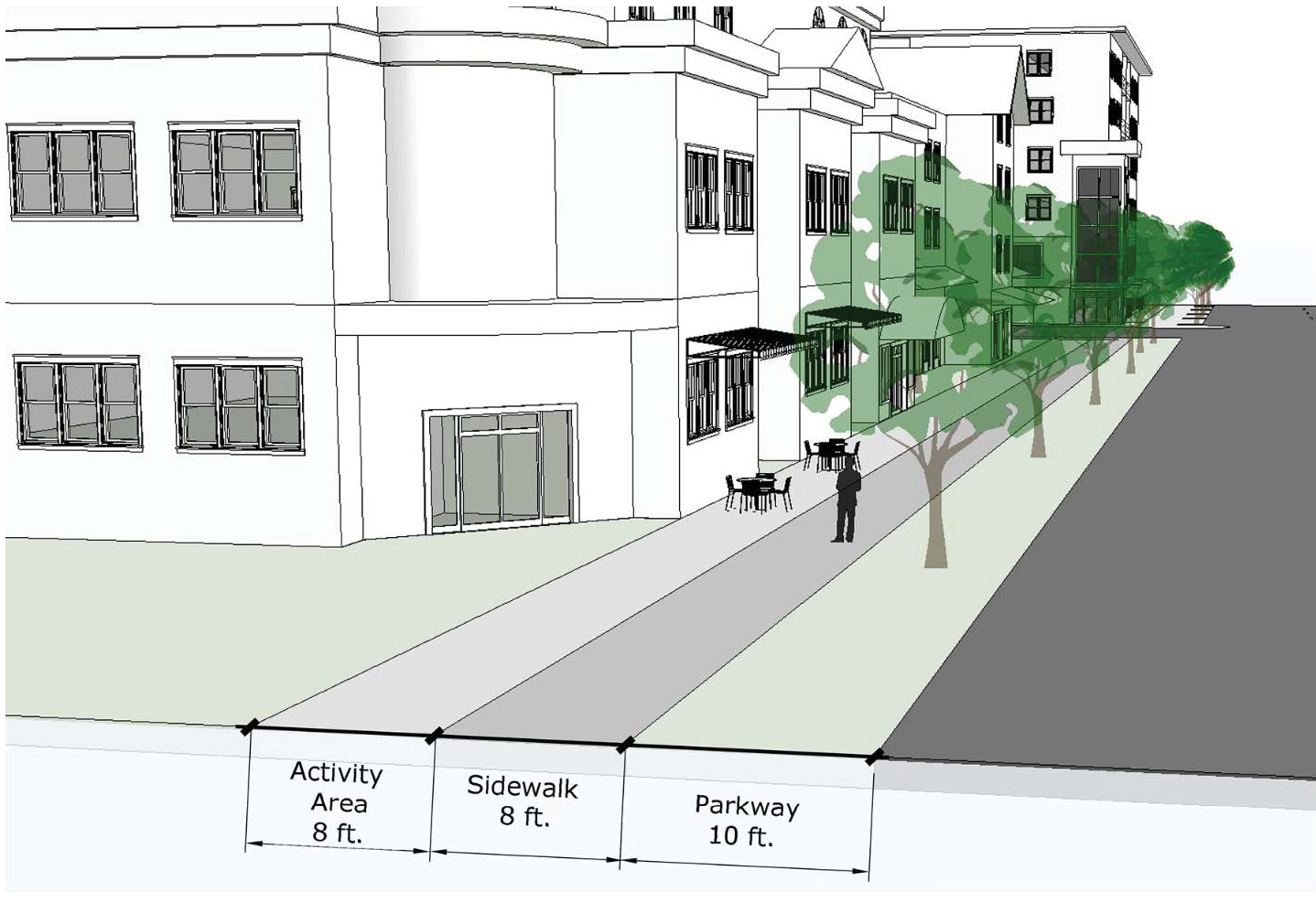
1.
A reduction in the minimum width for an activity area may be approved by the Community Development Director if the activity area use does not impede on the minimum width of the sidewalk (which is in compliance with the requirements of Table 3.3.5(e)(4)(B): Public Frontage Standards), and no activities are allowed within the sidewalk area.
2.
A reduction in the minimum width for a parkway may be approved by the Public Works Director if the tree species selected for the parkway complies with the minimum standards in Table 3.3.5(e)(4)(C): Street Tree Standards, and a landscape architect certifies the minimum width provided for the tree species is sufficient for its long term viability.
(C)
Street Trees. Street trees are required to be planted in the parkway in accordance with Table 3.3.5(e)(4)(C): Street Tree Standards. The street tree standards vary depending on the street type on which the development fronts. If a portion of the building frontage has been previously designed along the same corridor, the applicant shall be required to choose a similar tree species for continuity. The required spacing and placement of street trees shall be coordinated with the Public Works department to address potential conflicts with regulatory road signs and the clear zone within sight triangles.
(D)
Shrubs, Ground Cover, and Accent Plants. Shrubs, ground cover, and accent plants shall be planted in the parkway in accordance with Table 3.3.5(e)(4)(D): Shrub, Ground Cover, and Accent Plant Standards in Parkway. Accent plants shall be in scale with the sizes of surrounding plantings and shall be sufficiently significant in size to provide visual impact at planting with one hundred (100) percent ground coverage at maturity. They shall comply with the minimum on-center spacing requirements, by species, at the time of planting. Sod is prohibited within the parkway areas.
(E)
Street Lighting. The following light fixtures, which are provided by the applicable utility provider, shall be required. A required light fixture may be substituted with another comparable fixture approved by the Community Development Director if the product is no longer available. See Figure 3.3.5(e)(4)(E): Street Lighting Fixtures.
1.
Independence Lane Lighting: Mitchell LED With Ribs, Bands and Medallions on a colonial style pole.
2.
Single-family Residential Lighting: Traditional LED on a colonial style pole.
3.
Multifamily and Nonresidential Lighting: Biscayne LED on a Victorian style pole.
Figure 3.3.5(e)(4)(D): Street Lighting Fixtures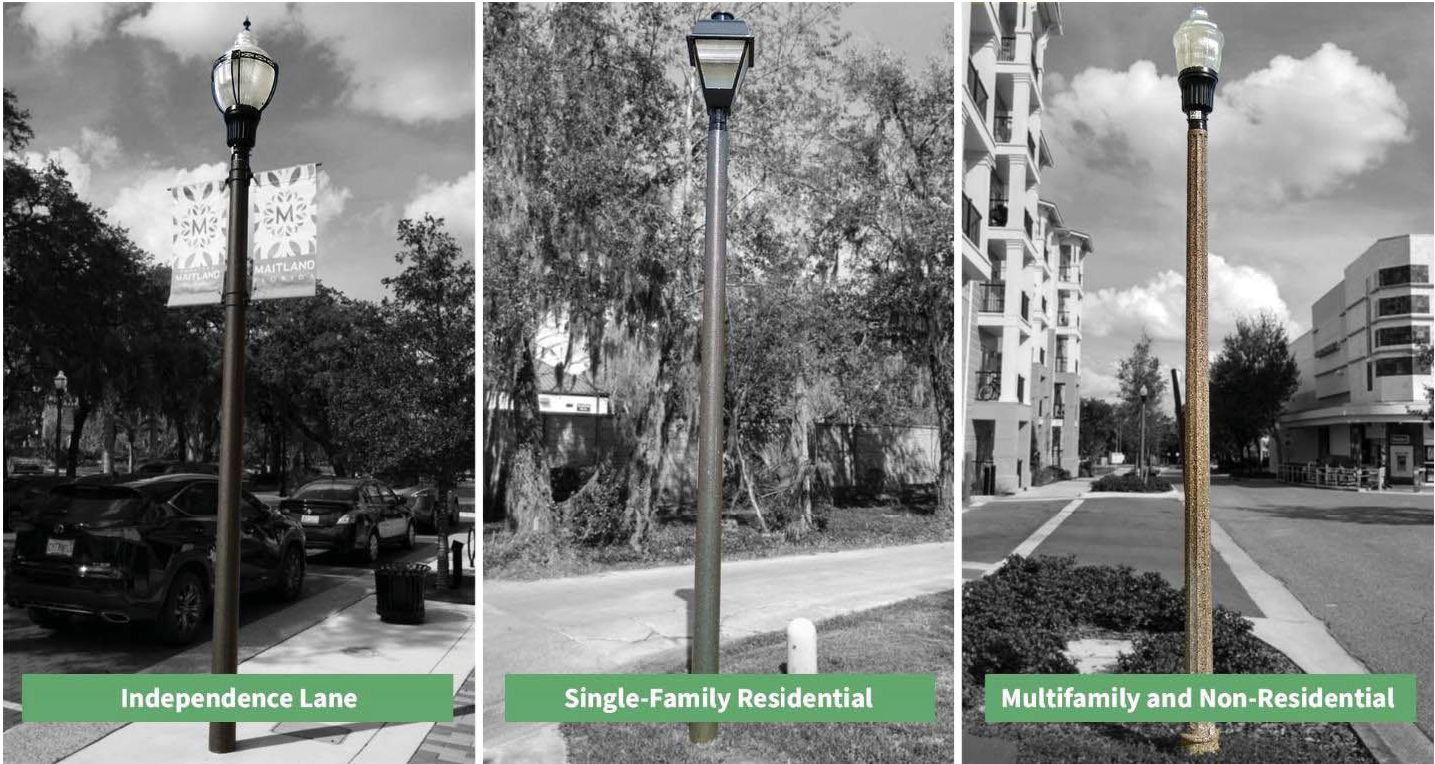
(F)
Streetscape Furnishings and Sidewalk Details.
1.
The street furnishings that shall be provided and located in the activity area or parkway are seating, bike racks, trash/recycling containers, and tree grates. There should be continuity in the arrangement and spacing of street furnishings with the overall block and street.
2.
The type of sidewalk design shall be consistent with the sidewalk design along the corridor being developed.
(G)
Sidewalk Standards. Sidewalks shall incorporate specialty pavers at periodic intervals as part of the sidewalk design. Paver design patterns can be obtained from the Public Works Director. A representative paver is shown in Figure 3.3.5(e)(4)(G): Representative Sidewalk Paver.
Figure 3.3.5(e)(4)(G): Representative Sidewalk Paver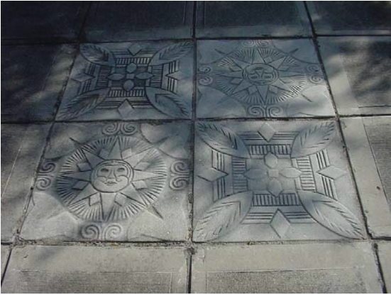
(H)
Activity Area.
1.
General.
a.
The activity area is intended to serve as a transition between the sidewalk and a building. Structures and activities allowed within the activity area include balconies, canopies, awnings, overhangs, arcades, porches, stoops, outdoor dining/sitting areas, and public plazas.
b.
The build-to-line and the build-to-zone may be set back by up to an additional fifteen (15) feet if a common activity area (like a plaza or meeting place) or outdoor dining is provided in the front of the building. The additional setback shall not be applied to more than fifty (50) percent of the building width.
2.
Standards. The following standards apply to structures within the activity area.
a.
Arcade and Gallery.
i.
The use of arcades, galleries, or other similar architectural elements that provide protection from the elements are required along Independence Lane (see Figure 3.3.5(e)(4)(H)2.a: Arcade).
ii.
Arcades and galleries shall provide a 12-foot vertical clearance on the first floor and have a minimum depth of eight (8) feet.
iii.
Floors above an arcade or gallery are allowed to encroach into the activity area for the entire depth of the arcade.
Figure 3.3.5(e)(4)(H)2.a: Arcade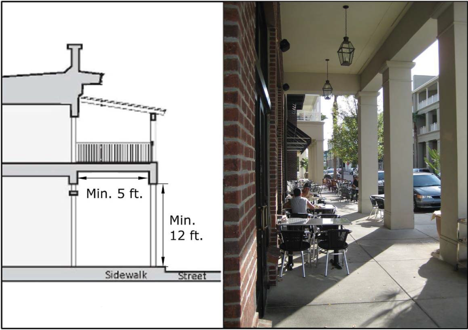
b.
Awning and Canopy. Awnings and canopies shall:
i.
Have a minimum depth of eight (8) feet.
ii.
Have a minimum vertical clearance of twelve (12) feet from the lowest point of the awning to the sidewalk.
iii.
Be made of fabric (high-gloss or fabrics that resemble plastic are prohibited).
iv.
Not cover architectural elements such as cornices or ornamental features.
v.
Not be back-lit.
vi.
Be sized to match the corresponding window openings.
vii.
If in a multi-story building, have the highest point of a first-floor awning or canopy be no higher than the midpoint between the top of the first story window and the bottom of the second story windowsill.
c.
Porch.
i.
A porch:
1)
Shall have a minimum depth of six (6) feet and a minimum height of seven feet.
2)
May be partially or fully enclosed.
3)
May be projecting or integral.
4)
May wrap around corners to attach to other porches, galleries, decks, or balconies on abutting building faces.
5)
May have stairs extending off its front or side unless it is located on an upper floor (in which case the stairs cannot be located along the primary frontage).
Figure 3.3.5(e)(4)(H)2.c: Porch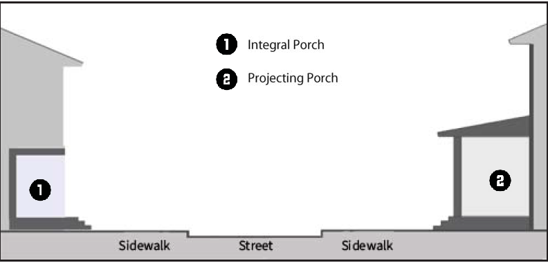
ii.
When built on an upper floor, a porch shall be supported from below by a porch, arcade, or other supporting component; or visually supported by brackets, corbels, cantilever, or beams along its full depth.
iii.
When built on the first floor, the space between piles or piers of a porch shall be enclosed on all sides with latticework or similar material, or concealed visually by evergreen landscaping. See Figure 3.3.5(e)(4)(H)2.c: Porch; Figure 3.3.5(e)(4)(H)2.c-1:< Integral Porch; and Figure 3.3.5(e)(4)(H)2.c-2: Projecting Porch.
Figure 3.3.5(e)(4)(H)2.c-1: Integral Porch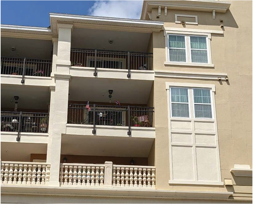
Figure 3.3.5(e)(4)(H)2.c-2: Projecting Porch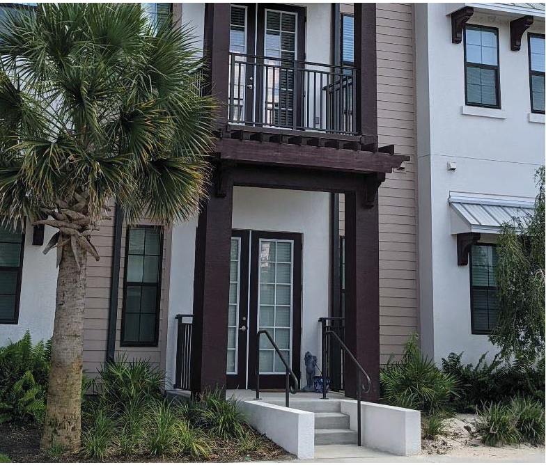
d.
Stoop.
i.
A stoop:
1)
May be built perpendicular or parallel to the building face, but shall lead directly to the ground level or an abutting sidewalk from the building entrance.
2)
May be recessed into the building façade, but if recessed shall not be enclosed.
3)
Shall have a minimum width of three feet, six (6) inches, with a minimum height of seven feet, when recessed.
ii.
If a stoop is built as part of a townhouse or live/work flex building, it may be configured as a split stair to access a below grade unit (see Figure 3.3.5(e)(4)(H)2.d-1: Stoop and Figure 3.3.5(e)(4)(H)2.d-2: Stoop Example.
Figure 3.3.5(e)(4)(H)2.d-1: Stoop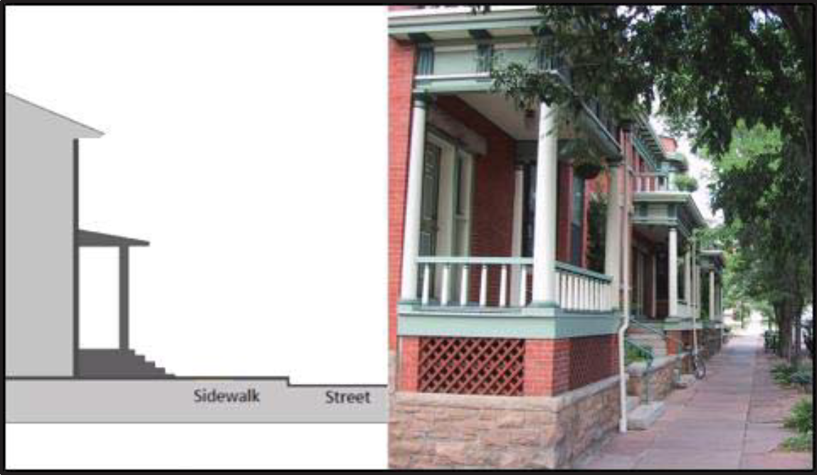
Figure 3.3.5(e)(4)(H)2.d-2: Stoop Example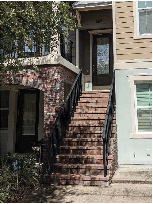
e.
Outdoor Dining.
i.
Outdoor dining shall be immediately adjacent to the façade of the dining establishment with which it is associated. See Figure 3.3.5(e)(4)(H)2.e-1: Outdoor Dining and Figure 3.3.5(e)(4)(H)2.e-2: Outdoor Dining Example.
ii.
Alterations to or the covering of sidewalks in outdoor dining areas is prohibited (including but not limited to the use of paint, carpet, turf, platforms, etc.)
iii.
Menu boards, planters, booths, and other associated furniture shall be placed within the outdoor seating envelope.
iv.
Outdoor seating for all establishments serving alcohol shall be surrounded by a 36-inch high free-standing, removable barrier, if required by law or license, and shall not impede pedestrian access and circulation.
v.
If required, barriers shall not include chain link, chain rail, rope rail, or any material not specifically designed for fencing.
vi.
Outdoor dining and associated furniture and barriers may encroach into City-maintained right-of-way upon execution of a right-of-way encroachment agreement approved by the DRC.
Figure 3.3.5(e)(4)(H)2.e-1: Outdoor Dining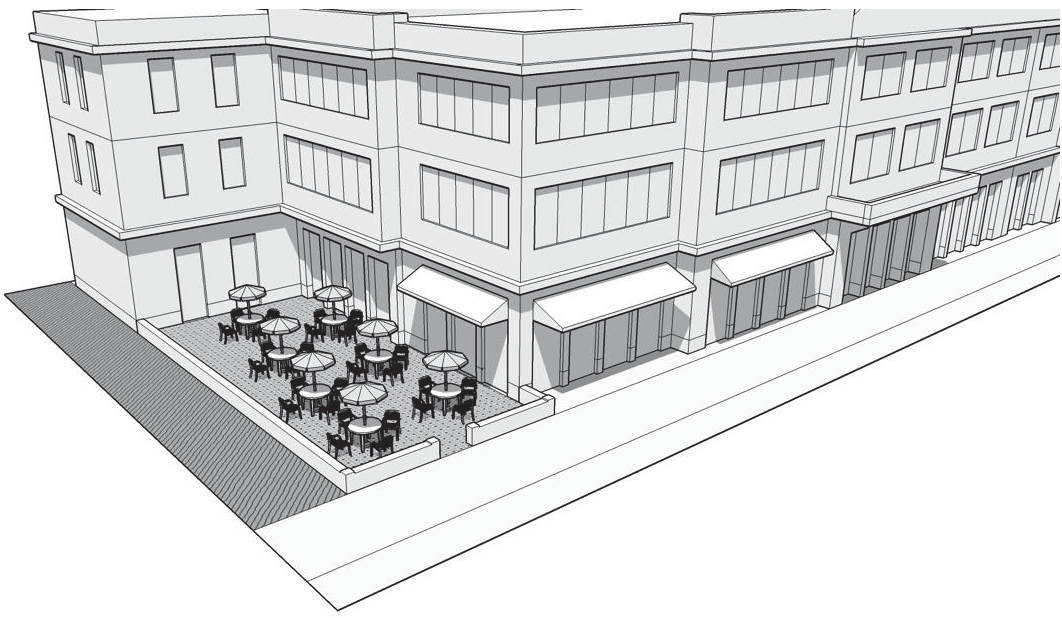
Figure 3.3.5(e)(4)(H)2.e-2: Outdoor Dining Example
f.
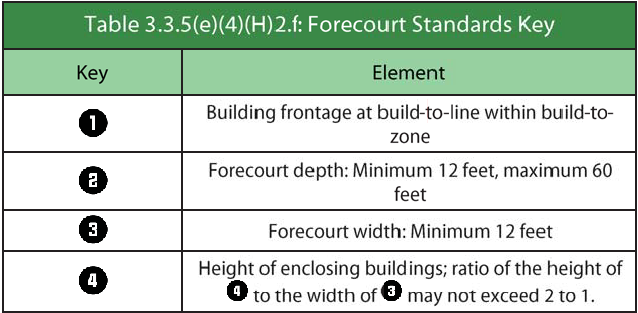
Forecourts.
i.
Buildings may be set back sixty (60) feet from the build-to-line within the build-to-zone for the provision of a forecourt. (See Figure 3.3.5(e)(4)(H)2.f: Forecourt Standards and Table 3.3.5(e)(4)(H)2.f: Forecourt Standards Key.)
ii.
The minimum width and depth of the forecourt is twelve (12) feet, and the maximum ratio of height of the enclosing building and the width and depth of the forecourt is two (2) to one (1.)
Figure 3.3.5(e)(4)(H)2.f: Forecourt Standards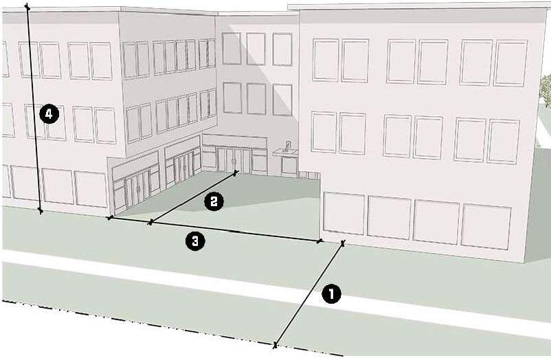
g.
Courtyards, Plazas, or Other Public Gathering Places.
i.
Buildings may be setback up to twenty (20) feet from the build-to-line within the build-to-zone for the provision of forecourts, courtyards, plazas, or other public gathering places (see Figure 3.3.5(e)(4)(H)2.f: Forecourt Standards). The additional setback shall not be applied to more than fifty (50) percent of the building width. A street wall shall be installed at the build-to-line or along the sidewalk for the length of the recess to maintain continuity along the street front (see Sec. 3.3.5(e)(8)(C)1, Street Wall).
ii.
Plazas shall additionally be a minimum of three hundred (300) square feet in area and fifteen (15) feet in width, and have a minimum perimeter frontage of twenty-five (25) percent on a public right-of-way.
(5)
Site Access and Circulation.
(A)
Shared access and circulation systems for pedestrians and vehicles are required where existing conditions allow, in order to minimize curb cuts, provide direct access between adjacent uses, and improve traffic circulation.
(B)
Projects shall be designed to establish a balanced transportation system that supports pedestrian, bicycle, and transit users, as well as vehicular mobility, and provide a system of connections to maximize choices for all modes of travel.
(C)
Non-residential and mixed-use development with fifty thousand (50,000) gross square feet or more of gross floor area which is adjacent to a street that is or may be used as a transit route shall coordinate with the relevant public transportation agency and, if recommended by the public transportation agency and required by the City, provide access for an on-site public transit stop. The public transit stop shall include a shelter and shall include a bus pullout if it is determined appropriate by the Community Development Director in consultation with the Public Works Director, the public transportation agency, and FDOT, as applicable.
(D)
A new street shall be designed to include public frontage standards (see Sec. 3.3.5(e)(4)(B)) that have an activity area, sidewalk, and parkway. The width and design of the street shall be consistent with the City's overall transportation plan and any other plans that identify specific pedestrian needs of the City.
(E)
Curb cuts for driveway entrances and other purposes shall be limited to no more than one (1) every one hundred twenty-five (125) feet. The use of cross-access easements to improve access and reduce the number of required driveways is encouraged. In areas such as the Orlando Avenue corridor, vehicular entrances are encouraged to be from side streets and rear access roads.
(F)
Joint access driveways and cross-access easements are required between sites to reduce the number of access points and driveway area, and to increase the amount of landscaping.
(G)
Access driveway lane width shall not exceed twelve (12) feet for one-way driveways and twenty-four (24) feet for two-way driveways, unless a wider width is needed because the driveway is along a fire access route. The crossing area connecting the sidewalk over an access driveway shall be distinct from the driveway pavement in accordance with the MUTCD.
(H)
Vehicular access to a nonresidential or mixed use development shall be provided from a secondary street or access road, when it is feasible, without adversely impacting abutting single-family residential development, unless the Planning and Zoning Commission approves a waiver in accordance with Sec. 2.5.4(b), Waiver .
(I)
All new development and redevelopment shall incorporate safe drop-off facilities for persons arriving and departing via taxi or rideshare that minimize conflicts with vehicular, bicycle, and pedestrian circulation.
(6)
Pedestrian and Bicycle Circulation and Access.
(A)
Pedestrian Circulation. Development shall comply with the following pedestrian connections standards:
1.
Along Orlando Avenue, direct pedestrian access shall be provided from the principal entrance of the building to the sidewalk along the closest public right-of-way.
2.
Additional or secondary pedestrian access shall be provided directly from a parking lot or parking structure to the ground floor of nonresidential and mixed use development, either through rear building entrances, sidewalks along the perimeter of buildings, or by pedestrian alleyways or pathways which connect a rear parking lot or parking structure to the sidewalk along the front street. Pedestrian alleyways and pathways shall be a minimum of ten (10) feet wide.
3.
Pedestrian pathway surface design shall be differentiated from driving surfaces through a change in materials and/or elevation, and shall provide places for protection from the weather and shade.
4.
Marked crosswalks are required wherever pedestrian circulation intersects a vehicular area.
(B)
Bicycle Circulation and Access. All new development and redevelopment is required to provide connections to the City's bicycle and pedestrian path system identified in the City of Maitland Bike and Pedestrian Master Plan.
(7)
Parking Lot Location.
(A)
The placement of a new parking lot should avoid conflicts between vehicular and pedestrian activities. Parking lots shall be located at the side or rear of the building, and behind the build-to zone. Parking located between the primary façade of the building and the street and pull-off or parallel parking directly off a road except in properly designated public parking spaces are prohibited.
(B)
Consolidated parking areas are encouraged to minimize the amount of pavement. Cross access driveways between development shall be provided, to the maximum extent practicable.
(8)
Parking Lot Landscaping and Screening. Parking lots shall be designed to minimize direct views of parked vehicles from streets and sidewalks and avoid spill-over light, glare, noise, and exhaust fumes onto adjacent properties through layout, landscaping, buffering, and screening.
(A)
Landscape Strips Between Parking Aisles. Parking lots with more than one hundred (100) spaces shall be visually and functionally segmented into smaller lots with landscaped islands and strips. Parking lots with more than two (2) head-to-head rows of parking shall include a continuous six-foot wide landscape strip between the parking spaces (parallel to the drive aisle). The strip shall be provided every other double row of parking. Trees shall be planted within the landscape strip in accordance with Table 3.3.5(e)(8)(A): Parking Lot Landscape Strip Tree Standards.
(B)
Landscape Islands. No more than ten (10) consecutive parking stalls are allowed without a landscape island at least eight (8) feet wide (measured from the back of curb) and two hundred (200) square feet in area extending the entire length of the parking stall. One (1) tree that complies with the standards in Table 3.3.5(e)(8)(A): Parking Lot Landscape Strip Tree Standards shall be planted in each landscape island per two hundred (200) square feet of area. The trees shall comply with the caliper, height, spread, clearance, and soil volume standards in Table 3.3.5(e)(8)(A). The remainder of the landscape island shall be filled with a combination of mulch and ground cover.
(C)
Parking Lot Perimeter Screening. The landscaping within the parking lot perimeter along the side and rear property lines shall comply with Sec. 5.3.4(c)(6), Parking Lot Perimeter Landscaping. The parking lot perimeter landscaping along the front property line may be located within the activity area and shall comply with the following standards.
1.
Street Wall. In order to minimize direct views of parked vehicles from streets and sidewalks, a street wall shall be provided along the perimeter of surface parking lots fronting on public streets or alleys. See Figure 3.3.5(e)(8)(C)1-1: Street Wall and Figure 3.3.5(e)(8)(C)1-2: Street Wall Example. The street wall shall comply with the following standards:
a.
The street wall shall be constructed of decorative metal, brick, masonry, stone, or other decorative materials matching the building materials and style. The use of cast stone squares to match the sidewalk is encouraged.
b.
A chain link or wood street wall is prohibited.
c.
The street wall shall be a minimum of three (3) feet and a maximum of five (5) feet in height. A street wall greater than three (3) feet in height above grade shall consist of no more than fifty (50) percent solid materials.
d.
The street wall may be located anywhere within the width of the activity area but shall provide for at least a two-foot wide strip of landscaping.
e.
The street wall shall incorporate raised lintels to protect existing trees and bridge over their existing root system.
f.
The quality of the street wall materials shall match or exceed the quality of materials used for the building construction. The finish used on the street wall shall match or compliment the finishes on the building.
g.
A gap in the street wall shall not exceed the width of a pedestrian crossing, plus one (1) foot clearance on each side, or the minimum width necessary to accommodate each lane of vehicular access and to not intrude into the sight triangle.
h.
A street wall shall not intrude into the sight triangle.
Figure 3.3.5(e)(8)(C)1-1: Street Wall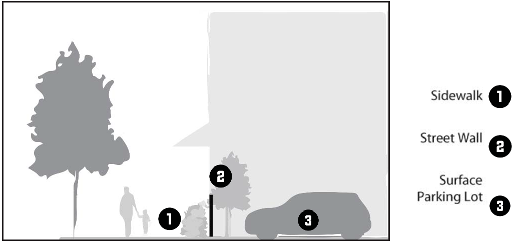
Figure 3.3.5(e)(8)(C)1-2: Street Wall
Example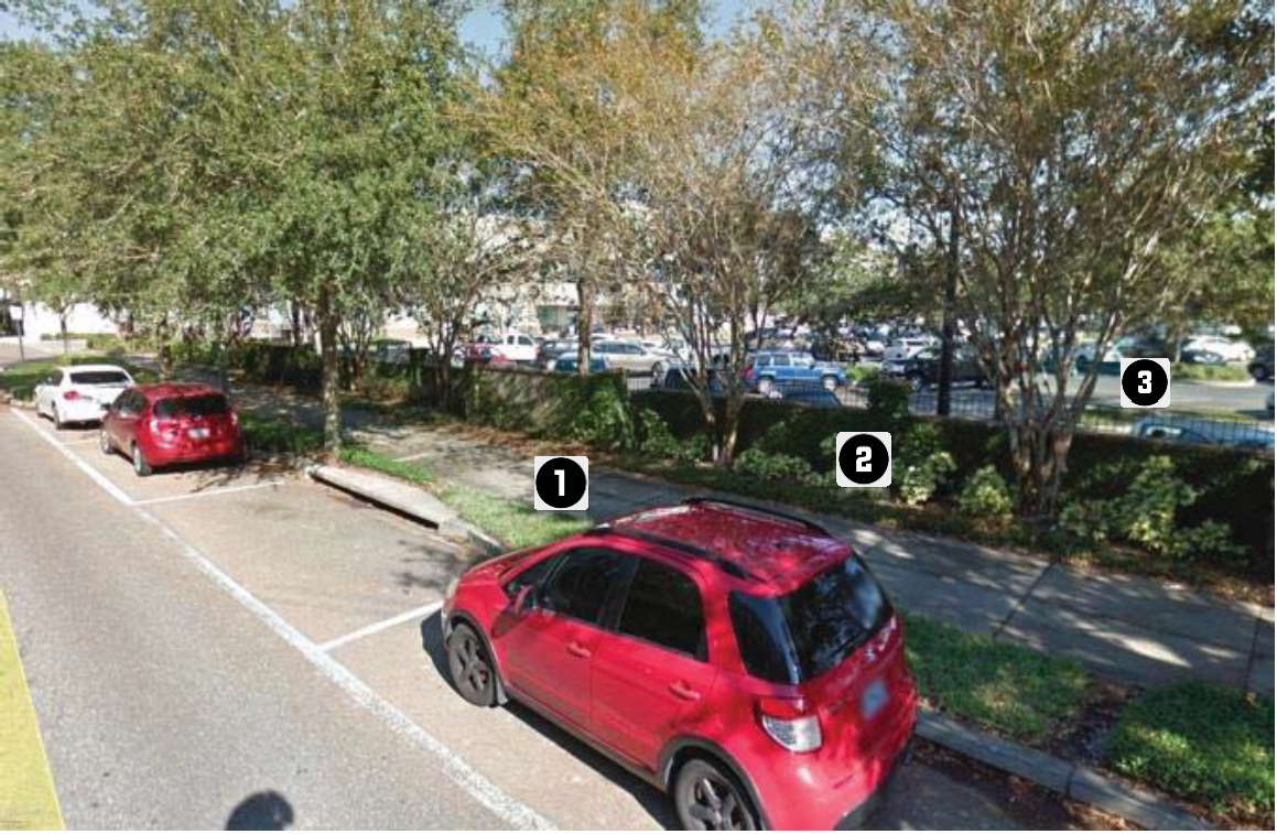
2.
Landscaping. Ground cover, hedges, or shrubs shall be installed on both sides of the wall. On the inside of the wall, trees shall be planted as outlined in Sec. 3.3.5(e)(8)(A), Landscape Strips Between Parking Aisles, above.
(D)
Buffer Yard. The buffer yard requirements in Section 5.3, Landscape, Buffer, and Tree Protection Standards, shall only apply to development abutting land in a Residential zone district, and only along the property line shared by the development in the DM district and the land in the Residential zone district. A buffer is not required between any other uses in the DM district, unless specifically required as part of a conditional use approval.
(9)
Exterior Lighting.
(A)
General Standards.
1.
Light fixtures shall be equipped with dark sky light shields.
2.
Light fixtures for a parking lot shall be designed so that light is directed onto the parking area and away from neighboring residential development and lots.
3.
Lighting fixtures in parking lots adjacent to lands in a Residential zone district shall not exceed sixteen (16) feet in height as measured from the adjacent grade to the top of the light fixture.
4.
Parking lot lighting fixture design shall be complementary to the street light design.
5.
Tree and site lighting locations shall not conflict. In the event of a conflict, the site lighting shall not be impeded by trees.
(B)
Maximum Height. The height of all exterior light fixtures, whether mounted on poles, walls, or by other means, shall comply with the standards in Table 3.3.5(e)(9)(B): Maximum Height for Exterior Lighting.
(10)
Landscaping and Screening. Development shall comply with the following landscaping and screening standards:
(A)
A minimum of one (1) tree shall be planted or preserved for every five thousand (5,000) square feet of site area. Trees planted as part of the parking lot or buffer yard landscaping requirements may count toward this requirement. In-lieu of providing the trees on-site, applicants may choose to pay into the City's tree fund.
(B)
Plant materials for landscaping, buffering, and screening shall [be] chosen from the landscape palette maintained by the Community Development Director in the Procedures Manual. All proposed trees and plant materials shall be graded as Nursery Grade No. 1 or better, as outlined by the Florida Department of Agriculture and Consumer Services, Division of Plant Industry Grades and Standards for Nursery Plants (latest edition as revised from time to time).
(C)
To minimize water consumption, the use of vegetative ground cover with low-water demand is encouraged rather than turf.
(D)
Trees that are planted closer than six (6) feet from a curb and/or sidewalk shall be planted with a root barrier control method that is approved by the Public Works Director.
(11)
Building Entrances. Entrances to buildings shall comply with the following standards:
(A)
In order to emphasize pedestrian access, building entrances shall be differentiated from the rest of the façade by a change in material, architectural features, setbacks, or level.
(B)
Buildings shall have clearly defined, operable, and highly visible customer entrances facing the street.
(C)
Entryways facing a public right-of-way shall include at least two (2) of the following elements (See Figure 3.3.5(e)(12): Building Entrance and Mass Elements and Table 3.3.5(e)(12): Building Entrance and Mass Elements Key):
1.
Alcoves (recessed entry);
2.
Structural shading (overhang, canopy, or portico);
3.
Columns; and
4.
Other architectural elements meeting the intent of this section.
(D)
If multiple tenants are located in an open retail center, each individual establishment having public right-of-way frontage shall have at least one (1) exterior customer entrance which complies with the standards of this section.
(E)
Where parking lots are located behind businesses, a secondary entrance may be provided in the back of the business. A rear entrance may provide direct service and customer access to the store from parking areas as well as improve circulation between the parking lots and the street.
(F)
Architectural embellishments, awnings, and landscaping shall be used to mark the secondary entrance, and the design of the rear of the building shall be consistent with the detail and materials of the front façade.
(G)
All customer entrances shall remain active, usable, and unlocked during business hours.
(12)
Building Mass. Buildings shall be designed using the following techniques:
(A)
Horizontal masses shall not exceed a height to width ratio of 1:3 without providing a substantial architectural element that projects up and/or out, such as a tower or bay, an architecturally prominent public entrance, and/or recesses into the building. Façade projections and recesses shall have a minimum depth of three (3) feet.
(B)
Street-facing building façades that are greater than 100 feet wide shall be articulated with wall offsets (e.g., projections or recesses in the façade plane with a minimum depth of three (3) feet), changes in façade color or material, or similar features that visually interrupt the wall plane horizontally such that the width of uninterrupted façade does not exceed sixty (60) feet.
(C)
Roof assemblies shall be used to reduce building mass.
(D)
Both single and multi-use buildings shall include a minimum of three (3) building design treatments from the following list, or any other similar treatment (See Figure 3.3.5(e)(12)-1: Building Entrance and Mass Elements, Table 3.3.5(e)(12)-1: Building Entrance and Mass Elements Key, and Figure 3.3.5(e)(12)-2: Bell Tower):
1.
Canopies or porticos integrated in a way that is consistent with the building's mass and style.
2.
Overhangs.
3.
Arcades.
4.
Raised cornice parapets over doors.
5.
Peaked roof forms.
6.
Arches.
7.
Clock or bell towers.
8.
Ornamental and structural architectural details, other than cornices, which are integrated into the building structure and overall design.
Figure 3.3.5(e)(12)-1: Building Entrance and Mass Elements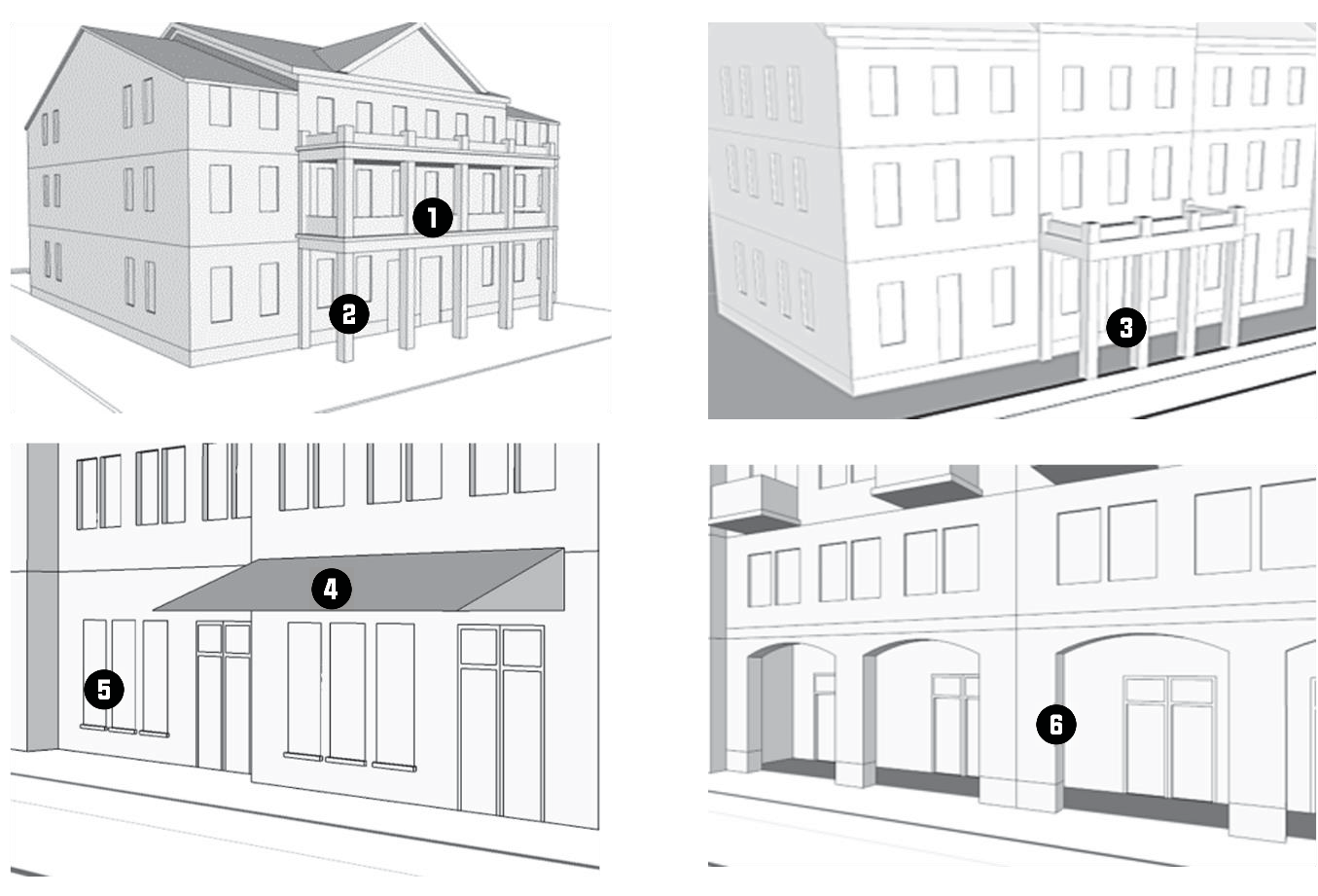
| Table 3.3.5(e)(12)-1: Building Entrance and Mass Elements Key | |
|---|---|
| Key | Building Element |
 | Balcony |
 | Columns |
 | Portico |
 | Canopy |
 | Recessed entry |
 | Arcade |
Figure 3.3.5(e)(12)-2: Bell Tower
(13)
Corner Buildings.
(A)
Buildings located at major intersections along Orlando Avenue (at Lake Avenue, Maitland Avenue, Packwood Avenue, Horatio Avenue, and Sybelia Avenue), shall be designed with architectural embellishments such as corner towers, urban plazas, or other similar design features to emphasize their location as gateways and transition points within the City.
(B)
Buildings on corner lots and buildings that terminate vistas should incorporate distinctive architectural treatments, or other distinguishing features to emphasize their prominent location.
(14)
Building Façade. The façade of a building shall comply with the following standards:
(A)
General Façade Standards. Building façade shall provide visual interest from the perspective of pedestrians and motorists.
(B)
Specific Façade Standards. A building's façade should have clear definition of the following components (see Figure 3.3.5(e)(14): Building Façade):
1.
Base. The base comprises the first floor of the building. The base should include elements such as a water table marked by a cornice line or a change in materials, color, or plane.
2.
Middle. Comprises the area between the first floor and the top. The transition between the first and upper floors shall be marked with a raised cornice, awnings, canopies/marquee, clerestory windows, or similar elements.
3.
Top. All buildings shall have a recognizable top in the form of stepped parapets of various heights with cornice treatment, gables or gable ends, spires, cupolas, dormers, and similar elements. Colored stripes/bands on flat roofs are not acceptable.
Figure 3.3.5(e)(14): Building Façade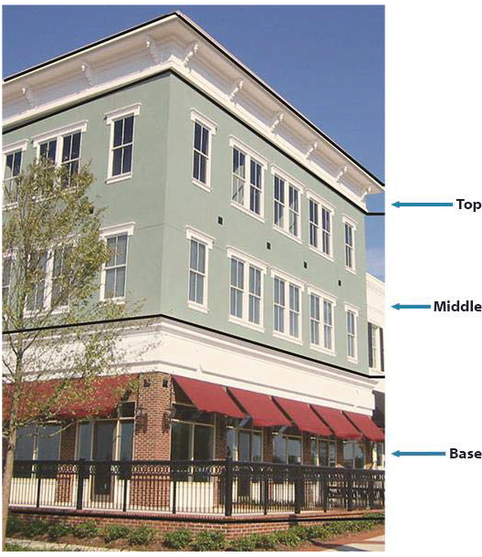
(15)
Building Components.
(A)
Buildings adjacent to pedestrian use areas shall integrate the public and private space using ground floor windows, arcades, and awnings.
(B)
Buildings shall relate to neighboring structures by using unifying design elements such as proportion/scale, rhythm, and fenestration that are consistent with the design and form standards of this Sec. 3.3.5(e).
(C)
Architectural elements (e.g., doorways, dormers, gables, porticos, porches) shall be used to articulate building façades.
(D)
Façades shall include traditional design elements such as: lintels above windows, keystones, protruding sills, roof overhangs with brackets, cornice treatments, brick reveals, columns, pilasters, and hip or gabled roofs and dormers.
(16)
Building Windows. All windows and doors shall meet the following standards:
(A)
First floor windows shall be constructed between zero feet and two-and-a-half (2½) feet above finished floor level.
(B)
Upper level windows shall be differentiated from lower level window treatments.
(C)
Glass shall be transparent, without color, except for stained or art glass; provided the stained or art glass is in character with the style of the building (e.g., churches, craftsman buildings, etc.).
(D)
Windows and doors shall be glazed in clear glass with no more than ten (10) percent daylight reduction (transmittance) for retail establishments, and fifty (50) percent for office and residential uses. Glass reflectance shall not exceed fifteen (15) percent. Glass block is not considered transparent and is not permitted in storefront windows.
(E)
Windows shall not be blacked-out or covered with signage, furniture, window treatments, displays, or similar elements except as provided in Sec. 3.3.5(e)(19)(B)4, Signs Erected on Buildings.
(17)
Building Materials and Covers.
(A)
Permitted Building Materials. Concrete masonry units with stucco and reinforced concrete with stucco are encouraged for use in buildings and accessory structures. Additional accent materials may be approved by the Community Development Director. The following materials are also permitted:
1.
Brick;
2.
"Hardie-Plank" siding;
3.
Wood lap board siding;
4.
Stone; and
5.
Cast Stone.
(B)
Prohibited Building Materials. The following materials are prohibited for buildings (including accessory structures):
1.
Cedar shakes;
2.
Metal/steel (except for architectural accents);
3.
Corrugated or reflective metal panels;
4.
Unfinished block;
5.
Textured plywood;
6.
Mirrored glass and glass curtain walls;
7.
Butler-type buildings;
8.
Plastic siding;
9.
Tile (except for architectural accents); and
10.
EIFS (except for architectural accents).
(C)
Building Colors.
1.
Building, trim, and detail colors shall be complementary and shall not be used to advertise the business. Corporate colors and design shall only be permitted as part of the overall signage design and standards.
2.
Prohibited colors include fluorescent and neon colors, purple, lime green, florescent or day glow and other similar hues. Black as the predominant exterior building color and similar monochromatic (all one-paint color) schemes are prohibited.
3.
A solid line band of color or group of stripes shall not be used for architectural detail.
(18)
Roof Design. Roof features shall be in scale with the building mass, consistent with the architecture of the structure, and comply with the following standards.
(A)
Roof Treatments. Roof treatments and features shall include:
1.
Roof structures varying in height up to fifteen (15) feet above eave line (roof appurtenances are exempt from height requirements);
2.
Parapets or other roof treatments to screen flat roofs and all mechanical equipment from street/pedestrian view;
3.
Multi-plane roofs that incorporate additional gable areas; and
4.
Overhangs no less than three (3) feet beyond the supporting walls with a minimum fascia of eight (8) inches where overhanging eaves are used.
(B)
Prohibited Roof Treatments. Prohibited roof types and materials are:
1.
Asphalt shingles, except laminated, 320-pound, 30-year architectural grade asphalt shingles or better;
2.
Mansard and gambrel roofs and canopies;
3.
Roofs with a two (2) to twelve (12) slope or less without full parapet coverage;
4.
Back-lit awnings used as a mansard or canopy roof;
5.
Roof lines, overhangs, and the front fascia shall be extended to the rear of each building; and
6.
Single plane roofs on sloped roofs.
(19)
Signs. All signs in the DM district shall be erected, altered, and maintained in accordance with the provisions of this subsection and shall be consistent with the requirements of Section 5.14, Signs. Where there is a conflict between these regulations, the regulations of this section shall apply.
(A)
General Requirements.
1.
Sign materials, colors, shapes, and placement shall be compatible with the architecture of the building.
2.
All signs shall be in proportion and to scale with the building façade. Signs shall not be the dominant feature on a building.
3.
Whenever multiple signs are proposed on a single site or a multi-tenant building, the application shall include a Master Sign Plan prepared in accordance with the Procedures Manual that identifies:
a.
The types of signs proposed and their number, size, height, and copy area;
b.
The proposed style and color palette for all letter colors, background colors, and text;
c.
The proposed general location(s) for freestanding signs on a lot, as well as the proposed location(s) for building signs on a building façade;
d.
The type and description of illumination, if any, proposed for all signs; and
e.
A description of any structure (i.e., any wall or fence base) upon which a sign face is proposed to be placed.
4.
Signs may encroach into the activity area but shall not extend over the public right-of-way.
(B)
Permitted On-Site Signs.
1.
General. The only signs to be allowed within the DM district are freestanding, monument, wall, projecting, A-frame, building (including window), and canopy signs.
2.
Standards. The standards that apply to signs in Section 5.14 Signs, apply except as modified in this section.
3.
Monument Signs. Monument signs shall comply with Table 3.3.5(e)(19)(B)3: Monument Sign Standards.
4.
Signs Erected on Buildings. Building signs refer to any sign physically attached to the building. However, as noted in this section, not all types of building signs are allowed:
a.
The maximum allowable sign copy area for signs erected on a building (including on a canopy or awning) on a particular street frontage shall not exceed one (1) square feet per every linear foot of street frontage up to eighty (80) square feet per sign. This maximum allowable copy area may be increased by ten (10) percent for any building higher than thirty-five (35) feet. Specific requirements apply for different types of signs as follows:
i.
Projecting or Blade Signs. The area of a projecting sign shall be no more than six (6) square feet, with a maximum width of thirty-six (36) inches and a maximum height of thirty-six (36) inches. The minimum clearance of the base of the sign shall be eight (8) feet above the sidewalk. See Figure 3.3.5(e)(19)(B)4.a.i: Projecting Sign.
ii.
Wall or Arcade Signs. The maximum width of a wall or arcade sign shall be the width of the shopfront; the minimum copy area height shall be one (1) foot and the maximum shall be three (3) feet. The minimum clearance of the base of the sign shall be eight (8) feet above the sidewalk. See Figure 3.3.5(e)(19)(B)4.a.ii: Wall Sign.
iii.
Canopy or Awning Signs. The maximum area of a sign on a canopy or awning shall not exceed thirty (30) percent of the canopy or awning face area. The minimum copy area shall be one (1) foot and the maximum shall be three (3) feet.
Figure 3.3.5(e)(19)(B)4.a.i: Projecting Sign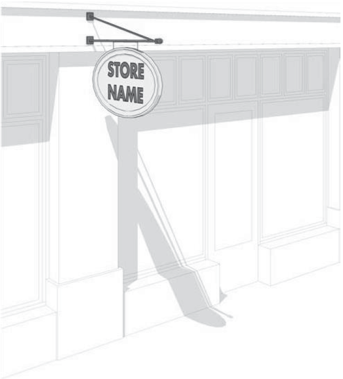
Figure 3.3.5(e)(19)(B)4.a.ii: Wall Sign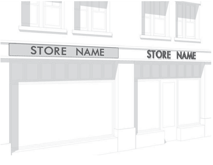
5.
Window signs may not cover more than twenty-five (25) percent of the minimum amount of area required to be provided by Sec. 3.3.5(e)(16), Building Windows, above. One (1) window sign per storefront is permitted. Each such window sign shall be no larger than five (5) feet in width and three (3) feet in height and shall consist of individual letters and designs that are not made of temporary materials and are part of the overall design of the signage. Gold leaf and decals are permitted materials. Painted signs are prohibited.
(20)
Parking Structures. The following standards apply to parking structure façades:
(A)
Vehicle entrances to a parking structure shall be distinct and separate from and coordinated with safe design for pedestrian access.
(B)
Pedestrian access to a parking structure shall be provided directly from adjacent streets.
(C)
When fronting pedestrian-oriented spaces, at least fifty (50) percent of ground floor parking structure frontage, exclusive of entrance driveways, stairwells, and pedestrian entryways, shall consist of active allowed uses in the district, other than parking, such as residences, offices retail, personal services, civic uses, and entertainment businesses. (The Community Development Director may approve other design alternatives, such as a liner building around the outer edge of the parking structure, designed to achieve this intent.)
(D)
The space provided for active allowed uses shall be at least thirty (30) feet deep along its entire length.
(E)
Those areas of the building that do not include ground floor active uses shall provide landscaping instead of paved activity areas.
(F)
Parking structures shall comply with all building design standards for building façade, scale, building features, and lighting, compatibility, and placement on the site. The architectural design of a parking structure façade shall be consistent with neighboring structures and all buildings it is intended to serve. See Figure 3.3.5(e)(20): Parking Structure Façade Examples.
(G)
Parking structures are exempt from the floor height requirements in Sec. 3.3.5(c), Intensity and Dimensional Standards.
Figure 3.3.5(e)(20): Parking Structure Façade Examples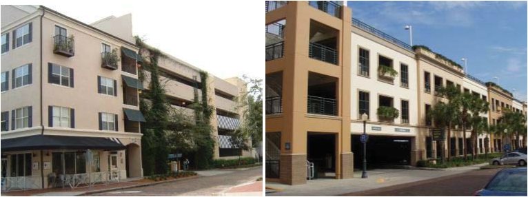
(21)
Stormwater Design.
(A)
The preferred method of accommodating stormwater impacts is through use of regional stormwater facilities in-lieu of accommodating stormwater on site. All stormwater management areas should be incorporated into the project's overall design.
(B)
If the use of regional stormwater facilities is not practical, underground storage and exfiltration are preferred.
(C)
Ponds are encouraged to not be located adjacent to public rights-of-way, but to the side or rear of a development.
(D)
Wet stormwater areas shall be designed as amenities. Features such as fountains or aerators shall be required to accent the ponds and provide adequate aeration to prevent stagnation and fish kills.
(E)
Landscaping is required to soften the visual appearance of a pond's edges. Native trees and shrubs shall be used for landscaping. No exotic invasive plants are permitted.
(F)
Subject to the requirements of the St. Johns River Water Management District, other governmental agencies, and a consideration of safety related issues, stormwater facilities shall be prohibited from having fencing unless it is demonstrated it is necessary due to the configuration and topography of the lot in accordance with Appendix A: Engineering and Design Manual.
(G)
Whether stormwater is provided onsite or offsite, low-impact design concepts such as rainwater harvesting, green roofs, bio-swales, rain gardens, parking lot water capture, and pervious pavement are encouraged to be used. The goal of encouraging the use of these mechanisms is to reduce stormwater runoff, capture contaminants closer to the source, and reduce the use of potable water for irrigation and grey water activities.
(22)
Service Areas/Utilities. The following standards apply to all utility and service areas:
(A)
Outdoor storage, trash collection, and loading areas shall not be located adjacent to land in a Residential zone district. If site constraints exist, outdoor storage, trash collection, and loading areas may be located adjacent to lands in a Residential zone district if:
1.
The service areas are screened from view by a wall that is at least one (1) foot higher than the largest object being screened, but no more than eight (8) feet high, on all sides where access is not needed. Where access is needed, an opaque gate of the same height as the wall shall be provided;
2.
The wall shall be obscured by landscaping. Sufficient planting materials shall be used such that no more than two-thirds (⅔) of the surface area of the screening wall is visible from the street within three (3) years of the wall's erection. Plant materials used to fulfill these requirements shall be a minimum of four (4) feet in height when planted, and planted so that there is no gap greater than two (2) feet between plant foliage. Alternatively, the required landscape screening may be provided by a natural evergreen plant material which can be expected to reach six (6) feet or greater within two (2) years of planting;
3.
Deliveries and collections are prohibited between 10:00 p.m. and 7:00 a.m.; and
4.
Commercial vehicular idling is prohibited.
(B)
Loading areas or docks, outdoor storage, waste disposal, mechanical equipment, satellite dishes, truck parking, and other service support equipment shall be located behind the building line and shall be fully screened from the view of adjacent properties.
(C)
Areas for outdoor storage, trash collection, and loading areas shall be incorporated into the primary building design, and construction for these areas shall be of materials of comparable quality and appearance as that of the primary building.
(D)
Shopping cart storage shall be located inside the building or shall be screened by a wall at least four (4) feet in height consistent with the building architecture and materials.
3.4.1. - General Purpose of Nonresidential Districts.
The purpose and intent of the non-residential zone districts is to:
(a)
Accommodate small-scale retail development that supports established neighborhoods within the City; or
(b)
Accommodate the development, maintenance, and expansion of special government and cultural land uses.
3.4.2. - Established Nonresidential Districts.
Nonresidential districts established by this LDC are identified in Table 3.4.2: Established Nonresidential Districts.
3.4.3. - GAP: Government, Arts, and Public District.
| (a) Purpose | |
| The purpose of the GAP: Governments, Arts, and Public District is to provide lands that accommodate a variety of government and cultural uses along with supportive ancillary uses. It is designed to have flexible development standards to accommodate the wide range of government uses, such as parks and libraries, that are allowed and the variety of land uses that may surround it. | |
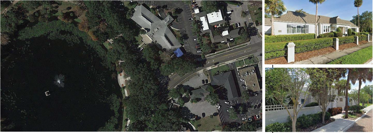 | |
| (b) Use Standards | |
| Allowed uses and use-specific standards for principal, accessory, and temporary uses are established in Article 4: Use Regulations. | |
| (c) Intensity and Dimensional Standards | |
| Standard | All Uses |
| Lot area, min. (sf) | — |
| Lot width, min. (ft) | N/A |
| Front yard setback, min. (ft) | — |
| Side yard setback, min. (ft) | — |
| Rear yard setback, min. (ft) | — |
| Building height, max. (ft) | |
| Building stories, max. (ft) | N/A |
| Impervious coverage, max. (%) | 70 |
| FAR, max. | [1] |
|
NOTES: sf = square feet; ft = feet; min.= minimum; max.= maximum
[1] Maximum FAR is controlled by the Comprehensive Development Plan Future Land Use Element, Table 1.1. | |
| (d) Reference to Other Standards | |
| Section 5.1 Mobility and Connectivity Standards | Section 5.10 Residential Compatibility Standards |
| Section 5.2 Off-Street Parking, Bicycle, and Loading Standards | Section 5.11 Architectural, Form, and Design Standards |
| Section 5.3 Landscape, Buffer, and Tree Protection Standards | Section 5.12 Sustainable Development Standards |
| Section 5.4 Open Space Set-Aside Standards | Section 5.13 Sustainable Development Incentives |
| Section 5.5 Vegetation Removal | Section 5.14 Signs |
| Section 5.6 Residential Tree Protection | Section 5.15 Building Numbering and Street Naming |
| Section 5.7 Flood Damage Prevention | Article 6 Subdivision Standards |
| Section 5.8 Fence and Wall Standards | Article 7 Public Facility Funding |
| Section 5.9 Exterior Lighting Standards | Appendix A Engineering and Design Manual |
3.4.4. - NC: Neighborhood Commercial District.
| (a) Purpose | ||
| The purpose of the NC: Neighborhood Commercial District is to provide lands that accommodate a limited range of small-scale neighborhood-serving commercial uses within or at the edge of the City's residential neighborhoods and along roadways. The district may apply to portions of a block, consisting of a few storefronts with limited on-site parking, and is intended for neighborhood-serving uses that are primarily pedestrian-oriented. The district regulations are intended to ensure that uses, development intensities, and development forms are consistent with this pedestrian-friendly and neighborhood scale. Allowable uses include limited retail sales and services, personal services, eating or drinking establishments, and related uses. Small-scale mixed-use development (residential over ground floor) is also permitted at a scale and form that is consistent with district character. | ||
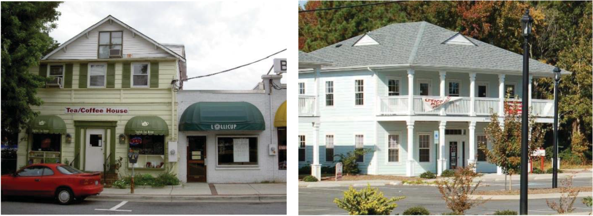 | ||
| (b) Use Standards | ||
| Allowed uses and use-specific standards for principal, accessory, and temporary uses are established in Article 4: Use Regulations. | ||
| (c) Intensity and Dimensional Standards | ||
| Standard | All Uses [1] | |
| Lot area, min. (sf) | 7,500 | |
| Lot width, min. (ft) | 75 | |
| Build-to zone, min. | max (ft) | 5 | 15 (35) [1] | |
| Side yard setback, min. (ft) | 10 | 30 [2] | |
| Rear yard setback, min. (ft) | 10 | 30 [2] | |
| Building height, max. (ft) | 35 | |
| Building stories, max. (ft) | 2 | |
| Building floorplate, max. (sf) | 5,000 | |
| Impervious coverage, max. (%) | 70 | |
| Density, max (du/acre) | N/A [3] | |
|
NOTES: sf = square feet; ft = feet; du = dwelling units; min.= minimum; max.= maximum
[1] For one-story buildings, all parking shall be located to the side or rear of the building. For two-story buildings, a single row of parking and accompanying drive aisle may be added in front of the building, in which case the maximum build-to zone is increased to 35 feet from the property line. [2] Thirty (30) feet from the lot line when adjacent to a residential use or a Residential zone district. [3] Residential development is only allowed above the ground floor. | ||
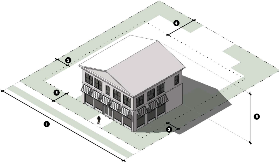 | ||
| (d) Reference to Other Standards | ||
| Section 5.1 Mobility and Connectivity Standards | Section 5.10 Residential Compatibility Standards | |
| Section 5.2 Off-Street Parking, Bicycle, and Loading Standards | Section 5.11 Architectural, Form, and Design Standards | |
| Section 5.3 Landscape, Buffer, and Tree Protection Standards | Section 5.12 Sustainable Development Standards | |
| Section 5.4 Open Space Set-Aside Standards | Section 5.13 Sustainable Development Incentives | |
| Section 5.5 Vegetation Removal | Section 5.14 Signs | |
| Section 5.6 Residential Tree Protection | Section 5.15 Building Numbering and Street Naming | |
| Section 5.7 Flood Damage Prevention | Article 6 Subdivision Standards | |
| Section 5.8 Fence and Wall Standards | Article 7 Public Facility Funding | |
| Section 5.9 Exterior Lighting Standards | Appendix A Engineering and Design Manual | |
3.5.1. - General Purpose of Planned Development Districts.
The purpose and intent of the Planned Development zone districts is to encourage land uses and designs that are innovative, integrated, and incorporate multiple uses in a way that makes efficient use of land and allows for creative site planning.
3.5.2. - Established Planned Development Zone Districts.
The Planned Development zone districts established by this LDC are identified in Table 3.5.2: Established Planned Development Zone Districts.
3.5.3. - General Provisions for All Planned Development Districts.
(a)
Classification of Planned Development Zone Districts. Land shall be classified into a Planned Development zone district only in accordance with the procedures and standards set forth in Sec. 2.5.1(f), Planned Development, and this section.
(b)
Organization of Planned Development Zone District Regulations. The following general standards apply to all types of Planned Development zone districts. Sec. 3.5.4, PD: Planned Development District, and Sec. 3.5.5, DM-PD: Downtown Maitland — Planned Development District, include additional provisions and standards for each of the different types of Planned Development districts.
(c)
Standards for All Planned Development Zone Districts. Before approving a Planned Development zone district, the City Council shall find that the application for the Planned Development district classification, as well as the PD Plan and PD Agreement, comply with the following standards.
(1)
PD Plan. As set forth in Sec. 2.5.1(f), Planned Development, a PD Plan is a required component in the establishment of a planned development zone district. The PD Plan is a master plan for the district that depicts the general configuration and relationship of the principal elements of the proposed development. The PD Plan shall accomplish the following:
(A)
Statement of Planning and Goals. Establish a statement of planning and development goals for the PD district that is consistent with the comprehensive development plan and other adopted City plans, as applicable, as well as the purposes of the individual PD district;
(B)
Allowable Uses. Identify the specific principal, accessory, and temporary uses permitted in the PD district. They shall comply with the Principal Use Table (see Article 4: Use Regulations) and the purposes of the PD district. Uses shall also be subject to applicable use-specific standards identified in the PD Plan, and any additional limitations or requirements applicable to the individual PD district;
(C)
General Location and Layout. Establish the general location of each development area in the PD district, its acreage, types, and mix of land uses (if applicable), number of residential units (by use type), nonresidential floor area (by use type), residential density, and nonresidential intensity;
(D)
Density, Intensity, and Dimensional Standards. Establish the density, intensity, and dimensional standards that apply in the individual PD district. The density, intensity, and dimensional standards shall be consistent with the requirements of the individual PD district and its purposes;
(E)
Compatibility Standards. Where relevant, establish the standards and requirements that ensure development on the perimeter of the PD district is designed and located to be compatible with the character of adjacent existing or approved development. Determination of compatible character shall be based on densities/intensities, lot size and dimensions, building height, building mass and scale, form and design features, hours of operation, exterior lighting, and siting of service areas;
(F)
Open Space. Establish the general location, amount, and type (whether designated for active or passive recreation) of open space, consistent with the purposes of the individual PD district;
(G)
Environmental Protection. Identify the location of environmentally sensitive lands, resource lands, wildlife habitat, and waterway corridors, and indicate how protection of these lands will be assured consistent with the purposes of the individual PD district and the requirements of this LDC;
(H)
Pedestrian and Bicycle Circulation. Identify the on-site pedestrian and bicycle circulation systems, and how they will connect to off-site pedestrian and bicycle systems in ways that are consistent with the purposes of the individual PD district, and the requirements of this LDC;
(I)
Vehicular Circulation. Identify the general design and layout of the on-site transportation circulation system, including the general location of all public streets, existing or projected transit corridors, and how they interface with the pedestrian circulation system (pedestrian and bicycle pathways, and trails), and connect to existing and planned City and regional systems in a manner consistent with the purposes of the individual PD district, and the requirements of this LDC;
(J)
Projected Impacts on Utilities and Recreation Facilities. Identify the projected impact of the development on surrounding utility services and park and recreation facilities, and whether there is adequate capacity to accommodate the proposed development;
(K)
Water and Wastewater Facilities. Identify the general location of on-site potable water and wastewater facilities, and how they will connect to existing and planned City and regional systems in a manner consistent with the purposes of the individual PD district, and the requirements of this LDC;
(L)
Drainage Facilities. Identify the general location of on-site storm drainage facilities, and how they will connect to existing and planned City systems, in a manner consistent with the purposes of the individual PD district, and the requirements of this LDC;
(M)
Public Facilities. Identify the general location and layout of all other on-site and off-site public facilities serving the development, and how they are consistent with the purposes of the individual PD district. The other on-site and off-site public facilities considered shall include — but not be limited to — parks, schools, and facilities for fire protection, police protection, emergency management, and solid waste management;
(N)
Stormwater Management Facilities. Establish provisions addressing how potable water, wastewater, stormwater management, and similar public utilities will be provided to accommodate the proposed development; and
(O)
Additional Development Standards. Establish the development standards that will be applied if differing from the development standards in this LDC. The development standards shall be consistent with the requirements of the individual PD district and its purposes, and the requirements of this LDC, as appropriate. At a minimum, the development standards shall address:
1.
Mobility and Connectivity Standards;
2.
Off-Street Parking, Bicycle, and Loading Standards;
3.
Landscape, Buffer, and Tree Protection Standards;
4.
Exterior Lighting Standards;
5.
Vegetation Removal;
6.
Residential Tree Protection;
7.
Residential Compatibility Standards, if applicable;
8.
Architectural, Form, and Design Standards;
9.
Sustainable Development Standards;
10.
Signs; and
11.
Subdivision Standards.
(P)
Development Phasing Plan. If development is proposed to be phased, the PD Plan shall include a development phasing plan that identifies:
1.
The general sequence or phases in which the planned development is proposed to be developed, including how residential and nonresidential development will be phased;
2.
How infrastructure (public and private), open space, and other amenities will be provided and timed;
3.
How development will be coordinated with the City's capital improvements program;
4.
How each development and phase can exist as an independent unit capable of creating a stable and desirable environment; and
5.
How environmentally sensitive lands will be protected and monitored.
(Q)
Conversion Schedule. If applicable, a conversion schedule that identifies the extent to which one type of use may be converted to another type of use and the methodology that will be used to determine the conversion.
(2)
Development Standards.
(A)
Development in a Planned Development zone district shall comply with the standards in Article 5: Development Standards, Article 6: Subdivision Standards, and Article 7: Public Facility Funding, unless they are modified as allowed by Table 3.5.3(c)(2): Planned Development District Development Standards Subject to Modification.
(B)
Modifications to development standards, as allowed by Table 3.5.3(c)(2): Planned Development District Development Standards Subject to Modification, shall be:
1.
Consistent with the purposes of the Planned Development district; and
2.
Documented in the PD Plan and PD Agreement, with a clear basis for why the change is needed, how it supports the purposes of the district, and how it supports high-quality development.
(3)
PD Agreement.
[A]
A PD Agreement is also a required component for the establishment of a Planned Development district. It includes all terms and conditions relating to the approval of the district, including monitoring rules, phasing rules (where relevant), requirements for how mitigation will occur, and how public facilities will be provided to serve the planned development. A PD Agreement shall include, but not be limited to:
1.
Conditions related to approval of the application for the individual PD district classification;
2.
Conditions related to the approval of the PD Plan, including any conditions related to the form and design of development shown in the PD Plan;
3.
Provisions addressing how public facilities (pedestrian and bicycle, other transportation, potable water, wastewater, stormwater management, and other public facilities) will be provided to accommodate the proposed development. This shall include but not be limited to:
a.
Recognition that the applicant/landowner will be responsible to design and construct or install required and proposed on-site public facilities in compliance with applicable City, state, and federal regulations; and
b.
The responsibility of the applicant/landowner to dedicate to the public the rights-of-way and easements necessary for the construction or installation of required and proposed on-site public facilities in compliance with applicable City, state, and federal regulations.
4.
Provisions related to environmental protection and monitoring (e.g., restoration of mitigation measures, annual inspection reports);
5.
Identification of community benefits and amenities that will be provided to compensate for the added development flexibility afforded by the individual PD zoning district;
6.
The development phasing plan described in subsection (1)(P) above;
7.
The conversion schedule described in subsection (1)(Q) above; and
8.
Any other provisions the City Council determines are relevant and necessary to the development of the Planned Development district.
(B)
All conditions shall be related in both type and amount to the anticipated impacts of the proposed development on the public and surrounding lands.
(4)
Compensating Community Benefits. Compensating community benefits shall also be identified in the PD Plan and the PD Agreement. These benefits shall be in addition to what is otherwise required to meet the minimum standards of this LDC and other City, county, state, and federal regulations. They may include, but are not limited to:
(A)
Improved Design. The use of architectural design that exceeds any minimum standards established in this LDC or any other City regulation, or the use of site design incorporating principles of walkable urbanism and traditional neighborhood development, compatible with the comprehensive development plan and other adopted City plans.
(B)
Sustainable Development Standards. The use of sustainable development standards for environmental, energy efficiency, or resiliency principles in community, site, and building design, beyond the minimum standards established in Section 5.12, Sustainable Development Standards.
(C)
Natural Preservation. The preservation on the site of environmentally sensitive lands, natural features, or trees that exceed the requirements of this LDC.
(D)
Dedication of Land or Facilities or In-Lieu Fee Contribution.
1.
Parks, Recreation, and Open Space. The dedication of land, construction of facilities, or contribution of an in-lieu fee for public parks, trails and trail linkages, greenways, waterfront access, recreation facilities, or open space identified in the comprehensive development plan or other adopted City plans, beyond the requirements of Section 5.4, Open Space Set-Aside Standards.
2.
Stormwater Management Facilities. The dedication of land, construction of facilities, or contribution of an in-lieu fee for stormwater management facilities that exceed the requirements of the LDC or the City Code.
3.
Transportation Facilities. The dedication of land, construction of facilities, or contribution of an in-lieu fees for off-site transportation facilities that exceed the requirements of Section 5.1, Mobility and Connectivity Standards, and Section 5.2, Off-Street Parking, Bicycle, and Loading Standards.
4.
Community Facilities. The dedication of land or construction of facilities for community facilities (e.g., cultural arts center, public plaza, and public art) identified in the comprehensive development plan or other adopted City plans.
5.
Other. Any other community benefit that would provide benefits to the development site and the citizens of the City, generally.
3.5.4. - PD: Planned Development District.
(d)
Additional Development Standards. In addition to the general standards set forth in Sec. 3.5.3, General Provisions for All Planned Development Districts, development in the PD district that is within the Employment Center designation on the Future Land Use Map in the comprehensive development plan shall comply with the design and form standards that apply to the WS district in Sec. 3.3.4(e), Design and Form Standards, unless they are modified in an approved PD Plan. Where standards differ between the WS-RT and WS-NM subdistricts, the PD Plan shall identify which of these subdistrict standards are applicable to the proposed development based on its location relative to other lands zoned WS-RT and WS-NM, and if applicable identify how the standards are proposed to be modified in accordance with Sec. 3.5.3(c)(2)(B) above.
3.5.5. - DM-PD: Downtown Maitland — Planned Development District.
(d)
DM-PD Zone District Development Standards. In addition to the general standards in Sec. 3.5.3, General Provisions for All Planned Development Districts, development in the DM-PD district shall comply with the following:
(1)
Design and Form Standards. Development in the DM-PD district shall comply with the design and form standards of the DM district in Sec. 3.3.5(e), Design and Form Standards, unless they are modified in an approved PD Plan, except for the following standards which shall not be modified:
(A)
Sec. 3.3.5(e)(2), Building Placement and Orientation;
(B)
Sec. 3.3.5(e)(4), Public Frontage Standards; and
(C)
Sec. 3.3.5(e)(7), Parking Lot Location.
(2)
Density Incentive Community Enhancement (DICE). The DICE program provides landowners/developers the opportunity to obtain density and intensity enhancements through approval of a DM-PD District in accordance with the procedures and standards of this section and Sec. 2.5.1(f), Planned Development, if the following types of community enhancements or benefits are provided to sufficiently offset any impacts from the increase in density and intensity, and the landowner/development appropriately mitigates all other impacts:
(A)
Regional stormwater ponds;
(B)
Shared parking structures;
(C)
Street extensions;
(D)
Bicycle/pedestrian connectivity;
(E)
Quality public active/passive open spaces; and/or
(F)
Undergrounding of downtown utilities.
(e)
Density Incentive Community Enhancement Program (DICE). The DICE program is a voluntary program providing applicants with the opportunity for density and intensity enhancements in planned developments within the Downtown Maitland district if the applicant is able to sufficiently offset the impacts from the increase in density and intensity consistent with one (1) or more of the six (6) general priorities identified in policy 1.1.16 of the 2035 Comprehensive Development Plan, including regional stormwater ponds, shared parking structures, street extensions, bike/pedestrian connectivity, quality public active/passive open spaces, and/or undergrounding of downtown utilities. While the city has identified six (6) general priorities, the applicant volunteering to participate in the DICE program is responsible for: (a) creating a specific proposal to offset the impacts of any increased density and/or intensity on public infrastructure, facilities, and/or utilities; (b) demonstrating there is an essential nexus between the applicant's specific proposal for public enhancements and the applicant's development; and (c) demonstrating the cost and/or public benefits derived from the applicant's specific proposal for public enhancements are roughly proportional to the cost and/or actual impact on public infrastructure, facilities, and/or utilities arising from the increased density and intensity of the development. No DICE application or request will be approved unless there is an essential nexus between the specific public benefits proposed by the applicant and the development; and the public benefits proposed by the applicant are roughly proportional to the increased density and/or intensity of the development. All DICE applications or requests made in conjunction with a planned development and approved by city council shall be reduced to writing in an enforceable development agreement.
(1)
Purpose and intent. The purpose of the density incentive community enhancement (DICE) program is to provide applicants an opportunity to apply for an increase in base-level density and intensity entitlements within the main street future land use designation of the Downtown Maitland district whereby the applicant offers to offset the impact from such increases in exchange for the provision of public improvements. The intent of the DICE program includes:
(A)
To provide for a voluntary program whereby the applicant has the incentive, discretion and flexibility to create a specific proposal for public enhancements, facilities, infrastructure, or utilities to offset the actual impact of the applicant's request for increased density and/or intensity on existing public infrastructure, facilities, or utilities;
(B)
To provide applicants with a general, non-comprehensive list of the city's priorities, as identified in the 2035 Comprehensive Development Plan, including regional infrastructure improvements such as stormwater ponds, shared parking structures, street extensions, bicycle and pedestrian connectivity, active and passive open spaces, and undergrounding of utilities, to aid applicants in the development of their specific proposal; and
(C)
To ensure there is an essential nexus between the applicant's specific proposal for public enhancements and the development; and the cost of the public enhancement is roughly proportional to the impact from the applicant's increased density and/or intensity.
(2)
Density and Site Floor Area Ratio. The maximum residential density and site floor area ratio (FAR) entitlements for properties in the main street future land use designation of the Downtown Maitland district are codified in subsection (c) above. As an option to applicants who wish to obtain increased densities and floor area ratios up to a maximum cap set forth in subsection (c) above, the DICE program allows such applicants to develop or contribute to the development of public enhancements in exchange for such increases in density and/or floor area ratios.
(3)
Operation. The DICE program shall be a voluntary program. No applicant for development of any kind shall be required to participate in the program. An applicant applying for the DICE program shall be responsible for:
(A)
Initiating and requesting the community development department place the applicant on a city council workshop agenda per Sec. 2.5.1(f)(3)(C) Initial City Council Review, whereas the applicant will discuss its intent to apply for participation in the DICE program, the anticipated increase in density or site FARs that will be requested, and the applicant's general plan to offset those impacts through the provision of specific public enhancements. At the workshop, the applicant should also be prepared to discuss how the applicant intends to demonstrate a nexus between the applicant's proposed public enhancement and the applicant's development, and how the applicant intends to demonstrate that the cost of the applicant's proposed public enhancement is roughly proportional to the cost and/or impact on public infrastructure, facilities or utilities from the increased density or site FAR the applicant intends to request;
(B)
Although the 2035 Comprehensive Development Plan provides a list of general public enhancement priorities for the city, the applicant is solely responsible for creating a specific proposal to offset the impact from the requested increase in densities and FARs through public enhancements;
(C)
Demonstrating an essential nexus exists between with applicant's development and the applicant's proposed public enhancement, and that the cost of the public enhancement is roughly proportional to the actual impact and/or cost from the increased densities and/or site FARs;
(D)
Entering into a development agreement with the city as part of the final planned development site plan approval process; and
(E)
Payment of any expenses incurred by the city for the services of outside professional engineers, architects, appraisers, attorneys, or others with respect to the DICE application through the city's pass-through ordinance.
(4)
DICE Program Approval. The city council shall approve or deny an applicant's DICE program application as part of the applicant's final planned development. A development agreement between the city and the applicant shall also be required at the time the final planned development is approved by city council. In addition to the requiring consistency with the 2035 Comprehensive Development Plan and the Land Development Code, the city council shall not approve an application for the DICE program unless it determines that the applicant has (1) demonstrated an essential nexus between the applicant's development and the applicant's proposed public enhancement; and (2) demonstrated a rough proportionality between the cost of the proposed public enhancement and the actual cost or impact of the increased densities and/or site FAR on exiting public infrastructure, facilities or utilities.
(5)
DICE Funds. The city manager shall establish a DICE program fund account whereby applicants may deposit funds in lieu of providing a specific public enhancement where the applicant deems it appropriate. If funds are deposited in lieu of a specific public enhancement, the applicant will still be required demonstrate compliance with the essential nexus and rough proportionality requirements of subsection (4) above. Amounts on deposit in the DICE fund account shall be specifically designated for each project and shall be promptly used by the city for specific public enhancements detailed within the terms of the development agreement. If funds deposited by an applicant/developer are not utilized by the city within five years from the date of deposit, the city shall refund all remaining funds to the applicant/developer upon written request.
3.6.1. - General Purpose of Overlay Districts.
The purpose and intent of overlay zone districts are to provide supplemental standards with respect to special areas, land uses, or environmental features that supersede the standards of the underlying base zone district.
3.6.2. - Established Overlay Districts.
The overlay zone districts established by this LDC are identified in Table 3.6.2: Established Overlay Districts.
3.6.3. - Conflicting Standards.
If there is a conflict between any base zone district and overlay district regulations, the overlay district regulations shall control, unless expressly stated to the contrary.
3.6.4. - Classification of Overlay Districts.
Land shall be classified or reclassified into an overlay zone district only in accordance with the procedures and standards in Sec. 2.5.1(e), Site-Specific Zone District Map Amendment.
3.6.5. - CHA-O: Culture, History, and Arts Overlay.
(a)
Purpose. The purpose of the Culture, History, and Arts Overlay (CHA-O) district is to:
(1)
Support and protect the City's cultural and historic features in a way that ensures these features become part of the City's identity;
(2)
Protect and enhance the unique urban environment of the lands adjacent to the Maitland Art Center and Lake Lily Park;
(3)
Provide connections between the important historical and cultural features in the City like the Maitland Art Center, Waterhouse Building, and the Maitland Public Library; and
(4)
Ensure development in the overlay district is compatible with development in the DM- Downtown Maitland District.
(b)
Applicability.
(1)
General Applicability.
(A)
Unless exempted in accordance with subsection (2) below, the standards and requirements of this section apply to new development and redevelopment within the CHA-O district.
(B)
A parcel of land that is split by the CHA-O district is considered to be in the CHA-O district if the majority of the land is located within that district.
(2)
Exemptions. Development on City-owned lands is exempt from the standards and requirements of the CHA-O district.
(3)
Place District on Official Zoning District Map. The CHA-O district is identified on the Official Zoning District Map.
(c)
Modifications of Otherwise Applicable Development Regulations.
(1)
Underlying Base Zone District Regulations. Unless required in accordance with subsection (2) below, the development standards for the underlying base zone district apply.
(2)
Standards that Apply in the CHA-O District. The standards in the CHA-O District are listed in Table 3.6.5(c)(2): CHA-O District Dimensional and Development Standards and apply as follows:
(A)
New Development. All new development shall comply with the standards in Table 3.6.5(c)(2).
(B)
Existing Development. An expansion or alteration of development that existed on March 1, 2022 shall comply with the standards Table 3.6.5(c)(2) to the maximum extent practicable, if the expansion increases the building's floor area by fifty (50) percent or more, or the alteration involves fifty (50) percent or more of the building's gross floor area, as measured over any five-year period.