
Maitland City Zoning Code
ARTICLE 5
DEVELOPMENT STANDARDS
SECTION 5.6.- RESIDENTIAL MINIMUM TREE QUANTITIES AND TREE PROTECTION[1]
Editor's note—Ord. No. 1434, § 1, adopted October 14, 2024, amended Section 5.6 in its entirety to read as herein set out. Former Section 5.6, §§ 5.6.1—5.6.5, pertained to residential tree protection, and derived from Ord. No. 1407, § 10, September 12, 2022.
5.1.1.- Purpose.
The purpose of this section is to ensure that developments are served by a coordinated multimodal transportation system that permits the safe and efficient movement of motor vehicles, emergency vehicles, transit, bicyclists, and pedestrians within the development and between the development and external transportation systems, neighboring development, and local destination points such as places of employment, schools, parks, and shopping areas. Such a multimodal transportation system is intended to:
(a)
Provide transportation options;
(b)
Increase the effectiveness of local service delivery;
(c)
Reduce emergency response times;
(d)
Promote walking and bicycling;
(e)
Facilitate use of public transportation;
(f)
Contribute to the attractiveness of the development and community;
(g)
Connect neighborhoods and increase opportunities for interaction between neighbors;
(h)
Reduce vehicle miles of travel and travel times;
(i)
Reduce greenhouse gas emissions;
(j)
Improve air quality;
(k)
Minimize congestion and traffic conflicts; and
(l)
Preserve the safety and capacity of the City's transportation systems.
5.1.2. - Applicability.
(a)
New Development. All new development shall comply with the standards of this section.
(b)
Existing Development. An expansion or alteration of development that existed on March 1, 2022 shall comply with the standards of this section to the maximum extent practicable, if the expansion increases the building's floor area by fifty (50) percent or more, or the alteration involves fifty (50) percent or more of the building's gross floor area, as measured over any five-year period.
(c)
Timing of Review. Review for compliance with the standards in this section shall occur during review of a development application for planned development (Sec. 2.5.1(f), Planned Development), site plan (Sec. 2.5.2(a), Site Plan), subdivision (Sec. 2.5.2(b), Subdivision), site construction permit, or building permit, whichever occurs first.
5.1.3. - Developer Responsible for Access and Circulation Improvements.
The developer of the development being reviewed in accordance with this section shall provide the road, street, bikeway, sidewalk, and other access and circulation improvements, both on the development site and off the site as required by the approved development order, in accordance with the standards for design and construction in Appendix A: Engineering and Design Manual; Article 6: Subdivision Standards; and this Article 5: Development Standards; and shall dedicate any required rights-of-way or easements, as appropriate.
5.1.4. - Multimodal Access and Circulation System.
Development subject to the requirements of this section shall comply with the following standards:
(a)
Multimodal Access and Circulation System. All developments shall be served by a system of sidewalks, paths, streets, accessways, and other facilities designed to provide for multiple travel modes (vehicular, transit, bicycle, and pedestrian), as appropriate to the development's size, character, and relationship to surrounding development and development patterns and existing and planned community transportation systems. Vehicular, transit, bicycle, and pedestrian access and circulation systems shall be coordinated and integrated so as to provide transportation choices within and to and from the proposed development, as appropriate.
(b)
Cross Access Between Adjoining Development.
(1)
Vehicular Cross-Access.
(A)
An internal vehicular circulation system in nonresidential and mixed-use development that is subject to the requirements of this section shall be designed and constructed to provide vehicular cross-access between any parking lots within the development and any parking lots on adjoining parcels containing nonresidential or mixed-use development, and to the boundary of adjoining vacant land if it is in a Mixed-Use or Nonresidential district, and to a Planned Development district that includes nonresidential development. The cross-access shall consist of a driveway or drive aisle that is at least twenty-two (22) feet wide and that provides two-way access. See Figure 5.1.4(b)(1): Example of Parking Lot Cross-Access.
(B)
Easements allowing cross-access to and from lands served by a vehicular cross-access in accordance with subsection (A) above, along with agreements defining maintenance responsibilities of land owners pertaining to the vehicular cross-access, shall be recorded in the public records of Orange County.
(C)
The Development Review Committee (DRC) may waive or modify the requirement for vehicular cross-access established in subsection (A) above on determining that such cross-access is impractical or undesirable due to the presence of topographic conditions, natural features, vehicular safety factors, or land use conflicts.
Figure 5.1.4(b)(1): Example of Parking Lot Cross-Access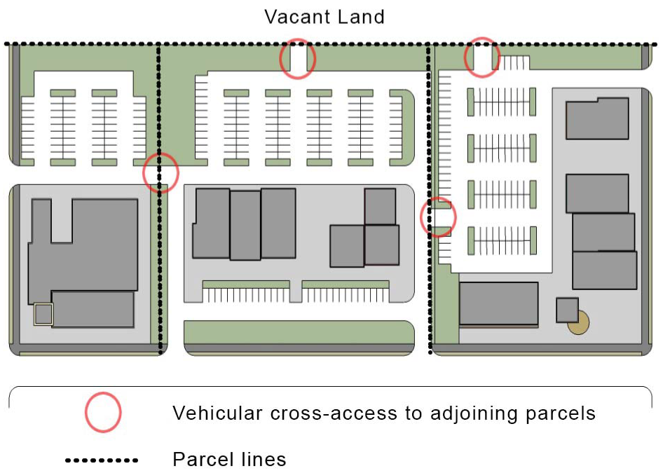
(2)
Pedestrian Cross-Access.
(A)
Multifamily, nonresidential, or mixed-use development subject to the requirements of this section shall establish an internal pedestrian circulation system that is designed to allow for pedestrian walkway cross access between the development's buildings and parking areas and those on adjoining lots containing multifamily, nonresidential, or mixed-use development, and to vacant lands.
(B)
Easements allowing cross-access to and from properties served by a pedestrian cross-access in accordance with subsection (A) above, along with agreements defining maintenance responsibilities of land owners, shall be recorded in the public records of Orange County.
(C)
The Community Development Director may waive or modify the requirement for pedestrian cross-access established in subsection (A) above on determining that such cross-access is impractical or infeasible due to the presence of topographic conditions or natural features.
(3)
Bicycle Facilities. All new development shall include bike lanes, bike paths, multiuse paths, or other facilities sufficient to allow safe and efficient bicycle access and circulation within the development and to connected developments where consistent with the City of Maitland Bike and Pedestrian Master Plan, as amended.
(c)
Connectivity.
(1)
Street Layout Standards. All development that provides streets shall lay them out in accordance with Sec. 3.2, Streets, in Appendix A: Engineering and Design Manual.
(2)
Culs-de-Sac. A right-of-way at least eight (8) feet wide shall be provided in a single-family or two-family residential subdivision for pedestrian and bicycle access between a cul-de-sac head or street turnaround and the closest street or pedestrian path (as shown in Figure 5.1.4(c)(2): Pedestrian Connections), if the cul-de-sac:
(A)
Is in close proximity (defined generally as within a one-quarter-mile) to significant pedestrian generators or destinations such as schools, parks, trails, greenways, employment centers, mixed use development, retail centers, or similar features; or
(B)
Creates an unreasonable impediment to pedestrian circulation (defined generally as walking distance between uses on the cul-de-sac and uses on the closest street that is at least four (4) times the actual physical distance between these two (2) uses); and
(C)
Can be reasonably connected to an existing or proposed sidewalk, trail, greenway, or other type of pedestrian connection.
Figure 5.1.4(c)(2): Pedestrian Connections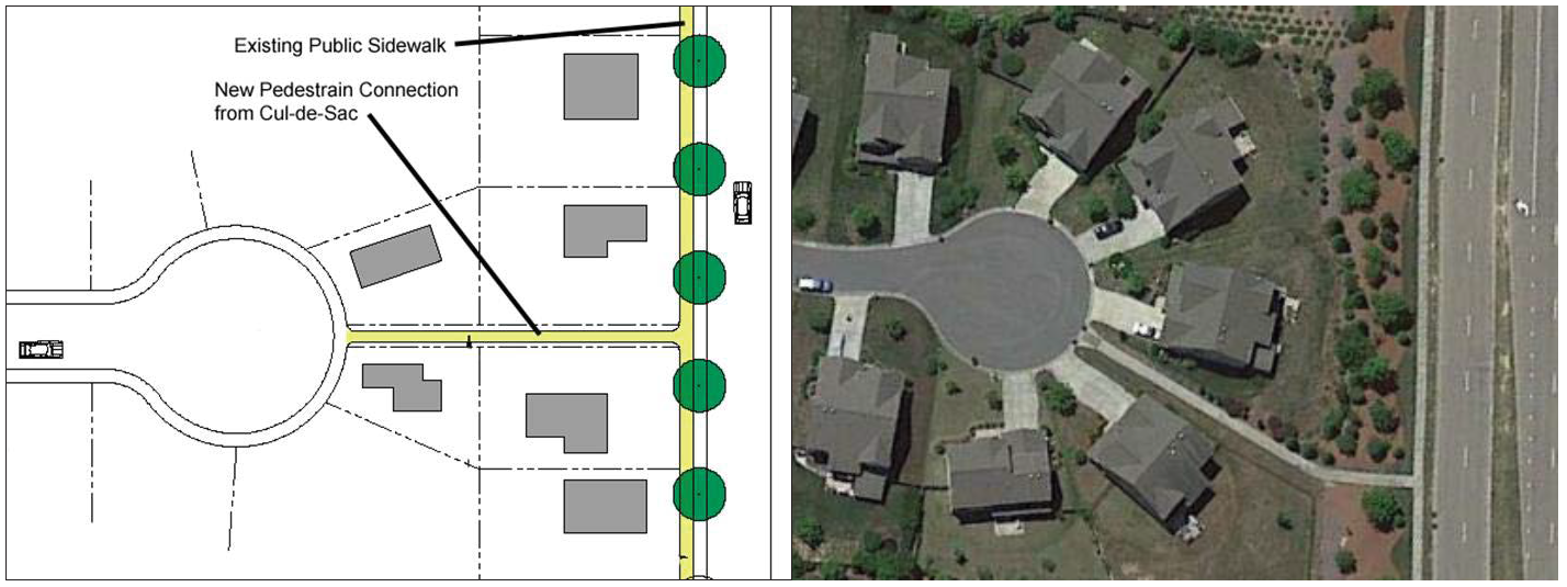
(3)
Connectivity Index.
(A)
Minimum Connectivity Index Score Required. Except as provided in subsection (C) below, new subdivisions where at least fifty (50) percent of the developed land area is dedicated to single-family dwelling units shall achieve an internal street connectivity index score of 1.7.
(B)
Connectivity Score Index Calculation. The connectivity index score for a development is calculated by dividing its links by its nodes. Figure 5.1.4(c)(3)(B): Street Connectivity Index Illustration, provides an example of how to calculate the connectivity index.
1.
A "link" refers to that portion of a street or alley defined by a node at each end or at one end. Approved stubs to adjacent property shall be considered links. A pedestrian connection provided through a cul-de-sac in accordance with subsection (2) above shall count as a link for purposes of this calculation.
2.
A "node" refers to the terminus of a street or the intersection of two (2) or more streets, except that intersections that use a roundabout shall not be counted as a node.
Figure 5.1.4(c)(3)(B): Street Connectivity Index Illustration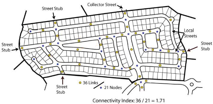
3.
Street links and nodes within the collector or arterial streets providing access to a proposed subdivision shall not be considered in computing the connectivity ratio.
(C)
Exceptions. The minimum connectivity index required by subsection (A) above may be reduced by the Community Development Director if the applicant demonstrates it is infeasible to achieve due to natural features, existing road configurations, or adjacent existing development patterns. In these instances, street design shall achieve as high a connectivity ratio as reasonably practical, especially by providing stub-outs and other potential connections that may be made in the future, including through public infrastructure improvements.
(d)
Sidewalks.
(1)
Sidewalks are required to be constructed in accordance with Sec. 3.15(c), Sidewalks, in Appendix A: Engineering and Design Manual.
(2)
Sidewalks shall be constructed when the most proximate structure which the sidewalk serves is completed. No certificate of occupancy on all structures under construction or to be constructed in the development by the particular builder shall be issued if sidewalks are not completed in accordance with this paragraph. No final inspection will be made and no surety bonds issued in favor of the City will be released until all required sidewalks are in place.
(e)
Bicycle Facilities. All development shall provide connections to the City's bicycle and pedestrian path system identified in the Maitland Bicycle and Pedestrian Master Plan.
(f)
Transit Facilities. Non-residential and mixed-use development subject to the requirements of this section with fifty thousand (50,000) gross square feet or more of floor area which is adjacent to a street that is or may be used as a transit route shall coordinate with the relevant public transportation agency and, if recommended by the public transportation agency, provide access for an on-site public transit stop. The public transit stop shall include a shelter and shall include a bus pullout if it is determined appropriate by the Community Development Director in consultation with the Public Works Director, the public transportation agency, and FDOT, as applicable.
5.1.5. - Street Design.
5.1.6. - Traffic Impact Analysis (TIA).
A Traffic Impact Analysis (TIA) evaluates the impact that a proposed development may have on existing transportation infrastructure, including but not limited to impacts that the development may have on vehicular, bicycle, pedestrian, and transit systems. A TIA is required to be submitted with development applications subject to review for compliance with the standards of this section in accordance with the requirements in Section 3.16, Traffic Impact Analysis, of Appendix A: Engineering and Design Manual.
5.2.1.- Purpose.
The purpose of this section is:
(a)
To ensure adequate facilities for off-street vehicular parking and loading and bicycle parking in proportion to the generalized parking and loading demand of the different zone districts and different uses allowed by this LDC.
(b)
To provide for adequate off-street vehicular parking while supporting walkable urbanism and bicycle storage in appropriate locations, and allowing the flexibility needed to accommodate alternative parking solutions.
(c)
To ensure that off-street parking and loading areas do not encroach on or interfere with the public use of streets and alleys by pedestrians and provide for safe passage of pedestrians through the lot.
(d)
To achieve comprehensive development plan policies of supporting development and redevelopment of the Downtown, redevelopment of office and mixed use development on the West Side, accommodating infill development that is consistent with the community's desired character, and avoiding excessive paved surface areas.
5.2.2. - Applicability.
(a)
New Development. All new development shall provide off-street vehicular parking, bicycle parking, and loading areas in accordance with the standards of this section.
(b)
Existing Development.
(1)
Change of Use. A change in use from a use permitted in the zone district to a different permitted use does not require the provision of any additional vehicular parking, bicycle parking, or loading areas.
(2)
Expansion. If an existing structure or use is expanded or enlarged (in terms of the number of dwelling units, floor area, number of employees, or seating capacity), any additional off-street parking and loading spaces that may be required shall be provided in accordance with the requirements of this section as applied only to the expanded or enlarged part of the structure or use.
5.2.3. - Parking and Loading Plan.
All development applications subject to review for compliance with the standards of this section which propose more than ten (10) off-street parking spaces shall include a parking and loading plan. The plan shall accurately designate the number and location of required vehicular parking spaces, delivery/pick-up/rideshare spaces, access aisles, driveways, bicycle parking spaces, and loading facilities, as applicable. The plan shall also illustrate how the vehicular and bicycle parking and loading facilities relate to the uses or structures they are designed to serve, including how they coordinate with the vehicular, pedestrian, bicycle, and transit circulation systems within and adjacent to the development. The plan shall also demonstrate any alternatives to the off-street vehicular surface parking requirements in Table 5.2.5(a): Minimum Number of Off-Street Vehicular Parking Spaces, by providing the information required by Sec. 5.2.5(h), Off-Street Vehicular Parking Alternatives.
5.2.4. - General Parking and Loading Area Standards.
(a)
Use of Parking and Loading Areas.
(1)
General. Parking lots required by this section shall be used solely for the parking of registered motorized vehicles in operating condition. Required parking spaces and loading berths shall not be used for the display of goods for sale (except for farmers' markets, food trucks, and seasonal sales permitted under this LDC), or the sale, lease, storage, dismantling, or service of any vehicles, boats, motor homes, campers, mobile homes, building materials, equipment, or supplies.
(2)
Identified as to Purpose and Location. Parking lots of three (3) or more spaces and all off-street loading areas shall include painted lines, wheel stops, or other methods of identifying individual parking spaces and loading berths and distinguishing such spaces or berths from aisles. Specific dimensional and marking standards are defined in subsection (d) below.
(3)
Commercial Vehicles. Within a Residential zone district, no commercial vehicles except for recreational vehicles shall:
(A)
Be parked at any time on privately-owned driveways or property located within any Residential zone district, except as provided in Sec. 18-24 of the City Code; or
(B)
Be parked overnight on driveways or property unless parked in a fully enclosed garage.
(4)
Special Parking Restrictions.
(A)
Major recreational equipment, airplanes, gliders, and utility trailers are subject to the following restrictions on parking and storage within a Residential zone district:
1.
No airplane or glider may be parked or stored.
2.
No houseboat may be parked or stored on land.
3.
Major recreational equipment may be parked or stored on a lot with a residential use for no more than forty-eight (48) hours during a seven-day period while loading and unloading, provided that the equipment is not used for living, sleeping, or housekeeping uses while on the lot or in any location not approved for such uses.
4.
Major recreational equipment that exceeds one hundred two (102) inches in width or a utility trailer may be parked or stored only if the equipment or trailer meets one (1) of the following standards:
a.
If a boat or houseboat, it is docked in the water or in a boathouse or launch attached to a waterway.
b.
If a boat trailer, it is parked on a launch attached to a waterway.
c.
The major recreational equipment is parked or stored entirely within a garage or carport; or
d.
The major recreational equipment is registered in accordance with Florida law, includes a tag or sticker demonstrating such registration as required by law, and:
i.
It is a boat that weighs in excess of two hundred (200) pounds, is operational, and is parked on a trailer on a paved or hard-packed driveway at least fifteen (15) feet from the edge of the pavement or road (if unpaved); or
ii.
It is not a boat and is parked behind the nearest portion of a building to the road.
(B)
Major recreational equipment that is less than twenty-four (24) feet in length and that is used regularly as a private passenger vehicle by a resident of the lot may be parked on the lot only if its parked at least fifteen (15) feet from the edge of the pavement or road (if unpaved) and in accordance with the standards of this section.
(C)
Vehicles or trailers which are not operable or which are not properly licensed and registered shall not be parked or stored on any lot within a Residential district except within a completely enclosed building.
(b)
Surfacing.
(1)
General.
(A)
Except as provided in subsection (2) below, all parking lots and loading areas shall be surfaced with asphalt, concrete, brick, stone, pavers, or an equivalent hard, dustless, and bonded surface material. Use of surfacing that includes recycled materials (e.g., glass, rubber, used asphalt, brick, block, and concrete) is encouraged. These surfaces shall be maintained in a smooth, well-graded, clean, orderly, and dust-free condition.
(B)
The use of pervious or semi-pervious parking lot surfacing materials, including but not limited to pervious asphalt and concrete, open joint pavers, and reinforced grass/gravel/shell grids, is encouraged and may be approved for parking lots and loading areas, provided such surfacing is subject to an on-going maintenance program (e.g., sweeping, annual vacuuming). Any pervious or semi-pervious surfacing used for aisles within or driveways to parking and loading areas shall be certified as capable of accommodating anticipated traffic loading stresses and maintenance impacts.
(2)
Exceptions. The following uses shall provide off-street parking in accordance with the following:
(A)
Single-Family and Two-Family (Duplex) Dwellings. Single-family and two-family dwellings may provide required off-street vehicular parking that:
1.
Is covered with pervious materials such as crushed stone or gravel if such material is:
a.
Expressly designed for such purposes, including but not limited to bricks or railroad ties;
b.
Includes plastic/PVC landscaping or similar materials to serve as borders for any loose material; and
c.
Renewed or replaced as reasonably necessary to maintain a neat and orderly appearance; or
2.
Includes surfacing in two (2) strips ("tire ribbons") of a material specified in subsection 1 above, designed to provide a driving surface for the wheels of an automobile along the length of the parking space and/or driveway, provided the overall parking space complies with the minimum dimensional requirements in this section.
(B)
Religious Institution, Education, and Parks and Open Space Uses. A Religious Institution or a use in the Education or Parks and Open Space categories may provide vehicular parking that is surfaced with grass, provided that the grass is maintained in good condition and adequate fire access is provided.
(c)
Location and Arrangement.
(1)
Safe and Convenient Access.
(A)
Off-street vehicular parking lots and loading areas shall be arranged for convenient access between an adjacent street and all parking spaces and loading berths to facilitate ease of mobility, ample clearance, and safety of vehicles and pedestrians. Each off-street parking space and loading berth shall have adequate, unobstructed means for the ingress and egress of vehicles.
(B)
Except for off-street vehicular parking serving single-family detached or two-family (duplex) dwellings, parking lots shall be arranged so no parking or maneuvering incidental to parking shall occur on a public street or sidewalk.
(C)
Except for off-street vehicular parking serving single-family detached, two-family (duplex), and townhouse dwellings, parking lots shall be arranged so an automobile may be parked or un-parked without moving another automobile, unless it is within an automated or mechanical parking deck or garage or part of valet or tandem parking in accordance with Sec. 5.2.5(h)(4), Valet or Tandem Parking.
(D)
Parking lots, aisles, pedestrian walks, landscaping, and open space shall be designed as integral parts of an overall development plan and shall be properly related to existing and proposed buildings.
(E)
Buildings, parking and loading areas, landscaping, and open spaces shall be designed so that pedestrians moving from parking areas to buildings and between buildings are minimally exposed to vehicular traffic.
(F)
Landscaped, paved, and gradually inclined or flat pedestrian walks shall be provided along the lines of the most intense use, particularly from building entrances to streets, parking areas, and adjacent buildings. Pedestrian walks should be designed to discourage incursions into landscaped areas except at designated crossings.
(G)
Each off-street parking space shall open directly onto an aisle or driveway that, except for single-family detached and two-family (duplex) dwellings, is not a public street.
(H)
Aisles and driveways shall not be used for parking vehicles, except that the driveway of a single-family detached or two-family (duplex) dwelling shall be counted as a parking space for the dwelling unit.
(I)
The design of the parking lot shall be based on a definite and logical system of drive lanes to serve the parking and loading spaces. A physical separation or barrier, such as vertical curbs, may be required to separate parking spaces from travel lanes.
(J)
No parking space shall be located to block access by emergency vehicles.
(K)
Access ways for internal traffic circulation of parking areas shall be a minimum of eighteen (18) feet in width for one-way traffic and twenty-four (24) feet in width for two-way traffic with a minimum of twenty (20) feet in width along a designated fire access route.
(L)
Off-street loading areas shall be arranged so no loading berth extends into the required aisle of a parking lot or pedestrian walkway or over a water meter.
(2)
Backing onto Streets Prohibited. Except for off-street vehicular parking areas serving single-family detached, two-family (duplex), and townhouse dwellings, all parking lots and loading areas shall be arranged so that no vehicle is required or encouraged to back out from such areas directly onto a street.
(d)
Dimensional and Marking Standards. The following standards apply to all off-street vehicular serving three (3) or more vehicles, except for parking areas serving a single-family or two-family (duplex) dwelling unit which are subject to the requirements of subsection (j) below.
(1)
General Requirements.
(A)
Each required parking lot and space, and each off-street loading area and berth, shall be identified by surface markings that are arranged to provide for orderly and safe loading, unloading, parking, and storage of vehicles. Such markings — including striping, directional arrows, lettering on signs and in handicapped-designated areas, and labeling of the pavement — shall be maintained to be readily visible at all times.
(B)
Vehicular parking spaces and aisles shall comply with the standards in the most current version of the Traffic Engineering Handbook published by the Institute for Transportation Engineers (ITE), the standards in Table 5.2.4(d): Dimensional Standards for Parking Spaces and Aisles, and the standards in subsection (2) below for compact cars.
Figure 5.2.4(d): Measurement of Parking Space and Aisle Dimensions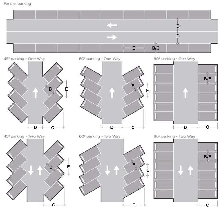
(2)
Compact Cars. Up to fifteen (15) percent of required off-street parking spaces may be designated for use by compact cars. The dimensions of such designated off-street parking stalls may be reduced to a width of eight (8) feet and a depth/length of sixteen (16) feet per vehicle.
(3)
Accessible Spaces. Development required to provide off-street vehicular parking spaces shall ensure that a portion of the total number of required off-street parking spaces are specifically designated, located, and reserved for use by persons with physical disabilities, in accordance with the standards in Sec. 316.1955, Fla. Stat.; Ch. 11, Florida Building Code; and the federal Americans with Disabilities Act Accessibility Guidelines.
(4)
Vehicle Overhang. A maximum of a two-foot overhang is allowed from a curb or wheel stop onto a non-paved surface for all off-street vehicular parking spaces except parallel spaces. The two-foot overhang areas may not intrude onto pedestrian walkways, landscaped buffers, accessways, rights-of-way, or adjacent property not a part of the site.
(e)
Exterior Lighting. Lighting in parking lots and loading areas shall comply with the standards of Section 5.9, Exterior Lighting Standards.
(f)
Landscaping. Parking lots and loading areas shall be landscaped in accordance with Section 5.3, Landscape, Buffer, and Tree Protection Standards.
(g)
Drainage. Parking lots and loading areas shall comply with all drainage requirements of this LDC and the City Code.
(h)
Large Parking Lots.
(1)
Applicability. Parking lots containing one hundred (100) or more parking spaces shall be configured in accordance with the following standards.
(2)
Primary Drive Aisle. Primary drive aisles within parking lots shall be designed to appear as an extension of the public street network extending from the public right-of-way along the full length of the primary façades of structures being served by the drive. Each primary drive aisle shall comply with the following standards (see Figure 5.2.4(h)(2): Location of Primary Drive Aisle):
(A)
Have a minimum cross section width between curbs to serve two (2) travel lanes;
(B)
Include a sidewalk or curb-delineated pedestrian passageway along the front façade of a building when the drive aisle is aligned parallel to that building façade; and
(C)
Provide street trees along both sides of the primary drive aisle with a maximum spacing of fifty (50) feet on-center. Small-maturing trees may be used adjacent to the building façade within forty (40) feet of building entrances.
Figure 5.2.4(h)(2): Location of Primary Drive Aisle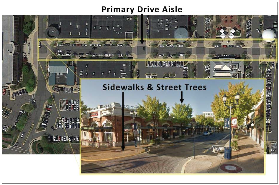
(3)
Pedestrian Pathway. The parking lot shall be visually and functionally segmented into smaller lots with landscape islands and strips through the use of fully-separated, improved pedestrian pathways that (see Figure 5.2.4(h)(3)-1: Example of Pedestrian Pathways):
(A)
Are provided, at a minimum, every six (6) parallel parking rows (every three (3) double-row parking bays) or every two hundred (200) feet, whichever is the lesser dimension (see Figure 5.2.4(h)(3)-2: Pedestrian Pathway Configuration);
(B)
Are enhanced with planted landscaping strips;
(C)
Include, to the maximum extent practicable, a pathway aligned with and perpendicular to the primary entrance into the building served by the parking lot;
(D)
Are paved with asphalt, cement, or other comparable material;
(E)
Are of contrasting color or materials when crossing drive aisles;
(F)
Follow applicable state and federal requirements while at a minimum are at least five (5) feet wide when located within planting strips, and ten (10) feet wide when crossing drive aisles;
(G)
Connect to all existing or planned adjacent transit and pedestrian facilities; and
(H)
Provide safe and efficient pedestrian access to the use they serve.
Figure 5.2.4(h)(3)-1: Example of Pedestrian Pathways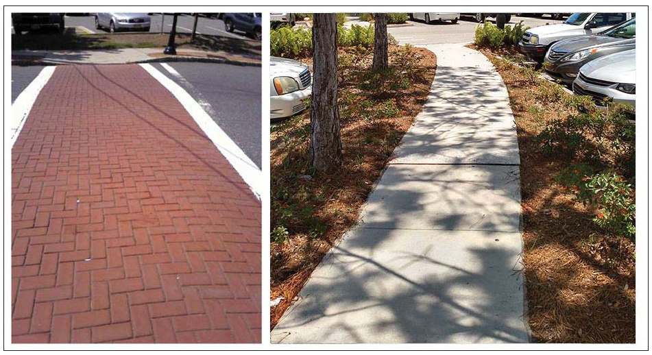
Figure 5.2.4(h)(3)-2: Pedestrian Pathway Configuration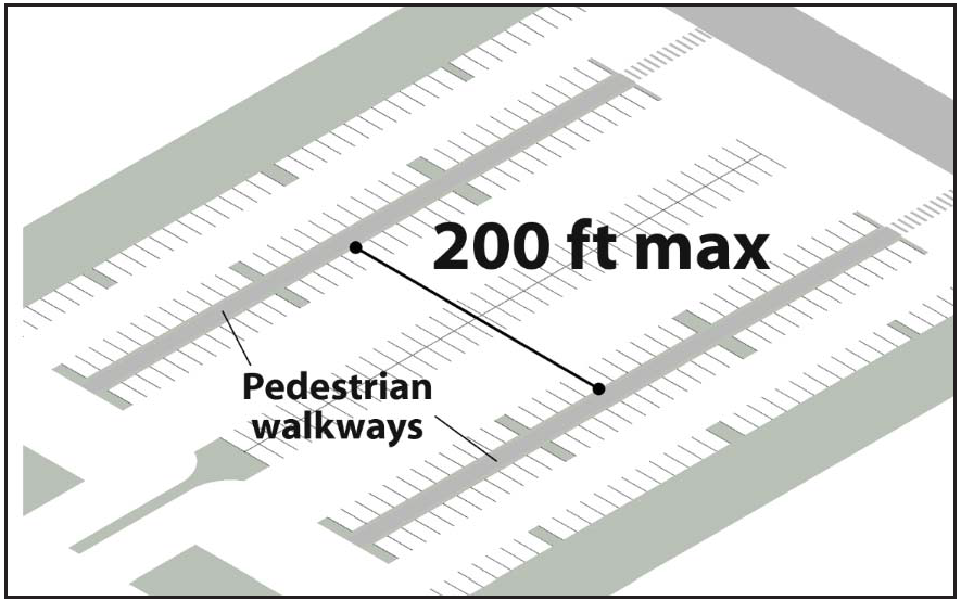
(4)
Pick-Up and Drop-Off Areas. The parking lot shall include designated areas for pick-up and drop-off by visitors, taxis, or other mobility service providers. The designated pick-up and drop-off area shall not interfere with or block the movement of vehicles, pedestrians, or bicycles within the parking lot.
(i)
Completion. All parking lots and loading areas shall be completed prior to the issuance of a certificate of occupancy for the development they serve. In the case of phased development, parking lots and loading areas are only required to be provided for the phase being developed.
(j)
Single-Family and Two-Family Residences.
(1)
Off-street parking spaces for single-family detached and two-family (duplex) dwellings shall be a minimum of eight (8) feet wide and sixteen (16) feet deep/long.
(2)
Motor vehicles within the front yard of a single-family or two-family (duplex) dwelling unit shall only be permitted to be parked upon a paved area as depicted on an approved site plan, subject to the following conditions and exceptions:
(A)
The paved parking area required by this subsection shall be located adjacent to a curb cut providing vehicular access between and street and off-street vehicular parking area and shall be constructed and surfaced in accordance with subsection (b)(2)(A) above. The parking area shall be surfaced with a non-erodible surface such as asphalt, concrete, pavers, or four (4) inches of gravel with permanent border.
(B)
Vehicles with traction engines, road rollers, vehicles that run only on a track, bicycles, and mopeds are not subject to this subsection.
(C)
On single-family and two-family dwelling units constructed prior to April 1, 2018, without a paved parking area, front yard vehicle parking shall only be allowed on an area defined by the Community Development Director after application with proposed site plan by the residence owner. The Community Development Director shall approve the application if it defines an area appropriate for paved parking, including non-pervious and other restrictions. If a single-family or duplex dwelling unit is without a paved parking area sufficient to contain two (2) standard four-wheeled automobiles, front-yard parking of motor vehicles immediately adjacent to the paved parking area shall be permitted.
5.2.5. - Off-Street Vehicular Parking Standards.
(a)
Minimum Number of Off-Street Vehicular Parking Spaces. Except as provided in subsections (b) and (f) below, or in accordance with reductions allowed elsewhere in this section or LDC, all development is required to provide the minimum number of off-street parking spaces in accordance with Table 5.2.5(a): Minimum Number of Off-Street Vehicular Parking Spaces, based on the principal use(s) involved and the extent of development. Interpretation of the off-street vehicular parking space standards for principal uses with variable parking demands or unlisted principal uses shall be in accordance with Sec. 5.2.5(e), Unlisted Uses.
(b)
Maximum Number of Off-Street Vehicular Parking Spaces.
(1)
For residential uses in the DM or DM-PD districts and all uses in the NC district, the maximum number of vehicular parking spaces that may be provided is 1.2 times the minimum number of parking spaces required in accordance with Table 5.2.5(a): Minimum Number of Off-Street Vehicular Parking Spaces.
(2)
For non-residential uses in the DM or DM-PD districts, the maximum number of vehicular parking spaces that may be provided is the same as the minimum number of off-street vehicular parking spaces required to be provided outside the DM and DM-PD Districts in accordance with Table 5.2.5(a): Minimum Number of Off-Street Vehicular Parking Spaces. Additional vehicular parking spaces may be provided if all spaces in excess of the maximum are made available for use by the general public.
(c)
Electric Vehicle Charging Stations.
(1)
An off-street parking area with more than thirty-five (35) parking spaces shall provide EV charging stations in at least two of the first thirty-five (35) parking spaces, make three (3) of those spaces electric-vehicle ready, plus provide two (2) additional EV charging stations and three (3) additional electric-vehicle ready parking spaces for each seventy-five (75) additional parking spaces.
(2)
Parking spaces used as EV charging stations in accordance with subsection (1) above shall:
(A)
Be Level 2 or Level 3 charging stations;
(B)
Be consolidated into groups of contiguous spaces located where they can be readily identified by drivers (e.g. through signage); and
(C)
Comply with the standards in Sec. 4.3.4(h), Electric Vehicle Charging Station.
(3)
Parking spaces that are electric-vehicle ready in accordance with subsection (1) above shall be served by dedicated and electric circuits and underground conduits adequate to support future installation of EV charging stations.
(d)
Rideshare and Delivery. Vehicular parking spaces that are reserved for rideshare/taxi pick-up and drop-off in accordance with Sec. 5.2.4(h)(4) above, or for small-scale delivery service such as food delivery, shall reduce the amount of minimum parking required in accordance with Table 5.2.5(a): Minimum Number of Off-Street Vehicular Parking Spaces, by a 1:1 ratio. This reduction is in addition to any other reductions permitted in this Section 5.2.5.
(e)
Unlisted Uses. An applicant proposing to develop a principal use that is unlisted in Table 5.2.5(a): Minimum Number of Off-Street Vehicular Parking Spaces, shall propose the amount of required vehicular parking by one (1) of the three (3) methods below. On receiving an application, the Community Development Director shall determine the amount of required vehicular parking using the applicant's methodology or the other methods listed, and may require that the applicant prepare a study as described in subsection (3) below:
(1)
Apply the minimum off-street parking space standard for the listed use that the Community Development Director deems most similar to the proposed use;
(2)
Establish the minimum off-street parking space standard by reference to standard parking resources published by the Institute for Transportation Engineers (ITE), Urban Land Institute (ULI), National Parking Association, or the American Planning Association (APA); or
(3)
Conduct a parking demand study to demonstrate the appropriate minimum off-street parking space standard. The study shall estimate parking demand based on the recommendations of the ITE, ULI, or another acceptable source of parking demand data. This demand study shall include relevant data collected from uses or combinations of uses that are the same or comparable to the proposed use in terms of density, scale, bulk, area, type of activity, and location.
(f)
Change of Use. Where an applicant proposes to change the use of a building to a new use that has increased parking standards, but the site cannot reasonably accommodate the additional parking required by the new use and the applicant demonstrates it is not feasible to use any of the off-street vehicular parking alternatives in subsection (h) below, the DRC is authorized to reduce the amount of parking otherwise required upon determining that the reduction will not adversely impact surrounding properties or traffic patterns.
(g)
Mixed-Use Development.
(1)
Unless an alternative parking plan is approved in accordance with subsection (h) below, development containing more than one (1) use shall provide parking spaces in an amount equal to the total of the standards for all individual uses.
(2)
An applicant for a development containing more than one (1) use may submit an alternative parking plan that proposes a reduction in the minimum number of required off-street parking spaces for the development based on a comprehensive analysis of parking demand for each use by time of day, in addition to any other reduction for off-street parking alternatives.
(3)
Combined on-site parking provisions for a site or parcel may be re-evaluated by the Community Development Director when there is proposed revision to the use or property that would require additional parking in accordance with this section, such as an increase in square footage of structures/buildings affected by the agreement, seating, or employee counts for restaurants.
(h)
Off-Street Vehicular Parking Alternatives. The Community Development Director is authorized to approve a parking plan that modifies the number of off-street vehicular parking spaces required by Table 5.2.5(a): Minimum Number of Off-Street Vehicular Parking Spaces, in accordance with the following standards.
(1)
Parking Study. An applicant may prepare and submit an alternative parking study, using professionally accepted methods of transportation engineering and off-street parking demand, which demonstrates that an amount of parking different from that required by Table 5.2.5(a): Minimum Number of Off-Street Vehicular Parking Spaces, is appropriate for the development.
(2)
Off-Site and Off-Site Shared Parking. An alternative parking plan may propose to reduce on-site parking by up to twenty-five (25) percent of the spaces required by Table 5.2.5(a): Minimum Number of Off-Street Vehicular Parking Spaces, by providing off-street vehicular parking spaces in an off-site parking facility in accordance with the following standards:
(A)
Location. All off-site vehicular parking spaces shall be located within a maximum walking distance of the primary pedestrian entrances to the uses served by the parking, in accordance with Table 5.2.5(h)(2)(A): Allowed Distances for Shared Parking. Distance shall be measured by the actual distance of the pedestrian pathway from the shared parking area to the primary pedestrian entrance(s) along a route that complies with the standards of subsection (B) below, not a straight-line, point-to-point distance.
(B)
Access and Signage.
1.
Adequate and safe pedestrian access shall be provided between the off-site parking area and the primary entrances to the uses served by the parking, by a pedestrian pathway protected by landscape buffer or a curb separation and elevation from the street grade.
2.
Off-site parking spaces shall not be separated from the use they serve by an arterial street unless pedestrian access across the arterial street is provided by appropriate traffic controls (such as a signalized crosswalk) or a separated pedestrian pathway (such as a bridge or tunnel).
3.
Signage complying with the standards in Section 5.14, Signs, shall be provided to direct the public to the shared parking spaces.
(C)
Justification. If the off-site parking is shared with other uses, the alternative parking plan shall include justification of the feasibility of shared parking among the proposed uses. Such justification shall address, at a minimum, the size and type of the uses proposed to share off-street parking spaces, the composition of their tenants, the types and hours of their operations, the anticipated peak parking and traffic demands they generate, and the anticipated rate of turnover in parking space use.
(D)
Accessible Parking. Parking spaces required to be accessible to persons with disabilities in accordance with Sec. 5.2.4(d)(3) above shall not be provided in an off-site parking facility.
(E)
Agreement Required. If land containing the off-site parking area is not under the same ownership as land containing the principal use served, if both lands are under the same ownership at the time the off-site parking area is established and ownership of one (1) is subsequently transferred independent of the other, or if multiple uses are sharing parking, then the off-site parking arrangement shall be established in a written agreement that complies with the following requirements:
1.
The agreement shall include as parties the owners of land containing the off-site parking area and all owners or long-term lessees of lands containing the uses proposed to share off-street parking spaces.
2.
If the agreement is for exclusive use of off-site parking by a single use, the agreement shall provide the owner of the served use the right to use the off-site parking area and shall specify that the parking spaces are for the exclusive use of the served use, including any customers and employees.
3.
If the agreement is for use of shared parking by multiple users, the agreement shall provide all parties the right to joint use of the shared parking area and shall ensure that as long as the off-site parking is needed to comply with this section, land containing either the off-site parking area or the served use will not be transferred except in conjunction with the transfer of land containing the other.
4.
The agreement shall state that no party can cancel the agreement without first sending notice via certified mail to the Community Development Director at least thirty (30) days prior to the termination of the agreement.
5.
The agreement shall be submitted to the Community Development Director for review and approval before execution.
6.
An attested copy of an approved and executed agreement shall be recorded in the public records of Orange County before issuance of a building permit for any use to be served by the off-site parking area.
7.
The agreement shall be considered a restriction running with the land and shall bind the heirs, successors, and assigns of the landowner.
8.
A violation of the agreement shall constitute a violation of this LDC, which shall be enforced in accordance with Article 9: Enforcement.
9.
No use served by the off-site parking may be continued if the off-site parking becomes unavailable to the use permanently or for longer than thirty (30) days, unless substitute off-street parking spaces are provided in accordance with this subsection.
(F)
Other Provisions. When the uses or property subject to a shared parking agreement are proposed to change, or a shared parking agreement expires, the Community Development Director is permitted to require a revised shared parking study and, whether or not a revised shared parking study is prepared, may:
1.
Revoke the shared parking agreement if it is determined that it is no longer necessary to meet parking requirements of the uses; or
2.
Require a new shared parking agreement or other types of additional parking when the revised parking study indicates that additional parking is required.
(3)
Deferred Parking. An alternative parking plan may propose to defer construction of up to twenty-five (25) percent of the number of off-street vehicular parking spaces required by Table 5.2.5(a): Minimum Number of Off-Street Vehicular Parking Spaces, in accordance with the following standards:
(A)
Justification. The alternative parking plan shall include a study demonstrating that because of the location, nature, mix of uses, or other unique site characteristics, there is a reasonable probability the number of parking spaces actually needed to serve the development is less than the minimum required by Table 5.2.5(a): Minimum Number of Off-Street Vehicular Parking Spaces.
(B)
Reserve Parking Plan. The alternative parking plan shall include a reserve parking plan identifying the amount of off-street parking spaces proposed to be deferred and the location of the area to be reserved for future parking, if future parking is needed.
(C)
Parking Demand Study.
1.
The alternative parking plan shall provide assurance that within twenty-four (24) months after the final certificate of occupancy is issued for the proposed development, an off-street parking demand study evaluating the adequacy of the existing parking spaces in meeting the off-street parking demand generated by the development will be submitted to the Community Development Director. However, if the Community Development Director determines that additional time beyond twenty-four (24) months is needed to determine whether the supply of parking is adequate to meet demand (for example, due to phasing of project development), the Community Development Director has discretion to delay the preparation of the parking report for up to twenty-four (24) additional months.
2.
If the Community Development Director determines that the study demonstrates the existing parking is adequate, then construction of the remaining number of parking spaces shall not be required. If the Community Development Director determines that the study indicates additional parking is needed, such parking shall be provided consistent with the reserve parking plan and the standards of this section.
(D)
Limitations on Reserve Areas. Areas reserved for future parking shall be brought to the finished grade and shall not be used for buildings, storage, loading, or other purposes. Such area may be used for temporary overflow parking, provided such use is sufficiently infrequent to ensure maintenance of its ground cover in a healthy condition.
(E)
Landscaping of Reserve Areas Required. Areas reserved for future off-street parking shall be landscaped with an appropriate ground cover and, if not ultimately developed for off-street parking, shall be landscaped in accordance with Section 5.3, Landscape, Buffer, and Tree Protection Standards.
(4)
Valet or Tandem Parking. An alternative parking plan may propose to use valet and tandem parking to meet a portion of the minimum number of off-street parking spaces required for commercial uses in accordance with the following standards:
(A)
Number of Valet or Tandem Spaces. No more than thirty-five (35) percent of the total number of parking spaces provided shall be designated for valet or tandem spaces except for restaurant uses, where up to fifty (50) percent of spaces may be designated for valet parking, and hotel uses, where up to sixty (60) percent of parking spaces may be designated for valet parking.
(B)
Drop-Off and Pick-Up Areas. The development shall provide a designated drop-off and pick-up area. The drop-off and pick-up area may be located adjacent to the building served, but shall not be located in a fire lane or where its use would impede vehicular and/or pedestrian circulation, cause queuing in a public street, or impede an internal drive aisle serving the development. Drop-off and pick-up areas shall not be allowed to use sidewalks for any stationing of vehicles.
(C)
Valet or Tandem Parking Agreement.
1.
Valet or tandem parking may be established and managed only in accordance with a valet or tandem parking agreement. The agreement shall run with the use being served by the valet or tandem parking, and include provisions ensuring that a valet parking attendant will be on duty during hours of operation of the uses served by the valet parking.
2.
The agreement shall be submitted to the Community Development Director for review and approval before execution.
3.
An attested copy of an approved and executed agreement shall be recorded in the public records of Orange County before issuance of a building permit for any use to be served by the valet or tandem parking.
4.
The agreement shall be considered a restriction running with the land and shall bind the heirs, successors, and assigns of the landowner. A violation of the agreement shall constitute a violation of this LDC, which may be enforced in accordance with Article 9: Enforcement.
5.
No use served by valet or tandem parking may be continued if the valet or tandem service becomes unavailable, unless substitute off-street parking spaces are provided in accordance with this section.
(Ord. No. 1433, § 7, 10-14-24)
5.2.6. - Vehicle Stacking Standards.
Development shall provide stacking space for vehicles in accordance with the following:
(a)
Drive Through and Similar Facilities.
(1)
Required Number of Stacking Spaces. Uses with drive through facilities and other auto-oriented uses where vehicles queue up to access a service facility shall provide at least the minimum number of stacking spaces established in Table 5.2.6(a): Minimum Stacking Spaces for Drive-Through and Similar Facilities.
(2)
Stacking Space Standards.
(A)
Required stacking spaces shall:
1.
Be a minimum of ten (10) feet wide and twenty (20) feet long;
2.
Be contiguous;
3.
Not impede onsite or offsite vehicular traffic movements or movements into or out of off-street parking spaces;
4.
Not impede onsite or offsite bicycle or pedestrian traffic movements; and
5.
Be separated from access aisles and other vehicular surface areas by raised medians, if necessary for traffic movement and safety.
(B)
The Public Works Director may require a study to evaluate the safety of the proposed stacking arrangement.
(b)
Vehicular Surface Area Entrance Driveways. All uses other than townhouses or dwellings with fewer than five (5) units in a single building shall provide stacking lanes between the edge of the street right-of-way and entrances into off-street parking areas in accordance with the minimum stacking lane distance established in Table 5.2.6(b): Minimum Stacking Lane Distance for Vehicular Surface Area Entrance Driveway (see Figure 5.2.6(b): Measurement of Stacking Lane Distance for Vehicular Surface Area Entrance Driveway).
Figure 5.2.6(b): Measurement of Stacking Lane Distance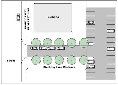
5.2.7. - Bicycle Parking Standards.
(a)
Minimum Bicycle Parking Required. The following shall include short-term and long-term bicycle parking spaces in accordance with Table 5.2.7(a): Bicycle Parking Standards:
(1)
All new development; and
(2)
Any individual expansion or alteration of a building existing prior to March 1, 2022 if the expansion increases the building's gross floor area by fifty (50) percent or more, or if the alteration involves fifty (50) percent or more of the building's gross floor area (including interior alterations), provided no long-term bicycle parking is required if the building has a gross floor area of less than ten thousand (10,000) square feet after the expansion or alteration.
(b)
Type of Bicycle Parking. A minimum of seventy-five (75) percent of the bicycle parking required to be provided in accordance with this section shall be short-term bicycle parking (see subsection (e) below), unless the applicant demonstrates to the Community Development Director that an alternate ratio of short-term to long-term bicycle parking would better meet the intent of this section.
(c)
Reduction Based on Alternative Bicycle Parking Justification. The Community Development Director may authorize up to a twenty-five (25) percent reduction in the minimum number of bicycle parking spaces required by Table 5.2.7(a): Bicycle Parking Standards, if the applicant:
(1)
Demonstrates the demand and need for bicycle parking on the site is less than required by this section because of the site's location, the site design, proximity to transit, or other factors; or
(2)
Offers a strategy that demonstrates other non-auto and non-bicycle travel modes will be used by occupants and users of the development that reduces the demand for bicycle parking spaces.
(d)
Bicycle Parking Space Standards. Bicycle parking spaces shall comply with the following requirements:
(1)
Surfacing. A bicycle parking space shall be located on a paved or similar hard, all-weather surface, having a slope not greater than three (3) percent.
(2)
Lighting. Lighting shall be provided for bicycle parking spaces that are accessible to the public or bicyclists after dark.
(3)
Dimensional Standards.
(A)
The minimum dimensional requirements for a bicycle parking space are:
1.
Six feet long by two (2) feet wide (see Figure 5.2.7(d)(3)(A)1: Example of Bicycle Parking Space and Parking Rack Dimensional Standards); or
2.
If designed for vertical storage, four (4) feet long by two (2) feet wide by eight (8) feet high (see Figure 5.2.7(d)(3)(A)2: Example of Vertical Bicycle Parking Dimensional Standards).
Figure 5.2.7(d)(3)(A)1: Example of Bicycle Parking Space and Parking Rack Dimensional
Standards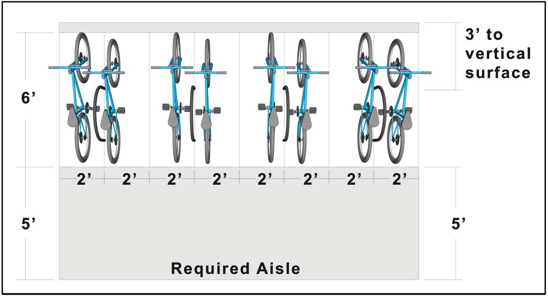
Figure 5.2.7(d)(3)(A)2: Example of Vertical Bicycle Parking Dimensional Standards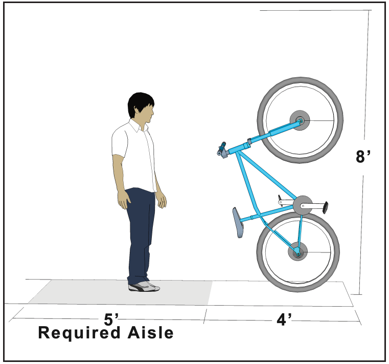
(B)
A bicycle parking space shall be accessible without moving another parked bicycle.
(C)
No more than twenty-five (25) percent of required short-term bicycle parking spaces and twenty-five (25) percent of required long-term bicycle parking spaces shall be vertical or wall-mounted parking.
(4)
Signage and Maintenance.
(A)
Bicycle parking is encouraged to be visible from the main entrance of the building it serves; however, directional signage shall be provided where a bicycle parking space is not visible from a main entrance to the building for which the bicycle parking space is required.
(B)
Bicycle parking areas shall be maintained free of inoperable bicycles (such as bicycles with flat tires or missing parts) and debris. Bicycle parking racks shall be maintained in good repair, securely anchored, and free of rust.
(5)
Rack Design. A bicycle rack shall meet the follow standards:
(A)
Rack Style. The bicycle rack shall be of an inverted-U or post-and-ring rack style, as approved by the Community Development Director. Wave-style racks are not permitted. In addition, the rack shall:
1.
Allow for the securing of the frame and at least one (1) wheel of a bicycle in a bicycle parking space to the rack with an industry-standard U-shaped bike lock;
2.
Provide each bicycle parking space with support for a bicycle in a stable position with direct support to the bicycle frame;
3.
Be securely anchored to the ground or to a structural element of a building or structure;
4.
Be designed and located so it does not block pedestrian circulation systems and pedestrian movements;
5.
Be constructed of materials designed to withstand cutting, severe weather, and permanent exposure to the elements such as powder-coated steel or stainless steel;
(B)
Rack Location.
1.
If bicycles must be moved onto or off of the rack parallel to their direction of travel, there shall be an aisle at least five (5) feet wide between all bicycle parking spaces served by the rack and any bicycle spaces served by another bicycle parking rack, vehicular surface areas, or obstructions, including but not limited to fences, walls, doors, posts, columns, or landscaping areas (see Figure 5.2.7(d)(3)(A)1: Example of Bicycle Parking Space and Parking Rack Dimensional Standards, and Figure 5.2.7(d)(3)(A)2: Example of Vertical Bicycle Parking Dimensional Standards);
2.
The bicycle rack shall be located at least three (3) feet from any vertical surface, such as another bicycle parking rack, the side of a building, a tree, or a fence or wall (see Figure 5.2.7(d)(3)(A)1: Example of Bicycle Parking Space and Parking Rack Dimensional Standards); and
3.
The bicycle rack shall be separated from any abutting vehicular surface area by at least three (3) feet and a physical barrier, such as bollards, curbing, wheel stops, reflective wands, or a fence or wall.
(e)
Short-Term Bicycle Parking Standards. In addition to the requirements of subsection (d) above, a short-term bicycle parking space shall:
(1)
Include independent access to a bicycle parking rack for supporting and securing a bicycle;
(2)
Be located within seventy-five (75) feet of a public entrance to the building for which the space is required, measured along the most direct pedestrian access route, provided, a short-term bicycle parking space located in a bicycle parking area serving more than one (1) use shall be located within one hundred fifty (150) feet of a public entrance to the building for which the space is required, measured along the most direct pedestrian access route; and
(3)
Be located to ensure significant visibility by the public and users of the building for which the space is required.
(f)
Long-Term Bicycle Parking Standards: In addition to the requirements of subsection (d) above, a long-term bicycle parking space shall:
(1)
Include one (1) of the following features:
(A)
A bicycle locker or similar structure manufactured for the sole purpose of securing and protecting a standard size bicycle from rain, theft, and tampering by fully securing the bicycle in a temporary enclosure; or
(B)
A secured and dedicated bicycle parking area provided either inside the principal building on the lot, within a parking structure, or in a structure located elsewhere on the lot. The secured and dedicated bicycle parking area shall be designed to protect each bicycle from weather, theft, and vandalism and shall have a minimum of eight (8) feet of clearance above the floor or ground.
(2)
Be located within five hundred (500) feet of a public entrance to the building for which the space is required, measured along the most direct pedestrian access route, provided, a long-term bicycle parking space located in a bicycle parking area serving more than one (1) use shall be located within seven hundred fifty (750) feet of a public entrance to the building for which the space is required, measured along the most direct pedestrian access route.
5.2.8. - Loading Area Standards.
(a)
Minimum Number of Off-Street Loading Berths. Any development subject to the requirements of this section involving the routine vehicular delivery or shipping of goods, supplies, or equipment to or from the development shall provide a sufficient number of off-street loading berths to accommodate the delivery and shipping operations of the development's uses in a safe and convenient manner. Table 5.2.8(a): Minimum Number of Off-Street Loading Berths, sets forth the minimum number of loading berths for the different principal uses. For proposed uses not listed in Table 5.2.8(a), the requirement for a use most similar to the proposed use shall apply.
(b)
Dimensional Standards.
(1)
Each loading berth shall be of sufficient size to accommodate the types of vehicles likely to use the loading area. The minimum loading berth size that presumptively satisfies loading berth needs is least twelve (12) feet wide and forty-five (45) feet long in general industrial, distribution, or warehousing uses. For all other uses, a berth as short as thirty-three (33) feet may be allowed. The Community Development Director may require a larger loading berth or allow a smaller loading berth on determining that the characteristics of the particular development warrant such increase or reduction and the general standard is met.
(2)
Each loading berth shall have at least fifteen (15) feet of overhead clearance.
(3)
The off-street loading berth shall be arranged so that vehicles shall maneuver for loading and unloading entirely within the property lines of the site.
(c)
Location and Arrangement of Loading Areas.
(1)
To the maximum extent practicable, loading areas should be located to the rear of the use they serve (see Figure 5.2.8(c): Loading Area Configuration).
(2)
Each loading berth should be located adjacent to the building's loading doors, in an area that promotes its practical use, and be accessible from the interior of the building it serves. Each shall be directly accessible from a street or alley without crossing or entering any other required off-street loading space.
(3)
Loading areas should be located and designed so vehicles using them can maneuver safely and conveniently to them from a public street and complete loading without obstructing or interfering with any public right-of-way or any parking space or parking lot aisle.
Figure 5.2.8(c): Loading Area Configuration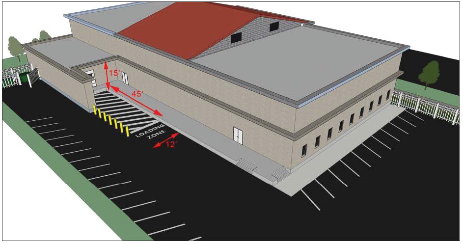
(d)
Additional Requirements.
(1)
Commercial vehicles shall not be loaded or unloaded on public streets unless approved by the DRC.
(2)
Two (2) more uses or buildings may make joint use of off-street loading facilities, provided that the total amount of loading facilities provided are equal in size and capacity to the combined requirements of all buildings or uses.
5.3.1.- Purpose and Intent.
The purpose of this section is to provide landscaping, buffering, and tree protection standards that promote the health, safety, and welfare of existing and future residents, visitors, and property owners by ensuring that developments plant and maintain trees, shrubs, and other vegetation in appropriate locations to improve the aesthetics and beauty of the City and minimize the impact of incompatible land uses, and protect existing trees and vegetation. In particular, the intent of this section is to establish standards that maintain and improve the natural and human environment by:
(a)
Maintaining permeable land areas which are essential to surface water management and aquifer recharge;
(b)
Reducing and reversing air, noise, heat, and chemical pollution through the biological filtering capacities of trees and other vegetation;
(c)
Promoting energy conservation through the creation of shade, reducing heat gain in and on buildings or paved areas;
(d)
Reducing the temperature of the microclimate through the process of evapotranspiration;
(e)
Reducing erosion caused by construction, neglect, or overuse of land by binding soil particles and holding the soil together against the effects of wind and water;
(f)
Promoting conservation of potable and non-potable water;
(g)
Preserving existing natural vegetation and trees, including through incorporating native plants, plant communities, and ecosystems into landscapes;
(h)
Minimizing disturbance of wetlands and requiring mitigation for any unavoidable impacts;
(i)
Removing species that are nuisances because of their tendency to damage public and private properties and negatively affect public health, and disrupt or destroy native ecosystems; and
(j)
Creating physical and psychological benefits to people by using landscaping to reduce noise and glare, break up monotony, and soften development.
5.3.2. - Applicability.
(a)
New Development. All new development shall comply with the standards in this section.
(b)
Existing Development. Any expansion or alteration of a building existing prior to March 1, 2022 shall comply with the standards of this section to the maximum extent practicable if the expansion increases the building's floor area by fifty (50) percent or more, or the alteration involves fifty (50) percent or more of the building's floor area (including interior alterations), as measured over any five-year period.
(c)
Timing of Review.
(1)
Review for compliance with the standards in this section shall occur during review of a development application for planned development (Sec. 2.5.1(f), Planned Development), site plan (Sec. 2.5.2(a), Site Plan), subdivision (Sec. 2.5.2(b), Subdivision), site construction permit, or building permit, whichever occurs first.
(2)
Development shall comply with the standards of this section prior to issuance of a building permit.
(3)
A certificate of occupancy or certificate of completion shall not be issued for a development until the work specified in an approved landscape plan is completed.
5.3.3. - Landscape Plan.
(a)
A landscape plan is required to be submitted for all development subject to this section.
(b)
The landscape plan shall be prepared, signed, and sealed by a landscape architect or engineer registered in the state, unless:
(1)
The parcel is smaller than one (1) acre in size and the estimated cost of the landscape improvements (including installation) is less than $5,000.00; or
(2)
The parcel is smaller than one-half (½) acre in size.
(c)
The landscape plan shall include a note stating that the site will be 100 percent irrigated or identify areas with native plants that will not require irrigation.
5.3.4. - Landscape Standards.
Development subject to the requirements of this section shall comply with the following standards:
(a)
Foundation Landscaping Standards. Except for single-family detached and two-family (duplex) dwellings, all buildings facing rights-of-way that are set back from lot lines shall contain foundation landscaping at least three feet in width along the entire length of the building façade. The foundation landscaping shall consist of shrubs and at least one small tree for every twenty (20) feet in length. Trees may be clustered. (See Figure 5.3.4(a): Foundation Landscaping.)
Figure 5.3.4(a): Foundation Landscaping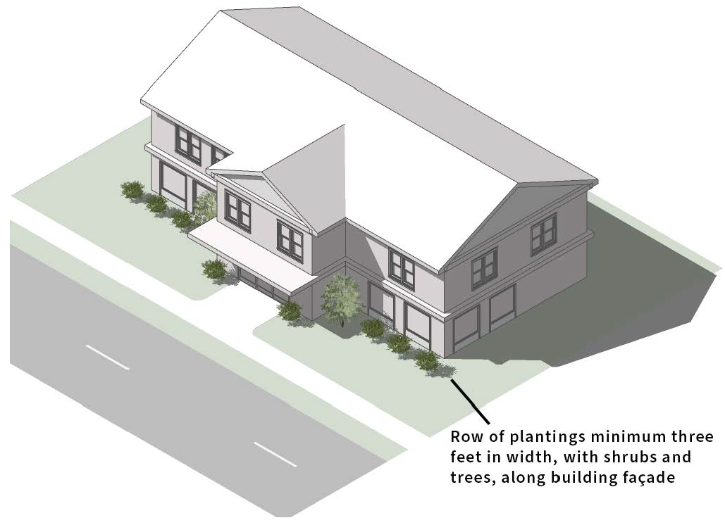
(b)
Site Landscaping Standards.
(1)
Single-Family and Two-Family Residential Development. A minimum number of trees shall be provided on each lot in accordance with Sec. 5.6.3, Required Tree Quantities and Table 5.6.3: Minimum Tree Coverage. The quantity and variety of trees shall meet the standards of Sec. 5.3.4(g)(3), Tree Standards.
(2)
All Other Development. All development other than single-family and two-family (duplex) development shall install the following landscaping:
(A)
Trees, turf, ground cover, shrubs, and landscape covering such as mulch shall be installed to cover all ground not covered by building and paving or preserved ecological communities. At least one tree and ten shrubs shall be planted or preserved for every two thousand five hundred (2,500) square feet of site area, excluding areas of vegetation required to be preserved. All vegetation planted in accordance with subsections (c) through (e) below may be used to comply with this standard.
(B)
Street trees shall be installed along all adjacent streets that are not limited-access streets, in accordance with Sec. 6.3.4, Street Trees.
(c)
Perimeter Buffer Standards.
(1)
Purpose. Perimeter buffers and bufferyards are provided to protect land uses from the traffic, noise, glare, trash, activity, vibration, odor, visual disorder, and other harmful or noxious effects likely to be emitted by or associated with an adjacent more intense land use.
(2)
Buffer Options. Table 5.3.4(c)(2): Landscape Buffer Options, defines four types of buffers based on their function, width, and minimum screening requirements. Each buffer type includes two options for plantings and other screening. The required minimum width is an average; the width of the buffer at any point may be reduced up to fifty (50) percent of the required buffer width, provided that where the width is reduced the Community Development Director determines that the buffer is adequate to screen the incompatible uses, and the total area of the buffer is the same is it would be if the buffer extended the minimum width along the entire frontage.
| Table 5.3.4(c)(2): Landscape Buffer Options | |||
|---|---|---|---|
| Buffer Type/Image | Description | Minimum Width and Screening | |
| Option 1 | Option 2 | ||
| Type A: Opaque | 40 ft | 20 ft | |
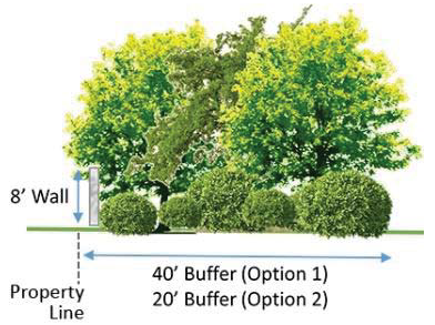 | This buffer functions as an opaque screen from the ground to a height of at least six feet. This type of buffer prevents visual contact between uses and creates a strong separation. | 6 trees (including 3 canopy trees) and 120 shrubs per 100 linear feet |
3 trees (all canopy trees) and 120 shrubs per 100 linear feet,
and a wall (see Sec. 5.3.4(c)(5)(A) below) |
| Type B: Semi-Opaque | 30 ft | 15 ft | |
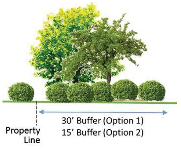 | This buffer functions as semi-opaque screen from the ground to at least a height of six feet. | 5 trees (including 3 canopy trees) and 100 shrubs per 100 linear feet | 3 trees (all canopy trees) and 120 shrubs per 100 linear feet |
| Type C: Aesthetic | 20 ft | 10 ft | |
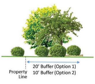 | This buffer functions as an intermittent visual obstruction from the ground to 20 feet, and creates the impression of spatial separation without eliminating visual contact between uses. | 5 trees (including 3 canopy trees) and 80 shrubs per 100 linear feet | 3 trees (all canopy trees) and 120 shrubs per 100 linear feet |
| Type D: Basic | 10 ft | 6 ft | |
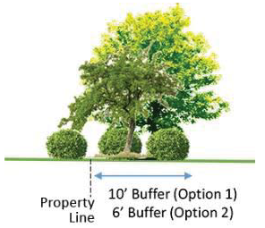 | This buffer functions as a basic edge demarcating individual properties with slight visual obstructions from the ground to a height of ten feet. | 3 trees (all canopy trees) and 80 shrubs per 100 linear feet | 3 trees (all canopy trees) and 120 shrubs per 100 linear feet |
(3)
Buffer Types. The width of a bufferyard and the required quantity and type of plantings varies based on the nature of the potentially adjacent uses. Table 5.3.4(c)(3): Buffer Types, establishes the type of perimeter buffer required between two adjacent land uses. The buffer types are described above in Table 5.3.4(c)(2): Landscape Buffer Options. Where parking lot landscaping requirements overlap with these buffer requirements, they shall be counted toward the perimeter buffer requirements.
(4)
Planting Standards.
(A)
Required trees shall be spaced a minimum of fifteen (15) foot apart for understory trees and twenty-five (25) feet apart for canopy trees, meet the standards in Sec. 5.3.4(g)(3), Tree Standards upon planting and at maturity, and be at least three (3) feet in height one (1) year after planting, and six (6) feet in height two (2) years after planting.
(B)
All required shrub plantings shall form a solid continuous visual screen at least six (6) feet in height within one (1) year after planting, except for shrubs within a sight triangle which shall be maintained at the maximum height allowed in accordance with the FDOT Design Manual.
(C)
Existing vegetation which meets or exceeds the quantity, spacing, and height standards of this section may be used to satisfy the requirements of this subsection, if there are no encroachments as defined in this LDC. Supplemental native shrubs may be required, however, if it can be reasonably inferred that after two (2) years, the existing vegetation will not provide the continuous visual screen required in subsection (B) above.
(5)
Modifications to Buffer Width. The width of buffers required by this subsection (c) may be reduced in accordance with the standards below. See Table 5.3.4(c)(5): Modifications to Buffer Width.
(A)
Wall. Except in a Type A buffer using Option 2 (see Table 5.3.4(c)(2): Landscape Buffer Options), if a solid masonry wall eight feet in height is placed within the perimeter buffer, the depth of the buffer yard may be reduced by 50 percent if:
1.
The required buffer area exceeds twenty (20) percent of the total lot area;
2.
The wall is compatible, in terms of texture and quality, with the material and color of the principal building on the site; and
3.
At least fifty (50) percent of the total plantings required by Table 5.3.4(c)(2): Landscape Buffer Options are located between the wall and the adjoining property.
(B)
Berm. If a berm is placed within the perimeter buffer with a minimum height of two (2) feet, a minimum crown of two (2) feet, and a stabilized side slope of 4:1, the depth of the buffer yard may be reduced by twenty-five (25) percent if:
1.
The berm is landscaped so at least seventy-five (75) percent of the raised area is planted with a combination of trees, shrubs, hedging, and/or ground cover, and the remainder of the berm is sodded; and
2.
The berm is constructed in a curvilinear manner to present a natural attractive appearance from the street.
(C)
Wall and Berm. Except in a Type A buffer yard, If a wall that complies with subsection (A) above is located between the higher intensity use and a berm that complies with subsection (B) above, at least twenty (20) percent of the total plantings required by Table 5.3.4(c)(2): Landscape Buffer Options are located between the wall and the higher intensity use, and at least fifty (50) percent of the total plantings required by Table 5.3.4(c)(2) are located between the fence or wall and adjoining property, the required depth of the buffer yard shall be reduced by sixty (60) percent.
Table 5.3.4(c)(5): Modifications to Buffer Width | ||
|---|---|---|
| Buffer Feature | Allowed Reduction in Width | Illustration |
| (A) Wall | 50 percent | |
| (B) Berm | 25 percent |  |
| (C) Wall and Berm | 60 percent |  |
(6)
Parking Lot Perimeter Landscaping. All parking lots shall be screened from abutting properties, rights-of-way, and exterior building walls with a wall, hedge, or other durable landscape barrier that complies with the following standards:
(A)
Any vegetative barrier shall use planting materials in accordance with Sec. 5.3.4(g), General Planting Standards, and shall be established in a planting strip at least five (5) feet wide that forms a solid continuous visual screen at least four (4) feet in height within two (2) years of planting, measured from the parking lot pavement surface.
(B)
No vegetative barrier shall obstruct visibility in the sight triangle.
(C)
Any fence or wall shall be at least four (4) feet high.
(D)
Any portion of the perimeter that does use a vegetative barrier, fence, or wall shall be landscaped with an average of one (1) tree for every thirty (30) linear feet of perimeter and sixty (60) shrubs for every one hundred (100) linear feet or fraction thereof of perimeter, with grass, ground cover, or other approved landscape treatment (excluding paving) constituting the rest. Intermediate trees may be used if all canopy trees are unable to be used due to the spacing requirements. The trees shall meet the standards in Sec. 5.3.4(g)(3), Tree Standards upon planting and at maturity.
(E)
The perimeter shall comply with the appropriate buffer standards established in subsection (c) above, if any, including any off-property swale between the pavement of a public street or alley and the property line.
(d)
Parking Lot Interior Landscaping Standards.
(1)
Applicability. The standards of this section apply to:
(A)
All off-street parking lots except for parking areas on single-family or two-family (duplex) lots;
(B)
All areas used for display of all types of vehicles, boats, or equipment; and
(C)
Areas used for a drive-through facility.
(2)
Standards.
(A)
Parking Islands. Parking islands shall be provided throughout a parking lot and located no more than one hundred (100) feet from another parking island and at the terminus of all rows of parking. Each parking island shall:
1.
Be at least five (5) feet wide and a minimum of two hundred (200) square feet in area for single parking rows, and four hundred (400) square feet for double parking rows; and
2.
Contain at least one (1) shade/canopy tree or two (2) intermediate trees per 200 square feet of area or fraction thereof.
(B)
Additional Interior Landscaping Standards.
1.
At least one (1) shrub shall be provided for every two hundred (200) square feet of parking lot area, exclusive of perimeter plantings. The shrubs may be placed in the islands, or in other locations within the interior of the parking lot. Any shrub contained in a parking island shall not exceed thirty (30) inches in height.
2.
All landscaped areas in or adjacent to a parking lot shall be protected from vehicular damage by either a raised curb at least six (6) inches in height, or a wall at least thirty (30) inches in height.
3.
All interior landscaped areas of the parking lot not dedicated to trees or to preservation of existing vegetation, including parking islands, shall be landscaped with grass, ground cover, shrubs, or other appropriate landscape treatment.
4.
Sand or other pavement shall not be used as landscape treatment.
(C)
Alternative Interior Landscape Option. If a parking lot that was in existence prior to March 1, 2022 needs to be expanded, but cannot reasonably comply with the requirements of this subsection, an alternative design may be used that utilizes four (4) parking spaces that intersect with planters measuring five-feet by five-feet that are installed between parking spaces to allow for installation of palm trees or intermediate trees. No vehicular encroachment is allowed into landscape areas.
(e)
Loading, Service Area, and Display Area Landscaping.
(1)
All loading areas, utility service areas, and outdoor areas used for the display of merchandise that are at least fifteen (15) feet wide shall provide one (1) of the following types of screens to block the view from any public street rights-of-way:
(A)
A closed fence or wall at least six (6) feet high that is compatible with the principal building on the site. It shall be landscaped with additional planting materials designed so that no more than two-thirds of the surface area of the fence or wall is visible from the public right-of-way within three (3) years of erection of the structure; or
(B)
Vegetative material that is a minimum of four (4) feet in height when planted, designed to form a solid hedge at time of maturity, and expected to reach six (6) feet or greater in height within two (2) years of planting.
(2)
Any access point to a utility service area that is visible from the public street right-of-way shall be screened with gates.
(f)
Alternative Compliance for Certain Landscape Standards. Development that existed prior to March 1, 2022 that proposes to redevelop a site and that cannot reasonably comply with the minimum standards of subsections (a) through (e) above may propose alternative means of compliance which the Community Development Director shall review and decide to approve, approve with conditions, or deny, based on the following:
(1)
Physical Limitations in Pre-Existing Parking Lots. Development that existed prior to March 1, 2022 that proposes to redevelop a site and that cannot reasonably comply with the perimeter buffer (Sec. 5.3.4(c)) and parking lot (Sec. 5.3.4(d)) standards may propose an alternative plan that includes the installation of trees, shrubs, other plantings, and an irrigation system that complies with the standards of Sec. 5.3.4(c), Perimeter Buffer Standards, and Sec. 5.3.4(d), Parking Lot Interior Landscaping Standards, within adjacent City rights-of-way, either on the shoulder or within the median, or on specific City properties approved for off-site vegetation. The alternative installation shall not exceed twenty-five (25) percent of the total requirements.
(2)
High Cost of Landscaping Pre-Existing Parking Lots. If site or structural alterations, expansion, or renovations for parking lot landscaping (Sec. 5.3.4(d)) and irrigation improvements (Sec. 5.3.5) exceed thirty (30) percent of the total cost of the proposed improvements for the site, the property owner may enter into an agreement with the City to install the landscaping during an agreed-upon period, up to five (5) years from the date of development approval, in accordance with the following requirements:
(A)
The applicant shall execute an agreement with the City outlining the scheduled improvements in a phased plan of improvements.
(B)
At least twenty-five (25) percent of the required improvements, as established in the schedule and agreement, shall be completed prior to issuance of a certificate of occupancy.
(C)
Where off-site mitigation is required, installation of these improvements shall also be included in the schedule of improvements and agreement.
(D)
The agreement shall be approved by the City Manager. The City Manager's decision may be appealed to the City Council.
(g)
General Planting Standards.
(1)
Quality, Species, and Planting Standards.
(A)
All proposed trees and plant materials shall be graded as Nursery Grade No. 1 or better, as outlined by the Florida Department of Agriculture and Consumer Services, Division of Plant Industry Grades and Standards for Nursery Plants. Plant materials shall be chosen from the list of species of acceptable plant materials maintained by the Community Development Department in the Procedures Manual. All trees and other plant material shall be graded at the time of final inspection.
(B)
All plant installation shall comply with the requirements established in the latest edition of the American Standard for Nursery Stock published by AmericanHort.
(C)
The use of native and drought-tolerant species is strongly encouraged.
(2)
Plant Placement. Plant materials included in a landscape plan shall be designed to be compatible with the proposed growing conditions. In particular:
(A)
Plant materials installed in locations where the predominate soil type is well draining sands, such as on a berm, shall be able to tolerate reduced water conditions.
(B)
Plant materials installed around retention/detention ponds or in swales shall be able to tolerate wet conditions caused by poorly drained soils.
(C)
Plant materials installed in locations where the predominate soil type is marly, mucky, has a hardpan layer, or is one (1) of many other poorly drained soils shall be able to tolerate wet conditions.
(D)
Plant materials shall be compatible with the expected level and intensity of sun, wind, and temperature exposure.
(3)
Tree Standards.
(A)
General Tree Planting Requirements. Trees required to be planted by this section shall be minimum three (3) inch caliper and comply with the standards in Table 5.3.4(g)(3)(A): Tree Standards.
(B)
Diversity Requirements. Trees shall be selected from the species list identified in subsection (1) above. When more than five (5) trees per category of tree type (see Table 5.3.4(g)(3)(A): Tree Standards) are required to be planted on a single site to meet the standards of this section and LDC, a mix of species shall be provided in accordance with Table 5.3.4(g)(3)(B): Tree Species Diversity Standards.
(C)
Existing Tree Credit. Trees existing on a site may be preserved and used to satisfy the tree planting standards of this section in accordance with the following:
1.
In the area required by the City to be protected, the developer may not change the natural grade, construct any impervious surfaces, conduct any trenching or excavation, store equipment, materials, or earth, or use the area for vehicular circulation or parking.
2.
Trees shall be located in the area in which credit is sought (e.g., for credit towards Sec. 5.3.4(c), Perimeter , the existing tree shall be located within the requisite buffer yard).
3.
Preservation of groups of trees is encouraged.
4.
Credit shall be given against the tree standards in this section in accordance with Table 5.3.4(g)(3)(C): Tree Credit Standards.
(4)
Shrub and Hedge Standards.
(A)
Shrubs or hedges required to be planted by this section or this LDC shall comply with the following standards:
1.
Minimum height at time of planting: thirty (30) inches.
2.
Spread at time of planting: eighteen (18) to twenty-four (24) inches.
3.
Spacing: Average of approximately thirty (30) inches.
4.
Hedges shall be of an evergreen species and form a solid continuous visual screen of at least three (3) feet in height within one (1) year of planting, except that shrubs planted in the required front yard in a residential zone district or in a sight triangle shall not exceed the maximum height allowed in accordance with the FDOT Design Manual.
5.
Exceptions and substitutions from this regulation may be reviewed and approved by the Community Development Director to promote the use of slow growing or native plant materials, or to promote safety.
(5)
Vine Standards. Vines planted in accordance with this section shall be a minimum of thirty (30) inches in supported height immediately after planting. They may be used in conjunction with fences, visual screens, or walls to meet landscape buffer requirements as specified, as long as the structure is maintained in good condition.
(6)
Ground Cover Standards.
(A)
Ground cover provided in accordance with this section shall be planted with a minimum of fifty (50) percent coverage, with one hundred (100) percent coverage occurring within two (2) years.
(B)
On nonresidential sites, sod shall be prohibited except where used for functional purposes (e.g. for active recreation or adjacent to an Animal Use) up to a maximum of fifteen (15) percent of the site landscaping. On residential sites, no more than twenty (20) percent of the site landscaping shall be planted with sod. The use of high-water grass species such as St. Augustine's is prohibited.
(C)
Sod shall not be used in areas less than four (4) feet in width.
(D)
Turf grass used for landscaping purposes in accordance with this section shall comply with the following standards:
1.
Turf shall be sodded, plugged, sprigged, or seeded, except that solid sod shall be used in swales or other areas subject to erosion.
2.
Sod shall be clean and reasonably free of weeds and noxious pests or diseases.
3.
Sod pieces shall be neatly cut and free from any damage or breakage upon installation.
4.
Grass seed shall be delivered to the job site in sealed bags with Florida Department of Agriculture tags attached.
5.
If used, seed shall be of a variety that will provide complete coverage within ninety (90) days from sowing.
6.
Where other than solid sod or grass seed is used, nurse grass seed shall be sown for immediate effect and protection until coverage is otherwise achieved.
7.
All sod shall be laid evenly and flat. Panels shall be staggered and tight with no gaps, to prevent erosion.
(7)
Mulch Standards.
(A)
A minimum of three (3) inches of organic mulch shall be placed over all newly installed tree, shrub, and ground cover planting areas, except for annuals and plants that are susceptible to fungus.
(B)
A weed mat may be used to decrease the mulch depth, as approved by the Community Development Director. Measurement for mulch depth shall be for settled mulch condition.
(C)
Cypress mulch is prohibited.
(8)
Prohibited Species. The following species shall not be planted within the City:
(A)
The species listed in Table 5.3.4(g)(8): Prohibited Species.
(B)
Species on the current list of invasive plant species maintained by the Florida Exotic Pest Plant Council (FLEPPC).
(h)
Sight Triangle and Sidewalk Clearance.
(1)
No vegetation shall be allowed to obstruct views within the sight triangle in accordance with Appendix A: Engineering and Design Manual.
(2)
All landscaping, except required turf and ground cover, shall be maintained with a 12-inch clearance from the edge of any sidewalk or accessway pavement.
(3)
All vegetation shall be maintained to provide a minimum clearance of eight (8) feet over a sidewalk and sixteen (16) feet over a road.
(i)
Plantings within Right-of-Way. No trees or landscaping shall be planted or added into any street median or public rights-of-way until the Public Works Director has issued a permit authorizing such work and approved of the location of the plants and landscaping with regard to safe engineering practices, including the standards of the Green Book. The permittee, or successor in interest, shall be responsible for the standard horticultural practices of all landscaping and shall keep the area free of debris. Species whose roots are known to cause damage to pavement or utilities shall not be planted closer than four (4) feet to a public street or utility structure unless an approved root barrier structure is installed.
(j)
Artificial Landscaping. Synthetic lawns, synthetic plants, or outdoor carpeting, such as Astroturf, shall not be used to meet any requirements of this section.
5.3.5. - Irrigation Standards.
(a)
Purpose. The purpose of this subsection is to ensure development installs and maintains irrigation systems that support the growth and survival of the landscaping required by this section while promoting water conservation.
(b)
Standards. Except in areas on a site where existing plant communities and ecosystems are being maintained in a natural state, all landscaping required to be installed in accordance with this section shall include an irrigation system that is designed, installed, and maintained in accordance with Appendix F, Florida Building Code, Plumbing; the latest edition of the Florida Irrigation Society Standards and Specifications for Turf and Landscape Systems; and the following standards:
(1)
The irrigation system shall incorporate sensor devices that inhibit its operation during periods of sufficient moisture. The sensor system shall comply with the standards in Sec. 373.62, Fla Stat.
(2)
The irrigation system shall not direct water onto pedestrian paths, buildings, roads, drives, or other hard surfaces.
(3)
Overall system design shall be appropriate for the type of plants being grown and for the type of soil.
(4)
Areas irrigating high-water demand landscape areas such as turf shall be served by a distinctly separate irrigation zone than lower-demand landscape areas such as trees, shrubbery, or other reduced water requirement areas.
(5)
Irrigation risers are prohibited.
(6)
The irrigation system shall be maintained to meet the requirements of this section and routinely examined to minimize water waste.
(7)
Automatic irrigation systems should be operated between the hours of midnight and 7:00 a.m.
(8)
When a water distribution system providing treated wastewater effluent or reuse water is available within two hundred (200) feet of a property, a property owner shall connect to such system for irrigation purposes. All connections shall be consistent with the rules of DEP and comply with Ch. 62-610, F.A.C., and any other applicable City or state laws and regulations.
5.3.6. - Preservation During Development and Construction.
(a)
Purpose. The purpose of this subsection is to ensure that the site work and construction activities that accompany development implement measures to protect vegetation, prevent erosion and sediment transport, preserve existing ground cover or other vegetation that is being preserved on site, and protect root structures and prevent soil contamination that may cause damage not discovered until after construction is complete.
(b)
Erosion Control Standards. All construction projects shall incorporate erosion and sediment control plans into their project site plans. The erosion and sediment control plans shall incorporate control of project construction water, selective clearing, and timely stabilization of newly finished work.
(c)
Protection of Vegetation During Construction. Development shall take all reasonable steps necessary to prevent damage to vegetation identified in the landscape plan to be preserved, or otherwise required to be preserved in accordance with this section. All development is required to comply with the following:
(1)
Installation of Barriers. Protective barriers shall be installed and maintained around vegetation, trees, or groups of trees being preserved. The protective barriers shall be installed for the period of time beginning with the commencement of any land clearing or building operations and ending with the completion of the permitted development. The barriers shall contain signage prohibiting storage or other harmful activity that is prohibited by this section.
(2)
Prohibited Activities.
(A)
Unless otherwise authorized by the vegetation and tree removal permit (see Sec. 2.5.3(e), Vegetation and Tree Removal Permit), preservation detail, or the landscape plan, during construction no excess soil, additional fill, vehicles, equipment, liquids, or construction debris shall be placed within the dripline of any vegetation that is required to be preserved in its present location.
(B)
Unless otherwise authorized by the vegetation and tree removal permit (see Sec. 2.5.3(e), Vegetation and Tree Removal Permit), no soil is to be removed or added within the dripline of any tree that is to remain at its original location.
(3)
Designation of On-Site Representative. At the time of any applicable development application, the property owner shall designate an on-site representative to be responsible for the installation and the maintenance of all tree protection barriers and for supervising the permitted removal of existing vegetation. The representative shall be on-site at all times during any vegetation clearing operations.
5.3.7. - Shoreline Protection Standards.
(a)
Purpose. The purpose of this subsection is to establish minimum standards for the protection of natural plant communities along wetlands and shorelines, as well as to ensure the installation and continued maintenance of wetland and waterfront vegetative areas within the City, consistent with the policies in the comprehensive development plan. In particular, the intent of this section is to:
(1)
Improve environmental quality in riparian and littoral zones through the preservation of vegetation that slows and filters pollutants from rainfall and other runoff, provides habitat and cover for wildlife, and reduces shoreline erosion;
(2)
Promote water conservation;
(3)
Preserve existing vegetation;
(4)
Encourage the removal of invasive species;
(5)
Improve the aesthetic beauty of lakes, wetlands, and other water bodies, providing opportunities for passive recreation such as fishing and adding values to homes and other waterfront property.
(b)
Permit Required.
(1)
General. The applicant shall obtain any required shoreline alteration permit in accordance with Sec. 2.5.3(b), Shoreline Alteration Permit, before altering any shoreline within the City. The activities which require a permit include digging or adding of fill which alters or changes the shoreline or existing topography of the shoreline or waterfront of any water body within the City, or any trimming, cutting, or removal of any shoreline or waterfront vegetation.
(2)
Shoreline Alteration Standards. Development subject to the requirements of this section shall comply with the following standards:
(A)
All cleared or trimmed vegetation shall be immediately removed from the lake, shoreline area, and dock for upland disposal offsite.
(B)
Revegetation required after permitted clearing shall be completed within ninety (90) days from the date the shoreline alteration permit is issued. A survival rate of eighty (80) percent shall be required to be maintained one (1) year after planting. If compliance is not achieved within one (1) year, additional plantings shall be required until a survival rate of eighty (80) percent is met and less than ten (10) percent of the surviving plantings are invasive species.
(C)
Littoral zones shall be planted with vegetation throughout all impacted areas outside of the allowed access corridor. Revegetated areas shall encompass the same percentage of shoreline coverage that was previously present. All emergent aquatic plants shall be planted a maximum of two (2) feet on center unless, due to size or type of plantings, the Public Works Director approves an alternate spacing plan.
(D)
The remaining shoreline outside of any cleared access corridor shall consist of one (1) of the following:
1.
Existing vegetation; or
2.
Beneficial vegetation or native aquatic plants that are planted following removal of existing nuisance or non-native vegetation, or that are planted on previously denuded areas outside the access corridor.
(E)
Trees may be removed from within the shoreline protection area only in accordance with Sec. 2.5.3(e), Vegetation and Tree Removal Permit
(3)
Wetlands. Landscaping is not required on the shoreline of wetlands preserved in their natural state.
(c)
Water Body Setback. No building, structure, or deck attached to a building or structure shall be constructed within 50 feet of any water body in the City, as measured by the Normal High Water Elevation of the lake or other water body. Normal High Water Elevation of lakes in the City are identified in Table 5.3.7(d)(2): Normal High Water Elevations. For water bodies not shown in Table 5.3.7(d)(2) but that are connected hydrologically to a lake that is identified in the table, the elevations for the appropriate connected lake shall be used. Any property upon which a structure not in compliance with this sub-paragraph (c) existed as of February 28, 2022 shall be exempt from this sub-paragraph (c) provided the structure was in compliance with all setbacks applicable to the property as of February 28, 2022 or otherwise lawfully noncompliant with such setbacks. The burden of establishing the existence of such structure as of February 28, 2022 shall lie with the applicant for a development permit. Exemption from the setback provided in this subsection (c) shall not create an exemption from any other applicable setback or regulation.
(d)
Shoreline Alteration Standards.
(1)
Plantings. All development and redevelopment occurring on property adjacent to surface water bodies, wetlands, or canals, or which include a wet retention design, shall be planted with native aquatic vegetation in accordance with the Procedures Manual.
(2)
High Water Elevations. Compliance with the normal high water elevations (NHWE) for lakes in the City as identified in Table 5.3.7(d)(2): Normal High Water Elevations, is required. For water bodies not shown on the table but connected hydrologically to a lake that is identified in the table, the elevations for the appropriate, connected lake shall be used. For wetlands and other natural water bodies, the City may require a formal wetland delineation.
(3)
Sand Beaches. Sand brought into a shoreline protection area shall be stabilized and retained above the normal high water elevation to prevent migration into the water body. To do so, the following features shall be installed:
(A)
A berm and swale system, designed to contain the sand, parallel to the shoreline in such a manner that it retains the sand in place during a rain event.
(B)
A containment barrier made of railroad ties, landscape logs, or similar structures made of concrete, vinyl, or stone, parallel and perpendicular to the shoreline in a manner that retains the sand in place above the NHWE during a rain event.
(4)
Fences and Walls. Fences, walls, and hedges shall not protrude into a lake beyond its normal high water elevation. Fences and walls shall comply with the standards in Section 5.8, Fence and Wall Standards.
(5)
Retaining Walls and Seawalls.
(A)
All seawalls shall be landscaped with aquatic vegetation along almost the entire length of the littoral zone. Only an access corridor may be kept clear, for swimming and recreational purposes.
(B)
For the purposes of this subsection, an access corridor shall include any areas devoted to docks, boathouses, or other waterfront structures and shall be a maximum of fifty (50) feet wide or fifty (50) percent of the shoreline, whichever is less.
(C)
When used to prevent erosion into a water body, a retaining wall shall be built landward of a surface water's normal high water elevation and the wetland delineation line established by DEP.
(D)
The maximum elevation of a seawall shall not exceed the 100-year flood elevation listed in Table 5.3.7(d)(2): Normal High Water Elevations.
(E)
Retaining walls and seawalls shall comply with the standards in Section 5.7, Flood Damage Prevention.
(6)
Chemicals.
(A)
The use of all fertilizers as well as reclaimed water and non-aquatic use pesticide is prohibited within the 25-foot setback from the NHWE within the shoreline protection area. Only herbicides labeled for aquatic use shall be applied below the NHWE of a water body in strict compliance with Ch. 68F-20.0055, F.A.C., and the aquatic plant management permit issued by Florida Fish and Wildlife Conservation Commission.
(B)
A 25-foot fertilizer free shoreline protection area is required where no fertilizers or non-aquatic use pesticides shall be applied. The 25-foot setback shall be established upland from the normal high water elevation.
(C)
Upland waterfront areas shall be fertilized in strict accordance with Sec. 20-96 of the City Code.
(e)
Violations.
(1)
Failure to comply with the standards in this subsection is a violation of this LDC and subject to the remedies and penalties in Article 9: Enforcement, Ch. 5.3, Code Enforcement, of the City Code, and Ch. 4.7, Article III, Special Magistrate, of the City Code.
(2)
Alteration of any shoreline without a shoreline alteration permit in accordance with Sec. 2.5.3(b), Shoreline Alteration Permit, shall be considered to be a violation of this section and may be mitigated by one (1) or a combination of the following:
(A)
Remedial action that restores the property consistent with a restoration plan approved by the City Manager. The restoration plan shall include payment of the required permit fee and may require vegetation and/or tree replacement and required mitigation of any other damage to the property. Remedial action shall be taken within sixty (60) days or as approved by the Code Enforcement Board or Special Magistrate.
(B)
The damage or removal of trees with a minimum 4-inch dbh within a shoreline protection area that is not conducted in accordance with the requirements of this subsection and Section 5.6, Residential Tree Protection, shall be remedied by one (1) or more of the following:
1.
Installation of replacement trees that equal the cumulative dbh of the removed trees. Replacement trees shall be subject to City approval as sustainable in the location where they are to be planted and shall have a one-year warranty; and/or
2.
Payment into a dedicated lake and wetland restoration/enhancement fund equal to the cost of replacement. The cost of replacement shall be determined based on the dbh of each removed or damaged tree:
a.
For each tree less than twenty (20) inches dbh: Ninety dollars ($90.00) per inch.
b.
For each tree twenty (20) or more inches dbh: Three hundred sixty dollars ($360.00) per inch.
(Ord. No. 1407, § 8, 9-12-22)
5.3.8. - Wetland Protection Standards.
(a)
Purpose.
(1)
The purpose of this section is to:
(A)
Provide for the protection, maintenance, and utilization of wetlands within the City;
(B)
Ensure there is no unavoidable net loss of wetlands function and acreage within the City;
(C)
Recognize the rights of individual property owners to use their lands in a reasonable manner; and
(D)
Support the right of all citizens to protection and purity of the waters of the City and their associated wetland ecosystems.
(2)
The City's policy is to minimize the disturbance of wetlands and to encourage their use only for purposes which are compatible with their natural functions and environmental benefits. Wetlands serve important functions in the hydrologic cycle and ecological system including:
(A)
Providing temporary storage of surface waters during times of flood, thereby regulating flood elevations and the timing, velocity, and rate of flood discharges;
(B)
Protecting water bodies by providing settling of suspended sediments, assimilation of nutrients, and uptake of other natural and manmade pollutants;
(C)
Providing essential breeding and predator escape habitats for many forms of mammals, birds, reptiles, amphibians, fishes, and invertebrates;
(D)
Providing essential habitat for many rare, endangered, and threatened species.
(b)
Applicability. This section applies to all development in the City. A wetland alteration permit (which includes a wetlands management plan) shall be obtained in accordance with Sec. 2.5.3(c), Wetland Alteration Permit, prior to engaging in any activity to remove, fill, drain, dredge, clear, destroy, or alter any part, portion, or entirety of any wetland protection zone.
(c)
Wetland Delineation.
(1)
Wetland boundaries shall be delineated in the field according to the state unified wetland delineation methodology. This delineation determines the final jurisdictional location and extent of wetlands and shall occur prior to any alteration on a site on which wetlands may be located.
(2)
Prior to any developmental actions that are likely to impact the wetland protection zone, the applicant shall have the wetland line delineated by a certified wetland professional and submit a wetland management plan prepared by the same wetland professional. Wetland boundaries shall be delineated through a field survey in accordance with the standards in the state's Unified Westland Determination Methodology, Ch. 62-340, F.A.C. The wetland management plan shall be submitted to and reviewed by the City.
(d)
Wetland Protection Zone. The wetland protection zone consists of all land within the wetland boundaries delineated in accordance with Sec. 5.3.8(c), Wetland, as well as all land within twenty-five (25) feet landward of the wetland boundaries.
(e)
Wetland Protection Standards. All development subject to the requirements of this section shall comply with the mitigation standards of subsection (g) below and the following standards:
(1)
The wetland protection zone shall be protected from sedimentation during development activities through the use of appropriate sediment and erosion control measures;
(2)
There shall be no temporary filling of any wetland protection zone.
(3)
Clearing or removal of native vegetation shall not occur except in compliance with the approved wetland alteration permit and wetland management plan;
(4)
Any structure permitted within a wetland protection zone shall be designed to accommodate surface water flows in a way that does not impede, interrupt, or impound surface water flows; and
(5)
Dredge and fill activities shall be prohibited except where the applicant has demonstrated the activity will not negatively impact water quality, natural functions, or endangered species habitat. Receipt of a permit from an appropriate agency, such as the US Army Corps of Engineers, DEP, or the St. Johns River Water Management District, that authorizes all proposed dredge and fill activities shall demonstrate compliance with this standard.
(f)
Setbacks. No building, structure, or deck attached to a building or structure shall be constructed within 50 feet of wetlands delineated in accordance with this section. Any property upon which a structure not in compliance with this sub-paragraph (f) existed as of February 28, 2022 shall be exempt from this sub-paragraph (f) provided the structure was in compliance with all setbacks applicable to the property as of February 28, 2022 or otherwise lawfully noncompliant with such setbacks. The burden of establishing the existence of such structure as of February 28, 2022 shall lie with the applicant for a development permit. Exemption from the setback provided in this subsection (f) shall not create an exemption from any other applicable setback or regulation.
(g)
Mitigation Determination. In determining the amount of restored or created wetlands and their associated buffer zones to be developed to mitigate impacts on wetland protection zones, the City shall consider, but not be limited to, the following:
(1)
The length of time that can be expected to lapse before the functions of the impacted wetlands functions have been restored or offset;
(2)
Any special designation or classification of the water body, including Outstanding Florida Waters, aquatic preserves, or class II;
(3)
The type of wetland to be created and the likelihood of successfully creating that type of wetland;
(4)
Whether or not the affected wetland is functioning as a natural and healthy wetland of that type;
(5)
Whether the wetland is unique for that watershed;
(6)
The presence or absence of exotic or nuisance plants within the wetland and adverse effects those plants have on the wetland's beneficial functions;
(7)
Whether the proposed project eliminates or changes the wetland from one (1) type to another; and
(8)
The amount and quality of upland habitat preserved as conservation areas or buffer.
(h)
Violations.
(1)
If the City obtains evidence that a violation of this Section 5.3.8 has occurred, the City shall have the power and authority to issue a stop work order requiring the violator to cease the activity or suspend operation of the facility causing the violation until the violation is investigated by the appropriate agencies.
(2)
The City may require that the owner/developer submit an application for a wetland alteration permit (see Sec. 2.5.3(c), Wetland Alteration Permit) which shall include a wetland mitigation plan. If a condition of approval for the wetland alteration permit is the requirement for corrective action, then the corrective actions shall occur within twenty (20) days of the date of issuance of the wetland alteration permit. If the corrective actions have not occurred within the specified time, the violation shall be submitted to the City's Code Enforcement Department for further action in accordance with Article 9: Enforcement, Ch. 5.3, Code Enforcement, of the City Code, and Ch. 4.7, Article III, Special Magistrate, of the City Code.
(Ord. No. 1407, § 9, 9-12-22)
5.3.9. - Maintenance.
(a)
General. The owner, occupant, tenant, and the respective agent of each, if any, shall be jointly and severally responsible for the maintenance of all landscaping. Landscaping shall be maintained in a good condition, present a healthy, neat, and orderly appearance at least equal to the original installation, and shall be kept free from refuse and debris. Any dead vegetation and landscaping material shall be promptly replaced with healthy, living plantings.
(b)
Maintenance of Natural Plant Communities.
(1)
At least once each year, all open space set-aside areas that are to be preserved as natural plant communities shall be cleared of all exotic vegetation, lawn grasses, trash, or other debris. All natural plant communities shall be managed in order to maintain the plant community for the purpose it was preserved.
(2)
The City may make periodic inspections of the natural areas to verify continued compliance.
(3)
Mechanical equipment shall not be used to maintain natural plant communities unless specifically authorized in writing by the City.
(c)
Replacement. Over the life of all installations, the landscape shall be maintained according to good horticultural practices. Vegetation which is required to be planted or preserved by this section and which is not living shall be replaced with equivalent vegetation. The replacement vegetation shall be installed within fifteen (15) days after notification by code enforcement of the non-living vegetation, and shall be subject to the approval of the City.
(d)
Pesticides. Persons who apply regulated substances such as pesticides shall comply with all applicable City, county, state, and federal laws and regulations.
(e)
Duty to Trim. An owner shall remove any dead, diseased, or dangerous trees or shrubs, or parts thereof, which are located on their property and which overhang or interfere with the public sidewalks, rights-of-way, or property owned by the City.
(f)
Pruning. All trees planted in accordance with this section and this LDC shall be allowed to grow to maturity. Pruning shall only be executed to allow for vehicular, pedestrian, and utility clearances, or to promote the health of the trees.
5.4.1.- Purpose and Intent.
Open space set-asides are intended for the use and enjoyment of a development's residents, employees, or users. Open space set-asides serve numerous purposes, including preserving natural resources, ensuring resident access to open areas and active recreation, reducing the heat island effect of developed areas, providing civic and meeting spaces, enhancing storm water management, and providing other public health benefits.
5.4.2. - Applicability.
(a)
General. Except as exempted in accordance with subsection (b) below:
(1)
New Development. All new development shall comply with the standards in this section.
(2)
Existing Development. Any expansion or alteration of development existing prior to March 1, 2022 shall comply with the standards of this section to the maximum extent practicable if the expansion increases the building's floor area by fifty (50) percent or more, or the alteration involves fifty (50) percent or more of the building's floor area (including interior alterations), as measured over any five-year period.
(b)
Exemptions. The following development is exempt from the standards in this section:
(1)
Single-family detached or two-family (duplex) dwellings on individual lots;
(2)
Utility facility uses; and
(3)
Development in the Downtown Maitland (DM) and the Downtown Planned Development (DM-PD) districts.
(c)
Timing of Review. Review for compliance with the standards in this section shall occur during review of a development application for planned development (Sec. 2.5.1(f), Planned Development) , site plan (Sec. 2.5.2(a), Site Plan), subdivision (Sec. 2.5.2(b), Subdivision), site construction permit, or building permit, whichever occurs first.
5.4.3. - Open Space Set-Aside Standards.
Development subject to the standards in this section shall provide the minimum amounts of open space set-asides identified in Table 5.4.3: Required Open Space Set-Asides, based on the use and the zone district classification.
5.4.4. - Areas Counted Towards Open Space Set-Aside Standards.
(a)
General. The features and areas identified as counting toward open space set-asides in Table 5.4.4: Open Space Set-Aside Features, shall be credited towards compliance with the amount of open space set-aside required in accordance with Table 5.4.3: Required Open Space Set-Asides.
Table 5.4.4: Open Space Set-Aside Features | ||
|---|---|---|
| Area Counted as Common Open Space Set-Asides | Description | Design and Maintenance Requirements |
| Natural Features | ||
 | Lakes, rivers, streams, ponds, wetlands, other riparian areas, flood hazard areas, natural vegetation, and wildlife habitat areas |
• Preservation of any existing natural features and flood hazard areas shall have
highest priority for locating open space set-asides.
• Maintenance is limited to the minimum removal and avoidance of hazards, nuisances, and unhealthy conditions. |
| Passive Recreation (Formal Plantings and Gardens) | ||
 | Formally planned and regularly maintained open areas that provide passive recreation opportunities, including arranged plantings, gardens, community gardens, green roofs, gazebos, and similar structures | Formal plantings and gardens shall have at least one direct access to a building or to a street, bikeway, or walkway accessible to the development's occupants and users. |
| Required Landscape Areas and Tree Protection Areas | ||
 | All areas occupied by required landscape areas, tree protection areas, vegetative screening, and water quality buffers, except landscape areas within parking lots | See Section 5.3, Landscape, Buffer, and Tree Protection Standards |
| Stormwater Management Areas Treated as Site Amenities | ||
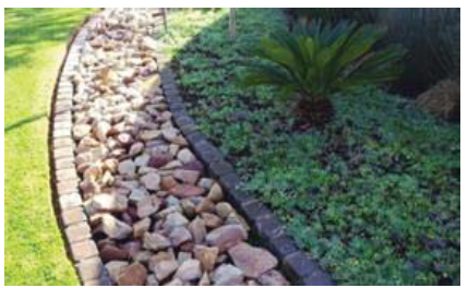 | All of the land area occupied by stormwater management facilities (including retention and detention ponds and other bioretention devices), when such features are treated as an open space site amenity | To qualify, stormwater management facilities shall support passive recreation uses by providing access, pedestrian elements such as paths and benches, gentle slopes (less than 4:1), and vegetative landscaping. |
| Access Easements with Paths or Trails | ||
 | Public access easements that include paths or trails that are available for passive recreational activities such as walking, running, and biking | Such access easements shall include at least one improved access from a public street, sidewalk, or trail that includes signage designating the access point, and adequate path and right-of-way width to accommodate the use and maintenance of the facilities. |
| Active Recreational Areas | ||
 | Land occupied by areas and facilities used for active recreational purposes, such as ballfields, playgrounds, tennis courts, pools, jogging trails, and community buildings and clubhouses, and land dedicated for parks. |
• Land shall be compact and contiguous unless used to link or continue an existing
or planned open space resource.
• Areas shall have at least one direct access to a building or to a street, bikeway, or walkway accessible to the public or the development's occupants and users. |
| Squares, Forecourts, and Plazas | ||
 | Flat, open areas immediately in front of a building or framed by buildings or streets that provide gathering places, opportunities for outdoor dining, etc. |
• A square, forecourt, or plaza shall be at least 200 square feet, but no more than
one acre, in area.
• A square, forecourt, or plaza shall have at least one direct access to a principal building, or to a street, bikeway, or walkway accessible to the public or the development's occupants and users. • Surrounding principal buildings shall be oriented toward the square, forecourt, or plaza. |
(b)
Not Counted as Open Space Set-Asides. The following areas shall not be counted as open space set-aside areas:
(1)
Private yards and setbacks not subject to an open space or conservation easement;
(2)
Street rights-of-way or private access easements, including sidewalks located within those rights-of-way or easements;
(3)
Open parking areas and driveways;
(4)
Land covered by structures, unless designated for active recreational uses;
(5)
Designated outdoor storage areas;
(6)
Stormwater ponds not located and designed as a site amenity (e.g., with low fencing, vegetative landscaping, gentle slopes, a fountain or other visible water circulation device, and pedestrian access or seating); and
(7)
Parking lot interior landscaping.
5.4.5. - Design Standards for Open-Space Set Asides.
(a)
Location. Open space set-asides shall be located so they are readily accessible and usable by occupants and users of the development. Where possible, a portion of the open space set-aside should provide focal points for the development through prominent placement or easy visual access from streets.
(b)
Configuration.
(1)
Open space set-asides shall be compact and contiguous, unless a different configuration is needed to continue an existing trail or accommodate preservation of natural features.
(2)
To the maximum extent possible, buildings adjacent to the required open space set-asides shall have at least one (1) entrance facing the open space set-aside.
(3)
If the development site is adjacent to existing or planned public trails, parks, or other public open space area, the open space set-aside shall, to the maximum extent practicable, be located to adjoin, extend, and enlarge the trail, park, or other public open space area (see Figure 5.4.5(b): Example Open Space Set-Aside Configuration).
Figure 5.4.5(b): Example Open Space Set-Aside Configuration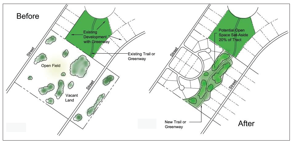
(c)
Prioritization of Open Space Set-Aside.
(1)
Except in the WS district, and to the maximum extent practicable, open space set-asides shall be located and organized to include, protect, and enhance as many of the following open areas and features as possible, in the following general order of priority:
(A)
Natural features such as riparian areas, riparian buffers, flood hazard areas, floodplains, and wildlife habitat areas;
(B)
Water features such as lakes, rivers, streams, natural ponds, wetlands, and retention and detention ponds;
(C)
Protected trees and other mature trees;
(D)
Parks and trails;
(E)
Perimeter buffers or visual transitions between different types or intensities of uses; and
(F)
Areas that accommodate multiple compatible open space set-aside uses rather than a single use.
(2)
In the residential districts when three-family, four-family, townhome, and multifamily development is built, to the maximum extent practicable, open space set-asides shall be located and organized to include, protect, or enhance the open areas and features identified in Table 5.4.4: Open Space Set-Aside Features, except that the a minimum of thirty-five (35) percent of the open space set-sides shall be for active recreation.
(3)
In the WS District, to the maximum extent practicable, open space set-asides shall be located and organized to include, protect, or enhance the open areas and features identified in Table 5.4.4 : Open Space Set-Aside Features, except that the establishment of squares, plazas, forecourts, civic greens, and similar urban open space amenities shall have the highest priority.
(d)
Development Allowed within Open Space Set-Aside. Development within an open space set-aside shall be limited to that appropriate to the purposes of the type(s) of open space set-aside. Where appropriate, such development may include, but is not limited to, walking, jogging, and biking paths or trails; benches or other seating areas; meeting areas; tables, shelters, grills, and other picnicking facilities; docks and other facilities for fishing; environmental education guides and exhibits; gazebos and other decorative structures; fountains or other water features; play structures for children; gardens or seasonal planting areas; pools; athletic fields and courts; and associated clubhouses.
5.4.6. - Ownership, Management, and Maintenance.
(a)
General. Open space set-asides shall be managed and maintained as permanent open space through one (1) or more of the following options:
(1)
Conveyance of open space set-aside areas to a property owners' or homeowners' association that holds the land in common ownership and will be responsible for managing and maintaining the land for its intended open space purposes, in perpetuity;
(2)
Conveyance of open space set-aside areas to a third party beneficiary such as an environmental or civic organization that is organized for, capable of, and willing to accept responsibility for managing and maintaining the land for its intended open space purposes, in perpetuity; or
(3)
Establishment of easements on those parts of individually-owned lots including open space set-aside areas that require the areas to be managed consistent with the land's intended open space purposes and prohibit any inconsistent future development, in perpetuity.
(b)
Deed Restrictions, Covenants, or Other Legal Instruments. All options involving private ownership of open space set-aside areas shall include deed restrictions, covenants, or other legal instruments that ensure continued use of the land for its intended open space purposes, in perpetuity, and provide for the continued and effective management, operation, and maintenance of the land and facilities. Such legal documents shall be recorded in the public records of Orange County, where appropriate.
(c)
Responsibility for Managing and Maintaining. Responsibility for managing and maintaining open space set-asides rests with the owner of the land of the open space set-asides. Failure to maintain open space set-asides in accordance with this section and the development approval or permit shall be a violation of this LDC.
5.5.1.- Purpose.
The purpose of this subsection is to preserve existing vegetation within the City by requiring that development other than single-family and two (2) family (duplex) dwellings have a vegetation and tree removal permit before removing vegetation on a site, and that development relocate or replace the removed vegetation in appropriate locations. The intent is to promote water and energy conservation, reduce erosion, and provide harmony between the built and natural environments.
5.5.2. - Applicability.
(a)
Unless exempted in accordance with subsection (b) below, no vegetation outside the shoreline protection zone (see Sec. 5.3.7, Shoreline Protection Standards) shall be destroyed or removed from any property within the City without the approval of a vegetation and tree removal permit in accordance with Sec. 2.5.3(e), Vegetation and Tree Removal Permit.
(b)
A vegetation and tree removal permit is not required before vegetation removal if the vegetation endangers health, safety, or property in a manner that requires immediate removal. In such cases, the City Manager shall provide verbal approval, and subsequent to that and the removal, a vegetation and tree removal permit shall be approved in accordance with Sec 2.5.3(e), Vegetation and Tree Removal Permit.
5.5.3. - Vegetation Relocation or Replacement.
As a condition for approval of a vegetation and tree removal permit, the applicant shall relocate vegetation to be removed to another location on the site, or replace the vegetation with suitable replacements elsewhere on the site, consistent with a relocation plan included as part of the required landscape plan. In determining the required relocation, replacement, or root-pruning of vegetation, the City shall consider the needs of the intended use of the property, including all lands dedicated to public use, as well as an evaluation of the following:
(a)
Existing vegetative coverage on the site and in the immediate surrounding area;
(b)
Quantity, type, size (in dbh), and condition of vegetation to be removed on the entire site;
(c)
The feasibility of relocating the particular vegetation;
(d)
Topography and drainage of the site;
(e)
The type, size, and condition of the replacement vegetation; and
(f)
The nature of the existing and intended use of the property.
5.5.4. - Vegetation Removal in Right-of-Way.
(a)
Unless performed by the City, no tree planting, removal, surgery, cavity-filing, trimming, or spraying shall be done on any tree or shrub within any public right-of-way or on any property owned by the City without first obtaining a permit for such work from the Building Official.
(b)
No tree or shrub shall be trimmed by or under the direction of any public utility company for any purpose without possession of such a permit from the City. Such tree and shrub work shall be done under the City's supervision.
5.6.1.- Purpose.
The purpose of this subsection is to protect and enhance the tree canopy within the City by incorporating minimum standards for tree planting, as well as encouraging the protection of certain healthy trees on non-multifamily residential development, promoting the removal of prohibited tree species, and requiring the replacement of removed trees as necessary to achieve the City's goals for thirty (30) percent tree canopy.
(Ord. No. 1434, § 1, 10-14-24)
5.6.2. - Required Minimum Tree Quantities.
All properties subject to this subsection shall provide either a minimum number of trees or minimum total diameter of trees in accordance with Table 5.6.2: Minimum Tree Coverage. The minimum diameter (inches dbh) at planting of a qualifying tree under this subsection shall be three (3) inches. The minimum tree quantities provided herein are intended as minimum tree coverage standards, not as replacement standards to be used when a tree is removed. While tree removal may necessitate new plantings to remain consistent with this subparagraph, this subparagraph shall apply regardless of the reason a lot has fallen below minimum tree coverage standards and shall only apply to establish minimum tree quantities. The minimum tree quantities set forth herein shall be applicable regardless of whether any trees have been removed or application for tree removal is made. Any tree planted after October 14, 2024, intended to meet this minimum quantity shall be of a species included in the City of Maitland Approved Tree Stock List which has been adopted by resolution.
(Ord. No. 1434, § 1, 10-14-24)
5.6.3. - Applicability.
Except as otherwise provided by Section 164.045, Florida Statutes, as amended from time to time, no tree on a lot with a single-family, two-family (duplex), three-family, or four-family dwelling unit shall be cut down, destroyed, removed, topped, or relocated without first obtaining a tree removal permit in accordance with Sec. 2.5.3(e), Vegetation and Tree Removal Permit, and complying with the tree replacement or relocation requirements of this section.
(Ord. No. 1434, § 1, 10-14-24)
5.6.4. - Tree Relocation and Replacement.
When application is made to remove a specimen tree, the applicant shall be required to relocate the removed tree on site or plant new tree, in accordance with the following standards:
(a)
Relocation. Tree relocation is accomplished by replanting the tree being removed to another location on the lot. If a tree is relocated, no additional tree is required to be planted.
(b)
Replacement. Specimen trees shall be replaced by a similar species or by a species included in the City of Maitland Approved Tree Stock List, adopted by resolution, in accordance with the standards of Table 5.6.4: Specimen Tree Replacement Standards.
(c)
Payment in-Lieu Alternative. In-lieu of tree replacement, an applicant may pay into the City tree replacement account if determined by the Public Works Director, or designee, that it is impossible or impractical to plant the required replacements on the site from which trees were removed. The in-lieu payment shall be made in the amount equal to the market price at the time of application of the minimum required replacement trees.
(d)
Additional Standards. If trees are relocated or replaced in accordance with subsections (a) or (b) above, the following additional requirements apply:
(1)
If the natural growth habit of a replacement tree is destroyed within a year of planting, or a relocated tree dies within one (1) year of being relocated, the applicant shall replace the tree.
(2)
If a replacement tree is planted within four (4) feet of a public sidewalk or other paved area, root barriers shall be installed in accordance with standard professional practice.
(Ord. No. 1434, § 1, 10-14-24)
5.6.5. - Violations.
(a)
Failure to comply with the standards in this section is a violation of this LDC and subject to the remedies and penalties in Article 9: Enforcement, Ch. 5.3, Code Enforcement, of the City Code, and Ch. 4.7, Article III, Special Magistrate, of the City Code.
(b)
Removal of trees except in accordance with Sec. 2.5.3(e), Vegetation and Tree Removal Permit, shall be considered a violation of this section and this LDC, and may be mitigated by one (1) or a combination of the following:
(1)
Replacement equal to 1.50 times the cumulative DBH of trees removed and/or damaged to the cumulative caliper of trees to be installed, planted in a location conducive to their long-term survival and with a one-year guarantee of survivability, as approved by the City Manager;
(2)
Providing an in-lieu payment into the City tree fund equal to three (3) times the cost of replacement on an inch-to-inch basis. If the precise DBH cannot be determined, the cost of replacement shall be determined by the City Manager based on the best estimate of the DBH of the removed or damaged tree; and/or
(3)
Any other remedy deemed appropriate by the Special Magistrate.
(Ord. No. 1434, § 1, 10-14-24)
5.7.1.- General.
(a)
Title. These regulations shall be known as the Floodplain Management Ordinance of the City of Maitland.
(b)
Scope. The provisions of this section shall apply to all development that is wholly within or partially within any flood hazard area, including but not limited to the subdivision of land; filling, grading, and other site improvements and utility installations; construction, alteration, remodeling, enlargement, improvement, replacement, repair, relocation or demolition of buildings, structures, and facilities that are exempt from the Florida Building Code; installation or replacement of tanks; placement of recreational vehicles; installation of swimming pools; and any other development.
(c)
Purpose and Intent. The purpose and intent of this section and the flood load and flood resistant construction requirements of the Florida Building Code are to establish minimum requirements to safeguard the public health, safety, and general welfare, and to minimize public and private losses due to flooding through regulation of development in flood hazard areas to:
(1)
Minimize unnecessary disruption of commerce, access, and public service during times of flooding;
(2)
Require the use of appropriate construction practices in order to prevent or minimize future flood damage;
(3)
Manage filling, grading, dredging, mining, paving, excavation, drilling operations, storage of equipment or materials, and other development which may increase flood damage or erosion potential;
(4)
Manage the alteration of flood hazard areas, watercourses, and shorelines to minimize the impact of development on the natural and beneficial functions of the floodplain;
(5)
Minimize damage to public and private facilities and utilities;
(6)
Help maintain a stable tax base by providing for the sound use and development of flood hazard areas in such a manner as to minimize flood blight areas;
(7)
Minimize the need for future expenditure of public funds for flood control projects and response to and recovery from flood events;
(8)
Preserve the integrity of the City's lakes and water bodies, aquifer, and any other natural resource deemed necessary within the conservation sub-element of the City's comprehensive development plan; and
(9)
Meet the requirements of the National Flood Insurance Program for community participation as set forth in 44 CFR 59.22.
(d)
Coordination with Florida Building Code. This section is intended to be administered and enforced in conjunction with the Florida Building Code. Where cited, ASCE 24 refers to the edition of the standard that is referenced by the Florida Building Code.
(e)
Warning. The degree of flood protection required by this section and the Florida Building Code is considered the minimum reasonable for regulatory purposes and is based on scientific and engineering considerations. Larger floods can and will occur. Flood heights may be increased by man-made or natural causes. This section does not imply that land outside of mapped special flood hazard areas, or that uses permitted within such flood hazard areas, will be free from flooding or flood damage. The flood hazard areas and base flood elevations contained in the flood insurance study and shown on flood insurance rate maps and the requirements of Title 44 CFR, Sections 59 and 60, may be revised by the Federal Emergency Management Agency (FEMA), requiring the City to revise these regulations to remain eligible for participation in the National Flood Insurance Program. No guaranty of vested use, existing use, or future use is implied or expressed by compliance with this section.
(f)
Disclaimer of Liability. This section shall not create liability on the part of the City Council or by any officer or employee of the City for any flood damage that results from reliance on this section or any administrative decision lawfully made under this section.
5.7.2. - Applicability.
(a)
General. Where there is a conflict between a general requirement and a specific requirement, the specific requirement shall be applicable.
(b)
Areas to which This Section Applies. This section shall apply to all flood hazard areas within the City, as established in subsection (c) below.
(c)
Basis for Establishing Flood Hazard Areas. The Flood Insurance Study for Orange County, Florida and Incorporated Areas dated June 20, 2018, and all subsequent amendments and revisions, and the accompanying Flood Insurance Rate Maps (FIRM), and all subsequent amendments and revisions to such maps, are adopted by reference as a part of this section and shall serve as the minimum basis for establishing flood hazard areas. Studies and maps that establish flood hazard areas are on file in the office of the Public Works Department, 1827 Fennell St, Maitland, Florida.
(d)
Submission of Additional Data to Establish Flood Hazard Areas. To establish flood hazard areas and base flood elevations, in accordance with Sec. 5.7.5, Site Plans and Construction Documents, the Floodplain Administrator may require submission of additional data. Where field surveyed topography prepared by a Florida licensed professional surveyor or digital topography accepted by the City indicates that ground elevations:
(1)
Are below the closest applicable base flood elevation, even in areas not delineated as a special flood hazard area on a FIRM, the area shall be considered as a flood hazard area and subject to the requirements of this section and, as applicable, the requirements of the Florida Building Code.
(2)
Are above the closest applicable base flood elevation, the area shall be regulated as a special flood hazard area unless the applicant obtains a letter of map change that removes the area from the special flood hazard area.
(e)
Other Laws. The provisions of this section shall not be deemed to nullify any provisions of City, county, state, or federal law.
(f)
Abrogation and Greater Restrictions. This section supersedes any ordinance in effect for management of development in flood hazard areas. However, it is not intended to repeal or abrogate any existing ordinances including but not limited to this LDC, other City laws and regulations, stormwater management regulations, or the Florida Building Code. In the event of a conflict between this section and any section of this LDC or any other provision of the City Code, the more restrictive shall govern. This section shall not impair any deed restriction, covenant, or easement, but any land that is subject to such interests shall also be governed by this section.
(g)
Interpretation. In the interpretation and application of this section, all provisions shall be:
(1)
Considered as minimum requirements;
(2)
Liberally construed in favor of the governing body; and
(3)
Deemed neither to limit nor repeal any other powers granted under state statutes.
5.7.3. - Duties and Powers of the Floodplain Administrator.
(a)
Designation. The City Manager or a designee is designated as the Floodplain Administrator.
(b)
Powers. The Floodplain Administrator is authorized and directed to administer and enforce the provisions of this section. The Floodplain Administrator shall have the authority to render interpretations of this section consistent with its intent and purpose and may establish policies and procedures in order to clarify the application of its provisions. Such interpretations, policies, and procedures shall not have the effect of waiving requirements specifically provided in this section without the granting of a variance in accordance with Sec. 5.7.7, Variances and Appeals.
(c)
Duties. The Floodplain Administrator shall have the following responsibilities:
(1)
Applications and Permits. The Floodplain Administrator, in coordination with other applicable City officials and departments, shall:
(A)
Review applications and plans to determine whether proposed new development will be located in flood hazard areas;
(B)
Review applications for modification of any existing development in flood hazard areas for compliance with the requirements of this section;
(C)
Interpret flood hazard area boundaries where such interpretation is necessary to determine the exact location of boundaries; a person contesting the determination shall have the opportunity to appeal the interpretation;
(D)
Provide available flood elevation and flood hazard information;
(E)
Determine whether additional flood hazard data shall be obtained from other sources or shall be developed by an applicant;
(F)
Review applications to determine whether proposed development will be reasonably safe from flooding;
(G)
Issue floodplain development permits or approvals for development other than buildings and structures that are subject to the Florida Building Code, including buildings, structures, and facilities exempt from the Florida Building Code, when compliance with this section is demonstrated, or disapprove the same in the event of noncompliance; and
(H)
Coordinate with and provide comments to the Building Official to assure that applications, plan reviews, and inspections for buildings and structures in flood hazard areas comply with the applicable provisions of this section.
(2)
Evaluation of Impacts on Flood Hazard Areas. The Floodplain Administrator shall not issue permits for proposed development, including substantial improvements, in flood hazard areas:
(A)
If the proposed development is determined to significantly increase flooding hazards, unless such increases are mitigated; or
(B)
Where sufficient area exists on a parcel or lot such that the development can occur without encroaching into flood hazard areas without causing an undue hardship on the owner.
(3)
Substantial Improvement and Substantial Damage Determinations. For applications for building permits to improve buildings and structures, including alterations, movement, enlargement, replacement, repair, change of occupancy, additions, rehabilitations, renovations, substantial improvements, repairs of substantial damage, and any other improvement of or work on such buildings and structures, the Floodplain Administrator, in coordination with the Building Official, shall:
(A)
Estimate the market value, or require the applicant to obtain an appraisal of the market value prepared by a qualified independent appraiser, of the building or structure before the start of construction of the proposed work; in the case of repair, the market value of the building or structure shall be the market value before the damage occurred and before any repairs are made;
(B)
Compare the cost to perform the improvement, the cost to repair a damaged building to its pre-damaged condition, or the combined costs of improvements and repairs, if applicable, to the market value of the building or structure;
(C)
Determine and document whether the proposed work constitutes substantial improvement or repair of substantial damage; and
(D)
Notify the applicant if it is determined that the work constitutes substantial improvement or repair of substantial damage and that compliance with the flood resistant construction requirements of the Florida Building Code and this section is required.
(4)
Modifications of the Strict Application of the Requirements of the Florida Building Code. The Floodplain Administrator shall review requests submitted to the Building Official that seek approval to modify the strict application of the flood load and flood resistant construction requirements of the Florida Building Code to determine whether such requests require the granting of a variance in accordance with Sec. 5.7.7, Variances and Appeals.
(5)
Notices and Orders. The Floodplain Administrator shall coordinate with appropriate local agencies for the issuance of all necessary notices or orders to ensure compliance with this section.
(6)
Inspections. The Floodplain Administrator shall make the required inspections as specified in Sec. 5.7.6, Inspections, for development that is not subject to the Florida Building Code, including buildings, structures and facilities exempt from the Florida Building Code. The Floodplain Administrator shall inspect flood hazard areas to determine if development is undertaken without issuance of a permit.
(7)
Other Duties. The Floodplain Administrator shall have other duties, including but not limited to:
(A)
Establish, in coordination with the Building Official, procedures for administering and documenting determinations of substantial improvement and substantial damage made in accordance with Sec. 5.7.3(c)(3), Substantial Improvement and Substantial Damage Determinations;
(B)
Require that applicants proposing alteration of a watercourse notify adjacent communities and the Florida Division of Emergency Management, State Floodplain Management Office, and submit copies of such notifications to FEMA;
(C)
Require applicants who submit hydrologic and hydraulic engineering analyses to support permit applications to submit to FEMA the data and information necessary to maintain the flood insurance rate maps if the analyses propose to change base flood elevations, flood hazard area boundaries, or floodway designations; such submissions shall be made within six (6) months of such data becoming available;
(D)
Review required design certifications and documentation of elevations specified by this section and the Florida Building Code to determine that such certifications and documentations are complete; and
(E)
Notify FEMA when the corporate boundaries of the City are modified.
(8)
Maintenance of Records. Regardless of any limitation on the period required for retention of public records, the Floodplain Administrator shall maintain and permanently keep and make available for public inspection all records that are necessary for the administration of this section and the flood resistant construction requirements of the Florida Building Code, including FIRMs; letters of map change; records of issuance of permits and denial of permits; determinations of whether proposed work constitutes substantial improvement or repair of substantial damage; required design certifications and documentation of elevations specified by the Florida Building Code and this section; notifications to adjacent communities, FEMA, and the state related to alterations of watercourses; assurances that the flood carrying capacity of altered watercourses will be maintained; documentation related to appeals and variances, including justification for issuance or denial; and records of enforcement actions taken in accordance with the requirements of this section and the flood resistant construction requirements of the Florida Building Code. These records shall be available for public inspection at the offices of the Public Works Department, 1827 Fennell St, Maitland, Florida.
5.7.4. - Floodplain Development Permit.
(a)
Permit Required. Any owner or owner's authorized agent (hereinafter "applicant") who intends to undertake any development activity within the scope of this section, including the development of buildings, structures, and facilities exempt from the Florida Building Code which are wholly within or partially within any flood hazard area, shall first make application to the Floodplain Administrator, and the Building Official if applicable, and shall obtain any required permits and approvals. No permit or approval shall be issued until compliance with the requirements of this section, this LDC, and all other applicable codes and regulations has been satisfied.
(b)
Floodplain Development Permit. Floodplain Development Permits or approvals shall be issued in accordance with the requirements of this section for any development activities not subject to the requirements of the Florida Building Code, including buildings, structures, and facilities exempt from the Florida Building Code. Depending on the nature and extent of proposed development that includes a building or structure, the Floodplain Administrator may determine that a floodplain development permit or approval is required in addition to a building permit. See Sec. 2.5.3(h), Floodplain Development Permit.
(c)
Buildings, Structures, and Facilities Exempt from the Florida Building Code. In accordance with the requirements of federal regulation for participation in the National Flood Insurance Program (Title 44 CFR, Secs. 59 and 60), Floodplain Development Permits or approvals shall be required for the following buildings, structures, and facilities that are exempt from the Florida Building Code and any further exemptions provided by law, which are subject to the requirements of this section:
(1)
Railroads and ancillary facilities associated with the railroad.
(2)
Nonresidential farm buildings on farms, as provided in Sec. 604.50, Fla. Stat.
(3)
Temporary buildings or sheds used exclusively for construction purposes.
(4)
Mobile or modular structures used as temporary offices.
(5)
Those structures or facilities of electric utilities, as defined in Sec. 366.02, Fla. Stat., which are directly involved in the generation, transmission, or distribution of electricity.
(6)
Chickees constructed by the Miccosukee Tribe of Indians of Florida or the Seminole Tribe of Florida.
(7)
Family mausoleums not exceeding two hundred fifty (250) square feet in area which are prefabricated and assembled on site or preassembled and delivered on site and have walls, roofs, and a floor constructed of granite, marble, or reinforced concrete.
(8)
Temporary housing provided by the Department of Corrections to any prisoner in the state correctional system.
(9)
Structures identified in Sec. 553.73(10)(k), Fla. Stat., that are not exempt from the Florida Building Code, if such structures are located in flood hazard areas established on flood insurance rate maps.
(d)
Application for a Permit or Approval. To obtain a Floodplain Development Permit or approval the applicant shall first file an application in writing on a form furnished by the City. The information provided shall:
(1)
Identify and describe the development to be covered by the permit or approval.
(2)
Describe the land on which the proposed development is to be conducted by legal description, street address or similar description, that will readily identify and definitively locate the site.
(3)
Indicate the use and occupancy for which the proposed development is intended.
(4)
Be accompanied by a site plan or construction documents as specified in Sec. 5.7.5, Site Plans and Construction Documents.
(5)
State the valuation of the proposed work.
(6)
Be signed by the applicant or the applicant's authorized agent.
(7)
Give such other data and information as is required by the Floodplain Administrator.
(e)
Validity of Permit. The issuance of a Floodplain Development Permit or approval in accordance with this section and Sec. 2.5.3(h), Floodplain Development Permit, shall not be construed to be a permit for, or approval of, any violation of this section, the Florida Building Codes, or any other laws or regulations of the City. The issuance of permits based on submitted applications, construction documents, and information shall not prevent the Floodplain Administrator from requiring the correction of errors and omissions.
(f)
Expiration of Permit. A Floodplain Development Permit or approval shall become invalid unless the work authorized by such permit is commenced within one hundred eighty (180) days after its issuance, or if the work authorized is suspended or abandoned for a period of one hundred eighty (180) days after the work commences. Extensions for periods of not more than one hundred eighty (180) days each shall be requested in writing and justifiable cause shall be demonstrated.
(g)
Suspension or Revocation. The Floodplain Administrator is authorized to suspend or revoke a Floodplain Development Permit or approval if the permit was issued in error, on the basis of incorrect, inaccurate, or incomplete information, or in violation of this section, this LDC, or any other ordinance, regulation, or requirement of the City.
(h)
Other Permits Required. Each Floodplain Development Permit and building permit shall include a condition that all other applicable state or federal permits be obtained before commencement of the permitted development, including but not limited to:
(1)
The St. Johns River Water Management District (SJRWMD); Sec. 373.036, Fla. Stat.
(2)
Florida Department of Health (FDH) for onsite sewage treatment and disposal systems; Sec. 381.0065, Fla. Stat., and Ch. 64E-6, F.A.C.
(3)
DEP for activities subject to the Joint Coastal Permit; Sec. 161.055, Fla. Stat.
(4)
DEP for activities that affect wetlands and alter surface water flows, in conjunction with the U.S. Army Corps of Engineers; Section 404 of the Clean Water Act (33 U.S.C. Sec. 1344).
(5)
Federal permits and approvals.
5.7.5. - Site Plans and Construction Documents.
(a)
Information for Development in Flood Hazard Areas. The site plan or construction documents for any development subject to the requirements of this section shall be drawn to scale and shall include, as applicable to the proposed development:
(1)
Delineation of flood hazard areas, floodway boundaries and flood zone(s), base flood elevation(s), and ground elevations, if necessary for review of the proposed development.
(2)
Where base flood elevations or floodway data are not included on the FIRM or in the flood insurance study, they shall be established in accordance with subsections (c)(2) and (c)(3) below.
(3)
Where the parcel on which the proposed development will take place will have more than fifty (50) lots or is larger than five (5) acres and the base flood elevations are not included on the FIRM or in the flood insurance study, such elevations shall be established in accordance with subsection (c)(1) below.
(4)
Location of the proposed activity and proposed structures, and locations of existing buildings and structures.
(5)
Location, extent, amount, and proposed final grades of any filling, grading, or excavation.
(6)
Where the placement of fill is proposed, the amount, type, and source of fill material; compaction specifications; a description of the intended purpose of the fill areas; and evidence that the proposed fill areas are the minimum necessary to achieve the intended purpose.
(7)
Existing and proposed alignment of any proposed alteration of a watercourse.
(b)
Waiver of Data. The Floodplain Administrator is authorized to waive the submission of site plans, construction documents, and other data that are required by this section but that are not required to be prepared by a registered design professional if it is found that the nature of the proposed development is such that the review of such submissions is not necessary to ascertain compliance with this section.
(c)
Information in Flood Hazard Areas without Base Flood Elevation (Approximate Zone A). Where flood hazard areas are delineated on the FIRM and base flood elevation data have not been provided, the Floodplain Administrator shall:
(1)
Require the applicant to include base flood elevation data prepared in accordance with currently accepted engineering practices.
(2)
Obtain, review, and provide to applicant's base flood elevation and floodway data available from a federal or state agency or other source, or require the applicant to obtain and use base flood elevation and floodway data available from a federal or state agency or other source.
(3)
Where base flood elevation and floodway data are not available from another source, where the available data are deemed by the Floodplain Administrator to not reasonably reflect flooding conditions, or where the available data are known to be scientifically or technically incorrect or otherwise inadequate:
(A)
Require the applicant to include base flood elevation data prepared in accordance with currently accepted engineering practices; or
(B)
Specify that the base flood elevation is two (2) feet above the highest adjacent grade at the location of the development, provided there is no evidence indicating flood depths have been or may be greater than two (2) feet.
(4)
Where the base flood elevation data are to be used to support a letter of map change from FEMA, advise the applicant that the analyses shall be prepared by a Florida licensed engineer in a format required by FEMA, and that it shall be the responsibility of the applicant to satisfy the submittal requirements and pay the processing fees.
(d)
Additional Analyses and Certifications. As applicable to the location and nature of the proposed development activity, and in addition to the requirements of this section, the applicant shall have the following analyses signed and sealed by an engineer licensed by the state for submission with the site plan and construction documents:
(1)
For development activities proposed to be located in a regulatory floodway, a floodway encroachment analysis that demonstrates that the encroachment of the proposed development will not cause any increase in base flood elevations; where the applicant proposes to undertake development activities that do increase base flood elevations, the applicant shall submit such analysis to FEMA as specified in subsection (e) below, and shall submit the conditional letter of map revision, if issued by FEMA, with the site plan and construction documents.
(2)
For development activities proposed to be located in a riverine flood hazard area for which base flood elevations are included in the flood insurance study or on the FIRM and floodways have not been designated, hydrologic and hydraulic analyses that demonstrate that the cumulative effect of the proposed development, when combined with all other existing and anticipated flood hazard area encroachments, will not increase the base flood elevation more than one (1) foot at any point within the City. This requirement does not apply in isolated flood hazard areas not connected to a riverine flood hazard area or in flood hazard areas identified as Zone AO or Zone AH.
(3)
For alteration of a watercourse, an engineering analysis prepared in accordance with standard engineering practices which demonstrates that the flood-carrying capacity of the altered or relocated portion of the watercourse will not be decreased, and certification that the altered watercourse shall be maintained in a manner which preserves the channel's flood-carrying capacity; the applicant shall submit the analysis to FEMA as specified in subsection (e) below.
(e)
Submission of Additional Data. When additional hydrologic, hydraulic, or other engineering data, studies, and additional analyses are submitted to support an application, the applicant has the right to seek a letter of map change from FEMA to change the base flood elevations, change floodway boundaries, or change boundaries of flood hazard areas shown on FIRMs, and to submit such data to FEMA for such purposes. The analyses shall be prepared by an engineer licensed by the state in a format required by FEMA. Submittal requirements and processing fees shall be the responsibility of the applicant.
5.7.6. - Inspections.
(a)
General. Development for which a Floodplain Development Permit or approval is required shall be subject to inspection.
(b)
Development Other Than Buildings and Structures. The Floodplain Administrator shall inspect all development to determine compliance with the requirements of this section and the conditions of approval of issued Floodplain Development Permits or approvals.
(c)
Buildings, Structures, and Facilities Exempt from the Florida Building Code. The Floodplain Administrator shall inspect buildings, structures, and facilities exempt from the Florida Building Code to determine compliance with the requirements of this section and the conditions of issued Floodplain Development Permits or approvals.
(d)
Buildings, Structures, and Facilities Exempt from the Florida Building Code, Lowest Floor Inspection. Upon placement of the lowest floor, including basement, and prior to further vertical construction, the owner of a building, structure, or facility exempt from the Florida Building Code, or the owner's authorized agent, shall submit to the Floodplain Administrator:
(1)
If a design flood elevation was used to determine the required elevation of the lowest floor, the certification of elevation of the lowest floor prepared and sealed by a Florida licensed professional surveyor; or
(2)
If the elevation used to determine the required elevation of the lowest floor was determined in accordance with Sec. 5.7.5(c)(3)(B) above, the documentation of height of the lowest floor above highest adjacent grade, prepared by the owner or the owner's authorized agent.
(e)
Buildings, Structures, and Facilities Exempt from the Florida Building Code, Final Inspection. As part of the final inspection, the owner or owner's authorized agent shall submit to the Floodplain Administrator a final certification of elevation of the lowest floor or final documentation of the height of the lowest floor above the highest adjacent grade; such certifications and documentations shall be prepared as specified in subsection (d) above.
5.7.7. - Variances and Appeals.
(a)
General. The P&Z shall hear and decide requests for appeals and requests for variances from the strict application of this section. In accordance with Sec. 553.73(5), Fla Stat., the P&Z shall hear and decide requests for appeals and requests for variances from the strict application of the flood resistant construction requirements of the Florida Building Code.
(b)
Appeals. The P&Z shall hear and decide appeals when it is alleged there is an error in any requirement, decision, or determination made by the Floodplain Administrator in the administration and enforcement of this section. Any person aggrieved by the decision may appeal such decision to the circuit court, as provided by Fla Stat.
(c)
Limitations on Authority to Grant Variances. The P&Z shall base its decisions on variances on technical justifications submitted by applicants, the considerations for issuance in subsection (g) below, the conditions of issuance set forth in subsection (h) below, and the comments and recommendations of the Floodplain Administrator and the Building Official. The P&Z has the right to attach such conditions of approval as it deems necessary to further the purposes and objectives of this section.
(d)
Restrictions in Floodways. A variance shall not be issued for any proposed development in a floodway if any increase in base flood elevations would result, as evidenced by the applicable analyses and certifications required in Sec. 5.7.5(d), Additional Analyses and Certifications.
(e)
Historic Buildings. A variance is authorized to be issued for the repair, improvement, or rehabilitation of an historic building that is determined eligible for the exception to the flood resistant construction requirements of the Florida Building Code, Existing Building, Ch. 12 Historic Buildings, upon a determination that the proposed repair, improvement, or rehabilitation will not preclude the building's continued designation as a historic building, and the variance is the minimum necessary to preserve the historic character and design of the building. If the proposed work precludes the building's continued designation as an historic building, a variance shall not be granted and the building and any repair, improvement, and rehabilitation shall be subject to the requirements of the Florida Building Code.
(f)
Functionally Dependent Uses. A variance is authorized to be issued for the construction or substantial improvement necessary for the conduct of a functionally dependent use, as defined in this section, provided the variance complies with the requirements of Sec. 5.7.7(d), Restrictions in Floodways; is the minimum necessary considering the flood hazard; and all due consideration has been given to use of methods and materials that minimize flood damage during occurrence of the base flood.
(g)
Considerations for Issuances of Variances. In reviewing requests for variances, the P&Z shall consider all technical evaluations, all relevant factors, all other applicable provisions of the Florida Building Code, this section, and the following:
(1)
The danger that materials and debris may be swept onto other lands resulting in further injury or damage;
(2)
The danger to life and property due to flooding or erosion damage;
(3)
The susceptibility of the proposed development, including contents, to flood damage and the effect of such damage on current and future owners;
(4)
The importance of the services provided by the proposed development to the community;
(5)
The availability of alternate locations for the proposed development that are subject to lower risk of flooding or erosion;
(6)
The compatibility of the proposed development with existing and anticipated development;
(7)
The relationship of the proposed development to the comprehensive development plan and floodplain management program for the area;
(8)
The safety of access to the property in times of flooding for ordinary and emergency vehicles;
(9)
The expected heights, velocity, duration, rate of rise and debris and sediment transport of the floodwaters and the effects of wave action, if applicable, expected at the site; and
(10)
The costs of providing governmental services during and after flood conditions, including maintenance and repair of public utilities and facilities such as sewer, gas, electrical and water systems, streets, and bridges.
(h)
Conditions for Issuances of Variances. Variances shall be issued only upon:
(1)
Submission by the applicant, of a showing of good and sufficient cause that the unique characteristics of the size, configuration, or topography of the site limit compliance with any provision of this section or the required elevation standards;
(2)
Determination by the P&Z that:
(A)
Failure to grant the variance would result in exceptional hardship due to the physical characteristics of the land that render the lot undevelopable; increased costs to satisfy the requirements or inconvenience do not constitute hardship;
(B)
The granting of a variance will not result in increased flood heights, additional threats to public safety, extraordinary public expense, nor create nuisances, cause fraud on or victimization of the public or conflict with existing local laws and ordinances; and
(C)
The variance is the minimum necessary, considering the flood hazard, to afford relief;
(3)
Receipt of a signed statement by the applicant that the variance, if granted, shall be recorded in the office of the Clerk of the Court in such a manner that it appears in the chain of title of the affected parcel of land; and
(4)
If the request is for a variance to allow construction of the lowest floor of a new building, or substantial improvement of a building, below the required elevation, a copy in the record of a written notice from the Floodplain Administrator to the applicant for the variance, specifying the difference between the base flood elevation and the proposed elevation of the lowest floor, stating that the cost of federal flood insurance will be commensurate with the increased risk resulting from the reduced floor elevation (up to amounts as high as twenty-five dollars ($25.00) for one hundred dollars ($100.00) of insurance coverage), and stating that construction below the base flood elevation increases risks to life and property.
5.7.8. - Violations.
(a)
Violations. Any development that is not within the scope of the Florida Building Code but that is regulated by this section that is performed without an issued permit, that is in conflict with an issued permit, or that does not fully comply with this section, shall be deemed a violation of this section and punishable for a non-criminal violation. A building or structure without the documentation of elevation of the lowest floor, other required design certifications, or other evidence of compliance required by this section or the Florida Building Code is presumed to be a violation until such time as that documentation is provided.
(b)
Authority. For development that is not within the scope of the Florida Building Code but that is regulated by this section and that is determined to be a violation, the Floodplain Administrator is authorized to serve notices of violation or stop work orders to owners of the property involved, to the owner's agent, or to the person or persons performing the work. Nothing contained herein shall prevent the City from taking such lawful actions as are necessary to prevent or remedy any violation.
(c)
Unlawful Continuance. Any person who shall continue any work after having been served with a notice of violation or a stop work order, except such work as that person is directed to perform to remove or remedy a violation or unsafe condition, shall be subject to penalties as prescribed by Sec. 1-8 of the City Code and, in addition, shall pay all costs and expenses involved in the case. Each day such violation continues shall be considered a separate offense.
5.7.9. - Buildings and Structures.
In accordance with Sec. 5.7.4(c), Buildings, Structures, and Facilities Exempt from the Florida Building Code, buildings, structures, and facilities that are exempt from the Florida Building Code, including substantial improvement or repair of substantial damage of such buildings, structures, and facilities, shall be designed and constructed in accordance with the flood load and flood resistant construction requirements of ASCE 24. Structures exempt from the Florida Building Code that are not walled and roofed buildings shall comply with the requirements of Sec. 5.7.15, Other Development.
5.7.10. - Subdivisions.
(a)
Minimum Requirements. Subdivision proposals shall be reviewed to determine that:
(1)
Such proposals are consistent with the need to minimize flood damage and will be reasonably safe from flooding;
(2)
All public utilities and facilities such as sewer, gas, electric, communications, and water systems are located and constructed to minimize or eliminate flood damage; and
(3)
Adequate drainage is provided to reduce exposure to flood hazards; in Zones AH and AO, adequate drainage paths shall be provided to guide floodwaters around and away from proposed structures.
(b)
Subdivision Plats. Where any portion of a proposed subdivision lies within a flood hazard area, the following shall be required:
(1)
Delineation of flood hazard areas, floodway boundaries and flood zones, and design flood elevations, as appropriate, shall be shown on preliminary plats;
(2)
Where the subdivision has more than fifty (50) lots or is larger than five (5) acres and base flood elevations are not included on the FIRM, the base flood elevations shall be determined in accordance with Sec. 5.7.5(c)(1) above; and
(3)
The subdivision shall comply with the site improvement and utilities requirements of Sec. 5.7.11, Site Improvements, Utilities, and Limitations.
5.7.11. - Site Improvements, Utilities, and Limitations.
(a)
Minimum Requirements. All proposed new development shall be reviewed to determine that:
(1)
Such proposals are consistent with the need to minimize flood damage and will be reasonably safe from flooding;
(2)
All public utilities and facilities such as sewer, gas, electric, communications, and water systems are located and constructed to minimize or eliminate flood damage; and
(3)
Adequate drainage is provided to reduce exposure to flood hazards; in Zones AH and AO, adequate drainage paths shall be provided to guide floodwaters around and away from proposed structures.
(b)
Sanitary Sewage Facilities. All new and replacement sanitary sewage facilities, private sewage treatment plants (including all pumping stations and collector systems), and on-site waste disposal systems shall be designed in accordance with the standards for onsite sewage treatment and disposal systems in Ch. 64E-6, F.A.C., and ASCE 24 Ch. 7 to minimize or eliminate infiltration of floodwaters into the facilities and discharge from the facilities into flood waters, and impairment of the facilities and systems.
(c)
Water Supply Facilities. All new and replacement water supply facilities shall be designed in accordance with the water well construction standards in Ch. 62-532.500, F.A.C., and ASCE 24 Ch. 7 to minimize or eliminate infiltration of floodwaters into the systems.
(d)
Limitations on Sites in Regulatory Floodways. No development, including but not limited to site improvements and land disturbing activity involving fill or regrading, shall be authorized in the regulatory floodway unless the floodway encroachment analysis required in Sec. 5.7.5(d)(1) above demonstrates that the proposed development or land disturbing activity will not result in any increase in the base flood elevation.
(e)
Limitations on Placement of Fill. Subject to the limitations of this section, fill shall be designed to be stable under conditions of flooding including rapid rise and rapid drawdown of floodwaters, prolonged inundation, and protection against flood-related erosion and scour. In addition to these requirements, if intended to support buildings and structures (Zone A only), fill shall comply with the requirements of the Florida Building Code.
(f)
Special Environmental Protection. Special flood hazard areas adjacent to Lake Lucien and Howell Creek exist substantially in a natural state and restriction of further encroachment and reduction of the flood capacity in these areas by development can prevent costly flooding and other environmental damage. Encroachments, including fill, new construction, substantial improvements, and other development shall be prohibited.
5.7.12. - Manufactured Homes.
In accordance with this LDC, the placement or installation of manufactured or mobile homes is not permitted.
5.7.13. - Recreational Vehicles and Park Trailers.
(a)
Temporary Placement. Recreational vehicles and park trailers placed temporarily in flood hazard areas shall:
(1)
Be on the site for fewer than one hundred eighty (180) consecutive days; or
(2)
Be fully licensed and ready for highway use, which means the recreational vehicle or park model is on wheels or jacking system, is attached to the site only by quick-disconnect type utilities and security devices, and has no permanent attachments such as additions, rooms, stairs, decks, and porches.
(b)
Permanent Placement. Recreational vehicles and park trailers that do not meet the limitations in subsection (a) above for temporary placement are not permitted.
5.7.14. - Tanks.
(a)
Underground Tanks. Underground tanks in flood hazard areas shall be anchored to prevent flotation, collapse, or lateral movement resulting from hydrodynamic and hydrostatic loads during conditions of the design flood, including the effects of buoyancy assuming the tank is empty.
(b)
Above-ground Tanks, Not Elevated. Above-ground tanks that do not comply with the elevation requirements of subsection (c) below shall be permitted in flood hazard areas provided the tanks are anchored or otherwise designed and constructed to prevent flotation, collapse, or lateral movement resulting from hydrodynamic and hydrostatic loads during conditions of the design flood, including the effects of buoyancy assuming the tank is empty and the effects of flood-borne debris.
(c)
Above-ground Tanks, Elevated. Above-ground tanks in flood hazard areas shall be elevated to or above the design flood elevation and attached to a supporting structure that is designed to prevent flotation, collapse, or lateral movement during conditions of the design flood. Tank-supporting structures shall comply with the foundation requirements of the applicable flood hazard area.
(d)
Tank Inlets and Vents. Tank inlets, fill openings, outlets, and vents shall be:
(1)
At or above the design flood elevation or fitted with covers designed to prevent the inflow of floodwater or outflow of the contents of the tanks during conditions of the design flood; and
(2)
Anchored to prevent lateral movement resulting from hydrodynamic and hydrostatic loads, including the effects of buoyancy, during conditions of the design flood.
5.7.15. - Other Development.
(a)
General Requirements for Other Development. All development, including man-made changes to improved or unimproved property for which specific provisions are not specified in this section or the Florida Building Code, shall:
(1)
Be located and constructed to minimize flood damage;
(2)
Comply with the limitations of Sec. 5.7.11(d), Limitations on Sites in Regulatory Floodways, if located in a regulated floodway;
(3)
Be anchored to prevent flotation, collapse, or lateral movement resulting from hydrostatic loads, including the effects of buoyancy, during conditions of the design flood;
(4)
Be constructed of flood damage-resistant materials; and
(5)
Have mechanical, plumbing, and electrical systems above the design flood elevation or comply with the requirements of ASCE 24, except that minimum electric service required to address life safety and electric code requirements is permitted below the design flood elevation, provided it conforms to the provisions of the electrical part of the Building Code for wet locations.
(b)
Fences in Regulated Floodways. Fences in regulated floodways that have the potential to block the passage of floodwaters, such as stockade fences and wire mesh fences, shall meet the limitations of Sec. 5.7.11(d), Limitations on Sites in Regulatory Floodways.
(c)
Retaining Walls, Sidewalks, and Driveways in Regulated Floodways. Retaining walls and sidewalks and driveways that involve the placement of fill in regulated floodways shall meet the limitations of Sec. 5.7.11(d), Limitations on Sites in Regulatory Floodways.
(d)
Roads and Watercourse Crossings in Regulated Floodways. Roads and watercourse crossings, including roads, bridges, culverts, low-water crossings and similar means for vehicles or pedestrians to travel from one (1) side of a watercourse to the other side, that encroach into regulated floodways shall comply with the limitations of Sec. 5.7.11(d), Limitations on Sites in Regulatory Floodways. Alteration of a watercourse that is part of a road or watercourse crossing shall comply with the requirements of Sec. 5.7.5(d)(3) above.
5.7.16. - Lakes, Canals, Streams, and Drainage Courses.
To protect the aquifer and surface water bodies in the City, impermeable surfaces of each property abutting the lakes, canals, streams, and drainage courses illustrated in Map A, Protected Water Courses in the City of Maitland, attached to Ordinance No. 940, incorporated herein by reference, and available for public inspection in the Department of Public Works, shall not be altered to increase square footage of such surfaces by more than 15 percent of impermeable surface area, except in accordance with the following:
(a)
On-site Drainage. The property shall be designed, constructed upon, and maintained to prevent direct discharge of stormwater into the abutting watercourse by use of environmental swales and/or another method as approved by the City, and providing for on-site retention of the first one-half (½) inch of rainfall for single-family or two-family (duplex) dwellings and the 25-year storm event for three-family, four-family, and multifamily residential and all non-residential development. Properties within subdivisions meeting the stormwater levels of service adopted by the City are exempt from this provision.
(b)
Structural Improvements within the Flood Hazard Area. If any structural improvements are proposed within the flood hazard area, a certified elevation survey showing the controlled water elevation of the lake(s) adjacent to the property and the base flood elevation contour to the subject property shall be provided. Also, soil borings and tests may be required on the property to establish the stability of the soil.
5.7.17. - Definitions.
Unless otherwise expressly stated, the following words and terms shall, for the purposes of this section only, have the meanings shown in this section. Where terms are not defined in this section and are defined in the Florida Building Code, such terms shall have the meanings ascribed to them in that code. Where terms are not defined in this section or the Florida Building Code, such terms shall have the meanings ascribed to them in Article 10: Definitions and Rules for Construction, Interpretation, and Measurement, of this LDC, and, if not defined in Article 10, shall have ordinarily accepted meanings such as the context implies.
ALTERATION OF A WATERCOURSE. A dam, impoundment, channel relocation, change in channel alignment, channelization, or change in cross-sectional area of the channel or the channel capacity, or any other form of modification which may alter, impede, retard, or change the direction and/or velocity of the riverine flow of water during conditions of the base flood.
APPEAL. A request for a review of the Floodplain Administrator's interpretation of any provision of this section.
ASCE 24. The standard titled Flood Resistant Design and Construction that is referenced by the Florida Building Code. ASCE 24 is developed and published by the American Society of Civil Engineers, Reston, VA.
BASE FLOOD. A flood having a one (1) percent chance of being equaled or exceeded in any given year. [Also defined in the Florida Building Code (FBC), B, Section 202.] The base flood is commonly referred to as the "100-year flood" or the "one (1) percent-annual chance flood."
BASE FLOOD ELEVATION. The elevation of the base flood, including wave height, relative to the National Geodetic Vertical Datum (NGVD), North American Vertical Datum (NAVD) or other datum specified on the Flood Insurance Rate Map (FIRM). [Also defined in FBC, B, Section 202.]
BASEMENT. The portion of a building having its floor subgrade (below ground level) on all sides. [Also defined in FBC, B, Section 202; see "Basement (for flood loads)".]
DESIGN FLOOD. The flood associated with the greater of the following two (2) areas: [Also defined in FBC, B, Section 202.]
(1)
Area with a floodplain subject to a one (1) percent or greater chance of flooding in any year; or
(2)
Area designated as a flood hazard area on the community's flood hazard map, or otherwise legally designated.
DESIGN FLOOD ELEVATION. The elevation of the "design flood," including wave height, relative to the datum specified on the City's legally designated flood hazard map. In areas designated as Zone AO, the design flood elevation shall be the elevation of the highest existing grade of the building's perimeter plus the depth number (in feet) specified on the flood hazard map. In areas designated as Zone AO where the depth number is not specified on the map, the depth number shall be taken as being equal to two (2) feet. [Also defined in FBC, B, Section 202.]
DEVELOPMENT. Any man-made change to improved or unimproved real estate, including but not limited to, buildings or other structures, tanks, temporary structures, temporary or permanent storage of equipment or materials, mining, dredging, filling, grading, paving, excavations, drilling operations, or any other land disturbing activities.
ENCROACHMENT. The placement of fill, excavation, buildings, permanent structures, or other development into a flood hazard area which may impede or alter the flow capacity of riverine flood hazard areas.
EXISTING BUILDING AND EXISTING STRUCTURE. Any buildings and structures for which the "start of construction" commenced before September 5, 1979. [Also defined in FBC, B, Section 202.]
FEDERAL EMERGENCY MANAGEMENT AGENCY (FEMA). The federal agency that, in addition to carrying out other functions, administers the National Flood Insurance Program.
FLOOD OR FLOODING. A general and temporary condition of partial or complete inundation of normally dry land from: [Also defined in FBC, B, Section 202.]
(1)
The overflow of inland or tidal waters.
(2)
The unusual and rapid accumulation or runoff of surface waters from any source.
FLOOD DAMAGE-RESISTANT MATERIALS. Any construction material capable of withstanding direct and prolonged contact with floodwaters without sustaining any damage that requires more than cosmetic repair. [Also defined in FBC, B, Section 202.]
FLOOD HAZARD AREA. The greater of the following two (2) areas: [Also defined in FBC, B, Section 202.]
(1)
The area within a floodplain subject to a one (1) percent or greater chance of flooding in any year.
(2)
The area designated as a flood hazard area on the community's flood hazard map, or otherwise legally designated.
FLOOD INSURANCE RATE MAP (FIRM). The official map of the City on which FEMA has delineated both special flood hazard areas and the risk premium zones applicable to the City. [Also defined in FBC, B, Section 202.]
FLOOD INSURANCE STUDY (FIS). The official report provided by FEMA that contains the flood insurance rate map, the flood boundary and floodway map (if applicable), the water surface elevations of the base flood, and supporting technical data. [Also defined in FBC, B, Section 202.]
FLOODPLAIN ADMINISTRATOR. The office or position designated and charged with the administration and enforcement of this Section 5.7, Flood Damage Prevention.
FLOODPLAIN DEVELOPMENT PERMIT OR APPROVAL. An official document or certificate issued by the City, or other evidence of approval or concurrence, which authorizes performance of specific development activities that are located in flood hazard areas and that are determined to comply with this section.
FLOODWAY. The channel of a river or other riverine watercourse and the adjacent land areas that shall be reserved in order to discharge the base flood without cumulatively increasing the water surface elevation more than one (1) foot. [Also defined in FBC, B, Section 202.]
FLOODWAY ENCROACHMENT ANALYSIS. An engineering analysis of the impact that a proposed encroachment into a floodway is expected to have on the floodway boundaries and base flood elevations; the evaluation shall be prepared by a qualified Florida licensed engineer using standard engineering methods and models.
FLORIDA BUILDING CODE. The family of codes adopted by the Florida Building Commission, including: the Florida Building Code, Building; the Florida Building Code, Residential; the Florida Building Code, Existing Building; the Florida Building Code, Mechanical; the Florida Building Code, Plumbing; the Florida Building Code, Fuel Gas.
FREEBOARD. The additional height, usually expressed as a factor of safety in feet, above a flood level for purposes of floodplain management. Freeboard tends to compensate for many unknown factors, such as wave action, blockage of bridge or culvert openings, and hydrological effect of urbanization of the watershed, which could contribute to flood heights greater than the heights calculated for a selected frequency flood and floodway conditions.
FUNCTIONALLY DEPENDENT USE. A use which cannot perform its intended purpose unless it is located or carried out in close proximity to water, including only docking facilities, port facilities that are necessary for the loading and unloading of cargo or passengers, and ship building and ship repair facilities; the term does not include long-term storage or related manufacturing facilities.
HARDSHIP. For the purpose of variances from this section, the exceptional difficulty associated with the land that would result from a failure to grant the requested variance. Hardships shall be exceptional, unusual, and peculiar to the property involved. Mere economic or financial hardship alone is not exceptional. Inconvenience, aesthetic considerations, physical handicaps, personal preferences, or the disapproval of one's neighbors do not, as a rule, qualify as an exceptional hardship. All of these concerns can be resolved through other means without granting a variance, even if the alternative is more expensive or requires the property owner to build elsewhere or put the parcel to a different use than originally intended.
HIGHEST ADJACENT GRADE. The highest natural elevation of the ground surface prior to construction next to the proposed walls or foundation of a structure.
HISTORIC STRUCTURE. Any structure that is determined eligible for the exception to the flood hazard area requirements of the Florida Building Code, Existing Building, Ch. 12 Historic Buildings.
LETTER OF MAP CHANGE (LOMC). An official determination issued by FEMA that amends or revises an effective flood insurance rate map or flood insurance study. Letters of map change include:
Letter of Map Amendment (LOMA). An amendment based on technical data showing that a property was incorrectly included in a designated special flood hazard area. A LOMA amends the current effective flood insurance rate map and establishes that a specific property, portion of a property, or structure is not located in a special flood hazard area.
Letter of Map Revision (LOMR). A revision based on technical data that may show changes to flood zones, flood elevations, special flood hazard area boundaries and floodway delineations, and other planimetric features.
Letter of Map Revision Based on Fill (LOMR-F). A determination that a structure or parcel of land has been elevated by fill above the base flood elevation and is, therefore, no longer located within the special flood hazard area. To qualify for this determination, the fill shall have been permitted and placed in accordance with the community's floodplain management regulations.
Conditional Letter of Map Revision (CLOMR). A formal review and comment as to whether a proposed flood protection project or other project complies with the minimum NFIP requirements for such projects with respect to delineation of special flood hazard areas. A CLOMR does not revise the effective flood insurance rate map or flood insurance study; upon submission and approval of certified as-built documentation, a letter of map revision may be issued by FEMA to revise the effective FIRM.
LIGHT-DUTY TRUCK. As defined in 40 CFR 86.082-2, any motor vehicle rated at eight thousand five hundred (8,500) pounds gross vehicular weight rating or less, which has a vehicular curb weight of six thousand (6,000) pounds or less and which has a basic vehicle frontal area of forty-five (45) square feet or less, which is:
(1)
Designed primarily for purposes of transportation of property or is a derivation of such a vehicle;
(2)
Designed primarily for transportation of persons and has a capacity of more than twelve (12) persons; or
(3)
Available with special features enabling off-street or off-highway operation and use.
LOWEST FLOOR. The lowest floor of the lowest enclosed area of a building or structure, including basement, but excluding any unfinished or flood-resistant enclosure, other than a basement, usable solely for vehicle parking, building access, or limited storage, provided that such enclosure is not built so as to render the structure in violation of the non-elevation requirements of the Florida Building Code or ASCE 24. [Also defined in FBC, B, Section 202.]
MARKET VALUE. The price at which a property will change hands between a willing buyer and a willing seller, neither party being under compulsion to buy or sell and both having reasonable knowledge of relevant facts. As used in this section, the term refers to the market value of buildings and structures, excluding the land and other improvements on the parcel. Market value may be established by a qualified independent appraiser, actual cash value (replacement cost depreciated for age and quality of construction), or tax assessment value adjusted to approximate market value by a factor provided by the property appraiser.
NEW CONSTRUCTION. For the purposes of administration of this section and the flood resistant construction requirements of the Florida Building Code, structures for which the "start of construction" commenced on or after September 5, 1979, including any subsequent improvements to such structures.
PARK TRAILER. A transportable unit which has a body width not exceeding fourteen (14) feet and which is built on a single chassis and is designed to provide seasonal or temporary living quarters when connected to utilities necessary for operation of installed fixtures and appliances. [Defined in Sec. 320.01, Fla. Stat.]
PUBLIC SAFETY. Anything which is injurious to safety or health of the entire community or a neighborhood, or any considerable number of persons, or unlawfully obstructs the free passage or use, in the customary manner, of any navigable lake, or river, bay, stream, canal, or basin.
RECREATIONAL VEHICLE. A vehicle, including a park trailer, which is: [See Sec. 320.01, Fla. Stat.)
(1)
Built on a single chassis;
(2)
Four hundred (400) square feet or less when measured at the largest horizontal projection;
(3)
Designed to be self-propelled or permanently towable by a light-duty truck; and
(4)
Designed primarily not for use as a permanent dwelling but as temporary living quarters for recreational, camping, travel, or seasonal use.
REGULATORY FLOODWAY. See Floodway.
RIVERINE. Relating to, formed by, or resembling a river (including tributaries), stream, brook, etc.
SPECIAL FLOOD HAZARD AREA. An area in the floodplain subject to a one percent or greater chance of flooding in any given year. Special flood hazard areas are shown on FIRMs as Zone A, AO, A1—A30, AE, A99, AH, V1—V30, VE, or V. [Also defined in FBC, B Section 202.]
START OF CONSTRUCTION. The date of issuance of permits for new construction and substantial improvements, provided the actual start of construction, repair, reconstruction, rehabilitation, addition, placement, or other improvement is within one hundred eighty (180) days of the date of the issuance. The actual start of construction means either the first placement of permanent construction of a building (including a manufactured home) on a site, such as the pouring of slab or footings, the installation of piles, or the construction of columns. Permanent construction does not include land preparation (such as clearing, grading, or filling), the installation of streets or walkways, excavation for a basement, footings, piers, or foundations, the erection of temporary forms or the installation of accessory buildings such as garages or sheds not occupied as dwelling units or not part of the main buildings. For a substantial improvement, the actual "start of construction" means the first alteration of any wall, ceiling, floor, or other structural part of a building, whether or not that alteration affects the external dimensions of the building. [Also defined in FBC, B Section 202.]
SUBSTANTIAL DAMAGE. Damage of any origin sustained by a building or structure whereby the cost of restoring the building or structure to its before-damaged condition would equal or exceed 50 percent of the market value of the building or structure before the damage occurred. [Also defined in FBC, B Section 202.]
SUBSTANTIAL IMPROVEMENT. Any repair, reconstruction, rehabilitation, addition, or other improvement of a building or structure, the cost of which equals or exceeds fifty (50) percent of the market value of the building or structure before the improvement or repair is started. If the structure has incurred "substantial damage," any repairs are considered substantial improvement regardless of the actual repair work performed. The term does not, however, include either: [Also defined in FBC, B, Section 202.]
(1)
Any project for improvement of a building required to correct existing health, sanitary, or safety code violations identified by the Building Official and that are the minimum necessary to assure safe living conditions.
(2)
Any alteration of an historic structure provided the alteration will not preclude the structure's continued designation as an historic structure.
VARIANCE. A grant of relief from the requirements of this section, or the flood resistant construction requirements of the Florida Building Code, which permits construction in a manner that would not otherwise be permitted by this section or the Florida Building Code.
WATERCOURSE. A river, creek, stream, channel, or other topographic feature in, on, through, or over which water flows, at least periodically.
5.8.1.- Purpose and Intent.
The purpose and intent of this section is to regulate the location, height, and appearance of fences and walls to:
(a)
Maintain visual harmony within neighborhoods and throughout the City;
(b)
Protect adjacent lands from the indiscriminate placement and the unsightliness of fences and walls; and
(c)
Ensure that fences and walls are subject to timely maintenance when it is needed.
5.8.2. - Applicability.
(a)
General. Unless exempted in accordance with subsection (b) below, the standards in this section apply to all construction, substantial reconstruction, or replacement of fences or walls in the City.
(b)
Exemptions. The following fences and walls are exempt from the standards in this section:
(1)
Fences and walls required for support of a principal or accessory structure;
(2)
Fences or barricades around construction sites;
(3)
Fences for tree protection or sedimentation and erosion control;
(4)
Fences customarily provided for athletic fields, recreational facilities, and cemeteries;
(5)
Landscaping berms installed without fences; and
(6)
Fences at parks and schools, where such uses are owned by public agencies.
(c)
Timing of Review. Review for compliance with the standards in this section shall occur during review of a development application for planned development (Sec. 2.5.1(f), Planned Development), site plan (Sec. 2.5.2(a), Site Plan), subdivision (Sec. 2.5.2(b), Subdivision), site construction permit, or building permit, whichever occurs first.
5.8.3. - General Standards.
(a)
Except on a flag lot in a Residential zone district, where construction of a fence or wall along the access section of the lot that connects to the public street by a narrow, private right-of-way or driveway is prohibited, fences and walls that comply with the standards in this subsection are allowed anywhere on a lot, or on a property line between privately-owned lots.
(b)
A fence or wall shall not unreasonably impede visibility of street traffic from vehicles or exiting driveways, or be located within the sight triangle.
(c)
Hedges may be placed, planted, and allowed to grow to form an opaque screen within any required front yard or within the access section of a flag lot, subject to the visibility requirements of paragraph (b) above.
(d)
Gates shall not swing outward over a sidewalk or into the right-of-way.
5.8.4. - Height.
(a)
Standard.
(1)
A fence or wall located in a required yard shall comply with the height standards in Table 5.8.4(a): Maximum Fence or Wall Height in Required Yards.
(2)
Fence posts and wall columns may extend above the maximum fence heights established in Table 5.8.4(a): Maximum Fence or Wall Height in Required Yards, by three (3) feet, provided no part of a fence or wall post or column shall have a height greater than six (6) feet in the front yard of a residential district, or nine (9) feet elsewhere.
5.8.5. - Materials.
(a)
General. Unless otherwise specified in subsection (b) below, fences and walls shall be constructed of any one (1) or more of the following materials:
(1)
Masonry or stone;
(2)
Ornamental iron or other decorative metal, except that fencing shall not incorporate spiked tops within a Residential district without approval of a security exemption plan in accordance with Sec. 5.8.8, Security Exemption Plan;
(3)
Painted wood, pressure treated wood, or rot-resistant wood such as cedar, cypress, or teak;
(4)
Composite materials designed to appear as wood, metal, or masonry;
(5)
Chain link only as a customary part of a sports field. Where permitted, all chain link fences shall be vinyl coated and installed with the pointed ends to the ground;
(6)
Vinyl fencing (for non-multifamily residential uses only); and
(7)
Walls clad with substrate material intended to support living vegetation.
(b)
Prohibited Materials. The following fence types or materials are prohibited unless approved as part of a security exemption plan in accordance with Sec. 5.8.8, Security Exemption Plan.
(1)
Barbed and/or razor wire;
(2)
Fences or walls with any material or substance designed to inflict pain or injury on any person or animal such as broken glass, spikes, nails, barbs, or similar material;
(3)
Fences constructed of chicken wire, corrugated metal, fabric materials, fiberboard, garage door panels, plywood, rolled plastic, sheet metal, debris, junk, or waste materials, unless such materials are recycled and reprocessed, for marketing to the general public, as building materials designed to resemble new building materials (e.g., picket fencing made from recycled plastic and fiber);
(4)
In the Mixed-Use and Nonresidential zone districts, opaque vinyl fence panels;
(5)
Chain link fences except as permitted in subsection (a)(5) above; and
(6)
Above-ground fences that carry electrical current (below-ground electrical fences intended for the keeping of pets are not prohibited).
5.8.6. - Appearance.
(a)
Finished Side to Outside. Wherever a fence or wall is installed, if one (1) side of the fence or wall appears more "finished" than the other (e.g., one (1) side of a fence has visible support framing and the other does not, or one (1) side of a wall has a textured surface and the other does not), the more "finished" side of the fence shall face the exterior of the lot rather than the interior of the lot.
(b)
Fence and Wall Landscaping. All fences and walls exceeding four (4) feet in height, if located within fifteen (15) feet of a street right-of-way, shall be supplemented with landscape screening in accordance with the standards in subsections (1) and (2) below, to soften the visual impact of the fence or wall. These standards shall apply to fences in Residential single-family districts (RSF-1, RSF-2, RSF-3, and RSF-D) only if they are located within 15 feet of the right-of-way of a principal arterial street or minor arterial street. (See Figure 5.8.6(b): Fence and Wall Landscaping.)
(1)
Shrubs Required. One (1) evergreen shrub shall be installed for every three (3) linear feet of fence or wall, on the side of the fence or wall facing the public street right-of-way. Shrubs may be installed in a staggered, clustered, grouped, or linear fashion.
(2)
Substitution of Understory Trees. One (1) intermediate tree may be substituted for every two (2) shrubs spaced no closer than fifteen (15) feet on center provided that the tree complies with the standards of Section 5.3, Landscape, Buffer, and Tree Protection Standards.
Figure 5.8.6(b): Fence and Wall Landscaping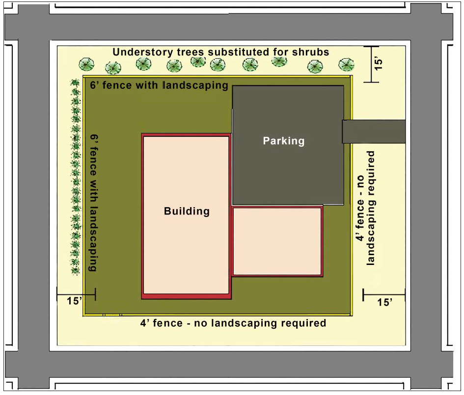
5.8.7. - Maintenance.
Fences, walls, and associated landscaping shall be maintained in good repair and in a safe and attractive condition. Maintenance of fences and walls shall include, but not be limited to, the replacement of missing, decayed, or broken structural or decorative elements; keeping the structure clean of dirt and debris; and the repair of deteriorated or damaged fence materials, including, but not limited to, weathered surfaces visible from the public right-of-way, sagging sections, and posts that lean more than ten (10) degrees from vertical.
5.8.8. - Security Exemption Plan.
(a)
A landowner, or a representative of a public agency responsible for a government facility or other use in need of heightened security, may submit to the Community Development Director a security exemption plan proposing, for security reasons, a fence or wall taller than those permitted by this section or the use of barbed and/or razor wire atop a fence or wall.
(b)
The Community Development Director may approve or approve with conditions the security exemption plan upon finding that the condition, location, or use of the land indicates the land or any materials stored or used on it are in significantly greater danger of theft or damage than surrounding land, without a taller fence or wall, and that the taller fence or wall will not have a significant adverse effect on the security, functioning, appearance, or value of adjacent lands or the surrounding area as a whole.
5.9.1.- Purpose and Intent.
The purpose and intent of this section is to regulate exterior lighting to:
(a)
Ensure all exterior lighting is designed and installed to maintain adequate lighting levels on site;
(b)
Assure that excessive light spillage and glare are not directed at adjacent property, neighboring areas, and motorists;
(c)
Curtail light pollution, reduce skyglow, and preserve the nighttime environment for the enjoyment of residents and visitors;
(d)
Conserve energy and resources to the greatest extent possible; and
(e)
Provide security for persons and property.
5.9.2. - Applicability.
(a)
General. Except as exempted in accordance with subsection (b) below:
(1)
New Development. All new development shall comply with the standards in this section.
(2)
Existing Development. Any expansion or alteration of development existing prior to March 1, 2022 shall comply with the standards of this section to the maximum extent practicable if the expansion increases the building's floor area by fifty (50) percent or more, or the alteration involves fifty (50) percent or more of the building's floor area (including interior alterations), as measured over any five-year period.
(b)
Exemptions. The following types of lighting are exempt from the standards of this section:
(1)
Lighting exempt under state or federal law;
(2)
FAA-mandated lighting associated with a utility tower or airport;
(3)
Lighting for public monuments and statuary;
(4)
Lighting solely for signage (see Section 5.14, Signs);
(5)
Temporary lighting for circuses, fairs, carnivals, and theatrical and other performance areas, provided such lighting is discontinued upon completion of the performance;
(6)
Temporary lighting of construction sites, provided such lighting is discontinued upon completion of the construction activity;
(7)
Temporary lighting for emergency situations, provided such lighting is discontinued upon abatement of the emergency situation;
(8)
Security lighting controlled and activated by motion sensor devices for a duration of fifteen (15) minutes or less;
(9)
Underwater lighting in swimming pools, fountains, and other water features;
(10)
Holiday or festive lighting, provided such lighting does not create unsafe glare on street rights-of-way or neighboring properties; and
(11)
Outdoor lighting fixtures that do not comply with provisions of this section March 1, 2022, provided they are brought into compliance with this section when they become unrepairable.
(c)
Prohibited Lighting. The following exterior lighting is prohibited:
(1)
Light fixtures that imitate an official highway or traffic control light or sign;
(2)
Light fixtures that have a flashing or intermittent pattern of illumination;
(3)
Spotlights, except when used by federal, state, or local authorities, or where they are used to illuminate alleys, parking garages, and working (maintenance) areas, so long as they are shielded and aimed so that they do not result in lighting on any adjacent lot or public right-of-way exceeding 2.0 foot candles; and
(4)
Light fixtures that direct lighting in an upwards direction except in accordance with Sec. 5.9.5(e), Decorative and Landscape Lighting.
(d)
Timing of Review. Review for compliance with the standards in this section shall occur during review of a development application for planned development (Sec. 2.5.1(f), Planned Development), site plan (Sec. 2.5.2(a), Site Plan), or building permit, whichever occurs first.
5.9.3. - Lighting Plan.
To ensure compliance with the standards of this section, a photometric plan demonstrating how exterior lighting will comply with the standards of this section shall be included as part of the application in which these standards are reviewed and approved.
5.9.4. - General Standards.
(a)
Maximum Illumination Levels. Except for street and pedestrian lighting, all exterior lighting and indoor lighting visible from outside shall be designed and located so that the maximum illumination measured at ground level at a lot line (see Sec. 5.9.7, Illumination Measurement) is zero foot-candles.
(b)
Maximum Height.
(1)
Except for athletic field lighting features, which shall not exceed ninety-five (95) feet in height, and street lights, the height of exterior light fixtures, whether mounted on poles, walls, or by other means, shall not exceed twenty (20) feet.
(2)
The height of street lights is dependent on the type of luminaire and its candlepower, the lamp, and the pole, and shall be approved by the Public Works Director.
(c)
Full Cut-Off Fixtures Required. Except for street lights, all exterior luminaries, including security lighting, shall be full cut-off fixtures that are directed downward, consistent with Figure 5.9.4(c): Full Cut-off Fixtures. In no case shall lighting be directed above a horizontal plane through the lighting fixture.
Figure 5.9.4(c): Full Cut-off Fixtures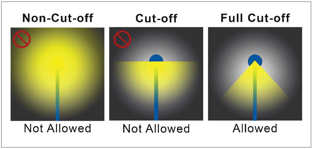
(d)
Energy-Efficient Fixtures and Elements Required.
(1)
All outdoor light fixtures and light elements shall be energy efficient, as defined in subsection (2) below. The Community Development Director may allow exceptions to this requirement if the applicant demonstrates any of the following:
(A)
An energy efficient fixture or light element is not reasonably available that meets the necessary functional requirements;
(B)
Available energy efficient fixtures or light elements are not cost-effective over the life of the product, taking energy cost savings into account; or
(C)
The use of an energy efficient fixture or light element is unreasonable or impractical for other reasons.
(2)
For purposes of this subsection, an energy efficient light fixture or light element shall meet one (1) of the following criteria:
(A)
Is in the upper twenty-five (25) percent of efficiency for all similar products as designated by the U.S. Department of Energy's Federal Energy Management Program; or
(B)
Meets Department of Energy and Environmental Protection Agency criteria for use of the Energy Star trademark label.
5.9.5. - Standards for Specific Uses and Site Features.
(a)
Sports or Performance Venue.
(1)
Lighting fixtures for outdoor sports areas, athletic fields, and performance areas shall be equipped with a glare control package (e.g., louvers, shields, or similar devices) and aimed so that their beams are directed and fall within the primary playing or performance area.
(2)
Notwithstanding the standards of this section, lighting for outdoor recreational uses such as ball diamonds, football fields, soccer fields, other playing fields, tennis courts, and similar uses, shall:
(A)
Be up to thirty (30) feet in height, except at ball diamonds, football fields, and other playing fields, where they can be up to ninety-five (95) feet in height;
(B)
Have maximum illumination from such lighting at the property line not to exceed 2.0 foot-candles; and
(C)
Be extinguished no later than 11:00 p.m. except to complete an activity that is in progress prior to 11:00 p.m.
(b)
Pedestrian Area Lighting.
(1)
Except near streets, crosswalks, or rights of way where the Public Works Director determines that different standards are needed for safety, light fixtures for sidewalks, walkways, trails, and bicycle paths, outside of vehicular surface areas (parking lots), except for pedestrian bollard lamps, shall comply with the following standards:
(A)
Provide at least 0.8 foot-candles of illumination, but not exceed 2.0 foot-candles;
(B)
Have a maximum height of fifteen (15) feet; and
(C)
Be placed a maximum of one hundred (100) feet apart.
(2)
Any pedestrian bollard lamps shall be mounted no higher than four (4) feet above grade and shall not exceed nine hundred (900) lumens for any single lamp. (See Figure 5.9.5(b)(2): Examples of Pedestrian Bollard Lamps).
Figure 5.9.5(b)(2): Examples of Pedestrian Bollard Lamps
(c)
Wall Pack Lights. Wall packs on the exterior of the building shall be fully shielded (e.g., true cut-off type bulb or light source not visible from off-site) to direct the light vertically downward and shall not exceed one thousand six hundred (1,600) lumens for any single fixture.
(d)
Canopy. Areas under a canopy shall be designed so as not to create glare off-site. Acceptable methods to address this include one (1) or both of the following:
(1)
A recessed fixture incorporating a lens cover that is either recessed or flush with the bottom surface (ceiling) of the canopy that provides a full cutoff or fully-shielded light distribution; or
(2)
A surface mounted fixture incorporating a flat glass that provides a full cutoff or fully-shielded light distribution.
(e)
Decorative and Landscape Lighting. Outdoor light fixtures used for decorative effects shall comply with the following standards:
(1)
Decorative lighting intended to enhance the appearance of a building, monument, and/or landscaping may cast light upward against the building surface or onto a landscape feature but not towards the sky.
(2)
Decorative lighting fixtures shall not exceed one thousand six hundred (1,600) lumens for any single fixture.
5.9.6. - Street Lights.
(a)
Street lights are required in all development.
(b)
Street lights shall be mounted on non-corrosive poles served by underground wiring. The lamps shall be designed to minimize direct glare and to provide reasonably uniform light distribution on the street and sidewalk surface.
(c)
The light structure and light color of street lights in an individual subdivision or development shall be consistent throughout the subdivision or development.
(d)
The lamps and poles to provide the required illumination shall be compatible with the structure types in the subdivision.
(e)
The developer shall coordinate with the utility that will provide electrical service for the street lights.
5.9.7. - Illumination Measurement.
(a)
If illumination is measured, the measurement shall be made at the lot line of the land upon which light is to be measured. If measurement on private property is not possible or practical, light level measurements may be made at the boundary of the public street right-of-way that adjoins the land. Measurements shall be made at finished grade (ground level), with the light-registering portion of the meter held parallel to the ground.
(b)
Illumination measurements shall be taken with a light meter that has been calibrated within two (2) years.
5.9.8. - Exemptions for Safety Reasons.
(a)
Government facilities, like property or rights-of-way, parks, public safety, and other development may submit a security plan to the Community Development Director proposing exterior lighting that deviates from the standards in this section. The Community Development Director shall approve or approve with conditions the security plan and its proposed deviation from the standards, upon finding that:
(1)
The proposed deviation from the standards is necessary for the adequate protection of the subject land, development, or the public;
(2)
The condition, location, or use of the land, or the history of activity in the area, indicates the property or any materials stored or used on it are in significantly greater danger of theft or damage, or members of the public are at greater risk for harm than on surrounding property without the additional lighting; and
(3)
The proposed deviation from the standards is the minimum required, and will not have a significant adverse effect on neighboring lands.
(b)
If the Community Development Director finds the applicant fails to demonstrate compliance with subsection (a) above, the security plan shall be denied.
5.10.1.- Purpose and Intent.
The purpose of these neighborhood compatibility standards is to provide a proper transition from and ensure compatibility between existing single-family detached and two-family (duplex) dwellings and vacant land in single-family residential zone districts, and more intense forms of development. More specifically, it is the intent of these standards to protect the character of existing residential neighborhoods consisting of primarily single-family detached and two-family (duplex) dwellings from potentially adverse impacts resulting from more intense and incompatible adjacent forms of development.
5.10.2. - Applicability.
(a)
General.
(1)
Unless exempted by subsection (b) below, the standards in this section apply to the following development:
(A)
New multifamily, townhome, four-family, nonresidential, and mixed-use development when located on land adjacent to or across a street or alley from "protected development" as defined in subsection (2) below.
(B)
Any expansion or alteration of an existing multifamily, townhome, four-family, nonresidential, or mixed-use development when located on land adjacent to or across a street or alley from protected development.
(2)
For purposes of this section, "protected development" shall mean the following when located within lands defined as part of the Traditional Neighborhood Future Land Use in the comprehensive development plan:
(A)
An existing single-family detached or two-family (duplex) dwelling; and
(B)
Vacant land in a single-family residential zone district (RSF-1, RSF-2, RSF-3, RSF-D).
(b)
Exemptions. The following are exempt from these standards:
(1)
Development separated from protected development by a street with four (4) or more lanes, by a right-of-way greater than seventy-five (75) feet, or by railroad right-of-way;
(2)
Uses in the Education category; and
(3)
All planned developments approved prior to March 1, 2022.
(c)
Conflict. In the case of conflict between these standards and other standards in this LDC, these standards shall control unless expressly stated to the contrary.
5.10.3. - Standards.
Development subject to this section shall comply with the following standards:
(a)
Off-Street Parking.
(1)
Off-street parking shall be established in one (1) or more of the following locations, listed in priority order:
(A)
Adjacent to existing parking lots serving nonresidential uses on abutting lots;
(B)
Adjacent to lot lines abutting nonresidential development;
(C)
Adjacent to lot lines abutting mixed-use development; or
(D)
Adjacent to lot lines abutting protected development or parcels.
(2)
Parking structure façades adjacent to protected development or parcels shall be configured to appear as articulated or landscaped building walls, to soften their visual impact.
(3)
Off-street parking lots located adjacent to protected development shall have at least a ten-foot wide buffer yard that includes the following:
(A)
A six-foot-tall fence in accordance with Sec. 5.10.3(j), Perimeter Fence or Wall); and
(B)
Six (6) trees (including three (3) canopy and three (3) intermediate trees) and sixty (60) shrubs per one hundred (100) linear feet planted between the fence and the lot line. The trees and shrubs shall comply with Sec. 5.3.4(g), General Planting Standards.
(C)
The total amount of off-street parking shall not exceed 1.1 times the required minimum specified in Sec. 5.2.5(a), Minimum Number of Off-Street Vehicular Parking Spaces, and may be reduced through an alternative parking plan approved by the Community Development Director if it will not have an adverse impact on the adjacent protected development.
(b)
Building Setbacks.
(1)
Except as provided in subsection (2) below, all buildings shall be setback a minimum of fifty (50) feet from the lot line of the protected development.
(2)
If a proposed development is required to provide a Type C buffer adjacent to protected development in accordance with Table 5.3.4(c)(3): Buffer Types, the building setback may be reduced to no less than 35 feet if the developer installs within the buffer a solid masonry wall at least eight (8) feet high that is compatible, in terms of texture and quality, with the material and color of the principal buildings on the site.
(c)
Building Orientation. To the maximum extent practicable, multifamily, townhouse, four-family, nonresidential, and mixed-use development shall be oriented to face similar forms of development on adjacent or opposing lots rather than protected development.
(d)
Building Location. No building shall be located within fifty (50) feet of the lot line of protected development or within the required yard adjacent to protected development, whichever distance is larger.
(e)
Building Massing.
(1)
Building façades facing protected development shall be configured to appear as a series of distinct building modules, storefronts, wings, projections, or recesses that comply with the following standards:
(A)
Each individual module, storefront, wing, projection, or recess shall maintain a minimum width of twenty (20) feet and a maximum width of seventy-five (75) feet.
(B)
Projections or recesses shall maintain a minimum offset of two (2) feet from the primary building façade wall plane.
(2)
Exterior, open corridors facing a protected development are prohibited.
(f)
Building Height.
(1)
Building height, as measured by Sec. 10.2.1(a), Building Height, shall not exceed the height established in Table 5.10.3(f)(1): Maximum Height Where Neighborhood Compatibility Standards Are Applicable. This does not allow greater height than would otherwise be allowed on the parcel by the other provisions of this LDC. Distance from protected development is measured from the lot line of the protected development to the building line or the point of height change of the building subject to the standard. (See Figure 5.10.3(f)(1): Maximum Height Where Neighborhood Compatibility Standards Are Applicable.)
Figure 5.10.3(f)(1): Maximum Height Where Neighborhood Compatibility Standards Are
Applicable
(2)
Buildings over three (3) stories in height adjacent to protected development shall be broken up into modules or wings with the smaller and shorter portions of the structure located adjacent to the protected development (see Figure 5.10.3(f)(2): Building Height Modulation).
Figure 5.10.3(f)(2): Building Height Modulation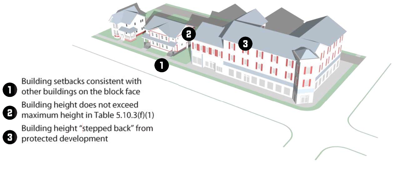
(g)
Building Roof Form.
(1)
Structures within one hundred fifty (150) feet of a lot line of protected development shall maintain a pitched roof.
(2)
All roof-mounted equipment shall be configured and screened from view from adjacent streets and protected developments and parcels, to the maximum extent practicable.
(h)
Building Materials — Transparency. Building façades within one hundred fifty (150) feet of a protected development or parcel, or that face the protected development or parcel, shall have a minimum transparency of 50 percent. Window and door openings counting toward meeting this transparency requirement shall consist of glass that is relatively clear and nonreflective, with a visible light transmittance measured between 0.2 and 0.65. The façade area shall be measured from the grade to the underside of the eaves, or from story line to story line on upper building stories. The first two (2) feet of façade area closest to the grade are not required to be transparent and shall be excluded from the façade area calculation.
(i)
Site Features.
(1)
Loading, Service, and Refuse Collection Areas. Loading, service, and refuse collection areas shall be:
(A)
Screened from view of protected development, using materials that are the same as, or of equal quality to, the materials used for the principal building; or
(B)
Incorporated into the overall design of the site so that the visual and acoustic impacts of these functions are fully contained within an enclosure or otherwise out of view from adjacent properties and public streets, to the maximum extent practicable.
(2)
Exterior Lighting. Exterior lighting shall, to the maximum extent practicable, be configured so that the source of illumination is not visible from a public street right-of-way or an adjacent protected development.
(3)
Signage.
(A)
Except for directional signage, to the maximum extent practicable, all signage shall be located a minimum of one hundred fifty (150) feet from lot lines shared with protected development.
(B)
Directional signs within one hundred fifty (150) feet of lot lines shared with a protected development shall be oriented towards the principal drive aisle of the use.
(j)
Perimeter Fence or Wall. Where a development subject to these standards abuts a protected development, a wall six (6) feet high using materials permitted in Sec. 5.8.5, Materials, shall be provided along the shared boundary to help screen the development from view of the protected development.
(k)
Outdoor Activity Areas. For all multifamily, townhouse, and three- and four-family buildings:
(1)
Ground-Level Features. Ground-level outdoor activity areas, porches, decks, vending areas, and other similar site attributes shall be screened from adjacent single-family dwellings with a perimeter buffer in accordance with Sec. 5.3.4(c), Perimeter Buffer Standards.
(2)
Upper-Story Balconies. Upper-story balconies serving individual dwelling units or common areas that are located within one hundred (100) feet of a single-family dwelling shall be located and designed to prevent views into the single-family dwelling's rear yard.
(l)
Operational Standards. Development shall:
(1)
Limit trash collection or other service functions to only between the hours of 7:00 a.m. and 7:00 p.m.; and
(2)
Prohibit amplified music, singing, or other forms of noise in excess of sixty-five (65) dB(A) measured at lot lines shared with protected development after 10:00 p.m. Sunday through Thursday nights, and 12:00 a.m. Friday and Saturday nights. The sound level shall be measured by the use of a sound level meter and frequency weighting network "A" as specified in the American National Standards Institute specifications for sound level meters.
5.11.1.- Multifamily, Townhouse, Three-Family, and Four-Family Form and Design Standards.
(a)
Purpose and Intent. The purpose and intent of these multifamily, townhouse, and three- and four-family form and design standards are to:
(1)
Establish a minimum level of development quality for multifamily, townhouse, and three- and four-family development;
(2)
Promote greater compatibility between multifamily, townhouse, and three- and four-family development and other allowable uses; and
(3)
Provide landowners, developers, architects, builders, business owners, and others with a clear and equitable set of parameters for developing land.
(b)
Applicability.
(1)
General. Unless exempted in accordance with subsection (2) below, the standards of this section shall apply to:
(A)
All new multifamily, townhouse, and three- and four-family development, unless expressly stated otherwise in the specific standards of this section; and
(B)
Any expansion or alteration of multifamily, townhouse, and three- and four-family development (unless expressly stated otherwise in the specific multifamily form and design standards) that existed prior to March 1, 2022, if the expansion increases the buildings' gross floor area by fifty (50) percent or more, or the alteration involves fifty (50) percent or more of the buildings' gross floor area (including interior alterations).
(2)
Exemptions. The standards in this section shall not apply to:
(A)
Development in the Downtown (DM) and Downtown Planned Development (DM-PD) districts; and
(B)
Any dwellings located above a nonresidential use.
(3)
Timing of Review. Review for compliance with the standards in this section shall occur during review of a development application for a site plan (Sec. 2.5.2(a), Site Plan) or building permit, whichever occurs first.
(c)
Multifamily, Townhouse, and Three- and Four-Family Form and Design Standards. Development subject to this section shall comply with the following standards.
(1)
Location of Off-Street Parking. For all multifamily, townhouse, and three- and four-family development:
(A)
No more than fifty (50) percent of off-street surface parking may be located between a building and the street it faces unless the parking bays are screened from view from the street by another building. Interior structures within a multi-building development served by a central, private driveway are exempted from this requirement. (see Figure 5.11.1(c)(1): Parking Location).
(B)
Guest and overflow parking within a development subject to these standards shall be located to the side or rear of the building containing the units, to the maximum extent practicable.
(C)
Off-street surface parking located beside a building shall not occupy more than thirty-five (35) percent of the parcel's street frontage. Associated driving areas shall be included as part of such off-street surface parking.
Figure 5.11.1(c)(1): Parking Locations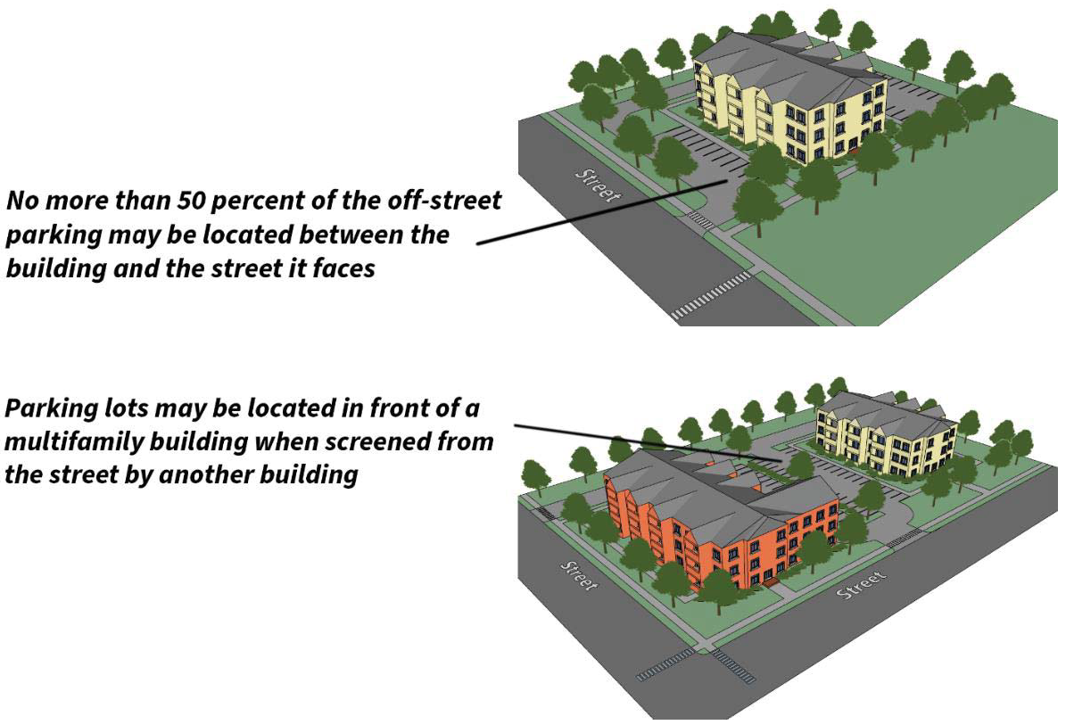
(2)
Building Orientation and Configuration.
(A)
Single-Building Development. The primary entrance of a multifamily, townhouse, and three- and four-family development shall face the street.
(B)
Multi-Building Development. Multifamily, townhouse, and three- and four-family development with more than two (2) buildings shall be configured so that the primary building entrances are oriented towards external streets, internal streets, or open spaces areas such as courtyards. See Figure 5.11.1(c)(2)(B): Multi-Building Development Orientation. Buildings may be oriented towards off-street parking lots only in cases where no other practical orientation exists.
Figure 5.11.1(c)(2)(B): Multi-Building Development Orientation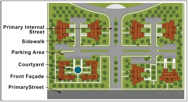
(3)
Maximum Building Length. The maximum length of any multifamily and townhouse building shall be one hundred fifty (150) linear feet, regardless of the number of units.
(4)
Building Façades. For all multifamily, townhouse, and four-family buildings, the following building façade standards apply:
(A)
Façades Shall Face a Street and Incorporate Wall Offsets. Façades of all buildings subject to these standards that face a street shall incorporate wall offsets, in the form of projections or recesses in the façade plane, spaced no more than fifty (50) feet apart. See Figure 5.11.1(c)(4)(A): Changes in Building Façade.
Figure 5.11.1(c)(4)(A): Changes in Building Façade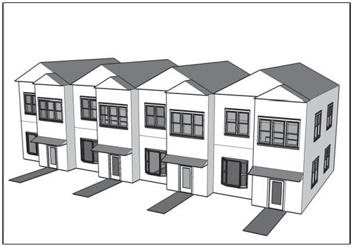
(B)
Depth of Wall Offsets. Wall offsets shall have a minimum depth of two (2) feet.
(C)
Design Features to Front Façades of Multifamily Buildings. In addition to wall offsets, front façades of multifamily buildings shall provide a minimum of three (3) of the following design features for each residential unit fronting onto a public street:
1.
One (1) or more dormer windows or cupolas;
2.
A recessed entrance;
3.
A covered porch at least eight (8) feet in depth;
4.
Pillars, posts, or columns adjacent to the doorway;
5.
One (1) or more bay windows projecting at least twelve (12) inches from the façade plane;
6.
Eaves projecting at least six (6) inches from the façade plane;
7.
Raised corniced parapets over the entrance door;
8.
Multiple windows with a minimum four-inch-wide trim;
9.
Integrated planters that incorporate landscaped areas or places for sitting; or
10.
Roof form and line changes consistent with the façade offsets.
(5)
Roofs. For all multifamily buildings:
(A)
Sloped Roofs on Buildings Over 100 Feet. Sloped roofs on buildings over one hundred (100) feet in length shall include two (2) or more different sloping roof planes, each with a minimum slope between 3:12 and 12:12.
(B)
Flat Roofs. Flat roofs shall be concealed by parapet walls that extend at least three (3) feet above the roof level and have three-dimensional cornice treatments that project at least eight (8) inches outward from the parapet façade plane.
(C)
Alternative Roof Forms Allowed for Small Roof Sections. Alternative roof forms or pitches may be allowed for small roof sections over porches, entryways, or similar features.
(D)
Roof-Based Mechanical Equipment and Other Roof Penetrations. All roof-based mechanical equipment, as well as vents, pipes, antennas, satellite dishes, and other roof penetrations (except chimneys), shall be located on the rear elevations or otherwise be configured and screened (if necessary) to have a minimal visual impact as seen from any public right-of-way.
(6)
Transparency/Fenestration. At least twenty (20) percent of the street-facing façade area of the ground-level floor of any multifamily building (as measured from the grade to the underside of the eave, top of the parapet, or the story line denoting the second floor) shall be occupied by windows or doorways.
(7)
Materials. For all multifamily, townhouse, and three-and four-family buildings, primary façade materials shall not change at outside corners, but shall extend along any side façade that is visible from a street. In all instances the extension shall be a minimum of twenty (20) feet, except materials may change where side or rear wings meet the main body of the structure.
(8)
Garage Standards. For all multifamily, townhouse, and three- and four-family buildings:
(A)
Detached Garages or Carports. Detached garages or carports shall be located to the side, rear, or within the building(s) containing the dwellings. See Figure 5.11.1(c)(8)(A): Garage Placement. A parking structure is exempt from this requirement.
Figure 5.11.1(c)(8)(A): Garage Placement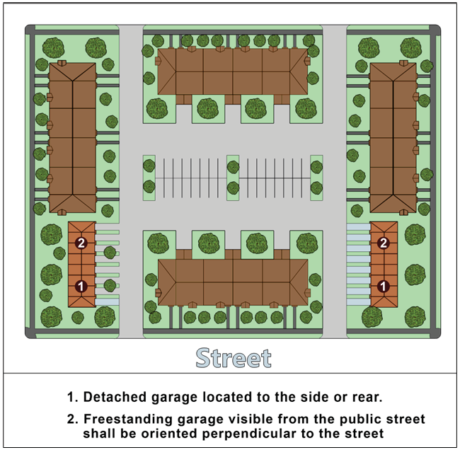
(B)
Freestanding Garages or Carports Visible from Public Street. Freestanding garages or carports visible from public streets outside the development shall be oriented perpendicular to the street, or the façade facing the street shall be configured to comply with the required wall offsets and façade design features in subsection (4) above.
(C)
Exterior Materials, Design Features, and Roof Form. The exterior materials, design features, and roof form of a detached garage or carport shall be the same as the building it serves.
5.11.2. - Nonresidential and Mixed-Use Form and Design Standards.
(a)
Purpose and Intent. The purpose and intent of these nonresidential and mixed-use form and design standards are to ensure a minimum quality of form and design for commercial and mixed-use development outside the Downtown (DM) and Downtown Planned Development (DM-PD) districts. More specifically, the purposes of this section are to:
(1)
Encourage the establishment of a stronger sense of place with vibrant commercial and mixed-use development;
(2)
Encourage a more pedestrian-friendly environment through attention to human-scale design and site features to limit large, bulky buildings with few architectural details;
(3)
Foster greater compatibility between adjacent residential and nonresidential development;
(4)
Limit the impacts of automobile-oriented development in commercial and mixed-use areas; and
(5)
Improve the aesthetics of the City.
(b)
Applicability.
(1)
General. Unless exempted in accordance with subsection (2) below, the standards in this section shall apply to:
(A)
All new nonresidential and mixed-use development; and
(B)
Any expansion or alteration of a nonresidential or mixed-use building that existed prior to March 1, 2022, if the expansion increases the building's gross floor area by fifty (50) percent or more, or the alteration involves fifty (50) percent or more of the building's gross floor area (including interior alterations).
(2)
Exemptions. The standards in this section shall not apply to development in the Downtown (DM) and Downtown Planned Development (DM-PD) districts.
(c)
Timing of Review. Review for compliance with the standards in this section shall occur during review of a development application for a site plan (Sec. 2.5.2(a), Site Plan) or building permit, whichever occurs first.
(d)
Nonresidential and Mixed-Use Form and Design Standards. Development subject to this section shall comply with the following standards:
(1)
Building Orientation.
(A)
Front Streets. The front façade of all buildings, as defined by the primary entrance, shall be oriented on and front onto a street, a courtyard, or plaza.
(B)
Single-Building Development.
1.
All single-building developments shall be configured with the long axis of the building parallel to the street it fronts, or be consistent with existing development patterns, rather than being sited at unconventional angles.
2.
New large single-use retail buildings shall comply with the standards in Sec. 5.11.3, Large Retail Establishment Form and Design Standards.
(C)
Multi-Building Development.
1.
The primary entrances of buildings in a multi-building development shall be oriented towards a street along the perimeter of a development, towards streets or driveways interior to the development, or towards open space areas such as courtyards or plazas.
2.
Developments composed of multiple buildings totaling two hundred fifty thousand (250,000) or more square feet of floor area shall be configured to:
a.
Break up the site into a series of smaller "blocks" defined by on-site streets, vehicle accessways, pedestrian walkways, or other circulation routes, as appropriate;
b.
Frame the corner of an adjacent street intersection or entry point to the development, if appropriate;
c.
Frame and enclose a "Main Street" pedestrian or vehicle access corridor within the development site, if appropriate; and
d.
Frame and enclose outdoor dining or gathering spaces for pedestrians between buildings, where appropriate.
(2)
Outparcel Development.
(A)
General. To the maximum extent practicable, outparcels and their buildings shall be configured and located to define street edges, development entry points, and spaces for gathering or seating between buildings.
(B)
Spaces Between Buildings. Where appropriate, spaces between buildings on outparcels shall be configured with small scale pedestrian amenities such as plazas, seating areas, pedestrian connections, and gathering spaces. See Figure 5.11.2(d)(2)(B): Outparcel Development.
Figure 5.11.2(d)(2)(B): Outparcel Development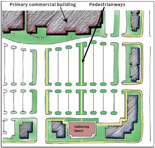
(3)
Façade Articulation.
(A)
Offsets Required. Street-facing front building façades that are greater than one hundred (100) feet wide shall be articulated with wall offsets (e.g., projections or recesses in the façade plane) that are at least two (2) feet deep, at least ten (10) feet wide, and spaced an average of fifty (50) feet apart.
(B)
Offset Alternatives. The following techniques may be used (alone or in combination with other techniques and/or wall offsets) as an alternative to the required front façade offsets. see Figure 5.11.2(d)(3)(B): Façade Massing Alternatives:
1.
Columns or pilasters that are at least eight (8) inches deep and at least eight (8) inches wide, and have a height equal to at least eighty (80) percent of the façade's height; or
2.
Roofline changes that vertically align with a corresponding wall offset or change in façade color or material, including changes in roof planes and changes in the height of a parapet wall (such as extending the top of pilasters above the top of the parapet wall).
Figure 5.11.2(d)(3)(B): Façade Massing Alternatives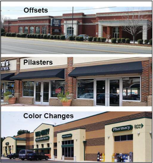
(C)
Side and Rear Façades. The street-facing side and, where visible off-site, the rear-facing façades of buildings shall be articulated with the same façade details as provided on the building's front façade.
(D)
Outbuildings. Outbuildings located in front of other buildings within the same development shall include a consistent level of façade articulation and architectural detail on all sides of the building, as well as exterior materials and colors that are compatible with the primary building in the development.
(4)
Façade Materials.
(A)
General. The use of aluminum siding, vinyl siding, corrugated metal siding, or other metal cladding is prohibited on any façade visible from a street right-of-way. Nothing shall limit the use of high-quality, decorative metal (e.g., brass, copper, steel) as a building accent material.
(B)
Primary Façade Materials at Outside Corners. Primary façade materials shall not change at outside corners, but shall extend along any side façade visible from a street right-of-way. In all instances the extension shall be a minimum of twenty (20) feet, except materials may change where side or rear wings meet the main body of the structure. Where two (2) or more materials are proposed to be combined on a façade, the heavier and more massive elements shall be located below the lighter elements (i.e., brick below stucco or wood). The heavier material may be used as a detail on the corner of a building or along cornices or windows.
(5)
Fenestration/Transparency. Unless more restrictive requirements are established elsewhere in this LDC, at least twenty-five (25) percent of the street-facing façade area of the ground-level floor of buildings (as measured from the grade to the underside of the eave, top of the parapet, or the story line denoting the second floor) shall be occupied by windows or doorways.
(6)
Roofs.
(A)
Sloped Roofs. Sloped roofs on principal buildings over one hundred (100) feet in length shall include two (2) or more different sloping roof planes, each with a minimum slope between 3:12 and 12:12.
(B)
Flat Roofs. Flat roofs on principal buildings shall be concealed by parapet walls that extend at least three (3) feet above the roof level and have three-dimensional cornice treatments that project at least eight (8) inches outward from the parapet façade plane.
(C)
Roof-Based Mechanical Equipment. All roof-based mechanical equipment, as well as vents, pipes, antennas, satellite dishes, and other roof penetrations (except chimneys), shall be located on the rear elevations or otherwise be configured, to the maximum extent practicable, to have a minimal visual impact as seen from the street.
(7)
Location of Off-Street Parking. Unless more restrictive requirements are established elsewhere in this LDC, development subject to this section is strongly encouraged to locate a minimum of fifty (50) percent of the surface parking to the side or rear of the buildings.
(8)
Loading, Service, and Equipment Areas.
(A)
Minimize Visibility from Off-site Areas. To the maximum extent practicable, loading, service, and equipment areas shall be located in a manner that minimizes their visibility from off-site areas.
(B)
Screen Outdoor Storage Areas. Outdoor storage areas shall be fully screened from adjacent streets and single-family detached dwellings.
(C)
Outparcels. Loading, service, and equipment areas that are associated with an outparcel building shall be screened through the use of structural elements and similar materials attached to and integrated with the building.
5.11.3. - Large Retail Establishment Form and Design Standards.
(a)
Applicability.
(1)
General. Unless exempted in subsection (2) below, in addition to the general nonresidential and mixed-use form and design standards in Sec. 5.11.2, Nonresidential and Mixed-Use Form and Design Standards, single-tenant buildings that have a gross floor area of fifty thousand (50,000) square feet or more and devote sixty (60) percent or more of the total floor area to retail sales activities shall also comply with the standards in this section. If there is a conflict between these standards and those in Sec. 5.11.2, these standards control.
(2)
Exemptions. The standards in this section shall not apply to development in the Downtown (DM) and Downtown Planned Development (DM-PD) districts.
(3)
Timing of Review. Review for compliance with the standards in this section shall occur during review of a development application for a site plan (Sec. 2.5.2(a), Site Plan) or building permit, whichever occurs first.
(b)
Large Retail Establishment Form and Design Standards. Development subject to this section shall comply with the following standards.
(1)
Building Entrances. Buildings shall have clearly defined, highly visible customer entrances featuring no less than three (3) of the following:
(A)
Canopies or porticos above the entrance;
(B)
Roof overhangs above the entrance;
(C)
Entry recesses or projections;
(D)
Arcades that are physically integrated with the entrance;
(E)
Raised corniced parapets above the entrance;
(F)
Gabled roof forms or arches above the entrance;
(G)
Outdoor patios or plazas adjacent to the entrance;
(H)
Display windows that are directly adjacent to the entrance;
(I)
Architectural details, such as tile work and moldings, that are integrated into the building structure and design and are above or directly adjacent to the entrance; or
(J)
Integral planters or wing walls that incorporate landscaped areas or seating areas.
(2)
Façades and Massing.
(A)
General. To reduce their perceived mass and scale, buildings shall incorporate three (3) or more of the following design elements on each façade facing a street:
1.
Variations in roof form and parapet heights;
2.
Pronounced wall offsets that are at least two (2) feet deep;
3.
Distinct changes in texture and color of wall surfaces;
4.
Ground level arcades and second floor galleries or balconies;
5.
Protected and recessed entries; and
6.
Vertical accents or focal points.
(B)
Side Building Walls. Side building walls that do not face a street and exceed thirty (30) feet in length shall have façade-articulating elements such as columns and/or changes in plane, texture, or masonry pattern. See Figure 5.11.3(b)(2)(B): Large Retail Building Entrances and Massing.
Figure 5.11.3(b)(2)(B): Large Retail Building Entrances and Massing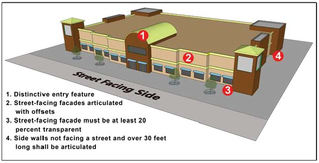
(3)
Fenestration/Transparency. Unless more restrictive requirements are established elsewhere in this LDC, at least twenty (20) percent of the street-facing façade area of the ground-level floor of buildings (as measured from the grade to the underside of the eave, top of the parapet, or the story line denoting the second floor) shall be occupied by windows or doorways.
(4)
Off-Street Parking Location Standards.
(A)
General. Unless more restrictive requirements are established elsewhere in this LDC, up to sixty (60) percent of the total off-street surface parking provided may be located between the front façade of the building and the street it faces.
(B)
Large Retail Parking Lot. Off-street surface parking lots with one hundred fifty (150) or more spaces shall be organized into a series of parking bays surrounded by buildings, landscaping, or accessways designed to appear as streets. See Figure 5.11.3(b)(4)(B): Large Retail Parking Lot with More Than 150 Spaces.
Figure 5.11.3(b)(4)(B): Large Retail Parking Lot with More Than 150 Spaces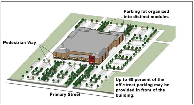
5.12.1.- Purpose and Intent.
The purpose of this section is to ensure development includes a minimum degree of sustainable development features as a means of protecting and conserving resources, making development more resilient, supporting a healthy lifestyle for citizens, and ensuring a high quality of life for residents. Specifically, this section is intended to ensure development practices:
(a)
Conserve energy;
(b)
Promote the use of alternative energy;
(c)
Conserve water resources;
(d)
Protect water quality;
(e)
Promote resiliency;
(f)
Support walkable, mixed-use development in appropriate places;
(g)
Support multiple modes of mobility;
(h)
Promote a healthy landscape;
(i)
Promote people living in place; and
(j)
Promote healthy and safe lifestyles.
5.12.2. - Applicability.
(a)
General. Unless exempted in accordance with subsection (b) below, all development shall comply with the standards of this section.
(b)
Exemptions. The following development is exempt from the requirements of this section.
(1)
Expansion or alteration of development existing prior to March 1, 2022 if the expansion increases the building's floor area by fifty (50) percent or less, or the alteration involves fifty (50) percent or less of the building's gross floor area over the five (5) years prior to the submission of an application; or
(2)
All planned developments approved prior March 1, 2022.
(c)
Timing of Review. Review for compliance with the standards in this section shall occur during review of a development application for planned development (Sec. 2.5.1(f), Planned Development), site plan (Sec. 2.5.2(a), Site Plan), subdivision (Sec. 2.5.2(b), Subdivision), or building permit, whichever occurs first.
5.12.3. - Minimum Number of Points Required.
Table 5.12.3: Sustainable Development Point System, establishes a menu of options for meeting the sustainable development standards of this section. Development subject to the requirements of this subsection shall achieve a minimum of five (5) points. Of the five (5) points, a minimum of two (2) points shall be from the General Sustainability Standards in Table 5.12.3, and a minimum of two (2) points shall be from the Water Conservation/Quality and Transportation Standards.
5.12.4. - Failure to Install or Maintain Sustainable Development Features.
Failure to install or maintain approved sustainable development features that are to be provided to comply with this section is a violation of the City Code.
5.13.1.- Purpose and Intent.
The purpose of this section is to add further support to sustainable development practices in the City by providing incentives for developments that incorporate specific types of sustainable development practices above the minimum required in Section 5.12, Sustainable Development Standards. Specifically, this section is intended to provide incentives for developments that incorporate sustainable development practices that support:
(a)
LEED or comparable development;
(b)
Energy conservation;
(c)
Alternative energy use;
(d)
Passive solar practices;
(e)
Water conservation and water quality;
(f)
Use of natural vegetation;
(g)
Use of recycled building materials;
(h)
Alternate forms of transportation; and
(i)
Universal design.
5.13.2. - Incentives and Applicability.
(a)
All development and redevelopment in all zone districts except RSF-1, RSF-2, RSF-3, and RSF-D that integrate sustainable development practices in accordance with this section shall be eligible for the following incentives. These practices shall be integrated into a development in addition to those included in accordance with Section 5.12, Sustainable Development Standards.
(1)
An increase in the maximum allowable height by up to one (1) story or fourteen (14) feet beyond the maximum allowed in the base zone district, and an increase in the allowed residential density by fifteen (15) percent beyond the maximum allowed in the base zone district, where allowed by the comprehensive development plan;
(2)
An increase in the maximum allowable impervious coverage by ten (10) percent beyond the maximum allowed in the base zone district; or
(3)
A modification to the off-street parking standards resulting in a reduction from the minimum requirements by fifteen (15) percent, or an increase to the maximum allowable number of spaces provided by fifteen (15) percent (without an alternative parking plan).
(b)
Development may include a sufficient number of sustainable development practices to take advantage of more than one (1) type of incentive, but in no instance shall the amount of an incentive be increased or decreased (as appropriate) beyond the maximum listed in this subsection.
5.13.3. - Conflict with Residential Compatibility Standards.
In cases where the incentives in this section conflict with the standards in Section 5.10, Residential Compatibility Standards, the residential compatibility standards shall control.
5.13.4. - Procedure.
(a)
Development seeking to use sustainability incentives in accordance with this section shall include a written request with the development application that demonstrates how compliance with the standards in this section will be achieved.
(b)
Review for compliance with the standards in this section shall occur during review of a development application for planned development (Sec. 2.5.1(f), Planned Development), site plan (Sec. 2.5.2(a), Site Plan), subdivision (Sec. 2.5.2(b), Subdivision), or building permit, whichever occurs first.
(c)
The decision-making body or person responsible for review of the development application shall also be responsible for the review of the sustainability incentive request.
5.13.5. - Incentive Requirements and Procedure.
(a)
The incentive(s) shall be based on the number of sustainable development features provided, in accordance with Table 5.13.5: Sustainable Development Incentives, and Table 5.13.6: Sustainable Development Practices. To obtain the right to a particular incentive identified in the left column of Table 5.13.5: Sustainable Development Incentives (for example, a density bonus of fifteen (15) percent beyond the maximum allowed in the base zone district, where allowed by the comprehensive development plan), the development proposed is required to provide the minimum number of sustainability features associated with the sustainable development practices from both schedule A and schedule B in Table 5.13.6: Sustainable Development Practices (for example, for the density bonus mentioned above, the proposed development is required to include three (3) sustainable development practices from Schedule A and three (3) sustainable development practices from Schedule B).
(b)
The features used to obtain a type of incentive shall only be counted for that incentive. If an applicant wants to achieve a second type of incentive (for example, both the density bonus incentive and the impervious coverage incentive), the proposed development shall include the minimum number of sustainable development practices in Schedule A and Schedule B required for both incentives (three (3) from Schedule A and three (3) from Schedule B for the density bonus incentive, and two from Schedule A and three (3) from Schedule B for the lot coverage incentive).
5.13.6. - Menu of Sustainable Development Practices.
One or more of the sustainable development practices in Table 5.13.6: Sustainable Development Practices may be offered by an applicant for proposed development in accordance with Table 5.13.5: Sustainable Development Incentives.
5.13.7. - Failure to Install or Maintain Sustainable Development Practices.
Failure to install or maintain approved sustainable development practices that are to be provided to comply with this section is a violation of the City Code.
5.14.1.- Purpose and Intent.
(a)
The purpose of the sign regulations in this section is to:
(1)
Promote the public health, safety, and general welfare through reasonable, consistent, and non-discriminatory sign regulations that reduce signage conflicts,
(2)
Promote safety for pedestrians, bicyclists, and motorists through regulations that prohibit distracting signs and limit sign placement;
(3)
Ensure that signs are installed and maintained in a safe manner; and
(4)
Increase the aesthetic value and economic viability of the City by classifying and regulating the location, size, type, and number of signs and related matters in a content-neutral manner. A pleasing, visually attractive environment is of primary importance to preserving and promoting the City as a desirable community in which to live, work, and visit.
(b)
No part of these regulations shall be construed to favor commercial speech over non-commercial speech, nor restrict speech on the basis of content, viewpoint, or message.
5.14.2. - Sign Content.
(a)
Substitution of Non-Commercial Speech for Commercial Speech. Notwithstanding anything contained in this section to the contrary, any sign erected in accordance with the provisions of this section may, at the option of the owner, contain a non-commercial sign message in-lieu of a commercial sign message. The non-commercial copy may be substituted at any time in place of the commercial copy provided that the sign complies with the sign standards and other applicable requirements contained within this section.
(b)
Content Neutrality as to Sign Message. Notwithstanding anything in this section to the contrary, no sign or sign structure shall be subject to any limitation based upon the content of the message contained on such sign or displayed on such sign structure.
5.14.3. - Applicability.
(a)
General.
(1)
Except as provided in subsection (b) below, no sign shall be erected, altered, or relocated until a sign permit has been issued in accordance with Sec. 2.5.3(a), Sign Permit, and, if required, a building permit in accordance with subsection (c) below.
(2)
A sign lawfully displayed may be repainted, or have ordinary and customary repairs performed, including replacement of plastic or glass panels, without requiring a new sign permit; however, if the sign is to be relocated, increased in sign copy area, or structurally altered in any manner, a new sign permit shall be required and the altered sign shall meet all requirements of this section, this LDC, the City Code, the Florida Building Code, and the MUTCD, if applicable.
(3)
A sign permit is not required to change the copy of a sign, as long as the sign copy area is not increased and no changes are made to the sign's height, size, location, structural design, or electrical elements.
(b)
Signs that Do Not Require a Sign Permit. Signs in Sec. 5.14.6, Permitted Signs, that do not require a sign permit in accordance with Sec. 2.5.3(a), Sign Permit, remain subject to the other requirements of this section and any applicable provisions of the Florida Building Code, including any requirement to receive approval of a building permit. The exemption from the sign permit requirement does not waive any applicable limitation or restriction on the number, size, height, setback, placement, or duration of such signs regulated by this section or any limitation or restriction under any other applicable law or regulation.
(c)
Building Code. It shall be unlawful for any person or business or the person in charge of the business to erect, construct, alter, or maintain a sign which is required to be constructed, altered, or maintained in accordance with the Florida Building Code, without first obtaining a building permit from the City. The requirement of a building permit under the Florida Building Code is separate and independent of the requirement for a sign permit under this section.
(d)
Development in the WS, DM, or DM-PD Districts. Development in the WS District is subject to the standards of this section to the extent they do not conflict with the standards that apply to development in the WS district in Sec. 3.3.4(e)(15), Signs. Development in the DM or DM-PD District is subject to the standards of this section to the extent they do not conflict with the standards that apply to development in the DM and DM-PD district in Sec. 3.3.5(e)(19), Signs, or the provisions of an adopted PD Plan.
5.14.4. - Prohibited Signs.
The following signs and sign-types are prohibited. Signs in existence prior to September 22, 2014, that are prohibited by this subsection are subject to the standards of Section 8.5, Nonconforming Signs:
(a)
Animated signs.
(b)
Electronic changeable signs, except when required as traffic control device signs, or as otherwise specifically allowed by this LDC or the City Code.
(c)
Billboards.
(d)
Off-site signs.
(e)
Permanent banners, wind signs, ribbons, spinners, streamers, or captive balloons, or other inflatable signs or devices and fixed aerial signs.
(f)
Any sign which, or any part of which, is in motion by any mechanical, electrical, or human powered means.
(g)
Any sign displaying flashing, undulating, swinging, rotating, revolving, or scrolling lights; alternating or intermittent lights or lights of changing degrees of intensity, brightness, or color or that move or appear to move.
(h)
Any sign that emits sparks, fire, sound, vapor, smoke, odor, particles, or gaseous matter.
(i)
Any sign constructed or maintained by an entity or person which, by reason of its size, location, movement, coloring, or manner of illumination may be confused with or construed as a traffic control device or which hides from view any traffic control device.
(j)
Any sign other than government-owned or City information signs erected in or on or over any public right-of-way, or other public property, except where otherwise permitted in this section.
(k)
Any sign located in a manner that could impede traffic on any street, alley, sidewalk, bikeway, or other pedestrian or vehicular travel way.
(l)
Any sign other than a traffic control device sign that is a copy or imitation of a traffic control device sign and which is located on or adjacent to the right-of-way of any road, street, or highway.
(m)
Any sign that is wholly or partially illuminated by flashing or intermittent lights, rotary beacon lights, strobe lights, or similar devices.
(n)
Portable signs.
(o)
Any sign that obstructs the sightline at private drives and/or public rights-of-way as established by Sec. 5.14.5(a), Sign Location and Setbacks.
(p)
Temporary signs except those allowed by this section.
(q)
Snipe signs.
(r)
Signs that display any statement, word, character, or illustration of any obscene nature, as defined by Ch. 847, Fla. Stat.
(s)
Mobile billboard signs consistently or repeatedly parked for more than twenty-four (24) consecutive hours at a fixed location on any street or that is visible within one hundred (100) feet of any street.
(t)
Signs, other than those erected by a federal, state, or local government pursuant to federal or state law, within any waterway within the City.
(u)
Signs attached to a dock, tie pole, or pier, other than building address numbering or safety signs.
(v)
Abandoned signs.
(w)
Bench signs larger than twelve (12) square inches.
(x)
Pennant strings.
(y)
Pole signs that exceed five (5) feet in height.
5.14.5. - General Standards.
(a)
Sign Location and Setbacks.
(1)
Freestanding signs shall be displayed on the premises to which the sign pertains along the public street abutting the property, but shall not be placed in a manner which obstructs vehicular or pedestrian visibility or traffic.
(2)
Signs shall not impede vision within the sight triangle.
(3)
No sign shall cover architectural detailing, windows, or building ornamentation.
(b)
Sign Lighting. Signs shall be lighted in accordance with the standards in Section 5.9, Exterior Lighting Standards, and the following:
(1)
Any external lighting used to illuminate signs shall be shielded so that the light source (light bulb) cannot be seen from abutting roads or properties.
(2)
Sign lighting shall not be designed or located to cause confusion with traffic lights.
(3)
Illumination of signs by floodlights or spotlights is permissible if none of the light emitted shines directly onto an adjoining property or into the eyes of the motorist using or entering public streets.
(4)
Illuminated signs shall have luminance no greater than three hundred (300) foot-candles as measured one (1) foot from the sign.
(5)
Illuminated signs shall not have lighting mechanisms that project more than 18 inches perpendicularly from any surface.
(6)
Illumination of signs shall be constant in intensity and color and shall not consist of flashing, animated, or changing lights.
(c)
Calculation of Sign Area.
(1)
Sign copy area square footage shall be calculated using standard geometry formulas for common shapes that include squares, rectangles, trapezoids, circles, and triangles. In the case of irregular shapes, the total sign area will be the area of the smallest common shape that encompasses the various components of the sign.
(2)
The supporting structure or bracing of a sign bearing no sign copy shall not be counted as a part of the sign copy area.
(3)
Signs with three (3) or more sign faces or with two (2) sign faces not computed as a single sign in accordance with subsection (d) below shall have a sign copy area that is the sum of all the sign faces.
(d)
Calculation of Number of Signs. For the purpose of determining the number of signs, a single sign shall be construed to be a sign that has its copy area on one (1) side and contains elements organized, related, and composed to form a single unit. A sign with sign copy area on both sides shall be construed as a single sign provided both copy areas are not more than three (3) feet apart at their closest point, and that they describe an internal angle between the copy area planes extended to no more than thirty (30) degrees.
(e)
Calculation of Maximum Sign Number and Copy Area. When the maximum number of signs and the maximum allowable copy area for a lot or development in Sec. 5.14.6, Permitted Signs is specified, the maximum number of signs shall not be exceeded even though the maximum allowable copy area is not used. However, signs exempted from acquiring a sign permit and temporary signs permitted in Sec. 5.14.6 shall not be calculated in determining the maximum number and copy area of signs permitted on a lot or parcel.
(f)
Hanging Signs. Any sign that is hung over a sidewalk or walkway or another pedestrian pathway, such as an awning/canopy sign, a suspended sign, a marquee sign, or a projecting sign, shall have a minimum clearance of nine (9) feet above the finished grade of the sidewalk or walkway.
(g)
Safety. In addition to any requirements of this section, LDC, or other applicable law, no sign shall be erected, maintained, and placed in such a way as to pose a safety hazard.
5.14.6. - Permitted Signs.
(a)
General.
(1)
Signs are permitted to be displayed in the City in accordance with this Section 5.14.6.
(2)
In addition to the signs permitted for certain uses and zone districts in subsections (b) and (c) below, the following signs are permitted in the City without a sign permit:
(A)
Signs located entirely inside the premises of a building or enclosed space which are not readily visible from the exterior of the enclosed space or premises.
(B)
Signs on buses, taxis, and similar common carriers that are licensed or certified by a governmental entity, and vehicle signs, except for mobile billboard signs that are prohibited under this section.
(C)
Signs incorporated onto machinery and equipment by a manufacturer or distributer that identify the manufacturer or the product dispensed by the machine or equipment.
(b)
Residential Development. Signs are allowed on lots occupied by residential development (including one-family detached, townhouse, two-family, three-family, and four-family dwellings) and in residential subdivisions, in accordance with this section.
(1)
Residential Development Signs That Do Not Require a Permit. The following signs are allowed without issuance of a sign permit as listed in Table 5.14.6(b)(1): Residential Development Sign Standards (No Permit Required).
(2)
Residential Development Signs That Require a Permit. The following signs are allowed following issuance of a sign permit in accordance with Sec. 2.5.3(a), Sign Permit as listed in Table 5.14.6(b)(2): Residential Development Sign Standards (Permit Required).
(c)
Non-Residential and Mixed-Use Development. Signs are allowed on lots occupied by multifamily dwellings, non-residential development, and mixed-use development (including live-work dwellings) in accordance with this section.
(1)
Non-Residential and Mixed-Use Development Signs That Do Not Require a Permit. The following signs are allowed without issuance of a sign permit as listed in Table 5.14.6(c)(1): Non-Residential and Mixed-Use Development Sign Standards (No Permit Required).
(2)
Non-Residential and Mixed-Use Development Signs That Require a Permit.
(A)
The following signs are allowed following issuance of a sign permit in accordance with Sec. 2.5.3(a), Sign Permit, as listed in Table 5.14.6(c)(2): Non-Residential and Mixed-Use Development Sign Standards (Permit Required).
(B)
In addition to the standards in Table 5.14.6(c)(2), for multifamily development, the maximum sign area of all freestanding, wall, awning/canopy, and blade signs is seventy-five (75) square feet per street frontage.
(Ord. No. 1433, § 8, 10-14-24)
5.14.7. - Removal.
(a)
General. Signs installed in violation of this section shall be removed or brought into compliance with the requirements of this section. The sign owner, the owner of the property on which the sign is placed, and the sign contractor shall each be held responsible for adherence to this section and any other applicable laws or regulations. This section may be enforced through code enforcement proceedings or by any equitable or legal remedy available to the City.
(b)
Immediate Removal. If the City finds that a sign is in violation of this section or other applicable regulations or state law, and by reason of its violation, presents an immediate and serious danger to the public, the City may, without prior written notice, order the immediate removal or repair of the sign within a specified period. The City may remove or authorize others to remove the sign if the sign's owner cannot be found or if the sign's owner, after notification, refuses to repair or remove it. The owner of the building, structure, or premises on which the sign is located, are jointly and severally liable for the cost of removing such sign. The City shall have the right to recover from the owner or person placing such sign the cost of removal and disposal of such sign.
(c)
Removal of Abandoned Signs. The owner of an abandoned sign shall remove the sign within thirty (30) days of the date of the City's order of removal. A sign need not be removed when a successor tenant, or business or property owner, agrees to maintain the sign as provided in this section by filing a letter of intent with the City within thirty (30) days after receiving notice to do so from the City.
(d)
Removal of Unpermitted Signs. The City may remove or order the removal, without prior written notice, of any sign erected without a sign permit required by this section.
(e)
Removal of Signs on Public Property. Any sign installed or placed on public property, except in accordance with the requirements of this section, shall be forfeited to the City and confiscated. The City shall have the right to recover from the owner or person placing such sign the cost of removal and disposal of such sign.
(f)
Removal of Temporary Signs.
(1)
Temporary signs which are erected or used unlawfully are subject to removal. The Community Development Director is authorized to remove such sign when unlawfully erected.
(2)
The City shall proceed by notifying the occupant and/or owner of the property. If the sign identifies a party other than the occupant/owner of the property, the identified party will also be notified. Notification shall occur in person, by phone, by email, or by letter.
(3)
The required notification shall advise that the sign is unlawful and that the removal is required within forty-eight (48) hours or the sign is subject to removal by the City. The notice shall advise that the sign, if removed by the City, may be retrieved within thirty (30) days and that if the sign is not retrieved within that time, it will be disposed of by the City.
(4)
Prior to the disposal of the sign, another notice shall be delivered to the occupant and/or owner of the property concerning possible disposal of the sign.
(5)
The removal and disposal of the sign shall be at the expense of the property owner or lessee.
5.14.8. - Maintenance.
(a)
All visible portions of a sign and its supporting structure shall be maintained in safe condition and neat appearance. If the sign is a lighted sign, all lights shall be maintained in working order and function in a safe manner. All elements of the sign structure and face should be in good repair and not discolored, peeling, cracked, bent, crumbling, or broken. All signs shall be kept in such manner as to constitute a complete sign at all times. The area immediately surrounding ground signs shall be kept clear of all vegetation or debris.
(b)
All signs for which a permit is required, together with all supports, braces, guys, anchors, sign faces, and other structural and nonstructural members, shall be maintained in good condition and appearance and in compliance with applicable regulations. The City may order the removal of any sign that is not maintained in accordance with this section in accordance with Sec. 5.14.7, Removal, and at the expense of the owner or lessee. Examples of unacceptable maintenance and repair include, but are not limited to, the following:
(1)
Cracked, ripped, or peeling materials present on the surface area of a sign;
(2)
Bent, broken, loose, or otherwise insufficiently attached supports, struts, or other appendages;
(3)
Partial illumination for more than fourteen (14) days; and
(4)
Obstruction of sign face by weeds, vines, tree branches, or other vegetative matter.
5.14.9. - Billboard Leases.
The City shall not renew upon expiration any existing lease of City property that provides for or allows the location of billboards on such property.
5.14.10. - Interpretation and Severability.
(a)
Conflicting Requirements. The sign regulations of this Section 5.14 shall not be construed to permit the erection, placement, or maintenance of any sign at any place or in any manner unlawful under any other provision of this LDC, the City Code, or other applicable law. In any case where a part of these sign regulations conflicts with a provision of any zoning, building, fire, safety, health ordinance or other code, the provision that establishes a stricter standard for the protection of the public health and safety shall prevail.
(b)
Severability in General. If any part, section, subsection, paragraph, subparagraph, sentence, phrase, clause, term, or word of this Section 5.14 or any adopting ordinance is declared unconstitutional by the valid judgment or decree of any court of competent jurisdiction, the declaration of such unconstitutionality shall not affect any other part, section, subsection, paragraph, subparagraph, sentence, phrase, clause, term, or word of this section.
(c)
Severability Where Less Speech Results. Without diminishing or limiting in any way the declaration of severability set forth in subsection (b) above, or elsewhere in this article, Code, or any adopting ordinance, if any part, section, subsection, paragraph, subparagraph, sentence, phrase, clause, term, or word of this Section 5.14 is declared unconstitutional by the valid judgment or decree of any court of competent jurisdiction, the declaration of such unconstitutionality shall not affect any other part, section, subsection, paragraph, subparagraph, sentence, phrase, clause, term, or word of this Section 5.14, even if such severability would result in a situation where there would be less speech, whether by subjecting previously exempt signs to permitting or otherwise.
(d)
Severability of Provisions Pertaining to Prohibited Signs. Without diminishing or limiting in any way the declaration of severability set forth in subsection (b) above, or elsewhere in this section, Code, or any adopting ordinance, if any part, section, subsection, paragraph, subparagraph, sentence, phrase, clause, term, or word of this Section 5.14 is declared unconstitutional by the valid judgment or decree of any court of competent jurisdiction, the declaration of such unconstitutionality shall not affect any other part, section, subsection, paragraph, subparagraph, sentence, phrase, clause, term, or word of this Section 5.14 that pertains to prohibited signs, including specifically those signs and sign-types prohibited and not allowed under Sec. 5.14.4, Prohibited Signs. Furthermore, if any part, section, subsection, paragraph, subparagraph, sentence, phrase, clause, term, or word of Sec. 5.14.4, Prohibited Signs, is declared unconstitutional by the valid judgment or decree of any court of competent jurisdiction, the declaration of such unconstitutionality shall not affect any other part, section, subsection, paragraph, subparagraph, sentence, phrase, clause, term, or word of Sec. 5.14.4, Prohibited Signs.
(e)
Severability of Provisions on Billboards. If any part, section, subsection, paragraph, subparagraph, sentence, phrase, clause, term, or word of this Section 5.14 are declared invalid or unconstitutional by the valid judgment or decree of any court of competent jurisdiction, the declaration of such unconstitutionality shall not affect the prohibition on billboards as contained in this section and Code.
5.15.1.- Purpose.
(a)
The purpose of this section is to require within the City the display of building numbers visible from public or private streets for all properties that contain buildings, as defined by the Florida Building Code, as well as along waterways for all properties that front on waterways.
(b)
This section also provides for the assignment of address numbers to buildings and structures and naming of streets. This requirement is established to assist the general public or City personnel in identifying any property in case of an emergency, as well as for the general welfare of the public in conducting normal affairs.
5.15.2. - Applicability.
This section applies to all properties within the City which contain buildings, as defined by the Florida Building Code.
5.15.3. - General Requirements.
All buildings on all properties within the City shall be assigned numbers by the Fire Department. All buildings shall display at least one (1) set of numbers except as set forth in this section. Buildings which front on waterways as well as streets shall display numbers visible from the waterway. Nonresidential buildings which back up to public streets, alleys, or private accessways shall also display numbers on the rear of the building in the same manner as on the front.
5.15.4. - Street Naming and Numbering Department.
(a)
The City Manager is authorized to designate as the street naming and numbering agency the department that the City Manager deems able to approve, coordinate, and maintain the building numbering and street naming system established by this section.
(b)
The department designated to approve, coordinate, and maintain the building numbering and street naming system under this section is the Fire Department, which shall serve in such capacity until the City Manager appoints a successor. In coordination with the county E-9-1-1 system, the Fire Department shall record and maintain records of all street names and numbers currently assigned.
5.15.5. - Specifications.
(a)
Visibility from Street. Building numbers shall be Arabic numerals between three (3) and eighteen (18) inches in height that are clearly visible from the center of the right-of-way from the front of the building. On a nonresidential building, the numbers shall be clearly visible from both the front and back of the building if the back is visible from a public right-of-way. The numerals shall be attached to the building unless the placement of the maximum size numerals upon the building would not be visible from the right-of-way, in which case the numerals may be placed by separate sign on the property so as to clearly identify the building number.
(b)
Visibility from Waterway. For buildings that front waterways, the numbers shall be clearly visible from fifty (50) feet off the shoreline. Numbers shall be securely mounted and sufficiently legible as to contrasting background, arrangement, spacing, and uniformity, to be read with ease during daylight hours. Numbers shall be displayed between two (2) and ten (10) feet above the ground and placed in a way that they are not totally obstructed by trees and shrubs, and are clearly visible. For numbers exceeding eighteen (18) inches in height, the requirements of Section 5.14, Signs, shall apply.
5.15.6. - Grid Numbering System.
A grid numbering system shall be used for the assignment of street addresses. The system is based on a zero base point located at Orlando Avenue (US 17-92) and Horatio Avenue within the City and proceeding outward on a horizontal and vertical axis.
(a)
Building numbers shall increase north and south from Horatio Avenue and east and west from Orlando Avenue.
(b)
Building numbers shall be assigned to buildings as determined by the grid system and approved by the head of the street naming and numbering agency.
(c)
Odd numbers shall be issued to the buildings on the north and east sides of the public or private street. Even numbers shall be issued to the buildings on the south and west sides of the public or private street.
(d)
The assignment of numbers on corner lots shall be determined from the public or private street on which the building fronts.
(e)
In cases in which the public or private street runs both north/south and east/west, the grid direction shall be determined by the proportional length of the public or private street.
(f)
Variations from this grid system may be made by the head of the street naming and numbering agency when it would be more reasonable or practical.
5.15.7. - Additional Provisions.
(a)
Existing Installations. Existing buildings that are in violation of the provisions of this section shall have thirty (30) days to come into compliance. Existing buildings which essentially meet the requirements or spirit of these regulations, in that the building number is displayed in a manner so that it can be read with ease from the street, including numbers presently on mail boxes, shall be granted approval without alteration.
(b)
Suites, Units, and Apartments. The Fire Department shall be responsible for the assignment of numbers to suites, units, and apartments.
(c)
Tampering. It shall be unlawful for any person to remove, obliterate, deface, or otherwise render useless for the purpose of identification, any building number displayed within the City.
(d)
New Construction. All new construction shall post an address in compliance with this section at the time of posting of the building permit. The numbers at this time may be of a temporary nature and, therefore, may be of any material and may be posted at any location approved by the Chief Code Enforcement Officer. The permanent numbers to be displayed shall be in place at the time of the final inspection.
(e)
Street Names. One (1) word names are strongly encouraged. The primary identifying name should be no greater than two (2) words. Names of new public and private streets shall not duplicate the names of existing public or private streets, or closely approximate phonetically or by use of alternative suffixes such as "lane," "way," "drive,' "court," "avenue," or "street." However, new public and private streets that are an extension of or in alignment with existing public or private streets shall bear the same name as that borne by the existing public or private street. Names likely to be confused with names of existing public or private streets shall be avoided. Street names should not contain initials, titles, hyphens, periods, or decimals.
(f)
Municipal Annexations. Whenever land becomes part of the City by annexation, it shall be the responsibility of the Fire Department to review the address numbers of the annexed property and determine whether the numbers, their posting, and the method of numbering conform to the system established by this section, within thirty (30) days of such annexation.
(g)
Notice of Change of Address. If the number, posting, or method of numbering a building is in nonconformance with the City and County grid system and uniform building numbering system after annexation, the street naming and numbering agency or Community Development Director shall give notice of such nonconformance to the owners or occupants of the affected building or property in accordance with the following:
(1)
The notice shall be delivered by certified mail, return receipt requested, or by posting the notice in a conspicuous place on the building, or by hand delivery.
(2)
The notice shall include a notification of a change of address, which shall contain the correct or new building numbers assigned to the building or property in accordance with the provisions of this section, and the date of notification.
(3)
The notice shall direct the owner or the occupant to post the newly assigned building number on the building or property in accordance with this section.
(4)
The notice shall notify the owner or occupant of the ability to appeal the determination of the street naming and numbering agency. The City Council shall hear such appeals within thirty (30) days of receipt of the notification of the determination by certified mail and seek participation from the Fire Department.
5.15.8. - Appeals.
(a)
Any owner or occupant aggrieved by the street naming and numbering agency's determination of street address or building number shall have the right to request, in writing, a review of such determination within thirty (30) days from the date the notice of change of address or other request for conformance is issued by the street naming and numbering agency.
(b)
The head of the street naming and numbering agency shall review the initial determination within thirty (30) days from the date of the request for review and shall notify the owner or occupant of the revised determination in writing.
(c)
The owner or occupant shall comply with the street naming and numbering agency's revised determination unless, within fifteen (15) days from the date of the revised determination, the owner or occupant files a written request for review by City Council, directed to the head of the street naming and numbering agency.
(d)
City Council shall schedule a hearing on the matter and shall notify the owner or occupant of the date and time of the hearing. The owner or occupant shall have the right to appear at the hearing and present evidence and argument in support of the request. After the hearing, City Council shall make a determination on the matter, which determination shall be final.
5.15.9. - Fees and Administration.
Charges for building number and street name assignments shall be implemented and collected in accordance with the fee schedule duly adopted by resolution of the City Council. Changes in charges and collections methods may be supplemented and amended by City Council.