
Marin County Unincorporated
City Zoning Code
City Zoning Code
ARTICLE II
ZONING DISTRICTS AND ALLOWABLE LAND USES
Chapter 22.16 - DISCRETIONARY DEVELOPMENT STANDARDS[2]
Editor's note—Ord. No. 3666, § II(exh. A), adopted March 14, 2017, retitled Ch. 22.16 from "Planned District Development Standards" to read as herein set out. At the editor's discretion, specific references to Ch. 22.16 have been amended to reflect this title change.
22.06.010 - Purpose of Chapter.
This Chapter establishes the zoning districts applied to property within the County, determines how the zoning districts are applied on the official zoning maps, and provides general permit requirements for development and new land uses.
(Ord. No. 3577, 2012)
22.06.020 - Zoning Districts Established.
The unincorporated areas of Marin County shall be divided into zoning districts which consistently implement the Marin Countywide Plan, and applicable community and specific plans. The following zoning districts are established, and shall be shown on the official Zoning Map (Section 22.06.030). Zoning districts with the term "Planned" in their title are Planned districts, which may be subject to Master Plan requirements, and all those districts without the term "Planned" in their title are conventionally zoned districts. The designation of certain planned zoning districts includes a numerical suffix on the zoning map, which indicates the maximum residential density. Zoning districts within the Coastal Zone are established by the Local Coastal Program.
(Ord. No. 3577, 2012; Ord. No. 3602, § II(exh. A), 2013; Ord. No. 3666, § II(exh. A), 2017; Ord. No. 3745, § 1(exh. A), 2021)
22.06.030 - Zoning Map Adopted.
A.
Inclusion by reference. The zoning district boundaries have been adopted by the Board in compliance with Government Code Sections 65800 et seq., and are hereby incorporated into this Development Code by reference as though they were fully included here.
B.
Zoning district boundaries. The boundaries of the zoning districts established by Section 22.06.020 (Zoning Districts Established) shall be shown upon the map or maps designated as the "Marin County Zoning Map" (hereafter referred to as the "Zoning Map"), on file and available for public review in the Agency offices.
C.
Relationship to Marin Countywide Plan. The Zoning Map shall implement the Marin Countywide Plan, specifically including the land use categories, densities, and land use intensities established by the Marin Countywide Plan, and/or any applicable Community Plan.
D.
Map amendments. Amendments to the Zoning Map shall follow the process established in Chapter 22.116 (Development Code, Zoning Map, Community Plan, and Countywide Plan Amendments).
E.
Unzoned land. Any land within the unincorporated area of the County not shown on the Zoning Map, or not identified on the Zoning Map with a zoning district symbol shall hereby be classified as A2, the Agriculture, Limited zoning district.
F.
Zoning Map interpretation. The Zoning Map shall be interpreted in compliance with Section 22.02.020.D (Zoning Map Boundaries).
(Ord. No. 3577, 2012)
22.06.040 - Allowable Land Uses and Permit Requirements.
A.
Restriction on new land uses. No use of land or structures shall be established, constructed, reconstructed, altered, allowed or replaced unless the use of land or structures complies with the following requirements:
1.
Allowable use. A proposed land use may be allowed on a site if the land use is listed as being allowable in Sections 22.08.030 (Agricultural District Land Uses and Permit Requirements), 22.10.030 (Residential District Land Uses and Permit Requirements), 22.12.030 (Commercial/Mixed Use, and Industrial District Land Uses and Permit Requirements), 22.14.020.B (Special Purpose and Combining Districts - Applicability of Special Purpose and Combining Districts) or 22.12.040.C (Special Purpose and Combining Districts - Applicability of Special Purpose and Combining Districts).
2.
Permit requirements. Any land use or development permit required by this Development Code shall be obtained before the proposed development is constructed, or the land use is established or put into operation, unless the proposed development or use is listed in Section 22.06.050 (Exemptions from Land Use Permit Requirements). The land use permit requirements of this Article are established by Chapters 22.08 (Agricultural Districts), 22.10 (Residential Districts), 22.12 (Commercial/Mixed Use and Industrial Districts), or 22.14 (Special Purpose Districts and Combining Districts).
3.
Development standards. The existing or proposed use and/or improvements shall comply with all other applicable requirements of this Development Code, including, but not limited to, the development standards of this Article, and the provisions of Article III (Site Planning and General Development Standards).
4.
Conditions of approval. The existing or proposed use and/or improvements shall comply with any applicable conditions imposed by previous land use approvals (e.g., Use Permits, Variances, etc.), unless amended or superseded by subsequent approvals.
B.
Determination of allowable land uses. Any questions about whether a proposed land use is allowed in a particular zoning district by Sections 22.08.030, 22.10.030, 22.12.030, or 22.14.020.B or 22.14.020.C (Agricultural, Residential, Commercial/Mixed Use and Industrial, Open Area, and Public Facilities District Land Uses and Permit Requirements, respectively), may be resolved by the Director in compliance with Section 22.02.020.E (Rules of Interpretation - Allowable uses of land).
C.
Temporary uses. Certain temporary uses may be allowed subject to first obtaining a Temporary Use Permit. Requirements for establishing a temporary use are in Chapter 22.50 (Temporary Use Permits).
(Ord. No. 3577, 2012; Ord. No. 3666, § II(exh. A), 2017)
22.06.050 - Exemptions from Land Use Permit Requirements.
The following activities, uses of land, and other improvements, are permitted in all zoning districts and do not require a land use permit; however, other permits may be required in compliance with Subsection G., below.
A.
Sitework. The installation of irrigation lines, decks, platforms, on-site paths, driveways, and other improvements that do not increase lot coverage, and are not over 18 inches above grade. Improvements located within a Stream Conservation Area in the San Geronimo Valley combining district are not exempt. Improvements that are necessary to meet accessibility requirements, regardless of whether they are subject to building or grading permits, are also exempt in all zoning districts.
B.
Governmental activities. Official activities and development of the County, the Marin Emergency Radio Authority, the State or an agency of the State, or the Federal Government on land owned or leased by a governmental agency are exempt from discretionary permits except Coastal Permits.
C.
Interior remodeling. Interior alterations that do not:
1.
Result in an increase in the gross floor area within the structure;
2.
Change the permitted use; and
3.
Change the exterior appearance of the structure.
D.
Repairs and maintenance. Ordinary repairs and maintenance of an existing improvement, provided that the repairs and maintenance work do not:
1.
Result in any change of the approved land use of the site or improvement; and
2.
Expand or enlarge the improvement.
E.
Play structures. Typical play structures and play equipment that are not required to have building or grading permits by Title 19 or Title 23 of the County Code and do not exceed 15 feet in height. Play structures located within a Stream Conservation Area in the San Geronimo Valley combining district are not exempt.
F.
Accessory Dwelling Units. Accessory Dwelling Units that comply with Development Code Section 22.32.120.A (Residential Accessory Dwelling Units) and the tables in this article entitled Allowed Uses and Permit Requirements.
G.
Utilities. Public utility facilities shall be exempt from the land use permit requirements of this Development Code only to the extent provided by Government Code Section 53091, and the California Public Utilities Code.
H.
Solar Energy Systems. Solar energy systems that do not exceed the height limit of the governing zoning district for structures or the roof height of a building by more than two feet, whichever is less restrictive. Solar energy systems within a Stream Conservation Area within the San Geronimo Valley combining district are not exempt unless the exemption is required by State law.
I.
Electronic Vehicle Charging Stations. Electronic Vehicle Charging Stations are exempt from the land use permit requirements of this Development Code. Electronic Vehicle Charging Stations within the San Geronimo combining district are not exempt unless the exemption is required by State law.
J.
Other permits may still be required. A permitted land use that is exempt from a land use permit or has been granted a land use permit may still be required to obtain Building Permits or other permits before the use is constructed or otherwise established and put into operation. Nothing in this Article shall eliminate the need to obtain any other permits or approvals required by:
1.
Other provisions of this Development Code, including, but not limited to, any subdivision approval required by Article VI (Subdivisions);
2.
Other provisions of the County Code, including, but not limited to, Building Permits, Grading Permits, or other construction permits if they are required by Title 19, or a business license if required by Title 5; or
3.
Any other permit required by a regional, State or Federal agency.
4.
All necessary permits shall be obtained before starting work or establishing new uses.
(Ord. No. 3577, 2012; Ord. No. 3602, § II(exh. A), 2013; Ord. No. 3666, § II(exh. A), 2017; Ord. No. 3745, § 1(exh. A), 2021; Ord. No. 3770, § 1(exh. A), 2022)
22.06.060 - Zoning District Regulations.
A.
Purpose.Chapters 22.08 through 22.16 determine which land uses are allowable in each zoning district, what land use permit is required to establish each use, and the basic development standards that apply to allowed land uses in each of the zoning districts established by Section 22.06.020 (Zoning Districts Established).
B.
Conflicts between provisions. In the event of any conflict between the zoning district regulations of this Article and the provisions of Article III (Site Planning and General Development Standards), the provisions of Article III shall control, except as expressly provided in Chapter 22.16 (Discretionary Development Standards).
C.
Single parcel in two zoning districts. In the event two or more parcels are consolidated through the approval of a lot line adjustment, merger, parcel or Tentative Map, or reversion to acreage in compliance with Article VI (Subdivisions), where a single parcel is covered by two or more zoning districts, the consolidated parcel should be reviewed by the Director to determine whether the parcel should be rezoned to a single zoning district.
D.
Measurements, calculations. Explanations of how height limits, site coverage requirements, and floor area ratios (FAR) apply to sites and projects are in Chapter 22.20 (General Property Development and Use Standards).
(Ord. No. 3577, 2012)
22.08.010 - Purpose of Chapter.
This Chapter determines the allowable uses of land, land use permit requirements, and basic development standards for the agricultural zoning districts established by Section 22.06.020 (Zoning Districts Established). The purposes of each agricultural zoning district are described in Section 22.08.020 (Applicability of Agricultural Zoning Districts). This Chapter then lists allowable uses of land, and permit requirements for each use, by zoning district (Section 22.08.030 - Agricultural District Land Uses and Permit Requirements); and finally provides standards for development within the agricultural zoning districts (Section 22.08.040 - Agricultural District Development Standards).
(Ord. No. 3577, 2012)
22.08.020 - Applicability of Agricultural Zoning Districts.
The applicability of each agricultural zoning district is as follows.
A.
A (Agriculture and Conservation) Districts. The A3 through A60 zoning districts identify areas suitable for commercial agricultural operations, and similar and compatible uses. The A3 through A9 zoning districts are consistent with the Agriculture 3 land use category of the Marin Countywide Plan; the A10 through A30 zoning districts are consistent with the Agriculture 2 land use category of the Marin Countywide Plan; and the A31 through A60 zoning districts are consistent with the Agriculture 1 land use category of the Marin Countywide Plan.
The designation of an A zoning district shall include a numerical suffix on the zoning map, which shall indicate the minimum lot area for new subdivisions in acres.
B.
A2 (Agriculture, Limited) District. The A2 zoning district identifies areas suitable for commercial agricultural operations, and similar and compatible uses. The A2 zoning district is consistent with the Agriculture 3 land use category and several residential land use categories of the Marin Countywide Plan.
Please refer to Sections 22.08.040 (Agricultural District Development Standards) and 22.14.050 (Minimum Lot Size "-B" Combining District) to understand the minimum lot area for new subdivisions.
C.
ARP (Agricultural, Residential Planned) District. The ARP zoning district identifies agricultural areas suitable for residential development, with varied housing types designed without the confines of specific yard, height, or lot area requirements, where the amenities resulting from this flexibility in design will benefit the public or other properties in the community. The ARP zoning district is consistent with the Agriculture land use categories and the Agriculture and Conservation 3 land use category of the Marin Countywide Plan.
The designation of an ARP zoning district shall include a numerical suffix on the zoning map, which shall indicate the maximum residential density in acres. Please refer to Section 22.08.040 (Agricultural District Development Standards) to understand the maximum density for each zoning district.
(Ord. No. 3577, 2012)
22.08.030 - Agricultural District Land Uses and Permit Requirements.
A.
The uses of land allowed by this Chapter in each agricultural zoning district are identified in Table 2-1 (Allowed Uses and Permit Requirements for Agricultural and Resource-Related Districts) as being:
1.
Allowed as a principally permitted use with no Use Permit required. Principally permitted uses are shown as "P" uses in the tables;
2.
Allowable as a conditional use, subject to approval of a Conditional Use Permit (Chapter 22.48) or Master Use Permit (Chapter 22.49), as applicable. Conditionally permitted uses are shown as "U" uses in the tables, and "U/P" means that the use may be either principally permitted or conditionally permitted depending on the specific criteria set forth in Chapter 22.32;
3.
Land uses that are not listed in the table, are not shown in a particular zoning district, or are shown as a "—" in the land use tables are not allowed, except where otherwise provided by Section 22.06.040.B (Determination of Allowable Land Uses), or Section 22.06.050 (Exemptions from Land Use Permit Requirements). In some instances, there are specific land use restrictions contained in Chapter 22.32 that prohibit certain uses under specific circumstances.
Where the last column in the tables ("See Requirements and Standards in Section") includes a section number, the regulations in the referenced section apply to the use; however, provisions in other sections of this Development Code may apply as well.
Reference notes apply to the table 2-1, as enumerated below:
1.
When required under the circumstances described in 22.32.065, an applicant may choose to apply for either a Conditional Use Permit or a Temporary Use Permit.
2.
Equestrian employee housing is permitted with Use Permit approval (See Chapter 22.48 Use Permits).
TABLE 2-1 - ALLOWED USES AND PERMIT REQUIREMENTS FOR AGRICULTURAL AND RESOURCE-RELATED DISTRICTS
"P" means principally permitted
"U" means conditionally permitted subject to Use Permit approval
"—" means prohibited
See Section 22.08.040 (Agricultural District Development Standards) for applicable standards.
TABLE 2-1 - ALLOWED USES AND PERMIT REQUIREMENTS FOR
AGRICULTURAL AND RESOURCE-RELATED DISTRICTS (Continued)
Notes:
(1)
When required under the circumstances described in 22.32.065, an applicant may choose to apply for either a Conditional Use Permit or a Temporary Use Permit
(2)
Equestrian employee housing is permitted with Use Permit approval (See Chapter 22.48 Use Permits)
"P" means principally permitted
"U" means conditionally permitted subject to Use Permit approval
"—" means prohibited
See Section 22.08.040 (Agricultural District Development Standards) for applicable standards.
TABLE 2-1 - ALLOWED USES AND PERMIT REQUIREMENTS FOR
AGRICULTURAL AND RESOURCE-RELATED DISTRICTS (Continued)
See Section 22.08.040 (Agricultural District Development Standards) for applicable standards.
(Ord. No. 3577, 2012; Ord. No. 3666, § II(exh. A), 2017; Ord. No. 3706, 2019; Ord. No. 3745, § 1(exh. A), 2021)
22.08.040 - Agricultural District Development Standards.
A.
General zoning district standards—Use of table. Proposed development and new land uses within the agricultural zoning districts established by Section 22.06.020 (Zoning Districts Established) shall be designed and constructed in conformity with the agricultural district development standards in Table 2-2 (Agricultural District Development Standards), except as provided by following Subsection B.
B.
Development standards for planned districts. Special development standards for the ARP zoning district established by Section 22.06.020 (Zoning Districts Established) are provided by Chapter 22.16 (Discretionary Development Standards). In the event of any conflict between the provisions of Chapter 22.16 and those of Table 2-2 (Agricultural District Development Standards), the standards of Chapter 22.16 shall control.
C.
Clustering Requirements. In A districts (A3 to A60) and in ARP districts, non-agricultural development shall be clustered to retain the maximum amount of land in agricultural production or available for future agricultural use. Homes, roads, residential support facilities, and other non-agricultural development, shall be clustered on no more than five percent of the gross acreage, to the extent feasible, with the remaining acreage retained in agricultural production and/or open space. Proposed development shall be located close to existing roads, or not require new road construction or improvements resulting in significant diminution of the existing or potential agricultural use of the land, grading that is inconsistent with the natural topography of the site, removal of significant vegetation, and degradation of the natural visual qualities of the site. Proposed development shall also be sited to minimize impacts on scenic resources, wildlife habitat and streams, and adjacent agricultural operations.
D.
Density. More than one single-family dwelling may be allowed for the residence of the owner or a lessee of the land, and/or for the family of the owner or a lessee who is engaged in agricultural use of the same property, provided each such single-family dwelling is consistent with the permitted density and is incidental to the agricultural use of the land. Agricultural use of the land means agriculture is the primary or principal use of the land as demonstrated by the applicant to the satisfaction of the Director. Prior to making this determination, the Director may refer any question about the use of the land to such individuals or groups with agricultural expertise as appropriate for a recommendation.
E.
Agricultural Processing. A Use Permit is required: (1) if any agricultural products to be processed are not produced on the same site or on other agricultural properties located in Marin County that are owned or leased by the processing facility owner or operator; or (2) if the floor area used for processing activities exceed an aggregate of 5,000 square feet. Agricultural products do not include additives or ingredients that are incidental to processing. New processing facilities shall comply with the stream conservation area standards established in the Countywide Plan.
F.
Sale of Agricultural Products. A Use Permit is required: (1) if any agricultural products to be sold are not produced on the same site, or on other agricultural properties located in Marin County that are owned or leased by the sales facility owner or operator; or (2) if the building(s), structure(s), or outdoor sales area used for the retail sales activities exceed an aggregate floor area of 500 square feet. New retail sales facilities shall comply with the stream conservation area standards established in the Countywide Plan.
G.
Commercial Uses. Limited commercial uses may be allowed only when: (1) included in a plan for new or continued agricultural activities on the site and surrounding properties, (2) determined by the Review Authority to be in all respects compatible with agricultural operations on surrounding properties, and (3) subject to specific approval in the adoption of a Use Permit.
TABLE 2-2
AGRICULTURAL DISTRICT DEVELOPMENT STANDARDS
Notes:
(1) Minimum lot area and setback standards may change, as follows:
a. In A2 districts, the minimum lot area and setback standards may change when such district is combined with a B district in compliance with the provisions of Section 22.14.050 (Minimum Lot Size [B] Combining District).
b. In A2 districts, including those combined with B districts, the minimum lot area may change in areas of sloping terrain in compliance with the provisions of Section 22.82.050 (Hillside Subdivision Design).
c. In A districts (A3 to A60), the minimum lot area and setback standards may be waived to allow for clustering of single-family dwellings in compliance with the provisions of Chapter 22.44 (Master Plans and Precise Development Plans); however, the total number of lots shall not exceed the maximum number permitted based on the total acreage of the parcel to be subdivided and the minimum lot area requirements of the respective A district.
(2) In ARP districts, minimum lot area is determined through the subdivision and/or Master Plan process.
(3) In ARP districts, any fraction of a dwelling unit should be rounded up to the next whole unit.
(4) See (1) above. See Section 22.20.090 (Setback Requirements and Exceptions) for setback measurement, allowed projections into setbacks, and exceptions to required setbacks. In ARP districts, setbacks are determined through the Master Plan, Precise Development Plan, or Design Review process in accordance with Chapters 22.44 (Master Plans and Precise Development Plans) or 22.42 (Design Review).
(5) See Section 22.20.060 (Height Measurement and Height Limit Exceptions) for height measurement and exceptions.
"P" means principally permitted
"U" means conditionally permitted subject to Use Permit approval
"—" means prohibited
See Article VIII (Development Code Definitions) for definitions of the terms used above.
(Ord. No. 3577, 2012; Ord. No. 3602, § II(exh. A), 2013; Ord. No. 3666, § II(exh. A), 2017; Ord. No. 3706, 2019; Ord. No. 3745, § 1(exh. A), 2021; Ord. No. 3819, § I(exh. A), 2024)
22.10.010 - Purpose of Chapter.
This Chapter determines the allowable uses of land, land use permit requirements, and basic development standards for the residential zoning districts established by Section 22.06.020 (Zoning Districts Established). The purposes of each residential zoning district are described in Section 22.10.020 (Applicability of Residential Zoning Districts). This Chapter then lists allowable uses of land, and permit requirements for each use, by zoning district (Section 22.10.030 (Residential District Land Uses and Permit Requirements)); and finally provides standards for development within the residential zoning districts (Section 22.10.040 (Residential District Development Standards)).
(Ord. No. 3577, 2012)
22.10.020 - Applicability of Residential Zoning Districts.
The applicability of each residential zoning district is as follows:
A.
RA (Residential, Agricultural) District. The RA zoning district is intended for areas where single-family residential development and small-scale agriculture can be accommodated with similar and related compatible uses. The RA zoning district is consistent with the Single-Family 3, 4, 5, and 6 land use categories of the Marin Countywide Plan.
B.
RR (Residential, Restricted) District. The RR zoning district is intended for areas where single-family residential development, and noncommercial recreation can be accommodated with similar and related compatible uses. The RR zoning district is consistent with the Single-Family 4 and 5 land use categories of the Marin Countywide Plan.
C.
RE (Residential, Estate) District. The RE zoning district is intended for single-family residential areas where small-scale agriculture accessory to residential uses can be accommodated. The RE zoning district is consistent with the Single-Family 4 and 5 land use categories of the Marin Countywide Plan.
D.
R1 (Residential, Single-Family) District. The R1 zoning district is intended for areas suitable for single-family residential neighborhood development in a suburban setting, along with similar and related compatible uses. The R1 zoning district is consistent with the Single-Family 3, 4, 5, and 6 land use categories of the Marin Countywide Plan.
E.
RSP (Residential, Single-Family Planned) District. The RSP zoning district is intended for areas suitable for single-family residential neighborhood development in a suburban setting, along with similar and related compatible uses, where site or neighborhood characteristics require the attention to design detail provided through the Master Plan process (Chapter 22.44 (Master Plans and Precise Development Plans)). The RSP zoning district is consistent with the Single-Family 1 through 6 land use categories of the Marin Countywide Plan.
The designation of the RSP zoning district shall include a numerical suffix on the zoning map, which shall indicate the maximum residential density.
F.
R2 (Residential, Two-Family) District. The R2 zoning district is intended for two primary dwellings as well as single-family dwellings on an individual lot in suburban settings, along with similar and related compatible uses. The R2 zoning district is consistent with the Multi-Family 2 land use category of the Marin Countywide Plan.
G.
RMP (Residential, Multiple Planned) District. The RMP zoning district is intended for a full range of residential development types within the unincorporated urban areas of the County, including single-family, and multi-family residential development, and limited commercial uses in suburban settings, along with similar and related compatible uses, where site or neighborhood characteristics require particular attention to design detail provided through the Master Plan process (Chapter 22.44 (Master Plans and Precise Development Plans)). The RMP district is applied to areas identified by the Marin Countywide Plan as capable of accommodating increased density, and is consistent with the Planned Residential and Multi-Family 2, 3, 3.5, 4, and 4.5, the General Commercial/Mixed Use, Office Commercial/Mixed Use, Neighborhood Commercial/Mixed Use, PD-Agricultural and Environmental Resource Area, PD-Reclamation Area, Public and Quasi-Public land use categories of the Marin Countywide Plan.
The designation of the RMP zoning district shall include a numerical suffix on the zoning map, which shall indicate the maximum residential density in units per acre.
H.
RMPC (Residential/Commercial Multiple Planned) District. See Chapter 22.12 (Commercial/Mixed Use and Industrial Zoning Districts). This district is generally similar to RMP, but also allows selected commercial uses.
The designation of the RMPC zoning district shall include a numerical suffix on the zoning map, which shall indicate the maximum residential density in units per acre.
I.
RX (Residential, Mobile Home Park) District. The RX zoning district is intended for areas of the County best suited for mobile homes within a mobile home park or mobile home subdivision with shared recreational and open space facilities, together with similar and related compatible uses. The RX zoning district is consistent with the Multi-Family 4 land use category of the Marin Countywide Plan.
This zoning district shall be applied only if the Commission and Board find that the area is of sufficient size, type, location and has special features (e.g., access to public transportation and shopping facilities), which make it a desirable mobile home park residential area.
J.
RF (Floating Home Marina) District. The RF zoning district is intended for near shore areas of San Francisco Bay and adjoining waterways suitable for the location of houseboats and other floating homes, where appropriate marina and other support services can be provided. The RF zoning district is consistent with the Floating Homes land use category of the Marin Countywide Plan.
(Ord. No. 3577, 2012; Ord. No. 3745, § 1(exh. A), 2021)
22.10.030 - Residential District Land Uses and Permit Requirements.
The uses of land allowed by this Chapter in each residential zoning district are identified in Tables 2-3 (Allowed Uses and Permit Requirements for Single-Family Districts) and 2-4 (Allowed Uses and Permit Requirements for Multi-Family Districts) as being:
1.
Allowed as a principally permitted use with no Use Permit required. Principally permitted uses are shown as "P" uses in the tables;
2.
Allowable as a conditional use, subject to approval of a Conditional Use Permit (Chapter 22.48) or Master Use Permit (Chapter 22.49), as applicable. Conditionally permitted uses are shown as "U" uses in the tables, and "U/P" means that the use may be either principally permitted or conditionally permitted depending on the specific criteria set forth in Chapter 22.32;
3.
Land uses that are not listed in the table, are not shown in a particular zoning district, or are shown as a "—" in the land use tables are not allowed, except where otherwise provided by Section 22.06.040.B (Determination of Allowable Land Uses), or Section 22.06.050 (Exemptions from Land Use Permit Requirements). In some instances, there are specific land use restrictions contained in Chapter 22.32 that prohibit certain uses under specific circumstances.
Where the last column in the tables ("See Requirements and Standards in Section") includes a section number, the regulations in the referenced section apply to the use; however, provisions in other sections of this Development Code may apply as well.
Reference notes apply to Tables 2-3 and 2-4, as enumerated below:
1.
Allowed only where the site has a lot area of 3 acres or more.
2.
Allowed only on a site of 5 acres or larger.
3.
Allowed only as a facility incidental to and serving only floating home marina residents.
4.
Equestrian employee housing is permitted with Use Permit approval (See Chapter 22.48 Use Permits).
TABLE 2-3 - ALLOWED USES AND PERMIT REQUIREMENTS FOR
SINGLE-FAMILY RESIDENTIAL DISTRICTS
Notes:
1.
Allowed only where the site has a lot area of 3 acres or more.
2.
Allowed only on a site of 5 acres or larger.
4.
Equestrian employee housing is permitted with Use Permit approval (See Chapter 22.48 Use Permits).
"P" means principally permitted
"U" means conditionally permitted subject to Use Permit approval
"—" means prohibited
See Section 22.10.040 (Residential District Development Standards) for applicable standards.
TABLE 2-3 - ALLOWED USES AND PERMIT REQUIREMENTS FOR
SINGLE-FAMILY RESIDENTIAL DISTRICTS (Continued)
Notes:
4.
Equestrian employee housing is permitted with Use Permit approval (See Chapter 22.48 Use Permits).
"P" means principally permitted
"U" means conditionally permitted subject to Use Permit approval
"—" means prohibited
See Section 22.10.040 (Residential District Development Standards) for applicable standards.
TABLE 2-3 - ALLOWED USES AND PERMIT REQUIREMENTS FOR
SINGLE-FAMILY RESIDENTIAL DISTRICTS (Continued)
"P" means principally permitted
"U" means conditionally permitted subject to Use Permit approval
"—" means prohibited
See Section 22.10.040 (Residential District Development Standards) for applicable standards.
TABLE 2-4 - ALLOWED USES AND PERMIT REQUIREMENTS FOR
MULTI-FAMILY RESIDENTIAL DISTRICTS
Notes:
4.
Equestrian employee housing is permitted with Use Permit approval (See Chapter 22.48 Use Permits).
"P" means principally permitted
"U" means conditionally permitted subject to Use Permit approval
"—" means prohibited
See Section 22.10.040 (Residential District Development Standards) for applicable standards.
TABLE 2-4 - ALLOWED USES AND PERMIT REQUIREMENTS FOR
MULTI-FAMILY RESIDENTIAL DISTRICTS (Continued)
Notes:
2.
Allowed only on a site of 5 acres or larger.
3.
Allowed only as a facility incidental to and serving only floating home marina residents.
4.
Equestrian employee housing is permitted with Use Permit approval (See Chapter 22.48 Use Permits).
"P" means principally permitted
"U" means conditionally permitted subject to Use Permit approval
"—" means prohibited
See Section 22.10.040 (Residential District Development Standards) for applicable standards.
TABLE 2-4 - ALLOWED USES AND PERMIT REQUIREMENTS FOR
MULTI-FAMILY RESIDENTIAL DISTRICTS (Continued)
"P" means principally permitted
"U" means conditionally permitted subject to Use Permit approval
"—" means prohibited
See Section 22.10.040 (Residential District Development Standards) for applicable standards.
(Ord. No. 3577, 2012; Ord. No. 3602, § II(exh. A), 2013; Ord. No. 3666, § II(exh. A), 2017; Ord. No. 3706, 2019; Ord. No. 3745, § 1(exh. A), 2021)
22.10.040 - Residential District Development Standards.
A.
General zoning district standards—Use of table. Proposed development and new land uses within the residential zoning districts established by Section 22.06.020 (Zoning Districts Established) shall be designed and constructed in conformity with the residential district development standards in Table 2-5 (Residential District Development Standards), except as provided by following Subsection B.
B.
Development standards for planned districts. Special development standards for the RSP, RMP, RX, and RF zoning districts established by Section 22.06.020 (Zoning Districts Established) are provided by Chapter 22.16 (Discretionary Development Standards). In the event of any conflict between the provisions of Chapter 22.16 (Discretionary Development Standards) and those of Table 2-5 (Residential District Development Standards), the standards of Chapter 22.16 shall control.
TABLE 2-5
RESIDENTIAL DISTRICT DEVELOPMENT STANDARDS
Notes:
(1) Minimum lot area and setback standards may change, as follows:
a. In RA, RR, RE, R1, and R2 districts, the minimum lot area and setback standards may change when such district is combined with a B district in compliance with the provisions of Section 22.14.050 (Minimum Lot Size "-B" Combining District).
b. In RA, RR, RE, R1, and R2 districts, including those combined with "-B" districts, the minimum lot area may change in areas of sloping terrain in compliance with the provisions of Section 22.82.050 (Hillside Subdivision Design).
c. In RSP and RMP districts, minimum lot area is determined through the Master Plan, or Design Review process in compliance with Chapters 22.44 (Master Plans and Precise Development Plans) or 22.42 (Design Review). Through this process, the Review Authority will determine whether the lot area is adequate for a proposed land use.
(2) In RSP and RMP districts, any fraction of a dwelling unit shall be rounded up to the next whole number.
(3) See (1) above. See Section 22.20.090 (Setback Requirements and Exceptions) for setback measurement, allowed projections into setbacks, and exceptions to required setbacks. In RSP and RMP districts, setbacks are determined through the Master Plan, Precise Development Plan, or Design Review process in compliance with Chapters 22.44 (Master Plans and Precise Development Plans) or 22.42 (Design Review).
(4) See Section 22.20.060 (Height Measurement and Height Limit Exceptions) for height measurement and exceptions.
See Article VIII (Development Code Definitions) for definitions of the terms used above.
(Ord. No. 3577, 2012; Ord. No. 3602, § II(exh. A), 2013; Ord. No. 3666, § II(exh. A), 2017; Ord. No. 3706, 2019; Ord. No. 3745, § 1(exh. A), 2021; Ord. No. 3819, § I(exh. A), 2024)
22.12.010 - Purpose of Chapter.
This Chapter determines the allowable uses of land, land use permit requirements, and basic development standards for the Commercial/Mixed Use and Industrial zoning districts established by Section 22.06.020 (Zoning Districts Established). The purposes of each Commercial/Mixed Use and Industrial zoning district are described in Section 22.12.020 (Applicability of Commercial, Mixed Use and Industrial Zoning Districts). This Chapter then lists allowable uses of land, and permit requirements for each use, by zoning district (Section 22.12.030 (Commercial/Mixed Use and Industrial District Land Uses and Permit Requirements)); and finally provides standards for development within the Commercial/Mixed Use and Industrial zoning districts (Section 22.12.040 (Commercial/Mixed Use Industrial District Development Standards)).
(Ord. No. 3577, 2012)
22.12.020 - Applicability of Commercial/Mixed Use and Industrial Zoning Districts.
The applicability of each commercial/mixed use and industrial zoning district is as follows:
A.
VCR (Village Commercial/Residential) District. The VCR zoning district is intended to: maintain the established historical character of village commercial areas; promote village commercial self-sufficiency; foster opportunities for village commercial growth; maintain a balance between resident-serving and non-resident-serving commercial uses; protect, without undue controls, established residential, commercial, and light industrial uses; and maintain community scale. The VCR zoning district is consistent with the Neighborhood Commercial/Mixed Use land use category of the Marin Countywide Plan.
B.
RMPC (Residential/Commercial Multiple Planned) District. The RMPC zoning district is primarily a residential district that allows commercial uses. The RMPC district is applied to areas identified by the Marin Countywide Plan as capable of accommodating increased density, and is consistent with the General Commercial/Mixed Use, Neighborhood Commercial/Mixed Use, Office Commercial/Mixed Use, Industrial, PD-Agricultural and Environmental Resource Area, and PD-Reclamation Area land use categories of the Marin Countywide Plan.
C.
C1 (Retail Business) District. The C1 zoning district provides for community shopping areas where retail stores and shops are the primary land use, together with similar and related compatible uses, including residential uses. The C1 zoning district is consistent with the General Commercial/Mixed Use land use category of the Marin Countywide Plan.
D.
CP (Planned Commercial) District. The CP zoning district provides for lower-intensity commercial areas for retail shopping, office facilities, and residential uses, in pleasing and harmonious surroundings, through the control of building coverage, height, parking and landscaping. The CP zoning district is consistent with the General Commercial/Mixed Use, PD-Agricultural and Environmental Resource Area, and PD-Reclamation Area land use categories of the Marin Countywide Plan.
E.
AP (Administrative and Professional) District. The AP zoning district provides for lower-intensity commercial areas emphasizing offices, and similar and related compatible uses, including residential uses. The AP zoning district is consistent with the Office Commercial/Mixed Use and PD-Reclamation Area land use categories of the Marin Countywide Plan.
F.
OP (Planned Office) District. The OP zoning district provides for lower-intensity commercial areas for administrative, professional office and residential uses, in pleasing and harmonious surroundings, through the control of building coverage, height, parking and landscaping. The OP zoning district is consistent with the Office Commercial/Mixed Use and PD-Reclamation Area land use categories of the Marin Countywide Plan.
G.
H1 (Limited Roadside Business) District. The H1 zoning district is applied to properties in rural areas where commercial uses may be appropriate, in addition to limited residential development. The H1 zoning district is consistent with the General Commercial/Mixed Use land use category of the Marin Countywide Plan.
H.
RCR (Resort and Commercial Recreation) District. The RCR zoning district is intended to create and protect resort facilities in pleasing and harmonious surroundings with emphasis on public access to recreational areas within and adjacent to developed areas. The RCR zoning district is consistent with the Recreational Commercial land use category of the Marin Countywide Plan.
I.
IP (Industrial, Planned) District. The IP zoning district is intended for areas of the County appropriate for business park, light industrial and manufacturing uses in campus-like settings. The IP zoning district is consistent with the Industrial and PD Reclamation Area land used categories of the Marin Countywide Plan.
(Ord. No. 3577, 2012)
22.12.030 - Commercial/Mixed-Use and Industrial District Land Uses and Permit Requirements.
The uses of land allowed by this Chapter in each commercial zoning district are identified in Tables 2-6 (the VCR, RMPC, C1, and CP zoning districts) and 2-7 (the AP, OP, H1, RCR, and IP zoning districts) as being:
1.
Allowed as a principally permitted use with no Use Permit required. Principally permitted uses are shown as "P" uses in the tables;
2.
Allowable as a conditional use, subject to approval of a Conditional Use Permit (Chapter 22.48) or Master Use Permit (Chapter 22.49), as applicable. Conditionally permitted uses are shown as "U" uses in the tables, and "U/P" means that the use may be either principally permitted or conditionally permitted depending on the specific criteria set forth in Chapter 22.32;
3.
Land uses that are not listed in the table, are not shown in a particular zoning district, or are shown as a "—" in the land use tables are not allowed, except where otherwise provided by Section 22.06.040.B (Determination of Allowable Land Uses), or Section 22.06.050 (Exemptions from Land Use Permit Requirements). In some instances, there are specific land use restrictions contained in Chapter 22.32 that prohibit certain uses under specific circumstances.
Where the last column in the tables ("See Standards in Section") includes a section number, the regulations in the referenced section apply to the use; however, provisions in other sections of this Development Code may apply as well.
Reference notes apply to Tables 2-6 and 2-7, as enumerated below:
1.
Allowed only where the site has a lot area of 3 acres or more.
2.
Allowed where review authority determines through the Use Permit process that proposal is consistent with the small-scale, village-serving purposes of the VCR zoning district.
3.
Dwellings allowed above the first floor only. First floor shall be reserved for non-residential use.
4.
Dwellings, except for affordable housing, shall be accessory to the primary commercial use. See 22.32.150 (Residential Uses in Commercial/Mixed Use Areas).
5.
Non-residential development may trigger residential requirements in the VCR, RMPC, RCR, C1, CP, AP, OP and H1 zoning districts pursuant to Section 22.32.150 - Residential Requirements in Commercial/Mixed Use Districts.
TABLE 2-6 - ALLOWED USES AND PERMIT REQUIREMENTS FOR COMMERCIAL/MIXED USE DISTRICTS
Notes:
1.
Allowed only where the site has a lot area of 3 acres or more.
5.
Non-residential development may trigger residential requirements in the VCR, RMPC, RCR, C1, CP, AP, OP and H1 zoning districts pursuant to Section 22.32.150 - Residential Requirements in Commercial/Mixed Use Districts.
"P" means principally permitted
"U" means conditionally permitted subject to Use Permit approval
"—" means prohibited
See Section 22.12.040 (Commercial/Mixed Use and Industrial District Development Standards) for applicable standards.
TABLE 2-6 - ALLOWED USES AND PERMIT REQUIREMENTS FOR COMMERCIAL/MIXED USE DISTRICTS (Continued)
Notes:
2.
Allowed where review authority determines through the Use Permit process that proposal is consistent with the small-scale, village-serving purposes of the VCR zoning district.
5.
Non-residential development may trigger residential requirements in the VCR, RMPC, RCR, C1, CP, AP, OP and H1 zoning districts pursuant to Section 22.32.150 - Residential Requirements in Commercial/Mixed Use Districts.
"P" means principally permitted
"U" means conditionally permitted subject to Use Permit approval
"—" means prohibited
See Section 22.12.040 (Commercial/Mixed Use and Industrial District Development Standards) for applicable standards.
TABLE 2-6 - ALLOWED USES AND PERMIT REQUIREMENTS FOR COMMERCIAL/MIXED USE DISTRICTS (Continued)
Notes:
3.
Dwellings allowed above the first floor only. First floor shall be reserved for non-residential use.
4.
Dwellings, except for affordable housing, shall be accessory to the primary commercial use. See 22.32.150 (Residential Uses in Commercial/Mixed Use Areas).
5.
Non-residential development may trigger residential requirements in the VCR, RMPC, RCR, C1, CP, AP, OP and H1 zoning districts pursuant to Section 22.32.150 - Residential Requirements in Commercial/Mixed Use Districts.
"P" means principally permitted
"U" means conditionally permitted subject to Use Permit approval
"—" means prohibited
See Section 22.12.040 (Commercial/Mixed Use and Industrial District Development Standards) for applicable standards.
TABLE 2-6 - ALLOWED USES AND PERMIT REQUIREMENTS FOR COMMERCIAL/MIXED USE DISTRICTS (Continued)
Notes:
2.
Allowed where review authority determines through the Use Permit process that proposal is consistent with the small-scale, village-serving purposes of the VCR zoning district.
5.
Non-residential development may trigger residential requirements in the VCR, RMPC, RCR, C1, CP, AP, OP and H1 zoning districts pursuant to Section 22.32.150 - Residential Requirements in Commercial/Mixed Use Districts.
"P" means principally permitted
"U" means conditionally permitted subject to Use Permit approval
"—" means prohibited
See Section 22.12.040 (Commercial/Mixed Use and Industrial District Development Standards) for applicable standards.
TABLE 2-6 - ALLOWED USES AND PERMIT REQUIREMENTS FOR COMMERCIAL/MIXED USE DISTRICTS (Continued)
Notes:
5.
Non-residential development may trigger residential requirements in the VCR, RMPC, RCR, C1, CP, AP, OP and H1 zoning districts pursuant to Section 22.32.150 - Residential Requirements in Commercial/Mixed Use Districts.
"P" means principally permitted
"U" means conditionally permitted subject to Use Permit approval
"—" means prohibited
See Section 22.12.040 (Commercial/Mixed Use and Industrial District Development Standards) for applicable standards.
TABLE 2-6 - ALLOWED USES AND PERMIT REQUIREMENTS FOR COMMERCIAL/MIXED USE DISTRICTS (Continued)
Notes:
5.
Non-residential development may trigger residential requirements in the VCR, RMPC, RCR, C1, CP, AP, OP and H1 zoning districts pursuant to Section 22.32.150 - Residential Requirements in Commercial/Mixed Use Districts.
"P" means principally permitted
"U" means conditionally permitted subject to Use Permit approval
"—" means prohibited
See Section 22.12.040 (Commercial/Mixed Use and Industrial District Development Standards) for applicable standards.
TABLE 2-7 - ALLOWED USES AND PERMIT REQUIREMENTS FOR COMMERCIAL/MIXED USE AND INDUSTRIAL DISTRICTS
Notes:
5.
Non-residential development may trigger residential requirements in the VCR, RMPC, RCR, C1, CP, AP, OP and H1 zoning districts pursuant to Section 22.32.150 - Residential Requirements in Commercial/Mixed Use Districts.
"P" means principally permitted
"U" means conditionally permitted subject to Use Permit approval
"—" means prohibited
See Section 22.12.040 (Commercial/Mixed Use and Industrial District Development Standards) for applicable standards.
TABLE 2-7 - ALLOWED USES AND PERMIT REQUIREMENTS FOR COMMERCIAL/MIXED USE AND INDUSTRIAL DISTRICTS (Continued)
Notes:
4.
Dwellings, except for affordable housing, shall be accessory to the primary commercial use. See 22.32.150 (Residential Uses in Commercial/Mixed Use Areas).
5.
Non-residential development may trigger residential requirements in the VCR, RMPC, RCR, C1, CP, AP, OP and H1 zoning districts pursuant to Section 22.32.150 - Residential Requirements in Commercial/Mixed Use Districts.
"P" means principally permitted
"U" means conditionally permitted subject to Use Permit approval
"—" means prohibited
See Section 22.12.040 (Commercial/Mixed Use and Industrial District Development Standards) for applicable standards.
TABLE 2-7 - ALLOWED USES AND PERMIT REQUIREMENTS FOR COMMERCIAL/MIXED USE AND INDUSTRIAL DISTRICTS (Continued)
Notes:
5.
Non-residential development may trigger residential requirements in the VCR, RMPC, RCR, C1, CP, AP, OP and H1 zoning districts pursuant to Section 22.32.150 - Residential Requirements in Commercial/Mixed Use Districts.
"P" means principally permitted
"U" means conditionally permitted subject to Use Permit approval
"—" means prohibited
See Section 22.12.040 (Commercial/Mixed Use and Industrial District Development Standards) for applicable standards.
(Ord. No. 3577, 2012; Ord. No. 3602, § II(exh. A), 2013; Ord. No. 3666, § II(exh. A), 2017; Ord. No. 3682, § II(I.1.1), 2018; Ord. No. 3706, 2019; Ord. No. 3745, § 1(exh. A), 2021; Ord. No. 3797, § II(exh. A), 2023)
22.12.040 - Commercial/Mixed Use and Industrial District Development Standards.
A.
General standards—Use of table. Proposed development within the commercial and industrial zoning districts established by Section 22.06.020 (Zoning Districts Established) shall be designed and constructed in conformity with the Commercial District Development Standards in Table 2-8 (Commercial/Industrial District Development Standards), except as provided by following Subsection B.
B.
Development standards for planned districts. Special development standards for the CP, OP, RCR, RMPC, and IP zoning districts established by Section 22.06.010 (Zoning Districts Established) are provided by Chapter 22.16 (Discretionary Development Standards). In the event of any conflict between the provisions of Chapter 22.16 and those of Table 2-8 (Commercial/Industrial District Development Standards), the standards of Chapter 22.16 shall control.
TABLE 2-8
COMMERCIAL/MIXED USE AND INDUSTRIAL DISTRICT DEVELOPMENT STANDARDS
Notes:
(1) Minimum lot area and setback standards may change, as follows:
a. In VCR, AP, H1, and C1 districts, the minimum lot area and setback standards may change when the district is combined with a "-B" district in compliance with provisions of Section 22.14.050 (Minimum Lot Size "-B" Combining District).
b. In VCR, AP, H1, and C1 districts, including those combined with "-B" districts, the minimum lot area may change in areas of sloping terrain in compliance with provisions of Section 22.82.050 (Hillside Subdivision Design).
c. In CP, IP, RCR, OP, and RMPC districts, minimum lot area is determined through the Master Plan, or Design Review process in compliance with Chapters 22.44 (Master Plans and Precise Development Plans) or 22.42 (Design Review). Through such process, the Review Authority will determine whether the lot area is adequate for the proposed land use.
(2) With the exception of affordable housing development, the following standards shall apply to residential development in the RMPC and CI districts:
a. In RMPC districts, when determining the maximum residential density allowed, any fraction of a dwelling unit shall be rounded up to a whole unit.
b. In C1 districts, dwellings are allowed above the first floor only. The first floor shall be reserved for non-residential use.
c. Where allowed, dwellings shall be accessory to the primary non-residential use of the property. See Section 22.32.150 (Residential Uses in Commercial/Mixed Use Areas).
(3) See (1) above. See Section 22.20.090 (Setback Requirements and Exceptions) for setback measurement, allowed projections into setbacks, and exceptions to required setbacks. In CP, IP, RCR, OP, and RMPC districts, setbacks determined through the Master Plan, Precise Development Plan, or Design Review process in compliance with Chapters 22.44 (Master Plans and Precise Development Plans) or 22.42 (Design Review).
(4) See Section 22.20.060 (Height Measurement and Height Limit Exceptions) for height measurement and exceptions.
(5) See Section 22.32.150 Residential Uses in Commercial/Mixed Use Areas for standards on residential development. For mixed use developments, the floor area ratio shall not exceed the floor area ratio as established by the governing Countywide Plan Land Use Designation.
See Article VIII (Development Code Definitions) for definitions of the terms used above.
(Ord. No. 3577, 2012; Ord. No. 3666, § II(exh. A), 2017; Ord. No. 3706, 2019; Ord. No. 3745, § 1(exh. A), 2021; Ord. No. 3797, § II(exh. A), 2023; Ord. No. 3819, § I(exh. A), 2024)
22.14.010 - Purpose of Chapter.
This Chapter determines the allowable uses of land, land use permit requirements, and basic development standards for the special purpose zoning districts and combining districts established by Section 22.06.020 (Zoning Districts Established).
(Ord. No. 3577, 2012)
22.14.020 - Applicability of Special Purpose and Combining Districts.
A.
General applicability.
1.
Special purpose districts. Special purpose zoning districts are intended to identify sites suitable for types of land uses that are substantially different from, or that may not be appropriate or cannot be readily accommodated along with, most land uses allowed within the other agricultural, residential, and commercial zoning districts established by this Development Code.
2.
Combining districts. Combining districts are applied to property together with one of the other agricultural, residential, or commercial zoning districts, to highlight areas where important site, neighborhood, or area characteristics require particular attention in project planning.
a.
The combining districts established by this Chapter provide standards that apply to development and new land uses in addition to those of zoning districts.
b.
The applicability of a combining district to property is shown by its map symbol established by Section 22.06.020 (Zoning Districts Established) being shown as a prefix or a suffix to the symbol for the primary zoning district (e.g., R1:BD, R2:B2, etc.). A site designated within a combining district shall be subject to all applicable provisions of this Chapter, in addition to the requirements of the primary zoning district. If provisions of this Chapter conflict with any requirements of a primary zoning district, this Chapter shall control.
B.
OA (Open Area) Zoning/Combining District. The OA zoning district is intended for areas of the County committed to open space uses, as well as environmental preservation. The OA zoning district is consistent with the Open Space, and Agriculture and Conservation land use categories of the Marin Countywide Plan.
C.
PF (Public Facilities) Zoning/Combining District.
1.
The PF zoning/combining district is applied to land suitable for public facilities and public institutional uses, where a governmental, educational, or other institutional facility is the primary use of the site. The PF zoning district is consistent with the Public and Quasi-Public land use categories of the Marin Countywide Plan.
2.
The PF district may be applied to property as a primary zoning district where the Board determines that the facility is sufficiently different from surrounding land uses to warrant a separate zoning district, and as a combining district where a publicly-owned site accommodates land uses that are similar in scale, character, and activities, to surrounding land uses.
D.
B, and BFC Combining Districts. See Sections 22.14.050 (Minimum Lot Size "-B" Combining District) and 22.14.060 (Bayfront Conservation (BFC) Combining District) for the applicability of these districts.
E.
Affordable Housing (AH) Combining District. The AH combining district allows affordable housing development at a density of 20 dwelling units per acre. See Section 22.14.090 (Housing Overlay Designation (HOD) Combining District).
(Ord. No. 3577, 2012; Ord. No. 3602, § II(exh. A), 2013; 3634, § II(exh. A), 2015; Ord. No. 3780, § 1(exh. A), 2023)
22.14.030 - Special Purpose District Land Uses and Permit Requirements.
The uses of land allowed by this Chapter in the OA and PF zoning districts are identified in Table 2-9 (Allowed Uses and Requirements for Special Purpose Districts) as being:
1.
Allowed as a principally permitted use with no Use Permit required. Principally permitted uses are shown as "P" uses in the tables;
2.
Allowable as a conditional use, subject to approval of a Conditional Use Permit (Chapter 22.48) or Master Use Permit (Chapter 22.49), as applicable. Conditionally permitted uses are shown as "U" uses in the tables, and "U/P" means that the use may be either principally permitted or conditionally permitted depending on the specific criteria set forth in Chapter 22.32;
3.
Land uses that are not listed in the table, are not shown in a particular zoning district, or are shown as a "—" in the land use tables are not allowed, except where otherwise provided by Section 22.06.040.B (Determination of Allowable Land Uses), or Section 22.06.050 (Exemptions from Land Use Permit Requirements). In some instances, there are specific land use restrictions contained in Chapter 22.32 that prohibit certain uses under specific circumstances.
Where the last column in the tables ("See Requirements and Standards in Section") includes a section number, the regulations in the referenced section apply to the use; however, provisions in other sections of this Development Code may apply as well.
Reference notes apply to Table 2-9, as enumerated below:
1.
Dairy operations are allowed only on a site with a minimum of 50 acres.
2.
Only allowed where a single-family dwelling is first approved.
3.
Only dwellings for teachers or custodial staff, or dwellings clearly accessory to the primary use of the site for agricultural purposes are allowed.
4.
Housing is permitted in combined districts that allow housing, such as PF-RSP, PF-RMP, and PF-ARP. Single-family, two-family, and multi-family dwellings are principally permitted only on the Countywide Plan's Housing Overlay Designation sites.
TABLE 2-9 - ALLOWED USES AND PERMIT REQUIREMENTS
FOR SPECIAL PURPOSE DISTRICTS
Notes:
1.
Dairy operations are allowed only on a site with a minimum of 50 acres.
"P" means principally permitted
"U" means conditionally permitted subject to Use Permit approval
"—" means prohibited
See Section 22.14.040 (Special Purpose District Development Standards) for applicable standards.
TABLE 2-9 - ALLOWED USES AND PERMIT REQUIREMENTS
FOR SPECIAL PURPOSE DISTRICTS (Continued)
Notes:
2.
Only allowed where a single-family dwelling is first approved.
3.
Only dwellings for teachers or custodial staff, or dwellings clearly accessory to the primary use of the site for agricultural purposes are allowed.
4.
Housing is permitted in combined districts that allow housing, such as PF-RSP, PF-RMP, and PF-ARP. Single-family, two-family, and multi-family dwellings are principally permitted only on the Countywide Plan's Housing Overlay Designation sites.
"P" means principally permitted
"U" means conditionally permitted subject to Use Permit approval
"—" means prohibited
See Section 22.14.040 (Special Purpose District Development Standards) for applicable standards.
TABLE 2-9 - ALLOWED USES AND PERMIT REQUIREMENTS
FOR SPECIAL PURPOSE DISTRICTS (Continued)
"P" means principally permitted
"U" means conditionally permitted subject to Use Permit approval
"—" means prohibited
See Section 22.14.040 (Special Purpose District Development Standards) for applicable standards.
(Ord. No. 3577, 2012; Ord. No. 3666, § II(exh. A), 2017; Ord. No. 3706, 2019; Ord. No. 3745, § 1(exh. A), 2021)
22.14.040 - Special Purpose District Development Standards.
General Standards—Use of Table. Proposed development within the special purpose zoning districts established by Section 22.06.020 (Zoning Districts Established) shall be designed and constructed in compliance with the development standards in Table 2-10 (Special Purpose District Development Standards).
TABLE 2-10 - SPECIAL PURPOSE DISTRICT DEVELOPMENT STANDARDS
Notes:
(1)
Development is subject to Chapter 22.42 (Design Review).
(2)
Dwellings are not permitted in PF districts, except in PF-residential combined districts. Maximum residential density in OA districts is determined through the Design Review process in compliance with Chapter 22.42 (Design Review).
See Article VIII (Development Code Definitions) for definitions of the terms used above.
(Ord. No. 3577, 2012; Ord. No. 3666, § II(exh. A), 2017; Ord. No. 3745, § 1(exh. A), 2021))
22.14.050 - Minimum Lot Size "-B" Combining District Standards.
A.
Purpose. The Minimum Lot Size "-B" combining district is intended to establish lot area, setback, height, and floor area ratio (FAR) requirements for new development that are different from those normally applied by the primary zoning district applicable to a site; and to configure new development on existing lots, where desirable because of specific characteristics of the area.
B.
Development standards. Where the B combining district is applied, the minimum lot area, setback, height, and floor area ratio standards in Table 2-11 (B Combining District Development Standards) shall be required, instead of those that are normally required by the primary zoning district.
TABLE 2-11
B COMBINING DISTRICT DEVELOPMENT STANDARDS
Notes:
(1) Minimum lot area shown applies except where Section 22.82.050 (Hillside Subdivision Design) establishes a different standard.
(2) See Section 22.20.090 (Setback Requirements and Exceptions) for setback measurement, allowed projections into setbacks, and exceptions to required setbacks.
(3) See Section 22.20.060 (Height Measurement and Height Limit Exceptions) for height measurement and exceptions. Single-family dwellings over 30 feet in height require Design Review approval in compliance with Chapter 22.42 (Design Review), and single-family dwellings over 35 feet in height require Design Review and Variance approval in compliance with Chapters 22.42 (Design Review) and 22.54 (Variances).
(4) Single-family dwellings that contain over 3,500 square feet of floor area require Design Review approval in compliance with Chapter 22.42 (Design Review).
See Article VIII (Development Code Definitions) for development standard definitions.
(Ord. No. 3577, 2012; Ord. No. 3602, § II(exh. A), 2013; Ord. No. 3706, 2019; Ord. No. 3745, § 1(exh. A), 2021); Ord. No. 3770, § 1(exh. A), 2022; Ord. No. 3819, § I(exh. A), 2024)
22.14.060 - Bayfront Conservation (-BFC) Combining District Standards.
A.
Purpose. The Bayfront Conservation (-BFC) combining district is intended to regulate land and water uses, to:
1.
Prevent destruction or deterioration of habitat and environmental quality;
2.
Prevent further loss of public access to and enjoyment of the bayfront;
3.
Preserve or establish view corridors to the bayfront;
4.
Ensure that potential hazards associated with development do not endanger public health and safety; and
5.
Maintain options for further restoration of former tidal marshlands.
B.
Application of combining district. The -BFC district may only be combined with the following zoning districts established by Section 22.06.020 (Zoning Districts Established):
1.
A (Agriculture and Conservation);
2.
ARP (Agricultural, Residential Planned);
3.
RSP (Residential, Single-Family Planned);
4.
RMP (Residential, Multiple Planned);
5.
RX (Residential, Mobile Home Park);
6.
RF (Residential, Floating Home Marina);
7.
RMPC (Residential/Commercial Multiple Planned);
8.
CP (Planned Commercial);
9.
OP (Planned Office);
10.
RCR (Resort and Commercial Recreation); and
11.
IP (Industrial, Planned).
C.
Environmental assessment. Before the filing of a development application for undeveloped, agricultural or redevelopment lands within the -BFC combining district, an environmental assessment shall be prepared in consultation with the County to determine the development capability and physical and policy constraints of land and water areas. A composite definition of the appropriate subzone(s) and map delineation for the parcel proposed for development shall be based upon the findings, conclusions and recommendations of the environmental assessment. Thus, a range of appropriate permitted and/or conditional uses and specific regulations for siting and design of development on the site can be identified.
The use of an environmental assessment is intended to provide the highest degree of environmental protection while permitting reasonable development of sensitive land and water areas consistent with the goals, objectives and policies contained within the Marin Countywide Plan.
D.
Waiver of environmental assessment. The requirements for an environmental assessment may be waived in conjunction with the proposed development of one single-family dwelling or other minor projects, or when a project is subject to environmental review. The Director may grant this waiver upon finding that the project conforms to the purpose of the Bayfront Conservation District and that sufficient evidence has been submitted to demonstrate the project's compliance with the design standards contained in this Section.
E.
Combining district subzones. The Bayfront Conservation Combining District consists of the following three subzones (See Figure 2-1):
1.
Tidelands Subzone. The tidelands subzone includes all areas subject to tidal action including salt marshes, beaches, rocky shorelines, and mudflats, and all open water areas.
This subzone also includes all the contiguous and adjacent land up to Mean High Tide Line or five feet above Mean Sea Level where tidal marsh is present (as applied by the Bay Conservation and Development Commission (BCDC) in compliance with the McAteer-Petris Act); or the landward dike which circumscribes tidal inflow; or the nearest publicly-maintained road; whichever bounds the largest area of tidal marsh and channels.
This subzone further includes a 100-foot wide band landward on undeveloped land, as measured from the Mean High Tide Line or five feet above Mean Sea Level where marsh is present, within which a flexible buffer could be delineated on a case-by-case basis. The purpose of this subzone is to define areas that should be left in their natural state because of their biological importance to the estuarine ecosystem.
FIGURE 2-1
BAYFRONT CONSERVATION COMBINING DISTRICT SUBZONES
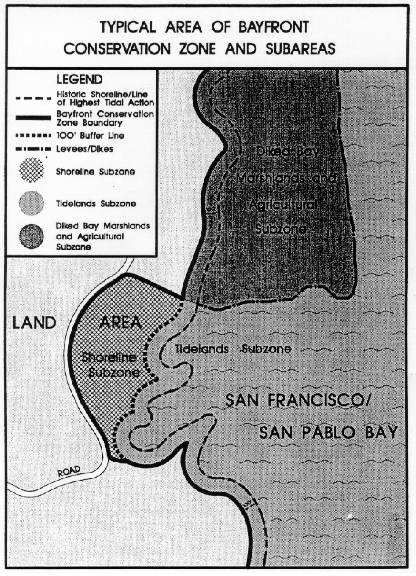
2.
Diked Bay Marshland and Agricultural Subzone. (Mapped as "modified wetland.") The diked bay marshlands and agricultural subzone includes all historic bay marshlands (as determined by Nicholas and Wright (1971)). These former marshlands have been diked off from tidal action, and in many cases, filled or partially filled and/or converted to agricultural uses, airports, urban development, and in a few instances lagoons with residences.
This subzone defines areas with similar subsurface or surface conditions; areas which are close to and functionally related to tidal lands; areas in which it is possible to foster the continuation of agriculture; or, if that ceases, to consider the feasibility of returning undeveloped, unfilled former marshes to a more productive wildlife habitat by restoration or leaving as open space for inland marsh migration with sea level rise. This subzone includes a 100-foot wide band landward on undeveloped lands, within which a flexible buffer can be delineated on a case-by-case basis.
3.
Shoreline Subzone. The shoreline subzone includes a few shoreline areas where main public thoroughfares (Highway 101, Paradise Drive, San Pedro Road, etc.) follow the coastline and promote visual access to the bay. The subzone extends from the bayside of the roadway to the tidelands subzone. This subzone defines a viewshed and promotes conservation of coastal habitats such as bluff vegetation and wildlife nesting/resting areas.
F.
Design guidelines.
1.
Habitats:
a.
Development should not encroach into wetlands and sensitive wildlife habitats, limit normal range areas, create barriers which cut off access to food, water or shelter, or cause damage to fisheries or fish habitats. Buffer zones between development and identified or potential wetland areas should be provided. Access to environmentally sensitive marshland and adjacent habitat should be restricted, especially during spawning and nesting seasons.
b.
Buffers between wetland habitat and developed uses should be 100 feet minimum width, determined by: biological (habitat) significance; sensitivity of habitats or particular species; presence of threatened or endangered species; susceptibility of adjacent site to erosion and flooding from sea level rise; topography and configuration of wetland areas; space required for marsh migration with sea level rise; and type and scale of development proposed. Existing man-made features (e.g., roads and dikes) are useful buffers.
c.
Proposed development should be designed to minimize removal of vegetation, which is important for soil stabilization, increasing recharge, and providing wildlife habitat. Areas which must be cleared of vegetation should be restored with plantings of native and other non-competing species, where revegetation is determined to be environmentally desirable. Exotic species which are considered invasive and which displace native species should be removed. Evaluation of vegetation to be removed and restored will be done on a case-by-case basis.
d.
Freshwater habitats in the Bayfront Conservation Combining District should be preserved and/or expanded so that the circulation, distribution, and flow of the fresh water supply is facilitated. These habitats are found along freshwater streams and small former marshes.
2.
Access and recreation:
a.
Public access should be sited and designed to facilitate public use and enjoyment of the bayfront lands. Public areas should be clearly marked, and continuous ten-foot wide pedestrian easements from the nearest roads to the shoreline and along the shoreline should be provided. Public access areas should be designed to minimize possible conflicts between public and private uses on the properties. Walkways should generally be set back at least ten feet from any proposed structure.
b.
Within the Bayfront Conservation Zone, provisions should be made for recreational development and access to the shoreline marshes for such uses as fishing, boating, hunting, picnicking, hiking and nature study. There should be provisions for both separated wildlife preserve and more intensively used recreational uses along the bayfront.
3.
Buildings:
a.
Design and spacing of structures should permit visual access to shoreline areas. Buildings should be clustered to allow bay views from streets and, where appropriate, to allow for animal movement corridors from uplands to marshes. Building design should be low profile.
b.
Public activity centers where outdoor human activity is expected should be set back at least 100 feet from the marsh edge (i.e., from the edge of either a defined wetland (diked bay marshland subzone), or in the adjacent tidelands subzone). This includes theaters, restaurants, schools, commercial uses, office uses and similar uses.
c.
Buildings or structures that are constructed in designated flood zones shall comply with the minimum development standards for identified flood plain areas as established in Title 23, Section 23.09 of the County Code.
4.
Utilities: All new utility distribution lines shall be placed underground.
5.
Environmental quality:
a.
The County may, upon consultation with Regional, State, and Federal Agencies, require off-site as well as on-site mitigation measures in order to eliminate or reduce adverse environmental impacts as a result of any proposed development.
b.
Development shall occur in a manner which minimizes the impact of earth disturbance, erosion, water pollution, and disruption of wildlife habitat.
c.
The development of jetties, piers and outfalls should not alter the movement patterns of the bay's tides and currents such that significant adverse impacts would result.
6.
Diking, filling and dredging. The County shall prohibit diking, filling or dredging in areas subject to tidal action (Tidelands subzone) unless the area is already developed and currently being dredged. Current dredging operations for maintenance purposes may continue subject to environmental review, if necessary. In some cases, exceptions to the prohibition of diking, filling, and dredging may be made for areas that are isolated, limited in productivity, or where filling is necessary to sustain marsh habitat or use natural approaches for shoreline protection against rising sea level. In tidal areas, only land uses which are water-dependent shall be permitted, consistent with Regional, State, and Federal policy. These include ports, water-related industry and utilities, essential water conveyance, wildlife refuge, and water-oriented recreation.
Exceptions to the prohibition of diking, filling, and dredging may be granted for emergency or precautionary measures in the public interest (e.g., protection from flood or other natural hazards). Removal of vegetation shall be discouraged. Alteration of hydrology should only be allowed when it can be demonstrated that the impact will be beneficial or non-existent.
7.
Aesthetic and scenic quality:
a.
The County shall ensure protection of visual access to the bayfront and scenic vistas of water and distinct shorelines through appropriate siting and design of development.
b.
In particular, waterfront development should be sited and designed to permit open views in optimal locations for public enjoyment of bayfront lands.
8.
Protection from geologic, flooding and other hazards:
a.
Any development proposed for lands within the -BFC combining district shall be consistent with policies of the Environmental Hazards Element of the Countywide Plan. Proposed development should not occur in areas which pose hazards, including differential settlement, slope instability, liquefaction, ground shaking and rupture, tsunami, flooding, or other ground failures.
b.
Areas underlain by deposits of "young muds" should be reserved for water-related recreational uses, habitat, and open space. Limited development may be allowed subject to the approval of the U.S. Army Corps of Engineers and other trustee agencies.
c.
Development proposed on bayfront lands with soil conditions that are unsuitable for construction, or experience seismic activity, should be designed to minimize earth disturbance, erosion, flooding, water pollution, and other hazards to public safety, or flooding.
9.
Agricultural uses:
a.
Agricultural activities should minimize removal of natural vegetation where possible.
b.
Use of pesticides, insecticides, etc. should comply with existing State and Federal standards.
c.
Development shall be sited and designed to preserve and protect existing agricultural lands in the Bayfront Conservation Zone.
10.
Sea Level Rise:
a.
The following provisions apply to new development in the BFC district where the development would be located in areas up to the 3.3-foot sea level rise inundation area depicted in Countywide Plan, Safety Element Map 2-19:
i.
New buildings shall be located in suitable upland areas less susceptible to the effects of sea level rise.
ii.
The lowest habitable floor area of new buildings shall be elevated at least three feet above the Base Flood Elevation, unless there are other site-specific factors that make this elevation infeasible.
iii.
New hardscape shoreline protection improvements are only allowed when nature-based shoreline protection improvements and hybrid (i.e. nature-based with hard shoreline protection) improvements have been demonstrated to be infeasible.
iv.
Prior to the development of new buildings in this area, the property owner shall record a deed restriction against the subject property in which the property owner acknowledges and agrees, on behalf of themselves and successors and assigns that:
1)
The property is subject to sea level rise hazards, including, but not limited to, flooding, bluff and shoreline erosion;
2)
Property owner acknowledges and assumes responsibility for the risks of potential damage or injury at the property caused by sea level rise; and explicitly waives, and releases the County from, any claim against the County regarding such damage or injury, including any claim for injunctive or other equitable relief, personal injury, property damage, and/or inverse condemnation;
3)
Property owner acknowledges that sea level rise may also potentially damage public infrastructure that provides benefits to members of the public, including the property owner, and that it may not be in the public interest for the County to repair and/or replace such infrastructure in the future. Property owner further acknowledges that such damage, and/or the County's decision not to repair and/or replace such infrastructure following such damage, may render the property uninhabitable. Property owner explicitly waives, and releases County from, any claim against the County regarding such damage to, or decision not to repair and/or replace, public infrastructure; and/or such uninhabitability;
4)
Housing Code provisions prohibit the occupancy of structures where sewage disposal or water systems are rendered inoperable; and
5)
Property owner will bear all responsibility for demolishing and removing structures damaged by the effects of sea level rise and deemed by the Marin County Building Official as substandard and/or unsafe pursuant to the Marin County Building Code.
(Ord. No. 3577, 2012; Ord. No. 3666, § II(exh. A), 2017; Ord. No. 3780, § 1(exh. A), 2023)
22.14.070 - Primary Floodway (F-1).
A.
Purpose. The Primary Floodway (F-1) combining district is intended to insure that life and property will be protected within designated floodways and to prevent increased flooding due to random and uncontrolled development which will impede passage of ultimate floodwaters.
B.
Application of combining district. The F-1 district shall apply to those lands within a primary floodway and shall consist of the channel of a watercourse and that portion of the adjoining floodplain which is reasonably required to provide for the passage of floodwaters of the watercourse. The F-1 district may be combined with any zoning districts established by Section 22.06.020 (Zoning Districts Established) and their companion coastal zones established by Article V.
C.
Prohibited Uses. No buildings or structures shall be constructed within an F-1 district. No dredging, filling or levee or dike construction shall be permitted in an F-1 district if it will tend to increase the water surface level or impede the flow of water.
D.
Permitted Uses. Actual uses existing at the time of the adoption of an F-1 district for a specific area shall be permitted and shall be treated as nonconforming uses according to Chapter 22.112 (Nonconforming Structures, Uses, and Parcels). Nothing herein shall prohibit placing one floating boat dock on each legal lot of record that existed at the time the F-1 district was created.
(Ord. No. 3577, 2012)
22.14.080 - Secondary Floodway (F-2).
A.
Purpose. The Secondary Floodway (F-2) combining district is intended to insure that life and property will be protected within secondary floodways and to prevent increased flooding due to random and uncontrolled development which will impede the capacity of secondary floodplains to receive overflow floodwaters.
B.
Application of combining district. The -F-2 district shall apply to those lands within the portion of a natural floodway between the limits of the primary floodway, and the limits of the floodplain where inundation may occur. The F-2 district may only be combined with any zoning districts established by Section 22.06.020 (Zoning Districts Established) and their companion coastal zones established by Article V (Coastal Zones - Development and Resource Management Standards).
C.
Permitted Uses. Those uses authorized by the governing zoning district may be permitted on lands within an F-2 district subject to the established design standards.
D.
Design Standards.
1.
No buildings, structures, levee, dike, fill, or any other activity shall be permitted within an F-2 district, if it would reduce the ponding area and capacity of any parcel of land within the F-2 district.
2.
Buildings, structures, levees, dikes, fill and other activity may be permitted in an F-2 district provided the following findings are made:
a.
The improvement is located within an encroachment area specified at the time the F-2 district was established, or would not reduce the ponding capacity of the site by the percentage specified at the time the F-2 district was established. The remaining land area shall be dedicated as a ponding area to absorb overflow from the primary floodway.
b.
Prior to performing any activity in an F-2 district, the property owner shall enter into an agreement with the County, the Marin County Flood Control and Water Conservation District, or other appropriate public agency. The agreement shall include the following provisions:
1.
The remaining area or percentage of the parcel shall be subject to ponding and overflow;
2.
Lands within any F-1 district included in the property involved shall be dedicated to the County, the Marin County Flood Control and Water Conservation District, or other appropriate public agency;
3.
Drainage improvements which will enable the remaining area or percentage to serve as a ponding and overflow area shall be constructed by the property owner;
4.
A bond may be required to guarantee performance of the agreement;
5.
Other provisions reasonably required to fulfill the purposes of the F-1 and F-2 district may be imposed.
c.
Full use of the entire parcel shall be permitted only at such time as both of the following conditions are met:
1.
Ultimate flood control channel improvements specified at the time the F-2 district was adopted are constructed through the parcel or parcels being developed. Alternative methods of providing flood control facilities may be approved by the County, the Marin County Flood Control and Water Conservation District, or other appropriate public agency provided they provide equal capacity to that of the ultimate flood control channel improvements adopted at the time the F-2 district was created; and
2.
The ultimate flood control channel section is constructed from the parcel to be developed, downstream to the mouth of the primary floodway.
(Ord. No. 3577, 2012)
22.14.090 - Housing Overlay Designation (HOD) Combining District.
A.
Purpose. The HOD combining district allows housing development at a density described in table 2-12 below and offers ministerial review for housing development projects. The combining district is supplemental to the underlying zoning, which remains unchanged. This approach allows compact development and encourages housing on key sites.
B.
Applicability. This chapter shall apply to housing development projects on all properties identified in table 2-12 below.
C.
Allowable Uses. Housing development projects are permitted ministerially in an HOD combining district through application of the Form Based combining district, Form Based Code, and Housing Development Regulation Compliance Review. Other types of projects are subject to the requirements of the land use tables for the underlying zoning district.
D.
Ministerial Review: The Form Based combining district may be applied to housing development projects on any HOD site. Housing development projects under the Form Based combining district are subject to a Housing Development Regulation Compliance Review and must conform with the standards of the Form Based Code as specified in Section 22.14.100.
E.
Location, Density, and Development Standards. The HOD combining district applies to the sites listed in table 2-12 below, which also specifies the required transect zones that must be applied under the Form Based Code, and the maximum density and number of primary dwelling units for the acreage under the HOD district on the site. While a specific minimum number of units is not required on an HOD site, housing development projects on HOD sites must be clustered to achieve at least the minimum residential density per acre required by Table 2-12.
1. See the Form Based Combining District in the Development Code for explanation of
applicable transect zones.
2. ;hg;Housing development projects that consist of 100 percent affordable housing
on those sites designated for Lower Income Household in the 2023 Housing Element Update
must be developed at no less than 20 units per acre as required by Government Code
Section 65583.2.
(Ord. No. 3782, § 1, 2023; Ord. No. 3819, § I(exh. A), 2024)
Editor's note— Ord. No. 3782, § 1(exh. A), adopted January 24, 2023, repealed § 22.14.090 and enacted a new § 22.14.090 as set out herein. Former § 22.14.090 pertained to the Affordable Housing (AH) Combining District and derived from Ord. No. 3602, § II(exh. A), 2013; 3634, § II(exh. A), adopted 2015.
22.14.100 - Form Based (FB) Combining District.
A.
Purpose. The Form Based (FB) combining district is intended to provide objective design standards for multi-family housing development projects that qualify for ministerial review. The combining district is supplemental to the underlying zoning, which remains unchanged. This section incorporates by reference the Marin County Form Based Code in its entirety.
B.
Application of combining district. The FB combining district shall apply to the new development of at least five primary residential dwelling units on either of the following:
1.
Sites of residential or mixed use projects subject to Senate Bill 35 (if SB applies to the County), Assembly Bill 2011, or any other State legislation that mandates ministerial review of housing development projects.
2.
Sites of residential or mixed use projects within the Housing Overlay Designation (HOD) area where residential development is proposed at a density consistent with the HOD designation on the site listed in Table 2.12. However, in this instance a property owner may choose to rely on the underlying zoning district standards, subject to any discretionary requirements, instead of applying the FB district.
The FB district shall not be applied to floating home marinas or mobile home parks.
C.
Allowable Uses. Allowable uses are governed by the underlying zoning district and application of the FB combining district shall have no effect on the allowable uses on a property.
D.
Density. At least five new primary dwelling units shall be created by a project subject to the FB combining district. The project shall result in at least the number of units on the property necessary to reach the minimum number of units established in the density range of the Countywide Plan Land Use Designation, or the residential density per acre specified by the HOD, as applicable.
E.
Design Standards. New development shall comply with the provisions of the Marin County Form Based Code, which supersedes all other design standards in this Development Code. Development on those properties within an HOD area shall be subject to the specific transect zone(s) indicated in the HOD standards.
F.
Deviations. Deviations from the provisions of the Marin County Form Based Code, as identified in subsection E. above, are subject to Design Review (Chapter 22.42), or the Exceptions process for civil engineering standards (Chapter 24.15) related to parking and access improvements.
(Ord. No. 3781, § 1, 2023; Ord. No. 3819, § I(exh. A), 2024)
22.16.010 - Purpose of Chapter.
This Chapter provides development standards intended to enhance the character and preserve the natural heritage of the area.
(Ord. No. 3577, 2012; Ord. No. 3666, § II(exh. A), 2017)
22.16.020 - Applicability.
The provisions of this Chapter apply to proposed development subject to Master Plan, Design Review, and Site Plan Review, in addition to all other applicable provisions of this Development Code. In the event of any conflict between the provisions of this Chapter and other provisions of this Development Code, this Chapter shall control.
(Ord. No. 3577, 2012; Ord. No. 3666, § II(exh. A), 2017)
22.16.030 - General Standards.
A.
Subdivisions, residential density. The minimum lot area for new subdivisions, and the maximum density for residential projects within the planned districts, shall be evaluated for consistency with the Marin Countywide Plan and zoning.
B.
Site planning standards. The minimum setback requirements, floor area ratio, maximum site coverage, height limits, and other development standards, applicable to a site in a planned district, shall be determined through Master Plan (Chapter 22.44) , Design Review (Chapter 22.42), Site Plan Review (Chapter 22.52), or Tentative Map (Chapter 22.84), as applicable.
C.
Access.
1.
Roads. In ridge land areas designated by the Marin Countywide Plan, roads shall be designed to rural standards. (Generally, not more than 18 feet pavement width, depending on safety requirements. A minimum of 16 feet may be permitted in certain very low use areas, as provided in the improvement standards established in compliance with Title 24, Sections 24.04.020 et seq., of the County Code (Roads).) No new roads shall be developed where the required grade is more than 15 percent unless the Review Authority determines that the roads can be built without environmental damage, comply with State fire safety regulations, and be used without public inconvenience.
2.
Driveways. Driveways shall be designed in compliance with Title 24, Sections 24.04.235 et seq., of the County Code (Driveways). Driveway length shall be minimized, consistent with the clustering requirements of following Subsection F.1.
D.
Building location.
1.
Clustering requirement. Structures shall be clustered in the most accessible, least visually prominent, and most geologically stable portions of the site, consistent with needs for privacy where multiple residential units are proposed. Clustering is especially important on open grassy hillsides; a greater scattering of buildings may be preferable on wooded hillsides to save trees. The prominence of construction shall be minimized by placing buildings so that they will be screened by existing vegetation, rock outcroppings or depressions in topography. In agricultural areas, residential development shall be clustered or sited to minimize possible conflicts with existing or possible future agricultural uses.
FIGURE 2-2
CLUSTERING OF DEVELOPMENT
2.
Development near ridgelines. No construction shall occur on top of, or within 300 feet horizontally, or within 100 feet vertically of visually prominent ridgelines, whichever is more restrictive, unless no other suitable locations are available on the site or the lot is located substantially within the ridgeline area as defined herein. If structures must be placed within this restricted area because of site constraints or because siting the development outside of the ridgeline area will result in greater visual or environmental impacts, they shall be in locations that are the least visible from adjacent properties and view corridors.
FIGURE 2-3
LOCATION OF STRUCTURES NEAR RIDGELINES
3.
Energy conservation. Solar access shall be considered in the location, design, height and setbacks of all buildings. Generally, buildings should be oriented in a north/south fashion with the majority of glazing on the south wall or walls of the buildings.
4.
Noise mitigation. Noise impacts on residents in nearby areas shall be minimized through the placement of buildings, recreation areas, roads and landscaping.
E.
Facilities. Where possible, facilities and design features called for in the Marin Countywide Plan shall be provided on the site. These include units with three or more bedrooms, available to households with children; child-care facilities; use of reclaimed wastewater; use of materials, siting, and construction techniques to minimize consumption of resources such as energy and water; use of water-conserving appliances; recreation facilities geared to age groups anticipated in the project; bus shelters; design features for bicycle paths to accommodate people with disabilities linked to City-County systems; bicycle parking and related showers and lockers; and facilities for composting and recycling.
F.
Landscaping. Introduced landscaping should be designed to minimally disturb natural areas, and shall be compatible with the native plant setting. Landscaping plans should be prepared in compliance with Chapter 22.26 (Landscaping). Landscaping plans should consider fire protection, solar access, the use of native and drought-tolerant plant species and minimal water use. Planting should not block scenic views from adjacent properties or disturb wildlife trails. See also Chapter 22.26 (Landscaping).
G.
Lighting, exterior. Exterior lighting visible from off-site should be allowed for safety purposes only, shall consist of low-wattage fixtures, and should be directed downward and shielded to prevent adverse lighting impacts on nearby properties, subject to the approval of the Director.
H.
Open space areas. Project approval may require the preservation of land as open space to protect rural visual character, wildlife habitat, riparian corridors and wetlands.
1.
Open space dedication. Land to be preserved as open space may be dedicated in fee title to the County or other agency designated by the County before issuance of any construction permit, or may remain in private ownership with appropriate scenic and/or open space easements/agreements granted to the County in perpetuity. The County may require reasonable public access across those lands remaining in private ownership, consistent with Federal and State law.
2.
Maintenance. The County or other designated public agency will maintain all open space lands accepted in fee title, as well as public access and trail easements across private property. Open space lands that remain in private ownership with scenic easements shall be maintained in compliance with the adopted policies of the Marin County Open Space District and may require the creation of a homeowners' association or other organization to maintain the private open space.
3.
Open space uses. Uses in open space areas shall be in compliance with policies of the Marin County Open Space District. Generally, uses shall have no or minimal impact on the natural environment. Pedestrian and equestrian access shall be provided where possible and reasonable.
I.
Project design.
1.
Height limits for structures.
a.
Thirty feet for primary structures, except that multi-family residential buildings may be increased in height to 45 feet when side yard setbacks of 15 feet or greater are provided.
b.
Sixteen feet for detached accessory structures, except that parking structures may reach a height allowed for the primary structures when they comply with Section 22.20.090.E.2 (Parking structures on steep lots). Further, a detached accessory structure may be constructed to the height allowed for primary structures if the accessory structure is located at least 40 feet from all property lines.
c.
The floor level of the lowest floor shall not exceed 10 feet above natural grade at the lowest corner.
d.
Structures located within the ridgeline areas pursuant to Subsection D.2 above shall be limited to a maximum height of 18 feet.
e.
Where allowed, agricultural structures sited in compliance with the requirements of Section 22.16.030.D.2 (Development near ridgelines) may exceed the above height limits with Design Review approval. See Chapter 22.42 (Design Review).
These requirements may be waived by the Director in unusual circumstances resulting from an irregular site characteristic (e.g., location, lot shape/size, topography) where the waiver will not result in a structure that will impinge significantly on sun and light exposure, views, vistas, and privacy of adjacent properties and rights-of-way.
2.
Materials and colors. Building materials and colors shall be chosen to blend into the natural environment unobtrusively, to the greatest extent possible.
J.
Site preparation.
1.
Grading. Grading shall occur in compliance with Title 23, Chapter 23.08 (Excavating, Grading and Filling) of the County Code, but shall be held to a minimum. Every reasonable effort shall be made to retain the natural features of the land: Skylines and ridgetops, rolling land forms, knolls, native vegetation, trees, rock outcroppings, and watercourses. Where grading is required, it shall not create flat planes and sharp angles of intersection with natural terrain. Slopes shall be rounded and contoured to blend with existing topography. See Figure 2-4 (Desirable Grading Practice).
2.
Drainage. Areas adjacent to creeks shall be maintained in their natural state as much as possible. All construction shall ensure drainage into the natural watershed in a manner that will avoid significant erosion or damage to adjacent properties. Impervious surfaces shall be minimized.
3.
Trees and vegetation. Every effort shall be made to avoid tree removal, or changes or construction that would cause the death of existing trees, rare plant communities, and wildlife habitats.
FIGURE 2-4
DESIRABLE GRADING PRACTICE
4.
Fire hazards. Development shall be permitted in areas subject to wildfire threat only where the Review Authority determines there is adequate access for fire and other emergency vehicles, an adequate water supply, a reliable fire warning system, and fire protection service. Setbacks for firebreaks shall be provided if necessary. Projects shall comply with State fire safe requirements including defensible space and residential construction techniques.
5.
Geologic hazards. Construction shall not be permitted on identified seismic or geologic hazard areas such as on slides, on natural springs, on identified fault zones, or on bay mud without approval from the Department of Public Works, based on acceptable soils and geologic reports.
6.
Watershed areas. All projects within water district watershed areas shall be referred to the affected district for review and comment. Damaging impoundments of water shall be avoided.
K.
Utilities. Street lights in ridge land areas shall be of low intensity and low profile. Power and telephone lines shall be undergrounded in all areas, where feasible.
L.
Plan consistency. Project approval shall require findings of consistency with the Marin Countywide Plan and any applicable Community Plan that may have more restrictive standards than the preceding provisions of this Section.
(Ord. No. 3577, 2012; Ord. No. 3666, § II(exh. A), 2017; Ord. No. 3706, 2019; Ord. No. 3745, § 1(exh. A), 2021; Ord. No. 3819, § I(exh. A), 2024)
22.16.040 - Additional ARP District Standards.
The following standards apply to development and new land uses within the ARP zoning district, in addition to the provisions of Section 22.16.030 (Planned District General Standards):
A.
Agricultural and open space uses. Agricultural uses shall be encouraged in ARP zones.
1.
Usable agricultural land should be identified and efforts made to preserve and/or promote its use. Agricultural land not presently in production, may be preserved as undeveloped private open space to be made available in the future on a lease basis for compatible agricultural uses. The primary intent shall be to preserve agricultural land not in production for future agricultural uses, not to provide open space/recreational land uses that will interfere with agricultural operations.
2.
Lands to be preserved for agriculture and/or open space use may require the creation of a homeowner's association or other organization for their maintenance.
3.
The nature and intensity of large-scale agricultural uses should be described in the form of an agricultural management plan prepared by the landowner or lessee and approved by the County. Management plans should consider intensity of grazing, water runoff protection, chemical and fertilizer use, and separation from existing or proposed residential uses, to preserve agricultural land practices.
4.
In some cases, the County may require reasonable public access across those lands remaining in private ownership. Pedestrian and/or equestrian access shall be provided where consistent with adopted County and coastal plans, where not in conflict with agricultural uses, and where liability issues have been resolved. Public access for pedestrian and/or equestrian purposes shall be required as a condition of plan approval.
B.
Fire protection. In rural areas, and areas without public water systems, on-site water storage capacity may be required for each single-family dwelling, subject to the requirements of the County Fire Department. In planned or cluster developments, provisions should be made for common water storage facilities and distribution systems, where feasible. Maintenance of these water storage facilities and distribution systems should be performed according to a plan approved by the County Fire Department.
(Ord. No. 3577, 2012; Ord. No. 3666, § II(exh. A), 2017)