
Marin County Unincorporated
City Zoning Code
City Zoning Code
ARTICLE VIII
DEVELOPMENT CODE DEFINITIONS
Chapter:
22.130.010 - Purpose of Chapter.
This Chapter provides definitions of terms and phrases used in this Development Code that are technical or specialized, or that may not reflect common usage.
(Ord. No. 3577, 2012)
22.130.020 - Applicability.
If any of the definitions in this Chapter conflict with definitions in other chapters of the Marin County Code, these definitions shall prevail for the purposes of this Development Code. If a word used in this Development Code is not defined in this Chapter, or other Titles of the County Code, the most common dictionary definition is presumed to be correct.
(Ord. No. 3577, 2012)
22.130.030 - Definitions of Specialized Terms and Phrases.
Definitions are listed in alphabetical order.
A. Definitions, "A."
Accessory Dwelling Unit. A residential dwelling unit, which is accessory to a primary dwelling unit, that provides complete independent living facilities for one or more persons and is located on a lot with a proposed or existing primary dwelling. It shall provide permanent provisions for living, sleeping, eating cooking, sanitation, and independent exterior access, on the same lot as the single-family or multi-family dwelling is or will be situated. An Accessory Dwelling Unit (ADU) also includes the following: (1) an efficiency unit as defined in Section 17958.1 of the California Health and Safety Code and (2) a manufactured home as defined in Section 18007 of the California Health and Safety Code. Category 1-Statewide Exemption ADUs are those that meet the standards of Section 22.32.120(A). Category 2-Permit ADUs are those that meet that standards of Section 22.32.120(B).
Accessory Dwelling Unit, Attached. An Accessory Dwelling Unit contained entirely within an addition to an existing legal primary dwelling.
Accessory Dwelling Unit, Detached. An Accessory Dwelling Unit contained entirely within a detached accessory structure (outbuilding).
Accessory Retail Uses (land use). This land use consists of the retail sale of various products (including food) in a store or similar facility that is located within a health care, hotel, office, or industrial complex, for the purpose of serving employees or customers, and is not visible from a public street. These uses include pharmacies, gift shops, food service establishments within hospitals, convenience stores and food service establishments within hotels, and office and industrial complexes.
Accessory Structure, Detached. There are two types of accessory structures: (1) buildings, and (2) affixed improvements including fences, retaining walls, septic systems, utility lines, outdoor appliances, back-up generators, propane tanks, fountains and other water features. A structure is considered to be accessory when it is secondary and incidental to, and commonly associated with the primary structure or use.
A detached accessory building lacks any type of substantial physical connection with the primary structure with roofs between the primary building and the accessory building separated by a horizontal distance of at least five feet. If the roofs are separated by a horizontal distance of less than five feet, then the buildings are considered attached.
Accessory structures that are not buildings are always considered detached regardless of the degree of proximity and physical connection, provided they are located outside of the building footprint.
Acres, Gross and Net. See "Lot Area."
Adult Day Program (land use). This land use consists of a non-medical community based facility that provides a program of care to people 18 years of age or older in need of personal care services, supervision, or assistance essential for sustaining the activities of daily living or for the protection of the individual. The facility cannot be open more than 16 hours per day and must be licensed by the California Department of Social Services as an Adult Day Program. Physician's care and skilled nursing care services are not included in this land use.
Adult Entertainment Establishment (land use). This land use consists of any adult bookstore, adult hotel or motel, adult motion picture arcade, adult motion picture theater, cabaret, sexual encounter center, or any other business or establishment that offers its patrons services or entertainment characterized by an emphasis on matter depicting, describing or relating to "specified sexual activities" or "specified anatomical areas," but not including those uses or activities, the regulation of which is preempted by state law.
Affordable Housing. Dwelling units that are income restricted and rented or sold at rates that are affordable to households with income qualifying as low, very low or extremely low income, as described in Chapter 22.22 (Affordable Housing Regulations) or Chapter 22.24 (Affordable Housing Incentives) and defined by Health and Safety Code Sections 50052.5 and 50053. Affordable Housing includes Transitional and Supportive Housing, and Single Room Occupancy (SRO) consistent with qualifying income requirements.
Affordable Housing Impact Fee. A fee, initially set by the Board of Supervisors and subject to adjustments, assessed for residential development that is not part of a subdivision. The payment of any applicable fees shall be due prior to issuance of Certificate of Occupancy.
Affordable Ownership Cost. The cost at which affordable housing must be provided for purchase, which is calculated as annual housing costs, during the first calendar year of a household's occupancy, including mortgage payments, property taxes, homeowners insurance, and homeowners association dues, if any, which do not exceed the following:
1. For inclusionary units required by Chapter 22.22, annual housing costs cannot exceed 30 percent of household income adjusted for household size. Inclusionary housing income ranges and associated sales price requirements are:
2. For affordable housing that qualifies a project for a state density bonus, consistent with Government Code Section 65915, annual housing costs cannot exceed the following:
(a) For moderate income households: Housing cost shall not be less than 28 percent of the gross income of the household or exceed the product of 35 percent of 110 percent of area median income, adjusted for household size.
(b) For low income households: 30 percent of 70 percent of area median income, adjusted for household size.
(c) For very low income households: 30 percent of 50 percent of area median income, adjusted for household size.
Affordable Rent. Annual rent, including utilities and all fees for housing services, which does not exceed the following:
1. For inclusionary units required by Chapter 22.22, annual rent cannot exceed 30 percent of household income. Inclusionary housing income ranges and associated rent level requirements are:
2. For affordable housing that qualifies a project for a state density bonus, annual rent cannot exceed the following:
(a) For moderate income households: Housing cost shall not be less than 28 percent of the gross income of the household or exceed the product of 35 percent of 110 percent of area median income, adjusted for household size.
(b) For low income households: 30 percent of 70 percent of area median income, adjusted for household size.
(c) For very low income households: 30 percent of 50 percent of area median income, adjusted for household size.
Affordable Rent. Annual rent, including utilities and all fees for housing services, which does not exceed the following:
1. For inclusionary units required by Chapter 22.22, annual rent cannot exceed 30 percent of 50 percent of median area income, adjusted for household size.
2. For affordable housing that qualifies a project for a state density bonus, annual rent cannot exceed the following:
(a) For low income households: 30 percent of 60 percent of area median income, adjusted for household size.
(b) For very low income households: 30 percent of 50 percent of area median income, adjusted for household size.
(c) for extremely low income households: 30 percent of 30 percent of area median income, adjusted for household size.
Agent. A person authorized in writing by the property owner to represent and act for a property owner in contacts with County employees, committees, Commissions, and the Board, regarding matters regulated by this Development Code.
Agency. The Marin County Community Development Agency.
Agriculture (land use). The breeding, raising, pasturing, and grazing of livestock, for the production of food and fiber; the breeding and raising of bees, fish, poultry, and other fowl; and the planting, raising, harvesting and producing of agricultural, aquacultural, horticultural and forestry crops.
Agricultural Accessory Activity (land use). This land use consists of accessory activities customarily incidental to agricultural operations, and which involve agricultural products produced only on-site or elsewhere in Marin County, including:
Corn shelling;
Custom milling of flour, feed and grain;
Drying of corn, rice, hay, fruits, and vegetables;
Grain cleaning and grinding;
Hay baling and cubing;
Pre-cooling and packaging of fresh or farm dried fruits and vegetables;
Preparation and packaging of animal byproduct (such as eggs and wool) produced on-site;
Sorting and packaging of fruits and vegetables;
Tree nut hulling and shelling.
Any of the above activities performed in the field with mobile equipment not involving permanent structures are included under the definition of "Crop Production."
Agricultural Accessory Structures (land use). This land use consists of agricultural worker housing or an uninhabited structure for the storage of farm animals, implements, supplies or products, that contains no residential use, is not accessory to a residential use, and with the exception of retail sales structures, agricultural accessory structures are not open to the public and include:
- agricultural worker housing
- barns
- coops
- corrals
- grain elevators
- facilities for milking
- fences
- pens
- silos
- stables
- facilities for cleaning, drying, pre-cooling, and packaging of fruits and vegetables produced on-site
- greenhouses
- utility facilities
- other similar structures
Does not include commercial greenhouses (which are under "Plant Nurseries") or structures for agricultural processing activities (which are under "Agricultural Processing") or retail sales of agricultural products. Wind machines for water pumping or other conversion of wind energy to mechanical or thermal power are included under the definition of "Wind Energy Conversion Systems" (WECS).
Agricultural District or Zone. Any of the agricultural zoning districts established by Chapter 22.08 (Agricultural and Resource-Related Districts), or Coastal Zoning Districts established by Article V (Coastal Zones - Development and Resource Management Standards), including A (Agriculture and Conservation), A2 (Limited Agriculture), ARP (Agricultural, Residential Planned), C-APZ (Coastal, Agricultural Production Zone), and C-ARP (Coastal, Agricultural, Residential Planned).
Agricultural Processing (land use). This land use consists of the processing of harvested crops and other agricultural products, including the following:
Food oil production, including olive oil;
Processing of milk;
Production of butter, cheese, and other dairy products;
Shellfish processing;
Wine production.
Also includes structures used in connection with the above activities.
Agricultural Worker. An employee who is engaged in services associated with an agricultural use, including: cultivation and tillage of soil; dairying; the production, cultivation, growing, and harvesting of any agricultural or horticultural commodity; and the preparation, delivery, or storage of any agricultural or horticultural commodity for market.
Agricultural Worker Housing. Any attached and detached dwelling unit used to house agricultural workers and their family members, including temporary mobile homes. For the purpose of calculating density, no more than one food preparation area shall be provided for each agricultural worker housing unit.
Airpark (land use). This land use consists of airfields, landing strips, and/or heliports, in compliance with the regulations of the Federal Aviation Administration (FAA), and California Division of Aeronautics.
Alley. A public or private roadway, not intended for general vehicle traffic circulation, that provides secondary vehicle access to the rear or side of lots having other public street frontage.
Alteration. Any construction or physical change in the internal arrangement of rooms or the supporting members of a structure, or a change in the external appearance of any structure, not including painting.
Anadromous Fish. Species of Fish that mature in the ocean and migrate into streams to spawn.
Animal Sales Lot. See "Livestock Operations, Sales Lots, Feedlots, Stockyards."
Antennas. See "Telecommunications Facilities."
Antiquated Subdivision. A subdivision recorded before January 1, 1930.
Apartment. See "Multi-Family Housing."
Appealable Area. The areas described by Public Resources Code Sections 30519.b and 30603.a.1 and a.2, within which a County decision to approve a development may be appealed to the California Coastal Commission.
Appeals Area Maps. The official maps on file with the Community Development Agency which identify areas within the Coastal Zone where County decisions on Coastal Permit applications may be appealed to the Coastal Commission.
Applicant. Any person, firm, partnership, association, joint venture, corporation, or any entity or combination of entities, which seeks County permits and approvals.
Approval. An official sanction that includes both approval and approval with conditions.
Aquaculture (land use). This land use consists of the raising and harvesting of aquatic organisms, including shellfish, mollusks, crustaceans, kelp, and algae.
Arborist. An arborist is: 1) a person currently certified by the Western Chapter of the International Society of Arboriculture as an expert on the care of trees; 2) a consulting arborist who satisfies the requirements of the American Society of Consulting Arborists; or 3) such other qualified professionals who the Director determines has gained through experience the qualifications to identify, remove or replace trees.
Area Median Income. Median income for Marin County as published by the U.S. Department of Housing and Urban Development (HUD) or the California Department of Housing and Community Development (HCD) with adjustments for household size. Applicable schedule to be applied is at the discretion of the Director.
Ark. Any vessel, boat, craft, or structure originally designed to float that is now permanently grounded or supported by a foundation or piling.
Assessor's Parcel. A unit of real property recognized by the Marin County Assessor's Office for tax purposes, mapped and assigned an Assessor's Parcel Number by the Assessor's Office.
Auto, Mobile Home, Vehicle, Parts Sales (land use). This land use consists of the retail sale and/or rental of the following (vehicles may be new or used):
Automobiles;
Boats;
Campers;
Dealerships;
Golf carts;
Jet skis;
Mobile homes;
Motorcycles;
Motorized farm equipment;
Recreational and utility trailers;
Repair shops with new car;
Snowmobiles;
Tires;
Trucks;
Vans;
Vehicle accessories;
Vehicle parts.
Does not include: Bicycle and moped sales (see "Retail Stores, General Merchandise"); tire recapping establishments (see "Repair and Maintenance - Vehicle"); businesses dealing exclusively in used parts, (see "Recycling, Scrap and Dismantling Yards"); or "Service Stations," which are separately defined.
Automatic Teller Machine (ATM) (land use). This land use consists of machines used by bank and financial service patrons for conducting transactions, including deposits, withdrawals and fund transfers, without contact with financial institution personnel. The machines may be located at or within banks, or in other locations, in compliance with this Development Code.
Automobile Repair. See "Repair and Maintenance, Vehicle."
Automobile Dismantling Yard. See "Recycling, Scrap, and Dismantling Yards."
Avian Migratory Concentration Point. Avian migratory concentration point refers to both the place of departure and the destination of birds from one region to another, especially as a result of seasonal or periodic movement in order to breed, seek food, or to avoid unsuitable weather conditions.
B. Definitions, "B."
Bankfull. Indicates the height (or stage) of a stream that just fills the stream channel.
Banks and Financial Services (land use). This land use consists of financial institutions including:
Banks and trust companies;
Credit agencies;
Holding (but not primarily operating) companies;
Lending and thrift institutions;
Securities/commodity contract brokers and dealers;
Security and commodity exchanges;
Vehicle finance (equity) leasing agencies;
Other investment companies.
See also, "Automatic Teller Machine," above.
Bars and Drinking Places (land use). This land use consists of the sale of alcoholic beverages for on-site consumption, not as part of a larger restaurant. Includes bars, taverns, pubs, and similar establishments where any food service is subordinate to the sale of alcoholic beverages. May include entertainment (e.g., live music and/or dancing). May also include beer brewing as part of a microbrewery, and other beverage tasting facilities.
Base Flood Elevation (BFE). The elevation of the 100-year flood level as determined by statistical analysis for each local area and as designated on the Federal Emergency Management Agency's Flood Insurance Rate Maps (FIRMs). This elevation is the basis of the insurance and floodplain management requirements of the National Flood Insurance Program.
Basement. A story which is partly or completely below grade.
Bay Window. A windowed enclosure that projects from an exterior wall and is at least 18 inches above the adjoining finished floor as measured to the lowest horizontal plane of the projection. To be considered a bay window for the purposes of allowed exemptions and floor area, the windowed enclosure shall not occupy an area greater than 25 percent of any individual wall element of a building for each story or extend more than 30 inches from the exterior wall.
Bed and Breakfast Inns (land use). This land use consists of providing up to five guest bedrooms for overnight lodging, where the use is clearly secondary and incidental to the use of the property as a single-family residence. County requirements applicable to Bed and Breakfast Inns are in Section 22.32.040 (Bed and Breakfast Inns), and applicable Health Department regulations. A Bed and Breakfast Inn with more than five guest rooms is considered a hotel or motel, and is not permitted in a residential zoning district. Refer to the definition of "Room Rental" to distinguish between a Bed and Breakfast Inn and room rental in a "boarding house" situation.
Below Market Rate. Housing that is sold or rented at a price which is below the prevailing rate for equivalent housing units within the same community.
Beverage Production (land use). This land use consists of manufacturing facilities including bottling plants, breweries, coffee roasting, soft drink production, and wineries. Does not include milk processing; see "Food Products." May include tasting and accessory retail sales of beverages produced on-site. A tasting facility separate from the manufacturing facility is included under the definition of "Bars and Drinking Places" if alcoholic beverages are tasted, and under "Restaurant" if beverages are non-alcoholic.
Block. A group of lots surrounded by streets or roads, or streets or roads and railroad right-of-way, mean high tide line or unsubdivided acreage.
Blue Line Stream. A watercourse shown as a blue line (perennial or intermittent) on the most recent applicable U.S.G.S. topographic quadrangle map.
Board, Board of Supervisors. The Board of Supervisors of the County of Marin, State of California.
Board, Board of Commissioners of the Housing Authority. The Board of Commissioners of the Housing Authority of the County of Marin, State of California.
Broadcasting Studios (land use). This land use consists of commercial and public communications facilities entirely within buildings, including radio and television broadcasting and receiving stations and studios. Transmission and receiving apparatus, including antennas and towers, are included under the definition of "Telecommunications Facilities."
Buffer Zone. An area which separates one land use from another, for purposes of safety, environmental protection or compatibility.
Building. Any structure, having a roof supported by columns or walls and usable for shelter, housing, or enclosure of any person, animal, equipment or material.
Building Area. The sum of the floor area of all floors in all buildings on a site. Unlike "Floor Area," building area includes garages, carports, storage buildings, and other attached or detached accessory structures.
Building Element. Any uninterrupted flat surface finished with a single material to which a sign may be mounted, excluding the background to a sign.
Building Envelope. An area of real property identified for the construction of buildings.
Building, Main. See "Structure, primary."
Building Material Stores (land use). This land use consists of the retail sale of lumber and other large building materials, where most display and sales activities occur indoors. Products sold may include paint, wallpaper, glass, fixtures, nursery stock, and lawn and garden supplies. Includes stores selling to the general public, even if contractor sales account for a major proportion of total sales. Includes incidental retail ready-mix concrete operations, except where excluded by a specific zoning district. Establishments primarily selling electrical, plumbing, heating, and air conditioning equipment and supplies are classified in "Wholesaling and Distribution." Hardware stores are listed in the definition of "Retail Stores, General Merchandise," even if they sell some building materials.
Building, Primary Detached. A detached primary building lacks any type of substantial physical connection with other buildings and roofs between the buildings are separated by a horizontal distance of at least five feet. If the roofs are separated by a horizontal distance of less than five feet, then the buildings are considered attached.
Building Site. A lot or parcel that is recognized by the Community Development Agency as having been created in compliance with the governing zoning and development standards.
Bulk. Total interior cubic volume as measured from the exterior surfaces of the structure.
Business Day. Any day that the Planning Division's public service center is staffed and open to the public.
Business Support Services (land use). This land use consists of establishments located primarily within buildings, providing other businesses with services including maintenance, repair and service, testing, rental, etc. Examples of these services include:
Blueprinting;
Business equipment repair services (except vehicle repair, see "Repair and Maintenance - Vehicle");
Commercial art and design (production);
Computer-related services (rental, repair);
Copying, quick printing, and blueprinting services;
Equipment rental businesses within buildings (rental yards are "Storage Yards and Sales Lots");
Equipment repair services where repair occurs on the client site;
Film processing laboratories;
Graphic design;
Janitorial services;
Mail advertising services (reproduction and shipping);
Outdoor advertising services;
Photocopying;
Photofinishing;
Secretarial and personnel services;
Security services;
Soils and materials testing laboratories;
Window cleaning.
C. Definitions, "C."
Cabinet Shop. See "Furniture and Fixtures" (land use).
California Environmental Quality Act (CEQA). A State law originally enacted in 1970, which requires public agencies to document and consider the environmental effects of a proposed action, before a decision is issued. See California Public Resources Code Sections 21000 et seq.
Campground (land use). This land use consists of land that is used or intended for camping, which may include individual campsites, but where utility hookups for recreational vehicles are typically not provided at campsites. See also "Recreational Vehicle Parks."
Camping (land use). This land use consists of inhabiting or staying overnight in the outdoors in the open or in a tent, tarpaulin, hammock or other minimal shelter.
Car Deck. See "Parking Structure."
Cargo Container. A portable, rectangular metal storage container, generally with a height greater than five feet and with doors on one end, designed to be transported on trucks, rail cars, or ships, individually or stacked.
Carport. See "Parking Structure."
Cemeteries, Columbariums and Mortuaries (land use). This land use consists of internment establishments engaged in subdividing property into cemetery lots and offering burial plots or air space for sale. Includes animal cemeteries; cemetery, mausoleum, crematorium and columbarium operations, and full-service funeral parlors, whether accessory to or separate from a cemetery or columbarium.
CEQA. See California Environmental Quality Act (CEQA).
Certificate of Compliance. A Certificate of Compliance is a document recorded by the County Recorder, which acknowledges that the subject parcel, which was typically created prior to current subdivision map requirements, is considered by the County to be a legal lot of record. A Conditional Certificate of Compliance is used instead of a Certificate of Compliance to validate a parcel that was not legally subdivided. Procedures for Certificates of Compliance may be found in Chapter 22.96 (Certificates of Compliance) of this Development Code.
Chemical Products (land use). This land use consists of the manufacture of chemicals and other products created predominantly by chemical processes. This definition includes the manufacture of three general classes of products: (1) basic chemicals, such as acids, alkalis, salts, and organic chemicals; (2) chemical products to be used in further manufacture, such as synthetic fibers, plastic materials, dry colors, and pigments; and (3) finished chemical products to be used for ultimate consumption, such as drugs and cosmetics, or to be used as materials or supplies in other industries such as paints, fertilizers, and explosives. Also includes sales and transportation establishments handling the chemicals described above in other than one of the uses included in the Retail Trade Group on the land use and permit tables.
Chicken Coop. A structure designed to completely enclose chickens on all sides as well as below and above.
Child Care Facility. A child daycare facility other than a family daycare home, including, but not limited to, infant centers, preschools, extended daycare facilities, and school age childcare centers.
Child Day-Care Facilities (land use). This land use consists of the provision of nonmedical care and supervision of minor children for periods of less than 24 hours. This land use includes the following types of facilities, all of which are required to be licensed by the California State Department of Social Services:
1. Child Day-Care Center (land use). This land use consists of commercial or non-profit child day-care facilities designed and approved to accommodate 15 or more children. Includes infant centers, preschools, sick-child centers, and school-age day-care facilities. These may be operated in conjunction with other approved land uses, or as an independent land use.
2. Large Family Day-Care Home (land use). This land use consists of a day-care facility located in a single-family residence where an occupant of the residence provides care and supervision for eight to 14 children. Children under the age of ten years who reside in the home count as children served by the day-care facility.
3. Small Family Day-Care Home (land use). This land use consists of a day-care facility located in a single-family residence where an occupant of the residence provides care and supervision for either six or fewer children, or eight or fewer children provided that no more than two of the children are under the age of two and at least two of the children are over the age of six. Children under the age of ten years who reside in the home count as children served by the day-care facility.
Churches. See "Religious Places of Worship."
Clothing Products (land use). This land use consists of the manufacture of clothing, and the fabrication of products by cutting and sewing purchased textile fabrics, and related materials such as leather, rubberized fabrics, plastics and furs. Custom tailors and dressmakers not operating as a factory and not located on the site of a clothing store ("Retail Stores, General Merchandise") are instead included under "Personal Services." See also, "Textile and Leather Products."
Coastal Act. The California Coastal Act of 1976, enacted by the legislature in response to the 1972 ballot initiative known as Proposition 20. The Coastal Act requires local jurisdictions to adopt and maintain Local Coastal Plans (LCPs) and implementing ordinances consistent with its provisions. Article V (Coastal Zones - Development and Resource Management Standards) of this Development Code comprises the implementing ordinances of the Marin County LCP.
Coastal Commission. The California Coastal Commission as established by the California Coastal Act of 1976.
Coastal Dependent Use. Any development or use that requires a site on, or adjacent to the ocean to function.
Coastal Permit. A discretionary land use permit that may be granted in compliance with Article V (Coastal Zones - Development and Resource Management Standards), which authorizes a specific use of land on a specific site, subject to compliance with any conditions of approval imposed on the permit.
Coastal Zone. The portions of the California Coastal Zone established by the California Coastal Act of 1976, and as defined by Section 30103 of the Public Resources Code, within Marin County.
Coastal Zoning Districts. Any of the coastal zoning districts established by Article V (Coastal Zones - Development and Resource Management Standards), including:
C-ARP (Coastal, Agricultural Residential Planned);
C-APZ (Coastal, Agricultural Production Zone);
C-CP (Coastal, Planned Commercial);
C-H1 (Coastal, Limited Roadside Business);
C-RA (Coastal, Residential Agricultural);
C-R1 (Coastal, Single-Family Residence);
C-R2 (Coastal, Two-Family Residence);
C-RMP (Coastal, Residential Multiple Planned);
C-RSP (Coastal, Residential Single-Family Planned);
C-RSPS (Coastal, Residential Single-Family Planned, Seadrift Subdivision);
C-OA (Coastal, Open Area);
C-RMPC (Coastal, Residential Multiple Planned Commercial);
C-RCR (Coastal, Resort Commercial Recreation);
C-VCR (Coastal, Village Commercial Residential).
Co-Located. A telecommunications facility site where a structure contains antennas for more than one telecommunications service or service providers.
Combining District. A combining district is a supplementary zoning designation that is applied to property in addition to a primary zoning district to highlight special regulations that apply to properties within the combining district. The combining districts established by Section 22.06.020 (Zoning Districts Established), include -B (Minimum Lot Size), and -BFC (Bayfront Conservation).
Commercial District or Zone. Any of the commercial zoning districts established by Sections 22.06.020 (Zoning Districts Established), or Article V (Coastal Zones - Development and Resource Management Standards) including:
AP (Administrative and Professional);
C1 (Retail Business);
C-CP (Coastal, Planned Commercial);
C-H1 (Coastal, Limited Roadside Business);
CP (Planned Commercial);
C-RCR (Coastal, Resort and Commercial; Recreation);
C-RMPC (Coastal, Residential/Commercial; Multiple Planned);
C-VCR (Coastal, Village Commercial/Residential);
H1 (Limited Roadside Business);
OP (Planned Office);
RCR (Resort and Commercial Recreation);
RMPC (Residential/Commercial Multiple Planned);
VCR (Village Commercial/Residential).
Commercial Gardening (land use). This land use consists of small-scale truck gardening, tree farming, and other similar agricultural production activities, where products are sold off-site.
Commercial Parking and Vehicle Storage (land use). This land use consists of service establishments in the business of storing operative cars, buses, recreational vehicles, and other motor vehicles for clients. Includes both day use and long-term public and commercial garages, parking lots and structures, except when accessory to a principal use. Includes sites where vehicles are stored for rental or leasing. All principal uses are considered to include any customer or public use off-street parking required by this Development Code. Does not include dismantling yards; see "Recycling, Scrap and Dismantling Yards."
Commercial Solar Facility. Photovoltaic solar electric panels, as well as appurtenant structures and facilities, designed to provide energy for off-site use such as through a feed-in tariff. Only those solar facilities that provide more than 125 percent of the power used on-site as determined by industry averages for a particular use or utility averages are considered commercial solar facilities.
Commission. See "Planning Commission."
Common Interest Development. A condominium, community apartment project, planned development or stock cooperative, as provided by California Civil Code Section 1351, where individually-owned housing units are located together on a parcel or within a building that is owned in common by all owners of individual units.
Community Apartment Project. A development in which an undivided interest in land is coupled with the right of exclusive occupancy of any apartment located thereon; as defined in Business and Professions Code Section 11004 and Civil Code Section 1351(d).
Community Centers (land use). This land use consists of multi-purpose meeting and recreational facilities, typically consisting of one or more meeting or multi-purpose rooms, kitchen and/or outdoor barbecue facilities, that are available for use by various groups for such activities as meetings, parties, receptions, dances, etc.
Community Garden (land use). This land use consists of public or private gardening for noncommercial neighborhood or community use where there is usually a formal or informal sharing of cultivation and maintenance responsibilities. Unlike parks and playgrounds, where plantings are often ornamental and ecological, community gardens emphasize planting of vegetables and agricultural crops.
Community Garden, Market (land use). This land use consists of public or private gardening for commercial uses (i.e., produce grown is intended to be sold for profit or commercial gain) where there is usually a formal or informal sharing of cultivation and maintenance responsibilities. Unlike parks and playgrounds, where plantings are often ornamental and ecological, community gardens emphasize planting of vegetables and agricultural crops. This excludes gardens where the produce is explicitly used for non-commercial or community use (see "Community Garden"). While this use does not include more intensive commercial gardening activities included in "Commercial Gardening," it includes on-site sales.
Community Plan. A planning document which sets forth goals, objectives, policies, and programs to address specific issues related to a particular unincorporated community. Community Plans are considered part of the Marin Countywide Plan.
Completeness Determination. The review of a land use permit application and all supporting materials to determine whether the submittal includes all information and materials required by the Agency.
Concrete, Gypsum, and Plaster Products (land use). This land use consists of the manufacture of bulk concrete, concrete building block, brick and all types of precast and prefab concrete products. Also includes ready-mix concrete batch plants, lime manufacturing, and the manufacture of gypsum products, such as plasterboard. A retail ready-mix concrete operation as an incidental use in conjunction with a building materials outlet is defined under "Building Material Stores."
Conditions, Covenants, and Restrictions (CC&Rs). A declaration recorded with the title to a parcel that may establish private provisions governing how a property shall be held, conveyed, encumbered, leased, rented, used, occupied, and/or improved. CC&Rs are not administered or enforced by the County.
Condominium. As defined by Civil Code Section 1351.f, a development where undivided interest in common in a portion of real property is coupled with a separate interest in space called a unit, the boundaries of which are described on a recorded final map, parcel map, or condominium plan. The area within the boundaries may be filled with air, earth, or water, or any combination, and need not be physically attached to any land except by easements for access and, if necessary, support.
Construction Equipment Sales (land use). This land use consists of the retail sale or rental of heavy construction equipment, including cranes, earth moving equipment, heavy trucks, etc.
Construction Yard (land use). This land use consists of the outdoor storage of vehicles and large equipment, or other materials commonly used in the construction business; storage of scrap materials used for repair and maintenance of construction equipment; and buildings or structures for uses including offices and repair facilities.
Contiguous Properties. For the purposes of Chapter 22.92 (Merger of Parcels), all adjoining land owned or controlled by the applicant, the property lines of which touch or join at more than one point, or the property lines of which are separated only by a public or private street, road or other public or private right-of-way, or separated only by other land owned by the applicant.
Conventional District. Any zoning district established by Sections 22.06.020 (Zoning Districts Established), and Article V (Coastal Zones - Development and Resource Management Standards), that is not included under the definition of "Planned District" provided by this Chapter. The conventional districts include:
A (Agriculture and Conservation);
A2 (Limited Agriculture);
AP (Administrative and Professional);
C1 (Retail Business);
C-H1 (Coastal, Limited Roadside Business);
C-OA (Coastal, Open Area);
C-R1 (Coastal, Residential, Single-Family);
C-R2 (Coastal, Residential, Two-Family);
C-RA (Coastal, Residential, Agricultural);
C-VCR (Coastal, Village Commercial/Residential);
H1 (Limited Roadside Business);
OA (Open Area);
PF (Public Facilities);
R1 (Residential, Single-Family);
R2 (Residential, Two-Family);
RA (Residential, Agricultural);
RE (Residential, Estate);
RR (Residential, Restricted);
VCR (Village Commercial/Residential).
Cottage Industry (land use). This land use consists of the design, light manufacturing or product assembly, and the sale of products and services inside a dwelling or within an accessory building located on the same site as the dwelling, by the inhabitants of the dwelling. This land use involves the design, manufacture, and sale of the following products and services, or other uses determined by the Director to be similar in nature including: See Section 22.32.060 (Cottage Industries):
Antique repair and refinishing;
Batik and tie dyeing;
Catering;
Ceramics;
Dress making, cloth decoration, etc.;
Furniture and cabinet making, other woodworking;
Jewelry making;
Painting and sculpture;
Photography;
Sewing;
Weaving;
Other handcrafts.
County. The County of Marin, State of California, referred to in this Development Code as "the County."
County Boundary. The boundary of the unincorporated limits of the County of Marin.
County Code. The Marin County Code.
Countywide Plan. The Marin Countywide Plan, including all of its elements and amendments, and all Community Plans, as adopted by the Board of Supervisors under the provisions of the Government Code (Sections 65300 et seq.), and referred to in this Development Code as the "Countywide Plan."
Countywide Plan Land Use Element. The Land Use Element of the Countywide Plan is comprised exclusively of the Community Development and Planning Areas sections.
Coverage. See "Lot Coverage."
Crop Production (land use). This land use consists of commercial agricultural field and orchard uses, including production of:
Field crops;
Flowers and seeds;
Fruits;
Grains;
Melons;
Ornamental crops;
Tree nuts;
Trees and sod;
Vegetables.
Also includes associated crop preparation services and harvesting activities, such as mechanical soil preparation, irrigation system construction, spraying, crop harvesting, and sales in the field not involving a permanent structure.
D. Definitions, "D."
Dairy Operations (land use). This land use consists of specialized and intensive commercial animal facilities for the raising and keeping of dairy animals, including facilities for milking.
Deck. An open platform without a roof.
Demolition. The act of tearing down, removing, or replacing an existing building, structure, or other physical improvement. For structures other than buildings (e.g. fences, retaining walls), removal of more than 75 percent of the length or area of the structure shall be considered demolition. For buildings, cumulative removal or substantial modification of more than 75 percent of the linear sum total of a building's exterior walls, counted for all stories, shall be considered demolition of the building. Modification of improvements is considered to be substantial when the work makes structural modifications to the exterior walls of buildings in accordance with the California Building Code, including new shear walls over existing framing and/or the substitution or replacement of existing framing materials. The installation of interior drywall and in-kind replacement of exterior material treatment (e.g., stucco for stucco), regardless of color, is considered substantial modification only when structural modifications are included. The replacement of doors and windows and in-kind barge replacements for floating homes are not considered to be substantial modifications.
Density. The number of dwellings per acre of lot area, unless otherwise stated, for residential uses.
Density Bonus. A density increase over the otherwise allowable maximum residential density as of the date of application, or if elected by the applicant, a lesser percentage of density increase including no increase in density.
Design Review. See Chapter 22.42 (Design Review).
Development. On land, in or under water, the placement or erection of any solid material or structure; discharge or disposal of any dredged material or of any gaseous, liquid, solid, or thermal waste; grading, removing, dredging, mining, or extraction of any materials; change in the density or intensity of use of land, including subdivision pursuant to the Subdivision Map Act (commencing with Section 66410 of the Government Code), and any other division of land except where the land division is brought about in connection with the purchase of such land by a public agency for public recreational use; change in the intensity of use of water, or of access thereto; construction, reconstruction, demolition, or alteration of the size of any structure, including any facility of any private, public, or municipal utility; and the removal or harvesting of major vegetation other than for agricultural purposes, kelp harvesting, and timber operations which are in accordance with a timber harvesting plan submitted pursuant to the provisions of the Z'berg-Nejedly Forest Practice Act of 1973 (commencing with Section 4511 of the Public Resources Code).
As used in this section, "structure" includes any building, road, pipe, flume, conduit, siphon, aqueduct, telephone line, and electrical power transmission and distribution line.
"Development" does not mean a "change of organization," as defined in California Code Section 56021 or a "reorganization," as defined in California Code Section 56073.
Development Code. The Marin County Development Code, Title 22 of the Marin County Code, referred to herein as "this Development Code."
Development Permit. See "Land Use Permit."
Development Project. (Non-Coastal) Any project undertaken for the purpose of development. "Development project" includes a project involving the issuance of a permit for construction or reconstruction but not a permit to operate. "Development project" does not include any ministerial projects proposed to be carried out or approved by public agencies.
Development Standard. A site or construction condition including a height limitation, a setback requirement, a floor area ratio, an on-site open space requirement, a parking ratio that applies to any ordinance, general plan element, specific plan, or other local condition, law, policy, resolution, or regulation that is adopted by the Board of Supervisors or that is enacted by a public initiative or referendum, whether that power is derived from the California Constitution, statute, or ordinances of Marin County.
Diameter at Breast Height (DBH). DBH means the diameter of a tree trunk measured in inches at a height of 4.5 feet above ground while standing on level ground or from the uphill side of the tree. If a tree splits into multiple trunks below 4.5 feet, the trunk is measured at its most narrow point beneath the split.
Director. The Director of the Marin County Community Development Agency or designee of the Director, referred to throughout this Development Code as "Director."
Disabled. A person with: (1) a physical or mental impairment which substantially limits one or more of a person's major life activities; (2) a record of having such an impairment; or (3) being regarded as having such an impairment.
Discretionary Permit. A permit granted by a review authority in response to a land use permit application after applying the exercise of judgment or deliberation prior to making a decision. Includes any of the following entitlements/approvals established by Article IV (Land Use and Development Permits): Coastal Permits, Design Reviews, Floating Home Exceptions, Master Plans and Precise Development Plans, Use Permits, Sign Reviews, Temporary Use Permits, Tentative Maps, Site Plan Reviews, and Variances. See also "Ministerial Permit."
Discretionary Project. A project which requires the exercise of judgment or deliberation when the public agency or body decides to approve or disapprove a particular activity, as distinguished from situations where the public agency or body merely has to determine whether there has been conformity with applicable statutes, ordinances, or regulations. A timber harvesting plan submitted to the State Forester for approval under the requirements of the Z'berg-Nejedly Forest Practice Act of 1973 (Pub. Res. Code Sections 4511 et seq.) constitutes a discretionary project within the meaning of the California Environmental Quality Act. Section 21065(c).
Dock. A structure extending alongshore or out from the shore into a body of water, to which boats may be moored.
Dripline. A vertical line extending from the outermost edge of the tree canopy to the ground.
Drive-in and Drive-thru Sales (land use). This land use consists of the retail sale of food or other products to motorists who do not leave their vehicles to complete their purchases. Examples of facilities included under this land use are fast-food restaurants, drive-through photo processing facilities, coffee sales, dairy product stores, pharmacies, etc.
Drive-in and Drive-thru Services (land use). This land use consists of services provided to motorists who do not leave their vehicles to obtain the services. Examples of facilities included under this land use are drive-up bank teller windows, dry cleaners, etc. Does not include: automatic teller machines (ATMs) or automobile service stations, which are separately defined; or car washes (see "Repair and Maintenance - Vehicle").
Driveway. A vehicular access across private property, extending from an improved street to a building site.
Dwelling, or Dwelling Unit. A room or group of internally connected rooms that have sleeping, food preparation, eating, and sanitation facilities, but not more than one kitchen, which constitute an independent housekeeping unit, occupied by or intended for one household on a long-term basis. Types of dwellings include single-family dwellings, two-family dwellings, multi-family dwellings, mobile homes, condominiums and townhouses, floating homes, and independent living units for the elderly.
E. Definitions, "E."
Easement, Conservation or Scenic. A grant of partial title from a landowner to a public or nonprofit agency for the purpose of protecting on-site environmental resources or scenic features by limiting the future development of the property.
Educational Tours (land use). Interactive excursion for groups and organizations for the purpose of informing them of the unique aspects of a property, including agricultural operations and environmental resources.
Electrical and Electronic Equipment, Instruments (land use). This land use consists of the manufacture of manufacturing machinery, apparatus, and supplies for the generation, storage, transmission, transformation and use of electrical energy. Examples of these products include:
Appliances including stoves/ovens, refrigerators, freezers, laundry equipment, fans, vacuum cleaners, sewing machines;
Aviation instruments;
Computers, computer components, peripherals;
Electrical transmission and distribution equipment;
Electrical welding apparatus;
Electronic components and accessories, semiconductors, integrated circuits, related devices;
Industrial controls, instruments for measurement, testing, analysis and control, associated sensors and accessories, miscellaneous electrical machinery, equipment and supplies such as batteries, X-ray apparatus and tubes, electromedical and electrotherapeutic apparatus, electrical equipment for internal combustion engines;
Lighting and wiring equipment such as lamps and fixtures, wiring devices, vehicle lighting;
Motors and generators;
Optical instruments and lenses;
Photographic equipment and supplies;
Radio and television receiving equipment;
Storage media, blank and pre-recorded, including magnetic, magneto-optical, and optical products such as compact disks (CDs), computer diskettes and hard drives, digital versatile disks (DVDs), magnetic tape products, phonograph records, etc.;
Surgical, medical and dental instruments, equipment, and supplies;
Surveying and drafting instruments;
Telephone and telegraph apparatus;
Transformers, switch gear and switchboards;
Watches and clocks.
Does not include testing laboratories (soils, materials testing, etc.) (see "Business Support Services"), or research and development facilities separate from manufacturing (see "Research and Development").
Electric Vehicle Charging Station. Any level of electric vehicle supply equipment, including solar energy systems and electrical equipment cabinets, built in compliance with Article 625 of the California Electrical Code, that delivers electricity from a source outside an electric vehicle into a plug-in electric vehicle.
Emergency. A sudden, unexpected occurrence demanding immediate action to prevent or mitigate loss of, or damage to life, health, property, or essential public services.
Employee Housing. An accessory residential dwelling unit located in a commercial building on a parcel having a primary commercial land use and occupied by an employee of the commercial use on the same property or a family member who is actively engaged in such commercial use.
Environmental Impact Report (EIR). An informational document in compliance with the California Environmental Quality Act (CEQA). Please refer to CEQA Section 21061 for a complete definition of an EIR.
Environmental Impact Statement (EIS). An informational document that analyzes a project's significant environmental effects and identifies mitigation measures and reasonable alternatives, in compliance with the National Environmental Policy Act (NEPA).
Equestrian Facilities (land use). This land use consists of the commercial keeping of horses, donkeys, and mules in facilities, including:
Boarding stables;
Horse exhibition facilities;
Horse ranches;
Pack stations;
Riding schools and academies.
This land use includes barns, stables, corrals, and paddocks accessory and incidental to the above uses. Noncommercial facilities of this type are included in the definition of "Agricultural Accessory Structures." This land use does not include the boarding of up to five horses on property in the ARP, C-ARP and C-APZ zones as indicated in Standard 5 of Table 3-7 (General Requirements for the Keeping of Large Animals).
Estuarine Habitats. A habitat made up of a mixture of fresh and salt waters.
Exotic Animals. Non-domesticated animals that are carnivorous, poisonous, or not native to North America, commonly displayed in zoos as per Chapter 8.04 of the Marin County Code.
F. Definitions, "F."
Family. One or more persons occupying a dwelling and living as a single, domestic housekeeping unit, as distinguished from a group occupying a hotel or motel, club, fraternity or sorority house.
Farm Equipment and Supplies Sales (land use). This land use consists of the retail sale, rental, or repair of agricultural machinery, equipment, and supplies for use in soil preparation and maintenance, the planting and harvesting of crops, and other operations and processes pertaining to farming and ranching.
Farm Worker Housing. See "Agricultural Worker Housing."
Farmer's Markets (land use). This land use consists of the temporary and/or occasional outdoor retail sale of farm produce from vehicles or temporary stands, located within a parking lot, or a public right-of-way (where authorized by encroachment permit).
Feasible. That which is capable of being accomplished in a successful manner within a reasonable period of time, taking into account economic, environmental, social and technological factors.
Final Map. A subdivision map prepared in compliance with Subdivision Map Act, Article 2, Chapter 2, and approved in compliance with Subdivision Map Act, Article 4, Chapter 3.
Fire Inspector. A person empowered by the chief of a fire department to inspect property for fire safe landscape, wildland management or fire protection.
Fish Hatcheries and Game Reserves (land use). This land use consists of commercial fish hatcheries, rearing ponds, aquaculture, fish and game preserves, and game propagation. (See "Mariculture" for shellfish, kelp, algae, etc.)
Flag lot. See "Lot or Parcel."
Floating Home (land use). This land use consists of any boat, craft, living accommodation, or structure supported by means of floatation, designed to be used without a permanent foundation, that is used or intended for human habitation.
Floating Home Exception Permit. See Chapter 22.46 (Floating Home Exceptions).
Floating Home Fairway. An area of water within a floating home marina that is used exclusively for access to other waters for vessels permanently moored in the floating home marina. A fairway shall not be used for the permanent mooring of any vessel or for piers, docks, ramps, walkways or other exit ways.
Floating Home Marina (land use). This land use consists of a facility that contains one or more berthing spaces for floating homes.
Floor Area. Except as specified by the Tamalpais Area Community Plan, the sum of the gross area of all floors in all buildings on a site, measured from the exterior faces of the exterior walls, including enclosed understory, basement, and attic area that can be converted to habitable area with an interior remodel, but excluding:
1.
All unenclosed horizontal surfaces, including balconies, courts, decks, porches, terraces;
2.
For single-family residential structures, the first 250 square feet of floor area of all detached accessory structures not designed for and/or used for habitable area;
3.
For single-family residential structures, the first 540 square feet of garage areas primarily designed for parking four-wheeled vehicles;
4.
For two-family, multi-family, and non-residential structures, all floor area that is required to meet minimum parking standards under Title 24;
5.
Chimney area that projects beyond an exterior building wall; and
6.
Bay windows.
The floor area of stairways, elevators, and other vertical accesses, is included in the total floor area only as to the "footprint" (area at the base) of the vertical access, and is not counted at each floor of a building. In order to qualify as an unenclosed horizontal surface, at least one of the longest wall planes of the space shall be kept open with the exception that railings with a surface area that is at least 50 percent open and unobstructed by structural elements and that are necessary for safety or convenience purposes may be allowed within the open wall plane. As defined herein, understory, basement, and attic space that can be converted to habitable area with an interior remodel includes: (1) enclosed unconditioned and unimproved areas that yield a minimum clear room area of 7 feet by 7 feet and a minimum ceiling height of 7 feet or higher; and (2) all attic areas with a minimum ceiling height of 5 feet or higher.
Accessory Dwelling Units (ADU) are included in the floor area calculation; however, the floor area of a proposed ADU is calculated after the floor area is calculated for existing and other proposed development for the purpose of determining permit thresholds.
In the A3 to A60 zoning districts on lots one acre and larger, agricultural accessory structures and structures used for agricultural processing and retail sales uses are not included in the floor area calculation.
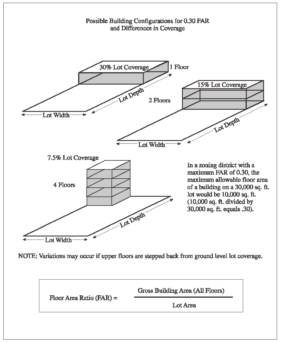
Floor Area Ratio (FAR). The total floor area of all buildings on a lot, divided by the area of that lot. For example, a building with 3,000 square feet of floor area on a 10,000 square foot lot has a FAR of 0.30. See Figure 8-1 (Floor Area Ratio).
FIGURE 8-1
FLOOR AREA RATIO
Food Preparation Facilities. See "Kitchen."
Food Products (land use). This land use consists of the manufacture of or processing foods for human consumption, and certain other related products. Examples of the products included in this land use are:
Bakery products;
Candy, sugar and confectionery products;
Catering services separate from stores or restaurants;
Dairy products;
Fats and oil products;
Fruit and vegetable canning, preserving, related processing;
Grain mill products and by-products;
Meat, poultry, and seafood canning, curing, byproduct processing;
Miscellaneous food item preparation from raw products.
Does not include: bakeries which sell all products on-site (see "Retail Stores, General Merchandise"); beer brewing as part of a brew pub, bar or restaurant (see "Bars and Drinking Places"); beverage production other than dairy products (see "Beverage Production"); slaughterhouses and rendering plants (see "Slaughterhouses and Rendering Plants"); or operations on crops after harvest (see "Agricultural Processing Uses").
Footprint. The horizontal surface area covered by a structure.
Form Based Code. The objective standards for multifamily housing development, which are incorporated by reference in their entirety into this Development Code.
FIGURE 8-2
WALL FRONTAGE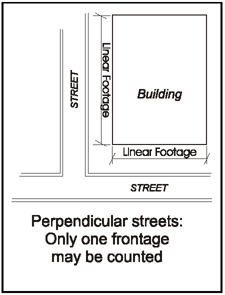
Front Wall. The wall of the building or other structure nearest the street upon which the building faces.
Front Wall (Signs). For the purposes of Chapter 22.28 (Signs), the front wall is the wall of a structure that contains the primary entrance or entrances to the premises. If there are entrances in more than one wall, the longest of the walls in which primary entrances are located shall be the front wall. The front wall includes not only the wall itself, but all doors, windows, and other openings and projections. See Figure 8-2.
Frontage. See "Lot Frontage."
Fuel and Ice Dealers (land use). This land use consists of the retail sale to consumers of ice, bottled water, fuel oil, butane, propane and liquefied petroleum gas (LPG), bottled or in bulk, as a principal use.
Furniture and Fixtures Manufacturing (land use). This land use consists of the manufacture of products including:
Bedsprings and mattresses;
Drapery hardware;
Household appliances;
Lockers;
Office furniture;
Partitions;
Shades;
Shelving;
Store furniture;
Window blinds;
Wood and metal household furniture.
Includes wood and cabinet shops, but not sawmills or planing mills, which are instead included under "Lumber and Wood Products."
Furniture, Furnishings and Equipment Stores (land use). This land use consists of the retail sale of products including:
Draperies;
Floor coverings;
Furniture;
Glass and chinaware;
Home furnishings;
Home sound systems;
Large musical instruments;
Lawn furniture;
Movable spas and hot tubs;
Office furniture;
Other household electrical and gas appliances;
Outdoor furniture;
Refrigerators;
Stoves;
Televisions.
G. Definitions, "G."
Garage, Carport, or Car Deck. See "Parking Structure."
General Plan. See "Marin Countywide Plan."
Glass Products (land use). This land use consists of the manufacture of flat glass and other glass products that are pressed, blown, or shaped from glass produced in the same establishment. Does not include artisan and craftsman type operations of a larger scale than home occupations; see "Handcraft Industries and Small Scale Manufacturing."
Goat Shed. A structure designed to completely enclose goats on all sides, as well as below and above.
Golf Courses/Country Clubs (land use). This land use consists of golf courses, and accessory facilities and uses including: Clubhouses with bar and restaurant, locker and shower facilities; driving ranges; "pro shops" for on-site sales of golfing equipment and clothing; and golf cart storage and sales facilities.
Grade. The ground elevation used as the basis for measurement of allowed structure height. Grade shall be the elevation of the natural or finished grade at the exterior surface of the structure, whichever is more restrictive, and the elevation of the natural grade within the footprint of the structure. In those instances where a structure, or a portion of a structure, is seaward of the mean high tide line then mean sea level shall be treated as grade in that location.
Grantee/Grantor Index. The index to real property transfer transactions maintained by the Marin County Recorder.
Group Homes (land use). This land use consists of a dwelling unit licensed or supervised by any Federal, State, or local health/welfare agency which provides 24-hour nonmedical care of unrelated persons who are in need of personal services, supervision, or assistance essential for sustaining the activities of daily living or for the protection of the individual in a family-like environment. Includes: children's homes; rehabilitation centers; self-help group homes. Medical care may be provided in conjunction with group homes that provide alcoholism or drug abuse recovery or treatment services. Convalescent homes, nursing homes and similar facilities providing medical care are included under the definition of "Medical Services - Extended Care."
Guest House (land use). This land use consists of a detached structure accessory to a primary residence that has a bathroom, and that contains more than 400 square feet of floor area that is subject to building permit requirements under a residential occupancy code. To be a guest house, the structure cannot contain kitchens.
Guy Wires. Wires used to secure wind turbines or towers that are not self-supporting.
H. Definitions, "H."
Habitat. The physical location or type of environment in which an organism or biological population lives or occurs.
Habitat Island. A habitat island refers to an isolated area of land generally surrounded by water that provides valuable foraging and roosting habitat for resident and migratory birds and wildlife, particularly during winter and early spring months.
Handcraft Industries, Small-Scale Manufacturing (land use). This land use consists of the manufacture of products not classified in another major manufacturing group, including: Jewelry; musical instruments; toys; sporting and athletic goods; pens, pencils, and other office and artists' materials; buttons, costume novelties, miscellaneous notions; brooms and brushes; and other miscellaneous manufacturing industries.
Harbors (land use). This land use consists of facilities providing a full range of services related to: Commercial and recreational fishing; fisheries and hatcheries; seafood processing; ship and boat building and repair; marine hardware sales and service; petroleum storage and handling; boat storage and miscellaneous storage activities. Facilities primarily oriented toward recreational activities are included under the definition of "Marinas."
Hardscape Shoreline Protection. Also referred to as grey infrastructure, hardscape shoreline protection improvements are physical features engineered, designed and constructed to provide shoreline protection with hard materials such as concrete, rock, and steel, and without relying on biological components for their primary functions.
Hazardous Waste Facility. A State-licensed facility for the temporary storage and/or processing of hazardous waste.
Health/Fitness Facilities (land use). This land use consists of fitness centers, gymnasiums, health and athletic clubs including sauna, spa or hot tub facilities; tennis, handball, racquetball, archery and shooting ranges and other sports activities.
Health Officer. The Marin County Health Officer.
Height, Structure. The vertical distance from grade to the highest point of a structure. The maximum height of buildings located in areas subject to tidal action shall be measured from Mean Sea Level. Section 22.20.060 (Height Measurement and Height Limit Exceptions) explains how this Development Code requires structure height to be measured.
Heritage Tree. See "Protected Tree and Heritage Tree."
Highway. State Route 1, State Route 101, Panoramic Highway, and State Route 131.
Historic Area. Areas mapped and described as historic areas in the Local Coastal Program, including those within Bolinas, Inverness, Marshall, Olema, Point Reyes Station, Stinson Beach, and Tomales.
Historic Lot. A unit of real property that was formerly a legal lot of record.
Historic Structure. As determined by the Local Coastal Plan, any building constructed prior to 1930, including any accessory structures on a site.
Holiday Product Sales. See "Outdoor Retail Sales, Temporary."
Home Occupation (land use). This land use consists of the conduct of a business within a dwelling, or within an accessory building located on the same site as the dwelling, employing the occupant of the dwelling, with the business activity being subordinate to the residential use of the property. See Section 22.32.100 (Home Occupations).
Homeless Shelter. Housing with minimal supportive services for homeless persons that is limited to occupancy of six months or less by a homeless person. In order for a facility to be a homeless shelter, no person may be denied emergency shelter because of an inability to pay, per Health and Safety Code Section 50801(e).
Horizontal Axis WECS. A horizontal-axis wind turbine (HAWT) is an energy conversion system whose rotor axis is substantially parallel to the wind flow. The main rotor shaft and electrical generator is at the top of a tower and must be pointed into the wind.
Horses, Donkeys, Mules, Ponies (land use). This land use consists of the raising or keeping of horses, donkeys, mules, and/or ponies for domestic/recreational or agricultural purposes.
Hotel or Motel (land use). This land use consists of facilities with guest rooms and/or suites, provided with or without meals or kitchen facilities, rented to the general public for overnight or other temporary lodging (less than 30 days). Hotels provide access to most guest rooms from an interior walkway. Motels provide access to most guest rooms from an exterior walkway. Also includes accessory guest facilities such as swimming pools, tennis courts, indoor athletic facilities, accessory retail uses, etc.
Household Income. The gross annual household income considering household size, income of all wage earners, elderly or family members with disabilities, and all other sources of household income.
Household Pets (land use). This land use consists of the keeping of cats, dogs, and other domesticated animals, determined by the Director to be comparable based on factors including size, sanitation requirements, odor, noise, etc., accessory and incidental to a residential use.
Housing Authority. The Marin County Housing Authority, a nonprofit public corporation.
Housing Costs. The monthly mortgage principal and interest, property taxes, homeowners insurance, and condominium fees, where applicable, for ownership units; and the monthly rent for rental units.
Housing Development. A development of five or more residential units, including mixed-use developments. Also included in this definition are a subdivision or common interest development consisting of residential units or unimproved residential lots and either a project to substantially rehabilitate and convert an existing commercial building to residential use or the substantial rehabilitation of an existing multi-family dwelling.
Housing Director. The Executive Director of the Marin County Housing Authority.
Housing Project. A development of housing units at one location, including all units for which permits have been applied for or approved within a 12-month period.
HUD. The United States Department of Housing and Urban Development, or its successor.
Hunting and Fishing Clubs - Private (land use). This land use consists of hunting of wildlife, fishing, and accessory structures where such activities are undertaken by the property owner(s) and their guests without a fee being charged.
Hunting and Fishing Clubs - Public (land use). This land use consists of hunting of wildlife, fishing, and accessory structures where such activities are undertaken by guests or members of the public for a fee.
I. Definitions, "I."
Impoundments and Diversions. Impoundments and diversions refers to alterations in stream flows through holding or diverting water supply.
Including. Means "including, but not limited to, . . ."
Inclusionary Unit/Lot. A dwelling unit or lot that is required by Chapter 22.22 (Affordable Housing Regulations) to be affordable to extremely low, very low, or low income households, as specified, or that has been proposed by an applicant and approved by the County to meet the requirements of Chapter 22.22.
Income Qualifying Household. Household whose income is defined as extremely low, very low, low or moderate-income for Marin County as published by the U.S. Department of Housing and Urban Development (HUD) or the California Department of Housing and Community Development (HCD) with adjustments for household size. Current or applicable schedule to be applied is at the discretion of the Director.
1. Moderate income, 80 to 120 percent of area median income;
2. Low income, 50 to 80 percent of area median income;
3. Very low income, under 30 to 50 percent of area median income;
4. Extremely low income, 30 percent and less of the area median income.
Income Restricted Housing. Dwelling units with a long-term income restriction which restricts occupancy to households at or below a specific income.
Indoor Recreation Centers (land use). This land use consists of facilities providing indoor amusement/entertainment services for a fee or admission charge, such as:
Bowling alleys;
Card rooms;
Coin-operated amusement arcades;
Dance halls, clubs and ballrooms;
Electronic game arcades;
Ice skating and roller skating rinks;
Pool and billiard rooms.
Five or more electronic games or coin-operated amusements in any establishment is considered an electronic game arcade as described above. Four or less machines are not considered a land use separate from the primary use of the site.
Infant. An infant is a child less than 12 months of age.
Initial Study. A preliminary analysis to determine whether an Environmental Impact Report (EIR) or a Negative Declaration must be prepared, and to identify any significant environmental effects that are to either be mitigated or further analyzed.
In-Kind Reconstruction. Reconstruction resulting in the same outward appearance and at least equivalent functional utility as the original structure. The location, footprint, and physical dimensions must substantially conform to the original structure to meet this definition.
In-Lieu Fee. A fee paid to the County by developers in-lieu of providing required on-site inclusionary units or lots, or a fee paid to the County by developers in lieu of dedicating parkland. Inclusionary in-lieu fees, initially set by the Board of Supervisors and subject to adjustments, are assessed for residential lot creation, multifamily subdivision, and multifamily rental development. The payment of any applicable fees shall be due prior to issuance of Certificate of Occupancy.
Institutional Structure, or Use. A publicly-owned structure accommodating a public facility; or a private structure designed and operated as a church, hospital, school, or similar facility.
J. Definitions, "J."
Junior Accessory Dwelling Unit (Land Use). A type of Accessory Dwelling Unit that is no more than 500 square feet in size, has a kitchenette but not a kitchen, is contained entirely within a single family dwelling, and has been certified as a Junior Accessory Dwelling Unit by the Director.
Junk. Materials that characterize junk typically include automotive parts, vehicle body parts, inoperable vehicles, household furniture, appliances, household trash, building materials, scrap wood, scrap metal, and machine parts.
Junk Yard (land use). This land use consists of outdoor storage occupying an area of 200 square feet or more, or the storage of junk in any yard adjoining a street, for collecting and assembling, storing, breaking up, sorting, and the temporary storage and distribution of recyclable or reusable scrap and waste materials, including auto wreckers engaged in dismantling automobiles for scrap, and the incidental wholesale or retail sales of parts from those vehicles. In no case shall the stored junk exceed a height of five feet.
K. Definitions, "K."
Kennels and Animal Boarding (land use). This land use consists of the keeping, boarding or maintaining of six or more household pets at least four months of age or older, except for household pets in pet shops or animal hospitals. "Kennel" does not mean and does not include any lot or premises on which a person has been issued a dog hobbyist or ranch dog permit in compliance with the provisions of Sections 8.04.245 or 8.04.246 of the Marin County Code.
Kitchen. Kitchens include a stove, oven, refrigerator, sink, counters, and cabinets, and may include a microwave, hot plate, and other appliances.
Kitchenette. A cooking facility with appliances, and a food preparation counter with a sink and storage cabinets that are a reasonable size in relation to the size of the unit. Kitchenettes are not considered kitchens.
L. Definitions, "L."
Land Use. The purpose for which land or a building thereon is occupied.
Land Use Permit. Any of the entitlements/approvals described by Article IV (Land Use and Development Permits), including Design Review, Floating Home Adjustment Permits, Use Permits, Temporary Use Permits, Tidelands Permits, Variances, Master Plans, or Precise Development Plans.
Landscaped Area. The entire planting area within a parcel affected by new plantings and supporting irrigation, excluding building footprints, paved driveways, parking areas, decks, patios, walkways and undisturbed natural areas. Water features are included in the landscaped area.
Large Family Day-Care Home (land use). See "Child Day-Care Facilities."
Laundries and Dry Cleaning Plants (land use). This land use consists of service facilities engaged primarily in high volume laundry and garment services, including: Power laundries (family and commercial); garment pressing and dry cleaning; linen supply; diaper service; industrial laundries; and carpet and upholstery cleaners. Does not include coin-operated laundries or dry cleaning pick-up stores without dry cleaning equipment; see "Personal Services."
LCP. See "Local Coastal Program."
Lead Agency. The public agency which has the principal responsibility for carrying out or approving a project which may have a significant effect upon the environment.
Legal Lot of Record. A parcel is considered to be a legal lot of record if it was created in conformance with any of the following criteria:
1.
Recorded subdivision. The lot was created through a subdivision Final Map or Parcel Map recorded on or after January 1, 1930. Antiquated subdivisions may not be deemed to have created lots. A lot created on a subdivision Final Map or Parcel Map recorded before January 1, 1930 may be considered a legal lot if it has been reconveyed subsequently with references made to the original subdivision Final Map or Parcel Map.
In instances when a deed that created a lot by conveyance listed multiple antiquated lot numbers consistent with the original Parcel Map or Final Map, the entirety of the areas covered by such lot numbers is considered a single legal lot of record, except for those individual antiquated lots that met the zoning and subdivision standards that were in effect at the time the initial conveyance legally created them.
2.
Individual lot legally created by deed. The lot was legally created by deed in compliance with the zoning and subdivision requirements that applied at the time of creation.
3.
Government conveyance. The lot was created by conveyance to a governmental entity.
Notwithstanding A through C above, when historic lots were merged by agency action or pursuant to applicable State law, the merged historic lots comprise a single legal lot of record.
Libraries and Museums (land use). This land use consists of public or quasi-public facilities including aquariums, arboretums, art exhibitions, botanical gardens, historic sites and exhibits, libraries, museums, and planetariums, which are generally noncommercial in nature.
Liquor Store (land use). A retail store offering beer, wine, and/or distilled spirits for off-premises consumption which either devotes 20% or more of the floor area or display area to, or derives 75% or more of gross sales receipts from, the sale of these products.
Livestock Operations, Grazing (land use). This land use consists of the raising or keeping of cattle, or other animals of similar size, where feed is provided primarily by grazing when on-site resources are available. Does not include the keeping of horses, donkeys, mules, or ponies, (see "Horses, Donkeys, Mules and Ponies").
Livestock Operations, Large Animals (land use). This land use consists of the raising or keeping of cattle, goats, ostriches, sheep, hogs, or other farm or exotic animals of similar size, in corrals or other similar enclosures. Does not include the keeping of horses, donkeys, mules, or ponies, (see "Horses, Donkeys, Mules and Ponies") or the grazing or pasturing of large animals on open rangeland (see "Livestock Operations, Grazing"). See also, "Dairy Operations."
Livestock Operations, Sales/Feed Lots, Stockyards (land use). This land use consists of specialized and intensive commercial animal facilities including animal sales yards, stockyards, and cattle feedlots. Feedlots are any site where cattle are held or maintained for the purposes of feeding/fattening, for market or milking, and where at least 60 percent of the feed is imported or purchased. Does not include slaughterhouses or rendering plants; see "Slaughterhouses and Rendering Plants." See also, "Dairy Operations."
Livestock Operations, Small Animals (land use). This land use consists of the raising or keeping of up to 12 fowl and/or 12 rabbits or similar animals. Does not include hog raising, dairying or the raising or keeping for commercial purposes of cattle, horses, or similar livestock, as determined by the Director; see "Livestock Operations, Large Animals."
Local Coastal Program (LCP). The Marin County Local Coastal Program, Units I and II, prepared and adopted in compliance with the California Coastal Act of 1976 (Division 20 of the Public Resources Code).
Lot. A legal lot of record. Types of lots include the following. See Figure 8-3 (Lot Types):
1. Corner Lot. A lot located at the intersection of two or more streets, bounded on two or more sides by street lines.
2. Flag Lot. A lot having access from the building site to a public street by means of private right-of-way strip that is owned in fee or by means of an access easement.
3. Interior Lot. A lot abutting only one street.
4. Through Lot. A lot with frontage on two generally parallel streets.
FIGURE 8-3
LOT TYPES
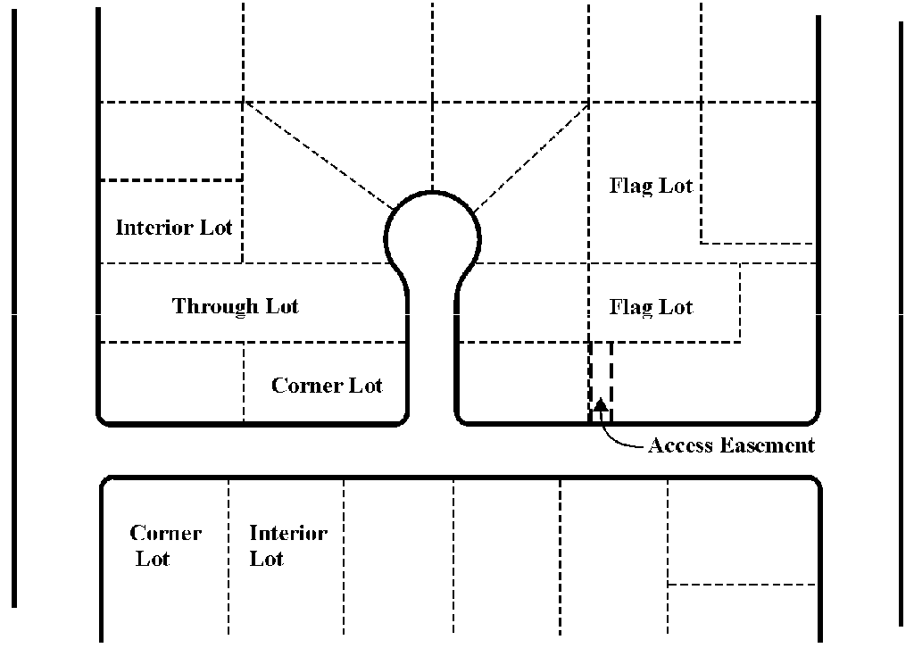
Lot Area. Lot area is the total area included within the lot lines of a lot, exclusive of adjacent street or paper street rights-of-way and any portion of the property located below mean high tide that is subject to tidal action.
Lot Coverage. Lot coverage is the percentage of total site area occupied by buildings and other structures, impervious paving and other hard surfaces that have a water runoff factor of 0.5 or more according to the Bay Area Storm Water Management Agencies Association guidelines. Structure/building coverage includes the primary structure, all accessory structures (e.g., carports, garages, patio covers, storage sheds, trash dumpster enclosures, etc.) and architectural features (e.g., chimneys, balconies, decks, porches, stairs, etc.). Structure/building coverage is measured from exterior wall to exterior wall. See Figure 8-4 (Lot Coverage).
FIGURE 8-4
LOT COVERAGE
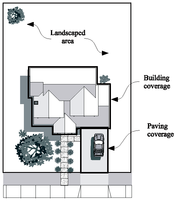
Lot Depth. The average linear distance between the front and the rear lot lines or the intersection of the two side lot lines if there is no rear line. See Figure 8-5 (Lot Lines and Lot Features). The Director shall determine lot depth for parcels of irregular configuration.
FIGURE 8-5
LOT LINES AND LOT FEATURES
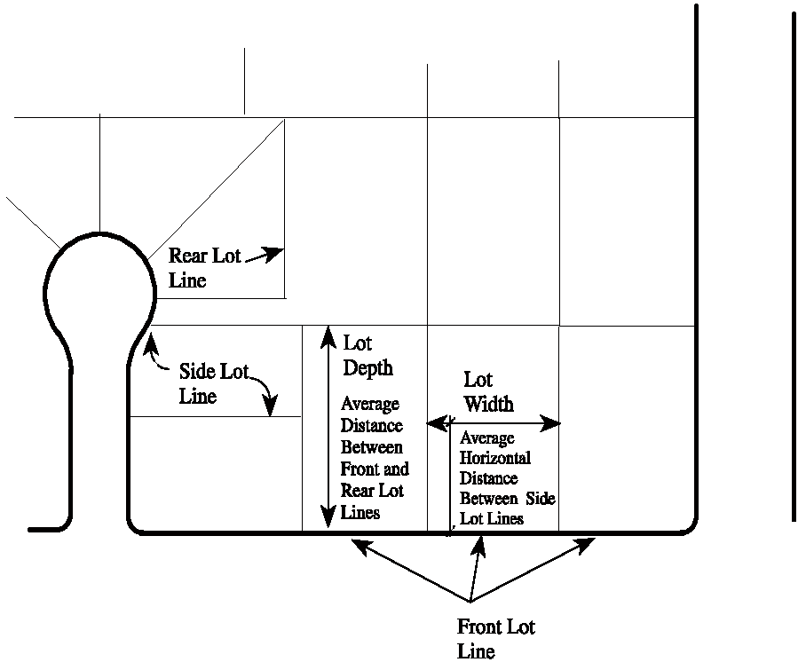
Lot Frontage. The boundary of a lot adjacent to a public or private street right-of-way.
Lot Line, or Property Line. Any recorded boundary of a lot. Types of lot lines are as follows (see Figure 8-5 (Lot Lines and Lot Features)):
1. Front Lot Line. On an interior lot, the property line separating the parcel from the street. The front lot line on a corner lot is the property line bounding the street to which the property is addressed and the street from which access is taken. On a through lot, both lot lines are front lot lines and the lot is considered to have no rear lot line.
2. Interior Lot Line. Any lot line not abutting a street.
3. Rear Lot Line. A property line that does not intersect the front lot line, which is most distant from and most closely parallel to the front lot line.
4. Side Lot Line. Any lot line that is not a front or rear lot line.
Lot Width. The average horizontal distance between the side lot lines. See Figure 8-5 (Lot Lines and Lot Features). The Director shall determine lot width for parcels of irregular shape.
Low Income. See "Income Qualifying Household."
Lower Income Households. Persons and families whose income does not exceed the qualifying limits for lower income families as established and amended from time to time pursuant to Section 8 of the United States Housing Act of 1937. The limits shall be published in the California Code of Regulations as soon as possible after adoption by the Secretary of Housing and Urban Development. Lower income households include very low income households, as defined in Health and Safety Code Section 50105, and extremely low income households, as defined in Health and Safety Code Section 50106.
Lumber and Wood Products (land use). This land use consists of the manufacture, processing, and sale of milled forest products, including rough and finished lumber and other wood materials for use in other manufacturing, craft, or construction processes. Includes the following processes and products:
Containers, pallets and skids;
Milling operations;
Trusses and structural beams;
Turning and shaping of wood products;
Wholesaling of basic wood products;
Wood product assembly.
Craft-type shops are included in "Handcraft Industries and Small-Scale Manufacturing." Other wood and cabinet shops are included under "Furniture and Fixture Manufacturing." The indoor retail sale of building materials, construction tools and equipment is included under "Building Material Stores."
M. Definitions, "M."
Machinery Manufacturing (land use). This land use consists of the manufacture of machinery and equipment for purposes and products including the following:
Bulldozers;
Carburetors;
Construction;
Conveyors;
Cranes;
Die casting;
Dies;
Dredging;
Engines and turbines;
Farm and garden;
Food products manufacturing;
Gear cutting;
Heating, ventilation, air conditioning;
Industrial trucks and tractors;
Industrial furnaces and ovens;
Industrial molds;
Laundry and dry cleaning;
Materials handling;
Mining;
Oil field equipment;
Paper manufacturing;
Passenger and freight elevators;
Pistons;
Printing;
Pumps;
Refrigeration equipment;
Textile manufacturing.
Map Act. See "Subdivision Map Act."
Mariculture (land use). This land use consists of the culture and husbandry of aquatic organisms including shellfish, mollusks, crustaceans, kelp, and algae. (See "Fish Hatcheries and Game Reserves," for activities related to fish.)
Marin Countywide Plan. The Marin Countywide Plan, including all its elements and all amendments, adopted as the General Plan by the Board of Supervisors under the provisions of Government Code Sections 65300 et seq.
Marinas (land use). This land use consists of recreationally-oriented, small craft harbors that may include mooring and launching facilities and accessory facilities for boat servicing. Mooring, launching, and service facilities oriented primarily toward the needs of commercial fishing are included under the definition of "Harbors." Marinas accommodating floating homes are defined as "Floating Home Marinas."
Master Plan. See Chapter 22.44 (Master Plans and Precise Development Plans).
Maximum Allowable Residential Density. The greatest number of units allowed under the zoning and Land Use element of the Countywide Plan, or if a range of density is permitted, the greatest number of units allowed the specific zoning range and Land Use element of the Countywide Plan applicable to the project. If the density under the zoning is inconsistent with the density under the Land Use element of the Countywide Plan, the greater density shall prevail. Density shall be determined using dwelling units per acre. However, if the applicable zoning ordinance, or Land Use element of the Countywide Plan does not provide a dwelling-units-per-acre standard for density, then the density shall be calculated as follows:
1.
Estimating the realistic development capacity of the site based on the objective development standards applicable to the project, including, but not limited to, floor area ratio, site coverage, maximum building height and number of stories, building setbacks and stepbacks, public and private open space requirements, minimum percentage or square footage of any nonresidential component, and parking requirements, unless not required for the base project. Parking requirements shall include considerations regarding number of spaces, location, design, type, and circulation. A developer may provide a base density study and the local agency shall accept it, provided that it includes all applicable objective development standards.
2.
Maintaining the same average unit size and other project details relevant to the base density study, excepting those that may be modified by waiver or concession to accommodate the bonus units, in the proposed project as in the study.
Medical Services - Clinics and Laboratories (land use). This land use consists of businesses primarily engaged in furnishing outpatient medical, mental health, surgical and other personal health services, but which are separate from hospitals, including:
Health management organizations (HMOs);
Medical and dental laboratories;
Medical, dental and psychiatric offices;
Out-patient care facilities;
Other allied health services.
Counseling services by other than medical doctors or psychiatrists are included under "Offices."
Medical Services - Extended Care (land use). This land use consists of the provision of nursing and health-related care as a principal use, with in-patient beds. This land use includes: convalescent and rest homes; extended care facilities; and skilled nursing facilities that are licensed or supervised by any Federal, State, or local health/welfare agency. Long-term personal care facilities that do not emphasize medical treatment are included under "Residential Care Facilities," and "Group Homes."
Medical Services - Hospitals (land use). This land use consists of the provision of diagnostic services and extensive medical treatment, including surgical and other related services. These establishments have an organized medical staff, inpatient beds, and equipment and facilities to provide complete health care services. May include on-site accessory clinics and laboratories, accessory retail uses and emergency heliports (see the separate definition of "Accessory Retail Uses").
Membership Organization Facilities (land use). This land use consists of permanent headquarters and meeting facilities for organizations operating on a membership basis for the promotion of the interests of the members, including facilities for:
Business associations;
Civic, social and fraternal organizations;
Country clubs (golf courses separately defined);
Labor unions and similar organizations;
Political organizations;
Professional membership organizations;
Other membership organizations.
Metal Fabrication, Machine and Welding Shops (land use). This land use consists of the assembly of metal parts, including the following uses that produce metal duct work, tanks, towers, cabinets and enclosures, metal doors and gates, and similar products:
Blacksmith and welding shops;
Sheet metal shops;
Machine shops and boiler shops.
Meteorological Tower (Met Tower). For the purpose of the Wind Energy Conversion System Ordinance, meteorological towers are those towers which have been temporarily installed to measure wind speed and directions plus other data relevant to siting WECS.
Mezzanine. An intermediate floor placed within any story or room. If the total floor area of a mezzanine is more than one-third of the total floor area of the room, it shall be considered an additional story.
Mineral Resource Extraction (land use). This land use consists of the extraction from the ground of hydrocarbons, gravel, or sand resources, or other commercial surface mining or underground mining and processing activity. Oil and gas well drilling, geothermal wells, production operations and related facilities are not permitted.
Mini Mart. A convenience retail store on the site of a service station, which typically sells food products and other products serving the needs of travelers.
Miniature Goat. Those types of goats commonly known as Pygmy, Dwarf, and Miniature Goats.
Ministerial Permit. A permit granted to a project after applying fixed, objective standards with little or no subjective evaluation as to the wisdom or manner of carrying out the project. Examples are Sign Permit, Large Family Day-care Permit, Homeless Shelter Permit, Certificate of Compliance, Accessory Dwelling Unit Permit, Final Map approval, and Building Permits. See also "Discretionary Permit."
Minor. Any person under 18 years of age.
Mixed Use. An existing or proposed development that includes more than one type of land use.
Mobile Home. A trailer, transportable in one or more sections, that is certified under the National Manufactured Housing Construction and Safety Standards Act of 1974, which is over eight feet in width and 40 feet in length, with or without a permanent foundation and not including recreational vehicle, commercial coach or factory-built housing. A mobile home on a permanent foundation is included under the definition of "Single-Family Dwellings."
Mobile Home Park (land use). This land use consists of any site that is planned and improved to accommodate two or more mobile homes used for residential purposes, or on which two or more mobile home lots are rented, leased, or held out for rent or lease, or were formerly held out for rent or lease and later converted to a subdivision, cooperative, condominium, or other form of resident ownership, to accommodate mobile homes used for residential purposes.
Moor. The fixing of a vessel in one location, temporarily or permanently, by mooring, anchoring, grounding, or any other means.
Motel. See "Hotel or Motel."
Multi-Family Dwellings (land use). This land use consists of the development of any structure designed for human habitation that has been divided into two or more legally created independent living quarters, including supportive housing, as defined in California Government Code Section 65650. Accessory Dwelling Units and Junior Accessory Dwelling Units are not considered in the calculation of the number of units for this definition and do not convert a single-family residential development into a multi-family residential development.
Mutual Water Company. A State-licensed water purveyor providing domestic water to multiple residences, where the owners of property being served are shareholders in the company.
N. Definitions, "N."
Native Tree. Any tree in the list "Trees Native to Marin County," maintained and provided by the Department.
Native Tree Removal. Generally means the destruction of any protected tree or the alteration of any protected tree which may adversely affect the health and survival of the tree. Includes "removal of a tree." Routine trimming and pruning is not considered tree removal for the purpose of this Chapter.
Natural Disaster. Any situation in which the force or forces which destroyed a structure were beyond the control of the owner, including fire, flood, storm, explosion, landslide, earthquake, or other similar conditions.
Nature-Based Shoreline Protection. Nature-based shoreline protection improvements, also called living shorelines, are physical landscape features that are created and evolve over time through the actions of environmental processes, or features that mimic characteristics of natural features but are created by engineering and construction (in concert with natural processes) to provide shoreline protection and other ecosystem services. Nature-based protection includes tidal marsh restoration and enhancement, off-shore island preservation and enhancement, ecotone levees, beach enhancement, and other methods of slowing water movement and increasing filtration.
Nature Preserves (land use). This land use consists of sites with environmental resources intended to be preserved in their natural state.
NAVD (North American Vertical Datum). A vertical elevation control datum used in height measurements.
Negative Declaration. A written statement describing the reasons that a proposed project that is not otherwise exempt from the California Environmental Quality Act (CEQA) will not have a significant adverse effect on the environment and, therefore, does not require the preparation of an Environmental Impact Report (EIR). Please refer to CEQA Guidelines Section 15369.5 for a complete definition of a Negative Declaration.
Net Lot Area. The baseline area of a lot used for calculating maximum subdivision potential, and calculated by taking the area of the whole lot and subtracting the following:
1.
Any areas seaward of mean high tide.
2.
Any areas within a Stream Conservation Area or Wetland Conservation Area.
The resulting area is the net lot area.
No Net Loss of Habitat. Complete replacement of habitat of equivalent acreage, value, and function on the same parcel on which habitat will be displaced by the project, except that offsite mitigation of habitat loss may be allowed under a County approved mitigation program. Complete replacement means replacement with native vegetation at a 2:1 ratio, which is monitored for a period of no less than five years to ensure effective replacement.
Nonconforming Lot. A lot of record that was legally created, but does not conform with this Development Code because the lot is of a size, shape, or configuration no longer allowed in the zoning district that applies to the site, as a result of the adoption of, or amendments to this Development Code.
Nonconforming Structure. A structure that was legally constructed, but does not conform with this Development Code because amendments to this Development Code or the previous Marin County Zoning Ordinance made the structure nonconforming in its size, location on its site, separation from other structures, number of parking spaces provided, or other features.
Nonconforming Use. A use of land, and/or within a structure, that was legally established, but does not conform with this Development Code because the use is no longer allowed in the zoning district that applies to the site, as a result of amendments to this Development Code or the previous Marin County Zoning Ordinance.
Non-Residential, Mixed Use, and Residential Care Facility Affordable Housing Fees. Fees, initially set by the Board of Supervisors and subject to adjustments, are assessed for non-residential, mixed use, and residential care facilities. The payment of any applicable fees shall be due prior to issuance of Certificate of Occupancy.
O. Definitions, "O."
Oak Woodland Management Guidelines. The Oak Woodland Management Guidelines adopted by the Board and on file with the Agency.
Objective Standards. Standards that involve no personal or subjective judgment by a public official and are uniformly verifiable by reference to an external and uniform benchmark or criterion available and knowable by both the development applicant or proponent and the public official prior to submittal. These standards may be embodied in alternative objective land use specifications adopted by a local agency, and may include, but are not limited to, housing overlay zones, specific plans, inclusionary zoning ordinances, and density bonus ordinances.
Occupancy. The use or operation of a site or structure for an approved land use.
Off-Road Vehicle Courses (land use). This land use consists of areas set aside for the use of off-road vehicles, including dirt bikes, motorcycles, and four-wheel drive vehicles. Does not include sports assembly facilities (see "Sports Facilities and Outdoor Public Assembly"), or simple access roads that are usable only by four-wheel or two-wheel drive vehicles in conjunction with a permitted land use.
Off-Site Product. A product that is produced on property other than the site where it is offered for sale.
Offices, Business (land use). This land use consists of the provision of direct services to consumers. This land use includes establishments such as insurance agencies, real estate offices, and post offices (not including bulk mailing distribution centers, which are included under "Vehicle and Freight Terminals").
Does not include: Medical offices (see "Medical Services - Clinics and Laboratories"); or offices that are incidental and accessory to another business or sales activity that is the principal use. Incidental offices that are customarily accessory to another use are allowed as part of an approved principal use.
Offices, Professional (land use). This land use consists of professional or government offices including:
Accounting, auditing and bookkeeping services;
Advertising agencies;
Architectural, engineering, planning and surveying services;
Attorneys;
Counseling services;
Court reporting services;
Data processing and computer services;
Detective agencies and similar services;
Educational, scientific and research organizations;
Employment, stenographic, secretarial and word processing services;
Government offices including agency and administrative office facilities;
Management, public relations and consulting services;
Photography and commercial art studios;
Writers and artists offices outside the home.
Does not include: Medical offices (see "Medical Services - Clinics and Laboratories") or offices that are incidental and accessory to another business or sales activity that is the principal use. Incidental offices that are customarily accessory to another use are allowed as part of an approved principal use.
Offices, Property Management (land use). This land use consists of accessory offices on the site of an apartment complex, mobile home park, or commercial facility, for the purpose of providing tenant services.
Offices, Temporary (land use). This land use consists of a mobile home, recreational vehicle or modular unit used as a temporary office facility. Temporary Offices may include: Construction supervision offices on a construction site or off-site construction yard; a temporary on-site real estate office for a development project; or a temporary business office in advance of permanent facility construction.
Offices, Temporary Real Estate (land use). This land use consists of the temporary use of a dwelling unit within a residential development project as a sales office for the units on the same site, which is converted to residential use at the conclusion of its office use.
On-Site Product. A product that is produced on the same property where it is offered for sale.
Open Water. In conjunction with a Floating Home Marina, a privately owned or controlled water area, which is devoid of any structure or appurtenances including mooring facilities for any vessels or piers, docks, ramps, walkways or other exit ways.
Organizational Houses (land use). This land use consists of residential lodging houses operated by membership organizations for their members and not open to the general public. Includes fraternity and sorority houses.
Original Lot. A contiguous area of real property under one ownership, which is proposed for division in compliance with Article VI (Subdivisions) of this Development Code.
Outbuilding. See definitions for "Accessory Structures, Detached" and "Building."
Outdoor Commercial Recreation (land use). This land use consists of facilities for various outdoor participant sports and types of recreation where a fee is charged for use, including:
Amusement and theme parks;
Drive-in theaters;
Go-cart and miniature auto race tracks;
Golf driving ranges separate from golf courses;
Health and athletic club outdoor facilities;
Miniature golf courses;
Skateboard parks;
Swim and tennis clubs;
Tennis courts;
Water slides;
Zoos.
May also include commercial facilities customarily associated with the above outdoor commercial recreational uses, including bars and restaurants, fast-food restaurants, video game arcades, etc. Spectator facilities are included in the definition of "Sport Facilities and Outdoor Public Assembly."
Outdoor Retail Sales and Activities (land use). This land use consists of the outdoor retail sale or rental of autos and other vehicles and equipment, lumber, and other uses where the business is not conducted entirely within a structure.
Outdoor Retail Sales, Temporary (land use). This land use consists of the temporary outdoor retail sales activities, examples of which include:
Christmas trees, pumpkins or the sale of other seasonal items;
Semi-annual sales of art/handcrafted items in conjunction with community festivals or art shows;
Sidewalk or parking lot sales longer than one weekend;
Retail sales in temporary locations outside the public right-of-way.
Farmer's markets are separately defined.
P. Definitions, "P."
Paper Products (land use). This land use consists of the manufacture of paper and paperboard, from both raw and recycled materials, and their conversion into products such as paper bags, boxes, envelopes, wallpaper, etc.
Paper Street. Any street, road, or public vehicular access, or portion thereof, shown on a subdivision map recorded prior to April 3, 1953, which is undeveloped and/or unimproved, excluding "driveways," as previously defined.
Parcel. A unit of real property.
Parcel Map. The subdivision map described by the Subdivision Map Act, Article 3, Chapter 2, which is required by Article VI (Subdivisions) of this Development Code to complete a subdivision of four or fewer lots.
Parking Structure. Parking space or shelter for automobiles or other vehicles.
1.
A garage is an attached or detached accessory structure, which is enclosed on at least three sides;
2.
A carport is an attached or detached accessory structure, which is enclosed on no more than two sides and has no vehicle/garage door;
3.
A car deck is an unenclosed and uncovered platform providing off-street parking spaces, normally constructed at the street level of a sloping lot.
Parks and Playgrounds (land use). This land use consists of public parks, play lots, playgrounds, and athletic fields for noncommercial neighborhood or community use, including tennis courts. If privately-owned, the same facilities are included under the definition of "Private Residential Recreation Facilities." See also "Golf Courses/Country Clubs," "Outdoor Commercial Recreation," and "Sport Facilities and Outdoor Public Assembly."
Passageway. A pathway that is unobstructed clear to the sky and extends from the street to one entrance of an accessory dwelling unit.
Paving and Roofing Materials (land use). This land use consists of the manufacture of various common paving and petroleum-based roofing materials, including bulk asphalt, paving blocks made of asphalt, creosote wood and various compositions of asphalt and tar. The manufacture of wood roofing materials (shingles, shakes, etc.) is included under "Lumber and Wood Products."
Permitted Use. A land use allowed by Article II (Zoning Districts and Allowable Land Uses) subject to compliance with all applicable provisions of this Development Code, and subject to first obtaining any building permit or any other permit required by the County Code.
Person. Any natural person, partnership, cooperative association, private corporation, public corporation, personal representative, receiver, trustee, assignee, or any other legal entity.
Personal Services (land use). This land use consists of the provision of non-medically related services. Examples of facilities included in this land use include: Beauty and barber shops; clothing rental; dry cleaning pick-up stores; laundromats (self-service laundries); psychic readers; shoe repair shops; tanning salons. These uses may also include accessory retail sales of products related to the services provided.
Pier. A platform supported on pillars or girders leading out from the shore into a body of water, often used as a landing stage for boats.
Pipelines and Utility Lines (land use). This land use consists of transportation facilities for the conveyance of water or commodities other than petroleum. Also includes pipeline surface and terminal facilities, including pump stations, bulk stations, surge and storage tanks. Utility lines include facilities for the transmission of electrical energy for sale, including transmission lines for a public utility company. Also includes telephone, telegraph, cable television and other communications transmission facilities utilizing direct physical conduits. Does not include offices or service centers (see "Offices"), or distribution substations (see "Public Utility Facilities").
Planned Development. As defined by Civil Code Section 1351(k), a development having either or both of the following features: (1) the common area is owned either by an association or in common by the owners of the separate interests; (2) a power exists in the association to enforce an obligation of an owner of a separate interest with respect to the beneficial use and enjoyment of the common area by means of an assessment which may become a lien upon the separately owned lot, parcel, or area in compliance with Civil Code Section 1367. Does not include a community apartment project, condominium or stock cooperative, which are each separately defined.
Planned District. Any zoning district established by Sections 22.06.020 (Zoning Districts Established), and Article V (Coastal Zones - Development and Resource Management Standards), that is not included under the definition of "Conventional District" provided by this Chapter. The planned districts include:
C-APZ (Coastal, Agricultural Production Zone);
ARP (Agricultural, Residential Planned);
C-ARP (Coastal, Agricultural, Residential Planned);
RSP (Residential, Single-Family Planned);
C-RSP (Coastal, Residential, Single-Family Planned);
C-RSPS (Coastal, Residential, Single-Family Planned, Seadrift Subdivision);
RMP (Residential, Multiple Planned);
C-RMP (Coastal, Residential, Multiple Planned);
RX (Residential, Mobile Home Park);
RF (Residential, Floating Home Marina);
RMPC (Residential/Commercial Multiple Planned);
CP (Planned Commercial);
OP (Planned Office);
RCR (Resort and Commercial Recreation);
C-RCR (Coastal, Resort and Commercial Recreation);
C-RMPC (Coastal, Residential/Commercial Multiple Planned);
C-CP (Coastal, Planned Commercial);
IP (Industrial, Planned);
RF (Floating Home Marina).
The designation of certain planned zoning districts includes a numerical suffix on the zoning map, which indicates the maximum residential density.
Planning Commission. The Marin County Planning Commission, appointed by the Board of Supervisors as provided by Government Code Section 65101, and Title 2 of the Marin County Code, referred to throughout this Development Code as the "Commission."
Plant Nurseries (land use). This land use consists of the commercial production of ornamental plants and other nursery products, grown under cover or outdoors. May include establishments engaged in the sale of such products, and commercial scale greenhouses. The sale of house plants or other nursery products is also included under "Retail Stores, General Merchandise." Home greenhouses are included under "Residential Accessory Uses and Structures."
Plastics and Rubber Products (land use). This land use consists of the manufacture of rubber products such as: Tires; rubber footwear; mechanical rubber goods; heels and soles; flooring; and other rubber products from natural, synthetic or reclaimed rubber. Also includes establishments engaged primarily in manufacturing tires. Also includes: Establishments engaged in molding primary plastics for other manufacturers, and manufacturing miscellaneous finished plastics products; fiberglass manufacturing, and fiberglass application services. Establishments engaged primarily in recapping and retreading automobile tires are classified in "Auto, Mobile home, Vehicle and Supplies Sales."
Playground. See "Parks and Playgrounds.
Pocket Neighborhood. The type of clustered residential development described in the Multifamily Residential Design Guidelines or the Form Based Code, as applicable.
Porch. A deck with a roof, which is attached to a building.
Poster Board. A sign consisting of a framed or unframed surface, freestanding or attached to a wall or fence or other structure, designed and located only for the display of announcements of coming performances of cultural, educational, and athletic events.
Potbellied Pig. That type of swine commonly known as the Vietnamese, Chinese, or Asian Potbelly Pig (Sus scrofa bittatus).
Poultry Processing Facility (Land Use). This land use consists of facilities permanently installed on a site engaged in slaughtering poultry for meat to be sold.
Precise Development Plan. See Chapter 22.44 (Master Plans and Precise Development Plans).
Premise(s). The site of a land use or activity subject to the requirements of this Development Code.
Primary Structure. See "Structure, primary."
Primary Zoning District. One of the agricultural, residential, commercial, or special purpose zoning districts established by Sections 22.06.020 (Zoning Districts Established) and Article V (Coastal Zones - Development and Resource Management Standards), that is applied to a site by the Zoning Map in addition to one or more of the combining districts established by Section 22.06.020.
Printing and Publishing (land use). This land use consists of printing by letterpress, lithography, gravure, screen, offset, or electrostatic (xerographic) copying, and other "quick printing" services; and other establishments serving the printing trade such as bookbinding, typesetting, engraving, photoengraving and electrotyping. This use also includes establishments that publish newspapers, books and periodicals; and establishments manufacturing business forms and binding devices.
Private Residential Recreation Facilities (land use). This land use consists of privately-owned, noncommercial outdoor recreation facilities provided for members or project/neighborhood residents, including swim and tennis clubs, park and sport court facilities. Does not include golf courses/country clubs, which are separately defined.
Private Road. A street or right-of-way owned and maintained by a private person(s) or entity(ies).
Project. See "Development, or Project."
Property Line. See "Lot Line or Property Line."
Proposed Dwelling. A new dwelling that is the subject of a permit application that meets all requirements for permitting, including zoning requirements.
Proposed Parcel(s). Each separate parcel shown on a tentative map or lot line adjustment, as proposed by an applicant.
Proposed Single Family Dwelling. See "Proposed Dwelling" and "Single Family Dwelling."
Protected Tree and Heritage Tree. Any one of the following as indicated in the table below:
Public Right-of-Way. A street that has been accepted or is being maintained by the State, the County, or a city, and provides unrestricted vehicular access to the public.
Public Road. A street or highway owned and maintained by the County, a City, the State, or the Federal government.
Public Safety/Service Facilities (land use). This land use consists of facilities operated by public agencies including fire stations, other fire prevention and fire-fighting facilities, police and sheriff substations and headquarters, including interim incarceration facilities, and civic buildings.
Public Utility Facilities (land use). This land use consists of fixed-base structures and facilities serving as junction points for transferring utility services from one transmission voltage to another or to local distribution and service voltages. These uses include any of the following facilities that are not exempted from land use permit requirements by Government Code Section 53091:
Corporation and maintenance yards;
Electrical substations and switching stations;
Natural gas regulating and distribution facilities;
Public water system wells, treatment plants and storage;
Telephone switching facilities;
Wastewater treatment plants, settling ponds and disposal fields.
These uses do not include office or customer service centers (classified in "Offices").
Q. Definitions, "Q."
Quarry. See "Surface Mining."
R. Definitions, "R."
Racially Concentrated Area of Affluence (RCAA). RCAAs, as defined by the California Department of Housing and Community Development (HCD), are "neighborhoods where the population is disproportionately white and affluent." The location of RCAAs are defined by HCD. The term was developed to express the continuum of segregation in communities. It represents the opposite of the Racially and Ethnically Concentrated Areas of Poverty (R/ECAP) metric developed by the U.S. Department of Housing and Urban Development.
Recreation, Passive. A type of recreation that does not require the use of organized play areas.
Recreational Vehicle (RV). A motor home, travel trailer, truck camper, or camping trailer, with or without motive power, originally designed for human habitation for recreational, emergency, or other occupancy, which meets all of the following criteria:
1. It contains less than 320 square feet of internal living room area, excluding built-in equipment, including wardrobe, closets, cabinets, kitchen units or fixtures, and bath or toilet rooms;
2. It contains 400 square feet or less of gross area measured at maximum horizontal projections;
3. It is built on a single chassis; and
4. It is either self-propelled, truck-mounted, or permanently towable on the highways without a towing permit.
Recreational Vehicle Park (land use). This land use consists of a privately owned site used, or intended to be used, by those inhabiting a recreational vehicle. Recreational vehicle parks may include public restrooms, water, sewer, and electric hookups to each lot and are intended as a higher density, more intensively developed use than campgrounds. May include accessory retail uses where they are clearly incidental and intended to serve RV park patrons only.
Recycling Facilities (land use). This land use type includes a variety of facilities involved with the collection, sorting and processing of recyclable materials.
1. Mobile Recycling Unit. An automobile, truck, trailer, or van used for the collection of recyclable materials, and carrying bins, boxes, or other containers for such materials.
2. Processing Facility. A structure or enclosed space used for the collection and processing of recyclable materials for shipment, or to an end-user's specifications, by such means as baling, briquetting, cleaning, compacting, crushing, flattening, grinding, mechanical sorting, remanufacturing and shredding. Processing facilities include the following types, both of which are included under the definition of "Scrap and Dismantling Yards:"
a. Light processing facility occupies an area of under 45,000 square feet of collection, processing and storage area, and averages two outbound truck shipments each day. Light processing facilities are limited to baling, briquetting, compacting, crushing, grinding, shredding and sorting of source separated recyclable materials sufficient to qualify as a certified processing facility. A light processing facility shall not shred, compact, or bale ferrous metals other than food and beverage containers; and
b. A heavy processing facility is any processing facility other than a light processing facility.
3. Recycling Facility. A center for the collection and/or processing of recyclable materials. A "certified" recycling or processing facility is certified by the California Department of Conservation as meeting the requirements of the California Beverage Container Recycling and Litter Reduction Act of 1986. A recycling facility does not include storage containers located on a residentially, commercially or industrially designated site used solely for the recycling of material generated on the site. See "Collection Facility" above.
4. Recycling or Recyclable Material. Reusable domestic containers and other materials which can be reconstituted, remanufactured, or reused in an altered form, including glass, metals, paper and plastic. Recyclable material does not include refuse or hazardous materials.
5. Reverse Vending Machine. An automated mechanical device which accepts at least one or more types of empty beverage containers and issues a cash refund or a redeemable credit slip with a value not less than the container's redemption value, as determined by State law. These vending machines may accept aluminum cans, glass and plastic bottles, and other containers.
A bulk reverse vending machine is a reverse vending machine that is larger than 50 square feet, is designed to accept more than one container at a time, and issues a cash refund based on total weight instead of by container.
6. Scrap and Dismantling Yards. See "Junk Yard."
Referral. Any transmittal, notification, posting, consultation, request for or distribution of information, initiated by the Agency to communicate with other agencies, organizations, groups or the public that pertains to a proposed project.
Regulatory Agreement. A written agreement between the County of Marin and the Developer that ensures the continued affordability of the housing at issue by imposing certain rules and regulations on the operation and maintenance of the site and restricting the rent and/or sale of the housing to Income Qualifying Households at an affordable rental level or sale price. The specific terms of each Regulatory Agreement depend on the circumstances of the property and/or development project at issue and are subject to approval by the County. Each Regulatory Agreement will be recorded against the property at issue to ensure that the requirements in such agreement binds all successors in interest with respect to such property.
Religious Places of Worship (land use). This land use consists of religious facilities operated by organizations for worship, or the promotion of religious activities, including:
Churches;
Synagogues;
Mosques;
Religious schools.
Includes accessory uses on the same site, such as living quarters for ministers and staff, and child day-care facilities where authorized by the same type of land use permit required for the religious facility itself. Does not include other establishments maintained by religious organizations, such as full-time educational institutions, hospitals and other potentially related operations (such as a recreational camp), which are defined under their respective activities.
Religious Residential Retreat (land use). This land use consists of convents, monasteries, and other facilities where members of religious organizations set themselves apart from the external community for short- or long-term periods to participate in worship and other religious activities.
Repair and Maintenance - Consumer Products (land use). This land use consists of the repair of consumer products as the principal business activity. Examples of establishments included in this land use are: Electrical repair shops; television and radio and other appliance repair; watch, clock and jewelry repair; re-upholstery and furniture repair. Does not include shoe repair (see "Personal Services"), or businesses serving the repair needs of heavy equipment (see "Business Support Services").
Repair and Maintenance - Vehicle (land use). This land use generally consists of the repair, alteration, restoration, towing, painting, cleaning (including self-service and attended car washes), or finishing of automobiles, trucks, recreational vehicles, boats and other vehicles as a principal use, including the incidental wholesale and retail sale of vehicle parts as an accessory use. This use includes major and minor facilities. Major vehicle repair facilities deal with entire vehicles. Minor facilities specialize in limited aspects of repair and maintenance (i.e., muffler and radiator shops, quick-lube, etc.).
Includes tire recapping establishments. Does not include automobile parking (see "Commercial Parking and Vehicle Storage"), repair shops that are part of a vehicle dealership on the same site (see "Auto, Mobile home, Vehicle and Parts Sales"); automobile service stations, which are separately defined; or automobile dismantling yards, which are included under "Recycling, Scrap and Dismantling Yards."
Resale Controls. Legal restrictions by which the price of affordable housing will be controlled to ensure that the units remain affordable to extremely low, very low, low or moderate-income households, as applicable, over a specified period of time.
Research and Development (land use). This land use consists of scientific research, and the design, development and testing of computer software, and electrical, electronic, magnetic, optical and mechanical components in advance of product manufacturing, not associated with a manufacturing facility on the same site. Includes chemical and biotechnology research and development.
Residence. See "Dwelling, or Dwelling Unit."
Residential Accessory Dwelling Unit (land use). This land use consists of a second permanent dwelling that is accessory to a primary dwelling on the same site. A residential accessory dwelling unit provides complete, independent living facilities for one or more persons, including permanent provisions for living, sleeping, eating, food preparation, and sanitation. The primary criterion for defining an accessory dwelling unit shall be the existence of separate kitchen. Also see "Junior Accessory Dwelling Unit."
Residential Accessory Uses and Structures (land use). This land use consists of and includes any use that is customarily a part of, and clearly incidental and secondary to, a residence and does not change the character of the residential use. These uses include the following accessory structures, and other similar structures and uses normally associated with a residential use of property:
Garages;
Gazebos;
Greenhouses;
Spas and hot tubs;
Storage sheds;
Studios;
Swimming pools;
Workshops.
Also includes community gardens and the indoor storage of automobiles (including their incidental restoration and repair), personal recreational vehicles and other personal property, accessory to a residential use. Does not include home satellite dish and other receiving antennas for earth-based TV and radio broadcasts; see "Telecommunications Facilities."
Residential Care Facilities (land use). This land use consists of a dwelling unit licensed or supervised by any Federal, State, or local health/welfare agency which provides 24-hour nonmedical care of unrelated persons who are disabled and in need of personal services, supervision, or assistance essential for sustaining the activities of daily living or for the protection of the individual in a family-like environment. This land use includes licensed senior care facilities. For purposes of calculating residential densities, a unit that contains a food preparation area is not counted as a separate residential unit if meal service is provided at least twice a day as part of the residential care component.
Residential District or Zone. This designation includes any of the residential zoning districts established by Sections 22.06.020 (Zoning Districts Established) and Article V (Coastal Zones - Development and Resource Management Standards), including:
RA (Residential, Agricultural);
RR (Residential, Restricted);
RE (Residential, Estate);
R1 (Residential, Single-Family);
RSP (Residential, Single-Family Planned);
R2 (Residential, Two-Family);
RMP (Residential, Multiple Planned);
RX (Residential, Mobile Home Park);
RF (Residential, Floating Home Marina);
C-RA (Coastal, Residential, Agricultural);
C-R1 (Coastal, Residential, Single-Family);
C-RSP (Coastal, Residential, Single-Family Planned);
C-RSPS (Coastal, Residential, Single-Family Planned, Seadrift Subdivision);
C-R2 (Coastal, Residential, Two-Family);
C-RMP (Coastal, Residential, Multiple Planned).
Restaurant (land use). This land use consists of the retail sale of prepared food and beverages for on-site consumption. This Development Code distinguishes between restaurants (including cafes and coffee shops) designed to accommodate 40 or fewer patrons, more than 40 patrons, and restaurants that serve alcohol and/or provide live entertainment.
Restaurant, Fast-Food (land use). This land use consists of restaurants where customers are served prepared food from a walk-up ordering counter, or drive-through window, for either on- or off-site consumption.
Resubdivision. Changing the street alignment, lot configuration, or drainage of an existing subdivision, except through the Lot Line Adjustment process described in Chapter 22.90 (Lot Line Adjustments).
Retail Stores, General Merchandise (land use). This land use consists the retail sale of many lines of merchandise. Examples of the types of merchandise, and stores included within this land use are:
Artists' supplies;
Auto parts (not repair or machine shops);
Bakeries (retail only);
Bicycles;
Books;
Cameras and photographic supplies;
Clothing and accessories;
Department stores;
Drug and discount stores;
Dry goods;
Fabrics and sewing supplies;
Florists and houseplant stores;
Garden supply stores and sale of houseplants and nursery products;
General stores;
Grocery stores;
Hardware;
Hobby materials;
Jewelry;
Luggage and leather goods;
Musical instruments, parts and accessories;
Newsstands;
Orthopedic supplies;
Pet stores;
Religious goods;
Shoe stores;
Small wares;
Specialty shops;
Sporting goods and equipment;
Stationery;
Toys and games;
Variety stores.
Retail Stores, Visitor/Collector (land use). This land use consists of the retail sale of products oriented primarily toward visitors to Marin County and/or collectors other than local resident populations. Examples of the stores and products included under this land uses are antiques, art galleries, gift, souvenir, and curio shops, and handcraft sales (stores may include crafting subordinate to sales).
Retreat Rate. The rate at which wave action and other erosion processes will cause a coastal bluff to erode.
Review Authority. The Board of Supervisors, Health Officer, Planning Commission, Zoning Administrator, or Community Development Director, where designated by this Development Code as having the responsibility and authority to review, approve, or deny land use and development applications in compliance with this Development Code.
Ridge and Upland Greenbelts. The uppermost portions of hills, and the wooded hillsides identified in the Environmental Quality Element of the Marin Countywide Plan.
Right-to-Farm Ordinance. An ordinance that was adopted in compliance with the Marin Countywide Plan for the purpose of protecting existing or future agricultural uses.
Riparian. Associated with or dependent upon a river, stream, or other water body.
Riparian Habitats. Areas of riparian vegetation that are characterized by plant species that occur along and adjacent to fresh water courses, including perennial and intermittent streams, lakes, springs, and other bodies of fresh water. Riparian habitats include transitional zones between land and water and are distinguished by characteristic woody trees and shrubs, a variety of important ecological functions, and generally high wildlife habitat values.
Riparian Vegetation. Vegetation associated with a watercourse and relying on the higher level of water provided by the watercourse, Riparian vegetation can include trees, shrubs, and/or herbaceous plants. Woody riparian vegetation includes plants that have tough, fibrous stems and branches covered with bark and composed largely of cellulose and lignin. Herbaceous riparian vegetation includes grasses, sedges, rushes and forbs—broad-leaved plants that lack a woody skeleton.
Room Rental (land use). This land use consists of the rental of individual bedrooms within a dwelling or accessory structure. This use is subordinate to the primary residential use of the property.
Rotor Blade. The part of a wind turbine that interacts with wind to produce energy. It consists of the turbine's blades and the hub to which the blades attach.
Rural Recreation (land use). This land use consists of facilities for outdoor recreational activities including: Outdoor archery, pistol, rifle, and skeet shooting ranges and clubs; rodeo facilities; guest ranches; and health resorts including outdoor hot springs or hot tub facilities. Hunting and fishing clubs are separately defined.
S. Definitions, "S."
Sale of Agricultural Products (land use). This land use consists of retail sales of agricultural products. Includes seasonal structures, such as roadside stands, which are open structures for retail sales, and permanent structures for year-round sales. Does not include hay, grain and feed sales; see "Farm Equipment and Supplies."
SCA. See "Stream Conservation Area."
Schools (land use). This land use consists of public and private educational institutions, including:
Boarding schools;
Business, secretarial, and vocational schools;
Community colleges, colleges and universities;
Elementary, middle, and junior high schools;
Establishments providing courses by mail;
High schools;
Military academies;
Professional schools (law, medicine, etc.);
Seminaries/religious ministry training facilities;
Pre-schools.
Also includes specialized non-degree granting schools offering instruction in:
Art;
Ballet and other dance;
Computers and electronics;
Drama;
Driver education;
Language;
Music.
Also includes facilities, institutions and conference centers that offer specialized programs in personal growth and development, such as fitness, environmental awareness, arts, communications, and management. Includes child day-care facilities where authorized by the same type of land use permit required for the school itself.
Scrap. See "Junk."
Second Hand Stores (land use). This land use consists of the purchase and retail sale of used products, including books, clothing, furniture and household goods. The sale of antiques is included under "Retail Stores, Visitor/Collector." The sale of cars and other used vehicles is included under "Auto, Mobile Home, Vehicle and Parts Sales."
Sensitive Habitat. Stream Conservation Areas and Wetland Conservation Areas. (See Environmentally Sensitive Habitat Area for properties in the coastal zone.)
Septic System. An on-site sewage disposal system consisting of a septic tank, and a soil infiltration leach field, evapotranspiration mound, or other approved disposal facility.
Setback. The distance by which a structure is required to be separated from a boundary line, measured perpendicular to the boundary line. Setbacks from private streets and driveways are measured from the edge of the easement. See also "Yard." Figure 8-6 (Setbacks) shows the location of front, side, street side, and rear setbacks.
FIGURE 8-6
SETBACKS
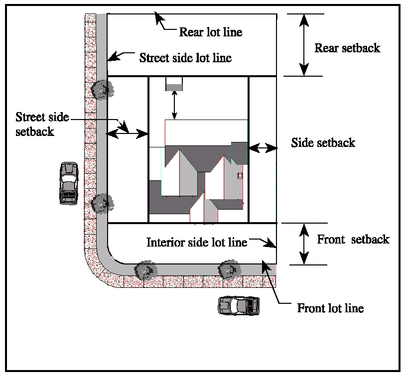
Service Station (land use). This land use consists of the retail sale of gasoline or other motor vehicle fuels, which may also include services incidental to fuel sales. These incidental services may include vehicle engine maintenance and repair, towing and trailer rental services. Does not include the storage or repair of wrecked or abandoned vehicles, vehicle painting, body or fender work, or the rental of vehicle storage or parking spaces.
Shopping Center (land use). This land use consists of structures with six or more independently operated retail uses whose combined gross floor area totals at least 20,000 square feet, and which are located on a site where any underlying separate lots are tied together by a binding legal agreement providing rights of reciprocal parking and access.
Sign. A structure, device, figure, display, message placard or other contrivance, or any part thereof, situated outdoors or indoors, which is designed, constructed, intended or used to advertise, provide information in the nature of advertising, provide historical, cultural, archeological, ideological, political, or social information, or direct or attract attention to an object, person, institution, business, product, service, message, event, or location by any means, including words, letters, figures, designs, symbols, fixtures, colors, or illumination.
Sign, A-frame. A portable, and self-supporting sign used for advertising purposes, constructed in such a manner as to form an "A" or a tent-like shape, hinged or not hinged at the top (Syn. Sandwich Board Sign).
Sign, Abandoned. Any lawfully erected sign that, for a period of 90 days or more, no longer advertises or identifies an ongoing business, activity, product, service, or other use available on the premise where the sign is located.
Sign Area. Sign area consists of the message, background and any frame or outline and does not include any material used exclusively for structural support. Where a sign message has no background material or where the background is an undifferentiated wall, the area shall consist of the smallest convex shape which encompasses the total message. The area of a conic, cylindrical, spherical or multi-faced sign shall be its maximum projection on the vertical plane (e.g., for a two-faced sign, only one side shall be measured).
Sign, Awning. Any sign copy that is printed, painted or affixed to an awning.
Sign, billboard. A permanent structure for the display of off-premises advertising.
Sign, building mounted. A sign attached to or painted on the wall of a building or an element or structure attached to the building, such as an awning or canopy.
Sign, canopy. A sign that is printed, painted, or affixed to a canopy, typically used to accent building entries.
Sign, changeable copy. A sign that is designed so that characters, letters, numbers or illustrations can be manually changed or rearranged without altering the face or surface of the sign.
Sign copy. All portions of a sign displaying a message, including text and symbols, not including the supporting structure or base of a sign.
Sign, directory. A sign or set of similarly designed individual signs, placed or displayed in sequence, to list all or part of the businesses within a building or business center.
Sign, electronic message center. A sign or portion of a sign that is capable of changing its characters, letters, numbers, illustrations, display, color, and/or light intensity by electronic or automatic means.
Sign, feather or vertical. A temporary sign constructed of cloth, canvas, plastic fabric, or similar lightweight, non-rigid material and supported by a single vertical pole mounted into the ground or on a portable structure.
Sign, freestanding. A sign that is erected or mounted on its own self-supporting permanent structure or base detached from any supporting elements of a building.
Sign, fuel pump topper. A sign affixed to the top of an operable fuel dispensing pump used to advertise goods offered for sale on the same parcel on which the fuel pump is located.
Sign, illegal. Any sign erected without complying with all ordinances and regulations in effect at the time of its construction and erection or use.
Sign, inflatable. A sign that is an air-inflated object, which may be of various shapes, made of flexible fabric, resting on the ground or a structure and equipped with a portable blower motor that provides a constant flow of air into the device. Inflatable signs or devices are restrained, attached, or held in place by a cord, rope, cable, or similar method. Includes air-activated graphics which are designed to be moved by action of forced air so as to make the sign appear to be animated or otherwise have motion.
Sign, internally illuminated. Any sign in which the source of light is entirely enclosed within the sign and not directly visible.
Sign, nonconforming. Any permanent or temporary sign, including its physical structure and supporting elements, which was lawfully erected and maintained in compliance with all applicable laws in effect at the time of original installation, but which does not now comply with the provisions of Chapter 22.28 (Signs).
Sign, off-premises. Any sign that directs attention to a business, commodity, service, entertainment, product, structure, use or property different from a structure or use existing on the property where the sign is located, and/or any sign on which space is rented, donated or sold by the owner of said sign or property for the purpose of conveying a message.
Sign, permanent. A sign constructed of durable materials and intended to exist for the duration of time that the use or occupant is located on the premises.
Sign Program. A coordinated design plan of one or more signs for an individual business, a multi-tenant business center, or other site that specifies the number, size, description, and location of all signs located or to be located on the parcel or business site.
Sign, projecting. A sign attached to, and extending from, a building or other structure.
Sign, roof. A sign constructed upon or over a roof or placed so that any portion of the sign extends above the roof line.
Sign, suspended. A sign that is suspended from the underside of an eave, canopy, awning, arcade, or other covered walkway.
Sign, temporary. A sign which is intended for a definite and limited period of display and which is not permanently affixed to a structure, sign area, or window.
Sign, vehicle. Any sign permanently or temporarily attached to or placed on a vehicle or trailer in any manner so that the sign is used primarily as a stationary sign.
Sign, wall. A sign attached to, painted on, connected to, erected against the wall, parapet, or fascia of a building or structure with the exposed face of the sign in a plane parallel to the vertical face of the building or structure.
Sign, wall banner. A temporary sign composed of cloth, canvas, plastic, fabric, or similar lightweight, non-rigid material that can be mounted to a structure other than a flag pole with cord, rope, cable, or a similar method. This definition does not include a flag.
Sign, window. A temporary or permanent sign placed on or behind a window, not including merchandise included in window displays. Window signs do not include common wall windows on the inside of a building not visible by the general public from any public right-of-way or any public area.
Sign, yard. Any temporary sign placed on the ground or attached to a supporting structure, posts, or poles, that is not attached to any building, not including banners.
FIGURE 8-7
SIGNS
Significant Tobacco Retailer. Any tobacco retailer engaged in the sale and/or distribution of tobacco products or paraphernalia to the general public, excluding wholesale businesses, that either devotes 20% or more of floor area or display area to, or derives 75% or more of gross sales receipts from, the sale or exchange of tobacco products and/or tobacco paraphernalia.
Single Room Occupancy (SRO). A multiple-tenant residential building, in which four or more studio apartments that do not have kitchens are rented as affordable housing on at least a monthly basis. One common kitchen may be provided for an SRO.
Single-Family Dwellings (land use). This land use consists of a building designed for and/or occupied exclusively by one family. Also includes factory-built, modular housing units, constructed in compliance with the California Building Code (UBC), and mobile homes/manufactured housing on permanent foundations and agricultural worker housing.
Single-Family Residential Zoning District. A zoning district listed in Articles II (Zoning Districts and Allowable Land Uses) and V (Coastal Zones - Permit Requirements and Allowable Land Uses) which allows single-family dwellings, but not two-family or multi-family dwellings. These zoning districts include:
RA (Residential, Agricultural);
RR (Residential, Restricted);
RE (Residential, Estate);
R1 (Residential, Single-Family);
RSP (Residential, Single-Family Planned);
RX (Residential, Mobile Home Park);
RF (Residential, Floating Home Marina);
C-RA (Coastal, Residential, Agricultural);
C-R1 (Coastal, Residential, Single-Family);
C-RSP (Coastal, Residential, Single-Family Planned);
C-RSPS (Coastal, Residential, Single-Family Planned, Seadrift Subdivision);
A2B (Agriculture, Limited);
Districts zoned A for agricultural uses, other than those listed above, are not included in this definition.
Site. A lot or parcel, or adjoining lots or parcels under single ownership or single control, which is considered a unit for the purposes of development or other use.
Site Assessment. An analysis of the environmental setting of developed or undeveloped land, including, but not limited to, sensitive wildlife habitats and sensitive resources, such as baylands, wetlands, stream and riparian systems, and special-status species and species of concern. A site assessment may also include findings regard i ng potential environmental effects resulting from a development application, and recommendations for measures that may avoid or minimize such effects.
Site Coverage. See "Lot Coverage."
Skilled Nursing Facility. A medical care facility providing care for people with physical or mental disabilities, where care is less than that provided by a hospital or other acute care facility. See "Medical Services - Extended Care."
Slaughter Facilities, Mobile. A self-contained facility engaged in slaughter that can travel from site to site.
Slope. The average slope of a lot expressed as a percent, which is calculated as follows:
S = (L × I × 100)/A
Where:
This definition assumes that slope calculations are based on accurate topographic survey maps drawn to a scale of not less than one inch equals 100 feet, with contour lines at maximum ten-foot intervals for ground slope over 15 percent, and at five-foot intervals for ground slope of 15 percent or less.
Slope Ordinance. Minimum lot area requirements established based on slope. See Section 22.82.050 (Hillside Subdivision Design).
Small Family Day-Care Homes (land use). See "Child Day-Care Facilities."
Solar Energy System. Any solar collector or other solar energy device whose primary purpose is to provide for the collection, storage, and distribution of solar energy for space heating, space cooling, electric generation, or water heating.
1.
A structural design feature of a building, including either of the following:
2.
Any design feature whose primary purpose is to provide for the collection, storage, and distribution of solar energy for electricity generation, space heating or cooling, or for water heating.
Any photovoltaic device or technology that is integrated into a building, including, but not limited to, photovoltaic windows, siding, and roofing shingles or tiles.
Commercial Solar Facilities are defined separately and are not included in this definition as a solar energy system.
Solid Waste. Unwanted materials discarded by the occupants of homes and businesses, which may include recyclable materials.
Special Purpose District or Zone. Any of the special purpose zoning districts established by Section 22.06.020 (Zoning Districts Established), including PF (Public Facilities), and OA (Open Area), and the C-OA (Coastal, Open Area) zone as defined in Article V (Coastal Zones - Development and Resource Management Standards).
Specific Plan. A detailed plan for the systematic implementation of the general plan, for all or part of the area covered by the general plan, as authorized by Government Code Sections 65450 et seq.
Sport Facilities and Outdoor Public Assembly (land use). This land use consists of indoor and outdoor facilities for spectator-oriented sports and other outdoor public assembly facilities for such activities as outdoor theater productions and concerts. These facilities include: Amphitheaters; stadiums and coliseums; arenas and field houses; race tracks; motorcycle racing and drag strips; and other sports facilities that are considered commercial.
Standard Management Practices. Method or techniques maintained by the Community Development Agency for the protection of hydrological processes, stream and riparian habitat, and water quality to avoid or minimize impacts to salmonids within the Stream Conservation Area within San Geronimo Valley.
State. The State of California.
Stealth Design. A telecommunications facility that is designed or located in such a way that the facility is not readily recognizable as telecommunications equipment.
Stock Cooperative. A development defined by the Business and Professions Code, Section 11003.2 and the Civil Code, Section 1351.m, where a corporation is formed to hold title to improved real property and the shareholders of the corporation receive a right of exclusive occupancy in a portion of the real property.
Stone and Cut Stone Products (land use). This land use consists of the cutting, shaping, and finishing of marble, granite, slate, and other stone for building and miscellaneous uses. Also includes establishments engaged primarily in buying or selling partly finished monuments and tombstones.
Stop Work Order. A notice issued by the Building Official, or other designated official, that directs the property owner to cease work that was undertaken without proper permits.
Storage, Accessory (land use). This land use consists of the storage of various materials in support of a residential, commercial, or industrial land use on the same site, where the primary use of the site is not a storage facility.
Storage, Personal Storage Facility (land use). This land use consists of a structure or group of structures containing generally small, individual, compartmentalized stalls or lockers rented as individual storage spaces and characterized by low parking demand.
Story. That portion of a building included between the surface of any floor and the surface of the next floor above it, or if there is no floor above it, then the space between the floor and the ceiling next above it.
Story (floating home). That portion of the superstructure located between the upper surface of any deck and the upper surface of the deck or ceiling next above.
Stream. A natural or once natural flowing open drainage channel with an established bed and bank. These consist of perennial, intermittent, and ephemeral streams, including open waterways that have been restored, modified, or channelized, but do not include ditches, culverts, or other above- or below-ground conduits constructed specifically for storm drainage function. Perennial and intermittent streams, shown as solid or dashed blue lines (or purple lines) on the most recent appropriate USGS data, and ephemeral streams as defined below, are subject to Stream Conservation Area protection policies. See "Stream Conservation Area (SCAT).
Stream, Ephemeral. A watercourse that carries only surface runoff and flows during and immediately after periods of precipitation.
Stream, Intermittent. A watercourse that is temporally intermittent or seasonal and that flows during the wet season, continues to flow after the period of precipitation, and ceases surface flow during at least part of the dry season. intermittent streams are typically shown as a dashed blue line on USGS data.
Stream, Perennial. A watercourse that flows throughout the year (except for infrequent or extended periods of drought), although surface water flow may be temporarily discontinuous in some reaches of the channel, such as between pools, typically shown as a solid blue line on USGS data. (Perennial streams can be spatially intermittent but flow all year.)
Stream Conservation Area. An area designated by the Marin Countywide Plan along all natural watercourses shown as a solid or dashed blue line on the most recent appropriate USGS topographic quadrangle map, or along all watercourses supporting riparian vegetation for a length of 100 feet or more, and/or supports special-status species and/or a sensitive natural community type, such as native grasslands, regardless of the extent of riparian vegetation associated with the stream. Sec Marin Countywide Plan policy BIO-4.1.
The Stream Conservation Area is a buffer established to protect the active channel, water quality and flood control functions, and associated fish and wildlife habitat values along streams.
The Stream Conservation Area encompasses any jurisdictional wetland or unvegetated other waters within the stream channel, together with the adjacent wetlands, and supersedes buffer standards defined for Wetland Conservation Areas.
The Stream Conservation Area consists of the watercourse itself between the stream tops of banks and a strip of land extending laterally outward on each side from the top of bank that is the width greater of either:
1.
50 feet landward from the outer edge of woody riparian vegetation associated with the stream; and/or
2.
100 feet landward from the top of bank. Within the SGV combining district, the Stream Conservation Area is measured from the centerline of the swale for ephemeral streams with no clear top of bank as shown in Figure 8-9.
An additional buffer may be required based on the results of a site assessment to protect riparian habitat.
The Stream Conservation Area applies to ephemeral streams that:
1.
Support riparian vegetation for a length of 100 feet or more; and/or
2.
Supports special-status species and/or sensitive natural community type, such as native grasslands, regardless of the extent of riparian vegetation associated with the stream.
Except for ephemeral streams within the SGV combining district, a minimum 20-foot buffer should be required for those ephemeral streams that do not meet these criteria, In the SGV combining district, the Stream Conservation Area applies to all ephemeral streams as mapped on the most recent appropriate USGS National Hydrography Dataset.
FIGURE 8-8
TYPICAL CROSS SECTION OF A STREAM CONSERVATION AREA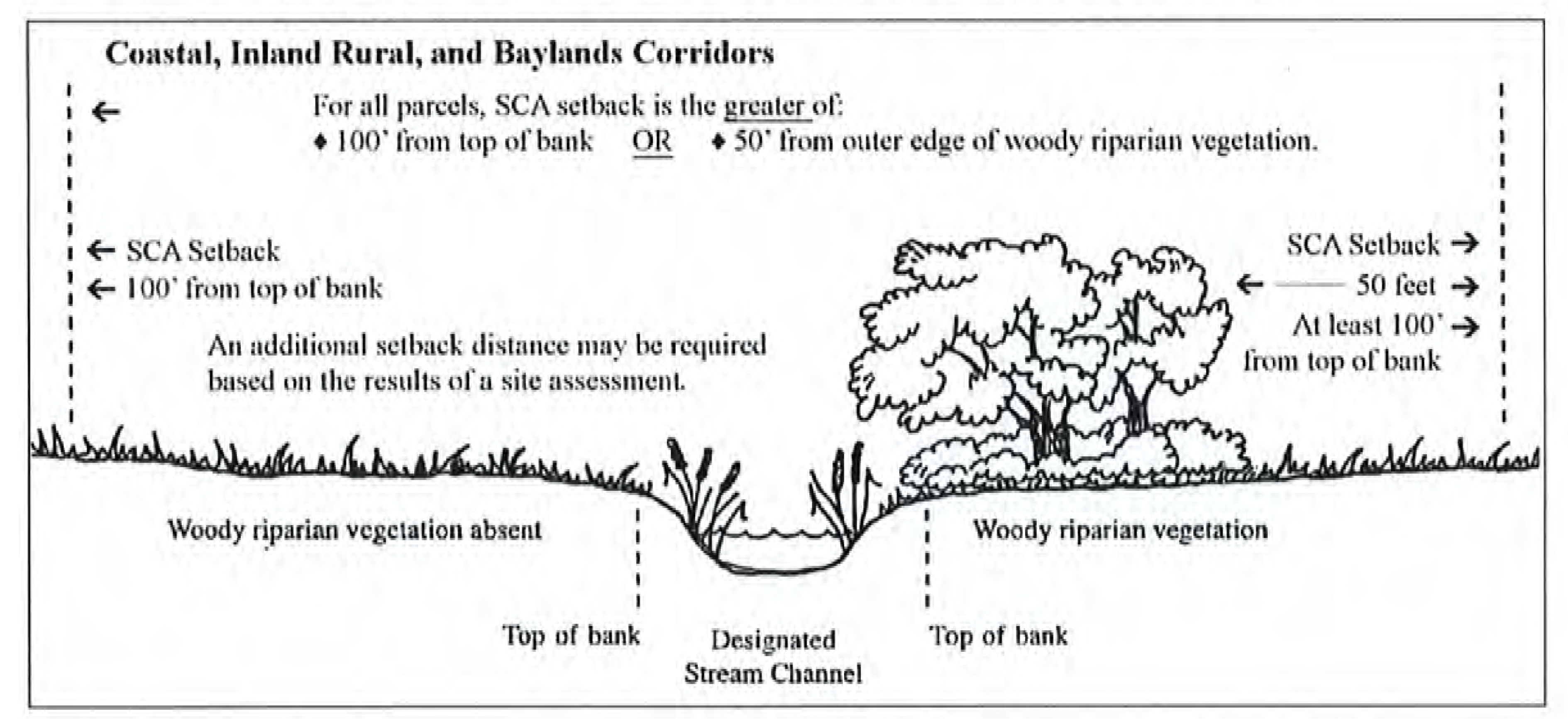
FIGURE 8-9
BUFFER MEASUREMENT FOR EPHEMERAL STREAMS IN SAN GERONIMO VALLEY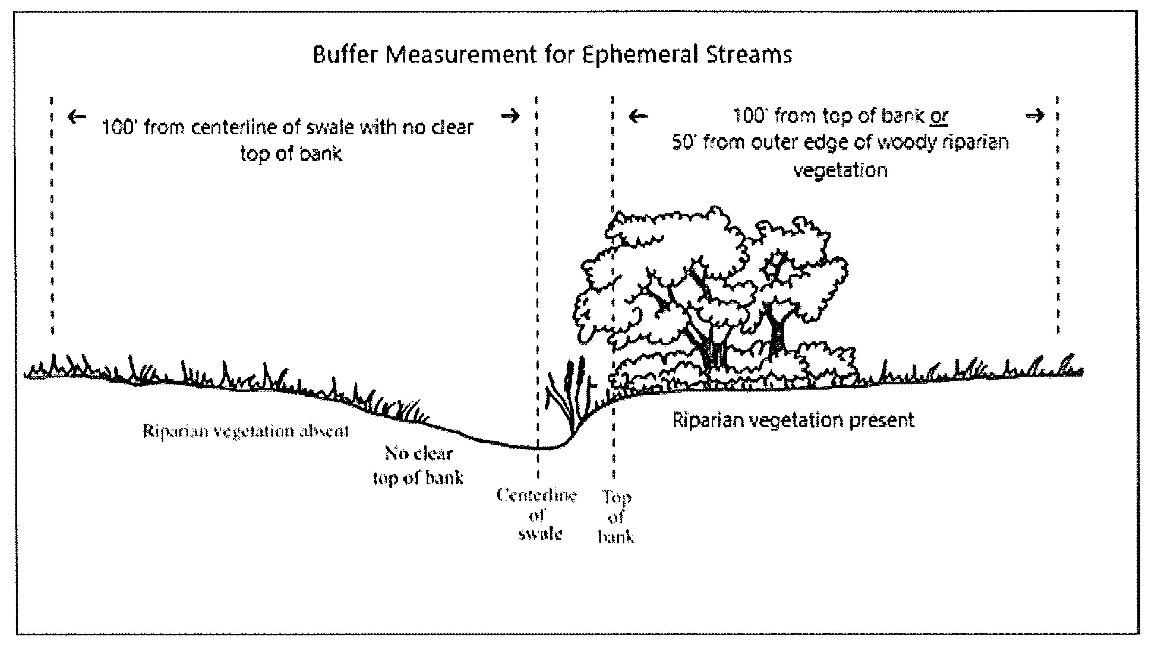
FIGURE 8-10
SETBACK MEASUREMENT FOR EPHEMERAL STREAMS NOT WITHIN SAN GERONIMO VALLEY AND NOT OTHERWISE
SUBJECT TO THE STREAM CONSERVATION AREA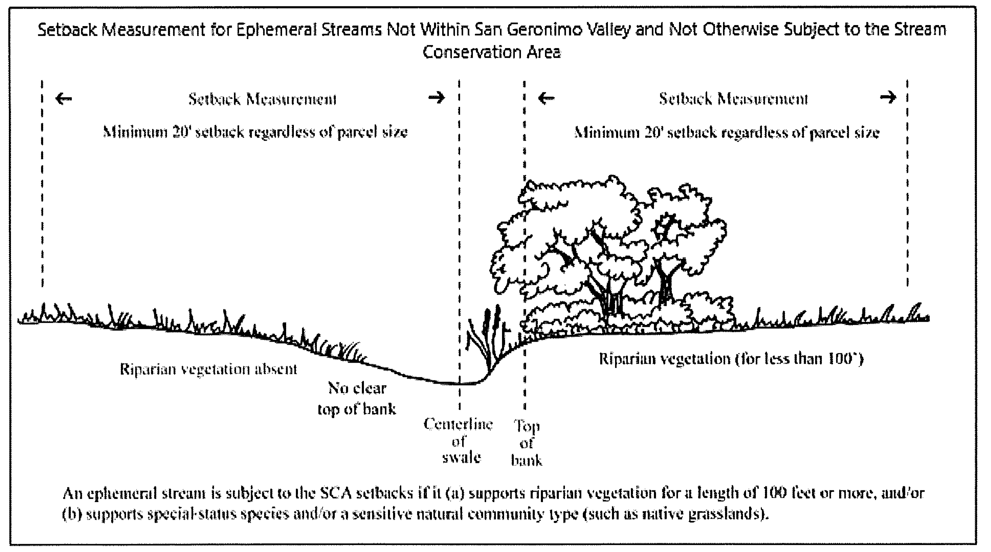
Street. A public right-of-way or access normally used for vehicular traffic, excluding vehicular driveways serving a single lot or parcel and trails or paths used for pedestrian access purposes only.
Structural Alterations. Any change in the supporting members of a building, including bearing walls, columns, beams or girders.
Structural Clay and Pottery Products (land use). This land use consists of the manufacture of brick and structural clay products, including pipe, china plumbing fixtures, and vitreous china articles, fine earthenware and porcelain products. Artist/craftsman uses are included in "Cottage Industries," "Handcraft Industries and Small Scale Manufacturing," "Home Occupations."
Structure. Anything constructed or erected, the use of which requires attachment to the ground or attachment to something located on the ground. For the purposes of this Development Code, the term "structure" includes "buildings." Examples of structures include:
Residence/guest house;
Garage/carport/car deck;
Swimming pool/spa;
Barn;
Arbor/gazebo;
Retaining wall;
Fence/trellis.
Structure, Accessory. See "Accessory Structures."
Structure, Primary. A structure in which the principal use of the site is conducted. On sites with multiple structures, the Director shall determine which is the primary structure based on zoning, use, floor area, owner occupancy, etc.
Studios for Art, Dance, Music, Photography, etc. (land use). This land use consists of the provision of individual and group instruction and training in: The arts; production rehearsal; photography, and the processing of photographs produced only by users of the studio facilities; and martial arts training studios.
Subdivider. A person, firm, corporation, partnership or association, a governmental agency, public entity or public utility, or the grantor to any such agency, entity, utility or subsidiary, who proposes to subdivide real property for themselves or for others, except employees and consultants or these persons or entities acting in this capacity.
Subdivision. The division, by any subdivider, of any unit or portion of land shown on the latest equalized Marin County assessment roll as a unit or contiguous units, for the purpose of sale, lease or financing, whether immediate or future. Property shall be considered as contiguous units, even if it is separated by roads, streets, utility easement or railroad rights-of-way. Subdivision includes a condominium project, as defined in Section 1351.f of the Civil Code, and a community apartment project, as defined in Section 1351.d of the Civil Code.
Subdivision Map. A Tentative, Parcel or Final Map, as described in Article VI (Subdivisions).
Subdivision Map Act. Division 2, Title 7 of the California Government Code, commencing with Section 66410 as presently constituted, and any amendments to those provisions.
Superstructure (floating home). The portion of a floating home or ark above the lowest deck or the level of floatation.
Supportive Housing. Housing with no limit on length of stay, that is occupied by the target population as defined in subdivision (d) of Health and Safety Code section 53260, and that is linked to on-site or off-site services that assist the supportive housing resident in retaining the housing, improving his or her health status, and maximizing his or her ability to live and, when possible, work in the community per Health and Safety Code section 50675.14(b).
Surface Mining. All or any part of the process involved in the mining of minerals on mined lands by removing overburden and mining directly from the mineral deposits, open pit mining of minerals naturally exposed, mining by the auger method, dredging and quarrying, or surface work incident to an underground mine.
T. Definitions, "T."
Telecommunications Facilities (land use). This land use consists of public, commercial and private electromagnetic and photoelectrical transmission, broadcast, repeater and receiving stations and equipment, including:
-
Cellular telephone and personal communications services (PCS) facilities, and enhanced specialized mobile radio facilities;
-
Commercial earth stations for satellite-based communications;
-
Data network communications facilities;
-
Radio and television broadcast facilities, including ham radio facilities;
-
Telephone and telegraph microwave facilities.
Includes antennas, microwave dishes or horns, structures or towers to support receiving and/or transmitting devices, accessory development and structures, and the land on which they are situated. Does not include telephone, telegraph and cable television transmission facilities utilizing hard-wired or direct cable connections (see "Pipelines and Utility Lines").
Telecommunications Facilities, Base Station. Structures other than wireless towers that support or house an antenna, transceiver, or other associated equipment that constitutes part of a base station at the time the relevant application is filed, even if the structure was not built for the sole or primary purpose of providing such support.
Telecommunications Facilities, Eligible Facility Request. Any request for modification of an existing wireless tower or base station that involves collocation of new transmission equipment, removal of transmission equipment, or replacement of transmission equipment.
Telecommunications Facilities, Substantial Change. A substantial change for telecommunications facilities is defined as any one of the following:
-
For wireless towers outside of public rights-of-way, it increases the height by more than 20 feet or 10%, whichever is greater; for those wireless towers in the rights-of-way and for all base stations, it increases the height of the wireless tower or base station by more than 10% or 10 feet, whichever is greater.
-
For wireless towers outside of public rights-of-way, it protrudes from the edge of the wireless tower more than 20 feet, or more than the width of the wireless tower structure at the level of the appurtenance, whichever is greater; for those wireless towers in the rights-of-way and for all base stations, it protrudes from the edge of the structure more than six feet.
-
It involves installation of more than the standard number of new equipment cabinets for the technology involved, but not to exceed four cabinets.
-
It entails any excavation or deployment outside the current site of the wireless tower or base station.
-
It would defeat the existing concealment elements of the wireless tower or base station.
-
It does not comply with conditions associated with the prior approval of the wireless tower or base station unless the non-compliance is due to an increase in height, increase in width, addition of cabinets, or new excavation that does not exceed the corresponding "substantial change" thresholds.
Telecommunications Facilities, Wireless Tower. Any structure built for the sole or primary purpose of supporting any Federal Communications Commission licensed or authorized antennas and their associated facilities.
Temporary Construction Yard. A site for the storage of construction materials other than the construction site.
Temporary Mobile Home (land use). This land use consists of a mobile home used as a temporary residence during the construction of a permanent residence on the same site.
Temporary Use Permit. A discretionary land use permit that may be granted in compliance with Chapter 22.50 (Temporary Use Permits), which authorizes a specific use of land on a specific site for a limited time, subject to compliance with any conditions of approval imposed on the permit.
Tennis and Other Recreational Uses (land use). Noncommercial recreational facilities constructed for private use on residential properties. See also "Hotel or Motel," "Outdoor Commercial Recreation," Private Residential Recreational Facilities, and "Sport Facilities and Outdoor Public Assembly."
Tentative Map. A map made for the purpose of showing the design and improvement of a proposed subdivision and the existing conditions in and around it.
Textile and Leather Products (land use). This land use consists of any of the following manufacturing activities:
Coating, waterproofing, or otherwise treating fabric;
Dying and finishing fiber, yarn, fabric, and knit apparel;
Manufacture of knit apparel and other finished products from yarn;
Manufacture of felt goods, lace goods, non-woven fabrics and miscellaneous textiles;
Manufacturing of woven fabric, carpets and rugs from yarn;
Preparation of fiber and subsequent manufacturing of yarn, threads, braids, and twine cordage;
Upholstery manufacturing.
Theaters and Meeting Halls (land use). This land use consists of indoor facilities for public assembly and group entertainment, other than sporting events, including:
Civic theaters, meeting halls and facilities for "live" theater and concerts;
Exhibition and convention halls;
Meeting halls for rent;
Motion picture theaters;
Public and semi-public auditoriums;
Similar public assembly uses.
Does not include outdoor theaters, concert and similar entertainment facilities, and indoor and outdoor facilities for sporting events; see "Sport Facilities and Outdoor Public Assembly."
Tidelands. All land and water areas that are below, or were at any time within a preceding 12-month period below the Mean High Tide line, and to contiguous land between that line, and either a point 100 feet inland or the nearest publicly maintained road, whichever is closer.
Areas behind secured dykes, which is normally not subject to tidal action by virtue of the dyke, are not considered tidelands.
Timber Harvesting. The cutting of timber and/or removal of forest products for commercial purposes, together with all the work incidental to those operations, including road building, tree marking, hazard reduction, etc.
Tobacco Paraphernalia. Cigarette papers or wrappers, pipes, holders of smoking materials of all types, cigarette rolling machines, and any other item designed for the smoking, use or ingestion of tobacco products.
Tobacco Products.
(1)
Any product containing, made, or derived from tobacco or nicotine that is intended for human consumption, whether smoked, heated, chewed, absorbed, dissolved, inhaled, snorted, sniffed, or ingested by any other means, including, but not limited to, cigarettes, cigars, little cigars, chewing tobacco, pipe tobacco, and snuff.
(2)
Any electronic device that delivers nicotine or other substances to the person inhaling from the device, including, but not limited to, an electronic cigarette, electronic cigar, electronic pipe, or electronic hookah.
(3)
Notwithstanding any provision of subsections (1) and (2) to the contrary, "tobacco product" includes any component, part, or accessory intended or reasonably expected to be used with a tobacco product, whether or not sold separately. "Tobacco product" does not include any product that has been approved by the United States Food and Drug Administration for sale as a tobacco cessation product or for other therapeutic purposes where such product is marketed and sold solely for such an approved purpose.
Tobacco Retailer. Any person who sells, offers for sale, or offers to exchange for any form of consideration, tobacco, tobacco products, and/or tobacco paraphernalia.
Top of Bank. The elevation at which flow spills out of a stream channel and onto the floodplain.
Total Height (System Height). The total WECS height is the height from natural grade to the fixed portion of the tower and includes the highest vertical length of any extensions above grade, such as the rotor blades when being operated.
Total Units or Total Dwelling Units. A calculation of the number of units that:
i.
Excludes a unit or units added by a density bonus awarded pursuant to the State Density Bonus Law.
ii.
Includes a unit designated to satisfy an inclusionary zoning requirement of Marin County.
Tower. The tower is the support structure, including guyed monopole and lattice types, upon which a wind turbine or other mechanical device is mounted as part of a wind energy system.
Tower Height (WECS). The tower height is the height from natural grade to the upper-most fixed portion of the tower excluding the length of any vertical axial-rotating turbine blade.
Transfer of Development Rights (TDR). The process established by Chapter 22.34 (Transfer of Development Rights), which allows some or all of the number of dwelling units potentially allowed by the zoning applicable to a "donor" site, to be transferred and built on another "receiving" site, in addition to the number of units potentially allowed by the zoning of the receiving site.
Transit Stations and Terminals (land use). This land use consists of passenger stations for vehicular, ferry, and rail mass transit systems; also terminal facilities providing maintenance and service for the vehicles operated in the transit system. Includes buses, taxis, railway, etc.
Transit Stop Shelter (land use). This land use consists of a small-scale covered waiting area for buses, taxis, and rail/mass transit stops.
Transitional Housing. Buildings configured as rental housing developments, but operated under program requirements that call for the termination of assistance and recirculation of the assisted unit to another eligible program recipient at some predetermined future point in time, which shall be no less than six months per Health and Safety Code section 50675.2(h).
Trash Full Capture System. Any device or series of devices that traps and retains all particles that are five millimeters or greater, and has a design treatment capacity of not less than the peak flow rate resulting from a one-year, one-hour, storm in the tributary drainage catchment area.
Two-Family Dwelling (land use). This land use consists of detached residential structures under single ownership containing two dwellings. This land use does not include residential accessory dwelling units, which are separately defined.
U. Definitions, "U."
Unincorporated Community. A concentration of structures and population within the unincorporated areas of the County identified by the Countywide Plan as a community.
Urban Uses. Any current or former residential, commercial, public institutional, transit or transportation passenger facility, or retail use, or any combination of those uses.
Urbanized Area. An urbanized area or urban cluster, as designated by the United States Census Bureau.
Use. The purpose for which land or a building thereon is designed, or for which it may be occupied. Each business, administrative, professional, industrial, or other establishment, which is separate from another establishment, both in fact and in the appearance presented to the public, shall be considered a separate use.
Use Permit. A discretionary land use permit that may be granted by the Review Authority in compliance with Chapter 22.48 (Conditional Use Permits) or Chapter 22.49 (Master Use Permits), which authorizes a specific use of land on a specific site, subject to compliance with any conditions of approval imposed on the permit.
V. Definitions, "V."
Vacant Lot. A lot which is not developed with a primary structure, or is developed only with one or more accessory structures. As used in this Code, development of a lot which entails demolition exceeding 75 percent of the total linear sum of the primary structure's exterior walls shall be subject to the regulations for developing a vacant lot.
Variance. See Chapter 22.54 (Variances).
Vehicle and Freight Terminals (land use). This land use consists of the provision of services incidental to air, motor freight, and rail transportation. Examples of these services and related facilities include:
Freight forwarding services;
Freight terminal facilities;
Joint terminal and service facilities;
Packing, crating, inspection and weighing services;
Postal service bulk mailing distribution centers;
Transportation arrangement services;
Trucking facilities, including transfer and storage.
Vertical Axis WECS. A vertical axis wind turbine (VAWT) is an energy conversion system whose rotor axis is substantially perpendicular to the wind flow. The main rotor shaft is arranged vertically and the turbine does not need to be pointed into the wind to be effective.
Vessel. Any watercraft of any type or size, including barges, ferry boats, yachts, houseboats, floating homes, and rafts.
Vest. To obtain a right by completing an action required by this Development Code.
Vesting Tentative Map. A map that is filed and processed in the same manner as a Tentative Map except as otherwise provided by Section 22.84.110 (Tentative Map Time Limits), or the Subdivision Map Act. A Vesting Tentative Map shall have the words "Vesting Tentative Map" printed conspicuously on its face at the time it is filed with the Agency.
Veterinary Clinics and Animal Hospitals (land use). This land use consists of office and entirely indoor medical treatment facilities used by veterinarians, including large and small animal veterinary clinics, and animal hospitals. See also, "Kennels and Animal Boarding."
Visitor-Serving Facility. Stores, shops, businesses, bed and breakfast inns, public and private recreational facilities that provide accommodations, food and services. Includes hotels and motels, campgrounds, parks, nature preserves, restaurants, and commercial recreational development such as shopping, eating and amusement areas which are used by the traveling public.
Visually Prominent Ridgeline. A line connecting the topographic highpoints within the Countywide Plan's Ridge and Upland Greenbelt along a ridge that separates watersheds and is visible from public viewpoints from open space areas, parks, trailheads, highways, arterial roads, the bay and other waterbodies.
W. Definitions, "W."
Warehouse Retail Stores (land use). This land use consists of the retail stores that emphasize the packaging and sale of products in large quantities or volumes, some at discounted prices, where products are typically displayed in their original shipping containers. Sites and buildings are usually large and industrial in character. Patrons may or may not be required to pay membership fees.
Warehousing (land use). This land use consists of facilities for the storage of farm products, furniture, household goods, or other commercial goods of any nature. Includes cold storage. Does not include: Warehouse, storage or mini-storage facilities offered for rent or lease to the general public (see "Storage, Personal Storage Facilities"); warehouse facilities in which the primary purpose of storage is for wholesaling and distribution (see "Wholesaling and Distribution"); or terminal facilities for handling freight (see "Vehicle and Freight Terminals").
Waste Disposal Sites (land use). This land use consists of County-approved or operated refuse dumps, sanitary landfills and other solid waste terminal disposal facilities, not including facilities for hazardous materials.
Water Conservation Dams and Ponds (land use). This land use consists of water impoundment reservoirs constructed for watering stock, groundwater recharge, and other conservation purposes.
WECS (land use). See "Wind Energy Conversion Systems (WECS)."
Wetland Conservation Area. An area designated by the Marin Countywide Plan that includes wetlands and associated buffer areas. See Marin Countywide Plan policy BIO-3.1.
Wetland, Jurisdictional. An area that meets the criteria established by the U.S. Army Corps of Engineers (Corps or COE) for Wetlands (as set forth in their Wetlands Delineation Manual). Such areas come under the jurisdiction of the Corps of Engineers for permitting certain actions such as dredge and fill operations.
Wholesaling and Distribution (land use). This land use consists of establishments engaged in selling merchandise to retailers; to industrial, commercial, institutional, farm, or professional business users; or to other wholesalers; or acting as agents or brokers in buying merchandise for or selling merchandise to such persons or companies. Includes such establishments as:
-
Agents, merchandise or commodity brokers, and commission merchants;
-
Assemblers, buyers and associations engaged in the cooperative marketing of farm products;
-
Merchant wholesalers;
-
Stores primarily selling electrical, plumbing, heating and air conditioning supplies and equipment.
Wild Animal Ranches (land use). This land use consists of the keeping or raising of wild animals for commercial agricultural purposes.
Williamson Act. Formally the California Land Conservation Act of 1965, this Act was designed as an incentive to retain prime agricultural land and open space in agricultural use, thereby slowing its conversion to urban and suburban development. The program entails a ten-year contract between the County and an owner of land whereby the land is taxed on the basis of its agricultural use rather than the market value. The land becomes subject to certain enforceable restrictions, and certain conditions need to be met prior to approval of an agreement.
Wind Energy Conversion System (WECS) (land use). This land use is defined as any machine that converts and then stores or transfers the kinetic energy in the wind into a usable form of mechanical or electrical energy. The WECS consists of all parts of the system, including the base or foundation tower, wind turbine, generator, rotor, blades, supports, and transmission equipment. Additional WECS definitions include:
1. Small Wind Energy Conversion System. This land use is defined as: (1) any small freestanding WECS up to 40 feet in total height above grade; (2) a roof-mounted WECS utilizing a horizontal-axis wind turbine (HAWT) or a vertical-axis wind turbine (VAWT) and not exceeding ten feet in height above the roof line of the structure; or (3) a non-grid-tied WECS used solely to pump water for agricultural uses and not exceeding 100 feet in total height above grade.
2. Medium Wind Energy Conversion System. This land use is defined as any WEC project between 40 feet and 200 feet in total height above grade.
3. Large Wind Energy Conversion System. This land use is defined as any WECS project greater than 200 feet in total height above grade.
Wind Turbine. A wind turbine is a rotating machine which converts the kinetic energy in wind into mechanical energy, which is then converted to electricity.
Wind Turbine Generator. A wind turbine generator converts mechanical energy into electrical energy by means of attaching a generator to a rotating part of a wind turbine.
X. Definitions, "X."
No definitions beginning with the letter "X" are used at this time.
Y. Definitions, "Y."
Yard. An area between a lot line and a setback, unobstructed and unoccupied from the ground upward, except for projections permitted by this Development Code. See Section 22.20.090 (Setback Requirements and Exceptions) and Figure 8-7 (Setbacks).
1. Front Yard. An area extending across the full width of the lot between the front lot line and a structure.
2. Rear Yard. An area extending the full width of the lot between a rear lot line and a structure.
3. Side Yard. An area extending from the front yard to the rear yard between the nearest side lot line and a structure.
4. Interior Yard. An area between a lot line and a structure that does not abut a street or right-of-way.
Z. Definitions, "Z."
Zoning Administrator. The employee of the Marin County Community Development Agency appointed by the Board of Supervisors as Zoning Administrator, with duties and authority as described in Section 22.110.040 (Zoning Administrator).
Zoning Code. Articles I through V, and VII through VIII of this Development Code.
Zoning District. An area identified on the County Zoning Map within which certain uses of land and structures are permitted, and regulations are specified by this Development Code. The zoning districts established by this Development Code are described in Sections 22.06.020 (Zoning Districts Established), and Article V (Coastal Zones - Development and Resource Management Standards).
Zoning Map. The official map or maps of Marin County that identify the specific zoning districts located in the unincorporated areas of the County. The Zoning Map is on file with the Marin County Community Development Agency.
(Ord. No. 3577, 2012; Ord. No. 3602, § II(exh. A), 2013; Ord. No. 3666, § II(exh. A), 2017; Ord. No. 3682, § II(I.1.2), 2018; Ord. No. 3698, § II, 2018; Ord. No. 3706, 2019; Ord. No. 3745, § 1(exh. A), 2021; Ord. No. 3770, § 1(exh. A), 2022; Ord. No. 3780, § 1(exh. A), 2023; Ord. No. 3797, § II(exh. A), 2023; Ord. No. 3798, § II(exh. A), 2023; Ord. No. 3806, § II(exh. A), 2023; Ord. No. 3819, § I(exh. A), 2024)