
Martin County Unincorporated
City Zoning Code
City Zoning Code
ARTICLE 11
PLANNED MIXED-USE VILLAGE
Sec. 11.1.1. - Purpose.
Article 11, Planned Mixed-Use Village (PMUV) is a form based code which implements the Mixed-Use Village future land use designation of the Comprehensive Growth Management Plan (CGMP) by:
• Creating the Planned Mixed-Use Village Zoning District.
• Providing the review procedures necessary to insure that the Mixed-Use Village development program established in Policy 4.13A.15, CGMP is achieved within the PMUV
• Providing for standards of development through the implementation of the form-based code.
• Providing for the organization of development through the establishment of transect zones.
Sec. 11.1.2. - Creation of the Planned Mixed-Use Village Zoning District.
11.1.2.A.
The PMUV Zoning District is hereby created and shall apply solely to the 3,411 acres located west of Florida's Turnpike and north of S.W. Martin Highway and further described in Exhibit "A", Legal Description, attached to Ordinance Number 1081.
11.1.2.B.
The PMUV will provide a compact, pedestrian oriented development and a predictable built environment with a mix of commercial and residential uses.
11.1.2.C.
By providing a compact walkable community the PMUV will be able to preserve large areas of open space.
11.1.2.D.
Traditional Neighborhood Design (TND) will be used in the PMUV to achieve efficient transportation corridors, walkable streets and an interconnected trail system that provides connectivity between natural areas, open space parks, civic spaces and neighborhood and workplace areas.
Sec. 11.1.3. - Applicability.
11.1.3.A.
This article shall apply to all areas, land or water within the Planned Mixed-Use Village Zoning District (PMUV) described in "Exhibit A", Legal Description, attached to Ordinance Number 1081.
11.1.3.B.
Within the PMUV, no building or structure shall be erected or altered or used for any purpose except as provided for within this article.
11.1.3.C.
All development within the PMUV shall comply with this article. All development within the PMUV shall also comply with Articles 1 through 10, LDR unless an exception to the requirements of Articles 1 through 10 is expressly provided. To the extent that a conflict occurs between this article and other provisions of the LDR, the provisions of this article shall control.
11.1.3.D.
This article implements the goals, objectives and policies of the CGMP. If a conflict arises between this article and the CGMP, the CGMP shall prevail.
Sec. 11.1.4. - Rules of Interpretation.
11.1.4.A.
The rules of interpretation set forth in Section 1.5, LDR, shall be applied to this article unless expressly set forth in the section.
11.1.4.B.
The words "must", "shall" and "will" are mandatory.
11.1.4.C.
The words "may" and "should" are permissive.
11.1.4.D.
Capitalized terms used in this article are defined in Section 11.1.5, Glossary of Terms. Words or phrases which are not capitalized and defined in Section 11.1.5, Glossary of Terms, shall be construed according to their customary meaning.
11.1.4.E.
In the event of a conflict between numerical metrics (i.e. measurements) and graphic metrics (i.e. pictures), the numerical metrics shall control.
11.1.4.F.
Where the provisions of this article require calculations to determine applicable requirements, any fractional results shall be rounded, up if the number you are rounding is followed by 5, 6, 7, 8, or 9. If the number you are rounding is followed by 0, 1, 2, 3, or 4, the fractional result shall be rounded down.
Sec. 11.1.5. - Glossary of Terms.
A
Accessory Dwelling Unit: Also referred to as accessory apartments, second units, or granny flats—are additional living quarters on single-family lots that are independent of the primary dwelling unit. The separate living spaces are equipped with kitchen and bathroom facilities, and can be either attached or detached from the Principal Building.
Accessory Structure: Any structure that is related to or in conjunction with the primary structure or use on a lot, such as patios, sheds or pools.
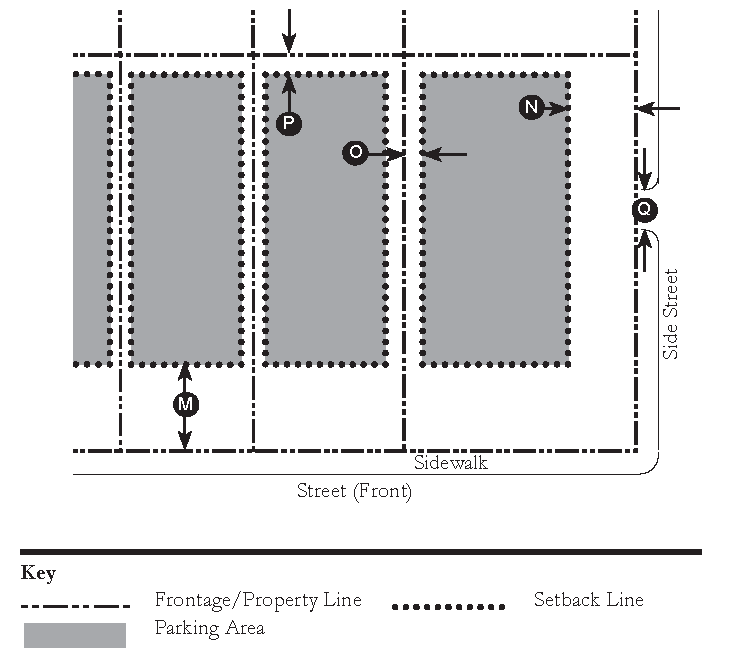
Alley: A service roadway that provides access to properties abutting another street and that is not intended for general traffic circulation.
Attic: The interior part of a building contained within a pitched roof structure.
Awning: A light, protective architectural element entirely supported by, but not permanently attached to a building, which does not exceed ten feet in length.
B
Backbuilding: A single-story structure connecting a Principal Building to an Outbuilding.
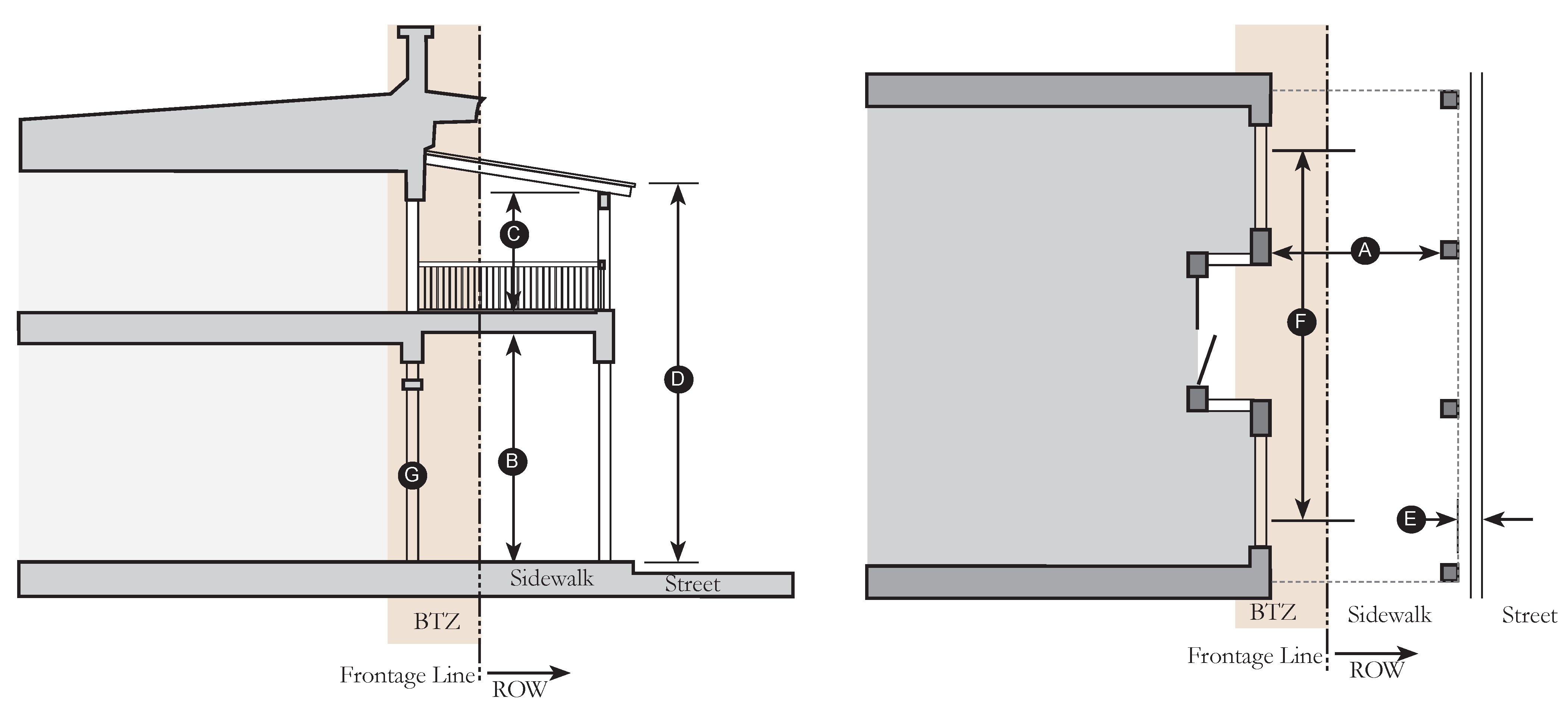
Balcony: An open habitable portion of an upper floor extending beyond a building's exterior wall that is not supported from below by vertical columns or piers but is instead supported by either a cantilever or brackets. An accessory area to a Dwelling, with one or more sides permanently open to the exterior except for a railing or parapet not exceeding four feet in height.
Bioswale: A linear landscape feature used to slow, collect, infiltrate, and filter stormwater that is vegetated with plants that can withstand moisture regimes ranging from flooded to dry that are designed to manage a specified amount of runoff from a large impervious area, such as a parking lot or roadway. A bioswale can accommodate larger quantities of stormwater and is deeper than a rain garden and is often greater in length than width.
Block: The aggregate of private Lots, Passages, and Alleys, circumscribed by Streets, including where abutting the Florida Turnpike in the Workplace District (SD-W) Neighborhood.
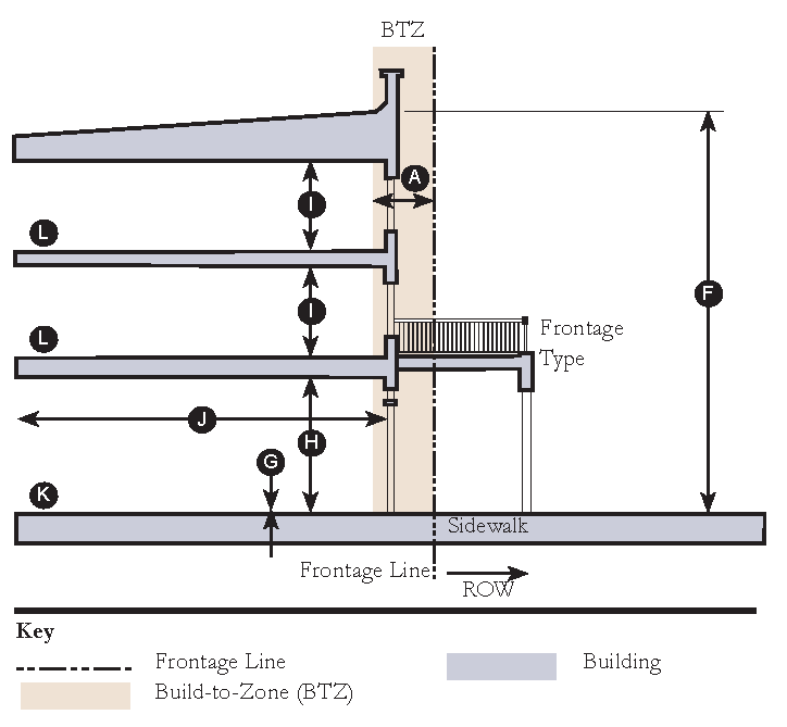
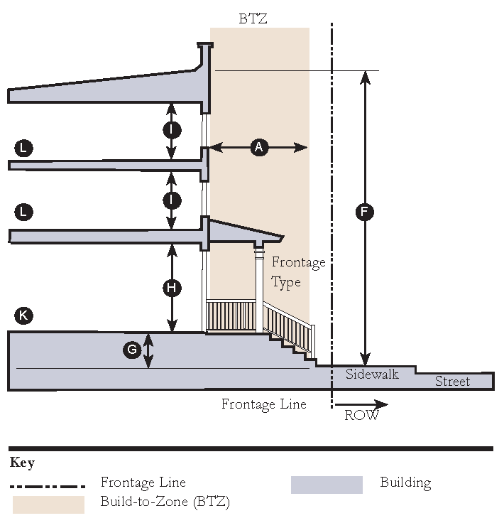
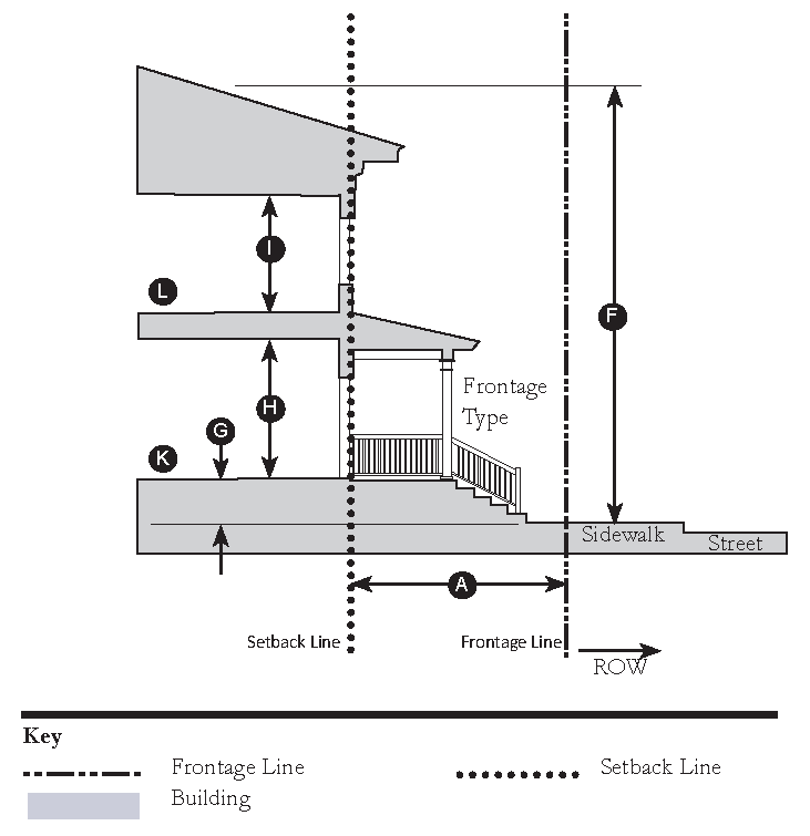
Building Height: The vertical distance between (1) the lowest permissible elevation above the existing grade which complies with finished floor elevation requirements as established by flood maps, the Health Department, or building code, along the front of a building and (2) either the highest point of the coping of a flat roof, the deck line of a mansard roof, or the mean height level between eaves and ridge for gable, hip and gambrel roofs.
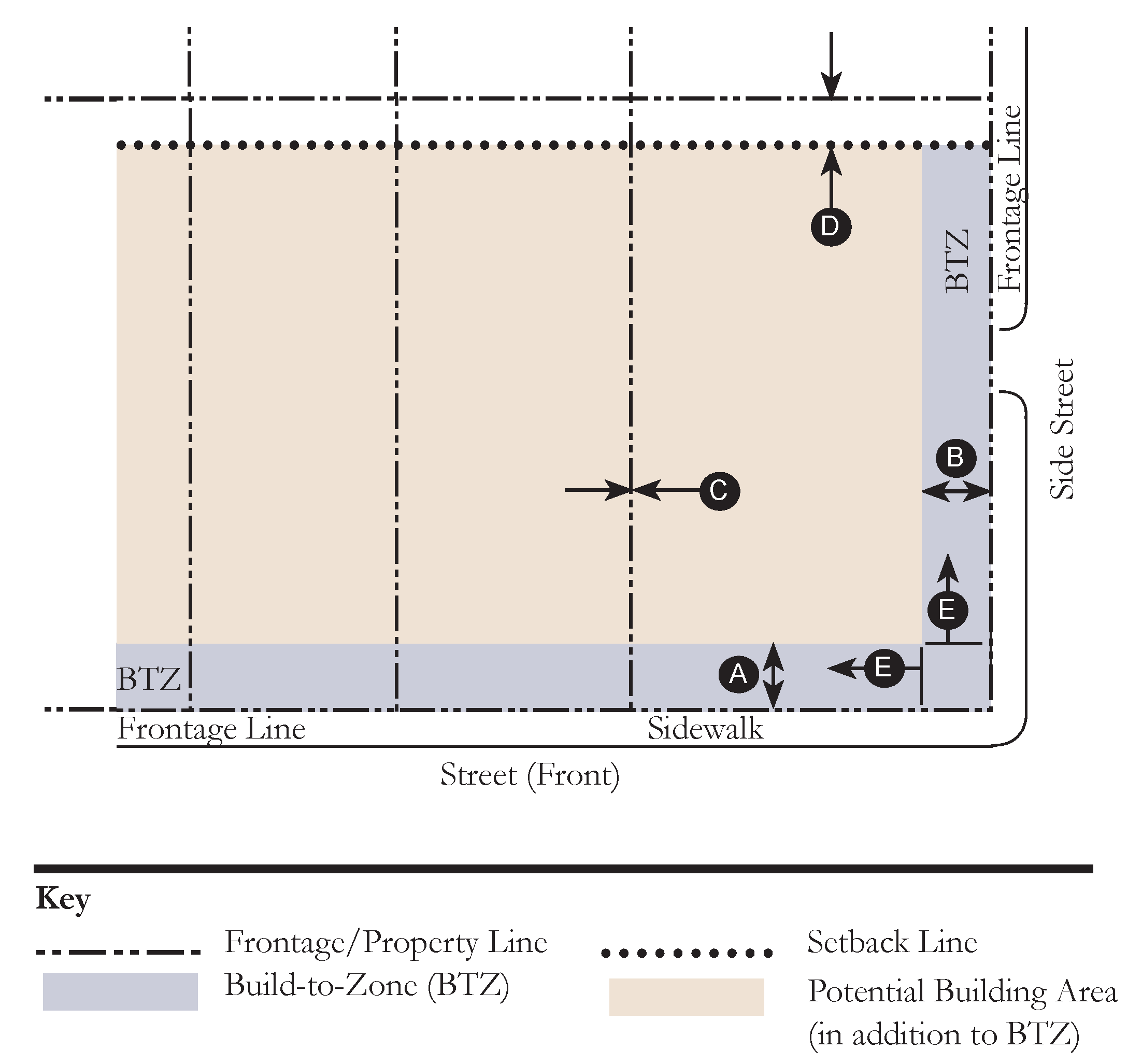
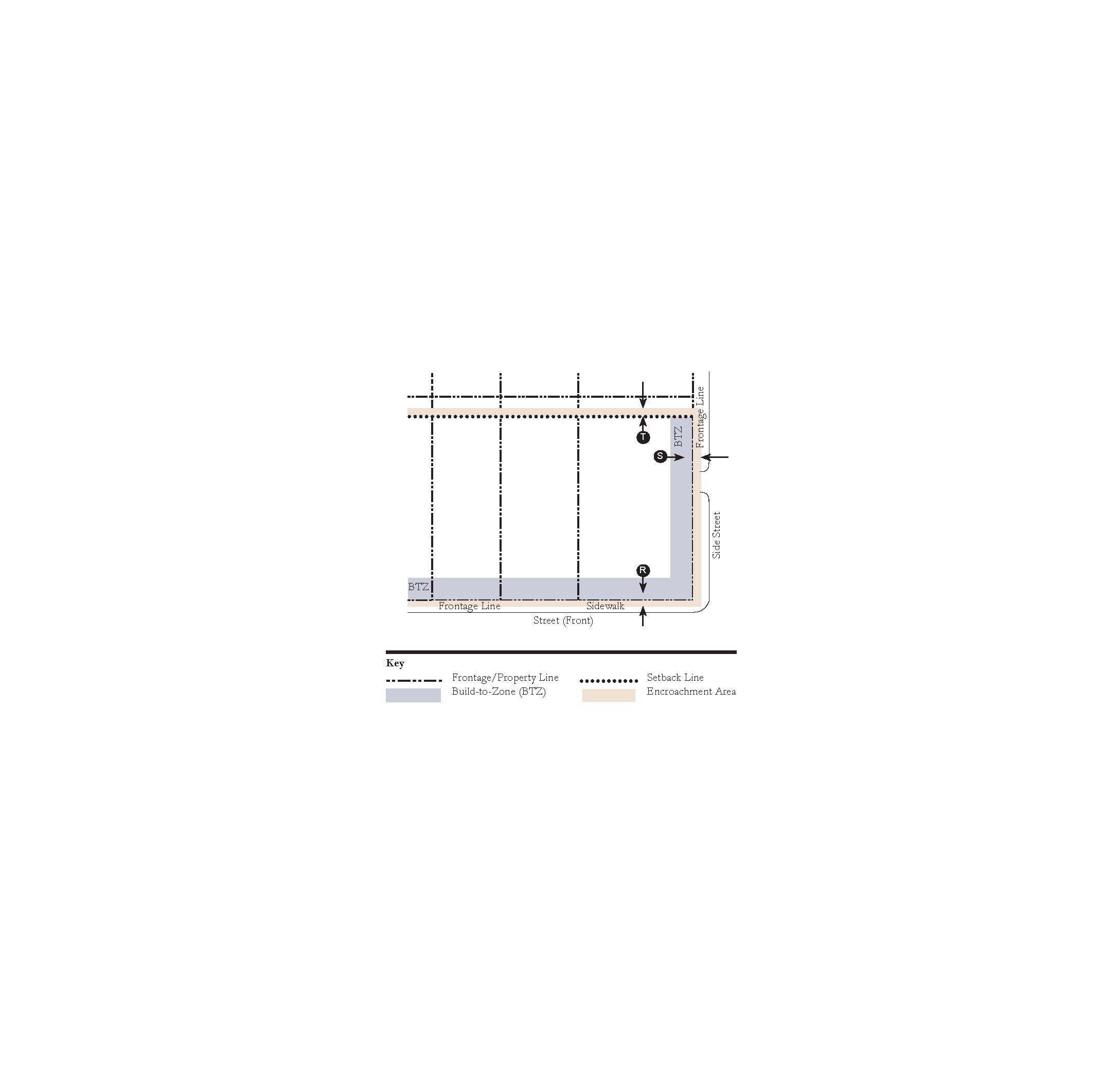
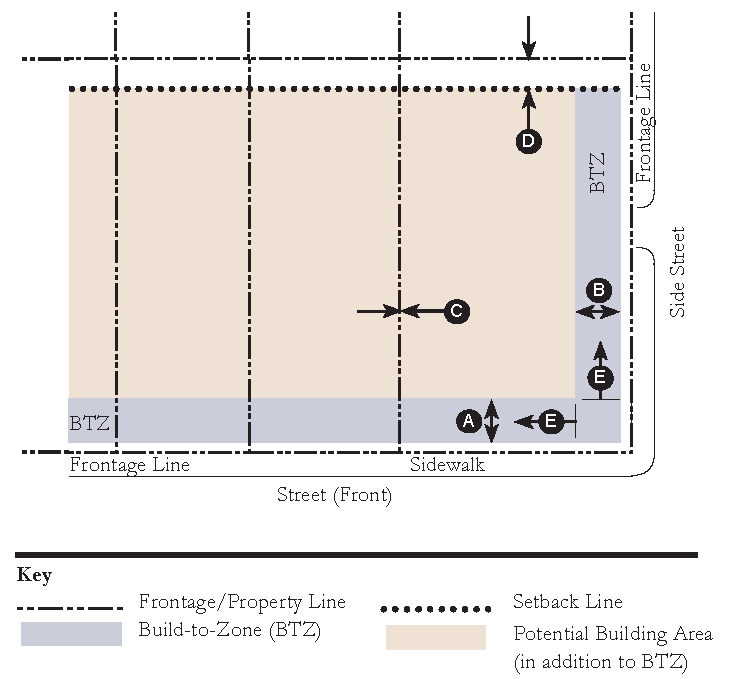
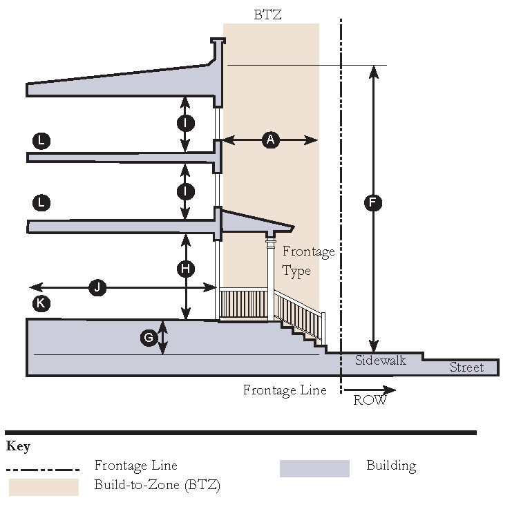
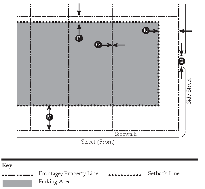
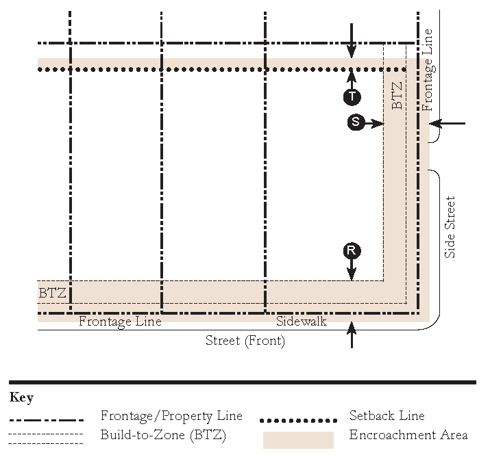
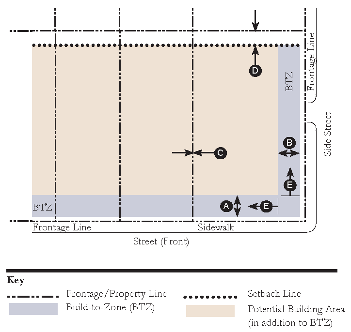
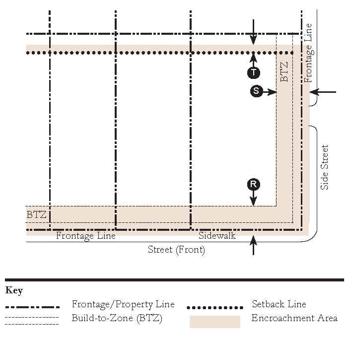
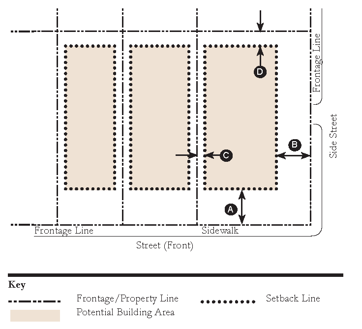
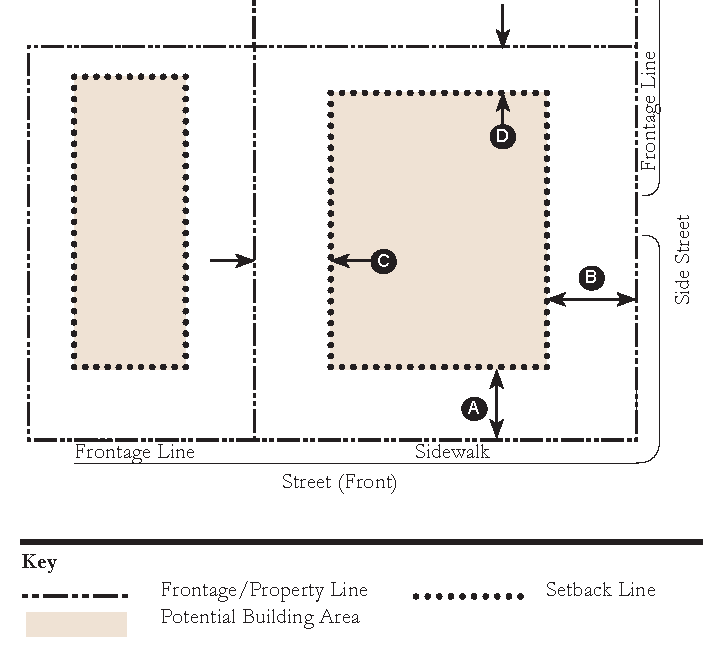
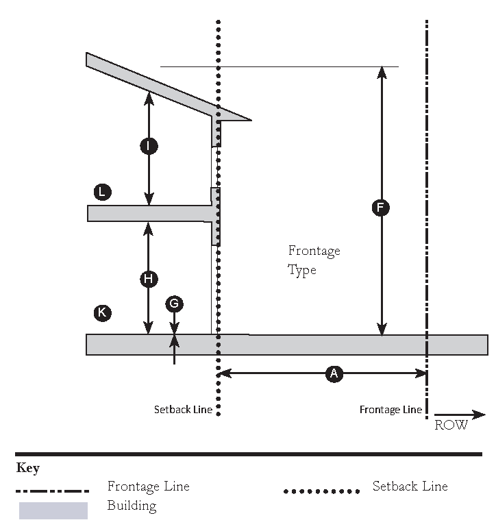
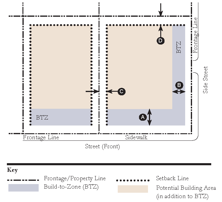
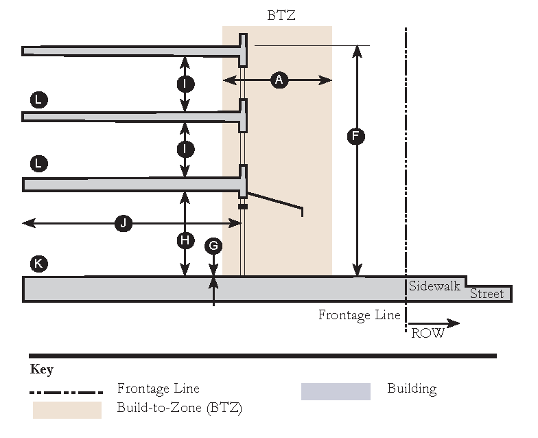
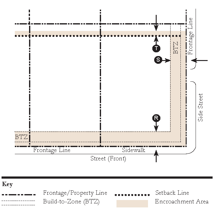
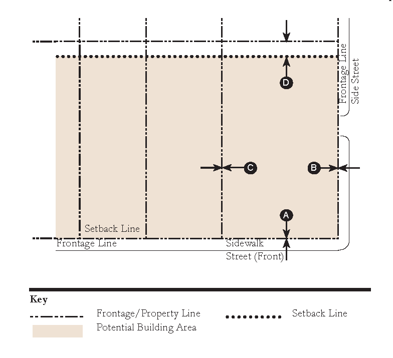
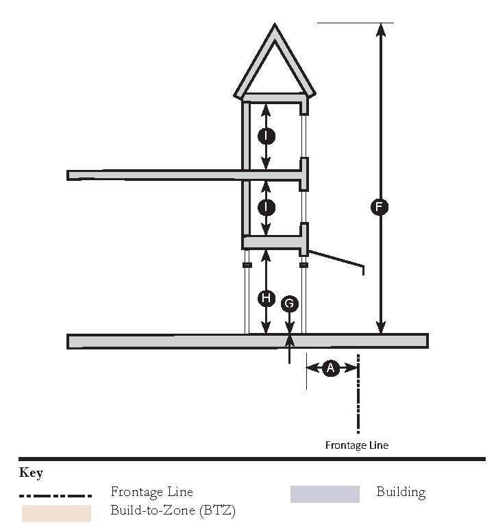
Build-to-Zone (BTZ): The range of allowable distances from the front property line along which the principal vertical plane of the building's primary façade shall be built in order to create a moderately uniform line of buildings along the street.
C
Canopy: A roof or overhead unenclosed structure that provides shade or shelter from the elements.
Civic Building: A building designed specifically for a Civic Use.
Civic Open Space: A natural or landscaped outdoor area provided for the purpose of active or passive public recreation. It may include publicly accessible outdoor amenities such as a playground, seating area, picnic area, multi-use path and temporary or permanent small outdoor performance space or religious facility.
Civic Use: A use that is open to the public at least some of the time and provides a focal point for community interaction and fosters citizen participation in civic activities, including churches, temples, synagogues, mosques, and other religious facilities; lodges; college or university facilities; exhibition halls and art galleries; grade schools; library; meeting halls; museum or similar facilities; performance theaters; post office; fire house; public administration offices; trade or specialty school facilities; or similar uses.
Common Destination: An area of focused community activity, usually defining the approximate center of a Pedestrian Shed. It may include without limitation one or more of the following: a Civic Open Space; a Civic Building; a Commercial center; a Third Place; a Meeting Hall; or a transit station, and may act as the social center of a neighborhood.
Cornice: Projecting horizontal decorative molding along the top of a wall or building.
E
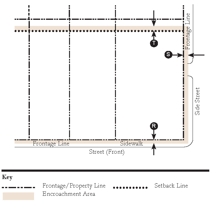
Encroachment: A structural or architectural element that breaks the plane of a vertical or horizontal regulatory limit extending into a Setback, into the Public Frontage, or into the Right-of-Way.
Exception: A type of amendment which permits a practice that is not consistent with a provision or the Intent of the PMUV as determined by the County Administration. Exceptions shall be granted only by the Martin County Board of County Commissioners.
Expression Line: A horizontal line, expressed by a material change or by a continuous projection not less than two inches nor more than one foot deep.
F
Façade: The exterior wall of a building.
Façade Transparency: The amount of transparent window glass or other openings in the façade of a building, relative to the overall surface area of the façade.
Final Site Plan: A development plan authorizing construction and development within an approved Master Site Plan in the PMUV.
Finish Level Above Sidewalk: The vertical distance between (1) the elevation of the sidewalk adjacent to the lot frontage and (2) the finished floor elevation of the unit (FFE). The porch shall be at the same elevation or up to 4" lower than the FFE.
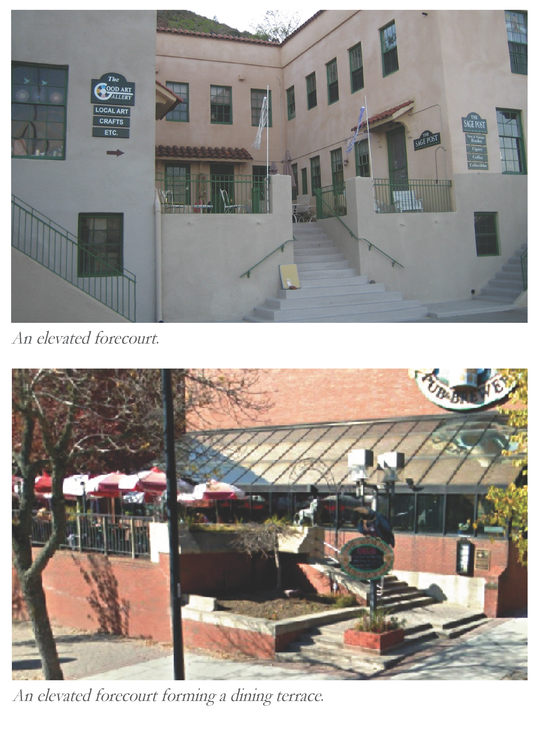
Forecourt: a Private Frontage wherein a portion of the Façade is close to the Frontage Line and the central portion is set back.
Front Façade: (Syn: Primary Façade)
Frontage: The area between a building Façade and the vehicular lanes or pedestrian-only Street, inclusive of its built and planted components.
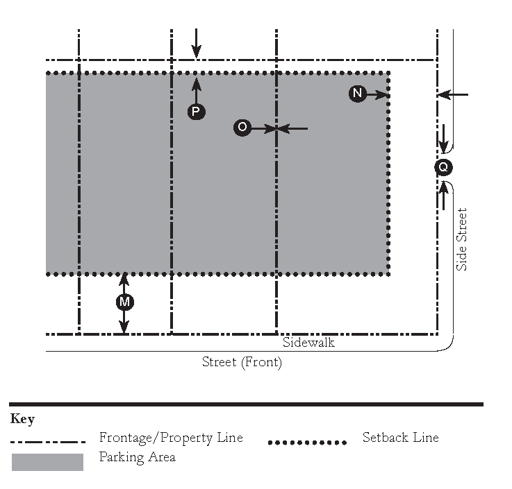
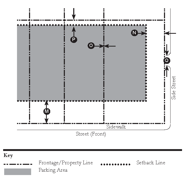
Frontage Line: A Lot Line abutting a Street Right-of-Way.
Frontage Buildout: The minimum percentage of the lot width which must be occupied by building façade within the Build-To-Zone. For example, a property which is 100 feet wide with a Frontage Buildout of 60% would require that at least 60 feet of façade length be maintained in the Build-to-Zone. Any additional length of front façade would be allowed to step back further from the Build-to-Zone, if desired. The intent of this requirement is to encourage development to maximize their front façade exposure along the Street or Civic Open Space.
Frontage Elements: The structural and architectural elements which extend outward from the Façade of a building along Frontages, including awnings, canopies, galleries, porches and stoops, and which do not count as an extension of the Façade itself for the purposes of measuring setbacks and build-to-zone.
G
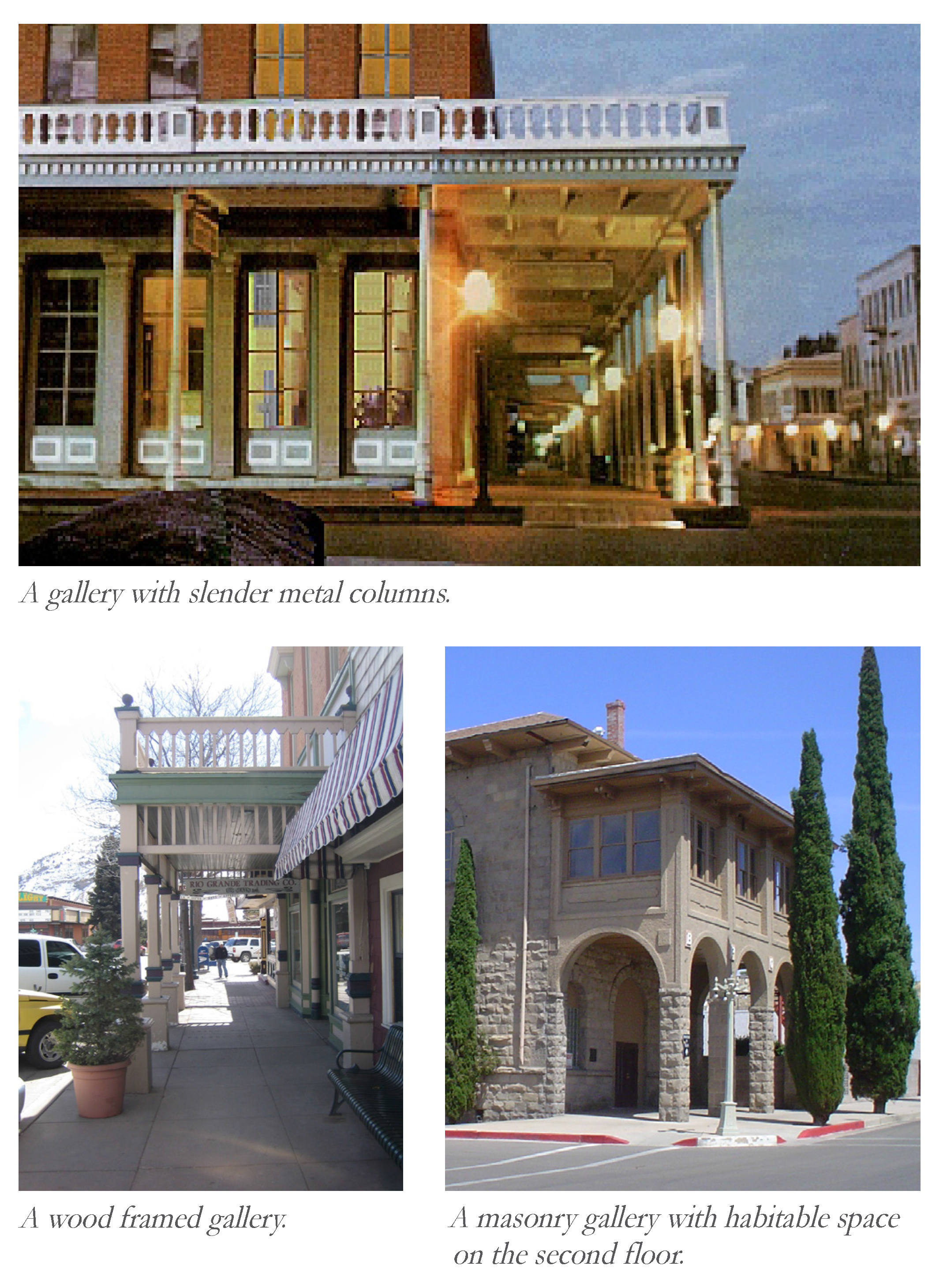
Gallery: A covered passage that is open at one side, such as a portico or a colonnade. More specifically, it is a narrow balcony or platform running the length of a wall.
Garden Wall: A wall no greater than 48" in height that defines the Frontage Line and/or the perimeter of a property, dividing private areas from streets, rear lanes, or adjacent lots.
Gas Station: A commercial enterprise established for the purpose of retail sale or supply to motor vehicles of fuel, lubrication, minor repairs to tires, minor accessories, and including the customary space and facilities for the installation of such commodities on or in vehicles, but not including space or facilities for storage, painting, repair, refinishing, body work, extensive mechanical work on or other servicing of motor vehicles.
Ground Cover: Low-growing plants other than turf grass or deciduous varieties, generally reaching a maximum height of not more than 24 inches at maturity, installed to form a continuous cover over the ground.
H
Habitable Space: Space in a structure for living, sleeping, eating or cooking. Habitable space excludes parking garages, self-service storage facilities, warehouses, display windows separated from retail activity, bathrooms, toilet rooms, closets, halls, storage or utility spaces, and similar areas.
Home Occupation: Any for-profit activity carried out within, or on the same lot as, a residential dwelling unit, by a resident of such a dwelling unit.
Hostel: An overnight lodging facility for transient guests that provides communal or dormitory-style accommodations where transient residents can rent a bed, usually a bunk bed (as opposed to renting an entire unit, as in a hotel), and share a bathroom, lounge, and sometimes a kitchen. Rooms can mixed or single-sex, although private rooms may also be available.
L
Liner Building: A building specifically designed to mask a parking lot or a parking garage from a Frontage.
Live-Work Unit: Buildings or structures used jointly for commercial and residential purposes where the residential use of the space is secondary or accessory to the primary place of work. The commercial function may be anywhere in the unit. It is intended to be occupied by a business operator who lives in the same structure that contains the commercial activity or industry.
Liquor Selling Establishment: A retail establishment where 50% or more of the income comes from alcohol sales.
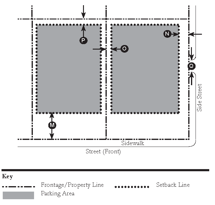
Lot: A parcel of land having specific boundaries and recorded as such in a deed or subdivision plat.
Lot Coverage: The portion of a Lot, expressed as a percentage, which may be occupied by a Principal Building and Accessory Structures, as well as sidewalks, patios, parking and loading areas, driveways, and other impermeable or man-made surfaces.
Lot Line: The lines abounding a Lot.
Lot Line, Front: The Lot Line dividing a Lot from a Street Right-of-Way. On a corner lot only one Lot Line shall be considered as a front lot line, where it is the Lot Line along the higher priority street on the street hierarchy.
Lot Line, Rear: The lot line opposite the Front Lot Line. In case of an irregular, triangular or gore-shaped lot, it shall mean a line within the lot, ten feet long, parallel to and at the maximum distance from the Front Lot Line.
Lot Line, Side: Any Lot Line which is not a Front Lot Line or Rear Lot Line.
Lot Site Plan: A plan developed for the construction on an individual parcel within a platted subdivision within the PMUV
Lot Width: The length of the Primary Frontage Line of a Lot.
M
Master Site Plan: A BCC approved plan depicting the proposed development of a neighborhood within the PMUV
Meeting Hall: A building available for gatherings, including conferences, that accommodates at least one room equivalent to a minimum of 10 square feet per projected dwelling unit within the Pedestrian Shed in which it is located.
O
Office of Settlement Architect: Established by the Settlement Founder, the Office of the Settlement Architect shall provide preliminary review of all development applications within the PMUV.
Open Space: That portion of a development that is permeable and remains open and unobstructed from the ground to the sky, specifically excluding parking areas, whether permeable or impermeable.
Outbuilding: An accessory building, usually located toward the rear of the same Lot as a Principal Building. A Backbuilding sometimes connects it to the Principal Building.
P
Pedestrian Shed: An area defined by the average distance that may be traversed at an easy walking pace from its edge to its center. This distance is applied to determine the size of a neighborhood or extent of a community. Pedestrian Sheds are oriented toward a central Common Destination. A standard Pedestrian Shed has an average Vi mile or 1,320-foot radius, which is about the distance of a five minute walk at a leisurely pace.
Place of Worship: Any structure, used on a regular basis by a group of persons who assemble for religious worship, including, but not limited to, a church, synagogue, mosque, or temple.
Playground: A Civic Open Space designed and equipped for children's recreation.
Porch: An open air element of a building with a raised floor and a roof covering the floor that is supported by columns, posts, or piers. A porch may be located on more than one story.
Primary Civic Open Space: The main outdoor gathering place for a community. It is often, but not always, associated with an important Civic Building.
Primary Façade: The façade of a building that faces the street. In the case of a corner lot, it is the façade along the higher priority street on the street hierarchy.
Primary Frontage: The Frontage along the Primary Frontage Line.
Primary Frontage Line: (Syn: Front Lot Line)
Principal Building: The main building on a Lot, usually located toward the Frontage, that contains the principal use or uses.
Principal Entrance: The main point of access for pedestrians into a building.
Property Line: (Syn: Lot Line)
Public Frontage: The area between the Vehicular Lanes and the Frontage Line.
Public Realm: The physical and social domain of the public that is held in common either by their physical presence or by visual association. This includes, but is not limited to Plazas, Squares, Parks, Thoroughfares, Public Frontages, Private Frontages, Civic Buildings and Civic Open Spaces.
R
Rain Garden: A small or residential landscape feature with a slight depression used to slow, collect, infiltrate, and filter stormwater that is vegetated with plants that can withstand moisture regimes ranging from flooded to dry.
Regulating Plan: A map that shows the physical locations and boundaries of Neighborhoods, primary streets, and Open Spaces subject to regulation by this Article.
Right-of-Way: A strip of land dedicated, deeded, used or intended to be used, for a street, alley, walkway, boulevard, railroad, drainage facility, access for ingress or egress, electric transmission line, oil and gas pipeline, sanitary and stormwater sewer line, or other purpose by the public, certain designated persons, or governing bodies. It is an appropriation of the land to some public use made by the owner and accepted for such use by the public.
S
Settlement Founder: The original holder of title to the area incorporated as the Planned Mixed-Use Zoning District.
Sign Band: An area on a building above the entrance(s) to tenant spaces that accommodates signage for each tenant.
Single-Family Residence: A building comprised of one or more rooms providing cooking, sleeping, and sanitary facilities, designed for the exclusive use of a single family.
Small Footprint Tower: A stand-alone structure that is significantly taller than it is wide, or a portion of a building that is significantly taller than it is wide and typically has more detail than the surrounding building(s). When a tower is a portion of a building, the tower eave or cornice is taller than the remainder of the building eave or cornice height and one or more of the tower facades is located forward of the remaining building façade.
Story: That part of a building contained between any floor and the floor or roof next above.
Street: A public or private thoroughfare which affords the principal means of access to abutting property for use by motor vehicles, bicycles, and pedestrians. A street may be for use by pedestrians only or prohibit motor vehicles.
Setbacks: The minimum distance a building façade or parking area must be located from a frontage line or public right-of-way line.
Streetscreen: Sometimes called streetwall. A freestanding wall built along the frontage line, or coplanar with the facade, often for the purpose of masking a parking lot from the thoroughfare.
T
Terminated Vista: A building, structure, or portion of a building or structure, specifically designed to visually attract a viewer's attention at the end of a visual axis, i.e. to terminate a view. A Terminated Vista may include towers, corner towers, symmetrical facades centered on a visual axis, an architecturally embellished entry, or similar distinctive architectural devices.
Third Place: A private building that includes a space conducive to unstructured social gathering. Third Places are usually bars, cafes, and corner stores.
Thoroughfare: A way for use by vehicular and pedestrian traffic, or pedestrian traffic only, and to provide access to Lots and Open Spaces, consisting of Public Frontage and often Vehicular Lanes.
Trail Head: The point at which a trail begins. Trail heads often contain rest rooms, sign posts and distribution centers for informational brochures about the trail and its features, and parking areas for vehicles and trailers.
Transect (Transect Zone): A planning and zoning tool that organizes zones in a continuum from rural to urban, referred to as Tl, T2, T3, T4, T5, and T6 where Tl is the most rural and T6 is the most urban. Each Transect zone has common characteristics that facilitate form-based regulation.
Tree Canopy Coverage: The percent of land area that is covered by the layer of leaves, branches, and stems of trees that cover the ground when viewed from above.
V
Vehicular Lanes: the lanes providing traffic and parking capacity within a Thoroughfare. They usually consist of marked lanes in a variety of widths for parked and for moving vehicles.
W
Warrant: A type of amendment which permits a practice that is not consistent with a specific provision of the PMUV but is justified by the practice's Intent as determined by the Growth Management Department. Warrants may be granted administratively by the County Administrator or Designee.
(Ord. No. 1235, Pt. I, 11-12-2024)
Sec. 11.1.6. - Acronyms.
For the purposes of this article, the following acronyms shall have the meanings set forth below:
11.1.6.G.
Acronyms.
BCC: Board of County Commissioners
CGMP: Comprehensive Growth Management Plan
FBC: Form-Based Code
LDR: Land Development Regulations
MUV: Mixed-Use Village Future Land Use
OSA: Office of Settlement Architect
PAMP: Preserve Area Management Plan
PMUV: Planned Mixed-Use Village Zoning District
Sec. 11.2.1. - Regulating Plan.
11.2.1.A.
Development planning within the PMUV begins with the creation of the Regulating Plan (see Figure 2-1). The Regulating Plan establishes the general location, size and type of neighborhoods, as well as other important elements that define the overall structure of the proposed development. The Regulating Plan is a regulatory document. Development within the PMUV shall be consistent with the Regulating Plan.
11.2.1.B.
The Regulating Plan shall clearly illustrate the following:
1.
The Primary Urban Services Boundary (PUSB);
2.
Neighborhood Types and general boundaries;
3.
Preserve areas, including wetlands and wetland buffers in accordance with the CGMP and Article 4, LDRs; and
4.
Primary Thoroughfares.
11.2.1.C.
The neighborhood boundaries shown on the Regulating Plan and the location of Primary Thoroughfares are subject to adjustment pursuant to applicable amendment provisions.
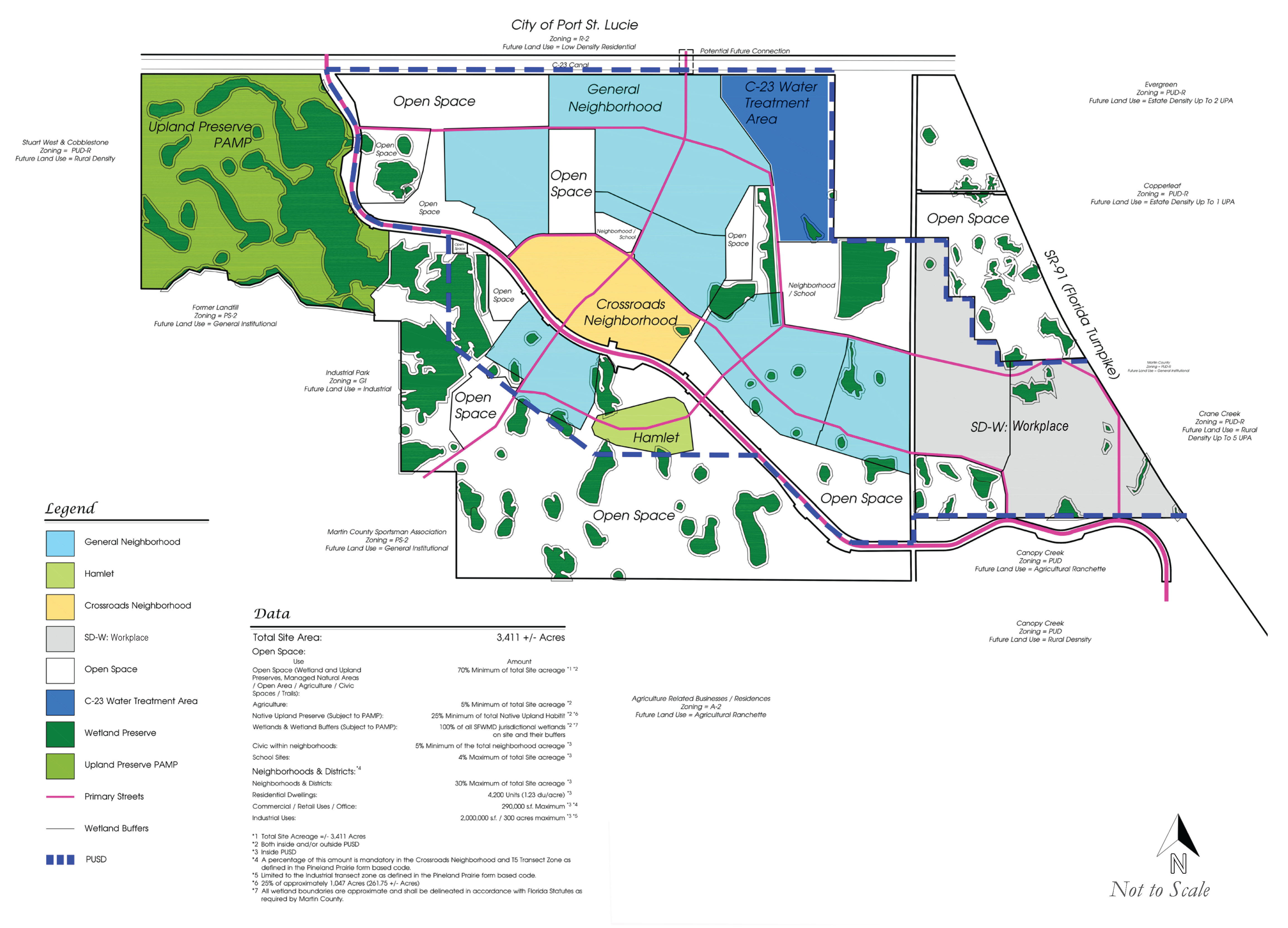
Figure 2-1: The Regulating Plan for PMUV.
Sec. 11.2.2. - General Neighborhood Standards.
11.2.2.A.
Each neighborhood shall contain a mix of Transect Zones corresponding to the neighborhood Type as established in Table 3-1.
11.2.2.B.
Each neighborhood shall assign at least 5 percent of its transected area to Civic Open Space.
11.2.2.C.
Each neighborhood shall contain at least one Primary Civic Open Space (not a Playground) and that Primary Civic Open Space shall be within 800 feet of the geographic center of the neighborhood.
11.2.2.D.
Every neighborhood shall have at least one Playground.
11.2.2.E.
Each neighborhood shall have at least one Meeting Hall or Third Place in close proximity to its Primary Civic Open Space.
11.2.2.F.
Each neighborhood shall have at least one Civic Building (such as but not limited to a childcare center, fire station, or pavilion) in close proximity to or within its Primary Civic Open Space.
Sec. 11.2.3. - Block Structure.
11.2.3.A.
To facilitate connectivity and pedestrian accessibility, the Blocks within the PMUV neighborhoods shall conform to the following standards:
1.
Maximum block sizes shall not exceed the maximum block perimeter established for each Transect Zone.
2.
The average perimeter of all blocks in a neighborhood shall not exceed 1,800 linear feet with the exception of Workplace District neighborhoods, which shall not exceed 3,000 linear feet.
3.
Any block face within the T5, T4-0, T4-R, T3 or Civic Transect Zones that exceeds 600' in length shall have a mid-block pedestrian access of at least 8' in width.
Sec. 11.3.1. - Purpose, Intent and General Standards.
11.3.1.A.
The Transect is a planning and zoning tool that organizes zones in a continuum from rural to urban, referred to as Tl, T2, T3, T4-R, T4-0, and T5. Two additional zones are the Special District—Workplace and Civic zones, which cover building types and uses that do not fit into any of the previous categories. Each Transect Zone has a different set of characteristics that correspond with building placement, building form, and frontage standards, all of which influence the neighborhood. Transect Zones are applied at the Master Plan level and remain consistent throughout development planning.
11.3.l.B.
Within each Neighborhood, each T3, T4-R, T4-0, and T5 Transect Zone shall contain at least three different permitted residential building types. The SD-W Transect Zone shall contain at least two different permitted residential building types within each Neighborhood. The permitted residential building types for each Transect Zone are established in Table 3-3 in Sec. 11.3.5.
11.3.l.C.
For those portions of the PMUV that are not within a Neighborhood, only the Tl, T2, and Civic Transect Zones can be applied.
11.3.1.D.
General Standards.
1.
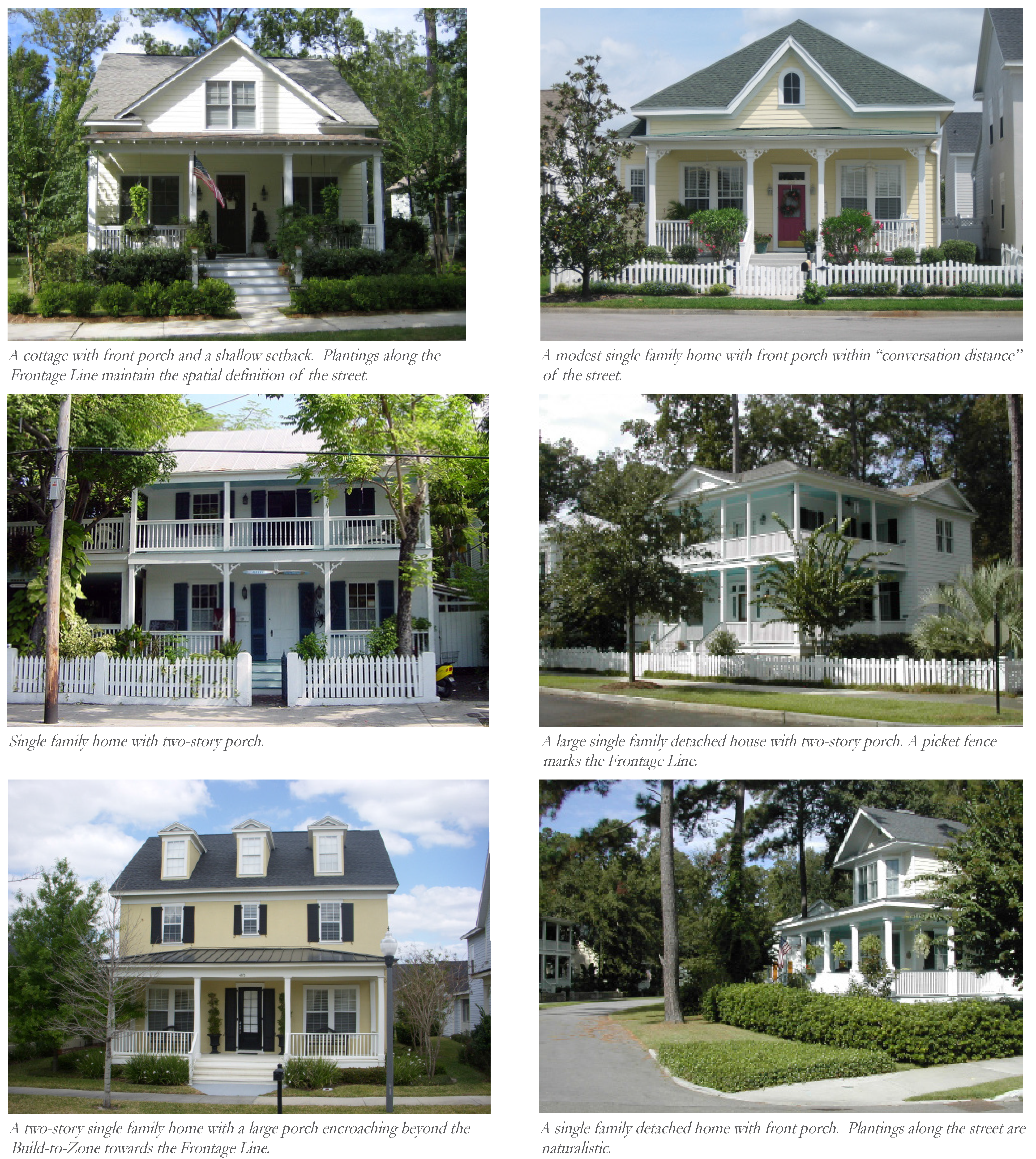
Precedent images are for illustrative purposes only to demonstrate the intent of the standards. They are provided as examples, and shall not imply that every element in the image is permitted.
2.
The allocation of Transect Zones and required Civic Open Space by percentage are based on gross area allocated transect zones within each neighborhood. Gross area transect zone allocation within neighborhoods does not include wetlands or areas designated with the T1 Transect.
3.
Minimum residential density is measured for the total net acres allocated to each Transect Zone within each neighborhood. The net acre calculation does not include Right-of-Ways.
4.
Accessory Dwelling Units do not constitute a separate unit for the purpose of calculating residential density.
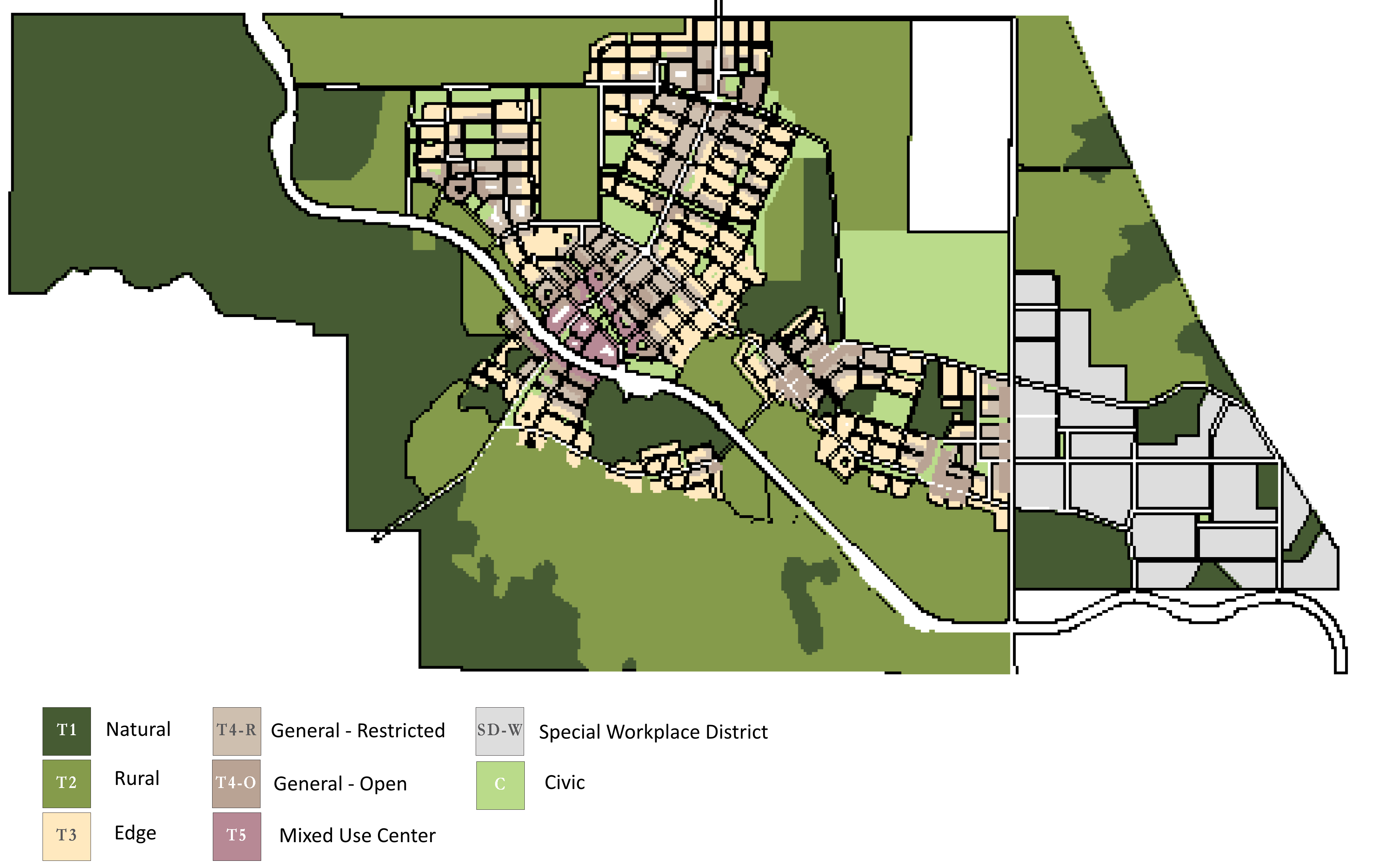
Figure 3-1: This illustration is not regulatory and depicts a possible application
of Transect Zones within the Neighborhood Regulating Plan.
(Ord. No. 1235, Pt. II, 11-12-2024)
Sec. 11.3.2. - Transect Zones.
11.3.2.A.
Standards for each of the Transect Zones are shown for comparison in Table 3-2. Each zone is further described in Sec. 11.3.6 through Sec. 11.3.13.
Sec. 11.3.3. - Open Space & Preserves.
The Tl Natural Zone and much of the T2 Rural lands, which may include farmland and other open space, will be protected in perpetuity by severing their development rights, placing open-space easements on the land, and recording those easements as legally binding deed restrictions.
Sec. 11.3.4. - Neighborhood Types and Transect Zones Summary Charts.
Tables 3-1 and Table 3-2 are set forth herein:
Notes:
At least 500 linear feet of Frontage shall be ground floor Office or Retail use with
a Shop front Frontage Type, exclusive of any grocery store Frontage.
2. ;hg;Where a mix of T4 R/O transect is permitted, the minimum transect allocation
may be achieved through either transect exclusively or a combination of both. When
combined, minimum density shall be applied proportionally in the same percentage as
the proposed transect area combination (e.g. if 40 acres of T4 have 30 acres of T4-O
and 10 acres of T4-R, the T4-O acreage will have a minimum density of 20 du/ac and
the 10 acres will have a minimum density of 12 du/ac).
Notes:
Accessory Dwelling Units do not constitute a separate unit for the purpose of calculating
residential density.
2. ;hg;See Division 1 for definition.
3. ;hg;Accessory uses setback is 3 feet from property line
4. ;hg;Lot coverage maximum is 90% with townhome or multi-family building type.
(Ord. No. 1235, Pt. II, 11-12-2024)
Sec. 11.3.5. - Permitted Uses.
Table 3-3: Permitted Uses
The allowable uses in each Transect Zone are as set forth in the Permitted Uses Table herein.
11.3.5.A.
Only those land uses that are listed in Permitted Uses Table 3-3 are the allowed land uses in the PMUV. As a general consideration, land uses not listed in the table are prohibited unless the applicant applies for an Exception in accordance with Section 11.7.7
■ = By Right □ = By Warrant
RESIDENTIAL TYPES
LODGING
OFFICE
RETAIL
CIVIC
OTHER: CIVIL SUPPORT
OTHER: EDUCATION
OTHER: INDUSTRIAL
OTHER: AGRICULTURE
OTHER: AUTOMOTIVE
(Ord. No. 1235, Pt. II, 11-12-2024)

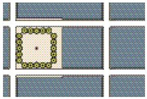
Sec. 11.3.6. - T5 Mixed Use Center.
11.3.6.A.
Overview.
This Transect Zone is found in the core of the PMUV Crossroads Neighborhood and may be found in other Neighborhood Centers. Priority is placed on optimizing the physical characteristics of the built environment for increased walkability and a vibrant center.
To maximize vibrancy and walkability, this Transect Zone permits the greatest intensity and mix of uses with buildings located close to the sidewalk, plentiful shade for pedestrians, and parking lots screened from public view. Building heights are permitted to be the tallest here, consistent with the CGMP, to create landmark defining features and terminate important vistas.
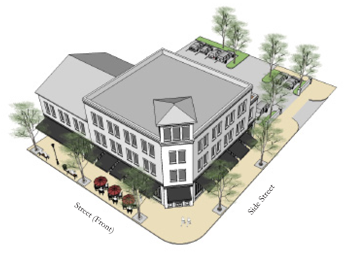
Figure 3-2: Illustrative example of buildings and site arrangement in the TS Mixed
Use Center Zone.
11.3.6.B.
Examples.
11.3.6.C.
Form.
| a. Building Placement | ||
| Setbacks | ||
| Front Build-to-Zone | 0' min., 10'max. | |
| Side Street Build-to-Zone | 0' min., 10'max. | |
| Interior Side Property Line Setback | 0' min. | |
| Rear Setback | 5' min. | |
| Frontage Buildout | ||
| Building Façade with Build-to-Zone | ||
|
Front Street Frontage
Side Street Frontage |
80% min.
30% min. | |
| Street Façades must be built to the BTZ for the first 30' on a corner. | ||
| b. Lot and Block Standards | ||
| Maximum Block Perimeter | 2,000 linear feet max. | |
| Lot Width | 18' min., 180' max | |
| Lot Depth | 30' min., 180' max | |
| Lot Coverage | 100% max. | |
| c. Building Form | ||
| Height | ||
| Main Building | 22' min. 1 | |
| 3 Stories max. 1 | ||
| Ground Floor Elev. Above Sidewalk | Comm. 6" max., Res. 24" min. | |
| Ground Floor Office/Retail Ceiling | 14' min. clear | |
| Ceiling Height | 9' min. clear | |
| 1 See Sec. 11.4.5. General Building Standards for more information | ||
| Footprint | ||
| Depth, ground floor commercial space: | 35' min. | |
| d. Allowed Frontage Types | ||
| ■ Shop front | ■ Gallery | |
| ■ Forecourt | ■ Stoop | |
| *See General Standards for Frontage details. | ||
| e. Allowed Use Types | ||
| Ground Floor | All Permitted Uses Allowed | |
| All Floors Otherwise | All Permitted Uses Allowed | |
11.3.6.D.
Parking & Encroachments.
| f. Parking | ||
| Parking Location (Distance from Property Line | ||
| Front Setback | 30' min. | |
| Side Street Setback | 30' min. | |
| Side Setback | 0' min. | |
| Rear Setback | 5' min. | |
| District Specific Parking Requirements | ||
| Parking shall be provided as established in Section 11.6.2 | ||
| Parking shall be located behind the Front Façade of buildings and accessed from Alleys or Side Streets whenever possible. | ||
| Streetscreens, Garden Walls, fences, or hedges are required along all un-built Street Right-of-Ways to shield views to parking. | ||
| Parking Curb Cut Width | 26' max. | |
| g. Allowed Encroachments | ||
| Balconies, Bay Windows, Awnings, Galleries, Stoops, and Other Frontage Elements | ||
| Front | 12' max. | |
| Side Street | 8' max. | |
| Rear | 4' max. | |
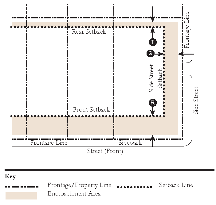
| Note: Frontage Elements may Encroach forward of the Build-to-Zone and/or into the Right-of-Way, barring any additional restrictions by the public entity that has control over the public Right-of-Way. A 6 foot minimum sidewalk clear zone must be maintained. | ||
| h. Miscellaneous | ||
| All buildings must have a Principal Entrance along the Front Façade. | ||
| Loading docks, overhead doors, and other service entries shall not be located on Façades facing Streets or across from, or adjacent to, Civic Building Frontages or Civic Open Spaces, and should instead be located in rear service areas. | ||
(Ord. No. 1235, Pt. II, 11-12-2024)

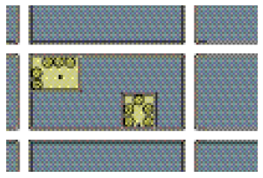
Sec. 11.3.7. - T4-O General—Open.
11.3.7.A.
Overview.
This Transect Zone provides a mix of uses and residential types in a pedestrian-oriented urban form. Buildings are typically attached with Front Façades located close to the sidewalk. This Transect Zone is appropriate at the center of Neighborhoods.
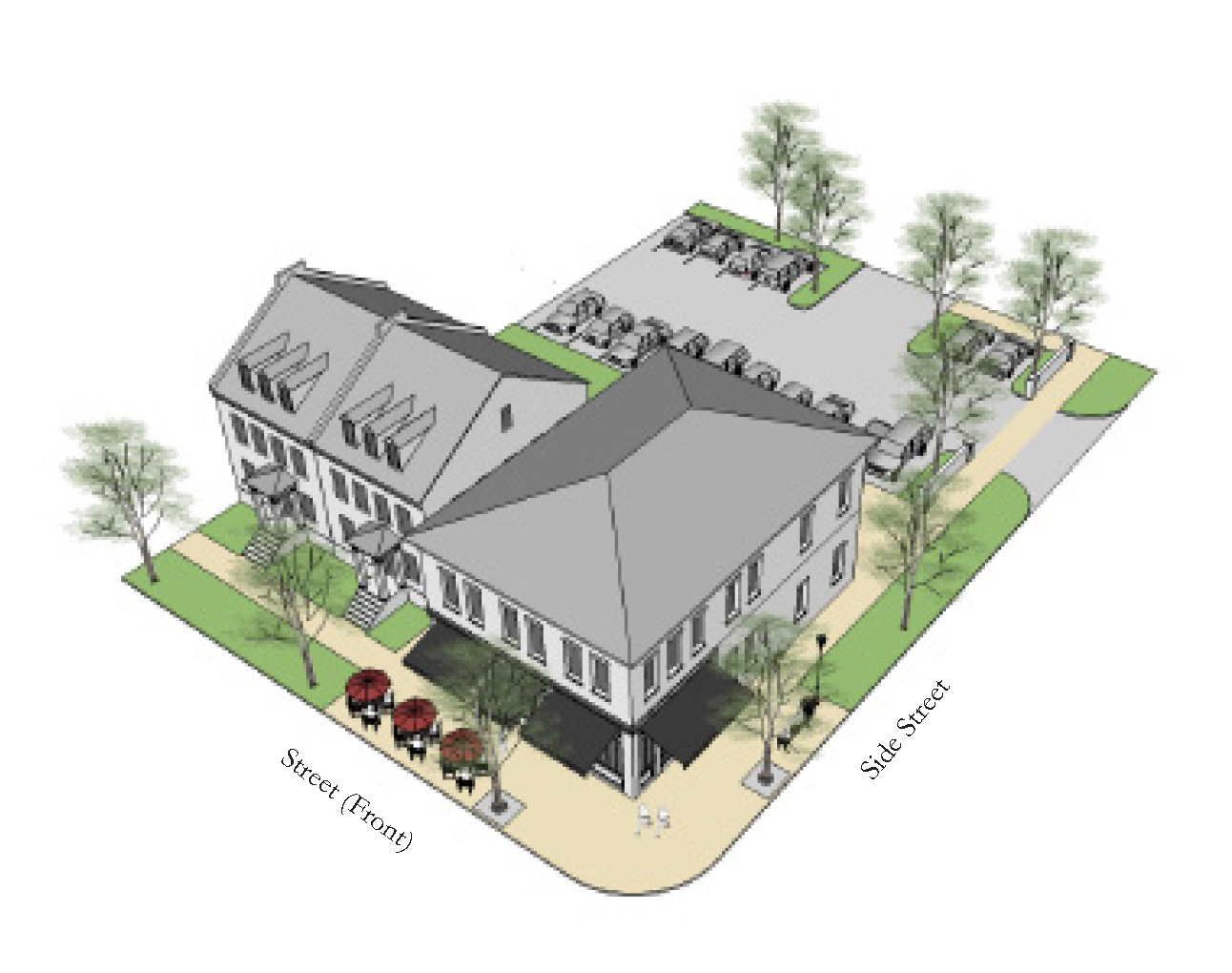
Figure 3-3: Illustrative example of buildings and site arrangement in the T4 General
Zone.
11.3.7.B.
Examples.
11.3.7.C.
Form.
| a. Building Placement | ||
| Setbacks | ||
| Front Build-to-Zone | 6' min., 18' max. | |
| Side Street Build-to-Zone | 6' min., 18' max. | |
| Interior Side Property Line Setback | 0' min. | |
| Rear Setback | 5' min. | |
| Frontage Buildout | ||
| Building Façade with Build-to-Zone | ||
| Front Street Frontage | 60% min. | |
| Side Street Frontage | 30% min. | |
| Street Façades must be built to the BTZ for the first 30' on a corner. | ||
| b. Lot and Block Standards | ||
| Maximum Block Perimeter | 2,000 linear feet max. | |
| Lot Width | 18' min., 200' max | |
| Lot Depth | 80' min., 300' max | |
| Lot Coverage | 70% max. (90% max. for townhouse and multi-family building type) | |
| c. Building Form | ||
| Height | ||
| Main Building | 16' min. 1 | |
| 3 Stories max. 1 | ||
| Ground Floor Elev. Above Sidewalk | Comm. 6" max., Res. 24" min. | |
| Ground Floor Office/Retail Ceiling | 12' min. clear | |
| Ceiling Height | 9' min. clear | |
| 1 See Sec. 11.4.5. General Building Standards for more information | ||
| Footprint | ||
| Depth, ground floor commercial space: | 35' min. | |
| d. Allowed Frontage Types* | ||
| ■ Shop front | ■ Gallery | |
| ■ Forecourt | ■ Stoop | |
| ■ Porch | ||
| *See General Standards for Frontage details. | ||
| e. Allowed Use Types | ||
| Ground Floor | All Permitted Uses Allowed | |
| All Floors Otherwise | All Permitted Uses Allowed | |
11.3.7.D.
Parking & Encroachments.
| f. Parking | ||
| Parking Location (Distance from Property Line | ||
| Front Setback | 30' min. | |
| Side Street Setback | 20' min. | |
| Side Setback | 0' min. | |
| Rear Setback | 5' min. | |
| District Specific Parking Requirements | ||
| Parking shall be provided as established in Section 11.6.2 | ||
| Parking shall be located behind the Front Façade of buildings and accessed from Alleys or Side Streets whenever possible. | ||
| Streetscreens, Garden Walls, fences, or hedges are required along all un-built Street Right-of-Ways to shield views to parking. | ||
| Parking Curb Cut Width | 26' max. | |
| g. Allowed Encroachments | ||
| Balconies, Bay Windows, Awnings, Galleries, Stoops, and Other Frontage Elements | ||
| Front | 12' max. | |
| Side Street | 8' max. | |
| Rear | 4' max. | |
| Note: Frontage Elements may Encroach forward of the Build-to-Zone and/or into the Right-of-Way, barring any additional restrictions by the public entity that has control over the public Right-of-Way. A 6 foot minimum sidewalk clear zone must be maintained. | ||
| h. Miscellaneous | ||
| All buildings must have a Principal Entrance along the Front Façade. | ||
| Loading docks, overhead doors, and other service entries shall not be located on Façades facing Streets or across from, or adjacent to, Civic Building Frontages or Civic Open Spaces, and should instead be located in rear service areas. | ||
(Ord. No. 1235, Pt. II, 11-12-2024)

Sec. 11.3.8. - T4-R General—Restricted.
11.3.8.A.
Overview.
This Transect Zone shares the same form and building characteristics as the T4-0 zone, but the uses are restricted to residential and Home Occupations.
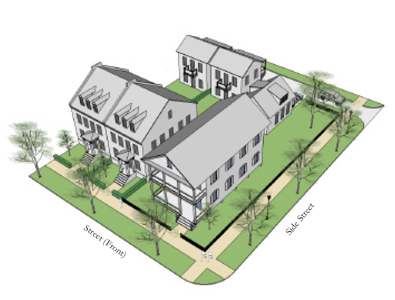
Figure 3-3: Illustrative example of buildings and site arrangement in the T4 General
Zone.
11.3.8.B.
Examples.
11.3.8.C.
Form.
| a. Building Placement | ||
| Setbacks | ||
| Front Build-to-Zone |
6' min., 18' max.
| |
| Side Street Build-to-Zone |
6' min., 18' max.
| |
| Interior Side Property Line Setback |
0' min.
| |
| Rear Setback |
5' min.
| |
| Frontage Buildout | ||
| Building Façade with Build-to-Zone | ||
| Front Street Frontage | 60% min. | |
| Side Street Frontage | 30% min. | |
| Street Façades must be built to the BTZ for the first 30' on a corner. | ||
| b. Lot and Block Standards | ||
| Maximum Block Perimeter | 2,000 linear feet max. | |
| Lot Width | 18' min., 200' max | |
| Lot Depth | 80' min., 300' max | |
| Lot Coverage | 70% max. (90% max. for townhouse and multi-family building type) | |
| c. Building Form | ||
| Height | ||
| Main Building |
16' min.
1
| |
|
3 Stories max.
1
| ||
| Ground Floor Elev. Above Sidewalk |
Res. 24" min.
| |
| Ground Floor Ceiling Height |
9' min. clear
| |
| Ceiling Height |
9' min. clear
| |
| 1 See Sec. 11.4.5. General Building Standards for more information | ||
| d. Allowed Frontage Types | ||
| ■ Porch | ■ Gallery | |
| ■ Forecourt | ■ Stoop | |
| *See General Standards for Frontage details. | ||
| e. Allowed Use Types | ||
| Ground Floor |
All Permitted Uses Allowed
| |
| All Floors Otherwise |
All Permitted Uses Allowed
| |
11.3.8.D.
Parking & Encroachments.
| f. Parking | ||
| Parking Location (Distance from Property Line | ||
| Front Setback |
30' min.
| |
| Side Street Setback |
20' min.
| |
| Side Setback |
0' min.
| |
| Rear Setback |
5' min.
| |
| District Specific Parking Requirements | ||
| Parking shall be provided as established in Section 11.6.2 | ||
| Parking shall be located behind the Front Façade of buildings and accessed from Alleys or Side Streets whenever possible. | ||
| Streetscreens, Garden Walls, fences, or hedges are required along all un-built Street Right-of-Ways to shield views to parking. | ||
| Parking Curb Cut Width |
20' max.
| |
| g. Allowed Encroachments | ||
| Balconies, Bay Windows, Awnings, Galleries, Stoops, and Other Frontage Elements | ||
| Front |
12' max.
| |
| Side Street |
8' max.
| |
| Rear |
4' max.
| |
| Note: Frontage Elements may Encroach forward of the Build-to-Zone and/or into the Right-of-Way, barring any additional restrictions by the public entity that has control over the public Right-of-Way. A 6 foot minimum sidewalk clear zone must be maintained. | ||
| h. Miscellaneous | ||
| All buildings must have a Principal Entrance along the Front Façade. | ||
| Loading docks, overhead doors, and other service entries shall not be located on Façades facing Streets or across from, or adjacent to, Civic Building Frontages or Civic Open Spaces, and should instead be located in rear service areas. | ||
(Ord. No. 1235, Pt. II, 11-12-2024)

Sec. 11.3.9. - T3 Edge.
11.3.9.A.
Overview.
This Transect Zone is predominately residential. Buildings are primarily detached with a few attached building types in this zone. The built environment in this area is intended to retain key features of walkability with front porches within conversation distance of the sidewalk.
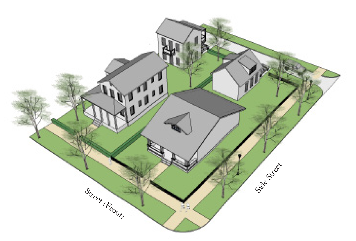
Figure 3-5: Illustrative example of buildings and site arrangement in the T3 Edge
Zone.
11.3.9.B.
Examples.
11.3.9.C.
Form.
| a. Building Placement | ||
| Setbacks | ||
| Front Setback |
20' min.
| |
| Side Street Setback |
12' min.
| |
| Interior Side Property Line Setback |
8' min.
| |
| Rear Setback |
10' min.
| |
| Frontage Buildout | ||
| Building Façade with Build-to-Zone | ||
| Front Street Frontage | 40% min. | |
| Side Street Frontage | 30% min. | |
| b. Lot and Block Standards | ||
| Maximum Block Perimeter | 2,400 linear feet max. | |
| Lot Width | 40' min. | |
| Lot Depth | 80' min. | |
| Lot Coverage | 60% max. | |
| c. Building Form | ||
| Height | ||
| Main Building |
1 story min.
1
| |
|
2 stories max.
1
| ||
| Ground Floor Elev. Above Sidewalk |
Res. 24" min.
| |
| Ground Floor Ceiling Height |
9' min. clear
| |
| Ceiling Height |
9' min. clear
| |
| 1 See Sec. 11.4.5. General Building Standards for more information | ||
| d. Allowed Frontage Types | ||
| ■ Common Yard | ■ Porch | |
| ■ Stoop | ||
| *See General Standards for Frontage details. | ||
| e. Allowed Use Types | ||
| Ground Floor |
All Permitted Uses Allowed
| |
| All Floors Otherwise |
All Permitted Uses Allowed
| |
11.3.9.D.
Parking & Encroachments.
| f. Parking | ||
| Parking Location (Distance from Property Line | ||
| Front Setback |
30' min.
| |
| Side Street Setback |
20' min.
| |
| Side Setback |
8' min.
| |
| Rear Setback |
5' min.
| |
| District Specific Parking Requirements | ||
| Parking shall be provided as established in Section 11.6.2 | ||
| Parking shall be located behind the Front Façade of buildings and accessed from Alleys or Side Streets whenever possible. | ||
| Streetscreens, Garden Walls, fences, or hedges are required along all un-built Street Right-of-Ways to shield views to parking. | ||
| Curb cuts are not permitted if a Alley is present. | ||
| Parking Curb Cut Width |
20' max.
| |
| g. Allowed Encroachments | ||
| Balconies, Bay Windows, Awnings, Galleries, Stoops, and Other Frontage Elements | ||
| Front |
12' max.
| |
| Side Street |
8' max.
| |
| Rear |
4' max.
| |
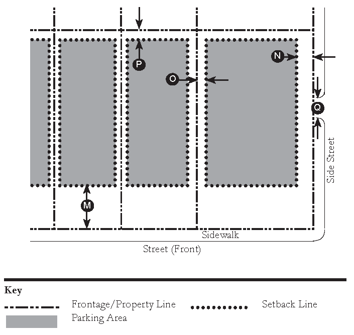
| Note: Frontage Elements may Encroach forward of the Setback Line, but shall not Encroach into the Right-of-Way. | ||
| h. Miscellaneous | ||
| All buildings must have a Principal Entrance along the Front Façade. | ||

Sec. 11.3.10. - T2 Rural.
11.3.10.A.
Overview.
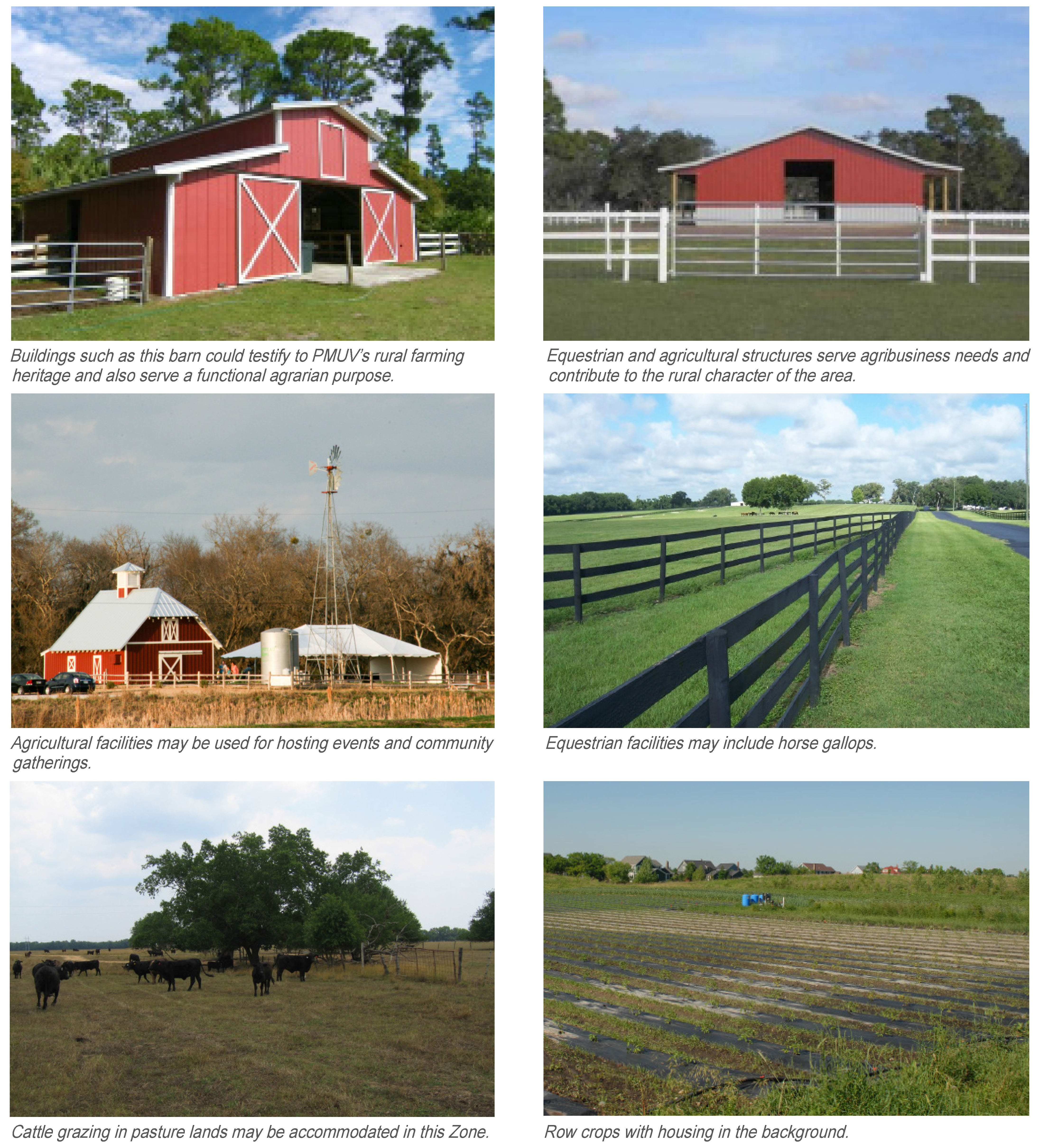
The Rural Transect Zone depicts a mix of uses such as recreation, farming, equestrian facilities, and open space, and is less formal than the other Transect Zones, allowing more flexibility in building placement. Development associated with these uses is permitted in this Transect Zone. This Transect Zone facilitates the transition from the more developed areas to the natural areas of the PMUV.
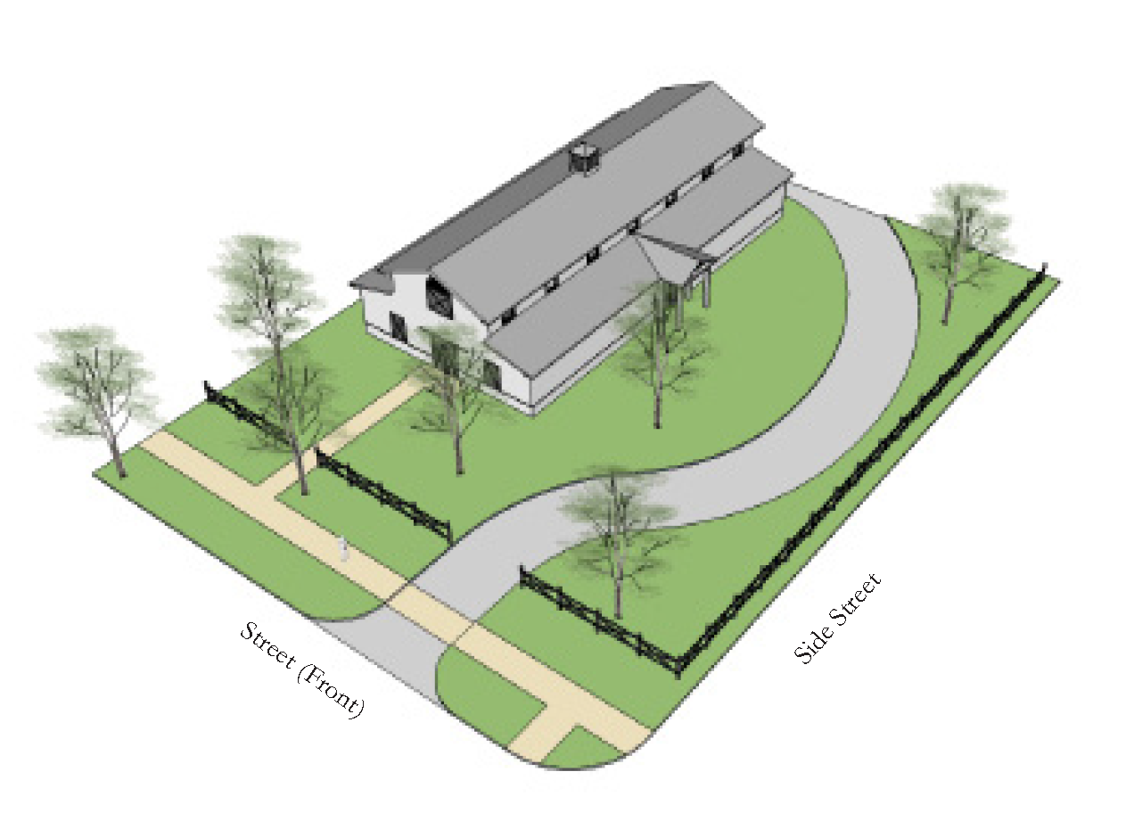
Figure 3-5: Illustrative example of buildings and site arrangement in the T2 Rural
Zone.
11.3.10.B.
Examples.
11.3.10.C.
Form.
| a. Building Placement | ||
| Setbacks | ||
| Front Setback |
20' min.
| |
| Side Street Setback |
20' min.
| |
| Interior Side Property Line Setback |
30' min.
| |
| Rear Setback |
30' min.
| |
| Frontage Buildout | ||
| Building Façade along: | ||
| Front Street Frontage | N/A | |
| Side Street Frontage | N/A | |
| b. Lot and Block Standards | ||
| Maximum Block Perimeter | N/A | |
| Lot Width | N/A | |
| Lot Depth | N/A | |
| Lot Coverage | N/A | |
| c. Building Form | ||
| Height | ||
| Main Building |
1 story min.
1
| |
|
2 Stories max.
1, 2
| ||
| Ground Floor Elev. Above Sidewalk |
Comm. 6" max., Res. 24" min.
| |
| Ground Floor Ceiling Height |
9' min. clear
| |
| Ceiling Height |
9' min. clear
| |
|
1
See Sec. 11.4.5. General Building Standards for more information
2 Permitted Agriculture Uses may be exempt from the 2 story max. height limit per Sec. 3.14, Martin County Land Development Regulations. | ||
| d. Allowed Frontage Types | ||
| ■ Common Yard | ■ Porch | |
| ■ Stoop | ■ Other | |
| *See General Standards for Frontage details. | ||
| e. Allowed Use Types | ||
| Ground Floor |
All Permitted Uses Allowed
| |
| All Floors Otherwise |
All Permitted Uses Allowed
| |
11.3.10.D.
Parking.
| f. Parking | ||
| Parking Location (Distance from Property Line | ||
| Front Setback |
30' min.
| |
| Side Street Setback |
30' min.
| |
| Side Setback |
5' min.
| |
| Rear Setback |
5' min.
| |
| District Specific Parking Requirements | ||
| Parking shall be provided as established in Section 11.6.2 | ||
| Parking shall be located behind the Front Façade of buildings and accessed from Alleys or Side Streets whenever possible. | ||
| Streetscreens, Garden Walls, fences, or hedges are required along all un-built Street Right-of-Ways to shield views to parking. | ||
| Shared driveways between adjacent lots is encouraged to reduce curb cuts. | ||
| Parking Curb Cut Width |
30' max.
| |

Sec. 11.3.11. - T1 Natural.
11.3.11.A.
Overview.
The Natural Transect Zone consists of land that is primarily wetland and native upland habitat. The goal of this Transect Zone is to preserve the natural character and environmental services of the PMUV. Limited boardwalk and other trails as well as trail heads may provide access for recreational purposes.
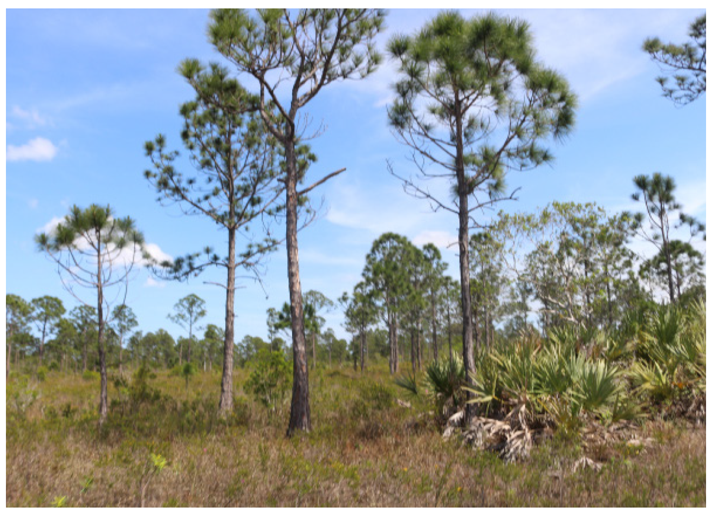
Figure 3-7: Image of the Natural Zone in PMUV.
11.3.11.B.
Examples and Standards.
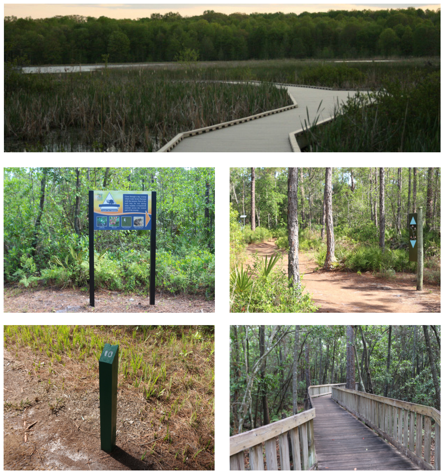
Samples of recreational trail boardwalks and wayfinding through preserved area.

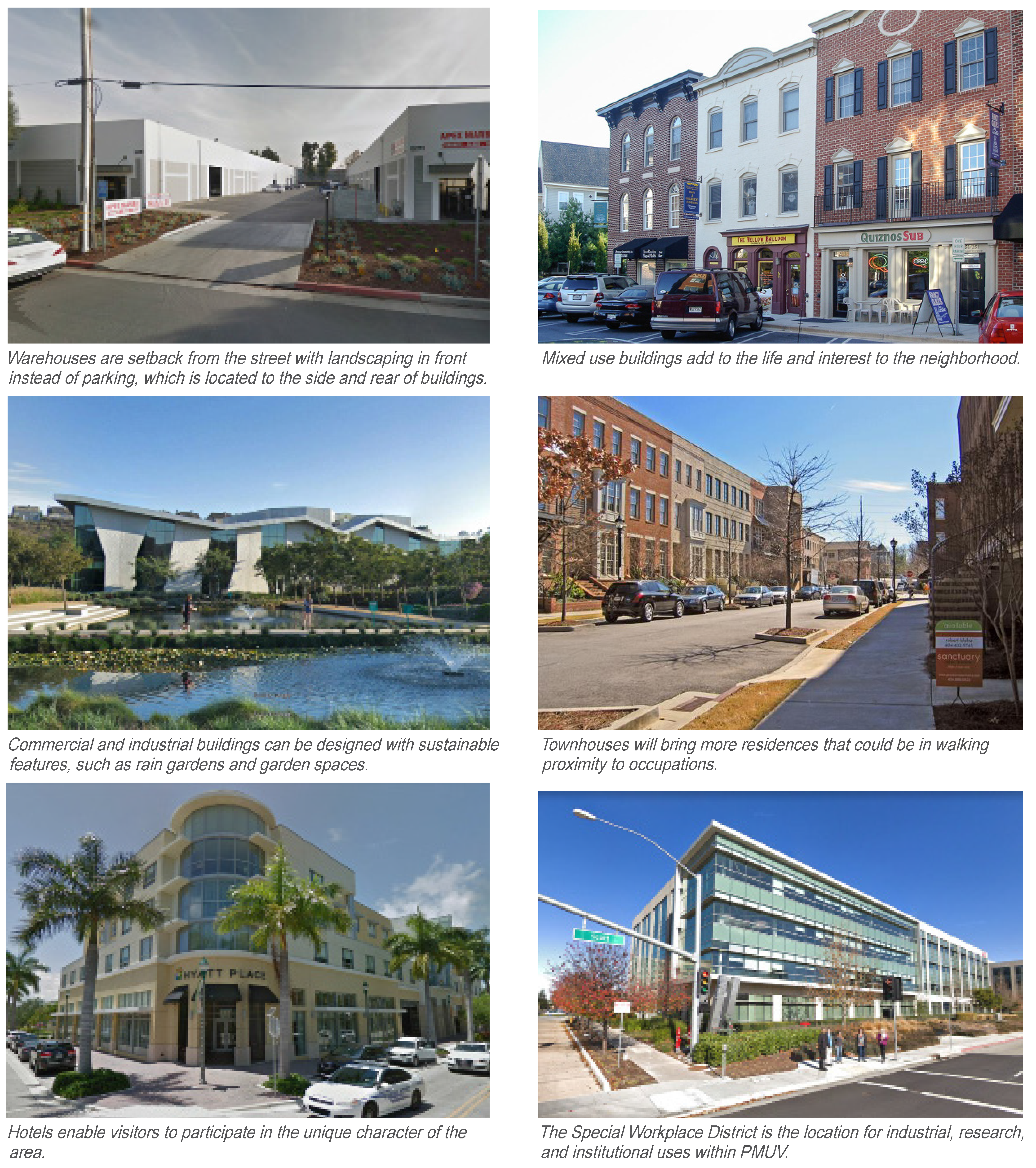
Sec. 11.3.12. - SD-W Workplace District.
11.3.12.A.
Overview.
Lot, Building, and Street dimensions within the Workplace District Transect Zone vary based on the functional requirements of the use type, but the goal of compact, walkable urban form remains. Retail, commercial, and residential uses are permitted, but the focus of this area is on industrial and office functions. This zone may also accommodate colleges and research institutions.
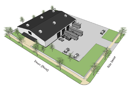
Figure 3-8: Illustrative example of buildings and site arrangement in the SD-W Special
Workplace District.
11.3.12.B.
Examples.
11.3.12.C.
Form.
| a. Building Placement | ||
| Setbacks | ||
| Front Build-to-Zone |
20' min., 60' max.
| |
| Side Street Build-to-Zone |
15' min., 40' max.
| |
| Interior Side Property Line Setback |
15' min.
| |
| Rear Setback |
15' min.
| |
| Note: Industrial lots that front toward a Civic Use shall position the building to front the Civic Use with parking, loading docks, and other service entries located to the side or rear. | ||
| Frontage Buildout | ||
| Building Façade along: | ||
| Front Street Frontage | 40% min. | |
| Side Street Frontage | 30% min. | |
| b. Lot and Block Standards | ||
| Maximum Block Perimeter | 3,000 linear feet max. | |
| Lot Width | N/A | |
| Lot Depth | N/A | |
| Lot Coverage | 80% max. | |
| c. Building Form | ||
| Height | ||
| Main Building |
22' min.
1
| |
|
40' max.
1
| ||
| Ground Floor Elev. Above Sidewalk |
Comm. 6" max., Res. 24" min.,
Ind. n/a | |
| Ground Floor Non-Residential Ceiling Height |
14' min. clear
| |
| Ceiling Height |
9' min. clear
| |
| 1 See Sec. 11.4.5. General Building Standards for more information | ||
| Footprint | ||
| Depth, ground floor commercial space: |
35' min.
| |
| d. Allowed Use Types | ||
| Ground Floor |
All Permitted Uses Allowed
| |
| All Floors Otherwise |
All Permitted Uses Allowed
| |
11.3.12.D.
Parking & Encroachments.
| e. Parking | ||
| Parking Location (Distance from Property Line) | ||
| Front Setback |
30' min.
| |
| Side Street Setback |
20' min.
| |
| Side Setback |
5' min.
| |
| Rear Setback |
5' min.
| |
| District Specific Parking Requirements | ||
| Parking shall be provided as established in Section 11.6.2 | ||
| Parking shall be located behind the Front Façade of buildings and accessed from Alleys or Side Streets whenever possible. | ||
| Streetscreens, Garden Walls, fences, or hedges are required along all un-built Street Right-of-Ways to shield views to parking. | ||
| Parking Curb Cut Width |
30' max.
| |
| f. Allowed Encroachments | ||
| Balconies, Bay Windows, Awnings, and Other Frontage Elements | ||
| Front |
12' max.
| |
| Side Street |
8' max.
| |
| Rear |
4' max.
| |
| Note: Frontage Elements may Encroach forward of the Build-to-Zone and/or into the Right-of-Way, barring any additional restrictions by the public entity that has control over the public Right-of-Way. A 6 foot minimum sidewalk clear zone must be maintained. | ||
| g. Miscellaneous | ||
| All buildings must have a Principal Entrance along the Front Façade. | ||
| Loading docks, overhead doors, and other service entries shall not be located on Façades facing Streets or across from, or adjacent to, Civic Building Frontages or Civic Open Spaces, and should instead be located in rear service areas. | ||
(Ord. No. 1235, Pt. II, 11-12-2024)

Sec. 11.3.13. - C Civic.
11.3.13.A.
Overview.
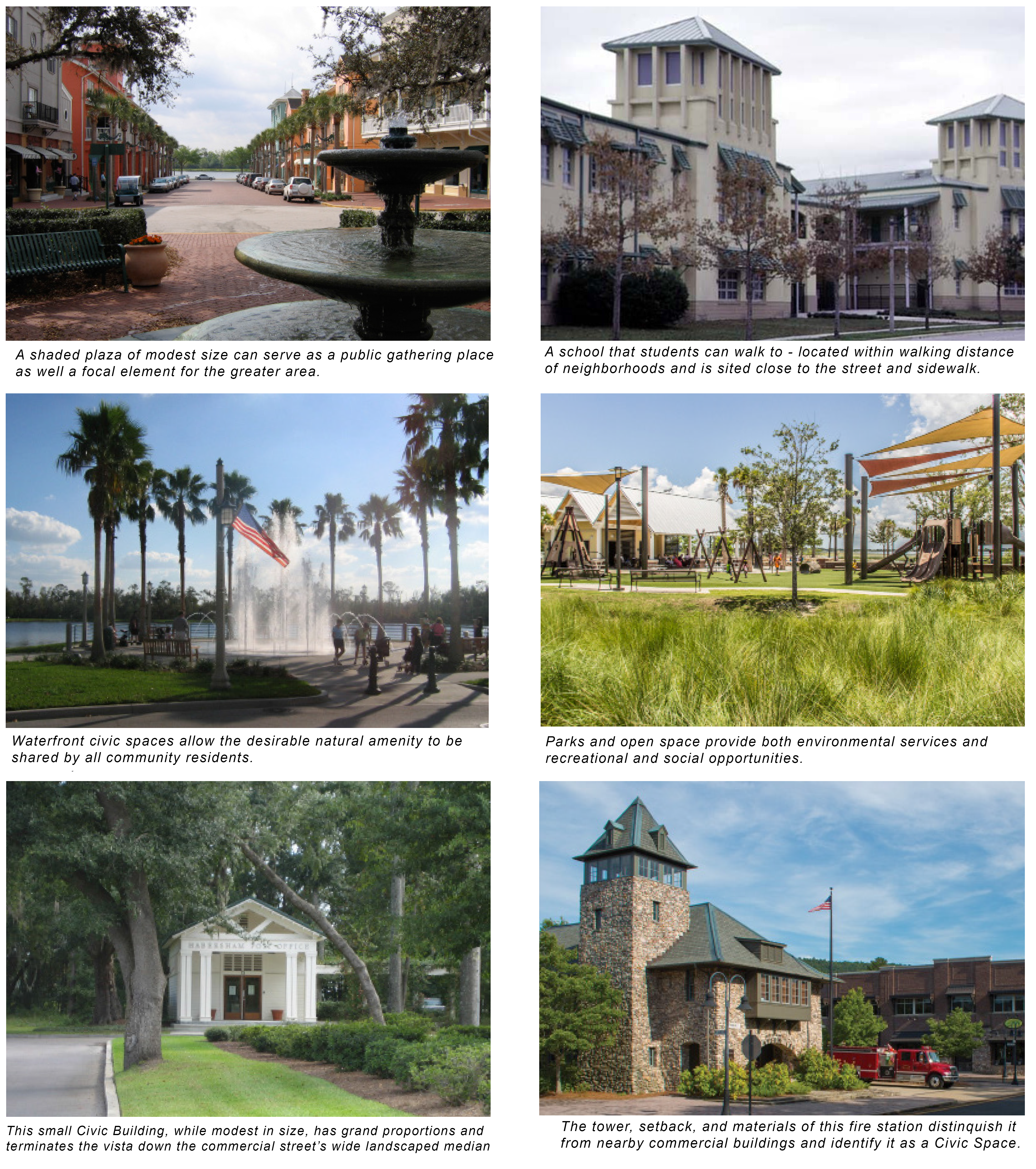
Civic spaces are those areas that serve a public function or are dedicated to preserving and enhancing the public well-being. These areas may contain passive or active civic uses dedicated to arts, culture, education (including public and private schools and colleges), recreation, government, transit, and municipal parking. Reflecting the diverse nature of this Transect Zone, it is divided into two categories: Civic Open Spaces and Civic Buildings. It is difficult to determine beforehand the multiplicity of potential uses that may occupy these Civic spaces overtime. Therefore, greater design flexibility shall be given to these sites with key development standards and guidelines, and buildings are to be subject to a greater degree of design review on a case-by-case basis.
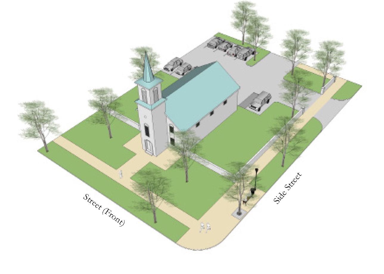
Figure 3-5: Illustrative example of buildings and site arrangement in the Civic Zone.
11.3.13.B
Examples.
11.3.13.C.
Civic Open Spaces.
(a)
General
Civic Open Space in the form of parks, greens, squares, plazas, playgrounds, pavilions, or recreational fields shall be located in each neighborhood at a minimum area greater than or equal to 5 percent of all land assigned a Transect Zone within the neighborhood.
(b)
Guidelines
Heightened attention shall be paid to the quality of landscape design and function according to the following principles:
1.
All designated Civic Open Spaces shall be shall be accessible to the public.
2.
The landscape design shall support and express environmental, cultural, and historical attributes.
3.
The landscape design shall promote connection with nature, social interaction and mental restoration.
4.
Views of natural features shall be preserved or maximized.
5.
The landscape design shall promote connection to surrounding neighborhood resources, amenities and services, and provide for optimum accessibility, safety and way-finding.
6.
Stormwater management improvements shall be integrated with the final landscape design as aesthetically and visually pleasing design elements.
7.
Whenever appropriate, landscape design shall promote sustainability awareness and education through interpretive signs, demonstrations and other forms of interpretation.
The appropriate arrangements for Civic Open Spaces are described to the right and are permissible within proximity of the Transect Zones indicated in Table 3-4.
(c)
Civic Open Space Types
| Park | |
 | A natural preserve available for unstructured recreation. A park does not need to be fronted by buildings. Its landscape shall consist of paths and trails, meadows, waterbodies, woodland, recreational fields, and open shelters, all naturalistically disposed. Parks may be lineal, following the trajectories of natural corridors. |
| Green | |
 | Available for unstructured recreation. A Green may be spatially defined by landscaping rather than buildings fronting it along the edges. Its landscape shall consist of lawn and trees, naturalistically disposed. |
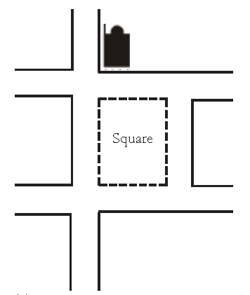
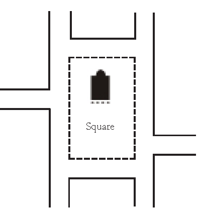
| Square | |
 | Available for unstructured recreation and public gatherings. A Square is spatially defined by building Frontages. Its landscape shall consist of paths, lawns and trees, formally disposed. Squares shall be densely shaded and provide seating. Trees and shrubs shall be of sufficient quantity and located as to define a specific geometry of open space and shall promote security by allowing visibility through all areas. |
| Plaza | |
 | Available for public gatherings and outdoor markets. A Plaza shall be spatially defined by building Frontages. Its landscape shall consist primarily of pavement. Plazas should use pervious pavers, where feasible. Trees are optional. |
| Playground | |
 | Designed and equipped for the recreation of children. A playground should be fenced and may include an open shelter. Playgrounds may be interspersed within residential areas and may be placed within a Block. Playgrounds may be included within parks, greens, and squares. |
11.3.13.D.
Civic Building Standards.
(a)
General.
1.
Civic Buildings may include, but are not limited to, municipal buildings, religious facilities, libraries, schools, daycare centers, recreation facilities, and places of assembly.
2.
The design and construction of Civic Buildings shall reflect the importance of these buildings within the community and with their function as landmarks in mind.
(b)
Building Placement.
Civic Buildings shall be sited in locations of particular geometric importance, such as anchoring a major Civic Open Space or terminating a street vista. Flexibility in building placement allows Civic Buildings to be distinguished from surrounding residential and commercial buildings and to be a prominent landmark in the community.
The Civic Building terminates the view of a street.
The Civic Building anchors the square at a prominent corner.
The Civic Building anchors the space from within the square.
| a. Building Placement | ||
| Setbacks | ||
| Front Setback | 0' min. | |
| Side Street Setback | 0' min. | |
| Interior Side Property Line Setback | 0' min. | |
| Rear Setback | 5' min. | |
| Building Façade with Build-to-Zone | ||
| Front Street Frontage | 40% min. | |
| Side Street Frontage | 30% min. | |
11.3.13.E.
Form.
(a)
The scale of Civic Buildings should typically be larger than surrounding buildings in order to be more prominent and visible across greater distances.
(b)
Floor-to-floor heights and architectural details should be proportionately larger than those of private buildings that exist or are anticipated within adjacent blocks.
(c)
Prominent roof forms and additive elements such as cupolas can visually extend the height of the building. See Sec. 11.4.5. General Building Standards for more information.
| c. Building Form | ||
| Height | ||
| Main Building | 16' min. 1 | |
| 3 Stories max. 1 | ||
| Ground Floor Elev. Above Sidewalk | N/A | |
| Ground Floor Ceiling Height | 12' min. clear | |
| Ceiling Height | 9' min. clear | |
| 1 See Sec. 11.4.5. General Building Standards for more information | ||
| c. Allowed Use Types | ||
| Ground Floor | All Permitted Uses Allowed | |
| All Floors Otherwise | All Permitted Uses Allowed | |
| d. Lot and Block Standards | ||
| Maximum Block Perimeter | N/A | |
| Lot Width | N/A | |
| Lot Depth | N/A | |
| Lot Coverage | 100% max. | |
11.3.13.F.
Parking & Encroachments.
| e. Parking | ||
| Parking Location (Distance from Property Line | ||
| Front Setback | 30' min. | |
| Side Street Setback | 30' min. | |
| Side Setback | 0' min. | |
| Rear Setback | 5' min. | |
| District Specific Parking Requirements | ||
| Parking shall be provided as established in Section 11.6.2 | ||
| Parking shall be located behind the Front Façade of buildings and accessed from Alleys or Side Streets whenever possible. | ||
| Streetscreens, Garden Walls, fences, or hedges are required along all un-built Street Right-of-Ways to shield views to parking. | ||
| When a Civic Building is located with in a Civic Space completely surrounded by streets, then parking shall be accommodated on-street or within mid-block locations within a ¼ mile of the Civic Building's front door. | ||
| Parking Curb Cut Width | 20' max. | |
| f. Allowed Encroachments | ||
| Balconies, Bay Windows, Awnings, and Other Frontage Elements | ||
| Front | 12' max. | |
| Side Street | 8' max. | |
| Rear | 4' max. | |
| Note: Frontage Elements may Encroach forward of the Build-to-Zone and/or into the Right-of-Way, barring any additional restrictions by the public entity that has control over the public Right-of-Way. A 6 foot minimum sidewalk clear zone must be maintained. | ||
| g. Miscellaneous | ||
| All buildings must have a Principal Entrance along the Front Façade. | ||
(Ord. No. 1235, Pt. II, 11-12-2024)
Sec. 11.4.1. - Purpose.
11.4.l.A.
This Division establishes standards for lots and individual buildings within the PMUV. Topics including Building Types, Accessory Units, Building Standards, Façades, Frontage Types, and site standards.
Sec. 11.4.2. - Residential Building Types.
11.4.2.A.
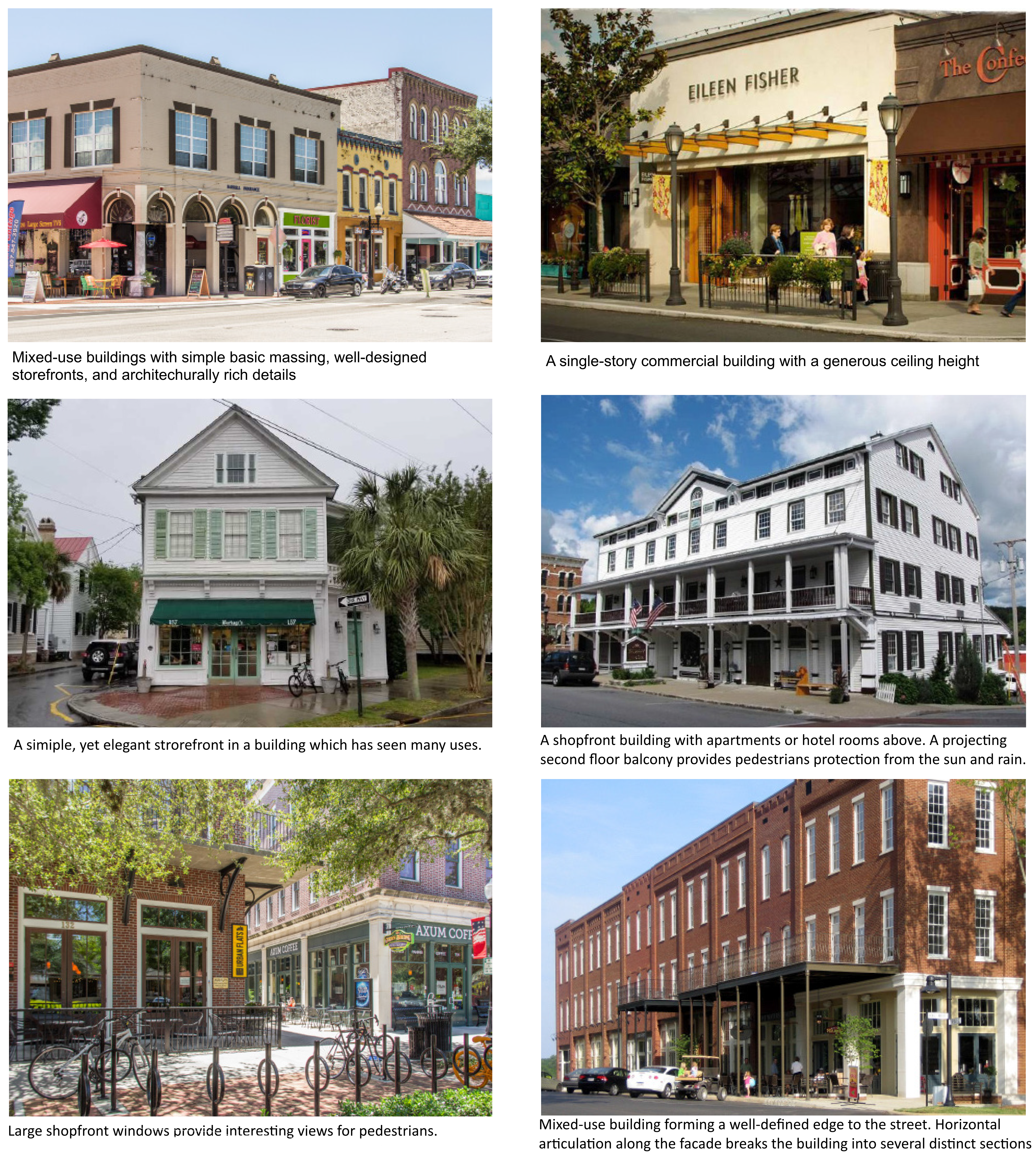
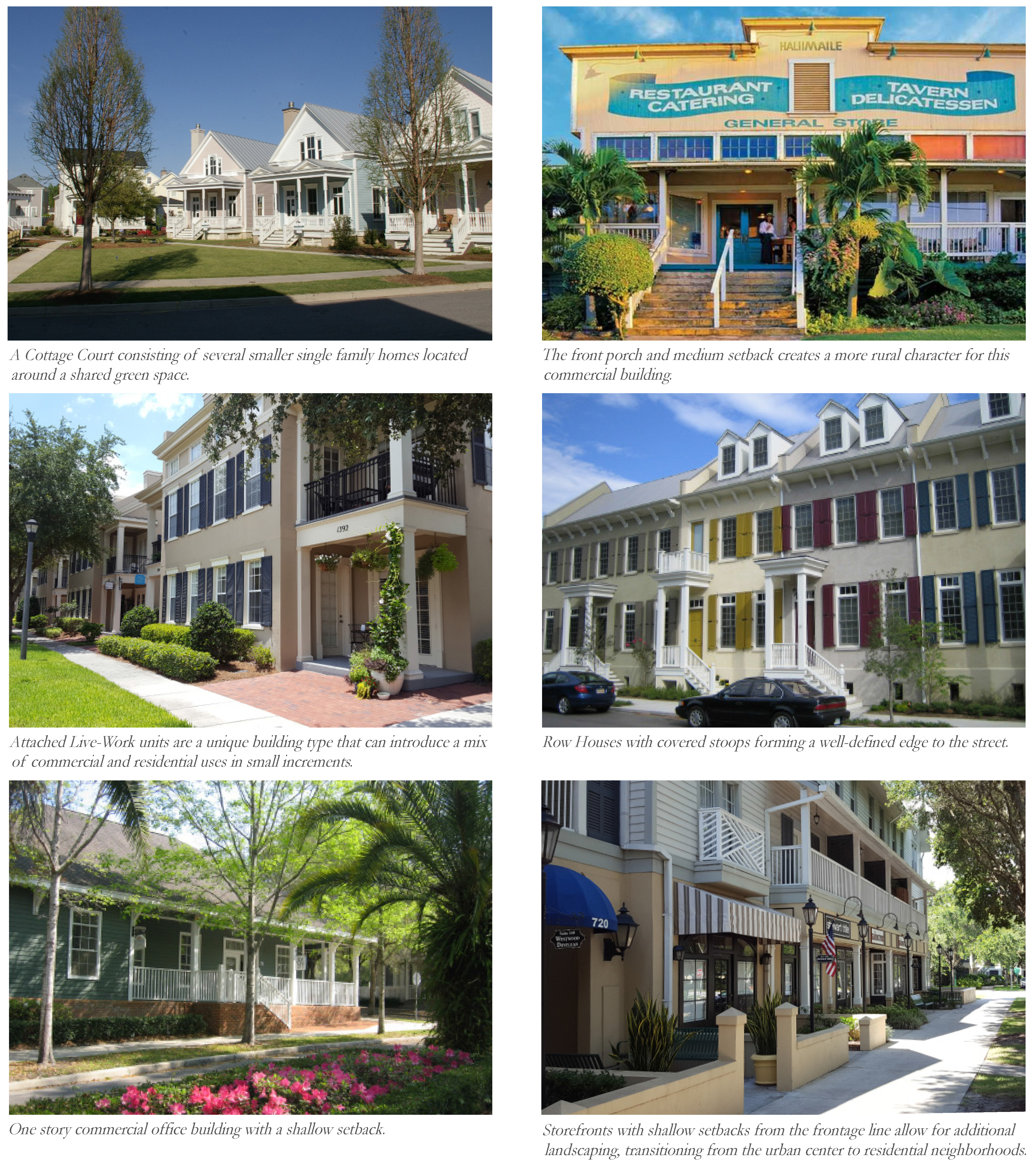
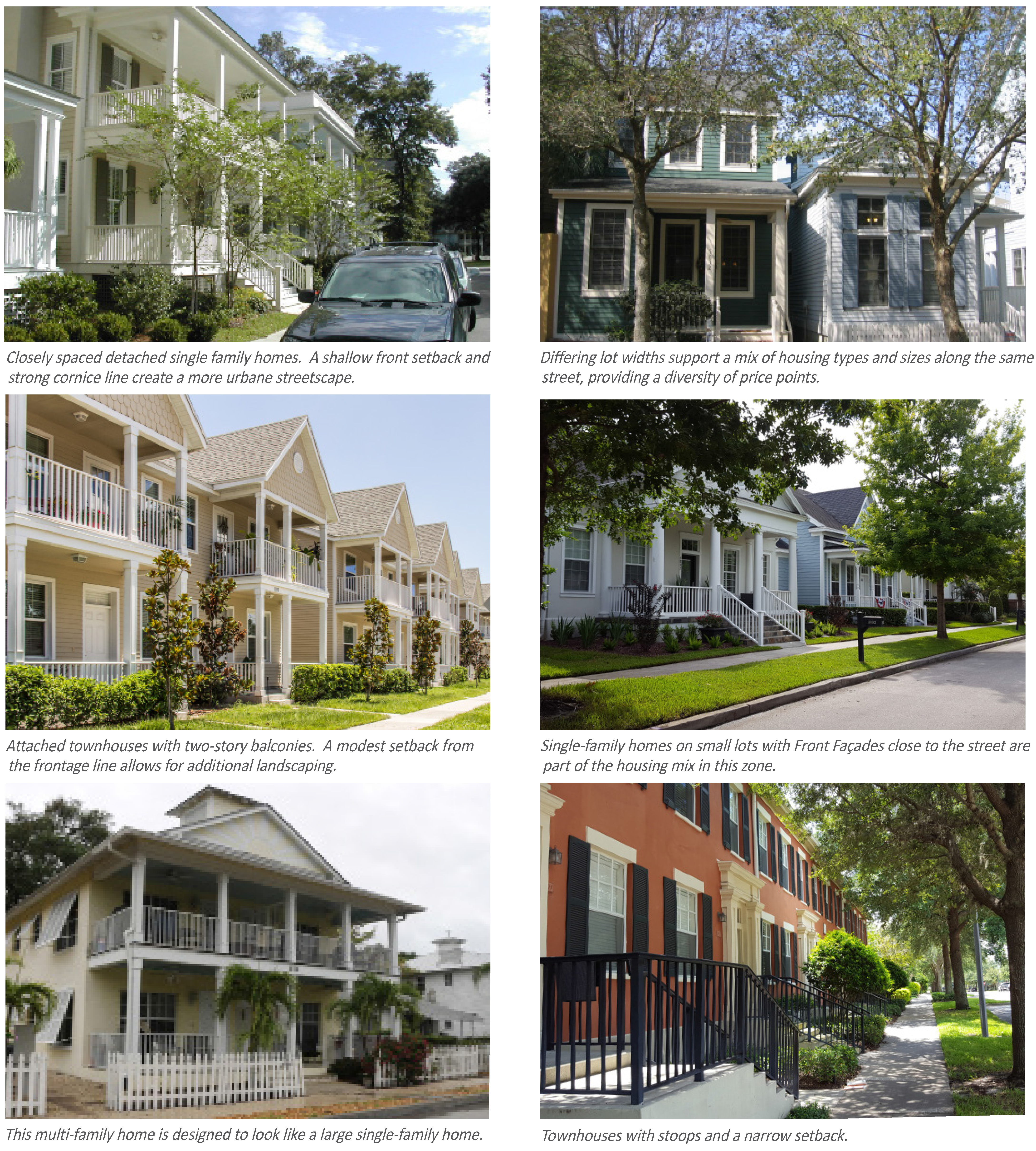
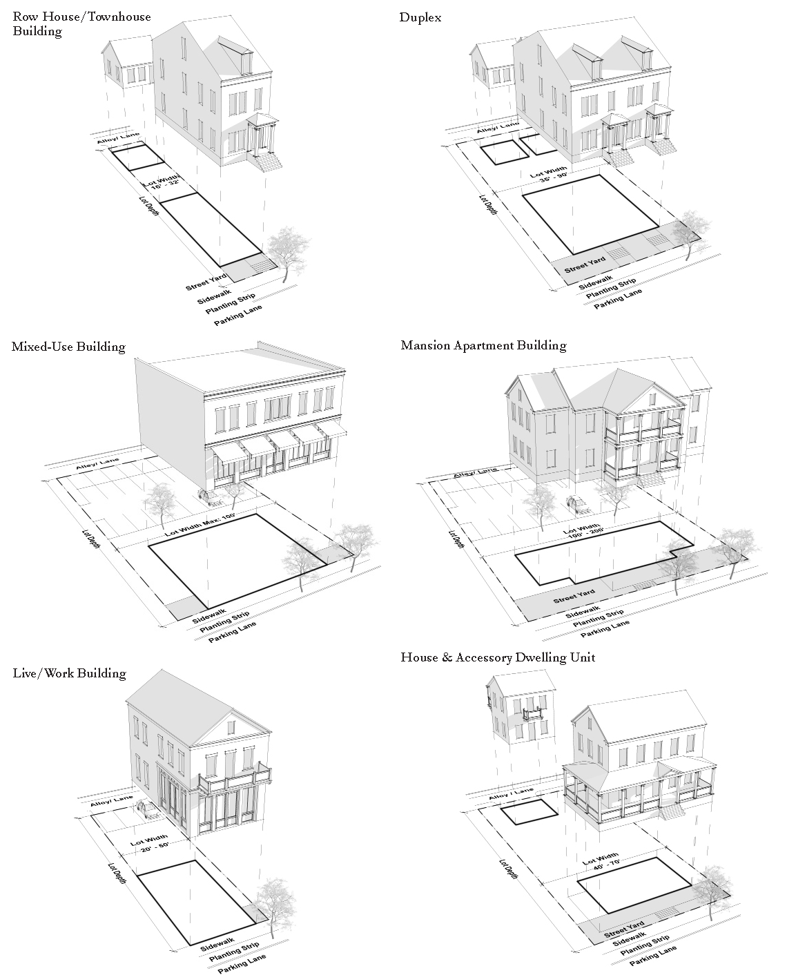
A mix of residential building types creates neighborhoods which allow a diversity of ages and incomes, and permit residents move or downsize their homes without having to move away. Multi-generational neighborhoods create strong social networks, avoid concentrations of poverty or wealth, and lead to safer communities. The residential building types permitted within the PMUV are described textually below and then through illustrations.
1.
Mixed Use Building/Block: This type features shop fronts on the ground floor with space designed to accommodate residential or office on the floors above. Mixed-use buildings often have a parapet with a pronounced cornice.
2.
Apartment Building: This type contains multiple units accessed via a main entrance on the primary frontage. Units may be for rent, or for sale as a condominium.
3.
Mansion Apartment: This multi-family type is designed to look like a large single family house but in fact contains several units. This type usually features a front porch to help it blend in with adjacent single family types.
4.
Live/Work Unit: Buildings or structures used jointly for commercial and residential purposes where the residential use of the space is secondary or accessory to the primary place of work. The commercial function may be anywhere in the unit. It is intended to be occupied by a business operator who lives in the same structure that contains the commercial activity or industry.
5.
Townhouse: This is a single family attached building type. Adjacent dwellings may share a party wall with another unit of the same type and occupies the full Frontage Line. Row Houses typically feature a private yard or patio between the main structure and the rear out-building.
6.
Duplex House: This is an attached single family house type where only two units share a party wall. The duplex can easily blend in with single family houses.
7.
Courtyard House: A dwelling that occupies the boundaries of its Lot while internally defining one or more private patios
8.
Sideyard House: A dwelling that is zero lot line on one side and occupies one side of the Lot with a Setback on the other side. This type can be a single or duplex depending on whether it abuts the neighboring house.
9.
Cottage: The smallest of the single family house types and generally has a small front porch.
10.
House: This single family house is generally two stories in height and often contains habitable attic space. Often shared with an Accessory Building in the back yard.
11.
Villa: This large single family house type is generally two stories in height and often contains habitable attic space. The type is typically located on the edge of a neighborhood and is sited on a very large lot of rural character, often shared by one or more Accessory Buildings.
12.
Accessory Dwelling Unit: Also referred to as accessory apartments, second units, or granny flats—are additional living quarters on single-family lots that are independent of the primary dwelling unit. The separate living spaces are equipped with kitchen and bathroom facilities, and can be either attached or detached from the Principal Building.
13.
Farm Labor Housing: A single family house type intended to be occupied by an occupant(s) who works on the same or adjacent property that contains the agricultural activity. Accessory buildings strictly for vehicular use are not permitted. Accessory buildings such as barns, sheds, and greenhouses are permitted.
14.
Residential Convertible to Retail: A flexible mixed use or live/work building type where the ground floor is initially occupied with residential units that can later be converted to commercial use as the market matures.
Sec. 11.4.3. - Lot Standards.
11.4.3.A.
Front and Backs.
Buildings and lots have fronts, sides, and backs and how these relate to one another forms neighborhood character.
1.
Front Façades, the main presentation faces of buildings and lots containing the Principal Entrance, should face the Public Realm.
2.
The backs of buildings and lots, which are the private or service side, should face mid-block and be screened from view. Backs of buildings or lots shall not abut the Frontage Line.
3.
Sides of buildings and lots may face either the Frontage Line or be concealed mid-block.
4.
Thoroughfares, with the exception of Alleys, should be faced with the fronts or sides of buildings and lots.
5.
Alleys and mid-block parking areas should be faced with the backs or sides of buildings and lots.
6.
The backs of buildings and Lots shall not be across from, or adjacent to, a Civic Open Space.
7.
The backs of buildings and Lots shall not face Civic Building Frontages.
11.4.3.B.
The table below outlines the range of relationships between the fronts, sides, and backs of buildings/lots.
Sec. 11.4.4. - Accessory Dwelling Units.
11.4.4.A.
One Principal Building and one Accessory Dwelling Unit may be built by right on each single-family lot, including townhomes, as permitted by Table 3-3.
1.
Accessory Dwelling Units shall not exceed 900 square feet in Habitable Space, excluding parking.
2.
Each single-family lot may accommodate one Accessory Dwelling Unit in the T3, T4-R, T4-0, and T5 Transect Zones.
3.
Accessory Dwelling Units shall be limited to 2 Stories, including ground floor parking. These units are not computed towards overall density or unit calculations.
(Ord. No. 1235, Pt. III, 11-12-2024)
Sec. 11.4.5. - General Building Standards.
Buildings shall comply with the following:
11.4.5.A.
Heights.
General building height information is provided below. Refer to the Transect Standards for setback and height information specific to each Transect Zone.
1.
A Story is that part of a building contained between any finished floor and the floor or roof next above. Habitable attics (space within the roof structure) are permitted and are not considered Stories for the purpose of determining Building Height.
2.
Stories may not exceed 14 feet in height from finished floor to finished ceiling, except for a first floor commercial function, which shall be a minimum of 12 feet and may be a maximum of 25 feet. A single floor level exceeding 14 feet, or 25 feet for ground floor commercial, shall be counted as two (2) Stories. Mezzanines extending beyond 33% of the floor area shall be counted as an additional Story.
3.
Building Height shall be measured as the vertical distance between (1) the lowest permissible elevation above the existing grade which complies with finished floor elevation requirements as established by flood maps, the Health Department, or building code, along the front of a building and (2) either the highest point of the coping of a flat roof, the deck line of a mansard roof, or the mean height level between eaves and ridge for gable, hip and gambrel roofs.
4.
Building Height is limited to 40 feet and four-Stories, with the following exceptions:
(a)
Steeples, spires and belfries on Places of Worship provided such structures do not exceed 60 feet in height, are part of a principal building, and are not used for human occupancy.
(b)
Roof structures including chimneys, parapet walls not over four feet high, tanks and supports, elevator machinery or shafts, penthouses used solely to enclose stairways and air conditioning equipment, provided that such structures do not exceed ten percent of the roof structure measured on a horizontal plane, are not used for human occupancy, and provided that the use of such structure does not exceed the district height requirements by more than eight feet.
(c)
Non habitable structures used exclusively for agricultural or industrial processes or for protective and emergency service uses may exceed the height limitation pursuant to Sec. 3.14 Martin County Land Development Regulations.
11.4.5.B.
Small Footprint Towers/Cupolas.
These features, as well as steeples, spires and belfries on Places of Worship, are designed to extend above the roofline, and are generally intended to be visual landmarks. They are commonly placed to terminate vistas.
1.
Small Footprint Towers/Cupolas with a footprint smaller than 30 feet by 30 feet may extend above the established Transect Zone Building Height, but shall not exceed the 40 foot height limit.
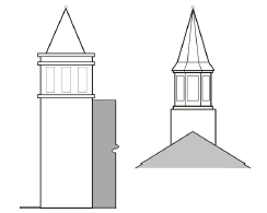
Figure 4-2: Small Footprint Tower and Cupola
11.4.5.C.
Principal Entrances.
The Principal Entrance of every Principal Building must be located along the Primary Façade and directly face a Street or Civic Open Space. Additional building entrances are permitted.
11.4.5.D.
Entry/Exit Doors.
Public entry and exit doors which swing outward shall be recessed into the façade a minimum of three feet where the sidewalk abuts the building.
11.4.5.E.
Window and Door Openings.
1.
Window and door openings in masonry facades should express a structural lintel above to express the conveyance of building weight. A similar method using wood trim can be used on wood-clad facades.
2.
Windows and doors shall be vertically proportioned or subdivided to appear vertical.
11.4.5.F.
Columns/Posts.
1.
The proportion of structural elements such as columns or posts should be appropriate to the weight they appear to be carrying.
2.
Columns and posts shall not be spaced further-apart than they are tall.
Sec. 11.4.6. - Façades.
11.4.6.A.
Material Changes.
1.
When materials are combined on a building façade horizontally, heavier materials should occur below lighter materials.
2.
For buildings of three stories, the ground floor should be differentiated from those floors above in order to reinforce the pedestrian space.
3.
Changes from one material or color to another along the horizontal direction should occur at "inside corner" transitions.
4.
Changes in material or color along the vertical direction should occur at a hard-edge "bump-out" transition which gives materials a surface to terminate into.
5.
Façades with an overabundance of different materials or colors are generally discouraged.
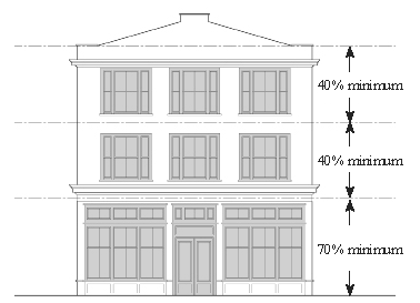
Figure 4-3: Façade transparency requirements for buildings with shopfront.
11.4.6.B.
Wide façades.
1.
Building facades longer than 50 feet shall be varied with at least one change of architectural expression. These changes in expression may be a vertical element running from the ground plane to the roof, a change in fenestration, color, or texture, or a break in building facade plane or roof line. These changes may be subtle or significant, but should soften the visual effect of very wide buildings, especially those directly across the street from narrower buildings. Strive for an appearance of authenticity when subdividing a large facade into multiple smaller facades resembling distinct buildings.
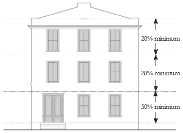
Figure 4-4: Façade transparency requirements for buildings without shopfront
11.4.6.C.
Façade Transparency.
All building Façades which face onto a Street or Civic Open Space shall meet the minimum transparency requirements outlined herein. The percentage of transparency per Story shall be calculated within the area between finished floor and finished ceiling and shall be a total percentage of doors and windows along that portion of the façade.
1.
Buildings with Shopfront
(a)
Minimum building façade transparency for ground Story: 70 percent and should allow a view of at least five 5 feet of interior space.
(b)
Minimum building façade transparency for upper Stories: 40 percent.
2.
Buildings without Shopfront
(a)
Minimum building façade transparency for ground Story: 30 percent.
(b)
Minimum building façade transparency for upper Stories: 20 percent.
11.4.6.D.
Shopfronts.
1.
The top of all shopfront window sills shall be between 1 and 3 feet above the adjacent sidewalk.
2.
Shopfront windows shall extend up from the sill at least 8 feet above the adjacent sidewalk.
3.
Shopfronts shall have a Cornice or Expression Line above, between the first and second story.
4.
Shopfront windows may not be made opaque by window treatments.
5.
Shopfront windows shall use only ultra-clear high performance glass. Reflective, frosted, tinted, or textured glass is prohibited on shopfronts.
6.
Doors or entrances for public access shall be provided at intervals no greater than 50 feet, unless otherwise approved. The intent is to maximize street activity, to provide pedestrians with frequent opportunities to enter buildings, and to minimize any expanses of inactive wall.
7.
Shopfront doors shall contain at least 60 percent transparent glass.
8.
The minimum depth of Habitable Space required behind each shopfront on the Primary Façade is provided in the Transect Zone Standards for each Transect Zone. This ensures that the area behind shopfronts is sufficient enough to be an actively used retail space.
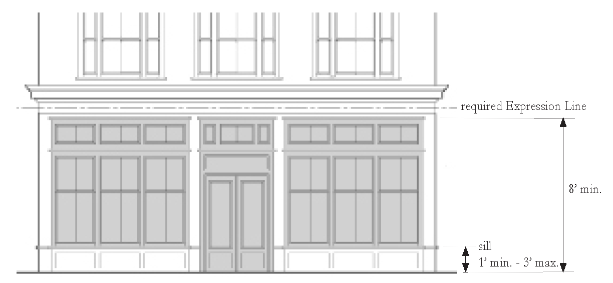
Figure 4-5: Anatomy of a shopfront.
11.4.6.E.
Encroachments.
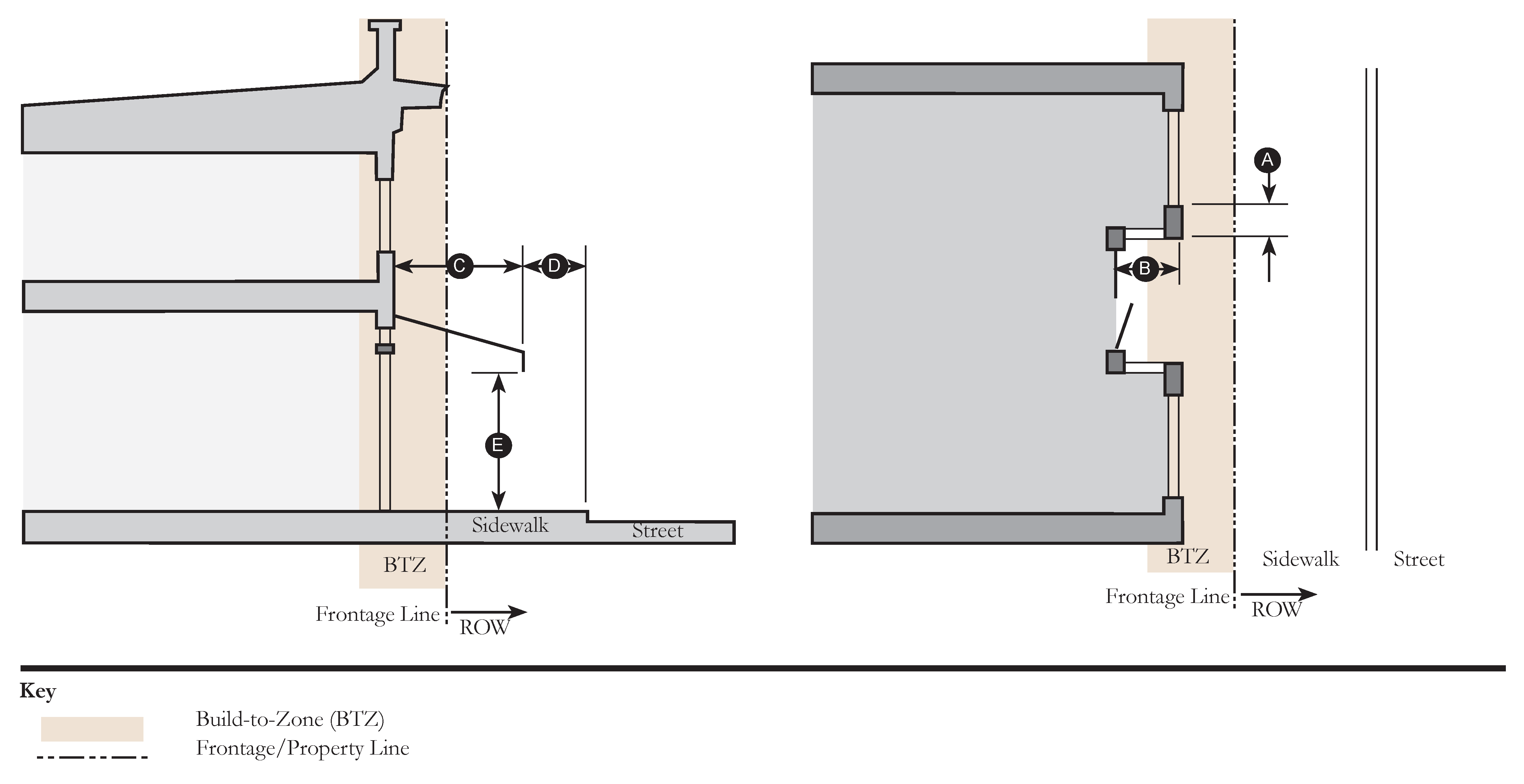
When structural or architectural elements, such as Balconies, Bay Windows, Awnings, etc., or Frontage elements are to extend over or into public sidewalks or Right-of-Way, the property owner shall be required to enter into a right-of-way agreement establishing the property owner's responsibility for repairing any damage that may result from public maintenance or improvements. Requirements and standards for Encroachments are provided in the Transect Zone Standards for each Transect Zone.
(Ord. No. 1235, Pt. III, 11-12-2024)
Sec. 11.4.7. - Frontage Types.
11.4.7.A.
Building frontages shall conform with the basic Frontage Types described in this section.
1.
The illustrations and photographs provided are for illustrative purposes.
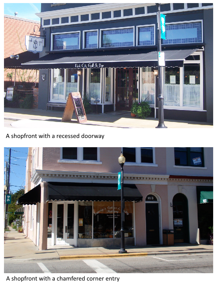
1. Shopfront
| a. Description | ||
| The Front Façade of the building is at or near the Frontage Line and shall include a Canopy or Awning element that overlaps the sidewalk along the majority of the Frontage. The Canopy is a structural cantilevered shed roof and the Awning is canvas or similar material and is often retractable. | ||
| b. Size | ||
| Distance between Glazing | 2' max. | |
| Ground Floor Transparency | See Sec. 11.4.6 Façades | |
| Door Recess | 3' min., 5' max. | |
| c. Canopy or Awning | ||
| Depth | 4' min. | |
| Width, Cumulative | 70% of facade width min. | |
| Setback from Curb | 2' min. | |
| Height, Clear | 8' min. | |
| d. Miscellaneous | ||
| Doors may be recessed as long as Front Façade is at BTZ. | ||
| Open-ended Awnings are encouraged. | ||
| Rounded and hooped Awnings are discouraged. | ||
2. Gallery
| a. Description | ||
| The Front Façade of the building is at the Build-to-Zone and the Gallery element overlaps the sidewalk, eliminating the need for an Awning or Canopy. This Frontage Type is intended for buildings with ground-floor commercial or retail uses and may be one or two stories in height. | ||
| b. Size | ||
| Depth, Clear |
8' min.
| |
| Ground Floor Height, Clear |
11' min.
| |
| Upper Floor Height, Clear |
9' min.
| |
| Height |
2 stories max.
| |
| Setback from Curb |
2' min.
| |
| Width |
75% of façade width min.
| |
| c. Miscellaneous | ||
| Galleries must also follow all the rules of the Shopfront Frontage Type. | ||
3. Forecourt
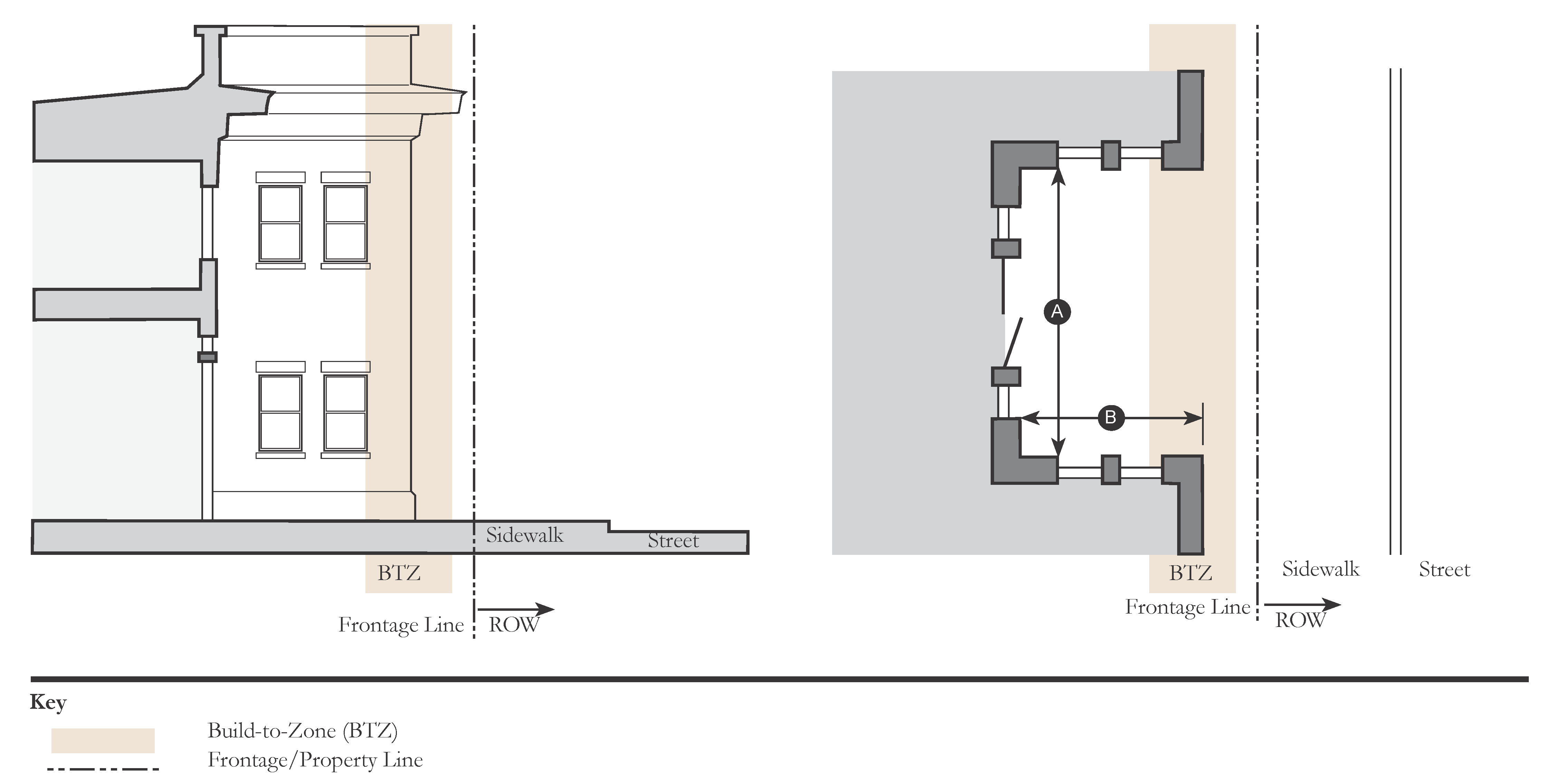
| a. Description | ||
| The primary portion of the building's Front Façade is at the Build-to-Zone while a small percentage is set back, creating a courtyard space. This space can be used as an apartment or office entry court, garden space, or for outdoor seating or dining. | ||
| b. Size | ||
| Width, Clear | 12' min. | |
| Depth, Clear | 12' min. | |
| c. Miscellaneous | ||
| Forecourts are especially useful along larger, more auto-dominant thoroughfares in order to provide well-shaped, intimately sized public outdoor spaces. | ||
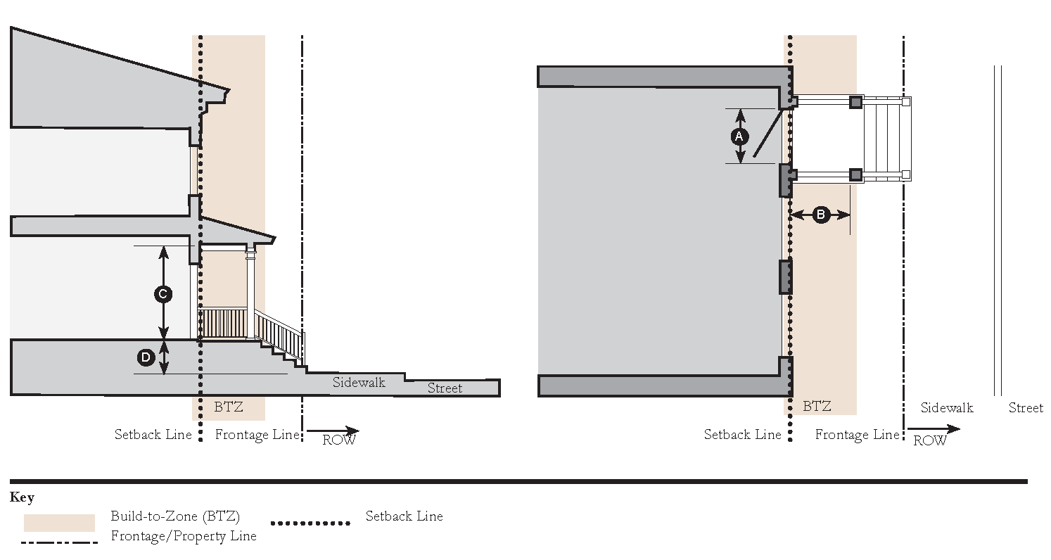
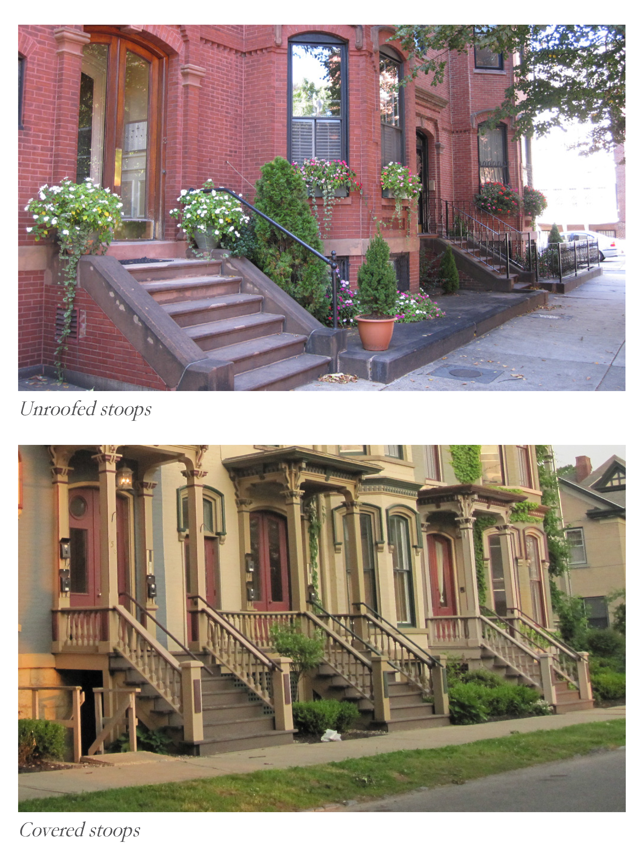
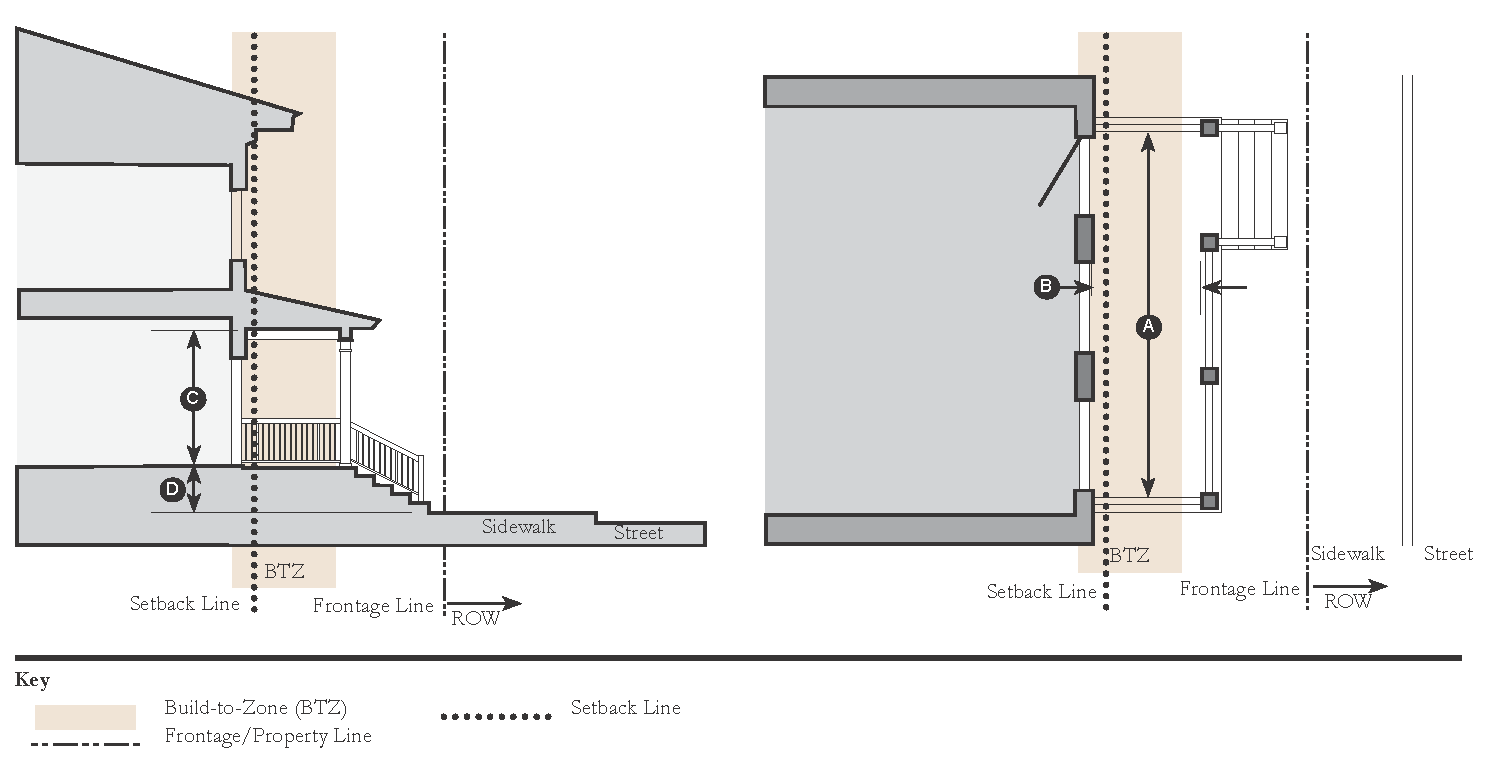
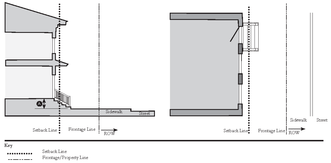
4. Stoop
| a. Description | ||
| The Front Façade of the building is at the Build-to-Zone or Setback Line and the elevated stoop projects forward. The stoop is used to access a first floor that is elevated above the sidewalk to ensure privacy within the building. Stairs from the stoop may descend forward or to the side. Stoops may extend forward of the Build-to-Zone or Setback Line and, if permitted by the Transect Zone standards, into the Right-of-Way; a 6' minimum clear zone for pedestrians shall be maintained on the sidewalk. | ||
| b. Size | ||
| Width, Clear | 5' min., 8' max. | |
| Depth, Clear | 5' min., 8; max. | |
| Height, Clear | 8' min. | |
| Height | 1 Story max. | |
| Finish Level Above Sidewalk | 24" min. may deviate according to finish floor elevation per table 3.2 | |
| c. Miscellaneous | ||
| Stairs may be perpendicular or parallel to the building Façade. | ||
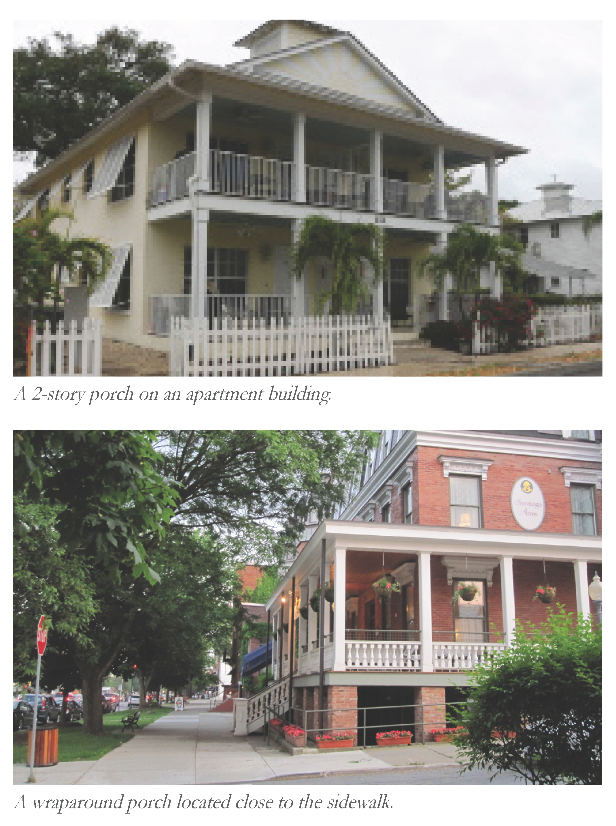
5. Porch
| a. Description | ||
| The Front Façade of the building is at the Build-to-Zone or Setback Line and the porch projects forward. The porch is used to access a first floor that is elevated above the sidewalk to ensure privacy within the building. A porch is large enough to function as an outdoor living space. Stairs from the porch may descend forward or to the side. Porches may extend forward of the Build-to-Zone or Setback Line. Stairs from the porch may extend into the Right-of-Way provided it is privately owned or owned by the CDD, if permitted by the Transect Zone standards; a 6' minimum clear zone for pedestrians shall be maintained on the sidewalk. | ||
| b. Size | ||
| Width, Clear | 10' min. | |
| Depth, Clear | 8' min. | |
| Height, Clear | 8' min. | |
| Height | 2 Stories max. | |
| Finish Level Above Sidewalk | 24" min. may deviate according to finish floor elevation per table 3.2 | |
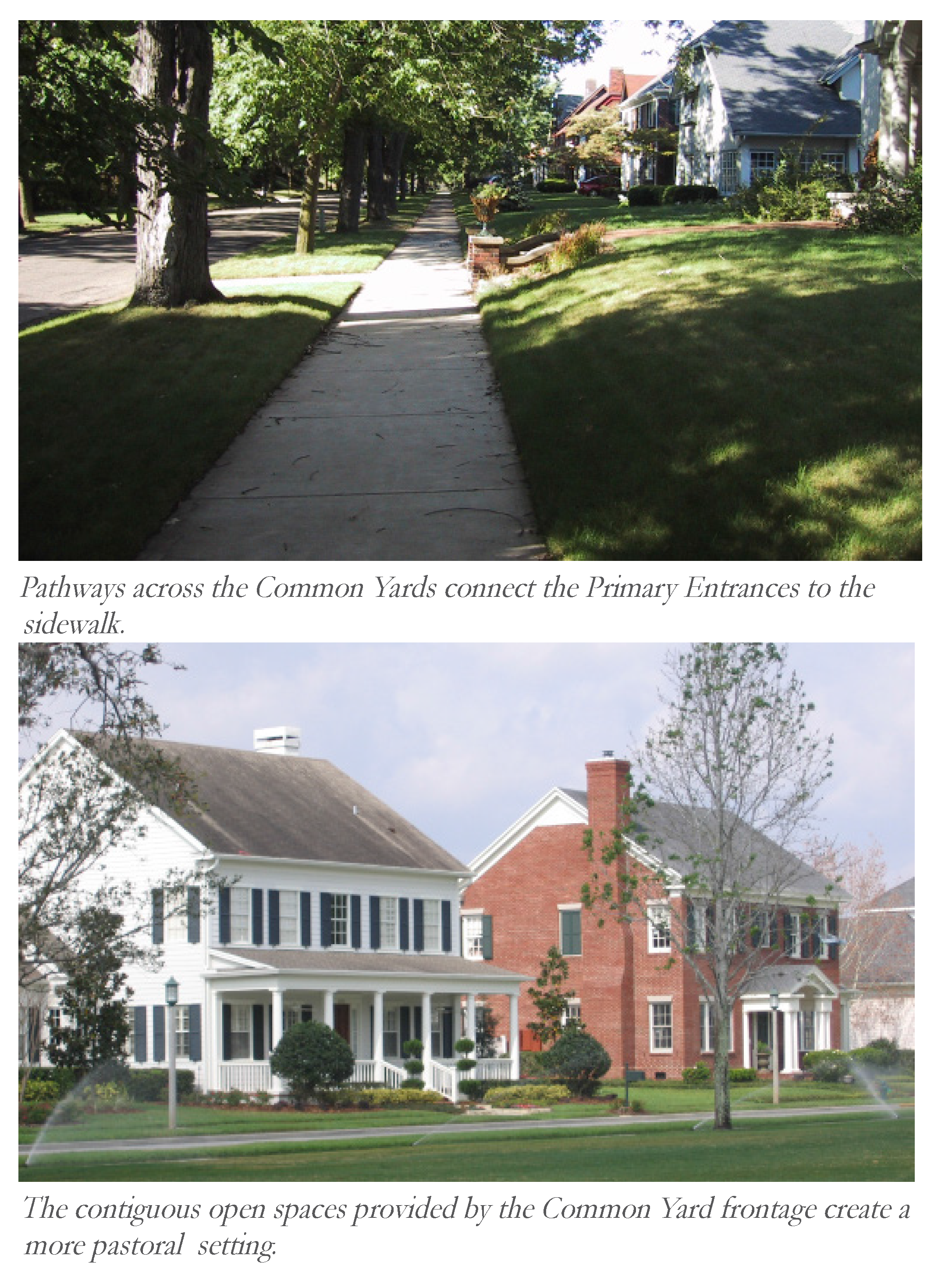
6. Common Yard
| a. Description | ||
| The Front Façade is set back substantially from the Frontage Line with a planted Frontage. The front yard created remains unfenced and is visually continuous with adjacent yards, supporting a common landscape. | ||
| b. Size | ||
| Finish Level Above Sidewalk | 24' min. | |
(Ord. No. 1235, Pt. III, 11-12-2024)
Sec. 11.4.8. - Roofs.
11.4.8.A.
Flat Roofs.
1.
Flat roof structures shall be bounded by an articulated parapet design which provides a noticeable "cap" to the building.
2.
The parapet on a single-story façade should express at least six inches in overhang depth, and be at least 18 inches tall. Parapet overhang depth and height for taller facades should be increasingly larger.
11.4.8.B.
Sloped Roofs.
1.
Sloped roof structures are encouraged to maintain a pitch between 6:12 minimum and 12:12 maximum for all primary roof areas (not including dormers, entry canopies, or similar accessory elements.)
2.
Roof overhangs are encouraged to be at least 6 inches deep.
3.
Dormers and Gables are encouraged along front facades to help maintain a prominent façade, reduce the scale of long runs of roof, and divert rainwater from entry areas.
Sec. 11.4.9. - Site Standards.
11.4.9.A.
Service Areas & Loading Docks.
4.
Trash and recycling dumpsters or similar collection areas shall be located in the rear or to the side of buildings and screened from view from adjacent public Right-of-Ways, properties, and pedestrian walkways (not including Alleys).
11.4.9.B.
Mechanical Equipment.
1.
For the purposes of these standards, mechanical equipment includes any heating, ventilation, and air conditioning (HVAC) or electrical machinery as well as air compressors, hoods, mechanical pumps, exterior water heaters, water softeners, utility and telephone company transformers, meters or boxes, garbage cans, storage tanks, generators, electric vehicle (EV) chargers, geothermal wells, and similar elements.
2.
If mechanical equipment is located at-grade, and is visible from an adjacent street or sidewalk, it shall be screened by a fence or Streetscreen.
3.
All mechanical equipment or penthouse screening placed on a roof shall be set back from the roof line by a distance at least equivalent to the height of the screening in order to minimize visibility from surrounding streets.
Sec. 11.4.10. - Specialty Buildings.
Within the T5 Center and SD-W Zones, some automotive-oriented uses and large footprint buildings may be provided to serve the daily needs of residents. The following criteria shall be used to ensure these uses and buildings do not detract from the overall walkability of the neighborhoods.
11.4.10.A
Gas Stations.
1.
A ground-floor shopfront shall face the Primary Street and define the Frontage of the lot. All pumps, parking, and drive-through areas must be located behind the shopfront building toward a mid-block location.
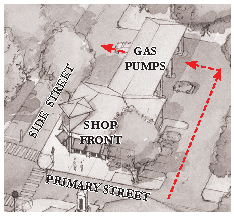
11.4.10.B
Drive-through.
1.
A ground-floor shopfront shall face the Primary Street. All parking shall be located in the rear and accessed from an Alley when present. Drive-through windows shall be located to the side or rear of the building and accessed from mid-block or Alleys, where existing. Where no mid-block or Alley access exists, access from a Secondary Street frontage is permitted, but shall not substantially disrupt pedestrian activity or surrounding uses
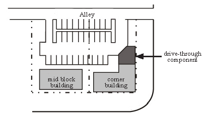
11.4.10.C
Large Footprint Buildings
Large Footprint Buildings are those with footprints greater than 30,000 sq. ft. Examples may include a grocery store, large-format retailer, or theater. Lots may exceed the dimensions set in the Transect Zone Standards provided such buildings comply with the following provisions:
1.
Habitable frontages (as part of the building or a separate liner building) that provide doors and windows facing the Public Realm shall be provided along Façades that face Civic Uses or Streets.
2.
To encourage use by pedestrians and decrease the need for solely auto-oriented patronage, Large-Footprint Buildings must reinforce the urban character of the neighborhood and shall therefore continue a connected system of walkable blocks/street frontages (including sidewalks and street trees) through the site as part of the design of parking and drive aisles.
3.
Building footprints may not be larger than a single block.
4.
Loading docks, service areas, and trash disposal facilities shall not face streets or Civic Uses.
Sec. 11.5.1. - Purpose.
The purpose of the Thoroughfare Standards is to provide guidance to create an interconnected network of streets that can accommodate all modes of travel, including vehicular, pedestrian, and bicycle. The function of streets within the PMUV is to handle multimodal forms of traffic by providing a memorable experience by persons using the Street network. The streets will work together with the trails network to provide multiple options for moving throughout the neighborhoods and around the PMUV The function of each street will guide the design in concert with its context. The context is determined by the character of its Transect Zone.
The location, Street type, and hierarchy of proposed new or improved corridors are identified in the Streets Atlas (Sec. 11.5.7). Typical street sections illustrating the key characteristics of each proposed new or improved street are provided in the following section. The conditions illustrated in the typical sections may be interrupted for intersections, bump-outs, central greens, or other traffic calming devices depending on the context details of the final neighborhood designs.
Sec. 11.5.2. - Street Hierarchy.
On each parcel that has multiple street frontages (e.g., corner lots), the street hierarchy will determine the highest priority (Primary) street frontage, where the Front Build-to-Zone or Setback shall apply. Along the lower priority frontages, the Side (Secondary) Build-to-Zones or Setbacks shall apply. The designated street hierarchy is as follows:
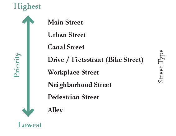
(Ord. No. 1235, Pt. IV, 11-12-2024)
Sec. 11.5.3. - General Standards.
The precise location and alignment of new streets may be adjusted to allow flexibility in the design of the site plan; however, the intended purpose and network connectivity of each new street shall not be compromised. Proposed improvements to Citrus Boulevard shall be permitted by Martin County.
11.5.3.A.
Street design.
The design of new streets and modifications to existing streets shall adhere to the following requirements:
1.
Some dimensional flexibility is permitted for street types to account for varying Right-of-Way widths, however they shall be designed to have all the basic functional characteristics including roadway width, on-street parking/Curb side Flex Zones, sidewalks, trails, street trees, and landscaped areas shown for their type, and be appropriately sized for the Transect Zones in which they are located.
2.
New street types (with new sections) shall be permitted with approval by the Settlement Architect and Martin County. The Martin County Engineer may approve new street types administratively without requiring an amendment to this Article.
3.
Each Neighborhood shall demonstrate appropriate provision for street connectivity and integration with adjoining neighborhoods. Connections to future development is required. When a Sub-district Site Plan, consisting of one or more neighborhoods, is submitted for approval, the street network contained in those neighborhoods should connect to stub-outs of adjacent neighborhoods or other rights-of-way that form the edge of the neighborhood(s).
4.
All non-pedestrian only Streets shall accommodate two-way traffic with the exception of streets adjacent to squares and plazas and Alleys, which may have 1 travel lane with one-way traffic.
5.
All Streets shall connect to other Streets, except that dead-end streets with cul-de-sacs or T-turnarounds may be permitted only when necessitated by environmental constraints, provided the Street terminus provides adequate maneuverability for public services.
6.
Curbside Flex Zones replace the traditional on-street parking lanes with zones for a variety of uses, depending on the adjacent Transect Zone, on the following Street Types: Citrus Boulevard side access lanes, Urban Streets, Workplace Streets, and Main Street. The zones can vary along the length of the curb and/or throughout the time of day or year. Permitted zones may include: parking, transit stops, ride share passenger pick-up/drop-off, delivery, vendors, and shared-mobility stations.
7.
Where possible, there should be parking lanes/Curbside Flex Zones on one or both sides of a Street, depending on need.
8.
On-street parking lanes/Curbside Flex Zones shall not be closer than 25 feet to intersections measured from the curb line.
9.
All streets shall have sidewalks which are a minimum width of 6 feet, and have a continuous unobstructed path of a width no less than 60 inches. This path shall be unobstructed by utility poles, fire hydrants, benches, street signs, or any other temporary or permanent structures. A shared-use path having a minimum width of 8 feet may take the place of a sidewalk.
10.
At-grade pedestrian crossings should be used where possible, eliminating the need for curb ramps. Bollards should be used at such crossings for pedestrian and vehicle separation.
11.5.3.B.
Curb Radius.
Several walkability benefits can be gained by decreasing the radius of curbs at intersections. These benefits include the following: decreased crossing distances for pedestrians, greater visibility of pedestrians by motorists, and traffic calming, enhancing safety for pedestrians.
Corner curb radius designs fall into two distinct categories: corners with and without on-street parking.
1.
Corners with on-street parking shall have curb radii of 15 feet maximum. The effective turning radius is larger than the curb radius when parking is present. Thus, the effective turning radius can be 30 plus feet when the curb radius is 15 feet.
2.
Corners without on-street parking require the curb radii to be similar to the turning radii, with the curb radius between 20 feet and 30 feet maximum.
3.
Curb radii may be larger, up to 40 feet, within the SD-W Transect Zone at larger intersections to accommodate the more frequent movement of large trucks.
4.
Curb radii may be smaller, 9 feet to 15 feet, for Alleys.
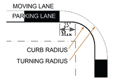
11.5.3.C.
Alleys.
A continuous network of Alleys is desirable to serve as the primary means of vehicular ingress to individual lots. Such networks are mandatory in the T5, T4-0, T4-R, and T3 Transect Zones.
1.
Alley entrances should align so as to provide ease of ingress for service vehicles.
2.
Alley entrances shall not face Civic Open Spaces or Civic Buildings.
3.
Internal deflections or variations in the Alley network are encouraged to prevent excessive or monotonous views of the rear of structures resulting from long stretches of Alleys.
4.
Alleys should meet streets with a mountable gutter pan, allowing the sidewalk to continue uninterrupted across the Alley pavement. The use of curb cuts, ramps, and marked crosswalks should be avoided for Alleys.
11.5.3.D.
Intersection Design/Size.
While intersection design shall accommodate larger vehicles, the safety of pedestrians and bicyclists shall be the highest priority.
1.
The majority of intersecting streets shall meet at approximately a 90-degree angle. Angles of intersection less than 60 degrees should be avoided.
2.
Offset intersections in close proximity to one another (220' for Urban Street Types, 150' for other Street Types) are prohibited.
3.
The use of auxiliary turn lanes at intersections for traffic movement shall be carefully weighed against the impact to pedestrian and cyclist movement at the intersection, and the use of such lanes shall not be determined by traffic analysis alone. The final decision on whether an auxiliary turn lane is required shall be made by the County Engineer with agreement from the Settlement Architect.
4.
Pedestrian and bike crossing infrastructure shall be provided across all intersection approaches, including high visibility crosswalks, sidewalk ramps, and detectable warnings.
5.
Traffic signals shall be timed primarily for the convenience and safety of pedestrians and bicyclists.
6.
To the extent possible, pedestrian exposure to vehicles and crossing distances shall be reduced through the use of refuge islands, bump outs, and pedestrian signals.
Sec. 11.5.4. - Street Lighting.
11.5.4.A.
General Street Lighting Standards.
1.
All street lighting shall comply with the standards established in Sec. 11.6.4.A and Sec. 11.6.4.B Lighting Standards.
2.
A combination of pedestrian-scaled street light fixtures and intersection street light fixtures may be required to ensure a well-lit street and to establish a unifying element along the street. Pedestrian-scaled fixtures shall be used on all streets, except Alleys. Intersection-scaled lighting may be used in addition to pedestrian-scaled lights where necessary.
3.
Street lights shall be aligned with street tree placement (generally between 2.5 feet and 4 feet from the back of the curb). Placement of fixtures shall be coordinated with the organization of sidewalks, landscaping, street trees, building entries, curb cuts, signage, etc.
4.
The height of light fixtures shall be kept low (generally not taller than 15 feet) to promote a pedestrian scale to the Public Realm and to minimize light spill to adjoining properties. Light fixtures shall be closely spaced (generally not more than sixty (60) feet on center) in T4-R, T4-O, and T5 Zones and eighty (80) feet in the T3 and SD-W Zones to provide appropriate levels of illumination.
5.
Light poles may include armature that allows for the hanging of banners or other amenities (e.g., hanging flower baskets, artwork, etc.).
6.
All street lighting fixtures shall be full cutoff.
11.5.4.B.
Lighting Types And Configurations.
1.
The configuration of street lighting fixtures shall be appropriately chosen for the Transect Zone within which they are located as outlined in the table below. Flexibility shall be permitted to vary from strict compliance with this table to achieve logical uniformity of fixtures within a given thoroughfare segment or Public Realm.
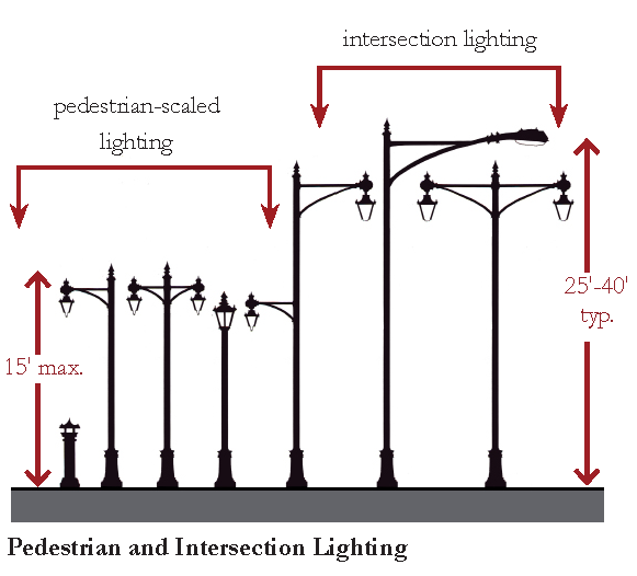
2.
The Settlement Architect shall set a lighting pole and fixture standard for use throughout the PMUV prior to the approval of the first Neighborhood Final Phase Plan for aesthetic conformity and maintenance inventory. Any light pole or fixture to be maintained by Martin County shall be approved by the County Engineer.
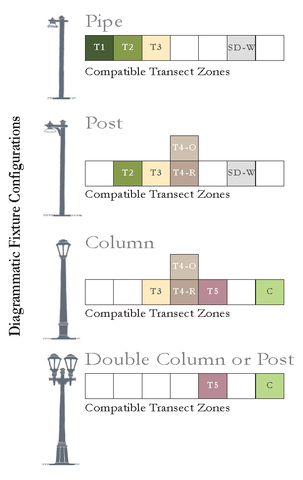
Sec. 11.5.5. - Street Trees.
1.
All street trees shall comply with the General Landscape Standards in Division 6: Site Development Standards.
2.
Street trees shall consist of shade trees with a minimum 3-inch caliper at time of planting. Other accent plants and trees are permitted in addition to the required street trees.
3.
Street trees shall be provided in a manner and at a spacing as defined by the Street Type standards.
4.
Street trees shall be planted in vegetated Planting Strips or Tree Wells with grates according to Street Types.
5.
Properly designed tree box filters to accept stormwater runoff are encouraged for stormwater quantity and quality mitigation, and shall count towards the street tree requirement as long as adequate maintenance access is provided and the street tree planted meets the requirements of this standard. See the National Association of Transportation Officials (NACTO) Urban Street Stormwater Guide and the Light Imprint Handbook for more information.
Sec. 11.5.6. - Thoroughfare Construction Standards.
1.
Construction shall adhere to the Martin County Standard Details for Road & Site Construction and Public Facilities.
Sec. 11.5.7. - Street Atlas.
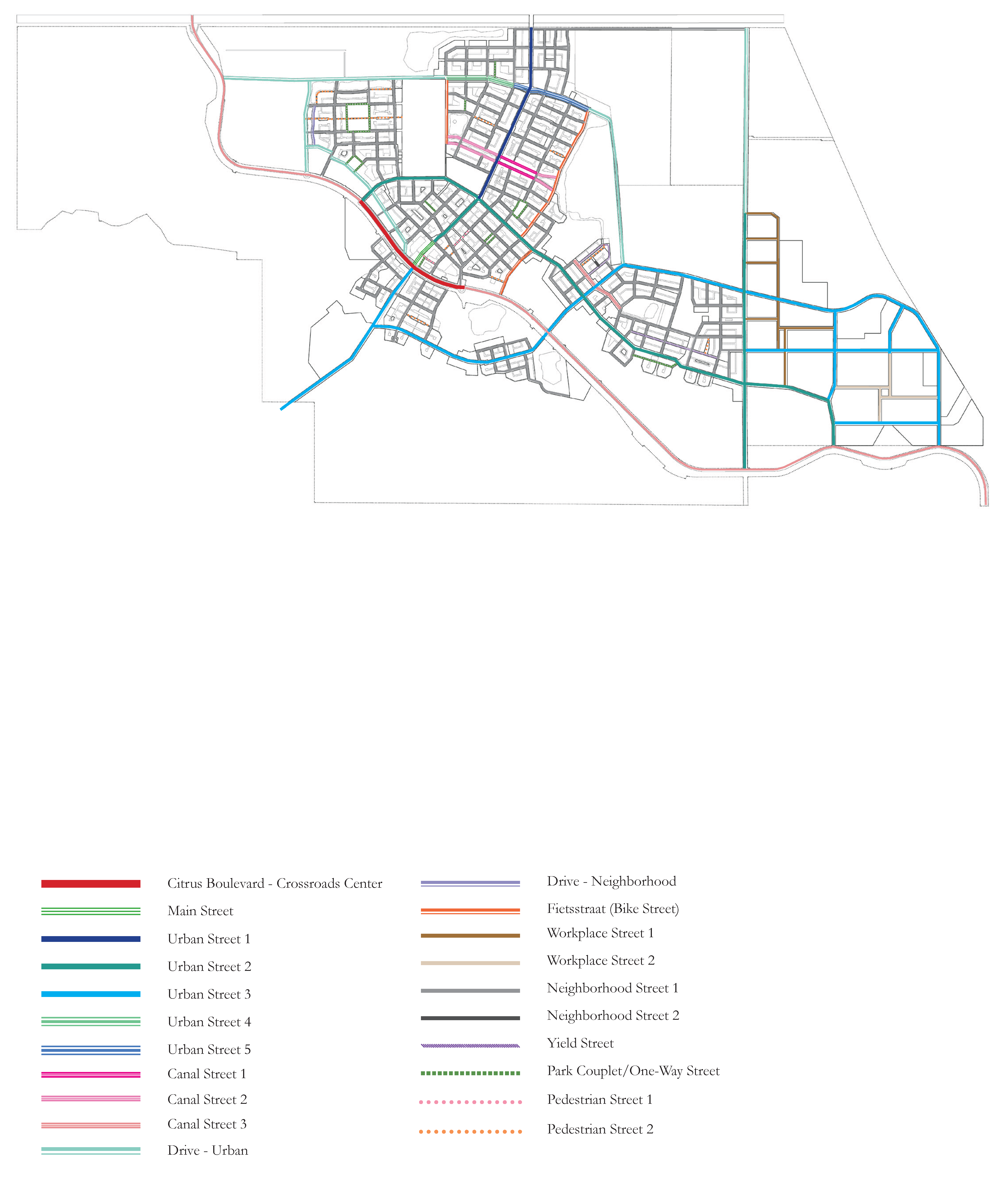
Note: This illustration is not regulatory and depicts a possible configuration of Street Types within the Neighborhood Regulating Plan.
(Ord. No. 1235, Pt. IV, 11-12-2024)
Sec. 11.5.8. - Trail Atlas & Connectivity.
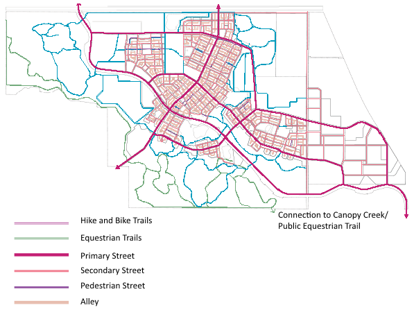
Note: This illustration is not regulatory and depicts a possible configuration of Trail Connectivity within the Neighborhood Regulating Plan.
(Ord. No. 1235, Pt. IV, 11-12-2024)
Sec. 11.5.9. - Street Types.
11.5.9.A.
Citrus Boulevard—Crossroads Center.
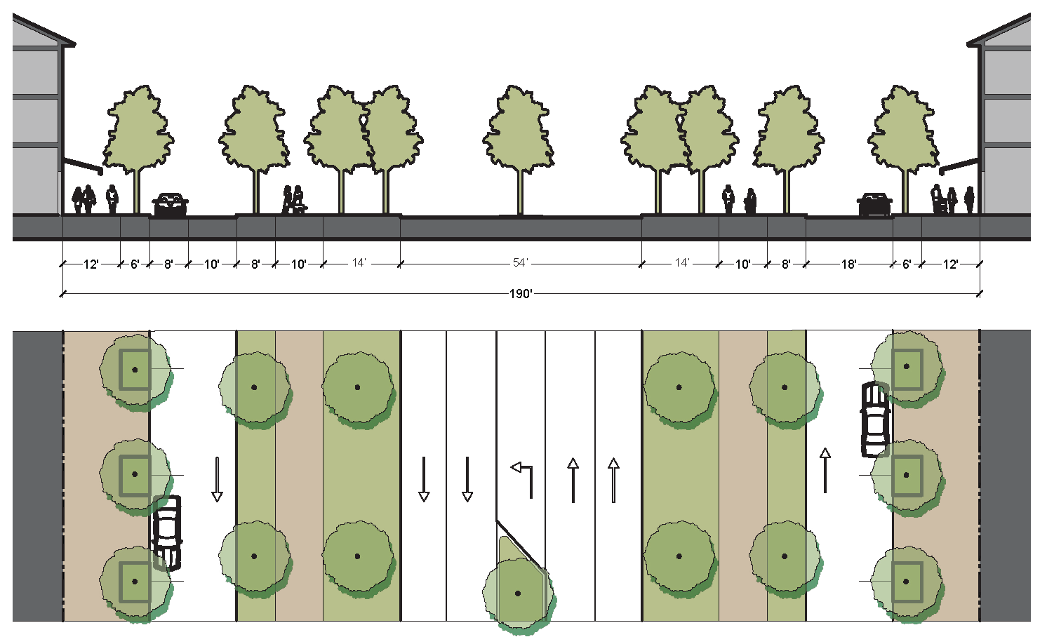
11.5.9.B.
Main Street.
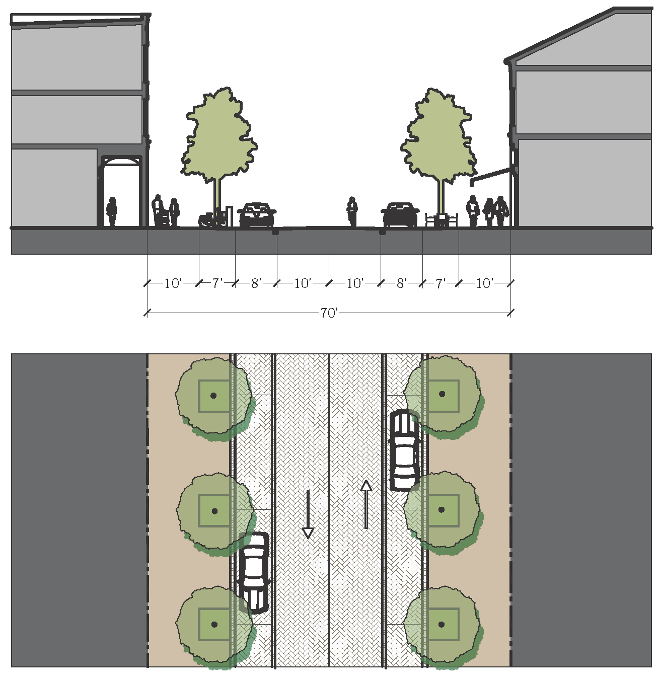
11.5.9.C.
Urban Street 1.
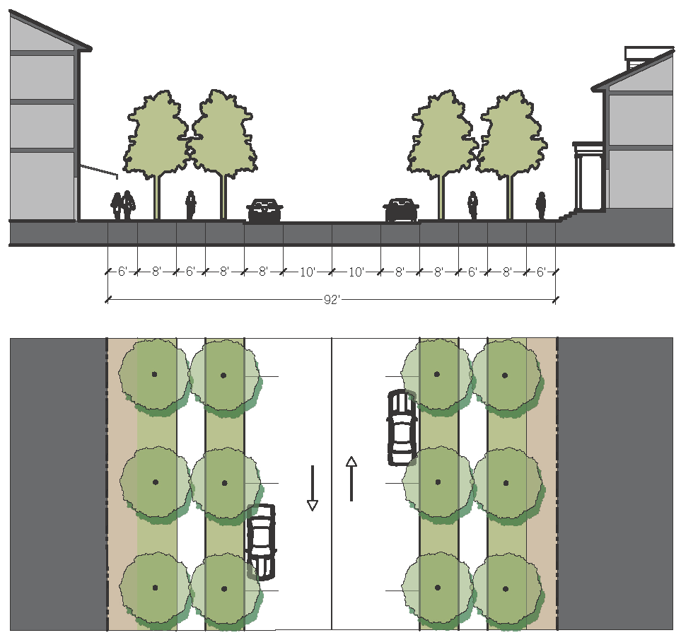
11.5.9.D.
Urban Street 2.
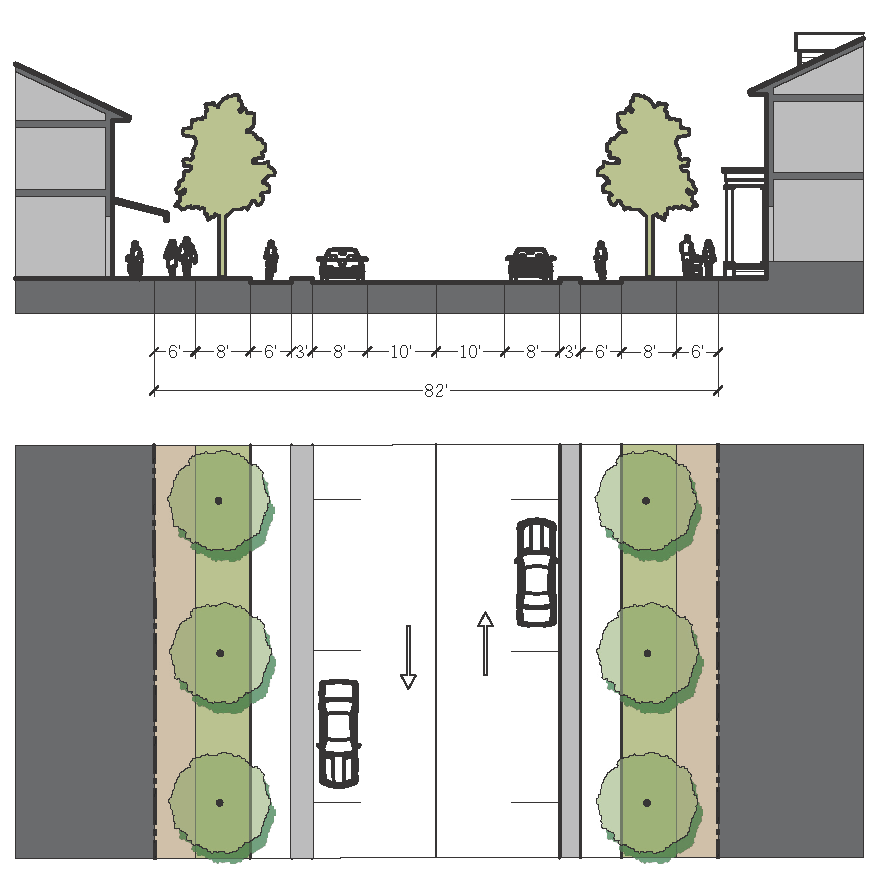
11.5.9.E.
Urban Street 3.
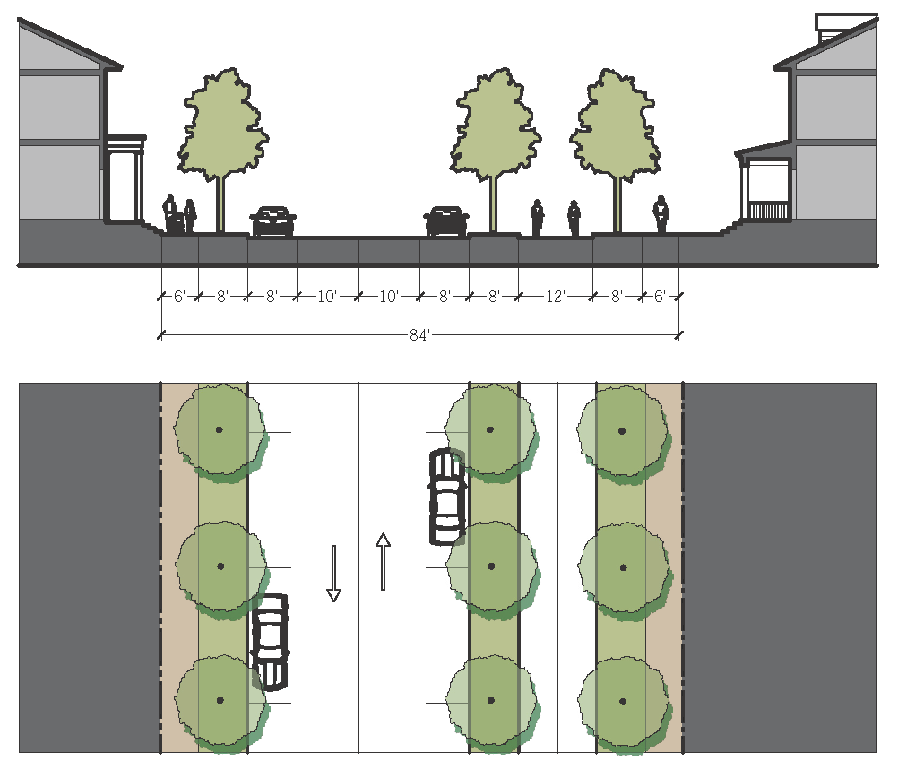
11.5.9.F.
Urban Street 4.
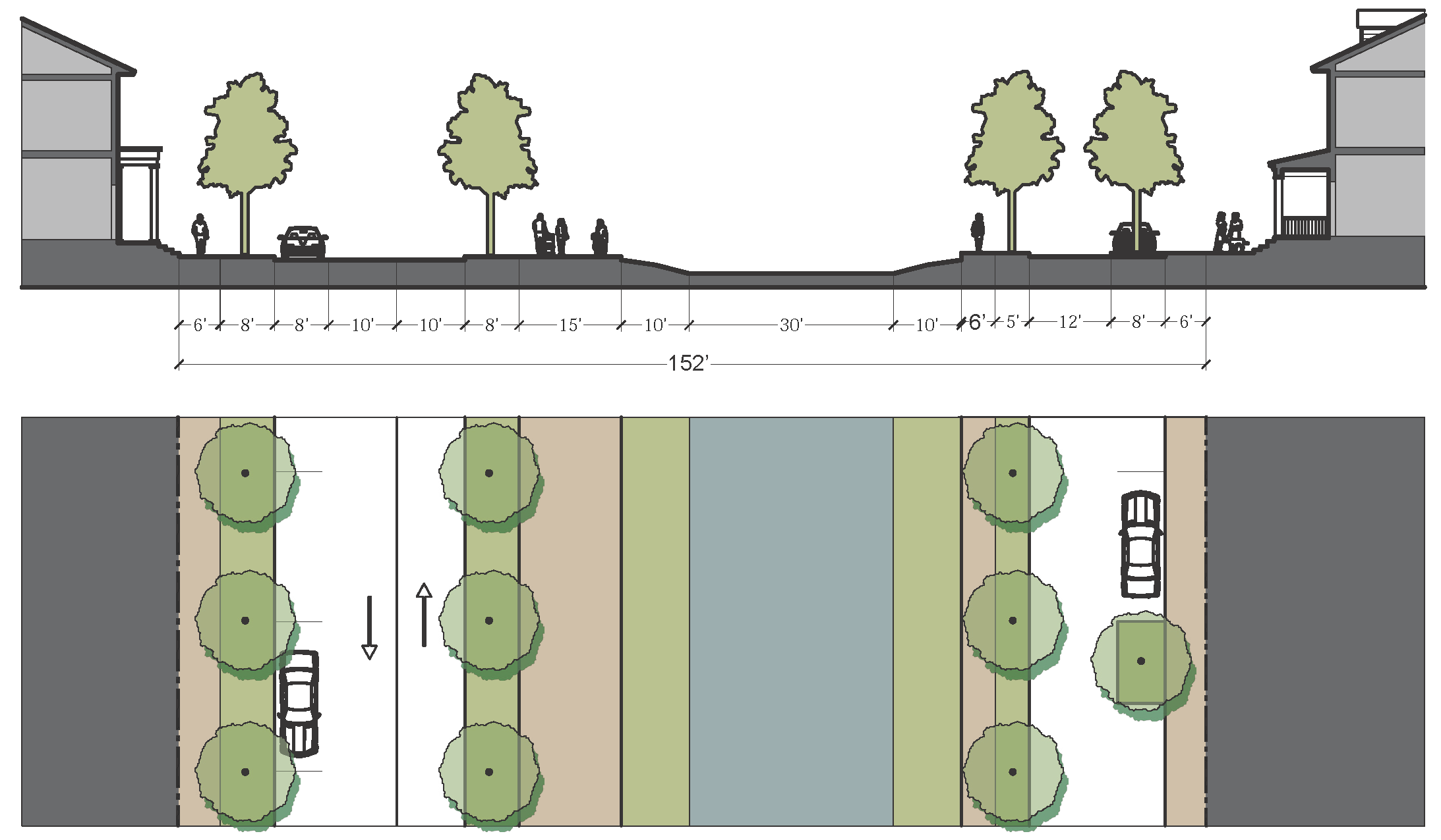
11.5.9.G.
Urban Street 5.
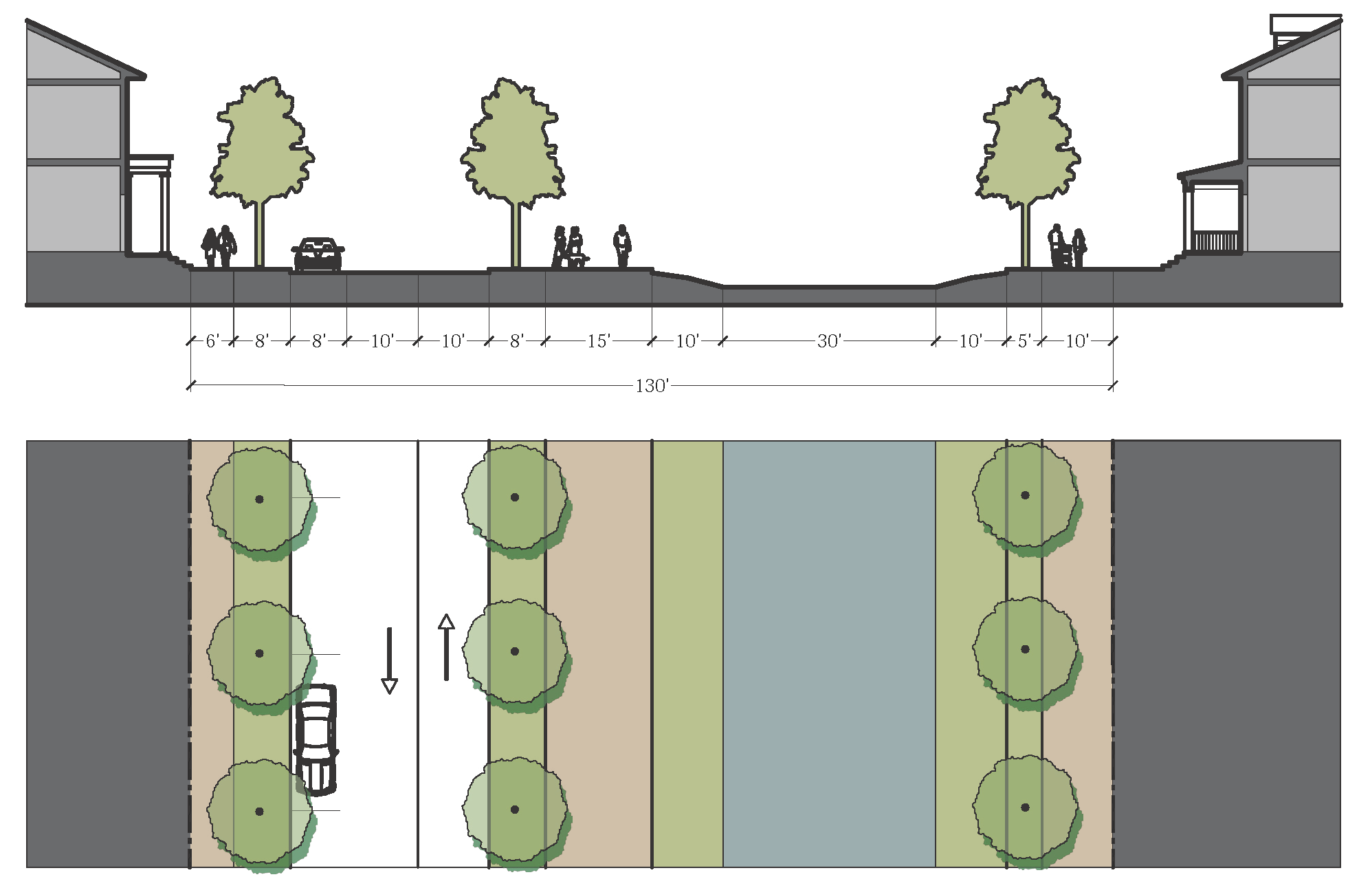
11.5.9.H.
Canal Street 1.
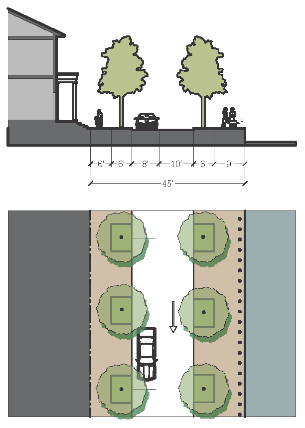
11.5.9.I.
Canal Street 2.
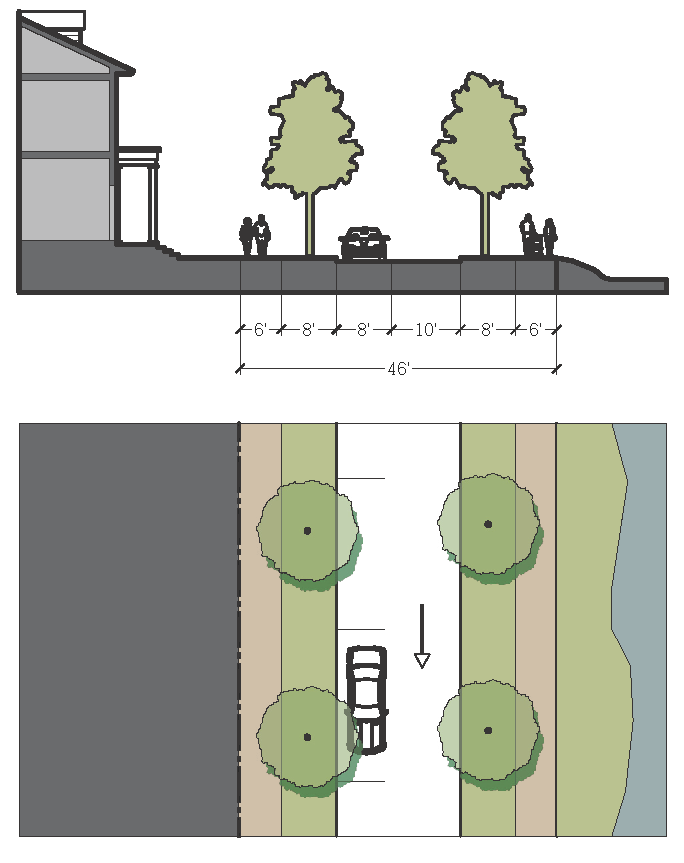
11.5.9.J.
Canal Street 3.
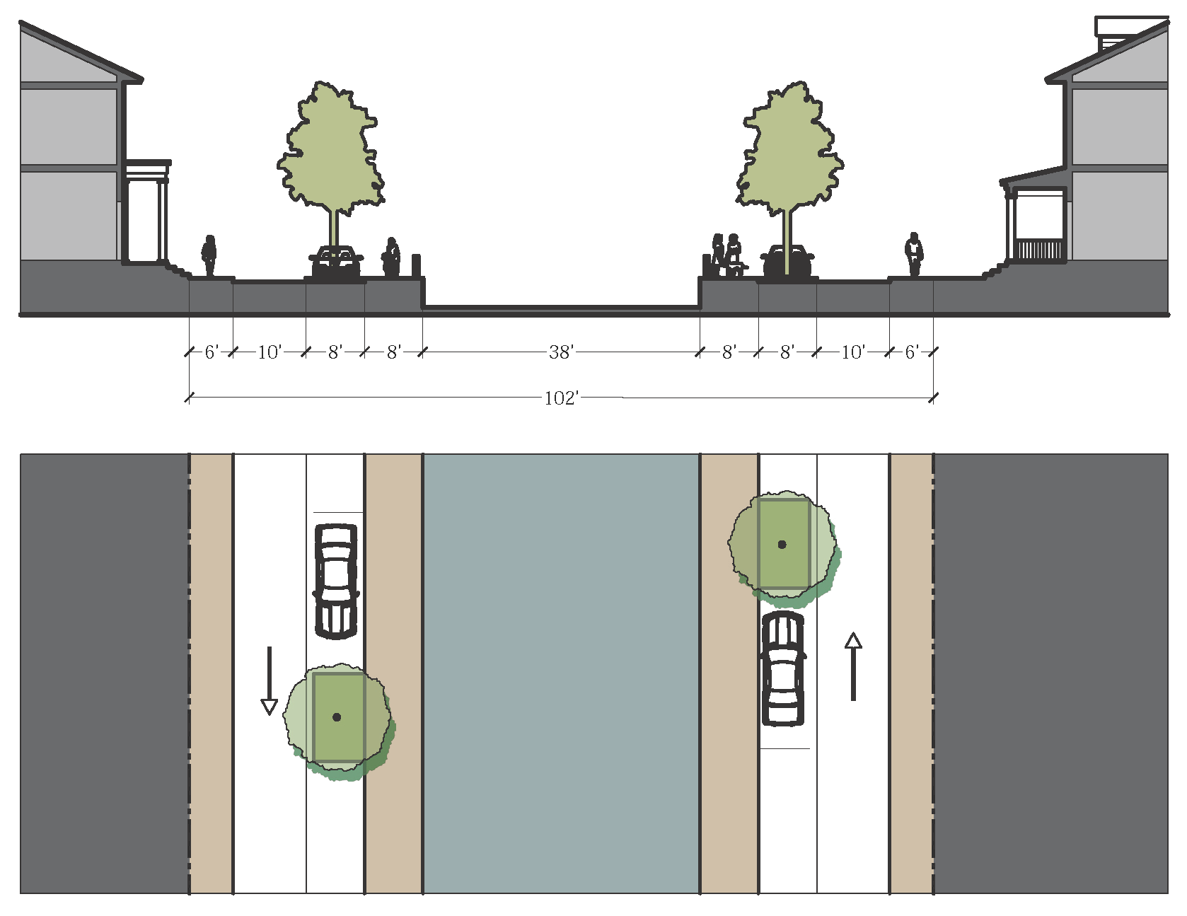
11.5.9.K.
Drive—Urban.
(a) Curb and Gutter

(b) Swale
11.5.9.L.
Drive—Neighborhood.
(a) Curb and Gutter
(b) Swale
11.5.9.M.
Park Couplet.
(a) Curb and Gutter
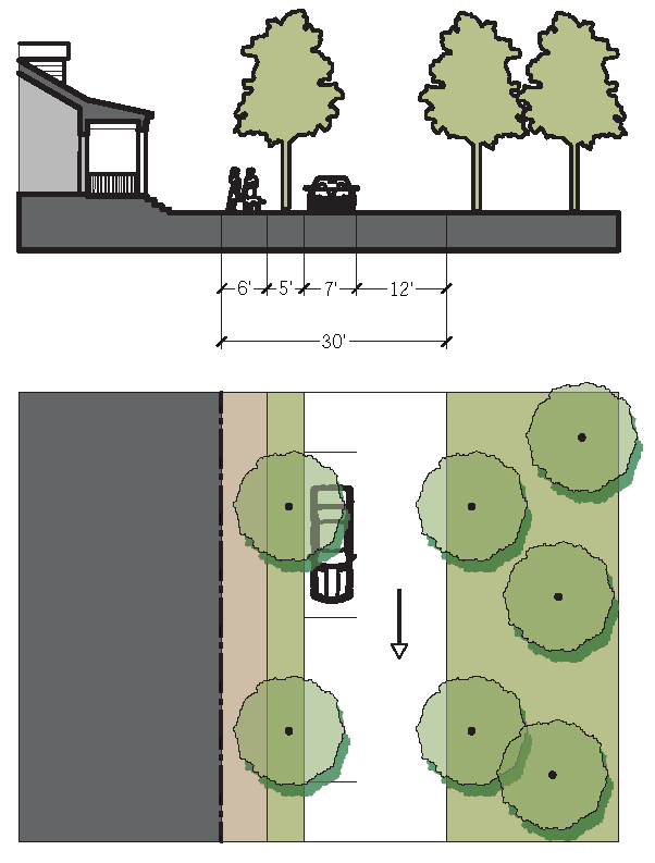
(b) Swale
11.5.9.N.
Workplace Street 1.
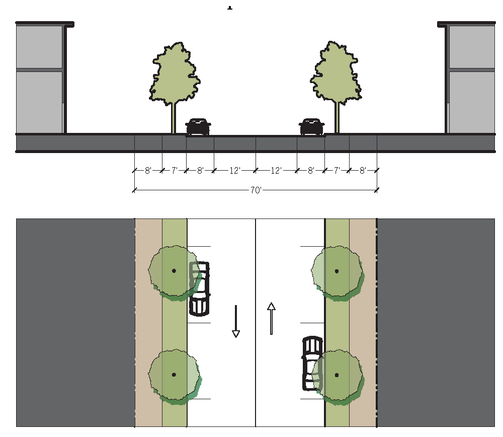
11.5.9.O.
Workplace Street 2.
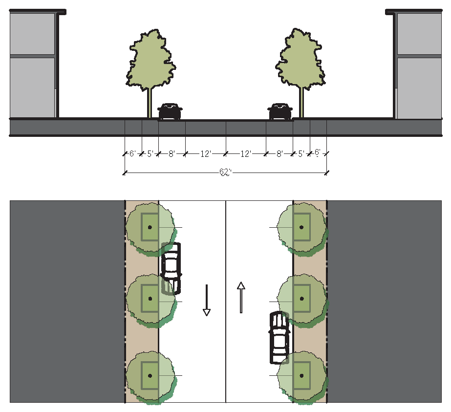
11.5.9.P.
Neighborhood Street 1.
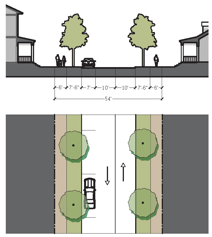
(a) Curb and Gutter
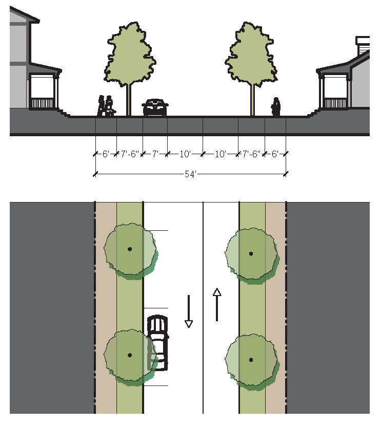
(b) Swale
11.5.9.Q.
Neighborhood Street 2.
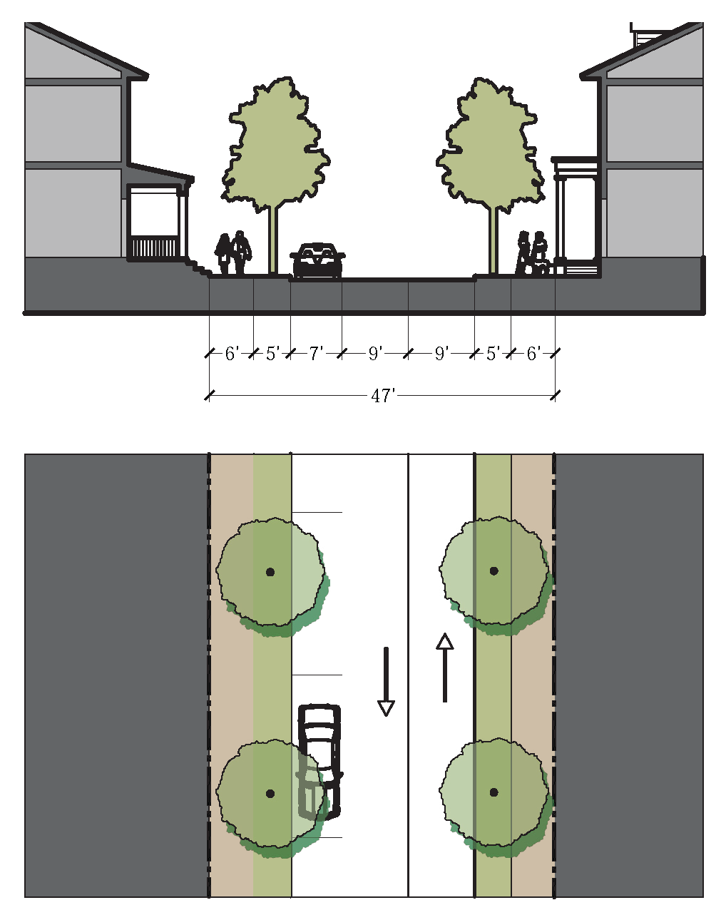
(a) Curb and Gutter
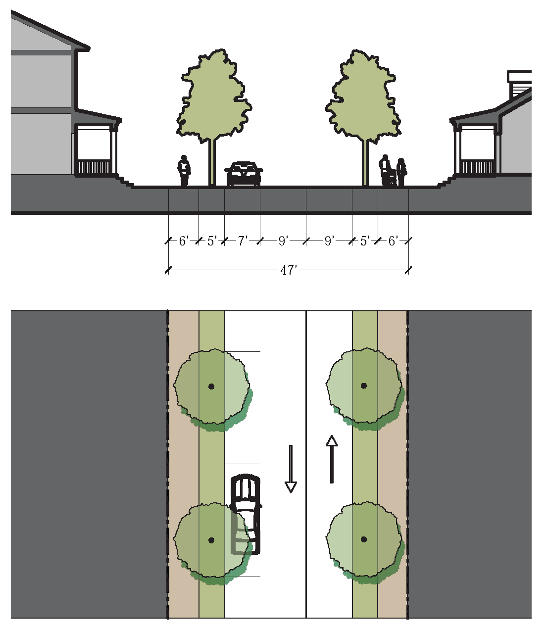
(b) Swale
11.5.9.R.
Yield Street.
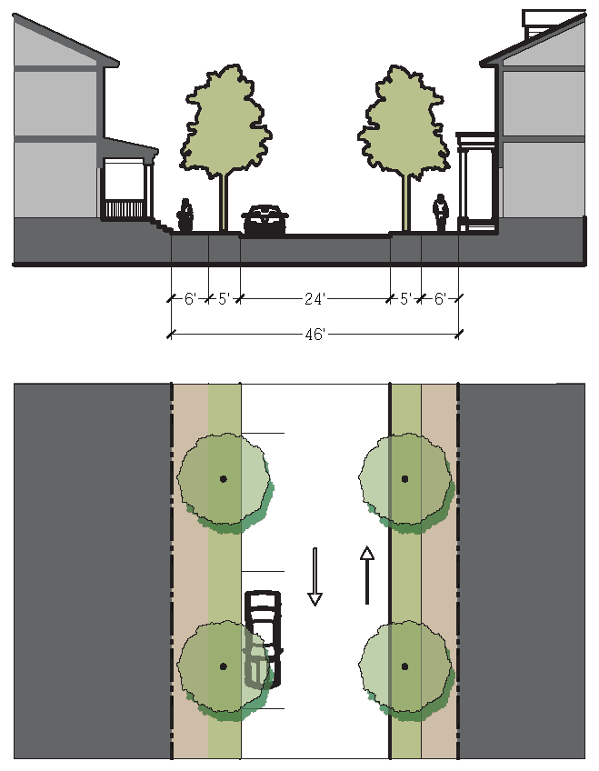
11.5.9.S.
Pedestrian Street 1.
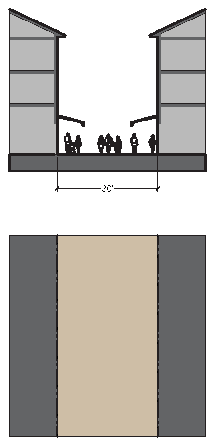
11.5.9.T.
Pedestrian Street 2.
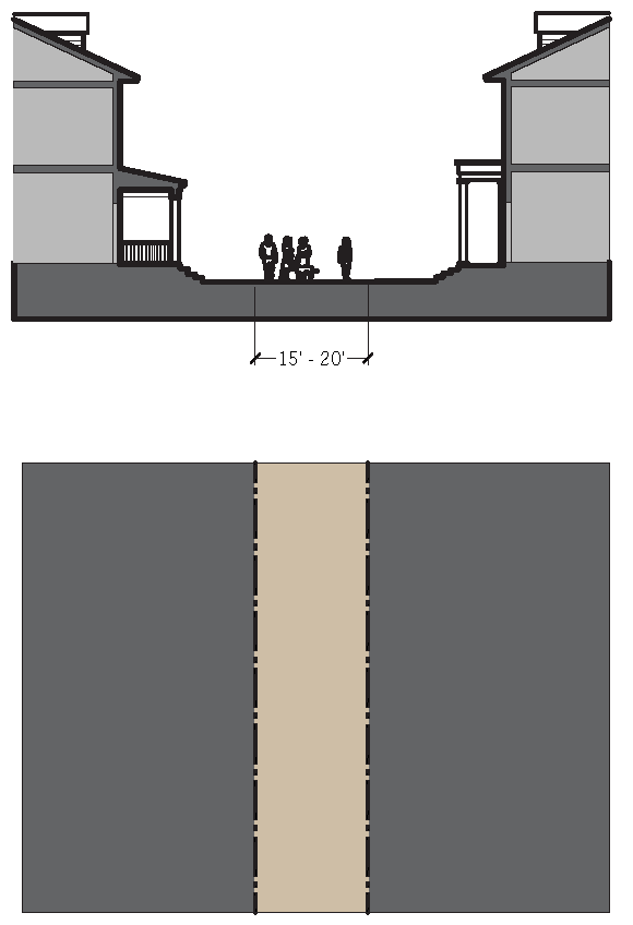
11.5.9.U.
Alley.
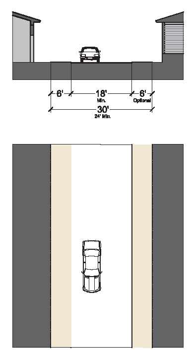
(1) Non-residential and/or Mixed Uses
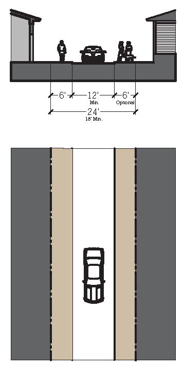
(2) Residential
(Ord. No. 1235, Pt. IV, 11-12-2024)
Sec. 11.6.1. - Purpose.
These general standards apply to all Transect Zones, unless otherwise noted, specifying standards that impact walkability and the quality of the Public Realm as well as parking requirements and the design of signage, lighting, landscaping, and utilities.
Sec. 11.6.2. - Parking Standards.
The intent of the parking standards is to encourage a balance between pedestrian-oriented development and necessary vehicle storage. The goal is to construct neither more nor less parking than is needed.
11.6.2.A.
Parking requirements.
1.
Parking shall be provided for each use based upon the minimum and maximum requirements outlined by use in Table 6-1: Automobile Parking Requirement Chart. Required parking quantities for a parcel may be modified by Warrant.
2.
Parking may be located on the same lot as the use it serves. Required parking may also be located on-street or in a common parking lot, provided the space is within 1/4 mile of the building's Principal Entrance. The required parking may be purchased or leased from a public or private civic parking reserve, the owner of which will manage the purchase or lease.
3.
Parking shall be located behind the Principal Façade of buildings whenever possible. Parking lots shall be masked from the frontage by a Liner Building. Streetscreens, Garden Walls, fences, or hedges are required along all rights-of-way without buildings to shield views to parking).
4.
Shared and Reduced Parking is encouraged in all Transect Zones for more efficient parking solutions. The amount of parking required is calculated by adding the total number of spaces required by each separate function in the Parking Requirement Chart and dividing by the appropriate factor from the Sharing Factor matrix. For example, the residential function requires ten spaces while the office function requires twelve spaces. Independently they would require twenty-two spaces, but when divided by the sharing factor of 1.4, they would require only sixteen spaces. When multiple functions share parking, the lowest sharing factor shall apply.
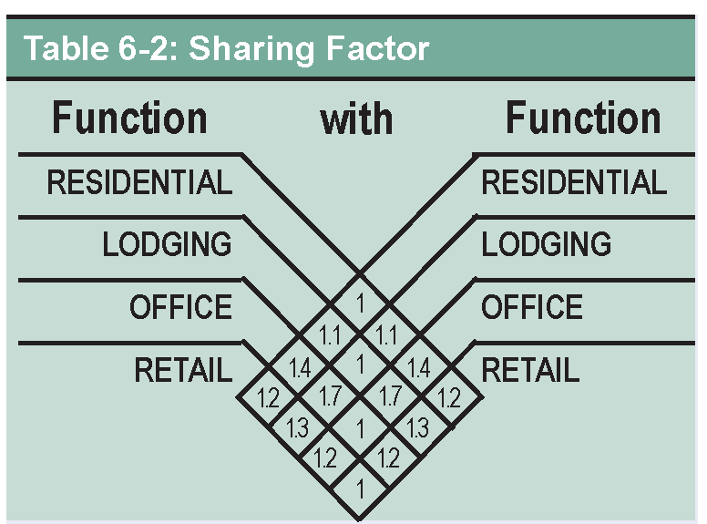
5.
Bicycle parking shall be provided in all Transect Zones per Table 6-3: Bicycle Parking Requirement Chart and subject to the two subsections below:
(a)
Anchors: All spaces provided shall include a metal anchor sufficient to secure the bicycle frame when used in conjunction with a user-supplied lock.
(b)
Location: Bicycle parking shall be located in a secure area covered from weather and shall be located as close to a building entrance as the closest on-site automobile parking space.
11.6.2.B.
Parking Access.
1.
Alleys, where proposed, shall be the primary source of access to off-street parking. Parking along Alleys may be perpendicular, diagonal, or parallel.
2.
Alleys may be incorporated into parking lots as standard drive aisles. Access between parking lots across property lines is also encouraged.
3.
Corner lots that have both rear and side access shall access parking through the rear. If no rear access exists, access to on-lot parking shall be provided from the side street.
4.
If no Alley or side street exists, then efforts should be made to demonstrate an attempt to gain access across neighboring properties.
5.
When access to rear parking must be directly from the Primary Frontage, driveways shall be located along the sides of the property lines and designed such that pedestrians crossing on sidewalks always have the right of way.
6.
The maximum width of vehicular driveways are provided in the Transect Zone Standards.
7.
Circular drives are prohibited except for Civic Buildings.
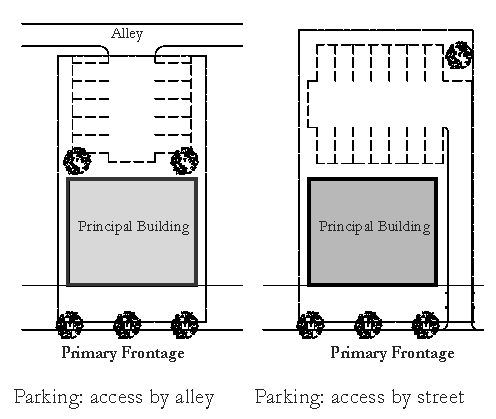
11.6.2.C.
Off-street Surface Parking.
1.
Minimum setbacks for off-street surface parking from all property lines are provided in the Transect Zone Standards.
11.6.2.D.
Garden Walls, Fences, and Hedges.
Garden walls, fences, or hedges may be located along Frontage Lines and other Lot Lines, or parallel with the Façades of buildings. When located along Frontage Lines, garden walls, fences, and hedges are called Streetscreens. Streetscreens may mask a parking lot from the Thoroughfare, provide privacy to a side yard, and/or strengthen the spatial definition of the Public Realm.
1.
Streetscreens shall be a minimum of 3 feet tall in all Transect Zones. Maximum heights shall be:
(a)
T3: 4 feet along Primary Frontage, 8 feet along other Frontages
(b)
T4-0 & T4-R: 4 feet along Primary Frontage, 6 feet along other Frontages
(c)
T5: 4 feet along all Frontages
(d)
SD-W: 4 feet along Primary Frontage, 6 feet along other Frontages
2.
All Streetscreens over 4 feet high should be a minimum of 30% permeable or articulated.
3.
Streetscreens may be non-permeable by warrant.
4.
Streetscreens shall have openings no larger than necessary to allow automobile and pedestrian access.
5.
Streetscreens shall not be permitted in the Right-of-Way.
6.
Along Lot Lines that are not Frontage Lines, garden walls, fences, and hedges shall have a maximum height of 8 feet.
Sec. 11.6.3. - Signage Standards.
Article 4, Division 16, Signs, LDR shall apply within the PMUV except as provided in this section. To the extent that a conflict occurs between this section and Article 4, Division 16, the provisions of this section shall control.
11.6.3.A.
Wayfinding Signs.
1.
Signs in the Public Realm shall enhance the character of the Public Realm, provide orientation to pedestrians and motorists, and help to give identity to the street. Signs should be designed and scaled for use by the pedestrian.
2.
Signage should be coordinated with other streetscape furniture (e.g., light posts) to reduce visual clutter in the Public Realm.
3.
The OSA shall set the pole and frame standard for use throughout the PMUV prior to approval of the first Final Site Plan for aesthetic conformity and maintenance inventory. Any signage, post or frame, to be maintained by Martin County shall be approved by the County Engineer.
4.
Wayfinding signage, which identifies key civic areas or public destinations, shall be consistent in theme and placement as determined by the OSA.
5.
Architectural features and gateways announcing arrival to the entire community or individual neighborhoods may have identification signs of no more than 36 square feet, the theme and placement of which determined by the OSA.
11.6.3.B.
Commercial Signs.
1.
Free standing signs, ground signs, and monument signs are not permitted. All signs shall be attached to the façade. Signs may be flat against the façade, or mounted projecting or hanging from the façade.
2.
Signs shall be externally lit from the front with a full-spectrum source. Back lighting is permitted as an exception only for individual letters or numbers (panelized back lighting is prohibited). Signage within the shopfront may be neon lit.
3.
Maximum gross area of signs on a given façade shall not exceed ten percent of the façade area. Signage painted on a building façade or mounted on the roof may exceed this limit, with approval by the OSA and Growth Management Director.
4.
Signs attached to the façade shall maintain a minimum clear height above sidewalks of eight feet.
5.
Projecting signs shall not extend within two feet of the curb line, and shall not be placed closer than 16 inches apart.
6.
Maximum area of any single sign mounted perpendicular to a given façade shall not exceed nine square feet in the T5 Center and SD-W Zones and shall not exceed six square feet in other Transect Zones.
7.
A single external Sign Band may be applied to the façade of each building, provided that such sign not exceed three feet in height by any length. Letter height shall not exceed 24 inches.
8.
Permitted finish materials include: Wood: painted or natural; Metal: copper, brass, galvanized steel; Painted or printed canvas; Painted/engraved directly on façade surface; Neon (In T5 and SD-W only).
11.6.3.C.
Banner Signs.
1.
The use of banner signs shall be limited to the promotion of public events and activities, or to identify a district.
2.
Banner signs may be mounted on light poles or other street furniture designed specifically for such a purpose.
3.
Banner Signs shall not be illuminated.
4.
Temporary banner signs not exceeding three (3) feet in height and thirty (30) feet in length may be hung over the public right-of-way pursuant to Article 4, Division 16.
11.6.3.D.
Temporary Sidewalk Signs.
1.
Temporary sidewalk signs such as A-frame sandwich boards are permitted on public sidewalks immediately adjacent to a business for the purpose of advertising food or products sold within with the approval of the OSA.
2.
The placement of signs on the sidewalk must maintain a clear sidewalk path of a minimum dimension of five feet.
Examples of Permitted Commercial Signage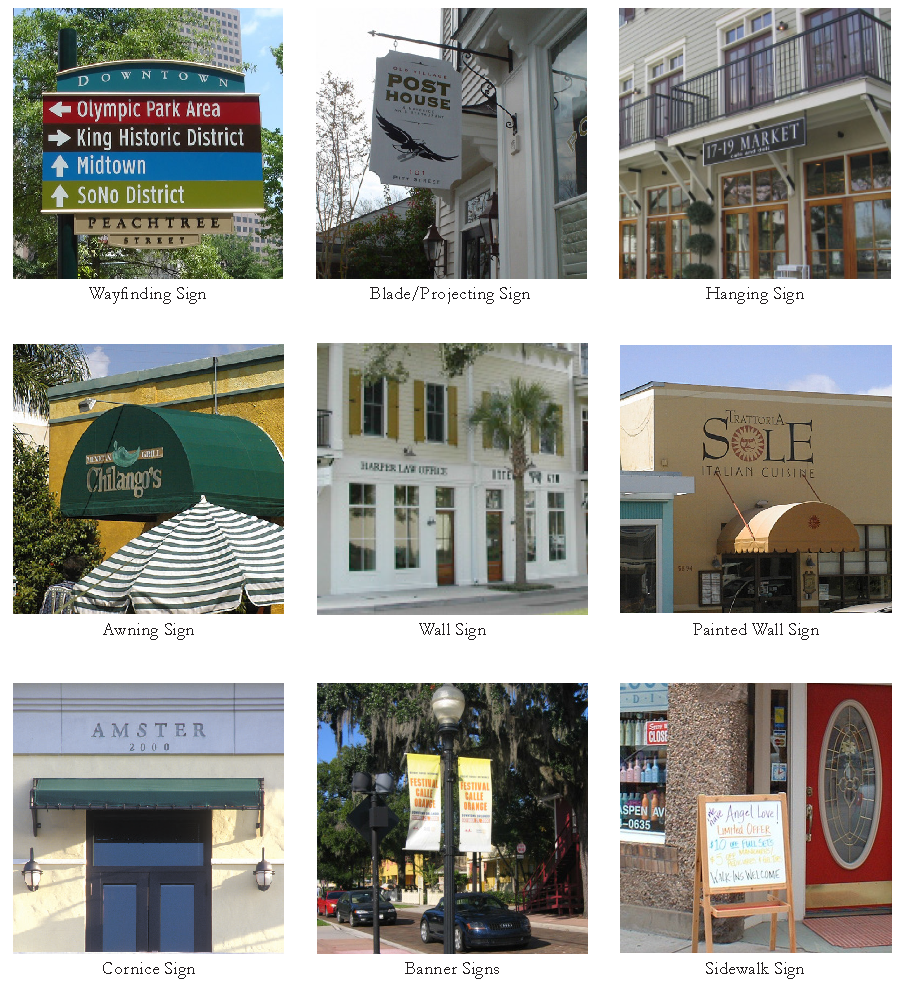
3.
The dimensions of the sign shall be no greater than two and a half feet wide and five feet high.
4.
Temporary sidewalk signs shall not be illuminated.
5.
Temporary sidewalk signs shall be approved by the OSA.
Sec. 11.6.4. - Lighting Standards.
Adequate and quality lighting of the sidewalk and street area is essential to creating a safe and inviting streetscape.
11.6.4.A.
General Lighting Standards.
1.
Lighting fixtures shall be appropriately chosen for the PMUV There shall be consistency in creating a unifying scheme of illumination that is appropriate to the scale of the street and the level of evening activity.
2.
Lamp styles should not be mixed along any one particular block of a street.
3.
Light fixtures shall be downcast or low cut-off fixtures to prevent glare and light pollution.
4.
In order to conserve energy and reduce long-term costs, energy-efficient lamps shall be used for all Public Realm lighting.
11.6.4.B.
Light Levels.
1.
Lighting standards protect against glare, preserve the night sky, and reduce unnecessary energy use from over lighting. Rural zones tend to be darker, while higher levels of outdoor lighting may be more suitable in mixed use urban zones.
2.
It is the intent of this Article to follow Dark Sky provisions as established by the International Dark-Sky Association (IDA). All outdoor lighting within the Public Realm should be IDA-Approved fixtures.
3.
The standards in Table 6-4 maintain the desired general ambient light levels across the Transect. Light levels in the Civic Transect Zone shall be consistent with the intent of this Article and not contribute to excessive light pollution, as determined by the Settlement Architect.
11.6.4.C.
Street Lighting.
See Part 6: Thoroughfare Standards
11.6.4.D.
Parking Lot Lighting.
1.
All fixtures shall be full cutoff, downward facing.
2.
Light fixtures located within the interior area of a parking lot shall not exceed 30 feet in height. Light fixtures located along the perimeter edge of a parking area within 50 feet of a property line shall not exceed 15 feet.
11.6.4.E.
Pedestrian Walkway Lighting.
1.
Light fixtures located along pedestrian walkways adjacent to parking lots shall not exceed 15 feet in height.
2.
Light fixtures located along internal pedestrian walkways or paths not adjacent to a parking area shall not exceed 10 feet in height.
11.6.4.F.
Building and Security Lighting.
1.
All exterior building or security lighting must be full cutoff, shielded, and/or angled downward to focus the light only on the intended doorway or walkway as necessary.
2.
Security lighting is encouraged to be provided with regular pedestrian light fixtures where visible from the street or Public Realm to match others used on site.
3.
Building mounted architectural "accent lights" are encouraged to emphasize architectural character and signage.
4.
Business owners are encouraged to assist with lighting the sidewalk and to accent their business location by leaving display window and interior lighting on at night. Lighting shall be designed in such a way as to prevent the direct view of the light source to neighboring residential areas.
5.
Edges of Civic Open Spaces, especially Plazas and Squares, should be lit along the Right-of-Ways to define and identify the space.
6.
Focal points such as sculptures, fountains, and towers, especially those visible to pedestrians and vehicles, may be illuminated to call attention to the element and to provide a form of wayfinding.
Sec. 11.6.5. - Utilities.
11.6.5.A.
General Standards.
1.
With the exception of fire hydrants, utilities shall run underground and above-ground projections of utilities shall be placed in rear service areas wherever practicable.
2.
All utility services should be located in the rear of buildings, clear of pedestrian and vehicular interaction, and screened from view from adjacent public Right-of-Ways, properties, and pedestrian walkways (not including Alleys).
3.
Tree wells or root barriers should be used where proposed street trees are near proposed underground infrastructure lines or adjacent to a travel way (vehicular or pedestrian).
4.
Alleys and portions of the Thoroughfare Right-of-Way should serve as designated drainage and utility corridors/easements.
5.
Where special circumstances dictate utility easements are needed between Lots, utility easements shall be a minimum width as required by the utility agency and approved by the OSA.
Sec. 11.6.6. - Landscape Standards.
11.6.6.A.
General Standards.
1.
Sec. 4.661.B.l, Sec. 4.663.A, Sec. 4.663.B, and Sec. 4.663.C of the Martin County Land Development Regulations do not apply to the PMUV.
2.
Landscape design shall enhance the quality and character of the Public Realm by coordinating public and private space, providing spatial definition to the Public Realm, screening undesirable places/sounds/odors, and increasing health and safety.
3.
Landscaping shall complement the architectural design of mixed-use development.
4.
Landscaping shall be designed to remain functional and attractive during all seasons through a thoughtful selection of plant varieties.
5.
In order to promote sustainable landscape practices, plant varieties shall be selected for resistance to drought, moisture, salt, urban conditions, or insects and other pests depending on the location of landscaping and the specific stressors anticipated for different areas of the site, as well as for their intended function and context. Plants shall be selected so that landscaping can be maintained with minimal care and the need for watering, pesticides, or fertilizers can be minimized or eliminated. Native species are encouraged. See Sec. 4.664.A, Sec. 4.664.C, Sec. 4.664.D, and Sec. 4.664.E of the Martin County Land Development Regulations for landscape material standards. See Sec. 4.665 of the Martin County Land Development Regulations for standards on maintenance of required landscaping.
6.
The use of turf shall be minimized and shall not be planted in strips less than 5 feet wide. Lawn seed mixes shall be drought resistant. To achieve a high level of drought tolerance, lawn mixes may include, but shall not be limited to, a predominance of Floratam. The use of Zoysia hybrids and other drought tolerant grasses is encouraged.
7.
In Transect Zones T2 and T3, native plant perennial landscapes should replace turf grasses where possible and be very diverse. They should be placed lower than walkways, not mounded up.
8.
Design of landscape should maximize use of green infrastructure stormwater Best Management Practices (BMPs) such as pervious paving, bioretention systems, rain gardens, bioswales, and stormwater planters to slow and treat stormwater runoff while providing multiple additional community benefits. The settlement architect will approve landscaping in private front yards, civic spaces, etcetera.
9.
Trees on Lots shall be protected as required by Sec. 4.666 Martin County Land Development Regulations.
10.
Preserve area interface requirements for landscaping and stormwater management systems are established by Sec. 4.663.E Martin County Land Development Regulations.
11.6.6.B.
Landscape Application Requirements.
1.
All development applications shall include a landscape plan as required by Sec. 4.662.A Martin County Land Development Regulations.
2.
If an irrigation system is to be installed on a Lot, irrigation plans shall be submitted as established by Sec. 4.662.B Martin County Land Development Regulations.
3.
Sec. 4.667 and Sec. 4.668 of the Martin County Land Development Regulations establish alternative compliance and certification of compliance standards, respectively, for landscape plans and irrigation plans.
11.6.6.C.
Parking Lot Landscape Standards.
The landscaping requirements in this section are intended to provide a set of standards toward reducing the visual impacts of large areas of pavement, improving the overall environment of parking areas by providing areas for shade and heat reduction, and enhancing the overall aesthetic appeal of parking areas.
1.
Developments with proposed parking areas of 6 spaces or more shall provide a minimum of ten percent of landscaped open space within the area designated for parking inclusive of any landscaped borders surrounding the parking lot. Use of the provided landscaped open space for vegetated stormwater quality management is allowed and encouraged.
2.
Surface parking lot entrances shall be landscaped with a combination of trees, shrubs, walls, and other landscape features. No trees, shrubs, fences, walls, or other landscape feature shall be planted in a manner to obstruct sight lines of motorists.
3.
The ends of parking aisles in surface lots that are more than 15 spaces in length shall incorporate landscape islands at either end of the row. Each island shall include at least one tree. Where the length of a parking aisle exceeds 25 spaces, additional landscaped islands shall be installed at regular intervals. This interval shall not be more than every 13 spaces. The width of landscaped islands perpendicular to adjacent spaces shall be no less than 6 feet.
4.
In addition to the requirements above for parking area landscaping, trees shall be planted in buffer areas and along frontage lines at a minimum frequency of one every 30 linear feet measured along the buffer or lot line. Trees shall be selected and placed in landscaped areas so that all parking areas can reasonably be expected to receive 30% Tree Canopy Coverage. The expected canopy radius of each selected tree shall be noted in the required site plan materials.
11.6.6.D.
Street Trees.
See Sec. 11.5.5 Street Trees.
11.6.6.E.
Irrigation Systems.
1.
When irrigation systems are provided, sustainable systems, such as low volume heads, drip irrigation, and other water efficiency methods are encouraged.
Sec. 11.6.7. - Stormwater Management.
11.6.7.A.
General Standards.
1.
The objectives of the stormwater management standards are to reduce water quality impacts at receiving waters, enhance community character in support of compact development, and promote the public health, safety, and welfare. The stormwater management standards include the following goals:
(a)
Manage rainfall as close to where it falls as possible, approximating the natural pre-development hydrology (water quality and water quantity) by using natural, decentralized stormwater management practices that do not impede or negatively alter the historic flow of stormwater runoff.
(b)
Celebrate stormwater as an integral part of the built environment.
(c)
Establish watershed sensitive planning and design criteria at the neighborhood scale of development to support shared flood control solutions.
(d)
Encourage incorporation of Light Imprint Best Management Practices (BMPs) at the Block, street, and site scales of development, appropriate to land use context and site conditions.
2.
A Stormwater Management System shall be developed to manage stormwater in each Neighborhood as whole.
3.
Stormwater management shall be implemented within a Final Site Plan.
4.
Stormwater standards for individual Lots within the neighborhood can assist in meeting the standards of the neighborhood as a whole.
5.
All stormwater shall be managed in accordance with Divisions 9 and 10 of Article 4 of the Martin County Land Development Code.
11.6.7.B.
Light Imprint Storm Drainage Methods.
1.
Table 6-5 provides recommended stormwater management methods as outlined in the Light Imprint Handbook. These methods shall be utilized as the elements of the neighborhood stormwater strategy and the Final Site Plan detailed stormwater management plan. At least one of these methods shall be applied at the neighborhood, corridor, and Lot levels to implement the neighborhood stormwater strategy. Refer to the Light Imprint Handbook for comprehensive descriptions of each method and its application.
2.
The Light Imprint stormwater management methods appropriate for use within the Civic Transect Zone shall be determined by the Settlement Architect and the County on a site-by-site basis based on the use and character of each site.
11.6.7.C.
Design Criteria.
1.
Properly designed Pervious Paving shall be permitted and is encouraged to reduce stormwater runoff volume. Pervious Paving approaches may be technically infeasible where underlying soils are contaminated or other site constraints exist.
2.
Green roofs shall be permitted for all building types.
3.
Roof drains shall not outfall onto impervious pedestrian use areas and should instead be directed to underground storm drainage systems or a vegetated stormwater management system.
4.
Irrigation systems are encouraged to first make use of all available surface stormwater runoff or other retained or detained stormwater as a water supply.
5.
Bioretention systems, rain gardens, bioswales, tree filters, and other vegetated stormwater management systems are encouraged for treatment of stormwater runoff from streets, parking lots, plazas, and other impervious surfaces. These vegetated stormwater management systems can include impermeable liners with underdrains to provide water quality treatment where infiltration is not technically feasible due to site contamination concerns.
6.
Trees should be planted below the grade of the sidewalk and the street. Structural cells should be used for trees planted in tree wells, or in plazas or other paved areas, to ensure sufficient root space for healthy tree growth and to increase the stormwater management potential of the trees.
7.
Special Detention Areas such as parking lots, rooftops ("blue roofs"), parks, plazas, and fields are areas primarily designated for other uses but that may be used for temporary infiltration and/or peak rate mitigation during storm events if the requirements herein are satisfied. Special Detention Areas shall be designed sensitive to land use context and public use requirements and the following conditions:
(a)
Temporary storage areas must be located so that ponding will not significantly disrupt typical traffic (pedestrian/bicycle/vehicle) flow, and areas should be adequately sloped towards outlets to ensure complete drainage after storm events.
(b)
Special Detention Areas shall be clearly identified as such and their use shall be restricted during and after storms.
(c)
Emergency overflows shall be incorporated and designed to prevent excessive depths from occurring during extreme storm events or if the primary flow control structure/structures are clogged. In most cases, ponding depth shall not exceed 12 inches.
(d)
Rooftop storage must consider structural support, HVAC requirements, waterproofing, emergency overflows, and all other building design considerations.
(e)
Landscape or turf Special Detention Areas used for high-intensity public uses (community parks, athletic fields, greens, etc.) shall be located in areas of well-draining soils to guarantee public use is not compromised by excessively wet ground between rain events.
Sec. 11.6.8. - Environmental.
11.6.8.A.
General Provisions.
This section applies to the preservation and conservation areas within the PMUV, including protected wetlands, wetland buffers and native upland habitat. Conservation areas outside the PUSD shall provide recreational activities, such as hiking, horseback riding and bicycling. Native vegetation shall be retained in conservation areas except for limited clearing required for trails, boardwalks, agricultural fencing, supporting infrastructure and existing agricultural uses. These areas shall be maintained free of invasive exotic plant species.
The upland preservation requirements for the MUV shall be established with PAMP I for the PMUV All development within the PMUV district will conform to the provisions set forth within this article and shall comply with the regulations established in Article 4 of the Land Development Regulations for wetlands protection. This division shall be consistent with the Comprehensive Growth Management Plan.
11.6.8.B.
Establishment of Preserve Area Management Plans.
As required by Article 4, Division 1 of the Land Development Regulations, all wetland areas shall be protected and managed under a PAMP. The PAMPs for the PMUV shall be created in three categories.
1.
PAMP I. Established for the management of contiguous wetland and upland habitat within the preserve shown in the northwest area of the regulating plan. This plan shall designate primitive pedestrian trails and equestrian trails as provided on the Trail Atlas. This PAMP shall include language that is appropriate for management of large scale preservation areas including prescribed fire management. PAMP I shall be approved concurrently with the first Master Plan for development.
2.
PAMP II. Established for the management of wetlands and wetland buffers within conservation areas and that are not part of PAMP I or any master or final site plan for development. These wetland and wetland buffer preserve areas shall be protected from agricultural activities, including cattle grazing, in order to maintain native vegetative communities, which may include agricultural fencing. PAMP II shall be approved concurrently with the first Master Plan for development.
3.
PAMP III. Established for the management of wetlands and wetland buffers within neighborhoods as approved with final site plans for development. PAMP III shall be amended to incorporate additional preservation areas as each new final site plan is approved in the PMUV
11.6.8.C.
Requirements for listed species.
The PMUV will endeavor to establish a long-term gopher tortoise recipient site within a conservation area. The designation shall be in conformance with criteria and permitting as required by the listing agency. As necessary, the appropriate PAMP shall be amended to reference any such permit requirements, including habitat management criteria for gopher tortoises. The recipient site may be managed and maintained by a land trust or other similar entity that meets permit criteria.
Sec. 11.7.1. - Purpose.
11.7.1.A.
The purpose of this division is to provide development review procedures which implement the MUV and the PMUV.
11.7.1.B.
The development review process established in this Division is applicable to all proposed development activity within the PMUV The provisions of Article 10, LDR, are not applicable within the PMUV unless expressly provided.
11.7.l.C.
No development, including clearing, excavation of soil, or alteration of vegetation, shall be commenced or undertaken in the PMUV that is inconsistent with the Comprehensive Growth Management Plan (CGMP), the LDR and the Code of Ordinances (Code). It shall at all times be the applicant's responsibility to demonstrate consistency with the goals, objectives and policies of the CGMP, the provisions of the LDR and the Code.
Sec. 11.7.2. - Master and Final Site Plans Required.
11.7.2.A.
All development within the PMUV requires Master Site Plan and Final Site Plan approval. Development outside the Urban Services Boundary shall require a final site plan.
11.7.2.B.
Issuance of a development order for a Master Site Plan shall authorize the applicant to submit the Final Site Plan(s) in accordance with the terms and conditions of the Master Site Plan, including the timetable of development. Issuance of a development order for a Master Site Plan shall not constitute approval to build or construct any improvements and is not the final approval necessary for construction of the development.
11.7.2.C.
Issuance of a development order for a Final Site Plan shall authorize the applicant to submit Lot Plans as part of a building permit applications in accordance with the terms and conditions of the approval. Permission to initiate construction of site improvements shall not be granted or building permits issued until all required documents are executed and all applicable conditions of approval satisfied.
11.7.2.D.
All Master, Final and Lot Plans submitted to the Martin County shall include a letter from the OSA stating the application is in compliance with OSA requirements.
(Ord. No. 1235, Pt. V, 11-12-2024)
Sec. 11.7.3. - Master Site Plans.
11.7.3.A.
The land area encompassed by a Master Site Plan shall be the minimum area allowed for neighborhood development pursuant to Table 3-1 Neighborhood Type Summary.
11.7.3.B.
The following documents must be submitted by the applicant to the Settlement Architect and subsequently to the County for review and approval:
1.
Illustrative plan that is "to scale" and clearly illustrates a neighborhood structure, a network of streets and blocks, the location of lots, and the reservation of lots for Civic Buildings and Civic Open Space;
2.
Master site plan tied to a boundary survey that clearly illustrates a neighborhood structure, a network of streets and blocks, and the reservation of lots for Civic Buildings and Civic Open Space;
3.
Transect plan showing the lot, block and street network and allocation of Transect Zones;
4.
Streets atlas showing the Street Thoroughfare locations and Street Types including street cross sections;
5.
Conceptual stormwater management plan;
6.
Concurrency data at the neighborhood level;
7.
Overall program and percentages of total vested rights; and
8.
Illustrations that depict the proposed scale and character or the development of the area.
11.7.3.C.
These documents must clearly:
1.
Identify any natural resources with T1 or other Transect Zones that are to be protected through easement or other means;
2.
Establish a maximum allowable development program; and,
3.
Meet all other neighborhood requirements as established in Divisions 2, 3, and 5 of this Article.
11.7.3.D.
Applications for County approval of Master Site Plans shall be subject to the following:
1.
A letter of approval and all documents and plans reviewed and approved by the OSA shall be submitted along with the development application to the County for review.
2.
The application shall be filed with the County Administrator by the owner or other person having power of attorney to act as agent for the owner.
3.
Applications shall be received by the county for processing on any working day.
4.
Proof of ownership and financial disclosure pursuant to Section 10.5.D.1., LDR is required.
5.
The application shall be submitted in a form approved by the County Administrator and made available to the public. At a minimum, it shall include sufficiently detailed and documented information for staff to make the required findings of compliance. All applications shall include a checklist provided by the County specific to Master Site Plan applications, submitted in accordance with Article 11, LDR.
6.
Each application shall be accompanied by the application fee and completeness determination fee as established by resolution of the BCC.
11.7.3.E.
If a Master Site Plan application approval requires changes to the Regulating Plan, the applicant shall address such changes within the application materials submitted with the Master Site Plan application. The change to the Regulating Plan, shall require approval of an amendment to this Article by the BCC, unless the change qualifies as a Warrant.
11.7.3.F.
Applications will be reviewed for completeness within 5 working days. Applications deemed incomplete will be returned to the applicant with a letter outlining the deficiencies that need to be addressed for review. Applications found complete will be transmitted to development review staff.
11.7.3.G.
The County Administrator shall prepare a staff report within 30 working days of transmittal which addresses all of the requirements of the CGMP, the LDR, and the Code.
11.7.3.H.
Upon a finding of noncompliance, a resubmittal of requested materials shall be made within 30 working days of the issuance of the staff report. If the applicant fails to meet the resubmittal deadline, the application may be terminated, unless the applicant gives notice that an elective resubmittal will be made. The elective resubmittal may be made within 90 days from the date the prior resubmittal was due, and shall include the resubmittal fee established by resolution of the BCC. All documents that have expired must be updated by the applicant. Upon receipt of the resubmittal, staff will have 20 working days to review and provide comments. Minor adjustments to plans and application materials that do not require full staff review may be amended prior to the BCC hearing at the discretion of the Growth Management Director.
11.7.3.I.
Upon findings of compliance with the CGMP, LDR and the Code, the development application shall be scheduled for consideration by the BCC at a public meeting. The public meeting shall be conducted pursuant to Section 10.10, LDR.
11.7.3.J.
Once a Master Site Plan has been found in compliance and scheduled for the BCC meeting, the applicant may submit an application for Final Site Plan. No Final Site Plan may be approved without approval of the corresponding Master Site Plan.
11.7.3.K.
An approved Master Site Plan is valid for ten (10) years.
(Ord. No. 1235, Pt. V, 11-12-2024)
Sec. 11.7.4. - Final Site Plans.
11.7.4.A.
No development, including construction, clearing, excavation of soil, or alteration of vegetation, shall be commenced or undertaken prior to approval of a Final Site Plan by the County.
11.7.4.B.
A Final Site Plan application shall contain a minimum area that is two block faces across a ROW or public space, or similar acreage that results in a complete place. The maximum area of a Final Site Plan application shall be no larger than 25 percent of an approved Master Site Plan. Final site plans for areas completely outside of the Urban Services Boundary are exempt from these size criteria.
11.7.4.C.
The following documents must be submitted by the applicant to the OSA and subsequently to the County for review and approval:
1.
Illustrative plan that is "to scale" and clearly illustrates a network of streets and blocks, the location of lots, and the reservation of lots for Civic Buildings and Civic Open Space;
2.
A final site plan tied to a boundary survey;
3.
Transect Zones showing the lot, block and street network;
4.
Street types;
5.
Detailed stormwater management plan;
6.
Development program and percentages of total neighborhood program and overall vested rights.
11.7.4.D.
Applications for County approval of Final Site Plans shall be subject to the following:
1.
A letter of approval and all documents and plans reviewed and approved by the OSA shall be submitted along with the development application to the County for review.
2.
The application shall be filed with the County Administrator by the owner or other person having power of attorney to act as agent for the owner.
3.
Applications shall be received by the county for processing on any working day.
4.
Proof of ownership and financial disclosure pursuant to Section 10.5.D.1, LDR is required.
5.
The application shall be submitted in a form approved by the County Administrator and made available to the public. At a minimum, it shall include sufficiently detailed and documented information for staff to make the required findings of compliance. All applications shall include a checklist provided by the County specific to Final Site Plan applications, submitted in accordance with Article 11, LDR.
6.
Each application shall be accompanied by the application fee and completeness determination fee as established by resolution of the BCC.
11.7.4.E.
Applications will be reviewed for completeness within five working days. Applications deemed incomplete will be returned to the applicant with a letter outlining the deficiencies that need to be addressed for review.
11.7.4.F
The County Administrator shall prepare a staff report within 15 working days of transmittal which addresses all of the requirements of the CGMP, the LDR, and the Code.
11.7.4.G.
Upon a finding of non-compliance, the applicant will have 30 working days to resubmit appropriate application materials addressing staff comments. If the applicant fails to meet the resubmittal deadline, the application shall be terminated, unless the applicant gives notice that an elective resubmittal will be made. The elective resubmittal shall be made within 90 days from the date the prior resubmittal was due, and shall include the resubmittal fee established by resolution of the BCC. All documents that have expired must be updated by the applicant.
11.7.4.H.
Upon a finding of compliance with the CGMP, the LDR, and the Code, the County Administrator shall issue a development order approving the Final Site Plan and listing all conditions of approval for site development. A post submittal requirement letter along with the development order shall be issued to the applicant within five working days.
11.7.4.I.
The plat approval process shall be in accordance with Section - 10.2.F., LDR and Article 4, Division 21, LDR, except that public notice signs shall not be required.
11.7.4.J.
A Final Site Plan or a revised Final Site Plan may be approved prior to an applicant obtaining a permit or approval from a state or federal agency unless the agency has issued a final action that denies the federal or state permit before the County action on the application. The issuance of a development order by the County does not in any way create any rights on the part of the applicant to obtain a permit from a federal or state agency and does not create any liability on the part of the County issuance of the development order if the applicant fails to obtain the required federal or state permit or approval or fulfill the obligations or conditions imposed by a federal or state agency or undertakes any action that result in a violation of federal or state law. If an application is made to any federal or state agency for a new permit or approval or a modification to a existing permit or approval that is required for the Final Site Plan or revised Final Site Plan, the application must be submitted concurrently to Martin County.
11.7.4.K.
A Final Site Plan approval is valid for five (5) years and all infrastructure and horizontal development authorized by a Final Site Plan development order shall be completed within five (5) years. Timetable amendments shall be obtained according to state and county regulations. Where the development order includes a subdivision of lots for individual resale, this mandatory timetable shall not apply to the development of approved uses on individual lots.
(Ord. No. 1235, Pt. V, 11-12-2024)
Sec. 11.7.5. - Lot Plan Approval.
11.7.5.A.
Lot Plan approval through building permit is reserved for lots that are within an approved Final Site Plan. The development of individual lots must be consistent with the approved uses on the approved Final Site Plan, the Transect Plan, and shall conform to Divisions 2 through 6 of this article.
11.7.5.B.
No Lot Plan shall be processed without a letter of approval from the OSA.
11.7.5.C.
The design of Civic Buildings shall be approved by the OSA prior to submittal to the County Building Department.
(Ord. No. 1235, Pt. V, 11-12-2024)
Sec. 11.7.6. - Post Approval.
After a development order has been issued by the County, the applicant will have 60 working days to submit all items listed in the post approval letter. Upon the determination that all requirements are met, including the issuance of any required state and federal agency permits, the County will schedule a pre-construction meeting, if applicable. After a pre-construction meeting has taken place, construction is permitted consistent with the approved development order.
(Ord. No. 1235, Pt. V, 11-12-2024)
Sec. 11.7.7. - Warrants, Exceptions, and Amendments.
11.7.7.A.
This section provides a mechanism by which a proposed development may vary from the strict requirements of Divisions 2 through 6 of this article. Section 9.5, LDR is not applicable to the PMUV. This section also provides for amendment of approved Master Site Plans and Final Site Plans. Lastly, this section addresses amendments to this article. The intent of this section is to provide flexibility for unusual situations and to provide alternative ways to meet the purposes of Article 11, while ensuring that Article 11 realizes the vision sought by the MUV Future Land Use designation.
11.7.7.B
Any proposed variation from the requirements of this article shall be reviewed by the County Administrator. If the proposed development is consistent with the intended purpose of this article and the MUV Future Land Use designation, the Administrator may:
1.
Issue a Warrant allowing a variation from the requirements of Divisions 2 through 6 of this Article; or
2.
Recommend that the County Commission approve an Exception allowing a variation from the requirements of Divisions 2 through 6 of this article; or
3.
Recommend that Article 11 be amended, pursuant to Article 10.
11.7.7.C.
Warrants may be approved by the County Administrator for the following:
1.
The allowance of a use not listed in Table 3-3 Permitted Uses, upon a finding that the use is functionally similar to the permitted uses and that the use is not likely to generate harmful impacts or create incompatibilities with other uses in the Neighborhood.
2.
Modifications of a requirement of Divisions 2 through 6 of this article to accommodate circumstances such as natural features, access requirements related to fire and life safety, and site designs that demonstrate excellent urban design or architectural merit.
11.7.7.D.
Exceptions for proposed Master Site Plans may be approved by the County Commission for the following:
1.
Variation of up to 10% change in criteria found in Table 3.2 for a Neighborhood size, and allocation of Transect Zones.
2.
Realignment and/or reconfiguration of the street network that does not change the proposed number of intersections or the Regulating Plan.
11.7.7.E.
Amendments to Article 11.
1.
Unless a proposed change qualifies as a Warrant or an Exception, changes to the Permitted Use Table, other provisions of Article 11, and the Regulating Plan shall require consideration by the Local Planning Agency and the BCC, pursuant to Sections 10.5, 10.6, 10.8, 10.9, and 10.10, LDR.
11.7.7.F.
Amendments to Approved Site Plans.
1.
The County Administrator may approve minor or technical changes to approved Final Site Plans in accordance with Section 10.5.F.6.e.2, LDR.
2.
Technical changes to the approved Master Site Plan may be processed administratively concurrent with a proposed Final Site Plan within the following thresholds:
(a)
Up to ten percent of transect allocation provided it does not create inconsistencies with other requirements of Article II including appropriateness of designated street types.
(b)
Reallocation of total number of units or square footage of other uses provided that the previously approved total units and square footage is not exceeded.
(c)
Modifications to the street network including street type and exact configuration that does not change the number of intersections or impact the streets represented on the Regulating Plan;
(d)
Modifications to block size including perimeter and average block size provided the requirements for block size within those transect areas still meet the requirements of Article 11.
3.
A proposed amendment of a Master Site Plan that does not qualify as a minor or technical change shall require the approval of the Board of County Commissioners.
4.
The County Administrator may approve minor or technical changes to Final Site Plans including changes that do not affect compliance with this article or require changes to permits from outside agencies. All other amendments to Final Site Plans shall require review pursuant to Section 11.7.4.
11.7.7.G.
An application for a Warrant, Exception, or amendment, shall include a letter of approval from the OSA. The application shall be submitted on a form approved by the County Administrator and made available to the public. Each application shall be accompanied by the application fee established by resolution of the BCC.
11.7.7.H.
The Growth Management Director shall keep a record of all Warrants and Exceptions granted.
11.7.7.I.
Warrants and Exceptions shall not be issued for the following:
1.
Street or Alley dimensions and required infrastructure.
2.
Parking locations.
3.
Building Height.
4.
Protection of wetlands, upland native habitat, and listed species.
5.
Preserve area requirements.
(Ord. No. 1235, Pt. V, 11-12-2024)
Sec. 11.7.8. - Inspection.
11.7.8.A.
Any member of the BCC and any duly authorized representative of the BCC, such as, but not limited to, staff of the Environmental Review Division of the Growth Management or the Public Works Department, may enter and inspect any parcel of land for which a development approval or permit has been issued, or where there is a reasonable cause to believe that a development activity is being carried out, for the purpose of ascertaining the state of compliance with the LDR. The interiors of buildings shall not be subject to such inspections unless related to the enforcement of the building code. No person shall refuse immediate entry or access to any authorized representative of the BCC or one of the specified agencies who requests entry for the purpose of inspection and who presents appropriate credentials. No person shall obstruct, hamper or interfere with any such inspection. If requested, the owner or operator of the premises shall receive a report setting forth the facts and results of the compliance determination.