
Mauston City Zoning Code
ARTICLE I
- IN GENERAL
Sec. 114-1.- Title.
This chapter shall be known, cited and referred to as the "City of Mauston Zoning Ordinance," except as referred to herein, where it shall be known as "this chapter."
(Ord. No. 2017-1092, § 1, 4-11-2017)
Sec. 114-2. - Authority.
This chapter is enacted pursuant to the authority granted by state statutes. (See generally, Wis. Stats. §§ 62.23(7), 62.231, 87.30 and 289.35.) Specific statutory references are provided within the body of this chapter solely as a means of assisting the reader. Such references are not to be considered as all inclusive and shall in no manner be construed to limit the application or interpretation of this chapter.
(Ord. No. 2017-1092, § 1, 4-11-2017)
Sec. 114-3. - Legislative intent.
In enacting this chapter, special attention has been given to ensuring a direct relationship between these regulations and the city's comprehensive master plan. The general intent of this chapter is to implement those goals and objectives of the comprehensive master plan which are best addressed through zoning approaches, as enabled by state statutes. In developing the specific regulations of this chapter, much effort has gone into balancing the goals and objectives of the comprehensive master plan. The current status of this chapter and its components, including the official zoning maps, represent the cohesive result of carefully considered plan implementation practices. Amendments to these provisions and/or the official zoning map shall seriously consider the effect of such changes on the interrelationships which exist within this chapter, and between this document, the comprehensive master plan, and related long-range planning policies and programs.
(Ord. No. 2017-1092, § 1, 4-11-2017)
Sec. 114-4. - Purpose.
(a)
The overall purpose of this chapter is to implement the city's comprehensive plan to the extent possible under zoning, as authorized by state statutes. This chapter is adopted for the purpose of protecting the public health, safety, morals, comfort, convenience and general welfare of city residents and visitors by regulating the use of all structures, lands and waters.
(b)
Specifically, this chapter is designed, among other things, to:
(1)
Lessen congestion in and promote the safety and efficiency of the streets and highways;
(2)
Secure safety from fire, panic and other dangers;
(3)
Promote health and general welfare by the adoption of standards for such things as noise, odors, vibration, air pollution, glare and heat, and hazardous or dangerous materials;
(4)
Encourage the protection of groundwater resources by regulating and promoting such things as stormwater drainage, natural resource areas and landscaping;
(5)
Regulate population distribution and density, and the size and location of all structures;
(6)
Preserve, protect and promote property values by the adoption of standards for such things as landscaping, lighting, fencing, antennas, and exterior storage;
(7)
Facilitate the adequate provision of transportation, water, sewerage, schools, parks, and other public facilities; and
(8)
Provide penalties for its violation.
(Ord. No. 2017-1092, § 1, 4-11-2017)
State Law reference— Purposes of zoning ordinances, Wis. Stats. § 62.23(7)(c).
Sec. 114-5. - Appearance of ordinance text.
(a)
Appearance of chapter text. The underlined or boldfaced headings used in this chapter are inserted primarily for convenience, and are in no way to be construed as a limitation on the scope of the particular sections or subsections which they head.
(b)
Omitted sections. Throughout this chapter, sections, subsections, paragraphs and subparagraphs may be omitted from the outline of numbers and letters found herein. These omitted items are intended to be reserved for future use, and should not reflect the existence of a defect or typographical error. In some cases, the phrase "reserved for future use" may be inserted for purposes of clarification.
(c)
References to amendments. Throughout this chapter, there will be references to ordinances which have amended the text of this chapter. These references are inserted primarily for convenience and should not be construed as an interpretation or limitation on the particular sections to which they refer.
(Ord. No. 2017-1092, § 1, 4-11-2017)
Sec. 114-6. - Separability and non-liability.
It is hereby declared to be the intention of the city council that the several provisions of this chapter are separable in accordance with the following:
(1)
If any court of competent jurisdiction shall adjudge any provision of this chapter to be invalid, such judgment shall not affect any other provisions of this chapter not specifically included in said judgment.
(2)
If any court of competent jurisdiction shall adjudge invalid the application of any portion of this chapter to a particular property, water, building, or structure, such judgment shall not affect the application of said provision to any other property, water, building, or structure not specifically included in said judgment.
(3)
If any requirement or limitation which is attached to an authorization given under this chapter is found invalid, it shall be presumed that the authorization would not have been granted without the requirement or limitation and, therefore, said authorization shall also be invalid.
(4)
The city does not guarantee, warrant or represent that only those areas designated as floodlands, wetlands, or shorelands will be subject to periodic inundation. The city, its officers, employees, agents or representatives, shall not be liable for any flood damages, sanitation problems, or structural damages caused by any such inundation.
(Ord. No. 2017-1092, § 1, 4-11-2017)
Sec. 114-7. - Abrogation.
It is not intended that this chapter abrogate or interfere with any constitutionally protected vested right. It is also not intended that this chapter abrogate, repeal, annul, impair or interfere with any existing easements, covenants, deed restrictions, agreements, rules, regulations or permits previously adopted or issued pursuant to law.
(Ord. No. 2017-1092, § 1, 4-11-2017)
Sec. 114-8. - Jurisdiction.
This chapter is applicable to all territory located within the corporate limits of the city. This chapter is also applicable to those extraterritorial zoning jurisdictions which specifically incorporate, by reference, all or part of this chapter.
(Ord. No. 2017-1092, § 1, 4-11-2017)
Sec. 114-9. - Re-enactment and repeal.
This chapter, in part, carries forward by re-enactment some of the prior provisions of the regulations governing zoning and related matters, being previously known collectively as the "Zoning Code," section 114 of the Code of Ordinances for the City of Mauston, adopted prior to the effective date of the ordinance from which this chapter is derived. It is not the intention of this chapter to repeal, but rather to re-enact and continue in force such existing provisions so that all rights and liabilities that have accrued hereunder are preserved and may be enforced, unless explicitly surrendered by specific provisions of this chapter or altered by the official zoning map.
(1)
All provisions of former section 114 of the City of Mauston Code of Ordinances which are not re-enacted herein are hereby repealed, except the provisions of extraterritorial zoning, are not repealed.
(2)
The adoption of this chapter shall not waive or adversely affect the city's right to prosecute any violation of the predecessor zoning ordinance, provided the violation occurred while that ordinance was in effect.
(3)
The adoption of this chapter shall not repeal, amend or adversely affect extraterritorial zoning, of section 114, and its continued application to the extraterritorial zoning district, until such time as is repealed and replaced by a new separate extraterritorial zoning ordinance. To the extent that repealed portions of section 114 are incorporated by reference into the extraterritorial zoning ordinance, such portions shall remain in full force and effect, but only as they relate to the extraterritorial zoning ordinance.
(Ord. No. 2017-1092, § 1, 4-11-2017)
State Law reference— Extraterritorial zoning, Wis. Stats. § 62.23(7a).
Sec. 114-10. - Effective date.
All plans approved under previous zoning regulations shall be valid and may be used to obtain permits for a period of not more than six months after the effective date of the ordinance from which this chapter is derived, except where subject to developer's agreement provisions. This chapter shall become effective upon:
(1)
The passage and posting of an enabling ordinance which adopts this chapter according to law; and
(2)
The adoption of a new zoning map, whichever occurs later. (This effective date was October 31, 2001.)
(Ord. No. 2017-1092, § 1, 4-11-2017)
Sec. 114-11. - Appendices and checklists.
Incorporated herein by this reference are various appendices and checklists. The appendices and checklists are instructions on how to use this chapter and are not to be construed as a repetition of or a replacement for the text of this chapter. These instructions are intended to be an aide to outline a step-by-step procedure for applying the rules and regulations of this chapter to a particular development. Appendices and checklists may be revised from time to time by the city administrator whenever, in his discretion, an appendix or checklist needs revision to accomplish its purpose. If the information contained in any appendix or checklist is found to be inconsistent with the text of this chapter, the text shall be controlling. If the information contained in any appendix or checklist omits information found in the text of this chapter, the text shall be controlling.
(Ord. No. 2017-1092, § 1, 4-11-2017)
Sec. 114-12. - Rules of interpretation.
(a)
In their interpretation and application, the provisions of this chapter shall be held to be the minimum requirements for the promotion of the public health, safety, morals and welfare, and shall be liberally construed in favor of the city and shall not be construed to be a limitation or repeal of any other power now possessed by the city.
(b)
Where property is affected by the regulations imposed by any provision of this chapter and by other governmental regulations, the regulations which are more restrictive or which impose higher standards or requirements shall prevail. Regardless of any other provision of this chapter, no land shall be developed or used, and no structure erected or maintained in violation of any state or federal regulations.
(c)
No structure or part thereof shall hereafter be located, erected, moved, reconstructed, extended, enlarged, converted or structurally altered without a zoning permit, and without full compliance with the provisions of this chapter and all other applicable local, county and state regulations.
(d)
Nothing herein contained shall require any changes in plans, construction, size or designated use of any building or part thereof, for which a zoning or building permit has been issued before the effective date of the ordinance from which this chapter is derived and the construction of which shall have been started within six months from the date of such permit.
(e)
Except as provided in this chapter, under provisions for nonconforming uses (section 114-51), nonconforming developments, substandard lots (section 114-77), and nonconforming structures and buildings (section 114-78), no building, structure, development or premises shall be hereinafter used or occupied and no applicable permit granted that does not conform to the requirements of this chapter.
(f)
In cases of mixed-occupancy or mixed-use, the regulations for each land use shall apply to the portion of the structure or land so occupied or so used.
(g)
Except for outlots authorized under the city's land division regulations to contain permanently protected green space area, no yard or open space on one lot shall be considered as providing a yard or open space for a building or structure on another lot.
(Ord. No. 2017-1092, § 1, 4-11-2017)
Sec. 114-13. - Word usage.
The interpretation of this chapter shall abide by the provisions, definitions and rules of this section, except where the context clearly requires otherwise, or where the result would clearly be inconsistent with the manifest intent of this chapter:
(1)
The terms "shall", "must" and "will" are mandatory.
(2)
The terms "may, "can" and "might" are permissive.
(3)
The term "person" includes individuals, firms, corporations, partnerships, associations, trusts, and any other legal entity.
(4)
The term "city" means the City of Mauston, Wisconsin.
(5)
The term "county" means the County of Juneau, Wisconsin.
(6)
The term "state" means the State of Wisconsin.
(7)
The term "commission" means the City of Mauston Plan Commission.
(8)
The terms "council," "city council," and "common council" refer to the City of Mauston Common Council.
(9)
The term "board" shall mean the City of Mauston Board of Zoning Appeals.
(10)
If there is any ambiguity between the text of this chapter and any caption, illustration, or table, the text shall control.
(Ord. No. 2017-1092, § 1, 4-11-2017)
Sec. 114-14. - Statutory references.
The provisions of state statutes and administrative code regulations listed herein, including any future revisions or amendments thereto or replacements thereof, are hereby made a part of this chapter as if fully set forth herein. Any future amendments, revisions or modifications of any statute or code referred to herein shall also be made a part of this chapter.
(Ord. No. 2017-1092, § 1, 4-11-2017)
Sec. 114-15. - Abbreviations.
The following abbreviations in this chapter are intended to have the following meanings:
Table 114-15(a)
(Ord. No. 2017-1092, § 1, 4-11-2017)
Sec. 114-16. - Definitions.
The following words, terms and phrases, when used in this chapter, shall have the meanings ascribed to them in this section, except where the context clearly indicates a different meaning:
Abutting means having a common border with, or being separated from, such common border only by an alley or easement.
Access means a means of vehicular or nonvehicular approach, i.e., entry to or exit from a property, street or highway.
Access, direct, means a condition of immediate physical connection resulting from adjacency of a road or right-of-way abutting a property.
Access, secondary, means a means of vehicular or nonvehicular approach, entry to, or exit from property from a source other than a public street or highway.
Activity center means an area which is typified by a concentration of nonresidential and/or multifamily development.
Addition. In addition to the definition provided by the Wis. Admin. Code SPS 20.07(2), the term "addition" includes, but is not limited to, the following: decks made of any material and elevated more than two feet; balconies; swimming pools; and fireplaces.
Adjacent means abutting, or being located directly across a right-of-way from a separate lot.
Alley means a public right-of-way usually of reduced width which affords a secondary means of access to abutting property.
Animal unit means a measure which represents a common term for the purpose of defining a husbandry or intensive agricultural land use. The animal unit measure relates to the carrying capacity of one acre of land and is related to the amount of feed various species consume, and the amount of waste they produce. The following table indicates the number of common farm species which comprise a single animal unit:
Antenna means any system of wires, poles, rods, reflecting discs, or similar devices, external to or attached to the exterior of any building, and used for the transmission or reception of electromagnetic waves (e.g., television, radio, microwave, telephone, internet access or shortwave signals).
Appeal means a means for obtaining review of a decision, determination, order, or failure to act pursuant to the terms of this chapter as expressly authorized by the provisions of section 114-295.
Attic means the area of a building which is used only for long-term storage or mechanical equipment and is not used for habitation or work space, and which is located between the roof framing and the ceiling of the highest habitable floor. Improvement to habitable status shall make it a story.
Average ground elevation means the average level of the finished surface of the ground adjacent to the exterior walls of a building or structure.
Awning means a roof-like cover, often fabric, metal or glass, designed and intended for protection from weather or for decorative embellishment, which projects from a wall or from a roof of a structure, and is located over a window, walk, door or the like.
Awning, fixed, means an awning constructed with a rigid frame that cannot be routinely retracted, folded or collapsed, and then opened or unfolded.
Awning, illuminated, means a fixed awning covered with a translucent membrane that is, in whole or in part, illuminated by light passing through the membrane from within or underneath the awning structure.
Base flood means the flood having a one percent chance of being equaled or exceeded in any given year (a/k/a the 100-year flood).
Basement means a portion of a building located partly underground, but having one-half or less of its floor to ceiling height below the average grade of the adjoining ground.
Bedroom means a room in a residence marketed, designed, or otherwise likely to function primarily for sleeping.
Blanket variance means a variance which is automatically granted by a provision of this chapter in order to reduce the creation of legal nonconforming developments or legal nonconforming residential structures.
Bufferyard means any permitted combination of distance, vegetation, fencing and berming which results in a reduction of visual and other interaction with an adjoining property.
Building means a structure built, maintained, or intended for use for the shelter or enclosure of persons, animals, or property of any kind. The term "building" is exclusive of structures or portions of structures which are not intended for shelter, such as open air decks and patios, open air balconies, outdoor pools, etc., which do not have a roof or other enclosure surrounding them. Where independent units with separate entrances are divided by shared walls, each unit is a building.
Building, accessory, means a building which:
(1)
Is subordinate to and serves a principal structure or a principal use;
(2)
Is subordinate in area, extent, and purpose to the principal structure or use served;
(3)
Is located on the same lot as the principal structure or use served except as otherwise expressly authorized by provisions of this chapter; and
(4)
Is customarily incidental to the principal structure or use. Any portion of a principal building devoted or intended to be devoted to an accessory use is not an accessory building.
Building coverage means the percentage of a lot covered by the principal and accessory buildings, including all structures with a roof.
Building front means that exterior wall of a building which faces the front lot line of the lot.
Building height means the vertical distance between:
(1)
The lowest elevation of either the:
a.
Adjoining ground level; or
b.
Established grade; and
(2)
The highest elevation of the:
a.
Top of the cornice of a flat roof;
b.
Deck line of a mansard roof;
c.
Point of the roof directly above the highest wall of a shed roof;
d.
Uppermost point on a round or other arch type roof;
e.
Mean distance of the highest gable on a pitched or hip roof; or
f.
Top of any structure attached to a building.
Building line means an imaginary line on a lot, generally parallel to a lot line or road right-of-way line, located a sufficient distance away to provide for the minimum yards required by this chapter. The building lines on a lot determine the area in which buildings may be placed, subject to all other applicable provisions of this chapter. The building line is also referred to as a setback line.
Building, principal, means a building in which is conducted, or in which is intended to be conducted, the main or principal use of the lot on which it is located.
Building separation means the narrowest distance between two buildings. See Minimum building separation.
Building size means the total gross floor area of all the floors of a building, including basements but not crawl spaces. See Maximum building size.
Bulk (of a building) means the combination of building height, size, and location on a lot.
Bulkhead line means a geographic line along a reach of navigable water that has been adopted by a municipal ordinance and approved by the department of natural resources pursuant to Wis. Stats. § 30.11 and which allows limited filling between this bulkhead line and the original ordinary high water mark, except where such filling is prohibited by the floodway provisions of this chapter.
Caliper means a measurement of the size of a tree equal to the diameter of its trunk measurement one-half foot above natural grade. Used for trees in a nursery setting.
Candlepower means the amount of light that will illuminate a surface one foot distant from a light source to an intensity of one foot-candle. Maximum (peak) candlepower is the largest amount of candlepower emitted by any lamp, light source, or luminaire.
Canopy means a freestanding, permanently-roofed shelter projecting over a sidewalk, driveway, entry, service area, gas pump area or similar area, which shelter is supported, in whole or in part, by columns, poles or braces extending from the ground.
Carport (land use) means an open sided, roofed vehicle shelter, usually formed by extension of the roof from the side of a building. See section 114-128(3).
Cellar means that portion of the building having more than one-half of the floor-to-ceiling height below the average grade of the adjoining ground.
Clerestory window means a window in which the lowest glassed area is a minimum of seven feet above the level of the floor located directly under the window.
Climax tree means a tree that would occupy the uppermost canopy of a forest in a natural ecological situation. These trees are often referred to as shade trees. Examples include hickory, oak, maple, etc.
Commercial vehicle means any motor vehicle used for business or institutional purposes or having painted thereon or affixed thereto a sign identifying a business or institution or a principal product or service of a business or institution. Agricultural equipment used as part of a permitted agricultural principal use shall not be considered as a commercial vehicle.
Communication tower means a structure, whether free-standing or attached to an existing building or structure, other than a building or structure which is owned by the city in which located and dedicated to a governmental use or used as a warning siren site, that is designed and constructed primarily for the purpose of supporting one or more antennas, including self-supporting lattice towers, guy towers or monopole towers. The term includes radio and television transmission towers, microwave towers, common-carrier towers, cellular telephone towers, alternative tower structures, and the like.
Community character means the impression which an area makes in regard to the type, intensity, density, quality, appearance, and age of development.
Comprehensive master plan means the comprehensive master plan of the city, adopted November 22, 2016, and as subsequently amended.
Conditional use. See Use, conditional.
Conditional use, limited. See Use, limited conditional.
Conservation envelope means the area on a site which contains the resource protection area (RPA), within which site disruption, e.g., grading, vegetation clearing, building, etc., is limited or prohibited.
Construction, start of, means the installation of foundation footings and/or materials for road construction.
Conventional residential development means all residential land uses except institutional residential development, mobile home residential development and mobile home park residential development.
Crawl space means an enclosed area below the first usable floor of a building, generally less than five feet in height, used for limited access to plumbing and electrical utilities.
Daycare. See Family day care home, Intermediate day care home, or Group day care center.
Deck means a structure that has no roof or walls. A deck can be attached or detached to the principle structure. If attached, the deck is required to have main supports and continuous footings below grade by 48 inches and must be raised above grade and must comply with the principle setback requirements or as modified by section 114-53(c). If detached, the deck shall be an accessory structure.
Dedication means the transfer of property interest from private to public ownership for a public purpose. The transfer may be of fee simple interest or of a less than fee simple interest, including an easement.
Density means a term used to describe the maximum number of dwelling units and the minimum amount of landscaping required for residential projects. Each zoning district contains density standards which determine the maximum amount of development permitted on any given site, taking into consideration a variety of factors, including, but not limited to the:
(1)
Area of the site;
(2)
Proportion of the site not containing sensitive natural resources;
(3)
Zoning district in which the site is located;
(4)
Development option under which the site is developed; and
(5)
Use considered for development. (See Intensity, which is the term used to describe the same standards for nonresidential sites.)
Developer means the legal or beneficial owner of a lot or parcel of any land proposed for inclusion in a development, including an optionee or contract purchaser.
Development means the division of a parcel of land into two or more parcels, or the construction, reconstruction, conversion, structural alteration, relocation, or enlargement of any building; or any use or change in use of any buildings or land; or any extension of any use of land; or any clearing, grading, or other movement of land, for which permission may be required pursuant to this chapter.
Development option means the type of residential or nonresidential land uses which may develop on a lot as determined by the requirements of this chapter.
Development pad means the area of a lot where site disruption will occur, including building areas, paved areas, yards and other areas of non-native vegetation, and areas devoted to septic systems.
Drainage means the removal of surface water or groundwater from land by drains, grading, or other means. The term "drainage" includes the control of runoff, to minimize erosion and sedimentation during and after development, and the means necessary for water supply preservation or prevention or alleviation of flooding.
Drainage way means non-navigable, aboveground watercourses, detention basins and/or their environs which are identified by the presence of one or more of the following:
(1)
All areas within 75 feet of the ordinary high water mark of a perennial stream as shown on USGS 7.5-minute topographic maps for the city and its environs;
(2)
All areas within 50 feet of the ordinary high water mark of an intermittent stream or open channel drainage way as shown on USGS 7.5-minute topographic maps for the city and its environs.
Dryland access means a vehicular access route which is above the regional flood elevation and which connects land located in the floodplain to land which is outside the floodplain, such as a road with its surface above the regional flood elevation and wide enough to accommodate wheeled vehicles.
Dwelling means a residential building or one or more portions thereof occupied or intended to be occupied exclusively for residence purpose, but not including habitations provided in nonresidential uses such as lodging uses and commercial campgrounds.
Dwelling, attached, means a dwelling which is joined to another dwelling at one or more sides by a party wall or walls.
Dwelling, detached, means a dwelling which is entirely surrounded by open space on the same lot.
Dwelling, single-family detached. means a dwelling located on an individual lot or within a group development and which is fully detached from another dwelling unit or building.
Dwelling unit means a room or group of rooms providing or intended to provide permanent living quarters for not more than one family.
Dwelling unit separation means the narrowest distance between two dwelling units. See Minimum dwelling unit separation.
Easement means written authorization by a property owner for another party to use for a specified purpose any designated part of his property which has been recorded in the register of deeds' office.
Elevated building means a non-basement building built to have its lowest floor elevated above the ground level by means of fill, solid foundation perimeter walls, pilings columns (post and piers), shear walls, or breakaway walls.
Encroachment means any unauthorized and/or unpermitted fill, structure, building, use, or development in or on a floodway, easement, right-of-way or property.
Environmental control facility means any facility, temporary or permanent, which is reasonably expected to abate, reduce, or aid in the prevention, measurement, control or monitoring of noise, air, or water pollutants, solid waste or thermal pollution, radiation or other pollutants, including facilities installed principally to supplement or to replace existing property or equipment not meeting or allegedly not meeting acceptable pollution control standards or which are to be supplemented or replaced by other pollution control facilities.
Environs (of the city) mean the area in which the city may exercise extraterritorial powers.
Erosion means the detachment and movement of soil or rock fragments by water, wind, ice, and/or gravity.
Essential services mean facilities that are:
(1)
Owned or maintained by public utility companies or public agencies;
(2)
Located in public ways or in easements provided for the purpose, or on a customer's premises and not requiring a private right-of-way;
(3)
Reasonably necessary for the furnishing of adequate water, sewer, gas, electric, communication, or similar services to adjacent customers; and
(4)
Do not include any cross-country lines on towers.
Extraterritorial area means the area outside of the city limits in which the city exercises extraterritorial powers pursuant to Wis. Stats. § 62.23(7a).
Family means an group of individuals living together as the functional equivalent of a family where the residents may share living expenses, chores, eat meals together and are a close group with social, economic and psychological commitments to each other. A family includes, for example, the residents of residential care facilities and group homes for people with disabilities. A family does not include larger institutional group living situations such as dormitories, fraternities, sororities, monasteries or nunneries.
Fence means an artificially constructed barrier of wood, masonry, stone, wire, metal or other manufactured material or combination of materials, erected to enclose, screen or separate areas.
Fence, solid, means any fence which cannot be seen through. Such fences include basket weave fences, stockade fences, plank fences, and similar fences.
First habitable floor. means the top surface above an unfinished basement, cellar, or crawl space that is intended for living quarters.
Floor (F) means a habitable level of a building, typically not including unfinished basement, cellar, crawlspace, or attics that are unintended for living quarters.
Floor area means the sum of the gross horizontal areas of the several floors of a building, including interior balconies, mezzanines, basements and attached accessory buildings, fitting rooms, stairs, escalators, unenclosed porches, detached accessory buildings utilized as dead storage, heating and utility rooms, inside off-street parking or loading space. Measurements shall be made from the inside of the exterior walls and to the center of interior walls.
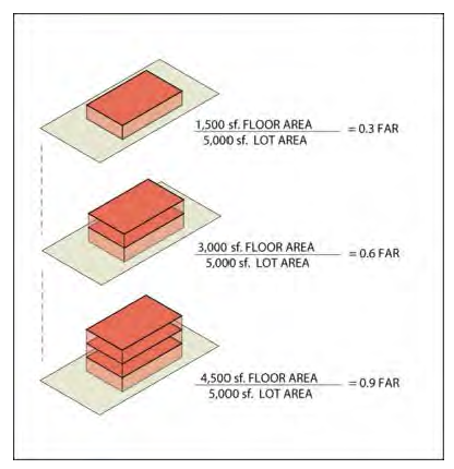
Floor area ratio (FAR) means the ratio calculated by dividing the total floor area of all buildings on a site by the area of the subject lot. See Maximum floor area ratio.
Foot candle means a unit of illumination produced on a surface, all points of which are one foot from a uniform point source of one candle.
Freeboard means a factor of safety usually expressed in terms of a certain amount of feet above a calculated flood level. Freeboard compensates for the many unknown factors that contribute to flood heights greater than the height calculated. These unknown factors may include, but are not limited to, ice jams, debris accumulation, wave action, obstruction of bridge openings and floodways, the effects of urbanization on the hydrology of the watershed, loss of flood storage areas due to development and the sedimentation of a river or streambed.
Garage, residential, means a detached accessory building or portion of the principal building, including a carport, which is used primarily for storing passenger vehicles, trailers or one truck of a rated capacity not in excess of 10,000 pounds.
General floor plans means a graphic representation of the anticipated utilization of the floor area within a building or structure, but not necessarily as detailed as construction plans.
Glare means the brightness of a light source which causes eye discomfort.
Green space means the area of a site upon which site disruption and site development are strictly limited. The term "green space" consists of the following:
(1)
Resource protection areas (RPA);
(2)
Areas devoted to land uses which incorporate natural resources, such as passive outdoor public recreational land use (section 114-123(a)), or outdoor institutional land use (section 114-123(d));
(3)
Portions of a site which are prevented from development by deed restrictions; and
(4)
Any area included within a lot that:
a.
Is not defined as an impervious surface under this section; and
b.
Maintains living vegetation.
Gross density means the result of dividing the number of dwelling units located on a site by the gross site area. See Maximum gross density.
Gross floor area (GFA) means the total habitable floor area on all levels of a building.
Gross site area (GSA).
(1)
The term "gross site area" means the total area of a site or parcel, minus all of the following:
a.
Existing and proposed rights-of-way of roads and public facilities;
b.
Land which, although part of the same site, parcel or lot, is not contiguous to, or is not accessible from, the existing or proposed road network serving the site;
c.
Land which is proposed for a different development option or a different zoning district; and
d.
Areas of navigable waters (lakes and streams).
(2)
GSA is calculated whenever a person wishes to develop a parcel or site, e.g., any subdivision of land or the creation of a plat. The determination of GSA is designed to help the developer calculate how much land is available for development after subtracting the undevelopable land from the proposed site.
Hearing notice means publication or posting which meets the requirements of Wis. Stats. ch. 985. Class 1 notice is the minimum required for appeals, published once at least one week (seven days) before hearing. Class 2 notice is the minimum required for enactment of all new zoning ordinances and amendments including map amendments, published twice, once each week consecutively, the last at least a week (seven days) before the hearing.
High flood damage potential means any danger to human life or public health or the potential for any significant economic loss to a structure or its contents.
Holding zone means a zoning district designed to limit development potential until adequate public services and infrastructure are provided.
Impervious surface means areas which prohibit infiltration of storm water. Concrete, brick, asphalt and similar paved surfaces are considered impervious. Gravel areas and areas with landscaped pavers which are intended for vehicular traffic are considered to be impervious.
Increase in regional flood height means a calculated upward rise in the regional flood elevation, equal or greater than one one-hundredth of a foot, resulting in comparison of existing conditions and proposed conditions which is directly attributable to manipulation of mathematical variables such as roughness factors, expansion and contraction coefficients and discharge.
Institutional residential unit means a dwelling unit contained in an institutional residential development.
Intensity means a term used to describe the maximum amount of gross floor area and the minimum amount of landscaping required for nonresidential projects. Each zoning district contains intensity standards which determine the maximum amount of development permitted on any given site, taking into consideration a variety of factors, including, but not limited to the:
(1)
Area of the site;
(2)
Proportion of the site not containing sensitive natural resources;
(3)
Zoning district in which the site is located;
(4)
Development option under which the site is developed; and
(5)
Use considered for development. See Density, which is the term used to describe the same standards for residential sites.
Interchange means a grade-separated highway intersection with one or more turning lanes for travel between intersecting roads or highways.
Lakeshore.
(1)
The term "lakeshore" means those lands lying between the ordinary water line of navigable waters and either:
a.
The backside of the principal structure on the lot; or
b.
A point 75 feet from said water line, whichever is closer to said water line.
(2)
The term "lakeshore" shall not include those lands adjacent to farm drainage ditches where:
a.
Such lands are not adjacent to a navigable stream or river;
b.
Those parts of such drainage ditches adjacent to such lands were not navigable streams before ditching or had no previous stream history; and
c.
Such lands are maintained in non-structural agricultural use.
Landscape surface ratio (LSR) means the percentage of the Gross Site Area (GSA) which must be preserved for landscaped area. LSR is calculated by dividing the total landscaped area of a lot by the GSA.
Landscaped area (LA) means the area of a site which is not covered by impervious surfaces and continually maintained in vegetation, including grasses, flowers, herbs, garden plants, native or introduced ground covers, shrubs, bushes, and trees. Landscaped area includes the area located within planted and continually maintained landscaped planters and the area landscaped pursuant to article VI of this chapter. The term "landscaped area" may also include resource protection areas (RPA) and other green space.
Lawn ornament means walks, drives, paved terraces and purely decorative garden accessories, such as small pools (not intended for human use), fountains, bird baths, statuary, sun dials, flag poles, etc.
Local residential street means a road which primarily serves to collect traffic originating directly from residential driveways and private residential courts and streets.
Lot means a parcel of land that is:
(1)
Undivided by any street or private road;
(2)
Occupied by, or is designated to be developed for, one building or one principal use; and
(3)
Either:
a.
Designated as a single lot on a plat or certified survey map; or
b.
Is a combination of contiguous lots owned by a single entity and identified as a single tax parcel (e.g., a group of three contiguous lots in a residential neighborhood, which are combined into a single tax parcel, and upon which a single home and accessory structures are placed).
Lot area means the area contained within the property boundaries of a recorded lot. Lot area has the effect of limiting the density and intensity of development on a lot.
Lot, corner, means a lot situated at the junction of and abutting on two or more intersection streets or a lot at the point of deflection in alignment of a continuous street, the interior angle of which does not exceed 135 degrees.
Lot depth means the average distance between the front lot line and the rear lot line of a lot, as measured at each side lot line.
Lot frontage means lot width measured at the street lot line. When a lot has more than one street lot line, lot width shall be measured, and the minimum lot width required by this chapter shall be provided at each such line.
Lot interior means a lot other than a corner lot.
Lot line means the property line bounding a lot, except that where any portion of a lot extends into an existing or proposed public right-of-way, the line of such public right-of-way shall be the lot line for applying this chapter.
Lot line, front, means a lot line which abuts a public or private street right-of-way. In the case of a lot which has two of more street frontages, the lot line along the street from which the house is addressed shall be the front lot line.
Lot line, rear, means, in the case of rectangular or most trapezoidal shaped lots, that lot line which is parallel to and most distant from the front lot line of the lot. In the case of an irregular, triangular, or gore-shaped lot, a line 20 feet in length, entirely within the lot, parallel to and at the maximum possible distance from the front line shall be considered to be the rear lot line. In the case of lots which have frontage on more than one road or street, the rear lot line shall be the lot line opposite the front lot line as defined above.
Lot line, side, means any boundary of a lot which is not a front lot line, a street side lot line, or a rear lot line.
Lot line, street side, means any lot line which abuts a public or private street right-of-way which is not the front lot line.
Lot of record means a platted lot; or lot described in a certified survey map by metes and bounds, which has been approved by the city or by the county and has been recorded in the office of the register of deeds.
Lot, through, means a lot which has a pair of opposite lot lines abutting two substantially parallel streets, one or more of which may be a portion of a cul-de-sac; Except for through lots which abut an arterial or nonresidential collector street, through lots are prohibited.
Lot width means the maximum horizontal distance between the side lot lines of a lot, measured parallel to the front lot line and at the rear of the required front yard.
Lowest floor means the lowest enclosed floor, including basement. Any unfinished or flood resistant enclosure, usable solely for parking vehicles, building access or storage, in an area other than a basement area, is not considered a building's lowest floor.
Manufactured dwelling (modular) means a dwelling structure or component thereof, as defined in the state uniform dwelling code, Wis. Admin. Code SPS 320.07(52m), which bears the state department of commerce insignia certifying that it has been inspected and found to be in compliance with subchapter V of said uniform dwelling code (Wis. Admin. Code SPS 320.12 et seq.).
Manufactured home means a single-family dwelling structure or component thereof, fabricated in an off-site manufacturing facility, for installation or assembly at the building site, bearing HUD label or insignia certifying that it is built in compliance with the federal manufactured housing construction standards under 42 USC 5401 to 5426.
Maximum accessory building coverage means the largest permitted area of all accessory buildings on a lot.
Maximum building coverage (MBC) means the largest permitted area (footprint) of all buildings on a lot.
Maximum building size (MBS) means the largest permitted total gross floor area a building may contain. See Building size.
Maximum floor area ratio (FAR) means the largest floor area ratio permitted on a lot. See Floor area ratio.
Maximum gross density (MGD) means the maximum number of dwelling units permitted on one acre (or 43,560 square feet) of lot area in a specific zoning district and land use.
Maximum height means the maximum height of the highest portion of any structure. See Height.
Maximum number of floors means the maximum number of floors a building is permitted to contain in a zoning district.
Minimum building separation means the narrowest permitted building separation.
Minimum dwelling unit separation means the narrowest permitted dwelling unit separation.
Minimum floor elevation means the lowest elevation permissible for the construction, erection, or other placement of any floor, including a basement or cellar floor, but not a crawl space.
Minimum landscape surface ratio (LSR) means the minimum permitted percentage of area of a lot that must be preserved as landscaped area. See landscape surface ratio.
Minimum lot area (MLA) means the minimum size lot permitted within the specified zoning district and land use. MLA has the effect of limiting the density of a residential site, and the intensity of a nonresidential site.
Minimum lot width means the smallest permissible lot width for the applicable dwelling unit type or nonresidential development option.
Minimum setback means the narrowest distance permitted from a street, side, or rear property line to a structure.
Minimum site area (MSA) means the minimum gross site area in which the specified development option may occur. See Gross site area (GSA).
Minimum zoning district area (MZA) means the minimum area of a zoning district. This is intended to prevent spot zoning of small areas.
Mobile home means a type of residential land use defined and regulated in section 114-121(i).
Mobile home/manufactured home park means a type of residential land use defined and regulated in section 114-121(j).
Natural resource protection area. See Resource protection area (RPA).
Natural resource protection overlay zoning districts means zoning districts which primarily identify and regulate the disturbance of areas containing protected natural resources.
Navigable water means rivers and streams will be presumed to be navigable if they are designated as either continuous or intermittent waterways on the U.S. Geological Survey quadrangle maps until such time that the DNR has made a determination that the waterway is not, in fact, navigable.
Net developable area (NDA) means the area of a parcel or site which may be disturbed by development activity. Net developable area is the result of subtracting resource protection areas (RPA) from the gross site area (GSA). The purpose for calculating NDA is to assist a developer in determining what percentage of a site is available for development
Nonconforming building or structure means any building, or other structure, which is lawfully existing under provisions preceding this chapter, which would not conform to the applicable regulations if the building or structure were to be erected under the provisions of this chapter.
Nonconforming development means a lawful development approved under provisions preceding the effective date of the ordinance from which this chapter is derived, which would not conform to the applicable regulations if the development were to be created under the current provisions of this chapter.
Nonconforming use means an active and actual use of land, buildings or structures lawfully existing prior to this chapter which has continued as the same use to the present and which does not comply with all the applicable regulations of this chapter.
Noxious matter or materials means material capable of causing injury to living organisms by chemical reaction, or is capable of causing detrimental effects on the physical or economic well-being of individuals.
Obstruction to flow means any development which physically blocks the conveyance of floodwaters such that this development by itself or in conjunction with any future similar development will cause an increase in regional flood height.
Official map means the map adopted by the common council which indicates the existing and proposed location of streets, highways, parks, playgrounds, roads, rights-of-way, waterways, public transit facilities and other public facilities as authorized by state statutes.
Off-site parking lot (land use). See section 114-126(a).
On-site means located on the lot in question, except in the context of on-site detention, when the term means within the boundaries of the development site as a whole.
Opacity means the degree to which vision is blocked by bufferyard. Opacity is the proportion of a bufferyard's vertical plane which obstructs views into an adjoining property.
Open sales lot means an unenclosed portion of a lot or lot of record where goods are displayed for sale, rent or trade.
Ordinary high water mark means the point on the bank or shore of a body of water up to which the presence and action of surface water is so continuous as to leave a distinctive mark such as by erosion, destruction or prevention of terrestrial vegetation, predominance of aquatic vegetation, or other easily recognized characteristics.
Overlay zoning district means a zoning district which imposes uniform restrictions on all properties within its area which are in addition to the restrictions specific to the standard zoning districts described in article II of this chapter, as well as the general restrictions of this chapter.
Owner means the person or entity which holds legal title to a lot or parcel of land.
Parcel (a/k/a site) means a tract of land designated for development or redevelopment. Typically, a parcel is either:
(1)
A tract of land under single ownership, which typically has not been divided by streets, has not been designated for a principal use, and has not been divided into recorded lots; or
(2)
In the case of redevelopment, a tract of multiple lots with multiple principal uses which the developer intends to acquire or has acquired for combination into a single redevelopment. A parcel is to be differentiated from a lot, which is ready for development without combination with other property or without subdivision into smaller lots.
Performance guarantee means a financial guarantee to ensure that all improvements, facilities, or work required by this chapter will be completed in compliance with the chapter, regulations and the approved plans and specifications of a development.
Performance standard means criterion established to control and limit the impacts generated by, or inherent in, uses of land or buildings.
Peripheral setback means the distance between a structure and the boundary of a zoning district or development option. Peripheral setbacks are used to provide a setback in addition to, not overlapping with, regularly required building setbacks. Bufferyards are distinct from peripheral setbacks, but may be located within the peripheral setback.
Principal use means any and all of the primary uses of a property, as determined by the zoning administrator, which uses are allowable as uses permitted by right or by conditional use, and not allowable as an accessory use or a temporary use per articles II, III and IV of this chapter.
Private sewage system means any sewage treatment and disposal system within the city which is not owned and operated by the city. The term "private sewage system" includes alternative sewage systems approved by the department of safety and professional services, including a substitute for the septic tank or soil absorption field, a holding tank, a system serving more than one structure, or a system located on a different parcel than the structure.
Protected natural resources means resources, such as floodways, floodfringes, floodplain conservancy areas, wetlands, drainageways, woodlands, steep slopes, and lakeshores, which are protected by the provisions of this chapter.
Public improvement means any improvement, facility, or service, together with customary improvements and appurtenances thereto, intended to provide for public needs, such as streets, roads, alleys or pedestrian walks or paths, storm sewers, flood control improvements, water supply and distribution facilities, sanitary sewage disposal and treatment, public utility and energy services.
Public sewer means the sanitary sewer system owned and operated by the city.
Recorded lot. See Lot of record.
Recreational vehicle means a vehicle designed and used principally for the transport of persons.
Residentially zoned means a property located in a residential district per article II of this chapter.
Resource protection area (RPA) means the area of a site which contains floodways, floodplain areas, floodfringes, wetlands, drainageways, lakeshores, woodlands and steep slopes, and in which development activity is limited to protect these natural resources.
Restrictive, more (less). Regulation imposed by this chapter is more (less) restrictive than another if it prohibits or limits development to a greater (lesser) extent or by means of more (less) detailed specifications.
Scale (of development) means the gross floor area, height, or volume of a single structure or group of structures.
Sedimentation means the deposition of soil that has been transported from its site of origin by water, ice, wind, gravity, or other natural means as a result of erosion.
Setback means the shortest distance between a building's or structure's exterior and the nearest point on the referenced lot line. Various setback requirements are established in each zoning district
Shrub means a low lying deciduous or evergreen plant. See article VI of this chapter.
Site evaluation worksheet means a worksheet designed to assist persons interested in developing a site, parcel or lot in the city, e.g., development of a parcel into a residential subdivision, or a multifamily development, or a commercial development. This worksheet helps calculate the amount of land which is actually available for development, after things like wetlands and rights-of-way have been subtracted from the total area of the parcel. For example, if a developer needs one acre of developable property, this worksheet will help the developer determine whether a proposed site will accommodate a one-acre development after subtracting rights-of-way, lakes, streams, floodplains, drainageways, and other areas protected under this chapter.
Skylight means a window or other paned area located on the ceiling or roof of a structure.
Standard industrial classification code (SIC) means the numeric code for categorizing land uses developed by the U.S. Department of Commerce. SIC codes in this chapter are based on the listing contained within the 1987 manual.
Standard pavement width means required pavement width per the city subdivision ordinance in residential subdivisions on a street that allows parking or as otherwise determined by the director of public works.
Standard zoning districts means zoning districts which primarily regulate the use of land and intensity or density of such use. See article II of this chapter.
Start of construction means the date the building permit is issued, provided the actual start of activity was within 730 calendar days of the permit date. The actual start of activity means either the first placement of permanent construction of a structure on the site, such as the pouring of a slab or footings, the installation of piles, or the construction of columns. The term "permanent construction" does not include land preparation, such as clearing, grading and filling; nor does it include the installation of streets and/or walkways; nor does it include excavation for basement, footings, piers, or foundations; nor does it include the erection of temporary forms; nor does it include the installation on the property of accessory buildings, such as garages or sheds not occupied as dwelling units or part of the main structure.
Story means that portion of a building included between the surface of any floor and the surface of the floor next above; or if there is no floor above, the space between the floor and the ceiling next above. Basements, cellars, crawl spaces and attics shall not be counted as a story.
Street means, unless specifically designated otherwise by the common council, any public or private way that is dedicated or permanently open to pedestrian and vehicular use, which is 22 feet or more in width if it exists at the time of enactment of this chapter; and any such public right-of-way 60 feet or more in width when established after the effective date of the ordinance from which this chapter is derived.
Street, arterial, means a street which is anticipated to carry in excess of 3,500 vehicles per day in traffic volume, at desirable speeds ranging from 30 to 45 miles per hour, and which is used for travel between areas within and outside the city and is defined specifically as such on the zoning map.
Street, collector, means a street which is anticipated to carry from 2,500 to 5,000 vehicles per day in traffic volume, at desirable speeds ranging from 25 to 35 miles per hour, which serves a collecting function by distributing traffic between local streets and arterial streets and is defined specifically as such on the zoning map.
Street, local, means a street which is anticipated to carry less than 2,500 vehicles per day in traffic volume at desirable speeds up to 25 miles per hour, and which provides access to abutting property and primarily serves local traffic and is defined specifically as such on the zoning map.
Street, local residential, means a local street serving primarily to collect traffic originating directly from residential driveways and private residential courts and streets.
Street, residential collector, means a collector street serving primarily residential land uses which serves to connect local residential streets to collector or arterial streets.
Strip development means a pattern of land uses typified by nonresidential and/or multifamily development located along one or both sides of a street which is generally only one lot deep and which is characterized by many curb cuts, low green space ratios, low landscape surface ratios, high floor area ratios, and/or low quantities of landscaping.
Substandard lot means a lot of record which lawfully existed prior to this chapter, which would not conform to the applicable regulations if the lot were to be created under the current provisions of this chapter. See section 114-77.
Substantial improvement means any structural repair, reconstruction, or improvement of a structure, the cost of which equals or exceeds 50 percent of the present equalized assessed value of the structure either before the improvement or repair is started, or if the structure has been damaged, and is being restored, before the damage occurred. The term "substantial improvement" does not, however, include either:
(1)
Any project to improve a structure to comply with existing state or local health, sanitary, or safety code specifications solely necessary to ensure safe living conditions; and
(2)
Any alteration of a structure or site documented as deserving preservation by the state historical society, or listed on the National Register of Historic Places.
Ordinary maintenance repairs are not considered structural repairs, modifications or additions. Such ordinary maintenance repairs include internal and external painting, decorating, paneling, and the replacement of doors, windows, and other non-structural components. For purposes of this definition, the term "substantial improvement" is considered to occur when the first alteration of any wall, ceiling, floor, or other structural part of the building commences, whether or not that alteration affects the external dimensions of the structure.
Structure means anything constructed or erected, the use of which requires a more or less permanent location on the ground, or attached to something having a permanent location on the ground, excepting public utility fixtures and appurtenances.
Swale means a linear depression in land running downhill or having a marked change in contour direction in which sheet runoff would collect and form a temporary watercourse.
Trademark architecture means a structure using combinations of building styles, forms, configurations, patterns or arrangements of solids and voids, materials, finishes, colors, signage, lighting and/or appurtenances typically associated with and frequently used by a specific land use, tenant, or corporations part of a self-identified image, character or marketing strategy.
Unnecessary hardship means the circumstance where special conditions affecting a particular property, which were not self-created, have made strict conformity with restrictions governing areas, setbacks, frontage, height or density unnecessarily burdensome or unreasonable in light of the purposes of this chapter.
Use, conditional, means a land use which requires a conditional use permit in order to develop. In general, conditional uses are those land uses which are of such a special nature or which are so dependent upon actual contemporary circumstances, as to make impractical the predetermination of permissibility, or the detailing in this chapter of specific standards, regulations or conditions which would permit such determination in each and every individual situation. Conditional uses, when granted, are subject to all the requirements of the specific standard zoning district (article II of this chapter) and overlay zoning district (article III of this chapter) in which the use is located, plus any requirements applicable to that particular land use as contained in article IV of this chapter, plus any additional requirements imposed as part of the conditional use process contained in article VIII of this chapter. Each application for, and instance of, a conditional use shall be considered a unique situation and shall not be construed as creating a precedent for similar requests. Conditional uses are granted pursuant to the procedures of section 114-288.
Use, permitted, means a land use which is allowed to develop without special oversight by the plan commission through the conditional use process (section 114-288), but instead, is allowed to develop subject to the zoning permit process (section 114-287) administered by the zoning administrator. However, permitted uses, like conditional uses, are subject to all the requirements of the specific standard zoning district (article II of this chapter) and overlay zoning district (article III of this chapter) in which the use is located, plus the general land use requirements of article IV of this chapter, the general standards and regulations of article II of this chapter, and the other applicable provisions of this chapter. Before any permitted use is commenced, changed or altered, a zoning permit must be obtained.
Use, temporary, means a land use, identified in section 114-129, which is present on a property for a limited and specified period of time, and which is subject to all the requirements of the specific standard zoning district (article II of this chapter) and overlay zoning district (article III of this chapter) in which the temporary use is located, plus any requirements applicable to that particular temporary land use as contained in article IV of this chapter. Temporary uses are granted pursuant to the procedures of section 114-289.
Utility vehicle means a vehicle designed and used primarily for the transport of equipment and/or materials.
Variance means permission to depart from the literal requirements of this chapter granted pursuant to section 114-293.
Vision clearance triangle means an occupied triangular space at the corner of intersecting roads, designed for the purpose of maintaining an unobstructed area at each intersection to assist motorists and pedestrians using such intersections.
Wisconsin wetland inventory map means maps prepared by the state department of natural resources.
Woodland means areas of trees whose combined canopies cover a minimum of 80 percent of an area of one acre or more, as shown on USGS 7.5-minute topographic maps for the city and its environs.
Yard means a required open space on a lot, which is unoccupied and unobstructed by a structure from its lowest ground level to the sky, except as expressly permitted in this chapter. A yard shall extend along a lot line and at right angles to such lot line to a depth or width specified in the yard regulations for the district in which such lot is located.
Yard, front, means a yard extending along each street that abuts a lot, and extending from the street right-of-way line to a depth required by the front yard regulations of the district in which such lot is located. Lots which abut on more than one street, e.g., corner lots, have a front yard on each abutting street. (See section 114-53(c) regarding yard setback adjustments.)
Yard, rear, means a yard extending along the full width of the rear lot line between the side lot lines and extending toward the front lot line for a depth as specified in the yard regulations for the district in which such lot is located.
Yard, side, means a yard extending along the side lot line between the front and rear yards, having a width as specified in the yard regulations for the district in which such lot is located.
Yard, street, means any yard which extends along a street right-of-way, and which shall have a consistent depth equal to the distance from the street right-of-way to the closest edge of the principal structure on the lot. The term "street yard" may include front yards, rear yards and side yards.
Zero lot line structure means a structure that is built on the property line, such as a twin house, townhouse, or downtown unit.
Zoning administrator means the person authorized and charged by the city with the administration of this chapter. See section 114-297.
Zoning district means a geographic area of the city which is identified on the official zoning map and which is subject to the rules and regulations set forth in this chapter. Article II of this chapter identifies the standard zoning districts into which the entire city is divided, and article III of this chapter identifies the overlay zoning districts which cover part of the city.
Zoning district categories means categories of similar districts. For example, zoning districts which establish different types of residential land uses are all contained in the residential category. See article II of this chapter for agricultural, residential, nonresidential and planned development categories, and see article III of this chapter for natural resource protection and community character overlay categories.
(Ord. No. 2017-1092, § 1, 4-11-2017; Ord. No. 2024-2065, 4-23-2024)