
Mauston City Zoning Code
ARTICLE II
STANDARD ZONING DISTRICTS
Sec. 114-38.- Purpose.
The purpose of this article is to identify and describe the standard zoning districts into which the entire city is divided, and to list various regulations and requirements which are specific for each district. Additionally, to identify the different types of land uses and to set forth various general requirements applicable to all development for all land uses in all zoning districts within the jurisdiction of this chapter. These requirements cover a broad array of issues which are important for the promotion and protection of the safety and general welfare of the public, including, but not limited to, requirements for density, intensity, bulk, access, visibility, off-street parking, off-street loading, exterior storage, exterior lighting, vibration, noise, air pollution, odors, electromagnetic radiation, glare and heat, fire and explosion, toxic and noxious materials, waste materials, drainage, exterior construction materials, and hazardous materials for all development occurring in the city.
(Ord. No. 2017-1092, § 1, 4-11-2017)
Sec. 114-39. - Standard zoning district categories and standard zoning districts.
For the purpose of this chapter, all areas within the jurisdiction of this chapter are hereby divided into the following standard zoning districts, and standard zoning district categories, which shall be designated as follows:
(1)
Agricultural category.
a.
Agricultural (AG) district.
(2)
Residential category.
a.
Estate residential-1 (ER-1) district.
b.
Single-family residential-3 (SR-3) district.
c.
Single-family residential-4 (SR-4) district.
d.
Two-family residential-6 (TR-6) district.
e.
Multifamily residential-8 (MR-8) district.
f.
Multifamily residential-10 (MR-10) district.
(3)
Nonresidential category.
a.
Neighborhood business (NB) district.
b.
Planned business (PB) district.
c.
General business (GB) district.
d.
Central business (CB) district.
(4)
Industrial category.
a.
General industrial (GI) district.
b.
Heavy industrial (HI) district.
(5)
Planned development category. Planned development district (PD year-order of approval in that year) e.g., (PD 97-2).
(Ord. No. 2017-1092, § 1, 4-11-2017)
Sec. 114-40. - Map of standard zoning districts.
(a)
Map established. There is hereby established an official zoning map of the city, which shall be maintained in the office of the city administrator. The standard zoning districts established by this chapter are shown on the official zoning map of the city, which, together with all explanatory materials thereon, is hereby made part of this chapter.
(b)
Electronically stored. The official zoning map may be maintained and stored electronically, i.e., on computer and/or on paper.
(c)
Annexation. Upon annexation, a parcel shall be automatically placed into the agriculture (AG) district, unless the ordinance of annexation designates otherwise, and shall remain in the AG district until formal action is taken to establish different zoning.
(Ord. No. 2017-1092, § 1, 4-11-2017)
Sec. 114-41. - Interpretation of zoning district boundaries.
The following rules shall be used to determine the precise location of any zoning district boundary shown on the official zoning map of the city:
(1)
Zoning district boundaries shown as following or approximately following the limits of any city, village, town or county boundary shall be construed as following such limits.
(2)
Zoning district boundaries shown as following or approximately following streets or railroad lines shall be construed as following the centerline of such streets or railroad lines.
(3)
Zoning district boundary lines shown as following or approximately following platted lot lines shall be construed as following such lines.
(4)
Zoning district boundaries shown as following or approximately following the centerlines of streams, rivers, or other continuously flowing watercourses shall be construed as following the channel centerlines of such watercourses, and, in the event of a natural change in the location of such streams, rivers, or other watercourses, the zoning district boundary shall be construed as moving with the channel centerline.
(5)
Zoning district boundaries shown as following or approximately following ridgelines or watershed boundaries shall be construed as following such lines.
(6)
Zoning district boundaries shown as separated from any of the features listed in subsections (1) through (5) of this section shall be construed to be at such distances there from as are shown on the official zoning map.
(7)
Where any uncertainty exists as to the exact location of a zoning district boundary line, as shown on the official zoning map, the location of the line shall be determined by the zoning administrator, who shall then take appropriate action to officially clarify the location of the line.
(Ord. No. 2017-1092, § 1, 4-11-2017)
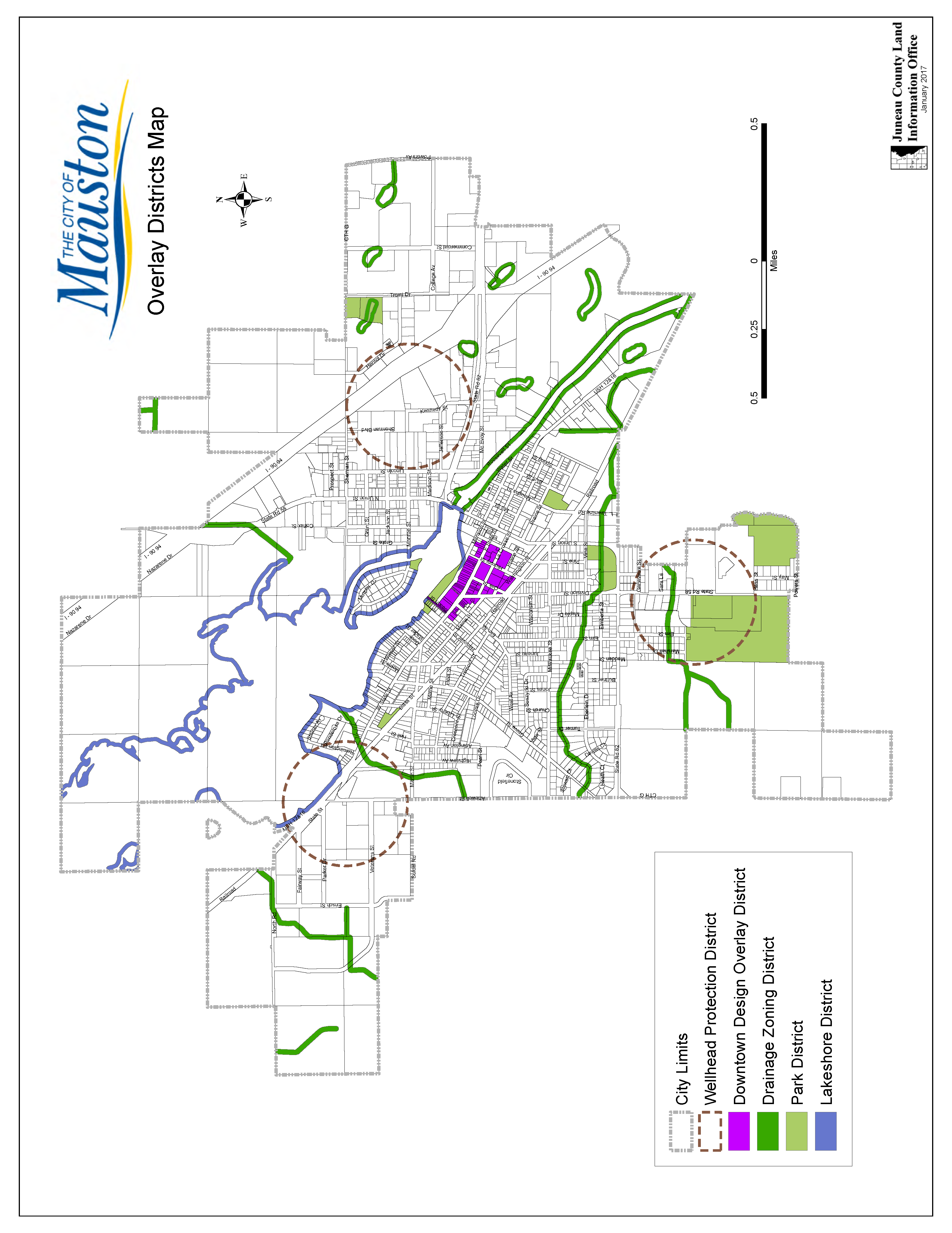
Sec. 114-42. - Relationship to overlay zoning districts.
Overlay zoning districts are a set of zoning requirements imposed in addition to the requirements of the standard zoning districts found in this chapter. Development within the overlay zones must conform to the requirements of both the standard zoning district and the overlay zoning districts, and if the two zones are inconsistent, then the development shall comply with the requirements of the more restrictive of the two zones. Overlay districts are used for the protection of natural resource features and the preservation and enhancement of significant community character features. For specific overlay zoning districts and regulations see article III of this chapter.
(Ord. No. 2017-1092, § 1, 4-11-2017)
Sec. 114-44. - Agriculture (AG) district.
(a)
Description and purpose. This district provides for the continuation and preservation of agriculture. The specific regulations of this district are intended to comply with the Wis. Stats. ch. 71, so that owners of lands in this district may be eligible for the farmland preservation credit permitted pursuant to Wis. Stats. ch. 71, subch. IX (Wis. Stats. § 71.57 et seq.). In addition, this district is intended to protect farming from the intrusion of incompatible uses, including urban and suburban development, and to sustain the economic base of agriculture as well as preserve its rural lifestyle. The possibility of agribusiness uses, which are not part of a typical farm, but which are necessary at limited suitable locations to support the farm industry, are provided for in this district as conditional uses.
(b)
Table of principal and accessory land uses.
Note: P = Permitted use; C = Conditional use
(c)
Table of temporary uses.
T = Temporary use
(d)
Residential districts—Residential and non-residential use regulations.
1 The acreage may be reduced to a minimum of one acre with a conditional use permit, which shall require a total minimum of 35 acres, contiguous to the one acre subject parcel, to be deed restricted to prohibit subsequent development of additional principal structures on the 35 acres unless rezoned for higher density development.
2 20 acres with a conditional use permit.
3 Standard 35 feet, but 40 feet for a lot adjacent to a street within an officially mapped right-of-way equal to or exceeding 100 feet.
4 Accessory uses shall not be located between a principal building and a street frontage on the same lot, nor within any required front yard or street side yard. Adjustment to setbacks are provided in section 114-53(c).
5 Exceptions to height regulations are found in section 114-53(d).
6 A minimum separation of ten feet shall be maintained unless the owner complies with those regulations of the uniform dwelling code (Wis. Admin. Code SPS 321.08) which permit a separation of less than ten feet if fire-rated construction is employed.
Regulations. The following regulations apply to this district, in addition to the performance standards of article V of this chapter, the landscaping regulations of article VI of this chapter, and the signage regulations of article VII of this chapter:
(Ord. No. 2017-1092, § 1, 4-11-2017)
Sec. 114-45. - Residential districts.
(a)
Residential districts descriptions.
(1)
Estate residential-1 (ER-1) district description and purpose. This district is intended to permit development which has a low density, estate community character. The land use standards for this district permit primarily single-family detached residential development and a variety of related institutional land uses. Density and intensity standards for this district are designed to ensure that the estate residential-1 district shall serve as a designation which preserves and protects the estate character of its area.
(2)
Single-family residential-3 (SR-3) district description and purpose. This district is intended to permit development which has a moderate density community character. Density and intensity standards for this district are designed to ensure that the single-family residential-3 district shall serve as a designation which preserves and protects the residential community character of its area. Residential development with a maximum gross density (MGD) of three and one-half dwelling units per gross acre is available within this district.
(3)
Single-family residential-4 (SR-4) description and purpose. This district is intended to permit development which has a moderate density, community character. Density and intensity standards for this district are designed to ensure that the single-family residential-4 (SR-4) district shall serve as a designation which preserves and protects the residential community character of its area. Residential development with a maximum gross density (MGD) of four dwelling units per gross acre is available within this district.
(4)
Two-family residential-6 (TR-6) district description and purpose. This district is intended to permit development which has a moderate density community character. The land use standards for this district permit both single-family detached residential development and twin-house/duplexes permitted by right and two flat, mobile home parks, and mobile home subdivisions permitted as a conditional use. Density and intensity standards for this district are designed to ensure that the two-family residential-6 (TR-6) district shall serve as a designation which preserves and protects the moderate density residential community character of its area. Various residential development options are available in this district, with a maximum gross density (MGD) of six dwelling units per gross acre.
(5)
Multifamily residential-8 (MR-8) district description and purpose. This district is intended to permit development which has a moderate density community character. The land use standards for this district permit single-family detached, twin-house/duplex, two-flats, townhouses, and multiplexes and apartments up to four units permitted by right and related institutional land uses. Density and intensity standards for this district are designed to ensure that the multifamily residential-8 (MR-8) district shall serve as a designation which preserves and protects the community character of its area. A variety of residential development options are available in this district, with a maximum gross density (MGD) of eight dwelling units per gross acre.
(6)
Multifamily residential-10 (MR-10) district description and purpose. This district is intended to permit development which has a higher density community character. The land use standards for this district permit single-family detached, twin-house/duplex, two-flats, townhouses, multiplexes, and apartments permitted by right and related institutional land uses. Density and intensity standards for this district are designed to ensure that the multifamily residential-10 (MR-10) district shall serve as a designation which preserves and protects the community character of its area. A variety of residential development options are available in this district, with a maximum gross density (MGD) of ten dwelling units per gross acre.
(b)
Residential districts—Principal land uses table.
Note: P = Permitted use; C = Conditional use
(c)
Residential districts—Accessory land uses table.
Note: P = Permitted use; C = Conditional use
(d)
Residential districts—Temporary uses table.
Note: T = Temporary use
(e)
Residential districts—Residential use regulations. The following regulations apply to the residential districts, in addition to the performance standards of article V of this chapter, the landscaping regulations of article VI of this chapter, and the signage regulations of article VII of this chapter:
1 20,000 square feet with a conditional use permit.
2 The first number is for lots adjacent to streets with a right-of-way less than 100 feet, and the second number is for lots adjacent to a street with a right-of-way equal to or exceeding 100 feet.
3 Accessory uses shall not be located between a principal building and a street frontage on the same lot, nor within any required front yard or street side yard. Adjustment to setbacks are provided in section 114-53(c).
4 Exceptions to height regulations are found in section 114-120(f).
5 Or the height of the principal building, whichever is lower.
6 A minimum separation of ten feet shall be maintained unless the owner complies with those regulations of the uniform dwelling code (Wis. Admin. Code SPS 321.08) which permit a separation of less than ten feet if fire-rated construction is employed.
7 More than one principal building shall be permitted on any one lot upon the granting of a conditional use permit for a group development in compliance with section 114-130.
8 Twenty feet for townhouse on interior row; 30 feet for townhouse on end of row.
(f)
Residential district—Nonresidential uses regulation.
Regulations. The following regulations apply to the residential districts, in addition to the performance standards of article V of this chapter, the landscaping regulations of article VI of this chapter, and the signage regulations of article VII of this chapter:
1 20,000 square feet with a conditional use permit.
2 The first number is for lots adjacent to streets with a right-of-way less than 100 feet, and the second number is for lots adjacent to a street with a right-of-way equal to or exceeding 100 feet.
3 Accessory uses shall not be located between a principal building and a street frontage on the same lot, nor within any required front yard or street side yard. Adjustment to setbacks are provided in section 114-53(c).
4 Exceptions to height regulations are found in section 114-120(f).
5 Or the height of the principal building, whichever is lower.
6 More than one principal building shall be permitted on any one lot upon the granting of a conditional use permit for a group development in compliance with section 114-130.
(Ord. No. 2017-1092, § 1, 4-11-2017)
Sec. 114-46. - Non-residential districts.
(a)
Non-residential districts—Descriptions and purpose.
1.
Neighborhood business (NB) district description and purpose. This district is intended to permit small scale commercial development, high quality office, and institutional land uses which are compatible with the desired overall neighborhood community character of the area in general, and with adjacent residential development in particular. The desired neighborhood community character of the development is attained through landscape surface area ratio (LSR) requirements, and by restricting the maximum building size (MBS) of all buildings within each instance of this district to 5,000 square feet. Significant areas of landscaping are required in this district to ensure that this effect is achieved. In order to ensure a minimum of disruption to residential development, no development within this district shall take direct access to a local residential street or a residential collector street.
2.
Planned business (PB) district description and purpose. This district is intended to permit large and small scale commercial development, high quality office and institutional land uses which is compatible with the desired overall community character of the area in general. Significant areas of landscaping are required in this district to ensure that this effect is achieved. A wide range of office, retail, and lodging land uses are permitted within this district. In order to ensure a minimum of disruption to residential development, no development within this district shall take direct access to a local residential street or a residential collector street.
3.
General business (GB) district description and purpose. This district is intended to permit both large and small scale commercial development at intensities which provide significant incentives for infill development and the continued economic viability of existing development. To accomplish this effect, minimum required green space ratios (GSRs) are substantially lower than those required in the planned business district. A wide range of office, retail, and lodging land uses are permitted within this district. In order to ensure a minimum of disruption to residential development, no development within this district shall take direct access to a local residential street or a residential collector street.
4.
Central business (CB) district description and purpose. This district is intended to permit both large and small scale downtown mixed-use development at an intensity which provides significant incentives for infill development, redevelopment, and the continued economic viability of existing development. To accomplish this effect, minimum landscape surface ratios (LSRs) permitted in this district are much lower than those allowed in the planned business and general business districts. A wide range of office, retail, lodging, and mixed-use land uses are permitted within this district. In order to ensure a minimum of disruption to residential development, no development within this district shall take direct access to a local residential street or a residential collector street. This district is strictly limited to the central city locations.
(b)
Non-residential district—Principal land uses table.
Note: P = Permitted Use; C = Conditional Use
(c)
Non-residential district—Accessory land use table.
Note: P = Permitted Use; C = Conditional Use
(d)
Non-residential districts—Temporary uses.
Note: T = Temporary Use
(e)
Non-residential districts—Non-residential use regulations. The following regulations apply to the non-residential districts, in addition to the performance standards of article V of this chapter, the landscaping regulations of article VI of this chapter, and the signage regulations of article VII of this chapter:
# For single-family and two-family dwellings, follow standards of TR-6 district. For townhouse, multiplex, apartment and institutional residential development, follow standards of MR-10 district.
1 The first number is for lots adjacent to streets with a right-of-way less than 100 feet, and the second number is for lots adjacent to a street with a right-of-way equal to or exceeding 100 feet.
2 More than one principal building shall be permitted on any one lot upon the granting of a conditional use permit for a group development in compliance with section 114-130.
3 Accessory uses shall not be located between a principal building and a street frontage on the same lot, nor within any required front yard or street side yard. Adjustment to setbacks is provided in section 114-161(c).
4 Exceptions to height regulations are found in section 114-120(f).
5 Or the height of the principal building, whichever is lower.
6 Maximum permitted setbacks of zero feet, except where permitted by conditional use if determined by the plan commission as an essential component of site design.
7 For architectural consistency, buildings shall be a minimum of two stories in height, except when otherwise permitted by conditional use. Other exceptions to height regulations are found in section 114-161(d).
8 Existing parking/loading spaces shall not be reduced on existing structures, except by conditional use. Parking requirements for all new buildings and additions to existing buildings shall be established by conditional use.
(f)
Non-residential districts—Residential uses regulations. The following regulations apply to the non-residential districts, in addition to the performance standards of article V of this chapter, the landscaping regulations of article VI of this chapter, and the signage regulations of article VII of this chapter:
# For single-family and two-family dwellings, follow standards of TR-6 district. For townhouse, multiplex, apartment and institutional residential development, follow standards of MR-10 district.
1 The first number is for lots adjacent to streets with a right-of-way less than 100 feet, and the second number is for lots adjacent to a street with a right-of-way equal to or exceeding 100 feet.
2 More than one principal building shall be permitted on any one lot upon the granting of a conditional use permit for a group development in compliance with section 114-130.
3 Accessory uses shall not be located between a principal building and a street frontage on the same lot, nor within any required front yard or street side yard. Adjustment to setbacks are provided in section 114-53(c).
4 Exceptions to height regulations are found in section 114-53(d).
5 Or the height of the principal building, whichever is lower.
6 Maximum permitted setback of zero feet, except where permitted by conditional use if determined by the plan commission as an essential component of site design.
7 For architectural consistency, buildings shall be a minimum of two stories in height, except when otherwise permitted by conditional use. Other exceptions to height regulations are found in section 114-53(d).
(Ord. No. 2017-1092, § 1, 4-11-2017; Ord. No. 2024-2066, 4-23-2024)
Sec. 114-47. - Industrial districts.
(a)
Industrial districts description and purpose.
(1)
General industrial (GI) district description and purpose. This district is intended to permit both large and small scale industrial and office development at an intensity which is consistent with existing transition and suburban community character. Beyond a relatively high minimum green space ratio (GSR), the primary distinguishing feature of this district is that it is geared to indoor industrial activities which are not typically associated with high levels of noise, soot, odors and other potential nuisances for adjoining properties. To ensure a minimum of disruption to residential development, no development within this district shall take direct access to a local residential street or a residential collector street.
(2)
Heavy industrial (HI) district description and purpose. This district is intended to permit both large and small scale industrial and office development at an intensity which provides ample incentive for infill development and redevelopment of industrial areas existing as of the effective date of the ordinance from which this chapter is derived. This district is designed to permit a very wide variety of industrial uses which may occur both indoors and outdoors, including certain land uses which are permitted in no other zoning district because of their potential to create nuisances for adjoining properties. In order to ensure a minimum of disruption to residential development, no development within this district shall take direct access to a local residential street or a residential collector street.
(b)
Industrial districts—Principal land uses table.
Note: P = Permitted Use; C = Conditional Use
(c)
Industrial districts—Accessory land uses table.
Note: P = Permitted Use; C = Conditional Use
(d)
Industrial districts—Non-residential use regulations.
Regulations. The following regulations apply to the non-residential districts, in addition to the performance standards of article V of this chapter, the landscaping regulations of article VI of this chapter, and the signage regulations of article VII of this chapter:
1. The first number is for lots adjacent to streets with a right-of-way less than 100 feet, and the second number is for lots adjacent to a street with a right-of-way equal to or exceeding 100 feet.
2. More than one principal building shall be permitted on any one lot upon the granting of a conditional use permit for a group development in compliance with section 114-130.
3. Accessory uses shall not be located between a principal building and a street frontage on the same lot, nor within any required front yard or street side yard. Adjustment to setbacks are provided in section 114-161(c).
4. Exceptions to height regulations are found in section 114-120(f).
5. Or the height of the principal building, whichever is lower.
(Ord. No. 2017-1092, § 1, 4-11-2017)
Sec. 114-48. - Planned development (PD) district.
(a)
Description and purpose. This district is intended to provide more incentives for redevelopment in areas of the community which are experiencing a lack of reinvestment, or which require flexible zoning treatment because of factors which are specific to the site. The intent of this district is to require higher levels of development quality in both design and materials in exchange for carefully controlled flexibility on matters of land use, density, intensity, setbacks and/or bulk. This district is designed to forward both aesthetic and economic objectives of the city by controlling the site design and the land use, appearance, density, or intensity of development within the district in a manner which is consistent with sound land use, urban design, and economic revitalization principles. The application of these standards will ensure long-term progress and broad participation toward these principles. Refer to section 114-296 for the procedures applicable to proposal review in this standard zoning district.
(b)
Development standards. Development standards are flexible within this zoning district. Refer to section 114-296(b) for the range of development standards potentially available in this zoning district.
(Ord. No. 2017-1092, § 1, 4-11-2017)
Secs. 114-49—114-80. - Reserved.
(Ord. No. 2017-1092, § 1, 4-11-2017)