
Millersburg City Zoning Code
ARTICLE I
- PURPOSE AND SCOPE
1.01.010 - Title.
This document shall be known as the "Millersburg Development Code" and may be referred to as the "Development Code," "Land Use Development," or "Code." Further, the regulations contained herein this Title may be referred to as the "Development Code" or the "Code."
1.01.020 - Purpose.
This Code is enacted to:
(1)
Implement the goals and policies of the City of Millersburg Comprehensive Plan;
(2)
Promote the public health, safety, prosperity, and general welfare of the community; and
(3)
Provide methods of administering and enforcing the provisions of this Code.
1.01.030 - Conformance Required.
The use of all land, as well as the construction, reconstruction, enlargement, structural alteration, movement, use, or occupation of any structure within the City of Millersburg shall conform to the requirements of this Code.
1.01.040 - Administration.
The Development Code shall be administered by the City Manager of the City of Millersburg. Unless otherwise specifically prohibited by the Charter, the City Manager is granted the authority to delegate his/her duties under this Code.
1.01.050 - Violations.
(1)
Enforcement. It shall be the duty of the City Manager, or other designated agents of the City, to enforce this Code. All officials, employees, and contract employees of the City of Millersburg who have the authority to issue permits shall comply with the provisions of this Code and shall not issue or approve any permit, certificate, or license for any use, building, or purpose, which violates or fails to comply with conditions or standards imposed by this Code. Any permit, certificate or license issued in conflict with the provisions of this Code, intentionally or otherwise, shall be void.
(2)
Penalties. Upon failure to comply with any provision of this Code, or with any restrictions or conditions imposed hereunder, the Council may withhold any further permits and may withhold or withdraw City utility services until correction is made. Notwithstanding any such action taken by the Council, any person, firm, or corporation who violates, disobeys, omits, neglects, or refuses to comply with any of the provisions of the Code, or who resists the enforcement of such provisions, shall be subject to civil penalties as prescribed by the Millersburg Municipal Code for each offense. Each day that a violation is permitted to exist shall constitute a separate offense.
(3)
Inspection and Right of Entry. Whenever there is reasonable cause to suspect a violation of this Code, or when necessary to investigate an application or revocation of an approval under procedures prescribed in this Code, officials responsible for enforcement or administration of this Code may enter onto a site or structure for the purpose of investigation, provided it shall be done in a reasonable manner. No premises shall be entered without first attempting to obtain the consent of the owner or occupant. If consent cannot be obtained, the responsible official shall secure a search warrant from a court of competent jurisdiction before further attempts to gain entry and shall have recourse to every other remedy provided by law to secure entry.
1.01.060 - Interpretation.
(1)
Authority. The provisions of this Code shall be interpreted as minimum requirements. When this Code imposes a greater restriction than is required by other provisions of law, or by other regulations, resolutions, easements, covenants, or agreements between parties, the provisions of this Code shall control. When a certain provision of the Development Code conflicts with another provision of this Code, or is unclear, the correct interpretation of the Code shall be determined by the City Manager. The Manager may request that City Legal Counsel, the Planning Director, the Planning Commission, or the City Council resolve the conflict or uncertainty.
(2)
Process. The City shall keep a record of all such interpretations made by the City including the reasoning behind the interpretation. Requests by the public for an interpretation shall be processed as a Type I application.
1.01.070 - Effect on Other Public and Private Regulations and Restrictions.
It is not the intent of the Development Code to interfere with other laws or codes relating to the use of structures, vehicles, or land, or relating to the construction or alteration of any buildings or improvements. It is not the intent of this Code to interfere with any easement, deed restriction, covenant, or other legally enforceable restriction imposed on the use or development of land more restrictive than the provisions of this Code. Further, it is not the intent of this Code to enforce deed restrictions, covenants, and similar legal instruments.
1.01.080 - Conflicting Regulations.
All other codes, ordinances, or parts of codes or ordinances in conflict herewith are hereby repealed.
1.01.090 - Severability and Validity.
If any article, section, sentence, clause, or phrase of this Code is held by a court of competent jurisdiction to be invalid, for any reason, said decision shall not affect the validity of the remainder of this Code. The City Council of the City of Millersburg, Oregon hereby declares that it would have adopted this Code, and each article, section, sentence, clause, or phrase thereof, irrespective of the fact that any one or more article, section, sentence, clause, or phrases might be declared invalid.
1.01.100 - Fees.
(1)
Purpose. Fees are for the purpose of defraying administrative costs.
(2)
General Provisions:
a.
Payment. Fees shall be payable at the time of application and shall be as set forth by Resolution of the City Council. There shall be no fee required for an application initiated by the Planning Commission or the City Council.
b.
Failure to Pay. The failure to submit the required fee with an application or notice of appeal, including return of checks unpaid or other failure of consideration, shall be a defect and result in an incomplete application.
c.
Refunds. Fees are not refundable unless the application is withdrawn prior to the notification of the application or hearing.
d.
Fee Reduction. The City Council may reduce or waive the fees upon showing of just cause to do.
1.02.010 - Grammatical Interpretation.
(1)
Interpretation. Words used in the masculine include the feminine and feminine the masculine. Words used in the present tense include the future, the singular number includes the plural, and the word "shall" is mandatory and not directory. Where terms or words are not defined, they shall have their ordinary accepted meanings within the context of their use.
(2)
Headings. If there is any conflict or inconsistency between the heading of an article, section, or paragraph of this Code and the context thereof, the said heading shall not be deemed to affect the scope, meaning, or intent of such context.
(3)
General and Specific Terms. The definitions in this Section include those that are applicable to the entire Development Code and those terms that apply to specific sections. Terms used in specific sections are identified as follows:
a.
Flood. Floodplain Overlay Zone, Chapter 2.12.
b.
Historical. Historical Property Overlay Zone, Chapter 2.13.
c.
Sign. Signs, Chapter 3.06.
d.
Greenway. Willamette Greenway Overlay Zone, Chapter 2.14.
1.02.020 - Definitions.
The following words and phrases, when used in this Code, shall have the meanings ascribed to them in this Chapter, except in those instances where the context clearly indicates a different meaning.
Abut or Abutting. Adjacent, contiguous, or adjoining exclusive of street right-of-way with a common boundary line, except that where two or more lots adjoin only a corner or corners, they shall not be considered as abutting unless the common property line between the two parcels measures at least eight feet in a single direction.
Access. The way or means by which pedestrians, bicycles, and vehicles shall have safe, adequate, and usable ingress and egress to property. Specific definitions include:
Alternate. Property access by a means other than the proposed approach or access connection. It may include an existing public right-of-way, another location on the subject street or highway, an easement across adjoining property, a different street, a service road, a local road, or an alley, and may be in the form of a single or joint approach.
Control. Where the right of access between a property abutting the highway and the highway has been acquired by a roadway authority, or eliminated by law, pursuant to access or approach spacing standards.
Easement. An access conveyed for the purposed of providing vehicle, bicycle, and/or pedestrian access from a public street to a lot or parcel across intervening property under separate ownership from the parcel being provided access. Cross access easement is an easement providing vehicular access between two or more separate sites, so that the driver need not enter the public street system between sites.
Point. A connection providing for the movement of vehicles between a lot or parcel and a public roadway.
Reasonable. Access that does not require excessive out-of-direction travel or pose a safety hazard.
Spacing/Intersection Spacing. The minimum required distance from an intersection of a public or private street to the nearest driveway or other access connection, measured from the closest edge of the pavement of the intersecting street to the closest edge of the pavement of the connection along the traveled way.
Way. A walkway or multi-use path connecting two rights-of-way to one another where no vehicle connection is made.
Access Management. Regulation of access to streets, roads, and highways from abutting property and public and private roads and driveways.
Accessory Structure. A subordinate building or portion of a main building, the use of which is incidental to that of the main building or to the use of the land but does not include dwellings or living quarters.
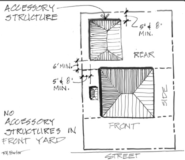
Figure 1 - Accessory Structure
Accessory Dwelling Unit. An interior, attached, or detached residential structure that is used in connection with, or that is accessory to, a single-family dwelling or duplex.
Accessory Use. A use incidental, appropriate, and subordinate to the main use of the parcel, lot, or building.
Accessway. An unobstructed way or required width containing a paved drive or roadway, which provides vehicular access within a development.
Adjacent. In near, or close, proximity.
Adequate Access. Direct routes of travel between destinations; such destinations may include residential neighborhoods, parks, schools, shopping areas, and employment centers.
Adequate Area. Space sufficient to provide all required public services to standards defined in this Code or the City's most current Engineering Standards.
Adverse. Acting against or contrary to, as to cause harmful interference or conflict.
Adverse Impact. An impact that is detrimental to or contrary to the desired effect or so opposed as to cause harmful interference. A negative effect that is detrimental to the public welfare or injurious to people, property or the community environment.
Agriculture. The use of land, typically larger than one acre, for the primary purpose of deriving income from growing plants, crops, orchards, or fruit production.
Alley. A minor public or private accessway affording only secondary means of access to the back or side of property otherwise abutting a public street.
Altered or Alteration. Any change or repair, which is intended to prolong the life of a supporting component of a building, such as bearing walls, columns, beams or girders; or any excavation, grading, or contouring of land, which changes the topography, slope, and/or drainage flow from natural conditions.
Alteration (Historic). A change, addition, or modification to the exterior of a building.
Alteration or Altered (Sign). Any change in the size, shape, method of illumination, position, location, construction, or supporting structure of a sign. A change in sign copy or sign face alone shall not be considered an alteration.
Antenna (Wireless Communication). A specific device used to receive or capture incoming and/or to transmit outgoing communications transmitted from, or to be received by, other antennas.
Attached Wireless Communications Facility (Wireless Communication). A wireless communications facility that is affixed to an existing structure, other than a Wireless Communications Tower.
Apartment.A building or structure designed to house three or more dwelling units, also known as multi-family dwelling.
Applicant.The person making a formal application.
Appeal.A request for a review, by a higher review authority, of any land use decision or interpretation of any provision of this Code.
Approval Authority. The person or body authorized to make application decisions.
Area of Shallow Flooding (Flood). A designated AO or AH Zone on the Flood Insurance Rate Map (FIRM). The base flood depths range from one (1) to three (3) feet; a clearly defined channel does not exist; the path of flooding is unpredictable and indeterminate; and velocity flow may be evident. AO is characterized as sheet flow and AH indicates ponding.
Area of Special Flood Hazard (Flood). The land in the floodplain within a community subject to a one percent or greater chance of flooding in any given year. It is shown on the Flood Insurance Rate Map (FIRM) as Zone A, AO, AH, A1-30, AE, A99, AR. "Special flood hazard area" is synonymous in meaning and definition with the phrase "area of special flood hazard".
Automobile Wrecking Yard. A building or lot used for dismantling or disassembling of motor vehicles or trailers, or the storage, sale, or dumping of dismantled, partially dismantled, obsolete, or wrecked vehicles, or their parts.
Awning (Sign). A shelter supported entirely from the exterior wall of a building and composed of non-rigid materials, except for the supporting framework.
Base Flood Level or Elevation (Flood). The flood having a one percent chance of being equaled or exceeded in any given year.
Base flood elevation (BFE) (Flood). The elevation to which floodwater is anticipated to rise during the base flood.
Basement.A portion of a building which has less than one-half or more of its height measured from finished floor to finished ceiling below the average elevation of the adjoining grade.
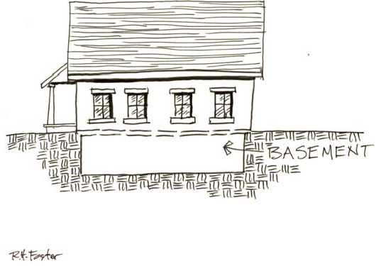
Figure 2 - Basement
Bed and Breakfast Facility. A building or premises used for the provision of lodging and meals, usually breakfast.
Berm. A linear mound of soil.
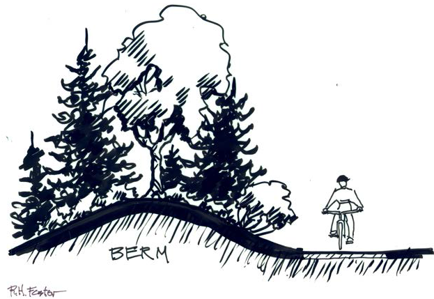
Figure 3 - Berm
Bicycle Facilities. Improvements that provide for the needs of bicyclists, including bikeways and bicycle parking.
Bikeway. The general term for the five basic types of bikeways:
Bikes Lanes. A hard surfaced or paved facility, either separated physically from a road or separated by paint stripes, and which is designated specifically for use by bicyclists.
Cycle Track. A hard surfaced or paved facility separated physically from a road or street and which is designated specifically for two-way use by bicyclists.
Shoulder Bikeways. Where bicyclists travel within the roadway's paved shoulder.
Shared Bikeways. Where bicyclists and motor vehicles share the travel lane.
Multi-Use Paths. Paths that are separated from vehicular traffic. They are two-way pathways used by pedestrians, bicyclists, and joggers.
Block. A tract of land bound on four sides by streets or bounded by streets and other such features as the city limits or physical barriers such as bodies of water or canyons.
Figure 4 - Block
Boarding or Rooming House. A building where lodging, with or without meals, is provided for compensation, but shall not include Homes for Senior Living, the Aged, Nursing Homes, or Group Care Homes.
Buffers or Buffering. Distance, landscaping, walls, berms, or other measures used to physically separate one land use from another.
Building. Any structure enclosed with walls, excluding canvas or fabric, including windows and doors, having a roof and permanent foundation, conforming to the design and construction requirements of the Oregon Residential Structural Specialty Code, built and maintained for the support, shelter, or enclosure of persons, animals, chattels, or property of any kind. Trailers, with or without wheels, shall not be considered as buildings, except that manufactured homes sited in accordance with standards in this Code shall be considered a building.
Building Frontage (Sign). The portion of a building face most closely in alignment with an adjacent right-of-way or fronting a parking lot when so defined, as allowed in this Chapter. A gasoline service station may use the overhanging canopy as a substitute for building frontage. Given different lengths, the longest side of the building or canopy shall be used to compute the allowable sign area.
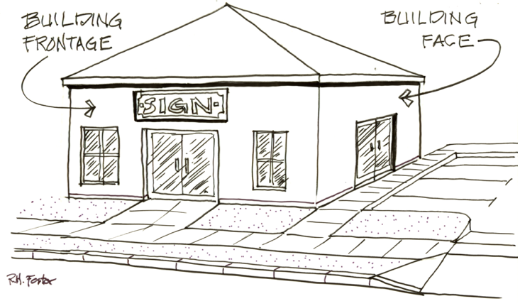
Figure 5 - Building Frontage
Building Height. The vertical distance from the average ground level measured five feet from the foundation of a building to the highest point of the coping of a flat roof, deck line of a mansard roof, or to the middle height between the eaves and ridge of a pitch or hip roof. If a building is divided into units or segments by means of masonry walls or firewalls and parapets, each unit shall be calculated separately relative to building height.
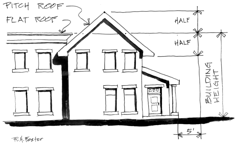
Figure 6 - Building Height
Building Inspector. A designated person with duties and authority to enforce all building codes and the provisions of this Code.
Building Line. A line that is adjacent to the front side of a main building parallel to the front lot line.
Building Official. An individual empowered by the City Council to administer and enforce building regulations.
Canopy Sign (Sign). A sign hanging from a canopy or eve, at any angle relative to the adjacent wall.
Figure 7 - Canopy Sign
Canopy Tree. A deciduous shade tree with a high crown of foliage at maturity intended, planted, and maintained so as to provide shade to parking lots, parks, and other publicly accessible areas, usually in concert with other canopy trees.
Figure 8 - Canopy Trees in parking lot
Capacity. Maximum holding or service ability, as used for transportation, utilities, parks, and other public facilities. See also, definition of "Occupancy" in applicable building codes.
Caretaker/Caretakers unit. A caretaker is a person or persons employed principally on the lot for purposes of care and protection of plants, buildings, equipment, or other facilities on-site or on contiguous lots under the same ownership. A dwelling unit for a caretaker is a structure on the premises being cared for or guarded and is occupied exclusively by a caretaker and his/her family.
Carpool. Two or more persons commuting in a single vehicle.
Carport. A stationary structure consisting of a roof with its supports and not more than one wall or storage cabinet substituting for a wall and used for covering a vehicle parking space.
Cemetery. Land used or intended to be used for the burial of the dead, and dedicated for cemetery purposes, including a columbarium, crematory, mausoleum, or mortuary, when operated in conjunction with and within the boundary of such cemetery.
Change of Use. Change in the primary type of use on a site as defined and administered by the Building Official.
Change of Use (Greenway). A different use of the land or water than that which existed on December 6, 1975. It includes a change which requires construction, alterations of the land, water, or other areas outside of existing buildings or structures and which substantially alters or affects the land or water. It does not include a change of use of a building or other structure which does not substantially alter or affect the land or water upon which it is situated. Change of use shall not include the completion of a structure for which a valid permit has been issued as of December 6, 1975 and under which permit substantial construction has been undertaken by July 1, 1976. The sale of property is not in itself considered to be change of use. An existing open storage area shall be considered to be the same as a building. Landscaping, construction of driveways, modifications of existing structures, or the construction or placement of such subsidiary structures or facilities as are usual and necessary to the use of existing improvements.
City. The City of Millersburg, Oregon.
City Council or Council. The legally elected City Council of the City of Millersburg, Oregon.
City Manager. The City Manager employed by the City Council of the City of Millersburg, Oregon or his/her designee.
Clear Vision Area. A triangular area on a lot at the intersection of two streets or a street and a railroad. Two sides are lines measured from the corner intersection of the right-of-way lines for a specific distance. The third side of the triangle is a line across the corner of the lot joining the ends of the other two sides. Where the right-of-way lines at the intersections have rounded corners, the lines will be extended in a straight line to a point of intersection for purpose of measurement.
Clinic. A facility for examination and treatment of human ailments by a group of physicians, dentists, or other licensed practitioners on an out-patient basis and not involving overnight housing of patients.
Clinic, Large Animal. A business establishment in which veterinary services are rendered to large animals including livestock on an outpatient basis with no overnight boarding.
Clinic, Small Animal. A business establishment in which veterinary services are rendered to small domestic pets on an outpatient basis with no overnight boarding.
Club. A facility owned or operated for a social, fraternal, religious, educational, or recreational purpose, to which membership is required for participation and which is neither operated primarily for profit nor to render a service which is customarily carried on by a business.
Co-Location (Wireless Communication). A wireless communications facility comprised of a single communications tower or building supporting one or more antennas, dishes, or similar devices owned or used by more than one provider.
Commence. For construction activities see Start of Construction. For use, beginning of actual use.
Commission. The Planning Commission of the City of Millersburg, Oregon.
Community Center. A facility owned and operated by a governmental agency or a non-profit community organization which is open to any resident of the neighborhood in which the facility is located or to any resident of the City or surrounding area, provided that the primary purpose of the facility is for assembly, and provided further that no permanent or temporary commercial eating or drinking facilities shall be operated on the premises.
Comprehensive Plan. The Comprehensive Plan of the City of Millersburg, Oregon.
Conveyance (Flood). Refers to the carrying capacity of all or a part of the floodplain. It reflects the quantity and velocity of floodwaters. Conveyance is measured in cubic feet per second (CFS). If the flow is 30,000 CFS at a cross section, this means that 30,000 cubic feet of water pass through the cross section each second.
County Assessor. The County Assessor of Linn County, Oregon.
Curb Line. The line indicating the edge of the vehicular roadway within the overall right-of-way.
Cultural Resource Inventory (Historic). Historical buildings or sites identified as "significant" on the Goal 5 historical resource inventory.
Cut. Any act by which earth, sand, gravel, rock, or any other similar material is excavated or removed from a site or parcel of land and includes the conditions resulting there from.
Day Care Facility. An institution, establishment, or place, appropriately licensed by the State of Oregon and not a part of a public-school system, in which are commonly received three or more children for the purpose of being given board, care, or training apart from their parents or guardians for compensation or reward. All day care facilities in residential zones must be home occupations and therefore owner occupied.
Deck. A raised platform, typically made of wood, that is either flush with a home or business or detached from a structure. A deck is an accessory structure if over 200 square feet, though separate rules apply. See Section 3.08.070.
Declarant. The person who files a declaration under ORS 92.075.
Declaration. The instrument described in ORS 92.075 by which the subdivision or partition plat was created.
Dedication. The designation of land by its owner for any public use as reflected on a subdivision or partition plat, deed, or other recording with the County. The term may also be used for dedications to a private homeowners' association.
Demolish (Historic). To raze, destroy, dismantle, deface or in any other manner cause partial or total destruction of a landmark or any building within an historic district.
Density. The number of residential dwelling units per acre of land.
Gross density is calculated based on the total property acreage of each tax lot multiplied by the allowed units per acre.
Net density is calculated on the total acres, minus any floodplain, dedicated right-of-way, or other proposed or required dedications or allocations of land to uses other than the allowed residential units, except garages and other typical residential accessory uses.
Development. Any human-caused change to improved or unimproved real estate, including, but not limited to, buildings or other structures, mining, dredging, filling, grading, paving, excavation or drilling operations or storage of equipment or materials excavating, or drilling operations.
Development (Flood). Any human-made change to improved or unimproved real estate, including, but not limited to, buildings or structures, mining, dredging, filling, grading, paving, excavation or drilling operations or storage of equipment or materials.
Discretionary. A permit action or decision that involves substantial judgment or discretion.
DLCD. Oregon Department of Land Conservation and Development.
Driveway. A private way used by vehicles and pedestrians to gain access from an approved public access or right-of-way onto a lot or parcel of land.
Dwelling, Multi-Family. A building or portion thereof designed or used as three or more dwelling units.
Dwelling, Prefabricated. A prefabricated structure means a building or subassembly that has been in whole or substantial part manufactured or assembled using closed construction at an off-site location to be wholly or partially assembled on-site. This does not mean a manufactured dwelling or a small home as defined in section 2, chapter 401, Oregon Laws 2019, or any structure not intended for living such as a shed. A prefabricated structure may be an accessory dwelling unit.
Dwelling, Single-family. A building designed or used as one detached dwelling unit. This definition typically includes manufactured and prefabricated housing complying with the standards of this Code.
Dwelling, Two-Family (Duplex). A building designed or used as two attached residential dwelling units, neither of which meets the definition of an accessory dwelling unit.
Dwelling Unit. A building or portion thereof designed with one or more rooms for residential purposes by not more than one family and including a kitchen and bathroom. A recreational vehicle is not a Dwelling Unit.
Easement. A grant of the right to use a strip of land for designated purposes.
Encroachment. Advancement of a surrounding or adjacent use or structure onto another property, right-of-way, or a natural resource or hazard.
Encroachment (Flood). Any obstruction in the floodplain which affects flood flows.
Existing Mobile/Manufactured Home Park or Manufactured Home Subdivision (Flood). A parcel (or contiguous parcels) of land divided into two or more mobile/manufactured home lots for rent or sale for which the construction of facilities for servicing the lot on which the mobile/manufactured home is to be affixed (including, at a minimum, the installation of utilities, either final site grading or the pouring of concrete pads, and the construction of streets) is completed before the effective date of this Code.
Expansion to an Existing Mobile/Manufactured Home Park or Manufactured Home Subdivision (Flood). The preparation of additional sites by the construction of facilities for servicing the lots on which the mobile/manufactured homes are to be affixed (including the installation of utilities, either final site grading or pouring of concrete pads, or the construction of streets).
Family. An individual or two or more persons related by blood, marriage, adoption, or legal guardianship, or a group of not more than five unrelated individuals, living together as a single housekeeping unit.
Farming. To engage in the cultivation of crops or the raising of animals. Farm Use as defined in ORS 215.203 including non-farm uses authorized by ORS 215.213 and ORS 215.283.
Farmland, High Value. Lands classified by the US Natural Resource Conservation Service (NRCS) as predominantly Class I through IV soils in Western Oregon.
FEMA. The Federal Emergency Management Agency, the federal organization responsible for administering the National Flood Insurance Program.
Fence, Non-sight Obscuring. Any fence constructed in such a manner as to allow vision through at least 80 percent of the fence when viewed from either side of the fence at a 90-degree angle.
Fence or Wall, Sight Obscuring. Any fence or wall constructed in such a manner as to obstruct vision by at least 80 percent when viewed from a 90-degree angle.
Fill. Any act by which earth, sand, gravel, rock, or any other similar material is deposited, placed, pulled, or transported to raise the land to a higher level or grade.
Fill (Flood). The placement of any material on the land for the purposes of increasing its elevation in relation to that which exists. Fill material includes, but is not limited to, the following: soil, rock, concrete, bricks, wood stumps, wood, glass, garbage, plastics, metal, etc.
Flag. A piece of cloth or other flexible material attached to a staff, cord, bracket, or structure.
Flashing Sign (Sign). A sign any part of which pulsates or blinks on and off, except time and temperature signs and signs allowed by conditional use.
Flood or Flooding (Flood) - A general and temporary condition of partial or complete inundation of normally dry land areas from:
The overflow of inland or tidal waters.
The unusual and rapid accumulation or runoff of surface waters from any source.
Mudslides (i.e., mudflows) which are proximately caused by flooding as defined above and are akin to a river of liquid and flowing mud on the surfaces of normally dry land areas, as when earth is carried by a current of water and deposited along the path of the current.
The collapse or subsidence of land along the shore of a lake or other body of water as a result of erosion or undermining caused by waves or currents of water exceeding anticipated cyclical levels or suddenly caused by an unusually high water level in a natural body of water, accompanied by a severe storm, or by an unanticipated force of nature, such as flash flood or an abnormal tidal surge, or by some similarly unusual and unforeseeable event which results in flooding as defined above.
Flood elevation study (Flood) - An examination, evaluation and determination of flood hazards and, if appropriate, corresponding water surface elevations, or an examination, evaluation and determination of mudslide (i.e., mudflow) and/or flood-related erosion hazards.
Flood Insurance Rate Map (FIRM)(Flood) - The official map of a community, on which the Federal Insurance Administrator has delineated both the special hazard areas and the risk premium zones applicable to the community. A FIRM that has been made available digitally is called a Digital Flood Insurance Rate Map (DFIRM).
Flood Insurance Study (FIS) (Flood). See "Flood elevation study".
Flood proofing (Flood) - Any combination of structural and nonstructural additions, changes, or adjustments to structures which reduce or eliminate risk of flood damage to real estate or improved real property, water and sanitary facilities, structures, and their contents.
Floodway (Flood) - The channel of a river or other watercourse and the adjacent land areas that must be reserved in order to discharge the base flood without cumulatively increasing the water surface elevation more than a designated height. Also referred to as "Regulatory Floodway."
Floor Area. The area of the building, exclusive of porches and exterior stairs, which shall extend to the exterior faces of all walls. Floor area shall include all levels within a structure, including mezzanines and additional stories above the first floor, and including basements improved for regular human occupancy. Within a residential structure, floor area does not include garages or carports.
Floor Elevation. The height above mean sea level of the first floor of a building that is not a basement.
Floor, Habitable. Any floor area intended to be used for residential living purposes, which includes working, sleeping, eating, cooking or recreating, or a combination thereof. A floor area used only for storage purposes is not a "habitable floor."
Food Pod. A single site that includes three or more mobile food units. (See Mobile Food Unit.)
Free-Standing Sign (Sign). A sign supported by one or more uprights, poles or braces placed in or upon the ground, or a sign supported by any structure primarily for the display and support of the sign.
Frontage. That portion of a lot or parcel which abuts a public street.
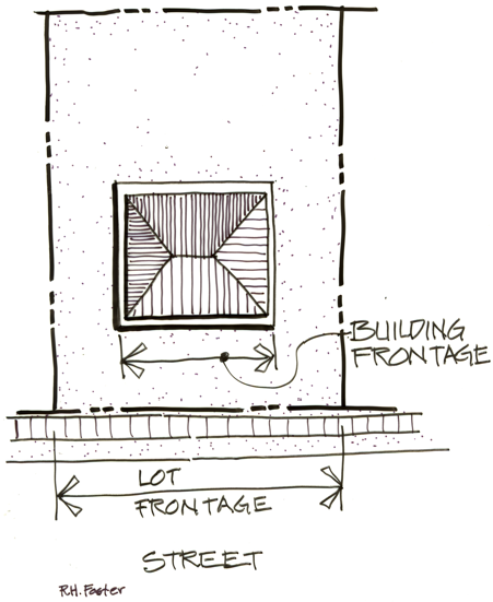
Figure 9 - Frontage - Lot and Building
Functionally dependent use (Flood) - A use which cannot perform its intended purpose unless it is located or carried out in close proximity to water. The term includes only docking facilities, port facilities that are necessary for the loading and unloading of cargo or passengers, and ship building and ship repair facilities, and does not include long term storage or related manufacturing facilities.
Garage, Private. A detached accessory building or portion of a main building for the parking of automobiles of the occupants of the premises.
Garage, Public. A building other than a private garage used for the care, repair, parking, or storage of automobiles.
Grade. The average elevation of the finished ground at the centers of all walls of a building, except that if a wall is parallel to and within five feet of a sidewalk, the sidewalk elevation opposite the center of the wall shall constitute the ground elevation.
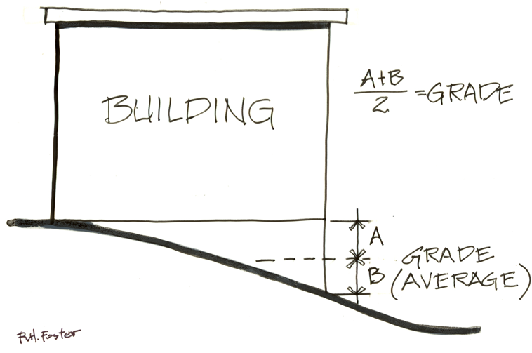
Figure 10 - Grade
Ground Mounted Solar Systems. A ground mounted solar system is comprised of solar panels mounted to a substructure that is located on the ground as opposed to a rooftop mounted system. These can change position to track the sun or remain stationary. All forms of ground mounted solar systems are considered a structure.
Hazardous Material (Flood). Combustible, flammable, corrosive, explosive, toxic, or radioactive substance which is potentially harmful to humans and the environment.
Highest adjacent grade (Flood) - The highest natural elevation of the ground surface prior to construction next to the proposed walls of a structure.
Height (Sign). Height is measured from the grade of the curb line lowest to the base of the sign to the highest point of the sign. In the absence of a curb line, the edge of the street pavement shall be used. In the absence of street pavement, the ground level shall be used to measure the height.
Historic District (Historic). A geographically definable area, the boundaries of which have been adopted by the City Council.
Half-Story. Means that part of any building wholly or partly within the roof frame and not occupying more than two-thirds of the floor area immediately below it.
Historic structure. Any structure that is:
Listed individually in the National Register of Historic Places (a listing maintained by the Department of Interior) or preliminarily determined by the Secretary of the Interior as meeting the requirements for individual listing on the National Register;
Certified or preliminarily determined by the Secretary of the Interior as contributing to the historical significance of a registered historic district or a district preliminarily determined by the Secretary to qualify as a registered historic district;
Individually listed on a state inventory of historic places in states with historic preservation programs which have been approved by the Secretary of Interior; or
Individually listed on a local inventory of historic places in communities with historic preservation programs that have been certified either:
By an approved state program as determined by the Secretary of the Interior or
Directly by the Secretary of the Interior in states without approved programs.
Home Occupation. An occupation, profession, or craft, which is customarily incidental to or carried on in a dwelling or residential premises and not one in which use as a dwelling is largely incidental to the business use, and continually conforms to the criteria set forth in this Code.
Hotel or Motel. Any building or portion thereof designed or used to offer guest rooms or suites for temporary lodging, with or without meals, for compensation but excluding any institution in which human beings are housed or detained under legal restraint.
House of Worship. A permanently located building primarily used for religious worship. This definition shall also include accessory buildings for related religious activities and residences as allowed by state law.
Impervious Area. An area with minimal infiltration of surface water into the underlying soil and shall include pavement, such as concrete, asphalt, gravel, roadways, structures, and roofs or other similar surfaces that limit water penetration.
Incidental Signs (Sign). A sign which is normally incidental to the allowed use of the property but can contain any message or content. Such signs can be used for, but are not limited to, nameplate signs, warning or prohibition signs, and directional signs not otherwise allowed.
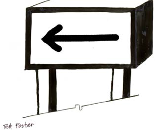
Figure 11 - Sign, Incidental
Indirect Illumination (Sign). A source of illumination directed toward such sign so that the beam of light falls upon the exterior surface of the sign.
Integrated Business Center (Sign). A group of two or more businesses which are planned or designed as a center and share a common off-street parking area or access, whether or not the businesses, buildings, or land are under common ownership.
Figure 12 - Integrated Business Center
Interested Person. A person who has legal standing in a land use decision and may appeal a decision by virtue of their participation in the public hearing process for that decision.
Internal Illumination (Sign). A source of illumination from within a sign.
Intersection. An at-grade connection of a public or private approach road to a public road or highway.
Intensification (Greenway). Any additions which increase or expand the area or amount of an existing use, or the level of activity. Remodeling of the exterior of a structure not excluded below is an Intensification when it will substantially alter the appearance of the structure. Intensification shall not include the completion of a structure for which a valid permit was issued as of December 6, 1975 and under which permit substantial construction has been undertaken by July 1, 1976. Maintenance and repair usual and necessary for the continuance of an existing use is not an intensification of use. Reasonable emergency procedures necessary for the safety or the protection of property are not an intensification of use. Seasonal increases in gravel operations shall not be considered an intensification of use.
Junk Yards. The use of property for the storage of salvage materials, including scrap metals or other scrap materials, or for the dismantling or "wrecking" of automobiles or other vehicles or machinery, whether or not such uses are conducted as a business for profit or otherwise.
Kennel. Any premises where four or more dogs, cats, or other small animals or any combination thereof, are kept commercially or permitted to remain for compensation, propagation, training, or sale, except not including a veterinary clinic or hospital.
Landmark (Historic). Any site, object, building, or structure designated by the City Council pursuant to provisions in Chapter 2.13.
Landscaping. The term includes trees, grass, shrubs, flowers, water features, garden areas, the arrangement of paths, walkways, fountains, patios, decks, fencing, street and yard furniture, ornamental concrete or stonework, decorative retaining walls, earth forms, such as grading, mounding, contouring, and terracing, exterior use of artificial turf or carpeting, artificial plants, shrubs, or flowers. Both native and non-native vegetation may constitute landscaping materials. This definition pertains to complete site modifications other than buildings and parking areas and driveways.
Land Division. Any partition or subdivision of a lot or parcel.
Land Use. The activity or activities that occur on a piece of land. Activities may be individually identified as primary or accessory uses.
Land Use Decision. A final decision or determination made by the City of Millersburg that concerns the adoption, amendment, or application of the Statewide Planning Goals, the Comprehensive Plan, or any land use regulation (i.e., this Code) where the decision requires the interpretation or exercise of policy or legal judgment. Decisions requiring Quasi-Judicial review by the City are considered Land Use Decisions. Decisions subject to Administrative review are considered Limited Land Use Decisions, pursuant to ORS 197.015, including Site Development Review applications.
Lattice Tower (Wireless Communication). Means a support structure constructed of vertical metal struts and cross braces forming a triangular or square structure which often tapers from the foundation to the top.
LCDC. Oregon Land Conservation and Development Commission.
Legislative Process. A process that leads to the adoption of rules or policies that have broad implications for a large geographic area or for the community as a whole.
Livestock. Domestic animals of types customarily raised or kept on farms for profit or other purposes.
Loading Space. An off-street space or berth on the same lot with a building, or contiguous to a group of buildings, used for the temporary parking of a commercial vehicle while loading or unloading merchandise or materials, and which abuts upon a street, alley, or other appropriate means of access.
Lot. A unit of land created by a subdivision as defined in ORS 92.010 in compliance with all applicable zoning and subdivision codes; or created by deed or land sales contract if there were no applicable zoning, subdivision, or partitioning codes, exclusive of units of land created solely to establish a separate tax account. Such lots may consist of a single lot of record; a portion of a lot of record; or a combination thereof. Lots created judicially may be considered legal lots only if established as part of a formal judicial decree or settlement.
Lot Area. The total horizontal area contained within the lot lines of a lot, excluding street or alley rights-of-way, and the portion of a flag lot within the pole or driveway area.
Lot, Corner. A lot abutting upon two or more streets at their intersection, or upon two parts of the same street, such streets or parts of the same street forming an interior angle of less than 135 degrees within the lot lines.
Figure 13 - Lot, Corner
Lot Coverage. That portion of the total lot area covered by impervious surfaces, including structures and paving, expressed as a percentage of the total lot area.
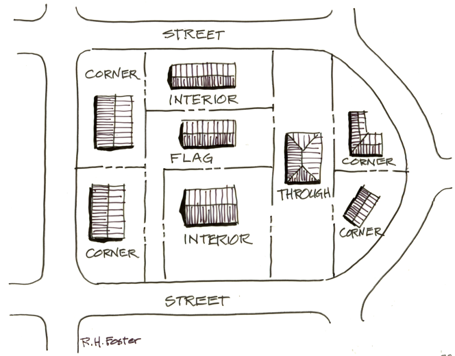
Figure 14 - Lot Configurations
Lot Depth. The horizontal mean average distance between the front and rear lot lines.
Lot, Flag. A lot created which is behind a lot fronting on a street and which is connected to that street by a driveway located on a narrow strip of land. The strip of land may be a portion of the lot behind the street-fronting lot, or an access easement over the street-fronting lot.
Lot, Interior. A lot or parcel of land other than a corner, flag, or through lot.
Lot Line. A line that defines a boundary of a lot, see also "Property Boundary."
Lot Line, Front. The boundary line of a lot that abuts a street other than a side or rear yard line. For a corner lot, the shortest property line along a street, other than an alley. If the lot does not abut a street, the longest boundary line closest to the street, other than the pole portion of a flag lot, shall be the front lot line.
Lot Line, Rear. A lot line not abutting a street which is opposite and most distant from the front lot line and not intersecting a front lot line, except on a corner lot.
Lot Line, Side. Any lot line not a front or rear line.
Lot, Through. Any lot, except a corner lot, that abuts two or more streets and/or highways.
Lot of Record. A legally created lot held in separate ownership as shown on the records of the County prior to the time of the passage of an ordinance or regulation establishing a new zoning district, or new standards within an existing district, within which it is located regardless of lot's compliance with standards of the new regulation.
Lot Width. The horizontal distance between the side lot lines measured within the lot boundaries or the mean distance between the side lot lines within the buildable area.
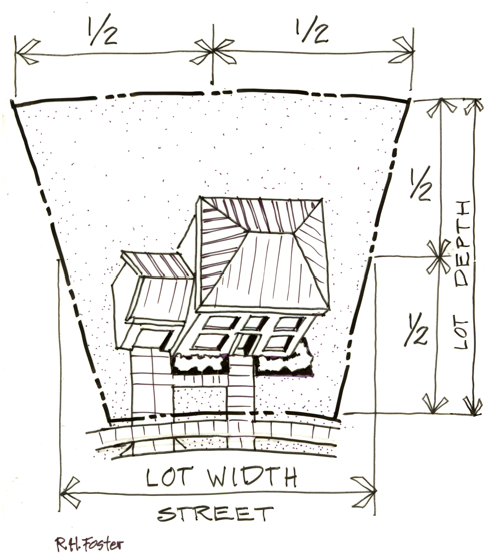
Figure 15 - Lot Depth and Width
Lowest Floor (Flood). Means the lowest floor of the lowest enclosed area (including basement). An unfinished or flood resistant enclosure, usable solely for parking of vehicles, building access or storage, in an area other than a basement area, is not considered a building's lowest floor, provided that such enclosure is not built so as to render the structure in violation of the applicable non-elevation design requirements of this Code.
Maintain. To cause or allow to continue in existence. When the context indicates, the word shall mean to preserve and care for a structure, improvement, condition, or area to such an extent that it remains attractive, safe, and presentable and carries out the purpose for which it was installed, constructed, or required.
Major Public Improvement (Historic). The expenditure of public funds or the grant of permission by a public body to undertake change in the physical character of property within a district or on a landmark site, except for the repair or maintenance of existing public improvements.
Manufactured Dwelling or Home. A structure designed for movement on the public highways and for residential occupancy that has sleeping, cooking, and plumbing facilities, and was constructed in accordance with Federal Manufactured Housing Construction and Safety Standards and regulations in effect at the time of manufacture. For City zoning standards, the term does not include travel trailers and other similar recreational vehicles, nor does it include Accessory Dwelling Units as defined by the Oregon Building Codes Division.
Manufactured dwelling (Flood) - A structure, transportable in one or more sections, which is built on a permanent chassis and is designed for use with or without a permanent foundation when attached to the required utilities. The term "manufactured dwelling" does not include a "recreational vehicle" and is synonymous with "manufactured home".
Manufactured Home or Mobile Home Park. Any place where four or more manufactured dwellings are located within 500 feet of one another on a lot, tract, or parcel of land under the same ownership.
Manufactured Dwelling Park or Subdivision (Flood). Means a parcel (or contiguous parcels) of land divided into two or more manufactured home lots for rent or sale.
Mean Sea Level (Flood). Means, for purposes of the National Flood Insurance Program, the National Geodetic Vertical Datum (NGVD) of 1929 or other datum, to which base flood elevations shown on a community's Flood Insurance Rate Map are referenced.
Message Sign (Sign). A sign which can change its message electronically including, but not limited to, signs displaying time and temperature.
Mini-Storage Warehouse. An area or areas located within an enclosed building or structure used only in connection with a residential land use for the storage of nonflammable or non-explosive materials.
Mobile Food Unit. As defined by OAR 333-150-0000 as any vehicle that can be pulled or pushed down a sidewalk, street, highway, or waterway, on which food is prepared, processed or converted or which is used in selling and dispensing food to the ultimate customer. Mobile Food Units fall into the four following categories:
Food Stands in a location and operating for a limited duration. Examples include a hot dog stand that operates on a street during the lunch hour or a lemonade stand in a neighborhood. Maximum size is 48 square feet. Customer access is walk up only.
Food Carts in a location and operating for a limited duration. Includes both mobile carts and also temporary stands with a maximum size of 100 square feet. Examples include a food stand erected for and kept up only for the duration of an event, fair, or festival. Customer access is walk up only.
Food Trucks/Trailers in which food is prepared and from which food is served. Food Trailers and Trucks park generally in parking lots and may move from the business site daily or may locate in the same site for several weeks at a time. Maximum size is 200 square feet. There is no indoor seating. Customer access can be walk up or drive-up window.
Food Kiosks located on a site in a long-term or permanent manner such as a drive-up coffee stand. These may be structures or trailers. There is no kitchen or indoor seating. Customer access can be walk up or drive-up window.
Mobile Home. A vehicle or structure constructed for movement on the public highways, that has sleeping, cooking, and plumbing facilities, is intended for residential occupancy, and that was constructed between January 1, 1962 and June 15, 1976, and met the construction requirements of the Oregon Mobile Home law in effect at the time of construction. For City zoning standards, the term does not include travel trailers and other similar recreational vehicles, nor does it include Accessory Dwelling Units as defined by the Oregon Building Codes Division.
Mobile Home (Flood). Means a vehicle or structure, transportable in one or more sections, which is eight feet or more in width, is 32 feet or more in length, is built on a permanent chassis to which running gear is or has been attached and is designed to be used as a dwelling with or without permanent foundation when connected to the required utilities. Such definition does not include any recreational vehicle as defined by this Section.
Mobile Home Space. A plot of land within a manufactured or mobile home park designed for the placement of one mobile home.
Modular Home. A structure for residential use that has sleeping, cooking, and plumbing facilities, and is constructed off-site in compliance with the Uniform Building Code (Oregon State Structural Code) and designed to be transported to a site for installation and/or assembly of modular components to form a permanent structure.
Monopole (Wireless Communication). Means a support structure constructed of a single, self-supporting hollow tube securely anchored to a foundation.
Motor Vehicle. A vehicle that is self-propelled or designed for self-propulsion.
Multi-Faced Sign (Sign). A sign which has two or more identical sign faces, contained in a single sign structure.
Figure 16 - Sign, Multi-Faced
Mural (Sign). A covering of the surface area of a wall with paint or other artistic medium, that creates a pictorial or abstract design and usually without advertising or commercial symbolism - such as logos or trademarks - or any representation of a product or business, except to identify the artist.
Natural Vegetative Fringe (Greenway). The naturally vegetated area that provides a transition between the water of a river and the most landward edge of this naturally vegetated area.
Nearby Uses. Activities or uses within one quarter mile of a development which can be reasonably expected to be used by pedestrians and within one mile of a development which can reasonably expected to be used by bicyclist.
Neighborhood Activity Centers. Schools, parks, and other similar sites.
New Construction. Structures for which construction was initiated on or after the effective date of this Code.
New Construction (Flood). Any structure(s) for which the start of construction commenced on or after the original effective date of the Floodplain Overlay Zone.
Nonconforming Sign (Sign). Any sign which lawfully exists prior to the effective date of this Chapter but, which due to the adopted requirements, no longer complies with the height, area, and placement regulations or other provisions of these regulations.
Nonconforming Site Conditions. A legally established site that does not conform to the landscaping, parking, or other site development standards of the zone in which it is located.
Nonconforming Structure. A legally established building or other structure that does not conform with the height, setback, lot area, lot coverage, or other standards for structures within the zone it is located.
Nonconforming Use. A use of land or a building or structure which lawfully existed at the time of the adoption of this Code, or any amendment thereto, but which does not conform to the regulations imposed by this code or such amendments thereto.
Nursing Home. Any home, place, or institution which operates and maintains facilities providing convalescent or nursing care, or both, for period exceeding 24 hours for two or more ill or infirm patients not related to the nursing home manager, or owner, by blood or marriage. Convalescent care may include, but is not limited to, the procedures commonly employed in nursing and caring for the sick and includes rest homes and convalescent homes but does not include a boarding home for the aged, a retirement home, hotel, hospital, or a chiropractic facility licensed under the Oregon Revised Statutes.
Obstruction (Flood). Any dam, wall, wharf, embankment, levee, dike, pile, abutment, projection, excavation, channel bridge, conduit, culvert, building, wire, fence, rock, gravel, refuse, fill, structure or matter in, along, across or projecting into any channel, watercourse, or regulatory flood hazard area which may impede, retard, or change the direction of the flow of water, either in itself or by catching or collecting debris carried by such water, or that it is placed where the flow of water might carry the same downstream to the damage of life or property.
Occupancy. The purpose for which a building, or part of a building, is used or intended to be used.
Official Zoning Map. The map established by adoption, and occasionally amended, by the City Council on which plan locations, particularly of streets, are indicated with detail and exactness so as to furnish the basis for property acquisition, building restrictions, building permits, zoning, or other uses or activities, the original of which shall be kept on file in the office of the City Manager.
Open Space. Land that is not covered by buildings, paving, or other hard surfaces, unless such hard surfaces are part of an approved landscape plan, and such land is intended to remain open for visual and/or active or passive recreational use.
Ordinary High Water (Greenway). The level to which waters ordinarily rise, usually represented by the line of permanent vegetation. In areas without vegetation, this line may be determined with nearby permanent vegetation, either upstream or downstream or by the locations of a high bank extending out of the floodplain.
Owner. The owner of record of real property as shown on the latest tax rolls or deed records of the County, or a person who is purchasing a parcel or property under written contract.
Owner (Sign). The owner or lessee of a sign. If the owner or lessee of a sign cannot be determined, then "owner" means owner or purchaser of the land on which the sign is placed.
Parcel. A single unit of land that is created by a partitioning of land, or a unit of land created by deed or land sale contract prior to adoption of local planning, zoning, or partitioning regulations. Parcel does not include a unit of land created solely to establish a separate tax account.
Parking Area, Private. An open area, building, or structure, other than a street or alley, used for the parking of the automobiles of residents and guests of a building.
Parking Area, Public. An open area, building, or structure, other than a private parking area, street, or alley, used for the parking of automobiles and other motor vehicles, including trucks less than 12,000 pounds gross vehicle weight and available for use by persons patronizing a particular building, establishment, or area.
Parking Space. A durable, dustless, concrete, or asphalt paved and marked surface area, but excluding paved area necessary for access and maneuvering into and out of the space. The following are not considered parking spaces for the purposes of OAR 660-12-045(5)(c): park and ride lots, handicapped parking, and parking for carpools and vanpools.
Partition. To divide an area or tract of land into two or three parcels within a calendar year when such area or tract of land exists as a unit or contiguous units of land under single ownership at the beginning of such year. "Partition" does not include:
Divisions of land resulting from lien foreclosures, divisions of land resulting from contracts for the sale of real property, and divisions of land resulting from the creation of cemetery lots; or
Any adjustment of a lot line by the relocation of a common boundary where an additional parcel is not created and where the existing parcel reduced in size by the adjustment is not reduced below the minimum lot size established by any applicable zoning regulation; or
A sale or grant by a person to a public agency or public body for state highway, county road, or other right-of-way purposes provided that such road or right-of-way complies with the applicable comprehensive plan and ORS 215.213 (2)(q) to (s) and 215.283 (2)(p) to (r).
Partition, Serial. A series of partitions of land resulting in the creation of four or more parcels over a period of more than one calendar year.
Pathway. A pedestrian facility that is entirely separate from the roadway and generally serves as an on-site pedestrian system within a development or park.
Patio. A landscape feature that is flush with the ground consisting of gravel, stone pavers, concrete, or similar material. If covered by a pergola or similar feature, only the material on the ground is considered the patio.
Pedestrian Connection. A continuous, unobstructed, reasonably direct route intended and suitable for pedestrian use between two points. Pedestrian connections include but are not limited to sidewalks, walkways, accessways, stairways, and pedestrian bridges.
Pedestrian Way. A right-of-way for pedestrian traffic.
Pergola. A built cover, either open to the sky with slats or covered by a solid roof. These are detached from a structure and have open sides. They are typically freestanding. A pergola is an accessory structure if over 200 square feet, though separate rules apply. See Section 3.08.070.
Permittee. The person who is proposing to use or develop property for which use, or development, requires a permit or the person who is using the property or development subject to a permit issued for the property.
Person. Every natural person, firm, partnership, association, social or fraternal organization, corporation, trust, estate, receiver, syndicate, branch of government, or any group of combination acting as a unit.
Pets. Dogs or cats, excluding large or exotic varieties normally located in the wild or displayed by zoological societies; birds, excluding poultry; turtles, fish, lizards, non-poisonous reptiles and snakes, and rodents when contained and housed within a residence and not present in sufficient numbers as to constitute a nuisance to neighbors or to constitute a business.
Plan Map. An officially adopted map of the City, including urban growth boundary, showing land use designations and other graphic information which is part of the City's Comprehensive Plan.
Planned Road or Street. A highway, road, street, or alley identified in an adopted corridor plan, comprehensive plan, or transportation system plan in accordance with administrative procedures of OAR 660-012 and ORS Chapter 197, but that has not been constructed.
Planter Strip. A landscape area for street trees and other plantings within the public right-of-way, usually a continuous planter area between the street and a sidewalk.
Planned Unit Development. A type of development of a site which, as a single project, is based on a design which incorporates all elements of land, structures, and uses in conformance with the applicable standards of this Code.
Planning Commission. The Planning Commission of the City of Millersburg, Oregon, as may be appointed by the City Council as established in the Millersburg Municipal Code.
Planning Director. The Planning Director (or his/her designee) of the City of Millersburg, Oregon, as appointed by the City Manager.
Plat. A map, diagram, drawing, re-plat, or other writing containing all of the descriptions, locations, specifications, dedications, provisions, and information concerning a subdivision, condominium division, or land partition.
A tentative plat is one that is prepared for review and considered by the City for compliance with development regulation standards.
A final plat is one that is prepared for recordation with the County after the City has approved the tentative plat. A final plat must substantially conform to the specifications as approve for the tentative plat.
Porch. A covered and elevated platform attached to a house or business. These can sometimes be called a veranda, which is a porch that wraps around a corner. For the purposes of this Development Code a veranda is considered a porch. An uncovered platform is considered a deck even when attached to a home or structure. Once enclosed, the area is considered interior to the structure and no longer a porch. A porch is not considered an accessory structure though separate rules apply. See Section 3.08.070.
Portable Sign (Sign). Any sign that is not originally designed to be permanently affixed to a building, structure, or the ground; a sign originally designed, regardless of its current modification, to be moved from place to place. These signs include, but are not limited to, A-frame or sandwich board signs, signs attached to wood or metal frames and designed to be self-supporting and movable, and also including trailer reader boards. Portable signs are also considered temporary signs.

Figure 17 - Signs, Portable - Examples
Professional-Type Service. Shall include activities of professional quality and requiring special training such as those offered by a physician, surgeon, dentist, lawyer, architect, engineer, planner, or accountant, of which may or may not require a license issued by the State of Oregon.
Projecting Signs (Sign). A sign projecting from a structure, the face of which is not parallel to the wall on which it is mounted.
Figure 18 - Sign, Projecting
Property (or Lot) Boundary. The division line between two units of land.
Property (or Lot) Boundary Adjustment. The relocation of a common property line between two abutting properties.
Provider (Wireless Communication). A company, which may or may not hold a Federal Communications Commission (FCC) license, that is in business to provide wireless communications services.
Public Facilities and Services. Projects, activities, and facilities which are necessary for the public health, safety, and welfare.
Quasi-Judicial Process. A process that leads to a decision on a land use or development application involving a single property or small group of properties. The process involves application of existing laws and regulations, or imposition of specific new regulations limited to the properties included in the application.
Reasonably Direct. A route that does not deviate unnecessarily from a straight line or a route that does not involve a significant amount of out-of-direction travel for likely users.
Recreational Vehicle. A vacation trailer, vehicle, or portable unit, as defined in ORS 801.180, 801.350, and 801.565, which is either self-propelled, towed, or carried by a motor vehicle, which is:
Built on a single chassis;
400 square feet or less when measured at the largest horizontal projection;
Designed primarily not for use as a permanent dwelling but as temporary living quarters for recreational, camping, travel, or seasonal use.
For the purpose of this definition, a recreational vehicle also includes a street legal trailer used for transporting motorized or non-motorized recreational vehicles including, but not limited to, boats, snowmobiles, ATV's, and motorcycles.
A recreational vehicle does not meet the definition for a manufactured home or mobile home.
Recreational Vehicle Park. A lot, which is designed and operated for compensation as a place for temporary or short-term parking of occupied recreational vehicles.
Recreational Vehicle, Storage. A lot which is designed and operated for compensation as a place for temporary or long-term storage of unoccupied recreational vehicles.
Residential Accessory Dwelling. A secondary dwelling unit with kitchen facilities, on the same lot as a single-family dwelling and being of substantially the same exterior design as the single-family unit, whether attached or detached. This definition includes guesthouse.
Residential Care Facility. As used in ORS Chapter 197, a residential care facility is a residential treatment or training home, or adult foster home, licensed by the State of Oregon, which provides care, treatment, or training for six to 15 individuals, and which may also provide housing for staff persons who provide services to those individuals. For the purposed of this Code, a residential care facility is considered to be a form of multi-family residential development.
Residential Care Home. As used in ORS Chapter 197, a residential care home is a residential treatment or training home, or adult foster home, licensed by the State of Oregon, which provides care, treatment, or training for five or fewer individuals, and which may also provide housing for staff persons who provide services to those individuals. For the purposed of this Code, a residential care home is considered to be a form of single-family dwelling unit.
Retaining Wall. A structure that holds back any material (usually earth) and prevents it from sliding or eroding away.
Review Authority. The individual, Board, Commission, or City Council who has authority to decide on a land use application as defined by this Code.
Right-of-Way. Real property or an interest in real property owned by a roadway authority for the purpose of constructing, operating, and maintaining public facilities.
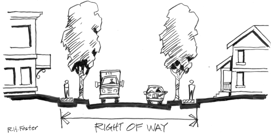
Figure 19 - Right-of-Way
Riparian Areas. Those areas adjacent to a water resource that display transitions between terrestrial and aquatic zones. These areas are beneficial to a large number of organisms and provide for flood storage amelioration, erosion control, and bank or slope stabilization. This is the zone where vegetative material is deposited, where significant shading of streams can occur, where humidity is typically higher and temperatures typically cooler. Thermal regulation, erosion control, flood control, water quality, and wildlife habitat are primary functions of riparian areas.
Roadway. The portion of a right-of-way that is improved for motor vehicle and bicycle travel, subject to applicable state motor vehicle licensing requirements. Roadway includes vehicle travel lanes and on-street parking areas. Roadway does not include area devoted to curbs, parking strips, or sidewalks.
Roadway Authority. The City or other agency with jurisdiction over a road or street.
Roof Line (Sign). Either the eaves of the roof, or the top of the parapet, at the exterior wall. A "mansard roof" is below the top of a parapet and is considered a wall for sign purposes.
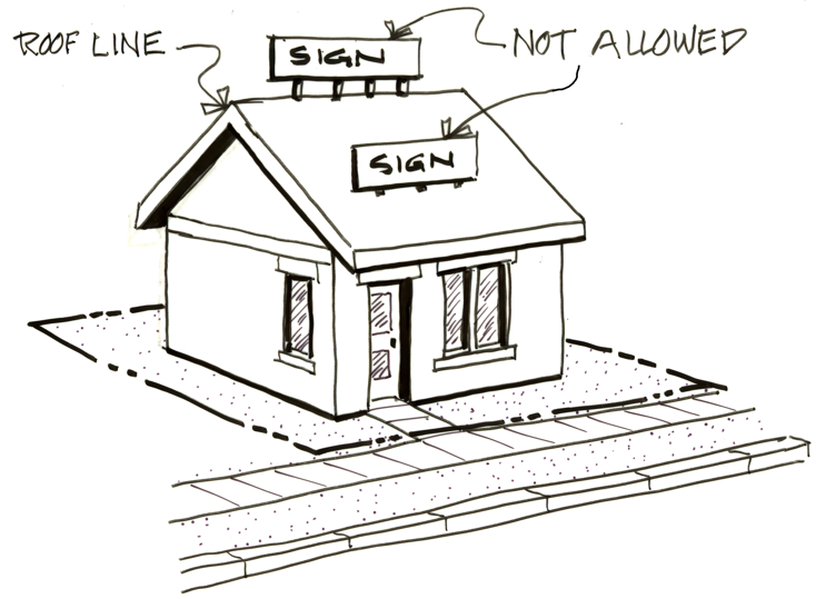
Figure 20 - Sign, Roof and Roof Line
Roof Sign (Sign). A sign or any portion of which is displayed above the highest point of the roof, whether or not such sign is also a wall sign.
Rotating/Revolving Sign (Sign). A sign, all or a portion of which moves in some manner.
School, Elementary, Middle School, or High School. A public, private, or parochial institution offering instruction in the several branches of learning and study in accordance with the rules and regulations of the State Department of Education.
School, Trade, or Commercial. A building where the instruction is given to pupils for a fee in money or otherwise which fee is the principal reason for the existence of the school.
Semi-Public Use. A structure or use intended or used for a semi-public purpose by a church, lodge, club, or any other non-profit organization.
Senior Housing. Housing specifically designed for, and occupied by, individuals 55 years of age and older. Housing arrangements may include independent living (apartments), assisted living including nursing, rehabilitation care, and continuing care facilities and communities.
Service Station. Any lot used primarily for the retail sales of motor vehicle fuels and lubricants for delivery on premises, and minor automobile repair and service.
Setback. A line within a property boundary defining a locational limit for buildings, structures, or other defined uses that creates an area or yard between the property line and the setback line.
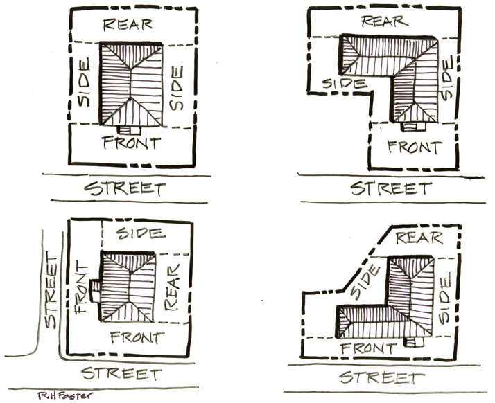
Figure 21 - Setbacks
Shared Driveway. A driveway used to access two or more parcels.
Shared Parking. Required parking facilities for two or more uses, structures, or lots or parcels, which are satisfied jointly with the same facilities.
Sidewalk. A publicly or privately paved pedestrian walkway within or adjacent to a street right-of-way or private street.
Sign (Sign). Any writing, including letter, word, or numeral; pictorial presentation, including illustration or decoration; emblem, symbol, or trademark; banner or pennant; or any other device, figure, or similar thing which is a structure or any part thereof, or is attached to, painted on, or in any other manner represented on a building, structure, or device; and is used to announce, direct attention to, or advertise; and is visible from any City or County public right-of-way.
Sign Area (Sign). The area of a sign shall be the entire area within any type of perimeter or border which encloses the outer limits of any writing, representation, emblem, figure, or character. If the sign is enclosed in a frame or cabinet, the area is based on the inner dimensions of the frame or cabinet surrounding the sign face. When a sign is on a base material and attached without a frame, such as a wood board or Plexiglas panel, the dimensions of the base material are to be used. The area of a sign having no such perimeter, border, or base material shall be computed by enclosing the entire area within a parallelogram or a triangle of the smallest size sufficient to cover the entire message of the sign and computing the area of the parallelogram or a triangle. For the purpose of computing the number of signs, all writing included within such a border shall be considered one sign, except for multi-faced signs on a single sign structure, which shall be counted as one sign per structure. The area of multi-faced signs shall be calculated by including only one-half the total area of all sign faces.
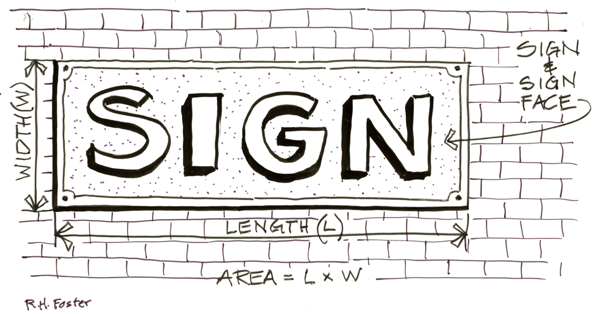
Figure 22 - Sign Area - Framed Sign
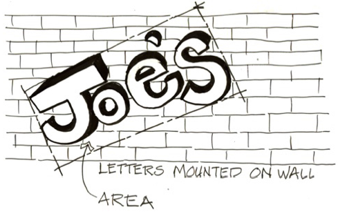
Figure 22 - Sign Area - Framed Sign
Sign Face (Sign). Surface of a sign containing the message. The sign face shall be measured as set forth in the definition for "Sign Area."
Sign Structure (Sign). The supports, uprights, braces, framework, and other structural components of the sign.
Single Room Occupancy (SRO). A primary residential structure with no fewer than four attached SRO Dwelling units. The primary residential structure must provide access for all occupants to a location for food preparation (shared or unshared), and sanitary facilities, or both.
Site Development. Any human-caused change to improved or unimproved property, including, but not limited to, land surface mining, grading, filling, excavating, tree cutting, clearing, construction, installation or alteration of a building or other structure, paving, landscaping, establishment, or termination of an access or outdoor storage on the land.
Site Plan or Development Plan. A drawing or graphic depiction or plan, prepared to scale, showing accurately and with complete scaled dimensioning, all existing and proposed uses, buildings, paving, and landscaping proposed for a specific parcel of land.
Special flood hazard area (Flood) - See "Area of special flood hazard" for this definition.
Space, Manufactured Home. An area or lot reserved exclusively for the use of a manufactured home occupant.
SRO unit. A single, independently lockable living and sleeping room for rent and exclusive use by a single occupant in a primary residential structure with access to a food preparation area and restrooms.
Start of Construction. The date a building permit is issued, provided that the actual start of construction, repair, reconstruction, placement, or other improvement occurs within 180 days of the permit date.
Start of Construction (Flood). Includes substantial improvement and means the date the building permit was issued, provided the actual start of construction, repair, reconstruction, rehabilitation, addition, placement, or other improvement was within 180 days from the date of the permit. The actual start means either the first placement of permanent construction of a structure on a site, such as the pouring of slab or footings, the installation of piles, the construction of columns, or any work beyond the stage of excavation; or the placement of a manufactured dwelling on a foundation. Permanent construction does not include land preparation, such as clearing, grading, and filling; nor does it include the installation of streets and/or walkways; nor does it include excavation for a basement, footings, piers, or foundations or the erection of temporary forms; nor does it include the installation on the property of accessory buildings, such as garages or sheds not occupied as dwelling units or not part of the main structure. For a substantial improvement, the actual start of construction means the first alteration of any wall, ceiling, floor, or other structural part of a building, whether or not that alteration affects the external dimensions of the building.
Story. That portion of a building included between the upper surface of any floor and the upper surface of the floor next above, except that the top-most story shall be that portion of a building included between the upper surface of the top-most floor and the ceiling or roof above. If the finished floor level directly above a basement or cellar is more than six feet above grade as defined herein, such basement or cellar shall constitute a story. For industrial or commercial applications, a 'story' shall be considered 14 feet. For example, a 28-foot tower would be considered a two-story structure.
Street or Road. A public thoroughfare or right-of-way dedicated, deeded, or condemned for use as such which affords the principal means of access to abutting property including, but not limited to, avenue, place, way, drive, lane, boulevard, highway, or road.
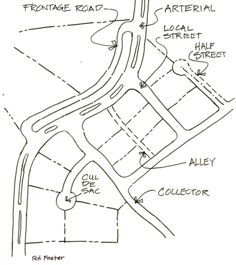
Figure 24 - Street Classifications
• Alley. A narrow street through a block used primarily for access by service vehicles to the back or side of properties fronting on another street.
• Arterial. A street used primarily for through traffic external to the City. Arterials are intersected by collector streets and typically have limited direct access to abutting properties.
• Collector. A street used to some extent for through traffic and also for local circulation and access to abutting properties.
• Cul-de-sac (dead-end). A short street with one end open to traffic and the other terminated by a vehicle turn-around.
• Frontage. A minor street parallel to and adjacent to an arterial or major collector street intended to provide access to abutting properties and providing protection from through traffic.
• Half-Street. A portion of the standard full width of a street, usually along the edge of a development where the remaining portion of the street could be provided in another development. A half-street improvement could include up to one half the total design width, plus sufficient additional width past the centerline to ensure proper design and construction of the centerline crown, as defined by the City Engineer.
• Limited Access Street. A means of access to property that is limited by law for public roads or by posting by an owner for private roads.
• Local. A street used exclusively for access to abutting properties.
• Stub Street. A temporary street ending where the street will be extended through adjacent property in the future, as those properties develop. Not a permanent street-end or dead-end street.
• Through Street. A street that connects to other streets at both ends or is planned to do so in the future, pursuant to a comprehensive plan, transportation system plan, access management plan, or land use approval.
• Structural Alteration. Any change to the supporting members of a structure including foundations, bearing walls or partitions, columns, beams, girders, or structural change in the roof or in the exterior walls.
Structure. That which is built or constructed and requires a building permit, including buildings, decks, fences, towers, flag poles, signs, and other similar objects. Structure does not include at-grade paved areas or vegetative landscaping materials.
Structure (Flood). For floodplain management purposes, a walled and roofed building, including a gas or liquid storage tank, that is principally above ground, as well as a manufactured dwelling.
Subdivide Land. To divide land into four or more lots within a calendar year, or to affect a subdivision of land, as defined below.
Subdivision. Either an act of subdividing land, or an area or tract subdivided as defined in this Code. A subdivision means the division of land into more than three lots within a calendar year.
Substantial damage (Flood) - Damage of any origin sustained by a structure whereby the cost of restoring the structure to its before damaged condition would equal or exceed 50 percent of the market value of the structure before the damage occurred.
Substantial Improvement. Any repair, reconstruction, or improvement of a structure, the cost of which equals or exceeds 50% of the market value of the structure, as determined by the City's Building Official.
Substantial improvement (Flood). Any reconstruction, rehabilitation, addition, or other improvement of a structure, the cost of which equals or exceeds 50 percent of the market value of the structure before the "start of construction" of the improvement. This term includes structures which have incurred "substantial damage," regardless of the actual repair work performed. The term does not, however, include either:
Any project for improvement of a structure to correct existing violations of state or local health, sanitary, or safety code specifications which have been identified by the local code enforcement official and which are the minimum necessary to assure safe living conditions; or
Any alteration of a "historic structure," provided that the alteration will not preclude the structure's continued designation as a "historic structure."

Figure 25 - Temporary Sign
Temporary Sign. A sign not permanently affixed to a structure on a property. These signs primarily include, but are not limited to, canvas, cloth, or paper banners or posters hung on a building wall or on a permanent pole such as on a free-standing sign support. Also see Portable Sign (Signs).
Tentative Plan. A tentative plan is the application, supplemental data, and map showing the general design of a proposed subdivision or partition, submitted to the City for approval under the provisions of ORS Chapter 92 and the Millersburg Development Code.
Transportation Facilities. A physical facility used to move people and goods from one place to another (i.e., streets, sidewalks, pathways, bike lanes, transit stations, bus stops, rail, airports, helipads, etc.)
Transportation Improvements. Facility improvements include, but are not limited to:
Normal operation, maintenance, repair, and preservation activities associated with existing transportation facilities.
Installation of culverts, pathways, medians, fencing, guardrails, lighting, and similar types of improvements within the existing right-of-way.
Projects specifically identified in the City's adopted Transportation System Plan.
Landscaping as part of a transportation facility.
Measures necessary for the safety and protection of property or the public.
Construction of a street or road as part of an approved subdivision or partition consistent with the City's adopted Transportation System Plan.
Construction of a street or road as part of an approved subdivision or land partition approved in accordance with the applicable land division ordinance.
Use. The purpose for which land or a building is arranged, designed, or intended for which either land or a building is or may be occupied.
Utilities. Any water, gas, sewer, storm drainage, electrical, telephone, or communication service, and all persons, companies, and agencies supplying the same.
Urban Growth Boundary. An adopted boundary around the City which defines the area in which the City expects to grow, where public facilities will be extended, and where joint planning responsibilities are exercised with Linn County.
Vacations. A procedure to revert public lands, including a right-of-way, easements, and other public places, to adjoining private property ownerships.
Variance. A grant of relief from the requirements of this Code which permits development in a manner that would otherwise be prohibited by this Code.
Variance (Flood). A grant of relief by the City of Millersburg from the terms of a flood plain management regulation.
Vehicle. Any device in, upon, or by which any person or property is or may be transported or drawn upon a public highway and includes vehicles that are propelled or powered by any means. Vehicle does not include a manufactured structure.
Veranda. See porch.
Violation. The division, construction, alteration, addition to, or use of land or structures in a manner that does not fully comply with the provisions of this Code. The failure of a structure or other development to be fully compliant with the community's floodplain management regulations. A structure or other development without the elevation certificate, other certifications, or other evidence of compliance required in this ordinance is presumed to be in violation until such time as that documentation is provided.
Visual Compatibility Characteristics (Wireless Communication). Characteristics that minimize the visual impact of a tower or antennas.
Wall Sign (Sign). A sign attached to, erected against, or painted on a wall of a building or structure, with the exposed face of the sign in a plane approximately parallel to the face of said wall and not projecting more than twelves inches.
Figure 26 - Wall Sign
Warehouse. A place for the safekeeping of goods and materials necessary for the proper functioning of an industrial or commercial enterprise. Also, a facility designed and intended to be used for the rental of storage units to individuals for the safekeeping of personal items.
Watercourse (Flood). A natural or artificial channel in which a flow of water occurs either continually or intermittently in identified floodplain.
Water-Dependent (Greenway). A use or activity which can be carried out only on, in, or adjacent to water areas because the use requires access to the water body for water-borne transportation, recreation, energy production, or source of water.
Water-Related (Greenway). Uses which are not directly dependent upon access to a water body, but which provide goods or services that are directly associated with water-dependent land or waterway use, and which, if not located adjacent to water, would result in a public loss of quality in the goods or services offered.
Wetland Areas. Defined as those areas that are inundated or saturated often enough to support a prevalence of vegetation adapted for life in standing water or saturated soil. Wetlands include swamps, bogs, marshes, and similar areas.
Wetlands-Jurisdictional. A wetland subject to rules and regulations identified in Section 404 of the US Clean Water Act and Oregon's Fill and Removal statute.
Wireless Communications (Wireless Communication). The transmission, via radio frequency electromagnetic waves, between or among points specified by the user, of information of the user's choosing, without change in the form or content of the information as sent and received.
Wireless Communications Accessory Structure/Equipment (Wireless Communication). Equipment shelters or radio equipment necessary for the operation of wireless communications in addition to the antenna and tower.
Wireless Communications Facility (WCF) (Wireless Communication). A facility consisting of the equipment and structures involved in receiving and or transmitting communications or radio signals.
Wireless Communications Equipment Shelter (Wireless Communication). The structure in which the electronic radio equipment, electronic equipment, relay equipment, and other supporting equipment for a wireless communications facility is housed.
Wireless Communications Tower (WCT) Support Facility (Wireless Communication). A structure intended to support equipment used to transmit and/or receive communications signals including monopoles, guyed and lattice towers, but not excluding any other approved structure.
Wrecking Yard. See Junk Yard.
Yard. Any open space on the same lot with a building or group of buildings, which is unoccupied and unobstructed by any structure from the ground upward to the sky, other than by landscaping or a permitted fence, and except for the projections as permitted in this Code.
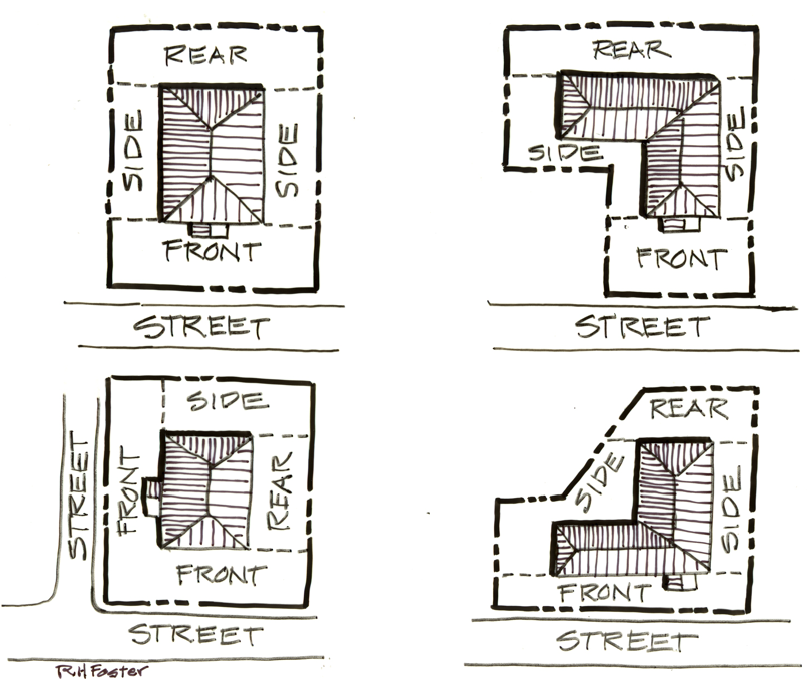
Figure 27 - Yard Locations
Front Yard. An exterior yard facing a street. For corner lots, the property line facing the garage or carport
Rear Yard. A yard opposite the Front Yard.
Side Yard. A yard that is not a Front Yard or Rear Yard.
Street Facing Side Yard. An exterior Side Yard facing a street that is not a Front Yard. For corner lots, usually the largest street facing dimension of the property.
Exterior Yard. A yard area abutting a street right-of-way created by a setback line.
Interior Yard. A yard area adjacent to a property line created by a setback line that may be either a Side Yard or Rear Yard abutting another property.
Zero Setback. A property line having no setback therefore permitting building locations on the property line and may equally divide a common wall between buildings on adjacent properties.
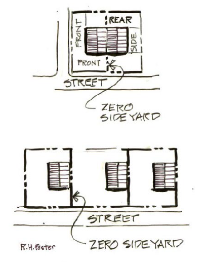
Figure 28 - Zero Setback - Zero Side Yard
(Ord. No. 192-21, §§ 1, 8, 14, 12-14-2021; Ord. No. 195-22, Exh. A, 7-12-2022; Ord. No. 210-24, Exh. A, 1-9-2024; Ord. No. 213-25, Exh. A, 2-11-2025)