
Millersburg City Zoning Code
ARTICLE IV
- LAND DIVISIONS
4.01.010 - Applicability.
Article IV addresses specific requirements related to the division of land, including partitions, subdivisions and middle housing land divisions. These provisions concern the process of dividing land and do not alter the requirements and standards of the underlying zone(s).
Procedures related to land divisions, including property line adjustments, are contained in Article V - Review Procedures.
(Ord. No. 216-25, Att. A, 7-8-2025)
4.02.010 - Purpose.
The purpose of this Chapter is to provide for the orderly, safe, and efficient division of land within the City.
4.02.020 - Scope.
The provisions of this Chapter shall apply to all partitions, subdivisions and middle housing land divisions within the City of Millersburg. The following shall determine the appropriate process and design standards:
(1)
Partition. A land division creating two or three parcels within a calendar year shall be processed as a Partition and subject to the design and improvement standards for a Partition.
(2)
Subdivision. A land division creating four or more lots within a calendar year shall be processed as a Subdivision and subject to the design and improvement standards for a Subdivision.
(3)
Middle Housing Land Division. A land division that allows the sale of duplexes to different owners by creating separate lots for each housing unit. All rules and regulations for Middle Housing Land Divisions are regulated by Oregon Revised Statutes 92.031 and 197.360.
(4)
Some standards listed below pertain specifically to residential or non-residential (typically commercial and industrial). If the standard does not state that it is specific to one or the other, then it is applicable to all land divisions. Maps for mixed use projects shall be treated like a non-residential map.
(Ord. No. 210-24, Exh. A, 1-9-2024; Ord. No. 213-25, Exh. A, 2-11-2025; Ord. No. 216-25, Att. A, 7-8-2025)
4.02.030 - Standards for Lots or Parcels.
The following standards shall apply to Partitions and Subdivisions.
(1)
Minimum Lot Area. Minimum lot area shall conform to the requirements of the zoning district in which the parcel is located. Access easements, or the access strip to a flag lot, shall not be included in the calculation of lot area for purposes of determining compliance with any minimum lot size provision of this Code.
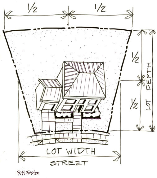
Figure 62 - Lot Depth and Width
(2)
Lot Width and Depth. The depth of a lot or parcel shall not be more than three times the width. The mean shall be used for lots that are a unique shape. For lots or parcels where the mean is not appropriate, a determination of consistency shall be made by the Community Development Director. Lots or parcels created for commercial, industrial, or public uses shall be exempt from width to depth ratio provisions.
(3)
Access.
a.
All new lots or parcels for commercial, industrial, or public uses must provide at a minimum either street frontage wide enough for a driveway, or a private access easement may be used to access parcels or lots. The following also apply:
i.
All private access easements must be at least 25 feet wide unless they are part of a parking lot, then parking lot standards apply, or in accordance with the Oregon Fire Code.
ii.
If a building on the lot or parcel is to be available to the public, it must also provide pedestrian access to that structure, except where a private access easement is outside City boundaries.
b.
Lots created as part of a shopping or industrial center must include a private reciprocal access easement in areas required for access. Building setbacks to the permitter of the center apply, but there [are] no setback requirements internal to the center regardless of the proposed lot layout. Proposed lots or parcels may be coterminous with the building footprint, for example, a grocery store could be on a lot that is the same size as the store's building.
c.
All new residential lots or parcels shall provide a minimum of 40 feet of frontage on an existing or proposed public street, or 25 feet of frontage along a cul-de-sac except residential lots or parcels may be accessed by a private street or private access easement developed in accordance with the provisions of Sections 3.02.040 and 4.02.030(4) when it is determined that a public street access is:
i.
Infeasible due to parcel shape, terrain, or location of existing structures; and
ii.
Unnecessary to provide for the future development of adjoining property.
iii.
No more than 10% of the lots within a subdivision may be accessed by a private street or private access easement.
(4)
Flag Lots. Flag lots shall be subject to the following development standards:
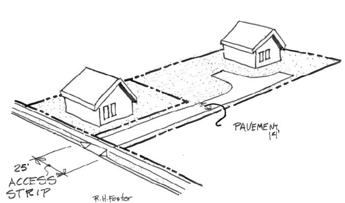
Figure 63 - Flag Lot Access
a.
The access strip shall be a minimum of 25 feet in width. The improved surface shall be a minimum of 14 feet in width.
b.
The access strip shall not be included in the lot area calculation.
c.
If the length of the access strip exceeds 150 feet, the parcel or lot shall include a turn-around area per Section 3.02.
d.
All flag parcels or lots shall comply with setback requirements of the Zone, however because the parcel or lot does not front a street, the designation of where the front setback applies shall be determined on a case-by-case basis by the Community Development Director. The rear setback shall be on the opposite side of the structure from the front. Side setbacks shall apply anywhere the front and rear do not apply.
(5)
Residential Through Lots.
a.
Through lots shall be avoided except where essential to provide separation of residential development from traffic arteries, adjacent non-residential activities, or to overcome specific disadvantages of topography.
b.
Conditions of approval may be added limiting access from any street.
c.
Screening or buffering, pursuant to the provisions of Chapter 3.07, may be required during the review of the land division request.
(6)
Lot Side Lines. The side lines of lots, as far as practicable, shall run at right angles to the public street, private street, or private access easement upon which the lot or parcel faces.
(7)
Utility Easements. Utility easements shall be provided on lot areas where necessary to accommodate public utilities. Easement width shall conform to adopted Engineering Standards.
(8)
Re-Division. When subdividing or partitioning into large lots which may be re-subdivided, the City shall require that the design of the lots be of a size and shape to allow for the subsequent division of any parcel into lots of smaller size and the creation and extension of future streets. Shadow plats may be required. A shadow plat shows the proposed lot design does not preclude future division by showing a fully subdivided plan. The plan is not binding, it just shows that the current design does not preclude future divisions. This does not apply to industrial or public subdivisions or partitions but does apply to residential and commercial.
(9)
Remainder areas. When subdividing or partitioning property, any area within the tentative/final plat that is not proposed to be part of a lot, parcel, or tract is a remainder area. Tracts must serve a function. Any such remainder area must meet the minimum requirements of this Code, including any requirements by the zone such as lot size or the requirement to connect to public water and/or sanitary sewer.
(10)
Lot Averaging. Lot averaging is not permitted. All lots must meet the minimum lot size requirements of the zone.
(11)
Phased Development.
a.
The Approval Authority may approve a time schedule for developing a subdivision in phases, but in no case shall the actual construction time period for any phase be greater than two years without reapplying for a tentative plat. All phasing must be approved with the entitlement. Phasing proposed after entitlement approval requires a project modification regulated by Section 5.16.060.
b.
The criteria for approving a phased subdivision (in addition to all standard subdivision criteria) review proposal are:
I.
The public facilities shall be scheduled to be constructed in conjunction with or prior to each phase to ensure provision of public facilities prior to building occupancy;
II.
The development and occupancy of any phase shall not be dependent on the use of temporary public facilities:
1.
For purposes of this subsection, a temporary public facility is an interim facility not constructed to the applicable City or district standard; and
2.
The phased development shall not result in requiring the City or other property owners to construct public facilities that were required as a part of the approval of the preliminary plat.
c.
The application for phased development approval shall be reviewed concurrently with the preliminary plat application and the decision may be appealed in the same manner as the preliminary plat.
(Ord. No. 192-21, § 11, 12-14-2021; Ord. No. 195-22, Exh. A, 7-12-2022; Ord. No. 210-24, Exh. A, 1-9-2024; Ord. No. 216-25, Att. A, 7-8-2025)
4.02.040 - Additional Standards for Subdivisions.
(1)
General. The length, width, and shape of blocks shall be designed with regard to providing adequate building sites for the use contemplated; consideration of needs for convenient access, circulation, control, and safety of street traffic - including pedestrian and bicyclist - and recognition of limitations and opportunities of topography.
(2)
Residential Block Sizes. Blocks shall not exceed 1,000 feet in between street lines with a preferred length of 500 feet. Exceptions are permitted for blocks adjacent to arterial streets, or if the previous development pattern or topographical conditions justify a greater length. The recommended minimum distance between collector street intersections with arterial streets is 1,800 feet.
(3)
Residential Traffic Circulation. A residential subdivision shall be laid out to provide safe, convenient, and direct vehicle, bicycle, and pedestrian access to nearby residential areas; neighborhood activity centers (e.g., schools and parks); shopping areas; and employment centers; and provide safe, convenient, and direct traffic circulation. At a minimum, "nearby" means the distance from the subdivision boundary - 1/4 mile for pedestrians and one mile for bicyclists.
(4)
Residential Connectivity. To achieve the objective in (3) Traffic Circulation above, the City shall require the following in residential subdivisions:
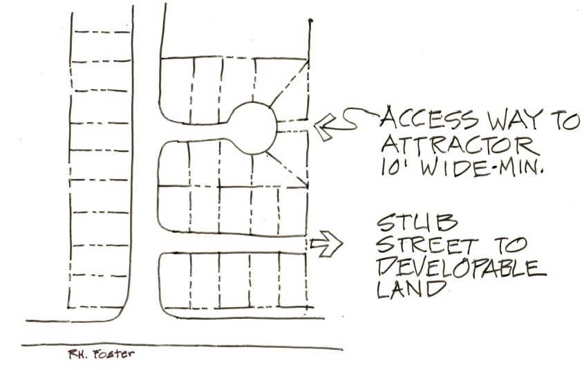
Figure 64 - Connectivity
a.
Stub-End Streets: Where the potential exists for additional residential development on adjacent property.
b.
Accessways: Public accessways to provide a safe, efficient, and direct connection to cul-de-sac streets, to pass through oddly shaped or blocks longer than 600-feet, to provide for networks of public paths creating access to nearby residential areas, neighborhood activity centers (e.g., schools and parks); shopping areas; and employment centers.
(5)
Collector and Arterial Connections. Accessway, bikeway, or sidewalk connections with adjoining Arterial and Collector streets shall be provided in residential subdivisions if any portion of the site's arterial or collector street frontage is over 600 feet from either a subdivision access street or other accessway. The placement of an accessway may be modified or eliminated if natural features (e.g., adverse topography, streams, wetlands) preclude such a connection.
(6)
Design Standards for Residential Pedestrian/Bicycle Accessways at the ends of cul-de-sacs. Pedestrian/bicycle accessways at the ends of cul-de-sacs shall meet the following design standards:
a.
Minimum dedicated width: 15 feet
b.
Minimum improved width: 12 feet
c.
Pedestrian scale lighting fixtures shall be provided along walkways and adequately lighted so the system can be used at night. Lighting shall either conform to adopted Public Works Standards or be approved by the decision authority.
d.
The accessway shall be designed to prohibit vehicle traffic.
(Ord. No. 210-24, Exh. A, 1-9-2024)
4.02.050 - Improvement Requirements - Partition.
During the review of Partition proposals, the City shall require, as a condition of approval, the following improvements:
(1)
Private Access. Where included, private driveways serving flag lots or private streets shall be surfaced per the requirements of this Code.
(2)
Street Frontage Improvements. The following improvements shall be required:
a.
Consistent with the adopted transportation plans, sufficient land shall be dedicated establishing the appropriate right-of-way width.
b.
If the street frontage of the subject property is less than or equal to 250 feet and does not connect to existing improvements, the applicant shall pay connection fees in accordance with the City's adopted Connection Charges ordinance in lieu of construction of the required frontage improvements. At City's option, a non-remonstrance agreement acceptable to the City of Millersburg may be allowed. This agreement shall stipulate that the applicant, or future property owner, will agree to participate in right-of-way improvements. The agreement may include provisions for the following: street paving, curbing, sidewalks, water lines, storm sewer facilities, and sanitary sewer facilities. The agreement shall be recorded at the County Clerk's Office at the time of the recording of the final plat.
c.
If the street frontage of the subject property exceeds 250 feet, or connects to an existing street improvement, the applicant shall improve the following:
i.
Public streets upon which the property fronts to public standards including surfacing from center line to curb, installation of curbing, storm sewers, sanitary sewers, water lines, and other necessary public utilities per approved master plans. In some cases, surfacing additional road width may be required. Where a master plan has not been adopted, or the City deems it to be in the City's best interest, the developer shall pay connection charges consistent with item (2) b, above.
ii.
Sidewalks, meeting City standards, along public street frontage: Sidewalk construction may be deferred until such time a building permit is issued.
iii.
The installation of storm sewers, sanitary sewers, water lines and other utilities necessary to serve parcels accessing off the new street.
d.
Partitions in the RU Zone, where all parcels remain over 2.5 acres, are not required to construct improvements. All other requirements apply.
(3)
Resultant parcels shall conform to the City's adopted code and standards including but not limited to transportation, stormwater, wastewater and water Public Facilities. The developer shall submit engineering plans or facility improvement plans to the City for review. The plans shall address the required improvements contained in this Article, and any conditions of approval, and shall conform with City Engineering Design Standards. Improvement work shall not commence until plans are approved by the City.
(4)
Connection Charge. In the circumstance where existing improved streets, sanitary sewer, water, and/or storm lines are adjacent to or within the project, a connection charge is required in accordance with the City's adopted Connection Charges ordinance.
(5)
Completion Requirements. All required improvements shall be completed prior to recording the final partition plat and the issuance of any building permits for the subject property. Alternatively, improvements required under this Section may be assured through a performance bond or other instrument acceptable to the City prior to the approval of the final plat of the Partition.
(Ord. No. 213-25, Exh. A, 2-11-2025; Ord. No. 216-25, Att. A, 7-8-2025)
4.02.060 - Improvement Requirements - Subdivision.
(1)
Improvements. The following improvements shall be required for all Subdivisions:
a.
Frontage Improvements. Half-street improvements designed to the City's Engineering Standards shall be required for all public streets on which a proposed Subdivision fronts. Additional frontage improvements shall include sidewalks, curbing, storm sewer, sanitary sewer, water lines, other public utilities as necessary, and such other improvements as the City shall determine to be reasonably necessary to serve the development or the immediate neighborhood. If the street frontage of the subject property does not connect to existing improvements, at the City's discretion the applicant may be required to pay connection charges in accordance with the City's adopted Connection Charges ordinance in lieu of constructing any portion of the required frontage improvements.
b.
Project Streets. Public or private streets within the Subdivision shall be constructed as required by City Engineering Standards. In the circumstance where existing streets are adjacent to or within the project, a connection charge is required in accordance with the City's adopted Connection Charges ordinance.
c.
Monuments. Monuments shall be established as required by the Engineering Design Standards.
d.
Surface Drainage and Storm Sewer System. Drainage facilities shall be provided within the Subdivision and to connect the Subdivision drainage to drainageways or to storm sewers outside the Subdivision. Design of drainage within the Subdivision shall be constructed in accordance with the Engineering Design Standards. In the circumstance where existing storm sewer lines are adjacent to or within the project, a connection charge is required in accordance with the City's adopted Connection Charges ordinance.
e.
Sanitary Sewers. Sanitary sewer shall be installed to serve the Subdivision and to connect the Subdivision to existing mains both on and off the property being subdivided conforming to Engineering Design Standards. The City may require that the developer construct sewage lines of a size in excess of that necessary to adequately service the development in question, where such facilities are or will be necessary to serve the entire area within which the development is located when the area is ultimately developed. The City may also require that the construction take place as an assessment project with such arrangement with the developer as is desirable to assure his share of the construction. In the circumstance where existing sanitary sewer lines are adjacent to or within the project, a connection charge is required in accordance with the City's adopted Connection Charges ordinance.
f.
Water System. Water lines with valves and fire hydrants serving the Subdivision and connecting the Subdivision to the City mains shall be installed in conformance with the Engineering Design Standards. The design shall take into account provisions for extension beyond the Subdivision to adequately grid the City system and to serve the area within which the development is located when the area is fully developed. However, the City will not expect the developer to pay for the extra cost of mains exceeding eight inches in size. In the circumstance where existing water lines are adjacent to or within the project, a connection charge is required in accordance with the City's adopted Connection Charges ordinance.
g.
Sidewalks. Sidewalks shall be installed along both sides of each public street and in any pedestrian ways within the Subdivision. This improvement may be deferred until prior to occupancy of a dwelling.
h.
Streetlights. The installation of streetlights is required at locations, and of a type required by City standards.
i.
Street Signs. The installation of street name signs and traffic control signs is required at locations determined to be appropriate by the City and shall be of a type required by City standards.
j.
Other Requirements:
i.
Curb cuts and driveway installations are not required of the developer at the time of development, but if installed, shall be according to the City standards.
ii.
Street trees are required pursuant to City engineering standards. All trees are to be planted prior to final occupancy of a structure or when required of the developer for areas where buildable lots do not exist (common space, open space, detention basins, etc.). Planting of street trees shall be according to City requirements and of a species compatible with the width of the planting strip and underground facilities. At least one tree will be located in the planting strip unless infeasible due to required sight clearances and/or offsets from utilities. No tree shall be located in the planting strip within 10 feet of a water or sewer service line. An additional tree shall be planted either in the planting strip or yard adjacent to the street or streets. Trees must be planted and viable prior to occupancy.
(2)
Completion of Improvements. All improvements required under this Chapter shall be completed to City standards or assured through a performance bond or other instrument acceptable to the City Attorney, prior to the approval of the Final Plat of the Subdivision. In no case shall the bond exceed 5% of the remaining project improvements as determined by the City Engineer.
(Ord. No. 210-24, Exh. A, 1-9-2024)
4.02.070 - Improvement Procedures.
In addition to Engineering Design Standards, improvements installed by a developer for any land division, either as a requirement of these regulations or the developer's option, shall conform to the requirements of this Code, the improvement standards and specifications adopted by the City, and shall be installed in accordance with the following procedures:
(1)
City Approval Required. Improvement work shall not commence until plans are approved by the City. All plans shall be prepared in accordance with requirements of the City.
(2)
Notification. Improvement work shall not commence until the City has been notified in advance; and, if work has been discontinued for any reason, it shall not be resumed until the City has been notified.
(3)
Inspections. Improvements shall be constructed under the inspection and to the satisfaction of the City Engineer or his/her designee. The City may require changes in typical street sections and improvements if unusual conditions arise during construction to warrant such changes.
(4)
Installation of Utilities. All underground utilities, sanitary sewers, and storm drains installed by the developer shall be constructed prior to the surfacing of the streets. Stubs for service connections for underground utilities and sanitary sewers shall be placed to a length eliminating the necessity for disturbing the street improvements when service connections are made.
(5)
As-Built Drawings. A map or plan showing all public improvements as built shall be filed with the City of Millersburg upon completion of the improvements.
4.02.080 - Regulations on Implementing Construction.
Once a Land Use decision is made on a subdivision, only those local laws in effect at the time of the application submittal shall govern subsequent construction on the property unless the applicant elects otherwise. This period shall last 3 years. This regulation does not automatically extend the life of the Tentative Map Land Use approval to 3 years.
(Ord. No. 213-25, Exh. A, 2-11-2025)