Milton City Zoning Code
ARTICLE VIII
LANDSCAPING REQUIREMENTS
Sec. 78-08.01.- Purpose.
The purpose of this article is to establish landscaping requirements and other regulations intended to preserve and maintain vegetation within in a manner that promotes the natural resource protection, aesthetic, and public health goals of the city.
Sec. 78-08.10. - Applicability.
(1)
The requirements of this section shall not apply retroactively to existing buildings, structures, or paved areas, including requirements for bufferyards.
(2)
Any use for which planning commission approval is required under section 78-10.20 shall provide landscaping in accordance with the regulations of this section, including the following development:
(a)
New buildings and paved areas. The entire site shall provide landscaping per the requirements of this article.
(b)
Expansions. Only the new portion of building or paved area or installation of mechanical equipment shall provide landscaping per the requirements of this article.
(c)
Two or more parking areas interconnected by on-site vehicular circulation are treated as one lot as are unconnected parking areas when separations (unpaved) between them are less than 20 feet in width. Unconnected parking areas with a separation of 20 feet or more shall be considered separate parking lots.
(3)
Where insufficient site area remains to comply with all provisions of this section, the planning commission may require compliance to the greatest extent practical.
(4)
This article is designed to encourage preservation of existing plants on the site. If existing plant material meets the requirements of this article and will be preserved on the subject property following the completion of development, it may be counted as contributing to the landscaping requirements and worth double the landscaping point value per plant.
(5)
Exemptions.
(a)
Parking areas of four or more spaces shall meet the paved area landscaping requirements for paved areas. Any parking area of three or fewer spaces is exempt from the paved area landscaping requirements.
(b)
All land uses in the Central Mixed Use District are exempt from landscaping requirements for building frontages, street frontages, and yards, but shall meet the paved area landscaping requirements for paved areas of four or more spaces.
(c)
Single family dwelling units, two family dwelling units, and agricultural land uses are exempt from landscaping requirements. See section 78-06.06(7)(h) for screening requirements for uncovered parking spaces associated with single family and two-family land uses.
(6)
Changes to the landscaping plan. The city may allow or require changes to the landscaping plan of section 78-08.20 or the landscaping requirements of section 78-08.30, as provided below.
(a)
The zoning administrator, and the plan commission shall have the authority to allow alterations or substitutions of one type of plant for another to the landscaping requirements if the altered requirements achieve an equivalent or greater level of landscaping on a site. Such alternations or substitutions may be based on the following:
1.
Unusual conditions.
2.
The consideration of landscape architecture approaches.
3.
The preservation of existing trees.
4.
The consideration of Wisconsin native landscaping.
5.
When larger size plantings are provided as part of the overall landscape plan.
6.
When more shrubs may be appropriate versus more trees, and vice versa.
7.
Utility or other easements.
(b)
The zoning administrator, and the plan commission shall have the authority to require the modification of any landscaping plan including the rearrangement of landscaping points on a site to better meet aesthetic, environmental, and stormwater goal or objectives.
Sec. 78-08.20. - Landscape plan.
The applicant shall provide a digital copy of a landscaping plan. The plan shall be drawn at a reasonable scale to clearly delineate the landscape improvements and depict the following, at the discretion of the zoning administrator:
(1)
The name and address of the developer/owner, architect/designer name, date of plan preparation, date and description of all revisions, name of project or development, scale of plan, and north point indication.
(2)
All property lines and easements.
(3)
Zoning of the subject property and abutting properties.
(4)
The location and dimensions of all existing and proposed structures, parking lots, driveways, roads, underground utilities, right-of-way, sidewalks, ground signs, refuse disposal areas, fences, freestanding electrical equipment and other utility boxes, and other freestanding structural features as determined necessary by the zoning administrator.
(5)
The location and contours at two-foot intervals, of all proposed berms.
(6)
The location, size, and type (common and botanical) of all existing plant material on the site and designation of all trees and shrubs to be saved and/or removed.
(7)
The location, quantity, size at planting, and type (common and botanical) of all proposed plant material. All plants shall be drawn at the spread they will achieve at maturity.
(8)
The number of required landscaping points per Figure 78.08.30d for all plant material compared to the proposed design points.
(9)
Details of refuse disposal area screening and mechanical equipment and utility screening.
(10)
Linear feet of the new/expanded building foundation and street frontage.
(11)
Square footage of the total lot and new/expanded paved area.
Sec. 78-08.30. - Landscaping requirements.
Landscaping shall be provided based on the following requirements for building foundations, paved areas, street frontages, yards, and bufferyards.
(1)
Building foundations.
(a)
For every 100 linear feet of building foundation, the landscaping installed shall at a minimum meet the number of landscaping points specified in Figure 78.08.30d.
(b)
Tall trees shall not be used to meet building foundation landscaping requirements.
(c)
Building foundation landscaping shall be placed so that at maturity, the plant's drip line is located within ten feet of the building foundation.
(d)
Building expansions shall be subject to the same landscaping formula requirements as new buildings (see Figure 78.08.30d). The formula shall not be applied to portions of the building foundation developed prior to the adoption of this ordinance, but it is strongly encouraged that the entire building be brought into conformance with this chapter.
(e)
The measurement of the building foundation may be simplified as the smallest single rectangle that contains the entire building perimeter, except where the sides of the building face an adjacent public street, in which case the actual perimeter shall be measured.
(2)
Paved areas.
(a)
For every ten off-street parking stalls or 10,000 square feet of pavement (whichever yields the greater landscaping requirement), landscaping shall at a minimum meet the number of landscaping points specified in Figure 78.08.30d.
(b)
Paved area landscaping shall be placed so that at maturity, the plant's drip line is located within ten feet of the paved area. Said area does not have to be provided in one contiguous area. Plants used to fulfill this requirement shall visually screen parking, loading, and circulation areas from view from public streets.
(c)
A minimum of 30 percent of all points shall be devoted to medium or tall trees, or a combination of such trees, and a minimum of 40 percent of all points shall be devoted to shrubs.
(d)
Parking lot design. See also section 78-06.06(7).
1.
Interior parking lot landscaping shall be required for any parking lot with more than 20 parking spaces. Internal parking lot landscaping shall be accomplished by the installation of landscaped planter islands or other types of landscaping application approved by the zoning administrator.
2.
Landscaped planter islands shall be required at the ends of all parking rows, driveway entrances, and at intermediate locations such that there is a maximum of 180 feet between islands. See Figure 78.08.30a.
a.
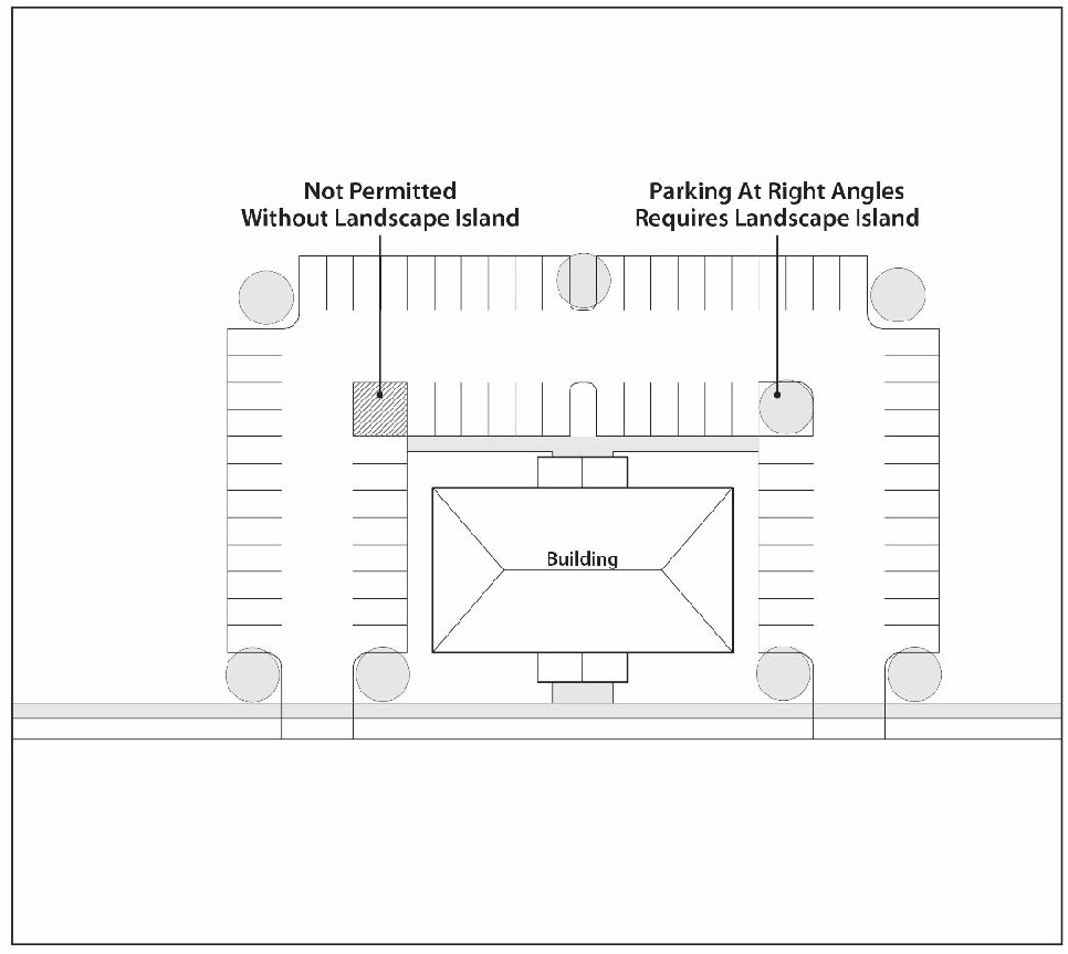
Landscaped planter islands are required where 2 rows of parking stalls meet at a right angle. See Figure 78.08.30b.
Figure 78.08.30a. Requirements for Interior Landscaping
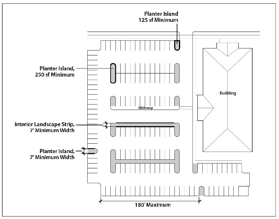
Figure 78.08.30b. Parking Rows at Right Angles
3.
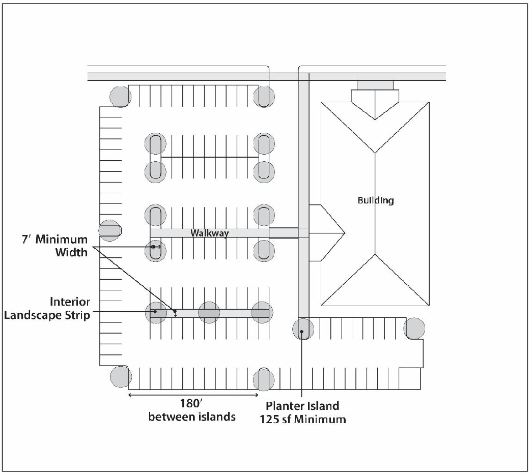
Each landscaped planter island shall be no less than 125 square feet in area and seven feet in width, measured from the back of the curb. For double-parking rows, each landscaped planter island shall be no less than 250 square feet in area. The seven-foot width requirement may be reduced to accommodate the triangular shape resulting from angled parking.
a.
Exception. A continuous seven-foot-wide landscape strip may be provided between double parking rows in place of landscaped planter islands.
b.
See Figure 78.08.30c.
Figure 78.08.30c. Interior Landscaping
4.
All islands shall be crowned for positive drainage, unless bio-retention methods of stormwater management are utilized per a stormwater management plan approved by the city engineer.
5.
One shade tree shall be provided for every island and for every 40 linear feet of continuous landscape strip, except as would conflict with a lighting fixture or underground wet utility pipe. Medium or low trees (evergreen or deciduous) may be used to supplement deciduous shade trees in locations that may not support healthy shade tree or tall deciduous tree growth. This determination shall be made by the zoning administrator. For double-row parking, two shade trees or tall deciduous trees shall be required for each island. See Figure 78.08.30g for minimum planting sizes.
6.
In addition to the required trees and shrubs, islands shall be planted with grass, low ground cover, shrubs, flowers, decorative stone/river rock, mulch, or a combination thereof. Mulches and decorative stone shall be installed so that the loose material will not erode, fall, be plowed, or be otherwise transported onto paved surfaces.
(e)
To ensure proper visibility within the parking lot, landscaping parking lot screening required by section 78-06.06(9) shall count toward the landscaping requirements of this section.
(f)
Parking lot screening required by section 78-06.06(7) (h) shall count toward the landscaping requirements of this section.
(g)
Paved area expansions shall be subject to the same landscaping formula requirements as new paved areas (see 78-08.30d). The formula shall not be applied to paved areas developed prior to the adoption of this ordinance.
(3)
Street frontages.
(a)
For every 100 linear feet of street frontage of a developed lot abutting a public street right-of-way, the landscaping installed shall at a minimum meet the number of landscaping points specified in Figure 78.08.30d.
(b)
Street frontage landscaping shall be placed so that at maturity, the plant's drip line is located within ten feet of the public street right-of-way.
(c)
Landscaping shall not be located within a public right-of-way. Landscaping shall not impede vehicle or pedestrian visibility. See section 78-06.05.
(d)
A minimum of 50 percent of all points shall be devoted to some combination of trees.
(e)
In the case of any new principal building, building expansion, new paved area, or paved area expansion on a previously developed site, a percentage of the landscaping points specified in Figure 78.08.30d shall be required.
(4)
Yards.
(a)
The intent of this section is to provide yard shade and to require a visual screen of a minimum of 6 feet in height for all detached exterior appurtenances (such as HVAC, utility boxes, standpipes, stormwater discharge pipes and other pipes).
(b)
For every 1,000 square feet of gross floor area of all principal and accessory buildings on the site, the landscaping installed shall at a minimum meet the number of landscaping points specified in Figure 78.08.30d.
(c)
Landscaping required by this section is most effective if located away from other areas required for landscaping such as building foundations, street frontages, paved areas, protected green space areas, or bufferyards.
(d)
Building expansions shall be subject to the same landscaping formula requirements as new buildings (see Figure 78.08.30d). The formula shall not be applied to portions of buildings developed prior to the adoption of this ordinance.
(5)
Bufferyards. A bufferyard is a combination of distance and a visual buffer or barrier. It includes an area, together with the combination of plantings, berms and fencing that are required to eliminate or reduce existing or potential nuisances (e.g. dirt, litter, noise, glare, signs, and incompatible land uses, buildings, or parking areas).
(a)
The required level of bufferyard opacity is listed in Figure 78.08.30e. Detailed bufferyard requirements are listed in Figure 78.08.30f. Opacity is a quantitatively-derived measure which indicates the degree to which a particular bufferyard screens the abutting property. The required level of opacity indicated is directly related to the degree to which the potential character of development differs between different zoning districts.
(b)
Bufferyards shall be located along (and within) the outer perimeter of a lot wherever 2 different zoning districts abut one another. Bufferyards shall not be required in front yards or along public street frontages.
(c)
To ensure that the year-round screening objectives are fulfilled, only the plant classifications in Figure 78.08.40b listed as "Appropriate for Screening" shall count toward bufferyard point totals, unless non-screening plants are used in combination with a solid fence or a berm of 6 feet or more, in accordance with Figure 78.08.30f.
(d)
Reduction of required bufferyard width.
1.
Intent. This subsection is intended to allow for the reduction of the required width of a required bufferyard where the presence of permanently protected green space or similar areas provides equivalent permanent screening and separation benefits as would be provided by the otherwise required bufferyard.
2.
Where the minimum permitted width for the required bufferyard is not available under the current or proposed state of development, the planning commission, may reduce the width required for the bufferyard to that currently available on the site, provided that the portion of the site that requires a bufferyard contains one or more of the following:
a.
Steep slopes that contain retaining walls or rip-rap.
b.
Permanently undevelopable green space or other permanently protected green space designated on site plans such as a native or restored prairies or park savannas, wetlands, bodies of water, floodplains, drainageways, upland woods, stormwater basins, or other natural resource protection areas, including areas protected by covenants or conversation easements.
3.
If there is permanently protected green space located on an adjoining property adjacent to the portion of a site that requires a bufferyard, the planning commission, may reduce the width required for the bufferyard. The reduction shall consist of no more than one foot for every three feet of permanently protected green space on the adjoining property, as measured from the property line at a right angle into said adjacent property. There shall be no reduction in the number of landscape points required.
(e)
Use of required bufferyard and landscaped areas.
1.
Any and all required bufferyards or landscaped areas may be used for passive recreation activities. Said areas may contain pedestrian or bike trails provided that no required landscaping material is eliminated; the total width of the required bufferyard, or the total area of required landscaping, is maintained; and all other regulations of this chapter are met.
2.
No swimming pools, tennis courts, sports fields, golf courses, or other such similar active recreational uses shall be permitted.
3.
No parking, buildings, outdoor light fixtures, and no outdoor display of storage of materials shall be permitted.
4.
Paving in such areas shall be limited to that required for necessary access to or across the subject property or for a passive recreational use such as paved multiuse trails or pedestrian walkways.
(6)
Determination of landscaping requirements.
(a)
The requirements of this article are additive to each other and any other landscaping or screening requirements in this chapter.
(b)
Landscape points used to meet one requirement (e.g. building foundations, paved areas, street frontages, yards, or bufferyards) shall not be used to meet another requirement.
(7)
Measurement and calculation.
(a)
Landscaping point values shall be doubled for mature existing landscape plantings that are retained and protected with the development of the site. Existing plantings eligible for double point values shall be determined by the zoning administrator.
(b)
In calculating the number of required landscaping points under the provisions of this section, all areas and distances on which required calculations are based shall be rounded up to the nearest whole number of square feet or linear feet.
(c)
Any partial plant derived from the required calculations of this section (for example, 23.3 shade trees) shall be rounded up to the next whole plant (for example, 24 shade trees).
(8)
Utility easements. Landscaping materials, fences and berms located within a duly recorded utility, stormwater, or a pedestrian easement shall not count toward meeting a landscaping requirement, unless authorized otherwise by the city and the easement holder. However, the width of such areas may be counted as part of a landscaping width requirement for bufferyards.
(9)
Other green space areas. Green space areas not used for landscape plantings other than natural resource protection areas shall be graded and seeded or sodded with an acceptable maintainable seed mix, restored to native vegetation. Alternatively, such areas may be maintained in crop production if a principal use exists on-site and if approved by the zoning administrator.
Figure 78.08.30d. Landscaping Requirements for Regular Development*
* Note. Single family dwelling units, two family dwelling units, agricultural land uses, and the Environmental Corridor Overlay Zoning District are exempt from landscaping requirements.
** See Figures 78-08.30g and 78-08.40a for points associated with plant types and see Figures 78.08.70a—78.08.70g for example of the point calculations used for this table.
Figure 78.08.30e. Required Bufferyard Opacity Values
Figure 78.08.30f. Detailed Bufferyard Requirements
Figure 78.08.30g. Landscaping Points
Sec. 78-08.40. - Classification of plant species.
Species suitable for landscaping and compatible with local climate and soil factors are listed in Figure 78.08.40a. Plant species native to Wisconsin are noted by an asterisk (*). This list is not intended to be exhaustive, and the Zoning Administrator, shall review proposals for the applicability of species not listed and is authorized to approve appropriate similar species. See Figure 78.08.40b for species appropriate for specific and common landscaping situations (e.g., planting under power lines), and Figure 78.08.40c for a list of species to use sparingly or to avoid.
Figure 78.08.40a. Commonly-Used Appropriate Landscaping Species
Figure 78.08.40b. Sample Plant Species Appropriate for Specific Situations
Figure 78.08.40c. Prohibited Species and Species to Use Selectively
Sec. 78-08.50. - Standards for rain gardens and bioswales.
(1)
Definition.
(a)
Rain gardens can serve both as landscaping and stormwater management features on a building site, where appropriately designed and sited. A rain garden is a shallow, depressed garden that is designed and positioned on a site to capture stormwater runoff and allow for the infiltration of water back into the ground. Rain garden plants are carefully chosen for their ability to withstand moisture extremes and potentially high concentrations of nutrients and sediments that are often found in stormwater runoff. A well designed and maintained rain garden serves as an attractive component of an overall landscaping plan for a development site.
(b)
Bioswales can serve both as landscaping and stormwater management features on a building site, where appropriately designed and sited. A bioswale is a linear, vegetative stormwater runoff conveyance system that is designed to store and infiltrate water from small storm events back into the ground and direct water from heavy rain events to appropriate storm sewer inlets or other management facilities. The flow of water being conveyed through a bioswale is slowed down, allowing for municipal storm systems to more effectively manage heavier rain events and help reduce the risk of flooding on or off-site. Water being infiltrated or conveyed via a bioswale is also filtered by the vegetation within it, generally improving both ground and surface water quality.
(2)
Requirements.
(a)
The installation of a rain garden or bioswale may contribute to the overall stormwater management plan for a development site and count toward meeting the city's landscaping guidelines. Rain gardens and bioswales may count for 20 points for every 20 square feet for yard, building foundation, and/or paved area requirements, provided the following requirement is met.
1.
Rain gardens and bioswales shall count for no more than 100 total points of the required landscaping per site.
(b)
Detailed plans shall be provided that show all proposed dimensions of the rain garden or bioswale including length, width, depth, and slope of depression; location of the rain garden or bioswale on the lot relative to hard-surfaced areas, downspouts, site topography, and drainage patterns; characteristics of the soil underlying the rain garden or bioswale; description of planting media; the species, number, and size at time of installation of all vegetation proposed for the rain garden or bioswale; and information on any other materials that will be used to line the rain garden or bioswale. The installation of a rain garden shall not change drainage patterns at the lot line. See the Wisconsin Department of Natural Resources Technical Standards for Rain Gardens for more information.
(c)
Installation shall not be proposed for any of the following areas of a site:
1.
Areas where there is known soil contamination unless the rain garden or bioswale is proposed to be constructed with an under-drain and an impervious basin liner;
2.
Areas where the characteristics of the soil would not allow for the proper infiltration, as defined by the Wisconsin Department of Natural Resources, of water into the ground; or
3.
Areas where there are expected to be high levels of foot traffic, unless such areas are protected from foot traffic.
4.
Areas less than five feet from any building foundation with frost footings or pavement and less than ten feet from any building foundation with a full basement.
(d)
The owner of the site shall record a maintenance agreement with the city if utilized for required stormwater management on the site. Specifically. kept free of trash, weeds, debris, and dead or dying plants; any pipes associated with the rain garden or bioswale will be inspected on a bi-annual basis and kept free of debris; and by the beginning of every spring dead plant materials will be cut back or removed.
(e)
Bioswales and rain gardens shall be generously (and appropriately) vegetated with native plantings to qualify for landscaping points. If bioswales and rain gardens (or portions thereof) are lined with turf but do not include other vegetation, then they will not count toward meeting landscaping point requirements.
(f)
Rain gardens and bioswales may serve as a component of an overall stormwater management plan for a site only if detailed plans, calculations, and specifications are submitted and approved by the city engineer. Detailed plans shall include the location and description of all other stormwater management facilities serving the site, particularly those to which any bioswale will be directed.
Sec. 78-08.60. - Installation requirements.
(1)
Installation. Any and all landscaping and bufferyard material required by the provisions of this chapter shall be installed on the subject property, in accordance with the approved site plan within 365 days of the issuance of an occupancy permit for any building on the subject property. Failure to comply with this requirement shall be subject to the fees and penalties in section 78-10.60.
(2)
If existing plant material meets the requirements of this article and will be preserved on the subject property following the completion of development, it may be counted as contributing to the landscaping requirements and worth double the landscaping point value per plant.
(3)
All landscaping and bufferyard areas shall be seeded with lawn or native ground cover unless such vegetation is already fully established.
(4)
The exact placement of plants and structures shall be depicted on the required detailed landscaping plan submitted to the city for its approval. Such plant and structure location shall be the decision of each property owner provided the following requirements are met:
(a)
Evergreen shrubs shall be planted in clusters to maximize their chance for survival.
(b)
Where a combination of plant materials, berming, and fencing is used in a bufferyard, the fence and/or berm may be located toward the interior or exterior of the subject property and at least 50 percent of the required landscaping points shall be located toward the exterior of the subject property.
(c)
A property owner may establish through a written agreement, recorded with the register of deeds that an abutting property owner agrees to provide on the immediately abutting portion of his or her land a partial or full portion of the required bufferyard, thereby relieving the developer of the responsibility of providing the entire bufferyard on his property. Responsibility for maintenance of bufferyard landscaping shall be included as part of this agreement.
(d)
Under no circumstance shall landscaping or bufferyard materials be selected or located in a manner resulting in the creation of a safety or visibility hazard.
(e)
The restrictions on types of plants listed in this article shall apply.
(5)
Upon completion of the approved landscape improvements, a certification of compliance shall also be submitted by the owner or agent.
(6)
Maintenance.
(a)
The continual maintenance of all required landscaping and bufferyard materials shall be a requirement of this chapter and shall be the responsibility of the owner of the property on which said materials and plants are required. This requirement shall run with the property and shall be binding upon all future property owners. Development of any or all property following the effective date of this chapter shall constitute an agreement by the property owner to comply with the provisions of this section.
(b)
The owner of the premises shall be responsible for the watering, maintenance, repair, and replacement of all landscaping, fences, and other landscape architectural features on the site. All planting beds shall be kept weed-free. Plant material which has died shall be replaced with equivalent vegetation within 12 months.
Sec. 78-08.70. - Sample landscaping schemes.
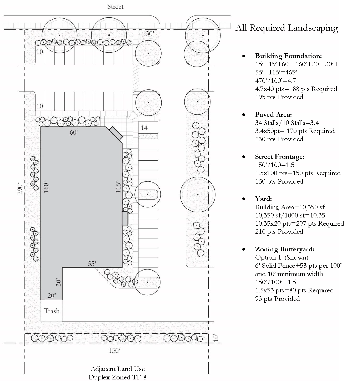
Sample landscaping schemes that may be used for building foundations, street frontages, paved areas, yards, and bufferyards are depicted in Figure 78.08.70a through Figure 78.08.70g. The property depicted in the sample landscaping schemes is shown in the NMU Zoning District.
Figure 78.08.70a. Sample Landscaping Schemes—Site Before Required Landscaping
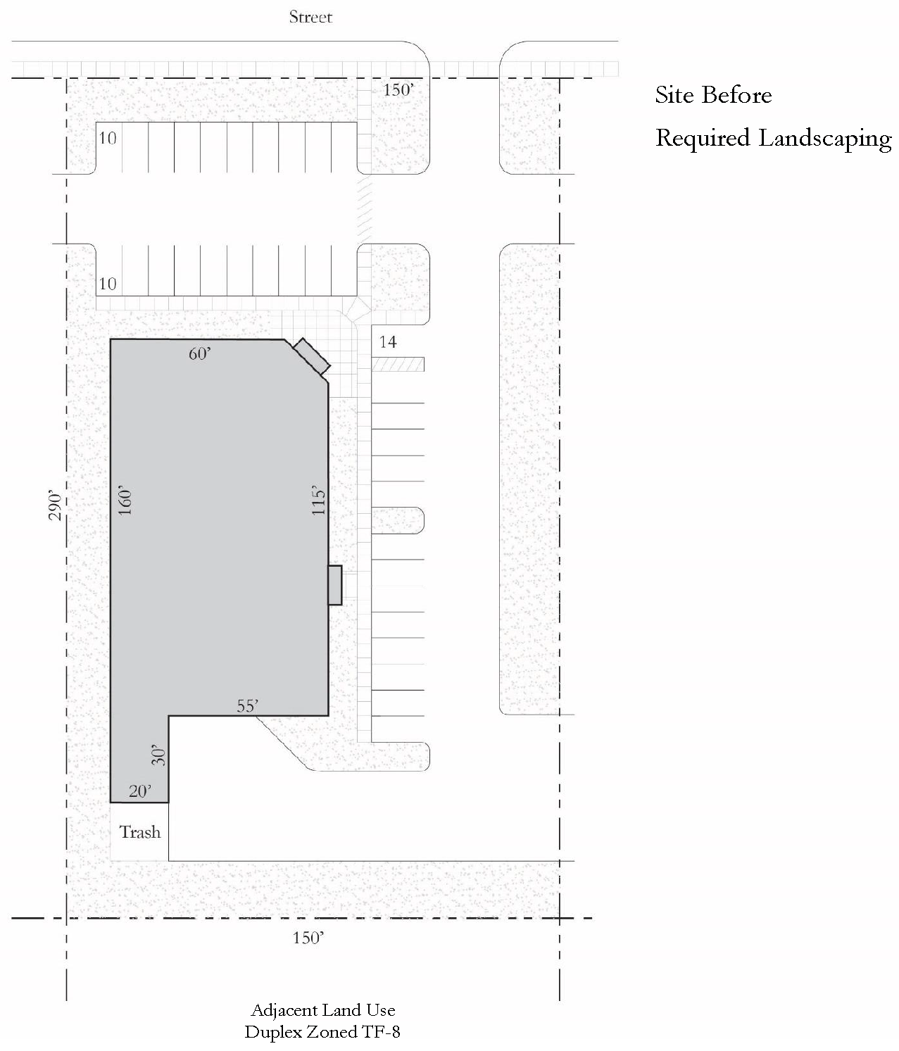
Figure 78.08.70b. Sample Landscaping Schemes—Building Foundation
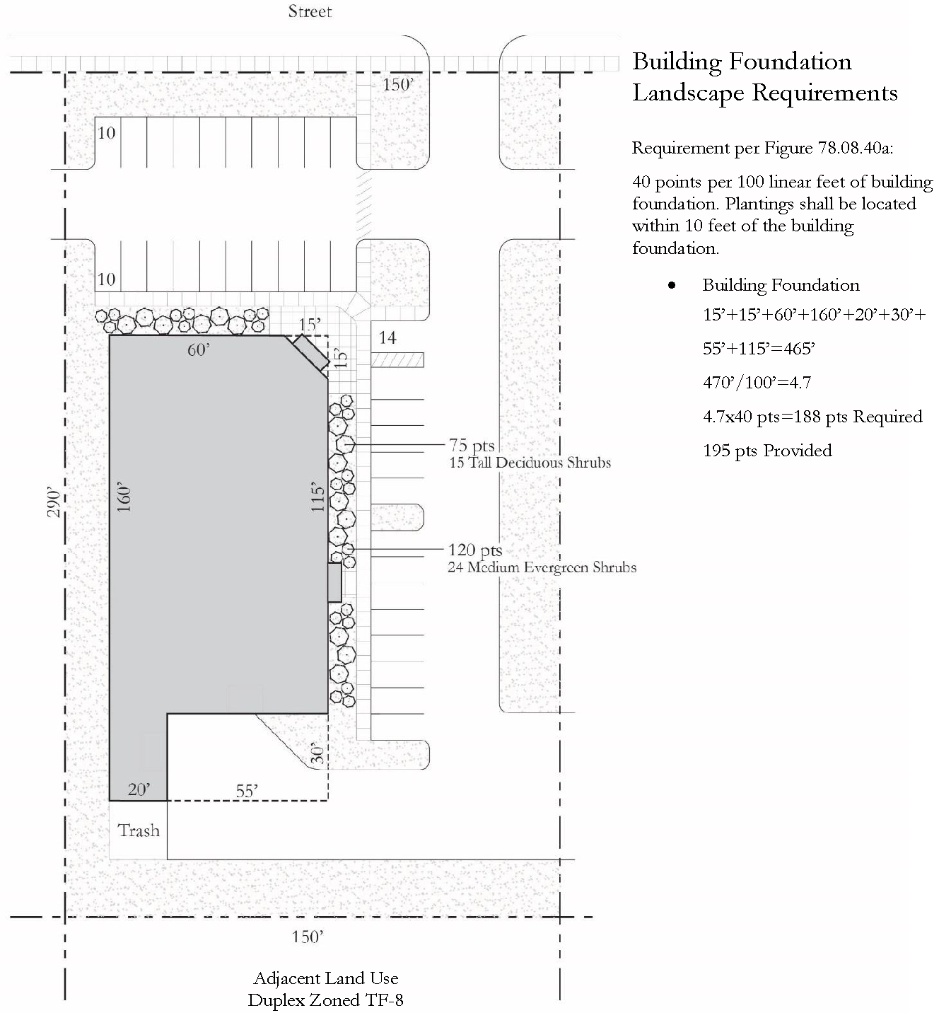
Figure 78.08.70c. Sample Landscaping Schemes—Paved Area
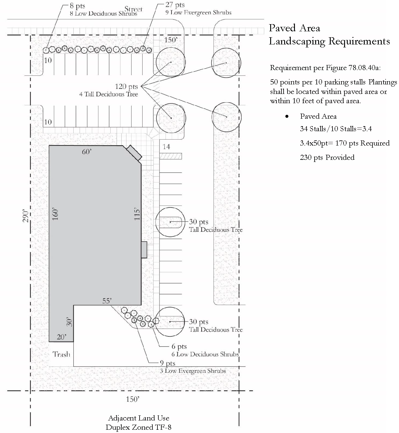
Figure 78.08.70d. Sample Landscaping Schemes—Street Frontage
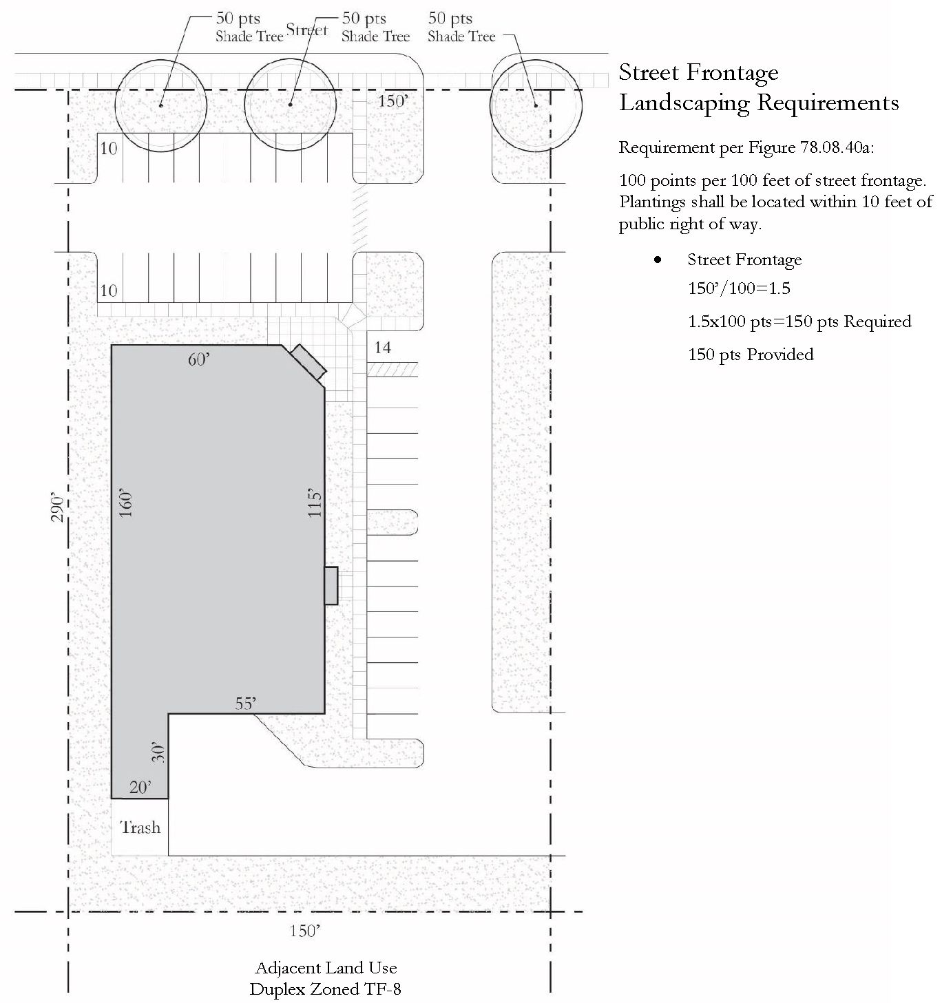
Figure 78.08.70e. Sample Landscaping Schemes—Yard
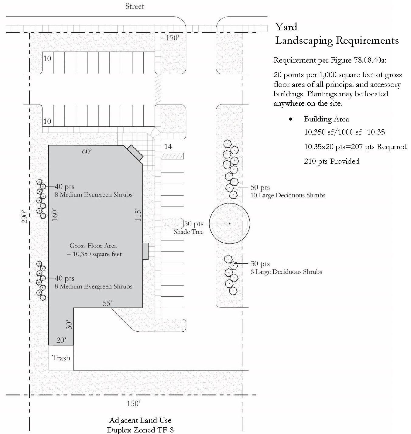
Figure 78.08.70f. Sample Landscaping Schemes—Bufferyard
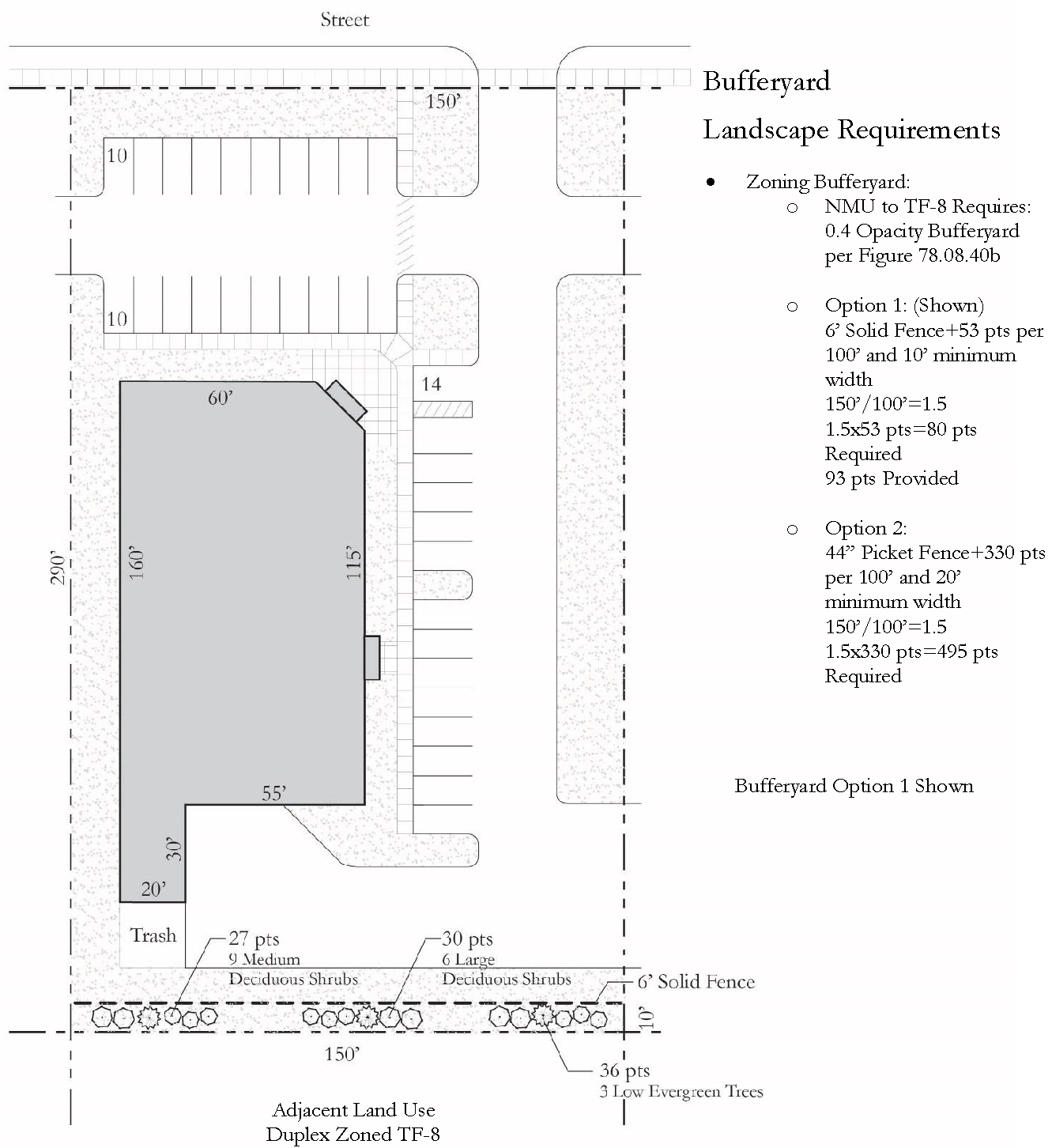
Figure 78.08.70g. Sample Landscaping Schemes—All Required Landscaping