
Moorland Township City Zoning Code
300.200
DEFINITIONS
300.200.0 - Rules of interpretation.
Sec. 2.0.
A.
The following rules of interpretation shall apply:
(1)
The particular shall control the general.
(2)
The word "person" includes an individual, a corporation, a partnership, an incorporated association, or any other legal entity.
(3)
The phrase "used for" includes arranged for, designed for, intended for, maintained for, or occupied for.
(4)
A "building" or "structure" includes any part thereof.
(5)
Unless clearly indicated to the contrary, any regulation involving two or more items connected by conjunction "and", "or", "either … or", the conjunction shall be interpreted as follows:
a.
"And" indicates that all connected items shall apply.
b.
"Or" indicates the connected items may apply singly or in any combination.
c.
"Either … or" indicates that the connected items apply singly, but not in combination.
(6)
Words used in the present tense shall include the future tense; words used in the singular shall include the plural and the plural shall include the singular, unless the text clearly indicates the contrary.
(7)
The word "shall" is always mandatory. The word "may" is permissive.
(8)
In the case of any difference of meaning between the text of this Ordinance and any illustration, the text shall control.
(9)
Terms not herein defined shall have the meaning customarily assigned to them.
(10)
Days mean calendar days.
300.201 - General definitions.
Sec. 2.1. For the purpose of this Ordinance, certain words and terms are defined as follows:
Abutting: A lot or parcel which shares a common border with another lot or parcel.
Accessory use, building or structure: A use, building or structure which is incidental to, customarily found in connection with, devoted exclusively to, subordinate to, and located on the same lot or parcel as the principal use, building or structure to which it is related.
Adjacent (lot or parcel): A lot or parcel which abuts or is directly across a public street or private easement from another lot or parcel.
Apartment: A dwelling unit within a building containing three or more dwelling units.
Arcade: Any place, premises, establishment, building or portion thereof in a retail or commercial facility in which are located for public use five or more coin operated amusement devices. This definition does not include establishments not open to the general public.
Automobile service station: Land, building and/or premises used for the purposes of retail sales of gasoline, oil, grease, and automobile accessories, the installation of such commodities, and for minor automobile repair, excluding auto body repair and finishing, storage or sale of used auto parts, or the storage of automobiles other than those in for immediate repair or service. (See Garages, Commercial)
Base flood: A flood having a one percent chance of being equalled or exceeded in any given year. This also refers to the 100-year flood.
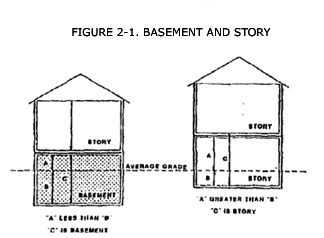
Basement (See Figure 2-1): That portion of a building which is partly or wholly below finished grade, but so located that the vertical distance from the average grade to the basement floor is greater than the vertical distance from average grade to the ceiling. A basement shall not be counted as a story.
Bed and breakfast establishment: A use within a single-family dwelling unit in which transient guests are provided a sleeping room, breakfast, and access to bathing and lavatory facilities in return for payment.
Berm: A mound of earth graded, shaped, and improved with grass, plant materials, and/or ground cover in such a fashion as to be used for visual and/or audible screening.
Boarding house: (See Bed and Breakfast Establishment).
Buffer zone: A strip of land often required between zoning districts and reserved for plant material, berms, walls or fencing to serve as a visual or sound or privacy barrier.
Building: Any structure having a roof supported by walls, columns or other supports, which is used for the purpose of housing, sheltering, or enclosing persons, animals or personal property or is used for conducting any business activities. This definition includes mobile homes, tents, sheds, garages, greenhouses, and other accessory structures.
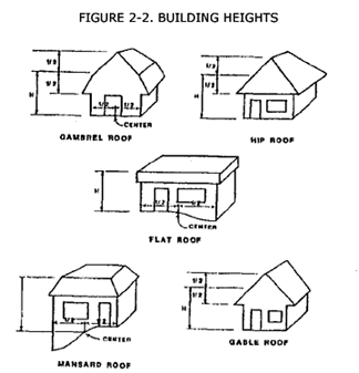
Building height: (See Figure 2-2) In the case of a principal building, the vertical distance measured from the average finished grade to the highest point of flat roofs, to the deck line of mansard roofs, and the average height between eaves and the ridge for gable, hip and gambrel roofs. For measurement of height of accessory buildings, see section 3.10(D) [300.310].
Building inspector or building official: An individual appointed by the Board of Trustees delegated to administer the Building Code Ordinance in effect in Moorland Township.
Building line: A line which defines the minimum distance (as determined by the minimum front, side, or rear yard setback) which any building shall be located from a property line or ordinary high water mark or bluffline.
Building, principal: A building in which is conducted the main or principal use on a lot or parcel.
Canopy tree: A deciduous tree whose mature height and branch structure provide foliage primarily on the upper half of the tree and which provides shade to adjacent ground areas.
Cellar: See definition of basement.
Certificate of zoning compliance: A document signed by the Zoning Administrator or seal on a final site plan, as a condition precedent to the commencement of a use or the construction of any building or structure, that such use, building or structure complies with the provisions of this Ordinance.
Child care center: A facility, other than a private residence, receiving one or more children for care for periods of less than 24 hours in any day, and where parents or guardians are not immediately available to the child. Child care center does not include a Sunday School, a vacation bible school, or a religious instruction class that is conducted by a religious organization where children are in attendance for not greater than four hours per day for an indefinite period, or not greater than eight hours per day for a period not to exceed four weeks during any 12-month period, or a facility operated by a religious organization where children are cared for not more than three hours while parents or guardians attend religious worship services.
Church or synagogue: A building, the primary use of which is regular assembly of persons for religious worship or services, together with accessory uses.
Clinic: An establishment where human patients are admitted for examination and treatment by a group of physicians, dentists, and other medical specialists and other medical professionals on an outpatient basis. A clinic may incorporate customary laboratories and pharmacies incidental or necessary to its operation.
Club: The buildings and facilities used by a non-profit organization of persons for special purposes or for the promotion of sports, arts, science, literature, politics, social activities, and other similar group activities.
Coin-operated amusement device: Any amusement machine operated by means of a coin or token or activated by any other means, for the purpose of amusement or test of skill. Coin-operated music machines shall not be considered a coin-operated amusement device.
Commercial recreation establishment: A facility designed and equipped for the conduct of sports, amusement or leisure time activities and other customary recreational activities, either within an enclosed building or outdoors and operated as a business for public use for a fee.
Common land: A parcel(s) of land with improvements, the use, maintenance and enjoyment of which are intended to be shared by owners or occupants of individual building units in a subdivision, condominium project, or a planned unit development.
Common open space: An unoccupied area within a planned unit development which is reserved for the leisure and enjoyment of all planned unit development residents and maintained in common by them or a homeowners association.
Condominium unit: That portion of a condominium project or site condominium subdivision which is designed and intended for separate ownership and use, as described in a master deed, regardless of intended use. The owner of a condominium unit also owns a share of the common elements. The terms "condominium unit" and "site condominium" shall be considered the equivalent to the term "lot" for purposes of determining compliance to minimum lot size, minimum lot width, maximum lot coverage and maximum floor area ratios. Lot requirements within this Ordinance shall apply to site condominium units as though they are designed and recorded under provisions of Public Act 288 of 1967 as amended.
Congregate housing: A dwelling unit providing shelter and services for the elderly which may include meals, housekeeping, and personal care assistance. Such facility offers a semi-independent lifestyle, but does not provide intensive health care such as dispensing of medications, nursing or medical care. (See Foster Care Facility)
Correctional facility: Any lot or parcel of land and/or building intended for use as a prison, reformatory, jail, correction, detention or housing facility for adult or juvenile persons convicted of any crime. A correctional facility shall include any facility operated by the State of Michigan and agencies thereof, other governmental unit, or a private organization. Also, any land or building intended for use as a training or detention facility in connection with farming or vocational skills training shall be included in this definition.
Cul-de-sac: A deadend public or private street which terminates in a circular section which allows for vehicle turnaround.
Commercial extraction or (mining): The extraction of sand or gravel or any other material for purposes of removal from the lot or parcel on which it is located whether for profit or not, that requires the digging or removal of the sand or gravel or other material. The extraction of the sand or gravel may or may not result in an accumulation of standing water. Extraction of sand or gravel shall be regulated by section 11.4(A) [300.1104(A)] of this Zoning Code. The extraction of top soil for removal from a lot or parcel is prohibited.
Deceleration lane: An added roadway land that permits vehicles to slow down before turning adjacent to, but not on a lane intended for through traffic.
Density: The number of dwelling units developed per net or gross acre of land.
Drive-in: A business establishment so designed that its retail or service activity is dependent on a driveway approach for motor vehicles to serve patrons while in the motor vehicle, including customer communication facilities for financial institutions and restaurants serving food and beverages from a drive through window to patrons in motor vehicles.
Driveway throat width: The driveway width, measured perpendicularly from the edge of pavement or curb face, in the narrowest section of the driveway.
Dwelling, efficiency: A dwelling unit of not more than one room in addition to kitchen and bathroom.
Dwelling unit, multiple-family: A building designed for three or more dwelling units.
Dwelling, single-family: A detached building designed for and containing one dwelling unit with exterior walls having a horizontal dimension of at least 20 feet.
Dwelling, two-family: A detached building designed for and containing two dwelling units.
Dwelling, functional family: A dwelling unit occupied by a functional family as defined in this Ordinance with exterior walls having a horizontal dimension of at least 20 feet.
Dwelling unit: A building, or enclosed portion thereof, designed for occupancy by one family for residential purpose and having living, eating, sleeping, cooking and sanitary facilities independent of any other dwelling unit. A dwelling unit shall include both factory manufactured units and site built units.
Dwelling unit, attached: A dwelling unit attached to any other dwelling unit by common structural elements.
Dwelling unit, detached: A dwelling unit which is not attached to another dwelling unit by any other means.
Easement: A grant of one or more property rights by a property owner to another person or public entity.
Essential services/public utilities: The erection, construction, alteration, or maintenance of utility systems whether underground, surface or overhead. These systems include storm and sanitary sewer, water, electric, gas, telephone, and cable television facilities and the required accessory uses and structures.
Erected: Any physical activity on land involving placement, construction, fabrication, or building of any structure or excavation in preparation for any structure above, on or below ground.
Erosion: The collapse, subsidence or removal of soil along a drain, creek, river, pond, lake or other watercourse occurring as a result of inadequate resistance to the flow of water over the soil or as a result of poor soil stabilization.
Excavation: Any activity involving removal of soil from the ground.
Family: An individual or a group of two or more persons related by blood, marriage, or adoption, including foster children and servants, together with not more than two other unrelated persons, living together as a single housekeeping unit in a dwelling unit.
Family, functional: A group of persons which does not meet the definition of "Family" herein defined, living in a dwelling unit as a single housekeeping unit and intending to live together for an indefinite period. This definition shall not include a fraternity, sorority, club, hotel, or other group of persons whose association is temporary or commercial in nature.
Feedlot: (See Livestock Operation, Intensive).
Fence: An accessory structure intended for use as a barrier to property ingress or egress, a screen for privacy from objectionable view or noise, or for decorative purpose.
Filling: The permanent depositing or dumping of any matter onto or into the ground, excluding activities relating to farming, lawn maintenance or landscaping.
Flea market: An enclosed or outdoor retail activity in which two or more persons, operating independently, sell new or used hardgoods, furniture, antiques, novelties or other merchandise.
Flood or flooding: A general and temporary condition of partial or complete inundation of normally dry land area from:
(1)
Overland flow of inland water, or
(2)
The unusual and rapid accumulation of runoff or surface water from any source.
Flood hazard area: Land which, on the basis of available floodplain information, is subject to a one percent or greater chance of flooding in any given year.
Flood insurance rate map (FIRM): A map of the Township prepared by the Federal Emergency Management Agency, which identifies 100- and 500-year floodplain and other flood-related information; and which is used as the official floodplain map for insurance purposes.
Flood insurance study: The official report provided by the Federal Emergency Management Agency containing flood profiles, as well as the Flood Hazard Boundary-Floodway Map and the water surface elevation of the base flood.
Floodproofing: Any combination of structural and non-structural additions, changes, or adjustments to structures which reduce or eliminate flood damage to real estate or improved real property, water and sanitary facilities, structures and their contents.
Floodway: The channel of a river or other watercourse and the adjacent land areas designated in the Flood Insurance Study which shall be preserved in order to discharge the base flood waters. Floodway is the same as the regulatory floodway.
Floor area, gross: The sum of all horizontal areas of all floors of a building or buildings, measured from the outside dimensions of the outside face of the outside wall. Unenclosed porches, court yards, or patios shall not be considered as part of the gross floor area except where they are used for commercial purposes such as the outdoor sale of merchandise.
Floor area ratio: The ratio of gross floor area of a building to the area of the lot or parcel on which it is located, calculated by dividing the gross floor area in square feet by the lot area in square feet and expressed as a percentage. In calculating the floor area ratio, the floor area of accessory buildings shall be included.
Foster care facility: An establishment which provides supervision, assistance, protection and personal care, in addition to room and board, to persons. A foster care facility is other than a home for the aged or a nursing home licensed under Public Act 139 of 1956, as amended, or a mental hospital licensed under Sections 51 and 52 of the Public Act 151 of 1923, as amended.
A.
Family home: A facility which provides foster care for six or fewer persons.
B.
Group home: A facility which provides foster care for seven or more persons.
Fraternity/sorority house: A dwelling unit maintained exclusively for persons who are joined together by common interests and affiliated with an institution of higher education.
Frontage road: A public or private street which parallels a public street located between the right-of-way line and the front building setback line. Frontage roads can be one-way or two-way in design. The frontage road provides specific access points to private properties while maintaining separation between the arterial roadway and adjacent land user. A road which allows parking or is used as a parking aisle within a parking lot may be considered as a frontage road.
Garage, commercial: A garage available to the public, operated for financial gain, and used for storage, repair, rental, servicing, washing, sale, or equipping automobiles and other motor vehicles.
Garage sale: A sale of primarily used goods, antiques, curios, clothing, etc., operated on residential property by the owner or occupant on an occasional basis.
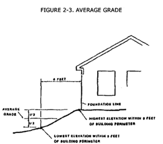
Grade, average: (See Figure 2-3) The arithmetic average of the lowest and highest grade elevations in an area five feet from the foundation of a building or structure.
Grade, finished: The lowest point of elevation between the exterior wall of the structure and the line five feet from the exterior wall of the structure.
Grade, natural: The elevation of the ground surface in its natural state, before man-made alterations.
Greenbelt: A landscaped area along a street between the curb or road shoulder and the front yard parking setback line.
Gross site area: The total area of a planned unit development site, including floodplain and waterbodies.
Group day care home: A single-family, detached dwelling in which the operator permanently resides as a member of the resident family. A group day care home involves child care for more than four weeks in any calendar year in which six but not more than 12 children are given day care and supervision for periods of less than 12 hours in a day, unattended by parent or guardian, except children related to an adult member of the family by blood, marriage or adoption.
Halfway house: Any land or building intended for and used for the occupancy and therapy of mentally disturbed or emotionally ill persons not requiring intensive care, supervision or confinement. For purposes of this Ordinance, all requirements for public and semi-public institutions shall apply.
Home occupation: An occupation conducted entirely within a dwelling and conducted by the resident family, not involving non-family employees, and which use is clearly secondary to the use of the dwelling for residential purposes.
Hospital: A facility offering primarily inpatient care and services for observation, diagnosis, and active treatment of patients with medical, surgical, obstetric, chronic, or rehabilitative condition requiring the daily care and supervision of a medical doctor and medical support staff. A hospital may also have a clinic offering outpatient services.
Hotel: A series of attached, semi-attached, or detached rental units which provide lodging on a temporary basis, and which are offered to the public for a fee. The term hotel shall include tourist cabins, motels, and motor courts.
Industry and industrial use: The production, manufacture, fabrication, assembly, or material change of raw material, semifinished goods and finished products, including customary accessory uses and facilities, excluding any farming activity.
Intensive livestock operations: Agricultural activities, facilities and lands in which livestock, fowl or other farm animals are maintained in close quarters for the purpose of raising or fattening such livestock, fowl or other farm animals for final shipment to market, where all such operations and activities are in compliance with generally accepted agricultural and management practices as promulgated by the Michigan Commission of Agriculture and applicable state law.
Junk yard: (See Salvage Yard)
Kennel, commercial: Any lot or parcel on which four or more dogs, six months or older, are kept, either permanently or temporarily, for the purpose of breeding, boarding, training, sale, or transfer.
Livestock: Animals including, but not limited to, horses, cattle, buffalo, llama, sheep, goats, swine, poultry and rabbits.
Loading space: An off-street space on the same lot or parcel with a building, or group of buildings, for the temporary parking of a vehicle while loading or unloading any merchandise, materials or passengers.
Lot: (See Figure 2-4) A parcel of land separated from other parcels of land by description on a recorded plat or by metes and bounds description, including a condominium unit in a site condominium subdivision having frontage upon a public street right-of-way or an approved private street and having sufficient area to comply with all lot requirements of this Ordinance for lot area, setbacks, lot coverage, and open space.
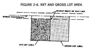
Lot area, gross: (See Figure 2-6) The area contained within the lot lines or property boundary including street right-of-way, if ownership runs to center line of right-of-way.
Lot area, net: (See Figure 2-6) The total area of land within the lot lines, exclusive of any public street right-of-way abutting any side of the lot.
Lot area, net buildable: For all uses: The net lot area less areas devoted to floodplains or waterbodies; waterbodies being defined as any area greater than one acre in size which are periodically or permanently covered with water and less the area within public road right-of-way or easements or the area of easement in which a private road is or will exist.
Lot, corner: (See Figure 2-4) Any lot having at least two contiguous sides abutting upon one or more streets, provided that the interior angle at the intersection of such two sides is less than 135 degrees.
Lot, coverage: The part or percent of a lot occupied by buildings and structures.
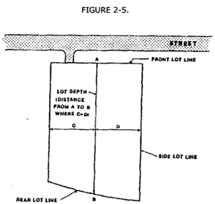
Lot, depth: (See Figure 2-5) The horizontal distance between the front and rear lot lines, measured along the mid-point between side lot lines.
Lot, flag: A land division with less frontage on a public road than required in the [this] Ordinance but with access/frontage of at least 66 feet. As of July 1999 flag lots are not permitted in Moorland Township.
Lot frontage: The length of the front lot line.
Lot, illegal: A lot created after the effective date of this Ordinance which does not meet all dimensional requirements of this Ordinance. An illegal lot may not be used for any purpose and may not be granted any variance by the Zoning Board of Appeals.
Lot, interior: (See Figure 2-4) A lot other than a corner lot which, with the exception of a "through lot", has only one lot line fronting on a public or private street.
Lot, nonconforming: A lot of record created lawfully prior to the effective date of this Ordinance which does not meet the dimensional requirements of this Ordinance. A nonconforming lot of record may be used for uses permitted by right in this Ordinance, subject to approval of site plan, special land use permit, or other permit required by this Ordinance. The Zoning Administrator shall be empowered to grant administrative variances on lawful non conforming lots of record.
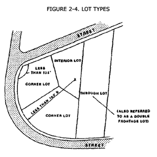
Lot, through (also called double frontage): (See Figure 2-4) An interior lot having frontage on two or more streets.
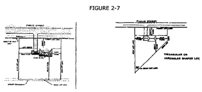
Lot line, front: (See Figure 2-7) The line(s) separating the lot from any street right-of-way, private road or other access easement.
Lot line, rear: (See Figure 2-7) The lot line opposite and most distant from the front lot line. In the case of a triangular or otherwise irregularly shaped lot or parcel, an imaginary line ten feet in length entirely within the lot or parcel, parallel to and at maximum distance from the front lot line.
Lot line, side: (See Figure 2-7) Any lot line other than the front or rear lot line.
Lot lines: (See Figure 2-7) The line bounding a lot or parcel of land.
Lot of record: A tract of land which is part of a subdivision plat or condominium subdivision, or a tract described by metes and bounds description which is the subject of a deed, recorded plat or condominium subdivision, or a land contract which is likewise recorded in the Office of the Register of Deeds of Muskegon County.
Lot width: (See Figure 2-7) The horizontal distance between side lot lines measured uninterrupted from the front lot line to the rear lot line.
Master deed: The document recorded as part of a condominium subdivision plan to which are attached as exhibits deed covenants, bylaws, easement descriptions, survey and related documents.
Master plan: A document containing future development policy, land use and related plans, together with supporting documents, as most recently adopted by the Township Planning Commission pursuant to Public Act 168 of 1959.
Manufactured housing: A dwelling unit which is designed for long-term residential occupancy and is wholly or largely fabricated at an off-site location. Manufactured housing includes mobile homes and modular homes.
Mobile home: A single-family dwelling unit of a type and quality conforming with the United States Department of Housing and Urban Development (HUD) mobile home construction and safety standards and which is transportable in one or more sections and designed to be used as a dwelling with or without a permanent foundation. Travel trailers are not mobile homes.
Mobile home park: A parcel or tract of land under the control of a person upon which three or more mobile homes are located on a continual non-recreational basis and which are offered to the public for that purpose. A recreational vehicle park or campground is not a mobile home park.
Modular home: A dwelling which consists of pre-fabricated sections transported to the site on a removable undercarriage or flat bed and assembled for permanent location on the lot or parcel.
Motel: (See Hotel)
Motor home: A self-propelled, licensed vehicle on a chassis, intended for recreation activities and temporary occupancy.
Nonconforming building or structure: A structure or building lawfully constructed that does not conform to the requirements of this Ordinance.
Nursery, plant material: Any land, space, building or structure, or combination thereof, used for the storage of live trees, shrubs or plants, but not including any land space, building or structure, or any part thereof, used for the sale of fruits, vegetables or harvested and cut Christmas trees.
Nursing or convalescent home: A structure with sleeping rooms where persons are housed or lodged and furnished meals and nursing care for hire.
Obscuring screen: A visual barrier between abutting uses or lots. The screen may consist of a wall, fence or living plant material.
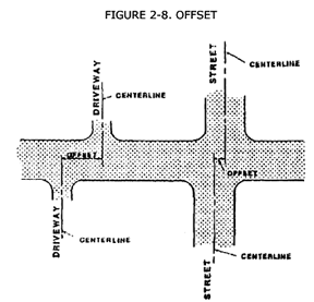
Offset: (See Figure 2-8) The distance between the centerlines of driveways or streets which are opposite from one another.
Off-street parking area: A land area upon which improved vehicular parking spaces along with adequate drives and aisles for maneuvering are placed for the parking of three or more automobiles.
100-year floodplain: Same as Flood Hazard Area.
Parcel: A lot described by metes and bounds description, whether or not included in a recorded plat or condominium subdivision.
Parking space: Any space used for off-street parking of motor vehicles.
Peak hour: The hour during the typical day in which traffic volume is the highest.
Pond: A natural or man-made waterbody, not including swimming pools, without a fencing enclosure.
Planned neighborhood shopping center: A group of commercial spaces, planned and developed as a unit, with off-street parking on the same lot or parcel. This type of facility is intended to meet convenience or day to day retail shopping and services needs of Township residents.
Planned unit development (PUD): A form of land development comprehensively planned as an entity via a unitary site plan which permits flexibility in the siting of building(s), usable open space, accessory facilities and the preservation of significant natural features present on a site. Such development may contain a mix of housing types and non-residential uses.
Planning commission: The Moorland Township Planning Commission as duly created under Public Act 168 of 1959, as amended.
Plat: A map of a subdivision of land.
Principal use: The main use to which a lot or parcel is devoted.
Private road/driveway: Any road or driveway used or intended for vehicular traffic which is privately owned. Private roads or driveways providing access to two or more lots or parcels are prohibited.
Public street: Any right-of-way by easement or ownership and operated by a unit of government. No part of any such right-of-way shall be considered when determining compliance with required setback, lot area or other dimensional requirement of this Ordinance.
Quarry: Any pit, excavation, or mining operation for the purpose of searching for, or removing for commercial purposes, any earth, sand, gravel, clay, stone, or other mineral in excess of 200 cubic yards in any calendar year, but shall not include an oil well or excavation in preparation for construction of a building, structure or roadway.
Reasonable access: A property owners legal right, incident to ownership of property abutting a public street. Reasonable access includes indirect access via frontage roads, service roads, and shared driveways where turning movements need to be restricted as to location due to heavy traffic volumes, limited site distance or other traffic conditions which could harm safe and efficient travel where access is unlimited.
Recreational vehicle park: All lands and structures which are designed and operated to accommodate recreational vehicles and provide for outdoor recreation activities.
Recreational vehicle or unit: A vehicular or portable structure designed as temporary living quarters for recreation, camping or travel, which either has its own motive of power or is mounted on or drawn by a vehicle which is self-powered. Recreational units shall include, but not be limited to, the following; travel trailers, camping trailers, tent trailers, motor homes, pickup truck campers and "fifth wheel" campers. Recreational units shall also include, but not be limited to, the following: boats, boat trailers, snowmobiles, snowmobile trailers, dune buggies, horse trailers, and similar equipment.
Recycling: Using dismantled and waste materials to make a product.
Refuse storage space: Any exterior area, which is not a principal use, for placement of containers, structures, or other receptacle intended for temporary storage of solid waste materials.
Retail store: Any building or structure designed and used for sale of goods, wares or merchandise direct to the consumer and not for resale.
Riding academy: Any establishment where horses are kept for training, riding, or stabling for compensation or which is an accessory use incidental to the operation of any club, association, ranch or similar establishment.
Right-of-way: A street, alley, or other throughway or easement permanently established for the passage of persons or vehicles.
Roadside stand: A structure which is used for a temporary period of time for the sale of produce or products produced or harvested on the same lot or parcel. The operation of a roadside stand shall not constitute a commercial district or use.
Salvage: Material to be used for further use, recycling or sale in bulk.
Salvage yard: The term salvage yard shall mean any place within the Township used for the acquisition, storage, selling or dismantling and disposing of salvage or refuse material of automobiles, trailers, vehicles, trucks, used rags, paper, metal, parts or products, machinery, appliance or any used personal tangible property. The term salvage yard includes premises described as an automobile dismantling yard or business, scrap yard, rag and metal yard, junk yard or the like. All requirements of Moorland Township Ordinance #93-5, as amended shall apply in addition to applicable requirements herein.
Sanitary landfill: A tract of land developed, designed, and operated for the disposal of solid waste in a manner consistent with the criteria established by Public Act 641 of 1978, as amended. "TYPE II" means an on-land disposal facility designed and operated to accommodate general types of solid waste including, but not limited to, garbage and rubbish, but excluding hazardous wastes. "Type III" means an on-land disposal facility designed and operated to accommodate large volumes of certain solid waste with minimal potential for ground water contamination.
Satellite dish antenna: A device incorporating a reflective surface that is solid, open mesh, or bar configuration; is in the shape of a shallow dish, parabola, cone or horn; and has a minimum diameter of three feet. Such a device may only be used to receive television, radio, or other electromagnetic communications signals, regardless of the signal source. This definition includes what are commonly referred to as "TVRO'S" (Television Reception Only Satellite Antennas).
Separation activity: Collection and/or dismantling of individual recyclable components at the point of generation or point of discard.
Service drive: A drive which generally parallels the public right-of-way but runs along the back of a land use or building which fronts the public street. A service drive may provide access to properties on both sides, and vary in width and design.
Setback: The minimum unoccupied distance between front, side, or rear lot line and the principal and accessory buildings, on any lot or parcel as required in this Ordinance.
Shipping container: A standardized, reusable container for transporting cargo that is capable of integrating with a railcar flatbed, flatbed semitrailer, or container ship for use in intermodal freight transport and also known as an intermodal container or cargo container. This definition also includes other standardized containers not used in intermodal freight transport which are designed for packing, shipping, and transportation of goods or other items.
Sight distance: The length of roadway visible to the driver of a vehicle. Generally related to the distance or time (perception/reaction time) sufficient for the driver to execute a maneuver without striking another vehicle or object in the roadway.
Sign: Any device, lettering, picture or structure designed to attract the attention of persons beyond the lot lines of the lot or parcel on which the sign is located. All signs shall be considered as accessory structures.
A.
Sign, area of: The entire area within a single continuous perimeter enclosing letters, lighting, illustrations, emblems, or similar image, together with the frame or background material, excluding structural supports to the ground, if any. This definition shall not include signs providing purely information on time and temperature. If a sign has two faces, and they are within two feet of one another, only the total display area of one face shall be counted.
B.
Sign, billboard: An off-premise sign as regulated by Public Act 106 of 1972, as amended.
C.
Sign, business: Any sign erected or placed for the purpose of advertising an operating business which is located on the lot or parcel on which such sign is located.
D.
Sign, ground: A sign which is entirely within a height of twelve feet from the average grade below the sign.
E.
Sign, height: The maximum vertical distance from average grade below the sign and the uppermost portion of the sign structure.
F.
Sign, home occupation: A sign identifying the occupation carried on and the address of a home occupation. No other information shall appear on the sign.
G.
Sign, identification: A sign giving information about a building, business, service, event, or product which is located on the same lot or parcel on which such building, business, service, event, or product is located, offered or produced.
H.
Sign, off-premises: A sign other than an on-premises sign.
I.
Sign, on-premises: A sign identifying or advertising a business, person, activity or service located on the premises where such sign is located.
J.
Sign, pole: An advertising structure which is supported by one or more uprights with all parts of the display area of the sign above eight feet in height.
K.
Sign, portable: Any sign that is not attached to a building, wall or to approved in-ground supports, or any sign mounted to a portable chassis or trailer, other than motor vehicles.
L.
Sign, projecting: A sign which is attached directly to a wall of a building and which extends more than 18 inches from the wall to which it is attached. Projecting signs are prohibited within any zoning district in the Township.
M.
Sign, roof: Any sign which extends above the highest point of a roof line, excluding the height of structural appurtenances such as chimneys, electrical or mechanical equipment and similar appurtenances. Roof signs are prohibited within any zoning district in the Township.
N.
Sign, setback: The distance as measured between the right of-way line or edge of easement and the nearest part of a sign.
O.
Sign, wall: A sign that is painted on or attached to a building wall, mansard roof, or to the underside of a roof overhang, which extends not more than 18 inches from said wall, mansard roof or roof overhang.
Site plan: A scaled drawing(s) illustrating existing conditions and containing all information required by this Ordinance concerning proposed use and development of a lot or parcel. The purpose of a site plan is to ensure compliance with all provisions of this Ordinance.
Site condominium subdivision: A division of land intended for ownership as a condominium unit under provisions of Public Act 59 of 1978, which is not subject to the provisions of Public Act 288 of 1967, the Subdivision Control Act.
Site condominium subdivision plan: The drawings attached to the Master Deed for a condominium development which describes the size, location, area, horizontal and vertical boundaries, and volume of each condominium unit contained within the condominium project, as well as the nature, location and size of common elements.
Sketch plan: A preliminary drawing indicating general development of a lot or parcel.
Special land use: A use of land or building(s) which is permitted in a particular zoning district only if applicable standards of this Ordinance and conditions required have been met. To establish any special land use, a special land use permit must be obtained in advance thereof.
Stormwater detention facility: A stormwater holding facility intended to hold and release stormwater into a drainage course over a short period of time.
Story: (See Figure 2-1) That portion of a building included between the surface of any floor and the surface of the next floor above it, or if there is no floor above it, then the space between the floor and the ceiling next above it.
Structure: Anything constructed or erected, the use of which requires more or less permanent location on the ground or attachment to something having permanent location on the ground, except utility posts, utility manholes, and sewage lift stations.
Subdivision Control Ordinance: An ordinance enacted by the Board of Trustees to regulate subdividing of land pursuant to Michigan Act 288 of 1967, as amended.
Substantial improvement: Any repair, reconstruction or improvement of a structure located within the 100-year floodplain, the cost of which equals or exceeds 50 percent of the market value of the structure either, (1) before the improvement or repair is started, or (2) if the structure has been damaged and is being restored, before the damage occurred. For the purpose of this definition, "substantial improvement" is considered to occur when the first alteration of any wall, ceiling, floor, or other structural part of the building commences, whether or not that alteration affects the external dimensions of the structure. This term does not include (1) any improvement of a structure to comply with existing state or local building, health, sanitary or safety code specifications which are necessary to assure safe occupancy of the structure or, (2) any alteration of a structure listed on the National or Michigan Register of Historic Places or in a local Historic District established under Michigan Law.
Tourist home: (See Bed and Breakfast Establishment).
Township board: The Board of Trustees of Moorland Township.
Trip generation rate: The number of trip ends associated with a development, based on building area, lot size, number of dwellings or employees and other parameters. The number can be estimated using accumulated data of comparable development given in nationally accepted sources, such as the "Trip Generation Manual" prepared by the Institute of Traffic Engineers (ITE) or the Federal Highway Administration (FHWA).
Variance: A relaxation or modification of the dimensional requirements in this Ordinance as authorized by the Moorland Township Zoning Board of Appeals.
Watercourse: An open channel or conduit, natural or man-made, which periodically or continuously contains moving water draining an area of land.
Wild animal: Any animal not domesticated by humans or any animal which a person is prohibited from possessing by law, absent a license or permit to possess. Wild animals shall include, but not be limited to, the following family groups: Alligator, deer, opossum, badger, dog (wild family), primate (excluding human), bear, wolf, wolf-dog interbred, raccoon, ferret, skunk, cat (wild family), lemur, poisonous spider, coyote, poisonous lizard, weasel, marten.
Yard: (See Figure 2-7) The open space on the same lot or parcel; with a principal building, unoccupied and unobstructed from the ground, except as otherwise provided in this Ordinance.
A.
Front yard: An open space extending the full width of the lot or parcel, the depth of which is the minimum horizontal distance between the front lot line and the nearest point of a building foundation. There shall be maintained a front yard on each street side of a corner lot.
B.
Rear yard: An open space extending the full width of the lot or parcel, the depth of which is the minimum horizontal distance between the rear lot line and the nearest point of the foundation of the principal building. In the case of corner lots, there shall be only one rear yard which shall be determined by the Zoning Administrator.
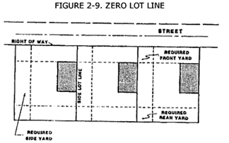
Zero lot line: (See Figure 2-9) The location of a building on a lot in such a manner that one or more of the building's sides rest directly on the lot line.
Zoning administrator: An individual or consulting firm appointed by the Township Board who shall administer the Moorland Township Zoning Ordinance.
Zoning board of appeals: The Moorland Township Zoning Board of Appeals created under the Michigan Zoning Enabling Act, Public Act 110 of 2006, as amended.
Zoning district: A portion of the Township within which certain land use regulations apply under provisions of this Ordinance.
(Ord. No. 15, 7-3-97; Ord. No. 21, 11-3-98; Ord. No. 29, 2-4-99; Ord. No. 32, 6-3-99; Ord. No. 06-21, § 9, 9-7-2006; Ord. No. 99-07, § 1, 5-3-2007; Ord. No. 12-01, § 1, 9-13-2012; Ord. No. 2025-5-8, § 1, 5-8-2025)

