
Morgantown City Zoning Code
CHAPTER THREE
SUBDIVISION REGULATIONS
ARTICLE 1311.- INTERPRETATION AND SCOPE[1]
Cross reference— Rules of construction and interpretation—see ADM. Art. 101.
State Law reference— Conflict of law—see W. Va. Code 8-24-70; extraterritorial jurisdiction—see W. Va. Code 8-24-71.
ARTICLE 1313 - DEFINITIONS[2]
Cross reference— Comprehensive plan—see P. & Z. Art. 1301; panhandle or flag lots defined—see P. & Z. 1321.06; hillside area defined—see P. & Z. 1325.01.
State Law reference— State law definitions—see W. Va. Code 8-24-3.
ARTICLE 1315 - ADMINISTRATION[3]
State Law reference— Application fees—see W. Va. Code 8-24-32; review of decisions of Commission—see W. Va. Code 8-24-38; enforcement—see W. Va. Code 8-24-66 et seq.
ARTICLE 1317 - PRELIMINARY PLAT[4]
Cross reference— Plat and plan defined—see P. & Z. 1313.01; recording of plat—see P. & Z. 1315.01; revision of plat after approval—see P. & Z. 1315.02.
State Law reference— Approval required prior to recordation—see W. Va. Code 8-24-28 et seq.
ARTICLE 1319 - FINAL PLAT[5]
Cross reference— Record in County Clerk's office—see P. & Z. 1315.01; revision of plat after approval—see P. & Z. 1315.02; sale of land prior to plat approval—see P. & Z. 1315.04; issuance of permits prior to plat approval - see P. & Z. 1315.05.
ARTICLE 1321 - DESIGN STANDARDS[6]
Cross reference— Certain trees prohibited—see S.U. & P.S. Art. 917; variances—see P. & Z. 1315.07; street design and classification standards—see S.U. & P.S. Art. 909.
ARTICLE 1323 - IMPROVEMENTS[7]
Cross reference— Street improvements—see S.U. & P.S. Art. 911; certificates, bonds required—see P. & Z. 1319.01.
State Law reference— Conditional approval of subdivision—see W. Va. Code 8-24-34.
ARTICLE 1325 - HILLSIDE AREAS[8]
Cross reference— Exception from general standards—see P. & Z. 1321.01; improvement exceptions—see P. & Z. 1323.01.
Sec. 1311.01. - Interpretation and purpose.
The procedures and standards for the development and subdivision of real estate and for the surveying and platting thereof, prescribed by this chapter are found by Council to be necessary to promote the public safety, health and general welfare, to provide for suitable residential areas with adequate streets and utilities and appropriate building sites, to save unnecessary expenditures or public funds by reserving space for public lands and buildings and by proper construction of streets and utilities and to provide proper land records for the convenience of the public and for better identification and permanent location of real estate boundaries.
(1967 Code § 30-2)
Sec. 1311.02. - Scope.
This chapter shall not apply to any lot or lots forming a part of a subdivision created and recorded prior to the effective date of these Subdivision Regulations. Nor it is intended by this chapter to repeal, abrogate, annul or in any way impair or interfere with existing provisions of other laws or regulations, except those specifically repealed by this chapter, or with private restrictions placed upon property by deed, covenant or other private agreement, or with restrictive covenants running with the land to which the County is a party. Where this chapter imposes a greater restriction upon land than is imposed or required by such existing provision of law, resolution, contract or deed, the provisions of this chapter shall control.
(1967 Code § 30-3)
Sec. 1311.03. - Areas of jurisdiction.
The following provisions, as provided in Chapter Three shall govern the subdividing of land within the area of the City under the jurisdiction of the City. The provisions of Article 1323 shall apply to improvements to be constructed in any plat within the jurisdiction of the City.
(1967 Code § 30-4)
Sec. 1311.04. - Jurisdiction.
(a)
After adoption of a Comprehensive Plan by Council and adoption and certification of an ordinance, containing these Subdivision Regulations for subdivision control and approval of plats and replats, a plat of a subdivision shall not be recorded by the County Clerk unless it has been approved by the Planning Commission.
(b)
No person shall subdivide or lay out onto lots any land within the area of the City unless it is by a plat complying with the regulations herein contained, and no plat shall be recorded and no lot or land shall be sold from any such plat until such plat has been approved as herein required.
(c)
The design and layout of all subdivisions shall conform with the requirements of Article 1321. The subdivider shall make improvements and shall submit preliminary and final plans, all in accordance with Articles 1317 and 1319 .
(1967 Code § 30-5)
Sec. 1311.05. - Public hearing.
Upon receipt of an application for the approval of a plat of a subdivision and upon tentative approval of such application, the Planning Commission shall set a date for a hearing, notify the applicant in writing and notify by general publication or otherwise any person or governmental unit having a probable interest in the proposed plat.
(1967 Code § 30-6)
Sec. 1311.06. - Construction of improvements.
These rules and regulations establish standards and specifications for the construction of streets, curbs, gutters, sidewalks, sanitary sewers, sewage disposal plants, storm sewers and other facilities to those lands within the corporate limits of the City.
(1967 Code § 30-7)
Sec. 1311.07. - Rules, regulations and forms.
The Planning Commission shall have the authority to provide reasonable rules and regulations relative to the fulfillment of the duties set forth herein and to prescribe the necessary forms to carry out the provisions of this chapter.
(1967 Code § 30-8)
Sec. 1313.01. - Definitions.
For the purposes of this chapter, the following words and phrases shall have the meaning respectively ascribed to them by this section:
Block means a piece or parcel of land entirely surrounded by public highways, public streets, railroad rights of way, parks, streams, lakes or bodies of water or a combination of aforesaid bounds.
Building line. See "setback line".
Building site means that portion of lot or parcel of land upon which the building and appurtenances are to be placed, or are already existing including adequate areas for sewage disposal, clearance, proper drainage and appropriate easements.
City means the City of Morgantown, West Virginia.
Commission means the City Planning Commission.
Comprehensive Plan means the complete plan, or any of its parts, for the development of the City, prepared by the Planning Commission and adopted by Council in accordance with the authority conferred by West Virginia Code Article 8-24.
Council means the Council of the City.
County means the County of Monongalia, West Virginia.
Crosswalk means a right-of-way which cuts across a block to facilitate access to adjacent streets and properties.
Developer means any person, partnership or corporation or duly authorized agent who constructs or contracts to construct improvement on subdivided land.
Easement means a grant by the property owner for specified use of such land to a corporation, partnership, person or persons or to be public.
Engineer means the registered engineer designated by Council.
Final plat means the final map, drawing or chart on which the subdivider's plan is presented to the Planning Commission for approval and which, if approved, will be submitted for recording in the office of the County Clerk.
Flood plain means that portion of a river or creek valley adjacent to the drainage channel which is periodically covered with water when the river or creek overflows its bank during flood stage.
Health Officer means the head of the County Health Department.
Improvement means a street improvement, with or without curb or gutter, sidewalks, crosswalks, water mains, sanitary and storm sewers, street trees and other appropriate items.
Location map means a drawing at a reduced scale which shows legibly, by dimension or other means, enough area beyond the bounds of the proposed subdivision to locate and orient the subdivision within the City and the relationship of the site to the community facilities which serve or influence the property.
Lot means a parcel or portion of land separated from other parcels or portions by description, as on a subdivision plat or record of survey map, or by metes and bounds as may be found in deeds, mortgages, leases or similar instruments for the purpose of sale, lease or separate use.
(1)
Corner lot means a lot abutting upon two or more streets at their intersection.
(2)
Interior lot means a lot other than a corner lot or a through lot.
(3)
Double or reverse frontage lot means an interior lot bounded by a street on front and back.
Master plan. See "Comprehensive Plan".
Neighborhood unit means an area of sufficient size to permit the design and development of an integrated urban unit containing in addition to a variety of residential types and groupings, its own elementary school, local business district, churches, clubs, recreation area and bounded by arterial highways, major streets or natural physical barriers.
Major Thoroughfare Plan means an officially adopted plan, being an element of the Comprehensive Plan, and designating a system of principal or major streets and highways for traffic intercommunication.
Owner means any individual, firm, association, syndicate, copartnership, corporation, trust or any other legal entity having sufficient proprietary interest in the land sought to be subdivided to commence and maintain proceedings to subdivide the same under these Subdivision Regulations.
Park and Recreation Plan means a long-range plan of parks, playgrounds or other recreation areas adopted by the Planning Commission.
Plat means the map, drawing or chart on which the developer's plan of subdivision is presented to the Planning Commission for approval and, after such approval, to the County Clerk for recording.
Preliminary plan means the preliminary plan, drawing or chart indicating the proposed layout of the subdivision.
Reserve strip means a strip of land controlling access to or egress from other property (including land dedicated to public use) or to or from any street or alley, or having the effect of restricting or damaging the adjoining property for subdivision purposes, or which will not be taxable or assessable for special improvements.
Right-of-way means the strip of land taken or dedicated for use as a public way, measured across from property line to property line. In addition to the roadway, it normally incorporates the curbs, planting strips, sidewalks, lighting and drainage facilities, and may include special features (required by the topography or treatment) as grade separation, landscaped areas, viaducts and bridges.
Roadway means the portion of the right-of-way included between the outside edges of the shoulder.
Setback line means a line indicating the minimum horizontal distance between the street easement or right-of-way line and building or any projection thereof other than steps or permanently open porches unless otherwise specifically defined.
Sidewalk means that portion of the road right-of-way, outside the roadway, which is paved for the use of pedestrian traffic. It does not include the planting strip, if any. Street, highway or road means a way for vehicular traffic, whether designated as a street, arterial highway, thoroughfare, parkway, throughway, freeway, road, boulevard, avenue, lane, place or however otherwise designated.
(1)
Controlled access highway means a divided arterial highway for through traffic with full or partial control of access.
(2)
Primary road or arterial highway means a thoroughfare primarily for through traffic, providing for major movements of traffic within and between urban centers and connecting principal traffic generators within municipalities and important rural routes.
(3)
Secondary road or highway means a highway which serves interdistrict traffic between urban and rural centers and provides traffic connections between primary roads or major arterial highways.
(4)
Major street means a local thoroughfare which carries crosstown traffic from several neighborhoods, thereby servicing several residential collector streets.
(5)
Collector street means a thoroughfare whether within a residential, industrial, commercial or other type of development, which carries traffic from minor streets to arterial highways or major streets, including the principal entrance streets of residential developments and primary circulation routes within such developments.
(6)
Minor local street or road means a local or neighborhood thoroughfare primarily providing for access to abutting properties.
(7)
Marginal access street means a minor street which is parallel and adjacent to an arterial street and provides access to abutting properties and protection from major streets, primary roads and arterial highways.
(8)
Cul-de-sac means a minor street of relatively short length with only one outlet and terminating in a vehicular turnaround.
(i)
Loop street means a U-shaped street or court.
(j)
Alley means a minor way which is used primarily for vehicular service access to the back or the side of properties otherwise abutting on a street.
Subdivider means any individual, firm, association, syndicate, copartnership, corporation, trust or any other legal entity commencing proceedings under these Subdivision Regulations to effect a subdivision or land hereunder for himself or for another.
Subdivision means all divisions of a tract or parcel of land divided into two or more lots, building sites or other divisions for the purpose, whether immediate or future, of sale, legacy or building development, and shall include all divisions of land involving the opening or construction of a new street or change in existing streets; provided, however, that the following shall not be included within this definition:
(1)
The division of land into parcels greater than five acres where no street right-of-way dedication is involved.
(2)
The public acquisition of strips of land for the widening or opening of streets.
A "resubdivision" of land, that is, a replatting or any adjustment in property lot lines, which combines lots or creates new lots by other means, shall constitute a subdivision under the meaning of this definition.
(1967 Code § 30-9)
Sec. 1315.01. - Recording of plat.
No plat of any subdivision shall be entitled to record in the office of the County Clerk or have any validity until it shall have been approved in the manner prescribed herein. In the event any such unapproved plat is recorded, it shall be considered invalid, and the Planning Commission shall institute proceedings to have the plat stricken from the records of the County.
(1967 Code § 30-52)
Sec. 1315.02. - Revision of plat after approval.
No changes, erasures, modification or revisions shall be made in any plat of a subdivision after approval has been given by the Planning Commission, and endorsed in writing on the plat, unless the plat is first resubmitted to the Commission.
(1967 Code § 30-53)
Sec. 1315.03. - Fees.
(a)
At the time of submitting a preliminary plan the subdivider shall pay a filing fee, in the amount provided on the current "Plan Review and Permitting Fee Schedule" published by the City.
(b)
The filing fee shall be paid in legal tender or by certified check or money order made payable to the City and deposited in the General Fund by the Finance Director.
(c)
In the event that a plat is disapproved before any physical inspection has been made of the site, the Planning Commission may, at its discretion, order that the developer be refunded the filing fee.
(d)
In addition to the filing fee, the subdivider shall be charged a fee by the Engineer for the cost of determinations and inspections of all improvements which fall under his jurisdiction.
(1)
The amount of deposit and method of payment shall be as required by the Engineer, who shall issue a schedule of charges for the purpose of covering the costs of determinations and inspections.
(2)
The determination and inspection shall be for all time spent by the Engineer or his duly authorized representative in checking the subdivider's improvements.
(1967 Code § 30-54; Ord. No. 18-10, 3-21-2018)
Sec. 1315.04. - Sale of land in subdivisions prior to plan or plat approval.
No owner or agent of the owner of any land located within a subdivision shall transfer, sell, agree to sell or negotiate to sell any land by reference to, exhibition of or by the use of a plan or plat of a subdivision before such plan or plat has been approved and recorded in the manner prescribed herein. Any sale or transfer contrary to the provisions of this section is void. The description of such lot or parcel by metes and bounds in the instrument of transfer or other documents used in the process of selling or transferring shall not exempt the transaction from the provisions of these Subdivision Regulations.
(1967 Code § 30-55)
Sec. 1315.05. - Issuance of permits prior to plat approval.
(a)
Building or repair permits shall not be issued for any structure on a lot in a subdivision for which a plat has not been approved and recorded in the manner prescribed herein.
(b)
No owner or agent of the owner of any land shall be entitled to a permit for the installation of wells and septic tanks upon any lots in a subdivision for which a plat has not been approved and recorded in the manner prescribed herein.
(1967 Code § 30-56)
Sec. 1315.06. - Large scale development.
The standards and requirements of these Subdivision Regulations may be modified by the Planning Commission in the case of a plan or progress for a new town, a complete community or a neighborhood unit, which in the judgment of the Commission provides adequate public space and improvements for the circulation, recreation, light, air and service needs of the tract when fully developed and populated, and which also provides such covenants or other legal provisions as will assure conformity to and achievement of the plan.
(1967 Code § 30-57)
Sec. 1315.07. - Variances and modifications.
Where the subdivider can show that a provision of these Subdivision Regulations would cause unnecessary hardship if strictly adhered to and where, in the opinion of the Planning Commission, because of topographical or other conditions peculiar to the site, a departure may be made without destroying the intent of such provision, the Commission may authorize a variance. In granting variances and modifications the Commission may require such conditions as will, in its judgment, secure substantially the objective of the standards or requirements so varied or modified. Any variance or modification thus authorized is required to be entered in writing in the minutes of the Commission and the reasoning on which the departure was justified shall be set forth.
(1967 Code § 30-58)
Sec. 1315.08. - Amendments.
All amendments to these Subdivision Regulations shall be in conformance with West Virginia Code Sections 8-24-18 through 8-24-22, as amended; except, that if Council desires an amendment it may direct the Planning Commission to prepare an amendment in accordance with West Virginia Code Section 8-24-23.
(1967 Code § 30-59)
Sec. 1315.99. - Penalty.
Any person who violates any provision of this chapter shall be fined not less than $10.00 nor more than $300.00.
(1967 Code § 30-60)
Sec. 1317.01. - Preapplication procedure; sketch plan.
Previous to the filing for tentative approval of the preliminary plat the subdivider shall submit to the Planning Commission a sketch plan.
The purpose of this stage is to discuss early and informally the purpose and effect of these Subdivision Regulations and to familiarize the developer with the Comprehensive Plan, official highway plans for the City and County, zoning and other municipal and County planning projects, drainage, sewage, water systems and similar standards, requirements and plans.
The sketch plan shall be clearly and legibly drawn by mechanical means or freehand. The map shall be drawn at a scale of one inch equals 100 feet except that a scale of one inch equals 200 feet may be used for tracts in excess of 100 acres.
(1967 Code § 30-10)
Sec. 1317.02. - Filing of preliminary plat.
Before any subdivider, or his agent, contracts for the sale of, or offers to sell, any subdivision of land or any part thereof which is under the jurisdiction of the Municipality, the subdivider or his agent shall file a preliminary plat of such subdivision with the Planning Commission.
An application, in writing, for the tentative approval of the plat, together with six copies of the plat, shall be filed with the Commission at least two weeks before the regular meeting of the Commission at which the plat is to be acted upon. The plat shall be prepared in accordance with the regulations set forth herein, and shall be submitted to the Commission prior to the completion of final surveys of roads and lots and before the start of any grading or construction work upon the proposed roads or streets and before any map of such subdivision is made in form suitable for recording. The Commission shall determine whether a tentative map is in proper form and shall not receive and consider such a map as filed until it is submitted in accordance with the requirements hereof. The staff of the Commission shall distribute a copy of the plat to the City Engineer. Where the plat covers only a part of the subdivider's entire holding, a sketch of the prospective future system of the unsubmitted part shall be considered in the light of adjustments and connections with the road system of the part not submitted.
(1967 Code § 30-11)
Sec. 1317.03. - Sewage disposal.
The subdivider in a letter accompanying the request for preliminary approval of a subdivision shall state the kind and type of sewage disposal treatment he proposes to use. If other than a sewage treatment plant, it shall be accompanied by a letter from the County Health officer stating what type of sewage disposal will be approved for the soil conditions encountered in the area of the proposed subdivision.
If a housing development or a shopping center, other commercial or industrial development is proposed to be built, a central sewage treatment plant and a central water system must be constructed by the developer when deemed necessary by the Planning Commission and County Health Officer.
(1967 Code § 30-12)
Sec. 1317.04. - Location map.
A vicinity map at a scale of not more than 800 feet to the inch shall be shown on, or accompany, the preliminary plat. This map shall show all existing subdivisions, roads and tract lines with the names of the owners of land immediately adjoining the proposed subdivision and between it and the nearest existing thoroughfares. It shall also show how roads in the proposed subdivision may connect with existing and proposed roads in neighboring subdivisions or undeveloped property to produce the most advantageous development.
(1967 Code § 30-13)
Sec. 1317.05. - Horizontal scale.
The horizontal scale of a preliminary plat shall be 50 or 100 feet to the inch on a standard sheet size of 31 by 41 inches or 16 by 21 inches.
(1967 Code § 30-14)
Sec. 1317.06. - Contents of preliminary plat.
The preliminary plat, consisting of one or more sheets, shall show:
(a)
The proposed name of the subdivision.
(b)
North point, scale and date.
(c)
The names and addresses of the subdivider and of the site planning engineer or surveyor.
(d)
The tract designation and other description according to the real estate records of the tax map office.
(e)
The boundary line (accurate in scale) of the tract to be subdivided.
(f)
Contours at intervals of five feet or less, referred to sea level datum, for subdivisions over ten acres, and for others when required by the engineer.
(g)
The location, widths and names of all existing or platted roads or other public ways within or adjacent to the tract, existing permanent buildings, railroad rights of way and other important features, such as lot lines, political subdivisions or corporation lines.
(h)
The names of adjacent subdivisions or the names of record owners or adjoining parcels of unsubdivided land.
(i)
Existing and proposed sewers, water mains, fire hydrants, culverts or other underground structures within the tract and immediately adjacent thereto with pipe sizes, grades and locations indicated.
(j)
All parcels of land intended to be dedicated for public use or reserved in the deeds for the use of all property owners in the proposed subdivision, together with the purpose of conditions or limitations of such reservation, if any.
(k)
The layout, names and widths of proposed roads and easements.
(l)
The building line proposed for each street or road.
(m)
The profile of each road with tentative grade. Sea level datum shall be used.
(n)
The cross section of proposed roads showing the width of roadways, ditches, locations and width of sidewalks and the location and size of utility mains.
(o)
A plan and profile of proposed storm water drainage, with grades and pipe sizes of sewers indicated, and drainage courses, culverts and bridges.
(p)
The layout, numbers and approximate dimensions of proposed lots.
(1967 Code § 30-15)
Sec. 1317.07. - Supplementary information.
(a)
Statement of the proposed use of lots, stating type of residential buildings with number of proposed dwelling units; type of business or industry; so as to reveal the effect of the development on traffic, fire hazards or congestion of population.
(b)
Proposed covenants and restrictions.
(c)
Evidence of an adequate source of water supply.
(d)
Statement outlining method to be used and provisions to be made for sewage disposal, drainage and flood control.
(e)
If any zoning changes are contemplated by the subdivider, the proposed zoning should be outlined and described.
(f)
After receiving notice of the approval of the preliminary plat and prior to the filing of the final plat the subdivider shall present to the Planning Commission typical sections and complete profiles of streets and other related improvements to be constructed in the proposed subdivisions prepared by a registered engineer. The Commission shall, within five working days after the filing of the above typical sections and complete profiles, transmit copies of same to the engineer for study and final recommendations. The Commission, after receiving a report from the aforementioned officials, shall notify the subdivider of any recommended changes or suggestions so that the subdivider may prepare the final improvement plans and final plat.
(1967 Code § 30-16)
Sec. 1317.08. - Approval of preliminary plat.
The following qualifications govern approval of the preliminary plat:
(a)
Following review of the preliminary plan and other material submitted for conformity to these Subdivision Regulations and negotiations with the subdivider on changes deemed advisable and the kind and extent of improvements to be made by him, the Planning Commission shall, within 40 days, give its acceptance or return the plat to the subdivider with suggestions for changes.
(b)
After the Commission has given acceptance, it shall set a date for a hearing, notify the applicant in writing, and notify by general publication or otherwise, any person or governmental unit having a probable interest in the proposed plat. The cost of publication of the notice of hearing shall be met by the applicant.
(c)
Following the hearing on the plat, the Commission shall notify the applicant in writing that it has conditionally approved the plat, or will advise the applicant of any further changes in the plat which are desired or should have consideration before approval will be given. If the plat is disapproved, the Commission shall give its reasons therefor.
(d)
The action of the Commission shall be noted on the copies of the plat, referenced and attached to any conditions determined. one copy shall be returned to the subdivider and one copy retained by the Commission.
(e)
Conditional approval of a preliminary plat shall not constitute approval of the final plat. Rather it shall be deemed on expression of approval of the layout submitted on the preliminary plat as a guide to the preparation of the final plat, which will be submitted for approval of the Commission and for recording upon fulfillment of the requirements of these regulations and the conditions of the conditional approval.
(f)
Approval of the engineering details of the proposed roads, sewer and water systems and other proposed public facilities by the Engineer and County Health officer will be required prior to the approval of the final plat by the Commission.
(g)
No streets shall be opened, graded, improved or constructed; no water or sewer line shall be constructed; nor shall permits be issued for any proposed structure upon any land in a subdivision until conditional approval of the subdivision has been granted by the Commission in accordance with the provisions of these regulations.
(h)
Conditional approval shall be effective for a maximum period of 12 months unless, upon application of the developer the Commission grants an extension. If the final plat has not been recorded within this time limit, the preliminary plat must again be submitted to the Commission for approval.
(1967 Code § 30-17)
Sec. 1319.01. - Procedure for approval of final plat.
(a)
After approval of the preliminary plans by the Planning Commission and the fulfillment of the requirements of these Subdivision Regulations and any other requirements specified by the Commission the final plat can then be submitted to the Commission for approval. The final subdivision plan shall be clearly and legibly drawn in ink on tracing cloth of good quality or on mylar, 0.003 inch thick. The scale shall be 50 or 100 feet to the inch, on one or more standard-size sheets of 31 by 41 inches or 16 by 21 inches. Marginal lines shall be drawn around the entire sheet, leaving a margin of one inch from the edge of the sheet. If more than one sheet is needed, each sheet shall be numbered, the relation of one sheet to another clearly shown, and the number of sheets used shall be set forth in the title of the plat.
(b)
A vicinity sketch of key map at a scale of 800 feet to the inch shall be shown on or accompany the preliminary plat. This map shall show the position of the subdivision with relation to the surrounding streets, properties and subdivisions.
(c)
Application for approval of the final plat shall be submitted in writing to the Commission at least 15 days prior to the meeting at which it is to be considered.
(d)
The original and four copies of the final plat and other exhibits required for approval shall be prepared as specified in this section and Section 1319.02 and shall be submitted to the Commission within 12 months after conditional approval of the preliminary plat; otherwise, such approval shall become null and void. An extension of time may be granted by the Commission.
(e)
When the final plat is submitted to the Commission, it shall be accompanied by a notice from the City Manager stating that there has been filed and approved by him, one of the following:
(1)
A certificate that all improvements and installations for the subdivision required for its approval have been made or installed in accordance with specifications; or
(2)
A bond which shall:
a.
Run to Council.
b.
Be in an amount determined by the Commission to be sufficient to complete the improvements and installations in compliance with these regulations.
c.
Be with surety satisfactory to the Commission.
d.
Specify the time for the completion of the improvements installations.
If a bond is filed, its amount may be reduced in stages subject to the certification of completed improvements.
(f)
Upon the completion of the improvements and installations required of a subdivider for the approval of a final plat, and prior to the acceptance thereof for public maintenance by Council or, if applicable, to any other governmental unit, the subdivider shall provide a three year maintenance bond which shall:
(1)
Run to Council and, if applicable, to any other governmental unit having a legal responsibility for the maintenance of the improvements and installations.
(2)
Be in an amount equal to 20 percent of the cost of such improvements and installations as estimated by the Commission.
(3)
Provide surety satisfactory to the Commission.
(4)
Warrant the workmanship and all materials used in the construction, installation and completion of such improvements and installations to be of good quality and have been constructed and completed in a workmanlike manner in accordance with the standards, specifications and requirements of these Regulations and the satisfactory plans and specifications therefor.
(5)
Provide that for a period of three years after such installations and improvements have been completed or are accepted for public maintenance by any appropriate governmental unit or agency thereof, the subdivider will at his own expense make all repairs to such improvements and installations, or the foundations thereof, which may become necessary by reason of improper workmanship or materials with such maintenance, however, not to include any damage to such improvements and installations resulting from forces or circumstances beyond the control of such subdivider or occasioned by the inadequacy of the standards, specifications or requirements of these regulations.
(g)
Within a reasonable time after application for approval of the final plat, the Commission shall approve or disapprove it. If the Commission approves, it shall affix the Commission's seal upon the plat, together with the certifying signature of its president and secretary. If it disapproves, it shall set forth the reasons for such disapproval in its own records and provide the applicant with a copy.
(1967 Code § 30-18)
Sec. 1319.02. - Final plat requirements.
The final plat shall be drawn in ink on linen or permanently reproducible material. The scale shall be 50 or 100 feet to the inch, on one or more standard size sheets of 31 by 41 inches or 16 by 21 inches. The following information shall be shown:
(a)
Name of the subdivision; location by appropriate legal description, date, north point, graphic and numerical scale and total acreage.
(b)
All plat boundaries with length of courses in feet and hundredths, bearing to not more than half minutes.
(c)
Bearings and distances to the nearest established street lines or other recognized permanent monuments, which shall be accurately described on the plat.
(d)
Lines of adjoining streets and alleys with their widths and names plus building setback lines.
(e)
The radii, arcs, chords and chord bearings, points of tangency and central angles for all curvilinear streets and radii for rounded corners.
(f)
All easements and rights of way provided for public services or utilities, and any limitations of such rights of way or easement.
(g)
All lot numbers and lines, with accurate dimensions in feet and hundredths, and with bearings. The basis of bearings shall be stated on plat. The acreage of each lot shall be indicated.
(h)
Accurate location and description of all monuments.
(i)
Names and addresses of the subdivider and the qualified surveyor who prepared the plan.
(j)
Accurate outlines of any areas to be dedicated or temporarily reserved for public use with the purpose indicated thereon.
(k)
Vicinity map of area within one-half mile radius.
(l)
Restrictions of all types which will run with the land and become covenants in deeds for lots.
(m)
The following certifications, copies of which are included in the appendix to these Regulations, must be labeled and completed on the final plat:
(1)
Engineer's certificate.
(2)
Commission certificate.
(3)
Deeds of dedication.
(1967 Code § 30-19)
Sec. 1319.03. - Other exhibits required.
The other exhibits which may be on one or more sheets shall show the following:
(a)
If a zoning change is involved, certification from the City Clerk shall be required indicating that the change has been approved and is in effect.
(b)
The final locations as constructed of all storm sewer and sanitary sewer lines, including service lines to each property line. All locations shall be referenced to the property line.
(c)
Dimensions and location of all paving, curbs and public sidewalks.
(d)
Final grades and profiles of all streets and sewers, when required.
(e)
Draft of protective covenants whereby the subdivider proposes to regulate land use in the subdivision and otherwise protect the proposed subdivision.
(f)
Certificate of a registered professional civil engineer that all improvements have been constructed in accordance with the standard specifications of the City.
(1967 Code § 30-20)
Sec. 1319.04. - Recording of final plat.
After approval of final plat by the Planning Commission such plat shall be recorded in the office of the County Clerk within 30 days after such approval. An extension of time may be granted by the Commission in unusual circumstances.
(1967 Code § 30-21)
Sec. 1319.05. - Offer of dedication.
Recording of the final plat shall have the effect of an irrevocable offer to dedicate all streets and other public ways shown thereon to public use, unless a notation is placed on the final plat by the subdivider stating that there is no offer of dedication and to dedicate or reserve as specified on the plat land for parks, schools or other public purpose; recording of the plat, however, shall not impose any duty on the Municipality concerning improvement or maintenance of any such dedicated streets or lands, until the proper authorities of the City have made actual appropriation of same through legal action.
(1967 Code § 30-22)
Sec. 1321.01. - General provisions.
The arrangement, character, extent, width and location of major, secondary and minor streets and highways shall conform with the Major Thoroughfare Plan for the City which is on file in the office of the City Manager and with the provisions of these Subdivision Regulations. Streets not contained in the Major Thoroughfare Plan should conform to the recommendation of the Planning Commission based on existing and planned streets, topography, public safety and convenience and proposed uses of land.
Planned unit type development is encouraged by the Commission. Where large subdivisions designed on the basis of neighborhood units are being reviewed, consideration will be given to the placement of commercial areas and public areas, in relation both to the neighborhood unit being developed and to other units that might be developed. Where small subdivisions are being reviewed, the Commission shall coordinate such subdivisions, to the extent practicable, into units so that the same relationship with respect to commercial areas and public areas may be realized. These design standards shall be required in all areas except where special provisions are made for planned unit developments and for hillside area in excess of 16 percent of slope. Exceptions to the provisions in this article which are made for hillside development are specified in Article 1325 and for planned unit developments in Article 1327.
(1967 Code § 30-23)
Sec. 1321.02. - Streets.
(a)
Design and arrangement.
(1)
The arrangement of streets in new subdivisions shall make provision for the continuation of the principal existing streets in adjoining areas (or their proper projection where adjoining land is not subdivided) insofar as they may be deemed necessary for public requirements. Every subdivision shall have access to a public right-of-way.
(2)
The street and alley arrangement shall be such as not to cause hardship to owners of adjoining property when they plat their own land and seek to provide for convenient access to it. Residential streets shall be so designed as to discourage through traffic, but offset streets with an offset of less than 150 feet should be avoided.
(3)
The angle of intersection between minor streets and major streets should not vary by more than ten degrees from a right angle. All other streets should intersect each other as near to a right angle as possible.
(4)
The minimum curb radius shall be 20 feet to face of curb. Without curb the minimum pavement radius shall be 30 feet to edge of pavements. Curb and gutter shall be required for all areas of 15 percent or greater slope.
(5)
Residential streets shall be designed to discourage through traffic which may otherwise use secondary or major highways, and whose origin and destination are not within the subdivision. Residential streets extending for considerable distance, parallel to any secondary or major street, should be avoided.
(6)
Street jogs with center line offsets of less than 150 feet shall be avoided.
(b)
Alignment.
(1)
Vertical. For main thoroughfares, profile grades shall be connected by vertical curves of a minimum length equivalent to 20 times the algebraic difference between the rates of grade, expressed in feet per 100; for secondary and minor streets and alleys, 15 times.
(2)
Minimum horizontal. The radii of centerline curvature:
A minimum 50-foot tangent shall be introduced between reverse curves on secondary and minor streets and 100 feet on primary thoroughfares.
(3)
Visibility requirements.
a.
Minimum vertical visibility (measured four and one-half feet eye level to tail light 18 inches above ground level):
Five hundred feet on primary thoroughfares;
Three hundred feet on secondary thoroughfares;
Two hundred feet on minor streets;
One hundred feet on streets shorter than 500 feet;
b.
Minimum horizontal visibility shall be:
Five hundred feet on main thoroughfares measured on centerline;
Three hundred feet on secondary thoroughfare measured on centerline;
Two hundred feet on all other streets measured on centerline.
c.
A clear sight triangle shall be provided at all street intersections. Within such triangle no vision obstruction objects shall be permitted which exceed a height of 30 inches above the elevation of the abutting streets. Such sight triangles shall be established from a distance of:
1.
One hundred feet from point of intersection of the street center lines for major streets; and
2.
Seventy-five feet from point of intersection of the street center lines for primary streets; and
3.
Fifty feet from point of intersection of the street center lines for all other streets.
(c)
Street type and width.
(1)
Width of major thoroughfares. The width of all major thoroughfares shall conform to the width designated on the Major Thoroughfare Plan of the City.
(2)
Minimum right-of-way. The minimum right-of-way widths of all collector streets shall be 60 feet.
(3)
Width of local streets. The minimum width of local streets serving single-family dwellings, townhouses and semi-detached houses shall be 50 feet and the pavement width shall be 28 feet, except where there are unusual topographical or other physical conditions, the Planning Commission may permit a lesser width for a local street. The minimum width of local streets serving apartment dwellings shall be 60 feet and the pavement width shall be 36 feet.
(4)
Location. When a proposed subdivision is adjacent to or contains a State highway, the Commission will seek information from the Commissioner of Highways as to the status of the highway in reference to width and direction, and also to access of such highway.
(5)
Half streets. Dedication of new half streets shall not be permitted. Where a dedicated or platted half street or alley exists adjacent to the tract being subdivided, the other half shall be platted, if deemed necessary by the Planning Commission.
(6)
Cul-de-sacs. Each cul-de-sac shall be provided with a turnaround having a minimum right-of-way radius of 50 feet. The outside of the road surface within the turnaround right-of-way shall have a minimum radius of 38 feet. The maximum length for a cul-de-sac shall be 600 feet except where topographical conditions require a longer length which shall be subject to the approval of the Commission.
(7)
Dead-end streets. Dead-end streets, designated to be so permanently, shall not be permitted. Any dead-end street of a temporary nature, if longer than 200 feet or fronted by existing lots, shall have a surfaced turning area equal in diameter to the right-of-way width of such street at its termination.
(8)
Marginal access streets.
a.
Where a subdivision adjoins a major street, and the greater dimension of the block fronts along such major street or highway, a marginal access street shall be designed to provide access to subdivided parcels. Points of access to the major street or highway shall be kept to a minimum interval of 300 feet.
b.
A planting strip of minimum width of 20 feet shall be provided between the pavement of the major street or highway and the pavement of the marginal access street.
c.
The minimum width of the marginal access street shall be 30 feet.
(9)
Street grades. Street grade shall not exceed the following with due allowances for reasonable vertical curves:
(10)
Street and subdivision names. The proposed name of the subdivision and proposed street names shall not duplicate or too closely approximate, phonetically, the name of any other subdivision or street in the area covered by these Subdivision Regulations. Proposed streets which are obviously in alignment with existing streets or are extensions of existing streets shall bear the name of the existing street. All street names shall be subject to approval by the Municipality or Commission.
(1967 Code § 30-24)
Sec. 1321.03. - Alleys.
Alleys should be avoided in single or two-family districts. They may, however, be required in multiple dwelling developments where they should have a minimum width of 20 feet. Alleys are required in the rear of all commercial and industrial lots, if no other provisions are made for adequate service access or for parking. The rights of way of such alleys shall not be less than 45 feet and dead-end alleys shall not be permitted.
(1967 Code § 30-25)
Sec. 1321.04. - Building lines and easements.
(a)
Building lines. Building lines shall be established according to the provisions of the Zoning Ordinance of the City.
(b)
Easements. Easements of at least five feet in width shall be provided on each side of all rear lot lines and along side lot lines, where necessary, for poles, wires, conduits and gas mains. Easements may also be required along or across lots where engineering design or special conditions may necessitate the installation of water and sewer lines outside public rights-of-way. A two-foot easement shall be required on one side of an alley to accommodate pole lines.
(1967 Code § 30-26)
Sec. 1321.05. - Blocks.
(a)
No block shall be longer than 1,320 feet nor less than 500 feet, except in unusual circumstances. Where a subdivision adjoins a major highway, the greater dimension of the block shall front along such major highway to minimize the number of points of ingress or egress.
(b)
Where blocks are over 750 feet in length a crosswalk easement not less than ten feet in width on or near the halfway point may be required, if necessary to provide proper access to schools, playgrounds, shopping centers and other facilities.
(1967 Code § 30-27)
Sec. 1321.06. - Lots.
(a)
The lot arrangement and design shall be such that all sublots will provide satisfactory and desirable building sites, properly related to topography and the character of surrounding development.
(b)
All side lines of lots shall be at right angles to street lines and radial to curved street lines except where a variation to this rule will provide a better street and lot layout. Lots with double frontage except when paralleling major highways will be avoided.
(c)
No lot shall have less area or width at the building line than is required by the zoning regulations applying to the area in which it is located.
(d)
"Panhandle lots" or "flag lots" may be permitted where topographic conditions or property configurations indicate such lots to be necessary and desirable provided that the main portion of the lot conforms to the requirements of the Zoning Ordinance.
(e)
In case of unusual soil conditions or other physical factors which may impair the health and safety of the neighborhood in which a subdivision may be located, upon recommendation of the County Health Officer or Engineer, the Planning Commission may require larger lot widths and lot areas as deemed necessary.
(f)
No corner lot shall have a width at the building line of less than 75 feet. Either of the two sides of a corner lot fronting on a street may be designated the front of a lot, provided the rear yard shall always be opposite the frontage so designated. Dwellings may be placed diagonally on a corner lot in which case the frontage shall be on both streets.
(g)
The corners of lots at street intersections, shall have a curve with a minimum radius of 20 feet joining the two sidelines of such rights-of-way.
(1967 Code § 30-28)
Sec. 1321.07. - Public lands.
(a)
Consideration shall be given to the allocation of areas suitably located and of adequate size for playgrounds, school sites, parks and other outdoor recreational facilities as indicated on the Comprehensive Plan and to be made available by one of the following methods:
(1)
Dedication to public uses.
(2)
Reservation of land for the use of property owners by deeds or covenants.
(3)
Reservation for acquisition by a public agency within a period of three years. Such reservation shall be made in such a manner as to provide for a release of the land to the subdivider in the event no public agency proceeds with the purchase.
(b)
Due regard shall be shown for preserving outstanding cultural, historic or natural features such as scenic spots, watercourses or exceptionally fine groves of trees. Dedication to and acceptance by a public agency is the preferred means of assuring their preservation.
(c)
Whenever any stream or important surface drainage course is located within the area being subdivided the subdivider shall provide a permanent easement dedicated to the proper authority for the purpose of widening, deepening, relocating, improving or protecting the stream for drainage or public use.
(d)
As a safety measure for the protection of the health and welfare of the people of this City, the Planning Commission shall reserve the right to disapprove any subdivision which is subject to flooding, during normal annual peak stream flows, contains extremely poor drainage facilities or has other physical impairment. However, if the subdivider agrees to make such improvements as will make the area completely safe for residential occupancy, provided that in lieu of the improvements the subdivider shall furnish a surety bond or a certified check covering the cost of the required improvements, the subdivision may be approved, subject, however, to the approval of the County Health Officer and the Engineer.
(1967 Code § 30-29)
Sec. 1321.08. - Trees.
Street trees when planted shall be located outside of the street right-of-way or any sewer or water easements that may be adjacent to the street right-of-way and planted in such manner as not to impair visibility at any corner or corners. All subdividers or developers should retain existing trees which are in satisfactory condition and plant trees in each lot. The Planning Commission will cooperate in giving advice on species of trees which are acceptable for planting (See Table 1367.11.01 "Approved Street Tree and Shrub List").
(Ord. No. 09-27, 7-7-2009)
Sec. 1323.01. - Requirements generally.
These minimum required improvements shall be required in all areas except where special provisions are made for hillside areas in excess of 16 percent of slope. Any exceptions to the provisions in this section which are made for hillside development are specified in Article 1325.
Prior to the granting of final approval the subdivider shall have installed or shall have furnished a performance bond for the amount of the estimated construction cost of the ultimate installation of improvements listed and described herein. The performance bond or cash deposit submitted to the office of the City Manager will assure the City that the subdivider, his heirs, successors and assigns, their agent or servants will comply with all applicable terms, conditions, provisions and requirements of these Subdivision Regulations; and will faithfully perform and complete the work of constructing and installing such facilities or improvements in accordance with such laws and regulations. Before such bond is accepted it shall be approved by the proper administrative officials.
The subdivider or developer shall submit a set of construction plans for the improvement of the road, street or alley, prepared by a registered professional engineer. The construction plans shall include title of plan, typical sections, plan and profile view, miscellaneous engineering details and estimate of quantities. Cross sections will be submitted upon request by the Engineer. All typical sections and major engineering details to be used on any particular road, street or alley shall be approved in advance by the Engineer or his representative before completion of the plans. When the subdivider or developer submits for approval a construction plan for street improvements for a part of a proposed subdivision area, preliminary street grades and proposed drainage facilities for the entire subdivision area shall also be presented.
When deemed desirable the Engineer or his representative may require the construction or vacation of part or all of any intersecting roads, streets or alleys in order to assure that no hardship or added expense be endured by abutting property owners or the County at some future date.
All of the required improvements shall be made in full compliance with the specifications for each of the various units of work as required by the Engineer or the County Health Officer, according to the nature of the improvements. Upon final approval of the construction plans, two sets of the prints will be required for the use of the Engineer.
(1967 Code § 30-31)
Sec. 1323.02. - Monuments.
Permanent markers shall be placed at all corners where permanent corners do not exist, if practical, otherwise as directed by the Engineer. These shall be permanent markers made of concrete at least two feet long and six inches square or six inches in diameter, with appropriate markings on top. The location and description of each of these markers shall be shown on the subdivision plat.
(1967 Code § 30-32)
Sec. 1323.03. - Utility and street improvements.
(a)
Water supply.
(1)
Public water supply. The subdivider shall provide the subdivision with a complete water main supply system, which shall be connected to a municipal or community water supply approved by the City Water Commission, except that when such municipal or community water supply is not available, the subdivider shall provide an individual water supply on each lot in the subdivision in accordance with minimum requirements of the County Health Department.
(2)
Plans for water supply systems. The plans for the installation of a water main supply system shall be provided by the subdivider and approved by the City Water Commission and the County Health Department. The water main supply system shall not be installed until the plans for the system have been approved, in writing, by the City Water Commission. Upon the completion of the water supply installation, the plans for such system as built shall be filed with the Planning Commission.
(3)
Private water supply.
a.
Test wells. Where public water supply is not available at least one test well shall be made in the area being platted for each 100 lots or each 25 acres of area, whichever is the smaller. In cases where copies of the logs of existing wells located within the area being platted are available, this may be submitted in lieu of making test wells. Test wells shall be at least 25 feet in depth and shall produce safe potable drinking water at a rate of not less than five gallons per minute per family.
A copy of the well log, which shall include the name and address of the well driller, shall be submitted with the plat to the Commission.
b.
Location and construction of individual private wells. Individual private wells shall be located at least 25 feet from property lines; 75 feet from all septic tanks; approximately 100 feet from all tile disposal fields and other sewage disposal facilities; ten feet from all cast iron sewer lines; 30 feet from any vitrified sewer tile lines; and shall not be located within any flood plain.
As a precaution against seepage, a water-tight seal shall be provided around the pump mounting. All abandoned wells shall be sealed in a manner that will render them water-tight.
In all cases where it has been determined that individual water supplies from private wells are not feasible, a public water distribution system will be required.
(b)
Sanitary sewage disposal.
(1)
Types of installation. The subdivider shall provide the highest type of sanitary sewage disposal facility consistent with the existing soil, physical and other geological conditions. The following types of sanitary sewage disposal facilities are listed in order of desirability:
a.
Public sanitary sewer and treatment plant system;
b.
Community sanitary sewer system with a temporary sewage treatment plant;
c.
Capped sewers with temporary, approved on-site facilities; and
d.
Septic tank with tile field.
(2)
Sanitary sewers. If a subdivision can be reasonably served by the extension of an existing public sanitary sewer, as determined by the Commission, the subdivider or developer shall provide a system of sanitary sewer mains and shall provide lateral connections for each lot. Whenever main lines are installed, sewer and water shall be extended to property lines. Connections to public sanitary sewer lines shall be subject to the approval of and according to the specifications of the Engineer.
(3)
On-site sewage disposal facilities. All lots which cannot be connected with a public or community sanitary sewage disposal system at the time of construction of a principal building shall be provided with an on-site sanitary sewage disposal system consisting of septic tanks connected with a tile disposal field, and which shall, as a minimum requirement, meet the design standards of the State Department of Health. If on-site sanitary sewage disposal facilities are to be utilized, the Commission may require that the subdivider submit a report relative to economic feasibility of off-site sewage disposal if the Commission considers that the proposed on-site facilities are not the highest type consistent with existing soil, physical and geological conditions. Such report shall compare the cost of providing such facilities and the cost of providing such higher type of facility as the Commission shall specify. Where on-site sanitary sewage disposal facilities are to be utilized, each lot so served shall be of a size and shape to accommodate the necessary length of tile field at a safe distance from, and at a lower elevation than, the proposed buildings.
Whenever a subdivider proposes that individual on-site sanitary sewage disposal systems shall be utilized within the subdivisions, the subdivider shall either install such facilities or shall require (by deed restriction or otherwise), as a condition of the sale of each lot or parcel within the subdivision that such facilities shall be installed by the purchaser of such lot or parcel at the time that a principal building is constructed, and in accordance with these Subdivision Regulations.
Where studies by the Commission or the County indicates construction or extension of sanitary trunk sewers to serve property being subdivided appears probable within a reasonably short time (up to five years), the Commission may require the installation and capping of sanitary sewer mains and house connections, in addition to the installation of temporary, individual, on-site sanitary sewage disposal systems. Capped sewers however, will not be required if completed plans and profile of trunk sewers are not available. It shall be the responsibility of the County or other such appropriate agency to supervise design and installation of such capped sewers, and the acceptance of such responsibility shall be prerequisite to the Commission's requirement of such installation.
The Health Officer shall certify the adequacy of the community or on-site sanitary sewage disposal system proposed. Such certification shall accompany all final plat applications.
(4)
Soil percolation test requirements. Soil percolation tests shall be performed for all subdivisions wherein buildings at the site of construction will not be connected to a public or community sanitary sewage disposal system.
Soil percolation tests shall be made, in accordance with the procedure requirement by the State Department of Health by a registered professional engineer, at the rate of one test site for each acre of the property being subdivided.
If the analysis of the soil percolation test results reveals the soil is unsuitable for the intended use at the first site proposed, the Commission may require that the lot sizes be increased in accordance with the test results or that additional tests be made on each proposed lot at the location of the contemplated disposal facilities, and the data submitted for approval.
(c)
Drainage. All necessary facilities, including underground pipe lets, catch basins or open drainage ditches shall be installed to provide for the adequate disposal of subsurface and surface water maintenance of natural drainage courses. All storm drainage facilities within the subdivision shall connect to an adequate drainage outlet. A drainage plan shall be submitted simultaneously with the plat of any subdivision, showing the proposed scheme of surface drainage.
(1)
Standards and specifications for drainage facilities. The construction of storm water drainage improvements shall be subject to the approval of the engineer.
(2)
Storm sewers and storm water. A drainage system adequate to serve the needs of the proposed new streets and the entire subdivision will be required in the new subdivisions. Where an adequate public storm sewer main is available at the plat boundary, the subdivider shall construct a storm sewer system and connect with such storm sewer main. If such storm sewer systems are not accessible, adequate storm water drainage shall be provided by natural drainage channels with easements of adequate width as approved by the engineer.
(3)
Culverts and bridges. When natural drainage channels intersect any street right-of-way it shall be the responsibility of the subdivider to have satisfactory bridges and culverts designed and constructed. Culverts shall be constructed in accordance with the standards established by the engineer.
(4)
Protection of cuts and fills. Wherever cuts and fills are to be made in a subdivision, the subdivider shall provide for the interception and diversion of surface waters away from the tops of the cuts and fills and into approved drainage ways.
(5)
Terraces. Terraces shall not be permitted in subdivisions when geological evidence shows the possibility of pressure heads developing in shale layers beneath the terrace surfaces; provided that the Commission may approve, or require as a condition of approval, the construction of retaining walls where necessary to retain cut or fill slopes within rights-of-way or easements.
(d)
Street improvements. All streets and thoroughfares shall be graded to their full width, including side slopes, and improved in accordance with the standards outlined in the following table:
Construction Standards and Requirements for Streets
* For right-of-way and pavement widths for areas where the average topographic slope is 15 percent or greater refer to hillside regulations in Article 1325.
All construction and installations shall be in accordance with applicable City standards.
The subdivider or developer shall present a plan and profile showing proposed street and road grades and drainage structures.
(e)
Utilities and other improvements. Electrical service, gas mains and other utilities should be provided within each subdivision. Whenever such facilities are reasonably accessible and available they may be required to be installed within the area prior to the approval of the final plat.
(f)
Street name signs. Street name signs, conforming to the standard in use throughout the City, shall be erected at all intersections.
(g)
Provisions for maintenance and operation. Where the subdivision contains sewers, sewage treatment plants, water supply systems, park areas, street trees or other physical facilities necessary or desirable for the welfare of the area and which are of common use or benefit and which are of such character that the City or other public agency does not desire to maintain them, provisions shall be made by trust agreements, which are a part of the deed restrictions and which are acceptable to the Commission for the proper and continuous maintenance and supervision of such facilities by the lot owners in the subdivisions.
(1967 Code § 30-33)
Sec. 1325.01. - "Hillside area" defined.
A "hillside area" as referred to herein is defined as one with an average slope of more than 16 percent. These Subdivision Regulations apply to all hillside areas with an added limitation that areas with a slope of 31 percent or greater are considered extremely difficult to develop and therefor should be limited to lots of one acre or more.
(1967 Code § 30-34)
Sec. 1325.02. - Determination of average slope.
The average slope for any hillside development shall be determined by the Planning Commission during the time of preliminary subdivision design. Determination will be on an area-by-area basis with each lot sized according to the average topographic change falling within each area.
(1967 Code § 30-35)
Sec. 1325.03. - Minimum lot regulations per family.
The minimum lot regulations per family shall be used to determine minimum lot area in 1,000 square feet once the average percent of slope is determined by the Planning Commission.
Minimum Lot Size Requirements
Based on Slope
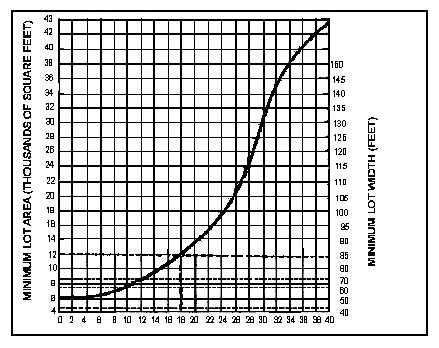
Average Percent of Natural Ground Slope
Example: For a lot whose natural ground slope is 18 percent, the indicated minimum lot area is 12,000 square feet and the indicated average width is 85 feet.
(1967 Code § 30-36)
Sec. 1325.04. - Minimum slope regulation requirements.
The following are the minimum slope regulation requirements:
(1967 Code § 30-37)
Sec. 1325.05. - Grading plan.
Grading plan shall show contour lines at five feet intervals where average slopes exceed 16 percent and at two feet intervals where the average slope is less than 16 percent. Elevations are to be based on sea level datum (USGS), if available. Datum for contours shall be indicated on the map.
(1967 Code § 30-38)
Sec. 1325.06. - Grading controls.
The lot layout and dimensions shall be shown for each lot and of each building site. Where pads are utilized or proposed for building sites, engineering data shall show the existing topography and the approximate finish grades, location and size of each building site and finish grades of streets prior to consideration of the final record of survey map.
(1967 Code § 30-39)
Sec. 1325.07. - Cuts and fills.
No land shall be graded, cut or filled so as to create a slope exceeding a vertical rise of one foot for each two feet of horizontal distance between abutting lots, and may do so within a lot only where a retaining wall of sufficient height and thickness is provided to retain the graded bank.
Major cuts, excavation, grading and filling materially changing the site and its relationship with surrounding areas or materially affecting such areas, shall not be permitted if such excavation, grading and filling will result in a slope exceeding a vertical rise of one foot for each two feet of horizontal distance between abutting lots or between adjoining tracts of land, except where adequate provision is made to prevent slides and erosion by cribbing and retaining walls.
(1967 Code § 30-40)
Sec. 1325.08. - Compaction of fills.
All fill shall be compacted to a density of 90 percent or greater. Inspection of fill shall be done by the Engineer.
(1967 Code § 30-41)
Sec. 1325.09. - Street requirements.
(a)
Design and arrangement. Rights-of-way should be designed in a manner so as to encourage aesthetics in road design and to avoid the destruction of trees and natural land formations.
(b)
Street type and width. The minimum right-of-way width for minor streets may be 40 feet in Groups 1 and 2; and 50 feet in Group 3, respectively, as referred to in Section 1325.04.
The Planning Commission reserves the right to require a greater width for local streets where necessary because of excessive grading or to provide for adequate drainage. The minimum width of local streets serving multiple dwellings shall be 50 feet, and the pavement width shall be 28 feet.
(c)
Alignment.
(1)
Vertical profile grades. Vertical profile grades shall be connected by vertical curves up to 20 percent, but only for short, straight stretches.
(2)
Minimum horizontal. The radii of centerline curvatures shall be no less than 75 feet.
(3)
Visibility requirement. Waiver of visibility requirements specified in Section 1321.02 shall be given subject to the approval of the Commission.
(4)
Street grades. Waiver of vertical curve requirements specified in Section 1321.02 shall be given subject to the approval of the Commission.
(1967 Code § 30-42)
Sec. 1325.10. - Building lines and easements.
Where the subdivision areas are to be used for residential purposes the building line shall be established according to the following table:
Minimum Building Setbacks
(feet from right-of-way)
Group 1 .....20
Group 2 .....25
Group 3 .....25
Easements shall be provided as specified in Section 1321.04; except that variances may be permitted to allow for the limitations of steeply sloping terrain.
(1967 Code § 30-43)
Sec. 1325.11. - Undeveloped land.
Land subject to flooding, land with excessive slope and land deemed by the Planning Commission to be undesirable for development shall not be platted for residential occupancy, nor for such other uses as may involve danger to health, life or property or to aggravate the erosion or flood hazard. Such land shall be set aside for compatible uses.
(1967 Code § 30-44)
Sec. 1325.12. - Utility and street improvements.
(a)
Sewage disposal. Where public sewers are not available and where private sewage disposal systems will be utilized, the results of a percolation test shall be submitted in accordance with the recommendation of the County Health officer.
(b)
Street improvements.
(1)
Width of pavement. The minimum pavement width for minor streets may be 20 feet in Class 1; 22 feet in Class 2; 24 feet in Class 3 type subdivision areas.
(2)
Curbs and gutters. Curbs shall be required on all streets designed to serve residential areas. Curbs shall be the straight side variety and shall have a radius of 20 feet to face of curb and at street intersection.
(1967 Code § 30-45)
Sec. 1325.13. - Retaining walls.
Retaining walls may be required wherever topographic conditions warrant or where necessary to retain fill or cut slopes within the right-of-way. Such improvements shall require the approval of the Engineer.
(1967 Code § 30-46)
Sec. 1325.14. - Existing trees and ground cover.
In a hillside subdivision, the existing tree growth and natural ground cover shall not be disturbed except for the grading of those portions of the lots for building sites and the installation of improvements, including earth cuts and fills; provided that the removal of additional natural tree growth and ground cover under other circumstances may be permitted by the Planning Commission when necessary to the successful development of the subdivision. In order to prevent erosion caused by the removal of such natural tree growth and ground cover the subdivider shall agree to the replacement of any additional trees and ground cover prior to final approval of the subdivision, such replacement to be as directed by the Commission relative to method of installation and type.
(1967 Code § 30-47)