
Morgantown City Zoning Code
CHAPTER SEVEN
LAND USE
ARTICLE 1331.- ESTABLISHMENT OF ZONING DISTRICTS AND ZONING MAP[1]
Cross reference— Amendments to text and map—see P. & Z. Art. 1377.
ARTICLE 1333.- R-1, SINGLE FAMILY RESIDENTIAL DISTRICT[2]
Cross reference— Design standards—see P. & Z. 1331.06(16); non-residential uses—see P. & Z. 1331.06(29); accessory uses—see P. & Z. 1331.08; permitted signs—see P. & Z. 1369.06.
ARTICLE 1335.- R-1A, SINGLE FAMILY RESIDENTIAL DISTRICT[3]
Cross reference— Design standards—see P. & Z. 1331.06(16); non-residential uses—see P. & Z. 1331.06(29); accessory uses—see P. & Z. 1331.08; permitted signs—see P. & Z. 1369.06.
ARTICLE 1337.- R-2, SINGLE AND TWO-FAMILY RESIDENTIAL DISTRICT[4]
Cross reference— Design standards—see P. & Z. 1331.06(16); non-residential uses—see P. & Z. 1331.06(29); accessory uses—see P. & Z. 1331.08; permitted signs—see P. & Z. 1369.06.
ARTICLE 1339.- R-3, MULTI-FAMILY RESIDENTIAL DISTRICT[5]
Cross reference— Design standards—see P. & Z. 1331.06(16); non-residential uses—see P. & Z. 1331.06(29); accessory uses—see P. & Z. 1331.08; permitted signs—see P. & Z. 1369.06.
ARTICLE 1341.- PRO, PROFESSIONAL, RESIDENTIAL AND OFFICE DISTRICT[6]
Cross reference— Home occupation—see P. & Z. 1331.06(2); drive-through facilities prohibited—see P. & Z. 1331.06(28).
State Law reference— Factory-built homes—see W. Va. Code 8A-11-1.
ARTICLE 1343.- OI, OFFICE AND INSTITUTIONAL DISTRICT[7]
Cross reference— Composting operation—see P. & Z. 1331.06(3); day care facilities—see P. & Z. 1331.06(19); mixed use dwelling units—see P. & Z. 1331.06(26).
ARTICLE 1345.- B-1, NEIGHBORHOOD BUSINESS DISTRICT[8]
Cross reference— Outdoor kennels—see P. & Z. 1331.06(7), (24); daycare facility—see P. & Z. 1331.06(19).
State Law reference— Group residential facility—see W. Va. Code 8A-11-2.
ARTICLE 1347.- B-2, SERVICE BUSINESS DISTRICT[9]
Cross reference— Outdoor kennels—see P. & Z. 1331.06(7), (24); daycare facility—see P. & Z. 1331.06(19).
State Law reference— Group residential facility—see W. Va. Code 8A-11-2.
ARTICLE 1349.- B-4, GENERAL BUSINESS DISTRICT[10]
Cross reference— Outdoor kennels—see P. & Z. 1331.06(7), (24); daycare facility—see P. & Z. 1331.06(19).
State Law reference— Group residential facility—see W. Va. Code 8A-11-2.
ARTICLE 1353.- B-5, SHOPPING CENTER DISTRICT[11]
Cross reference— Composting sites—see P. & Z. 1331.06(3); churches—see P. & Z. 1331.06(12); private club restaurant—see P. & Z. 1331.06(18).
ARTICLE 1355.- I-1, INDUSTRIAL DISTRICT[12]
Cross reference— Composting sites—see P. & Z. 1331.06(3); recycling station—see P. & Z. 1331.06(6); self storage facilities—see P. & Z. 1331.06(15).
ARTICLE 1357.- PUD, PLANNED UNIT DEVELOPMENT DISTRICT[13]
Cross reference— Signs permitted—see P. & Z. 1369.06.
ARTICLE 1359.- ISOD, INTERSTATE SIGN OVERLAY DISTRICT[14]
Cross reference— Signs permitted—see P. & Z. 1369.06.
Sec. 1331.01.- Establishment of zoning districts.
(a)
The City is hereby classified and divided into the following zoning districts:
(b)
In addition to the zoning districts listed above, portions of the City may be classified according to the following overlay zoning districts:
(c)
The zoning district and overlay zoning district boundaries are shown on the official zoning map, which shall be construed to include the Interstate Sign Overlay District (ISOD) as described in Article 1359 of the City Code and the Airport Overlay District as described in Article 1360 of the City Code with the dimensions described in such referenced articles and related exhibits.
(Ord. No. 07-18, 6-5-2007; Ord. No. 2020-06, 3-3-2020; Ord. No. 2020-26, 8-4-2020)
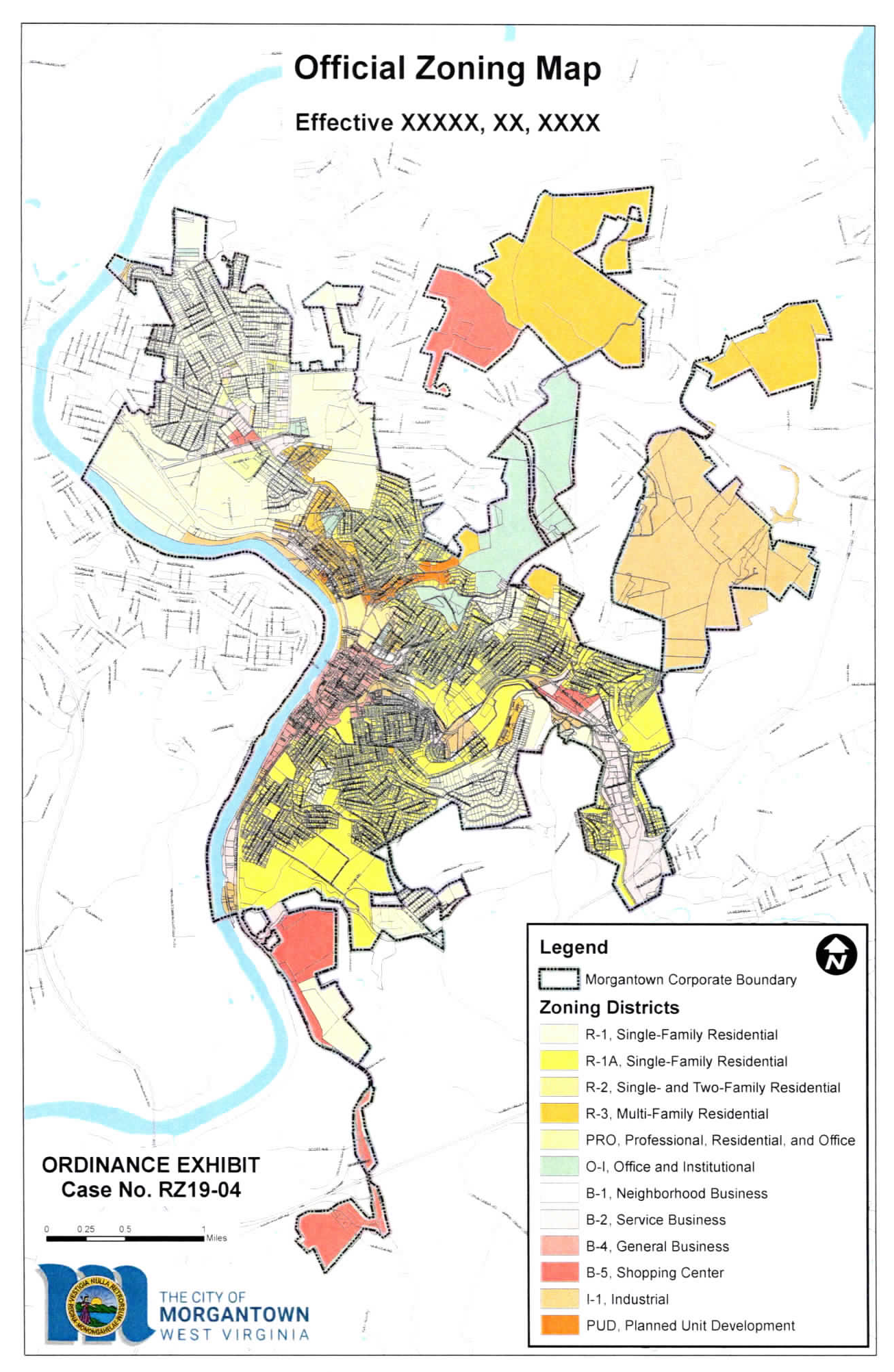
Sec. 1331.02. - Establishment of zoning map.
The official zoning map adopted with this ordinance is hereby established as the official zoning map and zoning districts (hereinafter "official zoning map") of Morgantown, West Virginia. The official zoning map designates the respective zoning districts in accordance with this ordinance.
(Ord. No. 19-29, 12-3-2019)
Sec. 1331.03. - Determination and interpretation of zoning district boundaries.
(a)
In determining the boundaries of districts, and establishing the provisions applicable to each district, due and careful consideration has been given to existing conditions, the character of buildings erected in each district, the most desirable use for which the land in each district may be adapted, and the conservation of property values throughout the City.
(b)
Where uncertainty exists as to the exact boundaries of any district as shown on the official zoning map, the following rules shall apply:
(1)
Unless otherwise indicated, the zone boundary lines are the center lines of streets or such lines extended; and
(2)
In the case of further uncertainty, the Board of Zoning Appeals shall interpret the intent of the zone map as to the location of the boundary in question.
Sec. 1331.04. - Annexation.
(a)
Zoning annexed areas. Prior to the filing of a petition for annexation, the petitioner should petition the Planning Commission for a recommendation as to said parcel's zoning designation. If no such petition is presented to the Planning Commission, the Commission may:
(1)
Direct planning staff to study the area proposed for annexation and prepare a report and recommendation for zoning; or
(2)
Initiate the establishment of the R-1, Single Family Residential District designation for the area proposed for annexation, which shall remain in place until such time as a formal rezoning petition can be submitted and acted upon.
(b)
Comprehensive plan as zoning guide. On future annexation, the Planning Commission shall give careful consideration to the principles and directives of the comprehensive plan of the City, as amended, in making zone district classification recommendations to the Council. If the area under consideration is not addressed in the comprehensive plan, the Commission should give careful consideration to the character of existing land uses, and the capacity of existing and future infrastructure serving the area.
Sec. 1331.05. - Permitted land uses.
The table and supplemental regulations of the Permitted Land Use Table are incorporated in this section and are adopted as the basic land use regulations for the City. The table and supplemental regulations identify the types of land uses that are permitted within the City and any applicable conditions and limitations.
To determine the zoning district in which a particular use is allowed, find the use in the list of uses along the left-hand side of the Permitted Land Use Table and read across the use row to find the zoning district column designations.
Legend:
P — Use is permitted by right in a particular zoning district.
A — Use is permitted as an accessory use in a particular zoning district.
C — Use is allowed only as a conditional use in a particular zoning district subject to the limitations and conditions specified; a conditional use permit is required.
Empty — Use is not permitted in a particular zoning district.
The uses listed in the Permitted Land Use Table are defined in the definitions section (Article 1329).
A description of the supplemental regulations immediately follows the Permitted Land Use Table.
Table 1331.05.01: Permitted Land Uses
(Ord. No. 06-37, 11-8-2006; Ord. No. 06-48, 12-5-2006; Ord No. 07-17, 6-5-2007; Ord. No. 07-19. 6-5-2007; Ord. No. 07-20, 6-5-2007; Ord. No. 07-53, 11-6-2007; Ord. No. 09-08, 3-3-2009; Ord. No. 09-16, 5-5-2009; Ord. No. 09-29, 7-7-2009; Ord. No. 11-44, 11-1-2011; Ord. No. 12-27, 7-3-2012; Ord. No. 13-32, 7-2-2013; Ord. No. 16-38, 8-2-2016; Ord. No. 16-43, 9-6-2016; Ord. No. 16-48, 10-4-2016; Ord. No. 17-27, 7-5-2017; Ord. No. 18-14, 4-3-2018; Ord. No. 18-23, 7-10-2018; Ord. No. 18-24, 6-5-2018; Ord. No. 18-29, 10-16-2018; Ord. No. 2020-21, 7-7-2020; Ord. No. 2023-23, 8-15-2023)
Sec. 1331.06. - Supplemental regulations pertaining to permitted land uses table.
(1)
A full-service hotel with ten or more separate guest rooms that also has an accessory restaurant within the same building may have a private club located within the establishment.
(2)
Home occupations shall be permitted when the following conditions can be met:
a.
A home occupation Class 1 is considered an accessory use, and is personal to the applicant, is not transferable to any other person, and does not apply to any other business of the applicant.
b.
A home occupation Class 2 is considered a conditional use, and is personal to the applicant, is not transferable to any other person, and does not apply to any other business of the applicant.
c.
The following regulations apply to both classes of home occupations:
1.
A home occupation shall be compatible with residential uses of the dwelling, shall not change the residential character of the dwelling, and shall not detract from the residential character of the neighborhood.
2.
A home occupation shall produce no detectable fumes, odors, dust, heat, noise, vibration, glare, electro-magnetic field, electrical interference or other effects outside the dwelling, including transmittal through vertical or horizontal party walls.
3.
A home occupation shall not require fixed installation of equipment or machinery that substantially changes the residential character of the dwelling.
4.
A home occupation shall occupy not more than 25 percent of the floor area of the principal structure, and shall not require internal or external alterations or construction features not customary to a residential dwelling.
5.
A home occupation shall be conducted entirely within the principal building. No home occupation shall be conducted outdoors or in any accessory building or garage, except that parking of a vehicle used in conducting the business and/or simple storage of materials or goods used in association with the business may be permitted in such buildings.
6.
Shall have no more than one vehicle with business identification, and shall have no vehicle with greater than one ton capacity and shall not have any trailer.
7.
Except as required by State law, there shall be no exterior indication of the home occupation, no exterior signs, nor any other on-site advertising visible from the exterior.
8.
A home occupation shall not involve on-site employment of persons not residing in the dwelling, except as otherwise provided in this ordinance.
9.
A home occupation shall register as a business with the City of Morgantown Finance Office and shall pay applicable business and occupation taxes.
10.
If the applicant is not the owner of the property at which the home occupation will be conducted, the applicant must verify that written notice of intention to conduct the home occupation has been given to the owner of the property, and the application shall be accompanied by a copy of the letter by which notice was provided to the owner of the property.
11.
No sexually oriented business, as defined herein, may be permitted as a home occupation.
12.
Merchandise delivery and/or pick-ups to and from the premises that are associated with the home occupation, and that utilize a commercial delivery service or the United States Postal Service, shall not exceed four per day.
d.
The following regulations apply to home occupations, Class 2:
1.
If any resident living within 300 feet of a home occupation, Class 2 believes that it is being conducted in violation of the imposed conditions or believes that the home occupation is detracting from the residential character of the neighborhood, the resident can submit a petition for revocation of the conditional use permit. If the Planning Director is unable to resolve the problem informally, it will be placed on the agenda of the Board of Zoning Appeals for a public hearing. On the basis of evidence introduced at this hearing, the Board may suspend or revoke the conditional use permit temporarily or permanently, or impose additional restrictions on the conduct of the business.
2.
After a home occupation, Class 2 conditional use permit is granted, if the holder of the permit wishes to make any change in the conduct of the business that departs from the description in the application or from any other conditions or restrictions imposed by the Board of Zoning Appeals, the holder of the permit must obtain prior permission of the Board on the basis of a new application.
3.
Retail sales shall not occur nor services be provided on the premises on a regular basis or in substantial volume, such that customer visitation to the premises is deemed to be unreasonable. The Board of Zoning Appeals shall decide if customer visitation for the proposed type and volume of retail activities or services is reasonable when considering the conditional use permit application.
4.
The application for a home occupation, Class 2 conditional use permit must be filled out completely, or the application shall be deemed to be incomplete and shall not be considered by the Board of Zoning Appeals.
(3)
Composting operation sites shall be screened with landscaping, or an opaque fence or wall to a height of at least six feet.
(4)
All storage associated with repair establishments shall be indoors.
(5)
In all residential districts where permitted, a bed and breakfast inn shall retain the architectural orientation and form characteristic of the surrounding neighborhood.
(6)
Recyclable collection center/solid waste transfer station shall be permitted subject to the following conditions:
a.
Unloading areas for materials shall not be less than 50 feet from any adjoining property, unless unloading is conducted entirely within a building.
b.
Portions of a site used for truck maneuvering or the storage, bailing, processing, or other handling of materials must be enclosed by an opaque fence or wall within a non-glare finish not less than eight feet in height.
c.
Loading and unloading areas must be paved.
d.
The site must be kept clear of litter, scrap paper, or other refuse matter.
e.
Chemical or heating processes shall not be conducted on materials.
(7)
Outdoor kennel and storage areas shall not be visible from streets and/or adjacent properties. No outdoor kennels or storage areas shall be permitted in the B-1, Neighborhood Business District, or the PRO, Professional Residential and Office District.
(8)
Fuel dispensing pumps shall be located no closer than 12 feet from any property line.
(9)
Use shall be conducted within the buildings or structures on the site, except when located in an industrial district.
(10)
All storage shall be indoors, except when located in an industrial district.
(11)
Park and recreation commercial uses, such as miniature golf, go-cart tracks, swimming pools and so forth, shall not be permitted in residential districts unless owned and operated by an agency exempt from the regulations of this ordinance.
(12)
Churches and places of worship shall meet the following requirements:
a.
A minimum lot size of 15,000 square feet is required;
b.
Churches and religious facilities may include customary accessory uses including gymnasiums, daycare, classroom, meeting rooms, etc.
(13)
Video gaming or lottery establishments shall comply with the following conditions:
a.
May locate no closer than 500 feet from another video gaming or lottery establishment. Proof that the establishment meets this distancing requirement shall be submitted by the applicant to the Planning Director in a form approved by the Planning Director.
b.
May locate no closer than 500 feet from a place of worship, school, hospital, nursing home, assisted living facility and residential uses of all types. Proof that the establishment meets this distancing requirement shall be submitted by the applicant to the Planning Director in a form approved by the Planning Director.
c.
Subject to all applicable zoning regulations including parking, signage, landscaping, etc.
d.
Subject to all applicable State regulations.
e.
The 500 foot buffer provided in paragraphs a. and b. above shall be measured as the shortest distance between any portion of both buildings.
f.
For the purpose of paragraph b. above, a place of worship shall be defined as an institution which qualifies as tax exempt under the provisions of 26 U.S.C. § 501(c)(3), within which weekly religious services are offered to the congregation and/or the general public.
(14)
Marinas shall comply with the following regulations:
a.
All applicable Federal and State rules and permit requirements shall be complied with.
b.
The use shall be designed and operated to maintain compatibility with natural resources and to minimize impacts on adjoining properties with regard to noise, traffic, glare, odor, and dust.
c.
No portion of the primary facility shall be within 30 feet of the riparian line of an adjoining use.
d.
All structures and other activities must be within the riparian rights area of the applicant and must be designed in a manner that will not restrict or otherwise infringe upon the riparian rights of adjacent riparian owners.
(15)
Self storage and personal storage facilities must comply with the following:
a.
Storage facilities should utilize a masonry (brick, stone, or split-face decorative block) facade on all vertical wall surfaces visible from a public street or from any residentially zoned or used property.
b.
The use of shiny metal roofing or unfinished metal roofing should not be allowed. Metal roofs should be finished in a neutral, earth-tone color that does not unduly call attention to the buildings. Examples of colors that should be avoided include, but are not limited to: Orange, red, yellow, white, etc. When such facilities are located near residentially zoned or used properties, roofing materials should be comparable to those used on the adjacent residential buildings.
c.
Security fencing surrounding such facilities should be ornamental in character, and of a type that is unobtrusive to nearby residentially zoned or used properties. Examples of ornamental fencing include, but are not limited to, wrought iron, or similar fencing, wooden privacy fencing, vinyl coated chain link fencing, masonry, landscape buffers that are double the normal requirements; and earth tone colors, etc.
d.
Parking requirements for such facilities are found in the parking section of this ordinance.
(16)
All single-family dwelling units shall comply with the following design standards regardless of the zoning district in which they are located:
a.
Principal building roofs should have a pitch that conforms to the roof pitches of adjacent homes.
b.
Roofing material shall be of a type that is in compliance with the West Virginia State Building Code.
c.
Roof overhand or eaves shall be designed for a minimum of six inches as measured from the vertical side of the building and not including rain gutters, which are required.
d.
Single-family dwellings should be clad in one or a combination of wood siding, vinyl siding, fiber cement siding, unit masonry, manufactured masonry or other material approved by the West Virginia State Building Code.
e.
A perimeter enclosure is required in accordance with the West Virginia State Building Code. For manufactured housing units, all tow bars, axles and wheels shall be removed. The housing unit shall rest on a required center support and meet tie-down requirements per the West Virginia State Building Code.
f.
No housing unit shall be less than 24 feet in width.
(17)
Junkyards shall comply with the following:
a.
The area to be occupied by the junkyard shall be located at least 300 feet from any residential district.
b.
Every junkyard operation shall either be conducted wholly within a substantially constructed building or within an area which shall be surrounded completely on all sides by a continuous solid fence, except for entrances and exits constructed of brick or wood and kept in repair so that the fence shall hide from view any part of the junkyard and its contents. The fence shall be at least eight feet in height and shall be constructed at street corner intersections so as to permit adequate vision clearance on the street. If the fence is constructed of wood, it shall be completely painted.
c.
No junk shall be loaded, unloaded or placed outside the enclosure fence, temporarily or permanently, either on the property or in the public right-of-way.
d.
Every junkyard shall be conducted so as not to create a nuisance for reason of noise or disagreeable odors or fumes. The loading or unloading of junk and the use of breakup hammers shall be carried on during the normal daylight business period only.
e.
All premises used as a junkyard shall be maintained in a clean, sanitary and neat condition so that rats, vermin and fire hazards shall be reduced to a minimum and the accumulation of anything not defined as junk, including waste and foodstuffs and similar materials, shall not be permitted.
(18)
When reviewing new or the expansion of existing conditional use private club applications, the Board of Zoning Appeals shall consider potential adverse impacts on surrounding residential properties such as, but not limited to, the arrangement and use of outdoor seating areas, hours of wine and liquor sales, noise, etc.
(19)
Day care facilities, Class 2 and Class 3 shall comply with the following:
a.
Permitted as a home occupation with a conditional use permit and subject to the following requirements:
1.
An outdoor recreation area may be approved by the Board of Zoning Appeals upon consideration of the care provider's operations plan and site specific circumstances so as to assure personal safety and to minimize offsite impacts upon adjacent properties.
2.
There shall be no swimming pool on-site.
3.
An on-site outdoor recreation area, if provided, shall be enclosed by a minimum three-foot high solid wall or fence with self- latching gate.
4.
There shall be no structural additions or equipment not customary in a residential dwelling except those modifications required under State regulations for child care facilities, Building Code or Fire Code regulations pertaining to this class of day care facilities.
(20)
Mixed use buildings shall comply with the following:
a.
Minimum building height. Unless provided otherwise by regulations specific to a given zoning district, the minimum height of a mixed use building shall be two stories.
b.
Floor-to-floor heights. All floor space provided on the ground floor of a building, regardless of use, must have a minimum floor-to-ceiling height of at least 11 feet.
c.
Nonresidential component space shall include commercial, business, and/or office use(s) permitted in the zoning district.
d.
Residential amenity space includes areas utilized as common entrance, lobby, leasing, management, meeting, exercise, and the like intended principally for the comfort, convenience, amenity, and/or necessity of the mixed use dwelling unit(s). Residential amenity spaces shall be considered residential component space and may not be counted toward meeting minimum nonresidential component space requirements.
e.
Minimum nonresidential component space. Unless provided otherwise by regulations specific to a given zoning district, a minimum net floor area (NFA) shall be dedicated to nonresidential component space to ensure that commercial land is preserved for primarily commercial purposes, which shall be calculated as at least 20 percent of the gross floor area (GFA) of the ground floor or 800 square feet, whichever is greater. Except:
1.
Within the R-2 districts, the maximum gross floor area of all permitted nonresidential component space within a mixed use building shall be 2,000 square feet and any permitted food service establishment shall not exceed 500 square feet of customer seating area.
2.
Within the R-3 District, the maximum gross floor area of all permitted nonresidential component space shall be 3,000 square feet and any permitted food service establishment shall not exceed 750 square feet of customer seating area.
f.
Floor area of enclosed off-street parking areas may not be counted toward meeting minimum nonresidential component space requirements.
g.
Minimum required nonresidential component space(s) shall be located along a principal facade of the ground floor, except that lots with topographic elevation changes may meet minimum required nonresidential component space by using at-grade floors as specified in this section. For purposes of this section, "topographical elevation changes" shall mean a slope in the ground surrounding the building that renders a floor above the ground floor at-grade by its direct access from the adjoining ground.
h.
On lots with topographic elevation changes, minimum required nonresidential component space(s) may be developed along a principal facade of an at-grade floor(s); provided, nonresidential component spaces(s) is developed along the principal facade of the ground floor level.
i.
Mixed use dwelling units shall not be located along a principal facade of the ground floor, except within residential districts where mixed use buildings are permitted.
j.
Transparency. Unless otherwise established by this ordinance within a specific zoning district, the ground floor of the principal facade of a mixed use building between three feet and eight feet in height shall have a minimum fenestration ratio of 60 percent, comprised of clear windows that allow views of indoor nonresidential component space and/or product display areas.
k.
No security bars, screens or gates shall be permitted to be attached to the principal facade of a mixed use building located within a residential zoning district.
(21)
Except no warehousing/distribution facility of any type shall be located within 300 feet of any property line of any residential district.
(22)
Fast food restaurants shall comply with the following:
a.
No drive-through facilities shall be permitted in the B-1 districts.
b.
No outdoor play areas are permitted in the B-1 districts.
c.
Franchise color schemes or materials are discouraged in the B-1 districts.
(23)
Taxicab service establishments shall comply with the following standards:
a.
All on-site repair and/or maintenance of vehicles shall be conducted entirely within an enclosed building.
b.
All outdoor storage of associated vehicles shall be entirely enclosed within a screened area surrounded by a privacy fence not less than six feet in height.
(24)
A dog run may not be located on any property within 200 feet of any residential property.
(25)
Drive-through facilities in association with a restaurant shall not be allowed in the B-1 district. In all other districts they shall be considered an accessory use in those districts where it is permitted.
(26)
Mixed use dwelling units shall comply with the following:
a.
Dwelling units may be located on the ground floor, where permitted, but shall not, with the exception of a common entrance(s), have direct access to the individual dwelling unit from a principal facade.
b.
Dwelling units located above the ground floor shall not have direct access to the individual dwelling unit from a principal facade by way of an outdoor pedestrian walkway as generally shown in Graphic 1331.06.01.
Graphic 1331.06.01: Outdoor Pedestrian Walkway
(27)
A restaurant, in the B-1 and B-4 districts, which seeks to obtain a State license as a private club for dispensing alcoholic beverages per the Code of West Virginia, Chapter 60, Article 7, Section 1 et seq., shall be subject to the following conditions upon approval of its conditional use application as a restaurant, private club:
a.
Such private club shall have as its principal purpose the business of serving meals on its premises to its patrons and to members of such club and their guests. For the purposes of this section, the term "meal" shall be consistent with that of the State of West Virginia as defined in its legislative rules and regulations pertaining to private club license and shall not include packaged potato chips and similar products; packaged crackers; packaged nuts; packaged desserts (fruit pies, cakes, cookies, etc.); and bar sausages and similar products.
b.
Such private club with a bar shall post a sign not smaller than three square feet in a prominent location near the bar that states the following: "It is a violation of City Ordinance to serve wine or liquor beverages after 1:00 a.m."
c.
No such applicant may be licensed as a private club under this conditional use that has not been in operation for at least one year as a bona fide restaurant before making application for a license under this conditional use. However, when an applicant owns another bona fide restaurant the same as the one being proposed, the Board of Zoning Appeals may consider the proposed restaurant application on the basis of the existing restaurant which has been in operation for at least one year. In the B-4 district the Board of Zoning Appeals may waive the requirement, to be in business for one year as a bona fide restaurant, when the applicant's written description of the business operations, menu, and floor plans, demonstrate clearly that the establishment will meet the criteria in this subsection.
d.
In the B-4 district a full-service hotel, convention or conference center which serves meals and services to private functions shall be exempt from the requirements of this section when the areas where liquors are served are only accessible from an internal part of the building. Such a hotel's bar facilities may serve to the general public after 9:00 p.m.
e.
Reserved.
f.
Such private club shall provide a seating capacity for at least 50 persons, at a table or counter maintained for the principal purpose of serving meals. Seats at a bar, which is primarily for the serving of alcoholic beverages, shall not be counted as meeting the minimum seating capacity of the establishment. Liquor or wine may be served either at seats intended primarily for dining, or at any bar area within the restaurant, with or without an accompanying meal.
g.
Liquor or wine shall not be served later than 1:00 a.m., except on New Year's Eve.
h.
The private club shall, at the time of each sale or at the time of payment, record the amount of revenue derived from the sale of liquor and wine beverages separately from the amount of revenue derived from the sale of food and nonalcoholic beverages.
i.
During each calendar month, the private club shall maintain and preserve accurate and adequate records including those required by paragraphs e. and h. above, to prove compliance to the City's Finance Director, and shall make all such records available for review and audit promptly upon request by the Finance Director. The records for each month shall be preserved for not less than 24 months next following.
j.
Reserved.
k.
In addition to the above requirements, in the B-4 district the following shall apply:
1.
The August 2, 1994 City ordinance which created this regulation stated that the specific locations at which private club licenses existed on the date of the August 2, 1994 ordinance shall become legal non-conforming uses and subject to the nonconforming provisions of the City's zoning ordinance, except that such use shall not be permitted to expand within the building it occupies. Effective November 11, 2003, this regulation is amended to permit the expansion of a private club location which became a legal nonconforming use in the B-4 district on August 2, 1994, and still exists as a legal nonconforming use within the structure that it occupied as of August 2, 1994 subject to the requirements of this ordinance, and provided that no structural alterations are made within the building in order to allow the use to expand, except those that may be required by the Building Inspections Department. No such nonconforming use location shall be allowed to increase the number of private clubs existing within it beyond that existing as of August 2, 1994. Nothing herein shall prohibit the location of a restaurant/private club by conditional use within any such nonconforming use location in addition to a private club, which may already exist.
2.
Existing non-conforming uses may apply to become approved conditional uses under the requirements of this ordinance. For purposes of this subsection, any location which had a private club license for the year 1993-94, and expiring on June 30, 1994, will have 60 days from the adoption of this subsection to obtain State and City private club licenses for 1994-95 and thereby remain a legal non-conforming use.
(28)
In the B-1 district, two-story buildings are permitted uses; however, one-story buildings require a conditional use permit regardless if the proposed land use is a permitted use. In the PRO district, drive-through facilities are prohibited.
(29)
In the R-1, R-1A, R-2 and R-3 districts, the following regulations shall apply to permitted nonresidential uses:
a.
Within the R-1, R-1A and R-2 districts, the maximum gross floor area for permitted nonresidential use space shall be 2,000 square feet and any permitted food service establishment shall not exceed 500 square feet of customer seating area.
b.
Within the R-3 district, the maximum gross floor area for permitted nonresidential use space shall be 3,000 square feet and any permitted food service establishment shall not exceed 750 square feet of customer seating area.
(30)
Telecommunications facilities shall comply with the following standards:
a.
Permitted classes.
1.
Class I telecommunications facilities shall include but are not limited to such facilities as television antennas, ham radio antennas, am/fm reception. Any Class I facility cannot be utilized for cell phone reception.
2.
Class II telecommunications facilities shall include but are not limited to such facilities as antennae and associated electronic equipment designed expressly for use by cell phone companies, as regulated under the Federal Telecommunication Act of 1996, that is not intended to be supported by or attached to a new telecommunications tower, as defined.
3.
Class III telecommunications facilities shall include but are not limited to such facilities as antennae and associated electronic equipment that is supported by or attached to a new telecommunications tower, as defined herein, and is designed expressly for use by cell phone companies, as regulated under the Federal Telecommunications Act of 1996.
4.
Nothing in this section is construed to regulate home satellite dishes, whether such dish is used for television reception or other purposes.
b.
Standards for facilities.
1.
Class I facilities.
(A)
Permitted in any zoning district;
(B)
Maximum height of 60 feet above grade;
(C)
Standard building permit required; and
(D)
A structural engineer shall certify that the design of such structure is such that in the event of structural failure, no part of the structure will encroach upon any adjoining property or public right-of-way.
2.
Class II facilities.
(A)
Permitted in any zoning district except R-1 and R-1A;
(B)
Antenna or associated electronic equipment shall be designed for co-location on an existing, permitted telecommunications tower, or attachment to an existing building, water tank or other existing structure. Unless specifically being attached to an existing, permitted telecommunications tower, these facilities must be designed utilizing the latest stealth technologies as defined in this ordinance. They may be attached to an existing, permitted telecommunications tower as a co-location, as per the requirements of this ordinance.
(C)
Approval shall be provided under the standards for a development of significant impact.
3.
Class III facilities.
(A)
Permitted as a conditional use in B-1, B-2, B-4, B-5 and I-1 districts;
(B)
Class III is reserved for applicants seeking to erect a new tower structure, with associated antennae and electronic equipment;
(C)
Towers shall be designed in such a manner as to permit future collocation of other carrier's antennae, rather than construction of additional single-use towers;
(D)
Minimize adverse visual impact of towers and telecommunications facilities through careful design, siting, landscaping and innovative camouflaging techniques;
(E)
Security fencing shall be provided around the equipment shed. A clear zone shall be established at a distance of 1.5 times the tower height around the base within which there are no existing buildings;
(F)
Avoid potential damage to property caused by towers and telecommunications facilities by ensuring that such structures are soundly and carefully designed, constructed, modified, maintained, and removed when no longer used or determined to be structurally unsound.
c.
If the erection or installation of a telecommunications facility has the potential to cause an impact on an historic property, as determined by the Planning Director, then the application for the telecommunications facility shall include completion of the Section 106 review process of the National Historic Preservation Act.
(31)
The following regulations are specific to extractive industry development:
a.
Extractive industry uses are considered major developments of significant impact of a regional scale for the purpose of site plan review and approval.
b.
Regardless of zoning classification, property annexed into the City still obligated to a mineral, oil and/or gas rights lease agreement with another party may exercise such lease for the surface extraction development of minerals, oil and/or gas as established under said lease for a period not to exceed seven years following annexation. If development of significant impact site plan approval is not obtained within three years of annexation, then the surface extraction development right shall expire unless otherwise permitted under this ordinance. All extractive industry development, regardless of zoning classification, must comply with related site plan review and performance standards of this ordinance.
c.
A recreational vehicle or camper may be utilized as a caretaker's residence for a period not to exceed 18 months. After 18 months, the caretaker's residence on an extractive industry development site must meet the supplemental regulations for all single-family dwelling units provided in Section 1331.06(16).
(32)
Heavy industry and heavy manufacturing uses are considered development of significant impact, regardless of gross floor or land area, for the purpose of site plan review and approval.
(33)
Consumer fireworks retail sales shall comply with the following regulations:
a.
Consumer fireworks retail sales intended to remain for 30 days or less may be located within a permanent building or a temporary stand, tent, canopy or membrane structure meeting all applicable safety standards and regulations required by the State of West Virginia and rules and regulations promulgated by the West Virginia State Fire Marshal or designee; provided, a temporary use permit is issued in accordance with Section 1331.07 for the sale of consumer fireworks.
b.
Permanent consumer fireworks retail sales and consumer fireworks retail sales establishments intended to remain for more than 30 consecutive days shall be located within a permanent building meeting all applicable safety standards and regulations required by the State of West Virginia and rules and regulations promulgated by the West Virginia State Fire Marshal or designee.
c.
All applicable local and State permits, registration and licenses must be conspicuously and permanently displayed.
(34)
Consumer fireworks wholesale establishments shall comply with the following regulations:
a.
The wholesale establishment shall be limited in its sale of consumer fireworks to a retailer or any other person for the purpose of resale.
b.
The wholesale establishment shall be limited in its sale of articles of pyrotechnics, display fireworks, and special effects to a person licensed to possess and use those devices.
c.
The wholesale establishment shall only be located in and the sale of all consumer fireworks and articles of pyrotechnics, display fireworks, and other special effects items shall only be made from and within a permanent free standing (detached) principal building dedicated solely for the sale of consumer fireworks and articles of pyrotechnics. display fireworks, and other special effects.
d.
The wholesale establishment may include the retail sales of consumer fireworks, provided:
1.
The area directly devoted to consumer fireworks retail sales is subordinate in gross floor area to the wholesale establishment, excluding related storage; and
2.
Temporary retail sales of consumer fireworks from an on-site temporary stand, tent, canopy or membrane structure may be permitted as set forth in Section 1331.07 for the sale of consumer fireworks.
3.
The retail sale of articles of pyrotechnic articles, display fireworks and special effects is prohibited;
e.
All buildings permitted to sell consumer fireworks and articles of pyrotechnics, display fireworks, and other special effects items shall meet all applicable safety standards and regulations required by the State of West Virginia and rules and regulations promulgated by the West Virginia State Fire Marshal or designee.
f.
All applicable local and State permits. registration and licenses must be conspicuously and permanently displayed.
(35)
Multi-family dwelling units shall comply with the following:
a.
Dwelling units may be located on the ground floor, where permitted, but shall not, with the exception of a common entrance(s), have direct access to the individual dwelling unit from a principal facade.
b.
Dwelling units located above the ground floor shall not have direct access to the individual dwelling unit from a principal facade by way of an outdoor pedestrian walkway as generally shown in Graphic 1331.06.01.
(Ord. No. 06-01, 1-3-2006; Ord. No. 06-14, 6-6-2006; Ord. No. 07-19, 6-5-2007; Ord. No. 07-20, 6-5-2007; Ord. No. 07-53, 11-6-2007; Ord. No. 08-11, 3-4-2008; Ord. No. 12-28, 7-3-2012; Ord. No. 15-33, 6-2-2015; Ord. No. 16-38, 8-2-2016; Ord. No. 18-23, 7-10-2018; Ord. No. 18-24, 7-10-2018; Ord. No. 2024-05, 1-16-2024)
Sec. 1331.07. - Temporary uses.
(a)
Intent. Temporary uses shall be permitted in all districts by the grant of a temporary use permit issued by the City Manager, or his/her designee, in accordance with the requirements of this section.
(b)
General provisions.
(1)
The duration of the temporary period is stated hereinafter, provided, however, renewal of such permit may be requested. The City Manager, or his/her designee, shall not be obligated to renew such permits.
(2)
Temporary use permit applications shall be categorized as Type II site plan submissions.
(c)
Permitted temporary uses.
(1)
Temporary office, model home or model apartment, and incidental signs thereof, both incidental and necessary for the sale, rental, or lease of real property in the zoning district. Maximum time permitted: 18 consecutive months.
(2)
Bazaars, carnivals, and similar temporary uses. Maximum time permitted: ten consecutive days.
(3)
Sale of Christmas trees, outdoor tent theater, sale of seasonal fruits and vegetables from roadside stands, tent sales. Maximum time permitted: 60 consecutive days and no more than four sales per year.
(4)
Sale of consumer fireworks, where permitted under Table 1331.05.01; except conditional use approval shall not be required in the B-2 district. Maximum time permitted: 30 consecutive days between June 7 and July 6.
(5)
Freestanding canopies or awnings used to enclose permitted outdoor seating areas of restaurants and/or private clubs and taverns. Maximum time permitted: four and one-half months between April 15 to September 1. Such canopies or awnings shall be designed to withstand a wind load prescribed in the West Virginia State Building Code.
(6)
Other similar uses deemed temporary by the City Manager and attached with such maximum time period, conditions and safeguards as the City Manager, or his/her designee may deem necessary.
(d)
Standards.
(1)
Adequate access and off-street parking facilities shall be provided which shall not interfere with traffic movement on adjacent streets nor utilize or obstruct minimum required parking stalls for existing principal and accessory uses on the site.
(2)
Any flood lights or other lighting shall be designed, located, installed and directed in such a manner as to prevent glare from encroaching onto adjoining properties or public rights-of-way.
(3)
No commercial banners shall be permitted in a residential district.
(4)
Signs shall not flash or blink or resemble traffic and emergency warning signals, and shall be limited in size to 20 square feet each and in number to three signs.
(5)
The lot shall be put in clean condition devoid of temporary use remnants upon termination of the temporary period.
(Ord. No. 16-38, 8-2-2016)
Sec. 1331.08. - Accessory structures and uses in residential districts.
(a)
Customary and incidental accessory buildings and uses are allowed in all residential districts, as specifically regulated in that zoning district, provided that:
(1)
In no case shall the maximum lot coverage permitted in a zoning district be exceeded.
(2)
Accessory structures, if detached from a principal structure, shall not be placed in the front yard. If placed in a side yard, accessory structures shall not be located closer to the street than the principal structure.
(3)
Accessory structures, if detached from a principal structure, shall not be located closer than five feet to the side or rear property line.
(4)
On corner lots, accessory structures shall not be located between any portion of the principal structure and either street.
(5)
When an accessory structure is attached to a principal structure, it shall comply in all respects with the requirements of this zoning ordinance applicable to the principal structure(s).
(6)
Any structure connected to another structure by an open breezeway (i.e., without enclosed walls) shall be deemed to be a separate structure.
(7)
The total square footage of all accessory structures shall not exceed the first or ground floor area of the principal building.
(8)
The square footage of the first (ground) floor of the accessory structure(s) shall be included in the computation of lot coverage.
(9)
Accessory structures shall not exceed 18 feet in height.
(10)
No accessory structure shall be constructed with a cellar or below-grade story.
(11)
No part of any such structure shall be designed or used for sleeping purposes, and no cooking fixtures shall be placed or permitted therein.
(12)
Any accessory structure designed as a poolhouse shall be constructed in accordance with applicable building and zoning codes. A swimming pool and poolhouse shall constitute one accessory structure.
(13)
A private garage may be constructed as part of a principal structure, provided that when so constructed the garage walls shall be regarded as the walls of the principal structure in applying the applicable front, side and rear setback requirements.
(b)
Accessory structures and uses in nonresidential districts. Customary and incidental accessory buildings and uses are allowed in all nonresidential districts subject to any specific restrictions applicable to that zoning district.
(Ord. No. 17-07, 4-4-2017; Ord. No. 2021-21, 7-20-2021)
Sec. 1331.09. - Fences.
(a)
Fences may be erected, with a building permit, on residentially zoned parcels, provided they meet the following restrictions:
(1)
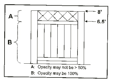
They may not exceed six and one-half feet in height at any point unless the entire fence or that portion of fence above six and one-half feet is open 50 percent or more. Fences permitted to exceed six and one-half feet as provided herein may not be constructed of chain link or wire and may not exceed eight feet in height at any point. (See Graphic 1331.08.01).
Graphic 1331.08.01: Fence Opacity on Residentially Zoned Parcels
(2)
No portion of an opaque fence (less than 70 percent open in any one square foot portion of the fence panel) erected within a sight triangle may exceed two and one-half feet in height.
(3)
Fences may be erected on a property line (except in violation of subsection (b)(2) hereof), but the City strongly encourages applicants to set them back slightly, to avoid any possibility of illegal encroachment onto neighboring properties, and to allow for property maintenance. It is the responsibility of the applicant to insure that the fence will not encroach upon an adjacent lot or within a public right-of-way. If a fence erected after the date of this ordinance is found to encroach onto an adjacent lot, the City Manager, or his designee, will order its removal within 30 days of confirmation of the encroachment and receipt of a notice by the fence owner.
(4)
Fences may be constructed of stone, brick, wood, vinyl, chain link or wire, wrought iron, aluminum, and ornamental concrete block, provided all other requirements herein are met. They shall not be constructed with barbed wire, razor wire, or electrified wire.
a.
Fencing must comply with West Virginia State Building Code standards.
b.
Fences must comply with all applicable local, State and Federal regulations.
(b)
Fences may be erected, with a building permit, on non-residentially zoned parcels, provided they meet the following restrictions:
(1)
They may not exceed ten feet in height except for those surrounding industrial uses, in which case they may be up to 15 feet in height at any point.
(2)
No portion of an opaque fence (less than 70 percent open in any one square foot portion of the fence panel) erected within a sight triangle may exceed two and one-half feet in height.
(3)
Fences may be constructed of stone, brick, wood, vinyl, wire, metal, ornamental concrete block, etc. except in the following districts: B-4, PUD, B-1, and O-I. In these districts, no chain link or other wire fences shall be permitted. For purposes of this section, ornamental concrete block shall mean pre-formed concrete blocks that are modified by covering the exposed surfaces with stucco, or using split-faced block, or ornamental landscaping blocks commonly found in home improvements stores and typically used for planting beds and retaining walls.
(4)
Fences must comply with all applicable local, State and Federal regulations.
(5)
Fences of at least eight feet in height may have barbed wire placed above the eight-foot mark. Under no circumstances shall concertina, razor or electric fences be permitted.
(Ord. No. 17-07, 4-4-2017)
Sec. 1331.10. - Demolition.
(a)
Vacant lots created as a result of building demolition shall be, at a minimum, seeded/landscaped to help mitigate standing water or erosion and shall be maintained by the owner. Such vacant lots shall be completely cleared, except when landscape features are to be preserved, graded, and seeded/landscaped within 30 days of the time of demolition, unless redevelopment plans have been submitted to the City for approval within that time. This period may be reasonably extended and/or temporary alternate measures approved when inclement seasonal conditions impede effective seeding/landscaping.
(b)
The demolition of all structures within designated historic districts shall be reviewed for comment by the Planning Commission, which shall consult with the Historic Landmarks Commission as part of its review process. This review shall be completed prior to the issuance of any demolition permit.
(c)
The demolition of all structures within the B-4 zoning district shall be reviewed for comment by the Design Review Committee. This review shall be completed prior to the issuance of any demolition permit.
(d)
If the Chief Building Inspector certifies that a structure is in imminent danger of collapse or poses extraordinary threat to public safety, a review process shall not be required before the issuance of a demolition permit.
(Ord. No. 17-07, 4-4-2017)
Sec. 1333.01.- Purpose.
The purpose of the Single Family Residential (R-1) District is to:
(a)
Provide for attractive single family neighborhoods for residents who prefer larger lot sizes and do not generally desire to live in close proximity to other types of uses; and
(b)
Preserve the desirable character of existing single family neighborhoods; and
(c)
Protect the single family residential areas from change and intrusion that may cause deterioration, and provide for adequate light, ventilation, quiet, and privacy for neighborhood residents.
Sec. 1333.02. - Permitted principal and conditional uses.
See the Permitted Land Use Table 1331.05.01.
Sec. 1333.03. - Lot provisions.
(a)
The minimum lot size shall be 7,200 square feet.
(b)
The minimum lot frontage shall be 70 feet. The frontage requirement may be waived for a parcel not fronting on an existing road if the parcel is served by a proper right-of-way.
(c)
Maximum lot coverage shall be 40 percent.
Sec. 1333.04. - Setbacks.
(a)
The following setbacks shall be required for all principal structures, except as otherwise provided in Section 1363.02(b), Yard, Building Setbacks and Open Space Exceptions:
(1)
Minimum front setback: .....25 feet
(2)
Maximum front setback: .....30 feet
(3)
Minimum side setback: .....10 feet
(4)
Minimum rear setback: .....25 feet
(b)
On a corner lot, the front lot line shall be the lot line having the shortest dimension along the street right-of-way line. The required side yard setback on the side facing a street shall be one and one-half times the normal side setback requirement.
(Ord. No. 18-24, 7-10-2018)
Sec. 1333.05. - Encroachments into setbacks.
(a)
Architectural features may project into a required setback as provided below:
(1)
Fire escapes, chimneys, cornices, awnings, canopies, eaves, sills, pilasters, lintels, gutters or other similar features may extend into a setback a distance not exceeding three feet, except that such features shall not extend closer than three feet from the property line.
(2)
Uncovered stairs, landings and porches shall not extend closer than three feet from the property line.
(3)
Open and covered, but un-enclosed front porches attached to single family dwellings may extend into the required front setback a distance equal to 50 percent of the setback depth. Such porches may not subsequently be enclosed unless the normal setback requirements for the district are met.
(b)
No permitted encroachment noted above shall extend to within three feet of an accessory structure.
(c)
Fences, walls, terraces, steps or other similar features may encroach into a required setback, except as provided in Section 1363.03, Safety and Vision. Such appurtenances shall not be located within access, drainage, or utility easements.
(d)
HVAC mechanical units may be located no closer than five feet to a side lot line and may not be placed in the front yard.
(e)
Parking shall be permitted in the front setback only on approved driveways constructed to the standards of the City Engineering Department and arranged so that no part of any vehicle parked on the driveway encroaches into the right-of-way of any street.
(Ord. No. 06-01, 1-3-2006; Ord. No. 18-24, 7-10-2018)
Sec. 1333.06. - Building height.
(a)
The maximum height of a principal structure shall not exceed two and one-half stories or 35 feet, whichever is less, except as provided in Section 1363.02(a), Height Exceptions.
(b)
The maximum height of an accessory structure shall not exceed 18 feet.
(Ord. No. 06-40, 11-21-2006)
Sec. 1333.07. - Performance standards.
(a)
All residential construction shall substantially conform in street orientation to adjacent interior lot residential structures.
(b)
Building design standards for single-family dwelling new construction, additions, and redevelopment projects.
(1)
Buildings should be clad in one or a combination of wood siding, vinyl siding, fiber cement siding, unit masonry, or manufactured masonry.
(2)
Garden walls shall not be made from concrete masonry units (CMU) unless of the split face ornamental variety designed for use in landscaping projects.
(3)
Principal building roofs should have a pitch that conforms to the roof pitches of adjacent single-family dwellings.
(4)
Dwellings should have substantial front porches oriented toward primary street frontage. Covered, but unenclosed front porches shall not count toward the permitted maximum lot coverage.
(5)
Front-load garages, if attached to the dwelling, may not take up more than 65 percent of the width of the front facade nor extend closer to the front lot line than the primary building line of the front facade.
(c)
Building design standards for nonresidential new construction, additions, and redevelopment projects.
(1)
Prohibited facade materials include vinyl siding; glare producing materials; unfinished wood; wood board sheathing products; ribbed, corrugated, galvanized, and alloy-coated metal panels; and, materials designed and intended for interior use.
(2)
Prohibited facade primary materials include synthetic stucco systems, concrete masonry units (CMU), or fiber cement siding.
(3)
Permitted accent materials for facades include unit masonry, manufactured masonry, metal, concrete, synthetic stucco systems, concrete masonry units (CMU), and fiber cement siding.
(4)
For new construction, masonry should be used as the primary material on at least 75 percent of the net facade area. Manufactured masonry must appear identical to traditional unit masonry construction.
(5)
Synthetic stone may be used if it is detailed to have the appearance of authentic stone. At a building corner, the synthetic stone must wrap around the corner and, at a minimum, extend to a depth of traditional stone.
(6)
Roofing shall be consistent in material, style, pattern, and color throughout. Roofing may only be of earth toned or other muted colors. Glare producing materials and unpainted metal roofing is prohibited.
(7)
No security bars, screens or gates shall be permitted to be attached to the principal facade of a nonresidential building.
(8)
Transparency. The ground floor of the principal facade of a nonresidential building between three feet and eight feet in height shall have a minimum fenestration ratio of 60 percent, comprised of clear windows that allow views of indoor nonresidential component space.
(9)
Civic buildings and churches or places of worship should be built so that they terminate street vistas whenever possible, and should be of sufficient design to create visual anchors for the community.
(d)
With the exception of single-family dwellings, parking areas shall be concealed along the street frontage by an architectural screen wall between three and one-half and five feet in height, and by dense landscaping along property lines not adjoining a public street. The material and finish of the architectural screen shall be consistent with the materials and finish of buildings with which it is associated or buildings in the immediate vicinity.
(e)
Sidewalks shall be constructed in accordance with the requirements of Article 913 of this Code at each lot upon which a use is to be constructed.
(f)
All exterior lights shall be designed, located, installed and directed in such a manner as to prevent glare from encroaching onto adjoining properties or public rights-of-way.
(Ord. No. 18-24, 7-10-2018; Ord. No. 18-25, 8-7-2018; Ord. No. 2019-19, 7-2-2019; Ord. No. 21-09, 4-20-2021)
Sec. 1335.01.- Purpose.
The purpose of the Single Family Residential (R-1A) District is to:
(a)
Provide for single family neighborhoods on smaller lots, located within convenient walking distance of other uses; and
(b)
Preserve the desirable character of existing single family neighborhoods; and
(c)
Protect the single family residential areas from change and intrusion that may cause deterioration; and
(d)
Provide for adequate light, ventilation, quiet, and privacy for neighborhood residents.
Sec. 1335.02. - Permitted principal and conditional uses.
See the Permitted Land Use Table 1331.05.01.
Sec. 1335.03. - Lot provisions.
(a)
The minimum lot size shall be 3,500 square feet.
(b)
The minimum lot frontage shall be 30 feet. The frontage requirement may be waived for a parcel not fronting on an existing road if the parcel is served by a proper right-of-way.
(c)
Maximum lot coverage shall be 50 percent.
Sec. 1335.04. - Setbacks.
(a)
The following setbacks shall be required for all principal structures, except as otherwise provided in Section 1363.02(b) Yard, Building Setbacks and Open Space Exceptions:
(1)
Minimum front setback: .....8 feet
(2)
Maximum front setback: .....20 feet
(3)
Minimum side setback: .....5 feet
(4)
Minimum rear setback: .....20 feet
(b)
On a corner lot, the front lot line shall be the lot line having the shortest dimension along the street right-of-way line. The required side yard setback on the side facing a street shall be one and one-half times the normal side setback requirement.
(Ord. No. 06-24, 7-18-2006)
Sec. 1335.05. - Encroachments into setbacks.
(a)
Architectural features may project into a required setback as provided below:
(1)
Fire escapes, chimneys, cornices, awnings, canopies, eaves, sills, pilasters, lintels, gutters or other similar features may extend into a setback a distance not exceeding three feet, except that such features shall not extend closer than three feet from the property line.
(2)
Uncovered stairs, landings and porches shall not extend closer than three feet from the property line.
(3)
Open and covered, but un-enclosed front porches attached to single family dwellings may extend into the required front setback a distance equal to 50 percent of the setback depth. Such porches may not subsequently be enclosed unless the normal setback requirements for the district are met.
(b)
No permitted encroachment noted above shall extend to within three feet of an accessory structure.
(c)
Fences, walls, terraces, steps or other similar features may encroach into a required setback, except as provided in Section 1363.03, Safety and Vision. Such appurtenances shall not be located within access, drainage, or utility easements.
(d)
HVAC mechanical units may be located no closer than two feet to a side lot line and may not be placed in the front yard.
(e)
Parking shall be permitted in the front setback only on approved driveways constructed to the standards of the City Engineering Department and arranged so that no part of any vehicle parked on the driveway encroaches into the right-of-way of any street.
(Ord. No. 06-01, 1-3-2006; Ord. No. 18-24, 7-10-2018)
Sec. 1335.06. - Building height.
(a)
The maximum height of a principal structure shall not exceed two and one-half stories or 35 feet, whichever is less, except as provided in Section 1363.02(a), Height Exceptions.
(b)
The maximum height of an accessory structure shall not exceed 18 feet.
(Ord. No. 06-40, 11-21-2006)
Sec. 1335.07. - Performance standards.
(a)
All residential construction shall substantially conform in street orientation to adjacent interior lot residential structures.
(b)
Building design standards for single-family dwelling new construction, additions, and redevelopment projects.
(1)
Buildings should be clad in one or a combination of wood siding, vinyl siding, fiber cement siding, unit masonry, or manufactured masonry.
(2)
Garden walls shall not be made from concrete masonry units (CMU) unless of the split face ornamental variety designed for use in landscaping projects.
(3)
Principal building roofs should have a pitch that conforms to the roof pitches of adjacent single-family dwellings.
(4)
Dwellings should have substantial front porches oriented toward the primary street frontage. Covered, but unenclosed, front porches shall not count toward the permitted maximum lot coverage.
(5)
Front-load garages, if attached to the dwelling, may not take up more than 65 percent of the width of the front facade nor extend closer to the front lot line than the primary building line of the front facade.
(c)
Building design standards for nonresidential new construction, additions, and redevelopment projects.
(1)
Prohibited facade materials include vinyl siding; glare producing materials; unfinished wood; wood board sheathing products; ribbed, corrugated, galvanized, and alloy-coated metal panels; and, materials designed and intended for interior use.
(2)
Prohibited facade primary materials include synthetic stucco systems, concrete masonry units (CMU), or fiber cement siding.
(3)
Permitted accent materials for facades include unit masonry, manufactured masonry, masonry detailed concrete, metal, concrete, synthetic stucco systems, concrete masonry units (CMU), and fiber cement siding.
(4)
For new construction, masonry should be used as the primary material on at least 75 percent of the net facade area. Manufactured masonry must appear identical to traditional unit masonry construction.
(5)
Synthetic stone may be used if it is detailed to have the appearance of authentic stone. At a building corner, the synthetic stone must wrap around the corner and, at a minimum, extend to a depth of traditional stone.
(6)
Roofing shall be consistent in material, style, pattern, and color throughout. Roofing may only be of earth toned or other muted colors. Glare producing materials and unpainted metal roofing is prohibited.
(7)
No security bars, screens or gates shall be permitted to be attached to the principal facade of a nonresidential building.
(8)
Transparency. The ground floor of the principal facade of a nonresidential building between three feet and eight feet in height shall have a minimum fenestration ratio of 60 percent, comprised of clear windows that allow views of indoor nonresidential component space and/or product display areas.
(9)
Civic buildings and churches or places of worship should be built so that they terminate street vistas whenever possible, and should be of sufficient design to create visual anchors for the community.
(d)
With the exception of single-family dwellings, parking areas shall be concealed along the street frontage by an architectural screen wall between three and one-half and five feet in height, and by dense landscaping along property lines not adjoining a public street. The material and finish of the architectural screen shall be consistent with the materials and finish of buildings with which it is associated or buildings in the immediate vicinity.
(e)
Sidewalks shall be constructed in accordance with the requirements of Article 913 of this Code at each lot upon which a use is to be constructed.
(f)
All exterior lights shall be designed, located, installed and directed in such a manner as to prevent glare from encroaching onto adjoining properties or public rights-of-way.
(Ord. No. 18-24, 7-10-2018; Ord. No. 18-25, 8-7-2018; Ord. No. 2019-19, 7-2-2019; Ord. No. 21-09, 4-20-2021)
Sec. 1337.01.- Purpose.
The purpose of the Single and Two-Family Residential (R-2) District is to:
(a)
Provide for two-family housing development and customary accessory uses at a density slightly higher than in single family neighborhoods; and
(b)
Preserve the desirable character of existing medium density family neighborhoods; and
(c)
Protect the medium density residential areas from change and intrusion that may cause deterioration; and
(d)
Provide for adequate light, ventilation, quiet, and privacy for neighborhood residents.
Sec. 1337.02. - Permitted principal and conditional uses.
See the Permitted Land Use Table 1331.05.01.
Sec. 1337.03. - Lot provisions.
(a)
The minimum lot size shall be 5,000 square feet and the minimum lot frontage shall be 40 feet. The frontage requirement may be waived for a parcel not fronting on an existing road if the parcel is served by a proper right-of-way.
(b)
Maximum lot coverage shall be 50 percent.
Sec. 1337.04. - Setbacks.
(a)
The following setbacks shall be required for all principal structures, except as otherwise provided in Section 1363.02(b), Yard, Building Setbacks and Open Space Exceptions:
(1)
Minimum front setback: .....10 feet
(2)
Maximum front setback: .....20 feet
(3)
Minimum side setback: .....5 feet
(4)
Minimum rear setback: .....20 feet
(b)
On a corner lot, the front lot line shall be the lot line having the shortest dimension along the right-of-way line. The required side yard setback on the side facing a street shall be one and one-half times the normal side yard setback requirement.
Sec. 1337.05. - Encroachments into setbacks.
(a)
Architectural features may project into a required setback as provided below:
(1)
Fire escapes, chimneys, cornices, awnings, canopies, eaves, sills, pilasters, lintels, gutters or other similar features may extend into a setback a distance not exceeding three feet, except that such features shall not extend closer than three feet from the property line.
(2)
Uncovered stairs, landings and porches shall not extend closer than three feet from the property line.
(3)
Open and covered, but unenclosed front porches attached to single family dwellings or two-family dwellings may extend into the required front setback a distance equal to 50 percent of the setback depth. Such porches may not subsequently be enclosed unless the normal setback requirements for the district are met.
(b)
No permitted encroachment noted above shall extend to within three feet of an accessory structure.
(c)
Fences, walls, terraces, steps or other similar features may encroach into a required setback, except as provided in Section 1363.03, Safety and Vision.
(d)
HVAC mechanical units may be located no closer than two feet to a side lot line and may not be placed in the front yard.
(e)
Parking shall be permitted in the front setback only on approved driveways constructed to the standards of the City Engineering Department and arranged so that no part of any vehicle parked on the driveway encroaches into the right-of-way of any street.
(Ord. No. 06-01, 1-3-2006; Ord. No. 06-24, 7-18-2006; Ord. No. 18-24, 7-10-2018)
Sec. 1337.06. - Building height.
(a)
The maximum height of a principal structure shall not exceed two and one-half stories or 35 feet, whichever is less, except as provided in Section 1363.02(a), Height Exceptions.
(b)
The maximum height of an accessory structure shall not exceed 18 feet.
(c)
Minimum building height for a two-family dwelling should be two stories.
(Ord. No. 06-40, 11-21-2006)
Sec. 1337.07. - Performance standards.
(a)
All residential construction shall substantially conform in street orientation to adjacent interior lot residential structures.
(b)
Building design standards for single- and two-family dwelling new construction, additions, and redevelopment projects.
(1)
Buildings should be clad in one or a combination of wood siding, vinyl siding, fiber cement siding, unit masonry, or manufactured masonry.
(2)
Garden walls shall not be made from concrete masonry units (CMU) unless of the split face ornamental variety designed for use in landscaping projects.
(3)
Principal building roofs should have a pitch that conforms to the roof pitches of adjacent single-family dwellings.
(4)
Two-family dwellings shall have substantial front porches oriented toward the primary street frontage. The total width of a front porch should not be less than 50 percent of the width of the front facade. Covered, but unenclosed, front porches shall not count toward the permitted maximum lot coverage.
(5)
Front-load garages, if attached to the dwelling, may not take up more than 65 percent of the width of the front facade nor extend closer to the front lot line than the primary building line of the front facade.
(c)
Building design standards for townhouse, multi-family, mixed use, and nonresidential new construction, additions, and redevelopment projects.
(1)
Prohibited facade materials include vinyl siding; glare producing materials; unfinished wood; wood board sheathing products; ribbed, corrugated, galvanized, and alloy-coated metal panels; and, materials designed and intended for interior use.
(2)
Prohibited facade primary materials.
a.
For townhouse and multi-dwellings, synthetic stucco systems or concrete masonry units (CMU).
b.
For mixed use and nonresidential buildings, synthetic stucco systems, concrete masonry units (CMU), or fiber cement siding.
(3)
For new construction of townhouse dwellings, masonry shall be used as the primary material on 100 percent of the net facade areas of exposed basement exterior walls and should be used as the primary material on at least 50 percent of the net facade area of the ground floor level. Manufactured masonry must appear identical to traditional unit masonry construction.
(4)
For new construction of multi-family, mixed use, and nonresidential buildings, masonry shall be used as the primary material on 100 percent of the net facade areas of exposed basement exterior walls and should be used as the primary material on at least 75 percent of the net facade area of the ground floor level and the first story above the ground floor level. Manufactured masonry must appear identical to traditional unit masonry construction.
(5)
Permitted facade accent materials include unit masonry, manufactured masonry, masonry detailed concrete, smooth metal panel systems, concrete, synthetic stucco systems, concrete masonry units (CMU), and fiber cement siding.
(6)
Synthetic stone may be used if it is detailed to have the appearance of authentic stone. At a building corner, the synthetic stone must wrap around the corner and, at a minimum, extend to a depth of traditional stone.
(7)
Building articulation. New development shall incorporate articulation techniques that divide the overall building mass into modules in order to provide a sense of human scale and reinforce, where applicable, the traditionally-scaled building pattern within the surrounding built environment.
a.
The following design options may be used individually, or in combination, to meet the intent of desired building articulation. Other creative building articulation strategies may also be appropriate.
1.
Wall offsets.
2.
Wall projections.
3.
Step backs.
4.
Variations in material.
5.
Base, middle, cap design.
b.
Appropriate vertical articulation techniques include:
1.
Wall plane offsets such as notches or varied facade setbacks.
2.
Wall projections such as columns, moldings, or pilasters.
3.
Vertical variations in material.
c.
Appropriate horizontal articulation techniques include:
1.
Stepping back taller building elements.
2.
Belt courses, expression lines, or other techniques that provide horizontal expression.
3.
Awnings, canopies, or other features that help define the ground floor of a building.
4.
Varied roof forms.
5.
Horizontal variations in material.
6.
Horizontally dividing the facade into a distinct base, middle, and cap.
(8)
Roof form. New development shall incorporate roof forms that convey compatible mass and scale, add visual interest, and are appropriate to a building's use.
a.
Roofing shall be consistent in material, style, pattern, and color throughout. Roofing may only be of earth toned or other muted colors. Glare producing materials and unpainted metal roofing is prohibited.
b.
Appropriate techniques to create a sense of visual interest along the street include:
1.
Using a combination of gable, hip, and flat roof forms to provide visual interest.
2.
Varying the roof profile by stepping down some parts of the facade.
3.
Defining a flat roof form with a distinct parapet or cornice line to help reinforce a vertical base, middle and cap building articulation, and contribute to a sense of iconic design.
4.
Using an overhang on sloped roof forms.
5.
Other creative roof form strategies may also be appropriate including, but not limited to, entry features, tower elements, and rounded elements.
(9)
No security bars, screens or gates shall be permitted to be attached to the principal facade of a townhouse, multi-family, mixed use, or nonresidential building.
(10)
Transparency. The ground floor of the principal facade of mixed use and nonresidential buildings between three feet and eight feet in height shall have a minimum fenestration ratio of 60 percent, comprised of clear windows that allow views of indoor nonresidential component space and/or product display areas.
(11)
Civic buildings and churches or places of worship should be built so that they terminate street vistas whenever possible, and should be of sufficient design to create visual anchors for the community.
(d)
With the exception of single-family, two-family, and townhouse dwellings, surface parking areas shall be concealed along the street frontage by an architectural screen wall between three and one-half and five feet in height, and by dense landscaping along property lines not adjoining a public street. The material and finish of the architectural screen shall be consistent with the materials and finish of buildings with which it is associated or buildings in the immediate vicinity.
(e)
Sidewalks shall be constructed in accordance with the requirements of Article 913 of this Code at each lot upon which a use is to be constructed.
(f)
All exterior lights shall be designed, located, installed, and directed in such a manner as to prevent glare from encroaching onto adjoining properties or public rights-of-way.
(Ord. No. 18-24, 7-10-2018; Ord. No. 18-25, 8-7-2018; Ord. No. 2019-19, 7-2-2019; Ord. No. 21-09, 4-20-2021)
Sec. 1339.01.- Purpose.
The purpose of the Multi-Family Residential (R-3) District is to:
(a)
Provide for a variety of housing density and types, and customary accessory uses at a density higher than in other City neighborhoods; and
(b)
Preserve the desirable character of existing high density residential neighborhoods; and
(c)
Provide for adequate light, ventilation, quiet, and privacy for neighborhood residents.
Sec. 1339.02. - Permitted principal and conditional uses.
See the Permitted Land Use Table 1331.05.01.
Sec. 1339.03. - Lot provisions.
(a)
The minimum lot size shall be 4,000 square feet.
(b)
The minimum lot frontage shall be 40 feet. The frontage requirement may be waived for a parcel not fronting on an existing road if the parcel is served by a proper right-of-way.
(c)
Maximum lot coverage shall be 60 percent.
Sec. 1339.04. - Setbacks.
(a)
The following setbacks shall be required for all principal structures, except as otherwise provided in Section 1363.02(b), Yard, Building Setbacks and Open Space Exceptions:
(1)
Minimum front setback: .....10 feet
(2)
Maximum front setback: .....20 feet
(3)
Minimum side setback: .....5 feet
(4)
Minimum rear setback: .....20 feet
(b)
On a corner lot, the front lot line shall be the lot line having the shortest dimension along the street right-of-way line. The required side yard setback on the side facing a street shall be one and one-half times the normal side setback requirement.
(Ord. No. 06-24, 7-18-2006)
Sec. 1339.05. - Encroachments into setbacks.
(a)
Architectural features may project into a required setback as provided below:
(1)
Fire escapes, chimneys, cornices, awnings, canopies, eaves, sills, pilasters, lintels, gutters or other similar features may extend into a setback a distance not exceeding three feet, except that such features shall not extend closer than three feet from the property line.
(2)
Uncovered stairs, landings and porches shall not extend closer than three feet from the property line. Such porches may not subsequently be enclosed unless the normal setback requirements for the district are met.
(3)
Open and covered, but un-enclosed front porches attached to single family or two-family dwellings may extend into the required front setback a distance equal to 50 percent of the setback depth.
(b)
No permitted encroachment noted above shall extend to within three feet of an accessory structure.
(c)
Fences, walls, terraces, steps or other similar features may encroach into a required setback, except as provided in Section 1363.03, Safety and Vision. Such appurtenances shall not be located within access, drainage, or utility easements.
(d)
HVAC mechanical units may be located no closer than two feet to a side lot line and may not be placed in the front yard.
(Ord. No. 06-01, 1-3-2006; Ord. No. 18-24, 7-10-2018)
Sec. 1339.06. - Building height.
(a)
The permitted maximum height shall be four stories or 55 feet, whichever is less, except as provided in Section 1363.02(a), Height Exceptions. A conditional use permit shall be required for buildings in excess of 55 feet but less than 80 feet.
(b)
The maximum height of an accessory structure shall not exceed 18 feet.
(c)
Minimum building height for a two-family or multifamily dwelling should be two stories.
(Ord. No. 06-40, 11-21-2006)
Sec. 1339.07. - Performance standards.
(a)
All residential construction shall substantially conform in street orientation and massing to adjacent interior lot residential structures.
(b)
Building design standards for single- and two-family dwelling new construction, additions, and redevelopment projects.
(1)
Buildings should be clad in one or a combination of wood siding, vinyl siding, fiber cement siding, unit masonry, or manufactured masonry.
(2)
Garden walls shall not be made from concrete masonry units (CMU) unless of the split face ornamental variety designed for use in landscaping projects.
(3)
Principal building roofs should have a pitch that substantially conforms to the roof pitches of adjacent single-family dwellings.
(4)
Two-family dwellings shall have substantial front porches oriented toward the primary street frontage. The total width of a front porch should not be less than 50 percent of the width of the front facade. Covered, but unenclosed, front porches shall not count toward the permitted maximum lot coverage.
(5)
Front-load garages, if attached to the dwelling, may not take up more than 65 percent of the width of the front facade nor extend closer to the front lot line than the primary building line of the front facade.
(c)
Building design standards for townhouse, multi-family, mixed use, and Nonresidential new construction, additions, and redevelopment projects.
(1)
Prohibited facade materials include vinyl siding; glare producing materials; unfinished wood; wood board sheathing products; ribbed, corrugated, galvanized, and alloy-coated metal panels; and, materials designed and intended for interior use.
(2)
Prohibited facade primary materials.
a.
For townhouse and multi-family dwellings, synthetic stucco systems or concrete masonry units (CMU).
b.
For mixed use and nonresidential buildings, synthetic stucco systems, concrete masonry units (CMU), or fiber cement siding.
(3)
For new construction of Townhouse Dwellings, masonry shall be used as the primary material on 100 percent of the net facade areas of exposed basement exterior walls and should be used as the primary material on at least 50 percent of the net facade area of the ground floor level. Manufactured masonry must appear identical to traditional unit masonry construction.
(4)
For new construction of multi-family, mixed use, and nonresidential buildings, masonry shall be used as the primary material on 100 percent of the net facade areas of exposed basement exterior walls and should be used as the primary material on at least 75 percent of the net facade area of the ground floor level and the first story above the ground floor level. Manufactured masonry must appear identical to traditional unit masonry construction.
(5)
Permitted facade accent materials include unit masonry, manufactured masonry, masonry detailed concrete, smooth metal panel systems, concrete, synthetic stucco systems, concrete masonry units (CMU), and fiber cement siding.
(6)
Synthetic stone may be used if it is detailed to have the appearance of authentic stone. At a building corner, the synthetic stone must wrap around the corner and, at a minimum, extend to a depth of traditional stone.
(7)
Building articulation. New development shall incorporate articulation techniques that divide the overall building mass into modules in order to provide a sense of human scale and reinforce, where applicable, the traditionally-scaled building pattern within the surrounding built environment.
a.
The following design options may be used individually, or in combination, to meet the intent of desired building articulation. Other creative building articulation strategies may also be appropriate.
1.
Wall offsets.
2.
Wall projections.
3.
Step backs.
4.
Variations in material.
5.
Base, middle, cap design.
b.
Appropriate vertical articulation techniques include:
1.
Wall plane offsets such as notches or varied facade setbacks.
2.
Wall projections such as columns, moldings, or pilasters.
3.
Vertical variations in material.
c.
Appropriate horizontal articulation techniques include:
1.
Stepping back taller building elements.
2.
Belt courses, expression lines, or other techniques that provide horizontal expression.
3.
Awnings, canopies, or other features that help define the ground floor of a building.
4.
Varied roof forms.
5.
Horizontal variations in material.
6.
Horizontally dividing the facade into a distinct base, middle, and cap.
(8)
Roof Form. New development shall incorporate roof forms that convey compatible mass and scale, add visual interest, and are appropriate to a building's use.
a.
Roofing shall be consistent in material, style, pattern, and color throughout. Roofing may only be of earth toned or other muted colors. Glare producing materials and unpainted metal roofing is prohibited.
b.
Appropriate techniques to create a sense of visual interest along the street include:
1.
Using a combination of gable, hip, and flat roof forms to provide visual interest.
2.
Varying the roof profile by stepping down some parts of the facade.
3.
Defining a flat roof form with a distinct parapet or cornice line to help reinforce a vertical base, middle and cap building articulation, and contribute to a sense of iconic design.
4.
Using an overhang on sloped roof forms.
5.
Other creative roof form strategies may also be appropriate including, but not limited to, entry features, tower elements, and rounded elements.
(9)
No security bars, screens or gates shall be permitted to be attached to the principal facade of a townhouse, multi-family, mixed use, or nonresidential building.
(10)
Transparency. The ground floor of the principal facade of mixed use and nonresidential buildings between three feet and eight feet in height shall have a minimum fenestration ratio of 60 percent, comprised of clear windows that allow views of indoor nonresidential component space and/or product display areas.
(11)
Civic buildings and churches or places of worship should be built so that they terminate street vistas whenever possible, and should be of sufficient design to create visual anchors for the community.
(d)
With the exception of single-family, two-family, and townhouse dwellings, surface parking areas shall be concealed along the street frontage by an architectural screen wall between three and one-half and five feet in height, and by dense landscaping along property lines not adjoining a public street. The material and finish of the architectural screen shall be consistent with the materials and finish of buildings with which it is associated or buildings in the immediate vicinity.
(e)
Sidewalks shall be constructed in accordance with the requirements of Article 913 of this Code at each lot upon which a use is to be constructed.
(f)
All exterior lights shall be designed, located, installed and directed in such a manner as to prevent glare from encroaching onto adjoining properties or public rights-of-way.
(Ord. No. 18-24, 7-10-2018; Ord. No. 18-25, 8-7-2018; Ord. No. 2019-19, 7-2-2019; Ord. No. 21-09, 4-20-2021)
Sec. 1341.01.- Purpose.
The purpose of the Professional, Residential and Office (PRO) District is to provide for a mixed use of professional, office and appropriate residential uses in transition areas between more intensive commercial districts and less intensive residential neighborhood districts.
Sec. 1341.02. - Permitted and conditional uses.
See the Permitted Land Use Table 1331.05.01.
Sec. 1341.03. - Lot provisions.
(a)
The minimum lot size shall be 7,000 square feet.
(b)
The minimum lot frontage shall be 60 feet.
(c)
Maximum lot coverage shall be 40 percent.
Sec. 1341.04. - Setbacks and encroachments.
(a)
The following setbacks shall be required for all principal structures, except as otherwise provided in Section 1363.02(b), Yard, Building Setbacks and Open Space Exceptions:
(1)
Minimum front setback: .....10 feet
(2)
Maximum front setback: .....15 feet
(3)
Minimum side setback: .....15 feet
(4)
Minimum rear setback: .....40 feet
(b)
The minimum setback for accessory structures on a lot shall be ten feet from the rear property line and ten feet from each side property line. No accessory structures are permitted within the front setback.
Sec. 1341.05. - Building height, size and use.
(a)
The maximum height of a principal structure shall not exceed two and one-half stories or 35 feet, whichever is less, except as provided in Section 1363.02(a), Height Exceptions.
(b)
The maximum height of an accessory structure shall not exceed 25 feet.
(c)
The total maximum gross floor area of any building shall not exceed 4,000 square feet.
(Ord. No. 06-40, 11-21-2006)
Sec. 1341.06. - Parking and loading standards.
(a)
All uses within this district shall conform to the off-street parking and loading requirements in Article 1365, Parking, Loading and Internal Roadways.
(b)
No parking spaces shall be permitted between the front facade of a building and any street right-of-way.
Sec. 1341.07. - Performance standards.
(a)
Important structures should be built so that they terminate street vistas whenever possible, and should be of sufficient design to create visual anchors for the community. All principal structures within a development should maintain a consistent architectural style.
(b)
Metal paneling shall not be used for any wall surfaces visible from a public street.
(c)
Materials:
(1)
Walls shall be clad in any combination of wood, stone, brick, marble, and/or cast concrete.
(2)
Roofs should be clad in slate, sheet metal, corrugated metal, and/or diamond tab asphalt shingles.
(3)
The orders, if provided, should be made of wood or cast concrete.
(d)
Configuration: Flat roof lines are allowed.
(e)
Techniques:
(1)
Windows should be set to the inside of the building face wall.
(2)
Rooftop equipment which is enclosed should be enclosed in building material that matches the structure or is visually compatible with the structure.
(f)
Residential construction within this district shall follow the height and performance standards listed in Sections 1339.06 and 1339.07.
(g)
Business hours for all non-residential uses within the district shall be limited to between 6:00 a.m. and 10:00 p.m.
(h)
All lighting shall be low intensity and shielded so as not to cause illumination of adjoining residential properties.
(i)
Sidewalks shall be constructed in accordance with the requirements of Article 913 of this Code at each lot upon which a use is to be constructed.
(Ord. No. 21-09, 4-20-2021)
Sec. 1341.08. - Landscaping.
Landscaping and screening as required in Article 1367, Landscaping and Screening, shall be provided for all uses, unless otherwise noted.
Sec. 1343.01.- Purpose.
The purpose of the Office and Institutional (OI) District is to:
(a)
Provide for office and institutional uses and customary accessory uses on appropriately-sized lots; and
(b)
Provide for a suitable environment for office and institutional uses that can be located adjacent to residential uses without undue harmful effects to such residential uses.
Sec. 1343.02. - Permitted and conditional uses.
See the Permitted Land Use Table 1331.05.01.
Sec. 1343.03. - Lot provisions.
(a)
The minimum lot size shall be 6,000 square feet.
(b)
The minimum lot frontage shall be 60 feet.
(c)
The minimum lot depth shall be 100 feet.
(d)
Maximum lot coverage shall be 60 percent.
Sec. 1343.04. - Setbacks and encroachments.
(a)
The following setbacks shall be required for all principal structures, except as otherwise provided in Section 1363.02(b), Yard, Building Setbacks and Open Space Exceptions:
(1)
Minimum front setback: .....15 feet
(2)
Maximum front setback: .....25 feet
(3)
Minimum side setback: .....30 feet
(4)
Minimum rear setback: .....40 feet
(b)
The minimum setback for accessory structures on a lot shall be ten feet from the rear property line and ten feet from each side property line. No accessory structures are permitted within the front setback.
Sec. 1343.05. - Building height and use.
(a)
The maximum height of a principal structure shall not exceed 72 feet, except as provided in Section 1363.02(a), Height Exceptions.
(b)
The maximum height of an accessory structure shall not exceed 25 feet.
(Ord. No. 06-40, 11-21-2006)
Sec. 1343.06. - Parking and loading standards.
(a)
All uses within this district shall conform to the off-street parking and loading requirements in Article 1365, Parking, Loading and Internal Roadways.
(b)
No parking spaces shall be permitted between the front facade of a building and any street right-of-way.
Sec. 1343.07. - Performance standards.
(a)
Important structures should be built so that they terminate street vistas whenever possible, and should be of sufficient design to create visual anchors for the community. All principal structures within a development should maintain a consistent architectural style.
(b)
Metal paneling may be used for wall surfaces, however the area of metal paneling shall not exceed 20 percent of any one wall face.
(c)
Materials:
(1)
Walls shall be clad in any combination of stone, brick, marble, approved metal paneling, and/or cast concrete.
(2)
Roofs shall be clad in slate, sheet metal, corrugated metal, and/or diamond tab asphalt shingles, when visible. Flat roofs shall be exempt from this requirement.
(3)
The orders, if provided, should be made of wood or cast concrete.
(d)
Configuration: Flat roof lines are allowed.
(e)
Techniques:
(1)
Windows should be set to the inside of the building face wall.
(2)
Rooftop equipment which is enclosed should be enclosed in building material that matches the structure or is visually compatible with the structure.
(f)
Residential construction within this district shall follow the height and performance standards listed in Sections 1339.06 and 1339.07.
(g)
Sidewalks shall be constructed in accordance with the requirements of Article 913 of this Code at each lot upon which a use is to be constructed.
(Ord. No. 21-09, 4-20-2021)
Sec. 1343.08. - Landscaping.
Landscaping and screening as required in Article 1367, Landscaping and Screening, shall be provided for all uses, unless otherwise noted.
Sec. 1345.01.- Purpose.
The purpose of the Neighborhood Business (B-1) District is to provide areas for convenient business uses, which tend to meet the daily shopping and service needs of the residents of an immediate neighborhood, and which contain pedestrian-oriented, human-scaled construction that is designed to be compatible with the surrounding neighborhood character. Because of the proximity to residential neighborhoods, high quality design is essential in order to preserve the integrity of those neighborhoods.
Sec. 1345.02. - Permitted and conditional uses.
See Permitted Land Use Table 1331.05.01.
Sec. 1345.03. - Lot provisions.
(a)
The minimum lot size shall be 3,000 square feet.
(b)
The minimum lot frontage shall be 30 feet.
(c)
The minimum lot depth shall be 100 feet.
(d)
Maximum lot coverage shall be 70 percent.
Sec. 1345.04. - Setbacks and encroachments.
(a)
The following setbacks shall be required for all principal structures, except as otherwise provided in Article Section 1363.02(b), Yard, Building Setbacks and Open Space Exceptions:
(1)
Minimum front setback: .....5 feet
(2)
Maximum front setback: .....12 feet,
unless there is outdoor seating associated with a restaurant, to be located between
the building and street, in which case the maximum may be 18 feet
(3)
Minimum side setback: .....3 feet
for any building abutting a residentially zoned parcel, except where such setbacks
may cause sight vision problems for motorists, as determined by the Planning Director
or City Engineer; or where such setbacks make it impossible to comply with the parking
standards of this ordinance
(4)
Minimum rear setback: .....20 feet
except for through lots, in which case the parcel will be considered to have two front
yards
(b)
The minimum setback for accessory structures on a lot shall be five feet from the rear property line and five feet from each side property line. No accessory structures are permitted within the front setback.
(c)
On a corner lot, the front lot line shall be the lot line having the shortest dimension along the street right-of-way line.
Sec. 1345.05. - Building height, use and size.
(a)
The minimum permitted height of a principal building shall be two stories. If a one-story building is desired, a conditional use permit shall be required regardless of the proposed use of the building.
(b)
The maximum height of a principal structure shall not exceed 40 feet. Exceptions to this provision can be found in Section 1363.02(a), Height Exceptions.
(c)
The maximum height of an accessory structure shall not exceed 15 feet.
(d)
The maximum gross floor area of the footprint of individual nonresidential buildings shall be 5,000 square feet, unless otherwise specified. The maximum gross floor area shall be 10,000 square feet for two-story buildings and 15,000 square feet for three-story buildings.
(Ord. No. 18-24, 7-10-2018)
Sec. 1345.06. - Parking and loading standards.
(a)
All uses within this district shall provide not less than 75 percent of the required parking as set forth in Article 1365, Parking, Loading and Internal Roadways.
(b)
No parking spaces shall be permitted between the front facade of a building and any street right-of-way.
(Ord. No. 15-28, 6-2-2015)
Sec. 1345.07. - Performance standards.
(a)
All construction shall conform in street orientation to adjacent structures, except where this shall cause conflict with other provisions.
(b)
Important structures should be built so that they terminate street vistas whenever possible, and should be of sufficient design to create visual anchors for the community. All principal structures within a development should maintain a consistent architectural style.
(c)
Materials:
(1)
Walls shall be clad in any combination of stone, brick, stucco, marble, or wood.
(2)
Roofs shall be clad in slate, sheet metal, corrugated metal, and/or diamond tab asphalt shingles, unless the roof is flat and generally not visible from a public street.
(3)
The orders, if provided, should be made of wood or cast concrete.
(d)
Configuration:
(1)
Two wall materials may be combined horizontally on one facade. The heavier material shall be below and should not extend above the first floor.
(2)
Skylights shall be flat (non-bubble).
(3)
Windows shall be of square or vertical proportion, unless they are transom windows.
(4)
The ground floor of the principal facade(s) of nonresidential buildings between three feet and eight feet in height shall have a minimum fenestration ratio of 60 percent, comprised of clear windows that allow views of indoor nonresidential component space and/or product display areas.
(e)
Techniques:
(1)
Stucco should be float finish, not of the synthetic variety.
(2)
Windows should be set to the inside of the building face wall.
(3)
All rooftop equipment that is enclosed should be enclosed in building material that matches the structure or is visually compatible with the structure.
(4)
No metal bars or screens shall be permitted to cover windows on any facade facing a street.
(f)
Sidewalks:
(1)
Sidewalks shall be constructed in accordance with the requirements of Article 913 of this Code at each lot upon which a B-1 use is to be constructed.
(2)
A canvas or fabric awning may be placed extending from a building over the sidewalk and into the public right-of-way. Such awning must be placed no lower than nine feet above the sidewalk and extend no closer than three feet from the curb line. An encroachment permit is required.
(Ord. No. 06-01, 1-3-2006 ; Ord. No. 18-36, 12-4-2018; Ord. No. 21-09, 4-20-2021)
Sec. 1345.08. - Landscaping.
Landscaping and screening as required in Article 1367, Landscaping and Screening, shall be provided for all uses, unless otherwise noted.
Sec. 1347.01.- Purpose.
The purpose of the Service Business (B-2) District is to provide areas that are appropriate for most kinds of businesses and services, particularly large space users such as department stores. Typically B-2 districts are located along major thoroughfares.
Sec. 1347.02. - Permitted and conditional uses.
See the Permitted Land Use Table 1331.05.01.
Sec. 1347.03. - Lot provisions.
(a)
The minimum lot size shall be 6,000 feet.
(b)
The minimum lot frontage shall be 60 feet.
(c)
The minimum lot depth shall be 100 feet.
(d)
Maximum lot coverage shall be 60 percent.
Sec. 1347.04. - Setbacks and encroachments.
(a)
The following setbacks shall be required for all principal structures, except as otherwise provided in Section 1363.02(b), Yard, Building Setbacks and Open Space Exceptions:
(1)
Minimum front setback: .....15 feet
(2)
Maximum front setback: .....30 feet
(3)
Minimum side setback: .....5 feet
on one side and 20 feet
on the side where any access drives are located
(4)
Minimum rear setback: .....40 feet
(b)
The minimum setback for accessory structures on a lot shall be ten feet from the rear property line and ten feet from each side property line. No accessory structures are permitted within the front setback.
(c)
On a corner lot, the front lot line is the one having the shortest dimension along the street right-of-way line. The required side yard setback on the side facing a street shall be one and one-half times the normal side yard setback requirements.
Sec. 1347.05. - Building height, use and size.
(a)
The maximum height of a principal structure shall not exceed 72 feet, except as provided in Section 1363.02(a), Height Exceptions.
(b)
The maximum height of an accessory structure shall not exceed 20 feet.
(Ord. No. 06-40, 11-21-2006)
Sec. 1347.06. - Parking and loading standards.
(a)
All uses within this district shall conform to the off-street parking and loading requirements in Article 1365, Parking, Loading and Internal Roadways.
(b)
No parking spaces shall be permitted between the front facade of a building and any street right-of-way.
Sec. 1347.07. - Performance standards.
(a)
Important structures should be built so that they terminate street vistas whenever possible, and should be of sufficient design to create visual anchors for the community. All principal structures within a development should maintain a consistent architectural style.
(b)
Metal paneling may be used for wall surfaces but the area of the metal paneling should not exceed 20 percent of any one wall face.
(c)
Materials:
(1)
Walls should be clad in stone, brick, marble, stucco, approved metal paneling, and/or cast concrete.
(2)
Roofs should be clad in slate, sheet metal, corrugated metal, and/or diamond tab asphalt shingles.
(3)
The orders, if provided, should be made of wood or cast concrete.
(d)
Techniques.
(1)
Windows should be set to the inside of the building face wall.
(2)
All primary entrance exterior doors should have rectangular recessed panels or glass.
(3)
All rooftop equipment that is enclosed should be enclosed in building material that matches the structure or is visually compatible with the structure.
(e)
Playground equipment, if provided, shall be located entirely behind the principal structure and shall meet required setbacks.
(f)
Sidewalks shall be constructed in accordance with the requirements of Article 913 of this Code at each lot upon which a use is to be constructed.
(Ord. No. 21-09, 4-20-2021)
Sec. 1347.08. - Landscaping.
Landscaping and screening as required in Article 1367, Landscaping and Screening, shall be provided for all uses, unless otherwise noted.
Sec. 1349.01.- Purpose.
The purposes of the General Business District (B-4) are to:
(a)
Promote development of a compact, pedestrian-oriented central business district consisting of a high-intensity employment center, vibrant and dynamic mixed-use areas, and residential living environments that provide a broad range of housing types for an array of housing needs;
(b)
Promote a diverse mix of residential, business, commercial, office, institutional, education, and cultural and entertainment activities for workers, visitors, and residents;
(c)
Encourage pedestrian-oriented development within walking distance of public transit opportunities at densities and intensities that will help to support transit usage and businesses;
(d)
Promote the health and well-being of residents by encouraging physical activity, alternative transportation, and greater social interaction;
(e)
Create a place that represents a unique, attractive, and memorable destination for visitors and residents; and
(f)
Enhance the community's character and historical significance through the promotion of high-quality urban design.
(Ord. No. 07-57, 11-6-2007)
Sec. 1349.02. - Permitted and conditional uses.
See the Permitted Land Use Table 1331.05.01.
(Ord. No. 07-57, 11-6-2007)
Sec. 1349.03. - Lot provisions.
(a)
The minimum lot size shall be 1,500 square feet.
(b)
The minimum lot frontage shall be 30 feet.
(c)
The minimum lot depth shall be 50 feet.
(d)
Maximum lot coverage shall not exceed 90 percent; however, in no case shall the lot coverage exceed that which will permit adequate space for provision and servicing of a dumpster on an approved pad.
(Ord. No. 07-57, 11-6-2007)
Sec. 1349.04. - Setbacks and encroachments.
(a)
The following setbacks shall be required for all principal structures, except as otherwise provided in Section 1363.02(b), Yard, Building Setbacks and Open Space Exceptions:
(1)
No minimum front or street side building setback is required. For developments that are bordered on all sides by public right-of-way (i.e., entire City block), then the minimum front or street side building setback is 15 feet.
(2)
The maximum front and street side building setback may not exceed the average front yard depth of the nearest two lots on either side of the subject lot or ten feet, whichever is less. (See Graphic 1349.04.01.) For developments that are bordered on all sides by public right-of-way (i.e., City block), then the maximum front or street side building setback is 20 feet.
a.
If one or more of the lots required to be included in the averaging calculation are vacant, such vacant lots will be deemed to have a yard depth of zero feet.
b.
When the subject lot is a corner lot, the average setback will be computed on the basis of the two adjacent lots that front the same street as the subject lot.
c.
When the subject lot abuts a corner lot fronting the same street, the average setback will be computed on the basis of the abutting corner lot and the nearest two lots that front on the same street as the subject lot.
d.
Lots fronting a different street than the subject lot or separated from the subject lot by a street or alley may not be used in computing the average.
Graphic 13.49.04.01: Calculating Setbacks
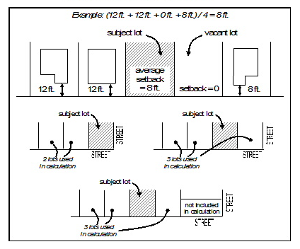
(3)
The following exceptions to the maximum front and street side building setbacks apply:
a.
Buildings taller than three stories may be set back farther than the maximum setback in order to accommodate design elements that preserve adequate sunlight distribution and airflow as required in Article 1351.01(I) below.
b.
A portion of the building may be set back from the maximum setback line in order to provide an articulated facade or accommodate a building entrance feature, provided that the total area of the space created must not exceed one square foot for every linear foot of building frontage.
c.
A building may be set back farther than the maximum setback in order to accommodate an outdoor eating area. In order to preserve the continuity of the street wall, the building may be set back no more than 12 feet from the front or street side property line; or, at least 40 percent of the building facade may not be located beyond the maximum setback line. The total area of an outdoor eating area that is located between a public sidewalk and the building facade may not exceed 12 times the building's street frontage in linear feet.
Graphic 1349.04.02: Exceptions to Minimum Front and Street Side Setbacks
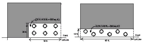
(4)
Minimum side setback: No interior side setbacks are required for the first floor. For floors above the first floor, interior side setbacks shall be sufficient to comply with applicable building codes.
(5)
Minimum rear setback: The minimum rear setback shall be ten percent of the lot depth or ten feet, whichever is greater.
(b)
The minimum setback for accessory structures on a lot shall be five feet from the rear property line and five feet from each side property line. No accessory structures are permitted within the front setback. With the exception of newspaper/periodical racks, parcel post drop boxes, and automatic teller machines, no vending machines (i.e. soft drink) or storage units (i.e. ice) are permitted within the front setback or on public right-of-way.
(Ord. No. 07-57, 11-6-2007)
Sec. 1349.05. - Building height.
(a)
The minimum height of a principal structure shall be two stories.
(b)
The maximum height of a principal structure, unless otherwise restricted by Article 1362 B-4NPOD, B-4 Neighborhood Preservation Overlay District, shall not exceed 120 feet, except as provided in Section 1363.02(a), Height Exceptions.
(c)
The maximum height of an accessory structure, unless otherwise restricted by Article 1362 B-4NPOD, B-4 Neighborhood Preservation Overlay District, shall not exceed 35 feet.
(Ord. No. 07-57, 11-6-2007)
Sec. 1349.06. - Floor area ratio (FAR).
The maximum FAR for all development in this district is 7.0. Area designed, constructed, and utilized to provide parking structure facilities shall be exempt from the maximum FAR.
(Ord. No. 17-09, 4-4-2017)
Sec. 1349.07. - Lot area per dwelling unit (residential density).
The minimum lot area per dwelling unit in this district is 300 square feet.
(Ord. No. 07-57, 11-6-2007)
Sec. 1349.08. - Parking and loading standards.
(a)
Off-street parking shall be provided in accordance with Article 1365, Parking, Loading and Internal Roadways for all Developments of Significant Impact within this district, unless otherwise restricted by Article 1362 B-4NPOD, B-4 Neighborhood Preservation Overlay District, except as follows:
(1)
Residential. Parking shall not be required for the first 22 occupants, as determined by the West Virginia State Building Code and adopted and implemented by the City, within permitted residential development. With the exception of the first 22 occupants, the minimum number of parking spaces for permitted residential uses shall be one-half a space per occupant, as determined by the West Virginia State Building Code and adopted and implemented by the City.
(2)
Nonresidential. Parking shall not be required for permitted nonresidential uses and development with a gross floor area of less than 15,000 square feet. The minimum number of parking spaces for permitted nonresidential uses shall be provided in accordance with Table 1365.04.01 "Minimum Off-Street Parking Requirements" for that gross floor area of 15,000 square feet and greater.
(3)
Movie theaters, as defined in this zoning ordinance.
(4)
Reduction in minimum required parking. The B-4 zoning district is characterized by businesses and mixed-uses that are well connected to pedestrian and public transit routes and are in close proximity to publicly provided parking facilities. In addition, the uses in the B-4 district are characterized by a mixture of primarily daytime and nighttime uses. For these reasons, the minimum parking requirements may be reduced somewhat in the B-4 district, as a conditional use, as provided in Section 1365.04, Determining the Number of Spaces Required.
(5)
Fee in-lieu-of parking. Reserved.
(6)
The Board of Zoning Appeals, with the recommendation of the Planning Commission, may permit as a conditional use alternate strategies (i.e. remote parking, etc.) to meet minimum off-street parking requirements provided the intent of this ordinance is observed and substantial justice done.
(b)
All on-site surface parking must be located to the rear of the principal building or otherwise screened so as to not be visible from public right-of-way or residential zoning districts.
(c)
Reserved.
(d)
Loading. Residential uses containing 30 or more dwelling units shall conform to the loading requirements set forth in Section 1365.10 as a "Type II use" (see Table 1365.10.01).
(Ord. No. 15-34, 6-2-2015)
Editor's note— Former subsection (c) hereof was removed by Ord. No. 16-42.
Sec. 1349.09. - Performance standards.
See Article 1351, Performance Standards for Buildings in the General Business (B-4) District.
(Ord. No. 07-57, 11-6-2007)
Sec. 1349.10. - Landscaping.
Landscaping and screening as required in Article 1367, Landscaping and Screening, shall be provided for all uses, unless otherwise noted.
(Ord. No. 07-57, 11-6-2007)
Sec. 1351.01 - Standards.
(a)
Chimneys, cooling towers, elevator bulkheads, fire towers, penthouses, stacks, tanks, water towers, transmission towers, or essential mechanical appurtenances, may be erected to any height not prohibited by other laws or ordinances.
(b)
The following regulations apply to private pedestrian walks, street furniture, and open space on private property.
(1)
All sidewalks, pedestrian walks, open space areas and recreation facilities shall be suitably paved or surfaced for their respective uses, landscaped with trees and/or shrubs and other appropriate plant materials, and provided with benches, trash receptacles, and lighting to coordinate with street furniture already in place.
(2)
Street furniture includes such items as benches, trash receptacles, ATM and telephone enclosures, vending boxes, planters, light standards, bollards, drinking fountains, and other similar improvements. Such furnishings should be integrated into the overall design of the streetscape, and new furnishing shall match existing examples already installed, where practical.
(3)
Where possible, the various elements should be clustered to eliminate visual clutter. Elements on poles, such as light standards, planters, traffic signs, and light should be installed in cluster to avoid forming unnecessary pedestrian barriers or conflicting with curb parking. When street furnishings or planting areas are added, sidewalks should be wide enough to accommodate both the improvement and pedestrian traffic.
(4)
Obstacles, such as obsolete signposts, parking meter standards, post or vending boxes, and other items no longer in use, should be removed from sidewalks, and any holes or other scars to the pavement repaired. Previous patching or repairs that do not match current paving should be replaced with materials that blend with the overall color, texture, and pattern of the pavement materials. Whenever possible, replace entire sidewalk segments.
(5)
Sidewalks are to have a safe and even walking surface, and areas that have settled or are otherwise damaged shall be repaired and/or replaced to provide an even and safe surface. Sidewalks that are replaced or repaired shall be constructed of material consistent with existing materials and shall be in conformity to the downtown comprehensive revitalization plan model. Any historic sidewalk paving material should be repaired and retained rather than replaced.
(c)
Private parking facilities shall comply with the following:
(1)
All parking areas shall be designed to City standards, with a hard paved, permanent surface such as asphalt, concrete, or pavers, and shall be properly lighted (minimum of two foot candles). All parking areas shall incorporate concrete curbs, gutters and adequate storm drain systems. Parking areas shall be designed with adequate ingress and egress from a public right-of-way or private street.
(2)
Points of potential conflict between pedestrian and vehicular traffic, such as crosswalks, parking lots, and alleys shall be clearly identified by a contrast in color and/or texture and /or material as appropriate. Parking spaces shall not be closer than 20 feet to such crossing.
(3)
Parking structures shall be designed with building-like facades and architectural context that will complement the scale, facades and materials found within the district. Where feasible, the design of parking structures shall incorporate street level retail or service uses to ensure pedestrian viability of the block.
(d)
Curb cuts. No part of a driveway leading from a public street shall be nearer than 35 feet to the street right-of-way line of any intersecting street, nor nearer than 30 feet to the end of a curb radius at an intersecting street, nor shall the driveway be nearer than 30 feet to any other part of another driveway entering a public street. The maximum width of any driveway leading from a public street shall not exceed 26 feet at the curb line or 22 feet at the street right-of-way line. Driveways that cross pedestrian walks shall be designated to allow for barrier free pedestrian travel.
(e)
Corner visibility. Where public rights-of-way intersect or where drives from parking lots enter a street or alley, a clear vision triangle is required as determined by the City Engineer.
(f)
Landscaping.
(1)
Any land not covered by buildings or pavement shall be suitably landscaped and maintained. Plans for treatment of landscape areas shall be submitted for approval in accordance with Article 1367.
(2)
For perennial plantings adjacent to public streets, street trees must be pruned sufficiently to allow pedestrian movement under the canopy. All perennial plant materials used shall meet the following criteria:
a.
Plants selected shall be tolerant of urban conditions, and with low/minimum maintenance.
b.
Plants selected shall be hardy species chosen on the basis of their height, form, color and visual interest.
c.
Plant materials should visually complement the building facades and public improvements.
d.
Plants selected should have deep root systems to avoid damage to road and sidewalk pavement.
(g)
Vacant lots.
(1)
Street frontages where vacant lots have been created as a result of building demolition shall be either fenced or landscaped to avoid "gaps" in the architectural or urban facades/streetscapes.
(2)
If the site is to be landscaped, a continuous evergreen shrub and/or tree screen shall be planted, with an installed minimum height of 36 inches.
(h)
Main Street Morgantown urban design guidelines. Aesthetic controls and specifications contained in the urban design guidelines, as adopted in City Code, may be used in evaluating a development proposal.
(i)
To minimize canyon effects created by tall structures, buildings taller than three stories shall incorporate design elements that preserve adequate light and airflow to public spaces including streets and sidewalks. Desired design elements include, but are not limited to, one or a combination of recessing or "stepping back" upper floors, increased front and/or street side setbacks while incorporating measures to preserve the continuity of the predominant street wall, etc. Site plan applications for buildings taller than three stories must include the following:
(1)
An air flow analysis conducted by a licensed architect or professional engineer, describing and illustrating the estimated impact of the proposed building on existing patterns of air flow in the general vicinity; and how those impacts may affect existing properties within a 300 foot radius of the site.
(2)
A sunlight distribution analysis conducted by a licensed architect or professional engineer, describing and illustrating the impact of the proposed building on sunlight distribution in the general vicinity, with special emphasis on predicting light blockage and shadow casting onto all properties within a 300 foot radius of the site.
(j)
Floor-to-floor heights and floor area of ground-floor space.
(1)
Floor-to-floor heights. All floor space provided on the ground floor of a building, regardless of use, must have a minimum floor-to-ceiling height of at least 11 feet.
(2)
Floor area of ground-floor space.
a.
The minimum standards for floor area of ground-floor space provided herein shall supersede Article 1331.06(20).
b.
The ground-floor of a mixed use building must contain the following minimum nonresidential component net floor area space:
1.
At least 800 square feet or 25 percent of the premises area, whichever is greater, on development sites with street frontage of less than 50 feet; or
2.
At least 20 percent of the premises area on development sites with 50 feet of street frontage or more.
c.
Floor area of enclosed off-street parking areas may not be counted toward meeting minimum nonresidential component space requirements.
(k)
Transparency.
(1)
A minimum of 60 percent of the street-facing building facade between three feet and eight feet in height must be comprised of clear windows that allow views of indoor nonresidential space or produce display areas.
(2)
The bottom edge of any window or product display window used to satisfy the transparency standard of subsection (k)(1) hereof may not be more than three feet above the adjacent sidewalk.
(3)
Product display windows used to satisfy these requirements must have a minimum height of four feet and be internally lighted.
(l)
Doors and entrances.
(1)
Buildings must have a primary entrance door facing a public sidewalk. Entrances at building corners may be used to satisfy this requirement.
(2)
Building entrances may include doors to individual shops or businesses, lobby entrances, entrances to pedestrian-oriented plazas, or courtyard entrances to a cluster of shops or businesses.
(m)
Solid waste. All new development shall, to the greatest extent feasible, provide sufficient area within the principal structure for the collection, storage, and removal of solid waste. Where internal areas are not feasible, external solid waste containment facilities shall be enclosed with masonry materials and an opaque gate. Said external facilities shall be designed so that they integrate with and compliment the architectural vocabulary of the principal structure.
(n)
Sidewalks and paths. Sidewalks and paths, as defined in Article 913 of this Code, shall be constructed in accordance with the requirements of Article 913 of this Code at each lot upon which a use is to be constructed. Where any sidewalk is required by the terms of this Part Thirteen, entitled "Planning and Zoning," excepting private walkways as governed by Section 1351.01(b), the sidewalk shall be constructed upon, or dedicated as, a public right-of-way. A path may be substituted for a sidewalk upon agreement of the property owner and City Council as provided in Article 913.
(Ord. No. 06-01, 1-3-2006; Ord. No. 07-57, 11-6-2007; Ord. No. 08-08, 3-4-2008; Ord. No. 09-14, 4-7-2009; Ord. No. 18-24, 7-10-2018; Ord. No. 21-09, 4-20-2021)
Sec. 1353.01.- Purpose.
The purpose of the Shopping Center (B-5) District is to permit a group of establishments to be planned, constructed and managed as a total entity. Typically, B-5 districts are located along major thoroughfares.
Sec. 1353.02. - Permitted and conditional uses.
See the Permitted Land Use Table 1331.05.01.
Sec. 1353.03. - Lot provisions.
(a)
The minimum lot size shall be 0.5 acre.
(b)
The minimum lot frontage shall be 60 feet.
(c)
The minimum lot depth shall be 100 feet.
(d)
Maximum lot coverage shall be 60 percent.
Sec. 1353.04. - Setbacks and encroachments.
(a)
The following setbacks shall be required for all principal structures, except as otherwise provided in Section 1363.02(b), Yard, Building Setbacks and Open Space Exceptions:
(1)
Minimum front setback: .....20 feet
(2)
Minimum side setback: .....30 feet
(3)
Minimum rear setback: .....30 feet
(b)
The minimum setback for accessory structures on a lot shall be five feet from the rear property line and five feet from each side property line. No accessory structures are permitted within the front setback.
(c)
On a corner lot, the front lot line shall be the lot line having the shortest dimension along the street right-of-way line.
Sec. 1353.05. - Building height and use.
(a)
The minimum height of a principal structure shall be 25 feet and the maximum height shall not exceed 75 feet, except as provided in Section 1363.02(a), Height Exceptions.
(b)
The maximum height of an accessory structure shall not exceed 25 feet.
Sec. 1353.06. - Parking and loading standards.
All uses within this district shall conform to the off-street parking and loading requirements in Article 1365, Parking, Loading and Internal Roadways.
Sec. 1353.07. - Performance standards.
(a)
All principal structures within a development should maintain a consistent architectural style.
(b)
Architectural metal paneling may be used for wall surfaces but shall not exceed 20 percent of any wall facing a public street.
(c)
Materials.
(1)
Walls shall be clad in stone, brick, marble, approved metal paneling, and/or cast concrete.
(2)
Roofs should be clad in slate, sheet metal, corrugated metal, and/or diamond tab asphalt shingles.
(d)
Techniques.
(1)
Windows should be set to the inside of the building face wall.
(2)
All primary entrance exterior doors should have rectangular recessed panels or glass.
(3)
All rooftop equipment that is enclosed should be enclosed in building material that matches the structure or is visually compatible with the structure.
(e)
Sidewalks shall be constructed in accordance with the requirements of Article 913 of this Code at each lot upon which a use is to be constructed.
(Ord. No. 21-09, 4-20-2021)
Sec. 1353.08. - Landscaping.
Landscaping and screening as required in Article 1367, Landscaping and Screening, shall be provided for all uses, unless otherwise noted.
Sec. 1355.01.- Purpose.
The purpose of the Industrial District (I-1) is to allow for the development of research and industrial parks, wholesale business, manufacturing and the like while ensuring the health and safety of Morgantown residents. Industrial districts are intended to be located on major thoroughfares where truck traffic does not disrupt local streets.
(Ord. No. 12-29, 7-3-2012)
Sec. 1355.02. - Permitted and conditional uses.
See the Permitted Land Use Table 1331.05.01.
(Ord. No. 12-29, 7-3-2012)
Sec. 1355.03. - Lot provisions.
(a)
The minimum lot size shall be two acres.
(b)
The minimum lot frontage shall be 60 feet.
(c)
The minimum lot depth shall be 100 feet.
(d)
Maximum lot coverage shall be 40 percent.
(Ord. No. 12-29, 7-3-2012)
Sec. 1355.04. - Setbacks and encroachments.
(a)
The following setbacks shall be required for all principal structures, except as otherwise provided in Section 1363.02(b), Yard, Building Setbacks and Open Space Exceptions:
(1)
Minimum front setback: .....50 feet
(2)
Minimum side setback: .....30 feet
(3)
Minimum rear setback: .....30 feet
(b)
The minimum setback for accessory structures on a lot shall be five feet from the rear property line and five feet from each side property line when abutting another I-1 District zoned property. No accessory structures are permitted within the front setback, or within the side setback along a public or private street. Where an I-1 district abuts another zoning district, a minimum setback of 30 feet shall be provided for the yard along the shared zoning district boundary line.
(c)
On a corner lot, the front lot line shall be the lot line having the shortest dimension along the street right-of-way line. The required side yard setback on the side facing a street shall be one and one-half times the normal side yard setback requirement.
(Ord. No. 12-29, 7-3-2012)
Sec. 1355.05. - Building height and use.
(a)
The maximum height of a principal structure shall not exceed 65 feet, except as provided in Section 1363.02(a), Height Exceptions.
(b)
The maximum height of an accessory structure shall not exceed 35 feet.
(Ord. No. 12-29, 7-3-2012)
Sec. 1355.06. - Parking and loading standards.
All uses within this district shall conform to the off-street parking and loading requirements in Article 1365, Parking, Loading and Internal Roadways.
(Ord. No. 12-29, 7-3-2012)
Sec. 1355.07. - Landscaping.
Landscaping and screening as required in Article 1367, Landscaping and Screening, shall be provided for all uses, unless otherwise noted.
(Ord. No. 12-29, 7-3-2012)
Sec. 1355.08. - Performance standards.
(a)
A light industry use is one which ordinarily uses only light machinery; is conducted entirely within enclosed substantially-constructed buildings; does not use the open area around such buildings for storage of raw materials or manufactured products or for any other industrial purpose and conforms to the following performance standards:
(1)
Smoke. No smoke is emitted of a density greater than No. 1 according to the Ringlemann's Scale, except that smoke of a density not in excess of No. 2 of Ringlemann's Scale shall be permitted for a period not in excess of six minutes in any hour.
(2)
Fly ash. No particles from any flue or smokestack shall be permitted to escape beyond the confines of the building in which it is produced.
(3)
Dust. No dust of any kind produced by the industrial operations shall be permitted to escape beyond the confines of the building in which it is produced.
(4)
Odor. No noxious or obnoxious odor of any kind shall be permitted to extend beyond the lot line.
(5)
Gases and fumes. No gases or fumes toxic to persons or injurious to property shall be permitted to escape beyond the building in which they occur.
(6)
Glare. No glare shall be seen from any street or any residential area.
(7)
Vibration. No intense earth shaking vibration shall be created or maintained by any industry beyond the property on which it is located.
(8)
Noise and sound. A maximum of 70 decibels at the property line is permitted. Noise is required to be muffled so as not to become objectionable due to intermittence, beat frequency or shrillness. Sound may equal but may not exceed street traffic noise in the vicinity during a normal day shift work period.
(9)
Exhaust control. Exhaust from any internal combustion engine or compressor, stationary or mounted on wheels, used in connection with any operation shall not be discharged into the open air unless it is equipped with an exhaust muffler, mufflers, or an exhaust box constructed of noncombustible materials designed and installed to sufficiently suppress disruptive noise and vibrations and prevent the escape of noxious or obnoxious gases or fumes. All such equipment shall be maintained in good operating condition according to manufacturer's specifications.
(b)
Heavy industry or heavy manufacturing use is one which requires both buildings and open area for manufacturing, fabricating, processing, extraction, heaving, repairing, dismantling, storage or disposal of equipment, raw materials, manufactured products or wastes and provided the use conforms to the following performance standards:
(1)
Smoke. No smoke is emitted of a density greater than No. 2 according to the Ringlemann's Scale, except that smoke of a greater density shall be permitted for a period not in excess of six minutes in any one hour.
(2)
Fly ash. No particles from any flue or smokestack shall exceed 0.3 grains per cubic foot of flue gas at a stack temperature of 500 degrees Fahrenheit.
(3)
Dust. No dust of any kind produced on the development site shall be permitted to escape beyond the limits of the property being used. Watering, wetting or other methods or materials must be used to control dust to adjacent properties. Watering, wetting, chemical suppression, or any other dust control measures which result in deposition of the dust control media and/or the captured dust upon the ground surface, or upon surfaces draining to the ground surface, shall be subject to regulation under City Code Article 929 "Stormwater Management and Surface Water Discharge Control" of the City of Morgantown.
(4)
Odor. No noxious or obnoxious odor of any kind shall be permitted to extend beyond the lot lines.
(5)
Gases and fumes. No gases or fumes toxic to persons or injurious to property shall be permitted to escape beyond the building in which they occur.
(6)
Glare. No glare shall be seen from any street or any residential area.
(7)
Vibration. No intense earth shaking vibration shall be created or maintained by any industry beyond the property on which it is located.
(8)
Noise and sound. A maximum of 70 decibels at the property line is permitted. Noise is required to be muffled so as not to become objectionable due to intermittence, beat frequency or shrillness. Sound may equal but not exceed street traffic noise in the vicinity during a normal day shift work period.
(9)
Exhaust control. Exhaust from any internal combustion engine or compressor, stationary or mounted on wheels, used in connection with any operation shall not be discharged into the open air unless it is equipped with an exhaust muffler, mufflers, or an exhaust box constructed of noncombustible materials designed and installed to sufficiently suppress disruptive noise and vibrations and prevent the escape of noxious or obnoxious gases or fumes. All such equipment shall be maintained in good operating condition according to manufacturer's specifications.
(10)
Perimeter landscaping and fencing. For the purpose of screening, buffering, and security, the following improvements shall be installed within 30 days after commencement of development.
a.
Landscaping. Where a heavy industry, heavy manufacturing, or extractive industry development site abuts a nonindustrial property (zoned or used) or public or private street, a 30-foot landscaping transitional yard shall be installed the length of said common border as follows:
1.
A ten-foot wide exterior landscaping transition area containing three to four medium to large trees and 15 to 20 evergreen shrubs per 100 linear feet.
2.
A 20-foot wide interior landscaping transition area containing parallel, staggered and/or concentric rows of evergreen trees or evergreen hedge planted eight to 12 feet on center per 100 linear feet.
3.
Trees shall have a minimum two-inch caliper and shrubs shall be at least three gallons in size.
b.
Fencing. A minimum ten-foot black vinyl-coated chain link fence must be erected the entire perimeter of a heavy industry, heavy manufacturing, or extractive industry development site between the landscaping transitional yards and the development site. Prominently displayed no trespassing signs are required on all four or more sides of the perimeter fencing.
Graphic 1355.08.01: Perimeter Landscaping and Fencing—Industry
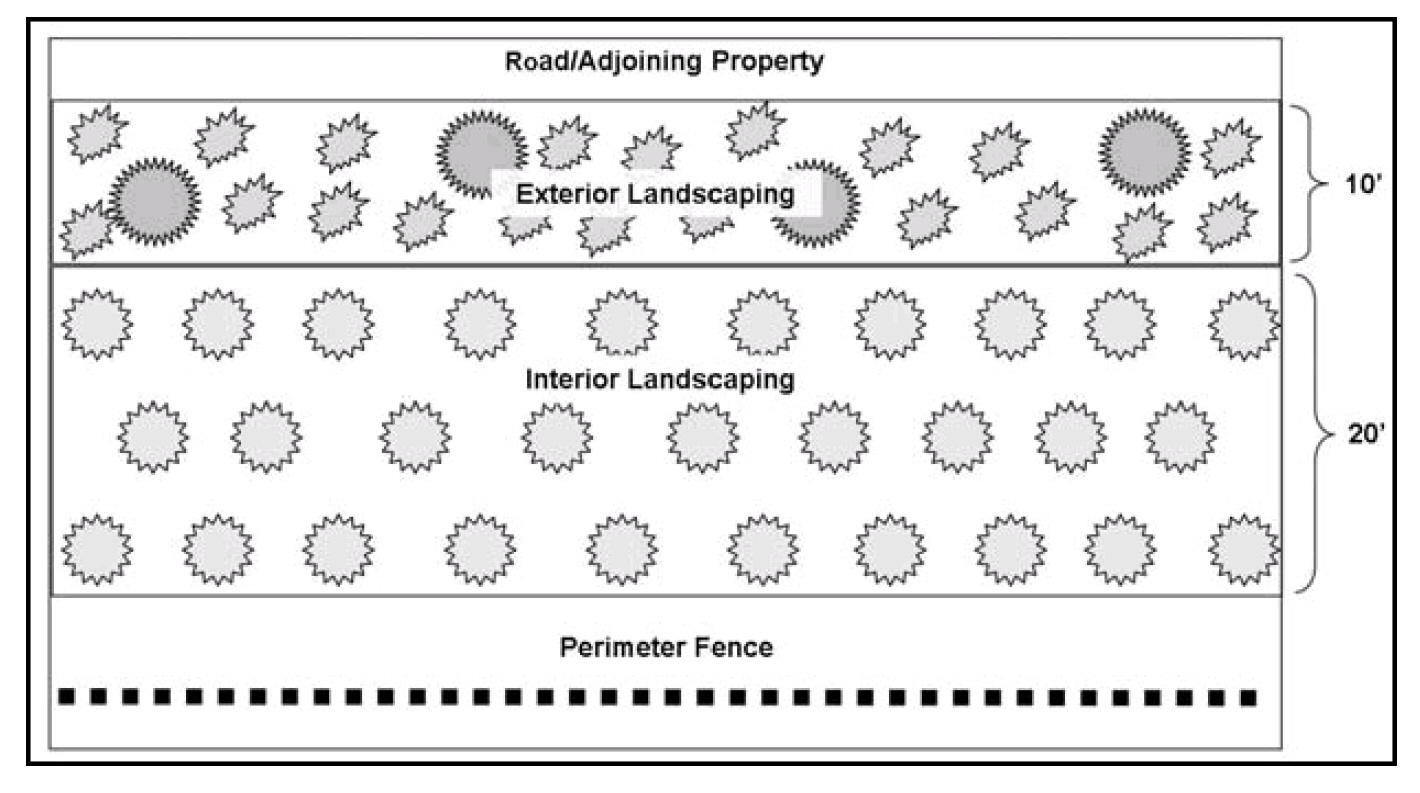
c.
Entrance gate specifications. All perimeter fences shall be equipped with at least one entrance gate. The gate shall meet the following specifications:
1.
Each gate shall be not less than 12 feet wide and be composed of two gates, each of which is not less than six feet wide, or one sliding gate not less than 12 feet wide. If two gates are used, gates shall latch and lock in the center of the span;
2.
The gates shall be provided with a combination catch and locking attachment device for a padlock, and shall be kept locked except when being used for access to the site; and
3.
The person in charge of the development site must provide the Morgantown Fire Department with a Knox Padlock or Knox Box entry system or equivalent on the gate to access the site in case of an emergency.
d.
Administrative adjustment. The Planning Director may approve administrative adjustments to the perimeter landscaping and fencing design if it is found that the adjustments:
1.
Are consistent with the spirit and intent of the landscaping and fencing requirements; and
2.
Will not adversely affect the proposed development, use of adjacent property or neighborhoods, or obstruct sight lines at intersections; and
3.
Are necessary to accommodate an alternative or innovative design that achieves to the same or better degree the objective of the landscaping and fencing standard to be modified.
(11)
Signage. For development that involves the use, storage, or generation of highly flammable, toxic, explosive, or hazardous materials, the following signage shall be provided as approved or designated by the City Fire Marshal.
a.
Prominently displayed permanent weatherproof retroreflective signs reading "DANGER NO SMOKING OR OPEN FLAME ALLOWED" shall be posted upon completion of the perimeter fencing at the entrance gate(s) or in any other appropriate location. Sign lettering shall be at least four inches in height and shall be red on a white background or white on a red background.
b.
Prominently displayed permanent weatherproof labels must be located on each tank containing highly flammable, toxic, explosive, or hazardous materials indicating the exact chemicals that are contained in the tank. Sign lettering shall be at least six inches in height, contrasting with the background color.
(12)
Waste disposal. All waste and hazardous materials used, stored, or generated by the development may only be discharged into above-ground and/or axle-mounted tanks. Waste materials shall be removed from the site and transported to an approved and permitted off-site disposal facility no less frequently than every 30 days. Wastewater stored in on-site above-ground and/or axle-mounted tanks shall be removed as necessary, except:
a.
Domestic sanitary sewage shall be discharged to a public sanitary sewer, as required under City Code Article 921 "Sewer Regulations" of the City of Morgantown. Such discharge shall conform to the rules and regulations of the Morgantown Utility Board; and
b.
Certain limited process/industrial waste may be discharged to the public sanitary sewer, but only as allowed and regulated under City Code Article 923 "Industrial Wastes" of the City of Morgantown. Any such allowed industrial discharge shall conform to the rules and regulations of the Morgantown Utility Board.
c.
Any liquid, or semi-liquid, waste not characterized as domestic sanitary sewage or as allowed industrial discharge, as described in items (a) and/or (b) above, shall be disposed of as herein provided above.
(13)
Security. At all times, the development site shall have a minimum of one security camera mounted inside the perimeter fencing. Signs shall be posted on the fence or wall of the site to indicate that activity on the site may be recorded by video surveillance. Camera systems shall be maintained in proper operating condition and shall be designed and located to meet the following requirements:
a.
Capture clear video images (day and night) of all traffic entering and exiting the gate(s).
b.
Be equipped with motion detection technology.
c.
Be equipped with panning technology to pan immediately to any motion detected at or near the gate(s).
d.
Show the date and time of all activity on the footage.
e.
Be capable of being viewed at the monitoring facility.
The person in charge of the development site shall maintain video data for a period of five business days. At the request of City law enforcement officials, the person in charge of the development shall make available recorded footage required herein.
(14)
Storage of equipment. On-site storage of equipment is prohibited on the development site except when servicing on-going operations. No vehicle or item of machinery shall be parked or stored on any public street, right-of-way or in any development site driveway entrance which constitutes a fire hazard or an obstruction to or interference with fighting or controlling fires except that equipment which is necessary for the operations of the development site. The Morgantown Fire Department shall be the entity that determines whether equipment on the site constitutes a fire hazard.
(15)
Private roads and driveway entrances. Prior to the commencement of development, all private roads and driveway entrances to the development site shall be at least 24 feet wide and have an overhead clearance of at least 14 feet. At a minimum, the road shall be surfaced with bituminous surface treatment (e.g., chip seal), however asphalt and concrete paving are preferred. Roads shall not be surfaced with gravel or caliche. All private roads shall have a concrete drive approach constructed in accordance with City design standards. In particular cases these requirements governing surfacing of private roads may be altered at the discretion of the City Engineer after consideration of all circumstances including, but not limited to, the following: Distances from public streets and highways; distances from nonindustrial property (zoned or used); topographical features; nature of the soil; and, exposure to wind.
(c)
An extractive industry use involves the extraction of minerals, including solids, such as coal and ores; liquids, such as crude petroleum; and gasses, such as natural gasses. In addition to the heavy industry or heavy manufacturing use performance standards provided in Section 1355.08(b), extractive industry uses shall conform to the following performance standards:
(1)
Minimum area. The tract of land on which an extractive industry use is to be developed must have a minimum area of five acres.
(2)
External setbacks. An extractive industry development must be a distance, calculated from the outermost boundary of its development site in a straight line without regard to intervening structures or objects, of no less than:
a.
Six hundred twenty-five feet from the R-1, R-1A, R-2, R-3, and PUD districts.
b.
Six hundred twenty-five feet from the property boundary on which the following protected uses exist:
1.
A dwelling unit located within any zoning district other the R-1, R-1A, R-2, R-3, and PUD districts.
2.
A church or place of worship.
3.
A hospital.
4.
A public or private school (K-12).
5.
A day care facility.
6.
A park.
c.
One hundred feet from the one percent (100-year) floodplain.
d.
One thousand feet from the Morgantown Utility Board public water supply intake.
e.
One thousand feet from the one percent (100-year) floodplain of the Monongahela River south or upstream of the Morgantown Lock and Dam.
(3)
External setback exception. With variance approval by the Board of Zoning Appeals, the external setbacks provided in paragraph b. above may be reduced to not less than 300 feet when there is the written consent of 60 percent of the surface property owners within the external setback exception radius area between 300 feet and 625 feet around said extractive industry development site. In the event such consent is not obtained, and upon providing evidence of an attempt to obtain written consent of 60 percent of the surface property owners, then the distance may be reduced to not less than 300 feet with variance approval by the Board of Zoning Appeals. For protection of the public health, safety and welfare, the Board of Zoning Appeals may impose additional requirements for a reduction of such distance, and take into account the presence of natural or man-made barriers.
a.
External setback exception applicants shall adhere to the following written consent or objection verification methodology:
1.
A consent/objection form provided by the Planning Department shall be used by the applicant to obtain consent or objection from all surface property owners as described above. Only one consent/objection form may be obtained from each property owner. Said form shall at a minimum include the name and contact information of the applicant and the operator; a description of the proposed extractive industry development; a map illustrating the location and extent of the proposed extractive industry development site and the external setback exception radius area; the name and address of the surface property owner; the tax map and parcel number(s) owned by the individual surface property owner; and, signature lines to provide written consent or objection by the individual surface property owner.
2.
The applicant shall submit to the Planning Department a complete list of the names and addresses of all property owners for parcels that are, in whole or in part, within 625 feet of the proposed extractive industry development site. Such information shall be obtained from the Monongalia County Assessor's Office.
3.
The applicant shall be responsible for sending by certified mail the consent/objection form described above to all property owners with the radius of 300 feet and 625 feet around the proposed extractive industry development site.
4.
For those surface property owners for which consent or objection is not obtained on the form described above, evidence of an attempt to obtain same shall be provided by returned unopened certified mailings and/or certified mail receipts. Certified unopened mailings returned due to incorrect address shall not be sufficient evidence of an attempt to obtain consent or objection.
b.
Applicants seeking a reduction of the external setback shall submit all obtained consent/objection forms, returned unopened certified mailings, certified mail receipts, and a summary sheet of the results of the effort to obtain written consent or objection from all of the surface property owners within the external setback exception radius area. The summary sheet shall include at a minimum the following:
1.
A map illustrating the location of the proposed extractive industry development site and the external setback exception radius area.
2.
Total number of properties within the external setback exception radius area.
3.
Total number of property owners within the external setback exception radius area.
4.
Total number of consenting property owners within the external setback exception radius area.
5.
Total number of objecting property owners within the external setback exception radius area.
6.
Total number of nonresponsive property owners within the external setback exception radius area.
7.
Total number of returned unopened certified mailings.
8.
Total number of certified mail receipts.
9.
Total number of obtained consent/objection forms.
c.
Applicants shall use ethical methods to obtain written consent/objection forms. The Board of Zoning Appeals should reject an external setback exception variance request if it finds that there is evidence of coercion, deception, compensation, or similar ethical misconduct on behalf of the applicant seeking a reduction of the external setback.
d.
Pursuant to Section 1381.03(e), at least ten days prior to the Board of Zoning Appeals hearing on the external setback exception variance approval, the applicant shall notify all owners of property within 625 feet of the public hearing by mail.
(4)
Signage. A sign shall be prominently displayed at the perimeter gate(s) enclosing the development site. Such sign(s) shall be durable weatherproof material, maintained in good condition and, unless otherwise required by the City, shall have a surface area of not less than two square feet nor more than four square feet and shall be lettered with the following:
a.
Mine, quarry, or well name and number.
b.
Name of operator.
c.
The emergency 911 number.
d.
Telephone numbers of two persons responsible for the extractive industry site who may be contacted in case of emergency.
(5)
Water impoundment. Freshwater impoundments are permitted on extractive industry development sites. Freshwater impoundments may be earthen impoundments or semi-portable axle-mounted above-ground storage tanks.
a.
Freshwater storage shall be prevented from putrefaction and/or becoming a mosquito breeding habitat.
b.
Freshwater earthen pits shall be securely enclosed by a six-foot tall black vinyl-coated chain link fence.
(6)
Secondary containment. Secondary containment using existing best practices shall be required for all equipment and storage facilities; be capable of containing a release of no less than 125 percent of the total combined volume of all storage containers; and, have a freeboard of no less than eight inches. In addition, for oil and gas extraction development, an earthen perimeter berm of not less than two feet shall be developed around the entire development site and meet at a minimum the following standards:
a.
The earthen perimeter berm shall confine a containment volume of no less than 125 percent of the total combined volume of all liquids utilized in the preparation, drilling, and completion of the well.
b.
The areas confined within the secondary containment facilities, and within the earthen perimeter berm, including the walls of the secondary containment facilities and the earthen berm, shall all be covered by a synthetic impermeable liner. Joints and seams within said liner shall be chemically or thermally fused so that it serves as a single, continuous unit.
c.
Access roadways into the development site shall be configured and designed in such a way as to not compromise the containment integrity of the perimeter earthen berm.
(7)
Waste disposal.
a.
Portable closed steel storage tanks must be used for storing liquid hydrocarbons. Tanks must meet American Petroleum Institute (API) standards. All tanks must have a vent line, flame arrester, and pressure relief valve. No tank battery shall be within 100 feet of any combustible structure.
b.
Drilling mud, cuttings, liquid hydrocarbons, flowback, produced water, and all other field waste derived or resulting from or connected with extraction shall only be discharged into above-ground axle-mounted tanks (closed loop mud and closed loop fracking system).
c.
Waste materials shall be removed from the site and transported to an off-site disposal facility no less frequently than every 30 days. Wastewater stored in on-site tanks shall be removed as necessary.
d.
All waste disposal shall be documented using manifest procedures. The manifests shall record the complete chain of custody from the retrieval at the development site to the ultimate disposal location, for all volumes/units of waste generated and removed from the development site. All such documentation shall be provided to the City of Morgantown and/or the Morgantown Utility Board upon their request.
(8)
Gas emission or burning. As a temporary and necessary safety function of the extractive industry operation, venting or burning by open flame (e.g., flaring) is exempt from light and glare regulations as required in this article and acceptable under the following conditions:
a.
No person shall allow, cause, or permit gases to be vented into the atmosphere or to be burned by open flame except as allowed by applicable State and Federal laws, rules, and regulations.
b.
Such venting or open flame shall not be located closer than 300 feet from any building not used in development site operations. Every reasonable effort should be made to screen such venting or open flame in such a way as to minimize detrimental effects to adjacent property owners.
c.
In order to ensure community awareness and security, the following notifications must be provided by the operator before any temporary burning or flaring activity is to begin:
1.
At least ten calendar days, public educational press release and advance notice sent to all primary local news media outlets.
2.
At least five calendar days, published notice in a local newspaper of general circulation.
3.
At least 72 hours, written notification to the City Fire Chief and MECCA 9-1-1.
d.
Flaring or burning of gas or petroleum of any kind after an oil or gas well is in production is prohibited.
(9)
Security. In addition to the standards provided in Section 1355.08(b)(13) above, camera systems shall be designed and located to meet the following requirements:
a.
Be equipped to capture clear video images (day and night) of all production equipment located on the site.
b.
Be equipped with panning technology to pan immediately to any motion detected at or near production equipment located on the site.
(10)
Cleanup and maintenance.
a.
With the exception of freshwater, any spill, leak, or malfunction resulting in five gallons or more shall be reported within 24 hours to the Morgantown Utility Board and the West Virginia Department of Environmental Protection. Regardless of the amount of fluid resulting from the spill, leak, or malfunction, the operator shall remove or cause to be removed all waste materials from any public or private property affected by such spill, leak, or malfunction. Clean-up operations must begin immediately.
b.
The 24-hour reporting period provided in item (a) above shall apply to discharges occurring within a containment area of the development site. For any discharge which occurs outside of a containment area, the Morgantown Utility Board and the West Virginia Department of Environmental Protection shall be notified immediately.
c.
Rainfall onto the development site for which containment barriers are required shall be captured by the required containment barriers and be collected and disposed of as is required for spilled wastes, except the occurrence of rainfall shall not require report notification to the Morgantown Utility Board and/or the West Virginia Department of Environmental Protection. Rainfall may not be left to undermine the capability of secondary containment to contain a release of no less than 125 percent of the total combined volume of all storage containers.
d.
The development site and public space within 100 feet shall at all times be kept free of debris, pools of water or other liquids, contaminated soil, weeds, brush, trash, or other waste material.
e.
Oil and gas extraction development. After well drilling has been completed and the well is either producing or temporarily plugged for later production and delivery to market, the operator shall clean the drill site, remove derrick(s) and all appurtenant equipment thereto, complete interim restoration activities, and repair all property damage caused by such operations within 90 days.
(11)
Site restoration. Within six months following the abandonment of an extractive industry development site, including permanent well plugging, the operator shall be responsible for the restoration of the development site to its original condition as nearly as practicable. Abandonment shall be approved by the City Engineer after restoration of the development site has been accomplished in conformity with the following requirements at the discretion of the City Engineer:
a.
All production, derricks, tanks, towers, and other appurtenant surface equipment and installations shall be removed from the development site.
b.
All concrete foundations, piping, wood, guy anchors and other foreign materials regardless of depth, except surface casing, shall be removed from the development site, unless otherwise directed by the City.
c.
All holes and depressions shall be filled with clean, compactable soil.
d.
All waste, refuse or waste material shall be removed from the development site.
(d)
Provisions and exceptions to light industrial and industrial uses.
(1)
Parking space requirements may be waived by the Board of Zoning Appeals where 50 percent or more of the area in a block was occupied by business or industrial structures at the time of passage of this article.
(2)
One-half of an alley abutting the rear of a lot may be included in the rear yard, but such alley space shall not be included for loading and unloading berths.
(3)
Chimneys, cooling towers, elevator bulkheads, fire towers, penthouses, tanks, water towers, transmission towers, derricks or essential mechanical appurtenances may be erected to any height not prohibited by other laws or ordinances.
(e)
Supplementary regulations.
(1)
There shall be one principal entrance to the industrial site from any major thoroughfare bordering the tract, which shall be designed so that traffic at its intersection with the major thoroughfare may be controlled and so that there will be adequate storage space for traffic destined to enter the thoroughfare or to leave the industrial site.
(2)
There shall be direct entrances or exits from parking areas or structures onto the adjoining major thoroughfare, but a service drive parallel to the main traffic-way may be provided for such access. Traffic on the service drive shall enter the main traffic-way via the principal entry.
(3)
The owner or owners shall provide a plan for the installation of adequate facilities for the disposal of human and industrial wastes meeting the approval of the State Department of Health.
(4)
The owner or owners of the site shall establish in the restrictions, which are a part of the plot for the subdivision, a perpetuating organization for the maintenance of the industrial site, such as roads and planting areas, the approval of building plans and other improvements, and the future maintenance of the site.
(5)
Sidewalks shall be constructed in accordance with the requirements of Article 913 of this Code at each lot upon which a use is to be constructed.
(Ord. No. 12-29, 7-3-2012; Ord. No. 21-09, 4-20-2021)
Sec. 1357.01.- General provisions.
The purpose of the planned unit development is to encourage flexibility in the development of land in order to promote its most appropriate use; to improve the design, character and quality of new developments; to encourage a harmonious and appropriate mixture of uses and/or housing types; to facilitate the adequate and economic provision of streets, utilities and City services; to preserve critical natural environmental and scenic features of the site; to encourage and provide a mechanism for arranging improvements and sites so as to preserve desirable features; and to mitigate the problems which may be presented by specific site conditions. It is anticipated that planned unit developments will offer one or more of the following advantages:
(a)
Serve to implement the goals, objectives, and strategies of the Morgantown comprehensive plan specific to the district or neighborhood in which the PUD is to be located;
(b)
Apply the design principles of new urbanism, neo-traditionalism, and other emerging smart growth principles, urban development patterns and best management practices;
(c)
Promote development patterns that maximize compatibility of differing adjacent land uses to avoid the necessity of extensive buffering;
(d)
Enhance the appearance of neighborhoods by conserving areas of special natural beauty, steep slopes, ecological importance, flood prone areas, and natural green spaces where appropriate, while understanding that land within urban areas is best suited for urban densities and development patterns;
(e)
Counteract poor urban design and mitigate congestion on streets;
(f)
Promote architecture that is compatible with the community vernacular, and/or the surroundings;
(g)
Promote design principles that allow differing types of land uses to coexist while preserving property values and minimizing potential negative consequences;
(h)
Promote appropriate urban densities that will help make alternative forms of transportation economically and socially feasible; and
(i)
Promote and protect the environmental integrity of the site and its surroundings by providing suitable design responses to the specific environmental constraints of the site and surrounding area.
Sec. 1357.02. - Requirements for planned unit development.
A planned unit development is an area under single ownership or control to be developed in conformance with an approved development plan, consisting of: 1) a map showing the development area and all proposed improvements to the development area; 2) a text which sets forth the uses and the development standards to be met; and 3) exhibits setting forth any aspects of the development plan not fully described in the map and text. The map, exhibits, and text constitute a development plan. The uses and standards expressed in the development plan constitute the use and development regulations for the planned unit development site in lieu of the regulations for the underlying district.
(a)
The area designated in the planned unit development map must be a tract of land at least two acres in size and under single ownership or control, except in the area of the City bounded by Campus Drive/Stewart Street on the south, Eighth Street on the north, and the Monongahela River on the west. To the east, the area is bounded by Jones Avenue from Stewart Street to Highview Place, then continuing along Highview Place to its end, then continuing westward to University Avenue, following University Avenue to its intersection with Eighth Street. Inside this area, commonly known as Sunnyside, planned unit developments may contain not less than one acre of land under single ownership or control. The property contained within a planned unit development should be under single ownership and control. However, multiple ownership is permissible provided that all owners are co-applicants for the planned unit development designation. In cases of multiple ownership, covenants and agreements shall be executed that provide for the identification of one person or corporation responsible for representing the application and having the authority to act as agent for all owners for all aspects of the planned unit development process. Such agreements shall accompany the application for planned unit development designation.
(b)
The outline plan shall indicate the land use, development standards, and other applicable specifications of the zoning ordinance of Morgantown, West Virginia, which shall govern the planned unit development. If the outline plan is silent on a particular land use, development standard, or other specification of the zoning ordinance, the standard of the underlying district or the applicable regulations shall apply.
(c)
The planned unit development map shall show the location of all improvements. The location of planned unit developments shall be designated on the zone map and adopted pursuant to rules and regulations governing amendments of the zoning ordinance.
(d)
The planned unit development must comply with all required improvements, construction standards, design standards, and all other engineering standards adopted and enforced by the City of Morgantown, and any other pertinent regulations, except where specifically varied through the provisions of this section of the zoning ordinance.
(e)
Designation and conveyance or ownership of permanent open space.
(1)
Definition. Permanent open space shall be categorized as one of two types:
a.
Improved open space is defined as parks, playgrounds, swimming pools, ball fields, plazas, landscaped green spaces, and other areas that are created or modified by man. At least 30 percent of the total permanent open space in any given planned unit development shall be of the improved open space type.
b.
Natural open space is defined as areas of natural vegetation, water bodies, or other landforms that are to be left undisturbed. Creation of a graded and surfaced walking trail through areas of natural open space shall constitute disturbance of the area in the amount of the length of the walking trail multiplied by its width. Neither definition of open space shall include schools, community centers or other similar areas in public ownership.
(2)
Designation. Within all planned unit developments, a minimum of ten percent of the proposed planned unit development area shall be designated as permanent open space. No plan for a single- or multi-family residential planned unit development shall be approved unless such plan provides for permanent landscaped or natural open space.
(3)
Proximity.
a.
In the case of mixed-use planned unit developments, permanent open space shall be allocated to the property in proportion to the uses assigned to the planned unit development and shall be located within reasonable proximity (within one-quarter of a mile) to those uses. Provided, however, the permanent open space need not be located in proximity to the use in the case of preservation of existing features.
b.
In the case of mixed-use planned unit developments located within the boundaries of the Sunnyside neighborhood, permanent open space may be located within reasonable proximity (within one-quarter of a mile) of the PUD with the approval of City Council. As an alternative, a payment in lieu of the open space provision may be made to the City for the purchase or provision of permanent open space on a separate parcel within one-quarter of a mile of a Sunnyside PUD.
(4)
Proportion. If the outline plan provides for the planned unit development to be constructed in stages, open space must be provided for each stage of the planned unit development in proportion to that stage.
(5)
Conveyance. Permanent open space shall be conveyed in or owned by one of the following forms:
a.
To a municipal or public corporation; or
b.
To a nonprofit corporation or entity established for the purpose of benefiting the owners and tenants of the planned unit development or, where appropriate and where approved by the Municipal Planning Commission and the City Council, adjoining property owners, or both. All conveyances hereunder shall be structures to insure that the grantee has the obligation and the right to affect maintenance and improvement of the common open space; and that such duty of maintenance and improvement is enforced by the owners and tenants of the planned unit development and, where applicable, by adjoining property owners; or
c.
To owners other than those specified in subsections a. and b. above, and subject to restrictive covenants describing and guaranteeing the open space and its maintenance and improvement, running with the land for the benefit of residents of the planned unit development or adjoining property owners, or both; or
d.
Included in single-family residential lots under the individual control of lot owners.
(6)
Uses permitted in a planned unit development may be any use that is found in the zoning ordinance in any district, subject to the approval of the Municipal Planning Commission and City Council. However, the City reserves the right to require that a PUD consist of only residential uses when circumstances warrant. Examples of such circumstances may include, but are not limited to: Significant infrastructure constraints that could cause practical difficulties in supporting nonresidential uses, the character and land use pattern of surrounding neighborhoods, and possible deleterious changes in traffic circulation patterns in the immediate area. A developer may also initiate a request to limit his or her PUD to residential uses.
(f)
For purposes of determining overall project size, two or more parcels of land owned by the applicant that are wholly or partially separated by a public street or other right-of-way may be considered contiguous and thus may be counted in fulfilling the minimum acreage requirement, provided that the use and development of the property is incorporated into, and is an integral part of the project plans; and provided that there is no other property not owned by the applicant separating the parcels in question. Where there is uncertainty in determining a parcel's qualification to be included in the PUD, the Planning Commission shall resolve the issue and make a determination as to the project boundaries, after considering the advice of the Planning Director and the request by the applicant.
Sec. 1357.03. - Procedure for approval of planned unit development.
(a)
Introduction. Applications shall be accompanied by all plans and documents required by Section 1357.02. A three-step application process shall be used. The steps in the process are:
(1)
Pre-application conference;
(2)
Outline plan approval; and
(3)
Development plan approval.
(b)
Pre-application conference. Prior to filing a formal application for approval of a planned unit development, the applicant shall schedule a pre-application conference with the Planning Director. The purposes of the pre-application conference shall be to:
(1)
Allow the applicant to present a general concept and to discuss characteristics of the development concept in relation to adopted municipal plans and policies.
(2)
Allow the Planning Director to inform the applicant of pertinent policies, standards and procedures for the planned unit development.
(3)
The pre-application conference is intended only for the above purposes; neither the developer nor the City of Morgantown is bound by any decision made during a pre-application conference.
(c)
Procedure for outline plan approval. Based upon the pre-application conference, the applicant shall develop and submit an outline plan for the proposed planned unit development.
(1)
The outline plan and application for the planned unit development shall be submitted to the Planning Director who, after certifying the application package to be complete, shall initiate a review of the proposed development.
(2)
The application and the results of the review shall then be forwarded to the Municipal Planning Commission for its consideration, public hearing and recommendations together with the Planning Department's report and such other documents as may be pertinent to the planned unit development.
(3)
The Municipal Planning Commission shall hold a special ward meeting in the ward where the proposed project is located. If the project crosses ward boundaries, the meeting shall be held in the ward where the majority of the property is located. The hearing shall be conducted at least seven days prior to the regularly scheduled Planning Commission meeting at which the formal public hearing will be held. The Planning Department will place an advertisement in the newspaper specifying the time and location of the ward meeting, at least five days prior to meeting.
(4)
Where there are environmentally sensitive features on the site or the development plan is expected to be complex, or there are other important planning implications involved, the Municipal Planning Commission may reserve the right to review the development plan. And, where the Municipal Planning Commission recommends denial of an outline plan and the City Council approves the plan, the Municipal Planning Commission shall review the development plan.
(5)
Upon completion of its review, the Municipal Planning Commission shall forward the application to the City Council with:
a.
A favorable recommendation;
b.
An unfavorable recommendation; or
c.
No recommendation.
(d)
Effect of approval of outline plan.
(1)
When an outline plan for a planned unit development has been approved by the City Council, the plan shall become effective and its location shall be shown on the zone map. The zone map shall be amended to designate the site as a planned unit development (PUD).
(2)
Upon such amendment of the zone map, the use and development of the site shall be governed by the planned unit development outline plan, subject to approval of a development plan.
(3)
No permit of any kind shall be issued until the development plan has been approved.
(4)
Development plan.
a.
Purpose of development plan approval. The purpose of the development plan is to designate the controls for development of the planned unit development. The development plan shall show the exact location of each building and improvement to be constructed and a designation of the specific internal use or range of uses for each building.
b.
Time limit for approval of development plan. The development plan shall be submitted to the Planning Department not more than 18 months following City Council approval of the outline plan. The outline and development plans may be submitted as a single plan if all requirements of Section 1357.02 are satisfied. The development plan may be submitted and approved in stages, with each stage representing a portion of the outline plan, at the discretion of the Municipal Planning Commission. The time limit for submitting each stage for approval may be set forth in the outline plan, in which case that schedule shall control the timing of development, rather then the time period contained in this paragraph. The Municipal Planning Commission may extend the time for application for approval of development plan for good cause, consistent with the purposes of the zoning ordinance.
c.
Expiration of time limit. Periodically, the Planning Director shall report to the Municipal Planning Commission on planned unit developments with time limits that have expired. The original applicants or current developers of the planned unit development shall be notified by the Planning Director. The Municipal Planning Commission shall determine whether to consider extending the time or to initiate action to amend the zone map so as to rescind the planned unit development designation.
d.
Relationship of development and outline plan. The development plan shall conform to the outline plan as approved.
e.
Procedure for approval of a development plan. The applicant must have the development plan approved prior to issuance of any building permit.
1.
Development plan submission. The development plan and supporting data shall be filed with the planning staff.
2.
Review. The Planning Director shall review the development plan to include site plan review, in accordance with the requirements of the zoning ordinance.
3.
Staff approval. It shall generally be the responsibility of staff to review development plans unless the Municipal Planning Commission reviews the development plans, or where no development plan is required.
4.
Municipal Planning Commission review. If the Municipal Planning Commission has retained development plan approval authority, the Municipal Planning Commission shall hold a public hearing in accordance with its rules and regulations for amendments. The Commission may:
(A)
Approve;
(B)
Deny; or
(C)
Approve with modifications.
f.
Expiration of development plan. The development plan shall expire two years after approval, unless grading and/or building permits have been obtained and are still current and valid on that date. This rule shall also apply to each stage of a development plan approved in stages. The applicant may request, in writing, an extension of time, and the approving authority may extend the time limit where deemed appropriate. Such extension may be considered at the time of development plan approval.
g.
Effect of approval of development plan. No permit of any kind shall be issued for any purpose within a planned unit development except in accordance with the approved development plan, and after acceptance by the City of Morgantown of all required guarantees for improvement.
Sec. 1357.04. - Specific content of plans.
Planned unit development plans and supporting data shall include all documentation listed in this section of the Code unless certain documentation is deemed superfluous by the Planning Director due to the specific circumstances of the particular request.
(a)
Pre-application conference requirements.
(1)
A written letter of intent from the applicant describing the applicant's intention for developing the site.
(2)
A scaled drawing of the site, in simple sketch form, showing the proposed location and extent of the land uses, major streets, and the approximate location of any existing easements, natural features, and topographic or geologic constraints.
(b)
Outline plan requirements. A drawing of the proposed planned unit development shall be prepared at scale not less than one inch equals 50 feet, or as considered appropriated by the Planning Director, and shall show in concept major circulation; generalized location and dimensions of buildings, structures, and parking areas; open space areas, recreation facilities, and other details to indicate the character of the proposed development. The submission shall include:
(1)
A site location map.
(2)
Map data such as north point, scale and date of preparation.
(3)
The name of the proposed development, with the words "Outline Plan" in the title block.
(4)
Boundary lines and acreage of each land use component.
(5)
Existing easements and rights-of-way, including location, width and purpose.
(6)
Existing land use on abutting and adjacent properties.
(7)
Other conditions on adjoining land: Topography (at two-foot contour intervals) including any embankments or retaining walls; use and location of major buildings, railroads, power lines, towers and other influences; name of any adjoining subdivision plat.
(8)
Existing streets on and adjacent to the tract, including street name, right-of-way width, walks, curbs, gutters, culverts and drainage ways.
(9)
Proposed public improvements: streets and other major improvements planned by the public for future construction on or adjacent to the tract.
(10)
Existing utilities on the tract.
(11)
Any land on the tract within FIRM Zone A; and/or A-E (the 100-year floodplain) and/or floodway.
(12)
Other conditions on the tract, including water courses, wetlands, sinkholes, wooded areas, isolated trees six inches or more in diameter, existing structures and other significant features.
(13)
Existing vegetation to be preserved and the locations, nature, and purpose of proposed landscaping.
(14)
A master plan for types, quantities and maximum square footage allotments for all signs proposed to be placed within the development, including illustrations of proposed sign types.
(c)
Miscellaneous. The Planning Director shall inform the applicant of any additional documents or data requirements after the pre-application conference. The developer must submit 18 copies of any page of any portion of the plan that exceeds 11 inches by 17 inches in size. If fewer copies than required are submitted, the Planning Director shall deem the application to be incomplete and shall not schedule hearing dates until the situation is resolved.
(d)
Written statement of character of the planned unit development. An explanation of the character of the planned unit development and the reasons why it has been planned to take advantage of the flexibility of these regulations. The written statement shall include:
(1)
Objectives. A specific explanation of how the proposed planned unit development meets the objectives of all adopted land use policies which affect the land in question.
(2)
Ownership. A statement of present and proposed ownership of all land within the project including the beneficial owners of a land trust.
(3)
Scheduling. Timing of proposed development indicating:
a.
Stages in which the project will be built, including the area, density, use, public facilities, and open space to be developed with each stage. Each stage shall be described and mapped; and
b.
Projected dates for beginning and completion of each stage of land development.
(4)
Proposed uses.
a.
Residential uses: Type, gross area, architectural concepts (narrative, sketch, or representative photo), number of units, bedroom breakdown, and proposed occupancy limits for each residential component;
b.
Nonresidential uses (for mixed use PUDS): Specific nonresidential uses, including gross floor areas (GFA), architectural concepts (narrative, sketch, or representative photo), and building heights.
(5)
Facilities plan. Preliminary concepts and feasibility reports for:
a.
Streets, roadways and bikeways.
b.
Sidewalks and pedestrian pathways.
c.
Water supply system.
d.
Sanitary sewers.
e.
Stormwater management.
f.
Public utilities.
g.
Streetscaping, furniture and lighting.
(6)
Traffic analysis. The Planning Director or the Municipal Planning Commission, shall require a study of the traffic impact caused by the proposed planned unit development and/or any measures proposed to mitigate that impact. Such study shall be conducted by a licensed traffic or transportation engineer.
(e)
Development plan requirements. The application for development plan approval shall include, but not be limited to, the following documents:
(1)
Such additional information as may have been required by the outline plan approval.
(2)
An accurate map exhibit of the entire phase for which development plan approval is being requested, showing the following:
a.
Precise location of all buildings to be constructed, and a designation of the specific use or range of uses for each building. Single-family residential development on individual lots need not show precise locations of buildings on each lot, but plans shall show building setback lines and other design constraints.
b.
Design and precise location of all streets, sidewalks, curbs, drives, and parking areas, including construction details, street lighting, traffic control devices, signage, centerline elevations, pavement type, pavement design, curbs, gutters, culverts details and any other information required by the City Engineer.
c.
Location of all public utility lines and easements, both proposed and existing.
d.
A final detailed landscape plan. Tabulation on each separate subdivided use area, including land area, number of buildings, number of dwelling units per acre, type of unit, bedroom breakdown, and limits on occupancy.
e.
Stormwater management plans including stormwater calculations, location and size of storm lines (both existing and proposed), detention/retention facilities with construction details. Stormwater management plans are to conform to local, State and Federal regulations.
f.
Sediment and erosion control plans per local, State and Federal regulations.
(3)
If lands to be subdivided are included in the planned unit development, a subdivision plat meeting the requirements of a preliminary plat, as modified by the outline plan approval, is required where platting is to be proposed concurrent with the development plan review and approval process.
(4)
Projected construction schedule.
(5)
Agreements and covenants which govern the use, maintenance, and continued protection of the planned unit development and its common spaces, shared facilities, and private roads.
(6)
Guarantee of performance for completion of improvements. A bond or other guarantee acceptable to the City of Morgantown shall be provided for all proposed public improvements and shall be executed at time of permit application or platting, whichever comes first. Improvements that must be guaranteed include facilities that shall become public, and may include other facilities or improvements as may be specified in the outline or development plan approval. If the project is to be built in phases, the guarantee shall be posted prior to the commencement of work on each phase. The guarantee shall specify the time for completion of improvements, and shall be in an amount of 125 percent of the estimated verifiable cost of the improvements, as determined by the project contractor or engineer, and as approved by the City Engineer.
Sec. 1357.05. - Review considerations.
In their consideration of a planned unit development outline plan, the Planning Director in his report to the Municipal Planning Commission, the Municipal Planning Commission in their recommendation to City Council, and the City Council in its decision, shall evaluate the project in light of as many of the following objectives as may be relevant to the specific proposal:
(a)
The extent to which the planned unit development meets the purposes of the zoning ordinance, the comprehensive plan, and any other adopted planning objectives of the City of Morgantown.
(b)
The extent to which the proposed plan meets the requirements, standards, and stated purpose of the planned unit development regulations.
(c)
The extent to which the proposed plan departs from the zoning and subdivision regulations otherwise applicable to the subject property, including but not limited to, the density, dimension, bulk, use, required improvements, and construction and design standards and the reasons why such departures are or are not deemed to be in the public interest.
(d)
The proposal will not be injurious to the public health, safety, and general welfare.
(e)
The physical design of the planned unit development and the extent to which it makes adequate provision for public services, provides adequate control over vehicular traffic and promotes alternative forms of transportation, provides for and protects designated permanent open space, and furthers the amenities of urban ambience, light and air, recreation and visual enjoyment.
(f)
The relationship and compatibility of the proposed plan to the adjacent properties and neighborhood, and whether the proposed plan would substantially interfere with the use or diminish the value of adjacent properties and neighborhoods.
(g)
The desirability of the proposed plan to the City of Morgantown's physical development, tax base and economic well-being. At the discretion of the Planning Commission and City Council, special consideration in the form of increased development flexibility may be given to projects that are intended to rehabilitate or replace dilapidated areas, brownfields, or other areas of general visual or economic blight. Such special consideration shall not be granted to projects intended for construction on lands that consist of 60 percent or more previously undeveloped lands.
(h)
The proposal will not cause undue traffic congestion, and can be adequately served by existing or programmed public facilities and services.
(i)
The proposal preserves significant ecological, natural, historical, and architectural resources to the extent possible.
(j)
The proposal will enhance the appearance, image, function, and economic sustainability of the community at large.
(k)
Projects which are designed to a more human scale, support multi-modal transportation options, preserve useful open space, provide significant amenities to residents, and incorporate architectural detailing, massing and scale that is consistent with historical community norms shall have a significant advantage in the review process over those that merely seek to maximize inappropriate forms of density, circumvent customary development standards, or promote a pattern of development that can be generally recognized as "urban sprawl," as defined in the definition section of the zoning ordinance. Projects that fail to achieve these objectives will likely result in a recommendation for denial by the Planning Director and/or Planning Commission.
(l)
The proposal makes reasonable accommodations in housing, recreational amenities, and pedestrian facilities for individuals with disabilities.
(m)
The proposal dedicates and provides a percentage of the total number of dwelling units to be offered at sale or rental prices deemed affordable to individuals of low and moderate income, as defined by the U.S. Department of Housing and Urban Development. Generally, between three to five percent of all units should meet this goal.
(n)
For PUDs containing only residential uses, clustering of units should be utilized (and may be required by the City) in order to preserve meaningful open space and/or recreational amenities for the residents. In addition, such projects shall be required to provide a mixture of different dwelling types and sizes. Examples of dwelling types include townhouses, row houses, patio homes, zero lot line houses, single-family detached housing, apartments, duplexes, condominiums, etc.
Sec. 1357.06 - Changes in the approved planned unit development.
(a)
Changes requiring outline plan approval. Changes which alter the concept or intent of the planned unit development including but not limited to:
(1)
Significant increases in density;
(2)
Significant changes in the proportion or allocation of land uses;
(3)
Change in the list of approved uses;
(4)
Changes in the locations of uses;
(5)
Changes in functional uses of open space, where such change constitutes an intensification of use of the open space; and/or
(6)
Changes in the final governing agreements where such changes conflict with the approved outline plan.
(b)
Changes requiring development plan approval. These changes shall include the following:
(1)
Changes in lot arrangement, or addition of buildable lots that change approved density of the development;
(2)
Changes in site design requirements, such as location of required landscaping, signage, building height, architectural character, cube and/or footprint, or other such requirements of the zoning ordinance;
(3)
Changes to the internal street system or off-street parking areas;
(4)
Changes in drainage management structures;
(5)
Changes in access to the development site, where such change amounts to an intensification in the traffic patterns of roadways of classification higher than local; and/or
(6)
All other changes not expressly addressed under subsection (a) shall require new development plan approval.
Sec. 1358.01.- Purpose.
The Wiles Hill Gateway Overlay District, pursuant to recommendations in the Future Study Area No. 5 Plan dated October 8, 2019 shall be divided into three blocks and serve as a set of demonstration land use, design, and performance standards to:
(a)
Advance desired infill development and redevelopment to modestly increase residential densities in a transitional pattern;
(b)
Advance infill and redevelopment through dwelling unit diversification; and
(c)
Promote construction of affordable workforce housing opportunities that includes a balance of owner and renter households.
Standards provided in this article shall supersede or supplement those provided in other parts of this article where conflicts exist.
(Ord. No. 2020-26, 8-4-2020)
Sec. 1358.02. - Blocks.
(a)
WHOD Block "A" boundary. Beginning at the intersection of Stewart Street and Highland Avenue; then in a southerly direction along Stewart Street to the intersection of Lorentz Avenue; then west along Lorentz Avenue to the parcel boundary separating Parcels 330.1 and 331 of Monongalia County Tax Map 20 in Tax District 12; then north along said parcel boundary to Wellen Avenue; then west along Wellen Avenue to its intersection with Raymond Street; then in a northerly direction along Raymond Street to the intersection of Highland Avenue; then east along Highland Avenue to the point of beginning at the intersection of Stewart Street and Highland Avenue. The Block "A" boundary is shown in Graphic 1358.02.01.
Graphic 1358.02.01—Block "A" Boundary
(b)
WHOD Block "B" boundary. Beginning at the intersection of Stewart Street and Lorentz Avenue; then in a southerly direction along Stewart Street to the intersection of First Street; then west along First Street to the intersection of Old Golden Blue Lane; then north along Old Golden Blue Lane to the parcel boundary separating Parcels 256 and 257.1 of Monongalia County Tax Map 20 in Tax District 12; then north along said parcel boundary to Wellen Avenue; then east along Wellen Avenue to the parcel boundary separating Parcels 330.1 and 331 of Monongalia County Tax Map 20 in Tax District 12; then south along said parcel boundary to Lorentz Avenue; then east along Lorentz Avenue to the point of beginning at the intersection of Stewart Street and Lorentz Avenue. The Block "B" boundary is shown in Graphic 1358.02.02.
Graphic 1358.02.02—Block "B" Boundary
(c)
WHOD Block "C" boundary. Beginning at the intersection of Stewart Street and First Street; then southwest along Stewart Street to the intersection of Jones Avenue; then north along Jones Avenue to the intersection of Overhill Street; then northeast along Overhill Street to the intersection of Sharon Avenue; then southeast along Sharon Avenue to the intersection of Lorentz Avenue; then southwest to southeast along Lorentz Avenue to the parcel boundary separating Parcels 256 and 257.1 of Monongalia County Tax Map 20 in Tax District 12; then south along said parcel boundary to First Street; then northeast along First Street to the point of beginning at the intersection of Stewart Street and First Street. The Block "C" boundary is shown in Graphic 1358.02.03.
Graphic 1358.02.03—Block "C" Boundary
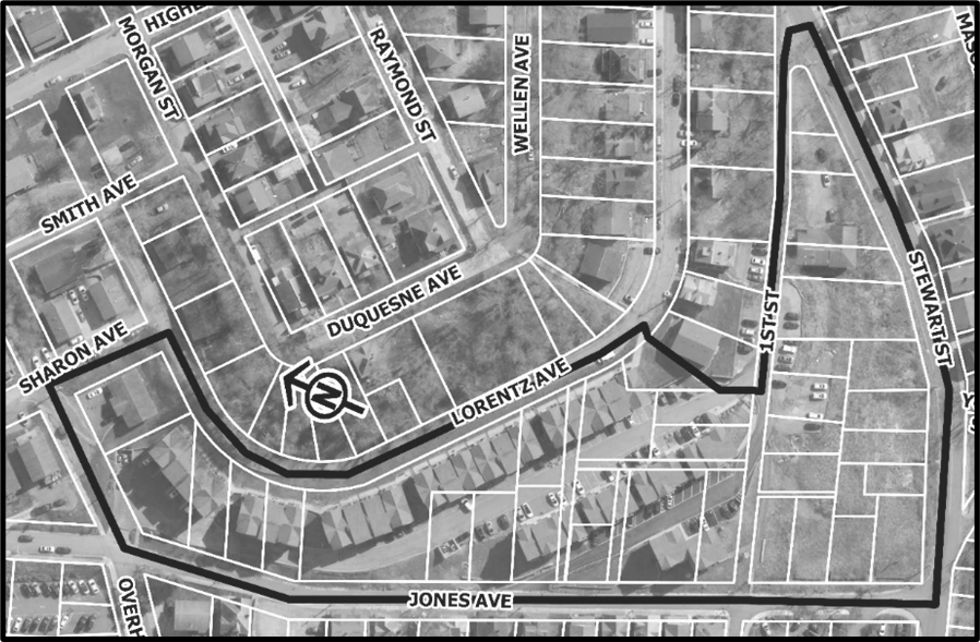
(Ord. No. 2020-26, 8-4-2020)
Sec. 1358.03. - Land use regulations and design and performance standards common to all Wiles Hill Gateway Overlay District blocks.
The following land use regulations and development design and performance standards are held in common to blocks that compose the Wiles Hill Gateway Overlay District.
(a)
Permitted principal and conditional uses. The table and supplemental regulations of the Wiles Hill Gateway Overlay District Permitted Land Uses Table are incorporated in this section and are adopted as the basic land use regulations for the Wiles Hill Gateway Overlay District. The table and supplemental regulations identify the types of land uses that are permitted within each of the blocks composing the overlay district and any applicable conditions and limitations.
Determining the overlay district block in which a particular use is allowed shall be interpreted as provided in Section 1331.05. However, the Wiles Hill Gateway Overlay District Permitted Land Uses Table shall supersede Table 1331.05.01, Permitted Land Use.
A description of the supplemental regulations immediately follows the Wiles Hill Gateway Overlay District Permitted Land Use Table, which shall supersede Section 1331.06 unless noted otherwise.
Table 1358.03.01. Wiles Hill Gateway Overlay District Permitted Land Uses
(b)
Supplemental regulations pertaining to Wiles Hill Gateway Overlay District permitted land uses table.
(1)
The maximum gross floor area for permitted nonresidential use space shall be 2,000 square feet and any permitted food service establishment shall not exceed 500 square feet of customer seating area.
(2)
Day care facilities, Class 2 shall observe Section 1331.06(19) supplemental regulations.
(3)
Accessory dwelling shall comply with the following provisions:
a.
An accessory dwelling shall not have more bedrooms or be permitted to have occupancy greater than the principal single-family dwelling.
b.
The gross floor area of a detached accessory dwelling shall be no more than 50 percent of the single-family dwelling's first floor gross floor area.
c.
A detached accessory dwelling shall not be located in front of the single-family dwelling's principal façade. On corner lots, a detached accessory dwelling shall not be located between any portion of the principal structure and either street.
d.
A detached accessory dwelling shall not be located closer than five feet to the side or rear property line.
e.
Parcels that include a detached accessory dwelling shall not have any additional accessory structures.
f.
An attached accessory dwelling shall only be permitted above a single-family dwelling's attached garage.
(4)
Mixed use dwelling shall observe Section 1331.06(20) and (26) supplemental regulations.
(5)
Multi-family dwelling shall observe Section 1331.06(35)(b) supplemental regulations.
(6)
For townhouse development, the minimum lot size shall be 1,800 square feet and the minimum lot frontage (lot width) shall be 20 feet. Townhouse dwellings shall be situated on individual lots separate from other townhouse dwelling unit lots within the same townhouse building.
(7)
Two-family dwellings in Block B may only be side-by-side (sharing the same side vertical common or party wall) and may not be over-under (one dwelling unit above another dwelling unit).
(8)
Home occupations shall observe Section 1331.06(2) supplemental regulations.
(9)
Mixed use buildings shall observe Section 1331.06(20) supplemental regulations.
(10)
Telecommunications facilities shall observe Section 1331.06(30).
(c)
Setback and encroachments into setbacks.
(1)
To promote affordable homeownership opportunities, no side building setbacks are required for interior lot lines for side-by-side two-family dwellings. Exterior building setbacks for side-by-side and for over-under two-family dwellings shall observe side setback standards provided in the applicable WHOD Block.
(2)
To promote affordable homeownership opportunities, townhouse dwellings shall have zero setbacks for interior lot lines. Exterior building setbacks shall observe side setback standards provided in the applicable WHOD Block.
(3)
On a corner lot, the required side yard setback on the side facing a street shall be one and one-half times the normal side setback requirement.
(4)
Architectural features may project into a required setback as provided below:
a.
Fire escapes, chimneys, cornices, awnings, canopies, eaves, sills, pilasters, lintels, gutters or other similar features may extend into a setback a distance not exceeding three feet, except that such features shall not extend closer than three feet from the property line.
b.
Uncovered stairs, landings and porches shall not extend closer than three feet from the property line.
c.
Open and covered, but un-enclosed front porches attached to single-family dwellings may extend into the required front setback a distance equal to 50 percent of the setback depth. Such porches may not subsequently be enclosed unless the normal setback requirements within the respective WHOD Block are met.
(5)
No permitted encroachment noted above shall extend to within three feet of an accessory structure.
(6)
Fences, walls, terraces, steps or other similar features may encroach into a requires setback, except as provided in Section 1363.03, Safety and Vision. Such appurtenances shall not be located within access, drainage, or utility easements.
(7)
HVAC mechanical units may be located no closer than two feet to a side lot line and may not be placed in the front yard.
(d)
Calculated building height.
(1)
Unless otherwise specified in a Wiles Hill Gateway Overlay District Block, principal building height measured in feet shall be the vertical distance measured from the centerline grade of the roadway from which the lot frontage and building envelope orientation is established to the highest point of the roof for a flat roof, to the deck line of a mansard roof, and to the mean height between eaves and ridges of gable, hip, and gambrel roofs. Building height calculation shall not include chimneys, spires, elevator and mechanical penthouses, water tanks, radio antennas, and similar projections or other exceptions provided in Section 1363.02(a), Height Exceptions.
(2)
Accessory structure height measured in feet shall be the average vertical distance measured from the adjoining grade to the halfway point between the highest and lowest elevations of the roof type as described in Section 1358.03(d)(1) above. The maximum height of an accessory structure shall not exceed 18 feet, except for detached accessory dwelling units, where permitted, which shall not exceed 20 feet.
(e)
Parking and loading standards. Unless otherwise provided, all uses within the Wiles Hill Gateway Overlay District shall conform to the off-street parking and loading requirements in Article 1365, Parking, Loading and Internal Roadways.
(1)
The minimum number of off-street parking spaces for residential uses shall be 0.75 spaces per occupant as determined by the West Virginia State Building Code as adopted and implemented by the City. The minimum number of off-street parking spaces for mixed-use dwellings shall be 0.75 spaces per occupant as determined by the West Virginia State Building Code plus required spaces for nonresidential use(s).
(2)
The maximum number of parking spaces for an accessory dwelling unit is one space.
(3)
All three types of site plan reviews for new development and redevelopment provided in Section 1385.04 et seq. shall provide bicycle storage facilities set forth in Section 1365.06(q) as well as the following provisions:
a.
With the exception of single-family dwellings, all residential units shall provide not less than one long-term bicycle storage space.
b.
All townhouse principal buildings shall provide not less than one short-term bicycle storage space located not more than 50 feet from the principal building.
c.
One long-term bicycle storage space and one short-term bicycle storage space shall be provided for each residential unit in a multi-family building and/or in a mixed-use building.
(f)
Retaining walls. As a part of any new development or redevelopment, existing retaining walls generally running parallel with and visible from the public right-of-way shall be replaced according to the following design standards. New retailing walls generally running parallel with and visible from the public right-of-way shall be constructed according to the following design standards.
(1)
New retaining wall construction shall be terraced from Stewart Street vertically to its highest point. Each terraced section of retaining wall shall not exceed a height of five feet measured from visible base to cap stone.
(2)
Permitted retaining wall materials include concrete masonry units (CMU) and masonry units; provided, materials shall have a consistent natural-stone appearance, preferably in the style of limestone, cobblestone, kingstone, or ledgestone. The use of flat forms shall be limited to not more than 50 percent of a retaining wall's face. Retaining walls shall be earth toned colors.
(3)
Areas between terraced walls shall be appropriately landscaped to soften the visual impact of larger retaining walls systems from adjoining properties and public rights-of-way. Landscaping should incorporate appropriate small trees, shrubs, ornamental grasses, perennials, etc. that compliments and is in continuity with the Stewart Street and University Avenue public green space.
(g)
Landscaping requirements for properties adjoining Stewart Street public right-of-way.
(1)
All new development and redevelopment involving lots that have rear yards adjoining Stewart Street public right-of-way shall provide a landscape buffer abutting the Stewart Street public right-of-way and is ten feet wide planted with one two-inch caliper small deciduous tree for every 20 feet and at least three shrubs of at least three gallons in size clustered between each two trees.
(2)
Maintenance of the landscaped buffer shall be completed in accordance with Sections 1367.10(c) and 1367.10(d).
(h)
Front gathering spaces. All residential construction shall include a front gathering space except for accessory dwelling units which may include a front gather space. Front gathering spaces should be covered and may not be enclosed.
(Ord. No. 2020-26, 8-4-2020)
Sec. 1358.04. - Block "A" development standards.
(a)
Purpose. The purpose of Block "A" is to serve as a transition into the adjoining R-1A District while enabling creative building forms and moderately higher detached single-family densities that incentivize infill and redevelopment of underutilized, functionally obsolete, and/or nonconforming properties.
(b)
Lot provisions.
(1)
Block "A" shall include four subgroups "A1", "A2", "A3", and "A4" as illustrated in Graphic 1358.04.01 for the purpose of establishing varying lot provisions.
Graphic 1358.04.01—Block "A" Subgroups
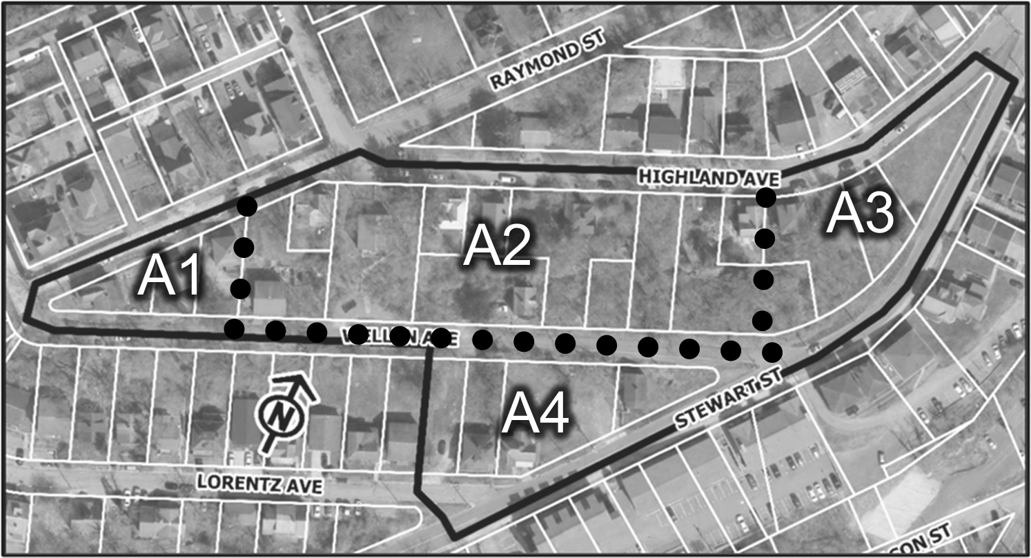
(2)
The following shall be the minimum lot size standard for each of the Block "A" subgroups:
a.
Subgroup "A1" 4,200 square feet.
b.
Subgroup "A2" 3,000 square feet.
c.
Subgroup "A3" 4,500 square feet.
d.
Subgroup "A4" 4,500 square feet.
(3)
The following shall be the minimum lot frontage standard for each of the Block "A" subgroups:
a.
Subgroup "A1" 50 feet.
b.
Subgroup "A2" 44 feet.
c.
Subgroup "A3" 40 feet.
d.
Subgroup "A4" 40 feet.
(4)
The following shall be the lot coverage standard for each of the Block "A" subgroups:
a.
Subgroup "A1" 28 percent.
b.
Subgroup "A2" 45 percent.
c.
Subgroup "A3" 55 percent.
d.
Subgroup "A4" 55 percent.
(5)
New development and/or redevelopment shall have the following frontage and building envelope orientation for each of the Block "A" subgroups:
a.
Subgroup "A1" Raymond Street or Wellen Avenue, as determined by the Planning Director.
b.
Subgroup "A2" Highland Avenue or Wellen Avenue, as determined by the Planning Director.
c.
Subgroup "A3" Highland Avenue.
d.
Subgroup "A4" Wellen Avenue.
(c)
Setbacks.
(1)
Principal buildings.
a.
Minimum front setback: five feet.
b.
Maximum front setback: 12 feet.
c.
Minimum side setback: five feet.
d.
Minimum rear setback: five feet.
(2)
Accessory structures. Except for detached accessory dwellings provided in this overlay district, see Section 1331.08 for accessory structures in residential districts.
(d)
Building height.
(1)
The maximum height of a principal building for lots with frontage on Highland Avenue or Raymond Street shall be 30 feet above the fronting roadway centerline.
(2)
The maximum height of a principal building for lots with frontage on the north side Wellen Avenue shall be 40 feet above the fronting roadway centerline.
(3)
The maximum height of a principal building for lots with frontage on the south side of Wellen Avenue shall be 30 feet above the fronting roadway centerline.
(e)
Performance standards.
(1)
New development and/or redevelopment approvals and permits for parcels fronting Highland Avenue may not be issued until the Highland Avenue public right-of-way is improved or performance guarantee secured to the satisfaction of the City Engineer between its intersection with Stewart Street and its intersection with Raymond Street. Improvements should accommodate two lanes of traffic, a parking lane, and sidewalk as generally illustrated in Graphic 1358.04.01.
Graphic 1358.04.02—Preferred Highland Avenue Roadway Cross-Section
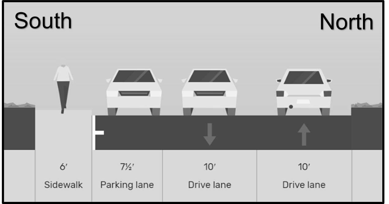
(2)
New development and/or redevelopment approvals and permits for parcels fronting Wellen Avenue may not be issued until the Wellen Avenue public right-of-way is improved or performance guarantee secured to the satisfaction of the City Engineer between its intersection with Stewart Street and its intersection with Raymond Street. Improvements should accommodate two lanes of traffic, a parking lane, and sidewalks as generally illustrated in Graphic 1358.04.02.
Graphic 1358.04.03—Preferred Wellen Avenue Roadway Cross-Section
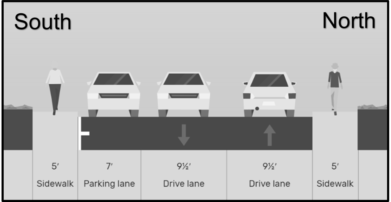
(3)
Unless otherwise provided in Block "A", see Section 1335.07 for building design standards for permitted residential development.
(4)
Single-family dwelling units shall comply with supplemental regulations provided in Section 1331.06(16); except, no housing unit shall be less than 20 feet in width.
(5)
Attached front loaded garages for southern facing structures may take up the complete width of the ground-level front façade.
(6)
At least one of the minimum required off-street parking spaces for each dwelling unit shall be located within an enclosed garage.
(7)
Off-street parking spaces shall not be located completely between the front façade and the public right-of-way; provided, off-street parking spaces may extend past the building line.
(8)
All open driveways and off-street parking spaces shall be surfaced with an all-weather, dust-free concrete or asphalt prior to the issuance of a certificate of occupancy. Driveways and off-street parking spaces shall be maintained in good condition. Other surface materials and designs may be utilized when specifically approved by the City Engineer, for purposes of reducing storm water runoff or other environmental and aesthetic considerations, with the exception of loose gravel which shall not be permitted.
(9)
Curb cuts and driveway entrances shall be prohibited from Stewart Street.
(10)
Principal buildings shall be no less than 12 feet wide.
(11)
Residential construction may deviate from street orientation of adjacent interior lot residential structures, except for structures on parcels that abut Stewart Street which shall be oriented towards either Wellen Avenue or Highland Avenue public roadways, whichever is closer.
(Ord. No. 2020-26, 8-4-2020)
Sec. 1358.05. - Block "B" development standards.
(a)
Purpose. The purpose of Block "B" is to serve as a transition between Blocks "A" and "C" while enabling creative building forms and moderately higher densities than Block "A" to incentivize redevelopment of existing nonconforming rental properties. Two-family and townhouse designs are preferred for this block.
(b)
Lot provisions.
(1)
The minimum lot size shall be 4,700 square feet. See Section 1358.03(b)(6) for minimum lot size standard for townhouse development.
(2)
The minimum lot frontage shall be 40 feet. See Section 1358.03(b)(6) for minimum lot frontage standard for townhouse development.
(3)
New development shall have frontage and building envelope orientation toward the Lorentz Avenue public right-of-way.
(4)
For development north of Lorentz Avenue—Maximum lot coverage shall be 35 percent.
(5)
For development south of Lorentz Avenue—Maximum lot coverage shall be 38 percent.
(c)
Setbacks.
(1)
For development of principal buildings north of Lorentz Avenue, except as provided in Section 1358.03(c)(1) and (2):
a.
Minimum front setback: 20 feet.
b.
Maximum front setback: 25 feet.
c.
Minimum side setback: five feet.
d.
Minimum rear setback: 45 feet.
(2)
For development of principal buildings south of Lorentz Avenue, except as provided in Section 1358.03(c)(1) and (2):
a.
Minimum front setback: five feet.
b.
Maximum front setback: ten feet.
c.
Minimum side setback: five feet.
d.
Minimum rear setback: 40 feet.
(3)
See Section 1331.08 for accessory structures in residential districts.
(d)
Building height.
(1)
The maximum height of a principal building for lots on the north side of Lorentz Avenue shall be 40 feet above the fronting roadway centerline.
(2)
The maximum height of a principal building for lots on the south side of Lorentz Avenue shall be 30 feet above the fronting roadway centerline.
(e)
Performance standards.
(1)
Unless otherwise provided in Block "B", see Section 1337.07 for building design standards for permitted residential development.
(2)
Single-family dwelling units shall comply with supplemental regulations provided in Section 1331.06(16); except, no single-family housing unit shall be less than 20 feet in width.
(3)
New development and/or redevelopment approvals and permits may not be issued until the Lorentz Avenue public right-of-way is improved or performance guarantee secured to the satisfaction of the City Engineer between its intersection with Stewart Street and the pedestrian way connecting Wellen Avenue to Lorentz Avenue to Old Golden Blue Way. Improvements should accommodate two lanes of traffic, a parking lane, and sidewalk as generally illustrated in Graphic 1358.05.01.
Graphic 1358.05.01—Preferred Lorentz Avenue Roadway Cross-Section
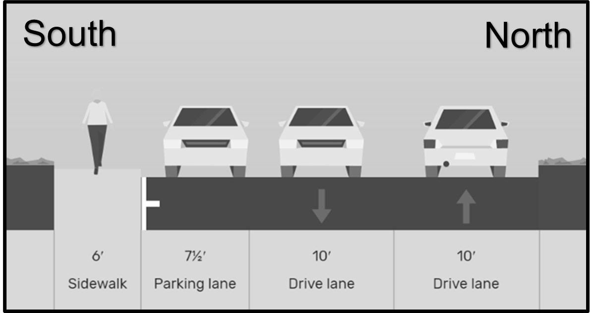
(4)
Residential dwelling unit occupancy will be determined by the West Virginia State Building Code as adopted and implemented by the City.
(5)
Sidewalks shall be constructed along the frontage of a lot upon which a use is to be constructed. Sidewalks shall be at least six feet wide. Sidewalk construction may only be waived by the City Engineer if the planned and accepted public right-of-way cross-section places the sidewalk facility on the opposite side of the right-of-way from the lot upon which a use is to be constructed; provided, a waiver must be accompanied by the sidewalk development in lieu of fee enacted by City Council.
(6)
Curb cuts and driveway entrances shall be prohibited from Wellen Avenue and Stewart Street.
(7)
Off-street parking spaces shall not be located between the front façade and the public right-of-way for development on the south side of Lorentz Avenue.
(8)
At least one of the minimum required off-street parking spaces for each dwelling unit shall be located within an enclosed garage.
(9)
All open driveways and off-street parking spaces shall be surfaced with an all-weather, dust-free concrete or asphalt prior to the issuance of a certificate of occupancy. Driveways and off-street parking spaces shall be maintained in good condition. Other surface materials and designs may be utilized when specifically approved by the City Engineer, for purposes of reducing storm water runoff or other environmental and aesthetic considerations, with the exception of loose gravel which shall not be permitted.
(10)
Principal buildings shall be no less than 20 feet wide and no more than 120 feet wide.
(Ord. No. 2020-26, 8-4-2020)
Sec. 1358.06. - Block "C" development standards.
(a)
Purpose. The purpose of Block "C" is to foster development, built into the hillside, of moderately higher densities than Block B that provides an attractive gateway into the Wiles Hill neighborhood. The Jones Avenue and Stewart Street intersection should be designed with significant terraced retaining walls and landscaping features allowing development to be accessible from First Street or Jones Avenue.
(b)
Lot provisions.
(1)
The minimum lot size shall be 4,000 square feet. See Section 1358.03(b)(6) for minimum lot size standard for townhouse development.
(2)
The minimum lot frontage shall be 35 feet. See Section 1358.03(b)(6) for minimum lot frontage standard for townhouse development.
(3)
Maximum lot coverage shall be 60 percent.
(4)
New development shall have frontage and building envelope orientation toward First Street, Jones Avenue, or Lorentz Avenue as determined by the Planning Director.
(c)
Setbacks.
(1)
For development of principal buildings in Block "C", except as provided in Section 1358.03(c)(1) and (2):
a.
Minimum front setback: five feet.
b.
Maximum front setback: 15 feet.
c.
Minimum side setback: five feet.
d.
Minimum rear setback: 20 feet.
(2)
See Section 1331.08 for accessory structures in residential districts.
(d)
Building height.
(1)
The maximum height of a principal building shall not exceed the 1,090-foot topographic elevation coordinate; provided:
a.
Principal buildings for which the frontage and building envelope orientation has been determined by the Planning Director to be First Street or its former linear path, the maximum principal building height shall be the lesser of 1,100 feet above mean sea level or 40 feet above the centerline grade of:
1.
The First Street roadway; or
2.
The annulled portion of First Street through which a public access and pedestrian path easement has been established.
b.
Principal buildings for which the frontage and building envelope orientation has been determined by the Planning Director to be Jones Avenue and located between Stewart Street and the annulled portion of First Street through which a public access and pedestrian path easement has been established, the maximum principal building height shall be 40 feet above the adjoining grade at any point of the front façade.
c.
Principal buildings for which the frontage and building envelope orientation has been determined by the Planning Director to be Lorentz Avenue, Old Golden Blue Lane, Pride Lane, or a new public or private roadway, the maximum principal building height shall be 35 feet above the fronting roadway centerline.
(2)
For the purpose of this section, the North American Datum 1983 State Plane West Virginia North FIPS 4701 Feet coordinate system shall be used in determining topographic elevation coordinates.
(e)
Performance standards.
(1)
Unless otherwise provided in Block "C", see Section 1337.07 for building design standards for permitted residential development.
(2)
Single-family dwelling units shall comply with supplemental regulations provided in Section 1331.06(16); except, no single-family housing unit shall be less than 20 feet in width.
(3)
New development and/or redevelopment approvals and permits for First Street and/or Jones Avenue frontage may not be issued until:
a.
The First Street public right-of-way is improved or performance guarantee secured to the satisfaction of the City Engineer between its intersection with Stewart Street and the annulled portion of First Street. Improvements should accommodate two lanes of traffic and sidewalk as generally illustrated in Graphic 1358.05.01.
Graphic 1358.06.01—Preferred First Street Roadway Cross-Section
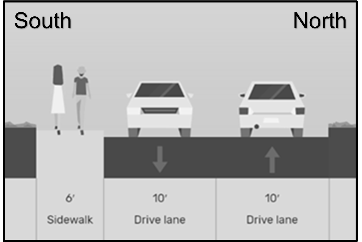
b.
The pedestrian path between Old Golden Blue Lane and Jones Avenue is improved or performance guarantee secured to the satisfaction of the City Engineer.
(4)
Building form. Multi-family development should complement and incorporate hillside slopes through terraced stacking of dwelling units as generally illustrated in Graphic 1358.06.01.
Graphic 1358.06.02—Block "C" Boundary
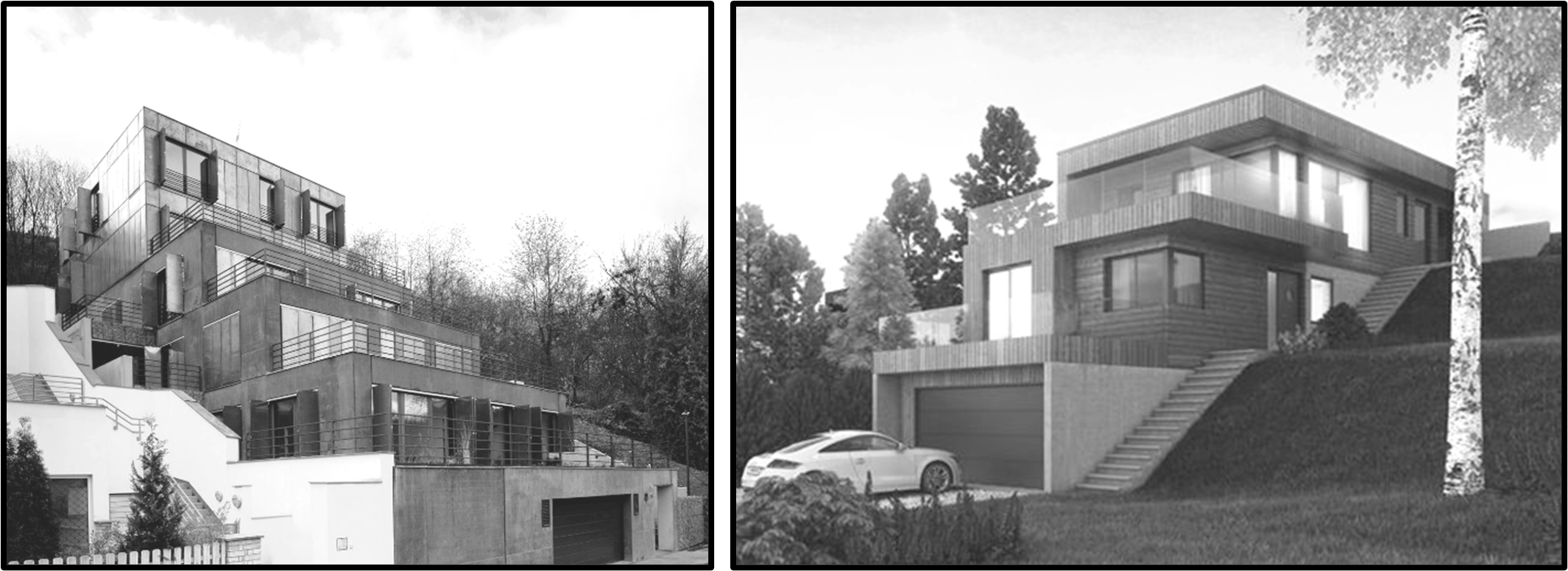
(5)
Minimum open space. Permanent open space shall be required as an integral part of townhouse and/or multi-family development. In townhouse or multi-family development within "Block C," at least ten percent of the total area (measured in square feet) of "Block C", not including the required yard setbacks, shall be dedicated as open space as a part of a townhouse and/or multi-family development and shall be maintained by the developer/owner/homeowners association and shall be accessible to all residents of the development. Open space shall not include any impervious surfaces designed, developed, and used for parking spaces. At least 30 percent of the total permanent open shall be of "improved open space" type. "Improved open space" is defined, for the purposes of this section, as parks, playgrounds, plazas, landscaped green spaces, and other areas that are created or modified by man.
(6)
Vehicle access and parking.
a.
Curb cuts and driveway entrances shall be prohibited from Stewart Street.
b.
Driveway entrances from First Street should be limited in number and designed to provide common access to on-site parking spaces located in the rear yard.
c.
At least one of the minimum required off-street parking spaces for each dwelling unit shall be located within an enclosed garage and/or under a permanent accessory canopy structure.
(Ord. No. 2020-26, 8-4-2020)
Sec. 1359.01.- Purpose.
The purpose of the Interstate Sign Overlay District is to provide an area within 500 feet of a Federal interstate highway right-of-way within which on-premise pole or pylon signs or billboard signs may be erected for the convenience of the motoring public. This overlay district may not be applied over any residentially zoned property.
(Ord. No. 13-08, 3-5-2013)
Sec. 1359.02. - General regulations.
(a)
Conditional use approval by the Board of Zoning Appeals shall be required for on-premise pole or pylon signs and billboard signs.
(b)
No more than one pole or pylon sign or billboard sign may be located on a parcel.
(c)
Spacing.
(1)
Billboard signs shall not be located within 1,000 feet of any other billboard sign. This distance requirement shall include in its calculation any billboards located outside the corporate boundaries of the City.
(2)
Billboard signs shall not be located within 200 feet of a residential zoning district. If illuminated by internal, external or digital/electronic means, said signs shall not be located within 300 feet of a residential zoning district.
(3)
No such spacing limit shall apply for on-premise pole or pylon signs.
(d)
Height. Maximum sign height for on-premise pole or pylon signs or billboard signs shall be determined by the Board of Zoning Appeals, after considering evidence supplied by the applicant that clearly demonstrates, to the satisfaction of the Board, that the requested height is necessary. The Board shall take into account the horizontal distance the sign will be from the travel lanes of the roadway, the difference in elevation between the property grade and the roadway grade, and the advice of the City Engineer and/or Planning Director. The Board may approve the height requested by the applicant, or any other height that it deems is warranted given the facts of the case.
(e)
Area. The maximum area for on-premise pole or pylon signs shall not exceed 250 square feet; for billboard signs 450 square feet; or, whatever smaller area the Board of Zoning Appeals approves, considering the same criteria as for height. This shall be in addition to any other signs permitted by these regulations. For the purposes of this section, the surface display area of a pole or pylon sign or a billboard sign shall be measured to include the entire area within a regular geometric form or combinations thereof comprising all of the display area of the sign, including all of the elements of the matter displayed. Frames and structural members, excluding necessary supports or uprights, shall be included in computation of the surface display area. In the case of a sphere, spheroid, or similar shaped sign (e.g. a ball), the total surface display area shall be divided by two for determine the maximum surface display area permitted. The regulations regarding computation of sign area for double-sided and V-type signs in Article 1369 shall apply.
(f)
Setback. No on-premise pole or pylon sign or billboard sign may be located within 15 feet of any parcel boundary line of the property on which the subject sign is located.
(g)
Distance requirements provided in this section shall be measured radially from the leading edge of the sign face.
(h)
No on-premise pole or pylon sign or billboard sign may be located on top of, cantilevered over or otherwise suspended above any building or structure.
(i)
An on-premise pole or pylon sign or billboard sign having more than one surface display area which are tandem (side-by-side) or stacked (one above the other) are considered two billboards and are prohibited.
(j)
Illumination. On-premise pole or pylon signs may only be internally illuminated. Billboard signs may be illuminated provided such illumination is consistent with the requirements for a digital billboard as set forth herein, or is concentrated on the surface of said sign and is located so as to avoid glare or reflection onto any portion of an adjacent street or highway, the path of oncoming vehicles or any adjacent premises.
(k)
Appearance.
(1)
Except for time and temperature signs or digital billboards as otherwise regulated herein, all on-premise pole or pylon signs and billboard signs must be static or stationary and may not contain any visible moving parts, alternating or moving messages or have the appearance of having moving parts or messages. Provided, each message or copy displayed on a mechanically changed billboard sign (e.g., tri-action, etc.) shall remain fixed for at least ten seconds; must accomplish the change between messages within an interval of two seconds or less; and must contain a default design that will freeze the sign in one position if a malfunction occurs.
(2)
Under no circumstances may any type of on-premise pole or pylon sign or billboard sign contain a message or display that appears to flash, undulate, pulse, move, scroll, or portray explosions, fireworks, flashes of light, or blinking lights or otherwise appears to move toward or away from the view, expand or contract, bounce, rotate, spine twist or make other comparable movements.
(3)
The frames, borders, and all structural members of a billboard sign shall be black, with no illumination and no writing or symbols other than the identification (name and/or logo) of the sign owner/operator.
(l)
Permitting. Every on-premise pole or pylon sign and billboard sign requires a City building permit before installation or modification. Permits shall be reviewed and issued consistent with the terms of this section as well as all other applicable ordinances of the City as amended from time to time. Every applicant for an on-premise pole or pylon sign or billboard sign shall file with the building permit application a certificate of insurance naming the City as coinsured and certifying that the applicant and City are insured against bodily injury and for property damage arising out of the erection, maintenance, repair, and replacement of the sign. Each applicant, if the permit is granted, shall be required to maintain said insurance and keep a certificate of insurance currently effective on file with the City so long as the sign is in existence. The certificate shall provide that the City shall receive ten days written notice in case of cancelation of the policy. Any on-premise pole or pylon sign or billboard sign in violation of the insurance requirements of this section shall be removed immediately and the cost of such removal shall be charged against the owner/operator of the sign.
(m)
Other applicable requirements and laws. An on-premise pole or pylon sign or billboard sign must otherwise comply with all other relevant regulations and ordinances of the City and comply with all applicable provisions of Federal and State law.
(Ord. No. 13-08, 3-5-2013)
Sec. 1359.03. - Digital off-premise and billboard sign regulations.
The City recognizes that billboards are, by their nature, different in scope and purpose from other types of signage in the City. Billboards are significantly larger in size than other types of signage allowed in the City and their principal purpose is to dramatically attract the attention of the travelling public. The potential impact of a billboard on adjacent areas is significantly greater than other types of signage. Advancements in technology and efficiencies enable signs to change static message or copy electronically (e.g. utilizing an LED or digital type of sign). These newer technologies exacerbate the potential impact of a billboard in terms of adversely dominating the environment in which they operate due to light spillover and light pollution, unless regulated in a reasonable fashion. The intent of this section is to establish standards and regulations for billboards, including addressing those utilizing these newer technologies, in order to minimize the secondary effects that can accompany the unregulated display of these types of signs; preserve the character and repose of adjacent areas, with a principal focus on residential neighborhoods; protect property values in all areas of the City; and, reduce traffic and similar hazards caused by undue distractions.
(a)
Locations. In addition to the spacing and setback standards provided in this section, digital or electronic billboard signs are prohibited on the same site as a National Register designated historic structure or within a National Register designated historic district. Digital or electronic billboard signs are prohibited within 500 feet of a National Register designated historic structure, except where a Federal interstate highway separates the digital or electronic billboard sign from the National Register designated historic structure.
(b)
Display.
(1)
The display or message on a digital billboard sign may change no more frequently than once every ten seconds. Any change in message or copy shall be completed instantaneously.
(2)
The display, message, or copy must otherwise comply with subsection 1359.02(k) and the digital billboard sign must have a light sensing device to adjust brightness as ambient light conditions change in order to insure that the message meets the following brightness standard.
Maximum brightness levels for digital billboards shall not exceed 0.2 foot-candles over ambient light levels measured within 150 feet of the sign. Certification must be provided to the City demonstrating that the sign has been preset to automatically adjust the brightness to these levels or lower. Certified re-inspection and recalibration shall be annually required by the City, in its reasonable discretion, at the sign owner/operator's expense to ensure that the specified brightness levels are maintained at all times.
(3)
Brightness of digital billboards shall be measured as follows:
a.
At least 30 minutes following sunset, a foot-candle meter shall be used to obtain an ambient light reading for the location. This is done while the sign is off or displaying black copy. The reading shall be made with the meter aimed directly at the sign area at the pre-set location.
b.
The sign shall then be turned on to full white copy to take another reading with the meter at the same location.
c.
If the difference between the readings is 0.2 foot-candles or less, the brightness is properly adjusted.
(4)
Consecutive messages on a single digital or electronic sign face (digital slots) are prohibited when the second message answers a textual question posed on the prior slot, continues or completes a sentence started on the prior slot, or continues or completes a story line started on the prior slot. Nothing in the subsection shall prohibit consecutive messages by the same advertiser or consecutive messages for the same product or service; provided, that the second of such advertisements does not answer a textual questions posed on the prior advertisement slot, continue or complete a sentence started on the prior advertisement slot, or continue or complete a story line started on the prior advertisement slot. For example, consecutive advertisements by a single grocery store advertising the same or multiple products are permitted provided that such advertisements do not answer textual questions from one slot to the next slot, continue or complete a sentence from one slot to the next slot, or continue or complete a story line from one slot to the next slot.
(5)
The sign shall have a default mechanism or setting that will cause the sign to turn off or show a "full black" image if a visible malfunction or failure occurs.
(6)
The sign shall not be configured to resemble a warning or danger signal. The sign shall not resemble or simulate any lights or official signage used to control traffic.
(c)
The Board of Zoning Appeals, in reviewing the conditional use application, may require, as a reasonable condition, that an approved digital billboard sign be turned off or display a "full black" image during nighttime hours to preserve the character and repose of adjacent residential areas.
(d)
The owner/operator of the digital billboard sign shall maintain a secure electronic communication network that controls the display and display changes.
(e)
Prior to the issuance of a permit for construction of a digital billboard sign, the owner/operator of the sign shall enter into an agreement with the City providing for public service announcements or a regular basis without charge. Such announcements shall be provided as specified in the agreement and shall include messages of significant public interest related to safety and traffic matters (e.g. AMBER Alerts, Cop Killer Alerts, severe weather, disaster, evacuation bulletins/notices, etc.).
(Ord. No. 13-08, 3-5-2013)
Sec. 1359.04. - Conditional use application.
(a)
As part of the conditional use application for on-premise pole or pylon signs and billboard signs, the applicant shall provide a certified land survey prepared by an engineer or surveyor licensed to practice in West Virginia that shows the following:
(1)
The parcel boundaries for the property on which the proposed sign is to be located.
(2)
The right-of-way boundary of the Federal interstate highway used to establish the applicable ISOD Overlay District.
(3)
The exact location of the proposed sign.
(4)
The distances between the subject Federal interstate highway right-of-way, the property on which the proposed sign is to be located, and the exact location of the proposed sign. If the parcel is entirely contained within the 500-foot ISOD Overlay District boundary, the survey shall so indicate. If only a portion of the parcel falls within the 500-foot ISOD Overlay District boundary, the survey must indicate which portions of the property fall within it, and which are outside of the boundary.
(5)
The location of any existing or proposed buildings, structures, and other on-premise pole or pylon and billboard signs on the subject property.
(6)
Floodplain boundaries, as may be required by the City Engineer.
(b)
In addition to the survey, the applicant must submit the following:
(1)
A scaled photo simulation of the proposed on-premise pole or pylon sign or billboard sign from no less than two points of view, the locations of which must be agreed to by the Planning Director.
(2)
The proposed height, square footage, and construction details of the proposed sign. Signs shall be designed by a licensed engineer and shall conform to the regulations of the West Virginia State Building Code and design standards provided herein.
(3)
If the proposed sign is a billboard sign, a map must be submitting illustrating the following:
a.
Any and all billboard signs within 1,500 feet, measured radially, of the proposed billboard sign location along with the distances between same.
b.
The distance of the proposed billboard sign, measured radially, to the closest residential zoning district.
(Ord. No. 13-08, 3-5-2013)
Sec. 1360.01 - Application.
(a)
The regulations and standards contained within the airport overlay district shall apply to the:
(1)
Erection of a new structure; and/or
(2)
Addition to or increase in the height of an existing structure; and/or
(3)
Establishment, erection, and/or maintenance of any use, structure, or object (natural or manmade), within the airport overlay district.
(b)
The application of this airport overlay district shall be limited to the corporate limits of the City of Morgantown.
(Ord. No. 14-49, 11-5-2014)
Sec. 1360.02. - Purpose and intent.
The purpose and intent of this airport overlay district are to:
(a)
Create an overlay district that considers safety issues around the Morgantown Municipal Airport (MGW).
(b)
Regulate and restrict the heights of established uses, constructed structures, and objects of natural growth.
(c)
Create a permitting process for certain uses, structures, and objects within said related zones.
(Ord. No. 14-49, 11-5-2014)
Sec. 1360.03. - Relation to other zoning districts.
This airport district overlay shall not modify the boundaries of any underlying zoning district or any other overlay district. Where identified, the airport overlay district shall impose certain requirements on land use, construction and development in addition to those contained in the applicable underlying zoning district and/or applicable overlay zoning district for the same area.
(Ord. No. 14-49, 11-5-2014)
Sec. 1360.04. - Definitions.
The following words and phrases when used in Article 1360 shall have the meaning given to them in this section unless the context clearly indicates otherwise.
Airport or Morgantown Municipal Airport (MGW) means any area of land or water which is used, or intended to be used, for the landing and takeoff of aircraft and any appurtenant areas which are used, or intended to be used, for airport buildings or air navigation facilities for rights-of-way, together with all airport buildings and facilities thereon.
Airport elevation means the highest point of an airport's useable landing area measured in feet above sea level. The airport elevation of the Morgantown Municipal Airport (MGW) is 1,248 feet above mean sea level.
Airport hazard means any structure or object, natural or manmade, or use of land which obstructs the airspace required for flight or aircraft in landing or taking off at an airport or is otherwise hazardous as defined in 14 CFR Part 77.
Airport hazard area means any area of land or water upon which an airport hazard might be established if not prevented as provided for in this airport overlay district.
Airport layout plan (ALP) means an FAA approved plan that shows:
(1)
Boundaries and proposed additions to all areas owned or controlled by the sponsor for airport purposes;
(2)
The location and nature of existing and proposed airport facilities and structures; and
(3)
The location on the airport of existing and proposed non-aviation areas and improvements thereon.
Airport noise impact zone means a rectangular shape defined by utilizing the longest existing or planned runway at the airport. This zone is established by offsetting the runway centerline a distance half the length of the longest existing or planned runway in all directions, i.e. from the sides and from the ends of each runway.
Approach surface (zone) means an imaginary surface longitudinally centered on the extended runway centerline and extending outward and upward from each end of the primary surface. An approach surface is applied to each end of the runway based on the planned approach. The inner edge of the approach surface is the same width as the primary surface and expands uniformly depending on the planned approach. The approach surface zone, as shown on the official supplementary airport overlay district zoning map, is derived from the approach surface.
CFR means Code of Federal Regulations.
Conical surface (zone) means an imaginary surface extending outward and upward from the periphery of the horizontal surface at a slope of 20 feet horizontally to one foot vertically for a horizontal distance of 4,000 feet. The conical surface zone, as shown on the official supplementary airport overlay district zoning map, is based on the conical surface.
Decision height (DH) means a specified height above the ground in an instrument approach procedure at which the pilot must decide whether to initiate an immediate missed approach if the pilot does not see the required visual reference, or to continue the approach. Decision height is expressed in feet above ground level.
Educational facility restriction zone means an area extending along the centerline of any runway and measured from the end of the runway and extending for a distance of five miles and having a width equal to one-half of the runway length.
FAA means the Federal Aviation Administration of the United States Department of Transportation.
Height, for the purpose of determining the height limits in all zones set forth in this airport overlay district and shown on the official supplementary airport overlay district zoning map, the datum shall be mean sea level elevation unless otherwise specified.
Horizontal surface (zone) means an imaginary plane 150 feet above the established airport elevation that is constructed by swinging arcs of various radii from the center of the end of the primary surface and then connecting the adjacent arc by tangent lines. The radius of each arc is based on the planned approach. The horizontal surface zone, as shown on the official supplementary airport overlay district zoning map, is derived from the horizontal surface.
Larger than utility runway means a runway that is constructed for and intended to be used by propeller driven aircraft of greater than 12,500 pounds maximum gross weight and jet powered aircraft.
Minimum descent altitude (MDA) means the lowest altitude specified in an instrument approach procedure, expressed in feet above mean sea level, to which descent is authorized on final approach or during circle-to-land maneuvering until the pilot sees the required visual references for the heliport or runway of intended landing.
Minimum obstruction clearance altitude (MOCA) means the lowest published altitude in effect between radio fixes on VOR airways, off-airway routes, or route segments, which meets obstacle clearance requirements for the entire route segment and which ensures acceptable navigational signal coverage only within 25 statute (22 nautical) miles of a VOR.
Nonconforming use means any pre-existing structure, object of natural growth, or use of land which is inconsistent with the provisions of this airport overlay district or an amendment thereto.
Non-precision instrument runway means a runway having an existing instrument approach procedure utilizing air navigation facilities with only horizontal guidance, or area type navigation equipment, for which a straight-in non-precision instrument approach procedure has been approved or planned.
Obstruction means any structure, growth, or other object, including a mobile object, which exceeds a limiting height set forth by this airport overlay district.
Precision instrument runway means a runway having an existing instrument approach procedure utilizing an instrument landing system (ILS) or a precisions approach radar (PAR). It also means a runway for which a precision approach system is planned and is so indicated on an approved airport layout plan or any other planning document.
Primary surface (zone) means an imaginary surface longitudinally centered on the runway, extending 200 feet beyond the end of paved runways or ending at each end of turf runways. The elevation of any point on the primary surface is the same as the elevation of the nearest point on the runway centerline. The primary surface zone, as shown on the official supplementary airport overlay district zoning map, is derived from the primary surface.
Runway means a defined area of an airport prepared for landing and takeoff of aircraft along its length.
Runway protection zone (RPZ) means an area, trapezoidal in shape and centered about the extended runway centerline, designated to enhance the safety of aircraft operations and the safety and protection of people and property on the ground. The RPZ for Runway 18 begins 200 feet beyond the runway end. The inner width is 1,000 feet centered on the extended runway centerline extending to an outer width of 1,750 feet. The length of the Runway 18 RPZ is 2,500 feet. The RPZ for Runway 36 begins 200 feet beyond the runway end. The inner width is 1,000 feet centered on the extended runway centerline extending to an outer width of 1,510 feet. The length of the Runway 36 RPZ is 1,700 feet.
Structure means an object, including a mobile object, constructed or installed by man, including but without limitation, buildings, towers, cranes, smokestacks, earth formation and overhead transmission lines.
Transitional surface (zone) means an imaginary surface that extends outward and upward from the edge of the primary surface to the horizontal surface at a slope of seven feet horizontally to one foot vertically (7:1). The transitional surface zone, as shown on the official supplementary airport overlay district zoning map, is derived from the transitional surface.
Tree means any object of natural growth.
Utility runway means a runway that is constructed for and intended to be used by propeller driven aircraft of 12,500 pounds maximum gross weight or less.
Visual runway means a runway intended solely for the operation of aircraft using visual approach procedures.
(Ord. No. 14-49, 11-5-2014)
Sec. 1360.05. - Establishment of airport zones.
There are hereby created and established certain zones within the airport overlay district, which are based on the FAA-approved airport layout plan (ALP) for the Morgantown Municipal Airport (MGW). Said zones are defined in Section 1360.04 and, with exception of the educational facility restriction zone, illustrated on the official supplementary airport overlay district zoning map, hereby adopted as part of this airport overlay district, which include:
(1)
Airport noise impact zone.
(2)
Approach surface zone.
(3)
Conical surface zone.
(4)
Educational facility restriction zone.
(5)
Horizontal surface zone.
(6)
Primary surface zone.
(7)
Runway protection zone.
(8)
Transitional surface zone.
(Ord. No. 14-49, 11-5-2014)
Sec. 1360.06. - Height restrictions.
(a)
The owner of any proposed construction and/or alteration within this airport overlay district shall comply with the provisions of 14 CFR Part 77 Subpart B by filing a Notice of Construction or Alteration (FAA Form 7460-1, as amended or replaced) with the FAA. Construction and/or alteration includes the:
(1)
Erection of a new structure; and/or
(2)
Addition to or increase in the height of an existing structure; and/or
(3)
Establishment, erection and/or maintenance of any use, structure, or object (natural or manmade).
(b)
Prior to the issuance of any building permit within this airport overlay district, the applicant shall submit documentation to the City demonstrating compliance with the Federal requirement for notification of the proposed construction or alteration, a valid aeronautical evaluation, and a copy of the FAA's determinations to said notification.
(c)
If the FAA returns a determination of no penetration of protected airspace, the building permit request shall be considered in compliance with the intent of this airport overlay district. If the FAA returns a determination of a penetration of protected airspace, the permit shall be denied, and the applicant may seek a variance from such regulations as outlined in Section 1360.07.
(d)
Exceptions. In the following circumstances, the filing of a notice of construction or alteration with the FAA within the airport overlay district shall not be required:
(1)
To make maintenance repairs to or to replace parts of existing structures which do not enlarge or increase the height of an existing structure.
(2)
Within the primary surface, approach surface, and transitional surface zones, when construction and/or alteration of a structure is below 1,248 feet above mean sea level.
(3)
Within the horizontal surface and conical surface zones, when the construction and/or alteration of a structure is below 1,398 feet above mean sea level.
(e)
In addition to the height restrictions of this airport overlay district, no structure or obstruction shall be permitted within the corporate limits of the City of Morgantown that would cause a minimum obstruction clearance altitude, a minimum descent altitude, or a decision height to be raised.
(Ord. No. 14-49, 11-5-2014)
Sec. 1360.07. - Variance from height restrictions.
(a)
In addition to provisions set forth in Article 1381 "Variances" of the City's Planning and Zoning Code, any request for a variance to the height restrictions of this airport overlay district shall include documentation in compliance with 14 CFR Part 77 Subpart B.
(b)
Applicants seeking variance relief to height restrictions of this airport overlay district must, as a part of the variance application, submit all documentation concerning the applicant's Notice of Construction or Alteration (FAA Form 7460-1, as amended or replaced) filed with the FAA, a valid aeronautical evaluation, and the FAA's determinations to said notification.
(c)
The Board of Zoning Appeals' considerations of whether to grant a variance to the height restrictions of this airport overlay district must include the determinations made by the FAA as to the effect of the proposed construction and/or alteration on the operation of air navigation facilities and the safe, efficient use of navigable air space. In particular, the request for a variance shall consider which of the following categories the FAA has placed the proposed development in:
(1)
No objection. The subject construction and/or alteration is determined to not exceed obstruction standards and marking/lighting is not required to mitigate potential hazard. Under this determination a variance shall be granted, as it relates to relief from the height restrictions of this airport overlay district.
(2)
Conditional determination. The proposed construction and/or alteration is determined to create some level of encroachment into an airport hazard area which can be effectively mitigated. Under this determination, a variance shall be granted, as it relates to relief from height restrictions of this airport overlay district, contingent upon implementation of mitigating measures as described in Section 1360.10, Obstruction Marking and Lighting and in consultation with the FAA.
(3)
Objectionable. The proposed construction/alteration is determined to be a hazard and is thus objectionable. A variance, as it relates to relief from the height restrictions of this airport overlay district, shall be denied and the reasons for this determination shall be outlined to the applicant.
(d)
Such requests for variances from height restrictions of this airport overlay district shall be granted where it is duly found that a literal application or enforcement of the regulations will result in unnecessary hardship and that relief granted will not be contrary to the public interest, will not create a hazard to air navigation, will do substantial justice, and will be in accordance with the intent of this airport overlay district.
(Ord. No. 14-49, 11-5-2014)
Sec. 1360.08. - Use restrictions.
(a)
Notwithstanding any other provisions of this airport overlay district, no use shall be made of land or water within this airport overlay district in such a manner as to:
(1)
Create electrical interference with navigational signals or radio communications between the airport and aircraft:
(2)
Make it difficult for pilots to distinguish between airport lights and others;
(3)
Impair visibility in the vicinity of the airport;
(4)
Create wildlife hazards; or
(5)
Otherwise endanger or interfere with the landing, takeoff or maneuvering of aircraft utilizing the Morgantown Municipal Airport (MGW).
(b)
Runway protection zone (RPZ).
(1)
The following uses are permitted to enter the limits of the RPZ:
a.
Agricultural activity as defined in Section 1329.02 of the Planning and Zoning Code.
b.
Irrigation channels, provided wildlife attractant conditions are not formed therefrom.
c.
Airport service roads.
d.
Underground facilities.
e.
Unstaffed NAVAIDs and associated facilities.
(2)
Prior to the granting of any approval or permit for new or modified development not included in Section 1360.08(b)(1), the City shall consult with the FAA Airports District Office to determine whether or not the land use and/or development proposed to enter the limits of the RPZ is acceptable based on a land use compatibility and alternatives analysis. Table 1360.08.01 generally identifies development that typically requires analysis.
Table 1360.08.01: Development Typically Requiring Analysis
(3)
The land use compatibility and alternatives analysis shall identify and document the full range of alternatives that include:
a.
Avoidance of introducing the land use issue within the RPZ.
b.
Minimizing the impact of the land use in the RPZ (i.e., routing a new roadway through the controlled activity area, move farther away from the runway end, etc.).
c.
Mitigating risk to people and property on the ground (i.e., tunneling, depressing and/or protecting a roadway through the RPZ, implement operational measures to mitigate any risks, etc.).
(4)
Documentation of the alternatives should include:
a.
A description of each alternative including a narrative discussion and exhibits or figures depicting the alternative.
b.
Full cost estimates associated with each alternative regardless of potential funding sources.
c.
A practicability assessment based on the feasibility of the alternative in terms of cost, constructability and other factors.
d.
Identification of the preferred alternative that would meet the project purpose and need while minimizing risk associated with the location within the RPZ.
e.
Identification of all Federal, State and local transportation agencies involved or interested in the issue.
f.
Analysis of the specific portion(s) and percentages of the RPZ affected, drawing a clear distinction between the central portion of the RPZ versus the controlled activity area, and clearly delineating the distance from the runway end and runway landing threshold.
g.
Analysis of (and issues affecting) the City's control of the land within the RPZ.
h.
Any other relevant factors for FAA consideration.
(5)
Any new or modified development described in Table 1360.09.01 that would enter the limits of the runway protection zone shall be categorized a Type III site plan—major development of significant impact. The land use compatibility and alternatives analysis and FAA's related response must be included with the Type III site plan application for it to be considered complete.
(c)
Educational facilities. No educational facility of a public or private K-12 school shall be permitted within the educational facility restriction zone. Exceptions approving construction of an educational facility of a public or private K-12 school within the educational facility restriction zone shall only be granted when the Planning Commission makes specific findings, as a part of a Type III site plan for a development of significant impact, detailing how the public policy reasons for allowing the construction outweigh public health and safety concerns prohibiting such a facility.
(d)
Landfills. In accordance with the Wendell H. Ford Aviation Investment and Reform Act for the 21st Center (Ford Act) (Pub. L. No. 106-181, April 5, 2000), codified at 49 U.S.C. § 40101 et seq., the construction of a new Municipal solid waste landfill (MSWLFs) within six miles of the Morgantown Municipal Airport (MGW) shall be prohibited unless a waiver is granted by the FAA.
(e)
Airport noise impact zone. Reserved.
(Ord. No. 14-49, 11-5-2014)
Sec. 1360.09. - Pre-existing non-conforming uses.
The regulations prescribed by this airport overlay district shall not be construed to require the removal, lowering, or other change or alteration of any structure or tree not conforming to the regulations as of the effective date of this airport overlay district, or otherwise interfere with the continuance of a non-conforming use. No existing non-conforming use shall be structurally altered or permitted to grow higher, so as to increase the non-conformity, and a non-conforming use, once substantially abated as set forth under Article 1373 "Nonconforming Provisions" of the City's Planning and Zoning Code may only be reestablished consistent with the provisions herein.
(Ord. No. 14-49, 11-5-2014)
Sec. 1360.10. - Obstruction marking and lighting.
Any permit or variance granted pursuant to the provisions of this airport overlay district may be conditioned according to the process described in Section 1360.07 to require the owner of the structure or object of natural growth in question to permit the municipality, at its own expense, or require the person requesting the permit or variance, to install, operate, and maintain such marking or lighting as deemed necessary to assure both ground and air safety.
(Ord. No. 14-49, 11-5-2014)
Sec. 1360.11. - Violations and penalties.
See Article 1393 "Violations and Enforcement" of the City's Planning and Zoning Code.
(Ord. No. 14-49, 11-5-2014)
Sec. 1360.12. - Appeals.
See Article 1383 "Administrative Appeals" of the City's Planning and Zoning Code.
(Ord. No. 14-49, 11-5-2014)
Sec. 1360.13. - Conflicting regulations.
See Article 1327.07(B) of the City's Planning and Zoning Code.
(Ord. No. 14-49, 11-5-2014)
Sec. 1360.14. - Severability.
See Article 1327.07(C) of the City's Planning and Zoning Code.
(Ord. No. 14-49, 11-5-2014)
Sec. 1361.01.- Purpose.
The Sunnyside neighborhood, pursuant to recommendations contained within the Sunnyside Up Comprehensive Revitalization Plan (Fall 2004), will be divided into three overlay districts: The Sunnyside Central (SCOD), Sunnyside South (SSOD), and Beechurst Corridor (BCOD) overlay districts. The design and performance standards herein shall supersede or supplement those provided in other parts of this ordinance where conflicts exist.
Sec. 1361.02. - Definitions.
For purposes of this article, the following definitions apply:
Articulation means the extent to which a building appears to be oriented vertically (taller than it is wide), or horizontally (wider than it is tall).
Build-to line means the distance that a building must be set back from a right-of-way line or property line.
Drivit means an exterior insulation and finishing system commonly known as synthetic stucco.
Primary street includes Beechurst Avenue, University Avenue, First/Stewart Street and Third Street.
Proportion means the extent to which windows appear to be oriented vertically (taller than they are wide), or horizontally (wider than they are tall).
Secondary street means any paved, two-lane street in the Sunnyside planning area not listed as a primary street.
Transparency means a term describing the relative ability of an average person to see inside a building. Those facades with significant window openings are more transparent than those with fewer window openings. The term also takes into account issues such as tinting of window glass. A related concept is fenestration ratio, which is an exact measurement of the percentage of window opening to solid wall in any given facade.
(Ord. No. 07-03, 3-6-2007)
Sec. 1361.03. - Design and performance standards common to all Sunnyside overlay districts.
The following design and performance standards are held in common and shall apply to the SCOD, SSOD, and BCOD overlay districts.
(a)
Buildings shall be oriented with the front facing the lot's primary street, or the Monongahela River if the parcel has frontage on the river.
(b)
Buildings should be designed to overlook streets and public open spaces so as to create a "self-policing" environment.
(c)
Buildings shall not be oriented with the front facing parking or service areas.
(d)
On primary streets, street trees shall be provided at a minimum of 35 feet on center.
(e)
Building facades that are adjacent to public streets and/or open spaces shall have a high degree of ground floor transparency (at least 60 percent).
(f)
The siting of buildings should avoid the creation of unusable open spaces and should respect and complement view corridors to and from the hillside and the riverfront.
(g)
Building massing should be the tallest at street corners. In order to achieve this, buildings constructed on a corner of two primary streets should be at least five (5) stories in height, provided that all other requirements of the zoning ordinance are adhered to.
(h)
Ground floor retail and service-type uses located within mixed-use buildings along primary streets shall not be included in height calculations.
(i)
For buildings taller than four stories or 75 feet in height, any additional floors in excess of four stories shall be recessed or set back at least 12 feet from the build-to line.
(j)
A minimum of 75 percent of the length of a building face shall be constructed at the build-to line, if established herein, along a primary street. The remaining 25 percent may be set back a maximum of ten feet from the build-to line.
(k)
Land between the front facade of a building and a public street shall be landscaped to integrate with the neighborhood's sidewalk system. In any area or setback between a building and sidewalk, one or a combination of the following shall be provided:
(1)
Landscaping/planting beds consisting of shrubbery and/or trees; or
(2)
Special paving areas designed as plaza space. No grass or sod areas shall be allowed in this space.
(l)
Sidewalks shall be constructed in accordance with the requirements of Article 913 of this Code at each lot upon which a use is to be constructed. The requirements of this Article 1361 with respect to the appearance and constituent materials of sidewalks shall prevail over conflicting requirements of Article 913.
(m)
Front yard setbacks along secondary streets shall be a minimum of five feet, and a maximum of 15 feet.
(n)
Within areas of single family and two family dwellings, front yard setbacks of in-fill development shall not deviate by more than five feet from the average front yard setbacks of the neighboring residences.
(o)
Building form and scale.
(1)
Total fenestration shall be at least 50 percent for building facades facing primary streets and/or public open spaces. For the ground floor, the ratio shall be at least 60 percent.
(2)
All ground floor retail areas along primary streets and/or public open spaces shall have awnings over entrances and ground floor windows, extending out at least four feet from the facade. Such awnings may be extended to cover public sidewalks, provided they are set back at least 18 inches from the curb line of the street.
(3)
Overall building widths along primary streets may vary, but building facades shall be designed in ten to 20-foot increments, so as to achieve the appearance of a series of distinct, adjoining buildings.
(4)
The articulation of buildings, and window proportions, shall be vertical for buildings constructed along primary streets.
(5)
The minimum building height for a parcel on a primary street, shall be three stories. On secondary streets, the minimum building height shall be two stories.
(6)
The majority of window openings shall be slightly recessed (four to eight inches) from the exterior building wall to create a distinct and uniform shadow line for the building's primary facade.
(7)
Unless no feasible alternative exists, fire escapes shall not be constructed on or attached to the front facade of any building or structure. The City of Morgantown Fire Department shall be the determining authority as to whether a feasible alternative exists.
(p)
Building materials.
(1)
Except for single and two family dwellings, the first two floors of a building shall be constructed of natural materials. Natural materials include stone, brick, and wood siding, but do not include materials such as, or similar to, wood roof shingles, reflective glass, split faced concrete block, imitation stone, and imitation stucco or Drivit. Thirty-five percent of the remaining building facade(s) on the public right-of-way or any facade(s) facing a single-family residence shall also be constructed of natural materials.
(2)
Vinyl siding or other composite materials shall not exceed 35 percent of a building face that abuts a right-of-way.
(3)
In general, brick and a recessed window vocabulary should predominate along the northern end of Beechurst and along University Avenue. Materials should transition into a mixed palette of brick, metal and glass toward the southern end of Beechurst. The Riverfront should utilize more contemporary materials such as metal and glass.
(4)
Building materials which promote energy efficiency and sustainability should constitute a minimum of 35 percent of the total materials used to construct a building.
(q)
Street hierarchies and land use.
(1)
Except for single and two family dwellings, buildings constructed along primary streets shall have 60 percent or more of their ground floor space dedicated to retail, restaurant, office or personal service uses. Residential uses shall be permitted on the ground floor in the remaining space, but shall not enfront the primary street.
(2)
The minimum number of off-street parking spaces for multi-family dwellings shall be one-half a space per occupant as determined by the West Virginia State Building Code and adopted and implemented by the City. The minimum number of off-street parking spaces for mixed-use dwellings shall be one-half a space per occupant as determined by the West Virginia State Building Code and adopted and implemented by the City plus required spaces for nonresidential use(s).
(3)
Surface parking lots between buildings shall be designed as interior landscaped courtyards where cars are screened from the right-of-way; surface lots shall not be constructed where two public rights-of-way intersect.
(4)
Parking structures abutting open spaces or fronting on primary streets shall be designed with building-like facades.
(5)
Parking garages three stories or higher shall provide ground floor retail or service uses in an amount not less than 35 percent of the ground floor area, located along the frontage of the garage.
(6)
Private parking areas shall be accessed from secondary streets and/or alleys. Access from primary streets shall only be utilized when other options are not available.
(7)
To minimize curb cuts along primary and secondary streets, residential garages or car ports or driveways shall be located at the rear of the property and accessed from an alley, when available.
(8)
Parking areas and properties containing multifamily or commercial buildings shall provide linkages of similar design and quality to adjacent off-site pedestrian amenities such as sidewalks, bike paths, etc.
(9)
Parking areas containing ten or more stalls shall be lighted to create safe, attractive nighttime environments. Such lighting shall not be designed or situated in such a manner as to cause spillover glare onto adjoining properties. Building entrances and significant architectural or landscape features should be illuminated with low-intensity, indirect lighting sources directed toward the feature.
(Ord. No. 06-01, 1-3-2006; Ord. No. 07-03, 3-6-2007; Ord. No. 15-29, 6-2-2015; Ord. No. 18-24, 7-10-2018; Ord. No. 21-09, 4-20-2021)
Sec. 1361.04. - Design and performance standards specific to each overlay district.
(a)
Sunnyside South Overlay District.
(1)
Buildings that contain non-residential uses on the ground floor may have a maximum height of 88 feet, provided all other requirements of the zoning ordinance are met.
(2)
Buildings taller than 55 feet shall not require a conditional use permit.
(3)
Minimum rear setbacks shall be one-half of that ordinarily required in the underlying zoning district.
(4)
Maximum lot coverage may be ten percentage points higher than ordinarily permitted in the underlying zoning district.
(5)
Primary materials for buildings along the riverfront should be metal and glass. Secondary materials along the riverfront should be brick, pre-cast concrete and stone.
(b)
Sunnyside Central Overlay District.
(1)
Front porches shall be required on all single and two family dwelling units constructed within this district. Such porches shall be not less than 50 percent of the width of the front building facade, and may be covered, but shall not be enclosed with other than mesh screening. Such covered, but unenclosed, porches may extend to within four feet of the front property line. No other architectural element of the dwelling shall extend closer than the usual front setback required by the Zoning Ordinance.
(2)
Reserved.
(c)
Beechurst Corridor Overlay District.
(1)
Vehicular access to development shall not be directly from Beechurst Avenue unless no other alternative is feasible.
(2)
Parking shall not be constructed between the Beechurst Avenue right-of-way and the front of any building.
(3)
Buildings shall be highly articulated and permit views to the river where feasible.
(4)
The build-to line shall be 15 feet from the property line along Beechurst Avenue.
(Ord. No. 07-03, 3-6-2007)
Sec. 1362.01.- Purpose.
The intent of the B-4 Neighborhood Preservation Overlay District (B-4NPOD) is to preserve and protect the unique and distinctive characteristics and valued features of established neighborhoods located within and around the B-4, General Business District, but outside the central downtown area, by reducing conflicts between the scale of new construction and existing development. The development standards established herein shall supersede or supplement those provided in Article 1349 and Article 1351 were conflicts exist.
(Ord. No. 07-18, 6-5-2007)
Sec. 1362.02. - Lot provisions.
The maximum lot coverage within the B-4NPOD shall not exceed 70 percent.
(Ord. No. 07-18, 6-5-2007)
Sec. 1362.03. - Setbacks and encroachments.
The following setbacks shall be required for all principal structures within the B-4NPOD, except as otherwise provided in Section 1363.02(b), Yard, Building Setbacks and Open Space Exceptions:
(a)
Minimum front setback: .....10 feet
(b)
Maximum front setback: .....15 feet
(c)
Minimum side setback: .....5 feet
(d)
Minimum rear setback: .....20 feet
(Ord. No. 07-43, 9-4-2007)
Sec. 1362.04. - Building height.
(a)
The maximum height of a principal structure within the B-4NPOD shall not exceed 55 feet or the 940-foot topographic elevation coordinate, whichever is less, except as provided in Section 1363.02(a), Height Exceptions. For the purpose of this section, the North American Datum 1983 State Plane West Virginia North FIPS 4701 Feet coordinate system shall be used in determining topographic elevation coordinates.
(b)
The maximum height of an accessory structure within the B-4NPOD shall not exceed 18 feet.
(Ord. No. 07-18, 6-5-2007)
Sec. 1362.05. - Parking and loading standards.
(a)
All uses within the B-4NPOD shall conform to the off-street parking and loading requirements in Article 1365, Parking, Loading and Internal Roadways.
(b)
With the exception of single-family, two-family and townhouse dwellings, no parking spaces within the B-4NPOD shall be permitted between the front facade of a building and any street right-of-way.
(Ord. No. 07-18, 6-5-2007)