
Mustang City Zoning Code
CHAPTER 106
SUBDIVISIONS
ARTICLE II.- ADMINISTRATION AND ENFORCEMENT[2]
Cross reference— Administration, ch. 2.
Sec. 106-1.- Definitions.
The following words, terms and phrases, when used in this chapter, shall have the meanings ascribed to them in this section, except where the context clearly indicates a different meaning. The word "building" includes "structure." The word "building" or "structure" includes any part thereof. The word "used" or "occupied," as applied to any land or building, shall be construed to include the words "intended, arranged or designed to be used or occupied."
Access means a way of approaching or entering a property.
Alley means a right-of-way or easement dedicated to public (public alley) use which gives a secondary means of vehicular access to the back or side of properties otherwise abutting a street, and which may be used for public utility purposes.
Applicant means the owner of land proposed to be subdivided, or his legally authorized representative.
As-built plans means a set of detailed plans and documents specifying how the public improvements required in the final plat were actually constructed.
Base flood means the flood having a one percent chance of being equalled or exceeded in any given year.
Block means a parcel of land, intended to be used for urban purposes, which is entirely surrounded by public streets, highways, railroad rights-of-way, public walks, parks or green strips, rural land or drainage channels, boundaries of a municipality, or a combination thereof.
Building line and setback line mean a line designating the area outside of which buildings may not be erected.
Certificate of survey means an instrument, prepared by a registered surveyor licensed to practice in the state, describing the location and boundaries of a tract or parcel of land.
Chief building official means the designated officer responsible for enforcement of building codes and supervision of building inspections in the city.
City engineer means the licensed engineer designated by the city council to furnish engineering assistance for the administration of this chapter.
Comprehensive plan means the long range comprehensive physical development plan for the city which has been officially adopted to provide long range development policies for the area subject to urbanization in the foreseeable future, and which includes, among other things, the plan for land use, land subdivision, circulation, transportation and community facilities.
Construction plan means the maps or drawings accompanying a subdivision plat and showing the specific location and design of improvements to be installed in the subdivision in accordance with the requirements of this chapter and this Code.
Covenant means a private legal restriction on the use of land contained in the deed to the property or otherwise formally recorded.
Cul-de-sac means a local street with only one outlet and having an appropriate terminus for the safe and convenient reversal of traffic movement.
Dedication means the grant of an interest in property to the public for public use and benefit.
Deed means a document under seal that states a conveyance of title to real property.
Deed approval means a process by the staff following an administrative review procedure authorized by this chapter for approval of deeds.
Deep absorption sanitary system means a soil absorption sewer system for disposal of effluent through the bottom and sides of a hole or trench at a depth of more than three feet below the natural undisturbed surface. See Individual sewage disposal system.
Density means the average number of housing units per unit of land, generally expressed as dwelling units per acre. Density may be specified as either gross density, the number of dwelling units per acre based on total land area being considered, or net density, the number of dwelling units per acre excluding area in street right-of-way and other publicly owned property.
Developer. See Subdivider.
Development means any manmade change to improved or unimproved real estate, including but not limited to buildings or other structures, mining, dredging, filling, grading, paving, excavation or drilling operations.
Director of community development and director mean the director of community development of the city, or his designated representative, who is the administrative official designated by the planning commission to administer the provisions of this chapter.
Easement means a grant, not in fee simple, by the property owner to the public, a corporation or persons of the use of a designated area of land for specific purposes.
Flood and flooding mean a general and temporary condition of partial or complete inundation or normally dry land areas from:
(1)
A temporary rise in a stream level that results in inundation of areas not ordinarily covered by water; and
(2)
The unusual and rapid accumulation or runoff of surface waters from any source.
Floodplain means the area adjoining a watercourse which, although not lying in the floodway, has been or may hereafter be inundated by floodwater.
Floodway, regulatory means the channel of a river or other watercourse and portions of the adjoining floodplain that must be reserved in order to discharge the base flood without cumulatively increasing the water surface elevation more than one foot.
Floor area ratio means a mathematical expression determined by dividing the gross floor area of a building by the area of the lot on which it is located, as follows:
Gross Floor Area / Lot Area = Floor Area Ratio
Grade means:
(1)
The slope of a road, street or other public way, specified in percentage terms; and
(2)
The average elevation at ground level of the buildable area, i.e., the area conforming to all zoning setback requirements, of a lot, tract or parcel of land.
Health department means the state department of health and the county health department.
Individual sewage disposal system means a septic tank, seepage tile sewage disposal system, or any other approved on-lot sewage treatment device. See Deep absorption sanitary system.
Intensity means the degree to which land is used, referring to levels of concentration or activity in uses.
Land surveyor, registered means a land surveyor licensed and registered in the state.
Landlocked means a lot, tract or parcel of land surrounded or bounded on all sides by other lots, tracts or parcels and lacking frontage on or access to an approved street.
Lot means a subdivision of a block or other parcel intended as a unit for the transfer of ownership or for development.
Lot, corner means a lot located at the intersection of and abutting two or more streets.
Lot depth means the average distance from the street line of the lot to its rear line, measured in the general direction of the side lines of the lot.
Lot, double frontage means a lot having a frontage on two nonintersecting streets, as distinguished from a corner lot.
Lot frontage means that dimension of a lot or portion of a lot abutting on a street, excluding the side dimension of a corner lot.
Lot, interior means a lot other than a corner lot and bounded by a street on only one side.
Lot lines means the lines bounding a lot.
Lot of record means a lot which is a part of an approved plat or metes and bounds subdivision, the map of which has been recorded in the office of the county registrar of deeds.
Lot, reverse frontage means a double frontage lot which is designed to be developed with the rear yard abutting a major street and with the primary means of ingress and egress provided on a minor street.
Lot width means the mean horizontal distance between the side lot lines of a lot measured at right angles to the depth, typically measured at the frontage line or front property line.
Metes and bounds means a system of describing and identifying land by measures (metes) and direction (bounds) from an identifiable point of reference such as a monument or other marker.
Nonconformities/noncompliance mean a lot, the area, dimensions or location of which was in existence prior to the adoption of the ordinance from which this chapter is derived or prior to the revision or amendment of this chapter, but which fails by reason of such adoption, revision or amendment to conform to the present requirements of this chapter.
Nullification means a process by which to revoke and invalidate a legal instrument.
Off-site means any real property not located within the area of the property to be subdivided, whether or not in the same ownership of the applicant for subdivision approval.
Off-site improvements means any utility, paving, grading, drainage, structure or modification of topography which is or will be located on property not within the boundary of the property to be developed.
Off-street parking means a type of parking wherein the maneuvering of the vehicle while parking and unparking, as well as parking itself, is done entirely off of the street right-of-way, and where access to the area is by means of a driveway approach built to the standards of the city.
On-site means any real property located within the area of the property to be subdivided, whether or not in the same ownership of the applicant for subdivision approval.
Parcel means a contiguous area of land described in a single description in a deed or as one of a number of lots on a plat; separately owned, either publicly or privately; and capable of being separately conveyed. For ease of indexing data, a segment of a street, highway, railroad, right-of-way, pipeline or other utility easement may be treated as though it were a parcel.
Percolation test means field test conducted and used in judging the suitability of soil for an on-site subsurface sewage disposal and seepage system.
Planned unit development means a form of development characterized by a unified site design, which may include providing common open space, density averaging, and a mix of building types and land uses.
Planning commission and commission mean the planning commission of the city, as created by the city council.
Plat, final means a map or plat of a land subdivision prepared according to applicable laws of the state and ordinances of the city and county, having the necessary affidavits for filing, dedications and acceptances, and with complete bearings and dimensions of all lines defining lots and blocks, streets and alleys, public areas and other dimensions of land.
Plat, preliminary means a map or plat of a proposed land subdivision showing the character and proposed layout of the tract in sufficient detail according to this chapter to indicate the suitability of the proposed subdivision.
Professional engineer means an engineer licensed and registered in the state.
Public improvement and improvement mean any improvements consisting of drainage, water, sanitary sewers, paving, parkways, sidewalks, pedestrian ways, trees, lawns, off-street parking areas, lot improvements or other facilities for which the local government may ultimately assume the responsibility for maintenance and operation, or which may affect an improvement for which local government responsibility is established.
Public use means any area, building or structure held, used or controlled exclusively for public purposes by any department or branch of any government, without reference to the ownership of the building or structure.
Public utility means a business or service which is engaged in regularly supplying the public with some commodity or service which is of public consequence and need, such as electricity, gas, water, sewage disposal, transportation or communications.
Real property means of or relating to permanent, immovable things.
Rear lot line means ordinarily that line of a lot which is opposite and farthest from the front lot line, or as designated on the plat for corner lots.
Reserve strip means a narrow linear strip of property, usually separating a parcel of land and a roadway or easement, that is characterized by limited depth which will not support development and which will prevent access to the roadway or easement from the land adjacent to the reserve strip.
Resubdivision, replat, amended plat and amended subdivision mean a change in a map of an approved or recorded subdivision plat, if such change affects any street layout on such map or area reserved thereon for public use, or any lot line, or if it affects any map or plan legally recorded prior to the adoption of any regulations controlling subdivision of land.
Rezoning means an amendment to or change in the zoning status of a lot, tract or parcel of land.
Right-of-way line means a boundary or dividing line between a lot, tract or parcel of land and a contiguous street. The right-of-way line is also known as the "property line." Also, it is a line between private and public ownership.
Right-of-way (private) means a strip of land in private ownership to be occupied or intended to be occupied by a street, crosswalk, railroad, road, electric transmission line, oil or gas pipeline, water main, or sanitary or storm sewer main, or for another special use. The usage of the term "right-of-way" for land platting purposes shall mean that every right-of-way hereafter established and shown on the final plat as a private right-of-way shall be maintained by the property owners abutting the right-of-way.
Right-of-way (public) means a strip of land dedicated to the public, in fee simple or by easement, to be occupied or intended to be occupied by a street, crosswalk, railroad, road, electric transmission line, oil or gas pipeline, water main, or sanitary or storm sewer main, or for another special use. The usage of the term "right-of-way" for land platting purposes shall mean that every right-of-way hereafter established and shown on the final plat is to be separate and distinct from the lots or parcels adjoining such right-of-way and not included within the dimensions or areas of such lots or parcels.
Roadway means the improved or unimproved portion of a street intended for the accommodation of vehicular traffic.
Setback. See Building line.
Short-form subdivision means a subdivision process by the planning commission, or, in planned unit developments, by the director, for subdivision of lots, tracts or parcels into three or fewer lots, tracts or parcels, usually by metes and bounds description.
Sidewalk means a paved surface area usually paralleling and separated from the roadway, used as a pedestrian way.
Sight triangle means a sight distance area at the intersection of two public streets, on any corner lot, which is a triangle formed by measuring from the point of intersection of the front and side lot lines a distance of 25 feet along the front and side lot lines and extending the hypotenuse (when at a right angle) to the curb and connecting the points so established to form a sight triangle on the area adjacent to the street intersection. The triangle is included in the street right-of-way.
Site plan means a plan showing the location and size of water and sewer lines and storm sewers, paving, contours at two-foot intervals, building pad elevations, spot elevations at each lot corner for all lots in the subdivision, lot and street drainage arrows, streetlight locations, water and sewer service connections, top of curb elevations, lot dimensions, fire hydrants, manhole locations, right-of-way widths and utility easements.
Street means generally any public or private right-of-way which affords the primary means of access to abutting property.
Street, collector means a street located within a neighborhood or other integrated use area which collects and distributes traffic from local streets or other minor streets and connects with arterial streets or community or neighborhood facilities.
Street, freeway means a divided multi-lane arterial street designed for rapid unimpeded movement of large volumes of traffic with full control of access and grade separation at intersections.
Street, frontage or service means a minor street auxiliary to and located on the side of a major street for service to abutting properties and adjacent areas for control of access.
Street, local means a street which collects and distributes traffic between parcels of land and collector or arterial streets, with the principal purpose to provide access to abutting property.
Street, major means all freeways and primary and secondary arterial streets so designated on the transportation plan map of the city.
Street, minor means all collector streets, local streets and streets not otherwise designated a major street according to the transportation plan map.
Street, primary arterial means a multi-lane arterial street designed primarily for traffic movement and secondarily for providing access to abutting properties and with a minimum number of at-grade intersections.
Street right-of-way width means the shortest distance between the lines delineating the right-of-way of a street.
Street, secondary arterial means a multi-lane facility for traffic movement and for giving access to abutting property which provides connections between local and collector streets and the primary arterials and freeways, and which provides movement of relatively large volumes of traffic for short distances within the community.
Street stub means a temporary dead-end street designed to provide future connection with adjoining unsubdivided areas.
Structure means anything constructed or erected, the use of which requires permanent location on the ground or which is attached to something having a permanent location on the ground. This includes but is not limited to advertising signs, billboards, antennas, wind generators, fences, poster panels and buildings.
Subdivider means any person, firm, partnership, corporation or other entity, acting as a unit, subdividing or proposing to subdivide land.
Subdivision means the division, redivision or delineation of land by lots, tracts, sites or parcels for the purpose of transfer of ownership, or for urban development, or for the dedication or vacation of a public or private right-of-way or easement.
Subdivision plat, unrecorded means a plat which has been approved by a city or county but has not been recorded with the county registrar of deeds.
Utility means a service provided to the public by either a private or public agency.
Vacate and vacation mean to make legally void.
Variation means a deviation from the required norm that may be granted following certain procedures specified in this chapter.
Yard means an open space at grade between a building and the adjoining lot lines, unoccupied and unobstructed by any portion of a structure from the ground upward except where otherwise specifically provided for in this chapter or this Code.
Zoning district means a section of the city designated in the zoning ordinance text and usually delineated on the zoning map in which requirements for the use of land and buildings and development standards are prescribed.
Zoning ordinance means the zoning ordinance of the city and any revisions thereto adopted and amended by the city council (chapter 122 of this Code).
(Code 1977, § 16.04.050)
Cross reference— Definitions generally, § 1-2.
Sec. 106-2. - General policy; intent of chapter.
(a)
It is hereby declared to be the policy of the city to consider the subdivision of land and its subsequent development to be subject to control by the city pursuant to the city's comprehensive plan for the orderly, planned, efficient and economical development of the city.
(b)
Land shall not be subdivided unless it is of such character that it can be used safely for building purposes without danger to health or peril from fire, flood or other menace, and land shall not be subdivided until public facilities and improvements exist or proper provision has been made for necessary improvements such as drainage, water, sanitary sewer and transportation facilities.
(c)
Existing and proposed public improvements shall conform to the intent of and be properly related to the policies of the city's comprehensive plan and the capital budget and program of the city. It is intended that this chapter shall supplement and facilitate the enforcement of the provisions and standards contained in the city zoning ordinance, the city comprehensive plan, the transportation plan map, and all related sections of this Code.
(Code 1977, § 16.04.010)
Sec. 106-3. - Purpose of chapter.
(a)
The subdivision of land is the first step in the process of urban development. The arrangement of land parcels in the community for residential, commercial and industrial uses, and for streets, alleys, schools, parks and other public purposes, will determine to a large degree the conditions of health, safety, economy and amenity that prevail in the urban area. The quality of these conditions is of public interest. This chapter and standards for the subdivision and improvement of land for urban use are intended to make provisions for adequate light, air, open spaces, drainage, transportation, public utilities and other needs to ensure the development and maintenance of a healthy, attractive and efficient community that provides for the conservation and protection of its human and natural resources.
(b)
This chapter is designed and intended and should be administered in a manner to:
(1)
Implement the long range/comprehensive plan;
(2)
Provide neighborhood conservation and prevent the development of slums and blight;
(3)
Harmoniously relate the development of the various tracts of land to the existing community and facilitate the future development of adjoining tracts;
(4)
Provide that the cost of improvements which primarily benefit the tract of land being developed be borne by the owners or developers of the tract, and that the cost of improvements which primarily benefit the whole community be borne by the whole community;
(5)
Provide the best possible design for the tract and establish reasonable design standards and procedures for subdivision and resubdivision;
(6)
Reconcile any differences of interests; and
(7)
Establish adequate and accurate records of land subdivision.
(Code 1977, § 16.04.020)
Sec. 106-4. - Applicability of chapter.
(a)
The regulations and development standards of this chapter shall apply to the following forms of land subdivision and properties within the corporate limits of the city:
(1)
The division of land into two or more tracts, lots, sites or parcels, any part of which when subdivided shall contain five acres or less in area.
(2)
The dedication, vacation or reservation of any public or private easement through any tract of land regardless of the area involved, including those for use by public and private utility companies.
(3)
The dedication or vacation of any street or alley through any tract of land regardless of the area involved.
(4)
Planned unit development.
(5)
Any commercial or industrial development.
(6)
The requirements and provisions set forth in article VII, division 3 of this chapter and sections 106-365, 106-366 and 106-367, which sections involve sewer and water, shall apply to new institutional, commercial or industrial structures and single- or multiple-family dwellings, unless specifically excluded. For purposes of those referenced sections, the term "developer" shall include any builder or developer of the structure or dwelling.
(b)
This chapter shall not apply to land legally subdivided prior to the original adoption of the ordinance from which this chapter is derived, except where provided in this chapter.
(Code 1977, § 16.04.040; Ord. No. 661, § 1, 3-4-1997)
Sec. 106-291.- General principles.
The quality of design of the urban area is dependent on the quality of design of the individual subdivisions that compose it. Good community design requires the coordination of the efforts of each subdivider and developer of land within the urban area. Therefore, the design of each subdivision shall be prepared in accordance with the principles established by the comprehensive plan for land use, circulation, community facilities and public utility services, and in accordance with the general principles set out in this article.
(Code 1977, § 16.16.010)
Sec. 106-292. - Planning units.
It is intended that the Mustang urban area should be designed as a group of integrated residential neighborhoods and appropriate commercial, industrial and public facilities. The neighborhood, as a planning unit, is intended as an area principally for residential use, and of a size that can be served by one elementary school. Space for religious, recreational, educational and shopping facilities to serve the residents of the neighborhood should be provided and designed as an integral part of each neighborhood.
(Code 1977, § 16.16.011)
Sec. 106-293. - Size of lots and other areas to be adequate for intended use.
The size of lots and blocks and other areas for residential, commercial, industrial and public uses should be designed to provide adequate light, air, open space, landscaping, and off-street parking and loading facilities.
(Code 1977, § 16.16.012)
Sec. 106-294. - Preservation of topography and natural physical features.
The arrangement of lots, blocks and the street system should be designed to make the most advantageous use of topography and natural physical features. Tree masses and large individual trees should be preserved. The system of sidewalks and roadways and the lot layout should be designed to take advantage of the visual qualities of the area.
(Code 1977, § 16.16.013)
Sec. 106-295. - Traffic circulation.
Circulation within the urban area shall be provided in accordance with the following design criteria:
(1)
Each subdivision shall provide for the continuation of all arterial streets and highways as shown on the transportation plan map. Arterial streets should be located on the perimeter of the residential neighborhood.
(2)
Minor streets should be designed to provide access to each parcel of land within the residential neighborhood and within industrial areas, and in a manner that will discourage use by through traffic. They should be planned so that future urban expansion will not require the conversion of local streets to collector or arterial routes.
(3)
Collector streets should be designed to provide a direct route from other minor streets to the major street system.
(4)
All subdivision street systems should be designed to allow vehicular and pedestrian circulation within subdivisions and from one subdivision to another.
(5)
Ingress and egress to residential properties shall be provided only on minor streets and, where design allows, restricted to local streets only.
(6)
Pedestrian ways should be separated from roadways used by vehicular traffic. Sidewalks shall be designed to provide all residential building sites as required by section 106-370 with direct access to all neighborhood facilities, including elementary schools, parks and playgrounds, churches and shopping centers.
(Code 1977, § 16.16.014)
Sec. 106-296. - Implementation of comprehensive plan.
(a)
Minimum standards for development are contained in the zoning ordinance, the building code and this chapter. However, the comprehensive plan expresses policies which are intended to achieve optimum quality of development in the urban area. If only the minimum standards are followed, as expressed by the various ordinances regulating land development, a standardization of development will occur.
(b)
Subdivision design shall be of a quality to carry out the purpose and spirit of the policies expressed in the comprehensive plan and in this chapter rather than be limited to the minimum standards required in this chapter.
(Code 1977, § 16.16.015)
Sec. 106-297. - Compliance with other regulations.
(a)
In addition to the requirements established in this chapter, all subdivision plats shall comply with the following laws, rules and regulations:
(1)
All applicable statutory provisions;
(2)
The provisions of this Code, including all requirements of chapter 122, pertaining to zoning, chapter 18, pertaining to buildings and building regulations, chapter 118, pertaining to utilities, and chapter 102, pertaining to streets and sidewalks;
(3)
The city's comprehensive plan, including section 3.0, Goals, Objectives and Policies, the Transportation Plan Map and the Utility Plan Map;
(4)
All laws, rules and regulations of the health department and appropriate state agencies;
(5)
The requirements of the state department of transportation if the subdivision or any lot contained therein abuts a state highway or connecting street; and
(6)
The standards and regulations adopted by the director and by all boards, commissions, agencies and officials of the city dealing with the subdivision of land.
(b)
If the owner of land proposed to be subdivided places restrictions on any of the land contained in the subdivision which are greater than those required by this chapter or any regulations stated in this section, such restrictions or a reference thereto should be indicated on the subdivision plat.
(Code 1977, § 16.16.020)
Sec. 106-298. - Streets.
The arrangement, character, extent, width, grade and location of all streets shall conform to all of the elements of the comprehensive plan, including the standards contained in the transportation plan, and shall be designed in accordance with the following provisions:
(1)
Integration with street system. All streets shall be properly integrated with the existing and proposed system of thoroughfares and dedicated rights-of-way as established on the transportation plan and shall provide for the integration of future streets.
(2)
Conformance with transportation plan. Major streets shall be planned to conform with the transportation plan map.
(3)
Subdivisions abutting or containing major street. Whenever a subdivision abuts or contains an existing or proposed major street, the planning commission may require service streets, reverse frontage with screen planting contained in a nonaccess reservation along the rear property line, deep lots, or such other treatment as may be necessary for adequate protection of residential properties and to afford separation of arterial and local traffic.
(4)
Minor streets. Minor streets shall be designed so that their use by arterial traffic will be discouraged, to conform as much as possible to topography, to permit efficient drainage and utility systems, and to require the minimum number of streets necessary for convenient and safe access to property.
(5)
Provision for future streets and resubdivision. When a tract is subdivided into lots containing one or more acres, such lots or parcels shall be arranged to permit the logical location and opening of future streets and appropriate resubdivision with provision for adequate utility easements and connections for such resubdivisions.
(6)
Provision for development of adjoining properties. The arrangement of streets shall be such as to cause no hardship in the subdividing of adjacent properties. The planning commission may require the dedication of street rights-of-way to facilitate the development of adjoining properties.
_____
(7)
Specific standards. Street design standards shall be in accordance with table 1.
TABLE 1. DESIGN STANDARDS FOR CITY STREETS
Notes:
(1)
All streets (except rural estates) shall have six-inch curbs and provide storm drainage as per chapter 50, article III. Stopping sight distances for vertical alignment shall be determined by use of the methods given on page 609 of the Traffic Engineering Handbook, third edition, Washington Institute of Traffic Engineers, 1965.
(2)
A cul-de-sac shall not exceed 500 feet in length, measured from the nearest street right-of-way line to the outer curbline (or edge of street paving in rural estate zoning) of the cul-de-sac. When topography or ownership create a hardship, the planning commission may waive the 500-foot maximum cul-de-sac length, but in no case shall the cul-de-sac length be in excess of 1,000 feet. If the street is more than 150 feet in length, a turnaround shall be provided. Culs-de-sac shall be designed in accordance with the design standards for city streets.
(3)
An intersection sight triangle shall be used as per city codes.
(4)
Rural estate streets shall be provided with bar ditches that have sufficient capacity to manage the storm drainage requirements per chapter 50, article III. Stormwater shall be contained within the bar ditches. Drainage culverts shall be provided with sufficient capacity to manage storm drainage per chapter 50, article III. The size of each culvert shall be shown on the preliminary plat.
_____
(8)
Right-of-way width. Street right-of-way widths shall be in accordance with table 1, and where not otherwise designated it shall be the responsibility of the developer to dedicate rights-of-way to provide a width of not less than required in this chapter. Rights-of-way of greater width may be required along or across lots where necessary for the placement of multiple utilities within the street right-of-way. Rights-of-way of greater width may also be required if the developer wishes to preserve trees along the rights-of-way.
(9)
Earth slopes. Right-of-way widths in excess of the standards designated in table 1 may be required whenever, due to topography, additional width is necessary to provide earth slopes. Slopes in excess of 2.5 to 1 shall be supported by a retaining wall or other construction method approved by the city council as recommended by the city engineer.
(10)
Subdivisions abutting or containing limited access highway or railroad right-of-way. Where a subdivision borders on or contains a railroad right-of-way or limited access highway right-of-way, the planning commission may require a street approximately parallel to and on each side of such right-of-way at a distance suitable for the appropriate use of the intervening land. Such distances also shall be determined with due regard for the requirements of approach grades and future grade separation structures.
(11)
Reserve strips. The creation of reserve strips shall not be permitted adjacent to a proposed or existing public easement or right-of-way in such manner that it denies access from adjacent property to the street or easement, except where their control is placed in the city under conditions approved by the planning commission and city council.
(12)
Intersections.
a.
Streets shall be designed to intersect, as nearly as possible, at right angles (90 degrees).
b.
No more than two streets shall intersect at any one point unless specifically approved by the planning commission.
c.
Street jogs with centerlines of less than 150 feet apart shall be avoided. The planning commission shall require that streets be connected in such a manner that a smooth flow of traffic and the elimination of traffic hazards are ensured.
d.
Street corners shall have a minimum radius of 25 feet at the curbline. Street intersections involving major streets and highways shall have a minimum street corner radius of 30 feet at the curbline. Alley intersections and abrupt changes in alignment within a block shall have the corners rounded to permit safe vehicular movement in accordance with section 106-299 and standard engineering practice.
_____
(13)
Driveways.
a.
Separation from street intersections. Driveways shall be separated from street intersections by the distance defined in the following table:
TABLE 2. MINIMUM SEPARATION BETWEEN DRIVEWAYS
AND STREET INTERSECTIONS
_____
b.
Separation between driveways. Driveways shall be separated from each other by the distance defined in the following table. However, the distance separation shall not apply to the following:
1.
The following land uses on a collector street only: single-fmaily residences, duplexes, triplexes, quadraplexes or townhouses.
2.
Any use on an approved cul-de-sac.
Distance separation shall be measured from center of driveway to center of driveway. This shall not prohibit the use of shared driveways.
TABLE 3. MINIMUM
SEPARATION OF
DRIVEWAYS
When developments of commercial or industrial properties are to be located across from each other along a section line road, the ingress and egress driveways shall be in alignment.
(14)
Street access for commercial and industrial subdivisions. Commercial or industrial subdivisions should have access to an arterial street and may have access to a collector street if traffic conditions, as determined by the planning commission, warrant such extension, but shall not have access to a residential street.
(15)
Dead-end streets.
a.
Permanent dead-end streets or culs-de-sac shall be designed in accordance with standards in the transportation plan. A cul-de-sac shall not exceed 500 feet in length, measured from the entrance to the center of the turnaround, and shall have a turnaround having a radius of not less than 50 feet at the property line and not less than 40 feet at the curbline; however, when deemed advisable, the planning commission may permit a variation from this length in order to adjust for topographic conditions. In all instances, provisions shall be made for adequate storm drainage structures to prevent water from standing in the end of a cul-de-sac or stub street. The cul-de-sac's terminus shall be no closer than 100 feet from the right-of-way line to the boundary of adjoining property.
b.
The arrangement of streets should provide for the continuance of local, collector or arterial streets between adjacent properties when such continuation is deemed necessary by the planning commission for convenient movement of traffic, for effective fire protection, or for efficient provision of utilities, where such continuation is an accordance with the comprehensive plan and transportation plan. If the adjacent property is undeveloped and the street must be a dead-end street temporarily, the right-of-way shall be extended to the property line. In the phasing of a final plat, a temporary turnabout may be required for temporary dead-end streets in excess of 1,000 feet. Temporary stub streets shall be permitted up to 200 feet, if adjoining property is under separate ownership. The planning commission may limit the length of temporary dead-end streets in accordance with the design standards of this chapter.
c.
For temporary dead-end streets in excess of 1,000 feet as allowed in subsection (15)b of this section, the subdivider shall post signs stating that the street is a dead-end street, as well as providing fire hydrants along the radius. For permanent dead-end streets, the applicant shall be required to post signs and provide fire hydrants according to the requirements of section 106-444. In all instances, provisions must be made for adequate storm drainage structures to prevent water from standing in the end of the cul-de-sac or stub street.
(16)
Access to major streets from residential subdivisions. Whenever a residential subdivision abuts or contains an existing or proposed major street, access to such major street shall be limited by one or more of the following means:
a.
Access from a major street to individual lots shall be prohibited.
b.
Reverse frontage may be required with screened plantings along the rear property line. Deep lots or other such treatment may be required along with this solution. For corner lots or lots with double or reverse frontage, the planning commission shall require that a "Limits of No Access" note be placed on the face of the final plat resulting in no access from collector streets or major streets when a lot may derive its access from a local street.
c.
A series of culs-de-sac, U-shaped streets or short loops entered from and designed generally at right angles to a parallel street with the rear line of their terminal lots backing onto major streets shall be encouraged.
(17)
Half streets. Half streets shall be prohibited except where essential to the reasonable development of the subdivision in conformity with other requirements of this chapter, and provided that the planning staff recommends to the planning commission that it will be practical to obtain the dedication of the other half of the street easement when the adjoining property is subdivided. Wherever a half street is adjacent to the tract to be subdivided, the other half of the street shall be platted within the tract being subdivided.
(18)
Improvement of existing streets; dedication of additional right-of-way. Where a subdivision borders an existing street or road not meeting city standards or specifications, or when the comprehensive plan, transportation plan or zoning setback requirements indicate plans for realignment or widening of that street or road which would require use of some of the land in the subdivision, the applicant shall dedicate the additional right-of-way from the centerline. All arterial or section line roads abutting or bordering a proposed subdivision shall be improved to city standards and specifications. Upon recommendation by the city engineer, the planning commission may require the improvement of an abutting collector or local street or road, or any part thereof, to city standards and specifications. Land reserved for any public street or road purposes shall not be counted in satisfying yard or area requirements of the zoning ordinance. The land shall be either dedicated to the city in fee simple, as an easement, or as a dedication on an approved final plat.
(19)
Street names generally. No street names shall be used which will duplicate or be confused with the names of existing streets. Street names shall be subject to the approval of the planning commission. (Refer to chapter 102, article III.)
(20)
Street names for continuations of existing streets. Streets that are obviously in alignment with other already existing streets shall bear the names or numbers of the existing streets.
(Code 1977, § 16.16.021; Ord. No. 753, § 1, 6-6-2000; Ord. No. 834, § 1, 4-15-2003; Ord. No. 1205, § 1, 6-2-2020)
Sec. 106-299. - Alleys.
(a)
Alleys shall be provided in commercial and industrial districts, except that, upon recommendation by the planning staff, the planning commission may waive this requirement where other definite and assured provision is made for service access, such as adequate off-street loading, unloading and parking facilities, consistent with and adequate for the uses proposed.
(b)
Alleys serving commercial and industrial areas shall not be less than 30 feet in width, and if provided shall be paved in accordance with city standards and specifications.
(c)
Placement of utilities under paved alleys should be avoided in commercial or industrial areas which contain utility lines.
(d)
Alleys are not required in residential areas, but when provided shall be not less than 20 feet in width and shall be paved in accordance with city standards and specifications.
(e)
Alley intersections and sharp changes in alignment shall be avoided, but, where necessary, corners shall be designed and constructed in such a manner as to permit safe and convenient vehicular movement.
(f)
Where alley intersections are unavoidable, as in "T," "L" or "H" alley configurations, a sight triangle at each intersection corner shall be provided. Corner lines shall be cut with a chord to provide a sight triangle with legs of ten feet from the point of intersection along both alley right-of-way lines. The sight triangle shall be included in the alley easement.
(g)
Dead-end alleys shall be avoided, but, where unavoidable, shall be provided with adequate turnaround facilities at the dead end, as determined by the planning commission.
(Code 1977, § 16.16.022)
Sec. 106-300. - Easements; installation of utilities.
(a)
Utility easements required. The subdivider shall dedicate to the public easements of not less than 20 feet, or a wider width as determined by the community development director where necessary for the extension of storm and sanitary sewer mains and other utilities, where both water and sewer lines are located in the same easement, and for deep trench access, to the end that each and every lot within a subdivision shall have access to all available essential public utilities.
(b)
Width of utility easements.
(1)
Easements on rear lot lines. Where alleys are not provided, easements of not less than ten feet shall be provided along each rear lot line, resulting in a 20-foot total easement along rear lot lines where lots abut adjoining lots. If the rear lot line does not abut another lot, or abuts property not previously subdivided, then a twenty foot easement shall be provided along the rear lot line of such lot.
(2)
Easements on subdivision boundary. If the subdivision abuts property on which there is no dedicated ten foot easement, a 20 foot easement is required along the boundary of the subdivision; however, if the subdivider is able to obtain a ten foot utility easement (by separate document in favor of the city) on this abutting property, then the subdivider is required only to dedicate ten feet of easement on his property.
(3)
Easements on side lot lines. Where utility easements are necessary or required along side lot lines of individual lots, a ten-foot easement shall be required, centered on the property line, with five feet in each abutting lot. On such side lot easements, the side yard setback line will be measured from the near edge of the utility easement to the structure. The community development director can require an easement of greater width where deemed necessary for access for construction and maintenance of the utilities.
(4)
Utility dedications will be laid out in such a manner that all lots will either border on a utility easement or that a utility easement will extend to each lot.
(c)
Private improvements on utility easements. Private improvements on utility easements are prohibited. If an improvement such as fencing, landscaping, a driveway or parking is placed upon utility easements, the property owner shall be responsible for replacement or repair of any improvements when utilities must be repaired or replaced. No private improvement shall be situated on or across an easement in the rear yard unless a revocable permit is first obtained from the city manager.
(d)
Authority to require aerial easements or easements of greater width. Aerial easements and easements of greater width for either extension of main sanitary sewers or other utilities, storm sewers and drainage, or the accommodation of utilities in unique situations, such as but not limited to lots backing onto unplatted land, may be required where deemed necessary by the planning commission.
(e)
Drainage easements. Where a subdivision is traversed by a watercourse, drainage channel or stream, there shall be provided a right-of-way or easement for drainage, public open space and utility purposes adequate to contain all of the runoff from a 100-year flood. In addition, the easement shall be determined with due regard for convenient access of maintenance equipment, which requires a minimum of eight feet in width for access. In no case shall a drainage easement be less than 25 feet in width. All other requirements of the comprehensive plan, chapter 50, article III, pertaining to storm sewers, chapter 50, article II, pertaining to flood prevention, and other related regulations shall be met.
(f)
Utility easements for private roads. For all subdivisions utilizing private roads, public utility easements having a minimum width of 20 feet, or such other width as determined by the city engineer, shall be provided on one side adjacent to and outside of the designated right-of-way of the private roads.
(g)
Utilities in rights-of-way.
(1)
Utilities in a street right-of-way shall be limited to water service, unless otherwise recommended by the community development director and approved by city council.
(2)
Utility placement shall begin with the shallowest utility nearest the roadway and extend away from the roadway to the deepest utility.
(3)
The community development director may require additional rights-of-way width where necessary for the extension of storm and sanitary sewer mains and other utilities, where both water and sewer lines are located in the same easement, and for deep trench access.
(4)
Under no circumstances shall utilities be placed in close proximity to utility poles with less than three feet horizontal separation between them.
(5)
All public rights-of-way in subdivisions shall be put to final grade before streets are paved and utilities installed.
(6)
Rights-of-way of greater width may be required along or across lots where necessary for the placement of multiple utilities. Rights-of-way of greater width may also be required if the developer wishes to preserve trees along the rights-of-way.
(h)
Location and depth of utility lines.
(1)
Separation of water and sewer lines. A minimum horizontal distance of ten feet shall be maintained between parallel water and sanitary sewer lines.
(2)
No utility line should be placed directly above or in the same trench as another utility line without the approval of the community development director and the mutual agreement between all utilities involved. Plans for trench sharing must be reviewed and approved by the community development department prior to installation.
(3)
Placement in 20-foot easements. The placement of utilities within a 20-foot easement shall be as follows:
a.
The electric line shall be located in the easement four feet north or east of the centerline.
b.
The telephone line shall be located in the easement two feet north or east of the centerline.
c.
The sewer or water line shall be located in the easement four feet south or west of the centerline.
d.
The cable TV line shall be located within the easement six feet south or west of the centerline.
e.
The natural gas line shall be located within the easement eight feet south or west of the centerline.
(4)
Placement in 15-foot easements. The placement of utilities within 15-foot easements shall be as follows:
a.
The electric line shall be located within the easement 2½ feet north or east of the centerline.
b.
The telephone line shall be located within the easement 1½ feet north or east of the centerline.
c.
The sewer or water line shall be located within the easement 2½ feet south or west of the centerline.
d.
The cable TV line shall be located within the easement 3½ feet south and west of the centerline.
e.
The gas line shall be located within the easement 6½ feet south or west of the centerline.
(5)
Depth. The depth of utility lines shall be as follows:
a.
The electric line shall be laid at a depth of approximately 40 inches.
b.
The telephone line shall be laid at a depth of 18 to 24 inches.
c.
The water line shall be laid at a minimum depth of three feet six inches.
d.
The sewer line shall be laid at a depth in accordance with standard engineering practices and as approved by the city engineer.
e.
The cable TV line shall be laid at a depth of 12 inches.
f.
The natural gas line shall be laid at a depth of 24 to 30 inches.
(i)
Order of construction of utilities.
(1)
Electrical lines, telephone or television cables and/or gas mains shall not be buried in public easements prior to the installation of required water, sewer and stormwater drainage improvements being constructed; provided that in all cases the lines having the greatest depth shall be constructed first.
(2)
The city engineer may permit the construction of utility tunnels and or conduits which meet city criteria and standards prior to the construction of water, sewer or stormwater drainage improvements.
(j)
Conflicts with existing private easements. When existing private easements may potentially interfere with a proposed public dedication or easement, the subdivision shall be designed to minimize the number and extent of places where such existing private easements cross public easements.
(k)
New electrical distribution lines placed underground. All electrical distribution and service lines in new subdivisions must be placed underground within dedicated utility easements so as to promote and preserve the health, safety and general welfare of the public and to assure the orderly development of all such new additions and subdivisions. If it does not prove to be feasible to bury the new lines, the utility company may request a variance to this ordinance through the Mustang Planning Commission who will make a recommendation to the city council. A variance from this ordinance may be granted only upon a finding by the city council that:
(1)
The application of this chapter to the particular area would create an unnecessary hardship;
(2)
Such conditions are peculiar to the particular area involved;
(3)
Relief, if granted, would not cause substantial detriment to the public good, or impair the purposes and intent of this chapter or the comprehensive plan;
(4)
The variance, if granted, would be the minimum necessary to alleviate the unnecessary hardship.
(l)
In instances of redevelopment of existing platted subdivisions, it shall be the responsibility of the developer, at the developer's cost, to change the existing easements and/or utility services as needed to provide proper alignment with the new subdivision.
(Code 1977, § 16.16.023; Ord. No. 903, § 1, 4-20-2004; Ord. No. 1138, § 1, 5-3-2016; Ord. No. 1206, § 1, 6-2-2020)
Sec. 106-301. - Public areas and open space.
Public parks, playgrounds, school sites and other public areas and open spaces shall be provided in accordance with the requirements set forth in the comprehensive plan and in the ordinances relating thereto. Refer to article VI of this chapter for required park land dedication.
(Code 1977, § 16.16.024)
Sec. 106-302. - Blocks.
(a)
The lengths, widths and shapes of blocks shall be determined with due regard for the following:
(1)
Provision of adequate building sites suitable to the special needs of the type of use contemplated;
(2)
Zoning requirements as to lot sizes and dimensions;
(3)
Need for convenient access, circulation, control and safety of street traffic; and
(4)
Limitations and opportunities of topography.
(b)
Blocks for residential use shall not be longer than 1,800 feet or less than 500 feet measured along the centerline of the block. Wherever practical, blocks along primary arterial and secondary arterial streets shall be not less than 1,000 feet.
(c)
When a block exceeds 600 feet in length, the planning commission may require a dedicated easement not less than 15 feet in width and a paved crosswalk not less than four feet in width to provide pedestrian access across the block. Such pedestrian walkways or crosswalks may be required by the planning commission if deemed essential to provide circulation or access to schools, playgrounds, shopping centers, transportation or other community facilities.
(d)
Blocks used for residential purposes shall be of sufficient width to allow for two tiers of lots of appropriate depth, but shall not be less than 220 feet in width except where otherwise required to separate residential development from through traffic. Other exceptions to this prescribed block width shall be permitted for blocks adjacent to major streets, railroads or waterways. Such exceptions are allowed provided other applicable provisions of this chapter are met.
(e)
Blocks intended for business and industrial use shall be of a width and depth suitable for the intended use, with due allowance for off-street parking and loading facilities.
(Code 1977, § 16.16.025)
Sec. 106-303. - Lots.
(a)
Generally. The lot arrangement shall be such that there will be no foreseeable difficulties for reasons of topography or other conditions in securing a building permit. All lots shall be arranged to comply with the comprehensive plan, the zoning ordinance, all drainage ordinances and building codes and all other ordinances of the city, and to provide access from an approach street.
(b)
Dimensions. Lot dimensions shall comply with the minimum standards of the zoning ordinance. Additional requirements shall be as follows:
(1)
Lots shall have a width, depth and area of not less than that required by the zoning ordinance. Lots, tracts or parcels created for a particular commercial or industrial use shall have sufficient area and dimensions to provide for off-street parking and loading facilities as required by the zoning ordinance for the type of use and development proposed.
(2)
Corner lots shall have an extra width that is adequate to permit building setbacks from side streets and front streets.
(3)
Side lot lines shall be at right angles to street lines or radial to curving street lines, except in townhouse development abutting a curved linear right-of-way.
(4)
Corner lot lines shall be cut with a chord to provide a sight triangle with legs of 25 feet from the point of intersection of the property lines along both property lines. The triangle shall be dedicated to the city and be included in the street right-of-way easement.
(5)
The 2002 edition of the Oklahoma Department of Environmental Quality, Title 252, Oklahoma Administrative Code, Chapter 641, "Individual and Small Public On-Site Sewage Disposal Systems" guidelines and all subsequent amendments or revisions are adopted by reference.
(c)
Lots under one ownership; lots for commercial and industrial uses. Where a block is to be developed and retained under single ownership, it is not required that the block be subdivided into lots; however, the block must meet all requirements of this chapter and other applicable regulations for lots and blocks, including lot sizes and dimensions. All lots proposed for commercial or industrial use shall abut upon a dedicated street, and shall be of appropriate size and arrangement to provide for adequate off-street parking and loading facilities based on the intended use. No individual parcel shall be created for a particular commercial or industrial use that has an area, width or depth that is less than is required for the permitted use under the applicable provisions of the zoning ordinance.
(d)
Double frontage and reverse frontage lots. Double frontage and reverse frontage lots shall be avoided, except where they are needed to provide for the separation of residential development from traffic arteries or to overcome specific disadvantages of topography and orientation. In all cases, a sight-proof screening shall be provided and shall not be less than six feet in height. The sight-proof screening shall be provided along the rear portion of the lots abutting such a traffic artery. There shall be no right of access to the rear or side portion of any lot abutting such traffic artery.
(e)
Street access. Low or medium density residential lots shall not derive access from a major street. Lots facing collector streets should be minimized to the fullest extent possible. Where a lot borders a collector street and a local street, access shall be gained from the local street only. If lots have access on local streets, the planning commission shall require on the face of the final plat a note limiting access for lots that back or side onto a collector, arterial or other major street. Where driveway access from a major or arterial street may be necessary for several adjoining lots, the planning commission may require that such lots be served by a combined access drive in order to limit possible traffic hazards. Driveways should be designed and arranged so that vehicles avoid backing into major or arterial streets. It is encouraged that driveways should be designed and arranged so that vehicles avoid backing into collector streets.
(f)
Drainage. Lots shall be laid out so as to provide positive drainage away from all buildings. Individual lot drainage shall be coordinated with the general storm drainage pattern for the area. Drainage shall be designed so as to avoid concentration of storm drainage water from each lot to adjacent lots. (Refer to chapter 50, article III, for storm sewer and drainage requirements.)
(Code 1977, § 16.16.026; Ord. No. 827, § 1, 11-19-2002)
Sec. 106-304. - Building and setback lines.
(a)
Building lines shall be provided for all residential subdivisions as required by the zoning ordinance.
(b)
Where crosswalks are provided or required, a side yard building line shall be provided not less than ten feet back of a crosswalk right-of-way line on the side of a lot abutting a midblock crosswalk.
(c)
Platted building lines shown on an approved final plat that are more restrictive than the setback requirements of the zoning ordinance shall represent the mandatory setback lines.
(Code 1977, § 16.16.027)
Sec. 106-305. - Planned unit developments.
(a)
Whenever a subdivision is developed as a neighborhood unit under the requirements and allowances of chapter 122, article VIII, pertaining to planned unit developments, the planning commission may vary the requirements of this chapter having to do with design, but not of procedures or improvements, in order to allow the subdivider more freedom in the arrangement of streets and lots, but at the same time protect the convenience, health, safety and general welfare of the future residents of the subdivision as well as the character of the surrounding property and the general welfare of the entire community.
(b)
In addition to the requirements of chapter 122, article VIII, the following requirements shall apply:
(1)
Review as to subdivision requirements shall be carried out simultaneously with the processing of the planned unit development application if the division of the land, vacant or improved, into two or more lots, parcels, sites, units, plots or interests for the purpose of offer, sale, lease or development, either on the installment plan or upon any or all other plans, terms or conditions, including resubdivision, whether residential or nonresidential, is part of and integral to the planned unit development application; and
(2)
The applicant may submit an application for preliminary plat review and approval for all or part of the development concurrent with an application for planned unit development, even though such submittal is not mandatory under this chapter.
(c)
The following procedure shall be required for simultaneous preliminary plat review and approval as set forth in subsection (b) of this section:
(1)
An application for preliminary plat review or approval shall be submitted along with the application for planned unit development approval to the planning commission in accordance with the requirements and procedures of this chapter.
(2)
The planning commission shall review the planned unit development application and shall forward its comments and recommendations to the city council.
(3)
The planning commission shall review the preliminary plat, and if it finds that the plat conforms to this chapter and other applicable regulations, may grant tentative approval pending approval of the planned unit development application by the city council. Tentative approval of such plat shall vest no rights or interest to the applicant until the planned unit development is approved by the city council.
(d)
A planned unit development may be subdivided or resubdivided for purposes of sale or lease after the planned unit development has been finally approved and development completed or partially completed, except when the proposed subdivision creates a change in the planned unit development design. If the change affects planned unit development boundaries or density of uses or if there are major changes to streets, drainage, utilities, etc., then the planning commission may approve the subdivision or resubdivision subject to city council approval of an amended planned unit development.
(Code 1977, § 16.16.030)
Section 106-306. - Storage area; garages required.
(a)
All residential dwellings, including manufactured and mobile homes, shall contain one or more storage area(s) for each dwelling unit which may be in a basement located under said dwelling, in a closet area, and/ or in a separate fully enclosed structure on the site, which may be a garage, the total of which area shall be equal to not less than 15 percent of the interior living area of each dwelling.
(b)
All one-family dwellings (including modular homes), two-family dwellings, townhouses and multifamily dwelling units must have a minimum of two off-street parking spaces for each family dwelling units, one of which must be in an enclosed garage. Said garage must measure not less than ten feet in width and 20 feet in depth. From and after the effective date of this ordinance, all conversions from existing garages to living area shall be reviewed by the community development director or his designee, before any permits will be issued, to ensure that all parking and storage requirements will be met. This section shall not apply to mobile homes.
(Ord. No. 754, § 1, 8-15-2000; Ord. No. 844, § 1, 7-15-2003; Ord. No. 864, § 1, 10-7-2003)
Sec. 106-331.- Applicability of article.
This article shall apply to all residential subdivisions or developments having a dwelling unit density of greater than one unit per acre, and/or to the owner or applicant for approval thereof.
(Code 1977, § 16.20.010; Ord. No. 708, § 1, 3-2-1999)
Sec. 106-332. - Land dedication or monetary contribution required.
(a)
All persons subdividing land under provisions of the ordinances of the city for residential purposes within the boundary of the city, shall, prior to the acceptance of their respective final plat by the city council, comply with the following park land requirements:
(1)
Dedicate land, pursuant to this article, to be used solely and exclusively for public parks and recreation purposes; and
(2)
Make an equivalent monetary contribution based upon a value of the land required to be dedicated, in lieu of the actual transfer of land.
(b)
Whether or not land or money shall be given to the city shall be at the sole option of the city council. However, such option of monetary contribution shall be available to the city council only when the total population for the pertinent preliminary plat, as projected under the provisions of section 106-334, is less than 1,500 persons.
(Code 1977, § 16.20.020; Ord. No. 708, § 1, 3-2-1999)
Sec. 106-333. - Duties of leisure services board.
It is the responsibility of the leisure services board to review all subdivision applications for park land dedication requirements based on this chapter and the comprehensive plan. The board shall then make recommendations to the city council on size, location, required improvements of park land to be made, and dedication or fees in lieu of land.
(Code 1977, § 16.20.032; Ord. No. 708, § 1, 3-2-1999)
Sec. 106-334. - Procedure for determination of requirements.
The determination as to whether land dedication or a monetary contribution is to be made for a particular subdivision shall be made by the city council, based upon the recommendation of the leisure services board and the standards set forth in the comprehensive plan. The following procedures will apply:
(1)
Prior to the submittal of a preliminary plat, the developer of a potential subdivision shall submit to the planning staff a sketch plan of the proposed subdivision. The developer shall consult with the planning staff about a set of mutually agreeable park sites and/or fee dedication.
(2)
The developer shall attend a review session with the leisure services board prior to the submittal of a preliminary plat and prior to making detailed engineering studies or plans. A quorum of three voting members of the leisure services board is needed to make recommendations on a park dedication issue.
(3)
Recommendations made by the leisure services board shall be referred to the city council. Recommendations shall be made on the following:
a.
Dedication or fees in lieu of land;
b.
Size of land to be dedicated;
c.
Location of land to be dedicated; and
d.
Any required improvements of park land.
(4)
Upon receiving the recommendation from the leisure services board, the city council shall consider the matter. Recommendations shall be based on this chapter and the comprehensive plan.
(5)
The city council shall, upon review of the sketch plan and the recommendations of the leisure services board, make a decision on the type and amount of land to be dedicated and location of the park dedication, or fee in lieu of land, and any required park land improvements. If land is required, the site shall be indicated on the preliminary plat as reserved for future dedication for city council approval. When required, the monetary contribution shall be paid prior to the final acceptance of the final plat by the city council.
(6)
Further refinement of acres (or fee in lieu of if required by the council) shall be made on the preliminary plat. Exact measures of land (or fee in lieu of) may be made when the final plat is submitted for approval.
(7)
If a subdivision is to be platted in phases, the city council shall decide how phasing of land dedication or fee in lieu of will be accomplished.
(Code 1977, § 16.20.040; Ord. No. 708, § 1, 3-2-1999)
Sec. 106-335. - Calculation of required land area.
(a)
The land area to be dedicated from a residential subdivision plat shall be determined by the following formula:
2 Acres × Each 1,000 Persons Projected to Occupy the Fully Developed Subdivision = Amount of Land to be Dedicated
Which is:
0.002 Acres × Number of Persons per Dwelling × Number of Dwelling Units Projected for Subdivision = Amount of Land to be Dedicated
(b)
In determining the number of persons projected to occupy a subdivision, the most recent federal decennial census statistics on number of persons per dwelling unit for the city shall be used. These figures shall be calculated by the planning staff and approved by the planning commission.
(Code 1977, § 16.20.050; Ord. No. 708, § 1, 3-2-1999)
Sec. 106-336. - Calculation of amount of monetary contribution; payment.
(a)
In those instances where it is established that less than 1,500 persons will ultimately occupy any given subdivision as reflected by the sketch plan submitted, the planning staff and the leisure services board, as described in this article, shall review the plan and promptly recommend to the city council whether land or money should be required of the developer and builder. The city council shall then make the final decision.
(b)
If a fee in lieu of land contribution is required, the amount of the fee shall be determined at the time of final platting according to the following formula:
(1)
Fees in lieu of park land dedication will be calculated on a per-unit cost of $100.00 per unit. In the event of multi-unit dwellings or structures, each individual dwelling unit shall be deemed a unit for purposes of calculation of fees.
(2)
One-half of this fee ($50.00) shall be due from the developer, as shown on the preliminary or final plat, and one-half ($50.00) shall be due by the builder as shown on the building permit; provided that nothing shall prevent either party from paying the entire fee.
(3)
Fees due from or attributable to the developer and builder shall be placed in the park improvement fund.
(c)
The entire amount of the fees assessed must be paid prior to recording the final plat.
(Code 1977, § 16.20.060; Ord. No. 708, § 1, 3-2-1999)
Sec. 106-337. - Credit for dedicating land in excess of requirements; deviations from preliminary plat.
(a)
The city council may determine that a developer may dedicate more land than would be required by the formulas set out in this article and receive a written credit against future mandatory park land dedications. Where a developer dedicates land against future requirements, the development which is thereby relieved of all or part of its mandatory park land dedication requirement must be in the same general area as that served by the dedicated credit land, such general area to be at the city's sole determination. The credit shall attach to the relieved land and remain with the relieved land, regardless of change in ownership thereof.
(b)
If a developer deviates from the approved preliminary plat in final platting or rezones land within the preliminary plat which has the effect of increasing the density of population over the earlier population density estimates made under this article, or where the use of property is changed from a nonresidential use to a residential use, the owner or subdivider shall be obligated to provide additional land or a fee based on the value of the previously platted land to compensate for the increase in population. Such contribution shall be made prior to the city issuing a building permit or the city council approving a final plat.
(Code 1977, § 16.20.070; Ord. No. 708, § 1, 3-2-1999)
Sec. 106-338. - Suitability of dedicated land.
Any land dedicated to meet the requirements of this article shall be reasonably located and adaptable for use as an active park or recreation facility as defined by the comprehensive plan. Factors to be used in evaluating the adequacy of the proposed park and recreation land areas include but are not limited to the following:
(1)
Unity. The dedicated land should form a single parcel or tract of land at least three acres in size, unless the leisure services board determines that a smaller tract would be in the public interest or that additional contiguous land will be reasonably available for dedication to or purchased by the city.
(2)
Shape. The shape of the parcel or tract of land to be dedicated should be appropriate for park and recreation purposes, i.e., ball diamonds, tennis courts and usable open space.
(3)
Access. Public access to park land shall be approved by the planning commission and delineated on the preliminary plat. The access shall consist of at least 150 feet of street frontage. At the time the land abutting the delineated areas is developed, the developer of such abutting land shall furnish and pay for paving all abutting street frontage and shall provide water and sewer access to the boundary of at least one side of the delineated area to meet minimum requirements as determined by the chief building inspector and/or city engineer.
(4)
Topography. The land to be dedicated to meet the requirements of this article should be suitable for parks, open spaces and recreation activities. Fifty percent of the land to be dedicated shall not exceed five percent grade.
(5)
Location. The land to be dedicated shall be located so as to serve the recreation and open space needs of the subdivision for which the dedication is made. However, an evaluation of possible locations would also include factors such as freedom from possible safety hazards, i.e., major thoroughfares, and unusable land such as floodplains or drainage channels.
(6)
Usable open space. For purposes of this section, usable open space is defined to mean any parcel of land which meets the requirements as to suitability, and does not necessarily require that the land be appropriate for such recreation purposes as ball diamonds, soccer, tennis and organized sports. Usable open space uses would also include but not be limited to the following: hiking trails, arboretums, bike paths, picnic areas, existing or planned greenbelt areas to be left in their natural state, linkage parcels for the greenbelt corridors as shown on the comprehensive plan, and similar uses that would benefit the public either from natural beauty or open space type of recreation use.
(Code 1977, § 16.20.080; Ord. No. 708, § 1, 3-2-1999)
Sec. 106-339. - Use of monetary contributions.
A separate fund to be entitled "Park Improvement Fund" is hereby created and will contain all money paid in by developers, builders, owners, subdividers or others at final approval of subdivision plats in lieu of the dedication of land. The fees and the interest accrued thereon shall be held in the fund, to be used only for the purposes of purchasing park land or for the improvement, development and maintenance of park and recreational land and for recreational facilities and programs within the general area in which the subdivision is located, as determined by the city council. It is specifically provided that the general area can include any location within the city boundaries when it is determined by the city council that such expenditures will inure to the benefit of the entire city.
(Code 1977, § 16.20.090; Ord. No. 708, § 1, 3-2-1999)
Sec. 106-340. - Conveyance of dedicated land.
Land accepted for dedication under the requirements of this article shall be conveyed by one of the following methods:
(1)
By dedication to the city within the plat to be filed of record in the office of the county clerk; or
(2)
By warranty deed transferring the property in fee simple to the city.
(Code 1977, § 16.20.100; Ord. No. 708, § 1, 3-2-1999)
Sec. 106-341. - Moratorium on park land dedications.
(a)
The City of Mustang finds that it currently has sufficient dedicated park lands to serve the needs of the citizens of the City of Mustang, and finds that a monetary contribution in lieu of park land dedication shall be required of developers on all applications for approval of zoning requests, preliminary plats or final plats filed or pending with the City of Mustang.
(b)
On all applications for approval of zoning requests, preliminary plats or final plats filed or pending with the City of Mustang, a moratorium on compliance with section 106-334 is declared, except as provided in subsection (d), below. Instead, the fee in lieu of park land dedication set forth in subsection 106-336(b) shall be due from developers and builders.
(c)
The duties of the leisure services board as set forth in section 106-333 shall be suspended during the period that this moratorium remains in effect, except for purposes of reviewing inquiries pursuant to subsection (d).
(d)
In the event the city planning department desires to include a dedicated park within its proposed development, the developer shall follow the procedure set forth in section 106-334, in which event the leisure services board shall review the request and make its determination and recommendation to the city council in the same manner as it would have in the absence of this declared moratorium.
(Ord. No. 975, § 1, 8-15-2006)
Sec. 106-31. - Conditions for issuance of building permits.
No building permit shall be issued for any new structure or change, improvement or alteration of any existing structure on any tract of land which was subdivided or sold in violation of this chapter.
(Code 1977, § 16.08.031)
Sec. 106-32. - Amendments.
The city council and/or planning commission may from time to time adopt, amend and make public rules and regulations for the administration of this chapter to the end that the public be informed and the approval of plats be expedited. This chapter may be enlarged or amended by the city council and/or planning commission after public hearings are held and due consideration given in a manner prescribed by law.
(Code 1977, § 16.08.020)
Sec. 106-33. - Enforcement generally.
The director and chief building official shall assist the planning commission in enforcing this chapter and shall notify the city attorney of any violations or lack of compliance herewith.
(Code 1977, § 16.08.030(A))
Sec. 106-34. - Resubdivision.
(a)
Any change in an approved or recorded subdivision plat that affects any street layout or area reserved thereon for public use, or any lot line, or that affects any map or plan legally recorded prior to the adoption of any regulations controlling subdivisions, shall be approved by the planning commission by the same procedures, rules and regulations as for a new subdivision.
(b)
Whenever the resubdivision of land is such that a preliminary and final plat must be prepared for the approval of the planning commission, such plat shall be conditioned upon the nullification and/or vacation of any underlying subdivision plat and or intervening easements as deemed necessary by the director. Such nullification and/or vacation shall follow the procedures prescribed in this chapter. The relocation and/or abandonment of any utilities shall be the responsibility of the developers and shall be provided for concurrently with the nullification and/or vacation procedure. The cost of any such relocation and/or abandonment shall be borne by the developers.
(c)
Whenever a parcel of land is subdivided and the subdivision plat shows one or more lots containing more than one acre of land and there are indications that such lots will eventually be resubdivided into smaller building sites, the planning commission may require that such parcel of land allow for the future opening of streets and the ultimate extension of utilities and adjacent streets. Provisional easements providing for the future opening of such streets and utility extensions may be made a requirement of the plat. Such easements would become effective at the time the parcel in question is resubdivided.
(Code 1977, §§ 16.04.060—16.04.062)
Sec. 106-35. - Correction of errors in plats.
The correction of errors in plats shall follow the following procedures:
(1)
Any final plat which has been approved by the city council, but not recorded with the county clerk, which is found to contain erroneous descriptions or is otherwise defective on its face may be corrected by the applicant and approved by the director.
(2)
Any recorded subdivision plat which has been erroneously described on any record in the chain of title to the plats, or is otherwise defective on its face, may be corrected by filing a petition in district court pursuant to the provisions of 11 O.S. §§ 41-112—41-115.
(Code 1977, §§ 16.04.080—16.04.082)
Sec. 106-51. - Generally.
Whenever the tract to be subdivided is of such unusual size, shape or topographical condition or is surrounded by such development or unusual conditions that the strict application of the requirements contained in this chapter would result in a substantial hardship or inequity, the planning commission may vary or modify, except as otherwise indicated, such requirement of design, but not of procedures or improvements, so that the subdivider may develop the property in a reasonable manner. Such a variation shall preserve the purpose, general intent and spirit of this chapter and shall protect the public welfare and interest of the city. The planning commission shall not approve variations except under the following conditions:
(1)
The granting of the variation shall not be detrimental to the public safety, health or general welfare, or injurious to nearby property.
(2)
The conditions upon which the request for variation is based are unique to the property for which the variation is sought and are not applicable generally to other property.
(3)
Because of the particular physical surroundings, shape or topographical conditions of the specific property involved, a particular hardship to the owners would result, as distinguished from mere inconvenience, if the strict letter of this chapter is carried out.
(4)
The variation will not in any manner vary the provisions of the zoning ordinance.
(Code 1977, § 16.08.010)
Sec. 106-52. - Conditions of approval.
In approving variations, the planning commission may require such conditions as will, in its judgment, secure substantially the objectives of the standards or requirements of this chapter.
(Code 1977, § 16.08.011)
Sec. 106-53. - Request for variation.
A written request for the variation shall be submitted by the subdivider at the time when the preliminary plat is filed. The request shall state the reason for the request and contain all supportive material.
(Code 1977, § 16.08.012)
Sec. 106-54. - Approval.
A variation to this chapter shall be approved or granted by an affirmative vote of three-fourths of the full membership of the planning commission and shall be subject to:
(1)
Reaffirmation by the planning commission at the time of final plat approval; and
(2)
Acceptance of the final plat and the dedications thereon by the city council.
(Code 1977, § 16.08.013)
Sec. 106-71. - Generally.
If the owner of any tract of land platted for municipal purposes, or the owner of any portion of such platted tract, desires to vacate the whole or some part thereof, the owner shall follow the procedures prescribed in this division.
(Code 1977, § 16.04.070)
Sec. 106-72. - Unrecorded plats.
(a)
The owner of any plat may nullify or void the plat by application at any time prior to the recordation of the plat, by a written instrument, a copy of which shall be attached to the plat, declaring it to be null or void.
(b)
The planning commission shall approve such an instrument in the same manner as platting or subdivision. The city council shall also review and approve the instrument if public easements were accepted by the city council.
(c)
The applicant shall execute and acknowledge such a written instrument and submit it for review and recommendation by the planning commission and for approval by the city council. Upon being duly recorded or filed with the county clerk, the instrument shall operate to destroy the force and the effect of the approval of the plat so nullified, and to divest all public rights in the streets, alleys and public grounds, and all dedications or easements laid out or described in the plats.
(d)
A fee in the amount set forth in section 42-106 shall be submitted with the application for plat vacation.
(Code 1977, § 16.04.071)
Sec. 106-73. - Vacation of recorded plat by city council.
(a)
At the request of the owner, the city council shall, at its discretion, vacate and nullify a duly approved and recorded plat or any part of any plat in accordance with 11 O.S. § 42-101 et seq., as amended. The owner shall apply for nullification and vacation of the plat by a written instrument, a copy of which shall be attached to the plat, declaring it to be null and void.
(b)
To qualify for nullification and vacation with approval from the city council, the plat must meet the following requirements:
(1)
None of the lots in the plat shall have been sold or title transferred;
(2)
If any of the lots have been sold, all owners of the lots shall approve, in writing, of the proposed nullification and vacation of the plat. This written approval shall accompany the application for nullification and vacation; and
(3)
The request for nullification and vacation shall be in accordance with 11 O.S. § 42-101 et seq., as amended.
(c)
The city council shall review and approve the application.
(d)
The applicant shall execute and acknowledge such written instrument and submit it for review and recommendation by the planning commission and for approval by the city council. Upon being duly recorded or filed with the county clerk, the instrument shall operate to destroy the force and the effect of the approval of the plat so vacated, and to divest all public rights in the streets, alleys and public grounds, and all dedications or easements laid out or described in the plats.
(e)
A fee in the amount set forth in section 42-106 shall be submitted with the application for plat vacation.
(Code 1977, § 16.04.072)
Sec. 106-74. - Vacation of recorded plat by court order.
If the applicant desires to vacate a plat which does not meet the provisions of section 106-72 or 106-73, such vacation requires the approval of a court of competent jurisdiction in the county in which the property is situated. Compliance with 11 O.S. § 42-101 et seq., as amended, and district court procedures is required.
(Code 1977, § 16.04.073)
Sec. 106-91. - Standards for improvements.
All improvements shall be designed and installed in accordance with all of the elements of the latest adopted comprehensive plan, and shall meet the minimum requirements and standards established by the ordinances and regulations relating thereto.
(Code 1977, § 16.32.040)
Sec. 106-92. - General requirements.
(a)
Construction plans shall be prepared for all subdivision improvements.
(b)
Construction plans shall be submitted with the final plat. No construction shall commence until the city engineer has approved the construction plans.
(c)
All water and sanitary sewer improvements must be approved by the state health department prior to any work commencing.
(d)
All construction plans shall be signed and sealed by a professional engineer licensed to practice in the state.
(e)
All construction plans shall conform to all standards and specifications required by this Code.
(f)
Plans shall be drawn on 24-inch by 36-inch sheets at a horizontal scale of 40 feet to an inch and a vertical scale of four feet to an inch, or at a scale approved by the city engineer.
(g)
After all improvements have been installed, four sets of as-built plans and specifications certified and signed by a professional engineer registered in the state shall be filed with the department of community development prior to the acceptance by the city council of any improvements installed by the subdivider.
(h)
The engineer shall utilize the Oklahoma One-Call system in locating all existing underground facilities.
(Code 1977, § 16.32.041)
Sec. 106-93. - Final construction plans.
(a)
Paving and street drainage. Final construction plans for paving and street drainage shall conform to all city standards and specifications, including:
(1)
The horizontal layout and alignment showing geometric data and other pertinent design details. The horizontal layout shall also show the direction of stormwater flow and the location of manholes, inlets and special structures;
(2)
Profile showing existing the centerline and proposed elevation along the curb tops of all roads; and
(3)
Typical paving sections showing design details and type of material.
(b)
Water distribution system. Final construction plans for water distribution systems shall conform to all city standards and specifications, including:
(1)
The layout and specific location of the water mains, pump stations, elevated tanks and other related structures in accordance with all current city standards, specifications and criteria for construction of water mains;
(2)
The size and location of all mains, existing and proposed;
(3)
The location of fire hydrants and valves;
(4)
Design details showing the connection with the existing city water system; and
(5)
The specific location and size of all water service connections for individual lots, when applicable.
(c)
Sanitary sewers. Final construction plans for sanitary sewers shall conform to all city standards and specifications, including:
(1)
A complete sewage flow map with flow calculations at outfall points;
(2)
Design details for manholes and special structures. The flow line elevation shall be shown at a minimum of every 100 feet and at every point where the line enters and leaves manholes;
(3)
Detailed design for lift stations, lagoon oxidation ponds, package plants or other special structures; and
(4)
Engineer's report and application for state health department approval.
(d)
Stormwater management. Final construction plans for stormwater management and control shall conform to all city standards and specifications, including:
(1)
A complete drainage map with computations as required by this chapter and other provisions of this Code; and
(2)
Detailed design of all drainage facilities, including a typical channel or paving section, storm sewers and other stormwater control facilities.
(e)
Supporting documents and calculations. Final design criteria, reports, basin calculations and all other related computations should be submitted with final construction plans, unless previously submitted.
(Code 1977, § 16.32.042)
Sec. 106-121. - Plat approval required.
No subdivider, or agent of the subdivider, of any parcel located in a proposed subdivision shall convey any parcel before such subdivision has been duly approved by the planning commission and plats, if required, are filed with the county registrar of deeds.
(Code 1977, § 16.08.030(B))
Sec. 106-122. - Unlawful subdivision.
The subdivision of any lot or parcel of land by the use of metes and bounds description, for the purpose of sale, transfer, mortgage or lease, with the intent of evading this chapter, shall not be permitted. All such described subdivisions are subject to the requirements contained in this chapter.
(Code 1977, § 16.08.030(C))
Sec. 106-123. - Enforcement of provisions of final plat.
The city may enforce any provision set forth in the final plat, though such provision may be more restrictive than the requirements of this chapter.
(Code 1977, § 16.08.030(D))
Sec. 106-124. - Review of plats and plans.
(a)
Review by city departments. For all cases of subdividing within the city, the subdivider shall be required to submit subdivision plans and documents as specified by this chapter and other applicable sections of this Code to the department of community development. Such submission is required 21 days prior to the date of the next scheduled planning commission meeting. Upon acceptance of the application, the director shall transmit the proposal to various city departments for internal review. When all internal reviews have been completed and all required changes have been made, the application shall be scheduled for the next appropriate planning commission meeting.
(b)
Review by planning commission. Each item submitted for approval shall be placed on the agenda of the planning commission only after fulfilling the appropriate requirements of this chapter. However, a preliminary plat not meeting all the requirements may be submitted provided the subdivider presents with the plat application a written request for specific variations, explaining the reasons therefor.
(c)
Review by county health department. For any subdivision proposing the use of water wells and/or septic tanks, the subdivider shall submit a copy of the preliminary plat and final plat to the health department for review. Comments from the health department shall be forwarded to the director prior to placing the item on the agenda.
(Code 1977, § 16.32.010)
Sec. 106-141. - Required.
The subdivider shall prepare a preliminary plat for submission to the planning commission. It shall conform to the minimum requirements of the comprehensive plan for the city. The preliminary plat shall include all contiguous land partially or fully owned or under option by the applicant. The applicant must submit all required documents as specified in this division before the planning commission can commence preliminary plat review.
(Code 1977, § 16.32.020)
Sec. 106-142. - Submission requirements.
The applicant shall submit the following as a preliminary plat application:
(1)
An application form supplied by the department of community development.
(2)
Twelve white background prints of the preliminary plat submitted to the planning and zoning department at least 21 days prior to the meeting at which the preliminary plat is to be considered, and five copies of any supporting maps.
(3)
A filing fee as set forth in section 106-148.
(4)
A listing of all property contiguous to that shown on the plat that is owned or under option to purchase by the subdivider.
(Code 1977, § 16.32.021)
Sec. 106-143. - Certification of design.
The preliminary plat shall be accompanied by a statement signed by the professional engineer and/or registered land surveyor preparing the plat that they have, to the best of their ability, designed the subdivision in accordance with the comprehensive plan with which they are completely familiar, and in accordance with the ordinances and regulations governing the subdivision of land except where a variance is requested in writing and the reasons for the variance are clearly stated.
(Code 1977, § 16.32.022)
Sec. 106-144. - General requirements.
(a)
The preliminary plat and all supporting maps shall be prepared in pen or pencil at a minimum scale of 100 feet to an inch on one or more 24-inch by 36-inch sheets. If more than two sheets are required, these shall be match-line sheets and an index sheet of the same dimensions or a map insert showing the entire subdivision shall accompany the preliminary plat. Plats in which all lots contain a net area in excess of 40,000 square feet may be drawn to a scale of 200 feet to the inch on one or more 24-inch by 36-inch sheets. The preliminary plat and all supporting maps shall be legible, and show the map scale, a north arrow and the date of preparation.
(b)
The subdivision name shall be indicated on the preliminary plat in the following manner:
(1)
The name of the subdivision or development, if the property is within an existing subdivision or development;
(2)
The proposed subdivision name, if not within a previously platted subdivision, or the name of a previously approved but not recorded subdivision; or
(3)
The name of the property, as it is commonly or locally known, if no subdivision name has been chosen.
(c)
A key map and description shall be shown on the preliminary plat accurately locating the property by lot, section, U.S. survey and congressional township lines, county boundaries, city limits or incorporated areas, sewer districts, public water supply and drainage districts, school districts and other public districts. The insert map shall identify the arterial streets bounding the section and shall approximately locate the actual project site.
(d)
The following requirements concerning ownership shall be indicated on the preliminary plat:
(1)
The name, address, zip code and telephone number of the legal owner or agent of the property shall be indicated. If the applicant is not the owner, a statement of the agent's authority and interest shall be submitted with the application.
(2)
The applicant shall file with the preliminary plat an affidavit certifying the owners of record of the land included in the proposed subdivision.
(3)
A description of any existing legal rights-of-way or easements affecting the property shall be included.
(4)
A copy of any existing covenants on the property, if any, shall be included.
(5)
The name, address, zip code and telephone number of the professional person responsible for subdivision design, for the design of public improvements, and for surveys shall be indicated.
(Code 1977, § 16.32.023)
Sec. 106-145. - Contents.
The preliminary plat shall contain or show the following information:
(1)
The scale, north point and date;
(2)
The proposed name of the subdivision and the wording "Preliminary Plat";
(3)
The names and addresses of the owners of record, the subdivider and the professional engineer preparing the plat;
(4)
A key map showing the location of the proposed subdivision referenced to existing or proposed major streets and to government section lines, and including the boundaries and number of acres of the drainage area of which the proposed subdivision is a part, at a scale of one inch to 2,000 feet;
(5)
Names, with location of intersecting boundary lines, of adjoining subdivisions, and location of city limits, if falling within or immediately adjoining the tract;
(6)
A topographic map showing existing contours, with intervals not to exceed two feet, referenced to a United States Geological Survey or Geodetic Survey benchmark or monument;
(7)
The location of existing property lines, existing easements, buildings, fences and other existing features within the area to be subdivided and similar facts regarding existing conditions on immediately adjacent property; provided, however, that actual measured distances shall not be required;
(8)
The location of any natural features, such as watercourses, water bodies, flood hazard areas, tree masses, steep slopes or rock outcroppings, within the area to be subdivided, and similar facts regarding existing conditions on immediately adjacent property;
(9)
The location, width and name of all existing or platted streets or other public ways within or immediately adjacent to the tract;
(10)
The location and size of all existing sewers, water mains, culverts and other drainage facilities within the tract and on immediately adjacent property;
(11)
Proposed fill or other structure-elevating techniques, levels, channel modification, and other methods to overcome flood or erosion related hazards. Such fill and compaction shall be in conformance with the building code as adopted and approved by the city;
(12)
The location of all existing or abandoned oil or gas wells, oil or gas pipelines and other appurtenances associated with the extraction, production and distribution of petroleum products and all related easements on the site or on immediately adjacent property;
(13)
Zoning district classification on land to be subdivided and on adjoining property. If there is more than one classification, delineation of each district shall be shown;
(14)
The location, right-of-way width, paving width and street names of proposed streets;
(15)
The length of the boundaries of the tract, measured to the nearest foot, and the proposed locations and widths of alleys, easements and setback lines and the approximate lot dimensions;
(16)
The proposed location and dimension size of all water distribution facilities;
(17)
The proposed location and dimension size of all sewage collection and disposal facilities;
(18)
The proposed location and dimension size of all stormwater management and control facilities;
(19)
The location and width of all proposed pedestrian crosswalks, sidewalks, bike trails, horse trails or other supplementary movement systems;
(20)
The approximate location, dimension and area of all parcels of land proposed to be set aside for park or playground use, or other public use, including schools and institutional or civic uses, or for the common use of property owners in the proposed subdivision; and
(21)
The classification of every street within or adjacent to the subdivision based on the proposed design. This shall be done by placing the appropriate term (freeway, major arterial, minor arterial, collector or local) directly on each street.
(Code 1977, § 16.32.024)
Sec. 106-146. - Statistical data.
The applicant for preliminary plat approval shall provide the following statistical information:
(1)
The total number of gross acres;
(2)
The total number of lots;
(3)
The number of dwelling units, the acreage, the gross residential density, and the net residential density by housing type;
(4)
The number of lots and acreage allocated to commercial and industrial uses, including the square footage of commercial and industrial structures, if appropriate;
(5)
The acreage allocated to parks and common recreational use;
(6)
The acreage allocated to common open space;
(7)
The lineal footage of proposed public local, collector and arterial streets; and
(8)
The acreage allocated to other public and semipublic uses.
(Code 1977, § 16.32.025)
Sec. 106-147. - Preliminary engineering design.
The following information shall be shown either on the preliminary plat or on supporting maps as appropriate:
(1)
Streets. The proposed street layout and design shall show the following:
a.
Pavement widths;
b.
Typical street standards;
c.
The direction of stormwater flow;
d.
The location and dimension of all private access facilities;
e.
Bridges, culverts, overpasses and other proposed grade separations;
f.
Width of right-of-way for all public and private streets;
g.
The location and width of all proposed sidewalks and crosswalks;
h.
Width of all public drainage and/or utility easements; and
i.
Proposed location of all streetlights.
(2)
Water distribution system. The proposed water distribution system and design layout shall be shown, with:
a.
Existing water main location and size;
b.
Proposed water main location and size in accordance with design criteria and standard details for construction of water distribution systems, including individual lot water service connections, when applicable;
c.
The location and spacing of fire hydrants; and
d.
Special structures such as elevated storage tanks and pump stations.
(3)
Sanitary sewers. The sanitary sewer layout shall be shown, with:
a.
Size of existing and proposed sanitary sewers;
b.
Special structures such as lift stations and inverted siphons; and
c.
Layout of sewage treatment facilities such as lagoons, oxidation ponds and package plants.
Additional information may be required by the city engineer.
(4)
Stormwater management. The proposed method of handling stormwater within and through the subdivision shall be shown, including:
a.
The area of the preliminary drainage plan, in acres, shown at points where stormwater enters and leaves the proposed subdivision, and where drainage channels intersect roadways, and at junction points;
b.
A drainage map indicating the direction of stormwater flow from all points within the subdivision;
c.
The location, size and type of existing and proposed stormwater control facilities, including storm sewers, inlets, culverts, swales, channels and retention or detention ponds and areas. The approximate area in acres served by the facilities shall be shown;
d.
Special structures such as dams, spillways, dikes or levees; and
e.
The location of the regulatory floodway upon completion of the improvements and an engineering report on the downstream flood impacts.
(5)
Supplemental transportation systems. The proposed supplemental transportation systems, showing the layout and dimensions of walkways, sidewalks, bike trails, horse trails and other related improvements, shall be indicated.
(Code 1977, § 16.32.026)
Sec. 106-148. - Filing fee.
To defray the cost of review and administration procedures, a filing fee shall be paid to the city treasurer at the time of preliminary plat application. Preliminary plat fees shall be as set forth in section 42-106.
(Code 1977, § 16.32.027)
Sec. 106-149. - Action by planning commission; effect of approval; expiration of approval.
(a)
Review by planning commission. The planning commission shall review the preliminary plat and supporting material, any recommendations from agencies or officials, and testimony and exhibits submitted, if any, and shall advise the applicant of any required changes and/or additions. The planning commission shall approve, approve conditionally, or disapprove the plat within 60 days of the date of its submission by the applicant, unless additional time is agreed to by the subdivider. If the preliminary plat is disapproved or approved conditionally, the reasons for such action shall be stated in writing, a copy of which shall be signed by the planning commission chairman and shall be attached to one copy of the plat and transmitted to the subdivider. Reasons for disapproval or conditional approval shall refer specifically to those parts of the comprehensive plan or specific ordinances or regulations with which the plat does not conform. On conditionally approving a plat, the planning commission may require submission of a revised preliminary plat.
(b)
Review by city council.
(1)
A preliminary plat recommended by the planning commission for approval, or approval subject to modifications, shall be transmitted to the city council with the report and recommendations of the planning commission within 30 days of the planning commission action for hearing before and city council action thereon.
(2)
A preliminary plat recommended for denial by the planning commission shall not be considered further unless the applicant, within 15 days of the action by the planning commission, shall file with the city clerk and the recording secretary of the planning commission a written request for a public hearing before the city council. If no such request is filed, then $50.00 of the original permit fee shall be refunded to the applicant.
(3)
If the city council disapproves or disapproves conditionally the preliminary plat, the reasons for such action shall be stated in writing, signed by the mayor, and transmitted to the subdivider or developer and shall refer specifically to the portion of the comprehensive plan or specific ordinances or regulations with which the preliminary plat does not conform. The revised preliminary plat shall be submitted to the city council for subsequent review and approval within 30 days of submission by the developer or subdivider to the community development director without the necessity of rehearing by the planning commission.
(c)
Plat conformity. If the plat conforms to all standards, or after the applicant and planning commission agree upon any revision which shall be filed with the planning commission on a revised copy, and upon approval by the city council, the subdivider may proceed with the laying out of streets and roads, the preparation of utility plans, and with preparation of a final plat.
(d)
Approval of preliminary plat. The approval of a preliminary plat shall be effective for a period of one year, except as provided in section 106-146(b). If a final plat is not submitted for approval within this time, the preliminary plat shall be void unless the planning commission agrees to an extension of time. A formal request for extension and reasons thereof must be submitted prior to the one year deadline date. Extensions may be granted for a period of one year and may not be granted more than two times. Any final plat not receiving final approval within the stated time limits, including extensions, if granted, shall be null and void and the developer shall be required to resubmit a new plat, with payment of required fees, for preliminary approval subject to all new zoning restrictions and subdivision regulations.
(e)
Validation of remainder of preliminary plat. Approval of the first and each subsequent final plat shall automatically validate the remainder of the preliminary plat for an additional one year, for developments constructed in "phases." The planning commission may, upon application of the developer or subdivider, extend the effective period of the remaining phases of the preliminary plat for one additional year. Applications for such extension shall not be considered more than two times.
(f)
Zoning Regulations. Every final plat shall conform to existing zoning and subdivision regulations applicable at the time of preliminary plat approval.
(Code 1977, § 16.32.028; Ord. No. 758, § 1, 10-17-00; Ord. No. 1174, § 4, 9-4-2018)
Sec. 106-171. - Required; compliance with approved preliminary plat.
(a)
The subdivider shall prepare a final plat for submission to the planning commission. The applicant must submit all required documents as specified in this division before the planning commission can commence final plat review. In no case shall construction of permanent public improvements commence until the subdivider submits improvement plans and approval of final improvement plans as specified in this chapter has been given by the city engineer and city council.
(b)
A final plat must be in substantial compliance with the approved preliminary plat in order to be heard by the planning commission. A revised preliminary plat may be required if changes to the final plat are considered by the director to be substantial. Changes which may be considered to be substantial include the following:
(1)
Changes in lot dimensions;
(2)
Changes resulting in higher density;
(3)
Changes in the circulation network;
(4)
Changes in drainage patterns;
(5)
Changes in relationship between uses of land; and
(6)
Changes in land use in general.
(c)
A final plat not meeting all the requirements of this chapter may be submitted provided the subdivider presents with the plat a written request for specific variations or exceptions and enumerates in detail the reasons therefor in conformance with section 106-51 and section 106-124.
(Code 1977, § 16.32.030)
Sec. 106-172. - Time limits.
(a)
The final plat of the proposed subdivision shall be submitted to the planning commission for final approval within one year of the date on which the preliminary plat was approved. If not submitted for final approval within such time, the preliminary plat shall be void unless the planning commission agrees to an extension of time. The final plat shall be filed in the office of the county clerk within two years after approval by the city council and planning commission, or, if not filed within such time, the approval shall be void.
(b)
Where only a portion of an approved preliminary plat is submitted for final approval, a final plat of the remaining area may be submitted at any time within five years of the preliminary approval, if each subsequent final plat conforms substantially to the approved preliminary plat. If a subsequent final plat is not submitted for approval within such time, such subsequent final plat shall be void unless the planning commission agrees to an extension of time. Any final plat previously approved by the planning commission without formal granting of an extension of such time is hereby ratified and approved.
(Code 1977, § 16.32.031; Ord. No. 1094, § 1, 10-1-2013)
Sec. 106-173. - Submission requirements.
The applicant shall submit the following as a final plat application:
(1)
An application form supplied by the department of community development;
(2)
Twelve white background prints of the final plat;
(3)
The original tracing of the final plat;
(4)
Five copies of any supporting maps;
(5)
Eight copies of the final water plans and six copies of the final sanitary sewer, paving and drainage plans, as specified in this chapter;
(6)
Two copies of final construction estimates, prepared and signed by a professional engineer licensed to practice in the state;
(7)
A filing fee as set forth in section 106-177; and
(8)
Copies of percolation tests for each lot approved by the health department, if applicable.
(Code 1977, § 16.32.032)
Sec. 106-174. - General requirements.
(a)
The final plat shall be prepared in ink on tracing cloth or other acceptable reproducible material, in accordance with the permanency requirements of applicable state law. The final plat shall be drawn at a minimum scale of 100 feet to an inch, from an accurate survey, on one or more sheets having dimensions of 24 inches by 36 inches. The drawing surface of the plat shall have a binding margin of two inches at the left side of the plat, a margin of not less than one inch at the right side, and a margin of not less than 1½ inches at the top and bottom. If more than one sheet is required, these shall be match-line sheets, and an index sheet of the same dimensions or a map insert showing the entire subdivision shall accompany the final plat.
(b)
Plats in which all lots contain a net area in excess of 40,000 square feet may be drawn to a scale of 200 feet to the inch on one or more 24-inch by 36-inch sheets. If more than one sheet is required, an index sheet of the same dimensions or a map insert showing the entire subdivision shall be filed.
(c)
The final plat shall be signed and sealed by a registered land surveyor licensed to practice in the state.
(d)
On the first sheet of every plat there shall be a key map showing the location of the subdivision referenced to government survey section lines and major streets, drawn at a scale of one inch to 2,000 feet.
(Code 1977, § 16.32.033)
Sec. 106-175. - Contents.
The final plat shall show the following:
(1)
The plat shall show the location and a description of all section corners and permanent survey monuments in or near the tract, to at least one of which the subdivision shall be referenced.
(2)
The plat shall show the length of all required lines dimensioned in feet and decimals thereof, and the value of all required true bearings and angles dimensioned in degrees and minutes, as specified in this section.
(3)
The plat shall show the boundary lines of the land being subdivided, fully dimensioned by lengths and bearings, and the location of boundary lines of adjoining lands, with adjacent subdivisions identified by official names.
(4)
The plat shall show the lines of all proposed streets, fully dimensioned by lengths and bearing or angles.
(5)
The plat shall show the lines of all proposed alleys. Where the length or direction of an alley is not readily discernible from data given for lot and block lines, the length and bearing shall be given.
(6)
The plat shall show the widths, and names where appropriate, of all proposed streets and alleys, and of all adjacent streets, alleys and easements, which shall be properly located.
(7)
The plat shall show the lines of all proposed lots, fully dimensioned by lengths and bearings or angles, except that where a lot line meets a street line at right angles, the angle or bearing value may be omitted.
(8)
The plat shall show the outline of any property which is offered for dedication to public use, fully dimensioned by lengths and bearings, with the area marked "Public."
(9)
The plat shall show blocks numbered consecutively throughout the entire subdivision, and the lots numbered consecutively throughout each block, with areas to be excluded from platting marked "Not a Part."
(10)
The plat shall show the location of all building lines, setback lines and easements for public services or utilities, with dimensions showing their location.
(11)
The plat shall show the radii, arcs, points of tangency, points of intersection and central angles for curvilinear streets and radii for all property returns. Distances measured along curves shall be arc lengths.
(12)
Proper notation shall be placed on all final plats where access to any street has been limited by the planning commission. The lots and area affected by such limitation shall be clearly indicated. The note "Limits of No Access" may be used.
(13)
The following note shall be placed on all private drives, private access facilities and private common areas: "ALL MAINTENANCE OF THE (Name Area(s)) AREA SHALL BE THE RESPONSIBILITY OF THE THEN CURRENT PROPERTY OWNERS OF THE SUBDIVISION THROUGH THE (Name of Subdivision) PROPERTY OWNERS' ASSOCIATION. THE PROPERTY OWNERS' ASSOCIATION SHALL, AT A MINIMUM, INCLUDE AS MEMBERS THE THEN CURRENT OWNERS OF TRACTS WITHIN THE PLATTED AREA, AND SHALL EXIST IN PERPETUITY. THE OBLIGATION TO MAINTAIN THE (Name Areas) IS INTENDED TO BENEFIT, AND MAY BE ENFORCED BY, THE CITY OF MUSTANG." The affected areas shall be clearly indicated.
(14)
If the subdivider places restrictions on any of the land contained in the subdivision greater than those required by the zoning ordinance or this chapter, such restrictions or references thereto should be indicated on the subdivision plat. The proper acknowledgement of owners and the consent by the mortgagee to plat restrictions shall be shown.
(15)
The following shall be made and shown on the original tracing:
a.
Owner's certificate and dedication, with acknowledgements, signed;
b.
Registered land surveyor's certificate of survey, signed, and his seal and acknowledgement;
c.
Certificate for release of mortgage for any portion dedicated to the public, acknowledged and signed;
d.
Certificate of planning commission approval;
e.
Certificate of city council acceptance of rights-of-way, easements and public land dedications;
f.
County treasurer's certificate; and
g.
Reference to any separate instruments, including restrictive covenants, filed in the office of the county clerk, which directly affect the land being subdivided.
(16)
The plat shall include a title which shall include:
a.
The name of the subdivision;
b.
The wording "Final Plat";
c.
The name of the city, county and state; and
d.
The location and a description of the subdivision, referenced to section, township and range, and a boundary traverse.
(Code 1977, § 16.32.034; Ord. No. 1168, § 1, 7-3-2018)
Sec. 106-176. - Statistical information.
The applicant for final plat approval shall provide the following statistical information:
(1)
The total number of acres (gross and net);
(2)
The total number of lots;
(3)
The number of dwelling units, the acreage, the gross residential density, and the net residential density by housing type;
(4)
The number of lots and acreage allocated to commercial and industrial uses, including the square footage of commercial and industrial structures, if appropriate;
(5)
The acreage allocated to parks and common residential use;
(6)
The acreage allocated to common open space;
(7)
The lineal footage of proposed public local, collector and arterial streets; and
(8)
The acreage allocated to other public and semipublic uses.
(Code 1977, § 16.32.035)
Sec. 106-177. - Filing fee.
To defray the costs of review and administrative procedures, there shall be paid to the city treasurer at the time of submission of the final plat application, a fee in the amount set forth in section 42-106.
(Code 1977, § 16.32.036)
Sec. 106-178. - Action by planning commission.
(a)
It shall be the duty of the planning commission to act upon the final plat within 45 days after the final plat application has been made and submitted for final approval. This approval and the date thereof shall be shown on the plat over the signature of the planning commission chairperson or secretary-member. Unless stipulation for additional time is agreed to by the subdivider, and if no action is taken by the planning commission at the end of 45 days after submission, the plat shall be deemed to have been approved. If the final plat is disapproved, grounds for this refusal shall be stated in writing, a copy of which shall be transmitted with the original and prints to the applicant. The reasons for disapproval shall refer specifically to those parts of the comprehensive plan or ordinance or regulation with which the plat does not comply.
(b)
A final plat recommended by the planning commission for approval, or approval subject to modifications, shall be transmitted to the city council with the report and recommendations of the planning commission within 30 days of the planning commission action for hearing before and city council action thereon.
(c)
A final plat recommended for denial by the planning commission shall not be considered further unless the applicant, within 15 days of the action by the planning commission, shall file with the city clerk and the recording secretary of the planning commission a written request for a public hearing before the city council. If no such request is filed, then $50.00 of the original permit fee shall be refunded to the applicant.
(Code 1977, § 16.32.037; Ord. No. 1174, § 5, 9-4-2018)
Sec. 106-179. - Acceptance by city council.
Before recording the final plat, it shall be submitted to the city council for acceptance of public ways and service and utility easements and land dedicated to the public use. This approval of the plat shall be shown over the signature of the mayor and attested by the city clerk. The disapproval of any plat or plan by the city council shall be deemed a refusal of the proposed dedication shown thereon. The subdivider must meet the requirements of section 106-473 prior to city council acceptance of any final plat.
(Code 1977, § 16.32.038)
Sec. 106-180. - Endorsement of approval; recording.
(a)
Signatures shall be affixed to the final plat under the following conditions:
(1)
When a bond or other assurance for completion of improvements is required, endorsement of approval on the plat shall be given after the assurance has been approved by the city council and all the conditions of the final plat approval pertaining to the plat have been satisfied; and
(2)
When installation of improvements is required, endorsement of approval on the plat shall be given after all conditions of the final plat approval have been satisfied and all improvements completed and accepted. There shall be written evidence that the required public facilities have been installed in a manner satisfactory to the city as shown by a certificate signed by the director.
(b)
A final plat may be recorded under the following conditions:
(1)
After the final approval of the plat and the affixing of all required signatures, the subdivider, accompanied by the city clerk, shall file the original tracing, one dark-line print on cloth, and one contact reproducible cloth tracing or mylar with the county clerk. After recording, the subdivider shall provide the planning and zoning office with three white background prints and one contact reproducible mylar. The subdivider shall also submit to the department of community development one 8½-inch by 11-inch reproducible copy of the recorded plat. The subdivider shall pay all required county recording fees.
(2)
No plat or other land subdivision instrument shall be recorded in the office of county clerk until it shall have been approved by the planning commission and by the city council as required.
(Code 1977, § 16.32.039)
Sec. 106-211. - Time limit for filing approved deeds.
Deeds approved for subdivision of property, whether through the deed approval process, short form subdivision, lot line adjustment or exemption by the planning commission or director, must be filed within one year from the date of the approval as reflected on the deeds. The time to file approved deeds may be extended for a period not to exceed one year by submitting an application to the same body that granting the initial deed approval and showing good cause why additional time is needed to file the deeds. If the deeds are not filed within one year from the date of approval, or within any extension of the filing period, the approval shall be void.
(Ord. No. 1060, § 1, 10-18-2011)
Sec. 106-231. - Intent of division.
The exemptions described in this division are intended to facilitate the limited conveyance of simple property divisions and to allow minor adjustments to be made to lot lines. Extensive subdivision or resubdivision shall not be accomplished by use of this division.
(Code 1977, § 16.12.010)
Sec. 106-232. - Eligibility; compliance with other regulations.
(a)
It is the intent of this division to limit this classification and procedure to those cases where the improvements required by this chapter have been provided and all such improvement requirements, except for the extension of service to individual lots, have been satisfied under applicable sections of this chapter.
(b)
The classification of a subdivision as a deed approval procedure shall not be construed as a waiver of any requirements of this chapter or the provisions of any other ordinance or other statute pertaining to the property.
(Code 1977, § 16.12.031)
Sec. 106-233. - General procedure.
(a)
Application; fee. Application for deed approval review shall be filed with the director. The application shall consist of the following:
(1)
The deed, with legal description, to be approved. In the case of a lot line adjustment, all deeds affected shall be submitted for approval concurrently.
(2)
A copy of the original deed.
(3)
A certified survey, prepared by a land surveyor registered in the state, showing the following:
a.
The legal description of the subject tract;
b.
Scale, north arrow and date;
c.
Name and address of the owner of record;
d.
A key map showing the location of the subject tract, parcel or lot referenced to existing and proposed major streets and government section lines;
e.
Location of existing structures, and dedicated and/or private streets where they adjoin and/or are immediately adjacent to the lot adjustment, showing widths where applicable;
f.
Easements and location of public utilities to serve the tract, parcel or lot, showing widths where applicable; and
g.
Original signature and seal of the registered land surveyor preparing the plat of survey, properly notarized.
(4)
Deeds of tracts or lots bordering the proposed deed approval, if deemed necessary by the director.
A filing fee in the amount set forth in section 42-106 shall accompany each deed submitted for deed approval application. The filing fee is not refundable.
(b)
Action by director. The director shall review the application and may submit it for review and comment to other agencies and/or departments as he deems necessary. Within five working days of the official date of application, the director shall approve or not approve the application for deed approval and shall notify the applicant of the decision. The applicant may waive this requirement and consent to an extension of the time period. If the application is not approved by the director, the applicant may apply to the planning commission for a public hearing following the same procedure as a short form subdivision.
(Code 1977, § 16.12.032)
Sec. 106-234. - Lot line adjustments.
(a)
The purpose of deed approval for lot line adjustments is to allow adjustments to be made to lot lines of platted lots for the purpose of adjusting the size of a building site; however, extensive replatting shall not be accomplished by use of this section.
(b)
Exceptions to this chapter designated as deed approval lot line adjustments shall not violate any of the provisions of this chapter as to requirements for design or improvements and shall constitute only procedural exceptions as stated in this division.
(c)
In addition to the criteria found in section 106-261, the approval of any lot line adjustment shall not result in the creation of any lot which is unusable or does not meet the requirements of this chapter or any ordinance of the city.
(d)
All lots affected shall be submitted for approval concurrently.
(e)
An application and filing fee shall accompany each deed submitted for approval.
(Code 1977, § 16.12.033)
Sec. 106-235. - Other deeds eligible for deed approval.
The director has the authority to approve deeds under the following conditions:
(1)
Preexisting deeds. The property conveyed by the deed submitted for review existed in its present configuration prior to its annexation to the city or prior to the September 30, 1971, the date of adoption of the subdivision regulations. Documentation of such fact shall be required.
(2)
Exempted deeds.
a.
The configuration of the property to be conveyed was created by a court decree or by an action of other governmental authority. Documentation of such court decree or governmental action shall be required;
b.
The property to be conveyed is bounded on all sides by properties which have previously received deed approvals by the planning commission or by the director. Documentation of such fact shall be required; and
c.
The deed submitted is exempted from the requirements of planning commission approval by a provision of state law. Documentation of such exemption shall be required.
(3)
Small tracts. The deed is for the sale or exchange of a parcel of land to or between adjoining property owners where a lot split under section 106-261, et seq. is not feasible, and the intention is that the property to be conveyed (the "appurtenant property") will become part of and an appurtenance to the adjoining property (the "primary property"), subject to the following:
a.
After the conveyance of the appurtenant property, the appurtenant property and the primary property shall be treated by the owner as a single parcel. Any future conveyance of the primary property shall include the legal description of and words of conveyance for the appurtenant property.
b.
The deed approval shall not create an additional lot or building site; rather, the appurtenant property shall be treated and considered as a part of the primary property.
c.
The two resulting properties, being the remainder of the property from which the appurtenant property is conveyed and the combined primary property and appurtenant property, shall each meet all applicable ordinances for their zoning districts.
d.
The deed conveying the appurtenant property to the owner of the primary property will include language as follows: "The property conveyed herein (the 'appurtenant property') shall be for the use and benefit of, and be appurtenant to, the following property, to wit: (insert legal description of adjoining tract) (hereinafter, the 'primary property'). The appurtenant property shall not be transferable except in conjunction with the transfer of title to the primary property to which it is appurtenant, and any conveyance of the primary property will include the legal description of and language of conveyance for the appurtenant property."
(4)
Other deeds. The property to be conveyed is located within a noncomplying subdivision or other area of the city for which specific guidelines governing development and/or redevelopment have been adopted by the planning commission. The property shall be in full compliance with such guidelines. A deed conveying property in a subdivision which is found to be nonconforming because of ordinance or regulation changes will be considered to be a preexisting deed and may be approved administratively so long as the subdivision was in conformance with the ordinances and regulations in force at the time of its creation.
(Code 1977, § 16.12.034; Ord. No. 1284, § 1, 4-4-2023)
Sec. 106-236. - Effect of approval.
Once the initial deed or any subsequent deed has been approved through the deed approval process either by short form subdivision, lot line adjustments or exemption by the planning commission or director, such approval relates back to the original approved legal description and covers all future conveyances using the same legal description.
(Code 1977, § 16.12.040)
Sec. 106-237. - Limitations on authority of director.
No further delegation of the planning commission's authority for the approval of deeds is granted or implied by this division. The director is hereby authorized by the planning commission to sign or stamp approval on the face of those deeds receiving approval by any manner of the deed approval process. Nothing in this chapter shall prevent the applicant from requesting a public hearing before the planning commission.
(Code 1977, § 16.12.050)
Sec. 106-261. - Eligibility.
(a)
Whenever there is a tract or previously subdivided parcel under single ownership which is to be resubdivided into three or fewer lots, the proposed subdivision may be exempt from the procedural provisions of this chapter, and a preliminary and final plat may not be required.
(b)
Subdivision of a tract, parcel or lot shall be defined as a short form subdivision under the following conditions and must meet the requirements described in this division:
(1)
No more than three tracts, parcels or lots shall be created or approved based on the original legal description submitted at the time of original application for land subdivision; and
(2)
For the land subdivision described in subsection (b)(1) of this section, the land shall not be resubdivided for a period of one year from the date of creation or approval of the short form subdivision, unless it is fully platted under article III of this chapter.
(Code 1977, § 16.12.020)
Sec. 106-262. - Purpose and intent.
(a)
The purpose of the short form subdivision process is not to allow extensive subdividing and/or resubdividing of large tracts, parcels or lots. Whenever a short form subdivision shows one or more tracts, lots or parcels containing more than one acre of land and there are indications that such tracts, lots or parcels will eventually be resubdivided or extensive improvements are required, the director and/or planning commission may require the applicant to submit a preliminary and final plat. Platting procedures and requirements shall be followed as specified in article III of this chapter.
(b)
The classification of a subdivision as short form subdivision shall not be construed as a waiver of any requirement of this chapter or the provisions of any other ordinance or statute pertaining to the property.
(Code 1977, § 16.12.021)
Sec. 106-263. - Application for approval.
(a)
Application for short form subdivision approval shall be filed with the director on forms supplied by the city. The application shall consist of the following:
(1)
A deed on each tract to be approved, with legal description, shall be submitted.
(2)
A certified survey, prepared by a land surveyor registered in the state, shall be submitted on the proposed tract and the resubdivision thereof. The survey shall show the following:
a.
Each new tract being formed shall be labeled "Tract A," "Tract B" and/or "Tract C";
b.
The legal description of the original tract of land and each new tract being created by the subdivision shall be shown;
c.
The scale, north point and date shall be shown;
d.
The name and address of the owner of record shall be shown;
e.
A key map showing the location of the reference to existing and proposed major streets and government section lines shall be included;
f.
The location of existing buildings and dedicated streets at the point where they adjoin and/or are immediately adjacent to the subdivision shall be shown;
g.
The length of boundaries of the tracts created, measured to the nearest foot, and proposed location and width of streets, alleys and easements and building setback lines, where applicable, shall be shown; and
h.
The original signature and seal of the registered land surveyor preparing the plat of survey, properly notarized, shall be included.
(3)
A copy of the original deed showing the legal description of the tract, site or parcel proposed as a short form subdivision shall be submitted.
(4)
Deeds of tracts, parcels or lots bordering the proposed short form subdivision shall be submitted if deemed necessary by the director.
(5)
All instruments for the dedication of required public easements and rights-of-way shall be submitted. This shall mean, in cases where private easements are required, that the applicant must submit certified copies of the instruments filed of record with the county clerk.
(6)
Percolation test results approved by the health department shall be submitted if applicable.
(b)
A filing fee in the amount set forth in section 42-106 shall accompany the short form subdivision application. The filing fee is not refundable.
(Code 1977, § 16.12.022)
Sec. 106-264. - Review.
The director and city staff shall review the proposed short form subdivision to ensure compliance with all design and improvement requirements of this chapter. The director may submit the application for review and comment to other agencies and/or city departments as he deems necessary.
(Code 1977, § 16.12.023)
Sec. 106-265. - Approval procedure.
(a)
Staff level approval.
(1)
For short form subdivisions of lots, blocks or parcels approved for commercial, industrial or high density multiple-family residential land uses in an approved planned unit development, approval may be granted at staff level under the following conditions:
a.
All other requirements of this section are met; or
b.
The proposed short form subdivision is in substantial conformance with the approved planned unit development master development plan map. Substantial conformance shall be determined by the director and based on the provisions in section 106-171(b).
(2)
If subsections (a)(1)a and b of this section are not met, the director may require the applicant to submit a preliminary and final plant and/or a revised planned unit development application to be reviewed and approved by the planning commission and city council.
(3)
After review of the application, and within five working days of the official date of application, the director shall approve or not approve the application for short form subdivision and shall notify the applicant of the decision. The applicant may waive this requirement and consent to an extension of such period. If the application is approved, each deed shall be certified by the director as the designated representative of the planning commission. If the application is denied, the director shall inform the applicant of the reasons for denial and shall advise him on appropriate alternate procedures.
(b)
Planning commission approval.
(1)
In all cases where staff level approval is not allowed, the director or his designate shall prepare a written report thereon, which shall be forwarded to the planning commission not more than 21 days after receipt of the short form subdivision application for consideration at the next regular meeting of the planning commission.
(2)
Upon approval by the planning commission, each deed shall be certified by the signature of the chairperson or his designate. If the application is denied, the reasons for denial shall be stated in writing, with reference made to the express provision of the regulations to which the proposed short form subdivision does not conform, and shall be transmitted to the applicant.
(3)
Whenever a deviation is required from the improvement requirements contained in this chapter or an easement or other element is to be dedicated, the action of the planning commission shall be forwarded to the city council for its approval and acceptance of dedications. For all other types of short form subdivision applications, the action of the planning commission is final.
(Code 1977, § 16.12.024)
Sec. 106-266. - Required improvements.
(a)
All current subdivision regulations shall be complied with for subdivisions subject to this division, including all ordinances and regulations relating to the improvement of streets, the installation of water, sewer and drainage facilities, and the dedication of required easements.
(1)
Sewage disposal facilities. The extension and/or installation of sanitary sewer facilities shall be required as prescribed by this chapter. If a subdivided tract, parcel or lot is proposed to utilize an individual sewage disposal system, the following conditions shall apply:
a.
Percolation test results for each tract affected, approved by the health department, shall be submitted with the short form subdivision application;
b.
The individual sewage disposal system shall be installed and inspected in accordance with health department and city requirements;
c.
Minimum lot size shall be as follows:
1.
Lots with water wells and septic tanks: One acre.
2.
Lots with septic tanks only: Three-fourths acre.
d.
All requirements of Septic Tank and Subsurface Tile Systems, Bulletin No. 600, of the state department of health, as currently adopted or subsequently amended, shall be met.
e.
The width of the lot at the front building line shall not be less than 100 feet.
(2)
Water distribution facilities. The extension of and/or installation of water facilities shall be required to serve the tract, parcel or lot as specified by this chapter. If a private water well is utilized, the following conditions shall apply:
a.
Approval of water well drilling by the health department must be secured; or
b.
The tract, parcel or lot must meet the locational criteria and health department requirements if a water well and septic tank are both used.
(b)
In all cases where sanitary sewer and/or public water facilities are not available and the extension of such facilities is not required, the deed submitted for approval shall have affixed to its face the following: "NOT SERVED BY PUBLIC SEWER AND/OR WATER."
(c)
If approval of the short form subdivision is conditional upon the extension and/or installation of any public improvements, upon short form subdivision approval by the planning commission and acceptance by city council, if appropriate, the applicant shall prepare and submit to the appropriate department improvement plans. All improvement plans shall be prepared in accordance with this chapter and any other applicable provisions of this Code. Assurance of completion of the improvements shall be made in accordance with article VII, division 4 of this chapter. Construction plans and the assurance of completion shall be submitted prior to any building permit being issued for any lot created using the short form subdivision procedure.
(Code 1977, § 16.12.025)
Sec. 106-267. - Conditions for classification as deed approval.
Subdivision of land shall be classified as a deed approval under the following conditions:
(1)
No additional tract, parcel or lot shall be created by any deed approval. Deed approval shall include:
a.
Deeds resulting from the adjustment of lot lines in an approved plat; or
b.
Preexisting or otherwise exempt deeds as defined in this chapter.
(2)
The dedication or abandonment of public rights-of-way and/or easements must not be involved in, included in or required by the deed approval.
(3)
This chapter and all other applicable ordinances and statutes must be satisfied without the construction of streets, water facilities, storm drainage facilities or other improvements except as necessary to directly serve the created lots and to provide a direct connection to an existing and approved system.
(Code 1977, § 16.12.030)
Sec. 106-361. - Conformance with comprehensive plan.
All improvements shall be designed and installed in accordance with all of the elements of the latest adopted comprehensive plan and shall meet the minimum standards established by the ordinances and regulations relating thereto.
(Code 1977, § 16.24.010)
Sec. 106-362. - Construction plans.
Final construction plans for the improvements required by this article shall be prepared by a professional engineer registered in the state. Proposed plans and specifications for all improvements shall be filed with the community development department in accordance with section 106-91, pertaining to construction plans.
(Code 1977, § 16.24.020)
Sec. 106-363. - Continuity of improvements.
All improvements shall be designed and installed so as to provide for a logical system of utilities, drainage and streets and to create continuity of improvements for the development of adjacent properties.
(Code 1977, § 16.24.030)
Sec. 106-364. - Inspection fees.
The subdivider shall pay an inspection fee based upon the engineer's estimate of the cost of construction of all improvements to the subdivision to be dedicated for public use, including streets, water, sanitary sewers and storm sewers, according to the scale set forth in section 42-106. The payment shall be made to the city prior to any work order being issued thereon, and shall cover the cost to the city for inspection of the improvements. Any and all costs of testing as set forth in the standard specifications shall be paid by the subdivider and/or the contractor before the work receives final approval by the city.
(Code 1977, § 16.24.040)
Sec. 106-365. - Reference monuments and markers.
The subdivider shall provide for permanent reference monuments or markers in the subdivision as follows:
(1)
Each lot and block corner shall be marked with iron pipes or pins not less than one-half inch in diameter and not less than 18 inches long at least one inch below finished grade.
(2)
Each subdivision corner shall be marked with a permanent concrete marker capped with a non-erosive metal plate set one inch below the finished grade.
(3)
Permanent benchmarks shall be set to effectively serve the subdivision by a registered land surveyor, licensed as such in the state. The benchmarks shall be based on USGS datum.
(4)
Centerline street control points shall be installed at all intersections, points of curvature and points of tangency in the following manner:
a.
Chiseled X's on concrete streets; or
b.
P.K. nails on asphalt streets.
(Code 1977, § 16.24.050)
Sec. 106-366. - Sanitary sewer system.
(a)
The subdivider shall provide a sewage collection and disposal system in accordance with this chapter and all other applicable ordinances, standards or regulations.
(b)
The subdivider shall, at his expense, install all sanitary sewers whenever a public sanitary sewer is reasonably accessible or procurable. For purposes of this section, a public sewer system is considered reasonably accessible if an existing or funded sewer main serves the watershed into which the subdivision naturally drains and is within one-quarter mile (1,320 feet) of any exterior boundary of the subdivision. Sewer service is considered procurable unless the city or other public agency owning and maintaining the public sewer system cannot or will not, by reason of statute, ordinance, regulation or policy, accept sewage from the subdivision. The internal sanitary sewer system shall be available to each lot within the subdivision.
(c)
The city shall provide adequate engineering inspection and will bill the developer according to section 106-364.
(Code 1977, § 16.24.090)
Sec. 106-367. - Individual sewage disposal systems.
(a)
Generally. If a public sanitary sewer system is not reasonably accessible as described in section 106-366, as determined by the city engineer, the subdivider may install a temporary alternate sewage disposal system, upon the recommendation of the city engineer and the approval of the city council, in addition to the provisions set forth in subsection (d) of this section, such recommendation and approval to be based upon considerations involving the general health, safety and welfare and best interests of the city. Such alternate systems shall be installed in accordance with the recommendations and requirements of the state department of environmental quality. Such system shall be constructed under the supervision of the city department of community development and shall conform to the following provisions:
(1)
At the time of submission of the preliminary plat to the planning commission, the developer shall also submit sketches showing the design, size and layout of the system.
(2)
In addition to other requirements, the preliminary and final plat shall show:
a.
The location of easements and utility line infrastructure, including the easements and infrastructure described in subsection (c) of this section;
b.
The location of all present and proposed structures;
c.
The location of all present walks and driveways;
d.
The location of all existing or proposed water wells, if any; and
e.
The location of the present disposal system.
(3)
The system shall be dedicated to the city as shown on the plat, in the same manner as easements are dedicated. Upon acceptance, the system shall become the property of the city, which shall thereafter maintain the system, except for any tank type, air injection, aerobic treatment system, which will be owned, maintained and operated by the property owner until such time as city service becomes accessible.
(b)
Sewer charges to users of alternate system. Property owners served by the alternate system shall be assessed charges for sewer service at the basic rate charged other customers of the city sewer system. Except for those portions of the sewer payments necessary for maintenance, operation and repair of the system, monies collected for sewer service from users of the alternate system will be placed in a special fund and used to extend city sewer service to properties served by temporary alternate systems.
(c)
Provisions for future city sewer service.
(1)
Infrastructure required.
a.
Developments and subdivisions shall contain provisions and completed infrastructure for connection to city sewer service when such service becomes accessible. Therefore, in addition to the temporary alternate disposal system, such subdivisions or developments must meet requirements for sewer service as though such service were available. This sewer infrastructure must allow for connection of the properties included in the subdivision or development to city sewer service at a single connection site and will be dedicated to the city as a part of the final plat approval process. Sewer infrastructure, as used in this section, refers to sewer system mains or refers to installation of manholes, sewer mains, lateral lines, service lines and appurtenances.
b.
If a developer desires to connect to city sewer service at the time of development when such service is not otherwise procurable as defined in this article, upon approval of the city council, the city will furnish materials and the developer will provide installation for connection lines. Such approval shall be solely within the discretionary authority of the city council, and such decision shall be made based upon funds available, the general health, safety and welfare, the best interests of the city, and applicable law.
c.
The city may connect the subdivision or other properties to city sewer service when such service becomes accessible. There will be no additional charge or fee to property owners for such connection.
(2)
Exceptions.
a.
Upon recommendation by the city engineer and upon approval by the city council, in lieu of installing the sewer infrastructure system, a fee in the amount of 110 percent of the engineer's approved estimate may be paid into an escrow account to be used, within the drainage basin, to bring the infrastructure to the area and/or pay for the cost of the system within the subdivision. If the city is unable to provide the infrastructure within five years, then the escrow funds will be returned to the developer.
b.
If none of the requirements or other exceptions provided in this chapter related to the sewer infrastructure system are feasible or are in the interests of the public health, safety and welfare, as determined by the city council, which will be provided a recommendation by the city engineer, then the council may approve a type system not otherwise addressed in this article, or any modification of a system, whether or not addressed in this article. In such cases, the city may determine to maintain such system if the city determines that such maintenance would be in the interests of the public health, safety and welfare. If it is not a system that conforms to the sewer extension program, then an alternate system could be developed and the city will maintain the alternate system.
(d)
New septic tank systems. Septic tank lateral field disposal systems shall not be permitted as temporary alternate systems without the express recommendation of the city engineer and the planning commission and approval of the city council. Approval from the council may be requested before the final plat is submitted. It is expressly declared that septic tank disposal systems are discouraged, and approval shall be given only in cases of extreme hardship involving topography or unique configurations of the property or other special considerations. The reasons for such approval shall be publicly declared. Generally, convenience or economic considerations shall not constitute hardship, except in cases involving construction by individuals not a part of a subdivision.
(e)
Repairs to existing septic tank systems.
(1)
For existing septic tank systems requiring repair, the owner or occupant of the property must submit an application for a repair permit to the community development department, at a fee in an amount set by the city council. The application must be accompanied by the results of a satisfactory percolation test performed within the past 15 days. The community development department reserves the right to refuse to issue a permit for repair if the department determines that the system cannot be practicably repaired and/or constitutes a danger or hazard to the general health, safety and welfare.
(2)
Notwithstanding and in addition to the provisions of subsection (e)(1) of this section, if a septic tank system, whether existing and operational before or after the effective date of the ordinance from which this section is derived, is damaged by fire, explosion, natural cause, public enemy or damage from any cause, including natural deterioration or wear and tear, by more than 50 percent of its true value, it shall not be replaced with another septic tank system unless the community development department shall determine that there is no other feasible option available to the occupant. In such cases, replacement of the system with another system will be determined by the applicable provisions of this article.
(3)
For purposes of this subsection, the term "repair" shall not be construed to include normal maintenance, which would include the removal of sludge, root removal or other clearing of obstructions, repair of broken or crushed service lines, and those other activities commonly associated with the operation and maintenance of septic tank systems.
(Code 1977, § 16.24.100; Ord. No. 661, § 1, 3-4-1997)
Sec. 106-368. - Storm sewers and drainage.
(a)
The planning commission shall not approve any plat or subdivision which does not meet the requirements of this chapter, chapter 50, article III, or any ordinances or regulations relating thereto.
(b)
Storm drainage facilities, when required, shall be designed by methods outlined in chapter 50, article III. A copy of design computations shall be submitted with all drainage plans.
(c)
in all cases, the storm drainage system shall be separate and independent of any sanitary sewer system.
(d)
Each lot, site and block within a plat or subdivision shall be adequately drained as prescribed in this chapter and all other ordinances and regulations.
(e)
No lot or site within a plat or subdivision shall derive sole access to a public street through a regulatory floodway unless such access shall be designed to remain open under base flood conditions.
(f)
Areas subject to inundation under base flood conditions shall be indicated, with the minimum floor elevation of each lot so affected on a certified copy of the recorded final plat. The planning commission and the city council may, when deemed necessary for the health, safety or welfare of the present and future population, place restrictions on the subdivision, design and use of areas within or affecting the regulatory floodway. The planning commission shall not approve any subdivision of land within the regulatory floodway of any stream or watercourse unless the applicant demonstrates that the subdivision and all development anticipated therein will comply with all ordinances and regulations relating thereto.
(Code 1977, § 16.24.110)
Sec. 106-369. - Trees.
(a)
The subdivider shall plant trees in new subdivisions that are not located in wooded areas. Before the trees are planted, the subdivider shall submit a plan of such planting to the planning commission for its study and recommendation in order to prevent the planting of certain species that could become nuisances either because of insects or disease or because they might unduly interfere with sewer mains or other utilities. The planting of trees in street easements shall be a minimum distance of four feet from the curb.
(b)
Planting and maintenance of all trees and landscaping shall be in accordance with chapter 122, article IX, division 2.
(Code 1977, § 16.24.140)
Sec. 106-370. - Sidewalks.
(a)
Sidewalks shall be required on minor streets in subdivisions within the R-1, R-2, R-3 and R-4 zoning districts to serve each lot and parcel of land situated within such subdivision. On streets forming the exterior boundary of subdivisions within the R-1, R-2, R-3 and R-4 zoning districts, developers shall be required to install sidewalks abutting that side of such boundary streets which lie adjacent to the developer's subdivision that have been constructed with curbs and enclosed storm sewers.
(b)
Sidewalks shall be required in all commercial developments and subdivisions along with collector and major streets.
(c)
Sidewalks shall be constructed in the street right-of-way, shall be 12 inches from the property line, and shall have not less than a two percent grade or more than a five percent grade from sidewalk to curb.
(d)
Sidewalk improvements shall be constructed in accordance with the specifications found in chapter 102, and shall be the responsibility of:
(1)
The individual builder on lots designated for individual sale and development, unless specifically required by the planning commission to be the responsibility of the developer.
(2)
The developer on all other parcels of land within the subdivision or development, to be completed by the developer with other developer infrastructure improvements under section 106-471, et seq.
(Code 1977, § 16.24.150; Ord. No. 1014, § 1, 11-18-2008; Ord. No. 1291, § 1, 9-12-2023)
Sec. 106-371. - Driveways.
All driveways and approaches shall meet the following requirements:
(1)
R-1, R-2, R-3 and R-4 zoning districts. All driveways and approaches within the R-1, R-2, R-3 and R-4 zoning districts shall:
a.
Primary driveways must maintain a minimum width of 18 feet on the entire length of the driveway. Secondary driveways must be a minimum width of ten feet.
b.
Maintain a minimum curb radius of five feet.
(2)
R-E zoning district. All driveways and approaches within the R-E zoning district shall conform to the following:
a.
Approaches on section lines shall be a minimum of 18 feet in width with a 15-foot turning radius. All other approaches must be a minimum of 15 feet in width with a five-foot turning radius.
b.
On the entire length of the driveway, a minimum width of ten feet shall be maintained.
c.
Driveway approaches from the edge of the paved street to the right-of-way line shall be paved to the R-E paving standard.
d.
The minimum driveway standard for R-E zoning is a sealed surface being either four inches of concrete on a compacted subgrade ten feet wide or two inches of asphalt on four inches of gravel of ten feet in width.
(3)
Commercial driveway approaches. All commercial driveway approaches shall maintain a minimum curb radius of 15 feet.
(4)
Additional standards. All driveways shall be improved to city standards and specifications in accordance with chapter 102.
(Code 1977, § 16.24.160; Ord. No. 1101, § 2, 4-15-2014)
Sec. 106-441. - Water system required; connection of subdivision to public water supply.
(a)
The subdivider shall provide a water supply and distribution system to a proposed subdivision capable of meeting water use and fire protection requirements in accordance with this chapter and other applicable ordinances, standards and specifications.
(b)
The subdivider shall, at his expense, provide a water system capable of supplying water to each lot within the subdivision. All such construction must comply with city standards and specifications and must be approved by the city engineer.
(1)
All subdivisions shall be equipped with not less than one-inch service lines and one-inch curb stops.
(2)
Water meters shall not be set until plumbing top-out is approved.
(3)
All water meters shall be set by a City of Mustang approved contractor.
(4)
Broken water meters cans must be replaced by the developer or builder at plumbing topout and plumbing final inspection.
(c)
Where an approved public water supply is reasonably accessible or procurable, the subdivider shall connect with the water supply. For purposes of this section, a public water supply is considered reasonably accessible if an existing or funded water main serves any quarter section in which the subdivision is wholly or partially located or is within one-quarter mile (1,320 feet) of any exterior boundary of the subdivision, whichever is the greater distance. Water supply is considered procurable unless the city or other public agency owning and maintaining the public water system cannot or will not, by reason of statute, ordinance, regulation or policy, furnish water to the subdivision. All water main construction must conform to the city standards and specifications and must be approved by the city engineer. Exceptions, under the special circumstances set forth in this subsection, to these construction standards and specifications for the sizing of water mains may be granted by the city council.
(Code 1977, § 16.24.080; Ord. No. 1305, § 1, 4-2-2024)
Sec. 106-442. - Water main extensions required; use of public water supply.
(a)
Water main extensions are required to serve all new subdivisions or new institutional, commercial or industrial structures, or multiple-family dwellings.
(b)
Individual water wells may be allowed when a public water supply is adjacent, however, water wells shall be allowed for outside watering purposes only. In no case shall a water well be connected to the house service line. Water well drilling permits are required on all water wells drilled for domestic and outside watering purposes, as further provided in section 106-447(b).
(c)
When any building, structure, facility, lot, parcel or tract of land has once been connected to a public water supply, it shall not be disconnected or use discontinued until authorization has been secured from the city council for discontinuance, as further provided in section 106-447(c).
(d)
Any person violating any provision of this section shall, upon conviction, be punished as provided in section 1-8, and each day that the facility is disconnected from city water and connected to an individual water system is a violation thereof shall constitute a separate offense, as further provided in section 106-447(d).
(Code 1977, § 16.24.081; Ord. No. 661, § 1, 3-4-1997)
Sec. 106-443. - Size of water mains.
(a)
Water mains constructed along section line roads shall be 12 inches in diameter. Water mains constructed along quarter section lines or along the closest street to be built to a quarter section line shall be eight inches in diameter. All other water mains shall be six inches in diameter. Six-inch loops are permitted from eight-inch or 12-inch main lines. The location of all water mains shall be approved by the city engineer and city staff.
(b)
Water mains constructed along section line roads shall connect to 12-inch or greater diameter water mains.
(c)
Water lines on a cul-de-sac shall be a minimum of six inches with a two-inch blow off valve at the end. Fire hydrants shall not be used as a blow off valve.
(d)
All dead-end lines shall not exceed 200 feet in length. Any proposed water line over 200 feet in length shall be part of a looped system.
(e)
Valve placement:
(1)
Valves shall be placed using a three-valve turnoff system.
(2)
No more than three valves shall be required to isolate a line.
(3)
The maximum number of homes that can be isolated at one time shall be 15.
(f)
The city council may, in response to a written request, grant exceptions to the requirements contained in subsections (a) through (d) of this section upon recommendation of the city engineer and fire chief or his designee and when such exceptions are in the best interests of the city. The record shall reflect the reasons for the granting of any exceptions.
(Code 1977, § 16.24.082; Ord. No. 1305, § 2, 4-2-2024)
Sec. 106-444. - Water supply for fire protection; fire hydrants and fire lanes.
(a)
Water supply for fire protection required. The developer of any subdivision containing four or more lots or building sites for single-family or two-family residences shall extend water mains for fire protection at his expense, except as provided in this section. All sites other than single-family or two-family residences shall provide water main extensions for fire protection, except as provided in this section.
(b)
Interconnection of mains. Water mains shall be interconnected to form a grid system. The length between interconnections shall not exceed the following:
(1)
Six-inch line: 1,200 feet.
(2)
Eight-inch line: 2,640 feet.
(3)
Twelve-inch line: 6,000 feet.
(c)
Diameter of mains; hydrants required; alternate fire protection plan. The city engineer shall not approve a water main supplying fire hydrants which is less than six inches in diameter. Fire hydrants of a type and manufacture approved by the fire chief or his designee shall be available to serve the building site of all commercial, industrial, mercantile, educational, institutional, assembly, hotel, motel, single-family, two-family, multifamily and mobile home park occupancies prior to the start of construction. In lieu of the required water line extension and fire hydrant installation, a developer may submit to the fire chief and city council for their approval an alternate fire protection plan for single-family and two-family residences in a subdivision containing less than four building sites and for business occupancies, other than mercantile, containing less than 5,000 square feet of gross floorspace. The alternate fire protection plan may include but is not limited to a special building requirement or an on-site water supply. The council and fire chief or his designee may approve, approve conditionally, or disapprove such plan after hearing such proposal and reviewing any other alternatives.
(d)
Hydrants to be shown on building plans. Building plans for all new construction involving the occupancies listed in subsection (c) of this section shall show the location of fire hydrants on both public and private property as approved by the fire chief and the city engineer before any actual construction is undertaken.
(e)
Hydrant location and standards. Hydrant location and standards shall be as follows:
(1)
All hydrants are to be installed according to city standards;
(2)
There shall be a maximum of one fire hydrant on a dead-end line;
(3)
There shall be a maximum of three fire hydrants on a looped six-inch line;
(4)
There shall be no limits on the number of fire hydrants on a looped eight- or 12-inch line, provided it does not violate the flow required under appendix B, as adopted in section 46-61 of the Mustang Code.
(5)
Fire hydrants shall be located at least 20 feet from any building and be fully accessible from paved driveways and fire lanes;
(6)
The five-inch discharge shall face the nearest roadway or fire lane; and
(7)
Fire hydrant requirements and locations shall also be determined pursuant to section 46-61, et seq., and other provisions of the Mustang Code.
(f)
Fire lanes.
(1)
Marking of fire lanes. The marking of fire lanes on private property devoted to public use shall be approved by the fire chief or his designee and chief of police of the city.
(2)
Access by fire equipment. Fire lanes shall be located so that all buildings served by them are accessible to fire equipment.
(3)
Standards for fire lanes. The contractor or designated person in charge of any construction site for commercial, industrial, mercantile, educational, institutional, assembly, hotel, motel, single-family, duplex, and multifamily dwelling or mobile home park uses shall provide and maintain an approved hard-surfaced all-weather access fire lane, not less than 20 feet in width, or 26 feet where a fire hydrant is present, as shown on approved site plans. Such access fire lane, at the beginning of and during construction, shall be at least a graded roadbed with a gravel surface. At such time that construction has progressed to completion, the access lane shall be an approved hard-surfaced all-weather lane before any occupant shall be allowed to occupy the structure.
(4)
Fire lane grades. Fire lane grades cannot exceed ten percent.
(g)
Fire department connections. The location of the fire department connections ("FDC") shall provide hose connections that shall not block access to the building or obstruct other fire apparatus from accessing the building. A fire hydrant shall be located within 100 feet of the FDC measured along a fire lane; provided, existing buildings that are retrofitted to add sprinkler systems and that do not otherwise change occupancy type to a higher hazard are excluded from this distance requirement. The placement of the FDC must be approved by the fire marshal. FDC's shall have a five-inch Storz connection on a 30-degree downturn and shall include an approved locking cap as specified by the fire marshal.
(Code 1977, § 16.24.083; Ord. No. 1016, § 1, 11-18-2008; Ord. No. 1075, § 1, 11-6-2012; Ord. No. 1167, § 2, 7-3-2018; Ord. No. 1228, § 1, 8-3-2021; Ord. No. 1270, § 1, 8-2-2022; Ord. No. 1305, § 3, 4-2-2024)
Sec. 106-445. - Approval of plans for water system.
The developer shall provide the city with copies of construction plans in accordance with article II, division 4 of this chapter. Upon approval by the planning commission, the city council and the state department of health, the director or the city engineer shall issue a notice to proceed for the approved water improvements. The developer shall not commence construction of water improvements until receiving the notice to proceed.
(Code 1977, § 16.24.084)
Sec. 106-446. - Responsibility of developer for cost of water main extensions.
(a)
The developer shall be responsible for the full cost of constructing and/or extending all water mains to serve the development.
(b)
Nothing in this section shall be construed to prohibit a developer from entering into a private agreement to share the costs of water main extensions.
(Code 1977, § 16.24.085)
Sec. 106-447. - Connection of individual lots to public water supply.
(a)
Whenever the public water supply is accessible by street right-of-way or public easement and is within 300 feet of any point of the lot, parcel or tract of land, connection to the public water supply shall be mandatory. In unique and unusual circumstances where hardships are created the decision shall be made by the city manager. No building permit shall be issued for the construction of a new building or an addition to an existing building without the owner or contractor first paying to the city clerk's office the water connection fee described in section 106-448. No building or addition to any building shall be occupied until the connection to the public water supply is completed and inspected by the city, with the exception of those structures which were not connected to the public water supply prior to the application for a building permit. Building permits for the construction and remodeling of detached accessory buildings shall be exempt from the requirements of this subsection.
(b)
Individual water wells may be allowed when public water supply is adjacent, however water wells shall be allowed for outside watering purposes only. In no case shall a water well be connected to the house service line. Water well drilling permits are required on all water wells drilled for domestic and outside watering purposes.
(c)
When any building, structure, facility, lot, parcel or tract of land has once been connected to a public water supply, it shall not be disconnected or use discontinued until authorization has been secured from the city council for discontinuance.
(d)
Any person violating any provision of this section shall, upon conviction, be punished as provided in section 1-8, and each day that the facility is disconnected from city water and connected to an individual water system in violation thereof shall constitute a separate offense.
(Code 1977, § 16.24.086; Ord. No. 661, § 1, 3-4-1997)
Sec. 106-448. - Water connection fee.
No person shall connect to the public water supply system without first paying to the city clerk's office the applicable water connection fee calculated by the chief building official of the city. The actual cost of the installation shall be calculated as provided for in chapter 118.
(Code 1977, § 16.24.087)
Sec. 106-449. - Individual water wells.
(a)
Generally.
(1)
Where an approved water supply is not procurable as described in section 106-441, the subdivision, institution, commercial or industrial structure or single- or multiple-family dwelling may be served by individual water wells upon the express approval of the city engineer, the planning commission and the city council. Individual water wells must meet federal and state drinking water standards.
(2)
Individual water wells shall meet state health design standards and construction specifications and shall provide adequate capacity to meet domestic demand.
(3)
Individual water wells shall have a minimum capacity of five gallons per minute. If soil and geological data indicates a possible groundwater deficiency, the applicant must demonstrate, at his expense, that the water is available in adequate quantity and quality.
(4)
As a fire protection measure, a minimum distance of 50 feet separation between residential structures shall be maintained in any residential district utilizing private water wells as the main source of water.
(5)
Developments and subdivisions shall contain provisions and completed infrastructure for connection to city water service when such service becomes accessible. Therefore, in addition to the temporary water well system, such subdivisions or developments must meet requirements for water service as though such service were available. This water infrastructure must allow for connection of the properties included in the subdivision or development to city water service at a single connection site and will be dedicated to the city as a part of the final plat approval process. Water infrastructure, as used in this section, refers to water mains or refers to the complete installation and acceptance by the city of the water mains, valves, fire hydrants, service lines, meter boxes and appurtenances required to serve the proposed development or subdivision.
(6)
If a developer desires to connect to city water service at the time of development when such service is not otherwise pro-curable as defined in this section, upon approval of the city council, the city will furnish materials and the developer will provide installation for connection lines. Such approval shall be solely within the discretionary authority of the city council and such decision shall be made based upon funds available, the general health, safety and welfare, the best interests of the city, and applicable law.
(7)
The city may connect the subdivision or other properties to city water service when such service becomes accessible. There will be no additional charge or fee to property owners for such connection. Under no circumstances will any private water well be connected to the city system.
(b)
Provisions for future city water service.
(1)
Infrastructure required.
a.
Developments and subdivisions shall contain provisions and completed infrastructure for connection to city water service when such service becomes accessible. Therefore, in addition to the individual water wells, such subdivisions or developments must meet requirements for city water service as though such service were available. This infrastructure will be dedicated to the city as a part of the final plat approval process.
b.
The city may connect the subdivision to city water service when such service becomes accessible. There will be no additional charge or fee to property owners within the subdivision or development for such connection.
(2)
Exceptions.
a.
Upon recommendation by the city engineer and upon approval by the city council, in lieu of installing the water infrastructure system, a fee in the amount of 110 percent of the engineer's approved estimate may be paid into an escrow account, to be used within the drainage basin to bring the infrastructure to the area and/or pay for the cost of the system within the subdivision. If the city is unable to provide the infrastructure within five years, then the escrow funds will be returned to the developer.
b.
If none of the requirements or other exceptions provided in this article related to the water infrastructure system are feasible or are in the interests of the public health, safety and welfare, as determined by the city council, who will be provided a recommendation by the city engineer, then the council may approve a type system not otherwise addressed in this article, or any modification of a system, whether or not addressed in this article. In such cases, the city may determine to maintain such system if the city determines that such maintenance would be in the interests of the public health, safety and welfare. If it is not a system that conforms to the water extension program, then an alternate system could be developed and the city will maintain the alternate system.
(Code 1977, § 16.24.088; Ord. No. 661, § 1, 3-4-1997)
Sec. 106-471. - Generally.
(a)
Improvements may be installed only in accordance with a final plat that has been approved, or approved on condition, by the planning commission. The improvements must be in accordance with construction plans approved by the city engineer, planning commission and city council. The subdivider may submit a construction phasing plan.
(b)
The applicant shall build and pay all costs of temporary improvements required by the planning commission and city council, and shall maintain the temporary improvements for the period specified.
(c)
All required improvements shall be made by the applicant, at his expense, without reimbursement by the city or any improvement district therein, except where approved by the city council.
(d)
Approval shall be deemed to have expired in subdivisions for which no assurance for completion has been posted and the improvements have not been completed within the period specified by the provisions of this chapter. In those cases where a performance bond or other instrument has been required and improvements have not been completed within the terms of the performance bond or other instrument, the city council may declare the bond to be in default and require that all the improvements be installed.
(Code 1977, § 16.28.010)
Sec. 106-472. - Inspection of improvements; certification of completion.
(a)
Engineering inspection of required improvements shall be provided by the city. The subdivider shall be responsible for inspection fees as required in section 106-364. If the city engineer finds, upon final inspection, that any of the improvements have not been constructed in accordance with city construction standards and specifications, the subdivider shall be responsible for completing the improvement.
(b)
The city council shall not accept dedications of required improvements, or release or reduce a performance bond, until the director has submitted a certificate stating that all required improvements have been satisfactorily completed. Also, the applicant's engineer or surveyor registered in the state shall submit to the city engineer four copies of certified as-built survey plans of the subdivision, indicating location, dimensions, materials and other information required by the city council. The as-built plans shall illustrate that the layout of the line and grade of all public improvements is in accordance with construction plans for the subdivision and that the improvements are ready for dedication to the local government and are free and clear of any and all liens and encumbrances. Upon such approval and recommendations, the city council shall accept the improvements in accordance with established procedure.
(Code 1977, § 16.28.020)
Sec. 106-473. - Methods of assurance.
Completion of the required improvements may be assured by one of the following methods:
(1)
Prior to recording the final plat, or, in the case of an approved planned unit development as per this chapter, prior to the issuance of a building permit, the subdivider shall complete, in accordance with the approved construction plans, all improvements required in this chapter as specified in the final plat and/or planned unit development master plan and master development plan map, and, when required, shall dedicate the improvements to the city in accordance with this chapter. The final plat shall be held by the planning commission and signed by the city council only after satisfactory completion and acceptance of the required improvements.
(2)
In lieu of completion of all improvements prior to final plat recording, the city council may, at its discretion, enter into an agreement with the subdivider, whereby the subdivider shall guarantee to complete all improvements as may be specified by the planning commission and approved by the city council. To secure this agreement, the subdivider shall provide, subject to the approval of the city council, one of the following guarantees:
a.
Surety bond. The subdivider shall file a surety bond with the city as set forth in this section in the amount of 110 percent of the estimated construction costs of the required improvements. A professional engineer shall furnish estimates of the costs of all required improvements and utilities to the city engineer, who shall review the estimates in order to determine the adequacy of the bond for insuring the construction of the required facilities. All dedications, easements and improvements relative to the final plat and to the surety bond shall be brought before the city council for its acceptance. Upon such acceptance, the applicant shall file the final plat with the county clerk. The bond shall be released when all improvements are certified as complete by the director and accepted by the city council, and a copy of the as-built plans on linen or other acceptable reproducible material, prepared by a professional engineer, showing the location of all improvements, is submitted to the director.
b.
Escrow account. The subdivider shall deposit cash, or other instrument readily convertible into cash at face value, either with the city or in escrow with a bank or savings and loan institution. The use of any instrument other than cash shall be subject to the approval of the city council. The amount of the deposit shall be 110 percent of the full amount of the cost of the required improvements, as estimated by a professional engineer and approved by the city engineer. In the case of any escrow account, the subdivider shall file with the city council an agreement between the financial institution and himself guaranteeing the following:
1.
That the funds of the escrow account shall be held in trust until released by the city council and may not be used or pledged by the subdivider as security in any other matter during that period; and
2.
That in the case of a failure on the part of the subdivider to complete the improvements, the financial institution shall immediately make the funds in the account available to the city for use in the completion of those improvements.
c.
Letter of credit. Subject to the approval of the city council, the subdivider shall provide a letter of credit from a bank or other reputable institution or individual. This letter shall be submitted to the city council and shall certify the following:
1.
That the creditor does guarantee funds equivalent to 110 percent of the full amount as estimated by a professional engineer and approved by the city engineer;
2.
That, in the case of failure on the part of the subdivider to complete the specified improvements within the required time period, the creditor shall pay to the city immediately and without further action such funds as are necessary to finance the completion of those improvements, up to the limit of credit stated in the letter; and
3.
That this letter of credit may not be withdrawn, or reduced in amount, until approved by the city council according to the provisions of this division.
(Code 1977, § 16.28.030)
Sec. 106-474. - Time limit for completion of improvements.
(a)
The period within which required improvements must be completed shall be specified by the planning commission in approving the final plat and shall be incorporated in the bond or other instrument, and shall not in any event exceed two years from the date of final approval of the plat or surety bond, whichever is later.
(b)
The planning commission may, upon application of the subdivider and upon proof of hardship, recommend to the city council extension of the completion date set forth in such bond or other instrument for a maximum period of one additional year. Such extension shall be granted no more than two times. Each application for extension shall be accompanied by an updated estimate of construction costs prepared by a professional engineer. Surety bonds or other assurance for completion must be filed in the amount of 110 percent of the updated estimate of construction costs as approved by the city engineer.
(Code 1977, § 16.28.040)
Sec. 106-475. - Maintenance of improvements.
(a)
Responsibility for maintenance. The contractor shall be required to maintain all improvements on the individual subdivided lots and on streets until acceptance of the improvements by the city council. Upon dedication to and acceptance by the city council of all public improvements, maintenance bonds shall be posted and submitted to the director according to procedures established by the director.
(b)
Maintenance bonds. Maintenance bonds shall be filed in the following amounts:
(1)
Paving: 100 percent for one year and ten percent for four years thereafter; and
(2)
Water, sewer and storm sewer systems: 110 percent for two years.
(c)
Sidewalks constructed by developer. The maintenance of sidewalks constructed by the developer as part of the subdivision improvement shall be the responsibility of the developer until the improvements are inspected and approved by the chief building official as per chapter 102.
(d)
Sidewalks constructed by individual builders. The maintenance of sidewalks constructed by individual builders shall be the responsibility of the builder until the improvements are inspected and approved by the chief building official as per chapter 102.
(Code 1977, § 16.28.050; Ord. No. 1006, § 1, 5-6-2008)
Sec. 106-476. - Prerequisites for issuance of certificates of occupancy.
Where a surety bond or other instrument is required for a subdivision, no certificate of occupancy for any building in the subdivision, or any approved phase, shall be issued prior to the completion of the improvements and dedication and acceptance of the improvements by the city council.
(Code 1977, § 16.28.060)
Sec. 106-391. - General standards.
The subdivider of any subdivision designed to be used for residential, commercial, industrial or other purposes shall lay out, grade and otherwise improve all streets that are designated on the approved plat or that directly serve the subdivision in accordance with the specifications of the city and in accordance with the following provisions:
(1)
The design of an improvement of an intersection of any new street with an existing state or federal highway shall be in accordance with the specifications of the state department of transportation, but in no case shall the standard be less than the applicable specifications and requirements of this chapter or other applicable regulations of the city.
(2)
The city will provide adequate engineering inspection and will bill the developer according to section 106-364.
(3)
All driveways which connect with public streets or private streets shall be constructed in accordance with section 106-371 and, where applicable, with specifications of the state department of transportation as well as this chapter.
(4)
Street surfacing shall be in accordance with the transportation plan and street standards as approved by the city council and, where applicable, the state department of transportation.
(Code 1977, § 16.24.060)
Sec. 106-392. - Streetlights.
(a)
The subdivider shall be responsible for having street lighting installed in all subdivisions and shall be responsible for all installation costs.
(b)
A streetlight standard of 30 feet mounting height shall be installed at all street intersections, at the end of all culs-de-sac, and at intermittent spacing necessary to produce a minimum of 0.6 maintained footcandle for collector streets and 0.4 maintained footcandle for local streets, with a uniformity ratio not exceeding three to one. Luminaires shall have minimum 175-watt high intensity discharge lamps.
(Code 1977, § 16.24.120)
Sec. 106-393. - Street and traffic signs.
All street and traffic signs within the subdivision shall be furnished at the expense of the subdivider and shall conform to the standards set forth in section 102-98. All street and traffic signs shall be supplied and installed by the city public works department.
(Code 1977, § 16.24.130; Ord. No. 833, § 1, 4-1-2003)
Sec. 106-394. - Paving standards for rural estate district.
The following paving standards are hereby required for rural estate roadway paving:
(1)
Private roadways.
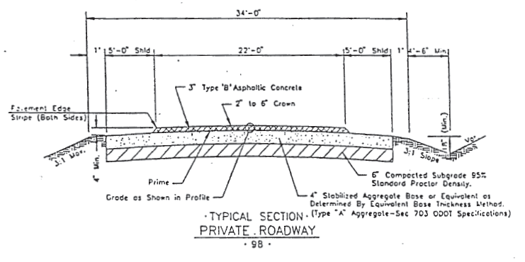
General notes:
1.
Stabilized aggregate base shall conform to state department of transportation specifications for type A aggregate, section 703.
2.
Asphaltic concrete mix design shall conform to state department of transportation specifications for type B asphaltic concrete mix design.
3.
Provide the city with one SPD per 2,400 SY of base, one field density per 500 tons of asphalt and one Hveem stability per 500 tons of asphalt.
4.
Provide one core per block to verify paving thickness.
(2)
Public roadways—concrete.
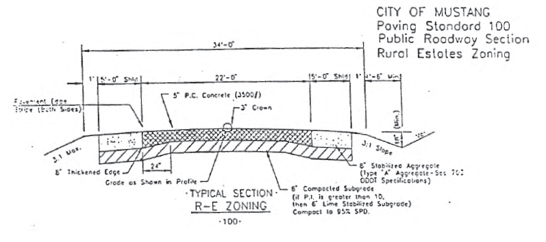
General construction notes:
1.
Install expansion joints at 100 feet c/c with sawed joints at 20 feet c/c.
2.
Provide city with one SPD per 2,400 SY of base and one set of conc. cylinders per 600 SY.
3.
Provide one core per block to verify paving thickness.
(3)
Public roadway—asphalt.
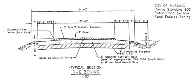
General notes:
1.
Stabilized aggregate base shall conform to state department of transportation specifications for type A aggregate, section 703.
2.
Asphaltic concrete mix design shall conform to state department of transportation specifications for type B asphaltic concrete mix design.
3.
Provide the city with one SPD per 2,400 SY of base, one field density per 500 tons of asphalt and one Hveem stability per 500 tons of asphalt.
4.
Provide one core per block to verify paving thickness.
(Code 1977, § 16.24.170)
_____
Sec. 106-411. - Areas where permitted.
Rural land not served by city water and sanitary sewer facilities shall be permitted the use of private roadways in either platted or unplatted areas, and building permits may be issued to property owners abutting upon private roadways under the conditions set out in this subdivision.
(Code 1977, § 16.24.070)
Sec. 106-412. - General standards.
(a)
The location of the private roadway easement shall be in compliance with the transportation plan map and city street standards, regardless of the size of the abutting property.
(b)
The private roadway easement shall be at least 50 feet in width in the case of local streets, or 60 feet in width in the case of collector streets.
(c)
All drives and curb cuts contained within the private roadway system shall comply with chapter 102, article II, and this chapter.
(d)
The tracts, lots, sites or parcels of land contained within the private roadway subdivision shall contain not less than two acres each, including respective portions of the adjacent roadways. However, public right-of-way on section line roads is not to be included in the two-acre requirement.
(e)
The nearest boundary of the property contained within the proposed subdivision must be more than one-quarter mile (1,320 feet) from sewer and water facilities furnished by the city. The measurement shall be the actual number of feet of sewer and/or water lines required to serve the property, to be determined by good engineering practices.
(f)
All storm drainage shall be in compliance with section 106-368. Open type bar ditches shall be prohibited. All stormwater runoff must be contained within the street curbline and removed in a safe manner from the subdivision.
(g)
The private roadway shall not be dedicated to the public, but reserved for future dedication, and until such future dedication it shall be the private roadway of the abutting property owners.
(h)
Private roadways shall be surfaced and improved in accordance with the transportation plan map and city street standards.
(i)
The private roadway shall be maintained by the owners of the property within the subdivision.
(j)
The city shall have no responsibility for the maintenance and repair of the private roadway or easement.
(k)
If the property is platted, there shall be emblemized on the face of the plat, clearly conspicuous, a notice that the streets shall always be open to police, fire and other official vehicles of all state, federal, county and city agencies, and subject to all traffic regulations of these agencies.
(l)
Every deed shall clearly acknowledge that the roadway is private and not maintained by the city.
(m)
All names for private roadways shall be approved by the planning commission in both platted and unplatted areas.
(Code 1977, § 16.24.071)
Sec. 106-413. - Street signs and "private roadway" sign.
(a)
Street signs. The developer shall install street signs at the intersection of all private roadways. The markers shall conform in style and quality with the standard street markers adopted by the city. After initial installation, the street signs shall be maintained by the property owners within the subdivision.
(b)
Private roadway sign. Prior to the sale of any parcel of land in the subdivision, a conspicuous sign shall be posted at the entrance into the subdivision, reading "Private Roadway not maintained by the City of Mustang, Oklahoma." The sign shall meet the following specifications:
(1)
The sign shall be of 20-gauge steel;
(2)
The dimensions shall be 36 inches by 48 inches;
(3)
Letters shall be three inches high and block style;
(4)
The color shall be a red background and white reflective lettering; and
(5)
The sign shall be affixed on two metal poles, with its lowest point not less than seven feet above grade.
(c)
Maintenance. After initial installation, the required street signs and the "private roadway" sign shall be maintained by the property owners within the subdivision. The property owners within the subdivision shall be given ten days' written notice by certified mail if a damaged, dilapidated or faded street sign or "private roadway" sign is not replaced or repaired. The procedure for abatement of a public nuisance, as outlined in chapter 38, article II, shall be followed if the sign is not replaced or repaired after the property owners have been given proper notice. Any cost for materials or labor suffered by the city shall be recovered directly from the property owners, or collected from the property owners by the county treasurer in the manner prescribed by the laws of the state.
(Code 1977, § 16.24.072)
Sec. 106-414. - Dedication to city; installation of city water or sewer facilities.
(a)
At any time after the city recognizes and permits the use of a private roadway, a petition of at least 60 percent of the owners in an area to improve and dedicate the street shall bind all of the owners thereby to permanently improve the street or roadway in order for it to be considered for acceptance into the city's street system.
(b)
If either city water or sewer facilities are provided to a private roadway subdivision, they shall be installed in accordance with the city ordinances relating thereto.
(Code 1977, § 16.24.073)
Sec. 106-415. - Resubdivision on private roads.
Resubdividing property fronting on private roadways into tracts, lots or parcels any part of which, when subdivided, contains less than two acres shall be prohibited.
(Code 1977, § 16.24.074)
Sec. 106-416. - Gated access.
(a)
Generally. Gated access for private streets may be permitted and approved for residential subdivisions, planned unit developments, apartment projects or two-acre private street developments under the terms and conditions set forth in this section and subject to other applicable provisions of this Code and when the city council determines, at its discretion, that such proposed gated access would not pose a threat to the general health, safety and welfare. The community development department and/or the planning commission may recommend, and the city council may require, multiple entrances. Gated access will not be permitted for public streets or roadways.
(b)
Conditions and requirements.
(1)
The gate shall be located a sufficient distance from a public street to allow four cars to line up at the gate without interfering with vehicles utilizing the public street. The minimum acceptable distance from the gate opening shall be no less than 80 feet from the nearest edge of the traveled public roadway.
(2)
A turnaround lane shall be provided for vehicles unable to enter the gated development, which shall not interfere with any adjacent public way.
(3)
Road spikes, barbs or other tire-damaging devices shall not be allowed.
(4)
Controlled access development shall comply with standards of the city involving engineering requirements, private streets, sidewalks, fire lanes and fire hydrants. In cases of conflict, the provisions of this section shall govern unless the city council specifically determines to the contrary, upon the recommendation of the city engineer.
(5)
The minimum gate opening width, including clearance for all improvements related to the gate, shall not be less than 20 feet.
(6)
An entry key pad shall be located on a pedestal near the normal access route. The entry code will be used for non-emergency access and shall be given to the fire department and the police department. If for any reason the entry code is changed, the new entry code shall not be implemented until the fire and police departments have been so notified. Failure to comply with any portion of this subsection shall be considered a violation of this section by the developer or the agent of the responsible party.
(7)
An emergency pull box shall be located on the key pad pedestal. When activated, the pull box will cause the gate to open and stay open until the emergency system is reset by the agent of the responsible party.
(8)
An emergency release hitch pin shall be installed on the control arm. This hitch pin, when removed, will detach the control arm from the gate and allow the gate to swing open freely with manual intervention.
(9)
A battery backup system shall be provided for each gate. These batteries will be trickle-charged to maintain electrical energy, and in the event of loss of normal electrical current cause the gate to open and remain open until reset by the homeowners' association.
(10)
The location of all entrance pedestals, emergency pull boxes, key pads, hitch pins and related equipment, operation of the gate, signage, opening design, swinging or sliding operation of the gate or any other design specification shall be constructed and installed in accordance with the plans approved by the community development director.
(11)
The minimum paving width for all lanes entering and exiting the development shall not be less than 20 feet in width. There shall be no parking on the 20-foot roadway. Appropriate signage shall be provided. If parking is requested, the minimum width of the roadway shall be 26 feet.
(12)
Should any problem occur in the operation of the gate or any violation of any provision of this section, the gate shall remain open and accessible until the problem is resolved and/or the gate is repaired and tested.
(13)
All culs-de-sac, dead-ends, turnarounds and entry or median street curblines shall be constructed to provide a minimum 40-foot radius to the outside edge of the fire lane pavement to ensure adequate access for fire protection vehicles. Parking along the fire lane and in the cul-de-sac or turnaround shall be prohibited, except where off-street parking is provided in a center island or median. If the cul-de-sac or turnaround design includes a center island or median with a radius concentric to the radius of the cul-de-sac or turnaround, the maximum radius to the outside edge of the center island or median along the back side of the cul-de-sac or turnaround shall be ten feet. If the radius of the center island or median is not concentric with the radius of the cul-de-sac or turnaround, the outside edge of the center island or median shall be so configured as to provide a minimum 26-foot width of fire lane pavement. In all cases, the entire area of fire lane pavement shall be unobstructed either horizontally or vertically, including any signage or landscaping. The design of all culs-de-sac, dead-ends and turnarounds, and entry of median street curblines, shall be subject to the approval of the city engineer and city fire marshal.
(14)
When a covered entry structure is requested, the minimum height shall be no less than 16 feet. The width shall be no less than 20 feet.
(c)
Responsible party.
(1)
There shall at all times be a responsible party for the gated access, who shall be the developer, or property owner, or homeowners' association formed pursuant to the provisions of 60 O.S. § 851 et seq. The name, address and telephone numbers of the responsible party shall be on file with the city clerk. A copy of the document forming such homeowners' association shall be on file with the city clerk, and a current membership list of the association shall be attached and updated within 30 days of any change. An agent of the association shall be appointed by the association, who shall serve as agent of the association for purposes of this section. The developer shall serve as the responsible party until a homeowners' association is formed.
(2)
The responsible party, as defined in subsection (c)(1) of this section, shall abide by and be responsible for the following:
a.
Maintenance and repairs of the private streets and/or fire lanes, and the provision of funds for the maintenance and repairs thereof through the use of assessments.
b.
Maintenance testing and repairs of all functions of the gate.
c.
Establishing the access code, and ensuring that the city emergency and utility services have the proper code number. Changing the code will not be allowed until all persons having the right of access, including the fire and police departments and utility services, if applicable, have been notified in writing, except that in an emergency all such persons may be notified by telephone with such change confirmed in writing within five days. In no instance shall persons who have a right of access to the property be denied an entrance to or exit from the property caused by failure of notification of a change in the code.
d.
Accompanying the fire department officer during inspection and testing of the opening systems.
e.
Maintaining a service agreement with a qualified contractor to ensure maintenance and the availability of instant emergency service.
(3)
The fire department shall approve an access agreement with the responsible party providing for an annual inspection of each gate to ensure that each gate is tested to meet all of the construction requirements. An inspection shall also be required for continued operation at any time the gate fails to meet the standards set forth in this section or when the fire chief determines that an inspection is in the interests of the public health, safety and welfare. A copy of the access agreement will be kept on file at the fire department with the maintenance contractor's name, address and 24-hour telephone number. No inspection shall be approved until the requirements for such agreement have been met. The fire chief is granted authority to deny approval for the operation of the gate in the event of failure of an inspection. An inspection will be repeated upon request of the responsible party when the deficiencies have been corrected.
(4)
Operation and maintenance of the controlled access system shall at all times remain the sole responsibility of the responsible party.
(d)
Penalty. Violation of any provision of this section shall, upon conviction, subject the violator to the penalties of section 1-8.
(Ord. No. 680, § 1, 12-2-1997)