
Newdale City Zoning Code
CHAPTER XII
APPENDICES
Appendix A - Detailed Performance Standards For Signs
- Purpose. This appendix establishes regulations for the location, type and size of signs permitted in the City of Newdale and in Newdale’s area of impact. Division 1 — Permit Requirements
- Permit Required. A Class I permit shall be required for the placement or installation of any sign. All signs located within the City of Newdale and its area of impact are intended for commercial or advertising purposes or for the identification of a business or residence. The sign will be allowed on the same premises, exceptions are directional and informational signs placed by governmental agencies or not-for profit organizations. Commercial signs along Hwy. 33 must get a permit from the State Department of Transportation in Rigby, Idaho.
- Exceptions to Permit Requirement. The signs listed here are not exempt from any requirement of this ordinance, except the requirement for a permit. No permit shall be required in the placement or installation of:
- residential nameplates;
- construction and real estate sign;
- political signs placed no more than 60 days before the election to which they relate and removed within 10 days after that election;
- window signs; or
- traffic control signs or public notices placed by public agencies.
- Placement of Signs. No sign shall be placed:
- in or over any public right-of-way;
- on any tree, or other natural feature; or on a utility pole;
- on a vehicle or trailer parked in a visible location for the primary purpose of displaying the sign; or
- where it creates a traffic safety hazard by obscuring traffic control sign or signals or obstructing vision at intersections or driveways.
- Signs in Public Rights-of-way. No sign shall be placed in any public right-of-way, except traffic control signs and public notices placed by public agencies.
- Permitted Signs. The following signs shall be permitted. All other signs are expressly prohibited.
- Traffic control signs or public notices placed by public agencies.
- For all uses:
- One nameplate of no more than four square feet for each dwelling or one cornerstone of no more than four square feet for each commercial or public building.
- One real estate sign, of no more than four square feet, for each lot or building currently offered for sale, lease, or rent.
- Political signs totaling no more than six square feet on a residential, provided that such signs are placed no more than 60 days before the election to which they relate and removed within 10 days after the election. A commercial use may display additional political signs within the limits established by this appendix.
- Any dwelling may display one temporary sign of no more than six square feet announcing the short-term sale of used household goods (a garage or yard sale), provided that sign is placed no more than two days before the sale and removed within one day after the sale.
- For home occupations. One sign no larger than 4 square feet shall be permitted on a residence. Sign must be located no closer than 15 feet from the lot corner at the intersection. On other side roads, it can’t hang over city right of way. It may not interfere with the clear vision triangle. See app. 1-2, #10., of the Development Code.
- On Site Commercial Use:
- One construction sign of no more than thirty-two square feet, provided that the sign is not placed until construction begins and that it is removed within 30 days after the end of construction.
- Necessary on-site directional signs of no more than four square feet each.
- Window signs that occupy no more than 20% of any window.
- Any combination of the following kinds of signs, provided that the total sign area does not exceed 10% of the area of the principal building facade facing a road frontage: wall signs, suspended signs, projecting signs with no more than 16 square feet per side, or one ground or pole sign for each road frontage, of no more than 180 square feet per side.
- Awnings may display the name or logo of the owner or operator.
- See appendices 1-2-10 clear sight distance.
- Off Premise Commercial Use: State highway right of ways will be in effect for any signs along state highway 33. The sign can not exceed thirty-two square feet in size. Signs must be located in Commercial Zone areas, on an active business site. See appendices 1-2-10 clear sight distance.
- Illuminated Signs. Signs with a constant source of illumination shall be permitted for commercial uses. No flashing, blinking, or moving signs are permitted. Spotlights or other fixtures used for the illumination of a sign shall be placed in compliance with the provisions of this ordinance prohibiting light or glare that constitutes a nuisance and shall not constitute a traffic hazard.
- Identification of Signs. All off-site signs shall bear a weatherproof label identifying their owner, including the owners name, mailing address and telephone number. Identification labels may be attached to the sign or it supporting structure.
- Maintenance of Signs. All signs and their supporting structures shall be maintained so as not to create a health or safety hazard.
- Abandoned Signs. Abandoned signs shall be removed within sixty days of the adoption of this ordinance, or within 60 days of the abandonment of the use to which the sign is appurtenant. Abandonment shall not be a matter of the owner’s intent, but shall be considered to occur whenever a use ceases operation for more than one year. Any sign that is not structurally sound or that no longer serves to inform or attract the public shall be considered abandoned and its removal required.
Appendix B - Model Hearing Notices
- Purpose. The purpose of this appendix is to provide models for the hearing notices required by this ordinance.
- Notice for Class II Permit Application Hearing.
PUBLIC HEARING NOTICE - CLASS II PERMIT
John and Jane Doe of P.O. Box 22, Jackson, WY 83001 propose to subdivide the SE 1/4, SW 1/4 of Section 37, T. 19 N., R 47 E.B.M. into 16 residential lots. The average density of this development will be 0.4 dwelling units per acre. The property is located on the north side of Pine Marten Road, approximately 1.4 miles east of Fool Hen Creek. The present land use is pasture.
The City of Newdale Planning and Zoning Commission will conduct a hearing on this proposal at 8:00 P.M., Monday, March 1, 1994 at the City Office. A copy of the application is available for public review at the City of Newdale Planning Administrator's Office. Public comment is encouraged. - Notice of Variance Hearing.
PUBLIC HEARING NOTICE - VARIANCE
Mr. and Mrs. J. Doe of P.O. Box 50999, Idaho Falls, ID 83405 have applied for a variance of Section __________ of the City of Newdale Development Code. This proposed variance would permit a 12 foot encroachment in the required stream corridor setback along Turkey Creek. This proposed encroachment would permit construction of a deck attached to the cabin located on Lot 6 of the Gobbler Subdivision. The property is located on the east side of Cranberry Drive, 0.3 miles from the intersection of Cranberry Drive and the Turkey Creek Highway.
The City of Newdale Planning and Zoning Commission will conduct a hearing on this proposal at 8:20 P.M., Monday, March 1, 1994 at the Newdale City Office. A copy of the application is available for public review at the Newdale City Office. Public comment is encouraged.
Appendix C - Idaho Attorney General's Takings Checklist Criteria
Agency or local government staff must use the following questions in reviewing the potential impact of a regulatory or administrative action on specific property. While these questions also provide a framework for evaluating the impact proposed regulations may have generally, takings questions normally arise in the context of specific affected property. The public review process used for evaluating proposed regulations is another tool that the agency or local government should use aggressively to safeguard rights of private property owners. If property is subject to regulatory jurisdiction of multiple governmental agencies, each agency or local government should be sensitive to the cumulative impacts of the various regulatory restrictions.
Although a question may be answered affirmatively, it does not mean that there has been a "taking". Rather, it means there could be a constitutional issue and that the proposed action should be carefully reviewed with legal counsel.
- Does the Regulation or Action Result in a Permanent or Temporary Physical Occupation of Private Property?
Regulation or action resulting in a permanent or temporary physical occupation of all or a portion of private property will generally constitute a "taking." For example, a regulation that required landlords to allow the installation of cable television boxes in their apartments was found to constitute a "taking". See Loretto v. Teleprompter Manhattan CATV Corp., 458 U.S. 419, 102 S. Ct. 3164 (1982). - Does the Regulation or Action Require a Property Owner to Dedicate a Portion of Property or to Grant an Easement?
Carefully review all regulations requiring the dedication of property or grant of an easement. The dedication of property must be reasonably and specifically designed to prevent or compensate for adverse impacts of the proposed development. Likewise, the magnitude of the burden placed on the proposed development should be reasonably related to the adverse impacts created by the development. A court also will consider whether the action in question substantially advances a legitimate state interest.For example, the United States Supreme Court determined in Nollan v. California Coastal Comm'n, 483 U.S. 825, 107 S. Ct. 3141 (1987), that compelling an owner of waterfront property to grant a public easement across his property that does not substantially advance the public's interest in beach access, constitutes a "taking." Likewise, the United States Supreme Court held that compelling a property owner to leave a public greenway, as opposed to a private one, did not substantially advance protection of a flood plain, and was a "taking." Dolan v. City of Tigard, 512 U.S. 374, 114 U.S. 2309 (1994).
- Does the Regulation Deprive the Owner of All Economically Viable Uses of the Property?
If a regulation prohibits all economically viable or beneficial uses of the land, it will likely constitute a "taking." In this situation, the agency can avoid liability for just compensation only if it can demonstrate that the proposed uses are prohibited by the laws of nuisance or other preexisting limitations on the use of the property. See Lucas v. South Carolina Coastal Coun., 505 U.S. 1003, 112 S. Ct. 2886 (1992).Unlike 1 and 2 above, it is important to analyze the regulation's impact on the property as a whole, and not just the impact on a portion of the property. It is also important to assess whether there is any profitable use of the remaining property available. See Florida Rock Industries, Inc. v. United States, 18 F.3d 1560 (Fed. Cir. 1994). The remaining use does not necessarily have to be the owner's planned use, a prior use or the highest and best use of the property. One factor in this assessment is the degree to which the regulatory action interferes with a property owner's reasonable investment-backed development expectations.
Carefully review regulations requiring that all of a particular parcel of land be left substantially in its natural state. A prohibition of all economically viable uses of the property is vulnerable to a takings challenge. In some situations, however, there may be pre-existing limitations on the use of property that could insulate the government from takings liability.
- Does the Regulation Have a Significant Impact on the Landowner's Economic Interest?
Carefully review regulations that have a significant impact on the owner's economic interest. Courts will often compare the value of the property before and after the impact of the challenged regulation. Although a reduction in property value alone may not be a "taking," a severe reduction in property value often indicates a reduction or elimination of reasonably profitable uses. Another economic factor courts will consider is the degree to which the challenged regulation impacts any development rights of the owner. As with 3, above, these economic factors are normally applied to the property as a whole.A moratorium as a planning tool may be used pursuant to Idaho Code § 67-6523 – Emergency Ordinances and Moratoriums (written findings of imminent peril to public health, safety, or welfare; may not be longer than 120 days); and Idaho Code § 67-6524 – Interim Ordinances and Moratoriums; (written findings of imminent peril to public health, safety or welfare; the ordinance must state a definite period of time for the moratorium). Absence of the written findings may prove fatal to a determination of the reasonableness of the government action.
The Idaho moratorium provisions appear to be consistent with the United States Supreme Court’s interpretation of moratorium as a planning tool as well. In Tahoe-Sierra Preservation Council, Inc. et al. v. Tahoe Regional Planning Agency et al., (Slip Opinion No. 00-1167, April 23, 2002); the Court held that planning moratoriums may be effective land use planning tools. Generally, moratoriums in excess of one year should be viewed with skepticism, but should be considered a one factor in the determination of whether a taking has occurred. An essential element pursuant to Idaho law is the issuance of written findings in conjunction with the issuance of moratoriums. See Idaho Code §§ 67-6523-6524.
- Does the Regulation Deny a Fundamental Attribute of Ownership?
Regulations that deny the landowner a fundamental attribute of ownership — including the right to possess, exclude others and dispose of all or a portion of the property — are potential takings.The United States Supreme Court recently held that requiring a public easement for recreational purposes where the harm to be prevented was to the flood plain was a 'taking. In finding this to be a "taking", the Court stated:
The city never demonstrated why a public greenway, as opposed to a private one, was required in the interest of flood control. The difference to the petitioner, of course, is the loss of her ability to exclude others ... [T]his right to exclude others is "one of the most essential sticks in the bundle of rights that are commonly characterized as property." Dolan v. City of Tigard, 512 U.S. 374, 114 U.S. 2309 (1994).The United States Supreme Court has also held that barring the inheritance (an essential attribute of ownership) of certain interests in land held by individual members of an Indian tribe constituted a "taking." Hodel v. Irving, 481 U.S. 704, 107 S. Ct. 2079 (1987).
- (a) Does the Regulation Serve the Same Purpose that Would be Served by Directly Prohibiting the Use of Action: and (b) Does the Condition Imposed Substantially Advance that Purpose?
A regulation may go too far and may result in a takings claim where it does not substantially advance a legitimate governmental purpose. Nollan v. California Coastal Commission, 483 U.S. 825, 107 S. Ct. 3141 (1987); Nolan v. City of Tigard, 512 U.S. 374, 114 S. Ct. 2309 (1994).
In Nollan, the United States Supreme Court held that it was an unconstitutional "taking" to condition the issuance of a permit to land owners on the grant of an easement to the public to use their beach. The Court found that since there was no indication that the Nolan’s' house plans interfered in any way with the public's ability to walk up and down the beach, there was no "nexus" between any public interest that might be harmed by the construction of the house, and the permit conditions. Lacking this connection, the required easement was just as unconstitutional as it would be if imposed outside the permit context.Similarly, regulatory actions which closely resemble, or have the effects of a physical invasion or occupation of property, are more likely to be found to be takings. The greater the deprivation of use, the greater the likelihood that a "taking" will be found.
Appendix D - Detailed Performance Standards For Home Occupations
- Purpose. These performance standards will permit limited commercial activity in residential areas, while assuring that such activity does not diminish the residential character of the neighborhood. Approval of a home occupation does not change any requirement of this ordinance that is applicable to the dwelling to which it is accessory.
- Maximum Floor Area. Home occupations may be located within dwellings or accessory buildings, but no home occupation shall occupy a floor area larger than that of the dwelling to which it is accessory.
- Nonresident Employees. No home occupation shall have more than one employee who is not a member of the resident family.
- Off-Street Parking. Home occupations shall provide off-street parking for all employees and any vehicles associated with the home occupation in compliance with the requirements of Appendix H.
- Outdoor Storage. The storage of any materials or solid waste associated with a home occupation shall be:
- within an enclosed structure, or
- within an area that is effectively screened from public view using a landscaped buffer that includes an opaque hedge, fence, or wall. The materials and color of screening fences or walls shall be compatible with those of the main building on the lot.
- Signs. Home occupations shall display only the following signs:
- one nonilluminated wall sign of no more than six square feet, and
- one nonilluminated on-site directional sign of no more than four square feet.
- Residential Care Facilities.
- To qualify as a home occupation, a residential care facility must have eight or fewer residents and two or fewer resident staff.
- Residential care facilities are not part of the local, state, or federal corrections system. Residents may not include persons who are serving a sentence imposed by a court.
- Residential care for the elderly, children's institutions, as defined by the Child Care Licensing Reform Act, and similar home occupations shall be certified or licensed as required by law.
Appendix E - Detailed Performance Standards For Buffering
- Purpose. Landscaping requirements are an essential element in mitigating potential land use conflicts and enhancing the visual appeal of the city. The purpose of this appendix is to ensure that landscaped buffers required by these regulations effectively accomplish those goals.
- Minimum Buffer Requirements. The width of required buffers shall vary with the nature of the uses being separated, the height of the buildings being separated, and the construction of the buffer, as shown in Table E.1. The basic buffer width given in that table is the width required where the buffer consists of a level or gently sloping area of sod or ground cover and at least four major trees per hundred lineal feet of buffer. That table also shows where a security fence and/or a solid fence, wall, or berm is required as part of a buffer.
- Height Adjustment. The basic buffer width shall be increased by the height adjustment factor, where one is established by Table E.1. The height adjustment factor is a ratio expressing the number of feet that must be added to the basic buffer width for each foot in height over 25 feet of the principal building being buffered.
- Buffer Width Reduction: Berms. The basic buffer width requirements may be reduced where a berm is included in the buffer. The width reduction shall be twice the height of the berm, but the maximum permitted reduction shall be 10 feet. No berm shall have a slope of more than 3:1, except where a retaining wall is incorporated into the berm on the side opposite the use or public way being buffered.
- Buffer Width Reduction: Additional Plantings. The basic width requirements may be reduced where a greater density and diversity of plantings is included in the buffer. The buffer width reductions permitted by this section are cumulative and may result in a total reduction of up to 30%. The buffer width reduction permitted by E.4. is cumulative with those permitted here.
- Major Trees. The required buffer width shall be reduced by 10% where five or more major trees per hundred lineal feet are planted or retained.
- Understory Trees. The required buffer width shall be reduced by 10% where five or more understory trees per hundred lineal feet are planted or retained.
- Shrubs. The required buffer width shall be reduced by 10% where 20 or more shrubs per hundred lineal feet are planted or retained.
- Minimum Buffer Width. No required buffer shall be less than half the basic buffer width or less than 10 feet in width, regardless of any reductions permitted by E.4. or E.5.
- Buffer Crossings/Inclusions. Buffers may be crossed by access driveways, utility lines, sidewalks, and pedestrian trails. A sidewalk or pedestrian trail may also run along the length of a buffer, with its width, up to a maximum five feet, being included in the required buffer width. Buffers may also include permitted signs.
- Plant Materials Specifications. Plant materials installed in required buffers shall be warrantied for one year and meet the following specifications:
- all trees, major and understory, shall be containerized or bagged and burlapped stock in good condition with a caliper of at least 1.5 inch, measured one foot above grade, for deciduous trees, and a height of at least six feet for coniferous trees; and
- all shrubs shall be minimum one gallon containerized stock in good condition
- Maintenance. Perpetual maintenance of required buffers is required by Chapter IX Sec O.
TABLE E.1. - BUFFERING REQUIREMENTSSF = square feet. Where requirements overlap the strictest applies.type of development type of development or area basic buffer width (feet) height adjustment headlight buffer? security fence required? industrial residential, platted residential lots 50 1:1 for parking Yes industrial any public way 12 None No Yes industrial or commercial adjoining visually sensitive area 50 1:1 NO No commercial residential, platted residential lots 20 .75:1 for parking No commercial outdoor materials storage, handling, or sales areas, over 10,000 SF residential, platted residential lots 50 None Yes Yes commercial outdoor materials storage, handling, or sales areas, any size any public way 12 None No Yes higher density residential lower density residential, platted residential lots 20 .80:1 for parking No
Appendix F - A Section Of The Idaho Code Establishing Requirements For The Subdivision Of Irrigated Lands
- Purpose. The purpose of this appendix is to provide ordinance users with a copy of a section of the Idaho Code for reference purposes.
- I.C. 31-3805. Delivery Of Water.
- When either a subdivision within the meaning of chapter 13, title 50, Idaho Code, or a subdivision subject to a more restrictive county or city zoning ordinance is proposed within the state of Idaho, and all or any part of said subdivision would be located within the boundaries of an existing irrigation district or other canal company, ditch association, or like irrigation water deliver entity, hereinafter called "irrigation entity" for the purposes of this chapter, no subdivision plat or amendment to a subdivision plat or any other plat or map recognized by the city or county for the division of land will be accepted, approved, and recorded unless:
- The water rights appurtenant and the assessment obligation of the lands in said subdivision which are within the irrigation entity have been transferred from said lands or excluded from an irrigation entity by the owner thereof; or by the person, firm or corporation filing the subdivision plat or amendment to a subdivision plat or any other plat or map recognized by the city or county for the division of land; or
- The owner or person, firm or corporation filing the subdivision plat or amendment to a subdivision plat or any other plat or map recognized by the city or county for the division of land has provided for underground tile or other like satisfactory underground conduit for lots of one (1) acre or less, or a suitable system for lots of more than one (1) acre which will deliver water to those landowners within the subdivision who are also within the irrigation entity, with the following appropriate approvals:
- For proposed subdivisions within the incorporated limits of a city, the irrigation system must be approved by the city zoning authority or the city council, as provided by city ordinance, with the advice of the irrigation entity charged with the delivery of water to said lands.
- For proposed subdivisions located outside incorporated cities but within a negotiated area of city impact pursuant to chapter 65. title 67, Idaho Code, or within one (1) mile outside the incorporated limits of any city, both city and county zoning authorities and city council and county commissions must approve such irrigation system in accordance with section 50-1306, Idaho Code. In addition, the irrigation entity charged with the delivery of water to said lands must be advised regarding the irrigation system.
- For proposed subdivisions located outside an area of city impact in counties with a zoning ordinance, the delivery system must be approved by the appropriate county zoning authority, and the county commission with the advice of the irrigation entity charged with the delivery of water to said lands.
- For proposed subdivisions located outside an area of city impact in counties without a zoning ordinance, such irrigation system must be approved by the board of county commissioners with the advice of the irrigation entity charged with the delivery of water to said lands.
- In the event that the provisions of either subsection 2,a,i or 2,a,ii of this section have not been complied with, the assessments of the irrigation entity for operation, maintenance, construction, and other valid charges permitted by statute shall in no way be affected. Any person, firm or corporation or any other person offering such lots in such subdivision for sale, or selling such lot shall, prior to the sale, advise the purchaser in writing as follows:
- That suitable water deliveries have not been provided; and
- That the purchaser of the lot must remain subject to all assessments levied by the irrigation entity; and
- That the individual purchaser shall be responsible to pay such legal assessments; and
- That the assessments are a lien on the land within the irrigation entity; and
- That the purchaser may at a future date petition the appropriate irrigation entity for exclusion from the irrigation district.
- A disclosure statement executed by the purchasers and duly acknowledged, containing the representations required in this subsection of this section, shall be obtained by the seller at the time of receipt of the earnest money from the purchaser, and affixed to the proposed sales contract and a copy thereof shall be forwarded to the appropriate irrigation entity.
- In the event that the provisions of either subsection 2,a,i or 2,a,ii of this section have not been complied with, the assessments of the irrigation entity for operation, maintenance, construction, and other valid charges permitted by statute shall in no way be affected. Any person, firm or corporation or any other person offering such lots in such subdivision for sale, or selling such lot shall, prior to the sale, advise the purchaser in writing as follows:
- When either a subdivision within the meaning of chapter 13, title 50, Idaho Code, or a subdivision subject to a more restrictive county or city zoning ordinance is proposed within the state of Idaho, and all or any part of said subdivision would be located within the boundaries of an existing irrigation district or other canal company, ditch association, or like irrigation water deliver entity, hereinafter called "irrigation entity" for the purposes of this chapter, no subdivision plat or amendment to a subdivision plat or any other plat or map recognized by the city or county for the division of land will be accepted, approved, and recorded unless:
- I.C. 31-3806. Civil Action To Enforce.
- If the owner of the property of the person, firm or corporation filing the subdivision plat or amendment to a subdivision plat or any other plat or map recognized by the city or county for the division of land fails to comply with either subsection 2,a or 2,b of section 31-3805, Idaho Code, prior to sale of the lots in the subdivision to purchasers, the owner of the property, or the person, firm or corporation filing the subdivision plat or amendment to a subdivision plat or any other plat or map recognized by the city or county for the division of land shall be liable to any purchaser for the costs of the lot's exclusion plus all assessments due and owing or the actual cost of installation of an irrigation delivery system not to exceed one thousand five hundred dollars ($1,500) per lot. The purchaser shall have a right to enforce this obligation in a civil action and the purchaser shall have the right to elect exclusion or installation of the system in such action.
- Any person, firm or corporation who shall omit, neglect or refuse to provide the purchaser or the irrigation entity within whose boundaries the land is located, a copy of the disclosure statement required by subsection 2,a of section 31-3805, Idaho Code:
- Shall be liable to the purchaser as provided in subsection 3,a of this section.
- Shall be liable to the irrigation entity for its reasonable expense, including employee time, of locating the purchaser and providing the information required in the form and for advising affected purchasers of the lack of a water delivery system and for any assessments on the property that are past due at the time of discovery of the violation. The irrigation entity affected shall have a right to claim such expenses in a civil action.
- In any civil action filed under subsection 3,a or 3,b of this section, the prevailing party shall be awarded its reasonable costs and attorney's fees. The purchaser and irrigation entity shall have two (2) years from the date of discovery of the violation to initiate any legal action.
Appendix G - Idaho Code Requirements For Manufactured Home Installation And Foundations
- Purpose. This appendix presents a portion of the Idaho Code for reference purposes.
44-2201. MOBILE/MANUFACTURED HOMES INSTALLATION.- All mobile/manufactured homes must be installed in accordance with the Idaho manufactured home installation standard, as provided by rule pursuant to this chapter. All mobile/manufactured homes must be installed in accordance with all other applicable state laws or rules pertaining to utility connection requirements.
- The administrator of the division of building safety may promulgate rules in accordance with the provisions of chapter 52, title 67, Idaho Code, specifying standardized installation instructions for mobile/manufactured homes. Upon the effective date of such rules, the rules shall prevail over any conflicting provisions in this chapter.
- The owner or the installer of a mobile/manufactured home must obtain an installation permit as required by city or county ordinance before installing a mobile/manufactured home that will be used as a residence on a building site or in a park. The installer's license must be in effect at the time of the application for the installation permit.
- Cities and counties, which have by ordinance adopted a building code, shall establish a permit process for the installation of all mobile/manufactured homes within their respective jurisdictions and shall provide for inspection of all work in accordance with the Idaho manufactured home installation standard. Fees for installation permits and inspections shall be as established by the city or county having jurisdiction.
- Immediately upon completion of the installation of a mobile or manufactured home, a licensed installer or the responsible managing employee of the licensed installer shall perform an inspection of the completed installation to ensure compliance with the Idaho manufactured home installation standard. Such inspection shall be recorded on an inspection record document approved by the division and a copy shall be provided to the homeowner upon completion of the inspection.
- This chapter shall apply to the installation of mobile homes constructed prior to June 15, 1976, within the jurisdiction of a city or county requiring an installation permit pursuant to section 44-2202, Idaho Code.
- Before a permit for the installation of the mobile home may be issued, the home must meet the rehabilitation requirements specified in this chapter and receive a certificate of compliance from the administrator of the division of building safety of the state of Idaho.
- Upon submission of the rehabilitation form required pursuant to section 44-2504, Idaho Code, and any other information required by the administrator to establish compliance with this chapter, the administrator shall issue a certificate of compliance to the homeowner. The certificate of compliance must be presented to the local jurisdiction before a permit for the installation of the home may be issued.
- Upon receipt of the certificate of compliance, the local jurisdiction shall issue the installation permit in the same manner as the permit would be issued with respect to a mobile/manufactured home for which rehabilitation is not required. No zoning or other ordinance or policy of the local jurisdiction prohibiting relocation or installation of a mobile home to which this chapter applies shall be effective to prohibit the relocation or installation of a mobile home for which a certificate of compliance has been issued in accordance with this chapter.
Appendix H - Detailed Performance Standards For Off-Street Parking And Loading
- Purpose. These performance standards are intended to prevent traffic congestion by requiring provision of adequate off-street parking and loading areas.
- Off-Street Parking Required. All buildings and uses shall provide the minimum number of off-street parking spaces required by Table H.1. Parking spaces shall have graded and drained gravel or paved surfaces.
- Off-Street Parking Requirements for Uses Not Listed. The classification of uses and the off-street parking requirements for uses not listed in Table H.I. shall be determined by the administrator. Any person who disputes a decision of the administrator may request a review of that decision using the appeals procedure of Chapter III. Sec N.
- Location of Off-Street Parking. Off-street parking shall be provided on the same lot and under the same ownership as the use it serves, except that two or more uses may share a parking area where:
- the total number of spaces provided is not less than the sum of the parking spaces required for all buildings or uses served, and
- a contract providing for shared parking for a period of 10 or more years is executed before approval of a permit and recorded before issuance of a certificate of compliance.
Required off-street parking spaces shall be within 600 feet of a main entrance of the building or use being served, except for spaces serving a dwelling unit, which shall be within 100 feet of the unit served.
- Passenger Loading Areas. Day care centers, pre-schools, public schools, and places for public assembly located on arterial roads shall provide at least one safe off-street passenger loading area. Such areas shall be located where there is adequate visibility for their safe use and they can
- be divided from the road by a curbed barrier of at least four feet in width;
- be at least 60 feet in length and 12 feet wide;
- accommodate one-way traffic only;
- include a depressed curb section for handicapped access; and
- be marked by pedestrian crossing signs facing both traffic lanes.
- Off-Street Loading Areas.
- Agricultural Storage Facilities. Certain agricultural storage facilities, like potato cellars generate substantial traffic during harvest, and may affect the flow of traffic on public roads. Setting specific setback or loading area standards for such uses is difficult, but all proposals for Class I permits for new agricultural storage facilities shall include an on-site circulation plan snowing how trucks will flow through the site and demonstrating that potentially adverse impacts on public roads will be minimized. Where storage facilities are part of a commercial or industrial development, the circulation plan must be submitted with the application for Class II permit review.
- Commercial and Industrial Uses. All commercial and industrial buildings and uses, except those to which a., above, applies, shall provide one safe, properly signed off-street loading area for each 10,000 square feet of gross floor area. Off-street loading areas shall: i. be on the same lot and under the same ownership as the building or use they serve, ii. be designed to accommodate the largest vehicle that may reasonably be anticipated for use on the site, and iii. have the following minimum dimensions: vertical clearance: 14 feet; width: 12 feet; and depth (length): 35 feet. No vehicle parked in a required off-street loading space shall extend into a public right-of-way.
- Access to Off-Street Parking and Loading Area. Graded and drained gravel or paved access driveways shall be provided for safe access to all off-street parking and loading areas.
- No parking area, except those serving single family dwellings, shall be designed or constructed to create a situation in which vehicles are required to back onto a public road.
- Parking and loading areas shall be sited and designed to minimize the number of access points to arterial roads.
- No access driveway to a local road shall be within 20 feet of any intersection or alley or 10 feet of another access point. The distance from an access driveway to an intersection is measured from the junction of the corner lot lines at the intersection, to the nearest side of the driveway.
- No access driveway to an arterial road shall be within 60 feet of its intersection with any local street, or 200 feet of its intersection with another arterial.
- Clear vision triangles shall be provided for all access driveways, as described in Appendix I.10.
- Access driveways for single family dwellings shall be a minimum of 10 feet wide, with a curb radius, where curbs exist, of five feet. Access driveways for other uses shall be designed to accommodate the reasonably anticipated level of use. No access driveway shall approach a public road at a grade of more than 12%.
- Where required for drainage, access driveways shall be constructed over a minimum 12 inch culvert capable of supporting a load of 40,000 pounds.
- Circulation Within Off-Street Parking Areas. The pattern of circulation within parking areas shall be designed to provide safe and efficient access to individual parking spaces, protect pedestrians moving through the parking area and prevent accidents by minimizing the random movement of automobiles, and facilitate safe access to public streets.
- Minimum aisle widths shall be:
- for two-way circulation and/or 90 degree parking: 24 feet;
- for one-way circulation and 60 degree angle parking: 18 feet;
- for one-way circulation and 45 degree angle parking: 15 feet; and
- for one-way circulation and 30 degree angle parking: 13 feet.
- Where one-way circulation is used, directional signs shall be installed at all access points to the parking area.
- No parking area shall be designed so that circulation from one portion of the area to another relies on a public street.
- Minimum aisle widths shall be:
- Protecting Pedestrians in Off-Street Parking and Loading Areas. There shall be safe pedestrian access around or through all parking and loading areas.
TABLE H.1 - MINIMUM OFF-STREET PARKING REQUIREMENTS FOR RESIDENTIAL, RETAIL, AND SERVICE USESNotes: Other uses (transportation, communications, and utilities; wholesale trade; and industrial) shall provide one parking space for each anticipated employee plus one and one parking space for each anticipated company vehicle, plus one. Where a place of assembly does not have fixed seating, one space shall be provided for each 25 square feet of assembly area. Off-street parking requirements for different uses in the same building shall be calculated separately.Land Use Parking Spaces Land Use Parking spaces per 1000 feet of gross floor area dwellings (SLUC 11, 14) 2 per unit retail automotive, marine (SLUC 55) 5 lodging places (SLUC 15) 1 per unit plus 1 eating and drinking places (SLUC 58) 15 theaters and similar places of assembly (including SLUC 72) .33 per seat financial, real estate, and insurance services (SLUC 61) 3 elementary and junior high schools 1 per classroom plus 1, (auditoriums used for public events are places of assembly) beauty and barber services (SLUC 623) 6 hospitals, rest homes, and similar uses (SLUC 6513, 6516) 2 per bed other personal services, misc. services (SLUC 62, 69) 3 land use parking spaces per 1000 feet of gross floor area health services, except hospitals (SLUC 51) 5 building materials, farm equipment, and furniture (SLUC 5211-5240, 5252, 57) 1 professional services (SLUC 65) 3 hardware, apparel, and misc. retail uses (SLUC 5251, 56, 59) 3 shopping centers 4 general merchandise, groceries, bakeries (SLUC 53, 54) 4 mixed office uses 3
Appendix I - Detailed Performance Standards For The Design And Construction Of Roads
- Purpose. The purpose of this appendix is to provide standards for the construction or reconstruction of roads. These standards are for roads in low to medium density residential and light commercial areas. A large-scale development study will be required for any development that generates sufficient traffic to necessitate additional construction requirements.
- Large-Scale Development. Any requirement of this appendix may be altered as a result of a large-scale development study required by this ordinance.
Division 1 - Street Design - Right-of-Way and Surface Width. Road right-of-way and surface widths shall be as required by Table I.1.
TABLE I.1 - LOCAL ROAD STANDARDSNotes: "Slope" refers to the slope on which the road is proposed, not to the grade of the road itself. Where one-way circulation systems are used, the developer shall install "one-way" and "do not enter" signs in the appropriate locations at all intersections.slope units served minimum right-of-way width minimum surface width maximum cul-de-sac length 0-8% > 16 60 feet 24 feet 660 feet 0-8% < 16 60 feet 24 feet, 16 feet one way 880 feet 8-15% > 16 40 feet 20 feet two-way, 16 feet one way 660 feet 8-15% < 16 40 feet 16 feet with pull-outs every 400 feet 880 feet > 15% any number, construction discouraged 40 feet 14 feet, with pull-outs every 400 feet 660 feet - Right-of-Way Treatment. The entire required right-of-way should not be cleared. Grading should be confined to the minimum area necessary for construction of a properly drained road surface. Where a road passes through timber or brushy vegetation that creates a wildfire hazard, the entire right-of-way shall be treated as a fuel reduction area where trees or brush are thinned to a density where crowns do not overlap or touch and ladder fuels are removed. Construction slash shall be removed from the right-of-way along with other fuels.
- Surface Construction. Road surfaces shall be laid over a properly compacted subgrade and consist of:
- a subbase of a minimum six inches of coarse aggregate; and
- a base of a minimum two inches of crushed coarse aggregate.
Roads may be paved, but paving is not required by this ordinance.
- Drainage. Road surfaces shall be crowned so as to slope away from the centerline at a grade of two percent. Shallow, parabolic drainage and snow storage areas shall be provided along all roads. These drainageways shall be reseeded after construction.
- Maximum Grade. The maximum grade of any road shall be eight percent, except at intersections. See I.1.
- Culs-De-Sac. Culs-de-sac may be used, with the maximum length permitted by Table I. l and a radius of 60 feet. Other dead-end streets shall be prohibited, except where temporarily permitted by a subdivision phasing plan, or to provide for future connections between developments. A temporary cul-de-sac shall be provided wherever a temporary dead-end street serves four or more lots.
- Minimum Centerline Radius of Curves. The minimum centerline radius of curves shall be 100 feet.
Division 2 - Intersection Design - Clear Sight Distance. Clear vision triangles shall be provided as follows:
- at intersections: the clear vision triangle includes the area defined by extending a line between two points, one on each lot line paralleling the road, each of which is 30 feet from the lot corner at the intersection; and
- at other points of access: the clear vision triangle includes the area defined by extending a line between two points, one on the lot line paralleling the road, and one on the outer edge of the driveway, each of which is 15 feet from the point where the driveway crosses the lot line.
- No solid fence or wall, planter, hedge, shrub, or other visual obstruction more than three feet in height above the grade of the adjoining roads shall be permitted within a clear vision triangle.
- No parking shall be permitted in a clear vision triangle.
- Trees shall be permitted in clear vision triangles, but only if all branches are removed to a height of at least seven feet above grade. See Table I.2.
FIGURE I.2 -- VISION TRIANGLE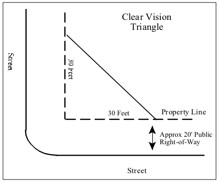
- Grade at Intersection. The maximum grade at, and within 50 feet along both approaches to, any intersection shall be three percent.
- Alignment of Intersection. All intersections shall be at a 90° angle, ±5° with both approaches running at 90°, ±5°, for at least 50 feet before the intersection.
- Minimum Centerline Offset of Intersections. Intersections shall either be aligned, or the minimum centerline offset between them shall be 125 feet, except for intersections with arterials, where it shall be 200 feet.
- Signs. The developer shall install stop signs at all intersections with arterial streets. The developer shall also install all other signs required for safe traffic and pedestrian movement in the development.
Division 3 - Additional Standards - Culverts and Bridges. All culverts and bridges shall be designed by a professional engineer. Bridges and culverts are subject to the stream corridor and floodplain requirements of this ordinance.
- All bridges and culverts on natural watercourses shall be designed to pass a 100-year flood without damage to the bridge or its approaches, without diverting floodwaters onto neighboring properties, and without increasing the level of the base flood downstream.
- The developer may be required to install a bridge rather than a culvert on any natural watercourse where such action is required, on the advice of the Idaho Fish and Game Department, to protect the fishery.
- Culverts not included in I.15.a. shall be designed to pass the runoff from the 10-year, 6-hour storm,
- All culverts and bridges shall be designed to support a minimum gross vehicle load of 40,000 pounds,
- There shall be a minimum 50-foot straight-on approach to all bridges.
Appendix J - Detailed Performance Standards For The Platting Of Lot Splits And Subdivisions
- Purpose. This appendix establishes standards for the form and content of subdivision plats. The requirements it imposes are in addition to the requirements of state law.
Division 1 - Preliminary Plats - Preliminary Plat Part of Application. A preliminary plat is one part of the application for a Class II permit to subdivide (see Chapter III. Sec I. of this ordinance) and shall accompany the official application form and all other materials required for a complete application.
- Preliminary Plats to Be Comprehensive. Preliminary plats shall cover the entire area to be developed by one owner or a group of related or associated owners, even when it is anticipated that development will be phased or occur in the form of multiple subdivisions over several years. An application for a subdivision permit may be rejected as incomplete solely because it covers insufficient area.
- Contents of Preliminary Plats. Preliminary plats shall include:
- a title block showing the name of the proposed subdivision and its location by quarter-quarter section, section, township, range, principal meridian, city, county and state;
- the name, address, and registration number of the engineer or land surveyor who prepared the preliminary plat;
- a north point and both graphic and written scales;
- a vicinity map that locates the proposed subdivision within the section and shows major roads and watercourses adjacent to or near the subdivision; and the boundaries of and recorded names of all adjacent or nearby subdivisions;
- the location, nature, and boundaries of all existing public ways and public or private easements in or adjacent to the proposed subdivision, including the city and county book and page number references to the instruments establishing those ways or easements;
- the location and size of all existing utility lines in or adjacent to the proposed subdivision;
- the exterior boundaries of the proposed subdivision;
- the location, exterior dimensions, and number of proposed lots and blocks, or other parcels created by the subdivision;
- the acreage of each proposed lot, and a table showing the total acreage of the area proposed for subdivision, the total acreage in lots, the total acreage in streets, and the total acreage of parcels proposed for dedication to public use or to be held in common by the lot owners;
- the names of all proposed streets and widths and boundaries of all proposed street rights-of-way and utility easements;
- the location of all irrigation structures, watercourses, and wetlands within or adjacent to the proposed subdivision;
- the location of any floodplain and floodway boundaries, as established by the Federal Emergency Management Agency, and any stream corridor setback lines established by this ordinance; and
- any other information required by this ordinance.
- Scale and Dimensions. Preliminary plats shall be prepared at a scale of one inch equals one hundred feet, with all dimensions shown shall be in feet and decimals thereof. Plats of large areas may be prepared on multiple, serially numbered sheets with match lines and a sheet index map, which may be combined with the vicinity map. The vicinity and index maps shall appear on the first of the serially numbered sheets.
Division 2 - Final Plats - Contents of Final Plats. All final plats submitted shall be prepared in compliance with Chapter 13, Title 50 of the Idaho Code, as amended, and shall include all information listed below:
- a title block showing the name of the subdivision and its location by quarter-quarter section, section, township, range, principal meridian, city, county, and state;
- the name, address, and registration number or seal of the engineer or land surveyor who prepared the plat and that person's certification that the plat is accurate, and that the monuments described in it have been located and/or established as described;
- a north point and both graphic and written scales;
- a vicinity map that locates the proposed subdivision within the section and shows major roads and watercourses adjacent to or near the subdivision; and the boundaries of and recorded names of all adjacent or nearby subdivisions;
- the point of beginning for the subdivision survey, which shall be a section or quarter section corner;
- the location and a description of all existing monuments found during the course of the survey;
- the location, nature, and boundaries, with bearings and distances, of all existing public ways and public or private easements in or adjacent to the subdivision, including the city or county book and page number references of the instruments establishing those ways or easements;
- the exterior boundaries of the subdivision, with all bearings and distances, including curve data for curving boundaries;
- the location, exterior dimensions, and number of all lots and blocks, or other parcels created by the subdivision, including bearings and distances and curve data for curving boundaries;
- the location and a description of all monuments established during the course of the survey;
- the location of any floodplain and floodway boundaries, as established by the Federal Emergency Management Agency, and any stream corridor setback lines established by this ordinance;
- the acreage of each lot, and a table showing the total acreage of the subdivided area, the total acreage in lots, the total acreage in streets, and the total acreage of any parcels dedicated to public use or held in common by the lot owners;
- the names of all streets and widths and boundaries of all street rights-of-way and utility easements, including bearings and distances and curve data for curving boundaries;
- a signed and dated owner's certificate which includes a complete legal description of the parcel being subdivided, and in which the owners of record dedicate all public ways and other public spaces to public use;
- a public notary's acknowledgment of the owner's certificate;
- a signed and dated certificate of consent in which all mortgagors, lienholders, and other parties with any real property interest, including the holders of mineral rights, in the property consent to its subdivision;
- a public notary's acknowledgment of the certificate of consent;
- a certificates for signature by the county assessor and county treasurer, stating that the plat properly describes the property being divided and that all real property taxes due on the land being subdivided nave been paid;
- certificates for plat approval by the commission and board;
- a statement of "sanitary restriction", as required by I.C. 50-1326;
- a certificate for use by the county recorder in recording the plat after its approval; and
- any other information required for compliance with this ordinance.
- Scale and Dimensions. Final plats shall be prepared at the scale of one inch equals one hundred feet and all dimensions shown shall be in feet and decimals thereof. Plats of large areas may be prepared on multiple, serially numbered sheets with match lines and a sheet index map, which may be combined with the vicinity map. All required certificates and the vicinity and index maps shall appear on the first of the serially numbered sheets.
- Copy. The developer shall also provide the city with one reproducible copy of the final plat suitable for photographic reproduction and reduction.
Division 3 - Plat Amendments - Plat Amendments. Plat amendments should be submitted in substantially the same form as a final plat (see Division 2 of this appendix).
- The amendment plat shall be clearly identified as such.
- The amendment plat shall show the dimensions and acreage of all parcels that have been modified. New parcels may not be created by amendment.
- The amendment plat shall include a key. That key shall show all changes made as an overlay over the final plat originally recorded.
- The certificate of consent (see J.6.p.) must be signed by all owners of record affected by the amendment.
- Plat amendments are reviewed by the administrator rather than the commission before being presented to the board. The certificates of approval (see J.6.s) should be for the administrator and the board.
Appendix K - Detailed Performance Standards For Cellular And Personal Wireless Facilities
- Purpose. The purpose of this appendix is to provide reasonable assurance that future cellular and personal wireless facilities will not adversely affect neighboring uses.
- Condition Of Approval. Must comply with all FCC and FAA regulations.
- Location. No communication tower or antenna shall be located where the center of the tower is within a distance of 1.25 times the total height from any above ground transmission lines, and from any public highway, public road, railroad, or building. No communication tower or antenna shall be located where the center of the tower is within one mile from a county mapped visually sensitive area.
- Site Improvements. Removal of existing vegetation should be minimized. Any accessory buildings shall be painted or otherwise treated to blend with surroundings. All guy wires shall be, distinctly, marked. Public access shall be restricted through the use of a fence with locked gates, non-climbable towers or other suitable methods. Suitable warning signs containing telephone number and an address for emergency shall be placed on approach to the communication tower. Construction of new communication towers or antenna must comply with height restrictions as stated in subdivisions covenants and restrictions.
- Seismic Zone. All communication towers shall comply with the requirements of the applicable seismic zone of the International Building Code.
- Use. New communication towers must be constructed and designed to accommodate multiple users, applicants must demonstrate that their antenna cannot be accommodated on an existing tower and provision for sharing user to be charge reasonable fees and costs for shared use.
- Removal. Communication towers must be removed by owner from premises, after 12 months of non-use.