
Newdale City Zoning Code
CHAPTER IV
ESTABLISHMENT OF ZONING DISTRICTS
- What This Chapter Does. This chapter creates zoning districts and overlay zoning districts for use in the city, and adopts an official map of those districts. It also provides rules for the interpretation of zoning district boundaries.
- Zoning Districts. The following zoning districts shall be established for use in the City of Newdale:
- Low Density Residential Zoning District (see Chapter V for other permitted and conditional uses, and the standards for development in this zoning district);
- Village Center Zoning District (see Chapter VI for the permitted and conditional uses, and the standards for development in this zoning district);
- Agricultural Services District (see Chapter VII for the permitted and conditional uses, and the standards for development in this zoning district); and
- Official Zoning Map. The "Official Zoning Map of Newdale" is adopted, by reference, as part of this ordinance. A dated copy of that map, certified to be correct by the signature of the mayor, shall be maintained for public inspection at the office of the administrator.
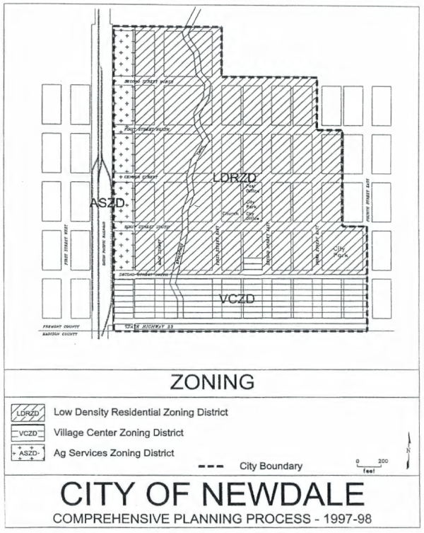
- Zoning District Boundaries. Zoning district boundaries shall be as shown on the "Official Zoning Map of Newdale." Any person who disputes the location of a zoning district boundary, as interpreted by the administrator, may appeal the administrator's decision using the appeals procedure of Chapter III. Sec N.
- Structure of Zoning Districts. Each zoning district established by this ordinance has the following elements.
- a statement of purpose, which briefly explains the reason why that district was established;
- a list of permitted uses, for which a Class I permit is required, unless the proposed use or building is exempted from the requirement for a permit by Chapter III. Sec C., Chapter III. Sec D., or Chapter III. Sec E.;
- a list of special permit uses, for which a Class II permit is required;
- specification standards, which regulate the placement of structures;
- performance standards, which regulate other aspects of development; and
- mapping guidance. The final section in each of the chapters that establish a zoning district provides guidance, based on the purpose of that district and the comprehensive plan, for responding to requests for zoning map amendments.
LF = linear feet, SF = square feet, ft = feetZoning district → LDRZD VCZD ASZD Standard ↓ Residential Commercial Residential Commercial Minimum lot size, maximum density 16,000 SF 16,000 SF None1 Minimum lot frontage 100 LF 100 LF None Minimum front setback 25 ft2 25 ft2 Highway 33: 50 ft
Other streets: 30 ft225 ft2 Highway 33: 50 ft
Other streets: 30 ft2Minimum side setback Interior lots: 5 ft
Corner lots: 25 ftInterior lots: 5 ft
Corner lots: 25 ft3 Interior lots: 5 ft
Corner lots: 20 ft3 Minimum rear setback 5 ft 5 ft 5 ft3 5 ft 5 ft3 Maximum lot coverage 40%4 40%4 80%4 40%4 None Maximum building height 35 ft 35 ft 35 ft 35 ft None
The City right-of-way is 80 ft. for roadways, 20 ft. for alley.
Notes for Table 1
1 Lot size must be large enough to comply with all requirements of this ordinance, including the requirements for off-street parking and loading areas and landscaped buffers.
2 The minimum front setback established here may be reduced or enlarged for the in-fill of blocks where at least 60% of all existing homes have a uniform setback (greater or lesser). New homes may match a uniform setback, where one exists.
3 Where the building is on the boundary of another zoning district, this ordinance may require a larger setback, in the form of a landscaped buffer.
4 The required open areas shall be maintained in native vegetation or landscaping.
Definitions for Table 1
Definitions of the principal terms used in this table are provided below. Every lot has one front, one rear, and two side yards.
interior lots - an interior lot is any lot that is bordered by only one street
The front setback is the distance, at the nearest point, from the street right-of-way to the outer foundation wall of the principal building, or to any projection of that building which extends more than three feet beyond the outer foundation wall.
The rear setback is the distance, at the nearest point, from the alley right-of-way, or the property line that is parallel, or more or less parallel, to the street, to the outer foundation wall of the principal building, or to any projection of that building which extends more than three feet beyond the outer foundation wall.
The side setback is the distance, at the nearest point, from a property line that is perpendicular, or more or less perpendicular, to the street, to the outer foundation wall of the principal building, or to any projection of that building which extends more than three feet beyond the outer foundation wall.
corner lots - a corner lot is any lot that is bordered by more than one street
The front setback is the distance, at the nearest point, from the street right-of-way on which the principal building has its address to the outer foundation wall of the principal building, or to any projection of that building which extends more than three feet beyond the outer foundation wall.
The rear setback is the distance, at the nearest point, from the property line opposite the street on which the principal building has its address to the outer foundation wall of the principal building, or to any projection of that building which extends more than three feet beyond the outer foundation wall.
The side setback is the distance, at the nearest point, from a property line that is perpendicular, or more or less perpendicular, to the street on which the building has its address, or to any projection of that building which extends more than three feet beyond the outer foundation wall.
Lot coverage is the portion of the lot covered by buildings, including accessory buildings, sidewalks, and other hard surfaces.
Building height is measured from average grade to the highest part of the structure. Antennae, vents, machinery housings, and similar nonstructural projections above the roofline are not included.