
Newport City Zoning Code
ARTICLE VII
SPECIAL ZONING OVERLAY DISTRICTS
DIVISION 2. - SHORELAND MANAGEMENT DISTRICT[5]
Editor's note— Ord. No. 2017-9, adopted Dec. 21, 2017, repealed the former div. 2, §§ 36-328—36-351, and enacted a new div. 2 as set out herein. The former div. 2 pertained to similar subject matter and derived from the 1997 Code.
DIVISION 3. - MISSISSIPPI RIVER CORRIDOR CRITICAL AREA (MRCCA) OVERLAY DISTRICT[6]
Editor's note— Ord. No. 2021-02, adopted Jan. 21, 2021, repealed Div. 3, §§ 36-360—36-369, and enacted a new Div. 3, §§ 36-360—36-372, as set out herein. The former Div. 3 pertained to similar subject matter and derived from 1997 Code, §§ 1370.04(1)—1370.04(9), and 1370.04(9)(app. A).
DIVISION 5. - BLUFFLAND AREA OVERLAY DISTRICT/BLUFF AND STEEP SLOPE REGULATIONS[7]
Editor's note— Ord. of 08-20-2020, repealed the former Div. 5, §§ 36-428—36-435, and enacted a new Div. 5 as set out herein. The former Div. 5 pertained to similar subject matter and derived from 1997 Code, §§ 1370.06(1)—(7), and 1370.06(10).
Sec. 36-296. - Purpose.
To address specific concerns related to such issues as the environment and preservation, to further protect the health, safety, and welfare of the public from the harms of certain types of development in sensitive land areas, and to implement the requirements imposed by state and federal statutes and regulations, the city has adopted special zoning overlay districts.
(Code 1997, § 1370.01)
Sec. 36-297. - Scope.
The requirements of each district established under this section shall be in addition to the general requirements imposed by the regulations of this article relating to the underlying zoning district.
(Code 1997, § 1370.02)
Sec. 36-328. - Statutory authorization and policy.
(a)
Statutory authorization. This shoreland ordinance is adopted pursuant to the authorization and policies contained in M.S.A. ch. 103F, Minnesota Regulations 6120.2500—6120.3900, and the planning and zoning enabling legislation in M.S.A. ch. 462.
(b)
Policy. The uncontrolled use of shoreland in the city affects the public health, safety and general welfare, not only by contributing to pollution of public waters, but also by impairing the local tax base. Therefore, it is in the best interests of the public health, safety, and welfare to provide for the wise subdivision, use and development of shorelands of public waters. The state legislature has delegated responsibility to local governments of the state to regulate the subdivision, use, and development of the shorelands of public waters and thus preserve and enhance the quality of surface waters, conserve the economic and natural environmental values of shorelands, and provide for the wise use of waters and related land resources. This responsibility is recognized by the city.
(Ord. No. 2017-9, 12-21-2017; Ord. No. 2021-06, 4-1-2021)
Sec. 36-329. - General provisions.
(a)
Interpretation. In their interpretation and application, the provisions of this division shall be held to be minimum requirements and shall be liberally construed in favor of the governing body and shall not be deemed a limitation or repeal of any other powers granted by state statutes.
(b)
Jurisdiction. The provisions of this division shall apply to the shorelands of the public water bodies as classified in this division and illustrated on the official zoning map. Pursuant to Minnesota Regulations, parts 6120.2500 and 6120.3900, no lake, pond, or flowage less than ten acres in size in municipalities, or 25 acres in size in unincorporated areas, need be regulated in a local government's shoreland regulations. A body of water created by a private user where there was no previous shoreland may, at the discretion of the city council, be exempt from this division.
The Mississippi River and adjacent river corridor lands are designated and classified as a "Critical Area" by the State of Minnesota and are regulated by provisions of the Mississippi River Corridor Critical Area Overlay District, Division 3 of this Code, and any other applicable provisions, whichever is more restrictive.
(c)
Compliance. The use of any shoreland of public waters; the size and shape of lots; the use, size, type, and location of structures on lots; the installation and maintenance of water supply and waste treatment systems; the grading and filling of any shoreland area; the cutting of shoreland vegetation; and the subdivision of land shall be in full compliance with the terms of this division and other applicable regulations.
(d)
Enforcement. The zoning administrator shall be responsible for the administration and enforcement of this division. Any violation of the provisions of this division or failure to comply with any of its requirements (including violations of conditions and safeguards established in connection with grants of variances or conditional uses) shall constitute a misdemeanor and shall be punishable as defined by law. Violations of this division can occur regardless of whether or not a permit is required for a regulated activity pursuant to this chapter.
(e)
Severability. If any section, clause, provision, or portion of this division is adjudged unconstitutional or invalid by a court of competent jurisdiction, the remainder of this division shall not be affected thereby.
(f)
Abrogation and greater restrictions. It shall not be intended by this division to repeal, abrogate, or impair any existing easements, covenants, or deed restrictions. However, where this division imposes greater restrictions, the provisions of this division shall prevail. All other divisions or sections of the zoning ordinance that are inconsistent with this division are hereby repealed to the extent of the inconsistency only.
(Ord. No. 2017-9, 12-21-2017; Ord. No. 2021-06, 4-1-2021)
Sec. 36-330. - Definitions.
The following words, terms, and phrases, when used in this division, shall have the meanings ascribed to them in this section, except where the context clearly indicates a different meaning: Unless specifically defined below, words or phrases used in this division shall be interpreted to give them the same meaning they have in common usage and to give this division its most reasonable application. For the purpose of this division, the words "must" and "shall" are mandatory and not permissive. All distances, unless otherwise specified, are measured horizontally.
Accessory structure or facility: Any building or improvement subordinate to a principal structure or facility on the same lot as a principal building, or part of the principal building, exclusively occupied by or devoted to a use incidental to the main use of the property.
Bluff: A topographic feature such as a hill, cliff, or embankment having the following characteristics:
(1)
Part or all of the feature is located in a shoreland area;
(2)
The slope rises at least 25 feet above the toe of bluff;
(3)
The grade of the slope from the toe of the bluff to a point 25 feet or more above the toe of the bluff averages 30 percent or greater, except that an area with an average slope of less than 18 percent over a distance of at least 50 feet shall not be considered part of the bluff; and
(4)
The slope must drain toward the water body.
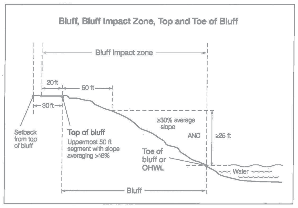
Bluff impact zone: A bluff and land located within 20 feet of the top of a bluff.
Bluff, toe of: The lower point of a 50-foot segment with an average slope exceeding 18 percent or the ordinary high-water level, whichever is higher.
Bluff, top of: For the purposes of measuring setbacks, the higher point of a 50-foot segment with an average slope exceeding 18 percent.
Boathouse: A facility as defined by M.S.A. § 103G.245.
Buffer: A vegetative feature as defined by M.S.A. § 103F.48.
Building line: A line parallel to a lot line or the ordinary high-water level at the required setback beyond which a structure may not extend.
Controlled access lot: A lot used to access public waters or as a recreation area for owners of non-riparian lots within the same subdivision containing the controlled access lot.
Commercial planned unit developments: Developments that provide transient, short-term lodging spaces, rooms, or parcels and their operations are essentially service-oriented. For example, hotel/motel accommodations, resorts, recreational vehicle and camping parks, and other primarily service-oriented activities are commercial planned unit developments.
Commercial use: The principal use of land or buildings for the sale, lease, rental, or trade of products, goods, and services.
Commissioner: The commissioner of the department of natural resources.
Conditional use: A permitted use which may be appropriate in a given zoning district but which requires special planning considerations in each instance, and which shall only be allowed in a specific location under conditions specified by the zoning ordinance and by the city council.
Deck: A horizontal, unenclosed platform with or without attached railings, seats, trellises, or other features, attached or functionally related to a principal use or site and at any point extending more than three feet above ground.
Duplex, triplex, and quad: A dwelling structure on a single lot, having two, three, and four units, respectively, attached by common walls and each unit equipped with separate sleeping, cooking, eating, living, and sanitation facilities.
Dwelling site: A designated location for residential use by one or more persons using temporary or movable shelter, including camping and recreational vehicle sites.
Dwelling unit: Any structure or portion of a structure, or other shelter designed and used exclusively for residential purposes for the occupancy of one or more persons.
Extractive use: The use of land for surface or subsurface removal of sand, gravel, rock, industrial minerals, other nonmetallic minerals, and peat not regulated under M.S.A. §§ 93.44 to 93.51.
Guest cottage: A structure used as a dwelling unit that may contain sleeping spaces and kitchen and bathroom facilities in addition to those provided in the primary dwelling unit on a lot.
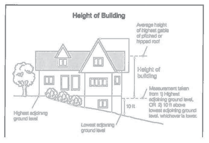
Height of building: The vertical distance between the highest adjoining ground level at the building or ten feet above the lowest adjoining ground level, whichever is lower, and the highest point of a flat roof, the deck line of a mansard roof, or average height between the eaves and the peak of the highest gable of a pitched or hipped roof.
Impervious surface: A constructed hard surface that prevents or retards entry of water into the soil and causes water to run off the surface in greater quantities and at an increased rate of flow than prior to development, including rooftops; decks; sidewalks; patios; swimming pools; parking lots; concrete, asphalt, or gravel driveways; and other similar surfaces.
Industrial use: The use of land or buildings for the production, manufacture, warehousing, storage, or transfer of goods, products, commodities, or other wholesale items.
Intensive vegetation clearing: The complete removal of trees or shrubs in a contiguous patch, strip, row, or block.
Lot: A parcel of land designated by plat, metes and bounds, registered land survey, auditors plot, or other accepted means and separated from other parcels or portions by said description for the purpose of sale, development, lease, transfer of ownership, or separation.
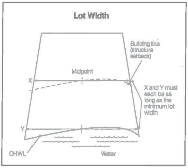
Lot width: The minimum horizontal distance between:
(1)
Side lot lines measured at right angles to the lot depth at the established front building setback line; and
(2)
Side lot lines at the ordinary high-water level, if applicable.
Nonconformity: Any legal use, structure, or parcel of land already in existence, recorded, or authorized before the adoption of official controls or amendments to those controls that would not have been permitted to become established under the terms of the official controls as now written.
Ordinary high-water level: The boundary of public waters and wetlands and shall be an elevation delineating the highest water level which has been maintained for a sufficient period of time to leave evidence upon the landscape, commonly that point where the natural vegetation changes from predominantly aquatic to predominantly terrestrial. For watercourses, the ordinary high-water level is the elevation of the top of the bank of the channel. For reservoirs and flowages, the ordinary high-water level is the operating elevation of the normal summer pool.
Planned unit development: A type of development characterized by a unified site design for a number of dwelling units or dwelling sites on a parcel, whether for sale, rent, or lease, that may involve clustering of these units or sites to provide areas of common open space, density increases, and a mix of structure types and land uses. These developments may be organized and operated as condominiums, time-share condominiums, cooperatives, full fee ownership, commercial enterprises, or any combination of these, or cluster subdivisions of dwelling units, residential condominiums, townhouses, apartment buildings, dwelling grounds, recreational vehicle parks, resorts, hotels, motels, and conversions of structures and land uses to these uses.
Public waters: Any water as defined in M.S.A. § 103G.005, subd. 15 and 15a.
Residential planned unit development: A type of development characterized by unified site design that may include a mixture of residential apartments, manufactured home parks, time-share condominiums, townhouses, cooperatives, and full fee ownership residences. To qualify as a residential planned unit development, a development must contain at least five dwelling units or sites.
Resort: "Resort" has the meaning in M.S.A. § 103F.227.
Semipublic use: The use of land by a private or private nonprofit organization to provide a public service that is ordinarily open to some persons outside the regular constituency of the organization. This use may include denominational cemeteries, private schools, clubs, lodges, recreational facilities, and churches.
Setback or setback line: The minimum horizontal distance between a structure, sewage treatment system, or other facility and an ordinary high-water level, sewage treatment system, top of a bluff, roadway, roadway right-of-way or easement, property line, or other facility as defined by the regulations of this division or the zoning ordinance.
Sewage treatment system: "Sewage treatment system" has the meaning given under Minnesota Rules, part 7080.1100, subpart 82.
Sewer system, municipal: Pipelines or conduits, pumping stations, and force main, and all other construction, devices, appliances, or appurtenances used for conducting sewage or industrial waste or other wastes to a point of ultimate disposal.
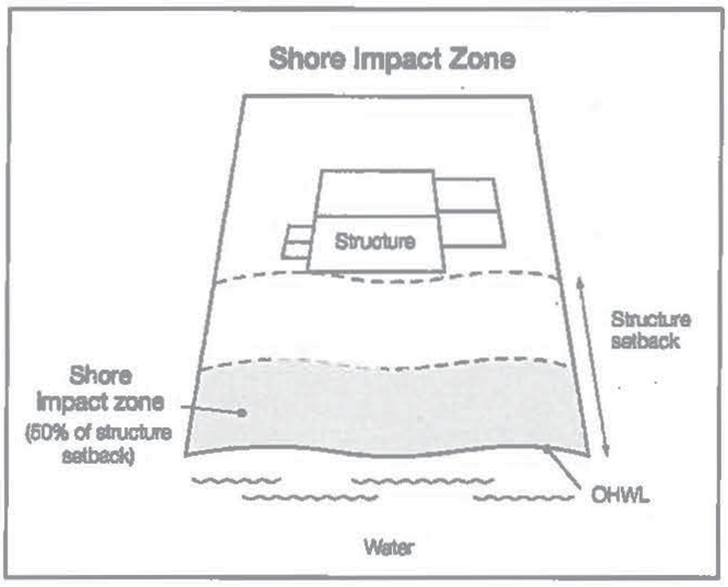
Shore impact zone: Land located between the ordinary high-water level of a public water and a line parallel to it at a setback of 50 percent of the structure setback.
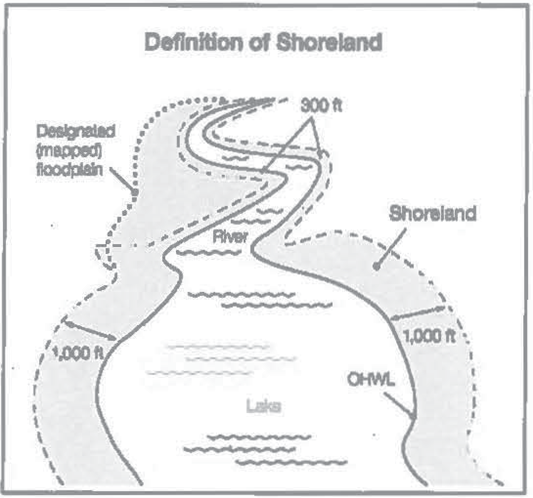
Shoreland: "Shoreland" means land located within the following distances from public waters:
(1)
One thousand feet from the ordinary high-water level of a lake, pond, or flowage; and
(2)
Three hundred feet from a river or stream, or the landward extent of a floodplain designated by ordinance on a river or stream, whichever is greater.
Shore recreation facilities: Swimming areas, docks, watercraft mooring areas and launching ramps, and other water recreation facilities.
Significant historic site: Any archaeological site, standing structure, or other property that meets the criteria for eligibility to the National Register of Historic Places or is listed in the state register of historic sites, or is determined to be an unplatted cemetery that falls under the provisions of M.S.A. § 307.08. A historic site meets these criteria if it is presently listed on either register or if it is determined to meet the qualifications for listing after review by th state archaeologist or the director of the state historical society. All unplatted cemeteries are automatically considered to be significant historic sites.
Steep slope: Lands having average slopes over 12 percent, as measured over horizontal distances of 50 feet or more, which are not bluffs.
Structure: Anything constructed or erected that requires permanent location on the ground or attachment to something having a permanent location on the ground, including any building or appurtenance, decks, swimming pools, recreational courts, etc. Structures do not include aerial or underground utility lines, such as sewer, electric, telephone, telegraph, gas lines, towers, poles, and related supporting facilities.
Subdivision: (1) The division of a parcel of land into two or more lots or parcels for the purpose of transfer of ownership, building or development; (2) Land that is divided for the purpose of sale, rent, or lease, including planned unit developments.
Suitability analysis: An evaluation of land to determine if it is appropriate for the proposed use. The analysis considers factors relevant to the proposed use and may include the following features: susceptibility to flooding; existence of wetlands; soils, erosion potential; slope steepness; water supply, sewage treatment capabilities; water depth, depth to groundwater and bedrock, vegetation, near-shore aquatic conditions unsuitable for water-based recreation; fish and wildlife habitat; presence of significant historic sites; or any other relevant feature of the natural land.
Variance: A modification or variation of the provisions of the zoning ordinance, as applied to a specific piece of property. "Variance" means the same as that defined in M.S.A. § 462.357 subd. 6 (2).
Water-oriented accessory structure or facility: A small, above ground building or other improvement, except stairways, fences, docks, and retaining walls, which, because of the relationship of its use to surface water, reasonably needs to be located closer to public waters than the normal structure setback. Examples of such structures and facilities include watercraft and watercraft equipment storage structures, gazebos, screen houses, fish houses, pump houses, saunas, patios, and detached decks. Boathouses and boat storage structures given the meaning under M.S.A. § 103G.245 are not a water-oriented accessory structures.
Water-dependent use: The use of land for commercial, industrial, public or semi-public purposes, where access to and use of a public water is an integral part of the normal conduct of operation. Marinas, resorts, and restaurants with transient docking facilities are examples of commercial uses typically found in shoreland areas.
Wetland: "Wetland" has the meaning given under Minnesota Rule, part 8420.0111.
(Ord. No. 2017-9, 12-21-2017; Ord. No. 2021-06, 4-1-2021)
Sec. 36-331. - Administration.
(a)
Permits required. A permit shall be required for the construction of buildings or building additions (and such related activities as construction of decks and signs) and those grading and filling activities not exempted by this division or other applicable Code provisions. An application for such a permit shall be made to the zoning administrator on forms provided by the city. The application shall include the necessary information so that the zoning administrator can determine the site's suitability for the intended use in the Shoreland District and compliance with Shoreland District regulations.
(b)
Permit compliance. The zoning administrator shall review each proposed activity requiring a permit within shoreland areas for compliance with the standards of this division. The permit approval shall specify that the use of land conforms to the requirements of this division. Any use, arrangement, or construction at variance with the action that was authorized by permit shall be deemed a violation of this division and shall be punishable as provided in this division.
(c)
Application materials. Applications for permits and other zoning applications such as variances shall be made to the zoning administrator on the forms provided by the city. The application shall include the required information so that the zoning administrator can evaluate whether the application complies with the requirements of this division.
(d)
Variances. Variances may only be granted in accordance with M.S.A. § 462.357 and with section 36-46 of the zoning ordinance, and are subject to the following:
(1)
A variance may not circumvent the general purposes and intent of this division; and
(2)
For properties with existing on-site sewage treatment systems, a certificate of compliance, consistent with Minnesota Rules, chapter 7082.0700, subp. 3, is required for variance approval. An on-site sewage treatment system shall be considered compliant if the only deficiency is the system's improper setback from the ordinary high-water level.
(e)
Conditional uses. All conditional uses in the shoreland area are subject to a thorough evaluation of the waterbody and the topographic, vegetation, and soil conditions to ensure:
(1)
The prevention of soil erosion or other possible pollution of public waters, both during and after construction; and
(2)
The visibility of structures and other facilities as viewed from public waters is limited; and
(3)
There is adequate water supply and sewage treatment; and
(4)
The types, uses, and numbers of watercraft that the development will generate are compatible in relation to the suitability of public waters to safely accommodate watercraft.
(f)
Conditions for variances, conditional uses, and zoning and permit applications. In evaluating applications for variances, conditional uses, and other zoning and permit applications, the city shall require the property owner to address the following conditions to address the potential impacts of the proposed action and to meet the purpose of this division, to protect adjacent properties, and the public interest. The city may include conditions in the approval that shall be related and proportional to the potential impacts of the proposed development.
(1)
Storm water runoff management and treatment and erosion and sediment control to meet the standards of the South Washington Watershed District and the city;
(2)
Reducing impervious surfaces;
(3)
Increasing setbacks from the ordinary high water level;
(4)
Restoration of wetlands;
(5)
Limiting vegetation removal and/or riparian vegetation restoration;
(6)
Provisions from the location, design, and use of structures, sewage treatment systems, water supply systems, watercraft launching and docking areas, and parking areas; and
(7)
Other conditions the zoning authority deems necessary.
(g)
Construction on steep slopes. In evaluating plans to construct sewage treatment systems, roads, driveways, structures, or other improvements on steep slopes, the city may attach conditions to permits to prevent erosion and to preserve existing vegetation screening of structures, vehicles, and other facilities as viewed form the surface of public waters assuming summer, leaf-on vegetation.
(h)
Nonconformities. All legally established nonconformities as of the date of this division may continue, and will be managed according to M.S.A. § 462.357, subd. 1e and the zoning ordinance for alterations, repair after damage, discontinuation of use, and intensification of use. All additions or expansions to the outside dimensions of an existing nonconforming structure must meet the setback, height, and other requirements of this division and the zoning ordinance. Any deviation from these requirements must be authorized by a variance.
(Ord. No. 2017-9, 12-21-2017; Ord. No. 2021-06, 4-1-2021)
Sec. 36-332. - Board of appeals and adjustments.
(a)
The board of appeals and adjustments shall hear and the city council will decide requests for variances in accordance with the rules that it has adopted for the conduct of business.
(b)
When a variance is approved after the department of natural resources has formally recommended denial in the hearing record, the notification of the approved variance required in section 36-333, shall also include the board of appeals and adjustment's and city council's summaries of the public record/testimony and the findings of facts and conclusions which supported the issuance of the variance.
(Ord. No. 2017-9, 12-21-2017; Ord. No. 2021-06, 4-1-2021)
Sec. 36-333. - Notification to the department of natural resources and environmental review.
(a)
Copies of all notices of any public hearings to consider variances, ordinance amendments, or conditional uses under local shoreland management controls shall be sent to the commissioner or the commissioner's designated representative and shall be postmarked at least 30 days before the hearings. Notices of hearings to consider proposed subdivisions/plats must include copies of the subdivision/plat.
(b)
A copy of all approved amendments and subdivision/plats, and final decisions granting variances or conditional uses under local shoreland management controls shall be sent to the commissioner or the commissioner's designated representative and shall be postmarked within ten days of final action. When a variance is approved after the department of natural resources has formally recommended denial in the hearing record, the notification of the approved variance shall also include the summary of the public record/testimony and the findings of facts and conclusions which supported the issuance of the variance.
(c)
Any request to change the shoreland management classification of public waters within the city must be sent to the commissioner or the commissioner's designated representative for approval and must include a resolution and supporting data as required by Minnesota Rules, part 6120.3000, subp. 4.
(d)
Any request to reduce the boundaries of shorelands of public waters within the city must be sent to the commissioner or the commissioner's designated representative for approval and must include a resolution and supporting data. The boundaries of shorelands may be reduced when the shoreland of water bodies with different classifications overlap. In these cases, the topographic divide between the water bodies shall be used for adjusting the boundaries.
(e)
Mandatory EAW. An environmental assessment worksheet consistent with Minnesota Rules, chapter 4410, must be prepared for projects meeting the thresholds of Minnesota Rules part 4410.4300, subparts 19a, 20a, 25, 27, 28, 29 and 36a.
(Ord. No. 2017-9, 12-21-2017; Ord. No. 2021-06, 4-1-2021)
Sec. 36-334. - Shoreland classification system.
(a)
Purpose. To ensure that shoreland development on the public waters of the city is regulated consistent with the classifications assigned by the commissioner under Minnesota Rules, part 6120.3300, the public waters listed below have been classified consistent with the criteria found in Minnesota Rules and the protected waters inventory map for Washington County, Minnesota.
(b)
The shoreland area for the waterbody listed in subsection (c) of this section shall be as defined in this division and as shown on the official zoning map.
(c)
Lakes in the city are classified as follows:
(Ord. No. 2017-9, 12-21-2017; Ord. No. 2021-06, 4-1-2021)
Sec. 36-335. - Land uses.
(a)
Purpose. To identify land uses compatible with the protection and preservation of shoreland resources in order to conserve the economic and environmental values of shoreland and sustain water quality.
(b)
Shoreland district land uses listed on the tables below are regulated as:
(1)
Permitted uses (P). These uses are allowed, provided all standards in this division are followed.
(2)
Conditional uses (C). These uses are allowed through a conditional use permit. The use must be evaluated according to the criteria in this division and the zoning ordinance.
(3)
Not permitted uses (N). These uses are prohibited.
(c)
Land uses for lake classifications:
P = Permitted; C = by Conditional use permit; N = Not permitted
(e)
Special land use provisions for commercial, industrial and semipublic use standards.
(1)
Water-dependent uses may be located on parcels or lots with frontage on public waters provided that:
a.
The use complies with section 36-340;
b.
The use is designed to incorporate topographic and vegetative screening of parking areas and structures;
c.
Uses that require short-term watercraft mooring for patrons must centralize these facilities and design them to avoid obstructions of navigation and to be the minimum size necessary to meet the need; and
d.
Uses that depend on patrons arriving by watercraft may use signs and lighting, provided that:
1.
Signs placed in or on public waters must only convey directional information or safety messages and may only be placed by a public authority or under a permit issued by the county sheriff;
2.
Signs placed within the shore impact zone are no higher than ten feet above the ground, and not greater than 32 square feet in size; and if illuminated by artificial lights, the lights must be shielded or directed to prevent illumination across public waters; and
3.
Other lighting may be located within the shore impact zone or over public waters if it is used to illuminate potential safety hazards and is shielded or otherwise directed to prevent direct illumination across public waters. This does not preclude use of navigational lights.
(2)
Commercial, industrial, public, and semi-public uses that are not water-dependent must be located on lots or parcels without public waters frontage, or, if located on lots or parcels with public waters frontage, must either be set back double the ordinary high water level setback or be substantially screened from view from the water by vegetation or topography, assuming summer, leaf-on conditions.
(f)
Agriculture use standards.
(1)
General cultivation farming, grazing, nurseries, horticulture, truck farming, sod farming, and wild crop harvesting are permitted uses if steep slopes and shore and bluff impact zones are maintained in perennial vegetation or operated under an approved conservation plan (resource management systems) consistent with the field office technical guides of the local soil and water conservation districts or the natural resource conservation service, as provided by a qualified individual or agency.
(2)
The shore impact zone for parcels with permitted agricultural land uses is equal to a line parallel to and 50 feet from the ordinary high-water level.
(Ord. No. 2017-9, 12-21-2017; Ord. No. 2021-06, 4-1-2021)
Sec. 36-336. - Dimensional and general performance standards.
(a)
Purpose. To establish dimensional and performance standards that protect shoreland resources from impacts of development.
(b)
Lot area and width standards. After the effective date of this division, all new lots must meet the minimum lot area and lot width requirements in subsection (c) below, subject to the following standards:
(1)
Only lands above the ordinary high-water level can be used to meet lot area and width standards; and
(2)
Lot width standards must be met at both the ordinary high-water level and at the building line; and
(3)
The sewer lot area dimensions can only be used if publicly owned sewer system service is available to the property; and
(4)
Residential subdivisions with dwelling unit densities exceeding those identified in this section are allowed only if designed and approved as residential PUDs under section 36-346 of this chapter.
(c)
Lake minimum lot area and width standards:
(d)
Special residential lot provisions
(1)
Subdivisions of duplexes, triplexes, and quads are conditional uses on natural environment lakes, and must also meet the following standards:
a.
Each building must be set back at least 200 feet from the ordinary high water level;
b.
The development must be served by municipal sewer and water services;
c.
Watercraft docking facilities for each lot must be centralized in one location and serve all dwelling units in the building; and
d.
No more than 25 percent of a lake's shoreline can be in duplex, triplex, or quad developments.
(Ord. No. 2017-9, 12-21-2017; Ord. No. 2021-06, 4-1-2021)
Sec. 36-337. - Additional requirements.
(a)
Controlled access lots are permissible if created at the time of and as part of a subdivision and in compliance with the following standards:
(1)
The lot must meet the area and width requirements for residential lots and be suitable for the intended uses of controlled access lots as provided in item (5).
(2)
If docking, mooring, or over-water storage of more than six watercraft is to be allowed at a controlled access lot, then the width of the lot (keeping the same lot depth) must be increased by a percentage of the requirements for riparian residential lots for each watercraft beyond six, consistent with the following table:
(3)
The lots must be jointly owned by all purchasers of non-riparian lots in the subdivision who are provided riparian access rights on the access lot.
(4)
Covenants or other equally effective legal instruments must be developed that:
a.
Specify which lot owners have authority to use the access lot.
b.
Identify what activities are allowed. The allowed activities may include watercraft launching, loading, storage, beaching, mooring, docking, swimming, sunbathing, or picnicking.
c.
Limit the total number of vehicles allowed to be parked and the total number of watercraft allowed to be continuously moored, docked, or stored over water.
d.
Require centralization of all common facilities and activities in the most suitable locations on the lot, to minimize topographic and vegetation alterations.
e.
Require all parking areas, storage buildings, and other facilities to be screened by vegetation or topography as much as practical from view from the public water, assuming summer, leaf-on conditions.
(b)
One guest cottage may be allowed on lots meeting or exceeding the duplex lot area and width dimensions presented in section 36-336 provided the following standards are met:
(1)
For lots exceeding the minimum lot dimensions of duplex lots, the guest cottage must be located within an area equal to the smallest duplex-sized lot that could be created including the principal dwelling unit.
(2)
A guest cottage must not cover more than 700 square feet of land surface and must not exceed 15 feet in height.
(3)
A guest cottage must be located or designed to reduce its visibility as viewed from public waters and adjacent shorelands by vegetation, topography, increased setbacks or color, assuming summer leaf-on conditions.
(Ord. No. 2017-9, 12-21-2017; Ord. No. 2021-06, 4-1-2021)
Sec. 36-338. - Placement, design and height of structures.
(a)
Placement of structures and sewage treatment systems on lots. When more than one setback applies to a site, structures and facilities must be located to meet all setbacks, and comply with the following provisions:
(1)
OHWL setbacks. Structures, impervious surfaces, and sewage treatment systems must meet the required setbacks from the ordinary high-water level (OHWL), except that one water-oriented accessory structure or facility, designed in accordance with section 36-337 of this chapter, may be set back a minimum distance of ten feet from the OHWL.
(2)
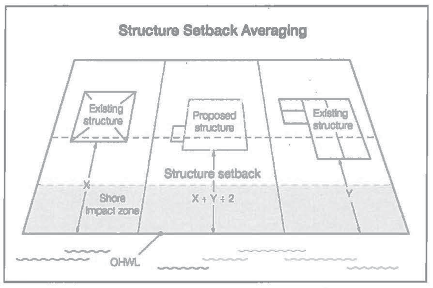
Setback averaging. Where structures exist on the adjoining lots on both sides of a proposed building site, structure setbacks may be altered without a variance to conform to the adjoining setbacks from the OHWL provided the proposed building site is not located in a shore impact zone or in a bluff impact zone.
(3)
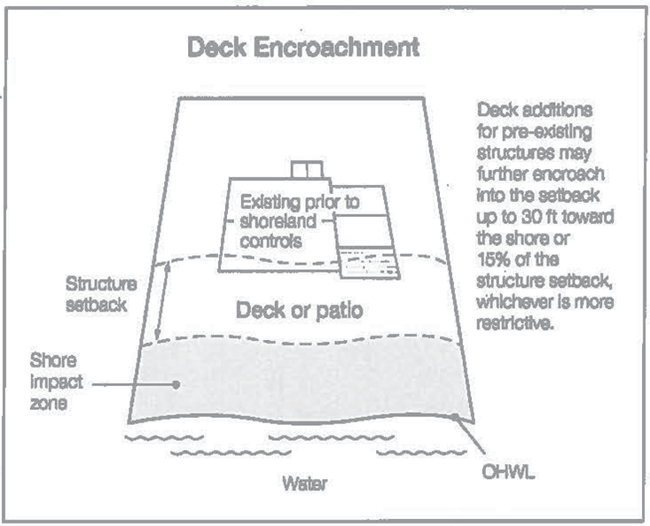
Setbacks of decks. Deck additions may be allowed without a variance to a structure not meeting the required setback form the OHWL if all of the following criteria are met:
a.
The structure existed on the date that the structure setbacks were established.
b.
A thorough evaluation of the property and structure reveals no reasonable location for a deck meeting or exceeding the existing OHWL setback of the structure.
c.
The deck encroachment toward the OHWL does not exceed 15 percent of the existing setback of the structure from the OHWL or is no closer than 30 feet from the OHWL, whichever is more restrictive.
d.
The deck is constructed primarily of wood and is not roofed or screened.
(4)
Additional structure setbacks. Structures must also meet the following setbacks regardless of the water body classification apply as follows:
(5)
Bluff impact zones. All structures impervious surfaces, and accessory facilities, except stairway and landings, shall not be placed within bluff impact zones.
(6)
Minimum floor elevation above flood of record. The minimum floor elevation above the flood elevation shall be three feet where floodplain controls do not exist.
(Ord. No. 2017-9, 12-21-2017; Ord. No. 2021-06, 4-1-2021)
Sec. 36-339. - Design criteria for structures.
(a)
Height of structures. All structures in residential districts, except churches and agricultural structures must not exceed 25 feet in height. The maximum height of commercial and industrial structures shall be regulated by the district standards in the zoning ordinance.
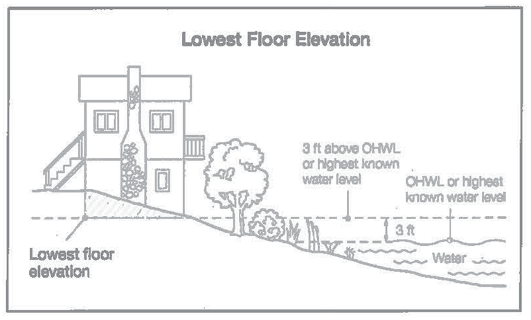
(b)
Lowest floor elevation. Structures shall be placed in accordance with any floodplain regulations applicable to the site. Where these controls do not exist, the elevation to which the lowest floor, including basement, is placed or floodproofed must be determined as follows:
(1)
For lakes, by placing the lowest floor at a level at least three feet above the highest known water level, or three feet above the OHWL, whichever is higher;
(2)
If the structure is floodproofed instead of elevated under item (a) above, then it must be floodproofed in accordance with Minnesota Rules, part 6120.5900 subp. 3(D).
(c)
Water supply and sewage treatment.
(1)
Any public or private supply of water for domestic purposes must meet or exceed standards for water quality of the state department of health and state pollution control agency.
(2)
Any premises used for human occupancy must be connected to a publicly-owned sewer system, where available, or comply with the Washington County SSTS Ordinance and Minnesota Rules (Ordinance 196) and Minnesota Rules, chs. 7080—7081.
(Ord. No. 2017-9, 12-21-2017; Ord. No. 2021-06, 4-1-2021)
Sec. 36-340. - Performance standards for public and private facilities.
(a)
Significant historic sites. No structure may be placed on a significant historic site in a manner that affects the value of the site unless adequate information about the site has been removed and documented in a public depository.
(b)
Placement and design of roads, driveways and parking areas. Public and private roads and parking areas shall be designed to take advantage of natural vegetation and topography to achieve maximum screening from view from the public waters and comply with the following standards:
(1)
Roads, driveways, and parking areas must meet structure setbacks, and must not be placed within bluff and shore impact zones, when other reasonable and feasible placement alternatives exist. If no alternative exist, they may be placed within these areas, and must be designed to minimize adverse impacts;
(2)
Watercraft access ramps, approach roads, and access-related parking areas may be placed within shore impact zones provided the vegetative screening and erosion control conditions of this division are met.
(3)
Private facilities must comply with the grading and filling provisions of this division.
(4)
For public roads, driveways, and parking areas, documentation shall be provided by the city engineer that they are designed and constructed to minimize and control erosion to public waters consistent with the field office technical guides of the local soil and water conservation district, or other technical materials.
(c)
Stairways, lifts and landings. Stairways and lifts shall be the preferred alternative to major topographical alterations for achieving access up and down bluffs and steep slopes to shore areas. Stairways and lifts shall meet the following design requirements:
(1)
Stairways and lifts shall not exceed four feet in width on residential lots. Wider stairways may be used for commercial properties, public recreational uses, and planned unit developments.
(2)
Landings for stairways and lifts on residential lots shall not exceed 32 square feet in area. Landings larger than 32 square feet may be used for commercial properties, public recreational uses, and planned unit developments.
(3)
Canopies or roofs shall not be allowed on stairways, lifts or landings.
(4)
Stairways, lifts and landings may be either constructed above the ground on posts or pilings, or placed into the ground, provided they are designed and built in a manner that ensures control of soil erosion.
(5)
Stairways, lifts and landings shall be located in the most visually inconspicuous portions of lots, as viewed from the surface of the public water assuming summer, leaf-on conditions, whenever practical.
(6)
Facilities such as ramps, lifts, or mobility paths for physically handicapped persons shall also be allowed for achieving access to shore areas, provided that the dimensional and performance standards of this section are complied with, in addition to Minnesota Rules chapter 1341.
(d)
Water-oriented accessory structures or facilities. Each lot may have one water-oriented accessory structure or facility if it complies with the following provisions:
(1)
The water-oriented accessory structure or facility shall not exceed ten feet in height, exclusive of safety rails, and shall not occupy an area greater than 250 square feet. The structure or facility may include patios or detached decks not exceeding eight feet above grade at any point.
(2)
The structure or facility shall not be located in the bluff impact zone.
(3)
The setback of structure or facility from the ordinary high-water level shall be at least ten feet.
(4)
The structure is not a boathouse or boat storage structure as defined under M.S.A. § 103G.245.
(5)
The structure or facility shall be treated to reduce visibility as viewed from the river and adjacent shorelands by vegetation, topography, increased setbacks, or color, assuming summer leaf-on conditions.
(6)
The roof of the structure or facility may be used as a deck with safety rails but shall not be enclosed or used as a storage area.
(7)
The structure or facility shall not be designed or used for human habitation and shall not contain water supply or sewer treatment facilities.
(8)
Water-oriented accessory structures may have the lowest floor placed lower than the elevation specified in this division if the structure is constructed of flood-resistant materials to the elevation, electrical and mechanical equipment is placed above the elevation, and if long-duration flooding is anticipated, the structure is built to withstand ice action and wind-driven waves and debris.
(Ord. No. 2017-9, 12-21-2017; Ord. No. 2021-06, 4-1-2021)
Sec. 36-341. - Vegetation and land alterations.
(a)
Purpose. Alterations of vegetation and topography shall be regulated to prevent erosion into public waters, fix nutrients, preserve shoreland aesthetics, preserve historic values, prevent bank slumping, sustain water quality, and protect fish and wildlife habitat.
(b)
Vegetation management. Removal or alteration of vegetation shall comply with the provisions of this subsection except for:
(1)
Vegetation alteration necessary for the construction of structures and sewage treatment systems under validly issued permits for those facilities.
(2)
The construction of public roads and parking areas if consistent with this chapter.
(3)
Agricultural uses consistent with this chapter.
(c)
Intensive vegetation clearing within the shore and bluff impact zones and on steep slopes is prohibited. Intensive clearing outside of these areas is allowed if consistent with the forest management standards of this chapter.
(d)
Limited clearing and trimming of trees and shrubs in the shore and bluff impact zones and on steep slopes is allowed to provide a view to the water from the principal dwelling and to accommodate the placement of stairways and landings, picnic areas, access paths, beach and watercraft access areas, and permitted water-oriented accessory structures or facilities, provided that:
(1)
The screening of structures, vehicles, or other facilities as viewed from the water, assuming summer, leaf-on conditions shall not be substantially reduced.
(2)
Cutting debris or slash shall be scattered and not mounded on the ground.
(3)
Perennial ground cover is retained.
(e)
Removal of trees, limbs, or branches that are dead, diseased, dying or pose safety hazards is allowed.
(f)
Fertilizer and pesticide runoff into surface waters must be minimized through use of vegetation, topography or both.
(Ord. No. 2017-9, 12-21-2017; Ord. No. 2021-06, 4-1-2021)
Sec. 36-342. - Grading and filling.
Grading and filling activities must comply with the provisions of this subsection, except for the construction of public roads and parking areas if consistent with section 36-340 of this chapter.
(1)
Grading, filling, and excavations necessary for the construction of structures and sewage treatment systems, if part of an approved permit, shall not require a separate grading and filling permit; however, the grading and filling standards in this section shall be incorporated into the issuance of permits.
(2)
For all other work, a grading and filling permit shall be required for:
a.
The movement of more than ten cubic yards of material on steep slopes or within shore or bluff impact zones; and
b.
The movement of more than 50 cubic yards of material outside of steep slopes and shore and bluff impact zones.
(3)
Grading, filling and excavation activities must meet the following standards:
a.
Grading or filling of any wetland shall meet or exceed the wetland protection standards under Minnesota Rules, chapter 8420, and any other permits, reviews, or approvals by other local, state, or federal agencies such as watershed districts, the DNR, or U.S. Army Corps of Engineers.
b.
Land alterations shall be designed and implemented to minimize the amount of erosion and sediment from entering surface waters during and after construction consistently by:
1.
Limiting the amount and time of bare ground exposure.
2.
Using temporary ground covers such as mulches or similar materials.
3.
Establishing permanent vegetation cover as soon as possible.
4.
Using sediment traps, vegetative buffer strips, or other appropriate techniques.
5.
Stabilizing altered areas to acceptable erosion control standards consistent with the field office technical guides of the soil and water conservation district.
6.
Not placing fill or excavated material in a manner that creates unstable slopes. Plans to place fill or excavated material on steep slopes must be reviewed by qualified professionals for continued slope stability and must not create finished slopes of 30 percent or greater.
7.
Fill or excavated material shall not be placed in a manner that creates an unstable slope.
8.
Any alterations below the ordinary high water level of public waters shall first be authorized by the commissioner under M.S.A. § 103G.
9.
Alterations of topography shall only be allowed if they are accessory to permitted or conditional uses and shall not adversely affect adjacent or nearby properties.
10.
Placement of natural rock riprap, including associated grading of the shorelines and placement of a filter blanket, shall be permitted if the finished slope shall not exceed three feet horizontal to one foot vertical; the landward extent of the riprap shall be within ten feet of the ordinary high water level; and the height of the riprap above the ordinary high water level shall not exceed three feet.
(4)
Connections to public waters. Excavations to connect boat slips, canals, lagoons, and harbors to public waters require a public waters permit and must comply with Minnesota Rules, chapter 6115.
(Ord. No. 2017-9, 12-21-2017; Ord. No. 2021-06, 4-1-2021)
Sec. 36-343. - Stormwater management.
(a)
General standards.
(1)
Stormwater management shall meet the requirements of the city's stormwater ordinance and the rules and standards of the South Washington Watershed District, including wetland protection and buffer requirements.
(2)
When possible, existing natural drainageways and vegetated soil surfaces shall be used to convey, store, filter, and retain stormwater runoff before discharge to public waters.
(3)
Development shall be planned and conducted in a manner that shall minimize the extent of disturbed areas, runoff velocities, erosion potential, and reduce and delay runoff volumes. Disturbed areas shall be stabilized and protected as soon as possible and facilities or methods used to retain sediment on the site.
(4)
When development density, topographic features, and soil and vegetation conditions are not sufficient to adequately handle stormwater runoff, constructed facilities such as settling basins, skimming devices, dikes, waterways, ponds, and infiltration may be used. Preference shall be given to surface drainage, vegetation, and infiltration rather than buried pipes and manmade materials and facilities.
(b)
Specific standards.
(1)
Impervious surface coverage of lots shall not exceed 25 percent of the lot area above the OHWL.
(2)
When constructed facilities are used for stormwater management, documentation shall be provided by a qualified individual that they are designed and installed consistent with the field office technical guide of the local soil and water conservation district or the Minnesota Stormwater Manual, as applicable.
(3)
New constructed stormwater outfalls to public waters must be consistent with Minnesota Rules, part 6115.0231.
(Ord. No. 2017-9, 12-21-2017; Ord. No. 2021-06, 4-1-2021)
Sec. 36-344. - Special provisions for water-oriented commercial uses.
(a)
Standards for water-oriented commercial uses. Existing surface water-oriented industrial, light industrial, industrial storage, public and semipublic uses with similar needs have access to and use of public waters may be located on parcels or lots with frontage on public waters. Those existing uses with water-oriented needs shall meet the following standards:
(1)
In addition to meeting impervious coverage limits, setbacks, and other zoning standards in this section, the uses shall be designed to incorporate topographic and vegetative screening of parking areas and structures.
(2)
Existing uses that require short-term watercraft mooring for patrons shall centralize these facilities and design them to avoid obstructions of navigation and to be the minimum size necessary to meet the need.
(3)
Uses that depend on patrons arriving by watercraft may use signs and lighting to convey needed information to the public, subject to the following standards:
(4)
No advertising signs or supporting facilities for signs may be placed in or upon public waters.
(5)
Signs conveying information or safety messages may be placed in or on public waters by a public authority or under a permit issued by the Washington County Sheriff.
(6)
Signs may be placed, when necessary, within the shore impact zone if they are designed and sized to be the minimum necessary to convey the location and name of the establishment. The signs shall not contain other detailed information such as product and prices, shall not be located higher than ten feet above the ground, and shall not exceed 32 square feet in size. If illuminated by artificial lights, the lights shall be shielded or directed to prevent illumination out across public waters.
(7)
Other outside lighting may be located within the shore impact zone if it is used primarily to illuminate potential safety hazards and is shielded or otherwise directed to prevent direct illumination out across public waters. This shall not preclude the use of navigational lights.
(b)
Uses without water-oriented needs shall be located on lots or parcels without public waters frontage, or, if located on lots or parcels with public waters frontage, shall either be set back double the normal ordinary high water level setback or be substantially screened from view from the water by vegetation or topography, assuming summer, leaf-on conditions.
(Ord. No. 2017-9, 12-21-2017; Ord. No. 2021-06, 4-1-2021)
Sec. 36-345. - Subdivision/platting provisions.
(a)
Purpose. To ensure that new development minimizes impacts to shoreland resources and is safe and functional.
(b)
Land suitability. Each lot created through subdivision, including planned unit developments authorized under this section, shall be suitable in its natural state for the proposed use with minimum alteration. A suitability analysis shall be conducted for each proposed subdivision, including planned unit developments, to determine if the subdivision is suitable in its natural state for the proposed use with minimal alteration and whether any feature of the land is likely to be harmful to the health, safety, or welfare of future residents of the proposed subdivision or of the community.
(c)
Consistency with other controls. Subdivisions and each lot in the subdivision shall conform to all official controls of the city subdivision ordinance. A subdivision shall not be approved where a later variance from one or more standards in official controls would be needed to use the lots for their intended purpose.
(d)
Water and sewer design standards.
(1)
A potable water supply and a sewage treatment system consistent with Minnesota Rules, chapters 7080—7081 must be provided for every lot.
(2)
Each lot that uses a subsurface septic treatment system (SSTS) must comply with Washington County SSTS Ordinance 196 and Minnesota Rules chapter 7080.
(3)
Lots that would require the use of holding tanks are prohibited.
(e)
Information requirements. Sufficient information shall be submitted by the applicant for the city to make a determination of land suitability. The information shall include all of the information required by the subdivision ordinance (chapter 28 of the City Code) and the following:
(1)
Topographical contours at two-foot intervals or less from United States Geological Survey maps or more accurate sources, showing limiting site characteristics.
(2)
The surface water features required in M.S.A. § 505.02, to be shown on plats, obtained from United States Geological Survey quadrangle topographic maps or more accurate sources.
(3)
Adequate soils information to determine suitability for building and on-site sewage treatment capabilities for every lot from the most current existing sources or from field investigations such as soil borings, percolation test, or other methods.
(4)
Information regarding adequacy of domestic water supply; extent of anticipated vegetation and topographic alterations; near-shore aquatic conditions, including depths, types of bottom sediments, and aquatic vegetation; and propose methods for controlling stormwater runoff and erosion, both during and after construction activities.
(5)
Location of 100-year floodplain areas and floodway districts from existing adopted maps or data.
(6)
A line or contour representing the ordinary high-water level, the "toe" and the "top" of bluffs, and the minimum building setback distances from the top of the bluff and the river.
(f)
Dedications. When a land or easement dedication is a condition of subdivision approval, the approval shall provide easements over natural drainage or ponding areas for management of stormwater and significant wetlands.
(g)
Platting. All subdivisions shall be processed as a plat in accordance with M.S.A. § 505. No permit for construction of buildings or sewage treatment systems shall be issued for lots created after these official controls were enacted unless the lot was approved as part of a formal subdivision.
(h)
Control access or recreational lots. Controlled access lots within a subdivision shall meet or exceed the sizing criteria of this section.
(Ord. No. 2017-9, 12-21-2017; Ord. No. 2021-06, 4-1-2021)
Sec. 36-346. - Planned unit developments (PUDs).
(a)
Purpose. To protect and enhance the natural and scenic qualities of shoreland areas during and after development and redevelopment of high density residential and commercial uses.
(b)
Types of PUDs permissible. Planned unit developments (PUDs) are allowed for new projects on undeveloped land, redevelopment of previously built sites, or conversions of existing buildings and land. Deviation from the minimum lot size standards of section 36-336 of this chapter is allowed if the standards in this section are met. However, in no circumstances shall densities greater than those determined in this section (36-346) be allowed.
(c)
Processing of PUDs. Planned unit developments must be processed as a conditional use and in compliance with the city's zoning ordinance, including chapter 35, article VI. An expansion to an existing commercial PUD involving six or less new dwelling units or sites since the date this division was adopted is permissible as a permitted use provided the total project density does not exceed the allowable densities calculated in the project density evaluation procedures in section 10.5. Approval cannot occur until all applicable environmental reviews are complete.
(d)
Application for a PUD. The application for a PUD shall follow the procedures and submittal requirements of chapter 35, article VI of the zoning ordinance, and shall also include:
(1)
Property owners association. A property owners association agreement shall be created for residential PUDs with mandatory membership and consistent with this division.
(2)
Deed restrictions, covenants, permanent easements, etc., for open space. PUDs shall include deed restrictions, covenants, permanent easements, or other instruments that:
a.
Address future vegetative and topographic alterations, construction of additional buildings, beaching of watercraft, and construction of commercial buildings in residential PUDs; and
b.
Ensure the long-term preservation and maintenance of open space in accordance with the criteria and analysis specified in section 35-346(g) of this chapter.
(e)
Density determination. Proposed new or expansions to existing planned unit developments must be evaluated using the following procedures.
(1)
Identify density analysis tiers. Divide the project parcel into tiers by drawing one or more lines parallel to the ordinary high-water level at the following intervals, proceeding landward:
(2)
Calculate suitable area for development. Calculate the suitable area within each tier by excluding all wetlands, bluffs, or land below the ordinary high-water level of public waters.
(3)
Determine base density:
a.
For residential PUDs, divide the suitable area within each tier by the minimum single residential lot area for lakes to determine the allowable number of dwelling units, or base density, for each tier.
b.
For commercial PUDs:
1.
Determine the average area for each dwelling unit or dwelling site within each tier. Include both existing and proposed dwelling units and sites in the calculation.
i.
For dwelling units, determine the average inside living floor area of dwelling units in each tier. Do not include decks, patios, garages, porches, or basements unless they are habitable space.
ii.
For dwelling sites (campgrounds), determine the area of each dwelling site as follows:
(A)
For manufactured homes, use the area of the manufactured home, if known, otherwise use 1,000 square feet.
(B)
For recreational vehicles, campers or tents, use 400 square feet.
2.
Select the appropriate floor area/dwelling site area ratio from the following table for the floor area or dwelling site area determined in the section above.
3.
Multiply the suitable area within each tier determined in subsection 36-346(e)(2) by the floor area or dwelling site area ratio to yield the total floor area or dwelling site area for each tier to be used for dwelling units or dwelling sites.
4.
Divide the total floor area or dwelling site area for each tier calculated in subsection 36-346(e)(3)b.2. by the average inside living floor area for dwelling units or dwelling site area determined in section 36-346(e)(3)b.3. This yields the allowable number of dwelling units or dwelling sites, or base density, for each tier.
c.
Allowable densities may be transferred from any tier to any other tier further from the waterbody but must not be transferred to any tier closer to the waterbody.
d.
All PUDs with densities at or below the base density must meet the design standards in this division.
(4)
Determine if the site can accommodate increased density:
a.
The following increases to the dwelling unit or dwelling site base densities determined section 36-346(e) are allowed if the design criteria in section 36-346(f) of this chapter are satisfied as well as the standards in the following table:
b.
Structure setbacks from the ordinary high-water level:
1.
Are increased to at least 50 percent greater than the minimum setback; or
2.
The impact on the waterbody is reduced an equivalent amount through vegetative management, topography, or additional acceptable means and the setback is at least 25 percent greater than the minimum setback.
(f)
Design criteria. All PUDs must meet the following design criteria.
(1)
General design standards.
a.
All residential planned unit developments must contain at least five dwelling units or sites.
b.
Municipal sewer and water services must be available and utilized.
c.
Dwelling units or dwelling sites must be clustered into one or more groups and located on suitable areas of the development.
d.
Dwelling units or dwelling sites must be designed and located to meet the dimensional standards in subsections 36-336(c) and 36-336(d).
e.
Shore recreation facilities:
1.
Must be centralized and located in areas suitable for them based on a suitability analysis.
2.
The number of spaces provided for continuous beaching, mooring, or docking of watercraft must not exceed one for each allowable dwelling unit or site in the first tier (notwithstanding existing mooring sites in an existing commercially used harbor).
3.
Launching ramp facilities, including a small dock for loading and unloading equipment, may be provided for use by occupants of dwelling units or sites located in other tiers.
f.
Structures, parking areas, and other facilities must be treated to reduce visibility as viewed from public waters and adjacent shorelands by vegetation, topography, increased setbacks, color, or other means acceptable to the local unit of government, assuming summer, leaf-on conditions. Vegetative and topographic screening must be preserved, if existing, or may be required to be provided.
g.
Accessory structures and facilities, except water oriented accessory structures, must meet the required structure setback and must be centralized.
h.
Water-oriented accessory structures and facilities may be allowed if they meet or exceed design standards contained in section 7.3 of this chapter and are centralized.
(g)
Open space requirements. Open space must constitute at least 50 percent of the total project area and must include:
(1)
Areas with physical characteristics unsuitable for development in their natural state.
(2)
Areas containing significant historic sites or unplatted cemeteries.
(3)
Portions of the shore impact zone preserved in its natural or existing state as follows:
a.
For existing residential PUD's, at least 50 percent of the shore impact zone.
b.
For new residential PUDs, at least 70 percent of the shore impact zone.
c.
For all commercial PUD's, at least 50 percent of the shore impact zone.
(4)
Open space may include:
a.
Outdoor recreational facilities for use by owners of dwelling units or sites, by guests staying in commercial dwelling units or sites, and by the general public.
b.
Subsurface sewage treatment systems if the use of the space is restricted to avoid adverse impacts on the systems.
c.
Non-public-water wetlands.
(5)
Open space shall not include:
a.
Dwelling units or sites and residential lots; road rights-of-way, or land covered by road surfaces; parking areas, or structures, except water-oriented accessory structures or facilities.
b.
Commercial facilities or uses.
c.
Land below the OHWL of public waters.
(h)
Open space maintenance and administration requirements.
(1)
Open space preservation. The appearance of open space areas, including topography, vegetation, and allowable uses, must be preserved and maintained by use of deed restrictions, covenants, permanent easements, public dedication, or other equally effective and permanent means.
The instruments must prohibit:
a.
Commercial uses (for residential PUD's);
b.
Vegetation and topographic alterations other than routine maintenance;
c.
Construction of additional buildings or storage of vehicles and other materials; and
d.
Uncontrolled beaching of watercraft.
(2)
Development organization and functioning. Unless an equally effective alternative community framework is established, all residential planned unit developments must use an owners' association with the following features:
a.
Membership must be mandatory for each dwelling unit or dwelling site owner and any successive owner;
b.
Each member must pay a pro rata share of the association's expenses, and unpaid assessments can become liens on units or dwelling sites;
c.
Assessments must be adjustable to accommodate changing conditions; and
d.
The association must be responsible for insurance, taxes, and maintenance of all commonly owned property and facilities.
(i)
Erosion control and stormwater management.
(1)
Erosion control plans must be developed and must be consistent with the city's stormwater management ordinance and watershed district requirements.
(2)
Stormwater management facilities must be designed and constructed to manage expected quantities and qualities of stormwater runoff to meet federal, state, and local requirements. For commercial PUDs, impervious surfaces within any tier must not exceed 25 percent of the tier area.
(Ord. No. 2017-9, 12-21-2017; Ord. No. 2021-06, 4-1-2021)
Sec. 36-360. - Authority, intent, and purpose.
(a)
Statutory Authorization. This Mississippi River Corridor Critical Area (MRCCA) overlay district ordinance is adopted pursuant to the authorization and policies contained in M.S.A. ch. 116G, Minnesota Rules, Parts 6106.0010—6106.0180, and the planning and zoning enabling legislation in M.S.A. chs. 462 and 473.
(b)
Policy. The Legislature of Minnesota has delegated responsibility to local governments of the state to regulate the subdivision, use and development of designated critical areas and thus preserve and enhance the quality of important historic, cultural, aesthetic values, and natural systems and provide for the wise use of these areas.
(Ord. No. 2021-02, 1-21-2021; Ord. No. 2021-12, 8-19-2021)
Sec. 36-361. - General provisions.
(a)
Jurisdiction. The provisions of this division apply to land within the river corridor boundary as described in the State Register, volume 43, pages 508 to 519 and shown on the city's MRCCA Overlay District zoning map.
(b)
Enforcement. The city is responsible for the administration and enforcement of this division. Any violation of its provisions or failure to comply with any of its requirements (including violations of conditions and safeguards established in connection with grants of variances or conditional uses) constitutes a misdemeanor and is punishable as defined by law. Violations of this division can occur regardless of whether a permit is or is not required for a regulated activity listed in subsection 36-363(2) of this division.
(c)
Severability. If any section, clause, provision, or portion of this division is adjudged unconstitutional or invalid by a court of competent jurisdiction, the remainder of this division shall not be affected thereby.
(d)
Abrogation and greater restrictions. It is not intended by this division to repeal, abrogate, or impair any existing easements, covenants, or deed restrictions. However, where this division imposes greater restrictions, the provisions of this division shall prevail. All other divisions or sections that are inconsistent with this division are hereby repealed to the extent of their inconsistency only.
(e)
Underlying zoning. Uses and standards of underlying zoning districts apply except where standards of this overlay district are more restrictive.
(Ord. No. 2021-02, 1-21-2021; Ord. No. 2021-12, 8-19-2021)
Sec. 36-362. - Definitions.
Unless specifically defined below, words or phrases used in this division shall be interpreted to give them the same meaning they have in common usage and to give this division its most reasonable application. For the purpose of this division "must" and "shall" are mandatory and not permissive. All distances, unless otherwise specified, are measured horizontally.
Access path means an area designated to provide ingress and egress to public waters.
Adjacent means having a boundary that physically touches or adjoins.
Agricultural use means a use having the meaning given under M.S.A. § 40A.02.
Alternative design means subdivision design methods such as conservation design, transfer of development density, or similar zoning and site design techniques that protect open space and natural areas.
Barge fleeting means temporarily parking and securing barges on the river, on or off channel, while tows are assembled or broken up.
Biological and ecological functions mean the functions of vegetation in stabilizing soils and slopes, retaining and filtering runoff, providing habitat, and recharging groundwater.
Bluff means a natural topographic feature having:
A.
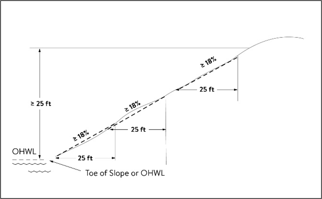
A slope that rises at least 25 feet where the grade of the slope averages 18 percent or greater, measured over any horizontal distance of 25 feet, from the toe of the slope to the top of the slope. Where the slope begins below the ordinary high-water level, the ordinary high water level is the toe of the slope. See figure 1; or
Figure 1. Bluff
B.
A natural escarpment or cliff where a slope that rises at least ten feet above the ordinary high-water level or toe of the slope, whichever is applicable, to the top of the slope, with a slope of 75 degrees or greater. See figure 2.
Figure 2. Natural Escarpment Bluff and Bluff Impact Zone
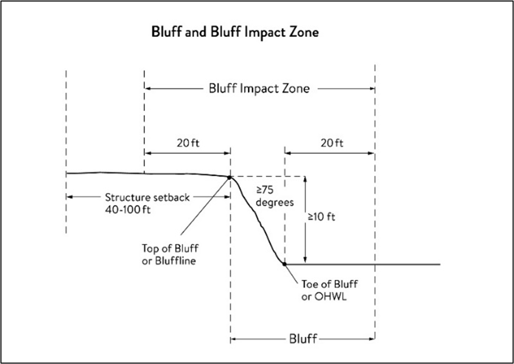
Bluff impact zone means a bluff and the land located within 20 feet of the bluff. See figure 2 for natural escarpment or cliff example and figure 3 for more common bluff example.
Figure 3. Toe, Top, and Bluff Impact Zone
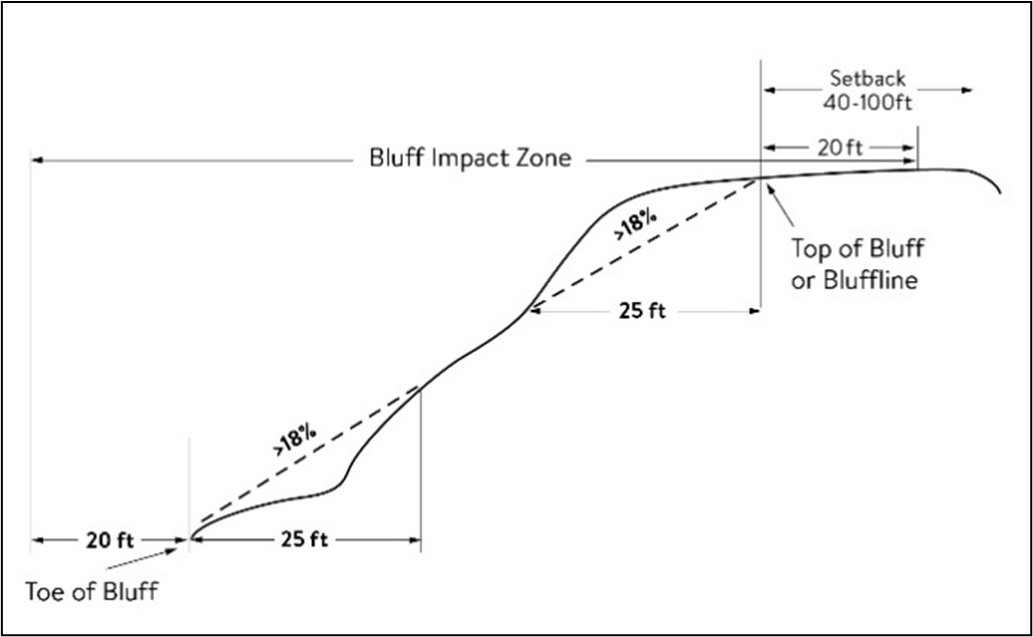
Bluffline means a line delineating the top of the bluff. More than one bluffline may be encountered proceeding landward from the river. See figure 2 for natural escarpment or cliff example and figure 3 for more common bluff example.
Bluff, Toeof means a line along the bottom of a bluff, requiring field verification, such that the slope above the line exceeds 18 percent and the slope below the line is 18 percent or less, measured over a horizontal distance of 25 feet. See figure 2 for natural escarpment or cliff example and figure 3 for more common bluff example.
Bluff, Top of means a line along the top of a bluff, requiring field verification, such that the slope below the line exceeds 18 percent and the slope above the line is 18 percent or less, measured over a horizontal distance of 25 feet. See figure 2 for natural escarpment or cliff example and figure 3 for more common bluff example.
Buildable area means the area upon which structures may be placed on a lot or parcel of land and excludes areas needed to meet requirements for setback, rights-of-way, bluff impact zones, historic properties, wetlands, designated floodways, land below the ordinary high-water level of public waters, and other unbuildable areas.
Building means a structure with two or more outside rigid walls and a fully secured roof and affixed to a permanent site.
Certificate of compliance means a document written after a compliance inspection, certifying that the development complies with applicable requirements at the time of the inspection.
Commissioner means the commissioner of the Minnesota Department of Natural Resources.
Conditional use means a use having the meaning given under M.S.A. chs. 394 and 462.
Conservation design means a pattern of subdivision that is characterized by grouping lots within a portion of a parcel, where the remaining portion of the parcel is permanently protected as open space.
Conventional subdivision means a pattern of subdivision that is characterized by lots that are spread regularly throughout a parcel in a lot and block design.
Deck means a horizontal, unenclosed, aboveground level structure open to the sky, with or without attached railings, seats, trellises, or other features attached or functionally related to a principal use or site.
Developer has the meaning given under M.S.A. § 116G.03.
Development has the meaning given under M.S.A. § 116G.03.
Discretionary action means an action under this division related to land use that requires a public hearing by local ordinance or statute, such as preliminary plats, final subdivision plats, planned unit developments, conditional use permits, interim use permits, variances, appeals, and rezonings.
Dock has the meaning given under Minnesota Rules, chapter 6115.
Electric power facilities mean equipment and associated facilities for generating electric power or devices for converting wind energy to electrical energy as identified and defined under M.S.A. § 216E.
Essential services mean underground or overhead gas, electrical, communications, steam, or water distribution, collection, supply, or disposal systems, including storm water. Essential services include poles, wires, mains, drains, pipes, conduits, cables, fire alarm boxes, traffic signals, hydrants, navigational structures, aviation safety facilities or other similar equipment and accessories in conjunction with the systems. Essential services does not include buildings, treatment works as defined in M.S.A. ch. 115.01, electric power facilities or transmission services.
Feedlot has the meaning given for animal feedlots under Minnesota Rules chapter 7020.
Floodplain has the meaning given the meaning given under Minnesota Rules chapter 6120.
Fully reconstructs means the reconstruction of an existing impervious surface that involves site grading and subsurface excavation so that soil is exposed. Mill and overlay and other resurfacing activities are not considered fully reconstructed.
Hard-surface trail means a trail surfaced in asphalt, crushed aggregate, or other hard surface, for multi-purpose use, as determined by local, regional, or state agency plans.
Historic property means an archaeological site, standing structure, site, district, or other property that is:
A.
Listed in the National Register of Historic Places or the State Register of Historic Places or locally designated as a historic site under M.S.A. § 471;
B.
Determined to meet the criteria for eligibility to the National Register of Historic Places or the State Register of Historic Places as determined by the director of the Minnesota Historical Society; or
C.
An unplatted cemetery that falls under the provisions of M.S.A. § 307, in consultation with the Office of the State Archaeologist.
Impervious surface means a constructed hard surface that either prevents or retards the entry of water into the soil and causes water to run off the surface in greater quantities and at an increased rate of flow than prior to development. Examples include rooftops, decks, sidewalks, patios, parking lots, storage areas, and driveways, including those with concrete, asphalt, or gravel surfaces.
Intensive vegetation clearing means the removal of all or a majority of the trees or shrubs in a contiguous patch, strip, row, or block.
Interim use has the meaning given under M.S.A. § 394 and 462.
Land alteration means an activity that exposes the soil or changes the topography, drainage, or cross section of the land, excluding gardening or similar minor soil disturbances.
Local government means counties, cities, and townships.
Local park agencies mean the Minneapolis Park and Recreation Board and the Three Rivers Park District.
Lot has the meaning given under Minnesota Rules, chapter 6120.
Lot width means the shortest distance between lot lines measured at both the ordinary high-water level and at the required structure setback from the ordinary high-water level. See figure 4.
Figure 4: Lot Width
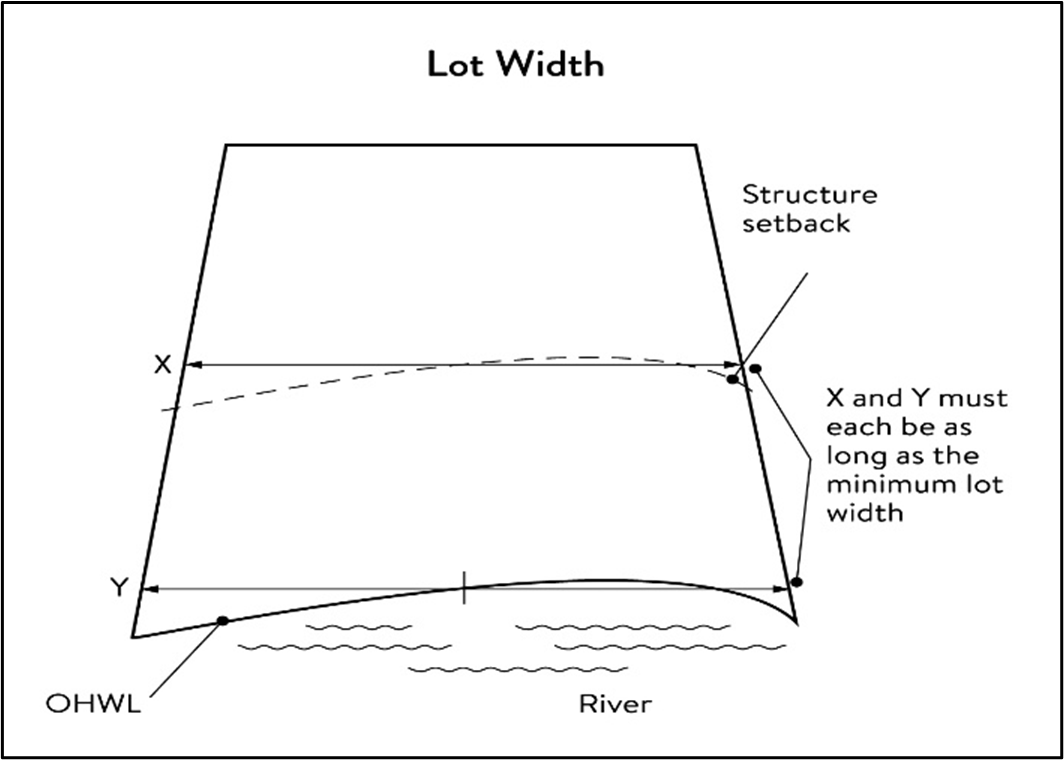
Marina has the meaning given under Minnesota Rules, chapter 6115.
Mississippi River Corridor Critical Area (MRCCA) means the area within the River Corridor Boundary (see River corridor boundary).
Mississippi River Corridor Critical Area (MRCCA) Plan means a chapter or other element in the city's comprehensive plan.
Mooring facility has the meaning given under Minnesota Rules, chapter 6115.0170.
Native plant community means a plant community that has been identified as part of the Minnesota Biological Survey or biological survey issued or adopted by a local, state, or federal agency.
Natural-surface trail means a trail composed of native soil and rock or compacted granular stone, primarily intended for hiking, equestrian, or mountain bike use, as determined by local, regional, or state agency plans.
Natural vegetation means any combination of ground cover, understory, and tree canopy that, while it may have been altered by human activity, continues to stabilize soils, retain and filter runoff, provide habitat, and recharge groundwater.
Nonconformity has the meaning given under M.S.A. § 394.22.
Nonmetallic mining means the construction, reconstruction, repair, relocation, expansion, or removal of any facility for the extraction, stockpiling, storage, disposal, or reclamation of nonmetallic minerals such a stone, sand, and gravel. Nonmetallic mining does not include ancillary facilities such as access roads, bridges, culverts, and water level control structures. For purposes of this subpart, "facility" includes all mine pits, quarries, stockpiles, basins, processing structures and equipment, and any structures that drain or divert public waters to allow mining.
Off-premises advertising signs means signs that direct attention to a product, service, business, or entertainment venue that is not exclusively related to the premises where the sign is located.
Ordinary high-water level (OHWL) has the meaning given under M.S.A. § 103G.005.
Overlay district means a zoning district that is applied over one or more previously established zoning districts, establishing additional or stricter standards and criteria for covered properties in addition to those of the underlying zoning district. Overlay districts are often used to protect historic features and natural resources such as shoreland or floodplain.
Parcel has the meaning given under M.S.A. § 116G.03.
Patio means a constructed hard surface located at ground level with no railings and open to the sky.
Picnic shelter means a roofed structure open on all sides, accessory to a recreational use.
Planned unit development means a method of land development that merges zoning and subdivision controls, allowing developers to plan and develop a large area as a single entity, characterized by a unified site design, a mix of structure types and land uses, and/or phasing of development over a number of years. Planned unit development includes any conversion of existing structures and land uses that utilize this method of development.
Plat has the meaning given under M.S.A. §§ 505 and 515B.
Port means a transportation complex established and operated under the jurisdiction of a port authority according to M.S.A. § 458.
Primary conservation areas mean resources and features, including shore impact zones, bluff impact zones, floodplains, wetlands, gorges, areas of confluence with tributaries, natural drainage routes, unstable soils and bedrock, native plant communities, cultural and historic properties, and significant existing vegetative stands, tree canopies, and other resources identified in local government plans.
Private facilities mean private roads, driveways, and parking areas, private water access and viewing facilities, decks and patios in setback areas, and private signs.
Professional engineer means an engineer licensed to practice in Minnesota.
Public facilities mean public utilities, public transportation facilities, and public recreational facilities.
Public recreation facilities mean recreational facilities provided by the state or a local government and dedicated to public use, including parks, scenic overlooks, observation platforms, trails, docks, fishing piers, picnic shelters, water access ramps, and other similar water-oriented public facilities used for recreation.
Public river corridor views mean views toward the river from public parkland, historic properties, and public overlooks, as well as views toward bluffs from the ordinary high water level of the opposite shore, as seen during the summer months and documented in the MRCCA chapter of the comprehensive plan.
Public transportation facilities mean all transportation facilities provided by federal, state, or local government and dedicated to public use, such as roadways, transit facilities, railroads, and bikeways.
Public utilities mean electric power facilities, essential services, and transmission services.
Public waters have the meaning given under M.S.A. § 103G.005.
Readily visible means land and development that are easily seen from the ordinary high-water level of the opposite shore during summer months.
Resource agency means a federal, state, regional, or local agency that engages in environmental, natural, or cultural resource protection or restoration activities, including planning, implementation, and monitoring.
Retaining wall means a vertical or nearly vertical structures constructed of mortar and rubble masonry, rock, or stone regardless of size, vertical timber pilings, horizontal timber planks with piling supports, sheet pilings, poured concrete, concrete blocks, or other durable materials.
Rock riprap means natural coarse rock placed or constructed to armor shorelines, streambeds, bridge abutments, pilings and other shoreline structures against scour, or water or ice erosion.
River corridor boundary means the boundary approved and adopted by the Metropolitan Council under M.S.A. § 116G.06, as approved and adopted by the legislature in M.S.A. § 116G.15, and as legally described in the Sate Register, volume 43, pages 508 to 518.
River-dependent use means the use of land for commercial, industrial, or utility purposes, where access to and use of a public water feature is an integral part of the normal conduct of business and where the use is dependent on shoreline facilities.
Selective vegetation removal means the removal of isolated individual trees or shrubs that are not in a contiguous patch, strip, row, or block and that does not substantially reduce the tree canopy or understory cover.
Setback means a separation distance measured horizontally.
Shore impact zone means land located between the ordinary high-water level of public waters and a line parallel to it at a setback of 50 percent of the required structure setback or, for agricultural use, 50 feet landward of the ordinary high-water level. See figure 5.
Figure 5: Shore Impact Zone
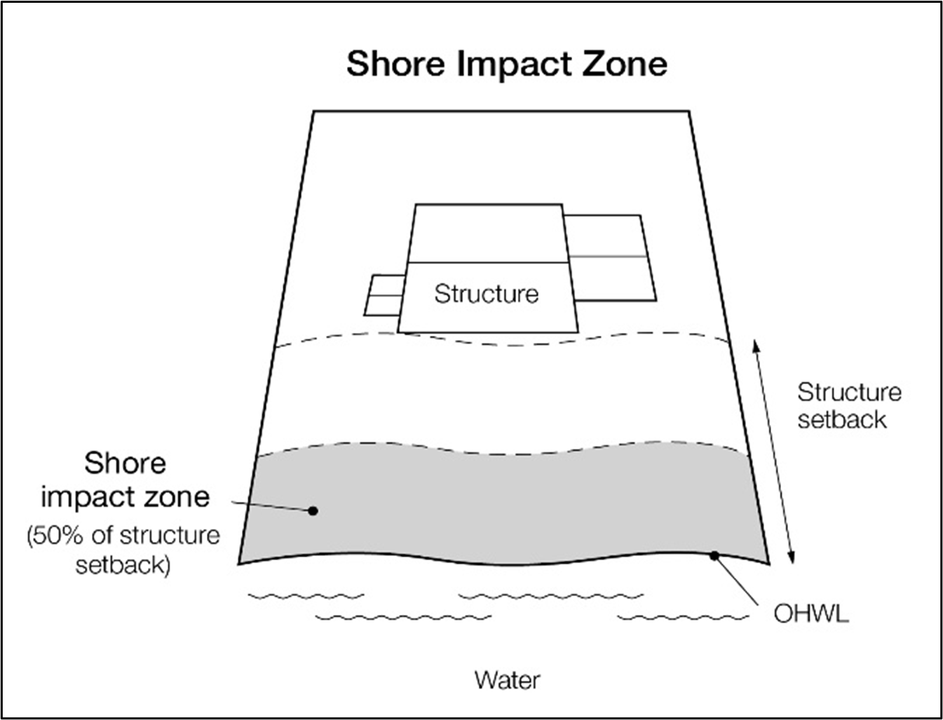
Shoreline facilities means facilities that require a location adjoining public waters for ingress and egress, loading and unloading, and public water intake and outflow, such as barge facilities, port facilities, commodity loading and unloading equipment, watercraft lifts, marinas, short-term watercraft mooring facilities for patrons, and water access ramps. Structures that would be enhanced by a shoreline location, but do not require a location adjoining public waters as part of their function, are not shoreline facilities, such as restaurants, bait shops, and boat dealerships.
Special purpose units of government mean the University of Minnesota, the St. Paul Port Authority, watershed management organizations established under M.S.A. ch. 103B, watershed districts established under M.S.A. ch. 103D, and any other unit of government other than local government or a state or regional agency.
State or regional agency means the Metropolitan Airports Commission, Minnesota Historical Society, University of Minnesota, Department of Natural Resources, Department of Transportation, Metropolitan Council, and other state agencies.
Steep slope means a natural topographic feature with an average slope of 12 to 18 percent, measured over a horizontal distance equal to or greater than 50 feet, and any slopes greater than 18 percent that are not bluffs.
Storm water management facilities means facilities for the collection, conveyance, treatment, or disposal of storm water.
Structure means a building, sign, or appurtenance thereto, except for aerial or underground utility lines, such as sewer, electric, telephone, or gas lines, and utility line towers, poles, and other supporting appurtenances.
Subdivision has the meaning given under M.S.A. § 462.352.
Subsurface sewage treatment system (SSTS) has the meaning given under Minnesota Rules, part 7080.1100.
Transmission services mean
A.
Electric power lines, cables, pipelines, or conduits that are:
(1)
Used to transport power between two points, as identified and defined under M.S.A. § 216E.01, subdivision 4; or
(2)
For mains or pipelines for gas, liquids, or solids in suspension, used to transport gas, liquids, or solids in suspension between two points; and
B.
Telecommunication lines, cables, pipelines, or conduits.
Treeline means the more or less continuous line formed by the tops of trees in a wooded area when viewed from a particular point. The treeline is determined during all seasons as if under full foliage.
Twin Cities Metropolitan Area means the area over which the Metropolitan Council has jurisdiction according to M.S.A. § 473.121 subdivision 2.
Variance has the meaning given under M.S.A. § 394.22.
Water access ramp means a boat ramp, carry-down site, boarding dock, and approach road, or other access that allows launching and removal of a boat, canoe, or other watercraft with or without a vehicle and trailer.
Water-oriented accessory structure means a small building or other improvement, except stairways, fences, docks, and retaining walls, that, because of the relationship of its use to public waters, needs to be located closer to public waters than the normal structure setback. Examples include gazebos, screen houses, fish houses, pump houses, and detached decks and patios.
Water quality impact zone means land within the shore impact zone or within 50 feet of the OHWL of the river, whichever is greater, and land within 50 feet of a public water, wetland, or natural drainage route.
Wetland has the meaning given under M.S.A. § 103G.005.
Wharf has the meaning given under Minnesota Rules, part 6115.0170.
(Ord. No. 2021-02, 1-21-2021; Ord. No. 2021-12, 8-19-2021)
Sec. 36-363. - Administration.
(1)
Purpose. The purpose of this section is to identify administrative provisions to ensure this division is administered consistent with its purpose.
(2)
Permits. A permit is required for the construction of buildings or building additions (including construction of decks and signs), the installation and/or alteration of sewage treatment systems, vegetation removal consistent with section 36-369 and land alterations consistent with section 36-370.
(3)
Variances. Variances to the requirements under this division may only be granted in accordance with M.S.A. § 462.357 and must consider the potential impacts of variances on primary conservation areas (PCAs), public river corridor views (PRCVs), and other resources identified in the MRCCA plan. In reviewing the variance application, the city shall:
a.
Evaluate the impacts to these resources. If negative impacts are found, require conditions to mitigate the impacts that are related to and proportional to the impacts, consistent with subsection 36-363(5) and
b.
Make written findings that the variance is consistent with the purpose of this division as follows.
i.
The extent, location and intensity of the variance will be in substantial compliance with the MRCCA Plan;
ii.
The variance is consistent with the character and management purpose of the MRCCA district in which it is located;
iii.
The variance will not be detrimental to PCAs and PRVCs nor will it contribute to negative incremental impacts to PCAs and PRVCs when considered in the context of past, present and reasonable future actions; and
iv.
The variance will not negatively impact other MRCCA resources identified in the city's MRCCA Plan such as wetlands, river overlooks, parks and open space, etc.
(4)
Conditional and interim use permits. All conditional and interim uses required under this division must comply with M.S.A. § 462.3595 and must consider the potential impacts on primary conservation areas, public river corridor views, and other resources identified in the city's MRCCA plan. In reviewing the application, the city shall:
a.
Evaluate the impacts to these resources and if negative impacts are found, require conditions to mitigate the impacts that are related to and proportional to the impacts, consistent with subsection 36-363(5); and
b.
Make written findings that the conditional use is consistent with the purpose of this division as follows:
i.
The extent, location and intensity of the conditional use will be in substantial compliance with the MRCCA plan;
ii.
The conditional use is consistent with the character and management purpose of the MRCCA district in which it is located;
iii.
The conditional use will not be detrimental to PCAs and PRVCs nor will it contribute to negative incremental impacts to PCAs and PRVCs when considered in the context of past, present, and reasonable future actions; and
iv.
The conditional use will not negatively impact other resources identified in the city's MRCCA plan, such as wetlands, river overlooks, and parks and open space.
(5)
Conditions of approval. The city shall evaluate the impacts to PCAs, PRCVs and other resources identified in the MRCCA Plan, and if negative impacts are found, require conditions to mitigate the impacts that are related to and proportional to the impacts. Mitigation may include:
a.
Restoration of vegetation identified as "vegetation restoration priorities" identified in the city's MRCCA plan;
b.
Preservation of existing vegetation;
c.
Increasing, enhancing, and/or connecting habitat for pollinators, birds, and other wildlife;
d.
Storm water runoff management;
e.
Reducing impervious surface;
f.
Increasing structure setbacks;
g.
Wetland and drainage route restoration and/or preservation;
h.
Limiting the height of structures;
i.
Modifying structure design to limit visual impacts on the PRCVs; and
j.
Other conservation measures.
(6)
Application materials. Applications for permits and discretionary actions required under this division must submit the following information unless the city determines that the information is not needed.
a.
A detailed project description; and
b.
Scaled maps and plans, dimensional renderings, maintenance agreements, and other materials that identify and describe:
i.
Primary conservation areas;
ii.
Public river corridor views;
iii.
Buildable area;
iv.
Existing and proposed topography and drainage patterns;
v.
Proposed storm water and erosion and sediment control practices;
vi.
Existing and proposed vegetation to be removed and established;
vii.
Ordinary high-water level, blufflines and all required setbacks;
viii.
Existing and proposed structures;
ix.
Existing and proposed impervious surfaces; and
x.
Existing and proposed subsurface sewage treatment systems.
(7)
Nonconformities.
a.
All legally established nonconformities as of the date of this chapter may continue consistent with M.S.A. § 462.357, subd. 1e.
b.
New structures erected in conformance with the setback averaging provisions of subsection 36-366(4) are conforming structures.
c.
Site alterations and expansion of site alterations that were legally made prior to the effective date of this chapter are conforming. Site alterations include vegetation, erosion control, storm water control measures, and other nonstructural site improvements.
d.
Legally nonconforming principal structures that do not meet the setback requirements of subsection 36-366(4) may be expanded laterally provided that:
i.
The expansion does not extend into the shore or bluff impact zone or further into the required setback than the building line of the existing principal structure (See figure 6); and
ii.
The expanded structure's scale and bulk is consistent with that of the original structure and existing surrounding development.
Figure 6. Expansion of Nonconforming Structures
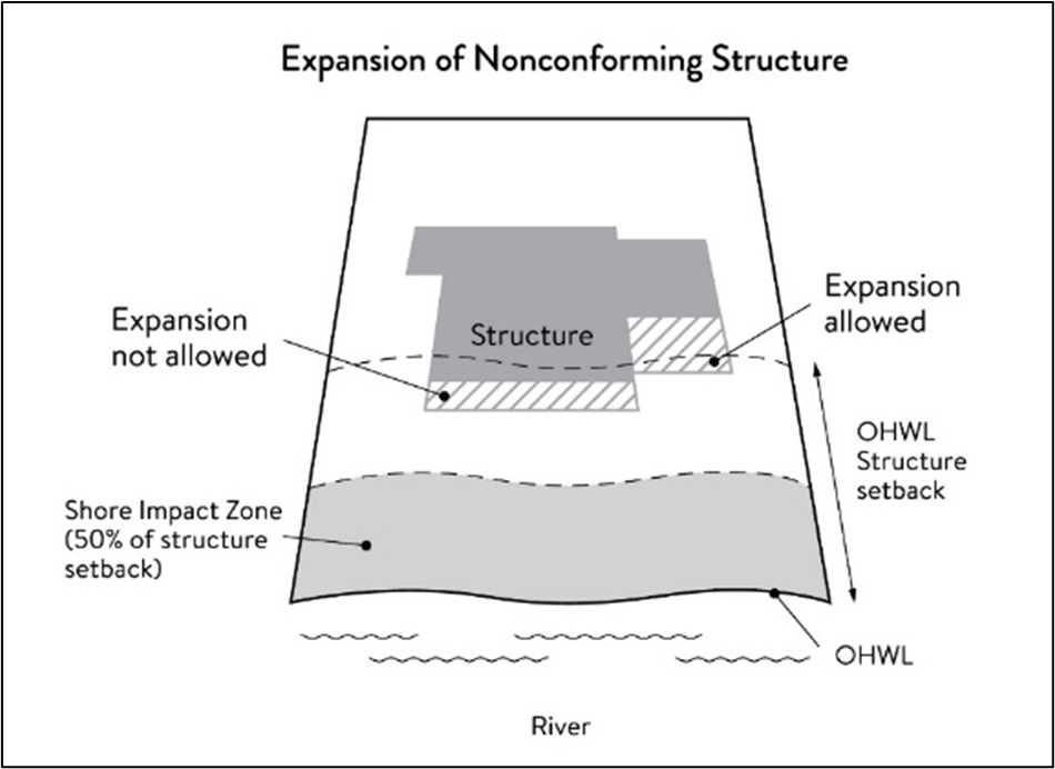
(8)
Notifications.
a.
Amendments to this division and to the MRCCA plan must be submitted to the Commissioner as provided in Minnesota rules, part 6106.0070, subp. 3, items B-I, and via email to the appropriate DNR Area Hydrologist.
b.
Notice of public hearings for discretionary actions, including conditional and interim use permits, variances, appeals, rezonings, preliminary plats, final subdivision plats, master plans, and PUDs, must be sent to the following entities at least 30 days prior to the hearing:
i.
To the Commissioner in a format prescribed by the DNR;
ii.
To the National Park Service; and
iii.
Where building heights exceed the height limits specified in subsection 36-366(2) as part of the conditional use or variance process, to the adjoining local governments within the MRCCA, including those with overlapping jurisdiction and those across the river.
c.
Notice of final decisions for actions in subsection 36-365(8)b, including findings of fact, but be sent to the Commissioner, the National Park Service, and adjoining local governments within the MRCCA within ten days of the final decision.
d.
Requests to amend district boundaries must follow the provisions in Minnesota Rules, part 6106.0100, Subp. 9, item C.
e.
The DNR will be notified at time of application submittal of master plans, PUDs, preliminary, and final plats.
(9)
Accommodating disabilities. Reasonable accommodation for ramps and other facilities to provide persons with disabilities access to the persons' property, as required by the federal Americans with Disabilities Act and the federal Fair Housing Act and as provided by Minnesota Rules, chapter 1341, must:
a.
Comply with sections 36-365 to 36-372; or
b.
If sections 36-365 to 36-372 cannot be complied with, ramps or other facilities are allowed with an administrative permit provided:
i.
The permit terminates on either a specific date or upon occurrence of a particular event related to the person requiring accommodation; and
ii.
Upon expiration of the permit, the ramp or other facilities must be removed.
(Ord. No. 2021-02, 1-21-2021; Ord. No. 2021-12, 8-19-2021)
Sec. 36-364. - MRCCA districts.
(1)
Purpose. The purpose of this section is to establish districts under which building height and structure placement are regulated to protect and enhance the Mississippi River's resources and features consistent with the natural and built character of each district.
(2)
District description and management purpose. The MRCCA within the city is divided into the following MRCCA Districts:
a.
River Neighborhood (RN).
i.
Description. The RN district is characterized by primarily residential neighborhoods that are riparian or readily visible from the river or that abut riparian parkland. The district includes parks and open space, limited commercial development, marinas, and related land uses.
ii.
Management purpose. The RN district must be managed to maintain the character of the river corridor within the context of existing residential and related neighborhood development, and to protect and enhance habitat, parks and open space, public river corridor views, and scenic, natural, and historic areas. Minimizing erosion and the flow of untreated storm water into the river and enhancing habitat and shoreline vegetation are priorities in the district.
b.
Separated from River (SR).
i.
Description. The SR district is characterized by its physical and visual distance from the Mississippi River. The district includes land separated from the river by distance topography, development, or a transportation corridor. The land in this district is not readily visible from the Mississippi River.
ii.
Management purpose. The SR district provides flexibility in managing development without negatively affecting the key resources and features of the river corridor. Minimizing negative impacts to primary conservation areas and minimizing erosion and the flow of untreated storm water into the river are priorities in the district.
c.
Urban Mixed (UM).
i.
Description. The UM District includes large areas of highly urbanized mixed use that are a part of the urban fabric of the river corridor, including institutional, commercial, industrial, and residential areas, parks, and open space.
ii.
Management purpose. The UM district must be managed in a manner that allows for future growth and potential transition of intensely developed areas that does not negatively affect public river corridor views and that protects bluffs and floodplains. Restoring and enhancing bluff and shoreline habitat, minimizing erosion and flow of untreated storm water into the river, and providing public access to and public views of the river are priorities in the district.
(3)
MRCCA district map. The locations and boundaries of the MRCCA districts established by this division are shown on the MRCCA Overlay District Map which is incorporated herein by reference. The district boundary lines are intended to follow the centerlines of rivers and streams, highways, streets, lot lines, and municipal boundaries, unless a boundary line is otherwise indicated on the map. Where district boundaries cross property that has not be subdivided, the district boundary line is determined by the use of dimensions or the scale appearing on the map.
(Ord. No. 2021-02, 1-21-2021; Ord. No. 2021-12, 8-19-2021)
Sec. 36-365. - Special land use provisions.
(1)
Purpose. The purpose of this section is to identify development standards and considerations for land uses that have potential to negatively impact primary conservation areas and public river corridor views.
(2)
Underlying zoning. Uses within the MRCCA are generally determined by underlying zoning, with additional provisions for the following land uses:
a.
Agricultural use. Perennial ground cover is required within 50 feet of the ordinary high-water level and within the bluff impact zone.
b.
Forestry. Tree harvesting and biomass harvesting within woodlands, and associated reforestation, must be consistent with recommended practices in Conserving Wooded Areas in Developing Communities: Best Management Practices in Minnesota.
c.
River-dependent uses. River-dependent uses must comply with the following design standards:
i.
Structures and parking areas, except shoreline facilities and private roads and conveyances serving river-dependent uses as provided in section 36-372 must meet the dimensional and performance standards in this division, must be designed so that they are not readily visible, and must be screened by establishing and maintaining natural vegetation;
ii.
Shoreline facilities must comply with Minnesota Rules, chapter 6115 and must:
A.
Be designed in a compact fashion to minimize the shoreline area affected; and
B.
Minimize the surface area of land occupied in relation to the number of watercraft or barges to be served; and
C.
Dredging and placement of dredged material are subject to existing federal and state permit requirements and agreements.
d.
Wireless communication towers. Wireless communication towers require a conditional use permit and are subject to the following design standards:
i.
The applicant must demonstrate that functional coverage cannot be provided through co-location, a tower at a lower height, or a tower at a location outside of the MRCCA.
ii.
The tower must not be located in a bluff or shore impact zone.
iii.
Placement of the tower must minimize impacts on public river corridor views.
iv.
The tower must comply with the general design standards in subsection 36-368(2).
(Ord. No. 2021-02, 1-21-2021; Ord. No. 2021-12, 8-19-2021)
Sec. 36-366. - Structure height and placement and lot size.
(1)
Purpose. The purpose of this section is to establish standards that protect primary conservation areas and public river corridor views from development impacts and ensure that new development is sited consistent with the purpose of the MRCCA.
(2)
Structure height. Structures and facilities must comply with the following standards unless identified as exempt in section 36-372.
a.
Structures and facilities must comply with the following standards unless identified as exempt in section 36-372.
i.
RN district: maximum 35 feet.
ii.
SR district: Height is determined by underlying zoning, provided the allowed height is consistent with that of the mature tree line, where preset, and existing surrounding development, as viewed from the OHWL of the opposite shore.
iii.
UM district: maximum 65 feet, provided tiering of structures away from the Mississippi River and from blufflines is given priority, with lower structure heights closer to the river and blufflines, and that structure design and placement minimize interference with public river corridor views. Structures taller than 65 feet and up to 70 feet may be allowed as a conditional use when they meet the goals of the MRCCA district and are in accord with subsection 36-366(2)c.
b.
Height shall be measured on the side of the structure facing the Mississippi River.
c.
In addition to the conditional use permit requirements for structures proposed to exceed the height standard in the UM district, the criteria for considering whether to grant a conditional use permit for structures exceeding the height limits must include:
i.
Assessment of the visual impact of the proposed structure on public river corridor views, including views from other communities;
ii.
Determination that the proposed structure meets the required bluff and OHWL setbacks;
iii.
Identification and application of one or more of the following techniques to minimize the perceived bulk of the proposed structure:
A.
Placing the long axis of the building perpendicular to the river;
B.
Stepping back of portions of the facade;
C.
Lowering the roof pitch or use of a flat roof;
D.
Using building materials or mitigation techniques that will blend in with the natural surroundings such as green roofs, green walls, or other green and brown building materials;
E.
Narrowing the profile of upper floors of the building; or
F.
Increasing the setbacks of the building from the Mississippi River or blufflines;
iv.
Identification of techniques for preservation of those view corridors identified in the MRCCA plan; and
v.
Opportunities for creation or enhancement of public river corridor views.
(3)
Structure and impervious surface placement.
a.
Structures and impervious surfaces must not be placed in the shore or bluff impact zones unless identified as an exemption in section 36-372.
b.
Structures and facilities must comply with the following OHWL setback provisions unless identified as exempt in section 36-372.
i.
RN district: 100 feet from the Mississippi River.
ii.
UM district: 50 feet from the Mississippi River.
c.
Structures and facilities must comply with the following bluffline setback provisions unless identified as exempt in section 36-372.
i.
RN district: 40 feet.
ii.
SR district: 40 feet.
iii.
UM district: 40 feet.
d.
Subsurface sewage treatment systems, including the septic tank and absorption area, must be located at least 75 feet from the OHWL of the Mississippi River and all other public water bodies.
e.
Structure setback averaging. Where principal structures exist on the adjoining lots on both sides of a proposed building site, the minimum setback may be altered to conform to the average of the adjoining setbacks if the new structure's scale and bulk riverward or bluffward of the setbacks required above are consistent with adjoining development.
i.
The city may consider the setbacks of additional structures on nearby lots in determining the average setbacks if needed, for example for corner lots.
Figure 7. Structure Setback Averaging
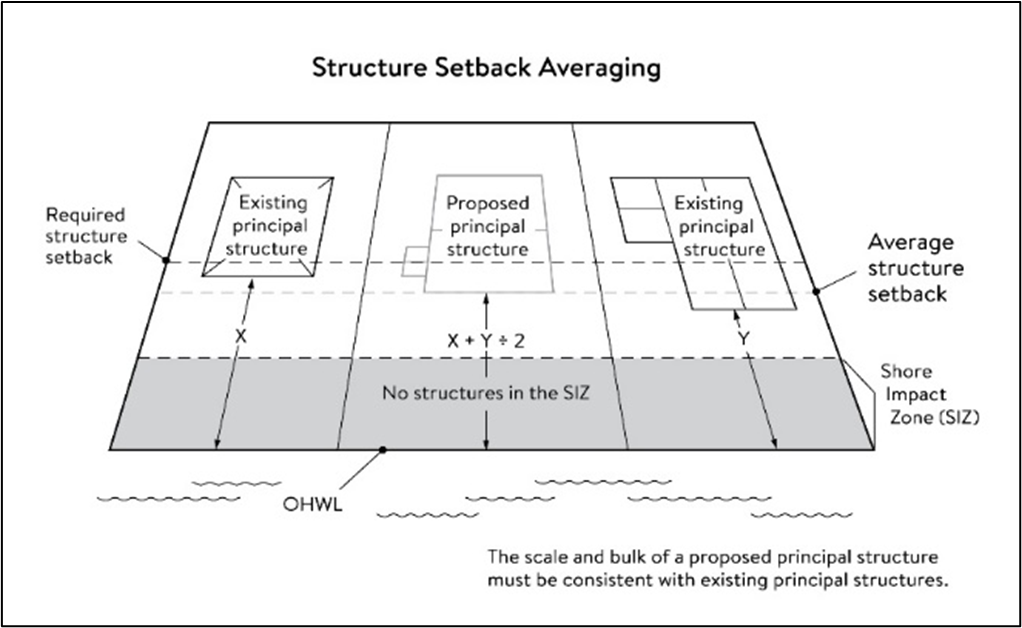
(4)
Lot size and buildable area. All new lots must have adequate buildable area to comply with the setback requirements of subsections 36-366(4) b and c so that a variance is not required to use the lots for their intended purpose.
(Ord. No. 2021-02, 1-21-2021; Ord. No. 2021-12, 8-19-2021)
Sec. 36-367. - Performance standards for private facilities.
(1)
Purpose. To establish design standards for private facilities that are consistent with best management practices and that minimize impacts to primary conservation areas, public river corridor views and other resources identified in the MRCCA plan.
(2)
General design standards. All private facilities must be developed in accordance with the vegetation management and land alteration requirements in sections 36-369 and 36-370.
(3)
Private roads, driveways, and parking areas. Except as provided in 36-372, private roads, driveways, and parking areas must:
a.
Be designed to take advantage of natural vegetation and topography so that they are not readily visible;
b.
Comply with structure setback requirements according to section 36-366; and
c.
Not be placed within the bluff impact zone or shore impact zone, unless exempt under section 36-372 and designed consistent with subsection 36-368(2).
(4)
Private water access and viewing facilities
a.
Private access paths must be no more than:
i.
Eight feet wide, if placed within the shore impact zone; and
ii.
Four feet wide, if placed within the bluff impact zone.
b.
Private water access ramps must:
i.
Comply with Minnesota Rules, chapters 6115.0210 and 6280.0250; and
ii.
Be designed and constructed consistent with the applicable standards in the Design Handbook for Recreational Boating and Fishing Facilities (US Fish and Wildlife Service).
c.
Design and construction of private stairways, lifts, and landings are subject to the following standards:
i.
Stairways and lifts must not exceed four feet in width on residential lots. Wider stairways may be used for commercial properties and residential facilities held in common, if approved by a conditional use permit;
ii.
Landings for stairways and lifts on residential lots must not exceed 32 square feet in area. Landings larger than 32 square feet in area may be allowed for commercial properties and residential facilities held in common, if approved by a conditional use permit;
iii.
Canopies or roofs are prohibited on stairways, lifts, or landings;
iv.
Stairways lifts, and landings shall be located in the least visible portion of the lot whenever practical; and
v.
Ramps, lifts, mobility paths, or other facilities for persons with physical disabilities are allowed for achieving access to shore areas according to items i-iv in this section and as provided under subsection 36-363 (9).
d.
One water-oriented accessory structure is allowed for each riparian lot or parcel less than 300 feet in width at the ordinary high-water level, with one additional water-oriented accessory structure allowed for each additional 300 feet of shoreline on the same lot or parcel. Water-oriented accessory structures are prohibited in the bluff impact zone and must:
i.
Not exceed 12 feet in height;
ii.
Not exceed 120 square feet in area; and
iii.
Be placed a minimum of ten feet from the ordinary high-water level.
e.
Decks and patios in setback areas. Decks and at-grade patios may encroach into the required setbacks from the ordinary high-water level and blufflines without a variance when consistent with sections 36-369 and 36-370 provided that:
i.
The encroachment of the deck or patio into the required setback area does not exceed 15 percent of the required structure setback:
ii.
The area of the deck or patio that extends into the required setback area occupies no more than 25 percent of the total area between the required setback and 15 percent using the formula: [Required setback depth (feet) x 0.15 x lot width at setback(feet) x 0.25 = maximum total area]
iii.
The deck or patio does not extend into the bluff impact zone. See Figure 8.
Figure 8. Deck and Patio Encroachment
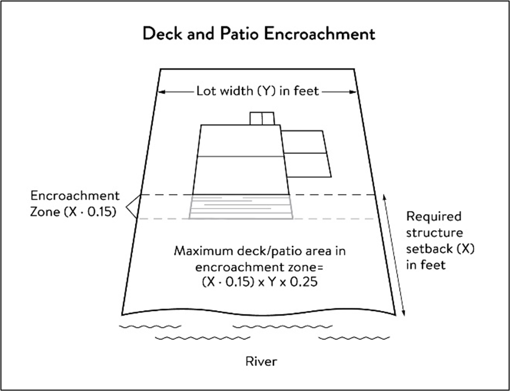
(5)
Off-premises and directional signs.
a.
Off-premises advertising signs must:
i.
Meet required structure placement and height standards in subsection 36-366 (2) and (3).
ii.
Not be readily visible from the water or shoreline.
b.
Directional signs for patrons arriving at a business by watercraft must comply with the following standards:
i.
They must be consistent with M.S.A. § 86B.115;
ii.
Only convey the location and name of the establishment and the general types of goods and services available, if located in a shore impact zone;
iii.
Be no greater than ten feet in height and 32 square feet in surface area; and
iv.
If illuminated, the lighting must be fully shielded and directed downward to prevent illumination out across the river or to the sky.
(6)
Fences. Fences between principal structures and the river are allowed if fences are:
a.
Not higher than six feet.
b.
Not located within 40 feet of slopes greater than 12 percent.
c.
Not located in the regulatory floodplain.
(7)
Lighting. Within the OHWL setback:
a.
Lighting shall be fully shielded and directed away from the river;
b.
Up-lighting is prohibited.
(Ord. No. 2021-02, 1-21-2021; Ord. No. 2021-12, 8-19-2021)
Sec. 36-368. - Performance standards for public facilities.
(1)
Purpose. The purpose of this section is to establish standards for public facilities that are consistent with best management practices and that minimize impacts to primary conservation areas, public river corridor views and other resources identified in the MRCCA plan. Public facilities serve the public interest by providing public access to the Mississippi River corridor or require locations in or adjacent to the river corridor and therefore require some degree of flexibility.
(2)
General design standards. All public facilities must be designed and constructed to:
a.
Minimize visibility of the facility from the river to the extent consistent with the purpose of the facility;
b.
Comply with the structure placement and height standards in section 36-366, except and provided in section 36-372;
c.
Be consistent with the vegetation management standards in section 36-369 and the land alteration and stormwater management standards in section 36-370, including use of practices identified in Best Practices for Meeting DNR General Public Waters Work Permit GP 2004-0001 where applicable;
d.
Avoid primary conservation areas unless no alternative exists. If no alternative exists then disturbance to primary conservation areas must be avoided to the greatest extent practicable, and design and construction must minimize impacts; and
e.
Minimize disturbance of spawning and nesting times by scheduling construction at times when local fish and wildlife are not spawning or nesting;
f.
Minimize disturbance during bird migration and nesting times by scheduling construction at times when birds are not migrating or nesting.
(3)
Right-of-way maintenance standards. Right-of-way maintenance must comply with the following standards:
a.
Vegetation currently in a natural state must be maintained to the extent feasible;
b.
Where vegetation in a natural state has been removed, native plans must be planted and maintained on the right-of-way; and
c.
Chemical control of vegetation must be avoided when practical, but when chemical control is necessary the chemicals used must be in accordance with the regulations and other requirements of all state and federal agencies with authority over the chemical's use.
(4)
Crossings of public waters or public land. Crossings of public waters or land controlled by the commissioner are subject to approval by the commissioner according to M.S.A. §§ 84.415 and 103G.245.
(5)
Public utilities. Public utilities must comply with the following standards:
a.
High-voltage transmission lines, wind energy conversion systems greater than five megawatts, and pipelines are regulated according to M.S.A. chs. 216E, 216F, and 216G, respectively; and
b.
If overhead placement is necessary, utility facility crossings must minimize the visibility of the facility from the river and follow other existing rights-of-way as much as practicable;
c.
The appearance of structures must be as compatible as practicable with the surrounding area in a natural state with regard to height and width, materials used, and color;
d.
Wireless communication facilities, according to subsection 36-365(2)d.
(6)
Public transportation facilities. Public transportation facilities shall comply with structure placement and height standards in section 36-366. Where such facilities intersect or abut two or more MRCCA districts, the least restrictive standards apply. Public transportation facilities must be designed and constructed to give priority to:
a.
Providing scenic overlooks for motorists, bicyclists, and pedestrians;
b.
Providing safe pedestrian crossings and facilities along the river corridor;
c.
Providing access to the riverfront in public ownership; and
d.
Allowing for use of the land between the river and the transportation facility.
(7)
Public recreational facilities. Public recreational facilities must comply with the following standards:
a.
Buildings and parking associated with public recreational facilities must comply with the structure placement and height standards in section 36-366, except as provided in section 36-372;
b.
Roads and driveways associated with public recreational facilities must not be placed in the bluff or shore impact zones unless no other placement alternative exists. If no alternative exists, then design and construction must minimize impacts to shoreline vegetation, erodible soils and slopes, and other sensitive resources.
c.
Trails, access paths, and viewing areas associated with public recreational facilities and providing access to or views of the Mississippi River are allowed within the bluff and shore impact zones if design, construction, and maintenance methods are consistent with the best management practice guidelines in Trail Planning, Design, and Development Guidelines.
i.
Hard-surface trails are not allowed on the face of bluffs with a slope exceeding 30 percent. Natural surface trails are allowed, provided they do not exceed eight feet in width.
ii.
Trails, paths, and viewing areas must be designed and constructed to minimize:
1.
Visibility from the river;
2.
Visual impacts on public river corridor views; and
3.
Disturbance to and fragmentation of primary conservation areas.
d.
Public water access facilities must comply with the following requirements:
i.
Watercraft access ramps must comply with Minnesota Rules chapters 6115.0210 and 6280.0250; and
ii.
Facilities must be designed and constructed consistent with the standards in the Design Handbook for Recreational Boating and Fishing Facilities.
e.
Public signs and kiosks for interpretive or directional purposes are allowed in the bluff or shoreland impact zones, provided they are placed and constructed to minimize disturbance to these areas and avoid visual impacts on public river corridor views. If illuminated, the lighting must be fully shielded and be directed downward.
f.
Public stairways, lifts, and landings must be designed as provided in subsection 36-367(4)c.
(Ord. No. 2021-02, 1-21-2021; Ord. No. 2021-12, 8-19-2021)
Sec. 36-369. - Vegetation management.
(1)
Purpose. To establish standards that sustain and enhance the biological and ecological functions of vegetation; preserve the natural character and topography of the MRCCA; and maintain the stability of bluffs and steep slopes and ensure stability of other erosion-prone areas.
(2)
Applicability. This section applies to:
a.
Shore impact zones;
b.
Areas within 50 feet of a wetland or natural drainage route;
c.
Bluff impact zones;
d.
Areas of native plant communities; and
e.
Significant existing vegetation stands identified in the MRCCA plan.
(3)
Activities allowed without a vegetation permit.
a.
Maintenance of existing lawns, landscaping and gardens;
b.
Removal of vegetation in emergency situations as determined by the city;
c.
Right-of-way maintenance for public facilities meeting the standards in subsection 36-368 (3);
d.
Agricultural and forestry activities meeting the standards of subsection 36-365 (2), items a and b;
e.
Selective vegetation removal, provided that vegetative cover remains consistent with the management purpose of the MRCCA District, including the removal of:
i.
Vegetation that is dead, diseased, dying, or hazardous;
ii.
Vegetation to prevent the spread of diseases or insect pests;
iii.
Individual trees and shrubs; and
iv.
Invasive non-native species.
(4)
Activities allowed with a vegetation permit.
a.
Only the following intensive vegetation clearing activities are allowed with a vegetation permit:
i.
Clearing of vegetation that is dead, diseased, dying, or hazardous;
ii.
Clearing to prevent the spread of diseases or insect pests;
iii.
Clearing to remove invasive, non-native species;
iv.
Clearing to prepare for restoration and erosion control management activities consistent with a plan approved by the city;
v.
The minimum necessary for development that is allowed with a building permit or as an exemption under section 36-372.
b.
General Performance Standards. The following standards must be met, in addition to a restoration plan under section 36-369, item (6), in order to approve a vegetation permit:
i.
Development is sited to minimize removal of or disturbance to natural vegetation;
ii.
Soil slope stability, and hydrologic conditions are suitable for the proposed work as determined by the City Engineer;
iii.
Clearing is the minimum necessary and designed to blend with the natural terrain and minimize visual impacts to public river corridor views and other scenic views;
iv.
Vegetation removal activities are conducted to expose the smallest practical area of soil to erosion for the least possible time, and to avoid bird migration and nesting seasons; and
v.
Any other condition determined necessary to achieve the purpose of this section.
(5)
Prohibited activities. All other intensive vegetation clearing is prohibited.
(6)
Vegetation restoration plan.
a.
Development of a vegetation restoration plan and reestablishment of natural vegetation is required.
i.
For any vegetation removed with a permit issued under section 36-369, item (4);
ii.
Upon failure to comply with any provisions in this section; or
iii.
As part of the planning process for subdivisions as provided in section 36-371.
b.
Restoration Plan Performance Standards. The vegetation restoration plan must satisfy the application submittal requirements in section 36-363, item (6) and:
i.
Vegetation must be restored in one or more of the following restoration priority areas:
1.
Areas with soils showing signs of erosion, especially on or near the top and bottom of steep slopes and bluffs;
2.
Shoreline areas within 25 feet of the water with no natural vegetation, degraded vegetation, or planted with turf grass;
3.
Areas on steep slopes and bluffs that are visible from the river with no natural vegetation, degraded vegetation, or planted with turf grass; or
4.
Other approved priority opportunity area, including priorities identified in the MRCCA plan, if none of the above exist.
ii.
Include vegetation that provides suitable habitat and effective soil stability, runoff retention, and infiltration capability. Vegetation species, composition, density, and diversity must be guided by nearby patches of native plant communities and by Native Vegetation Establishment and Enhancement Guidelines;
iii.
Any highly erodible soils disturbed during removal and/or restoration must be stabilized with deep-rooted vegetation with a high stem density;
iv.
Vegetation removed must be restored with native vegetation to the greatest extent practicable. The area (square feet) of the restored vegetation should be similar to that removed to the greatest extent practicable;
v.
For restoration of removed native plant communities restored vegetation must also provide biological and ecological function equivalent to the removed native plant communities. The area (square feet) of the restored vegetation should be equivalent to that removed;
vi.
Be prepared by a qualified individual; and
vii.
Include a maintenance plan that includes management provisions for controlling invasive species and replacement of plant loss for three years.
c.
The city will issue a certificate of compliance after the vegetation restoration plan requirements have been satisfied.
(Ord. No. 2021-02, 1-21-2021; Ord. No. 2021-12, 8-19-2021)
Sec. 36-370. - Land alteration standards and stormwater management.
(1)
Purpose. To establish standards that protect water quality from pollutant loadings of sediment, nutrients, bacteria, and other contaminants, and maintain the stability of bluffs, shorelines, and other areas prone to erosion.
(2)
Land alteration.
a.
Within the bluff impact zone, land alteration is prohibited, except for the following, which are allowed by permit.
i.
Erosion control consistent with a plan approved by the City and consistent with section 36-370, item (6);
ii.
The minimum necessary for development that is allowed as an exception under section 36-372; and
iii.
Repair and maintenance of existing buildings and facilities.
b.
Within the water quality impact zone, land alteration that involves more than ten cubic yards of material or affects an area greater than 1,000 square feet requires a permit.
(3)
Rock riprap, retaining walls, and other erosion control structures.
a.
Construction, repair, or replacement of rock riprap, retaining walls, and other erosion control structures located at or below the OHWL must comply with Minnesota Rules, chapters 6115.0215, subpart 4, item E and 6115.0216, subpart 2. Work must not proceed until approved by the commissioner, permitted by the US Army Corps of Engineers, and any other permits are obtained. See figure 9.
Figure 9. Riprap Guidelines
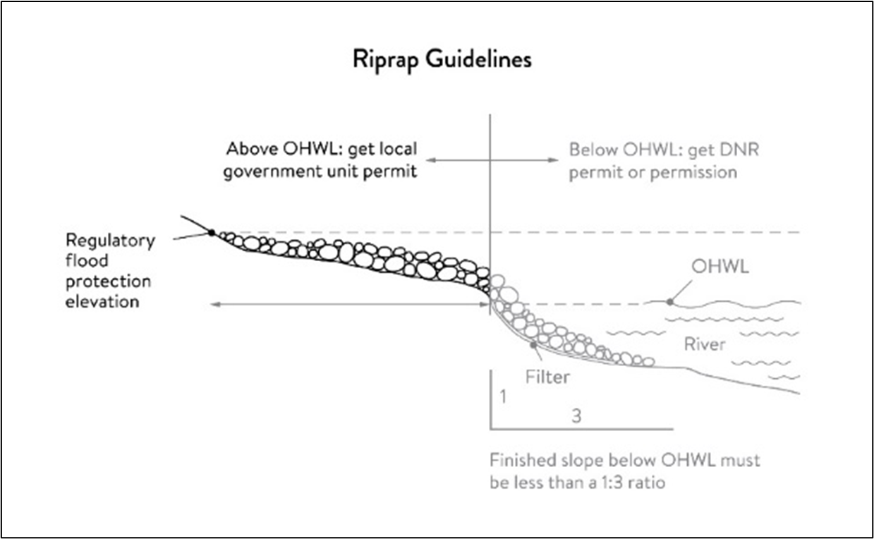
b.
Construction or replacement of rock riprap, retaining walls, and other erosion control structures within the bluff impact zone and the water quality impact zone are allowed with a permit consistent with provisions of section 10.6 provided that:
i.
If the project includes work at or below the OHWL, the commissioner has already approved or permitted the project.
ii.
The structures are used only to correct an established erosion problem as determined by the city.
iii.
The size and extent of the structures are the minimum necessary to correct the erosion problem and are not larger than the following, unless a professional engineer determines that a larger structure is needed to correct the erosion problem:
A.
Retaining walls must not exceed five feet in height and must be placed a minimum horizontal distance of ten feet apart; and
B.
Riprap must not exceed the height of the regulatory flood protection elevation.
c.
Repair of existing rock riprap, retaining walls, and other erosion control structures above the OHWL does not require a permit provided it does not involve any land alteration under section 36-370, item (2).
(4)
Stormwater management.
a.
In the bluff impact zone, stormwater management facilities are prohibited, except by permit if:
i.
There are no alternatives for storm water treatment outside the bluff impact zone on the subject site;
ii.
The site generating runoff is designed so that the amount of runoff reaching the bluff impact zone is reduced to the greatest extent practicable;
iii.
The construction and operation of the facility does not affect slope stability on the subject property or adjacent properties; and
iv.
Mitigation based on the best available engineering and geological practices is required and applied to eliminate or minimize the risk of slope failure.
b.
In the water quality impact zone, development that creates new impervious surface, as allowed by exemption in section 36-372, or fully reconstructs existing impervious surface of more than 10,000 square feet requires a storm water permit. Multipurpose trails and sidewalks are exempt if there is down-gradient vegetation or a filter strip that is at least five feet wide.
c.
In all other areas, storm water runoff must be directed away from the bluff impact zones or unstable areas.
(5)
Development on steep slopes. Construction of structures, impervious surfaces, land alteration, vegetation removal, or other construction activities are allowed on steep slopes if:
a.
The development can be accomplished without increasing erosion or storm water runoff;
b.
The soil types and geology are suitable for the proposed development; and
c.
Vegetation is managed according to the requirements of section 36-369.
(6)
Conditions of land alteration permit approval.
a.
Temporary and permanent erosion and sediment control measures retain sediment onsite consistent with the best management practices in the Minnesota Stormwater Manual;
b.
Natural site topography, soil and vegetation conditions are used to control runoff and reduce erosion and sedimentation;
c.
Construction activity is phased when possible;
d.
All erosion and sediment controls are installed before starting any land disturbance activity;
e.
Erosion and sediment controls are maintained to ensure effective operation;
f.
The proposed work is consistent with the vegetation standards in section 36-369; and
g.
Best management practices are employed for protecting and enhancing ecological and water resources identified in Best Practices for Meeting DNR General Public Waters Permit GP 2004-0001.
(7)
Compliance with other plans and programs. All development must:
a.
Be consistent with M.S.A. ch. 103B and local water management plans completed under Minnesota Rules, chapter 8410;
b.
Meet or exceed the wetland protection standards under Minnesota Rules, chapter 8420; and
c.
Meet or exceed the floodplain management standards under Minnesota Rules, chapter 6120.5000—6120.6200.
(Ord. No. 2021-02, 1-21-2021; Ord. No. 2021-12, 8-19-2021)
Sec. 36-371. - Subdivision and land development standards.
(1)
Purpose:
a.
To protect and enhance the natural and scenic values of the MRCCA during development or redevelopment of the remaining large sites;
b.
To establish standards for protecting and restoring biological and ecological functions of primary conservation areas on large sites; and
c.
To encourage restoration of natural vegetation during development or redevelopment of large sites where restoration opportunities have been identified in MRCCA plans.
(2)
Applicability.
a.
The design standards in this section apply to subdivisions, planned unit developments, and master-planned development and redevelopment of land involving ten or more acres for contiguous parcels that abut the Mississippi River and 20 or more acres for all other parcels, including smaller individual sites within the following developments that are part of a common plan of development that may be constructed at different times:
i.
Subdivisions;
ii.
Planned unit developments; and
iii.
Master-planned development and redevelopment of land.
b.
The following activities are exempt from the requirements of this section.
i.
Minor subdivisions consisting of three or fewer lots;
ii.
Minor boundary line corrections;
iii.
Resolutions of encroachments;
iv.
Additions to existing lots of record;
v.
Placement of essential services; and
vi.
Activities involving river-dependent commercial and industrial uses.
(3)
Application materials. Project information listed in section 36-363, item (6) must be submitted for all proposed developments.
(4)
Design standards.
a.
Primary conservation areas, where they exist, must be set aside and designated as protected open space in quantities meeting the following as a percentage of total parcel area:
i.
CA-RN District: 20 percent;
ii.
CA-UM District: Ten percent; and
iii.
CA-SR District: Ten percent if the parcel includes native plant communities or provides feasible connections to a regional park or trail system, otherwise no requirement.
b.
If the primary conservation areas exceed the amounts specified in subsection 36-371(2)d(i), then protection of native plant communities and natural vegetation in riparian areas shall be prioritized.
c.
If primary conservation areas exist but to not have natural vegetation (identified as restoration priorities in the MRCCA Plan), then a vegetation assessment must be completed to evaluate the unvegetated primary conservation areas and determine whether vegetation restoration is needed. If restoration is needed, vegetation must be restored according to section 36-369, item (6)b.
d.
If primary conservation areas do not exist on the parcel and portions of the parcel have been identified in the MRCCA Plan as a restoration area, vegetation must be restored in the identified areas according to section 36-369, item (6)b and the area must be set aside and designated as protected open space.
e.
Storm water treatment areas or other green infrastructure may be used to meet the protected open space requirements if the vegetation provides biological and ecological functions.
f.
Land dedicated under chapter 28, article IV, section 28-126 of this code for public river access, parks, or other open space or public facilities may be counted toward the protected open space requirement.
g.
Protected open space areas must connect open space, natural areas, and recreational areas, where present on adjacent parcels, as much as possible to form an interconnected network.
(5)
Permanent protection of designated open space.
a.
Designated open space areas must be protected through one or more of the following methods:
i.
Public acquisition by a government entity for conservation purposes;
ii.
A permanent conservation easement, as provided in M.S.A. ch. 84C;
iii.
A deed restriction; or
iv.
Other arrangements that achieve an equivalent degree of protection.
b.
Permanent protection methods must ensure the long-term management of vegetation to meet its biological and ecological functions, prohibit structures, and prohibit land alteration, except as needed to provide public recreational facilities and access to the river.
(6)
Permanent protection of designated open space.
a.
Alternative design standards. The city will consider the following alternative design option to increase the permanent protection of Primary Conservation Areas (PCAs) in subdivisions and other new developments in the MRCCA District and encourage restoration of native vegetation communities. The city may grant density bonuses to increase the permanent protection of PCAs and/or native plant communities up to 30 percent of the parcel area in the CA-RN, CA-UM and CA-SR District. Protection and restoration must be accomplished consistent with the requirements of this section.
The city may award additional development units based on the size of the area protected, as follows:
i.
Density bonuses. The city may approve density bonuses for a major subdivision when the proposed subdivision meets the objectives and requirements of this division and article VI of the city code to protect and preserve bluffs, steep slopes, native vegetation, natural resources, views of the bluffs area, and open space.
ii.
The city shall determine the amount and location of the density bonus permitted for each major subdivision based on site conditions, zoning district regulations, and potential impacts to the site and surrounding areas. The maximum density bonus for a subdivision shall be 20 percent for single-family and duplex housing units and 30 percent for multifamily units.
(Ord. No. 2021-02, 1-21-2021; Ord. No. 2021-12, 8-19-2021)
Sec. 36-372. - Exemptions.
(1)
Purpose. To provide exemptions to structure placement, height, and other standards for specific river or water access-dependent facilities as provided in M.S.A. § 116G.15 subd. 4.
(2)
Applicability.
a.
Uses and activities not specifically exempted must comply with this Division. Uses and activities exempted under shore impact zone and bluff impact zone must comply with the vegetation management and land alteration standards in sections 36-369 and 36-370.
b.
Uses and activities in section 36-372, item 3 are categorized as:
i.
Exempt-E. This means that the use or activity is allowed;
ii.
Exempt if no alternative-(E). This means that the use or activity is allowed only if no alternatives exist; and
iii.
Not exempt-N. This means that a use or activity is not exempt and must meet the standards of this chapter.
(3)
Use and activity exemptions classification.
a.
General uses and activities. On the tables below:
SIZ is the Shore Impact Zone
BIZ is the Bluff Impact Zone
b.
Public utilities.
c.
Public recreational facilities.
d.
River-dependent uses.
e.
Private residential and commercial water access and use facilities.
(Ord. No. 2021-02, 1-21-2021; Ord. No. 2021-12, 8-19-2021)
Sec. 36-395. - Statutory authorization.
(a)
Generally. The state legislature has delegated the responsibility to local government units to adopt regulations designed to minimize flood losses. Therefore, the city does ordain this section.
(b)
Findings of fact. The flood hazard areas of the city, are subject to periodic inundation which results in potential loss of life, loss of property, health and safety hazards, disruption of commerce and governmental services, extraordinary public expenditures or flood protection and relief, and impairment of the tax base, all of which adversely affect the public health, safety, and general welfare.
(1)
Methods used to analyze flood hazards. This chapter is based upon a reasonable method of analyzing flood hazards which is consistent with the standards established by the state department of natural resources.
(2)
National Flood Insurance Program compliance. This division is adopted to comply with the rules and regulations of the National Flood Insurance Program codified as 44 CFR 59—78, as amended, so as to maintain the community's eligibility in the National Flood Insurance Program.
(3)
Statement of purpose. It is the purpose of this division to promote the public health, safety, and general welfare, and to minimize those losses described in section 36-396(a).
(Code 1997, § 1370.05(1))
Sec. 36-396. - General provisions.
(a)
Lands to which division applies. This division shall apply to all lands within the jurisdiction of the city shown on the official zoning map or the attachments thereto as being located within the boundaries of the floodway, flood fringe, or general floodplain districts.
(b)
Establishment of official zoning map. The official zoning map together with all materials attached thereto is adopted by reference and declared to be a part of this division. The attached material shall include the Flood Insurance Study for Washington County, Minnesota and Incorporated Areas and flood insurance rate map panels numbered 27163C0319E, 27163C0340E, 27163C0382E and 27163C0405E, all dated February 3, 2010, and prepared by the Federal Emergency Management Agency. The official zoning map shall be on file in the office of the city clerk-administrator and the zoning administrator.
(c)
Regulatory flood protection elevation. The regulatory flood protection elevation shall be an elevation no lower than one foot above the elevation of the regional flood plus any increases in flood elevation caused by encroachments on the floodplain that result from designation of a floodway.
(d)
Interpretation.
(1)
In their interpretation and application, the provisions of this division shall be held to be minimum requirements, shall be liberally construed in favor of the city council, and shall not be deemed a limitation or repeal of any other powers granted by state statutes.
(2)
The boundaries of the zoning districts shall be determined by scaling distances on the official zoning map. Where interpretation is needed as to the exact location of the boundaries of the district as shown on the official zoning map, as for example where there appears to be a conflict between a mapped boundary and actual field conditions and there is a formal appeal of the decision of the zoning administrator, the board of adjustment shall make the necessary interpretation. All decisions will be based on elevations on the regional (100-year) flood profile, the ground elevations that existed on the site at the time the community adopted its initial floodplain ordinance or on the date of the first National Flood Insurance Program map showing the area within the 100-year floodplain if earlier, and other available technical data. Persons contesting the location of the district boundaries shall be given a reasonable opportunity to present their case to the board of adjustment and to submit technical evidence.
(e)
Abrogation and greater restrictions. It is not intended by this division to repeal, abrogate, or impair any existing easements, covenants, or deed restrictions. However, where this division imposes greater restrictions, the provisions of this division shall prevail. All other ordinances inconsistent with this division are repealed to the extent of the inconsistency only.
(f)
Warning and disclaimer of liability. This division does not imply that areas outside the floodplain districts or land uses permitted within such districts will be free from flooding or flood damages. This division shall not create liability on the part of the city or any officer or employee thereof for any flood damages that result from reliance on this division or any administrative decision lawfully made thereunder.
(g)
Severability. If any section, subdivision, clause, provision, or portion of this division is adjudged unconstitutional or invalid by a court of competent jurisdiction, the remainder of this division shall not be affected.
(h)
Definitions. The following words, terms and phrases, when used in this division, shall have the meanings ascribed to them in this subsection, except where the context clearly indicates a different meaning:
Accessory use or structure means a use or structure on the same lot with, and of a nature customarily incidental and subordinate to, the principal use or structure. In the case of any lot which is both in the floodplain governed by this section, as well as areas not governed by this section, any limitations on accessory uses or structures imposed by this section shall govern the entire contiguous lot.
Annexations means the flood insurance rate map panels adopted by reference into subsection (b) of this section may include floodplain areas that lie outside of the corporate boundaries of the city at the time of adoption of this division. If any of these floodplain land areas are annexed into the city after the date of adoption of this division, the newly annexed floodplain lands shall be subject to the provisions of this division immediately upon the date of annexation into the city.
Basement means any area of a structure, including crawl spaces, having its floor or base subgrade (below ground level) on all four sides, regardless of the depth of excavation below ground level.
Conditional use means a specific type of structure or land use listed in the official control that may be allowed but only after an in-depth review procedure and with appropriate conditions or restrictions as provided in the official zoning controls or building codes and upon a finding that:
(1)
Certain conditions as detailed in this chapter exist.
(2)
The structure or land use conform to the comprehensive land use plan if one exists and are compatible with the existing neighborhood.
Equal degree of encroachment means a method of determining the location of floodway boundaries so that floodplain lands on both sides of a stream are capable of conveying a proportionate share of flood flows.
Flood means a temporary increase in the flow or stage of a stream or in the stage of a wetland or lake that results in the inundation of normally dry areas.
Flood frequency means the frequency for which it is expected that a specific flood stage or discharge may be equaled or exceeded.
Flood fringe means that portion of the floodplain outside of the floodway. The term "flood fringe" is synonymous with the term "floodway fringe" used in the Flood Insurance Study for Washington County, Minnesota and Incorporated Areas.
Floodplain means the beds proper and the areas adjoining a wetland, lake or watercourse which have been or hereafter may be covered by the regional flood.
Floodproofing means a combination of structural provisions, changes, or adjustments to properties and structures subject to flooding, primarily for the reduction or elimination of flood damages.
Floodway means the bed of a wetland or lake and the channel of a watercourse and those portions of the adjoining floodplain which are reasonably required to carry or store the regional flood discharge.
Lowest floor means the lowest floor of the lowest enclosed area (including basement). An unfinished or flood resistant enclosure, used solely for parking of vehicles, building access, or storage in an area other than a basement area, is not considered a building's lowest floor.
Manufactured home means a structure, transportable in one or more subsections. which is built on a permanent chassis and is designed for use with or without a permanent foundation when attached to the required utilities. The term "manufactured home" does not include the term "recreational vehicle."
Obstruction means any dam, wall, wharf, embankment, levee, dike, pile, abutment, projection, excavation, channel modification, culvert, building, wire, fence, stockpile, refuse, fill, structure, or matter in, along, across, or projecting into any channel, watercourse, or regulatory floodplain which may impede, retard, or change the direction of the flow of water, either in itself or by catching or collecting debris carried by such water.
Principal use or structure means all uses or structures that are not accessory uses or structures.
Reach means a hydraulic engineering term to describe a longitudinal segment of a stream or river influenced by a natural or man-made obstruction. In an urban area, the segment of a stream or river between two consecutive bridge crossings would most typically constitute a reach.
Recreational vehicle means a vehicle that is built on a single chassis, is 400 square feet or less when measured at the largest horizontal projection, is designed to be self-propelled or permanently towable by a light duty truck, and is designed primarily not for use as a permanent dwelling but as temporary living quarters for recreational, camping, travel, or seasonal use. For the purposes of this division, the term "recreational vehicle" shall be synonymous with the term "travel trailer/travel vehicle."
Regional flood means a flood which is representative of large floods known to have occurred generally in the state and reasonably characteristic of what can be expected to occur on an average frequency in the magnitude of the 100-year recurrence interval. The term "regional flood" is synonymous with the term "base flood" used in a flood insurance study.
Regulatory flood protection elevation means the regulatory flood protection elevation shall be an elevation no lower than one foot above the elevation of the regional flood plus any increases in flood elevation caused by encroachments on the floodplain that result from designation of a floodway.
Structure means anything constructed or erected on the ground or attached to the ground or on-site utilities, including, but not limited to, buildings, factories, sheds, detached garages, cabins, manufactured homes, recreational vehicles not meeting the exemption criteria specified in section 36-403 and other similar items.
Substantial damage means damage of any origin sustained by a structure where the cost of restoring the structure to its pre-damaged condition would equal or exceed 50 percent of the market value of the structure before the damage occurred.
Substantial improvement means, within any consecutive 365-day period, any reconstruction, rehabilitation (including normal maintenance and repair), repair after damage, addition, or other improvement of a structure, the cost of which equals or exceeds 50 percent of the market value of the structure before the "start of construction" of the improvement. This term "substantial improvement" includes structures that have incurred "substantial damage," regardless of the actual repair work performed. The term does not, however, include either:
(1)
Any project for improvement of a structure to correct existing violations of state or local health, sanitary, or safety code specifications which have been identified by the local code enforcement official and which are the minimum necessary to assure safe living conditions.
(2)
Any alteration of an "historic structure," provided that the alteration will not preclude the structure's continued designation as an "historic structure." For the purpose of this division, the term "historic structure" shall be as defined in 44 CFR 59.1.
Variance means a modification of a specific permitted development standard required in an official control, including this division, to allow an alternative development standard not stated as acceptable in the official control, but only as applied to a particular property for the purpose of alleviating a hardship, practical difficulty or unique circumstance as defined and elaborated upon in a community's respective planning and zoning enabling legislation.
(Code 1997, § 1370.05(2))
Sec. 36-397. - Establishment of zoning districts.
(a)
Districts.
(1)
Floodway district. The floodway district shall include those areas designated as floodway on the flood insurance rate map adopted in section 36-396(b).
(2)
Flood fringe district. The flood fringe district shall include those areas designated as floodway fringe. The flood fringe district shall include those areas shown on the flood insurance rate maps adopted in 36-396(b) as being within zone AE but being located outside of the floodway.
(3)
General floodplain district. The general floodplain district shall include those areas designated as zone A on the flood insurance rate map adopted in section 36-396(b).
(b)
Compliance. No new structure or land shall hereafter be used and no structure shall be constructed, located, extended, converted, or structurally altered without full compliance with the terms of this division and other applicable regulations which apply to uses within the jurisdiction of this division. Within the floodway, flood fringe, and general floodplain districts, all uses not listed as permitted uses or conditional uses in sections 36-398 through 36-400 that follow, respectively, shall be prohibited. In addition, a caution is provided here that:
(1)
New manufactured homes, replacement manufactured homes and certain travel trailers and travel vehicles are subject to the general provisions of this division, and specifically section 36-403.
(2)
Modifications, additions, structural alterations, normal maintenance and repair, or repair after damage to existing nonconforming structures and nonconforming uses of structures or land are regulated by the general provisions of this division, and specifically section 36-405.
(3)
As-built elevations for elevated or floodproofed structures must be certified by ground surveys and floodproofing techniques must be designed and certified by a registered professional engineer or architect as specified in the general provisions of this division, and specifically as stated section 36-404.
(Code 1997, § 1370.05(3))
Sec. 36-398. - Floodway District (FW).
(a)
Permitted uses.
(1)
General farming, pasture, grazing, outdoor plant nurseries, horticulture, truck farming, forestry, sod farming, and wild crop harvesting.
(2)
Industrial/commercial loading areas, parking areas, and airport landing strips.
(3)
Private and public golf courses, tennis courts, driving ranges, archery ranges, picnic grounds, boat launching ramps, swimming areas, parks, wildlife and nature preserves, game farms, fish hatcheries, shooting preserves, target ranges, trap and skeet ranges, hunting and fishing areas, and single or multiple purpose recreational trails.
(4)
Residential lawns, gardens, parking areas, and play areas.
(b)
Standards for floodway permitted uses.
(1)
The use shall have low flood damage potential.
(2)
The use shall be permissible in the underlying zoning district if one exists.
(3)
The use shall not obstruct flood flows or increase flood elevations and shall not involve structures, fill, obstructions, excavations, or storage of materials or equipment.
(c)
Conditional uses.
(1)
Structures accessory to the uses listed in subsection (a) of this section and the uses listed in subsections (c)(2) through (8) of this section.
(2)
Extraction and storage of sand, gravel, and other materials.
(3)
Marinas, boat rentals, docks, piers, wharves, and water control structures.
(4)
Railroads, streets, bridges, utility transmission lines, and pipelines.
(5)
Storage yards for equipment, machinery, or materials.
(6)
Placement of fill or construction of fences.
(7)
Recreational vehicles either on individual lots of record or in existing or new subdivisions or commercial or condominium type campgrounds, subject to the exemptions and provisions of section 36-403.
(8)
Structural works for flood control such as levees, dikes and floodwalls constructed to any height where the intent is to protect individual structures and levees or dikes where the intent is to protect agricultural crops for a frequency flood event equal to or less than the ten-year frequency flood event.
(d)
Standards for floodway conditional uses.
(1)
All uses: No structure (temporary or permanent), fill (including fill for roads and levees), deposit, obstruction, storage of materials or equipment, or other uses may be allowed as a conditional use that will cause any increase in the stage of the 100-year or regional flood or cause an increase in flood damages in the reach or reaches affected. All floodway conditional uses shall be subject to the procedures and standards contained in section 36-404.
(2)
The conditional use shall be permissible in the underlying zoning district if one exists.
(3)
Fill:
a.
Fill, dredge spoil, and all other similar materials deposited or stored in the floodplain shall be protected from erosion by vegetative cover, mulching, riprap or other acceptable method.
b.
Dredge spoil sites and sand and gravel operations shall not be allowed in the floodway unless a long-term site development plan is submitted which includes an erosion/sedimentation prevention element to the plan.
c.
As an alternative, and consistent with subsection (d)(3)b of this section, dredge spoil disposal and sand and gravel operations may allow temporary, on-site storage of fill or other materials which would have caused an increase to the stage of the 100-year or regional flood but only after the governing body has received an appropriate plan which assures the removal of the materials from the floodway based upon the flood warning time available. The conditional use permit must be title registered with the property in the office of the county recorder.
(4)
Accessory structures:
a.
Accessory structures shall not be designed for human habitation.
b.
Accessory structures, if permitted, shall be constructed and placed on the building site so as to offer the minimum obstruction to the flow of floodwaters.
c.
Whenever possible, structures shall be constructed with the longitudinal axis parallel to the direction of flood flow.
d.
So far as practicable, structures shall be placed approximately on the same flood flow lines as those of adjoining structures.
e.
Accessory structures shall be elevated on fill or structurally dry classifications in the state building code. As an alternative, an accessory structure may be floodproofed to the FP-3 or FP-4 floodproofing classification in the state building code provided the accessory structure constitutes a minimal investment, does not exceed 500 square feet in size at its largest projection, and for a detached garage, the detached garage must be used solely for parking of vehicles and limited storage. All floodproofed accessory structures must meet the following additional standards.
(5)
The structure must be adequately anchored to prevent flotation, collapse or lateral movement of the structure and shall be designed to equalize hydrostatic flood forces on exterior walls.
(6)
Any mechanical and utility equipment in a structure must be elevated to or above the regulatory flood protection elevation or properly floodproofed.
(7)
To allow for the equalization of hydrostatic pressure, there must be a minimum of two "automatic" openings in the outside walls of the structure having a total net area of not less than one square inch for every square foot of enclosed area subject to flooding. There must be openings on at least two sides of the structure and the bottom of all openings must be no higher than one foot above the lowest adjacent grade to the structure. Using human intervention to open a garage door prior to flooding will not satisfy this requirement for automatic openings.
(8)
Storage of materials and equipment.
a.
The storage or processing of materials that are, in time of flooding, flammable, explosive, or potentially injurious to human, animal, or plant life is prohibited.
b.
Storage of other materials or equipment may be allowed if readily removable from the area within the time available after a flood warning and in accordance with a plan approved by the city council.
(9)
Structural works for flood control that will change the course, current or cross subsection of protected wetlands or public waters shall be subject to the provisions of M.S.A. ch. 103G. Communitywide structural works for flood control intended to remove areas from the regulatory floodplain shall not be allowed in the floodway.
(10)
A levee, dike or floodwall constructed in the floodway shall not cause an increase to the 100-year or regional flood and the technical analysis must assume equal conveyance or storage loss on both sides of a stream.
(Code 1997, § 1370.05(4))
Sec. 36-399. - Flood Fringe District (FF).
(a)
Permitted uses. Permitted uses shall be those uses of land or structures listed as permitted uses in the underlying zoning use district. If no pre-existing, underlying zoning use districts exist, then any residential or non-residential structure or use of a structure or land shall be a permitted use in the flood fringe district, provided such use does not constitute a public nuisance. All permitted uses shall comply with the standards for flood fringe district permitted uses listed in subsection (b) of this section and the standards for all flood fringe uses listed in subsection (e) of this section.
(b)
Standards for flood fringe permitted uses.
(1)
All structures, including accessory structures, must be elevated on fill so that the lowest floor including basement floor is at or above the regulatory flood protection elevation. The finished fill elevation for structures shall be no lower than one foot below the regulatory flood protection elevation and the fill shall extend at such elevation at least 15 feet beyond the outside limits of the structure erected thereon.
(2)
As an alternative to elevation on fill, accessory structures that constitute a minimal investment and that do not exceed 500 square feet at its largest projection may be internally floodproofed in accordance with section 36-398(d)(4)e.
(3)
The cumulative placement of fill where at any one time in excess of 1,000 cubic yards of fill is located on the parcel shall be allowable only as a conditional use, unless the fill is specifically intended to elevate a structure in accordance with subsection (b)(1) of this section.
(4)
The storage of any materials or equipment shall be elevated on fill to the regulatory flood protection elevation.
(5)
The provisions of subsection (e) of this section shall apply.
(c)
Conditional uses. Any structure that is not elevated on fill or floodproofed in accordance with subsection (b)(1) and (2) of this section and/or any use of land that does not comply with the standards in subsection (b)(3) and (4) of this section shall only be allowable as a conditional use. An application for a conditional use shall be subject to the standards and criteria and evaluation procedures specified in subsections (d) and (e) of this section and section 36-404(d).
(d)
Standards for flood fringe conditional uses.
(1)
Alternative elevation methods other than the use of fill may be utilized to elevate a structure's lowest floor above the regulatory flood protection elevation. These alternative methods may include the use of stilts, pilings, parallel walls, etc., or above-grade, enclosed areas such as crawl spaces or tuck under garages. The base or floor of an enclosed area shall be considered above-grade and not a structure's basement or lowest floor if:
a.
The enclosed area is above-grade on at least one side of the structure;
b.
It is designed to internally flood and is constructed with flood resistant materials; and
c.
It is used solely for parking of vehicles, building access or storage.
(2)
The above-noted alternative elevation methods are subject to the following additional standards:
a.
Design and certification. The structure's design and as-built condition must be certified by a registered professional engineer or architect as being in compliance with the general design standards of the state building code and, specifically, that all electrical, heating, ventilation, plumbing and air conditioning equipment and other service facilities must be at or above the regulatory flood protection elevation or be designed to prevent flood water from entering or accumulating within these components during times of flooding.
b.
Specific standards for above-grade, enclosed areas. Above-grade, fully enclosed areas such as crawl spaces or tuck under garages must be designed to internally flood and the design plans must stipulate:
1.
A minimum area of openings in the walls where internal flooding is to be used as a floodproofing technique. There shall be a minimum of two openings on at least two sides of the structure and the bottom of all openings shall be no higher than one-foot above grade. The automatic openings shall have a minimum net area of not less than one square inch for every square foot of enclosed area subject to flooding unless a registered professional engineer or architect certifies that a smaller net area would suffice. The automatic openings may be equipped with screens, louvers, valves, or other coverings or devices provided that they permit the automatic entry and exit of flood waters without any form of human intervention; and
2.
That the enclosed area will be designed of flood resistant materials in accordance with the FP-3 or FP-4 classifications in the state building code and shall be used solely for building access, parking of vehicles or storage.
(3)
Basements, as defined by section 36-396(h) shall be subject to the following:
a.
Residential basement construction shall not be allowed below the regulatory flood protection elevation.
b.
Nonresidential basements may be allowed below the regulatory flood protection elevation provided the basement is structurally dry floodproofed in accordance with subsection (d)(3) of this section.
(4)
All areas of nonresidential structures including basements to be placed below the regulatory flood protection elevation shall be floodproofed in accordance with the structurally dry floodproofing classifications in the state building code. Structurally dry floodproofing must meet the FP-1 or FP-2 floodproofing classification in the state building code and this shall require making the structure watertight with the walls substantially impermeable to the passage of water and with structural components having the capability of resisting hydrostatic and hydrodynamic loads and the effects of buoyancy. Structures floodproofed to the FP-3 or FP-4 classification shall not be permitted.
(5)
When at any one time within five years more than 200 cubic yards of fill or other similar material is located on a parcel for such activities as on-site storage, landscaping, sand and gravel operations, landfills, roads, dredge spoil disposal or construction of flood control works, an erosion/sedimentation control plan must be submitted unless the community is enforcing a state approved shoreland management ordinance. In the absence of a state-approved shoreland ordinance, the plan must clearly specify methods to be used to stabilize the fill on site for a flood event at a minimum of the 100-year or regional flood event. The plan must be prepared and certified by a registered professional engineer or other qualified individual acceptable to the city council. The plan may incorporate alternative procedures for removal of the material from the floodplain if adequate flood warning time exists.
(6)
Storage of materials and equipment.
a.
The storage or processing of materials that are, in time of flooding, flammable, explosive, or potentially injurious to human, animal, or plant life is prohibited.
b.
Storage of other materials or equipment may be allowed if readily removable from the area within the time available after a flood warning and in accordance with a plan approved by the city council.
(7)
The provisions of subsection (e) of this section shall also apply.
(e)
Standards for all flood fringe uses. All new principal structures must have vehicular access at or above an elevation not more than two feet below the regulatory flood protection elevation. If a variance to this requirement is granted, the board of adjustment must specify limitations on the period of use or occupancy of the structure for times of flooding and only after determining that adequate flood warning time and local flood emergency response procedures exist.
(1)
Commercial uses. Accessory land uses, such as yards, railroad tracks, and parking lots may be at elevations lower than the regulatory flood protection elevation. However, a permit for such facilities to be used by the employees or the general public shall not be granted in the absence of a flood warning system that provides adequate time for evacuation if the area would be inundated to a depth and velocity such that when multiplying the depth (in feet) times velocity (in feet per second) the product number exceeds four upon occurrence of the regional flood.
(2)
Manufacturing and industrial uses. Measures shall be taken to minimize interference with normal plant operations especially along streams having protracted flood durations. Certain accessory land uses such as yards and parking lots may be at lower elevations subject to requirements set out in subsection (e)(2) of this section. In considering permit applications, due consideration shall be given to needs of an industry whose business requires that it be located in floodplain areas.
(3)
Fill shall be properly compacted and the slopes shall be properly protected by the use of riprap, vegetative cover or other acceptable method. The Federal Emergency Management Agency (FEMA) has established criteria for removing the special flood hazard area designation for certain structures properly elevated on fill above the 100-year flood elevation. FEMA's requirements incorporate specific fill compaction and side slope protection standards for multi-structure or multi-lot developments. These standards should be investigated prior to the initiation of site preparation if a change of special flood hazard area designation will be requested.
(4)
Floodplain developments shall not adversely affect the hydraulic capacity of the channel and adjoining floodplain of any tributary watercourse or drainage system where a floodway or other encroachment limit has not been specified on the official zoning map.
(5)
Standards for recreational vehicles are contained in section 36-403.
(6)
All manufactured homes must be securely anchored to an adequately anchored foundation system that resists flotation, collapse and lateral movement. Methods of anchoring may include, but are not to be limited to, use of over-the-top or frame ties to ground anchors. This requirement is in addition to applicable state or local anchoring requirements for resisting wind forces.
(Code 1997, § 1370.05(5))
Sec. 36-400. - General floodplain district.
(a)
Permitted uses.
(1)
The uses listed in section 36-398(a) shall be permitted uses.
(2)
All other uses shall be subject to the floodway/flood fringe evaluation criteria, pursuant to subsection (b) of this section. Section 36-398 shall apply if the proposed use is in the floodway district and section 36-399 shall apply if the proposed use is in the flood fringe district.
(b)
Procedures for floodway and flood fringe determinations within the general floodplain district.
(1)
Upon receipt of an application for a permit or other approval within the general floodplain district, the applicant shall be required to furnish such of the following information as is deemed necessary by the zoning administrator for the determination of the regulatory flood protection elevation and whether the proposed use is within the floodway or flood fringe district.
a.
A typical valley cross-subdivisions showing the channel of the stream, elevation of land areas adjoining each side of the channel, cross-section, areas to be occupied by the proposed development, and high water information.
b.
Plan (surface view) showing elevations or contours of the ground, pertinent structure, fill, or storage elevations, the size, location, and spatial arrangement of all proposed and existing structures on the site, and the location and elevations of streets.
c.
Photographs showing existing land uses, vegetation upstream and downstream, and soil types.
d.
Profile showing the slope of the bottom of the channel or flow line of the stream for at least 500 feet in either direction from the proposed development.
(2)
The applicant shall be responsible to submit one copy of the above information to a designated engineer or other expert person or agency for technical assistance in determining whether the proposed use is in the floodway or flood fringe district and to determine the regulatory flood protection elevation. Procedures consistent with Minn. R. 6120.5000—6120.6200 and 44 CFR 65 shall be followed in this expert evaluation. The designated engineer or expert is strongly encouraged to discuss the proposed technical evaluation methodology with the respective department of natural resources' area hydrologist prior to commencing the analysis. The designated engineer or expert shall:
a.
Estimate the peak discharge of the regional flood.
b.
Calculate the water surface profile of the regional flood based upon a hydraulic analysis of the stream channel and overbank areas.
c.
Compute the floodway necessary to convey or store the regional flood without increasing flood stages more than 0.5 foot. A lesser stage increase than 0.5 foot shall be required if, as a result of the additional stage increase, increased flood damages would result. An equal degree of encroachment on both sides of the stream within the reach shall be assumed in computing floodway boundaries.
(3)
The zoning administrator shall present the technical evaluation and findings of the designated engineer or expert to the city council. The city council must formally accept the technical evaluation and the recommended floodway or flood fringe district boundary or deny the permit application. The city council, prior to official action, may submit the application and all supporting data and analyses to the Federal Emergency Management Agency, the department of natural resources or the planning commission for review and comment. Once the floodway and flood fringe district boundaries have been determined, the city council shall refer the matter back to the zoning administrator who shall process the permit application consistent with the applicable provisions of sections 36-398 and 36-399.
(Code 1997, § 1370.05(6))
Sec. 36-401. - Subdivisions.
Review criteria. No land shall be subdivided which is unsuitable for the reason of flooding, inadequate drainage, water supply or sewage treatment facilities. All lots within the floodplain districts shall be able to contain a building site outside of the floodway district at or above the regulatory flood protection elevation. All subdivisions shall have water and sewage treatment facilities that comply with the provisions of this article and have road access both to the subdivision and to the individual building sites no lower than two feet below the regulatory flood protection elevation. For all subdivisions in the floodplain, the floodway and flood fringe district boundaries, the regulatory flood protection elevation and the required elevation of all access roads shall be clearly labeled on all required subdivision drawings and platting documents.
(1)
Floodway/flood fringe determinations in the general floodplain district. In the general floodplain district, applicants shall provide the information required in section 36-336 to determine the 100-year flood elevation, the floodway and flood fringe district boundaries and the regulatory flood protection elevation for the subdivision site.
(2)
Removal of special flood hazard area designation. The Federal Emergency Management Agency (FEMA) has established criteria for removing the special flood hazard area designation for certain structures properly elevated on fill above the 100-year flood elevation. FEMA's requirements incorporate specific fill compaction and side slope protection standards for multi-structure or multi-lot developments. These standards should be investigated prior to the initiation of site preparation if a change of special flood hazard area designation will be requested.
(Code 1997, § 1370.05(7))
Sec. 36-402. - Public utilities, railroads, roads, and bridges.
(a)
Public utilities. All public utilities and facilities such as gas, electrical, sewer, and water supply systems to be located in the floodplain shall be floodproofed in accordance with the state building code or elevated to above the regulatory flood protection elevation.
(b)
Public transportation. Railroad tracks, roads, and bridges to be located within the floodplain shall comply with sections 36-398 and 36-399. Elevation to the regulatory flood protection elevation shall be provided where failure or interruption of these transportation facilities would result in danger to the public health or safety or where such facilities are essential to the orderly functioning of the area. Minor or auxiliary roads or railroads may be constructed at a lower elevation where failure or interruption of transportation services would not endanger the public health or safety.
(c)
On-site sewage treatment and water supply systems; where public utilities are not provided:
(1)
On-site water supply systems must be designed to minimize or eliminate infiltration of floodwaters into the systems; and
(2)
New or replacement on-site sewage treatment systems must be designed to minimize or eliminate infiltration of flood waters into the systems and discharges from the systems into floodwaters and they shall not be subject to impairment or contamination during times of flooding. Any sewage treatment system designed in accordance with the state's current statewide standards for on-site sewage treatment systems shall be determined to be in compliance with this section.
(Code 1997, § 1370.05(8))
Sec. 36-403. - Manufactured homes and manufactured home parks and placement of recreational vehicles.
(a)
New manufactured home parks and expansions to existing manufactured home parks shall be subject to the provisions placed on subdivisions by section 36-401.
(b)
The placement of new or replacement manufactured homes in existing manufactured home parks or on individual lots of record that are located in floodplain districts will be treated as a new structure and may be placed only if elevated in compliance with section 36-399. If vehicular road access for pre-existing manufactured home parks is not provided in accordance with section 36-399(e)(1), then replacement manufactured homes will not be allowed until the property owner develops a flood warning emergency plan acceptable to the city council.
(c)
All manufactured homes must be securely anchored to an adequately anchored foundation system that resists flotation, collapse and lateral movement. Methods of anchoring may include, but are not to be limited to, use of over-the-top or frame ties to ground anchors. This requirement is in addition to applicable state or local anchoring requirements for resisting wind forces.
(d)
Recreational vehicles that do not meet the exemption criteria specified in subsection (d)(1) of this section shall be subject to the provisions of this article and as specifically spelled out in subsections (d)(3) and (4) of this section.
(1)
Exemption. Recreational vehicles are exempt from the provisions of this article if they are placed in any of the areas listed in subsection (d)(2) of this section and further they meet the following criteria:
a.
Have current licenses required for highway use.
b.
Are highway ready meaning on wheels or the internal jacking system, are attached to the site only by quick disconnect type utilities commonly used in campgrounds and recreational vehicle parks and the recreational vehicle has no permanent structural type additions attached to it.
c.
The recreational vehicle and associated use must be permissible in any pre-existing, underlying zoning use district.
(2)
Areas exempted for placement of recreational vehicles.
a.
Individual lots or parcels of record.
b.
Existing commercial recreational vehicle parks or campgrounds.
c.
Existing condominium type associations.
d.
Recreational vehicles exempted in subsection (d)(1) of this section lose this exemption when development occurs on the parcel exceeding $500.00 for a structural addition to the recreational vehicle or exceeding $500.00 for an accessory structure such as a garage or storage building. The recreational vehicle and all additions and accessory structures will then be treated as a new structure and shall be subject to the elevation/floodproofing requirements and the use of land restrictions specified in sections 36-398 and 36-399. There shall be no development or improvement on the parcel or attachment to the recreational vehicle that hinders the removal of the recreational vehicle to a flood-free location should flooding occur.
(3)
Standards for new commercial recreational vehicle parks. New commercial recreational vehicle parks or campgrounds and new residential type subdivisions and condominium associations and the expansion of any existing similar use exceeding five units or dwelling sites shall be subject to the following:
a.
Any new or replacement recreational vehicle will be allowed in the floodway or flood fringe districts provided the recreational vehicle and its contents are placed on fill above the regulatory flood protection elevation and proper elevated road access to the site exists in accordance with section 36-399(e)(1). No fill placed in the floodway to meet the requirements of this subsection shall increase flood stages of the 100-year or regional flood.
b.
All new or replacement recreational vehicles not meeting the criteria of subsection (3)(a) of this section may, as an alternative, be allowed as a conditional use if in accordance with the following provisions and the provisions of section 36-404(c)(3)c. The applicant must submit an emergency plan for the safe evacuation of all vehicles and people during the 100-year flood. The plan shall be prepared by a registered engineer or other qualified individual, shall demonstrate that adequate time and personnel exist to carry out the evacuation, and shall demonstrate the provisions of subsection (d)(1) and (2) of this section will be met. All attendant sewage and water facilities for new or replacement recreational vehicles must be protected or constructed so as to not be impaired or contaminated during times of flooding in accordance with section 36-402(c).
(Code 1997, § 1370.05(9))
Sec. 36-404. - Administration.
(a)
Zoning administrator. A zoning administrator or other official designated by the city council shall administer and enforce this article. If the zoning administrator finds a violation of the provisions of this article the zoning administrator shall notify the person responsible for such violation in accordance with the procedures stated in section 36-406.
(b)
Permit requirements.
(1)
Permit required. A permit issued by the zoning administrator in conformity with the provisions of this article shall be secured prior to the erection, addition, modification, rehabilitation (including normal maintenance and repair), or alteration of any building, structure, or portion thereof; prior to the use or change of use of a building, structure, or land; prior to the construction of a dam, fence, or on-site septic system; prior to the change or extension of a nonconforming use; prior to the repair of a structure that has been damaged by flood, fire, tornado, or any other source; and prior to the placement of fill, excavation of materials, or the storage of materials or equipment within the floodplain.
(2)
Application for permit. Application for a permit shall be made in duplicate to the zoning administrator on forms furnished by the zoning administrator and shall include the following where applicable: plans in duplicate drawn to scale, showing the nature, location, dimensions, and elevations of the lot; existing or proposed structures, fill, or storage of materials; and the location of the foregoing in relation to the stream channel.
(3)
State and federal permits. Prior to granting a permit or processing an application for a conditional use permit or variance, the zoning administrator shall determine that the applicant has obtained all necessary state and federal permits.
(4)
Certificate of zoning compliance for a new, altered, or nonconforming use. It is unlawful to use, occupy, or permit the use or occupancy of any building or premises or part thereof hereafter created, erected, changed, converted, altered, or enlarged in its use or structure until a certificate of zoning compliance shall have been issued by the zoning administrator stating that the use of the building or land conforms to the requirements of this article.
(5)
Construction and use to be as provided on applications, plans, permits, variances, and certificates of zoning compliance. Permits, conditional use permits, or certificates of zoning compliance issued on the basis of approved plans and applications authorize only the use, arrangement, and construction set forth in such approved plans and applications, and no other use, arrangement, or construction. Any use, arrangement, or construction at variance with that authorized shall be deemed a violation of this article, and punishable as provided by section 36-406.
(6)
Certification. The applicant shall be required to submit certification by a registered professional engineer, registered architect, or registered land surveyor that the finished fill and building elevations were accomplished in compliance with the provisions of this article. Floodproofing measures shall be certified by a registered professional engineer or registered architect.
(7)
Record of first floor elevation. The zoning administrator shall maintain a record of the elevation of the lowest floor (including basement) of all new structures and alterations or additions to existing structures in the floodplain. The zoning administrator shall also maintain a record of the elevation to which structures or alterations and additions to structures are floodproofed.
(8)
Notifications for watercourse alterations. The zoning administrator shall notify, in riverine situations, adjacent communities and the commissioner of the department of natural resources prior to the community authorizing any alteration or relocation of a watercourse. If the applicant has applied for a permit to work in the beds of public waters pursuant to M.S.A. ch. 103G, this shall suffice as adequate notice to the commissioner of Natural Resources. A copy of the notification shall also be submitted to the Chicago Regional Office of the Federal Emergency Management Agency (FEMA).
(9)
Notification to FEMA when physical changes increase or decrease the 100-year flood elevation. As soon as is practicable, but not later than six months after the date such supporting information becomes available, the zoning administrator shall notify the Chicago Regional Office of FEMA of the changes by submitting a copy of the technical or scientific data.
(c)
City council.
(1)
Variances. In addition to any and all other valid considerations and restrictions to the granting of variances under this Code and state law, the following additional restrictions shall apply to areas governed by this section. No variance shall have the effect of allowing in any district uses prohibited in that district; permit a lower degree of flood protection than the regulatory flood protection elevation for the particular area, or permit standards lower than those required by state law. The following additional variance criteria of the Federal Emergency Management Agency must be satisfied:
a.
Variances shall not be issued by a community within any designated regulatory floodway if any increase in flood levels during the base flood discharge would result.
b.
Variances shall only be issued by a community upon:
1.
A showing of good and sufficient cause;
2.
A determination that failure to grant the variance would result in exceptional hardship to the applicant; and
3.
A determination that the granting of a variance will not result in increased flood heights, additional threats to public safety, extraordinary public expense, create nuisances, cause fraud on or victimization of the public, or conflict with existing local laws or ordinances.
c.
Variances shall only be issued upon a determination that the variance is the minimum necessary, considering the flood hazard, to afford relief.
(2)
Decision to be mailed. A copy of all decisions granting variances shall be forwarded by mail to the commissioner of natural resources within ten days of such action.
(3)
Flood insurance notice and recordkeeping. The zoning administrator shall notify the applicant for a variance that:
a.
The issuance of a variance to construct a structure below the base flood level will result in increased premium rates for flood insurance up to amounts as high as $25.00 for $100.00 of insurance coverage.
b.
Such construction below the 100-year or regional flood level increases risks to life and property. Such notification shall be maintained with a record of all variance actions. A community shall maintain a record of all variance actions, including justification for their issuance, and report such variances issued in its annual or biennial report submitted to the administrator of the National Flood Insurance Program.
c.
Conditional uses. The city council shall hear and decide applications for conditional uses permissible under this article in the same manner and procedure as is otherwise provided. Except as otherwise provided, any conditional use permit granted by the city shall be in accordance with its standard procedures for the consideration, granting or denial of any such request.
1.
Hearings. Upon filing with the city council an application for a conditional use permit for a use or location within those areas governed by this section, the city council shall submit by mail to the commissioner of natural resources a copy of the application for proposed conditional use sufficiently in advance so that the commissioner will receive at least ten days notice of the hearing.
2.
Decisions. In granting a conditional use permit for a use or location within the floodplain, the city council shall prescribe appropriate conditions and safeguards, in addition to those specified in subsection (c)(3)c of this section which are in conformity with the purposes of this article. Violations of such conditions and safeguards, when made a part of the terms under which the conditional use permit is granted, shall be deemed a violation of this article punishable under section 36-406. A copy of all decisions granting conditional use permits shall be forwarded by mail to the commissioner of natural resources within ten days of such action.
3.
Procedures to be followed by the city council in passing on conditional use permit applications within all floodplain districts.
(i)
Require the applicant to furnish such of the following information and additional information as deemed necessary by the city council for determining the suitability of the particular site for the proposed use:
A.
Plans in triplicate drawn to scale showing the nature, location, dimensions, and elevation of the lot, existing or proposed structures, fill, storage of materials, floodproofing measures, and the relationship of the above to the location of the stream channel; and
B.
Specifications for building construction and materials, floodproofing, filling, dredging, grading, channel improvement, storage of materials, water supply, and sanitary facilities.
(ii)
Transmit one copy of the information described in subsection (c)(3)c.3(i) of this section to a designated engineer or other expert person or agency for technical assistance, where necessary, in evaluating the proposed project in relation to flood heights and velocities, the seriousness of flood damage to the use, the adequacy of the plans for protection, and other technical matters.
(iii)
Based upon the technical evaluation of the designated engineer or expert, the city council shall determine the specific flood hazard at the site and evaluate the suitability of the proposed use in relation to the flood hazard.
4.
Factors upon which the decision of the city council shall be based. In passing upon conditional use applications, the city council shall consider all relevant factors specified in other subsections of this article, and:
(i)
The danger to life and property due to increased flood heights or velocities caused by encroachments.
(ii)
The danger that materials may be swept onto other lands or downstream to the injury of others or they may block bridges, culverts, or other hydraulic structures.
(iii)
The proposed water supply and sanitation systems and the ability of these systems to prevent disease, contamination, and unsanitary conditions.
(iv)
The susceptibility of the proposed facility and its contents to flood damage and the effect of such damage on the individual owner.
(v)
The importance of the services provided by the proposed facility to the community.
(vi)
The requirements of the facility for a waterfront location.
(vii)
The availability of alternative locations not subject to flooding for the proposed use.
(viii)
The compatibility of the proposed use with existing development and development anticipated in the foreseeable future.
(ix)
The relationship of the proposed use to the comprehensive plan and floodplain management program for the area.
(x)
The safety of access to the property in times of flood for ordinary and emergency vehicles.
(xi)
The expected heights, velocity, duration, rate of rise, and sediment transport of the floodwaters expected at the site.
(xii)
Such other factors which are relevant to the purposes of this article.
5.
Time for acting on application. The city council shall act on an application in the manner described above within 60 days from receiving a completed application, except for such additional time as it may be allowed, with notice, by law. Any application where additional information is required pursuant to subsection (c)(3)c of this section will be deemed incomplete on its face until such information is received by the city.
6.
Conditions attached to conditional use permits. Upon consideration of the factors listed above and the purpose of this article, the city council shall attach such conditions to the granting of conditional use permits as it deems necessary to fulfill the purposes of this article. Such conditions may include, but are not limited to, the following:
(i)
Modification of waste treatment and water supply facilities.
(ii)
Period of use, occupancy, and operation.
(iii)
Imposition of operational controls, sureties, and deed restrictions.
(iv)
Requirements for construction of channel modifications, compensatory storage, dikes, levees, and other protective measures.
(v)
Floodproofing measures, in accordance with the state building code and this article. The applicant shall submit a plan or document certified by a registered professional engineer or architect that the floodproofing measures are consistent with the regulatory flood protection elevation and associated flood factors for the particular area.
(Code 1997, § 1370.05(10))
Sec. 36-405. - Nonconforming uses.
A structure or the use of a structure or premises which was lawful before the passage or amendment of this article but which is not in conformity with the provisions of this article may be continued subject to the following additional conditions. Historic structures, as defined in section 36-396(h) shall be subject to the following provisions:
(1)
No such use shall be expanded, changed, enlarged, or altered in a way that increases its nonconformity, except as otherwise permitted or required by law.
(2)
Any structural alteration or addition to a nonconforming structure or nonconforming use which would result in increasing the flood damage potential of that structure or use shall be protected to the Regulatory Flood Protection Elevation in accordance with any of the elevation on fill or floodproofing techniques (i.e., FP-1 thru FP-4 floodproofing classifications) allowable in the state building code, except as further restricted in subsections (3) and (5) of this section.
(3)
The cost of all structural alterations or additions to any nonconforming structure over the life of the structure shall not exceed 50 percent (of the market value of the structure unless the conditions of this subsection are satisfied. The cost of all structural alterations and additions must include all costs such as construction materials and a reasonable cost placed on all manpower or labor. If the cost of all previous and proposed alterations and additions exceeds 50 percent of the market value of the structure, then the structure must meet the standards of subsection (4) or (5) of this section for new structures depending upon whether the structure is in the floodway or flood fringe district, respectively.
(4)
If any nonconforming use is discontinued for 12 consecutive months, any future use of the building premises shall conform to this article. The assessor shall notify the zoning administrator in writing of instances of nonconforming uses that have been discontinued for a period of 12 months.
(5)
If any nonconforming use or structure is substantially damaged, as defined in section 36-396(h), it shall not be reconstructed except in conformity with the provisions of this article. The applicable provisions for establishing new uses or new structures in subsection (4), (5) or (6) of this section will apply depending upon whether the use or structure is in the floodway, flood fringe, or general floodplain district, respectively.
(6)
If a substantial improvement occurs, as defined in section 36-396(h), from any combination of a building addition to the outside dimensions of the existing building or a rehabilitation, reconstruction, alteration, or other improvement to the inside dimensions of an existing nonconforming building, then the building addition and the existing nonconforming building must meet the requirements of subsection (4) or (5) of this section for new structures, depending upon whether the structure is in the floodway or flood fringe district, respectively.
(Code 1997, § 1370.05(11))
Sec. 36-406. - Penalties for violation.
(a)
Violation of the provisions of this article or failure to comply with any of its requirements (including violations of conditions and safeguards established in connection with grants of variances or conditional uses) shall constitute a misdemeanor and shall be punishable as defined by law.
(b)
Nothing contained shall prevent the city from taking such other lawful action as is necessary to prevent or remedy any violation. Such actions may include, but are not limited to:
(1)
In responding to a suspected ordinance violation, the zoning administrator and local government may utilize the full array of enforcement actions available to it, including, but not limited to, prosecution and fines, injunctions, after-the-fact permits, orders for corrective measures, or a request to the National Flood Insurance Program for denial of flood insurance availability to the guilty party. The community must act in good faith to enforce these official controls and to correct ordinance violations to the extent possible so as not to jeopardize its eligibility in the National Flood Insurance Program.
(2)
When an ordinance violation is either discovered by or brought to the attention of the zoning administrator, the zoning administrator shall immediately investigate the situation and document the nature and extent of the violation of the official control. As soon as is reasonably possible, this information will be submitted to the appropriate department of natural resources' and Federal Emergency Management Agency regional office along with the community's plan of action to correct the violation to the degree possible.
(3)
The zoning administrator shall notify the suspected party of the requirements of this article and all other official controls and the nature and extent of the suspected violation of these controls. If the structure or use is under construction or development, the zoning administrator may order the construction or development immediately halted until a proper permit or approval is granted by the community. If the construction or development is already completed, then the zoning administrator may either:
a.
Issue an order identifying the corrective actions that must be made within a specified time period to bring the use or structure into compliance with the official controls; or
b.
Notify the responsible party to apply for an after-the-fact permit/development approval within a specified period of time not to exceed 30 days.
(4)
If the responsible party does not appropriately respond to the zoning administrator within the specified period of time, each additional day that lapses shall constitute an additional violation of this article and shall be prosecuted accordingly. The zoning administrator shall also upon the lapse of the specified response period notify the landowner to restore the land to the condition which existed prior to the violation of this article.
(Code 1997, § 1370.05(12))
Sec. 36-407. - Amendments.
(a)
The floodplain designation on the official zoning map shall not be removed from floodplain areas unless it can be shown that the designation is in error or that the area has been filled to or above the elevation of the regulatory flood protection elevation and is contiguous to lands outside the floodplain. Special exceptions to this rule may be permitted by the commissioner of natural resources if he determines that, through other measures, lands are adequately protected for the intended use.
(b)
All amendments to this article, including amendments to the official zoning map, must be submitted to and approved by the commissioner of natural resources prior to adoption. Changes in the official zoning map must meet the Federal Emergency Management Agency's (FEMA) technical conditions and criteria and must receive prior FEMA approval before adoption. The commissioner of natural resources must be given ten days written notice of all hearings to consider an amendment to this article and the notice shall include a draft of the ordinance amendment or technical study under consideration.
(Code 1997, § 1370.05(13))
Sec. 36-428. - Purpose and intent.
The purpose of this division shall be to preserve the natural resources within the city including bluffs, steep slopes and associated natural vegetation and protect them from adverse effects by regulating developments that may have potential adverse and irreversible impacts on such resources.
(Ord. of 08-20-2020)
Sec. 36-429. - District boundaries and scope.
This overlay district shall apply to those areas that are located west of State Highway 61 which lie above the indicated sea level elevations identified below, based on USGS datum. The areas are identified on the city's zoning map. The requirements of this division shall be in addition to all requirements in the underlying zoning district.
(1)
Elevation 750 from the northerly municipal boundary to Ford Avenue and
(2)
Elevation 800 south of Ford Avenue to the southerly municipal boundary.
The areas of bluffs, steep slopes and natural vegetation in the city that are located east of State Highway 61 shall be governed by the Shoreland Management District and the Critical Area (MRCCA) Overlay District Ordinance, Divisions II and III of this Code.
(Ord. of 08-20-2020)
Sec. 36-430. - Definitions.
The following words, terms and phrases when used in this division, shall have the meanings ascribed to them in this section, except where the context clearly indicates a different meaning:
Bluff means a natural topographic feature having a slope that rises at least 25 feet and the grade of the slope averages 18 percent or greater, measured over a horizontal distance of 25 feet.
Bluff impact zone means a bluff and land located within 20 feet of the top of the bluff.
Bluff, toe of means a line along the bottom of a bluff, requiring field verification, such that the slope above the line exceeds 18 percent and the slope below the line is 18 percent or less, measured over a horizontal distance of 25 feet.
Bluff, top of means a line along the top of a bluff, requiring field verification, such that the slope below the line exceeds 18 percent and the slope above the line is 18 percent or less, measured over a horizontal distance of 25 feet.
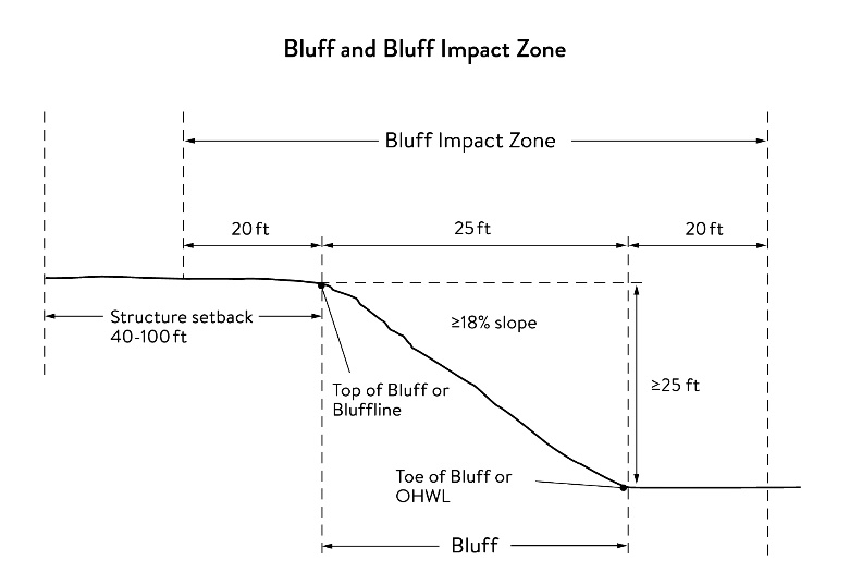
Crown cover means the ratio between the amount of land shaded by the vertical protection of the branches and foliage area of standing trees to the total area of land, usually expressed as a percentage.
Density bonus means an increase in the density of housing units over the otherwise maximum allowable residential density in a zoning district that is specified in the zoning ordinance.
Dimensional requirement means minimum and maximum setbacks, yard requirements, or structure height or size restriction as set in this chapter for the underlying zoning district.
Erosion means the general process by which soils are removed by flowing surface or sub-surface water or wind.
Retaining wall means a structure utilized to hold a slope in a position which it would not naturally retain.
Sediment means suspended matter carried by water, sewage, or other liquids.
Significant tree means a healthy tree measuring a minimum of six inches in diameter for hardwood deciduous trees or eight inches in diameter for coniferous (evergreen) trees or 12 inches in diameter for "common" deciduous tree species including aspen, box elder, cottonwood, elm, locust, poplar, silver maple, and willow species.
Significant woodland means a treed area of at least 15,000 square feet which includes significant trees, or a treed area located on a slope or bluff with a slope of 18 percent or more.
Slope means the inclination of the natural surface of the land from the horizontal.
Steep slope means a natural topographic feature with an average slope of 18 percent or more, measured over a horizontal distance equal to or greater than 50 feet, and any slopes greater than 19 percent that are not bluffs.
Structure means anything manufactured, constructed, or erected which is normally attached to or positioned on land including portable structures.
Terrace means a relatively level area bordered on one or more sides by a retaining wall.
Tree means any woody plant that has at least one trunk whose diameter at four feet above ground is four inches or greater.
Vegetation means all plant growth, especially trees, shrubs, forbs, and grasses.
Wetland has the meaning given under M.S.A. § 103G.005.
(Ord. of 08-20-2020)
Sec. 36-431. - Slope requirements.
(a)
Applicability. The city shall require that applicants for building permits, subdivisions, Planned Unit Developments and other permits for development within the Bluff Area Overlay District shall submit site plans, prepared and approved in accordance with the provisions of this division, to assist the city in the review of the applications for building and zoning permits, and to assure compliance with all applicable requirements of this division. No building permit, zoning approval or subdivision approval permit or certificate shall be issued for any action located in an area covered by this division until site planning approval has been obtained in strict conformance with the provisions of this division.
(1)
Building permit applications. Building permit applications for new structures on parcels with any slopes of 12 percent or greater in the Bluffland Overlay District must include a site plan and related drawings identified in this section (drawn at a scale suitable for review) that includes the following:
a.
Drawings shall include the address and legal description of the parcel, the name and contact information for the owner and applicant (if different from the owner), the scale of the drawing, a north arrow, signature of the producer of the drawing, and the date when the drawing was created.
b.
A drawing showing the existing topography of the parcel with a contour interval appropriate to the topography of the land but in no case having a contour interval greater than two feet. The topography map shall also clearly identify any bluffs and steep slopes, the top and toe of bluffs and slopes, all streams, including intermittent streams and swales, water bodies, and wetlands on the site.
c.
A drawing showing the proposed buildings, driveway, all paved areas and other improvements and the proposed finished grading shown at contours at the same interval as provided in item b. above or as required to clearly indicate the relationship of proposed changes to existing topography and remaining features.
d.
A landscape plan, drawn to an appropriate scale, including dimensions and distances and the location, type, size, and description of all existing vegetation including significant trees and woodlands, clearly delineating any vegetation proposed for removal and clearly delineating and describing all proposed landscape materials which will be added to the site as part of the development.
e.
An existing drainage plan of the site delineating in which direction and at what rate stormwater is conveyed from the site and identifying areas of the unaltered site where stormwater collects and is infiltrated into the ground.
f.
A proposed stormwater management plan of the developed site delineating in which direction and at what rate stormwater will be conveyed from the site and showing proposed stormwater management areas and methods that meet city requirements.
g.
An erosion and sedimentation control plan indicating the type, location, and control measures that meets the city's current requirements.
h.
Any other information pertinent to the proposed development which in the opinion of the building inspector, city engineer, or applicant shall be necessary or helpful for the review of the project.
(2)
Subdivisions approvals. Applications for the approval of subdivisions within the overlay district and MRCCA Overlay District shall include the required site plans, topographic, grading, and stormwater management submittals that are identified for such applications in chapter 28 (Subdivisions) and division II (MRCCA District) of this Code.
(3)
Planned Unit Developments (PUDs). PUDs are permitted in areas with bluffs and steep slopes and shall follow the procedures and requirements of article VI (PUDs) and chapter 28 (Subdivisions) of this Code.
(4)
Density bonuses. The city may approve density bonuses with a PUD when they meet the objectives and requirements of this section and article VI to protect and preserve bluffs, steep slopes, native vegetation, natural resources, views of the bluffs area, and open space.
The city shall determine the amount and location of the density bonus permitted for each PUD based on site conditions, zoning standards, and potential impacts to the site and surrounding areas. The maximum density bonus for a PUD shall be 20 percent for single-family units.
All calculations for density bonuses resulting in fractional numbers shall be rounded up to the next whole number.
(5)
Site plan review procedure. Site plans meeting the requirements of this chapter shall be submitted to the city. City staff shall review and approve building permit applications. The planning commission and city council shall review Subdivision and Planned Unit Development applications as required by this Code.
a.
Approval of a site plan submitted under the provisions of this division shall expire one year after the date of approval unless construction has commenced in accordance with the approved site plan.
b.
Should construction not be commenced within one year of approval of the site plan, the approval shall become void. However, if prior to the date established for expiration of the permit, the permittee makes a written request to the city for an extension of time to commence construction setting forth the reasons for the requested extension, the city council may grant one extension of not greater than one single year.
c.
Any request for an extension shall be acknowledged within 15 days and a decision made in that regard within 30 days of receipt by the city.
d.
Any site plan may be revised in the same manner as originally approved.
(6)
Structure placement and setbacks.
a.
No structure may be located on a bluff or bluff impact zone. No land alteration may occur on a bluff or bluff impact zone.
b.
Structures (including fences that require a building permit) shall be setback a minimum of 30 feet from slopes of 18 percent or more.
c.
Exceptions. Construction of structures, impervious surface, land alteration, vegetation removal or other construction activities are allowed within the 30-foot structure setback or on steep slopes if:
1.
The owner or applicant for a building or zoning permit for new development can demonstrate that the development can be accomplished without increasing erosion or storm water runoff and the plans are approved by the city engineer.
2.
The soil types and geology are suitable for the proposed development.
3.
The erosion control activities are approved by the city.
4.
Vegetation is managed according to the requirements of this division.
5.
The activities are limited to the repair and maintenance of existing buildings and facilities.
6.
Decks and at-grade patios may encroach into the required setbacks from the steep slopes without a variance provided that:
i.
The location of the deck or patio does not exceed 15 percent of the required structure setback.
ii.
The area of the deck or patio that extends into the required setback area occupies no more than 25 percent of the total area between the required setback and the 15 percent using the formula: [required setback depth (feet) x 0.15 x lot width (feet) = maximum total area].
iii.
The deck or patio does not extend onto the steep slope or bluff impact zone.
d.
All roads and paved surfaces must be set back a minimum of 20 feet from the top of the slopes greater than 24 percent.
e.
The maximum street grade shall be ten percent, or if approved by the city engineer, some street sections may have a maximum grade up to 15 percent over a distance of 400 feet. No driveways shall be permitted on streets with grades that exceed ten percent.
f.
The maximum driveway grade shall be ten percent. Driveway grades that exceed ten percent may be considered on an individual basis and shall be approved by the city engineer.
g.
Structures located in slopes greater than 24 percent in commercial districts require a conditional use permit.
(7)
Conditions of land alteration permit approval.
a.
The site plan shall meet the requirements of the city and watershed district standards for stormwater management and erosion and sediment control.
b.
The temporary and permanent erosion and sediment control measures shall be included to retain sediment onsite consistent with best management practices in the Minnesota Pollution Control Agency's most recent Minnesota Stormwater Manual.
c.
Natural site topography, soil, and vegetation conditions shall be used to control runoff and reduce erosion and sedimentation.
d.
Construction activity shall be phased when possible.
e.
Erosion and sediment controls shall be installed before starting any land disturbance activity.
f.
Erosion and sediment controls shall be maintained to ensure effective operation.
g.
The proposed work shall be consistent with the vegetation standards in this division.
h.
All structures other than buildings and roadway surfaces, but including retaining walls shall meet the following design requirements:
1.
Retaining walls or terrace contours shall not exceed five feet high;
2.
Construction shall be of native stone, wood, cast in place concrete or another material approved by the city.
i.
Any lift stations required to service the slope development with local sewer systems shall be designed in accordance with local design standards and approved by the city engineer. The applicant shall furnish a satisfactory arrangement or agreement by which the cost of maintenance and operation of the lift station are borne by those serviced by the facility.
j.
Erosion protection measures shall make maximum use of natural in-place vegetation rather than the placing of new vegetation on site as erosion control facilities. The use of natural erosion control devices shall be preferred to the maximum extent over the construction of artificial drainage devices including culverts, holding ponds, and ditches.
k.
A site plan may be approved subject to compliance with reasonable and necessary conditions ensure compliance with the requirements contained in this division. Such conditions may, among other matters limit the size, kind or character of the proposed development, require the construction of structures, drainage facilities, storage basins and other facilities, require replacement of vegetation, establish required monitoring procedures, and phasing of the proposed development.
(8)
Performance bond.
a.
Prior to approval of any site plan, there shall be executed by the owner and developer and submitted with the site plan an agreement to construct the required physical improvements, to declare the property or easements, and to comply with the conditions as may have been agreed to. If required by the city, the agreement shall be accompanied by a bond with surety or condition acceptable to the city council in the amount of the established cost of complying with the agreement.
b.
The agreement and performance bond required by this division shall be provided for guaranteeing completion and compliance with conditions within the time to be approved by the city, which time may be extended in accordance with this division.
(9)
Fees. A schedule of fees for the examination and approval of site plans and the inspection of all required improvements and conditions in such plans shall be determined by resolution of the city council, which may from time to time change the schedule. Prior to approval of any site plan, the fee shall be paid to the zoning administrator and be deposited to the credit of the general fund.
(Ord. of 08-20-2020)
Sec. 36-432. - Vegetation management.
(a)
Applicability. All applicants for building and zoning permits within the Bluff Area Overlay District shall submit a landscape plan, drawn to an appropriate scale, including dimensions and distances and the location, type, size, and description of all existing vegetation, including significant trees and woodlands, clearly delineating any vegetation proposed for removal and clearly delineating and describing all proposed landscape materials which will be added to the site as part of the development.
(b)
Vegetation management standards.
(1)
The development shall be located to minimize the removal of vegetation and alteration of the natural topography.
(2)
Development shall be conducted so that the maximum number of trees are preserved by the clustering or siting of structures in clearings. The use of other innovative and creative design techniques is encouraged.
(3)
Grading, contouring and paving shall not detrimentally affect the root zone or stability of trees to be preserved. Trees to be preserved must be provided with a watering area equal to at least one-half the crown cover.
(4)
Private development may not reduce the existing tree or significant woodland cover by an area greater than 35 percent. The understory plants and root area around preserved trees shall not be disturbed except for removal of invasive plants or under planting of desirable plant material. This requirement does not prohibit lawn establishment or maintenance by other means.
(5)
Replacement trees used in reforestation or landscaping must be compatible with the existing landscape and plant conditions, shall be hardy in the Twin Cities Metropolitan Area, and shall not include invasive species.
(6)
Diseased trees or trees seriously damaged by storm or other acts of God may be removed and are exempt from these regulations.
(7)
No clear cutting of trees is permitted on any land except as approved in a subdivision, planned unit development (PUD) or other site development permit.
(c)
Tree protection plan. A tree protection plan must be submitted for all subdivision or PUD applications for property where significant trees or woodlands are located within 15 feet of development structures or land disturbance. The plan must address the city's tree protection standards.
(1)
A tree protection plan must be submitted for concept PUD or preliminary subdivision plan review or be included with submission of a site plan for a building permit if not a part of a subdivision or PUD.
(2)
The tree protection plan must include the following information:
a.
The name(s), telephone number(s) and address(es) of the applicant and the property owner, the entire parcel(s) proposed for development, appropriate scale, north arrow, and the signature of the person(s) preparing the plan, their certification, and employer or firm, address, phone and fax numbers, and the date of the plan.
b.
The location of all existing and proposed buildings, structures, or impervious surfaces situated upon that will remain after development and the new structures and impervious surfaces proposed to be built upon the land.
c.
The delineation of all areas to be graded and the limits of land disturbance.
d.
The location and listing by size and species of existing significant trees and woodlands, and delineation of the canopy cover of areas of significant trees greater than 10,000 square feet in size. The data on the significant trees should be listed in tabular form on the plan or included as an attachment.
e.
A list of measures to be taken to protect significant trees.
f.
A map showing trees prepared to be moved, removed, or impacted.
(3)
Tree replacement. The following standards shall be met when tree replacement is required:
a.
Trees removed for subdivision improvements (including structures, drainage, roads and utilities) must be replaced with a minimum of ten trees per each acre of canopy removed.
b.
When trees are lawfully removed, the permittee must restore the density of trees that existed before the development. Comparable nursery stock must be utilized, but not more than ten trees per acre are required.
c.
All significant trees removed above the maximum 35 percent removal limit for private lot development must be replaced on a one-for-one basis. If 35 percent or less is removed, no replacement planting is required.
d.
Trees replaced under this requirement are in addition to any other trees required to be planted pursuant to this subdivision or other city planning subdivision requirements.
e.
Replacement trees must be planted on the development site according to an overall project tree replacement plan approved by the city.
f.
A replacement tree fee may be paid to the city if the city determines that on-site tree replacement is not feasible. The fee shall be based on the retail costs of a two-inch diameter deciduous tree for each required replacement tree.
g.
A tree replacement plan must include the following items:
1.
Plan contents. Applicant must provide a plan showing the size, species and location of all replacement trees proposed to be planted on the property in accordance with the tree replacement requirements.
2.
Replacement species. Replacement trees must be species which are hardy in the Twin Cities Metro Area and shall not include invasive species. Greater than 50 percent of the replacement trees must be species indigenous to the area. Improved cultivars of native species may be counted as native species when planted in a boulevard or landscaped areas. In woodland restoration areas native species shall be used rather than improved cultivars.
3.
Required size. Replacement trees must be an average of two inches in diameter for deciduous trees (except bur oak, bicolor oak, ironwood and ornamental trees, which may be an average of 1.25 caliper inches). Coniferous trees must be an average height of six feet.
4.
Relocation. Trees moved from one area of the site to another will be counted as replacement trees if they are in a healthy condition and approved by the community development director.
5.
Warranty requirements. Any replacement or relocated tree that is not alive or healthy, as determined by the community development director, within two years after the date of planting, must be removed by the applicant and replaced with a new, healthy tree meeting the same species and size requirements.
6.
Planting standards. Planting must adhere to the tree and shrub planting standards of the Minnesota DNR.
(4)
Oak trees. Because of their high value and susceptibility to disease, the following standards shall apply to oak trees:
a.
Oak pruning. Oaks may not be pruned or wounded between April 15 and July 1 to prevent insect transmission of the oak wilt fungus to healthy trees. If pruning or wounding occurs during this period, the wound must be covered with a recommended tree wound dressing immediately. Fresh oak stumps must be treated as wounds during this period and covered or ground out immediately following felling of trees.
(Ord. of 08-20-2020)
Sec. 36-451. - Findings.
The city finds that the lands and resources within the Conservation Residential Overlay District are a unique and valuable resource to the community. The prevention of irreversible damage to the bluffs, woodlands and other resources, and preservation and enhancement of its natural, aesthetic, cultural and historical values will further the health, safety, and general welfare of the city.
(Code 1997, § 1370.08(1))
Sec. 36-452. - Purpose and intent; objectives.
(a)
Purpose and intent. The Conservation Residential Overlay District is established to protect the bluffs, woodlands and other resources of the district by allowing the development of Conservation Residential Subdivisions (CRS) on parcels that are not served by municipal sanitary sewer services, while, providing for the protection of ecologically significant areas, natural landscapes, scenic attributes, open space, and cultural features, and as an alternative to standard single-family residential plats in the district.
(b
Objectives. The objectives of this district are to:
(1)
Preserve natural resources as identified in the comprehensive plan.
(2)
Preserve permanent natural habitat and vegetated corridors for the movement of wildlife.
(3)
Provide commonly owned open space areas and trails for passive or active recreational use by residents of the development and where specified, the larger community
(4)
Provide for efficient use of the land while maintaining contiguous blocks of mature woodlands, open space, natural habitat and corridors, scenic views, natural drainage systems, and other desirable features of the natural environment.
(5)
Encourage innovation and promote flexibility, economy and creativity in residential development.
(Code 1997, § 1370.08(2), (3))
Sec. 36-453. - Establishment.
A Conservation Residential Overlay District with its attendant regulations shall be established as part of the zoning regulations of the city. This district shall overlay the existing Residential Estates (RE) Zoning District so that any parcel of land lying in the overlay district shall also lie in the underlying established zoning district. If municipal sewer services are provided to a parcel in the RE District for development at R-1 or higher densities, it shall no longer be included in the CRSOD. Territory within the overlay district shall be subject to the requirements established in this division, as well as restrictions and requirements established by other applicable sections, chapter 28 (subdivisions), and other ordinances and regulations of the city. Within the overlay district, all uses shall be permitted in accordance with the regulations for the underlying zoning district; provided, however, that such uses shall not be entitled to or issued the appropriate development permit until they have first satisfied the additional requirements established in this section.
(Code 1997, § 1370.08(4))
Sec. 36-454. - District boundaries.
This section shall apply to the CRSOD which shall be specially delineated on the official zoning map of the city for purposes of determining the application of this division to any particular parcel of land. The above-referenced map shall be on file in the office of the zoning administrator and shall be available for inspection and copying.
(Code 1997, § 1370.08(5))
Sec. 36-455. - Definitions.
The following words, terms and phrases, when used in this division, shall have the meanings ascribed to them in this section, except where the context clearly indicates a different meaning:
Community garden means land which is cultivated by the residents of the development for the production of trees, vegetables, fruits, flowers, herbs and grasses for the residents' use.
Conservation easement means an interest in real property created in a manner that imposes limitations or affirmative obligations in regard to the use of property including the retention, protection and maintenance of natural resource and open space.
Conservation residential subdivision means a grouping of residential structures on smaller lots than allowed in the RE Zoning District, leaving some land dedicated as open space for the protection of ecologically significant areas, natural landscapes, scenic attributes, open space and cultural features.
Cultural resource means the historic and archeological characteristics of the land, including buildings and landscapes, which provide information regarding the history of the city and its people.
Homeowners' association means a formally constituted nonprofit association or corporation made up of the property owners or residents of the development for the purpose of owning, operating and maintaining common open space and facilities.
Neighborhood means an area containing a contiguous group of residential lots where people live in close proximity to one another.
Open space means land used for agriculture, natural habitat, pedestrian corridors or recreational purposes, that is undivided and permanently protected from future development.
Perimeter road means a road lying outside of and abutting the development parcel.
Plant community means a grouping of plants with common environmental requirements living within the landscape (i.e., wetlands, grasslands, woodlands).
Protective or restrictive covenant means a contract entered into between private parties that constitutes a restriction of the use of a particular parcel of property.
Resource inventory means a survey of the land's features, including its natural resources, cultural resources, scenic views and physical characteristics.
(Code 1997, § 1370.08(6))
Sec. 36-456. - Applicability.
The CRS standards are an alternative set of standards for residential development within the RE (Residential Estate) District. CRS shall be permitted on parcels that are not serviced by municipal sewer services with a conditional use permit within that district.
(Code 1997, § 1370.08(7))
Sec. 36-457. - Application procedure.
All procedures for a standard subdivision as provided in chapter 28, subdivisions, shall be followed for a CRS. A conditional use permit is required for a CRS. In addition, the application process and requirements for CRS include the following:
(1)
Meeting with potential easement holders. In addition to a pre-application meeting with the city, it is recommended that the applicant meet with potential conservation easement holders in order to be made fully aware of any procedures, policies or other issues regarding the easement required and the CRS.
(2)
Meeting with the city. The applicant shall meet with the city to prior to the preparation and submittal of the sketch plan for the CRS.
(3)
Conditional use permit. A permit application shall be filed, in writing with the city, including the items identified in section 36-45. In addition to those criteria, the following items shall be submitted as part of the sketch plan for a CRS:
a.
Topographic contours at two-foot intervals, showing rock outcrops and slopes of more than 12 percent.
b.
Soil type locations and identification of soil type characteristics such as depth to bedrock and suitability for subsurface septic treatment systems (SSTS) as permitted by the county.
c.
Hydrologic characteristics, including surface water bodies, floodplains, wetlands, natural swales and drainageways.
d.
A resource inventory, including vegetation of the site, according to general cover type [pasture, woodland, etc., using the Minnesota Land Cover Classification System (MLCCS)]. The cover type map shall define the boundaries of wetlands and woodland areas and identify any stand-alone trees with a caliper of more than eight inches when measured at a point four feet above the ground level. The resource inventory shall also include all resources identified on the site or adjacent areas by the state DNR natural heritage program.
e.
Current land use, existing buildings and structures, paved areas, and all encumbrances, such as easements or covenants.
f.
Visual resources, showing views onto the tract from surrounding roads and public areas, as well as views within the tract.
g.
Cultural resources, including a historic buildings and structures, archaeological features, and historically important landscapes.
h.
Context: general outlines of existing buildings, land use, and natural features, such as water bodies or wooded areas, roads and property boundaries within 500 feet of the tract. This information may be presented on an aerial photograph at a scale of no less than one inch: 500 feet.
i.
General location map.
(4)
Yield plan.
a.
The applicant shall submit a "yield plan" with the sketch plan showing the maximum number of dwelling units that would be permitted given the minimum lot size, lot widths, and other requirements of the development code and subdivision regulations for a conventional subdivision in the RE Residential Estates District. The yield plan need not be engineered, however, it shall be drawn to scale and it shall identify all the major physical features on the parcel.
b.
The minimum lot standards permitted in the RE Residential Estates Zoning District conventional subdivision for parcels not served by municipal sewer services are:
1.
Minimum lot size: Two acres.
2.
Minimum lot width: 160 feet.
(5)
Concept subdivision plan. The sketch plan application shall include one or more CRS subdivision plans to scale, meeting the intent of this division and including at least the following information:
a.
Open space areas indicating which areas are to be protected and their size, configuration and location within the subdivision.
b.
Boundaries of areas to be developed and proposed street and lot layout.
c.
Number and size of proposed lots.
d.
Number and type of housing units proposed.
e.
Areas proposed for stormwater management and on- or off-site sewer systems
(6)
Phasing plan. CRS may be phased developments in accordance with a unified development plan for the entire tract meeting the following requirements:
a.
A phasing plan identifying the sequence of development showing approximate development areas in each phase, serially numbered with a description of each phase. Information shall be provided regarding the number of dwelling units, proposed improvements, and common facilities for each.
b.
The phasing plan shall be made a part of the conditional use permit and is effective for five years from the date of preliminary plat approval. If final plat approval is not received within five years, the permit shall become null and void.
c.
Any common facilities shall be constructed prior to the sale of any lots and shall be clearly marked on a site map which shall be an attachment to all sales agreements for individual lots.
d.
As part of the development agreement, a financial guarantee to ensure completion of common facilities, trails and landscaping shall be provided.
(7)
Application process. Upon submittal of a sketch plan, the conditional use permit application for the CRS shall be processed according to the subdivision process required in chapter 28, subdivisions.
(Code 1997, § 1370.08(8))
Sec. 36-458. - CRS uses.
(a)
The uses permitted within the CRS are the same as those permitted in the underlying zoning district.
(b)
Open space. The following uses are allowed uses in the designated open space:
(1)
Conservation of natural community areas (i.e., woodlands, prairies).
(2)
Community gardens.
(3)
Recreational uses intended mainly to serve the residents of the development.
a.
Non-motorized trails (walking, skiing, cycling, horseback riding).
b.
Picnic areas.
c.
Community gardens.
d.
Composting (for organic waste generated by residents of the development).
e.
Turf areas for informal play.
f.
Common areas such as greens or squares.
g.
Ballfields, playgrounds, courts (tennis, basketball, etc.).
h.
Common recreational buildings.
(4)
Stormwater management facilities.
(5)
Recreational uses available to the public, including:
a.
Trails.
b.
Playgrounds.
c.
Ballfields, courts (tennis, basketball, etc.).
(Code 1997, § 1370.08(9))
Sec. 36-459. - Development standards for CRS.
(a)
Minimum land area. To be eligible for conservation residential subdivision, the development must contain a minimum of 20 acres.
(b)
Minimum open space. A minimum of 35 percent of the gross land area of the development site shall be dedicated as preserved open space protected by a conservation easement or deed restrictions in favor of the city. Of that 35 percent, 50 percent shall be developable area, a bluff area, or a significant natural area identified by the state DNR.
(c)
Open space requirements. Open space intended to be preserved as part of a CRS preservation development shall meet the following criteria:
(1)
Open space shall be protected by the placement of a conservation easement or deed restriction over the open space and used for the purposes as defined by this article. The conservation easement shall be dedicated to the city, an acceptable land trustee or other similar organization as approved by the city.
(2)
Open space shall be in an accessible, contiguous, connected configuration including or adjacent to existing natural areas or parks when feasible. Open space may be considered contiguous and connected if separated by a local street.
(3)
Open space in long, narrow corridors in back yards does not qualify as open space for conservation easements.
(4)
Open space shall be maintained free of noxious weeds, litter or debris.
(5)
Open space shall be owned by an individual, homeowners' association, city or other legal entity that will use the land for open space purposes pursuant to the conservation easement.
(6)
The city shall have the option to require that shoreline, areas along streams, areas within significant natural communities identified by the state DNR or areas in natural resource corridors be included as preserved open space.
(7)
The city shall have the option to require that a public trail corridor be dedicated within the open space area if the city's comprehensive park and trail plan has identified a trail corridor near the area.
(8)
A financial guarantee ensuring the construction and completion of the common facilities shall be submitted to the city clerk-administrator.
(d)
Residential lot requirements.
(1)
Minimum lot size: One acre in areas without municipal sewer service.
(2)
Principal building setbacks. Areas without city sewer.
a.
Front lot line: 30 feet.
b.
Side lot line: 15 feet.
c.
Rear lot line: 30 feet.
(3)
Accessory building setbacks.
a.
Side lot line: 15 feet.
b.
Rear lot line: Ten feet.
(4)
Maximum lot coverage: 25 percent.
(5)
Maximum building height: 35 feet.
(6)
All lots shall take access from interior local streets developed as part of the CRS. A local street may separate lots from the open space.
(e)
Neighborhood siting standards.
(1)
CRS neighborhoods shall be located to minimize their impacts on the natural, scenic and cultural resources of the site.
(2)
Fragmentation of open space shall be minimized.
(3)
CRS shall minimize disturbance to woodlands, mature trees or other significant vegetation.
(f)
Water and sewer systems.
(1)
Water may be provided by individual on-site wells, or by one or more community wells in open space areas, meeting all state department of health requirements, or if available within 125 feet by connection to the municipal water system water for domestic use shall be provided by connecting to the municipal water system.
(2)
If a municipal sewer system is not available within 125 feet, individual sewage treatment systems are required to be located on each individual lot. The developer must identify both primary and secondary on-site system locations.
(3)
The city may approve a centralized wastewater treatment system and smaller individual lots, provided the applicant can show compliance with MPCA standards and city standards, and would have no adverse impact on the environment or neighboring properties. Centralized wastewater treatment systems may be located in common open space within an easement. The area of land dedicated for the centralized wastewater treatment system may be located in the common open space, but this area shall not be included in the land area required to be dedicated for preserved open space. A sewage treatment system management plan must be submitted to the city that must be reviewed and approved prior to being recorded with the final plat. The plan shall clearly identify the following:
a.
The applicant must provide the following information to support the proposed primary and secondary septic sites so that the proposed septic systems will meet MPCA permit requirements:
1.
Hydrologic study prepared by a qualified individual for the proposed septic site.
2.
A minimum of four soil borings on each primary septic site and two soil borings on each secondary site.
3.
Percolation tests for the primary septic site.
4.
Well locations for the proposed development.
b.
The applicant must provide a management (replacement and repair) plan for centralized wastewater treatment system as approved by the city. The management plan must be reviewed and approved by the city council and recorded with the final plat. The plan should clearly identify the following:
1.
The ownership of the centralized wastewater treatment system.
2.
An annual schedule for maintenance, inspection and monitoring of the centralized wastewater treatment system.
3.
Contingency plan in the event of failure of the centralized wastewater treatment.
4.
Provisions describing how the sewage treatment portion of the system will be protected from vehicles, animals, humans and other sources of risk.
5.
Assignment of responsibility for the management of land payment for the centralized wastewater treatment system.
6.
The name and license number of the system's designer.
(Code 1997, § 1370.08(10))
Sec. 36-460. - Calculation of bonus density for open space.
A CRS that provides the minimum open space and meets the open space requirements identified in this division shall receive a 20 percent bonus.
(Code 1997, § 1370.08(11))
Sec. 36-461. - Homeowners' associations.
A homeowners' association shall be established if the open space is owned by a homeowners' association. Membership in the association is mandatory for all purchasers of homes in the development and their successors. A homeowners' association agreement, guaranteeing continuing maintenance, shall be submitted to the city as part of the data required for the preliminary plat. The homeowners' association documents or the declaration of covenants, conditions and restrictions shall contain the following information:
(1)
The legal description of the common lands or facilities.
(2)
The restrictions placed upon the use and enjoyment of the lands or facilities including the persons or entities entitled to enforce the restrictions.
(3)
A mechanism for resolving disputes among the owners or association members.
(4)
A mechanism to assess and enforce the common expenses for the land or facilities including upkeep and maintenance expenses, real estate taxes and insurance premiums.
(5)
The conditions and timing of the transfer of ownership and control of land or facilities to the Association or to common ownership.
(6)
The management of collector sewage treatment systems, if applicable.
(7)
Any other matter the developer or city deems appropriate.
(Code 1997, §1370.08(12))
Sec. 36-477. - Findings.
The city finds that the development of new transit facilities in the MX-3, Transit-Oriented Mixed Use District and redevelopment of the MX-3 District will benefit the general health and welfare of the residents of the city by fulfilling needs for housing, transportation, and employment. Redevelopment in the MX-3 District may encourage redevelopment of adjacent industrial zoning districts in the long-term. Redevelopment in adjacent areas should be coordinated with the city's long-range plans for the MX-3 District to benefit the community and make the best use of public and private investment in the area.
(Code 1997, § 1370.09(1))
Sec. 36-478. - Purpose and intent.
The River Redevelopment Overlay District is created to coordinate future redevelopment in the overlay district with redevelopment in the adjacent MX-3, Transit-Oriented Mixed Use District.
(Code 1997, § 1370.09(2))
Sec. 36-479. - Objectives.
The objectives of this district are to:
(1)
Provide for city review of proposed new uses and redevelopment of parcels in within the River Redevelopment Overlay District.
(2)
Coordinate redevelopment within the overlay district with redevelopment plans and activities in the adjacent MX-3, Transit-Oriented Mixed Use District.
(3)
Implement the city's concept plans for redevelopment in and around the MX-3 District by creating connections to the Mississippi River.
(Code 1997, § 1370.09(3))
Sec. 36-480. - Establishment.
A River Redevelopment Overlay District with its attendant regulations shall be established as part of the zoning regulations of Newport, Minnesota. This district shall overlay the existing I-1 and I-2 zoning districts so that any parcel of land lying in the overlay district shall also lie in the underlying established zoning district. Territory within the overlay district shall be subject to the requirements established in this section, as well as restrictions and requirements established by other applicable Code sections, the subdivision chapter 28, and other ordinances and regulations of the city. Within the overlay district, all existing uses shall be permitted in accordance with the regulations for the underlying zoning district provided, however, parcels within the overlay district shall not be entitled to add new uses or redevelop their sites until they have first satisfied the additional requirements established in this division.
(Code 1997, § 1370.09(4))
Sec. 36-481. - District boundaries.
This division shall apply to the River Redevelopment Residential Overlay District which shall be delineated on the official zoning map of the city for purposes of determining the application of this division to any particular parcel of land. The above-referenced map shall be on file in the office of the zoning administrator and shall be available for inspection and copying.
(Code 1997, § 1370.09(5))
Sec. 36-482. - Definitions.
The following words, terms and phrases, when used in this division, shall have the meanings ascribed to them in this section, except where the context clearly indicates a different meaning:
Redevelopment means the construction of new buildings, facilities or uses on a site that has existing uses.
(Code 1997, § 1370.09(6))
Sec. 36-483. - New uses permitted.
Permitted uses in the River Redevelopment Overlay District are those uses which are acceptable to any overall redevelopment plan adopted by the city and specific redevelopment plans approved by the city. Uses permitted in the MX-3 District are permitted within the River Redevelopment Overlay District. Upon approval of the specific redevelopment plans, the city shall determine the specific uses that are permitted within the development.
(Code 1997, § 1370.09(7))
Sec. 36-484. - New uses excluded.
The following types of uses are not permitted in the River Redevelopment Overlay District:
(1)
Uses which may be dangerous, create annoying odors, noise disturbances or be otherwise detrimental to the general welfare of persons residing or working in the vicinity thereof or may impair the use, enjoyment or value of any property.
(2)
Trucking terminals.
(3)
Uses whose operation requires the outdoor storage of materials or equipment, including the outdoor manipulation of the materials or equipment.
(4)
Uses whose principal operation requires the outdoor storage of motor vehicles, including the outdoor manipulation of the motor vehicles.
(Code 1997, § 1370.09(8))
Sec. 36-485. - Process for approval of redevelopment plans.
Plans for each new use or redevelopment project or combination of projects in the River Redevelopment Overlay District must be submitted to the city administrator for concept plan review. Site plan approval is required for all new construction in the River Redevelopment Overlay District. Applications and process for site plan approval shall follow the requirements for site plan approval identified in section 36-51.
(Code 1997, § 1370.09(9))