
Newton City Zoning Code
ARTICLE XIV
SPECIAL PUBLIC INTEREST SPI DISTRICTS
Sec. 102-621. - Intent.
(a)
It is the intent of these regulations to permit creation of special public interest (SPI) districts:
(1)
In general areas officially designated as having special and substantial public interest in protection of existing or proposed character, or of principal views of, from or through the areas;
(2)
Surrounding individual buildings or grounds where there is special and substantial public interest in protecting such buildings and their visual environment; or
(3)
In other cases where special and substantial public interest requires modification of otherwise applicable zoning regulations, or repeal and replacement of such regulations, for the accomplishment of the special public purposes for which the special public interest district is established.
(b)
It is further intended that such districts and the regulations adopted for them shall be in accord with and promote the purposes set out in the adopted land development plan and other officially adopted plans of the city in accordance therewith, and shall encourage land use and development in substantial accord with the physical design set out therein.
(Code 1972, § 26-18.1; Ord. No. 91.53, 10-16-1991)
Sec. 102-622. - Effect of district designation.
Such SPI districts may either:
(1)
Supplant districts or portions of districts existing at the time of creation of a particular SPI district; or
(2)
Have the effect of modifying requirements, regulations and procedures applying in existing districts or districts hereafter created and remaining after SPI districts are superimposed, to the extent indicated in the particular SPI amendment.
(Code 1972, § 26-18.2; Ord. No. 91.53, 10-16-1991)
Sec. 102-623. - Recommendations for creation of district—Preparation by planning director.
Recommendations for creation of SPI zoning districts shall be prepared by only the planning director on his own initiative or at the direction of the planning commission or the council. Each recommendation shall identify the proposed zoning by the SPI prefix and a number identifying the particular district, as, for example, SPI-2, together with whatever other identification appears appropriate, and shall contain information and proposals as indicated below concerning the areas, buildings, and/or premises proposed for such regulation.
(Code 1972, § 26-18.4; Ord. No. 91.53, 10-16-1991; Ord. No. 2002.31, 8-21-2002)
Sec. 102-624. - Same—Statement of intent.
The recommendation for SPI zoning shall include a statement of intent, specifying the nature of the special and substantial public interest involved and the objectives to be promoted by special regulations and/or procedures within the district as a whole or within subareas of the district, if division into such subareas is reasonably necessary for achievement of regulatory purposes.
(Code 1972, § 26-18.4.1; Ord. No. 91.53, 10-16-1991)
Sec. 102-625. - Same—Proposed district boundaries and effect on existing zoning.
The recommendations shall include a map or maps and pertinent supplementary material indicating, as applicable:
(1)
The boundaries of the SPI district and any subareas established within the district for purposes of SPI regulations.
(2)
The zoning designations of all portions of underlying districts, if any, which will remain after SPI zoning is superimposed and the general regulations of which will be affected by the superimposed SPI zoning. Where it is proposed to change the boundaries or zoning designation of remaining underlying districts affected in the same action by which SPI zoning is applied, the map shall show the nature and location of such change.
(3)
The location and zoning designation of districts or portions of districts, if any, to be supplanted by SPI zoning.
(Code 1972, § 26-18.4.2; Ord. No. 91.53, 10-16-1991)
Sec. 102-626. - Same—Proposed regulations.
The recommendations shall include regulations designed to promote the special purposes of the district, as set out in the statement of intent. In particular, such regulations may require submission of detailed site plans, building plans and elevations, and maps indicting the relation of proposed development to surrounding or otherwise affected property in terms of location, amount, character, and continuity of open space; protection of desirable principal views; convenience of access through and between buildings or in other locations where appropriate for public purposes and where such access will reduce pedestrian congestion on public streets; separation of pedestrian and vehicular traffic; signs; lighting; mixtures of proposed uses; and other matters appropriate to required determinations of the relation to the special public interest of the district and the objectives to be promoted.
(Code 1972, § 26-18.4.3; Ord. No. 91.53, 10-16-1991)
Sec. 102-627. - Special review and approval requirements.
The regulations may require special review of development plans by the planning director, the planning commission, the council, or other officials or agencies of the city generally within the SPI district or in designated portions of the district, and generally for all development or for specified classes of development. Where special approval or a special use permit is required, no zoning permit, building permit or certificate of occupancy shall be issued until after written approval for development other than that which is in accord with approved plans and instruments involved.
(Code 1972, § 26-18.4.4; Ord. No. 91.53, 10-16-1991; Ord. No. 2002.31, 8-21-2002)
Sec. 102-628. - Alteration of general district regulations—Authorized and required alterations.
In connection with special plan or special use permit requirements, regulations for a particular SPI district or for specified classes of SPI districts may also authorize or require alterations from regulations applying generally within such districts.
(1)
Authorized alterations. The body or bodies, officials, or agencies charged with responsibility for such special plan or special use permit review in SPI districts shall authorize alterations from regulations generally applying in such districts only upon written application by those submitting plans in a particular case, and only upon making written findings that:
a.
A plan proposed by an applicant, while not strictly in accord with regulations applying generally within the district, meets public purposes and provides public protection to an equivalent or greater degree; or
b.
In the particular circumstances of the case, strict application of the regulation or regulations is not necessary for the accomplishment of public purposes or the provision of public protection, at the time or under foreseeable circumstances.
No such alteration shall increase population density or maximum floor area above that generally permitted in the district. Where such special plan or special use permit review involves more than one body, official or agency, no such alteration shall be allowed except upon complete concurrence of all bodies, agencies or officials charged with a role in the decision-making process.
(2)
Required alterations.
a.
The body or bodies, officials or agencies charged with responsibility for such special plan or special use permit review in SPI districts may require alterations from regulations generally applying in such districts only upon making written findings in a particular case that, for reasons specifically set forth, such alterations are especially necessary for the public protection or the protection of the environs of particular buildings and premises.
b.
Among other things, such alterations may require relocation of or an increase in yards or other open spaces generally required; reduction in height generally permitted; additional limitation on uses, signs, or illumination; and buffering and screening to a greater degree than generally required. No such alteration shall increase the population density or maximum floor area generally permitted in the district.
c.
Where such special plan or special use permit review involves more than one body, official or agency, no such alteration shall be required except upon complete concurrence of all bodies, agencies or officials charged with a role in the decision-making process.
(Code 1972, § 26-18.4.5; Ord. No. 91.53, 10-16-1991)
Sec. 102-629. - Same—Recording of alterations.
Where alterations are thus authorized or required, notation shall be made in the official zoning atlas by appropriate identification of the property, the instrument involved and the date of the action. A certified copy of the alteration shall be recorded by the planning director in the office of the county register of deeds.
(Code 1972, § 26-18.4.6; Ord. No. 91.53, 10-16-1991)
Sec. 102-630. - Same—Alteration not variance.
An alteration, under the provisions of this division, is hereby declared not to be a variance of this chapter; and the two terms are not to be considered synonymous.
(Code 1972, § 26-18.4.7; Ord. No. 91.53, 10-16-1991)
Sec. 102-631. - Amendments.
Subject to such additional requirements as are set out under this article, adoption of SPI amendments shall be by the same procedures as for amendments generally, as set forth in article II, division 3 of this chapter.
(Code 1972, § 26-18.5; Ord. No. 91.53, 10-16-1991)
Sec. 102-651. - Statement of intent.
It is the intent of these regulations to establish higher standards for site planning and design within the highway corridor protection districts (HCPD) herein defined. These areas have and will continue to have a profound impact on the perceptions of the city's character by citizens of the city as well as visitors to the city. It is further the intent of the regulations to promote development that is compatible with the functional capacity of the highway corridors and to provide transportation service for the planned land uses, while minimizing disruption to the natural and human environment.
(Code 1972, § 26-18.6.1; Ord. No. 91.53, 10-16-1991)
Sec. 102-652. - Boundaries.
The boundaries of the highway corridor protection districts are as shown on the official zoning atlas and are designated as follows:
(1)
N.C. Highway 10 West Corridor Protection District (SPI-1).
(2)
U.S. Highway 321 South Corridor Protection District (SPI-2).
(3)
N.C. Highway 16 South Corridor Protection District (SPI-3).
(4)
N.C. Highway 10 East Corridor Protection District (SPI-4).
(Code 1972, § 26-18.6.2; Ord. No. 91.53, 10-16-1991)
Sec. 102-653. - Regulations.
The regulations of the HCPD shall be considered an overlay on whatever district regulations are imposed by other portions of this chapter and the subdivision regulations for the city. They shall, as appropriate, impose greater restrictions and require additional approvals as stated herein. These regulations shall be applicable to all new development, redevelopment or additional development of properties included within the boundaries.
(1)
General standards.
a.
Underground utilities. All on-site utilities shall be located underground unless required by the utility to be otherwise located.
b.
Outdoor storage. No outdoor storage of supplies or materials shall be permitted. For those permitted uses or permissible special uses in the appropriate underlying district which require outdoor display of a product for sale purposes, only said products in their completed form shall be so displayed outdoors. Such uses include sale of automobiles, recreation vehicles, boats, and manufactured homes.
c.
Mechanical equipment. For all nonresidential uses, all mechanical equipment including, but not limited to, heating and cooling units, gas meters and regulating equipment shall be screened with material which is equal to the color of the existing facade of the structures served by said mechanical equipment. Mechanical equipment located upon roof tops shall be screened with parapet walls to completely conceal said equipment from viewing along all sides which are visible from any adjoining streets.
d.
Development plan. A development plan based upon a survey prepared by a registered land surveyor shall be submitted upon application for a zoning clearance permit for all multifamily and nonresidential developments. The development plan shall show the boundaries of the property or properties upon which development will occur, all existing and proposed; structures, parking, loading, signs, landscaping, trees, natural features, utilities, walls and fences.
e.
Plan review. All applications for a zoning clearance permit or certificate of occupancy shall be reviewed and approved by the planning director, director of public works, city engineer, city horticulturist, fire chief, police chief, and the district engineer of NCDOT.
f.
Setbacks. The front yard setback shall be a minimum of 40 feet from the street right-of-way of all abutting arterial corridors as shown on the official zoning atlas for each of the corridor protection districts. No parking, structures or displays shall be placed within these setbacks. Signs shall be permitted within 15 feet from the street right-of-way. Driveways, open space, natural and proposed landscaping shall be permitted within these setbacks as approved.
(2)
Parking and loading standards.
a.
Loading. All loading areas and activities shall be located at the rear of all structures. Where loading areas located at the rear are visible from an adjoining street, they shall be effectively screened by a minimum six-foot-high fence with vegetative cover at least four feet high at planting, along the exterior of said fence.
b.
Parking. All parking areas for nonresidential uses located at the front or side abutting a street shall be effectively screened by an earth berm or landscaping, which shall be at least four feet above parking lot grade at the time of occupancy. Earth berms shall be stabilized for erosion purposes with grass, mulch or a combination of ground covers and plantings as minimums.
(3)
Signs.
a.
Height. Nonresidential signs shall not exceed 35 feet in height or 35 feet above the elevation of the pavement of the street adjoining the sign location, whichever is greater.
b.
Number. Only one free-standing sign shall be allowed for the entire site. Said free-standing sign shall be located at the frontage of the more major of intersecting thoroughfares or streets.
c.
Off-premises signs. No off-premises signs of any type shall be permitted, except church and civic signs, as provided for in article VII of this chapter. Industrial land uses within 2,600 feet of US 321 South are permitted a directional sign provided a private easement or property ownership (non-contiguous) is obtained by said industry.
d.
Directional signs. Signs permitted, provided they bear no advertising matter and do not exceed two square feet in area. Within the US 321 south protection corridor (SPI-2) as described within section 102-652, industrial land uses are permitted to install one directional sign no larger than 36 square feet in area bearing the industrial land use name and/or logo. If there are multiple industrial uses, one sign no larger than 60 square feet in area shall be permitted.
(4)
Access and circulation.
a.
Number of driveways permitted. A maximum of one driveway opening shall be permitted to a particular nonresidential development site or to residential projects with the potential for 50 units or more from each of any one or two abutting streets. Sites which either are occupied by a single-family dwelling or are proposed to be occupied by a single-family dwelling shall be exempt from this subsection. When, in the opinion of the city or NCDOT engineer, it is in the interests of good traffic operation, the board of adjustment may permit one additional driveway entrance along a continuous site with frontage in excess of 300 feet or two additional driveway entrances along a continuous site with frontage in excess of 600 feet. Where a dual-service driveway is used, it will be considered, for purposes of this section, to be only one direct-access driveway. In the case of dual one-way driveways, one pair may be used per 250 feet of frontage. Only one pair of one-way drives may be used per street frontage.
b.
Driveway spacing. Sites which either are occupied by a single-family dwelling or are proposed to be occupied by a single-family dwelling shall be exempt from this subsection.
These spacings are based on average vehicle acceleration and deceleration rates and are considered necessary to maintain safe traffic operation. Spacing will be measured from the midpoint of each driveway. In the event that a particular parcel or parcels lack sufficient arterial frontage to maintain adequate spacing, the landowner(s) have one of two options:
1.
They can seek a variance from the board of adjustment for minimum spacing, but in no case can the variance be greater than the next lowest classification on the table above. For example, on a 35 mph arterial requiring 150-foot spacing, the distance may not be reduced.
2.
The adjacent landowners may agree to establish a common driveway. In such cases, the driveway midpoint should be the property line between the two parcels. The driveway must meet standard specifications, and the estimated driveway volume will be the sum of the trip-generation rate of both land uses in question.
c.
Coordination of access. Provisions for circulation between adjacent parcels shall be provided through coordinated or joint parking areas whenever and wherever practicable as approved by the city engineer and NCDOT. Driveway placement should be such that loading and unloading activities will in no way hinder vehicle ingress and egress. Sites which are occupied by a single-family dwelling or are proposed to be occupied by a single-family dwelling shall be exempt from this subsection.
d.
Turn lanes and tapers. When required by the North Carolina Department of Transportation (NCDOT), left turn lanes and acceleration and deceleration lane tapers shall be provided for residential and nonresidential development. Required turn lanes and tapers shall be provided in accordance with NCDOT standards and approved by the NCDOT.
(Code 1972, § 26-18.6.3; Ord. No. 91.53, 10-16-1991; Ord. No. 95.58, § 1, 11-22-1995; Ord. No. 2015-11, § 1—3, 5-19-2015)
Sec. 102-671. - Intent.
It is the intent of these regulations to create a watershed protection overlay district to carry out the requirements of G.S. ch. 143, art. 21 (G.S. 143-211 et seq.), Water and Air Resources, and to limit the exposure of Lake Norman and the Jacob Fork River, which are used as a municipal water supply, to pollution from surface water runoff. The sources of such pollution include storm water runoff from built-upon areas, leachate from sanitary landfills, accidental spills of hazardous materials, waste water discharges, soil erosion, land application of sludge- or petroleum-contaminated soils and other point and nonpoint sources of pollution.
(Code 1972, § 26-18.7.1; Ord. No. 93.28, § 1, 6-16-1993; Ord. No. 2004.13, § 1, 2-18-2004)
Sec. 102-672. - Effect of district designation.
The watershed protection overlay district overlaps and overlays existing zoning districts and has the effect of modifying requirements, regulations and procedures applying in existing districts or districts hereafter created to the extent indicated by this article.
(Code 1972, § 26-18.7.2; Ord. No. 93.28, § 1, 6-16-1993; Ord. No. 2004.13, § 1, 2-18-2004)
Sec. 102-673. - Boundaries.
The boundaries of the watershed protection overlay district are shown on the official zoning atlas. The watershed protection overlay district shall consist of a protected area subdistrict shown in the official zoning atlas, and are designated as follows:
(1)
Lake Norman Watershed Protection District Protected Area: WS-IV PA (SPI-5PA).
(2)
Jacob Fork Watershed Protection District Critical Area: WS-III CA (SPI-6CA).
(3)
Jacob Fork Watershed Protection District Balance of Watershed: WS-III BW(SPI-6BW).
(Code 1972, § 26-18.7.3; Ord. No. 93.28, § 1, 6-16-1993; Ord. No. 2004.13, § 1, 2-18-2004)
Sec. 102-674. - Effect on general district regulations.
The watershed protection overlay regulations shall overlay district regulations imposed by other portions of this chapter. They shall, as appropriate, impose greater restrictions, require higher development standards, prohibit certain uses and require additional approvals as stated herein.
(Code 1972, § 26-18.7.4; Ord. No. 93.28, § 1, 6-16-1993; Ord. No. 2004.13, § 1, 2-18-2004)
Sec. 102-675. - Permitted and prohibited uses.
The following uses are permitted:
(1)
Agriculture, subject to the provisions of the Food Security Act of 1985 and the Food, Agricultural, Conservation and Trade Act of 1990.
(2)
Silviculture, subject to the provisions of the Forest Practices Guidelines Related to Water Quality (15 NCAC 1I.0101-.0209).
(3)
Residential development.
(4)
Nonresidential development with the exception of the uses as shown as being excluded in Table 14-1. In addition, new nonresidential uses requiring an erosion/sedimentation control plan under state law or an approved local program as delegated by the erosion control commission shall incorporate adequately designed, constructed and maintained spill containment structures if hazardous materials are either used, stored, or manufactured on the premises. The construction of new roads and bridges and nonresidential development shall minimize built-upon area, divert storm water away from surface water supply waters as much as possible, and employ best management practices (BMPs) to minimize water quality impacts. Road construction shall use BMPs outlined in the North Carolina Department of Transportation Document entitled "Best Management Practices for the Protection of Surface Waters."
TABLE 14-1. EXCLUDED NONRESIDENTIAL USES IN THE WATERSHED DISTRICTS
X = Excluded uses
(Code 1972, § 26-18.7.4.2; Ord. No. 93.28, § 1, 6-16-1993; Ord. No. 94.8, § 1, 2-16-1994; Ord. No. 2004.13, § 1, 2-18-2004)
Sec. 102-676. - Density.
Within the watershed overlay protection district area, the following density or built-upon area restrictions shall apply:
(1)
Lake Norman Watershed Protection District Protected Area (WS-IV PA) (SPI-5PA) low density option. New development under the low density option does not have to employ wet detention ponds meeting the design standards of the North Carolina Division of Environmental Management as the primary treatment system for stormwater runoff. Within the protected area, residential projects utilizing curbs and gutters are allowed at a density of two dwelling units per acre; other residential and all nonresidential development shall be allowed a 24 percent built-upon area. Residential projects not utilizing curbs and gutters are allowed at a density of three dwelling units per acre; other residential and nonresidential development shall be allowed a 36 percent built-upon area. In such areas, curbs and gutters may not be installed at a later date either by the city, the state or private action unless the requirements of the high density option are met or an exemption is granted by the North Carolina Environmental Management Commission. Measurements of built-upon area shall be based upon net project area excluding land within existing street rights-of-way.
(2)
Jacob Fork Watershed Protection District Critical Area (WS-III CA) (SPI-6CA) low density option. New development under this low density option does not have to employ wet detention ponds meeting the design standards of the North Carolina Division of Environmental Management as the primary treatment system for stormwater runoff. Single-family residential development shall not exceed one dwelling unit per acre (one du/ac) on a project by project basis. No residential lot shall be less than one acre (or 40,000 square feet excluding roadway right-of-way), except within an approved cluster development. All other residential and nonresidential development shall not exceed 12 percent built-upon area on a project by project basis. For the purpose of calculating built-upon area, the total project area shall include total acreage in the tract on which the project is to be developed. In such areas, curbs and gutters may not be installed at a later date either by the city, the state or private action unless the requirements of the high density option are met or an exemption is granted by the North Carolina Environmental Management Commission. Measurements of built-upon area shall be based upon net project area excluding land within existing street rights-of-way.
(3)
Jacob Fork Watershed Protection District Balance of Watershed (WS-III BW) (SPI-6BW) low density option. New development under this low density option does not have to employ wet detention ponds meeting the design standards of the North Carolina Division of Environmental Management as the primary treatment system for stormwater runoff. Single-family residential development shall not exceed two dwelling units per acre, as defined on a project by project basis. No residential lot shall be less than one-half acre (or 20,000 square feet excluding roadway right-of-way), except within an approved cluster development. All other residential and nonresidential development shall not exceed 24 percent built-upon area on a project by project basis. For the purpose of calculating built-upon area, total project area shall include total acreage in the tract on which the project is to be developed. In such areas, curbs and gutters may not be installed at a later date either by the city, the state or private action unless the requirements of the high density option are met or an exemption is granted by the North Carolina Environmental Management Commission. Measurements of built-upon area shall be based upon net project area excluding land within existing street rights-of-way.
(4)
High density option for all watershed protection districts. New development under the high density option must employ engineered storm water controls. Wet detention ponds designed by a North Carolina registered professional engineer and meeting the design standards of the North Carolina Division of Environmental Management must be employed under the high density option as the primary treatment system for storm water runoff. Engineered structures shall be so designed as to control runoff from the first one inch of rainfall. Under the high density option, built-upon area may not exceed the minimums as established in Table 14-2 in each watershed on a project-by-project basis.
TABLE 14-2. HIGH DENSITY OPTION MAXIMUM BUILT-UPON AREA
(Code 1972, § 26-18.7.4.3; Ord. No. 93.28, § 1, 6-16-1993; Ord. No. 2004.13, § 1, 2-18-2004)
Sec. 102-677. - Cluster development.
Clustering of development is permitted on a project-by-project basis in the watershed protection overlay area under procedures described in this chapter and the following conditions:
(1)
Minimum lot sizes are not applicable to single-family dwelling cluster development projects; however, under the low density option the number of single-family dwelling lots shall not exceed the number of lots allowed under the low density option (see section 102-676(1)).
(2)
All built-upon areas shall be designed and located to minimize stormwater runoff impact to the receiving waters and to minimize concentrated stormwater flow.
(3)
The remainder of the tract shall remain in a vegetated or natural state. Agreements satisfactory to the city attorney for assuring that the remainder of the tract is held, improved and maintained as open space shall be required.
(Code 1972, § 26-18.7.4.4; Ord. No. 93.28, § 1, 6-16-1993; Ord. No. 2004.13, § 1, 2-18-2004)
Sec. 102-678. - Buffer areas.
A minimum 100-foot vegetative buffer is required for all new high density development activities and a 30-foot vegetative buffer is required for all new low density development activities along all indicated perennial waters within the watershed protection overlay district as shown in the most recent version of the U.S. topographical 1:24,000 scale maps. No new development is permitted within the buffer except for artificial stream bank or shoreline stabilization, water-dependent structures and public or private projects such as road crossings or greenways where no practical alternatives exist. Activities within buffer areas shall minimize built-upon area, direct runoff away from surface waters and maximize the utilization of stormwater best management practices.
(Code 1972, § 26-18.7.4.5; Ord. No. 93.28, § 1, 6-16-1993; Ord. No. 2004.13, § 1, 2-18-2004)
Sec. 102-679. - Exemptions and modifications to applicability.
(a)
Existing development is not subject to the requirements of this division. Existing development is defined, for the purposes of this division, as those projects that are built or those projects that, at a minimum, have established a vested right under North Carolina Zoning Law as of the effective date of this section based on at least one of the following criteria:
(1)
Substantial expenditure of resources (time, labor, money) based on a good faith reliance upon having received a valid approval from the city to proceed with the project;
(2)
Having an outstanding valid building permit, as authorized by the North Carolina General Statutes (G.S. 153A-344.1 and G.S. 160-A-385.1); or
(3)
Having expended substantial resources (time, labor, money) and having an approved site-specific or phased development plan, as authorized by the General Statutes (G.S. 153A-344.1 and G.S. 160A-385.1).
(b)
Lots of record as of June 30, 1993, if zoned for residential uses, may be developed for single-family residential purposes in accordance with the other requirements of this chapter without being subject to the restrictions of this division. Unless otherwise required by this chapter (see section 102-385, Nonconforming lots) such lots of record are not required to be combined to achieve the density standards of this division.
(c)
Expansions to non-single-family structures classified as existing development must meet the requirements of this division; however, the built-upon area of the existing development is not required to be included in the density calculations. Expansions to structures other than existing development must meet the requirements of this division for the entire site.
(d)
Redevelopment of built-upon areas of existing development is allowed if the rebuilding activity does not have a net increase in built-upon area or provides equal or greater storm water control than the previous development.
(e)
Single-family dwellings may be expanded, redeveloped or replaced in accordance with the other requirements of this chapter without being subject to the restrictions of this division.
(Code 1972, § 26-18.7.4.6; Ord. No. 93.28, § 1, 6-16-1993; Ord. No. 94.8, § 2, 2-16-1994; Ord. No. 2004.13, § 1, 2-18-2004)
Sec. 102-680. - Additional contents of application for zoning clearance permit.
In addition to the information required by section 102-54, the following information shall be required for all nonexempt projects (see section 102-679 for exemptions):
(1)
The square footage and percent of built-upon area.
(2)
For residential projects, total dwelling units and dwelling units per acre.
(3)
The accurate location of all perennial streams and natural drainage areas on the property.
(4)
The location and landscaping proposed for all required buffer areas.
(5)
For high density projects, two reproducible copies of the development plan, including a location map, adjoining property owners, lot dimensions, and rights-of-way; the accurate location of all existing and proposed buildings and other structures, and the location and size in square feet of all built-upon areas. In cases where the developer intends to subdivide the property, the plan must specify the maximum allowed built-upon area for each parcel or tract.
(6)
For high density projects, the location of any wet detention ponds and two reproducible copies of the plans and specifications for any wet detention ponds designed and sealed by a North Carolina registered professional engineer with qualifications appropriate for the type of system required.
(7)
Two reproducible copies of the plans and specifications for proposed drainage facilities, including approximate location and dimensions of open drainage ways, storm sewers, culverts, retaining ponds or areas where water is to be diverted through grading, designed either by a North Carolina registered engineer or landscape architect, to the extent that G.S. ch. 89A (G.S. 89A-1 et seq.) allows.
(8)
Written verification that a soil erosion and sedimentation control plan has been submitted to and approved by the appropriate state or local agency.
(9)
Permit application fees as set by the city council.
(10)
For high density option projects, a legal description of the area containing the wet detention pond prepared as a separate deed to be filed in the name of the owning entity with the county register of deeds, along with any easements necessary for general access to the storm water control structure. The deeded area shall include the wet detention pond, vegetative filters, all pipes and water control structures, berm, dikes, etc. and sufficient area to perform inspections, maintenance, repairs and reconstruction.
(11)
For high density option projects, the proposed security performance bond or other security to provide adequate financial assurance for the maintenance, repair or reconstruction of the wet detention pond and its associated stormwater control structures.
(12)
For high density option projects, the proposed operation and maintenance agreement between the city and the owning entity to maintain, repair and, if necessary, reconstruct the wet detention pond and its associated storm water control structures in accordance with the operation and management plan or manual provided by the developer.
(13)
For high density option projects, an operation and maintenance plan or manual indicating what operation and maintenance actions are needed, what specific quantitative criteria will be used to determine when those actions are to be taken and who is responsible for those actions. The plan shall clearly indicate the steps that will be taken for restoring the wet detention pond system to design specifications if a failure occurs.
(Code 1972, § 26-18.7.4.7; Ord. No. 93.28, § 1, 6-16-1993; Ord. No. 2002.31, 8-21-2002; Ord. No. 2004.13, § 1, 2-18-2004)
Sec. 102-681. - Special procedures applicable to high density development.
(a)
High density permit approval. Where underlying zoning or planned development districts permit densities exceeding the low density option limits, a high density development permit shall be required and must be approved prior to issuance of a zoning clearance permit or subdivision final plat approval for high density projects. Application for a high density development permit shall be addressed to the city council and submitted to the city council and submitted to the planning director at least 14 days prior to the meeting at which it is to be considered. The planning director shall consult with all applicable departments, including but not limited to the engineering, city attorney, public works, fire and public utilities departments, and shall prepare a report of findings and recommendations to be presented to the city council with the application. The planning director shall also submit copies of the application to the state division of environmental management's water quality section and division of land quality for comments and recommendations. Upon receipt of a completed application, the city council shall call for and hold a public hearing. Notice of the hearing shall be given according to the procedures established by section 102-126. The city council may also provide an opportunity for public agencies affected by the development proposal to review and make recommendations on the application, however, failure of such agencies to submit their comments and suggestions shall not delay the city council's action. The city council shall either approve, approve with modifications, or disapprove each application for a high density development permit based on the applicable criteria contained in this article.
(1)
If the city council approves, or approves with modifications, the application based on its findings, such approval shall be indicated on the permit, both copies of the site plan and both copies of the plans and specifications of the storm water control structure. A high density development permit shall be issued after the applicant posts a performance bond or other acceptable security and executes an operation and maintenance agreement as required in subsection (b) of this section. A copy of the permit and one copy of each set of plans shall be kept on file at the planning director's office. The original permit and one copy of each set of plans shall be delivered to the applicant either by personal service or registered mail, return receipt requested.
(2)
If the city council disapproves the application based on its findings, the reasons for such action shall be stated in the minutes and presented to the applicant in writing either by personal service or registered mail, return receipt requested. The applicant may make changes and submit a revised plan. All revisions shall be submitted, reviewed and acted upon by the city council pursuant to the procedures of this section.
(b)
Financial security.
(1)
Required. All new storm water control structures shall be conditioned on the posting of adequate financial assurance for the purpose of maintenance, repairs or reconstruction necessary for adequate performance of the storm water control structures.
(2)
Form; amount. Financial assurance shall be in the form of the following:
a.
Security performance bond or other security. The permit applicant shall obtain either a performance bond from a surety bonding company authorized to do business in North Carolina, an irrevocable letter of credit or other instrument readily convertible into cash at face value payable to the City of Newton or placed in escrow with a financial institution designated as an official depository of the city. The bond or other instrument shall be in an amount equal to 1.25 times the total cost of the stormwater control structure, as estimated by the applicant and approved by the city engineer. The total cost of the storm water control structure shall include the value of all materials such as piping and other structures; seeding and soil stabilization; design and engineering; and grading, excavation, fill, etc. The costs shall not be prorated as part of a larger project, but rather under the assumption of an independent mobilization.
b.
Cash or equivalent security deposited after the release of the performance bond.
Consistent with subsection (e) of this section, the permit applicant shall deposit with the city either cash or other instrument approved by the city attorney that is readily convertible into cash at face value. The cash or security shall be in an amount equal to 15 percent of the total cost of the storm water control structure or 100 percent of the estimated cost of maintaining the storm water control structure over a ten-year period, whichever is greater. The estimated cost of maintaining the storm water control structure shall be consistent with the approved operation and maintenance plan or manual provided by the developer under subsection (d) of this section. The amount shall be computed by estimating the maintenance cost for 25 years and multiplying this amount by two-fifths or 0.4.
(3)
Operation and maintenance agreement. Consistent with section 102-680, the permit applicant shall enter into a binding operation and maintenance agreement between the city and all interests in the development. Such agreement shall require the owning entity to maintain, repair and, if necessary, reconstruct the storm water control structure in accordance with the operation and management plan or manual provided by the developer. The operation and maintenance agreement shall be filed with the county register of deeds by the city attorney.
(4)
Default under performance bond or other security. Upon default of the permit applicant to complete and/or maintain the storm water control structure as spelled out in the performance bond or other security, the city may obtain and use all or any portion of the funds necessary to complete the improvements based on an engineering estimate. The city shall return any funds not spent in completing the improvements to the owing entity.
(5)
Default under cash security. Upon default of the owning entity to maintain, repair and, if necessary, reconstruct the storm water control structure in accordance with the operation and maintenance agreement, the city shall obtain and use all or any portion of the cash security to make necessary improvements based on an engineering estimate. Such expenditure of funds shall only be made after exhausting all other reasonable remedies seeking the owing entity to comply with the terms and conditions of the operation and maintenance agreement. The city shall not return any of the deposited cash funds.
(c)
Maintenance and upkeep.
(1)
An operation and maintenance plan or manual shall be provided by the developer for each storm water control structure, indicating what operation and maintenance actions are needed, what specific quantitative criteria will be used for determining when those actions are to be taken, and, consistent with the operation and maintenance agreement, who is responsible for those actions. The plan shall clearly indicate the steps that will be taken for restoring a storm water control structure to design specifications if a failure occurs.
(2)
Landscaping and grounds management shall be the responsibility of the owning entity. However, vegetation shall not be established or allowed to mature to the extent that the integrity of the control structure is diminished or threatened, or to the extent of interfering with any easement or access to the storm water control structure.
(3)
Except for general landscaping and grounds management, the owning entity shall notify the planning director to any repair or reconstruction of the storm water control structure. All improvements shall be made consistent with the approved plans and specifications of the storm water control structure and the operation and maintenance plan or manual. After notification by the owning entity, the planning director and the city engineer shall inspect the completed improvements and shall inform the owning entity of any required additions, changes or modifications and of the time period to complete such improvements.
(4)
Amendments to the plans and specifications of the storm water control structure and/or the operation and maintenance plan or manual shall be approved by the city council. Proposed changes shall be prepared by a North Carolina registered professional engineer or landscape architect (to the extent that G.S. ch. 89A (G.S. 89A-1 et seq.) allows) and submitted to the planning director and reviewed by the city engineer, who shall prepare a report and recommendation prior to consideration by the city council. If the city council approves the proposed changes, the owning entity of the storm water control structure shall file sealed copies of the revisions with the planning director.
(5)
If the city council finds that the operation and maintenance plan or manual is inadequate for any reason, the council shall direct the planning director to notify the owning entity of any required changes and shall prepare and file copies of the revised agreement with the county register of deeds and the owning entity.
(d)
Application and inspection fees.
(1)
Processing and inspection fees shall be submitted in the form of a check or money order made payable to the City of Newton. Applications shall be returned if not accompanied by the required fee.
(2)
A permit and inspection fee schedule, as approved by the city council, shall be posted in the office of the planning director.
(3)
Inspection fees shall be valid for 60 days. An inspection fee shall be required when improvements are made to the storm water control structure consistent with subsection (c) of this section, except in the case when a similar fee has been paid within the last 60 days.
(e)
Inspections and release of performance bond.
(1)
The stormwater control structure shall be inspected by the city engineer and the planning director after the owning entity notifies the planning director that all work has been completed. At this inspection, the owning entity shall provide:
a.
The signed deed, related easements and survey plat for the storm water control structure ready for filing with the county register of deeds;
b.
A certification sealed by an engineer or landscape architect (to the extent that G.S. ch. 89A (G.S. 89A-1 et seq.) allows) stating that the storm water control structure is complete and consistent with the approved plans and specifications.
(2)
The planning director shall present the materials submitted by the developer and the inspection report and recommendations to the city council at its next regularly scheduled meeting.
a.
If the city council approves the inspection report and accepts the certification, deed and easements, the city shall file the deed and easements with the county register of deeds, release up to 75 percent of the value of the performance bond or other security and issue a certificate of watershed protection compliance for the storm water control structure.
b.
If deficiencies are found, the city council shall direct that improvements and inspections be made and/or documents corrected and resubmitted to the city council.
(3)
No sooner than one year after the filing date of the deed, easements and maintenance agreement, the developer may petition the city council through the planning director to release the remaining value of the performance bond or other security. Upon receipt of such petition, the city engineer and planning director shall inspect the storm water control structure to determine whether the controls are performing as designed and intended. The city engineer and planning director shall present the petition, inspection report and recommendations to the city council.
a.
If the city council approves the report and accepts the petition, the developer shall deposit with the city a cash amount equal to that described in subsection (b) of this section, after which the city council shall release the performance bond or other security.
b.
If the city council does not accept the report and rejects the petition, the council shall provide the developer with instructions to correct any deficiencies and all steps necessary for the release of the performance bond or other security.
(f)
Annual inspections.
(1)
All storm water control structures shall be inspected by the city engineer and planning director at least on an annual basis to determine whether the controls are performing as designed and intended. Records of inspection shall be maintained on forms approved or supplied by the North Carolina Division of Environmental Management. Annual inspections shall be conducted by the city engineer and planning director and shall begin within one year of the filing date of the deed for the storm water control structure. A fee set by the city council shall be charged to the owning entity for the annual inspection and any necessary reinspections. The inspection reports shall be filed with any planning director.
(2)
In the event the city engineer and planning director's report indicates the need for corrective action or improvements, the planning director shall notify the owning entity of the needed improvements and the date by which the corrective action is to be completed. All improvements shall be made consistent with the plans and specifications of the storm water control structure and the operation and maintenance plan or manual. After notification by the owning entity, the planning director and the city engineer shall inspect and approve the completed improvements, which shall be within 60 days of the date of notification.
(3)
Appeals of any order, requirement, decision or determination made by the planning director may be made to and decided by the city council consistent with the procedures of section 102-683.
(Code 1972, § 26-18.7.5; Ord. No. 93.28, § 1, 6-16-1993; Ord. No. 2002.31, 8-21-2002; Ord. No. 2004.13, § 1, 2-18-2004)
Sec. 102-682. - Stormwater control structures.
(a)
All storm water control structures shall be designed by either a North Carolina registered professional engineer or landscape architect, to the extent that G.S. ch. 89A (G.S. 89A-1 et seq.)allows. Other storm water systems shall be designed by a North Carolina registered professional with qualifications appropriate for the type of system required; these registered professionals are defined as professional engineers; landscape architect, to the extent that G.S ch. 89A (G.S. 89A-1 et seq.) allows; and land surveyors, as provided in G.S. 89C-3(7).
(b)
All storm water controls shall use wet detention ponds as a primary treatment system. Wet detention ponds shall be designed for specific pollutant removal according to modeling techniques approved by the North Carolina Division of Environmental Management. Specific requirements for these systems shall be in accordance with the following design criteria:
(1)
Wet detention ponds shall be designed to remove 85 percent of total suspended solids in the permanent pool and storage runoff from a one-inch rainfall from the site above the permanent pool.
(2)
The designed runoff storage volume shall be above the permanent pool.
(3)
The discharge rate from these systems following the one-inch rainfall design storm shall be such that the runoff does not draw down to the permanent pool level in less than two days and that the pond is drawn down to the permanent pool level within at least five days.
(4)
The mean permanent pool depth shall be a minimum of three feet.
(5)
The inlet structure shall be designed to minimize turbulence using baffles or other appropriate design features.
(6)
Vegetative filters shall be constructed for the overflow and discharge of all storm water wet detention ponds and shall be at least 30 feet in length. The slope and width of the vegetative filter shall be determined so as to provide a nonerosive velocity of flow through the filter for a ten-year, 24-hour storm with a ten-year, one-hour intensity and with a slope of five percent or less. Vegetation in the filter shall be natural vegetation, grasses or artificially planted wetland vegetation appropriate for the site characteristics.
(c)
In addition to the required vegetative filters, all land areas outside of the pond shall be provided with a ground cover sufficient to restrain erosion within 30 days after any land disturbance. Upon completion of the storm water control structure, a permanent ground cover shall be established and maintained as part of the maintenance agreement described in section 102-681(b)(3).
(d)
A description of the area containing the storm water control structure shall be prepared and filed consistent with section 102-681(e) as a separate deed with the county register of deeds, along with any easements necessary for general access to the storm water control structure. The deeded area shall include the detention pond, vegetative filters, all pipes and water control structures, berm, dikes, etc., and sufficient area to perform inspections, maintenance, repairs and reconstruction.
(Code 1972, § 26-18.7.6; Ord. No. 93.28, § 1, 6-16-1993; Ord. No. 2004.13, § 1, 2-18-2004)
Sec. 102-683. - Appeals.
Appeals of administrative decisions and interpretations of this division may be made to the board of adjustment, which is hereby established as the watershed review board, under the procedures described in article II, division 2, of this chapter. Applicants may seek variances only from the low-density regulations of this article under the procedures described in article II, division 2, of this chapter; provided, that the planning director shall mail a copy of the public notice of the variance request by first class mail to all other jurisdictions and entities, using the water supply for consumption within the watershed protection area established for Lake Norman and the Jacob Fork River, 15 days prior to the meeting date. The planning director shall send a preliminary record of the decision to grant a variance to the environmental management commission for its review, as follows:
(1)
If the commission concludes from the preliminary record that the variance qualifies as a variance and that the property owner can secure no reasonable return from, nor make any practical use of, the property unless the propose variance is granted, and the variation, if granted, will not result in a serious threat to the water supply, then the commission shall approve the variance as proposed or approve the proposed variance with conditions and stipulations. The commission shall prepare a commission decision and send it to the board of adjustment. If the commission approves the variance with conditions and stipulations, the board shall prepare a final decision, including such conditions and stipulations, granting the proposed variance.
(2)
If the commission concludes from the preliminary record that the variance qualifies as a variance and that the property owner can secure a reasonable return from, or make a practical use of, the property without the variance, or the variance, if granted, will result in a serious threat to the water supply, then the commission shall deny approval of the variance as proposed. The commission shall prepare a commission decision and send it to the board of adjustment. The board shall prepare a final decision denying the variance as proposed.
(3)
The city council shall hear all appeals for variances from the high-density option regulations of this article following the variance procedures established by this article and article II, division 2, of this chapter. The decision of the city council may be appealed to the superior court. When the city council finds that a variance from the high-density option regulations is necessary in unique circumstances to accommodate important social and economic development, it shall prepare a record of the appeal, the evidence presented, its deliberations and findings and its proposed decision, including all conditions or modifications it proposes. The city council shall send this record and its variance request to the environmental management commission, which may grant, grant with modifications, or deny the request. The commission shall notify the city council in writing of its decision. If the environmental management commission approves the variance request, any conditions or stipulations it requires shall become part of the high-density permit. Final decisions of the commission may be appealed under the Administrative Procedure Act, G.S. 150B-1 et seq.
(Code 1972, § 26-18.7.7; Ord. No. 93.28, § 1, 6-16-1993; Ord. No. 94.8, § 3, 2-16-1994; Ord. No. 2002.31, 8-21-2002; Ord. No. 2004.13, § 1, 2-18-2004)
Sec. 102-684. - Definitions.
The following words and phrases are defined for use in this division. The definitions listed here are used for water supply watershed overlay district purposes and do not change or present any definitions applicable for the remainder of this chapter.
Agricultural use means the use of waters for stock watering, irrigation, and other farm purposes.
Animal unit means a unit of measurement developed by the U.S. Environmental Protection Agency that is used to compare different types of animal operations.
Best management practices (BMP) means a structural or nonstructural management-based practice used singularly or in combination to reduce nonpoint source inputs to receiving waters in order to achieve water quality protection goals.
Buffer means an area of natural or planted vegetation through which storm water runoff flows in a diffuse manner so that the runoff does not become channelized, and which provides for infiltration of the runoff and filtering of pollutants. The buffer is measured landward from the normal pool elevation of impounded structures and from the bank of each side of streams or rivers.
Building means any structure having a roof supported by columns or by walls, and intended for shelter, housing or enclosure of persons, animals or property. The connection of two buildings by means of an open porch, breezeway, passageway, carport or other such open structure, with or without a roof, shall not be deemed to make them one building.
Built-upon area means and shall include that portion of a development project that is covered by impervious or partially impervious cover, including buildings, pavement, gravel roads, recreation facilities (e.g. tennis courts), etc. (Note: Wooden slatted decks and the water area of a swimming pool are considered pervious.)
Cluster development means the grouping of buildings in order to conserve land resources and provide for innovation in the design of the project including minimizing storm water runoff impacts. This term includes nonresidential development as well as single-family residential and multifamily developments. For the purpose of this division, planned unit developments and mixed use development are considered as cluster development.
Critical area means the area adjacent to a water supply intake or reservoir where risk associated with pollution is greater than from the remaining portions of the watershed. The critical area is defined as extending either one-half mile from the normal pool elevation of the reservoir in which the intake is located or to the ridge line of the watershed (whichever comes first); or one-half mile upstream from the intake located directly in the stream or river (run-of-the-river), or the ridge line of the watershed (whichever comes first). Local governments may extend the critical area as needed. Major landmarks such as highways or property lines may be used to delineate the outer boundary of the critical area if these landmarks are immediately adjacent to the appropriate outer boundary of one-half mile.
Development means any land disturbing activity which adds to or changes the amount of impervious or partially impervious cover on a land area or which otherwise decreases the infiltration of precipitation into the soil.
Existing development means those projects that are built or those projects that, at a minimum, have established a vested right under North Carolina zoning law as of July 1, 1993, based on at least one of the following criteria:
(1)
Substantial expenditures of resources (time, labor, money) based on a good faith reliance upon having received a valid local government approval to proceed with the project;
(2)
Having an outstanding valid building permit as authorized by the General Statutes (G.S. 153A-344.1 and G.S. 160A-385.1); or
(3)
Having expended substantial resources (time, labor, money) and having an approved site-specific or phased development plan as authorized by the General Statutes (G.S. 153A-344.1 and G.S. 160A-385.1).
Hazardous material means any substance listed as such in SARA section 302, Extremely Hazardous Substances; CERCLA Hazardous Substance; or section 311 of CWA (Oil and Hazardous substances).
Landfill means a facility used for the disposal of solid waste on land in a sanitary manner in accordance with G.S. ch. 130A, art. 9 (G.S. 130A-290 et seq.). For the purpose of this article, the term does not include compost facilities.
Nonresidential development means all development other than residential development, agriculture or silviculture.
Protected area means the area adjoining and upstream of the critical area in which protection measures are required. The boundaries of the protected area are defined as extending five miles upstream and draining to Lake Norman or to the ridge line of the watershed, whichever comes first.
Residential development means buildings for residence such as attached and detached single-family dwellings, apartment complexes, condominiums, townhouses, cottages, etc. and their associated outbuildings such as garages, storage buildings, gazebos, etc., and customary home occupations.
Residuals means any solid or semi-solid waste generated from a wastewater treatment plant, water treatment plant or air pollution control facility permitted under the authority of the environmental management commission.
Single-family residential means any development where:
(1)
No building contains more than one dwelling unit;
(2)
Every dwelling unit is on a separate lot; and
(3)
No lot contains more than one dwelling unit.
Street (road) means a right-of-way for vehicular traffic which affords the principal means of access to abutting properties.
Structure means anything constructed or erected, including but not limited to buildings, which requires location on the land or attachment to something having permanent location on the land.
Variance means a permission to develop or use property granted by the watershed review board relaxing or waiving a water supply watershed management requirement adopted by the environmental management commission that is incorporated into this division.
Water dependent structure means any structure for which the use requires access to or proximity to or citing within surface waters to fulfill its basic purpose, such as boat ramps, boathouses, docks and bulkheads. Ancillary facilities such as restaurants, outlets for boat supplies, parking lots and commercial boat storage areas are not water-dependent structures.
Watershed means the entire land area contributing surface drainage to a specific point (e.g., the water supply).
(Code 1972, § 26-18.7.8; Ord. No. 93.28, § 1, 6-16-1993; Ord. No. 94.8, § 4, 2-16-1994; Ord. No. 2004.13, § 1, 2-18-2004)
Sec. 102-691. - Intent.
It is the intent of these regulations to create a U.S. Highway 321 corridor overlay district to carry out the recommendations of the U.S. 321 corridor district plan concerning land use and land development within the corridor.
(Code 1972, § 26-18.8.1; Ord. No. 99.70, § 1, 10-20-1999)
Sec. 102-692. - District boundaries.
The boundaries of the 321 corridor overlay (hereinafter referred to as 321-COD) are shown on the official zoning atlas and the 321-COD district is the only new zoning classification, besides existing residential, allowed in the U.S. 321 corridor. The U.S. 321 corridor is defined in the 321 corridor district plan. Because of the unique nature of the 321-DOD district, request to rezone land to the 321-COD district shall only be allowed within the 321 corridor district boundaries, set forth in the adopted 321 corridor district plan and corresponding maps.
(Code 1972, § 26-18.8.2; Ord. No. 99.70, § 1, 10-20-1999)
Sec. 102-693. - Applicability of requirements.
(a)
Persons, partnerships, corporations, and other legal entities wishing to develop property of any size, type, or density within the 321-COD district shall comply with the following standards in addition to the other applicable requirements of this chapter. More specifically, no building or structure shall be erected or altered for any purpose except in accordance with the requirements herein.
(b)
Existing single-family, site-built or manufactured homes and duplexes are exempt from the requirements of the 321-COD district as long as the property is being used for residential purposes. Additions to said structures or accessory uses are permitted subject to the zoning requirements of the district prior to the time the property was rezoned to the 321-COD district. Existing single-family, site-built or manufactured homes and duplexes which are partially or fully destroyed may be rebuilt or repaired as a matter of right. Churches and existing commercial/office institutional/industrial uses or properties are exempt from the provision of the 321-COD district; however, they shall be subject to the requirements of this chapter prior to their inclusion in the corridor.
(c)
The 321-COD district regulations which follow shall apply generally to the development of land through the review process contained herein. Where there are conflicts between the special regulations herein and general zoning, subdivision, or other regulations or requirements, the more restrictive requirement shall apply in 321-COD districts, unless the planning director or his designee or his designee finds, in the particular case, that the provisions herein do not serve public purposes to a degree at least equivalent to such general zoning, subdivision, or other regulations or requirements.
(d)
Where actions, designs, or solutions proposed by the applicant are not literally in accord with applicable 321-COD regulations or general regulations, but the planning director or his designee or his designee makes a finding in the particular case, that public purposes are satisfied to an equivalent or greater degree, the planning director or his designee may make specific modification of the regulations in the particular case. However, where floor area and similar ratios as well as maximum permitted densities have been established by these regulations, the planning director or his designee or his designee shall not act, in a particular case, to modify such ratios or maximums.
(e)
Except as indicated above, notwithstanding procedures and requirements generally in effect, procedures and requirements set forth herein shall apply in 321-COD districts, to any amendments creating such districts, and to issuance of all required permits therein.
(Code 1972, § 26-18.8.3; Ord. No. 99.70, § 1, 10-20-1999)
Sec. 102-694. - Appeals.
Appeals shall follow the procedures set forth in section 102-103.
(Code 1972, § 26-18.8.4; Ord. No. 99.70, § 1, 10-20-1999)
Sec. 102-695. - Definitions.
The definitions found in article I of this chapter shall apply to the 321-COD district. In addition, for purposes of the 321-COD district, in determining whether the minimum five-acre requirement for a general development plan (GDP) is met, five acres shall be defined as any parcel having a combined total acreage of greater than or equal to 4.5 acres.
(Code 1972, § 26-18.8.5; Ord. No. 99.70, § 1, 10-20-1999)
Sec. 102-696. - Permitted uses generally.
(a)
Generally, the 321 COD district shall include two distinct use elements:
(1)
321-ED(MX): Any combination of retail commercial, office/institutional and residential components but never exclusively large lot single-family homes.
(2)
321-ED(I): Primarily industrial/warehousing/distribution with an accessory office/institutional component.
(b)
One of these two elements shall be indicated on all rezoning applications and shall be delineated on the official zoning atlas.
(c)
More specifically, the following principal and accessory uses and structures may be permitted in the 321-COD districts, subject to the limitations and requirements set forth. The listings are intended to be illustrative (except where limitations are set forth) rather than rigidly inclusive. Uses which are not expressly listed shall be permitted in the district where similar uses are permitted.
(Code 1972, § 26-18.8.6; Ord. No. 99.70, § 1, 10-20-1999)
Sec. 102-697. - Permitted uses in 321-ED(MX) district.
The following uses are permitted in 321-ED(MX) districts:
(1)
Retail stores, except those dealing primarily in secondhand merchandise (other than antiques), including:
a.
Bakeries, confectioneries, delicatessens, fish markets, meat markets, and the like, with products processed or prepared on the premises sold only at retail on the premises;
b.
Clothing stores, shoe stores;
c.
Drugstores, newsstands, tobacco shops;
d.
Florists, gifts shops, jewelry stores; stationery stores, specialty shops;
e.
Groceries, supermarkets;
f.
Hardware, sporting goods, garden supply stores;
g.
Variety stores.
(2)
Financial institutions.
(3)
Service stations, but not repair garages, provided that no more than two service stations shall be permitted in any GDP, and that no service station site shall consist of more than 25,000 square feet of the GDP site, and that total area in service station use shall not exceed five percent of the area of the GDP site.
(4)
Theaters.
(5)
Personal service establishments, including but not limited to:
a.
Barber shops, beauty shops;
b.
Cleaning and laundry agencies, cleaning and laundry establishments not employing more than ten persons in cleaning and/or laundry operations, and processing only goods delivered to and picked up from the premises by individual customers; coin-operated laundry and dry cleaning facilities.
(6)
Bowling alleys and similar commercial establishments.
(7)
Offices, clinics (other than veterinary offices or clinics); studios; laboratories; business, profession, labor, civic, social, and fraternal offices.
(8)
Funeral homes.
(9)
Banks, savings and loan associations, and similar financial institutions.
(10)
Hospitals.
(11)
Schools.
(12)
Hotels/motels.
(13)
Child care nurseries; day-care centers, pre-kindergarten, play and other special schools, or day-care facilities for young children.
(14)
Adult care centers.
(15)
Library, museum, and galleries.
(16)
Auditoriums and their accessory facilities.
(17)
Social, recreational, and cultural facilities such as neighborhood or community centers, game rooms, libraries, golf courses, swimming pools, tennis courts, and the like.
(18)
Eating and drinking establishments.
(19)
Structures and uses required for operation of a public utility or performance of a governmental function, except uses involving extensive storage, or with storage as the principal purpose. Utility substations, other than individual transformers, shall be screened as set forth herein. The uses shall be appropriate to the character of the surrounding land uses.
(20)
Dwellings, single-family (large-lot, zero-lot-line and cluster) two-family, and multiple family, provided they are a part of mixed use GDP) where a wide range of residential densities and options exist and in some instances may include land devoted to retail and /or office uses intended to service the on-site residential development.
(21)
Uses and structures which are customarily accessory and clearly incidental to permitted principal uses and structures.
(Code 1972, § 26-18.8.7; Ord. No. 99.70, § 1, 10-20-1999)
Sec. 102-698. - 321-ED(I) districts.
Permitted principal and accessory uses and structures shall be in accordance with Table 5-1 of the zoning ordinance and the corresponding EM-1 Zoning District. Business and professional service offices are also permitted uses.
(1)
Development standards for solid waste landfill affiliated enterprise. For the purposes of maintaining visual attractiveness of the 321 corridor, specific uses are only permitted subject to the development meeting these additional standards:
a.
A 50-foot buffer containing mature plantings and/or landscaped berm, at least high enough such that all principle and accessory uses are not visible from any public road and along all property lines where it does not adjoin a similar use or the Catawba County Blackburn Solid Waste Landfill; and
b.
The development must serve a public purpose.
c.
The following uses are permissible, so long as they meet all the standards contained within this section, otherwise they are prohibited.
1.
Aboveground pipelines.
2.
Asphalt products processing.
3.
Auto sales, storage or salvage yards.
4.
Lumberyards.
5.
Mining of earth products.
6.
Open conveyor belts.
7.
Open storage.
8.
Solid waste disposal sites.
9.
Wrecking yards or junkyards.
(2)
Prohibited uses. For the purposes of maintaining the visual attractiveness of the 321 corridor, the following uses are prohibited in the 321-ED district:
a.
Auto repair or auto service shops.
b.
Dragstrips or racetracks.
c.
Drive-in theaters.
d.
Flea markets (outdoor).
e.
Manufactured and modular home sales.
f.
Tire recapping shops.
(Code 1972, § 26-18.8.8; Ord. No. 99-70, § 1, 10-20-1999; Ord. No. 2005.35, § 3, 12-14-2005)
Sec. 102-699. - Prohibited uses.
For the purpose of maintaining visual attractiveness of the 321 corridor, the following uses are not permitted in any 321-COD district:
(1)
Mining of earth products.
(2)
Above ground pipelines.
(3)
Open conveyor belts.
(4)
Wrecking or junkyards.
(5)
Drive-in theaters.
(6)
Auto sales, storage or salvage yards.
(7)
Solid waste disposal sites.
(8)
Asphalt products processing.
(9)
Flea markets (outdoor).
(10)
Lumberyards.
(11)
Tire recapping shops.
(12)
Open storage.
(13)
Drag strips or race tracks.
(14)
Manufactured and modular home sales.
(15)
Auto repair or auto service shops.
(Code 1972, § 26-18.8.8; Ord. No. 99.70, § 1, 10-20-1999)
Sec. 102-700. - General development plan required; minimum parcel size; subdivisions.
Any person, partnership, or corporation wishing to develop land in the 321-COD district shall submit a general development plan (GDP) for approval. The following general provisions shall apply to all GDP's:
(1)
Required protective standards. The proposal must include the following:
a.
The use of extraordinary screening and buffering from roadways and adjacent sites that virtually eliminates views from all directions;
b.
Provisions that indicate that the majority of storage will occur in an enclosed building;
c.
Provisions to significantly contain noise, odors, smoke and dust and light on site; and
d.
Financial guarantees that public roadways that are damaged by the movement of heavy equipment or earthen materials shall be repaired at no cost to the public.
(2)
Minimum parcel size. Except as otherwise provided in this section, the minimum parcel size for submitting a GDP for review shall be five acres of contiguous property. Property may be subdivided into lots less than five acres subject to the requirements of "subdivisions" below. The property may include more than one owner and more than one recorded lot, provided that the total property equals or exceeds five acres and the submitted GDP includes development plans for the entire project site. Rezoning to the 321-COD district for property less than five acres may be requested provided that any proposed GDP site will equal five acres or more. A GDP for a parcel or combined parcels of less than five acres, but greater than one acre, may be approved provided the overall policies and goals contained with the Highway 321 corridor plan will not be compromised. GDP's pertaining to a parcel or combined parcels of less than five acres will be considered subject to the following criteria being met:
a.
Where a GDP, less than five acres, also provides for coordinated development with adjoining developments, including connected roads and shared driveways, such a plan may be approved provided the new development will not have independent driveway access onto a major/minor thoroughfare. The interior roads and driveways must be designed and built to connect to existing roads in the adjoining development. Any such plan shall be reviewed and approved by the planning board.
b.
The remaining standards of the 321-COD zoning district are met.
(3)
Subdivisions. Subdivisions of land shall be allowed in the 321-COD district only through review and approval of a GDP so as not to compromise the integrity of the GDP regulations and to avoid interference with the assemblage of smaller parcels for more appropriate development. Land that is subdivided as part of a GDP project shall conform to the following regulations in addition to other city regulations.
a.
Parcel size. Individual lot sizes shall be indicated in the "district site design and improvement standards, general subdivision lot requirements" of this chapter.
b.
Road designs. All roads shall conform to the most recent design standards set forth by NCDOT.
c.
Applicable site design standards. All applicable site design and improvement standards included herein shall be adhered to upon plan submittal. The planning director or his designee shall determine what requirements apply.
d.
Future development of subdivided lots. All future development of individual parcels in the subdivision shall submit a GDP and adhere to all applicable site design and improvement standards included herein.
(Code 1972, § 26-18.8.9; Ord. No. 99.70, § 1, 10-20-1999)
Sec. 102-701. - New residential development.
The following shall apply to all residential development in the 321-COD district:
(1)
New site-built and manufactured homes in 321-ED(I) district. So as to not interfere with the assemblage of smaller parcels for more appropriate nonresidential uses, site-built single-family and manufactured homes shall be prohibited in any 321-ED(I) district.
(2)
New site-built homes in 321-ED(MX) district. Site-built single-family homes shall be permitted in the 321-ED(MX) district only as a portion of a mixed use project. The 321-ED(MX) district is intended to encourage a mixture of development types including a range of residential types and densities. All applicable standards and procedures included herein shall be adhered to for all residential development projects in the 321-ED(MX) district.
(Code 1972, § 26-18.8.10; Ord. No. 99.70, § 1, 10-20-1999)
Sec. 102-702. - Existing residential uses and structures.
Existing single-family, site-built or manufactured homes and duplexes are exempt from the requirements of the 321-COD district as long as the property is being used for residential purposes. Additions to said structures or accessory uses are permitted subject to the zoning requirements of the district prior to the time the property was rezoned to the 321-COD district. Existing single-family site-built or manufactured homes and duplexes which are partially or fully destroyed may be rebuilt or repaired as a matter of right.
(Code 1972, § 26-18.8.11; Ord. No. 99.70, § 1, 10-20-1999)
Sec. 102-703. - Review of general development plan.
(a)
The following review process shall apply to all GDP projects in the 321-COD districts:
(1)
Initial contact with planning director or his designee.
(2)
Pre-application conference. The conference will be a relatively informal meeting between developers and local government staff from each city department or outside agency as (e.g. planning, public works and utilities director, fire chief, police chief, NCDOT district engineer, NC Division of Environmental Management, U.S. Army Corps of Engineers). As much information as possible (preferably including sketch plans) should be presented to the local government staff by the developer(s). The developer may waive this meeting and submit the application for GDP review.
(3)
Application filing and staff review. The developer shall submit a GDP. On receipt of the GDP application, site plan, and detailed proposals as indicated herein, the planning director or his designee shall cause a study to be made by the planning department, the city public works and utilities director and such other agencies or officials as appear appropriate in the circumstances of the case, to determine conformity with the adopted land use plan, zoning and other regulations applicable to the case. Staff comments and concerns will be compiled by the planning director or his designee, who, in turn shall assist the developer in making any necessary adjustments to the plans.
(b)
Following such review, unless complete conformity is found, the applicant shall be notified in writing by the planning director or his designee of discrepancies. The planning director or his designee shall assist the applicant in bringing the material submitted as nearly as possible into conformity with requirements or to define specifically the modification(s) of regulations which seem justified in view of equivalent service of public purposes by the proposal.
(c)
At such time as further changes appear unnecessary, the planning director or his designee shall review the GDP to ascertain whether the GDP meets the requirements of the 321-COD district.
(d)
The planning director or his designee shall approve the GDP, conditioned on specific modifications, or disapprove, with recorded reasons therefor. After a GDP has been approved, zoning, watershed and building permits shall be issued in the same manner as for building permits generally, provided that any requirements concerning the order and location in which building permits are to be issued in the particular GDP shall be observed. Except as provided below, approval of final plans and reports shall be binding on the applicants and any successors in title, so long as 321-COD zoning applies to the land.
(e)
GDP approval is an administrative action. No public notices or hearing is required in connection with approval proceedings on final plans or changes in approved plans. For nonresidential development, close coordination with Catawba County Economic Development Corporation (EDC) will be encouraged.
(Code 1972, § 26-18.8.12; Ord. No. 99.70, § 1, 10-20-1999)
Sec. 102-704. - Changes to general development plan.
Changes in approved plans may be permitted by the planning director or his designee on application by the original applicant or successors in interest. A revised plan shall be required when the following occurs:
(1)
Any increase in intensity of use. An increase in intensity of use shall be considered to be an increase in usable floor area, an increase in the number of dwelling or lodging units, or an increase in outside land area devoted to sales, displays or demonstrations.
(2)
Any change in parking resulting in an increase or reduction of five percent or more in the number of spaces approved.
(3)
Any reduction in the amount of open spaces, resulting in a decrease of more than five percent or any substantial change in the location or characteristics of open space.
(4)
Any change in use.
(5)
Substantial changes in pedestrian or vehicular access or circulation.
The planning director or his designee shall review the revised GDP to ascertain whether it meets the requirements of the current 321-COD district.
(Code 1972, § 26-18.8.13; Ord. No. 99.70, § 1, 10-20-1999)
Sec. 102-705. - Submittal requirements for general development plan.
Material submitted with the application, or on subsequent request by the planning director or his designee, shall include all plans, maps, studies and reports which are required to make the determinations called for in the particular case, with sufficient copies for necessary referrals and records. More specifically, all of the following shall be required before the application shall be considered filed for processing:
(1)
Written report and agreement. A report identifying all property ownerships and beneficial interests within the boundaries of the proposed GDP and giving evidence of unified control of its entire area. The report shall state agreement of all present owners and holders of beneficial interest:
a.
To proceed with the proposed GDP review;
b.
To conform with the process and standards for development review and to proposals for staging of development, according to requirements set below;
c.
To provide such bonds, dedications, easements, guarantees, agreements, deeds of trusts, contracts and/or covenants acceptable to city attorney as necessary to protect the public interest in completion of such development according to approved plans, and for provision and continuing operation and maintenance of such areas, facilities and functions as are not to be provided, operated or maintained at general public expense, and to provide such dedications, contributions or guarantees as are required for provision of needed public facilities and services; and
d.
General intentions concerning future selling and/or leasing of property and structures.
(2)
Site survey. A survey of the proposed GDP site showing property lines and ownerships, and existing features, including streets, alleys, easements, utility lines, existing land use, general topography and physical features.
(3)
Site plan requirements. A site plan for the GDP, drawn no smaller than 1" = 200' scale, shown graphically. The site plan and all accompanying maps must be a minimum of 18 inches by 24 inches. Five copies of the site plan and accompanying maps shall be submitted to the planning director or his designee. Photos, diagrams and other visual aids may be used as support documentation. The site plan and accompanying information shall, where applicable, include:
a.
The name of the proposed development, and the names of the developer(s) and professional planner(s).
b.
Scale, date, north arrow.
c.
Existing site conditions including floodplains, wetlands, watershed designations, forest and vegetative cover, unique natural features, topographic contours, slopes over 15 percent and other site conditions listed herein.
d.
General plans for grading and site preparation (this may be submitted as a statement if more appropriate).
e.
Quantitative data including acreage of tract(s) to be included in the project (including any proposed lot lines), building densities, parcel size, open space calculations, market analysis and other calculations required by the city.
f.
Location, height, floor area, and use of existing structures, if any, and approximate location, orientation, height, floor area and use of proposed structures or portions of structures.
g.
Location, dimensions, and proposed general uses (retail, office, etc.) of all buildings, including all required setback and buffer area boundaries as required herein.
h.
Planned street circulation system including all ingress and egress points, loading/service areas and pedestrian walkways (including crosswalks). Traffic flow shall be delineated by directional arrows and all directional and/or motorist aids shall be indicated.
i.
Location, character and scale of parking and service facilities, such as area and number of spaces in parking lots, character of structural parking and the like.
j.
Location of all service, maintenance, mechanical and trash/refuse areas and manner of screening as provided herein.
k.
Identification of surrounding land uses, streets and zoning; relation of abutting land uses and zoning districts, including, where view protection is an objective, location of principal public viewpoints into or through the site.
l.
General schematic landscape plan providing for the requirements herein. The type, number, location and size (current and projected) of all plants must be shown.
m.
Proposed treatment of the perimeter of the development including fences, vegetative screens/buffers and walls.
n.
Existing lots and blocks, if any, and general pattern of proposed lots and blocks, if any.
o.
Location and acreage of existing or proposed public and quasipublic facilities for pedestrian use or common enjoyment (excluding automotive uses); scale of such systems; indication of open air and internal components.
p.
Location of all existing and proposed lighting standards complete with routing of electrical supply and the circumference area that will be lighted by each standard.
q.
Location, type, size and capacity of all existing and proposed utility systems.
r.
Location, type and dimensions of all existing and proposed signs, including electrical routing and required setbacks. Detailed drawings and any technical data for the proposed signs shall be included.
The site plan is required for determination as to internal relationships between or among uses and activities proposed and their supporting systems and facilities, and relation to surrounding use, activities, systems and facilities. With respect to site plans, it is the intent of these regulations that such plans shall include all data necessary for determining whether the proposed development meets the specific requirements and limitations, and the intent, concerning development in the 321-COD district. Therefore, information in addition to that specified above may be requested in connection with the site plan when necessary to make such determinations with respect to a particular GDP. Such information shall be provided, where necessary, to make such determinations before processing proceeds.
(4)
Special surveys or reports. Special surveys, approvals or reports required by law in the circumstances of a particular GDP proposal are required where development of a major element of the proposal or the entire proposal is dependent upon such special surveys, approvals or reports.
(5)
Phasing plans. Where a GDP is to be constructed in stages, the infrastructure and improvements must be in place on initial phase before subsequent phases are developed.
(6)
Restrictive covenants. Proposals concerning any restrictive covenants to be recorded with respect to property included in the 321-COD district are required to be provided.
(7)
Additional requirements. The following additional maps, renderings and/or documentation shall also be submitted:
a.
Stormwater controls and watershed regulations must be addressed early in the GDP project review process. This must include compliance with water supply watershed ordinance(s). Watershed permits shall be issued with the GDP approval.
b.
Manner of disposing of solid waste.
c.
Provisions for placing all utilities underground.
d.
Potential historical or cultural sites (as identified in the Catawba County Land Development Plan, the U.S. 321 corridor district plan or other adopted county documents or those listed on state or federal historic preservation lists) and means to protect them from the encroachment of incompatible uses.
(8)
Driveway permit application. The NCDOT issues driveway permits for new driveway connections to the state highway system. Indication that a driveway permit has been applied for from NCDOT must be submitted.
(9)
Site access study. A "site access study" (commonly referred to a traffic impact analysis or traffic impact statement) shall be prepared and submitted for the GDP when recommended by the NCDOT district engineer. The site access study may also be prepared by the applicant to refute the necessity of one or more required traffic improvements. This study shall be completed by a professional engineer licensed in the State of North Carolina and familiar with the standard practice of site access analysis. A formal recommendation by the NC district engineer concerning a refuted requirement may be substituted for the study. The site access study will be used to determine and describe how traffic generated by new or altered land uses will be served by the existing relevant road network and what adjustments must be made to maintain the same or similar level of service. The following information must be prepared as part of the site access study:
a.
Peak hour trip generation for the proposed land use(s). Trip generation rates shall be obtained from the most recent edition of Trip Generation, an Institute of Traffic Engineers (ITE) publication.
b.
Trip distribution to attractions and surrounding area.
c.
Capacity analysis of adjacent intersections and all proposed access points in accordance with the latest Federal Highway Administration (FHWA) Highway Capacity Manual.
d.
Alternative analysis for a number of access points and any alternatives proposed by the developer or the city.
e.
Recommendations for necessary number and location of access points in accordance with calculated capacity and alternative analysis.
f.
An appendix which shall include all calculations, technical data, visual diagrams and other applicable information.
g.
A traffic mitigation plan that suggests alternative improvements aimed at correcting any adverse impacts, or decreases in the levels of service, caused by the new development.
The existing relevant traffic network includes all of the major and minor thoroughfares and collectors from the point of origin at the proposed development up to and including intersections with secondary roads. The study must show the impact of the proposed development on the level of service of the relevant streets in the traffic network. "Level of service" refers to the categories A through F set forth in the U.S. 321 corridor district plan. The city, with assistance from the Hickory-Newton-Conover Metropolitan Planning Organization (MPO) and the NCDOT district engineer, will review the site access study for compliance with these requirements. Projected traffic demands and necessary improvements created by a proposed GDP project will be evaluated by the city, the MPO and the NCDOT district engineer. The results of the corresponding impacts shall be evaluated relative to the computed levels of service at various time frames and durations as defined in the Highway Capacity Manual. A plan for mitigating any adverse impacts shall be proposed by the developer and approved by the city prior to the issuance of any building permits. The traffic mitigation plan shall be based on the results of the traffic impact study and shall include proposed improvements, a cost estimate, a construction schedule and the extent of participation by the proposed development. If adequate facilities cannot be provided by the city or NCDOT, the city may require that: (a) the developer of the project provide the necessary improvements to overcome the deficiency, or (b) the development be delayed until the public sector makes the improvements, or (c) the development be stated to coincide with stated improvements to ensure that roadway facilities are available concurrent with development.
(Code 1972, § 26-18.8.14; Ord. No. 99.70, § 1, 10-20-1999)
Sec. 102-706. - Site design and improvement standards.
The following standards and regulations shall be adhered to for all development and related activities within the 321-COD district:
(1)
General provisions. The following general provisions shall apply:
a.
Other regulations. The site design shall conform to all local, state, and federal regulations through the GDP review process.
b.
Long-range plans. It shall also conform to all long-range plans concerning such issues as road building and utility extensions.
c.
General site design. In general, the site design shall attempt to reduce cut and fill; protect ground water resources; avoid unnecessary paved surfaces; provide adequate access; promote visual attractiveness, and mitigate adverse impacts of noise, odor, traffic, drainage and utilities on adjacent properties.
d.
Suitable sites. The site shall be suitable for development in the manner proposed without hazards to persons or property, on or off the site, free from the probability of flooding, erosion, subsidence or slipping of the soil, or other dangers. Conditions of soil, ground water level, drainage and topography shall all be appropriate to both the kind and pattern of use intended.
e.
Unified site planning. If appropriate to the form of development, lands to be included in 321-COD districts may be divided by streets, alleys, rights-of-way of easements, but shall be so located, dimensioned and arranged as to permit unified planning and development and to meet all requirements in connection therewith, as well as to provide necessary protection against adverse relationships between uses in the district and uses in surrounding areas.
(2)
Preservation. Protecting environmentally sensitive land and historical sites should be given high priority in site design. More specifically, the following shall be preserved, whenever feasible:
a.
Wetlands: Wetlands as defined through field inspection by the U.S. Army Corps of Engineers;
b.
Floodplains: Lands in the floodplain as identified on Federal Emergency Management Agency flood hazard maps;
c.
Steep slopes: Slopes in excess of 20 percent over intervals of ten feet or more;
d.
Historic sites.
(3)
Dimensional requirements. The following dimensional requirements shall be adhered to:
a.
Permitted building height. Buildings up to 75 feet shall be allowed in the 321-COD district subject to the setback requirements set forth herein. Additional building heights shall be allowed subject to an increase in building setbacks of one foot for each additional one foot in building height.
b.
Building setbacks. The minimum building setback (required yard) from the edge of all street rights-of-way, planned street rights-of-way and property lines for the outer boundaries of the development shall be as follows:
c.
General subdivision lot requirements. In subdivisions approved through the GDP process, design of interior individual lots shall adhere to the following dimensional requirements (except for requirements included in site design and improvement standards, mixed use development provisions 321-ED(MX) district only, residential provisions and nonresidential provisions).
d.
Street line preservation. Where a major and minor thoroughfare is planned to be built or widened and initial roadway design and right-of-way locations have been completed, all building setbacks shall account for these improvements. In cases where a future road or road improvements is shown on the Catawba County Thoroughfare Plan or the Hickory-Newton-Conover Urban area Thoroughfare Plan, the developer is to take possible road improvements into account in the site design.
e.
Nonresidential densities. To encourage land assemblage, floor area ratios (FAR) shall be permitted on a sliding scale as follows:
(Code 1972, § 26-18.8.15; Ord. No. 99.70, § 1, 10-20-1999)
Sec. 102-707. - Circulation system design.
The following circulation system requirements shall apply to all development in the 321-COD district:
(1)
General provisions. 321-COD districts shall be so located with respect to expressways, arterial and collector streets, and shall be so designed as to provide direct access to and from such districts without creating traffic along minor streets in residential neighborhoods outside the district.
(2)
Access to major roads. All GDP's shall have access to at least one major or minor thoroughfare unless it is less than the minimum parcel size requirement as noted in section 102-700, GDP requirement, subsection (2), Minimum parcel size, subsection a.
(3)
Access points permitted. One access point shall be allowed on any property with less than 400 feet of frontage on a major or minor thoroughfare. Two access points shall be allowed on a major and minor thoroughfare if the property has frontage that equals or exceeds 400 feet on a major or minor thoroughfare and the results of a site access study or a recommendation from the NCDOT indicates the need for a second access point. Three access points shall be allowed if the property has a frontage that equals or exceeds 800 feet on a major or minor thoroughfare and the results of a site access study or a recommendation from the NCDOT indicates the need for a third access point. Three access points shall be the maximum number of access points allowed for a single project on any major or minor thoroughfare.
(4)
Location of access points. The location of access points shall be in conformance with NCDOT's policies for street and driveway connections.
(5)
Off-site traffic improvements. Transition tapers and deceleration lanes shall be required for all GDP projects where a site access study requires or a recommendation from the NCDOT indicates that such improvements are necessary. The costs of deceleration lanes and transition tapers shall be the responsibility of the owner or developer of the property.
(6)
Shared access. Mutual shared access agreements shall be required between adjacent property owners with frontage on major or minor thoroughfares when site plans are submitted concurrently. When access is to be shared, easements, liability arrangements and a maintenance agreement must be submitted to and approved by the city attorney prior to occupancy. Where no mutual shared access is feasible due to topographical or other physical constraints, access shall be in conformance with NCDOT's policies for street and driveway connections.
(7)
Connected interior driveways/parking. Adjacent commercial developments with access to a major or minor thoroughfare shall connect interior parking and driveways. Where adjacent commercial property is vacant, sufficient provisions to connect to the properties shall be submitted. Parcels with frontage on major or minor thoroughfares shall also be required to provide (or reserve) sufficient access to any adjacent properties with poor or nonexistent access. (See subsection (6) of this section, Shared access). When a GDP is submitted for a tract that is located immediately adjacent to properties less than five acres that front along a common public street, the plan shall include the provision of reasonable access to the adjacent properties by one of the following ways:
a.
Building layout shall be shown with a break or open space to allow for construction of a future road serving the adjoining property. The plans shall locate such future road site at a location where, according to sound engineering practices, actual construction of the road would be practical.
b.
The internal road circulation pattern on the site plan shall show a roadway that will be constructed as part of the GDP which connects to the adjoining property.
(8)
Channelization. Channelization (the separation of conflicting traffic movements into well-defined paths of travel by traffic islands or significant pavement markings) improvements shall be considered where a site access study indicates the possible existence of significant turning conflicts involved with the new development.
(9)
Signalization. Only after all other traffic improvements have been explored shall signalizations be installed. Traffic signals will reduce turning conflicts but may significantly disrupt traffic flow.
(10)
Street design. All streets shall be designed and paved to meet NCDOT standards.
(Code 1972, § 26-18.8.16; Ord. No. 99.70, § 1, 10-20-1999)
Sec. 102-708. - Landscaping, buffering and screening.
The following landscaping requirements shall apply to all development in the 321-COD district:
(1)
Construction cleanup. All dead or dying trees, stumps, litter, brush, weeds or other debris shall be removed from the site at the time of occupancy.
(2)
Maintenance. All landscaping and screening shall be maintained so as to continue their effectiveness.
(3)
Landscaping of disturbed land. Landscaping of all cuts and fills shall be sufficient to prevent erosion. All roadway slopes shall also be landscaped.
(4)
Interior street landscaping. For multitenant, multiparcel, or multibuilding developments, shade trees shall be planted along both sides of all interior access streets (excluding streets not typically used by the public). Typical plantings must include as a minimum 14 shade trees per 1,000 linear feet which are at least eight feet tall at planting and will be 20 feet tall at maturation are similar in size and shape.
(5)
Entranceway. Multitenant, multiparcel or multibuilding developments must provide for the installation of a median-type entranceway at all entrances on major or minor thoroughfares. The median shall be grassed and landscaped.
(6)
Use of existing topography. Developments shall utilize existing topography such as hills, ridges, and berms to screen parking and maintenance areas to the maximum extent possible.
(7)
Highway 321 buffer. A 50-foot "landscaped buffer area" shall be required for the portion of all development adjacent to the U.S. 321 right-of-way.
a.
The buffer shall include the following improvements:
1.
One tree (eight feet tall in three years) per 50 linear feet of frontage; and
2.
One tree (smaller ornamental tree) per 50 linear feet of frontage; and
3.
One shrub or similar planting per 15 linear feet of frontage.
b.
The remaining area shall include a ground cover of seeded grass, sod or rock, brick, or wood mulch or any combination of these items.
c.
The developer may substitute existing vegetation for some or all of these requirements when practical. Buildings or parking areas shall be prohibited in the buffer areas. The buffer shall extend along the entire length of the lot.
(8)
Residential buffers. When a 321-COD district directly abuts a residential zoning district, all of the structures for the nonresidential uses shall be set back 75 feet from the residential property line(s). This area shall be labeled as the "natural buffer area." No buildings, signs or parking are allowed in this area. The buffer must include a row of evergreen trees placed not more than five feet apart which would form a continuous hedge of at least eight feet tall at planting. Low-growing evergreen shrubs shall fill in all gaps between the trees. Opaque fencing (six feet tall) or existing topography may be used in lieu of vegetative screening for all or part of the natural buffer area if the same or better screening will result. The intent of this requirement is to heavily screen the development from the residential district.
(9)
Water body buffers. An undisturbed natural buffer shall be provided along all rivers, streams, creeks and other natural bodies of water which: (a) are identified as perennial waters on the United States Geological Survey (USGS) quadrangle topographic maps; and (b) qualify as environmentally sensitive areas (i.e., floodplains as delineated by the Federal Emergency Management Agency, and wetlands, as identified by the U.S. Army Corps of Engineers through field inspection). Where such resources are present, no design shall be approved unless it complies with the requirements of applicable federal, state, and local laws and regulations pertaining to these resources. These laws and regulations include, but are not limited to, section 404 of the Clean Water Act and its implementing regulations, article XIII of this chapter. Existing undesirable vegetation may be cleared and the buffer revegetated or landscaped within a reasonable time period to minimize sedimentation and erosion. Manmade bodies of water such as retention ponds or aesthetic eater attractions are not subject to this requirement. These areas may be used to calculate required open space as provided herein.
(10)
Parking area landscaping. Where parking facilities are located in the front of the development, the following landscaping standards are required.
a.
The standard for all parking areas shall be one shade tree (at least four feet tall at planting and eight feet within three years) per 2,000 square feet of space dedicated as parking. The trees shall be evenly spaced throughout the parking area. Five percent of the parking areas shall be landscaped with plantings (bushes, shrubs, flower beds). The perimeter landscaping standards shall not be combined with the parking area requirements. No more than 15 spaces may be in a continuous row without being interrupted by landscaping and at least one shade tree.
b.
A landscape buffer area, 35 feet wide, shall be required along all roads which shall include as a minimum one of the following:
One tree (eight feet tall in three years) per 50 linear feet of frontage; and
One tree (smaller ornamental tree) per 50 feet of linear feet of frontage; and
One shrub or similar planting per 15 linear feet of frontage. The remaining area shall include a ground cover of seeded grass, sod, or rock, brick, or wood mulch or any combination of these items.
or
A continuous row of shrubbery, a landscaped, stabilized earthen berm of at least four feet above parking lot grade level or a wall. Attention shall be given to ensure that traffic safety measures are adhered to (including site distance triangles).
It is the intention of this requirement to create a more pedestrian-friendly environment, reduce urban heat, reduce wind and air turbulence, reduce noise, reduce the glare of automobile lights, reduce stormwater drainage problems and protect and preserve the appearance, character and value of adjacent properties. It is not the intention of this requirement to decrease visibility or to unreasonably screen buildings or signs. No interior buffers are required between individual parcels or buildings in multiparcel or multitenant developments such as shopping centers and industrial/office parks. This requirement is intended to provide a natural edge to an increasingly urban environment. If significant existing topography or other natural barriers provide a sufficient natural edge, the landscaped buffer areas may be waived.
(11)
Maintenance area screening. All loading, shipping, storage, maintenance, trash/refuse and mechanical areas shall be heavily landscaped with mature trees (at least six feet tall) or other screening (also six feet tall) while providing sufficient space for ingress and egress of vehicles. Mechanical areas on the tops of buildings shall be screened.
(12)
Entrance landscaping. Landscaping shall be provided at site entrances, in public recreation/open space areas and adjacent to buildings. The type and amount of landscaping required shall be allowed to vary with the type of development
(Code 1972, § 26-18.8.17; Ord. No. 99.70, § 1, 10-20-1999)
Sec. 102-709. - Pedestrian design.
The following pedestrian design requirements shall apply to all development in the 321-COD district:
(1)
General provisions. In general, the plan shall provide a unified and well-organized arrangement of buildings, service areas, parking, pedestrian and landscaped common areas providing for maximum comfort and convenience of visitors and employees. Commercial buildings shall be so grouped in relation to parking areas that, after visitors arriving by automobile enter the walkway system, establishments can be visited conveniently with a minimum of conflicts with vehicles.
(2)
Pedestrian design. For multitenant/building/parcel projects, the site plan shall include provisions for pedestrian-scale amenities which may include benches, picnic tables, courtyards, plazas, water attractions and trash receptacles. These enhancements are essential to creating an efficient and functional environment as well as promoting a "sense of place." An area shall be reserved for pedestrian use and/or open space, and shall be improved and maintained accordingly. Such areas may include covered malls for general pedestrian use, exterior walkways, outdoor seating areas and the like where the facilities are available for common use by employees and visitors. Required buffer areas and setback yards as well as improved deck and roof areas may be used to meet this requirement.
(3)
Heavy traffic generators. Service stations, fast food restaurants and similar uses, if provided, shall be so located that operations do not interrupt pedestrian or traffic flows in other parts of the development.
(4)
Location of loading zones and maintenance areas. Loading zones where customers pick up goods shall be so located and arranged as to prevent interference with pedestrian movement within the development. Facilities and access routes for shopping center deliveries, servicing, and maintenance shall be so located and arranged as to prevent interference with pedestrian traffic in the center.
(5)
Pedestrian travel. All buildings or building clusters within the development shall be connected with linkages other than roads (sidewalks, bikeways and walking paths). When feasible, these linkages shall be provided between adjacent sites. Pedestrian access may be provided at any suitable locations within the district, but shall, where practicable, be separated from vehicular access points in order to reduce congestion, marginal friction and hazards, except where signalization is used in such a manner as to control pedestrian and vehicular movements safely.
(6)
Natural areas. Protecting environmentally sensitive areas for use as open space in the development should be given a high priority in site design. The GDP shall identify these environmentally sensitive areas (i.e., floodplains as delineated by the Federal Emergency Management Agency, and wetlands, as identified by the U. S. Army Corps of Engineers through field inspection). Where such resources are present, no design shall be approved unless it complies with the requirements of all applicable federal, state and local laws and regulations pertaining to these resources. These laws and regulations include, but are not limited to, section 404 of the Clean Water Act and its implementing regulations, article XIII of this chapter.
(Code 1972, § 26-18.8.18; Ord. No. 99.70, § 1, 10-20-1999)
Sec. 102-710. - Parking.
The following requirements shall apply to all parking in the 321-COD district:
(1)
General provisions. Off-street parking shall be provided as required by article IX of this chapter. Off-street loading shall be provided with area location and design appropriate to the needs of occupants of the district and protection of adjacent property from adverse effects. No space designated as required off-street parking space for the general public shall be used as off-street loading space or maneuvering room for vehicles being loaded or unloaded.
(2)
Interior parking encouraged. Parking lots shall be kept separate and shall be located in the interior sections of multiple building developments when possible. In single building developments, parking areas shall be located in the rear of the site when practical. If parking must be located in the front of buildings, the parking area landscaping requirements listed in section 102-708(10), Landscaping, buffering and screening, parking area landscaping, shall apply.
(3)
Parking setbacks. Where parking is located in the front, all parking areas shall be located behind the landscaped buffer areas and set back a minimum of five feet from all buildings. This separation shall be grassed and landscaped and may include sidewalks.
(4)
Connected parking areas. All parking areas should be lined to parking on adjacent project sites. When adjacent property is zoned 321-COD, provisions shall be made to allow for this parking connection when the property develops.
(Code 1972, § 26-18.8.19; Ord. No. 99.70, § 1, 10-20-1999)
Sec. 102-711. - Signs.
The following requirements shall apply to all signage in the 321-COD district:
(1)
General provisions. All signs for the GDP project shall conform to the requirements in article VII of this chapter except where the requirements included herein are more restrictive. Additionally, the following general provisions shall apply:
a.
No on-site sign larger than six square feet may be located closer than 100 feet from another similar or larger sign.
b.
All signs shall be located in such a manner to avoid impeding the view of motorists or pedestrians.
c.
No signs shall be located in any street right-of-way. Signs may be placed in the landscaped buffer areas.
(2)
Prohibited signs. The following signs shall be prohibited on any land zoned 321-COD:
a.
Off-site outdoor advertising (billboards).
b.
Portable signs.
c.
Roof mounted signs.
d.
Mechanical movement signs.
e.
Posters, streamers, or similar devices used to attract attention.
f.
Windblown signs (banners, balloons, streamers, etc.).
g.
Electronic changeable copy signs except for time and temperature signs not exceeding 15 square feet.
(3)
Permitted signs. The following signs shall be permitted:
a.
1.
One on-site sign structure for multitenant/building/parcel development, having not more than two sign surface areas, may be erected to identify the center along each section of road frontage on a major or minor thoroughfare from which there is a median entranceway to the center. Such signs may not exceed 300 square feet in total sign area, may not be over 35 feet in height, may identify the center, as a whole, and the establishment's activities and facilities within the center, but shall not include other advertising; or
2.
One on-site sign structure for single tenant/building/parcel development, having not more than two sign surface areas, may be erected to identify the site along each section of road frontage on a major or minor thoroughfare from which there is a median entranceway to the site. The following height and area requirements shall apply, based on the type road that the establishment fronts on:
SIGN REQUIREMENTS FOR INDIVIDUAL ESTABLISHMENTS
Source: Street Graphics and the Law, Mandelker and Ewald, 1988.
b.
1.
One wall sign shall be permitted for individual establishments or buildings within the project for each wall exposed to adjoining streets, mounted on the building and not extending above its lower roof line. Such sign shall not exceed ten percent of the area of the wall involved, provided that a sign area of 30 square feet shall not be exceeded; or
2.
One additional on-site sign shall be permitted for individual establishments or buildings within a multitenant/building/parcel project which shall have a width of no more than five percent of the building frontage (not to exceed seven feet) and a height of no more than four feet. The ground area around the sign shall also include landscaping (flowers, shrubs, etc.).
c.
Signs directing traffic shall be permitted but shall not exceed five square feet per side.
(Code 1972, § 26-18.8.20; Ord. No. 99.70, § 1, 10-20-1999)
Sec. 102-712. - Site appearance.
(a)
High quality design. Building designs in the 321-COD district shall promote a diversity in style while striving to define a distinct character and maintain a high quality development standard.
(b)
Underground utilities. All on-site utilities (electrical, telephone, etc.) shall be located underground unless technical restrictions exist for doing so. Provisions shall be made to significantly reduce the visual blight of any above ground utilities.
(c)
Lighting. Lighting shall be provided at intersections, along walkways, in parking lots, between buildings and at development entrances. All lighting shall be arranged to reflect the light away from adjacent properties and roadways. The maximum height shall be 25 feet for all lighting standards. Spacing of the standards shall be four times the height of the standard. Alternative lighting design may be approved which meets or exceeds the above required lighting pattern. The lighting plans shall be endorsed by the utility provider.
(d)
Paving materials. Design and choice of paving materials in pedestrian areas (including crosswalks and sidewalks) shall include brick, concrete (aggregate exposed finish), cement pavers, brick pavers, or similar materials.
(Code 1972, § 26-18.8.21; Ord. No. 99.70, § 1, 10-20-1999)
Sec. 102-713. - Mixed use development provisions (321-ED(MX) district only).
(a)
Intent. The mixed use development concept intends to:
(1)
Permit a flexible mixture of various residential development types which may include certain commercial/office/civic establishments primarily serving the residents living in the development.
(2)
Encourage commercial and office uses that do not attract large volumes of traffic and continuous consumer turnover.
(3)
Provide for an alternative to strip-style, highway-oriented commercial uses.
(4)
Permit uses that promote the construction of new buildings (and the conversion of existing buildings) that maintain the visual character and architectural scale of other uses in the same project.
(5)
Minimize the visual and functional conflicts between residential and nonresidential uses within and surrounding the development.
(6)
Create relatively self-contained residential neighborhoods that provide many services on-site that would otherwise require frequent automobile use.
(b)
Permitted uses. The following uses shall be permitted in mixed use developments provided that the use "compatibility criteria" (below) are adhered to for each proposed use:
(1)
Residential uses including multifamily (including townhouses), duplexes, zero-lot-line single-family homes, and typical large lot single-family detached homes.
(2)
Retail specialty shops including the sale of gifts, antiques, flowers, books, jewelry, wearing apparel, craft shops and other similar uses.
(3)
Personal service shops including tailors, beauty salons, barbers, shoe repair, dressmaking and other similar uses.
(4)
Business offices including financial services (excluding drive in windows), real estate sales, travel agencies, insurance sales, advertising, mailing services and other similar uses.
(5)
Studios for dance, art, music, photography or similar uses.
(6)
Professional offices for doctors, lawyers, dentists, chiropractors, engineers, architects, and other similar uses.
(7)
Mixed-uses structures containing one or more dwelling units and other nonresidential uses permitted herein.
(8)
Government buildings or structures necessary to serve the residents of the development, including but not limited to, schools, libraries, post offices, and utility maintenance buildings.
(9)
Accessory buildings and uses.
(c)
Use compatibility criteria. The uses listed in "permitted uses" (above) must adhere to all of the following compatibility criteria to be permitted:
(1)
There is a clear relationship between nonresidential and residential uses on any one site or adjacent sites.
(2)
The use will not attract large volumes of vehicular traffic nor require more than one access point.
(3)
Minimum visual and functional conflict will be created between the proposed uses or nearby uses.
(4)
Anticipated noise and congestion created by the use will be insignificant, especially in the evenings.
(5)
The bulk, height and scale of the building(s) will be compatible with surrounding (or proposed) residential development.
(Code 1972, § 26-18.8.22; Ord. No. 99.70, § 1, 10-20-1999)
Sec. 102-714. - Additional mixed use development standards.
In addition to the applicable 321-COD district requirements listed herein, all mixed use developments must conform to the following standards:
(1)
Project design. Without limiting the inventiveness and creativity of the developer, the following general design guidelines shall be adhered to:
a.
All building sites and/or buildings shall be accessed on interior streets, not on thoroughfares or arterials or collectors.
b.
The placement of all buildings shall take into consideration topography, privacy, building height, orientation, drainage and aesthetics.
c.
The commercial development on the site shall preferably be located at the development entrance ways at major or minor thoroughfares unless significantly reliant on pedestrian customers. Higher density residential development shall be located along major interior roads between or at intersections.
d.
Common, accessible open space shall be required for all mixed use developments. The open space shall be pedestrian-oriented and include such amenities as park benches, walking trails and gazebos. Parking or vehicular access within these areas shall be prohibited. The open space must comprise at least 20 percent of the gross project area and may be more when the reduced lot sizes are used or transfer of development rights are granted.
e.
The site shall be divided into "clusters" or "mini-neighborhoods" that separate the different development types. This must be done while maintaining the interconnectivity and accessibility of all uses. The number of units per cluster shall be between four and 20. The use of curving cul-de-sacs off interior collector roads is recommended to achieve the clusters.
f.
There must be one central "focus area" to the project. The focus may be a recreation or common open space area (playground, tennis courts, golf course), an entertainment facility (clubhouse, meeting facility, amphitheater) or a pedestrian-oriented commercial area needing little or no parking.
g.
There shall be several small "pocket parks" that serve as convenient passive open space and/or recreation areas for those directly adjacent residents.
h.
Sidewalks, five feet wide, shall be included with all interior access street and parking area designs. Sidewalks may be constructed at the time of development or may be phased in over a period of several years as demand warrants. If the sidewalks are to be phased in over time, the developer must make payments to a fund that would pay for the sidewalks over time. This payment arrangement must be satisfactory to the planning director or his designee. All sidewalks between residential, open space and commercial sections shall be safe and lead to store fronts, not service areas.
i.
Minimum lot size: 20,000 square feet. However, lots may be reduced by up to 50 percent of the minimum required lot size provided that at least 75 percent of the balance of the original lot size must be preserved as common open space, accessible by all reduced building sites.
j.
Minimum lot width: 50 feet (60 feet for duplexes); add ten feet on corner lots.
k.
Minimum front yard: 15 feet (25 feet where the lot abuts a dedicated street or a large-lot-single-family home site).
l.
Minimum side yards: Ten feet.
m.
Minimum rear yards: 20 feet.
n.
Maximum height: 35 feet or 2½ stories.
o.
Accessory buildings shall be located in the rear yard no closer than five feet from the principal dwelling or five feet from any property line and no more than ten feet in height.
(2)
Reserved.
(Code 1972, § 26-18.8.23; Ord. No. 99.70, § 1, 10-20-1999)
Sec. 102-715. - Zero lot line development.
Zero lot line development allows the construction of single-family dwellings on individual recorded lots without side yard requirement on one side. This concept permits the better use of the entire lot by compacting the front, rear, and side yards into one or more internal gardens which may be completely walled or screened. This type of development is an affordable alternative to standard large lot single-family dwelling units and apartments, condominiums or townhouses which usually share common walls.
(1)
Minimum lot size: 20,000 square feet. However, lots may be reduced by up to 75 percent of the minimum required lot size provided that at least 75 percent of the balance of the original lot size must be preserved as common open space, accessible by all reduced building sites. Up to 50 percent of the common open space may be located in a designated floodplain or may be reserved for a public use (school, library, community building, etc.).
(2)
Minimum lot width: 40 feet (50 feet on corner lots).
(3)
Minimum front yard: Ten feet (25 feet where the lot abuts a dedicated street or a large lot single-family home site).
(4)
Minimum side yards: Ten feet on one side, zero feet on the opposite. However, in no case shall a zero lot line dwelling be closer than ten feet to the lot line of a large lot single-family home site or a dedicated street).
(5)
Minimum rear yards: 20 feet.
(6)
Maximum height: 35 feet or 2½ stories.
(7)
Dwellings shall be constructed against one side lot line and no windows, doors or other openings shall be permitted on this side. The developer must provide for an unobstructed wall maintenance easement of five feet on the adjacent property.
(8)
Accessory buildings shall be located in rear yard no closer than five feet from the principal dwelling or five feet from any property line and no more than ten feet in height.
(Code 1972, § 26-18.8.24; Ord. No. 99.70, § 1, 10-20-1999)
Sec. 102-716. - Multifamily projects.
To encourage land assemblage, densities for all multifamily projects shall be administered on the sliding scale as follows. These provisions are based on the acreage of the project.
(1)
In no case shall there be more than four multifamily units in one linear designed building. Where the design is nonlinear, the planning director or his designee shall determine the number of attached units that are appropriate.
(2)
Minimum front yard: 15 feet (25 feet where the lot abuts a dedicated street or a large lot single-family home site).
(3)
Minimum side yards: Ten feet.
(4)
Minimum rear yards: 20 feet.
(5)
Maximum height: 35 feet or 2½ stories.
(6)
Minimum front yard: Ten feet (25 feet where the lot abuts a dedicated street or a large lot single-family home site).
(Code 1972, § 26-18.8.25; Ord. No. 99.70, § 1, 10-20-1999)
Sec. 102-717. - Nonresidential uses.
The permitted commercial uses listed in "permitted uses" above are allowed in the general development plan zoning district through the GDP review process. These uses shall comply with the following standards:
(1)
The permitted uses listed above in "permitted uses" must comply with the "use compatibility criteria" also listed above.
(2)
The following site design and dimensional standards shall apply for all nonresidential components of a mixed use development.
a.
Minimum lot size: 10,000 square feet.
b.
Minimum lot width: 50 feet (60 feet for duplexes); add ten feet on corner lots.
c.
Maximum height: 35 feet or 2½ stories.
d.
Accessory buildings shall be located in rear yard no closer than five feet from the principal dwelling or five feet from any property line and no more than ten feet in height.
(Code 1972, § 26-18.8.26; Ord. No. 99.70, § 1, 10-20-1999)
Sec. 102-718. - Parking requirements.
The following parking requirements shall apply to multifamily and nonresidential components of all mixed use developments:
(1)
The minimum number of off-street parking spaces shall comply with the requirements of the off-street parking and loading requirements of article IX of this chapter.
(2)
The parking area locational criteria and design and standards of "landscaping, buffering and screening" and "parking" herein shall be adhered to for all mixed use developments.
(3)
On-street parking (provided by the developer) may be allocated by the planning director or his designee as a portion of the required on-site parking requirements until the allocation of these spaces is completed. To be allocated, the parking space may be no further than 200 feet from the establishment's main entrance.
(Code 1972, § 26-18.8.27; Ord. No. 99.70, § 1, 10-20-1999)
Sec. 102-721. - Saint Pauls Overlay District—Intent.
The State of North Carolina General Statutes permit municipalities to establish zoning overlay districts. Within the zoning overlay district, additional requirements may be imposed over the underlying general use and special use zoning districts. The city recognizes, through an extensive community discussion process, that general use and special use zoning districts alone cannot accomplish the goals of the community. It has been determined by city council that zoning overlay districts offer the opportunity towards accomplishing the policies of the Saint Pauls Small Area Plan adopted May 9th, 2002.
The zoning overlay district standards require a basic level of site and structural design. The standards are not intended to limit creativity nor create a community where everything looks the same. The intent is to serve as a tool for design in the context of developing the Saint Pauls Area as a unique place while maintaining its sense of place. Consideration is given to balancing the interests of property owners with the betterment of the community's safety, welfare, well being, and aesthetic character.
(Ord. No. 2008-20, § 1, 8-5-2008)
Sec. 102-722. - Same—Boundaries.
The boundaries of the Saint Pauls Overlay District (SPI-7) are as shown on the official zoning atlas and are designated as follows:
Saint Pauls Overlay District (SPI-7)
(Ord. No. 2008-20, § 1, 8-5-2008)
Sec. 102-723. - Same—Applicability.
Persons, partnerships, corporations, and other legal entities wishing to develop property of any size, type, or density within the Saint Pauls Small Area Plan Overlay District (SPI-7) district shall comply with the following standards in addition to the applicable zoning ordinance requirements. More specifically, no building or structure shall be erected or altered for any purpose except in accordance with the requirements herein.
New and existing single-family, site-built or manufactured homes are exempt from the requirements of the SPI-7 district as long as the property is being used for residential purposes.
Existing non-residential or multifamily uses are exempt from the provision of the SPI-7 district; however, they shall be subject to the requirements of the SPI-7 District as they expand the physical structure of the building or facility to extent practical as determined by the planning director.
The SPI-7 district regulations which follow shall apply generally to the development of land through the review process contained herein. Where there are conflicts between the special regulations herein and general zoning, subdivision, or other regulations or requirements, the more restrictive requirement shall apply in spi-7 districts, unless the planning director or his designee or his designee finds, in the particular case, that the provisions herein do not serve public purposes to a degree at least equivalent to such general zoning, subdivision, or other regulations or requirements.
Where actions, designs, or solutions proposed by the applicant are not literally in accord with applicable SPI-7 regulations or general regulations, but the planning director or his designee makes a finding in the particular case, that public purposes are satisfied to an equivalent or greater degree, the planning director or his designee may make specific modification of the regulations in the particular case.
Except as indicated above, notwithstanding procedures and requirements generally in effect, procedures and requirements set forth herein shall apply in SPI-7 districts, to any amendments creating such districts, and to issuance of all required permits therein.
(Ord. No. 2008-20, § 1, 8-5-2008)
Sec. 102-724. - Same—Uses.
Permitted uses: The uses allowed within the Saint Pauls Overlay District are those uses that are identified as permitted and permissible special uses in the underlying zoning districts in table 4-1 as well as those listed as such in article IV with the exception of the uses that are specifically identified by this section as prohibited uses.
Prohibited uses: The following uses are prohibited in the Saint Pauls Overlay District:
TABLE 14-3. PROHIBITED USES IN THE SAINT PAULS SMALL AREA PLAN OVERLAY DISTRICT
X = Prohibited uses
Blanks indicated allowed uses only if allowed under existing zoning.
(Ord. No. 2008-20, § 1, 8-5-2008)
Sec. 102-725. - Same—Site plan required.
Any person wishing to develop or redevelop a lot or parcel shall submit a site plan. A separate zoning site plan shall be submitted showing applicable ordinance requirements. An architectural plan shall also be submitted indicating compliance with the applicable building design and site standards.
(Ord. No. 2008-20, § 1, 8-5-2008)
Sec. 102-726. - Same—Site standards.
The standards and regulations in this section should be adhered to for all development in the SPI-7 District:
(1)
General provisions:
a.
Plan compliance. It shall conform to all long-range plans concerning such issues as thoroughfares, utility extensions and land-use.
b.
General site design. In general, the site design shall attempt to reduce cut and fill; protect groundwater resources; avoid unnecessary paved surfaces; provide adequate access and promote visual attractiveness.
c.
Suitable sites. The site shall be suitable for development in the manner proposed without hazards to persons or property, on or off the site, free from the probability of flooding, erosion, subsidence or slipping of the soil, or other dangers. Conditions of soil, groundwater level, drainage and topography shall all be appropriate to both the kind and pattern of use intended.
d.
Unified site planning. If appropriate to the form of development, lands included in the SPI-7 may be divided by streets, alleys, rights-of-way or easements, but shall be so located, dimensioned and arranged as to permit unified planning and development and to meet all requirements in connection therewith, as well as to provide necessary protection against adverse relationships between uses in the district and uses in surrounding areas.
(2)
Preservation. Protecting environmentally sensitive land, open space and historical sites should be given high priority in site design. More specifically the following shall be preserved whenever feasible:
a.
Wetlands. Wetlands as defined through field inspection by the U.S. Army Corps of Engineers.
b.
Floodplains. Lands in the floodplain as identified on Federal Emergency Management Agency flood hazard maps.
c.
Historic sites. Sites that are designated by a federal, state, county, or city government or agency to be historical in nature and worthy of protection.
(Ord. No. 2008-20, § 1, 8-5-2008)
Sec. 102-727. - Same—Commercial, office and institutional building design standards/site standards.
(a)
Building size. Individual buildings are limited to a 50,000-square feet footprint. If a proposed building exceeds 50,000-square feet footprint, the development must have direct access to a main arterial.
(b)
Street line preservation. Where a major and minor thoroughfare is planned to be built or widened and initial roadway design and right-of-way locations have been completed, all building setbacks shall be measured from the expanded right-of-way for these improvements. Future roads or road improvements that are shown on the Greater Hickory MPO Transportation Plan or City Small Area Plan shall be indicated on any subdivision plat, site plan, or zoning compliance permit applications. Buildings and structures shall be located outside the proposed right of way or pavement edge of such improvements where these locations are indicated on the Greater Hickory MPO Thoroughfares Plan or City Small Area Plan.
(c)
Type of construction. Manufactured or mobile units shall be prohibited except as may be allowed for temporary office management or storage uses during the construction phase.
(d)
Roof pitch. Roof pitches less than 3/12 and flat roofs will require a parapet wall. A pitched roof shall be profiled by eaves a minimum of 12 inches from the building face or with a gutter.
(e)
Facade treatment. Architectural elements like windows and doors, bulkheads, masonry piers, transoms, cornice lines, window hoods, awnings, canopies, and other similar details shall be used on all facades facing public or private street rights-of-way. Building wall offsets, including projections, recesses, and changes in floor level shall be used in order to: add architectural interest and variety; relieve the visual effect of a single, long wall; and subdivide the wall into human size proportions. Similarly, roofline offsets should be provided to lend architectural interest and variety to the massing of a building and to relieve the effect of a single, long roof. In order to offer pedestrian interest along sidewalks and paths, the ground level of any building must include windows, entrances, architectural details and awnings. To encourage a pedestrian-friendly environment, buildings must have windows comprising not less than 30 percent of the wall area facing the public right-of-way. Building facades shall be separated at least every 400-feet by either a street or pedestrian amenity.
(f)
Building entrances.
(1)
The main customer entrance for a building shall face public or private streets.
(2)
All sides of a principal building that directly face an abutting public street shall include at least one customer entrance.
(3)
Customer entrances shall include at least three of the following: (i) canopies or porticos; (ii) roof overhangs; (iii) recesses/projections; (iv) arcades; (v) raised corniced parapets over the door; (vi) peaked roof forms; (vii) arches; (viii) outdoor patios; (ix) display windows; (x) architectural details such as tile work and moldings which are integrated into the building structure and design; or (xi) integral planters or wing walls that incorporate landscaped areas and/or places for sitting.
(4)
Service entrances for shipping and receiving shall not be visible from a public street.
(g)
Street walls. The first floors of all buildings shall be designed to encourage and complement pedestrian-style interest and activity by limiting blank walls to no more than 20 feet in length. A "blank wall" is a facade that does not contain transparent windows or doors. Ventilation grates or emergency exit doors located at the first floor level in the building facade, which are oriented to any public street, shall be decorative.
(h)
Site appearance. The site design and overall appearance should achieve proportionality and connectivity with adjacent sites to the extent possible while recognizing that individual businesses and uses developed within the corridor are separate and have unique characteristics.
(i)
Underground utilities. All on-site utilities (electrical, telephone, etc.) shall be located underground unless technical restrictions exist for doing so.
(j)
Paving materials. Permitted paving materials for onsite improvements such as crosswalks, sidewalks, and similar pedestrian pathways including brick, concrete (aggregate exposed finish), cement pavers, brick pavers or materials that are similar in appearance and durability. Breaking pavement patterns is to establish pedestrian spaces, which can be more easily recognized by the motoring public thus increasing a high level of safety for both parties.
(k)
Building materials. Building exterior materials shall be factory finished, stained, integrally colored, and otherwise suitable treated. Materials may include:
(1)
Split face or fluted concrete block or brick.
(2)
Factory glazed concrete masonry block or brick.
(3)
Face brick.
(4)
Stone veneer.
(5)
Insulated glazing and framing systems.
(6)
Architectural pre-cast concrete.
(7)
Painted or stained site-cast concrete.
(8)
Architectural concrete.
(9)
Factory finished, standing seam metal roofing.
(Ord. No. 2008-20, § 1, 8-5-2008)
Sec. 102-728. - Same—Industrial building design standards/site standards.
(a)
Street line Preservation. Where a major and minor thoroughfare is planned to be built or widened and initial roadway design and right-of-way locations have been completed, all building setbacks shall be measured from the expanded right-of-way for these improvements. Future roads or road improvements that are shown on the Greater Hickory MPO Transportation Plan or City Small Area Plan shall be indicated on any subdivision plat, site plan, or zoning compliance permit applications. Buildings and structures shall be located outside the proposed right of way or pavement edge of such improvements where these locations are indicated on the Greater Hickory MPO Thoroughfares Plan or City Small Area Plan.
(b)
Type of construction. Mobile or manufactured units shall be prohibited; however they may be allowed for project management or storage uses during the construction phase.
(c)
Building materials. Building exterior materials shall be factory finished, stained, integrally colored, otherwise suitable treated. Materials may include:
(1)
Split face or fluted concrete block or brick.
(2)
Factory glazed concrete masonry block or brick.
(3)
Face brick.
(4)
Stone veneer.
(5)
Insulated glazing and framing systems.
(6)
Architectural pre-cast concrete.
(7)
Painted or stained site-cast concrete.
(8)
Architectural concrete.
(9)
Factory finished, standing seam metal roofing.
(10)
Architectural metal siding.
(d)
Underground utilities. All on-site utilities (electrical, telephone, etc.) shall be located underground unless technical restrictions exist for doing so.
(e)
Metal clad buildings. Architectural metal is only permitted to be used on building facades that do not generally face adjacent streets and only on buildings less then 15,000 square feet and 30 feet in height.
(f)
Temporary walls. Temporary walls or "knock out" walls constructed of architectural metal siding or other similar material will be allowed provided that the building has approved plans indicating future expansion and that substantial preparation will be done indicating the intentions to expand. This preparation should include but not be limited to grading for the proposed expansion, properly sized utilities to allow for the proposed expanded size as well as other indicators that would indicate the intentions of expansion.
(Ord. No. 2008-20, § 1, 8-5-2008)
Sec. 102-729. - Same—Residential use and design standards.
(a)
Multi-family development is allowed to the extent that it is a portion of a mixed-use development or is otherwise permitted by the underlying zoning. Multi-family development can include town homes, rowhouses, or duplexes.
(b)
The multi-family development shall be connected by vehicular and pedestrian ways to the mixed use, commercial, office uses, and other multifamily residential projects.
(c)
Front-loaded garages, where constructed, shall be at least 10 feet behind the primary plane of the front façade of the residential structure.
(d)
On-street parking for multi-family development is allowed and is encouraged to be located adjacent to public open spaces and parks. Streets that allow on-street parking shall be widened to accommodate parking on one or both sides as needed.
(e)
Sidewalks shall be provided on both sides of all new residential streets and along adjacent existing streets.
(Ord. No. 2008-20, § 1, 8-5-2008)
Sec. 102-730. - Same—Driveway connection/access management.
(a)
Number of driveways permitted. A maximum of one driveway opening shall be permitted to a particular nonresidential development site or to residential projects with the potential of 50 units or more from each one of the abutting streets. Sites which either are occupied by a single-family dwelling or are proposed to be occupied by a single-family dwelling shall be exempt from this subsection.
When, in the opinion of the city or NCDOT engineer, it is in the interests of good traffic operation, the planning director may permit one additional driveway entrance along a continuous site with frontage in excess of 300 feet or two additional driveway entrances along a continuous site with frontage in excess of 600 feet. Where a dual-service driveway is used, it will be considered, for purposes of this section, to be only one direct-access driveway. In the case of dual one-way driveways, one pair may be used per 250 feet of frontage. Only one pair of one-way drives may be used per street frontage.
(b)
Driveway spacing. Sites which either are occupied by a single-family dwelling or are proposed to be occupied by a single-family dwelling shall be exempt from this subsection.
These spacings are based on average vehicle acceleration and deceleration rates and are considered necessary to maintain safe traffic operation. Spacing will be measured from the midpoint of each driveway. In the event that a particular parcel or parcels lack sufficient arterial frontage to maintain adequate spacing, the landowner(s) have one of two options:
The developer of the project can seek a variance from the board of adjustment for minimum spacing, but in no case can the variance be greater than the next lowest classification on the table above. For example, on a 35 mph arterial requiring 150-foot spacing, the distance may not be reduced.
The adjacent landowners may agree to establish a common driveway. In such cases, the driveway midpoint should be the property line between the two parcels. The driveway must meet standard specifications, and the estimated driveway volume will be the sum of the trip-generation rate of both land uses in question.
(c)
Coordination of access. Provisions for circulation between adjacent parcels shall be provided through coordinated or joint parking areas whenever and wherever practicable as approved by the city engineer and NCDOT. Driveway placement should be such that loading and unloading activities will in no way hinder vehicle ingress and egress. Sites which are occupied by a single-family dwelling or are proposed to be occupied by a single-family dwelling shall be exempt from this subsection.
(d)
Turn lanes and tapers. When required by the North Carolina Department of Transportation (NCDOT), left turn lanes and acceleration and deceleration lane tapers shall be provided for residential and nonresidential development. Required turn lanes and tapers shall be provided in accordance with NCDOT standards and approved by the NCDOT.
(Ord. No. 2008-20, § 1, 8-5-2008)
Sec. 102-731. - Same—Streetscape landscaping.
All public interior streets and development fronting along public streets shall provide the following along all street frontages:
(1)
Six-foot minimum landscape strip between the curb and sidewalk.
(2)
Five-foot wide sidewalk on both sides of a street for new streets and single side along all access driveways within the development.
(3)
A street yard a minimum of ten foot behind the right-of-way (within the front setback).
(4)
Street trees shall be planted on the street side of the sidewalk, refer to the City's Manual of Specification for species types and spacing. Where utilities conflict alternatives to trees maybe substituted with permission of planning director or his designee. All trees planted within the right-of-way shall require approval by NCDOT or the city engineer. In the event that that the street trees can not be accommodated in the right of way, the street trees will need to be located in the ten-foot street yard.

Figure 14-1: Streetscape landscaping
(Ord. No. 2008-20, § 1, 8-5-2008)
Sec. 102-732. - Same—Buffering and screening.
The requirements found in sections 102-290 through 102-292, shall apply in the SPI-7 District.
(Ord. No. 2008-20, § 1, 8-5-2008)
Sec. 102-733. - Same—Landscaping of parking areas.
The requirements found in article IX (Off-Street Parking and Loading), shall apply to off-street parking requirements in the SPI-7 District. Additionally, the following requirements shall also apply to parking in the SPI-7 District:
(Ord. No. 2008-20, § 1, 8-5-2008)
Sec. 102-734. - Same—screening of parking areas.
When parking is permitted in areas that abut a street, a continuous row of evergreen shrubs, a decorative masonry wall or combination berm/landscaping shall be installed to block the view of the parking lot from the traveling public.

Figure 14-2: Examples of parking lot screening.
(Ord. No. 2008-20, § 1, 8-5-2008)
Sec. 102-735. - Same—Parking.
The requirements found in article IX (Off-Street Parking and Loading), shall apply to off-street parking requirements in the SPI-7 District. Additionally, the following requirements shall also apply to parking in the SPI-7 District:
(1)
Generally. Parking is not encouraged in the area between the street and a principal building or structure. If parking is proposed within this area, the parking area landscaping requirements noted in section 102-734 shall be met. In the event that the site has multiple frontages then the building should be oriented to the street that best fits the context of the building. No more then 50 percent of the required parking shall be permitted between front façade of the building and the street which the building is oriented.
(2)
Where on-street parking is permitted. The number of required off street parking spaces shall be reduced by the number of on street parking spaces permitted along the lot frontage of the proposed development. This provision is not permitted on collector and arterial streets within the district.
(3)
Off-street loading. Off-street loading shall be screened from any abutting residential zoning district by a minimum 15-foot buffer as provided in section 102-290. No space designated as required off-street parking space for the general public shall be used as off-street loading space or maneuvering room for vehicles being loaded or unloaded.
(4)
Interior parking.
a.
When a parking lot is located in front of a building, a pedestrian walkway shall connect a customer entrance to the public street.
b.
Shared parking lots can be located in the interior sections of multiple-building developments provided screening, buffering, landscaping, pedestrian amenities and setbacks required by this section are adhered to.
(5)
Connected parking areas. Properties within the SPI-7 shall connect interior parking and driveways. Where adjacent property is vacant, sufficient provisions to connect to the properties shall be submitted.
(6)
Commercial vehicle parking. Parking of commercial vehicles owned or operated by tenets of the development shall not be visible from streets. Commercial vans are exempt from this requirement.
(7)
Bicycle parking. A multi-building development should include an area for parking bicycles.
(Ord. No. 2008-20, § 1, 8-5-2008)
Sec. 102-736. - Same—Pedestrian design.
(a)
Pedestrian design requirements. For multi-tenant building/parcel projects, the site plan shall include provisions for pedestrian-scale amenities, which may include benches, picnic tables, pocket parks, courtyards, plazas, water attractions and trash receptacles. An area shall be reserved for pedestrian use and/or open space and shall be improved and maintained accordingly. Such areas may include covered malls for general pedestrian use, exterior walkways/crosswalks, outdoor seating areas and the like where the facilities are available for common use by employees and visitors. Required buffer areas and setback yards as well as improved deck and roof areas may be used to meet this requirement.
(b)
Heavy traffic generators. Service stations, fast food restaurants and similar uses, if provided, shall be so located that operations do not block pedestrian or traffic flows in other parts of the development.
(c)
Location of loading zones and maintenance areas. Loading zones where customers pick up goods shall be so located and arranged as to prevent interference with pedestrian movement within the development. Facilities and access routes for shopping center deliveries, servicing, and maintenance shall be so located and arranged as to prevent interference with pedestrian traffic in the center.
(d)
Pedestrian travel. All buildings or building clusters within the development shall be connected with linkages other than roads (sidewalks, bikeways and walking paths). When feasible, as determined by the Planning Director or designee, linkages shall be provided between adjacent existing developments and/or shall continue to the site property line to provide access to adjacent future developments. Pedestrian access may be provided at any suitable locations within the district, but shall, where practicable, be separated from vehicular access points in order to reduce congestion, marginal friction and hazards, except where signalization is used in such a manner as to control pedestrian and vehicular movements safely.
(Ord. No. 2008-20, § 1, 8-5-2008)
Sec. 102-737. - Same—Lighting.
(a)
Generally.
(1)
Light fixtures (not attached to buildings) shall be affixed to a decorative pole, which may be of metal, fiberglass, or concrete. Wooden poles are not permitted.
(2)
All fixtures shall be either semi-cutoff or full-cutoff fixtures only.
(3)
The maximum height of the light source (light bulb), detached from a building, shall be 20 feet.
(4)
No fixture shall be located within 20 feet of a residentially zoned property.
(5)
Floodlights, spotlights or any other similar lighting shall not be used to illuminate buildings or other site features unless they are an integral architectural element that is designated on the development plan. On-site lighting may be used to accent architectural elements and shall not illuminate entire portions of building(s). Floodlights or other type of lighting attached to light poles that illuminate the site and/or building(s) are prohibited. Wall Packs on buildings may be used in locations such as rear service doors and loading bays. They are not intended to draw attention to the building or provide general building or site lighting.
(6)
Wall packs on the exterior of the building shall be fully shielded (true cut-off type bulb or light source not visible from off-site) to direct the light downward and be of low wattage (100 watts or lower).
(b)
Prohibited lighting and fixtures. The following are prohibited:
(1)
Drop lenses, vertical burn lamps, and similar lighting fixtures.
(2)
Canopies and awnings used for building accents shall not be internally illuminated.
(3)
Flashing, colored or obtrusive lighting.
(4)
The use of laser source light or any similar high intensity light for outdoor advertising or entertainment.
(5)
The operation of searchlights for advertising purposes.
(6)
Black lights and neon lights (including argon and similar rare gas fixtures), except for signage.
(Ord. No. 2008-20, § 1, 8-5-2008)
Sec. 102-738. - Same—Signs.
The requirements found in chapter 26, article VII shall apply in the SPI-7 District.
(Ord. No. 2008-20, § 1, 8-5-2008)
Sec. 102-739. - Same—Definitions.
Arcade. A series of arches supported by columns, piers, or pillars. The term is also used to refer to a roofed passageway with shops on one or both sides.
Arch. A curved structure capable of spanning a space while supporting significant weight.
Awnings. An awning is an architectural projection that provides weather protection, identity or decoration and is wholly supported by the building to which it is attached. An awning is comprised of a lightweight, rigid skeleton structure over which a rigid covering is attached.
Cornice. Decoration on a building just below the roofline.
Face brick. A type of brick used when consistency in appearance is required. A bath of face brick will be quite uniform in color, size, texture, and face structure.
Split block. A concrete masonry unit that has a rough, stone-like texture created by splitting a block during production.
Wing wall. An extension of a wall which projects out beyond the building itself.
(Ord. No. 2008-20, § 1, 8-5-2008)
Sec. 102-745. - Downtown core overlay district—Intent.
The State of North Carolina General Statutes permit municipalities to establish zoning overlay districts. Within the zoning overlay district, additional requirements may be imposed over the underlying general use and special use zoning districts. The city recognizes, through an extensive planning process, that general use and special use zoning districts alone cannot accomplish the goals of the community.
The intent of the downtown core overlay district is to protect and enhance the visual character of development and to preserve the unique streetscape of downtown by encouraging compatibility among downtown structures. Consideration is given to balancing the interests of property owners with the betterment of the community's safety, welfare, well-being, and esthetic character.
(Ord. No. 2016-8, § 2, 4-19-2016)
Sec. 102-746. - Same—Boundaries.
The boundaries of the downtown core overlay district (SPI-8) are as shown on the official zoning atlas and are designated as follows:
(Downtown core overlay district (SPI-8) map)
(Ord. No. 2016-8, § 2, 4-19-2016)
Sec. 102-747. - Same—Applicability.
This division shall apply to all of the land located within the downtown core overlay district (SPI-8), The effective date of this regulation is April 19, 2016. This regulation governs the development and use of all land and structures. No new building, structure, or land shall be used, occupied or altered, and no building, structure, or part thereof shall be erected, constructed, reconstructed, moved, enlarged, or structurally altered, unless in conformity with all the provisions of this regulation and all other applicable regulations, except as otherwise provided by this section.
(Ord. No. 2016-8, § 2, 4-19-2016)
Sec. 102-748. - Same—Uses.
Permitted uses: The uses allowed within the downtown core overlay district (SPI-8) are those uses that are identified as permitted and permissible special uses in the underlying zoning with the exception of the uses that are specifically identified by this section as prohibited uses.
Prohibited uses: The following uses are prohibited within the downtown core overlay district (SPI-8):
Commercial greenhouse
Commercial nursery
Boarding/rooming house
Residential—Ground floor
Warehousing
Gas station
Service station
Automotive repair—Minor
Amusement arcade
Tattoo parlor
Electronic and electric repair
Membership organization
Churches/synagogue
Child care center
Adult care center
Forestry
Truck farming
Aquarium
Arboreta
Botanical gardens
Zoological garden
Convenience store
Drive-in restaurants
Drive-up windows
Auto supplies
Drug stores (over 3,000 square feet)
Farm supplies
Furriers
Pawn shops
Saddleries
Enclosed compartmentalized storage
Photo labs
Coin operated laundry
Dry cleaners operations (excluding drop-off and pick-up services)
Prohibited accessory uses
Private greenhouses
Stables
Swimming pools
(Ord. No. 2016-8, § 2, 4-19-2016)
Sec. 102-749. - Same—Design standards.
In order to continue, recreate and, in some cases, replicate within the downtown core overlay district (SPI-8) the historic development pattern of downtown, the following standards shall apply to all new construction, additions, and substantial modifications to existing structures. For the purposes of this section, substantial modification shall be defined as any work which involves the alteration of the building's footprint, construction of additional stories, changes in roof pitch, modification of building fenestration and entryways, material changes to the building façade, or painting which does not use natural material colors.
(a)
Awnings and canopies. When used, awnings and canopies shall be placed at the top of window openings and shall relate to the shape of the top of the window. Awnings shall be made of canvas, treated canvas material, or metal. No awning shall extend more than two-thirds the width of the sidewalk or nine feet, whichever is less. Awnings and canopies must be self-supporting from the wall; no supports shall rest on or interfere with the use of pedestrian walkways or street. In no case shall any awning extend beyond the street curb or interfere with street trees or public utilities.
(b)
Building height. In no case shall any structure in the downtown core overlay district (SPI-8) exceed 85 feet with a minimum of two stories above ground level.
(c)
Building presentation. Building entrances shall face the street and be accessible from the public sidewalk. Any portion of a building that faces an adjacent street right-of-way shall be considered a building front and shall be subject to the presentation entrance and fenestration requirements of this section.
(d)
Building width. Additions and new construction located in the downtown core overlay district (SPI-8) shall maintain the existing building wall by extending the building front from side lot line to side lot line, except that an appropriate architectural wall or similar design feature may be used instead of a building extension.
(e)
Color. Additions and new construction shall relate paint colors to natural material colors found on neighboring historic buildings. Contrasting colors, which accent architectural details and entrances, may be used.
(f)
Fenestration. New construction and remodeling of existing buildings in the downtown core overlay district (SPI-8) shall maintain the prevalent pattern and spacing of the windows and doorways on downtown buildings. Windows on the street level front of buildings shall constitute at least 20 percent and not more than 80 percent of the facade. Windows on subsequent levels shall be a minimum of 15 square feet. Windows must be clear, transparent glass (not mirrored or tinted dark) and shall not be lower than two feet above grade. Double-hung windows with a height-to-width ratio of 2:1 are preferred for upper stories. No window or door shall be horizontally separated by more than 15 feet from the nearest other window or door in the same fa£ade. Frames and sashes for windows shall be of wood, vinyl or pre-finished metal and may have stone, brick or cast concrete lintels and stills. Window glass shall always be set back from the building face rather than flush. Windows covered up with boards or other non-transparent material is not permitted.
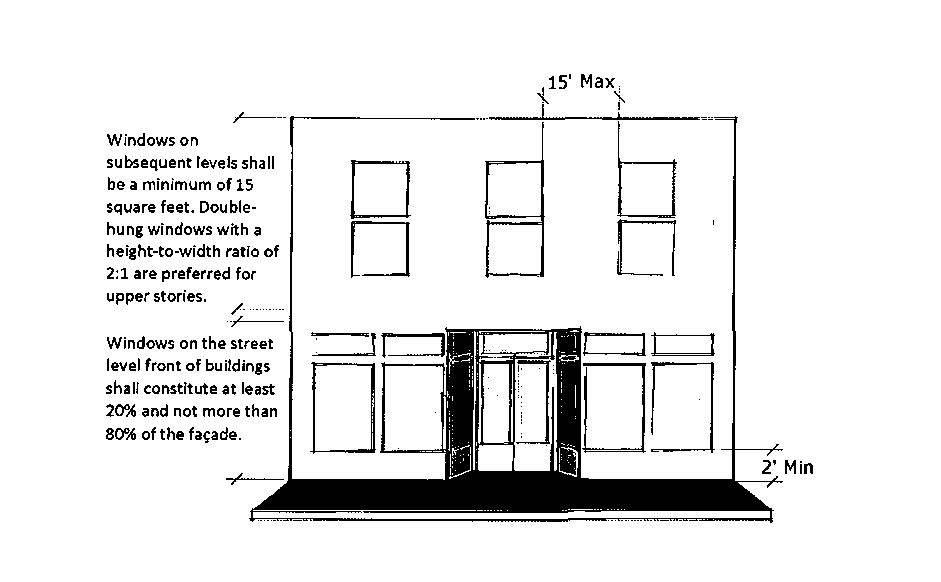
(g)
Front build-to-line. The fronts of all new buildings constructed in the downtown core overlay district (SPI-8) shall abut existing sidewalks.
(h)
Horizontal rhythms. Downtown building patterns traditionally emphasized a strong horizontal design element. New construction and additions to or remodeling of existing buildings shall maintain a clear visual division between street level and any upper architectural feature used to accomplish this effect.
(i)
Materials. Additions, alterations, modifications, and new construction shall use facing materials that are compatible in quality, color, texture, finish, and dimension to those common in the downtown core overlay district (SPI-8). Acceptable materials include, but may not be limited to brick, stone or wood. Under no circumstances shall metal siding, unfinished concrete block or vinyl siding be allowed.
(j)
Roofs. Additions and new construction using flat pitch or low pitch roof design (anything under 3:12) must install parapet walls on all sides or cap the walls with a cornice treatment that provides articulation to the roofline. When the roof drains to the rear of the building and is guttered the parapet may be eliminated upon staff approval.
(k)
Appearance and maintenance. All buildings, including materials, windows, lighting, canopies, awnings, brackets, signs and other associated items, must be maintained in appearance and good working order.
(Ord. No. 2016-8, § 2, 4-19-2016)
Sec. 102-750. - Same—Definitions.
Awnings means an architectural projection that provides weather protection, identity or decoration and is wholly supported by the building to which it is attached. An awning is comprised of a lightweight, rigid skeleton structure over which a rigid covering is attached.
Canopy means a permanent structure, other than an awning, attached or unattached to a building for the purpose of providing shelter to patrons or automobiles, or as a decorative feature on a building wall. A canopy is not a completely enclosed structure.
Fenestration means the arrangement of windows and doors on the elevations of a building.
(Ord. No. 2016-8, § 2, 4-19-2016)
Sec. 102-751. - Same—Accent lighting.
(a)
Lights that flash, move, revolve, rotate, blink, flicker, vary on intensity and color, or strobe are prohibited.
(b)
Awnings and canopies shall not be internally lit from underneath or behind.
(Ord. No. 2016-8, § 2, 4-19-2016)
Sec. 102-752. - Same—Window signs.
The total sign area of window placed signage shall not exceed 50 percent of the window or door pane or glass area on which the sign is located. A permit is not required for window signs.
(Ord. No. 2016-8, § 2, 4-19-2016)
Sec. 102-753. - Same—Utilities.
All utilities directly serving subject property shall be placed underground unless technical restrictions exist and prohibit from such.
(Ord. No. 2016-8, § 2, 4-19-2016)
Sec. 102-754. - Same—Historic structures.
Buildings listed in the national or state historic registry are exempt from the standards herewith in where they are in conflict with the secretary of interior guidelines.
(Ord. No. 2016-8, § 2, 4-19-2016)
Sec. 102-755. - Same—Alternative means of compliance.
Strict interpretation and application of the standards may create particular difficulties in the retrofit, rehabilitation or renovation of existing developed properties. The city council may approve the proposed development plan which does not meet any specific standard of this downtown core overlay district (SPI-8) as an alternative means of compliance, subject to making the following findings:
1.
The proposed development attempts to meet the intent of this downtown core overlay district (SPI-8) as to the fullest extent possible.
2.
There are physical conditions, not economic considerations, which prevent the proposed development from meeting the specific standards of this downtown core overlay district (SPI-8).
(Ord. No. 2016-8, § 2, 4-19-2016)