
North Branch City Zoning Code
ARTICLE V
DISTRICTS AND DISTRICT REGULATIONS
330-22
368-24
378-24
392-25
262-17
260-17S
345-22
266-17
288-18
260-17
317-21
255-17
249-17
301-20
251-17
270-17
287-18
267-17
325-21
269-17
329-22
342-22
Sec 66-170 Establishment Of Districts
The following zoning districts are established within the city:
| AG | Agriculture |
| B | Business |
| BN | Business Neighborhood |
| CBD | Central Business District |
| I | Industrial |
| I2 | Heavy Industrial |
| P | Park/Open Space |
| PUB | Public-SemiPublic |
| R-1 | Low Density Residential |
| R-2 | Medium Density Residential |
| R-3 | High Density Residential |
| RR | Rural Residential |
| SL | Shoreland Overlay District |
| FP | Floodplain Management Overlay District |
| WL | Wetland Systems Overlay District |
| PUD | Planned Unit Development District |
The map attached hereto as Exhibit A is hereby adopted as the Official Zoning Map for the City of North Branch in accordance with Sec 66-171 Map; Boundaries of Districts and all other previously approved zoning maps are hereby of no further force or effect.
Sec 66-171 Map; Boundaries Of Districts
The location and boundaries of the zoning districts are set forth on the official zoning map of the city. The official zoning map is on file with the planning director. The official zoning map, together with all notations and explanatory materials, is hereby incorporated in this article.
Sec 66-172 Annexation; Detachment
Sec 66-173 Zoning District Boundaries
- Boundaries indicated as approximately following the centerlines of streets, highways, alleys or railroad lines shall be construed to follow such centerlines.
- Boundaries indicated as approximately following plotted lot lines shall be construed as following such lot lines.
- Boundaries indicated as following shorelines shall be construed to follow such shorelines, and in the event of change in shoreline shall be construed as moving with the actual shoreline; boundaries indicated as approximately following the centerlines of streams, rivers, lakes or other bodies of water shall be construed as following such centerlines.
- Boundaries indicated as approximately following the city limits shall be construed as following such city limits.
- Where a district boundary line divides a lot which was in a single ownership at the time of passage of this article, the extension of the regulations for either portion of the lot beyond the district line into the remaining portion of the lot may be interpreted by the planning director upon request of the owner.
(Code 1996, § 17.04.040)
Sec 66-174 Zoning Changes And The Comprehensive Plan
(Code 1996, § 17.04.050)
Sec 66-175 Design Guidelines
(Code 1996, § 17.04.060)
Sec 66-176 Minimum District Regulations
The regulations of this article within each district shall be minimum regulations, and shall apply uniformly to each class or kind of structure or land, except as hereinafter provided.
- No buildings, structure or land shall hereafter be used or occupied, and no building structure or part hereof shall hereafter be erected, constructed, reconstructed, moved or structurally altered except in conformity with all of the regulations specified in this article for the district in which it is located.
- No building or other structure shall hereafter be erected or altered to exceed the height or bulk, to accommodate or house a greater number of families, to occupy a greater percentage of lot area, to have narrower or smaller rear yards, front yard, side yards or other open spaces, than required in this article; or in any other manner contrary to the provisions of this article.
- No yard or lot existing at the time of passage of this article shall be reduced in dimension or area below the minimum requirements set forth herein. Yards or lots created after the effective date of this article shall meet at least the minimum requirements established by this article.
(Code 1996, § 17.04.070)
Sec 66-206 Purpose
(Code 1996, § 17.06.010)
Sec 66-207 Permitted Uses
Sec 66-208 Accessory Uses
The permitted accessory uses in an R-1 single-family residential district shall be as set forth in section 66-6.
(Code 1996, §.06.030; Ord. No. 153-10, §, 8-9-2010)
Sec 66-208.5 Interim Uses
The following uses are interim uses in the R-1 (single-family residential) district that require city council approval of an interim use permit and shall be in conformance with the standards specified in section 66-64 of this chapter and the additional standards specified below:
- One temporary manufactured home for the property owners to occupy when rebuilding their primary residence after a fire, flood, tornado, wind damage or other destructive event or for the parents, grandparents or children of the property owners subject to:
- The manufactured home would be located on a parcel of at least one-half acre (21,780 square feet) of buildable land with one permanent dwelling. The occupant(s) of either the manufactured home or the permanent dwelling must be:
- The parents(s) or grandparents of the occupant of the other residence on the property; or
- A child, sister, brother or grandchild who has full or total disability as classified by Social Security, Worker's compensation or a doctor and who resides in or will reside in one of the residences.
- The parents(s) or grandparents of the occupant of the other residence on the property; or
- The applicant shall submit with the initial application and annually thereafter, a signed statement certifying that the occupants of the manufactured home is a parent, grandparent, child, sister or brother who suffers a full or total disability as classified by Social Security, Worker's Compensation or a doctor. The statement shall describe the need that makes it necessary for parents. Grandparents or relative of the first degree to live on the same parcel with the children or children or a release that will allow the city administrator or his/her designee to verify the disability.
- The owner shall remove the manufactured home from the site within 120 days of such time as it or the permanent residence ceases to be occupied by a parent, grandparent, grandchild, child, sister or brother.
- The owner shall not make the manufactured home a permanent residence.
- The manufactured home shall not require the creation of a separate well.
- An on-site sewage treatment system to serve the manufactured home can be installed on the property in accordance to all city and state standards or if possible, the owners may attach the sewage system for the manufactured home to an existing on-site sewage system if the existing system has enough capacity for additional users.
- The placement of the proposed manufactured home must meet all setback standards and shall not cause drainage or stormwater run-off problems for adjacent properties.
- The owner shall not place the manufactured home in a front yard.
- The owner submitting to the city an escrow, issued in the name of the city and payable to the city, for the sum of $5,000.00 that the city may draw down at its sole discretion for the purposes including, but not limited to, the cost of capping and closing of any separate on-site sewage treatment systems or wells, administrative and legal fees and the repayment of delinquent personal property taxes on the manufactured home. The city shall hold the escrow for as long as the manufactured home is on the property. The city shall hold the escrow for as long as the manufactured home is on the property and shall return the escrow within 90 days of the completion of all necessary site restoration.
- The manufactured home would be located on a parcel of at least one-half acre (21,780 square feet) of buildable land with one permanent dwelling. The occupant(s) of either the manufactured home or the permanent dwelling must be:
(Ord. No. 210-14, § 7, 7-14-2014)
Sec 66-209 Conditional Uses
The conditional uses in an R-1 single-family residential district that require a conditional use permit based upon procedures, factors and conditions set forth in and regulated by section 66-62 et seq shall be as set forth in section 66-6.
(Code 1996, § 17.06.040; Ord. No. 102, § 1(17.06.045), 10-24-2005; Ord. No. 153-10, § 1, 8-9-2010; Ord. No. 216-14, § 1, 9-22-2014; Ord. No. 224-15, § 2, 4-28-2015)
Sec 66-210 Design Standards
The following are minimum design standards for the R-1 single-family residential district:
- The design standards in each zoning district are as set forth in the official design standards chart. Click on Dimentional Standard Table.
- Driveways in this zoning district must meet the following minimum design standards:
- Shall be constructed from a hard, impervious or permeable surface such as bituminous or concrete. Said surface shall be of such character as is suitable and in harmony with similar improvements in the surrounding area.
- Shall be completed within the same time frame as that of the building permit.
- Shall be constructed from a hard, impervious or permeable surface such as bituminous or concrete. Said surface shall be of such character as is suitable and in harmony with similar improvements in the surrounding area.
(Code 1996, § 17.06.050; Ord. No. 153-10, § 1, 8-9-2010; Ord. No. 187-12, § 1, 4-9-2012)
Sec 66-211 Yard, Area, Building Size Requirements
The yard, area and building size regulations for permitted single-family detached dwellings in the R-1 single-family residential district are as set forth in the official design standards chart as set forth in Sec 66-210.
(Code 1996, § 17.06.060; Ord. No. 104, § 1(17.06.065), 12-12-2005; Ord. No. 153-10, § 1, 8-9-2010)
Sec 66-213 Yard, Area And Building Size Requirement; Two-Family
The yard, area and building size regulations for conditional two-family dwellings units in the R-1 single-family residential district are as set forth in the official design standards chart as set forth in Sec 66-210.
Sec 66-214 Fencing, Screening, And Landscaping Requirements
(Code 1996, § 17.06.070)
Note — Formerly § 66-213.
Sec 66-215 Signs
(Code 1996, § 17.06.080)
Note — Formerly § 66-214.
Sec 66-216 Off-Street Parking And Loading
(Code 1996, § 17.06.090)
Note — Formerly § 66-215.
Sec 66-271 Purpose
(Code 1996, § 17.10.010; Ord. No. 153-10, § 1, 8-9-2010)
Sec 66-272 Permitted Uses
Sec 66-273 Accessory Uses
The permitted accessory uses in the R-2 medium-density residential district shall be as set forth in Sec 66-6.
Sec 66.273.5 Interim Uses
The following uses are interim uses in the R-2 (medium-density residential) district that require city council approval of an interim use permit and shall be in conformance with the standards specified in section 66-64 of this ordinance and the additional standards specified below:
- One temporary manufactured home for the property owners to occupy when rebuilding their primary residence after a fire, flood, tornado, wind damage or other destructive event or for the parents, grandparents or children of the property owners subject to:
- The manufactured home would be located on a parcel of at least one-half acre (21,780 square feet) of buildable land with one permanent dwelling. The occupant(s) of either the manufactured home or the permanent dwelling must be:
- The parents(s) or grandparents of the occupant of the other residence on the property or:
- A child, sister, brother or grandchild who has full or total disability as classified by Social Security, Worker's compensation or a Doctor and who resides in or will reside in one of the residences.
- The parents(s) or grandparents of the occupant of the other residence on the property or:
- The applicant shall submit with the initial application and annually thereafter, a signed statement certifying that the occupants of the manufactured home is a parent, grandparent, child, sister or brother who suffers a full or total disability as classified by Social Security, Worker's Compensation or a doctor. The statement shall describe the need that makes it necessary for parents. Grandparents or relative of the first degree to live on the same parcel with the children or children or a release that will allow the city administrator or his/her designee to verify the disability.
- The owner shall remove the manufactured home from the site within 120 days of such time as it or the permanent residence ceases to be occupied by a parent, grandparent, child, grandchild, sister or brother.
- The owner shall not make the manufactured home a permanent residence.
- The manufactured home shall not require the creation of a separate well.
- An on-site sewage treatment system to serve the manufactured home can be installed on the property in accordance to all city and state standards or if possible, the owners may attach the sewage system for the manufactured home to an existing on-site sewage system if the existing system has enough capacity for additional users.
- The placement of the proposed manufactured home must meet all setback standards and shall not cause drainage or stormwater run-off problems for adjacent properties.
- The owner shall not place the manufactured home in a front yard.
- The owner submitting to the city an escrow, issued in the name of the city and payable to the city, for the sum of $5,000.00 that the city may draw down at its sole discretion for the purposes including, but not limited to, the cost of capping and closing of any separate on-site sewage treatment systems or wells, administrative and legal fees and the repayment of delinquent personal property taxes on the manufactured home. The city shall hold the escrow for as long as the manufactured home is on the property. The city shall hold the escrow for as long as the manufactured home is on the property and shall return the escrow within 90 days of the completion of all necessary site restoration.
- The manufactured home would be located on a parcel of at least one-half acre (21,780 square feet) of buildable land with one permanent dwelling. The occupant(s) of either the manufactured home or the permanent dwelling must be:
(Ord. No. 210-14, § 9, 7-14-2014)
Sec 66-274 Conditional Uses
The conditional uses in the R-2 medium-density residential district that require a conditional use permit based upon procedures, factors and conditions set forth in and regulated by section 66-62 et seq. shall be as set forth in Sec 66-6.
(Code 1996, §.10.040; Ord. No. 102, § 1 (17.10.045), 10-24-2005; Ord. No. 153-10, §, 8-9-2010; Ord. No. 224-15, §, 4-28-2015)
Sec 66-275 Design Standards
- The minimum design standards standards for the R-2 medium-density residential district are as set forth in the official design standards chart as set forth in 66-210.
- Driveways in this zoning district must meet the following minimum design standards:
- Shall be constructed from a hard, impervious or permeable surface such as bituminous or concrete. Said surface shall be of such character as is suitable and in harmony with similar improvements in the surrounding area.
- Shall be completed within the same time frame as that of the building permit.
Sec 66-276 Yard, Area, And Building Size Requirements; Single-Family
The yard, area and building size regulations for permitted single-family detached dwellings in the R-2 medium-density residential district are as set forth in the official design standards chart as set forth in 66-210.
Sec 66-278 Yard, Area And Building Size Requirements; Two-Family
The yard, area and building size regulations for permitted two-family dwellings units in the R-2 medium-density residential district are as set forth in the official design standards chart as set forth in 66-210.
Sec 66-279 Yard, Area And Building Size Requirements; 3-4 Dwelling Units
The yard, area and building size regulations for permitted developments containing three or more dwelling units in the R-2 medium-density residential district are as set forth in the official design standards chart as set forth in 66-210.
Sec 66-280 Fencing, Screening, And Landscaping Requirements
(Code 1996, § 17.10.080)
Sec 66-281 Signs
(Code 1996, § 17.10.090)
Sec 66-282 Off-Street Parking And Loading
(Code 1996, § 17.10.100)
Sec 66-311 Purpose
(Code 1996, § 17.12.010)
Sec 66-312 Permitted Uses
Sec 66-313 Accessory Uses
The permitted accessory uses in an R-3 high-density residential district shall be as set forth in Sec 66-6.
Sec 66-314 Conditional Uses
The conditional uses in the R-3 high-density residential district that require a conditional use permit based upon procedures, factors and conditions set forth in and regulated by section 66-62 et seq. shall be as set forth in Sec 66-6.
(Code 1996, §.12.030; Ord. No. 153-10, §, 8-9-2010; Ord. No. 224-15, §, 4-28-2015)
Sec 66-315 Design Standards
- The following are minimum design standards for the R-3 high-density residential district are as set forth in the official design standards chart as set forth in Sec 66-210.
- Driveways in this zoning district must meet the following minimum design standards:
- Shall be constructed from a hard, impervious or permeable surface such as bituminous or concrete. Said surface shall be of such character as is suitable and in harmony with similar improvements in the surrounding area.
- Shall be completed within the same time frame as that of the building permit.
Sec 66-316 Yard, Area, Building Size Requirements; Two-Family Dwelling
The yard, area and building size regulations for permitted two-family dwellings units in the R-3 high-density residential district are as set forth in the official design standards chart as set forth in Sec 66-210.
Sec 66-318 Yard, Area, And Building Size Requirements; Townhouses
The yard, area and building size regulations for permitted townhouse developments containing three or more dwelling units in the R-3 high-density residential district are as ser forth in the official design standards chart as set forth in Sec 66-210.
Sec 66-319 Yard, Area And Building Size Requirements; Apartment Dwellings
Sec 66-320 Fencing, Screening, And Landscaping Requirements
(Code 1996, § 17.12.090)
Sec 66-321 Signs
(Code 1996, § 17.12.100)
Sec 66-322 Off-Street Parking And Loading
(Code 1996, § 17.12.110)
Sec 66-384 Purpose
The purpose of the AG agricultural district is to preserve, promote, maintain and enhance the use of land for agricultural purposes and to protect such land from encroachment by nonagricultural uses.
(Code 1996, §.16.010)
Sec 66-385 Permitted Uses
The permitted uses in the AG agricultural district shall be as set forth in Sec 66-6.
Sec 66-386 Accessory Uses
Sec 66-386.5 Interim Uses
The following uses are interim uses in the AG (agricultural) district that require city council approval of an interim use permit and shall be in conformance with the standards specified in section 66-64 of this ordinance and the additional standards specified below:
- One temporary manufactured home for the property owners to occupy when rebuilding their primary residence after a fire, flood, tornado, wind damage or other destructive event or for the parents, grandparents or children of the property owners subject to:
- The manufactured home would be located on a parcel of at least one-half acre (21,780 square feet) of buildable land with one permanent dwelling. The occupant(s) of either the manufactured home or the permanent dwelling must be:
- The parents(s) or grandparents of the occupant of the other residence on the property; or
- A child, sister, brother or grandchild who has full or total disability as classified by Social Security, Worker's compensation or a doctor and who resides in or will reside in one of the residences.
- The parents(s) or grandparents of the occupant of the other residence on the property; or
- The applicant shall submit with the initial application and annually thereafter, a signed statement certifying that the occupants of the manufactured home is a parent, grandparent, child, sister or brother who suffers a full or total disability as classified by Social Security, Worker's Compensation or a doctor. The statement shall describe the need that makes it necessary for parents. Grandparents or relative of the first degree to live on the same parcel with the children or children or a release that will allow the city administrator or his/her designee to verify the disability.
- The owner shall remove the manufactured home from the site within 120 days of such time as it or the permanent residence ceases to be occupied by a parent, grandparent, grandchild, child, sister or brother.
- The owner shall not make the manufactured home a permanent residence.
- The manufactured home shall not require the creation of a separate well.
- An on-site sewage treatment system to serve the manufactured home can be installed on the property in accordance to all city and state standards or if possible, the owners may attach the sewage system for the manufactured home to an existing on-site sewage system if the existing system has enough capacity for additional users.
- The placement of the proposed manufactured home must meet all setback standards and shall not cause drainage or stormwater run-off problems for adjacent properties.
- The owner shall not place the manufactured home in a front yard.
- The owner submitting to the city an escrow, issued in the name of the city and payable to the city, for the sum of $5,000.00 that the city may draw down at its sole discretion for the purposes including, but not limited to, the cost of capping and closing of any separate on-site sewage treatment systems or wells, site restoration, administrative and legal fees and the repayment of delinquent personal property taxes on the manufactured home. The city shall hold the escrow for as long as the manufactured home is on the property and shall return the escrow within 90 days of the completion of all necessary site restoration.
- The manufactured home would be located on a parcel of at least one-half acre (21,780 square feet) of buildable land with one permanent dwelling. The occupant(s) of either the manufactured home or the permanent dwelling must be:
(Ord. No. 210-14, § 4, 7-14-2014)
Sec 66-387 Conditional Uses
The uses in the AG agricultural district, which require a conditional use permit based upon procedures, factors and conditions set forth in and regulated by Sec 66-62 et seq. shall be as set forth in Sec 66-6.
Sec 66-388 Design Standards
The minimum design standards for the AG agricultural district are set forth in the official design standards chart as set forth in Sec 66-210.
Sec 66-389 Yard, Area, And Building Size Requirements
The yard, area and building size regulations for permitted dwellings units in the AG agricultural district are as set forth in the official design standards chart as set forth in Sec 66-210.
Sec 66-390 Fencing, Screening, And Landscaping Requirements
The fencing, screening and landscaping requirements in Sec 66-970 et seq. shall apply to all developments in the AG agricultural district except for the following:
- Permits are not required for fences on bona fide farms in the AG zone.
(Code 1996, § 17.16.070)
Sec 66-391 Signs
All signs within the AG agricultural district shall comply with Sec 66-821 et seq.
(Code 1996, §.16.080)
Sec 66-392 Off-Street Parking And Loading
(Code 1996, § 17.16.090)
Sec 66-447 Purpose
The purpose of the RR rural residential district is:
- To prevent scattered nonfarm uses from developing improperly.
- To allow suitable areas of the city to be retained and utilized in open space and/or agricultural uses.
- To promote orderly development and secure economy in government expenditures for public utilities and service.
(Code 1996, § 17.18.010)
Sec 66-448 Permitted Uses
The permitted uses in the RR rural residential district shall be as set forth in Sec 66-6.
Sec 66-449 Accessory Uses
Sec 66-449.5 Interim Uses
The following uses are interim uses in the RR (rural residential) district that require city council approval of an interim use permit and shall be in conformance with the standards specified in section 66-64 of this chapter and the additional standards specified below:
- One temporary manufactured home for the property owners to occupy when rebuilding their primary residence after a fire, flood, tornado, wind damage or other destructive event or for the parents, grandparents or children of the property owners subject to:
- The manufactured home would be located on a parcel of at least one-half acre (21,780 square feet) of buildable land with one permanent dwelling. The occupant(s) of either the manufactured home or the permanent dwelling must be:
- The parents(s) or grandparents of the occupant of the other residence on the property; or
- A child, sister, brother or grandchild who has full or total disability as classified by Social Security, Worker's compensation or a doctor and who resides in or will reside in one of the residences.
- The parents(s) or grandparents of the occupant of the other residence on the property; or
- The applicant shall submit with the initial application and annually thereafter, a signed statement certifying that the occupants of the manufactured home is a parent, grandparent, child, sister or brother who suffers a full or total disability as classified by Social Security, Worker's Compensation or a doctor. The statement shall describe the need that makes it necessary for parents. Grandparents or relative of the first degree to live on the same parcel with the children or children or a release that will allow the city administrator or his/her designee to verify the disability.
- The owner shall remove the manufactured home from the site within 120 days of such time as it or the permanent residence ceases to be occupied by a parent, grandparent, child, sister, brother or grandchild.
- The owner shall not make the manufactured home a permanent residence.
- The manufactured home shall not require the creation of a separate well.
- An on-site sewage treatment system to serve the manufactured home can be installed on the property in accordance to all city and state standards or if possible, the owners may attach the sewage system for the manufactured home to an existing on-site sewage system if the existing system has enough capacity for additional users.
- The placement of the proposed manufactured home must meet all setback standards and shall not cause drainage or stormwater run-off problems for adjacent properties.
- The owner shall not place the manufactured home in a front yard.
- The owner submitting to the city an escrow, issued in the name of the city and payable to the city, for the sum of $5,000.00 that the city may draw down at its sole discretion for the purposes including, but not limited to, the cost of capping and closing of any separate on-site sewage treatment systems or wells, administrative and legal fees and the repayment of delinquent personal property taxes on the manufactured home. The city shall hold the escrow for as long as the manufactured home is on the property. The city shall hold the escrow for as long as the manufactured home is on the property and shall return the escrow within 90 days of the completion of all necessary site restoration.
- The manufactured home would be located on a parcel of at least one-half acre (21,780 square feet) of buildable land with one permanent dwelling. The occupant(s) of either the manufactured home or the permanent dwelling must be:
(Ord. No. 210-14, § 6, 7-14-2014)
Sec 66-450 Conditional Uses
The conditional uses in the RR rural residential district which require a conditional use permit based upon procedures, conditions and factors set forth in and regulated by section 66-62 et seq. shall be as set forth in Sec 66-6.
Sec 66-451 Design Standards
The minimum design standards for the RR rural residential district are as set forth in the official design standards chart as set forth in Sec 66-210.
Sec 66-452 Yard, Area, And Building Size Requirements
- The yard, area and building size regulations for permitted dwelling units in the RR rural residential district are as set forth in the official design standards chart as set forth in Sec 66-210.
- For lots outside of the Urban Service Area, a minimum of 1.0 acre buildable.
- For lots within the Urban Service Area and connected to municipal utilities, 12000 ft2; provided however, no new lots can be created within Urban Service Area that are not connected to municipal services, unless they established according to the terms of an approved PUD under Sec 66-788 through Sec 66-798.
- Lots of record created prior to July 21, 2017 shall be deemed legal lots for purposes of this section but subject to the requirements of Sec. 58-76
- Lot area:
- Within the Urban Service Area
I acre lot of upland/buildable are with 9 or more acres within a lot that is restricted for future development with a PUD. The location of the 1 acre lot will be in a location that will minimize the impact on extending City services. - Outside of the Urban Service Area:
A minimum of 1.0 acre of upland/buildable for property located outside the Urban Service Area.
- Within the Urban Service Area
(Code 1996, §.18.060; Ord. No. 108, §, 7-10-2006; Ord. No. 110A, §, 11-27-2006; Ord. No. 153-10, §, 8-9-2010; Ord. No. 157-11, §, 1-10-2011; Ord. No. 199-13, §§ 1, 2, 5-28-2013)
Sec 66-453 Fencing, Screening, And Landscaping Requirements
The fencing, screening and landscaping requirements in section 66-970 et seq. shall apply to all developments in the RR rural residential district except for the following:
- Fence permits are not required in RR zones when they are put up for agricultural purposes.
(Code 1996, § 17.18.070)
Sec 66-454 Signs
(Code 1996, § 17.18.080)
Sec 66-455 Off-Street Parking And Loading
(Code 1996, § 17.18.090)
Sec 66-456 Animals In RR District
Sec 66-503 Purpose
The purpose of the CBD commercial business district is:
- To provide for high intensity commercial activity within a compact central area stressing the pedestrian function and interaction of people and businesses; and
- To provide a local retail, service and civic center for the community.
(Code 1996, § 17.22.010)
Sec 66-504 Permitted Uses
Sec 66-505 Accessory Uses
Sec 66-506 Conditional Uses
The conditional uses in the CBD commercial business district that require a conditional use permit based upon the procedures, conditions and factors set forth in and regulated by Sec 66-62 et seq. shall be as set forth in Sec 66-6.
Sec 66-507 Design Standards
Sec 66-508 Area And Bulk Regulations
Area and bulk regulations in this zoning district are as set forth in the design standards chart as set forth in Sec 66-210.
Sec 66-509 Fencing, Screening, And Landscaping Requirements
(Code 1996, § 17.22.070)
Sec 66-510 Required Parking
Plans for off-street parking and loading facilities within the CBD commercial business district shall be reviewed by the planning agency. The planning agency may require such off-street parking and loading spaces as deemed appropriate for the proposed use. Upon review, the planning agency shall make a recommendation to the city council for final review and approval. The planning agency may recommend and the city council may require a cash contribution in lieu of off-street parking facilities.
(Code 1996, § 17.22.080)
Sec 66-540 Purpose
The purpose of the BN district is:
- To serve as a limited business use in residential areas and serve as a transition to commercial areas.
(Code 1996, §.24.010; Ord. No. 153-10, §, 8-9-2010)
Sec 66-541 Permitted Uses
Sec 66-542 Accessory Uses
The permitted accessory uses in the BN district shall be set forth in Sec 66-6.
Sec 66-543 Interim Uses
The following uses are interim uses in the BN district that require city council approval of an interim use permit and shall be in conformance with the standards specified in section 66-64 of this chapter and the additional standards specified below:
- Transient sales;
- Must be located in a suitable off-street location and shall not extend into adjacent right-of-way or other public property;
- Must not interrupt vehicular circulation on the site or obstruct parking spaces needed by permanent business established on the site;
- Must have written authorization from property owner;
- The business operator must secure all applicable licenses and approvals from the city, Chisago County or other appropriate jurisdictions;
- Sight visibility clearances at street intersections and access points must be provided in accordance with the City Code or as determined by the city to protect public safety;
- No portion of the use may take place within 100 feet of any developed property zoned for residential use;
- Signs are subject to all City Code standards and:
- Incidental product or pricing signs must be placed directly next to the appropriate product;
- Product advertising is permitted, but must be included in the maximum allowed sign area;
- The signs must have a professional appearance and must be securely mounted or erected in a safe location; and
- These limitations apply to all signs associated with the use, including those affixed to vehicles;
- Incidental product or pricing signs must be placed directly next to the appropriate product;
- Any display of items must be limited to representative samples and be arranged in as compact a manner as reasonably practicable;
- The interim use permit will be issued in the name of the person requesting the permit and will be for the purpose of selling a particular item or range of items at a specific location. Any change in the person, location or items sold will render the permit invalid; and
- Violation of the above standards or other conditions placed upon the interim use permit will result in immediate revocation of the interim use permit;
- Must be located in a suitable off-street location and shall not extend into adjacent right-of-way or other public property;
- Churches or places of worship for a space in a multi-tenant building.
(Ord. No. 210-14, §, 7-14-2014)
Sec 66-544 Conditional Uses
The conditional uses in the BN district that require a conditional use permit based upon procedures, conditions and factors set forth in and regulated by Sec 66-62 et seq. shall be as set forth in Sec 66-6.
Sec 66-545 Design Standards
All structures in this zoning district must meet 66-943 (b).
Sec 66-546 Area And Bulk Regulations
Sec 66-547 Fencing, Screening, And Landscaping Requirements
The fencing, screening and landscaping requirements in section 66-970 et seq. shall apply to all developments in the BN district.
(Code 1996, § 17.24.070)
Sec 66-548 Required Parking
For permitted uses, four parking spaces per 1,000 square feet of gross floor area shall be provided and maintained unless otherwise regulated in Sec 66-848 et seq.
(Code 1996, § 17.24.080)
Sec 66-566 Purpose
The purpose of the B business district is:
- To provide for the location of commercial activities that serve a primarily regional, nonlocal market area.
- To provide for the location of retail and commercial activities that require very large buildings.
- To complement the retail activity in the CBD and BN Districts.
(Code 1996, § 17.26.010)
Sec 66-567 Permitted Uses
The permitted uses in the B district shall be as set forth in Sec 66-6.
(Code 1996, § 17.26.020)
Sec 66-568 Accessory Uses
The permitted accessory uses in the B district shall be as set forth in Sec 66-6.
Sec 66-568.5 Interim Uses
The following uses are interim uses in the B that require city council approval of an interim use permit and shall be in conformance with the standards specified in section 66-64 of this chapter and the additional standards specified below:
- Transient sales;
- Must be located in a suitable off-street location and shall not extend into adjacent right-of-way or other public property;
- Must not interrupt vehicular circulation on the site or obstruct parking spaces needed by permanent business established on the site;
- Must have written authorization from property owner;
- The business operator must secure all applicable licenses and approvals from the city, Chisago County or other appropriate jurisdictions;
- Sight visibility clearances at street intersections and access points must be provided in accordance with the City Code or as determined by the city to protect public safety;
- No portion of the use may take place within 100 feet of any developed property zoned for residential use;
- Signs are subject to all City Code standards and:
- Incidental product or pricing signs must be placed directly next to the appropriate product;
- Product advertising is permitted, but must be included in the maximum allowed sign area;
- The signs must have a professional appearance and must be securely mounted or erected in a safe location; and
- These limitations apply to all signs associated with the use, including those affixed to vehicles;
- Incidental product or pricing signs must be placed directly next to the appropriate product;
- Any display of items must be limited to representative samples and be arranged in as compact a manner as reasonably practicable;
- The interim use permit will be issued in the name of the person requesting the permit and will be for the purpose of selling a particular item or range of items at a specific location. Any change in the person, location or items sold will render the permit invalid; and
- Violation of the above standards or other conditions placed upon the interim use permit will result in immediate revocation of the interim use permit;
- Must be located in a suitable off-street location and shall not extend into adjacent right-of-way or other public property;
- Churches or places of worship for a space in a multi-tenant building.
(Ord. No. 210-14, §, 7-14-2014)
Sec 66-569 Conditional Uses
The following are conditional uses in the B district that require a conditional use permit based upon procedures, conditions and factors set forth in and regulated by Sec 66-62 et seq. shall be as set forth in Sec 66-6.
Sec 66-570 Design Standards
Sec 66-571 Area And Bulk Regulations
Sec 66-572 Landscaping
The fencing, screening and landscaping requirements in section 66-970 et seq. shall apply to all developments in the B district.
(Code 1996, § 17.26.070)
Sec 66-573 Required Parking
(Code 1996, § 17.26.080)
Sec 66-625 Purpose
The purpose of the I general industrial district is to establish and preserve areas for industrial and related uses of such a nature that they do not create serious problems of compatibility with other kinds of land uses.
(Code 1996, §.28.010)
Sec 66-626 Permitted Uses
The following are permitted uses within the I general industrial district shall be as set forth in Sec 66-6.
Sec 66-627 Accessory Uses
The following are permitted accessory uses in the Igeneral industrial district shall be as set forth in Sec 66-6.
Sec 66-628 Conditional Uses
The conditional uses in the I general industrial district that require a conditional use permit approved by the city council based upon procedures set forth in and regulated by section 66-62 et seq. shall be as set forth in Sec 66-6.
Sec 66-629 Area And Bulk Regulations
Area and bulk regulations in the I general industrial district are as set forth in the official design standards chart as set for in Sec 66-210.
Sec 66-630 Fencing, Screening, And Landscaping Requirements
The fencing, screening and landscaping requirements in section 66-970 et seq. shall apply to all developments in the I general industrial district.
(Code 1996, § 17.28.060)
Sec 66-631 Required Parking
(Code 1996, § 17.28.070)
Sec 66-632 Performance Standards
All uses allowed in the I general industrial district shall comply with all applicable federal, state and local nuisance and pollution laws, ordinances and regulations.
(Code 1996, §.28.080)
Sec 66-633 Design Standards
Sec 66-671 Purpose
The purpose of the I-2 industrial district is to establish and preserve areas for industrial development including manufacturing, fabrication, packaging, assembly, warehouse, and distribution, as well as related uses of such a nature that they do not create serious problems of compatibility with other kinds of land uses.
(Ord. No. 121-08, §, 3-10-2008)
Sec 66-671.5 Permitted Uses
Sec 66-672 Accessory Uses
The permitted accessory uses in the I-2 industrial district shall be as set forth in Sec 66-6.
Sec 66-672.5 Conditional Uses
The conditional uses in the I-2 industrial district that require a conditional use permit approved by the city council based upon procedures set forth in and regulated by section 66-62 et seq. shall be as set forth in Sec 66-6
Sec 66-673 Area And Bulk Regulations
Area and bulk regulations in the I-2 industrial district are as set forth in the official design standards chart as set forth in Sec 66-210.
Sec 66-673.5 Screening And Landscaping Requirements
The screening and landscaping requirements in section 66-970 et seq. shall apply to all developments in the I-2 industrial district.
(Ord. No. 121-08, §, 3-10-2008)
Sec 66-674 Required Parking
For warehouse and distribution uses, one parking space per 2,000 square feet of gross floor area or 1.25 spaces for each employee per shift shall be provided and maintained.
If the applicant chooses the lesser number of parking spaces then a proof of parking plan will need to be submitted and approved to assure the larger standard can be met if additional parking is needed later.
(Ord. No. 121-08, § 1, 3-10-2008)
Sec 66-674.5 Performance Standards
All uses allowed in the I-2 industrial district shall comply with all applicable federal, state and local nuisance and pollution laws, ordinances and regulations.
(Ord. No. 121-08, §, 3-10-2008)
Sec 66-675 Design Standards
Sec 66-697 Statutory Authorization, Findings Of Fact, And Purpose
(a) Statutory Authorization. This floodplain ordinance is adopted pursuant to the authorization and policies contained in Minnesota Statutes, Chapter 103F; Minnesota Rules, parts 6120.5000 – 6120.6200; the rules and regulations of the National Flood Insurance Program in 44 CFR § 59 to 78; and the planning and zoning enabling legislation in Minnesota Statutes, Chapter 462.
(b) Purpose.
(1) This ordinance regulates development in the flood hazard areas of the City of North Branch. These flood hazard areas are subject to periodic inundation, which may result in loss of life and property, health and safety hazards, disruption of commerce and governmental services, extraordinary public expenditures for flood protection and relief, and impairment of the tax base. It is the purpose of this ordinance to promote the public health, safety, and general welfare by minimizing these losses and disruptions. (2) This ordinance is adopted in the public interest to promote sound land use practices, and floodplains are a land resource to be developed in a manner which will result in minimum loss of life and threat to health, and reduction of private and public economic loss caused by flooding. (3) This ordinance is adopted to maintain eligibility in the National Flood Insurance Program. (4) This ordinance is also intended to preserve the natural characteristics and functions of watercourses and floodplains in order to moderate flood and stormwater impacts, improve water quality, reduce soil erosion, protect aquatic and riparian habitat, provide recreational opportunities, provide aesthetic benefits and enhance community and economic development.
(c) Abrogation and Greater Restrictions: It is not intended by this ordinance to repeal, abrogate, or impair any existing easements, covenants, or other private agreements. The standards in this ordinance takes precedence over any less restrictive, conflicting local laws, ordinances, or codes. All other ordinances inconsistent with this ordinance are hereby repealed to the extent of the inconsistency only.
(d) Warning and Disclaimer of Liability: This ordinance does not imply that areas outside the floodplain districts or land uses permitted within such districts will be free from flooding or flood damages. This ordinance does not create liability on the part of the City of North Branch or its officers or employees for any flood damages that result from reliance on this ordinance or any administrative decision lawfully made hereunder.
(e) Severability: If any section, clause, provision, or portion of this ordinance is adjudged unconstitutional or invalid by a court of law, the remainder of this ordinance shall not be affected and shall remain in full force.
(Code 1996, § 17.30.010; Ord. No. 177-12, § 2, 3-12-2012)
Sec 66-698 Definitions
(a) Definitions. Unless specifically defined, words or phrases used in this ordinance must be interpreted according to common usage and so as to give this ordinance its most reasonable application.
(Code 1996, § 17.30.020; Ord. No. 177-12, § 2, 3-12-2012)
Sec 66-699 Jurisdiction And Districts
(a) Lands to Which Ordinance Applies. This ordinance applies to all lands within the jurisdiction of the City of North Branch within the boundaries of the Floodway, Flood Fringe and General Floodplain Districts.
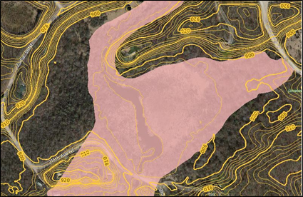
(1) The Floodway, Flood Fringe or General Floodplain Districts are overlay districts. The standards imposed in the overlay districts are in addition to any other requirements. In case of a conflict, the more restrictive standards will apply. (2) Where a conflict exists between the floodplain limits illustrated on the official floodplain maps and actual field conditions (as illustrated in Figure 1), the Base Flood Elevation (BFE) shall be the governing factor in locating the outer boundaries of the one-percent annual chance floodplain.
Figure 1: The mapped floodplain may not always align with on-the-ground contour elevations.
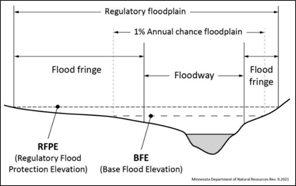
 (3) The regulatory limits of the district boundaries shall be further extended outward based on the horizontal extension of the Regulatory Flood Protection Elevation (RFPE) (Figure 2).
Figure 2: Horizontal extension of the Regulatory Flood Protection Elevation (RFPE)
(4) Persons contesting the location of the district boundaries will be given a reasonable opportunity to present their case to the [Planning Commission/Board of Adjustment] and to submit technical evidence.
(b) Incorporation of Maps by Reference. The following maps together with all attached material are hereby adopted by reference and declared to be a part of the Official Zoning Map and this ordinance. The attached material includes the Flood Insurance Study for Chisago County, Minnesota, and Incorporated Areas, and the Flood Insurance Rate map panels enumerated below, all dated April 17, 2012, and prepared by the Federal Emergency Management Agency. These materials are on file at North Branch City Hall.
27025C0145D 27025C0163D 27025C0165D 27025C0170D 27025C0250D 27025C0255D 27025C0260D
(c) Districts
(1) Floodway District. Those areas within Zones AE delineated within floodway areas as shown on the Flood Insurance Rate Maps referenced in Section 66-999(b). (2) Flood Fringe District. Those areas within Zones AE on the Flood Insurance Rate Maps referenced in Section 66- 999(b), but located outside of the floodway. This district also includes any additional area encompassed by the Regulatory Floodplain.
(3) General Floodplain District. Those areas within Zone A areas that do not have a floodway delineated as shown on the Flood Insurance Rate Maps referenced in Section 66-999(b). This district also includes any additional area encompassed by the Regulatory Floodplain.
(d) Annexations. The Flood Insurance Rate Map panels referenced in Section 66-999(b) may include floodplain areas that lie outside of the corporate boundaries of the City of North Branch at the time of adoption of this ordinance. If any of these floodplain land areas are annexed into the City of North Branch after the date of adoption of this ordinance, the newly annexed floodplain lands will be subject to the provisions of this ordinance immediately upon the date of annexation. Annexations into panels not referenced in Section 3.2 require ordinance amendment in accordance with Section 66-710
(e) Detachments. The Flood Insurance Rate Map panels referenced in Section 66-999(b) will include floodplain areas that lie inside the corporate boundaries of municipalities at the time of adoption of this ordinance. If any of these floodplain land areas are detached from a municipality and come under the jurisdiction of the City of North Branch after the date of adoption of this ordinance, the newly detached floodplain lands will be subject to the provisions of this ordinance immediately upon the date of detachment.
(Code 1996, § 17.30.030; Ord. No. 177-12, § 2, 3-12-2012)
Sec 66-700 Requirements For All Floodplain Districts
(a) Permit Required. A permit must be obtained from the Zoning Administrator to verify compliance with all applicable standards outlined in this ordinance prior to the following uses or activities:
(1) The erection, addition, modification, rehabilitation, repair, or alteration of any building, structure, or portion thereof. Normal maintenance requires a permit to determine if such work, either separately or in conjunction with other planned work, constitutes a substantial improvement, as specified in Section 66-708(m) (2) The construction of a fence, pool, deck, or placement of anything that may cause a potential obstruction. Farm fences, as defined in Section 66-8, are not considered to be an obstruction, and as such, do not require a permit. (3) The change or expansion of a nonconforming use. (4) The repair of a structure that has been damaged by flood, fire, tornado, or any other source. (5) The placement of fill, excavation, utilities, on-site sewage treatment systems, or other service facilities. (6) The storage of materials or equipment, in conformance with Section 66-700(c)(2). (7) Relocation or alteration of a watercourse (including stabilization projects or the construction of new or replacement dams, culverts and bridges). A local permit is not required if a public waters work permit has been obtained from the Department of Natural Resources, unless a significant area above the ordinary high water level is also to be disturbed. (8) Any other type of “development,” as defined in Section 66-8.
(b) No Permit Required. Certain uses or activities may be exempt from obtaining a permit, such as planting a garden, farming, or other obviously insignificant activities such as putting up a mailbox or flagpole. The continuation of existing uses, when the associated activities do not encroach further on the regulatory floodplain or trigger associated standards in this ordinance, do not require a permit.
(c) Minimum Development Standards.
(1) All development must:
A. Be designed (or modified) and adequately anchored to prevent floatation, collapse, or lateral movement resulting from hydrodynamic and hydrostatic loads, including the effects of buoyancy; B. Be constructed with materials and equipment resistant to flood damage; C. Be constructed by methods and practices that minimize flood damage; D. Be constructed with heating, ventilation, duct work, and air conditioning equipment and other service facilities elevated at least up to the Regulatory Flood Protection Elevation (RFPE). Water, sewage, electrical, and other utility lines below the RFPE shall be constructed so as to prevent water from entering or accumulating within them during conditions of flooding; E. Be reasonably safe from flooding and consistent with the need to minimize flood damage within the flood- prone area; F. Be assured to provide adequate drainage to reduce exposure to flood hazards; G. Not be detrimental to uses in adjoining areas; and H. Not adversely affect the efficiency or restrict the flood carrying capacity of the channel and adjoining floodplain of any tributary watercourse or drainage system.
(2) Materials that, in time of flooding, are buoyant, flammable, explosive, or could be injurious to human, animal, or plant life shall be stored at or above the Regulatory Flood Protection Elevation (RFPE), floodproofed, or protected by other measures as approved by the Zoning Administrator. Storage of materials likely to cause pollution of the waters, such as sewage; sand; rock; wrecked and discarded equipment; dredged spoil; municipal, agricultural or industrial waste; and other wastes as further defined in Minnesota Statutes, section 115.01, are prohibited unless adequate safeguards approved by the Minnesota Pollution Control Agency are provided. For projects not requiring approvals by the Minnesota Pollution Control Agency, adequate safeguards must be approved by the Zoning Administrator prior to issuance of a permit.
(3) Critical facilities are to be located so that the lowest floor is not less than two feet above the Base Flood Elevation (BFE), or the 0.2% annual chance flood elevation, whichever is higher.
Table 1. Summary of Permitting Requirements for Structures
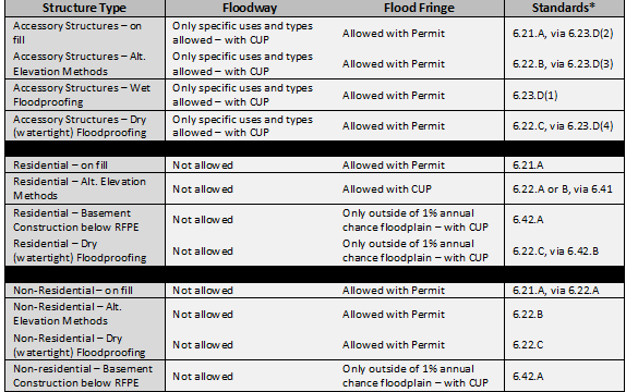
*Note - many of these standards are cross-referenced to avoid duplication
(Code 1996, § 17.30.040; Ord. No. 177-12, § 2, 3-12-2012)
Sec 66-701 Floodway District
(a) Permitted Uses in Floodway. Development allowed in the floodway district is limited to that which has low flood damage potential and will not obstruct flood flows, increase velocities, or increase the water surface elevations of the one-percent annual chance flood. The following uses and activities may be allowed with a permit, subject to the standards in Section 66-701(a), if allowed in the underlying zoning district:
(1) Agricultural uses, recreational uses, parking lots, loading areas, airport landing strips, water control structures, navigational facilities, as well as public open space uses. (2) Roads, railroads, trails, bridges, and culverts. (3) Public utility facilities and water-oriented industries which must be in or adjacent to watercourses. (4) Grading, filling, land alterations, and shoreline stabilization projects. (5) No structures, as defined in Section 66-8, are allowed in the Floodway District, except structures accessory to the uses detailed in Sections 66-701(a)(1) and 66-701(c)(1), which require a CUP under Section 66-701(c)(2). (6) Levees or dikes intended to protect agricultural crops for a flood event equal to or less than the 10-percent annual chance flood event.
(b) Standards for Permitted Uses in Floodway. In addition to the applicable standards detailed in Section 66-700:
(1) The applicant must demonstrate that the development will not result in any of the following during the one- percent chance flood: cause a stage increase of 0.00 feet or greater, obstruct flood flows, or increase velocities. As part of this demonstration, the applicant shall document that there will not be any stage increase through hydrologic and hydraulic analysis performed by a professional engineer, or using other standard engineering practices (e.g. projects that restore the site to the previous cross-sectional area). This is commonly documented through a “no-rise certification.” (2) Any development that would result in a stage increases greater than 0.00 feet may only be allowed with a permit if the applicant has applied for and received approval for a Conditional Letter of Map Revision (CLOMR) in accordance with 44 CFR § 65.12. Map revisions must follow the procedures in Sections 66-707(a)(5). (3) Any development resulting in decreases to the water surface elevation of the base flood identified in the Flood Insurance Study requires a Letter of Map Revision (LOMR) following the procedures in Sections 66-705(a)(5) and 66-710. (4) Any development in the beds of public waters that will change the course, current or cross section is required to obtain a public waters work permit in accordance with Minnesota Statutes, section 103G.245 or a utility crossing license in accordance with Minnesota Statutes, section 84.415, from the Department of Natural Resources, or demonstrate that no permit is required, before applying for a local permit. (5) Any facility used by employees or the general public must be designed with a flood warning system acceptable to the Zoning Administrator that provides adequate time for evacuation, or be designed to ensure that within the area inundated during the base flood event, the depth (in feet) multiplied by the velocity (in feet per second) is less than four. (6) Fill and other land alteration activities must offer minimal obstruction to the flow of flood waters, and be protected from erosion and sediment entering surface waters by the use of vegetative cover, riprap or other methods as soon as possible.
(c) Conditional Uses in Floodway. The following uses and activities may be permitted as conditional uses, subject to the standards detailed in Sections 66-701(d) and 66-707(c), if otherwise allowed in the underlying zoning district:
(1) Commercial extractive uses, and storage and stockpiling yards. (2) Structures accessory to uses detailed in Sections 66-701(a)(1) and 66-701(c)(1).
(d) Standards for Conditional Uses in Floodway. In addition to the applicable standards detailed in Sections 66-700, 66- 701(b) and 66-707:
(1) Extractive uses and storage of materials require the completion of a site development and restoration plan, to be approved by the City of North Branch. (2) Accessory Structures. Structures accessory to the uses detailed in Sections 66-701(a)(1) and 66-701(c)(1) must be constructed and placed so as to offer a minimal obstruction to the flow of flood waters, and are subject to the standards in Section 66-702(b)(3) of this ordinance.
(Code 1996, § 17.30.050; Ord. No. 177-12, § 2, 3-12-2012)
Sec 66-702 Flood Fringe District
(a) Permitted Uses in Flood Fringe. Any uses or activities allowed in any applicable underlying zoning districts may be allowed with a permit, subject to the standards set forth in Sections 66-702(b), provided it does not constitute a public nuisance.
(b) Standards for Permitted Uses in Flood Fringe. In addition to the applicable standards detailed in Section 66-700:
(1) Residential Structures.
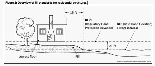
A. Elevation on Fill. All structures to be erected, constructed, reconstructed, altered, or moved on fill within the Flood Fringe District shall be placed so that the lowest floor, as defined in Section 66-8 of this ordinance, is elevated at or above the Regulatory Flood Protection Elevation (RFPE). The finished fill elevation shall be at or above the elevation associated with the base flood plus any stage increases that result from designation of a floodway. Fill must extend at the same elevation at least 15 feet beyond the outside limits of the structure. Elevations must be certified by a registered professional engineer, land surveyor or other qualified person designated by the Zoning Administrator. Elevation methods alternative to these fill standards are subject to a Conditional Use Permit, as provided in Section 6.31 of this ordinance (Figure 3).
(2) Nonresidential Principal Structures. Nonresidential principal structures must meet one of the following construction methods:
A. Elevation on Fill. Structures may be elevated on fill, meeting the standards in Section 66-702(b)(1)(A) of this ordinance. Fill for nonresidential structures is not required to be extended 15 feet beyond the outside limits of the structure. B. Alternative Elevation Methods. Structures may have their lowest floor elevated above the Regulatory Flood Protection Elevation (RFPE) using methods alternative to the fill standards in Section 66-702(b)(1)(A of this ordinance. Such methods include the use of blocks, pilings (Figure 4), filled stem walls (Figure 5), or internally- flooded enclosed areas (Figure 6) such as crawl spaces, attached garages, or tuck under garages.
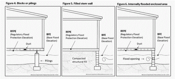
Designs accommodating for internally-flooded enclosed areas must be certified by a registered professional engineer or architect, or meet or exceed the standards detailed in FEMA Technical Bulletin 1, as amended, as well as the following standards:
(i) The floor of the enclosed area must be at or above the exterior grade on at least one side of the structure. (ii) To allow for the equalization of hydrostatic pressure, there shall be a minimum of two openings below the base flood elevation on at least two sides of the structure. The bottom of all openings shall be no higher than one foot above grade. The openings shall have a minimum net area of not less than one square inch for every square foot of enclosed area subject to flooding, have a net area of not less than one square inch for every square foot of enclosed area subject to flooding, and shall allow automatic entry and exit of floodwaters without human intervention. (iii) Internally flooded enclosed areas shall only be used for the parking of vehicles, building access, or storage. Such areas shall be subject to a deed-restricted non-conversion agreement or periodic inspections with the issuance of any permit.
C. Dry Floodproofing. Structures having watertight enclosed basements or spaces below the Regulatory Flood Protection Elevation (RFPE) must meet the following standards:
(i) Walls must be substantially impermeable to the passage of water, with structural components having the capacity of resisting hydrostatic and hydrodynamic loads and effects of buoyancy, at least up to the Regulatory Flood Protection Elevation (RFPE); (ii) Must meet the standards of FEMA Technical Bulletin 3, as amended; and (iii) A registered professional engineer or architect shall be required to certify that the design and methods of construction meet the standards detailed in this Section.
(3) Accessory Structures. All accessory structures must meet the following standards:
A. Structures shall not be designed or used for human habitation. B. Structures will have a low flood damage potential. C. Structures with fewer than two rigid walls, such as carports, gazebos, and picnic pavilions, may be located at an elevation below the Regulatory Flood Protection Elevation. D. Structures with two or more rigid walls, must meet one of the following construction methods:
(i) Wet Floodproofing. Structures may be floodproofed in a way to accommodate internal flooding. Such structures shall constitute a minimal investment not to exceed 576 square feet in size, one-story in height, and shall only be used for parking and storage. To allow for the equalization of hydrostatic pressure, there shall be a minimum of two openings on at least two sides of the structure and the bottom of all openings shall be no higher than one foot above grade. The openings shall have a minimum net area of not less than one square inch for every square foot of enclosed area subject to flooding, and shall allow automatic entry and exit of floodwaters without human intervention. (ii) Elevation on Fill. Structures may be elevated on fill, meeting the standards in Section 66-702(b)(1)(A) of this ordinance. Fill is not required to be extended 15 feet beyond the outside limits of the structure. (iii) Alternative Elevation Methods. Structures may have their lowest floor elevated above the Regulatory Flood Protection Elevation (RFPE) through methods alternative to the fill standards in Section 66-702(b)(3)(D)(ii), meeting the standards in Section 6.22.B of this ordinance. (iv) Dry Floodproofing. Structures may be dry-floodproofed, or watertight, meeting the standards in Section 66- 702(b)(2)(C) of this ordinance.
(4) Fill. The cumulative placement of fill or other materials for any purpose, up to 1,000 cubic yards, is permitted. Additional fill over 1,000 cubic yards is only permitted if the fill is specifically intended to elevate a structure in accordance with Section 66-702(b)(1) or 66-702(b)(2)(A) of this ordinance, or for a transportation project in accordance with Section 66-705(a). Fill over 1,000 cubic yards for purposes other than elevating a structure requires a conditional use permit as provided in Section 66-702(c)(2). Materials must be protected from erosion, discharge, and sediment entering surface waters by the use of vegetative cover or other methods as soon as possible.
(5) All new principal structures must provide for vehicular access no lower than one foot below the Base Flood Elevation (BFE), unless a flood warning/emergency evacuation plan has been approved by the City of North Branch.
(6) Any facilities used by employees or the general public must be designed with a flood warning system acceptable to the City of North Branch that provides adequate time for evacuation, or be designed to ensure that within the area inundated during the base flood event, the depth (in feet) multiplied by the velocity (in feet per second) is less than four.
(7) Manufactured homes and recreational vehicles must meet the standards of Section 66-706 of this ordinance.
(c) Conditional Uses in Flood Fringe. The following uses and activities may be permitted as conditional uses, subject to the standards in Sections 66-702(d) and 66-707(c), if otherwise allowed in the underlying zoning district:
(1) Alternative Elevation Methods – Residential Structures. Residential structures with their lowest floor elevated above the Regulatory Flood Protection Elevation (RFPE) using methods alternative to the fill requirements in Section 66-702(b)(1). (2) Fill. The cumulative placement of more than 1,000 cubic yards of fill or other materials, when the fill is not being used to elevate a structure or for a transportation project in accordance with Section 66-705(a).
(d) Standards for Conditional Uses in Flood Fringe. In addition to the applicable standards detailed in Sections 66-700, 66- 702(b) and 66-707(c):
(1) All residential structures with lowest floors elevated through alternative elevation methods must meet the standards for nonresidential structures in Section 66-702(b)(2)(A) or (B) of this ordinance. (2) The placement of more than 1,000 cubic yards of fill or other materials (other than for the purpose of elevating a structure to the RFPE) must comply with a site development and restoration plan approved by the Zoning Administrator. The plan must detail the anticipated topographic alterations and identify actions to be taken to mitigate environmental impacts, particularly erosion.
(Code 1996, § 17.30.060; Ord. No. 177-12, § 2, 3-12-2012)
Sec 66-703 General Floodplain District
(a) Permitted Uses in General Floodplain District
(1) The uses listed in the Floodway District, Section 66-701, of this ordinance are allowed with a permit or Conditional Use Permit. Development is also subject to the standards provided in this section. (2) All other uses are subject to a floodway/flood fringe determination as provided in Section 66-703(d), in addition to the standards provided in this section. Permitted uses shall be determined as follows:
A. If the development is determined to be in the Floodway District, Section 66-701 applies. B. If the development is determined to be in the Flood Fringe District, Section 66-702 applies.
(b) Standards for Determining Flood Elevations
(1) All development requires a determination of the Base Flood Elevation (BFE). Exceptions to this requirement include projects that restore the site to the previous cross-sectional area, such as shore stabilization or culvert replacement projects. Base Flood Elevations (BFE) may be found using best available data from any Federal, State, or other source (including MNDNR’s Lake & Flood Elevations Online (LFEO) Viewer). (2) The Regulatory Flood Protection Elevation (RFPE) can be determined by assuming a one-half (0.5) foot stage increase to accommodate for future cumulative impacts. A stage increase does not need to be assumed along lakes, wetlands, and other basins that are not affected by velocities.
(c) Encroachment Analysis
(1) Encroachments due to development may not allow stage increases more than one-half (0.5) foot at any point. This evaluation must include the cumulative effects of previous encroachments, and must be documented with hydrologic and hydraulic analysis performed by a professional engineer, or using other standard engineering practices. A lesser water surface elevation increase than one-half (0.5) foot is required if, due to the water surface level increase, increased flood damages would potentially result.
(d) Standards for the Analysis of Floodway Boundaries
(1) Requirements for Detailed Studies. Any development, as requested by the Zoning Administrator, shall be subject to a detailed study to determine the Regulatory Flood Protection Elevation (RFPE) and the limits of the Floodway District. This determination must be consistent with the minimum standards for hydrologic and hydraulic mapping standards and techniques, as detailed in Minnesota Rules, part 6120.5600, Subp. 4 and FEMA Guidelines and Standards for Flood Risk Analysis and Mapping, as revised. Additionally:
A. A regulatory floodway necessary to carry the discharge of the one-percent annual chance flood must be selected without increasing the water surface elevation more than one-half (0.5) foot at any point. This determination should include the cumulative effects of previous encroachments. A lesser water surface elevation increase than one-half (0.5) foot is required if, due to the water surface level increase, increased flood damages would potentially result; and B. An equal degree of encroachment on both sides of the stream within the reach must be assumed in computing floodway boundaries, unless topography, existing development patterns, and comprehensive land use plans justify a modified approach, as approved by the Department of Natural Resources.
(2) Other Acceptable Methods. For areas where a detailed study is not available or required:
A. Development prohibited in floodways (e.g. most buildings) requires a floodway/flood fringe determination to verify the development is within the flood fringe. This determination must be done by a professional engineer or utilize other accepted engineering practices. The Department of Natural Resources may also provide technical assistance and must approve any alternative methods used to determine floodway boundaries. B. For areas where the floodway has not been determined in and along lakes, wetlands, and other basins, the following methodology may be used as an alternative to Item A above, provided these areas are not affected by velocities and the lot is able to accommodate a building site above the Regulatory Flood Protection Elevation:
(i) All areas that are at or below the ordinary high water level, as defined in Minnesota Statutes, section 103G.005, Subd. 14, will be considered floodway, and all areas below the Base Flood Elevation (BFE) but above the ordinary high water level will be considered flood fringe, provided that within 25 feet of the ordinary high water level, or within the Shore Impact Zone as identified in the community’s Shoreland ordinance, whichever distance is greater, land alterations shall be restricted to:
(a) The minimum required to accommodate beach areas, access areas, and accessory structures as permitted, not to exceed a volume greater than 10 cubic yards; projects involving volumes exceeding 10 cubic yards require floodway/flood fringe determination in accordance with the procedures in Section 66-703(d)(2)(A); and (b) The minimum required to accommodate shoreline stabilization projects to correct an identified erosion problem as verified by a qualified resource agency or the zoning administrator.
(Code 1996, § 17.30.070; Ord. No. 177-12, § 2, 3-12-2012)
Sec 66-704 Subdivision Standards
(a) Subdivisions. All subdivisions must meet the following requirements. Manufactured home parks and recreational vehicle parks or campgrounds are considered subdivisions under this ordinance.
(1) No land may be subdivided which is unsuitable for reasons of flooding or inadequate drainage, specifically:
A. All lots within the floodplain districts must be able to contain a building site outside of the Floodway District at or above the Regulatory Flood Protection Elevation (RFPE); and B. The subdivision must be designed to provide adequate drainage to reduce exposure to flood hazards within the development and not increase runoff to adjoining areas.
(2) Subdivision of lands within the floodplain districts may not be approved if the cost of providing governmental services would impose an unreasonable economic burden on the City of North Branch.
(3) All subdivisions must have vehicular access both to the subdivision and to the individual building sites no lower than two feet below the Regulatory Flood Protection Elevation (RFPE), unless a flood warning/emergency evacuation plan has been approved by the City of North Branch.
(4) The Floodway and Flood Fringe District boundaries, the Regulatory Flood Protection Elevation (RFPE) and the required elevation of all access roads must be clearly labeled on all required subdivision drawings and platting documents.
(Code 1996, § 17.30.080; Ord. No. 177-12, § 2, 3-12-2012)
Sec 66-705 Railroads Roads Bridges And Public And Private Utilities And Service Facilities
(a) Public Transportation Facilities. Railroad tracks, roads, and bridges must be elevated to the Regulatory Flood Protection Elevation (RFPE) where such facilities are essential to the orderly functioning of the area, or where failure or interruption would result in danger to public health or safety. Minor or auxiliary roads or railroads may be constructed at a lower elevation where failure or interruption of transportation services would not endanger the public health or safety. All public transportation facilities should be designed to minimize increases in flood elevations.
(b) Public Utilities. All utilities such as gas, electrical, sewer, and water supply systems to be located in the floodplain must be elevated and/or floodproofed to the Regulatory Flood Protection Elevation (RFPE), be located and constructed to minimize or eliminate flood damage, and be designed to eliminate infiltration of flood waters into the systems and discharges from the systems into flood waters. All public utilities should be designed to minimize increases in flood elevations. New solid waste management facilities, as defined in Minnesota Rules, part 7035.0300, are prohibited in the one-percent annual chance floodplain. Water supply systems are subject to the provisions in Minnesota Rules, part 4725.4350.
(c) Private On-site Water Supply, Individual Sewage Treatment Systems, and other Service Facilities. Private facilities shall be subject to applicable provisions detailed in Section 9.2. In addition, new or replacement on-site sewage treatment systems are to be located to avoid impairment to them or contamination from them during times of flooding, shall not be located in a designated floodway, and are subject to the provisions in Minnesota Rules, parts 7080.2270.
(Code 1996, § 17.30.090; Ord. No. 177-12, § 2, 3-12-2012)
Sec 66-706 Manufactured Homes And Recreational Vehicles
(a) Manufactured Homes. Manufactured homes and manufactured home parks are subject to applicable standards for each floodplain district. In addition:
(1) New and replacement manufactured homes must be placed and elevated in compliance with Section 66-702 of this ordinance and must be securely anchored to a system that resists flotation, collapse and lateral movement. Methods of anchoring may include, but are not limited to, use of over-the-top or frame ties to ground anchors. (2) New manufactured home parks and expansions to existing manufactured home parks must meet the appropriate standards for subdivisions in Section 8.0 of this ordinance.
(b) Recreational Vehicles. New recreational vehicle parks or campgrounds and expansions to existing recreational vehicle parks or campgrounds are prohibited in any floodplain district. Recreational vehicles placed in existing recreational vehicle parks, campgrounds or lots of record in the floodplain must either:
(1) Meet the requirements for manufactured homes in Section 66-706(a), or (2) Be travel ready, meeting the following criteria:
A. The vehicle must be fully licensed. B. The vehicle must be ready for highway use, meaning on wheels or the internal jacking system, attached to the site only by quick disconnect type utilities. C. No permanent structural type additions may be attached to the vehicle. D. Accessory structures may be permitted in the Flood Fringe District, provided they do not hinder the removal of the vehicle should flooding occur, and meet the standards outlined in Sections 66-700 and 66-702(c).
(Code 1996, § 17.30.100; Ord. No. 177-12, § 2, 3-12-2012)
Sec 66-707 Administration
(a) Duties. A Zoning Administrator or other official must administer and enforce this ordinance.
(1) Permit Application Requirements. Permit applications must be submitted to the Zoning Administrator. The permit application must include the following, as applicable:
A. A site plan showing all existing or proposed buildings, structures, service facilities, potential obstructions, and pertinent design features having an influence on the permit. B. Location and detail of grading, fill, or storage of materials. C. Copies of any required local, state or federal permits or approvals. D. Other relevant information requested by the Zoning Administrator as necessary to properly evaluate the permit application.
(2) Recordkeeping. The Zoning Administrator must maintain applicable records in perpetuity documenting:
A. All certifications for dry floodproofing and alternative elevation methods, where applicable. B. Analysis of no-rise in the Floodway District, as detailed in Section 66-701(b)(1), and encroachment analysis ensuring no more than one-half foot of rise in the General Floodplain District, as detailed in Sections 66- 703(b)(2) and 66-703(c)(1). C. Final elevations, as applicable, detailing the elevation to which structures and improvements to structures are constructed or floodproofed. Elevations shall be determined by an engineer, architect, surveyor or other qualified individual, as approved by the Zoning Administrator. D. Substantial damage and substantial improvement determinations, as detailed in Section 66-708(a)(3), including the cost of improvements, repairs, and market value. E. All variance actions, including justification for their issuance, and must report such variances as requested by the Federal Emergency Management Agency.
(3) Certificate of Zoning Compliance for a New, Altered, or Nonconforming Use. No building, land or structure may be occupied or used in any manner until a certificate of zoning compliance has been issued by the Zoning Administrator stating that the finished fill and building floor elevations or other flood protection measures are in compliance with the requirements of this ordinance.
(4) Notifications for Watercourse Alterations. Before authorizing any alteration or relocation of a river or stream, the Zoning Administrator must notify adjacent communities. If the applicant has applied for a permit to work in public waters in accordance with Minnesota Statutes, section 103G.245, this will suffice as adequate notice. A copy of the notification must also be submitted to FEMA.
(5) Notification to FEMA When Physical Changes Increase or Decrease Base Flood Elevations. Where physical changes affecting flooding conditions may increase or decrease the water surface elevation of the base flood, the City of North Branch must notify FEMA of the changes in order to obtain a Letter of Map Revision (LOMR), by submitting a copy of the relevant technical or scientific data as soon as practicable, but no later than six months after the date such supporting information becomes available.
(b) Variances
(1) Variance Applications. An application for a variance to the provisions of this ordinance will be processed and reviewed in accordance with Minnesota Statutes, section 462.357, Subd. 6(2) and this ordinance. (2) Adherence to State Floodplain Management Standards. Variances must be consistent with the general purpose of these standards and the intent of applicable provisions in state and federal law. Though variances may be used to modify permissible methods of flood protection, no variance shall permit a lesser degree of flood protection than the Regulatory Flood Protection Elevation (RFPE). (3) Additional Variance Criteria. The following additional variance criteria of the Federal Emergency Management Agency must be satisfied:
A. Variances must not be issued by a community within any designated regulatory floodway if any increase in flood levels during the base flood discharge would result. B. Variances may only be issued by a community upon:
(i) A showing of good and sufficient cause; (ii) A determination that failure to grant the variance would result in exceptional hardship to the applicant; and (iii) A determination that the granting of a variance will not result in increased flood heights, additional threats to public safety, extraordinary public expense, create nuisances, cause fraud on or victimization of the public, or conflict with existing local laws or ordinances.
C. Variances may only be issued upon a determination that the variance is the minimum necessary, considering the flood hazard, to afford relief.
(4) Flood Insurance Notice. The Zoning Administrator must notify the applicant for a variance in writing that:
A. The issuance of a variance to construct a structure below the base flood level will result in increased premium rates for flood insurance up to amounts as high as $25 for $100 of insurance coverage; and B. Such construction below the base flood level increases risks to life and property. Such notification must be maintained with a record of all variance actions.
(5) Considerations for Approval. The community may consider the following factors in granting variances and imposing conditions on variances and conditional uses in floodplain districts:
A. The potential danger to life and property due to increased flood heights or velocities caused by encroachments. B. The danger that materials may be swept onto other lands or downstream to the injury of others. C. The safety of access to the property in times of flood for ordinary and emergency vehicles.
(6) Conditions of Approval. The City of North Branch may attach such conditions to the granting of variances and conditional use permits as it deems necessary to fulfill the purposes of this ordinance. Such conditions may include, but are not limited to, the following:
A. Limitations on period of use, occupancy, and operation. B. Imposition of operational controls, sureties, and deed restrictions. C. The prevention of soil erosion or other possible pollution of public waters, both during and after construction. D. Other conditions as deemed appropriate by the Zoning Administrator and City Council
(c) Conditional Uses.
(1) Administrative Review. An application for a conditional use permit will be processed and reviewed in accordance with the provisions in this ordinance. (2) Considerations for Approval. In passing upon conditional use applications, the City of North Branch must consider all relevant factors specified in other sections of this ordinance, including those detailed in Section 66-707(b)(5). (3) Conditions of Approval. In addition to the standards identified in Sections 66-701(d) and 66-702(d), the City of North Branch may attach such conditions to the granting of conditional use permits as it deems necessary to fulfill the purposes of this ordinance, including those detailed in Section 66-707(b)(6).
(d) Notifications to the Department of Natural Resources.
(1) All notices of public hearings to consider variances or conditional uses under this ordinance must be sent via electronic mail to the Department of Natural Resources respective area hydrologist at least ten (10) days before the hearings. Notices of hearings to consider subdivisions/plats must include copies of the subdivision/plat. (2) A copy of all decisions granting variances and conditional uses under this ordinance must be sent via electronic mail to the Department of Natural Resources respective area hydrologist within ten (10) days of final action.
(Code 1996, § 17.30.110; Ord. No. 177-12, § 2, 3-12-2012)
Sec 66-708 Nonconformities
(a) Continuance of Nonconformities. A use, structure, or occupancy of land which was lawful before the passage or amendment of this ordinance, but which is not in conformity with the provisions of this ordinance, may be continued subject to the following conditions:
(1) Within the floodway and general floodplain districts (when a site has been determined to be located in the floodway following the procedures in Section 66-703(c), or when the floodway has not been delineated), expansion or enlargement of uses or structures is prohibited. (2) Within all districts, any addition, modification, rehabilitation, repair, or alteration shall be in conformance with the provisions of this ordinance, shall not increase the flood damage potential or increase the degree of obstruction to flood flows, and where applicable, must be protected to the Regulatory Flood Protection Elevation (RFPE). (3) If any nonconforming structure is determined to be substantially damaged or substantially improved based on the procedures in Section 66-708(b), it may not be reconstructed except in conformity with the provisions of this ordinance. Existing structures within the regulatory floodplain, but outside of the one-percent annual chance floodplain, as detailed in Section 66-699(a)(3), are exempt from this provision. 12.14 If any nonconforming use, or any use of a nonconforming structure, is discontinued for more than one year, any future use of the premises must conform to this ordinance.
(b) Substantial Improvement and Substantial Damage Determinations. Prior to issuing any permits for additions, modifications, rehabilitations, repairs, alterations, or maintenance to nonconforming structures, the Zoning Administrator is required to determine if such work constitutes substantial improvement or repair of a substantially damaged structure. A determination must be made in accordance with the following procedures:
(1) Estimate the market value of the structure. In cases where the property has sustained damage, the market value of the structure shall be the market value before the damage occurred and before any restoration or repairs are made. (2) Estimate the cost of the project. The property owner shall accommodate for inspection, and furnish other documentation needed by the zoning administrator to evaluate costs.
A. Improvement costs shall be comprised of the market rate of all materials and labor, as well as the costs of all ordinary maintenance and upkeep carried out over the past one year. B. Costs to restore damages shall be comprised of the market rate of all materials and labor required to restore a building to its pre-damaged condition regardless of the work proposed, as well as associated improvement costs if structure is being restored beyond its pre-damaged condition.
(3) Compare the cost of the project and/or repairs to the estimated market value of the structure, and determine whether the proposed work constitutes substantial improvement or repair of a substantially damaged structure, as defined in Section 66-8 of this ordinance.
A. For the purposes of determining whether the proposed work would constitute substantial improvement, the evaluation shall also include all rehabilitations, additions, or other improvements completed since the community has adopted floodplain standards impacting this structure. B. If any nonconforming structure experiences a repetitive loss, as defined in Section 66-8 of this ordinance, it shall be considered substantially damaged and must not be reconstructed except in conformity with the provisions of this ordinance.
(4) Based on this determination, the zoning administrator shall prepare a determination letter and notify the property owner accordingly. Structures determined to be substantially damaged or substantially improved may not be reconstructed except in conformity with the provisions of this ordinance.
(Code 1996, § 17.30.120; Ord. No. 177-12, § 2, 3-12-2012)
Sec 66-709 Violations And Penalties
(1) Uses in Violation of the Ordinance. Every structure, fill, deposit, or other use placed or maintained in the floodplain in violation of this ordinance shall be considered a public nuisance.
(2) Civil Remedies. The creation of a public nuisance may be enjoined and the maintenance of a public nuisance under this ordinance may be abated by an action brought by the City of North Branch or the Department of Natural Resources.
(3) Enforcement. Violations of the provisions of this ordinance constitutes a misdemeanor and is punishable as defined by law. The Zoning Administrator may utilize the full array of enforcement actions available to it including but not limited to prosecution and fines, injunctions, after-the-fact permits, orders for corrective measures or a request to the National Flood Insurance Program for denial of flood insurance. The City of North Branch must act in good faith to enforce these official controls and to correct ordinance violations to the extent possible so as not to jeopardize its eligibility in the National Flood Insurance Program.
(Code 1996, § 17.30.130; Ord. No. 177-12, § 2, 3-12-2012)
Sec 66-710 Amendments
(a) Ordinance Amendments. Any revisions to the floodplain maps by the Federal Emergency Management Agency or annexations of new map panels require an ordinance amendment to update the map references in Section 66-699(b) of this ordinance.
(b) Required Approval. All amendments to this ordinance must be submitted to the Department of Natural Resources for review and approval prior to adoption, for compliance with state and federal rules and requirements. The floodplain ordinance shall not be considered valid until approved.
Sec 66-732 Statutory Authorization And Policy
- Statutory authorization. This shoreland management overlay district is adopted pursuant to the authorization and policies contained in Minn. Stats. ch. 103F, Minnesota Regulations Parts 6120.2500—6120.3900, and the planning and zoning enabling legislation in Minn. Stats., ch. 462.
- Policy. The uncontrolled use of shorelands of the city affects the public health, safety, and general welfare not only by contributing to pollution of public waters, but also by impairing the local tax base. Therefore, it is in the best interests of the public health, safety and welfare to provide for the wise subdivision, use, and development of shorelands of public waters. The Legislature of the state has delegated responsibility to local governments of the state to regulate the subdivision, use, and development of the shorelands of public waters and thus preserve and enhance the quality of surface waters, conserve the economic and natural environmental values of shorelands, and provide for the wise use of waters and related land resources. This responsibility is hereby recognized by the city.
(Code 1996, § 17.32.010)
Sec 66-733 District Application
(Code 1996, § 17.32.020)
Sec 66-734 General Provisions And Definitions
- Jurisdiction. The provisions of this district shall apply to the shorelands of the public water bodies as classified in section 66-736. Pursuant to Minnesota Regulations, Parts 6120.2500—6120.3900, no lake, pond, or flow-age less than ten acres in size need be regulated in a local government's shoreland regulations. A body of water created by a private user where there was no previous shoreland may, at the discretion of the governing body, be exempt from this division.
- Boundaries. Shoreland areas are defined as land located within the following distances from public waters:
- One thousand feet from the ordinary high water level of a lake, pond, or flowage; and
- Three hundred feet from a river or stream, or the landward extent of a floodplain designated by this division on a river or stream, whichever is greater.
The limits of shorelands may be reduced whenever the waters involved are bounded by topographic divides which extend landward from the waters for lesser distances and when approved by the commissioner.
- One thousand feet from the ordinary high water level of a lake, pond, or flowage; and
- Compliance. The use of any shoreland of public waters; the size and shape of lots; the use, size, type, and location of structures on lots; the installation and maintenance of water supply and waste treatment systems, the grading and filling of any shoreland area; the cutting of shoreland vegetation; and the subdivision of land shall be in full compliance with the terms of this division and other applicable regulations.
- Enforcement. The city is responsible for the administration and enforcement of this division. Any violation of the provisions of this division or failure to comply with any of its requirements (including violations of conditions and safeguards established in connection with grants of variances or conditional uses) shall constitute a misdemeanor and shall be punishable as defined by law. Violations of this division can occur regardless of whether or not a permit is required for a regulated activity pursuant to section 66-735(a).
- Interpretation. In their interpretation and application, the provisions of this division shall be held to be minimum requirements and shall be liberally construed in favor of the governing body and shall not be deemed a limitation or repeal of any other powers granted by state statutes.
- Abrogation and greater restrictions. It is not intended by this division to repeal, abrogate, or impair any existing easements, covenants, or deed restrictions. However, where this division imposes greater restrictions, the provisions of this division shall prevail. All other ordinances inconsistent with this division are hereby repealed to the extent of the inconsistency only.
- Definitions. Unless specifically defined in the definitions section of this chapter, words or phrases used in this division shall be interpreted so as to give them the same meaning as they have in common usage and so as to give this division its most reasonable application. For the purpose of this division, the words "must" and "shall" are mandatory and not permissive. All distances, unless otherwise specified, shall be measured horizontally.
(Code 1996, § 17.32.030)
Sec 66-735 Administration
- Permit required.
- A permit is required for the construction of buildings or building additions (and including such related activities as construction of decks and signs), the installation and/or alteration of sewage treatment system, and those grading and filling activities not exempted by section 66-737(c). Application for a permit shall be made to the planning director on forms provided. The application shall include the necessary information so that the site's suitability for the intended use can be determined and that a complete sewage treatment system will be provided.
- A permit authorizing an addition to an existing structure shall stipulate that an identified nonconforming sewage treatment system, as defined by section 66-737(h) shall be reconstructed or replaced in accordance with the provisions of this division.
- A permit is required for the construction of buildings or building additions (and including such related activities as construction of decks and signs), the installation and/or alteration of sewage treatment system, and those grading and filling activities not exempted by section 66-737(c). Application for a permit shall be made to the planning director on forms provided. The application shall include the necessary information so that the site's suitability for the intended use can be determined and that a complete sewage treatment system will be provided.
- Certificate of zoning compliance. The planning director shall issue a certificate of zoning compliance for each activity requiring a permit as specified in subsection (a). This certificate will specify that the use of land conforms to the requirements of this division. Any use, arrangement, or construction at variance with that authorized by permit shall be deemed a violation of this division and shall be punishable as provided in section 66-734(d).
- Variances.
- Variances may only be granted in accordance with Minn. Stats. ch. 462, as applicable. A variance may not circumvent the general purposes and intent of this division. No variance may be granted that would allow any use that is prohibited in the zoning district in which the subject property is located. Conditions may be imposed in the granting of a variance to ensure compliance and to protect adjacent properties and the public interest. In considering a variance request, the planning agency and the city council must also consider whether the property owner has reasonable use of the land without the variance, whether the property is used seasonally or year-round, whether the variance is being requested solely on the basis of economic considerations, and the characteristics of development on adjacent properties.
- The city council shall hear and decide requests for variances in accordance with the rules that it has adopted for the conduct of business. When a variance is approved after the department of natural resources has formally recommended denial in the hearing record, the notification of the approved variance required in subsection (d) of this section shall also include the planning commission summary of the public record/testimony and the findings of facts and conclusions which supported the issuance of the variance and shall also consider the conclusion and recommendations of the planning agency.
- For existing developments, the application for variance must clearly demonstrate whether a conforming sewage treatment system is present for the intended use of the property. The variance, if issued, must require reconstruction of a nonconforming sewage treatment system.
- Variances may only be granted in accordance with Minn. Stats. ch. 462, as applicable. A variance may not circumvent the general purposes and intent of this division. No variance may be granted that would allow any use that is prohibited in the zoning district in which the subject property is located. Conditions may be imposed in the granting of a variance to ensure compliance and to protect adjacent properties and the public interest. In considering a variance request, the planning agency and the city council must also consider whether the property owner has reasonable use of the land without the variance, whether the property is used seasonally or year-round, whether the variance is being requested solely on the basis of economic considerations, and the characteristics of development on adjacent properties.
- Notifications to the department of natural resources.
- Copies of all notices of any public hearings to consider variances, amendments, or conditional uses under local shoreland management controls must be sent to the commissioner or the commissioner's designated representative and postmarked at least ten days before the hearings. Notices of hearings to consider proposed subdivisions/plans must include copies of the subdivision/plat.
- A copy of approved amendments and subdivisions/plats, and final decisions granting variances or conditional uses under local shoreland management controls must be sent to the commissioner or the commissioner's designated representative and postmarked within ten days of final action.
- Copies of all notices of any public hearings to consider variances, amendments, or conditional uses under local shoreland management controls must be sent to the commissioner or the commissioner's designated representative and postmarked at least ten days before the hearings. Notices of hearings to consider proposed subdivisions/plans must include copies of the subdivision/plat.
(Code 1996, § 17.32.040)
Sec 66-736 Shoreland Classification System And Land Use Districts
- Shoreland classification system. The public waters of the city have been classified below consistent with the criteria found in Minnesota Regulations, part 6120.3300 and the protected water inventory map for the county.
- The shoreland area for the waterbodies listed in subsections (a)(2) and (3) of this section shall be defined in section 66-734(a) and as shown on the official zoning map.
- Lakes.
Protected Waters Inventory ID # General Development Lakes Mud Lake 13-66 Recreational Development Lakes Chain Lake 13-66 - Rivers.
Class River From To T, Transitional Sunrise Border of Chisago and Isanti Counties I-35, section 17, T35N, R21W U, Urban Sunrise I-35, section 17, T35N, R21 East section line, section 21W, T35N, R21 A, Agriculture Sunrise West section line, section 22, T35N, R21W East section line, section 24, T35N, R21W TR, Tributary Haycreek Section 2, T35N, R21W Section 12, T35N, R21W Unnamed to NBSR Section 28, T35N, R21W Section 22, T35N, R21W Unnamed to NBSR Section 30, T35N, R21W Section 19, T35N, R21W Unnamed to NBSR Section 34, T35N, R21W Section 23, T35N, R21W
- The shoreland area for the waterbodies listed in subsections (a)(2) and (3) of this section shall be defined in section 66-734(a) and as shown on the official zoning map.
- Land use district descriptions.
- Criteria for designation. The land use districts in subsection (b)(2) of this section and delineation of a land use district's boundaries on the official zoning map, must be consistent with the goals, policies, and objectives of the city's comprehensive land use plan and the following criteria, considerations, and objectives:
- General considerations and criteria for all land uses:
- Preservation of natural areas;
- Present ownership and development of shoreland areas;
- Shoreland soil types and their engineering capabilities;
- Topographic characteristics;
- Vegetative cover;
- In-water physical characteristics, values, and constraints;
- Recreational use of the surface water;
- Road and service center accessibility;
- Socioeconomic development needs and plans as they involve water and related land resources;
- The land requirements of industry which, by its nature, requires location in shoreland areas; and
- The necessity to preserve and restore certain areas having significant historical or ecological value.
- Factors and criteria for planned unit developments (PUDs):
- Existing recreational use of the surface waters and likely increases in use associated with PUDs;
- Physical and aesthetic impacts of increased density;
- Suitability of lands for the PUD approach;
- Level of current development in the area; and
- Amounts and types of ownership of undeveloped lands.
- General considerations and criteria for all land uses:
- Land use descriptions. The land use districts provided below, and the allowable land uses therein for the given classifications of waterbodies, shall be properly delineated on the official zoning map for the shorelands of the city. These land use districts are in conformance with the criteria specified in Minnesota regulations, pt. 6120.3200, subp. 3 listed below:
- A special protection district is intended to be used for two basic purposes. The first purpose is to limit and properly manage development in areas that are generally unsuitable for development or uses due to flooding, erosion, limiting soil conditions, steep slopes or other major physical constraints. A second purpose is to manage and preserve areas with special historical, natural or biological characteristics.
- A residential district is primarily intended to allow low to medium density seasonal and year-round residential uses on lands suitable for such uses. It is also intended to prevent establishment of various commercial, industrial and other uses in these areas that cause conflicts or problems for residential uses. Some nonresidential uses with minimal impacts on residential uses are allowed if properly managed under conditional use procedures.
- A high-density residential district is intended for use on lands with heterogeneous mixes of soils, vegetation and topography that are not well suited to residential development using standards, lot-block subdivisions. This approach enables such areas to be developed, often even with higher than lot-block densities, while also avoiding and preserving unsuitable terrain and soils. Other compatible uses such as residential planned unit development, surface water-oriented commercial, multiple unit single-family, parks, historic sites, and semi-public, and also allowed, primarily as conditional uses.
- A water-oriented commercial district is intended to be used only to provide for existing or future commercial uses adjacent to water resources that are functionally dependent on such close proximity.
- A general use district is intended to be used only for lands already developed or suitable for development with concentrated urban, particularly commercial, land uses. It should not generally be used on natural environment lakes or remote river classes. Several other intensive urban uses such as industrial and commercial planned unit development are allowed in this district if handled as conditional uses.
- Criteria for designation. The land use districts in subsection (b)(2) of this section and delineation of a land use district's boundaries on the official zoning map, must be consistent with the goals, policies, and objectives of the city's comprehensive land use plan and the following criteria, considerations, and objectives:
- Land uses for lakes. The following are the allowable land uses for lakes:
P = Permitted Use
C = Conditional Use*As accessory to a residential planned unit development.General Development Lakes Recreational Development Lakes (1) Special Protection AG District Uses: Forest Management P P Sensitive resource management P P Agricultural: cropland and pasture P P Agricultural: feedlots C C Parks and historic sites C C Single residential P P Mining of metallic minerals and peat P P (2) Residential RR, R-1 and Conservation District Uses Single residential P P Semipublic C C Parks and historic sites C C Agricultural: cropland and pasture (RR & CS only, see section 66-737(f)(2)b.) P P (3) High Density R-2 and R-3 District Uses: Residential planned unit developments* C C Single residential P P Semipublic C C Parks and historic sites C C Duplex, triplex and quad residential P P (4) Water-Oriented Commercial CBD, B-2, B-3 District Uses: Surface water-oriented commercial P P Commercial planned unit developments** C C Public, semipublic C C Parks and historic site C C Forest management P P (5) General Development B-2, B-3, I-1 and I-2 District Uses: Commercial P P Commercial planned unit developments** C C Industrial (I only) C C Public, semipublic P P Parks and historic sites C C Forest management P P
**Limited expansion of a commercial planned unit development involving up to six additional dwelling units or sites may be allowed as a permitted use provided the provisions of section 66-740 are satisfied. - Land uses for transition, agriculture and tributary rivers and streams. The following are the allowable land uses for transition, agriculture and tributary rivers and streams:
P = Permitted Use
C = Conditional Use*As accessory to a residential planned unit development.Transitional Agricultural Tributary (1) Special Protection AG District Uses: Forest management P P P Sensitive resource management P P P Agricultural: cropland and pasture P P P Agricultural: feedlots C C C Parks and historic sites C C C Single residential P P P Mining of metallic minerals and peat P P P (2) Residential RR, R-1 and Conservation District Uses: Single Residential P P P Semipublic C C P Parks and historic sites C C P Forest management P P P Agricultural: cropland and pasture(CS &RR only, see section 66-737(f)(2)b.) P P P (3) High Density Residential R-2 and R-3 District Uses: Residential planned unit development C C C Single residential P P P Semipublic C C C Parks and historic sites C C C Duplex, triplex and quad residential P P P (4) Water-Oriented Commercial CBD, B-2 and B-3 District Uses: Surface water-oriented commercial C C C Commercial planned unit development* C C C Public, semipublic P P P Parks and historic sites C C C Forest management P P P (5) General Commercial B-2, B-3, I-1 and I-2 District Uses: Commercial C C C Commercial planned unit development** C C C Industrial (I2 only) N N C Public, semipublic C C C Parks and historic sites C C C Forest management P P P
**Limited expansion of a commercial planned unit development involving up to six additional dwelling units or sites may be allowed as a permitted use provided the provisions of section 66-739 are satisfied.
(Code 1996, § 17.32.050)
Sec 66-737 Zoning And Water Supply/Sanitary Provisions
- Lot area and width standards. The lot area (in square feet) and lot width standards (in feet) for single, duplex, triplex and quad residential lots created after the date of enactment of this division for the lake and river/stream classifications are the following:
- Unsewered lakes.
- General development.
Riparian Lots Nonriparian Lots Area Width Area Width Single 40,000 150' 40,000 150' Duplex 40,000 180' 80,000 265' Triplex 60,000 260' 120,000 375' Quad 80,000 340' 160,000 490' - Recreational development.
Riparian Lots Nonriparian Lots Area Width Area Width Single 40,000 150' 40,000 150' Duplex 80,000 135' 80,000 265' Triplex 120,000 195' 120,000 375' Quad 160,000 255' 160,000 490'
- General development.
- Sewered lakes.
- General development.
Riparian Lots Nonriparian Lots Area Width Area Width Single 15,000 75' 10,000 75' Duplex 26,000 135' 17,500 135' Triplex 38,000 195' 25,000 190' Quad 49,000 255' 32,500 245' - Recreational development.
Riparian Lots Nonriparian Lots Area Width Area Width Single 20,000 75' 15,000 75' Duplex 35,000 135' 26,000 135' Triplex 50,000 195' 38,000 190' Quad 65,000 255' 49,000 245'
- General development.
- River/stream lot width standards. There are no minimum lot size requirements for rivers and streams. The lot width standards for single, duplex, triplex, and quad residential developments for the six river/stream classifications are:
Tributary Tributary Transition Agriculture Sewer No Sewer Single 150' 75' 100' Duplex 225' 115' 150' Triplex 300' 150' 200' Quad 375' 190' 250' - Additional special provisions.
- Residential subdivisions with dwelling unit densities exceeding those in the tables in subsection (a)(2) and (3) can only be allowed if designed and approved as residential PUDs under section 66-740. Only land above the ordinary high water level of public waters can be used to meet lot area standards, and lot width standards must be met at both the ordinary high water level and at the building line. The sewer lot area dimensions in subsection (a)(2) can only be used if publicly owned sewer system service is available to the property.
- One guest cottage may be allowed on lots meeting or exceeding the duplex lot area and width dimensions presented in subsection (a)(1)—(3) provided the following standards are met:
- For lots exceeding the minimum lot dimensions of duplex lots, the guest cottage must be located within the smallest duplex sized lot that could be created including the principal dwelling unit;
- A guest cottage must not cover more than 700 square feet of land surface and must not exceed 15 feet in height; and
- A guest cottage must be located or designed to reduce its visibility as viewed from public waters and adjacent shorelands by vegetation, topography, increased setbacks or color, assuming summer leaf-on conditions.
- Lots intended as controlled accesses to public waters or as recreation areas for use by owners of nonriparian lots within subdivisions are permissible and must meet or exceed the following standards:
- They must meet the width and size requirements for residential lots, and be suitable for the intended uses of controlled access lots.
- If docking, mooring, or over-water storage of more than six watercraft to be allowed at a controlled access lot, then the width of the lot (keeping the same lot depth) must be increased by the percent of the requirements for riparian residential lots for each watercraft beyond six, consistent with the following table:
Controlled Access Lot Frontage RequirementsRation of Lake Size to Shore Length Required Increase in Frontage (Acres/Miles) Percent Less than 100 25 101 to 200 20 201 to 300 15 301 to 400 10 Greater than 400 5 - They must be jointly owned by all purchasers of lots in the subdivision or by all purchasers of nonriparian lots in the subdivision who are provided riparian access rights on the access lot.
- Covenants or other equally effective legal instruments must be developed that specify which lot owners have authority to use the access lot and what activities are allowed. The activities may include watercraft launching, loading, storage, beaching, mooring, or docking. They must also include other outdoor recreational activities that do not significantly conflict with the general public use of the public water or the enjoyment of normal property rights by adjacent property owners. Examples of the nonsignificant conflict activities include swimming, sunbathing, or picnicking. The covenants must limit the total number of vehicles allowed to be parked and the total number of watercraft allowed to be continuously moored, docked, or stored over water, and must require centralization of all common facilities and activities in the most suitable locations on the lot to minimize topographic and vegetation alterations. They must also require all parking areas, storage buildings, and other facilities to be screened by vegetation or topography as much as practical from view from the public water, assuming summer leaf-on conditions.
- Unsewered lakes.
- Placement, design, and height of structures.
- Placement of structures on lots. When more than one setback applies to a site, structures and facilities must be located to meet all setback. Where structures exist on the adjoining lots on both sides of a proposed building site, structure setbacks may be altered without a variance to conform to the adjoining setbacks from the ordinary high water level, provided the proposed building site is not located in a shore impact zone or in a bluff impact zone. Structures shall be located as follows:
- Structure and on-site sewage system setbacks (in feet) from ordinary high water level.*
Setbacks**One water-oriented accessory structure designed in accordance with subsection (b)(2) of this section may be set back a minimum distance of ten feet from the ordinary high water level.Class of Public Waters Structures Unsewered Structures Sewered Sewage Treatment System Lakes General development 75' 50' 50' Recreational 100' 75' 75' Rivers Transition 150' 150' 100' Agriculture 100' 50' 75' Tributary 100' 50' 75' - Additional structure setbacks. The following additional structure setbacks apply, regardless of the classification of the water body.
Additional Structure SetbacksSetback From: Setback (in feet): Top of bluff 30 Unplatted cemetery 50 Right-of-way line of federal, state, or county highway 50 Right-of-way line of town road, public street, or other roads or streets not classified 20 - Bluff impact zones. Structures and accessory facilities, except stairways and landings, must not be placed within bluff impact zones.
- Uses without water-oriented needs. Uses without water-oriented needs must be located on lots or parcels without public water frontage, or, if located on lots or parcels with public water frontage, must either be set back double the normal ordinary high water level setback or be substantially screened from view from the water by vegetation or topography, assuming summer leaf-on conditions.
- Structure and on-site sewage system setbacks (in feet) from ordinary high water level.*
- Design criteria for structures.
- High water elevations. Structures must be placed in accordance with any floodplain regulations applicable to the site. Where these controls do not exist, the elevation to which the lowest floor, including basement, is placed or floodproofed must be determined as follows:
- For lakes, by placing the lowest floor at a level at least three feet above the highest known water level, or three feet above the ordinary high water level, whichever is higher.
- For rivers and streams, by placing the lowest floor at least three feet above the flood of record, if data is available. If data is not available, by placing the lowest floor at least three feet above the ordinary high water level, or by conducting a technical evaluation to determine effects of proposed construction upon flood stages and flood flows and to establish a flood protection elevation. Under all three approaches, technical evaluations must be done by a qualified engineer or hydrologist consistent with parts 6120.5000 to 6120.6200 governing the management of floodplain areas. If more than one approach is used, the highest flood elevation determined must be used for placing structures and other facilities.
- Water-oriented accessory structures may have the lowest floor placed lower than the elevation determined in this time if the structure is constructed of flood-resistant materials to the elevation, electrical and mechanical equipment is placed above the elevation and, if long duration flooding is anticipated, the structure is built to withstand ice action and wind driven waves and debris.
- Water-oriented accessory structures. Each lot may have one water-oriented accessory structure not meeting the normal structure setback in subsection (b)(1) of this section if the water-oriented accessory structure complies with the following provisions:
- The structure or facility must not exceed ten feet in height, exclusive of safety rails, and cannot occupy an area greater than 250 square feet. Detached decks must not exceed eight feet above grade at any point;
- The setback of the structure or facility from the ordinary high water level must be at least ten feet;
- The structure or facility must be treated to reduce visibility as viewed from public waters and adjacent shorelands by vegetation, topography, increased setbacks or color, assuming summer leaf-on conditions;
- The roof may be used as a deck with safety rails, but must not be enclosed or used as a storage area;
- The structure or facility must not be designed or used for human habitation and must not contain water supply or sewage treatment facilities; and
- As an alternative for general development and recreational development waterbodies, water-oriented accessory structures used solely for watercraft storage, and including storage of related boating and water-oriented sporting equipment, may occupy an area up to 400 square feet, provided the maximum width of the structure is 20 feet as measured parallel to the configuration of the shoreline.
- Stairways, lifts, and landings. Stairways and lifts are the preferred alternative to major topographic alterations for achieving access up and down bluffs and steep slopes to shore areas. Stairways and lifts must meet the following design requirements:
- Stairways and lifts must not exceed four feet in width on residential lots. Wider stairways may be used for commercial properties, public open space recreational properties, and planned unit developments;
- Landings for stairways and lifts on residential lots must not exceed 32 square feet in area. Landings larger than 32 square feet may be used for commercial properties, public open space recreational properties, and planned unit developments;
- Canopies or roofs are not allowed on stairways, lifts, or landings;
- Stairways, lifts, and landings may be either constructed above the ground on posts or pilings, or placed into the ground, provided they are designed and built in a manner that ensures control of soil erosion;
- Stairways, lifts, and landings must be located in the most visually inconspicuous portions of lots, as viewed from the surface of the public water assuming summer leaf-on conditions, whenever practical; and
- Facilities such as ramps, lifts, or mobility paths for physically handicapped persons are also allowed for achieving access to shore areas, provided that the dimensional and performance standards of subsections 66-737(b)(2)b.1.—5. are complied with in addition to the requirements of Minnesota Regulations, ch. 1340.
- Significant historic sites. No structure may be placed on a significant historic site in a manner that affects the values of the site unless adequate information about the site has been removed and documented in a public repository.
- Steep slopes. The planning director or the city engineer must evaluate possible soil erosion impacts and development visibility from public waters before issuing a permit for construction of sewage treatment systems, roads, driveways, structures, or other improvements on steep slopes. When determined necessary, the city will attach conditions to permits to prevent erosion and to preserve existing vegetation screening of structures, vehicles, and other facilities as viewed from the surface of public waters, assuming summer leaf-on vegetation.
- High water elevations. Structures must be placed in accordance with any floodplain regulations applicable to the site. Where these controls do not exist, the elevation to which the lowest floor, including basement, is placed or floodproofed must be determined as follows:
- Height of structures. All structures in residential districts, except churches and nonresidential agricultural structures, must not exceed 25 feet in height unless otherwise regulated in the ordinances.
- Placement of structures on lots. When more than one setback applies to a site, structures and facilities must be located to meet all setback. Where structures exist on the adjoining lots on both sides of a proposed building site, structure setbacks may be altered without a variance to conform to the adjoining setbacks from the ordinary high water level, provided the proposed building site is not located in a shore impact zone or in a bluff impact zone. Structures shall be located as follows:
- Shoreland alteration. Alterations of vegetation and topography will be regulated to prevent erosion into public waters, fix nutrients, preserve shoreland aesthetics, preserve historic values, prevent bank slumping, and protect fish and wildlife habitat.
- Vegetation alterations.
- Vegetation alteration necessary for the construction of structures and sewage treatment systems and the construction of roads and parking areas regulated by subsection (d) of this section are exempt from the vegetation alteration standards that follow.
- Removal or alteration of vegetation, except for agricultural and forest management uses as regulated in subsection (f)(2) and (3) of this section, respectfully, is allowed subject to the following standards:
- Intensive vegetation clearing within the shore and bluff impact zones and on steep slopes is not allowed. Intensive vegetation clearing for forest land conversion to another use outside of these areas is allowable as a conditional use if an erosion control and sedimentation plan is developed and approved by the soil and water conservation district in which the property is located.
- In shore and bluff impact zones and on steep slopes, limited clearing of trees and shrubs and cutting, pruning, and trimming of trees is allowed to provide a view to the water from the principal dwelling site and to accommodate the placement of stairways and landings, picnic areas, access paths, livestock watering areas, beach and watercraft access areas, and permitted water-oriented accessory structures or facilities, provided that:
- The screening of structures, vehicles, or other facilities as viewed from the water, assuming summer leaf-on conditions, is not substantially reduced;
- Along rivers, existing shading of water surfaces is preserved; and
- The above provisions are not applicable to the removal of trees, limbs, or branches that are dead, diseased, or pose safety hazards.
- Topographic alteration/grading and filling.
- Grading and filling and excavations necessary for the construction of structures, sewage treatment systems, and driveways under validly issued construction permits for these facilities do not require the issuance of a separate grading and filling permit. However, the grading and filling standards in this section must be incorporated into the issuance of permits for construction of structures, sewage treatment systems, and driveways.
- Public roads and parking areas are regulated by subsection (d) of this section.
- Notwithstanding subsections a. and b. of this section, a grading and filling permit will be required for:
- The movement of more than ten cubic yards of material on steep slopes or within shore or bluff impact zones; and
- The movement of more than 50 cubic yards of material outside of steep slopes and shore and bluff impact zones.
- The following considerations and conditions must be adhered to during the issuance of construction permits, grading and filling permits, conditional use permits, variances, and subdivision approvals:
- Grading or filling in any Type 2, 3, 4, 5, 6, 7, or 8 wetland must be evaluated to determine how extensively the proposed activity would affect the following functional qualities of the wetland:
- Sediment and pollution trapping and retention;
- Storage of surface runoff to prevent or reduce flood damage;
- Fish and wildlife habitat;
- Recreational use;
- Shoreline or bank stabilization; and
- Noteworthiness, including special qualities such as historic significance, critical habitat for endangered plants and animals, or others.
The applicant is responsible for determining whether the wetland alteration being proposed requires permits, reviews, or approvals by other local, state, or federal agencies such as a watershed district, the department of natural resources, or the United States Army Corps of Engineers. Documentation of such is required prior to issuance of permits.
- Alterations must be designed and conducted in a manner that ensures only the smallest amount of bare ground is exposed for the shortest time possible;
- Mulches or similar materials must be used, where necessary, for temporary bare soil coverage, and permanent vegetation cover must be established as soon as possible;
- Methods to minimize soil erosion and to trap sediments before they reach any surface water feature must be used;
- Altered areas must be stabilized to acceptable erosion control standards consistent with the field office technical guides of the local soil and water conservation districts and the United States Soil Conservation Service;
- Fill or excavated material must not be placed in a manner that creates an unstable slope;
- Plans to place fill or excavated material on steep slopes must be reviewed by qualified professionals for continued slope stability and must not create finished slopes of 30 percent or greater;
- Fill or excavated material must not be placed in bluff impact zones;
- Any alterations below the ordinary high water level of public waters must first be authorized by the commissioner under Minn. Stats. § 103G.245;
- Alterations of topography must only be allowed if they are accessory to permitted or conditional uses and do not adversely affect adjacent or nearby properties; and
- Placement of natural rock riprap, including associated grading of the shoreline and placement of a filter blanket, is permitted if the finished slope does not exceed three feet horizontal to one foot vertical, the landward extent of the riprap is within ten feet of the ordinary high water level, and the height of the riprap above the ordinary high water level does not exceed three feet.
- Grading or filling in any Type 2, 3, 4, 5, 6, 7, or 8 wetland must be evaluated to determine how extensively the proposed activity would affect the following functional qualities of the wetland:
- Connections to public waters. Excavations where the intended purpose is connection to a public water, such as boat slips, canals, lagoons, and harbors, must be controlled by local shoreland controls. Permission for excavations may be given only after the commissioner has approved the proposed connection to public waters.
- Vegetation alterations.
- Placement and design of roads, driveways, and parking areas.
- Public and private roads and parking areas must be designed to take advantage of natural vegetation and topography to achieve maximum screening from view from public waters. Documentation must be provided by a qualified individual that all roads and parking areas are designed and constructed to minimize and control erosion to public waters consistent with the field office technical guides of the local soil and water conservation district, or other applicable technical materials.
- Roads, driveways, and parking areas must meet structure setbacks and must not be placed within bluff and shore impact zones, when other reasonable and feasible placement alternatives exist. If no such alternatives exist, they may be placed within these areas, and must be designed to minimize adverse impacts.
- Public and private watercraft access ramps, approach roads, and access-related parking areas may be placed within shore impact zones provided the vegetative screening and erosion control conditions of this subpart are met. For private facilities, the grading and filling provisions of subsection (c)(2) of this section must be met.
- Stormwater management. The following general and specific standards shall apply:
- General standards.
- When possible, existing natural drainage ways, wetlands, and vegetated soil surfaces must be used to convey, store, filter, and retain stormwater runoff before discharge to public waters.
- Development must be planned and conducted in a manner that will minimize the extent of disturbed areas, runoff velocities, erosion potential, and reduce and delay runoff volumes. Disturbed areas must be stabilized and protected as soon as possible and facilities or methods used to retain sediment on the site. Erosion and sediment control best management practices shall meet the standards of the city's engineering design standards for stormwater management.
- When development density, topographic features, and soil and vegetation conditions are not sufficient to adequately handle stormwater runoff using natural features and vegetation, various types of constructed facilities such as diversions, settling basins, skimming devices, dikes, waterways, and ponds may be used to control and regulate stormwater. Preference must be given to designs using surface drainage, vegetation, and infiltration rather than buried pipes and manmade materials and facilities. Stormwater management best management practices shall meet the standards contained in chapter 58, section 58-260, approval standards and the city's engineering design standards for stormwater management.
- Specific standards.
- Impervious surface coverage of lots must not exceed 25 percent of the lot area.
- When constructed facilities are used for stormwater management, documentation must be provided by a qualified individual that they are designed and installed consistent with the field office technical guide of the local soil and water conservation districts.
- Newly constructed stormwater outfalls to public waters must provide for filtering or settling of suspended solids and skimming of surface debris before discharge.
- General standards.
- Special provisions for commercial, industrial, public/semipublic, agricultural and forestry.
- Standards for commercial, industrial, public and semipublic uses.
- Surface water-oriented commercial uses and industrial, public or semipublic uses with similar needs to have access to and use of public waters may be located on parcels or lots with frontage on public waters. Those uses with water-oriented needs must meet the following standards:
- In addition to meeting impervious coverage limits, setbacks, and other zoning standards in this division, the uses must be designed to incorporate topographic and vegetative screening of parking areas and structures;
- Uses that require short-term watercraft mooring for patrons must centralize these facilities and design them to avoid obstructions of navigation and to be the minimum size necessary to meet the need; and
- Uses that depend on patrons arriving by watercraft may use signs and lighting to convey needed information to the public, subject to the following general standards:
- No advertising signs or supporting facilities for signs may be placed in or upon public waters. Signs conveying information or safety messages may be placed in or on public waters by a public authority or under a permit issued by the county sheriff;
- Signs may be placed, when necessary, within the shore impact zone if they are designed and sized to be the minimum necessary to convey needed information. They must only convey the location and name of the establishment and the general types of goods or services available. The signs must not contain other detailed information such as a product brands and prices, must not be located higher than ten feet above the ground, and must not exceed 32 square feet in size. If illuminated by artificial lights, the lights must be shielded or directed to prevent illumination out across public waters; and
- Other outside lighting may be located within the shore impact zone or over public waters if it is used primarily to illuminate potential safety hazards and is shielded or otherwise directed to prevent direct illumination out across public waters. This does not preclude use of navigational lights.
- Uses without water-oriented needs must be located on lots or parcels without public water frontage, or, if located on lots or parcels with public water frontage, must either be set back double the normal ordinary high water level setback or be substantially screened from view from the water by vegetation or topography, assuming summer leaf-on conditions.
- Surface water-oriented commercial uses and industrial, public or semipublic uses with similar needs to have access to and use of public waters may be located on parcels or lots with frontage on public waters. Those uses with water-oriented needs must meet the following standards:
- Agriculture use standards.
- General cultivation farming, grazing, nurseries, horticulture, truck farming, sod farming, and wild crop harvesting are permitted uses if steep slopes and shore and bluff impact zones are maintained in permanent vegetation or operated under an approved conservation plan (Resource Management Systems) consistent with the field office technical guides of the local soil and water conservation districts or the United States Soil Conservation Service, as provided by a qualified individual or agency. The shore impact zone for parcels with permitted agricultural land uses is equal to a line parallel to and 50 feet from the ordinary high water level.
- Permitted agriculture within the CS district:
- Agriculture, including farm dwelling, sand agricultural related buildings and structures subject to state pollution control standards, but not including commercial feed lots or other commercial operations and not including agricultural uses located in platted subdivisions.
- Animal feedlots must meet the following standards:
- New feedlots must not be located in the shoreland of watercourses or in bluff impact zones and must meet a minimum setback of 300 feet from the ordinary high water level of all public water basins; and
- Modifications or expansions to existing feedlots that are located within 300 feet of the ordinary high water level or within a bluff impact zone are allowed if they do not further encroach into the existing ordinary high water level setback or encroach on bluff impact zones.
- Forest management standards. The harvesting of timber and associated reforestation must be conducted consistent with the provisions of the Minnesota Nonpoint Source Pollution Assessment-Forestry and the provisions of water quality in forest management "Best Management Practices in Minnesota."
- Standards for commercial, industrial, public and semipublic uses.
- Conditional uses. Conditional uses allowable within shoreland areas shall be subject to the review and approval procedures, and criteria and conditions for review of conditional uses as found in section 66-736. The following additional evaluation criteria and conditions apply to sites within shoreland areas:
- Evaluation criteria. A thorough evaluation of the waterbody of the topographic, vegetation, and soils conditions on the site must be made to ensure:
- The prevention of soil erosion or other possible pollution of public waters, both during and after construction;
- The visibility of structures and other facilities as viewed from public waters is limited;
- The site is adequate for water supply and on-site sewage treatment; and
- The types, uses, and numbers of watercraft that the project will generate are compatible in relation to the suitability of public waters to safely accommodate these watercraft.
- Conditions attached to conditional use permits. The city, upon consideration of the criteria listed above and the purposes of this division, shall attach such conditions to the issuance of the conditional use permits as it deems necessary to fulfill the purposes of this division. Such conditions may include, but are not limited to, the following:
- Increased setbacks for the ordinary high water level;
- Limitations on the natural vegetation to be removed or the requirement that additional vegetation be planted; and
- Special provisions for the location, design, and use of structures, sewage treatment systems, watercraft launching and docking areas, and vehicle parking areas.
- Evaluation criteria. A thorough evaluation of the waterbody of the topographic, vegetation, and soils conditions on the site must be made to ensure:
- Water supply and sewage treatment.
- Water supply. Any public or private supply of water for domestic purposes must meet or exceed standards for water quality of the state department of health and the state pollution control agency.
- Sewage treatment. Any premises used for human occupancy must be provided with an adequate method of sewage treatment, as follows:
- Publicly-owned sewer systems must be used where available.
- All private sewage treatment systems must meet or exceed the state pollution control agency's standards for individual sewage treatment systems contained in the document titled, "Individual Sewage Treatment Systems Standards, ch. 7080," a copy of which is hereby adopted by reference and declared to be a part of this division.
- On-site sewage treatment systems must be set back from the ordinary high water level in accordance with the setback contained in subsection (b)(1) of this section.
- All proposed sites for individual sewage treatment systems shall be evaluated in accordance with the criteria in subsection 66-737(h)(2)d.1.—4. If the determination of a site's suitability cannot be made with publicly available, existing information, it shall then be the responsibility of the applicant to provide sufficient soil borings and percolation tests for on-site field investigations. Evaluation criteria:
- Depth to the highest known or calculated ground water table or bedrock;
- Soil conditions, properties, and permeability;
- Slope; and
- The existence of lowlands, local surface depressions, and rock outcrops.
- Nonconforming sewage treatment systems shall be regulated and upgraded in accordance with section 66-738(2).
Sec 66-738 Nonconformities
All legally established nonconformities as of the date of this division may continue, but they will be managed according to applicable state statutes and other regulations of the city for the subjects of alterations and additions, repair after damage, discontinuance of use, and intensification of use; except that the following standards will also apply in shoreland areas:
- Construction on nonconforming lots of record.
- Subject to the requirements of section 66-133 et seq., lots of record in the office of the county recorder on the date of enactment of local shoreland controls that do not meet the requirements of section 66-737(a) may be allowed as building sites without variances from lot size requirements provided the use is permitted in the zoning district, the lot has been in separate ownership from abutting lands at all times since it became substandard, was created complying with official controls in effect at the time, and sewage treatment and setback requirements of this division are met.
- A variance from setback requirements must be obtained before any use, sewage treatment system, or building permit is issued for a lot. In evaluating the variance, the planning agency shall consider sewage treatment and water supply capabilities or constraints of the lot and shall deny the variance if adequate facilities cannot be provided.
- If, in a group of two or more contiguous lots under the same ownership, any individual lot does not meet the requirements of section 66-737(a), the lot must not be considered as a separate parcel of land for the purposes of sale or development. The lot must be combined with the one or more contiguous lots so they equal one or more parcels of land, each meeting the requirements of section 66-737(a) as much as possible.
- Subject to the requirements of section 66-133 et seq., lots of record in the office of the county recorder on the date of enactment of local shoreland controls that do not meet the requirements of section 66-737(a) may be allowed as building sites without variances from lot size requirements provided the use is permitted in the zoning district, the lot has been in separate ownership from abutting lands at all times since it became substandard, was created complying with official controls in effect at the time, and sewage treatment and setback requirements of this division are met.
- Additions/expansions to nonconforming structures.
- A sewage treatment system not meeting the requirements of section 66-737(h) must be upgraded, at a minimum, at any time a permit or variance of any type is required for any improvement on, or use of, the property. For the purposes of this provision, a sewage treatment system shall not be considered nonconforming if the only deficiency is the sewage treatment system's improper setback from the ordinary high water level.
- The governing body of the city has by formal resolution notified the commissioner of its program to identify nonconforming sewage treatment system. The city will require upgrading or replacement of any nonconforming system identified by this program within a reasonable period of time which will not exceed two years. Sewerage systems installed according to all applicable local shoreland management standards adopted under Minn. Stats. § 105.485, in effect at the time of installation may be considered as conforming unless they are determined to be failing, except that systems using cesspools, leaching pits, seepage pits, or other deep disposal methods, or systems with less soil treatment area separation above groundwater than required by the state pollution control agency's chapter 7080 for design of on-site sewage treatment systems, shall be considered nonconforming.
- A sewage treatment system not meeting the requirements of section 66-737(h) must be upgraded, at a minimum, at any time a permit or variance of any type is required for any improvement on, or use of, the property. For the purposes of this provision, a sewage treatment system shall not be considered nonconforming if the only deficiency is the sewage treatment system's improper setback from the ordinary high water level.
(Code 1996, § 17.32.070)
Sec 66-739 Subdivision/Platting Provisions
- Land suitability. Each lot created through subdivisions, including planned unit developments authorized under section 66-740, must be suitable in its natural state for the proposed use with minimal alteration. Suitability analysis by the local unit of government shall consider susceptibility to flooding, existence of wetlands, soil and rock formations with severe limitations for development, severe erosion potential, steep topography, inadequate water supply or sewage treatment capabilities, near shore aquatic conditions unsuitable for water based recreation, important fish and wildlife habitat, presence of significant historic sites, or any other feature of the natural land likely to be harmful to the health, safety, or welfare of future residents of the proposed subdivision of the city.
- Consistency with other controls. Subdivisions must conform to all official controls of the city. A subdivision will not be approved where a later variance from one or more standards in official controls would be needed to use the lots for their intended purpose. In areas not served by publicly owned sewerage and water systems, a subdivision will not be approved unless domestic water supply is available and sewage treatment system consistent with section 66-737(b) and (h) can be provided for every lot. Each lot shall meet the minimum lot size and dimensional requirements of section 66-737(a), including at least a minimum contiguous lawn area, that is free of limiting factors sufficient for the construction of two standard soil treatment systems. Lots that would require use of holding tanks must not be approved.
- Information requirements. Sufficient information must be submitted by the applicant for the community to make a determination of land suitability. The information shall include at least the following:
- Topographic contours at two foot intervals or less from United States Geological Survey maps or more accurate sources, showing limiting site characteristics;
- The surface water features required in Minn. Stats. § 505.02, subd. 1, to be shown on plats, obtained from United States Geological Survey quadrangle topographic maps or more accurate sources;
- Adequate soils information to determine suitability for building and on-site sewage treatment capabilities for every lot from the most current existing sources or from field investigations such as soil borings, percolation tests, or other methods;
- Information regarding adequacy of domestic water supply; extent of anticipated vegetation and topographic alterations; near-shore aquatic conditions, including depths, types of bottom sediments, and aquatic vegetation; and proposed methods for controlling stormwater runoff and erosion, both during and after construction activities;
- Location of 100-year floodplain areas and floodway subdistricts from existing adopted maps or data; and
- A line or contour representing the ordinary high water level, the "toe" and the "top" of bluffs, and the minimum building setback distances from the top of the bluff and the lake or stream.
- Topographic contours at two foot intervals or less from United States Geological Survey maps or more accurate sources, showing limiting site characteristics;
- Dedications. When a land or easement dedication is a condition of subdivision approval, the approval must provide easements over natural drainage or ponding areas for management of stormwater and significant wetlands.
- Platting. All subdivisions that create two or more lots or parcels shall be processed as a plat in accordance with Minn. Stats. ch. 505. No permit for construction of buildings or sewage treatment systems shall be issued for lots created after these official controls were enacted unless the lot was approved as part of a formal subdivision.
- Controlled access or recreational lots. Lot intended as controlled access to public waters or for recreational use areas for use by nonriparian lots within a subdivision must meet or exceed the sizing criteria in section 66-737(a)(4).
(Code 1996, § 17.32.080)
Sec 66-740 Planned Unit Developments (PUDs)
- Types of PUDs permissible. Planned unit developments (PUDs) are allowed for new projects on undeveloped land, redevelopment of previously built sites, or conversions of existing buildings and land. The land use districts in which they are an allowable use are identified in the land use district descriptions in section 66-736(b) and the official zoning map.
- Processing of PUDs. PUDs must be processed as a conditional use, except that an expansion to an existing commercial PUD involving six or less new dwelling units or sites since the date of this division was adopted is permissible as a permitted use provided the total project density does not exceed the allowable densities calculated in the project density evaluation procedures in subsection (f) of this section. Approval cannot occur until the environmental review process (EAW/EIS) is complete.
- Application for a PUD. The applicant for a PUD must submit the following documents prior to final action being taken on the application request:
- A site plan and/or plat for the project showing locations of property boundaries, surface water features, existing and proposed structures and other facilities, land alterations, sewage treatment and water supply systems (where public systems will not be provided), and topographic contours at the foot intervals or less. When a PUD is a combined commercial and recreational development, the site plan and/or plat must indicate and distinguish which buildings and portions of the project are residential, commercial, or a combination of the two.
- A property owners' association agreement (for residential PUDs) with mandatory membership, and all in accordance with the requirements of subsection (f) of this section.
- Deed restrictions, covenants, permanent easements or other instruments that:
- Properly address future vegetative and topographic alterations, construction of additional buildings, beaching of watercraft, and construction of commercial buildings in residential PUDs; and
- Ensure the long term preservation and maintenance of open space in accordance with the criteria and analysis specified in subsection (f) of this section.
- Properly address future vegetative and topographic alterations, construction of additional buildings, beaching of watercraft, and construction of commercial buildings in residential PUDs; and
- When necessary, a master plan/drawing describing the project and the floor plan for all commercial structures to be occupied.
- Those additional documents as requested by the city that are necessary to explain how the PUD will be designed and will function.
- A site plan and/or plat for the project showing locations of property boundaries, surface water features, existing and proposed structures and other facilities, land alterations, sewage treatment and water supply systems (where public systems will not be provided), and topographic contours at the foot intervals or less. When a PUD is a combined commercial and recreational development, the site plan and/or plat must indicate and distinguish which buildings and portions of the project are residential, commercial, or a combination of the two.
- Site "suitable area" evaluations. Proposed new or expansions to existing PUDs must be evaluated using the following procedures and standards to determine the suitable area for the dwelling unit/dwelling site density evaluation in section 66-739(e).
- The project parcel must be divided in tiers by locating one or more lines approximately parallel to a line that identifies the ordinary high water level at the following intervals, proceeding landward:
Shoreland Tier DimensionsUnsewerd Sewered (feet) (feet) General development lakes - First tier 200 200 General development lakes - Second and additional tiers 267 200 Recreational development lakes 267 267 Natural environment lakes 400 320 All river classes 300 300 - The suitable area within each tier is next calculated by excluding from the tier area all wetlands, bluffs, or land below the ordinary high water level of public waters. This suitable area and proposed project are then subject to either the residential or commercial PUD density evaluation steps to arrive at an allowable number of dwelling units or sites.
- The project parcel must be divided in tiers by locating one or more lines approximately parallel to a line that identifies the ordinary high water level at the following intervals, proceeding landward:
- Residential and commercial PUD density evaluation. The procedures for determining the "base" density of a PUD and density increase multipliers are as follows. Allowable densities may be transferred from any tier to any other tier further from the water body, but must not be transferred to any other tier closer.
- Residential PUD "base" density evaluation.
- .The suitable area within each tier is divided by the single residential lot size standard for lakes or, for rivers, the single residential lot width standard times the tier depth, unless the local unit of government has specified an alternative minimum lot size for rivers which shall then be used to yield a base density of dwelling units or sites for each tier. Proposed locations and numbers of dwelling units or sites for the residential PUD are then compared with the tier, density, and suitability analysis herein and the design criteria in subsection (f) of this section.
- Commercial PUD "base" density evaluation.
- Determine the average inside living area size of dwelling units or sites within each tier, including both existing and proposed units and sites. Computation of inside living area sizes need not include decks, patios, stoops, steps, garages, or porches and basements, unless they are habitable space.
- Select the appropriate floor area ratio from the following table:
Commercial Planned Unit Development
Floor Area Ratios*
Public Water Classes*For average unit floor areas less than shown, use the floor area ratios listed for 200 square feet. For areas greater than shown, use the ratios listed for 1,500 square feet. For recreational camping areas, use the ratios listed at 400 square feet. Manufactured home sites in recreational camping areas shall use a ratio equal to the size of the manufactured home, or if unknown, the ratio listed for 1,000 square feet.Average unit floor area (sq. ft.) Sewered general development lakes; first tier on unsewered general development lakes; urban, agricultural tributary river segments Second and additional tiers on unsewered general development lakes; recreational lakes; transition and forested river segments Natural environment lakes and remove river segments 200 .040 .020 .010 300 .048 .024 .012 400 .056 .028 .014 500 .065 .032 .016 600 .072 .038 .019 700 .082 .042 .021 800 .091 .064 .023 900 .099 .050 .025 1,000 .108 .054 .027 1,100 .116 .058 .029 1,200 .125 .064 .032 1,300 .133 .068 .034 1,400 .142 .072 .036 1,500 .150 .075 .038 - Multiply the suitable area within each tier by the floor area ratio to yield total floor area for each tier allowed to be used for dwelling units or site.
- Divide the total floor area by tier computed in subsection c. of this section by the average inside living area size determined in subsection a. of this section. This yields a base number of dwelling units and sites for each tier.
- Proposed locations and numbers of dwelling units or sites for the commercial PUD are then compared with the tier, density, and suitability analysis herein and the design criteria in subsection (f) of this section.
- Residential PUD "base" density evaluation.
- Maintenance and design criteria.
- Maintenance and administration requirements.
- Provisions. Before final approval by the city of a PUD, adequate provisions must be developed for preservation and maintenance in perpetuity of open spaces and for the continued existence and functioning of the development.
- Open space preservation. Deed restrictions, covenants, permanent easements, public dedication and acceptance, or other equally effective and permanent means must be provided to ensure long-term preservation and maintenance of open space. The instruments must include all of the following protections:
- Commercial uses prohibited (for residential PUDs);
- Vegetation and topographic alterations other than routine maintenance prohibited;
- Construction of additional buildings or storage of vehicles and other materials prohibited; and
- Uncontrolled beaching of watercraft prohibited.
- Development organization and functioning. Unless an equally effective alternative community framework is established, when applicable, all residential PUDs must use an owners association with the following features:
- Membership must be mandatory for each dwelling unit or site purchaser and any successive purchasers;
- Each member must pay a pro rata share of the association's expenses, and unpaid assessments can become liens on units or sites;
- Assessments must be adjustable to accommodate changing conditions; and
- The association must be responsible for insurance, taxes, and maintenance of all commonly owned property and facilities.
- Open space requirements. PUDs must contain open space meeting all of the following criteria:
- At least 50 percent of the total project area must be preserved as open space;
- Dwelling units or sites, road rights-of-way, or land covered by road surfaces, parking areas, or structures, except water-oriented accessory structures or facilities, are developed areas and shall not be included in the computation of minimum open space;
- Open space must include areas with physical characteristics unsuitable for development in their natural states, and areas containing significant historic sites or unplatted cemeteries;
- Open space may include outdoor recreational facilities for use by owners of dwelling units or sites, by guests staying in commercial dwelling units or sites, and by the general public;
- Open space may include subsurface sewage treatment systems if the use of the space is restricted to avoid adverse impacts on the systems;
- Open space must not include commercial facilities or uses, but may contain water-oriented accessory structures or facilities;
- The appearance of open space areas, including topography, vegetation, and allowable uses, must be preserved by the use of restrictive deed covenants, permanent easements, public dedication and acceptance, or other equally effective and permanent means; and
- The shore impact zone, based on normal structure setbacks, must be included as open space. For residential PUDs, at least 50 percent of the shore impact zone area of existing developments or at least 70 percent of the shore impact zone area of new developments must be preserved in its natural existing state. For commercial PUDs, at least 50 percent of the shore impact zone must be preserved in its natural state.
- Erosion control and stormwater management. Erosion control and stormwater management plans must be developed and the PUD must:
- Be designed and the construction managed to minimize the likelihood of serious erosion occurring either during or after construction. This must be accomplished by limiting the amount and length of time of bare ground exposure. Temporary ground covers, sediment entrapment facilities, vegetated buffer strips, or other appropriate techniques must be used to minimize erosion impacts on surface water features. Erosion and sediment control best management practices shall meet the standards of the city's engineering design standards for stormwater management. Erosion control plans approved by a soil and water conservation district may be required if project size and site physical characteristic warrant; and
- Be designed and constructed to effectively manage reasonably expected quantities and qualities of stormwater runoff. Impervious surface coverage within any tier must not exceed 25 percent of the tier area, except that for commercial PUDs 35 percent impervious surface coverage may be allowed in the first tier of general development lakes with an approved stormwater management plan and consistency with section 66-737(c). All stormwater management plans shall meet the standards contained in chapter 58, section 58-260, approval standards and the city's engineering design standards for stormwater management.
- Centralization and design of facilities. Centralization and design of facilities and structures must be done according to the following standards:
- PUDs must be connected to publicly owned water supply and sewerage systems, if available. On-site water supply and sewage treatment systems must be centralized and designed and installed to meet or exceed applicable standards or rules of the state department of health and sections 66-737(b) and (h). On-site sewage treatment systems must be located on the most suitable areas of the development, and sufficient lawn area free of limiting factors must be provided for a replacement soil treatment system for each sewerage system;
- Dwelling units or sites must be clustered into one or more groups and located on suitable areas of the development. They must be designed and dimensional standards for the relevant shoreland classification: setback from the ordinary high water level, elevation above the surface water features, and maximum height. Setbacks from the ordinary high water level must be increased in accordance with section 66-740 (e)(2)b. of this division for developments with density increases;
- Shore recreation facilities, including but not limited to swimming areas, docks, and watercraft mooring areas and launching ramps, must be centralized and located in areas suitable for them. Evaluation of suitability must include consideration of land slope, water depth, vegetation, soils, and depth to ground water and bedrock, or other relevant factors. The number of spaces provided for continuous beaching, mooring, or docking of watercraft must not exceed one for each allowable dwelling unit or site in the first tier (notwithstanding existing mooring sites in an existing commercially used harbor). Launching ramp facilities, including a small dock for loading and unloading equipment, may be provided for use by occupants of dwelling units or sites located in other tiers;
- Structures, parking areas, and other facilities must be treated to reduce visibility as viewed from public waters and adjacent shorelands by vegetation, topography, increased setbacks, color, or other means acceptable to the local unit of government, assuming summer leaf-on conditions. Vegetative and topographic screening must be preserved, if existing, or may be required to be provided;
- Accessory structures and facilities, except water-oriented accessory structures, must meet the required principal structure setback and must be centralized; and
- Water-oriented accessory structures and facilities may be allowed if they meet or exceed design standards contained in subsection (b) and are centralized.
- Maintenance and administration requirements.
- Conversions. The city may allow existing resorts or other land uses and facilities to be converted to residential PUDs if all of the following standards are met:
- Proposed conversions must be initially evaluated using the same procedures for residential PUDs involving all new construction. Inconsistencies between existing features of the development and these standards must be identified.
- Deficiencies involving water supply and sewage treatment, structure color, impervious coverage, open space, and shore recreation facilities must be corrected as part of the conversion or as specified in the conditional use permit
- Shore and bluff impact zone deficiencies must be evaluated and reasonable improvements made as part of the conversion. These improvements must include, where applicable, the following:
- Removal of extraneous buildings, docks, or other facilities that no longer need to be located in shore or bluff impact zones;
- Remedial measures to correct erosion sites and improve vegetative cover and screening of buildings and other facilities as viewed from the water; and
- If existing dwelling units are located in shore or bluff impact zones, conditions are attached to approvals of conversions that preclude exterior expansions in any dimension or substantial alterations. The conditions must also provide for future relocation of dwelling units, where feasible, to other locations, meeting all setback and elevation requirements when they are rebuilt or replaced.
- Existing dwelling unit or dwelling site densities that exceed standards in subsection (e) may be allowed to continue but must not be allowed to be increased, either at the time of conversion or in the future. Efforts must be made during the conversion to limit impacts of high densities by requiring seasonal use, improving vegetative screening, centralizing shore recreation facilities, installing new sewage treatment systems, or other means.
(Code 1996, § 17.32.090; Ord. No. 227-15, § 2, 5-26-2015)
Sec 66-764 Purpose
A district relating to lowlands, marshes, wetlands, drainageways, water bodies and water courses regulating alteration and development of such lands and providing for the issuance of permits therefor, and specifically to:
- Reduce danger to the health, safety and welfare of the residents of the city by protecting surface and groundwater supplies from the impairment which results from incompatible land uses and alterations, and by providing safe and sanitary drainage;
- Restrict and control land development so it will not impede the flow of floodwater or cause danger to life or property;
- Designate suitable land uses that are compatible with the preservation of the natural vegetation and marshes which are a principal factor in the maintenance of constant rates of water flow through the year and which sustain many species of wildlife and plant growth;
- Regulate runoff of surface waters from developed areas to prevent pollutants such as motor oils, sand, salt and other foreign materials from being carried directly into the nearest natural stream, lake or other public or private waters;
- Regulate the alteration of wetland systems to prevent excessive sediment pollution, increased and rapid water runoff, excessive nutrient runoff pollution and to maintain the aesthetic appearance of the wetlands;
- Prevent the development of structures in areas which will adversely affect the public passage and use of creeks, marshes, lowlands and watercourses within the city.
(Code 1996, § 17.34.010)
Sec 66-765 District Application
- The WL wetland systems district shall be applied to and superimposed upon the zoning districts contained in this chapter existing or amended by the text and map of this chapter. The regulations and requirements imposed by the WL wetland systems district shall be in addition to those established for the district which jointly apply. Under the joint application of districts, the more restrictive requirements shall apply.
- The wetland systems district within the city is defined and established to include those areas which include any watercourse, natural drainage system, water body or wetland, that may be subject to periodic flooding, overflow or seasonally high water tables. The district boundary lines shall be established at the edge of the aforesaid areas as depicted on the wetland systems map. The wetland systems map is based upon geographical, hydrological and surficial geological data obtained from the United States Department of Agricultural Soil Conservation Service. These specific soils are characterized as unsuitable for development due to their poor drainage qualities, flooding proneness, poor texture, high water table depth and general organic content.
(Code 1996, § 17.34.020)
Sec 66-766 Permitted Uses
The following operations and uses are permitted in the wetlands systems district as a matter of right, subject to any other applicable code, ordinance or law:
- Grazing, farming, nurseries, gardening and harvesting of crops.
- Sustained yield forestry and tree farms.
- Conservation of soil vegetation, water, fish and wildlife.
- Scientific research and educational activities that teach principles of ecology and conservation.
- Leisure activities such as hiking, nature studies, canoeing, boating, camping, water-skiing, skin-diving, horseback riding, field trails and general outdoor recreation including play and sporting areas that are not inconsistent with the intent of this chapter.
- Essential services.
(Code 1996, § 17.34.030)
Sec 66-767 Development Regulations
- Wetland systems impact plan. Land owners or developers desiring to develop land, construct any structure or any artificial obstruction on land, dig, dredge or in any other way alter, remove or deposit material or structures onto or from a wetland within the city shall first submit a conditional use permit application as regulated by section 66-62 et seq. and a plan of development, hereinafter referred to as a wetland systems impact plan, which shall set forth proposed provisions for sediment control, water management, maintenance of landscaped features, and any additional matters intended to improve or maintain the quality of the environment. Such a plan shall set forth proposed changes requested by the applicant and affirmatively disclose what, if any, change will be made in the natural condition of the earth, including loss or change of earth ground cover, destruction of trees, grade changes and its effect, if any, upon lakes, streams, watercourses and marshes, lowlands and wetlands in the area. The plan shall minimize tree removal, ground cover change, loss of natural vegetation, and grade changes as much as possible, and shall affirmatively provide for the relocation or replanting of as many trees as possible which are proposed to be removed. The purpose of the wetland systems impact plan shall be to eliminate as much as possible potential pollution, erosion and siltation.
- High water elevation. For lakes, ponds or flowages, no structure except boat houses, piers and docks, shall be placed at an elevation such that the lowest floor, including basement floor, is less than three feet above the highest known water level. In those instances where sufficient data on known high water levels are not available, the elevation of the line of permanent shoreland vegetation shall be used as the estimated high water elevation. When fill is required to meet this elevation, the fill shall be allowed to stabilize and construction shall not begin until the property has been inspected by the planning director. Cut slopes shall be a maximum of 1:1, or 100 percent; fill slope 3:1 or 30 percent; and construction slope 5:1, or 20 percent.
(Code 1996, § 17.34.040)
Sec 66-788 Purpose
The purpose of the PUD planned unit development district is:
- To encourage a more creative and efficient development of land and its improvements through the preservation of natural features and amenities than is possible under the more restrictive application of zoning requirements. This section may allow modifications such as non-standard lot sizes, private driveways, reduced rights-of-way and street widths, housing types, zero lot lines and building setbacks. These changes shall meet the standards and purposes of the comprehensive plan while preserving the health, safety, and welfare of the citizens of the city.
- To allow for the potential mixture of uses in an integrated and well planned area.
- To ensure concentration of open space into more useable areas, and a preservation of the natural resources of the site, unless the PUD is being created for purposes of lot development within the Urban Service Area in accordance with the terms of Sec. 66-791
- To facilitate the economical provision of streets and public utilities.
- To facilitate mixed use developments, and/or affordable housing, recreational uses and institutional uses.
- To allow for minimal development of lots zoned RR or R1 located within the Urban Service Area not currently served by municipal utilities.
(Ord. No. 153-10, § 1, 8-9-2010)
Sec 66-789 Permitted, Accessory, And Conditional Uses
The following are permitted, accessory and conditional uses within the PUD planned unit development:
- Dwelling units in detached, clustered, semi-detached, or attached structures or combinations thereof.
- Commercial and industrial uses.
- Supporting community facilities.
(Ord. No. 153-10, § 1, 8-9-2010)
Sec 66-790 General Standards For Approval
A conditional use permit shall be required of all planned unit developments. The planned unit development conditional use permit shall apply to all specified zoning districts. The city may approve the planned unit development only if it finds that the development satisfies all of the following standards unless the PUD is being created for purposes of lot development within the Urban Service Area in accordance with the terms of Sec. 66-791: (keep balance of 66-790 the same)
- The planned unit development is consistent with the comprehensive plan of the city.
- The planned unit development is an effective and unified treatment of the development possibilities on the project site and the development plan provides for the preservation or creation of unique amenities such as natural streams, stream banks, wooded cover, rough terrain, manmade landforms or landscaping and similar areas.
- The planned unit development can be planned and developed to harmonize with any existing or proposed development in the areas surrounding the project site.
- The tract under consideration is under single ownership or control.
- The tract is at least ten acres in size unless the applicant can show that a PUD of less acreage meets the standards and purposed of the comprehensive plan and preserves the health, safety and welfare of the citizens of the city and that all of the following conditions exist:
- The proposal better adapts itself to the physical and aesthetic setting of the site and with the surrounding land uses than could be developed using strict standards and land uses allowed within the underlying zoning district.
- The proposal would benefit the area surrounding the project to greater degree than development allowed within the underlying zoning district(s).
- The proposal would provide mixed land use and/or site design flexibilities while enhancing site or building aesthetics to achieve an overall, workable higher quality of development than would otherwise occur in the underlying zoning district.
- The proposal would ensure the concentration of open space into more workable or useable areas and would preserve the natural resources of the site than would otherwise occur in the underlying zoning district.
- The proposal better adapts itself to the physical and aesthetic setting of the site and with the surrounding land uses than could be developed using strict standards and land uses allowed within the underlying zoning district.
- A minimum of 15 percent of the project area is preserved for open space. It may be determined that portions of this open space will be dedicated to the city for general public recreation or open space purposes. This will not be credited towards the park dedication requirements.
(Ord. No. 153-10, § 1, 8-9-2010)
Sec 66-791 Density
In any planned unit development, the maximum number of dwelling units allowed shall not exceed those of the land use districts in the comprehensive plan.
- Density increases consistent with the comprehensive plan may be allowed if it can be demonstrated to meet objectives of affordable housing or increased open space identified in the comprehensive plan.
- Optional waiver of maximum residential density requirements. To assist in providing low and moderately priced housing or to provide increased land for open space corridors, park trails or natural resource preservation, certain zoning and subdivision ordinance standards may be modified when a PUD is submitted for approval. Land upon which the applicant agrees to build increased residential densities, consistent with the comprehensive plan and/or retain as increased open space, consistent with the comprehensive plan may also be subject to optional zoning provisions.
- The development of parcels zoned RR or R1 within the Urban Service Area that are not connected to municipal utilities is allowed if the overall density at the time of full development and eventual connection to municipal utilities meets or exceeds the minimum density standards if all of the following factors or conditions are met:
- that the lots without the municipal services are 1 acre buildable or larger;
- that the planned unit development is consistent with the comprehensive plan of the city;
- that following a thorough analysis, it is determined that connection to municipal utilities likely to be delayed due to geography and/or distance to nearest existing connection point;
- that the parcels to be subdivided are contiguous and of common ownership;
- that the lots to be developed will be clustered to ensure that the construction of future municipal utilities can be accommodated;
- that all of the developed lots will have restrictions placed upon them that require connecting to municipal utilities when available subject to Section 58-76 of City Code;
- that all remaining buildable property will have restrictions placed upon the land requiring connection to municipal utilities and a requirement of additional lots to be created above that which would be required under the zoning code should the acreage lots without municipal services had not been created;
- that the lots to be developed will be located as far from the existing services as practical so as not to interfere with the construction and installation of future municipal services;
- that a separate deed or deed restriction, as appropriate, must be filed for the affected sending and receiving parcel. All deed restrictions shall allow perpetual oversight and access for monitoring by the City. This document shall be in the a form acceptable to the City Attorney;
- that the PUD will document the transfer of density flow rights from the Sending Parcel to the Receiving Parcel (defined in 66-8); and
- that in calculating the additional lots required on future development on the remaining buildable acres, the minimum density within the City Comprehensive Plan will be used, and additional lots will be created within the remaining buildable land cover and above the amount that would be normal for a development. By way of example, if the minimum lot density allowed under the comprehensive plan for the applicable zoning of the parcel is 2 units per acre, the following calculations would be used;
Total Buildable Acres within Urban Service Area Maximum buildable acreage without municipal service - any lot size (sending parcel) Remaining buildable acres for future development (receiving parcel) Total # of lots that would have been required for the maximum buildable acreage (sending parcel credits) 40 acres 4 acres 36 acres 8 lots (4 acres x 2 units per acre) 30 acres 3 acres 27 acres 6 lots (3 acres X 2 units per acre) 20 acres 18 acres 18 acres 4 lots (2 acres X 2 units per acre) 10 acres 9 acres 9 acres 2 lots (1 acre X 2 units per acre) - A unanimous vote of all of the members of the acting City Council is necessary to (i) modify the density plan so as to alter any requirements regarding the future connection of lots with the PUD area to municipal services once available; or (ii) accept a second application after an earlier denial of substantially the same request.
(Ord. No. 153-10, § 1, 8-9-2010)
Sec 66-792 Coordination With Subdivision Regulations
- It is the intent of this article that subdivision review under chapter 54 be carried out simultaneously with the review of a planned unit development under this division.
- The plans required under this division must be submitted in a form, which will satisfy the requirements of chapter 54 for the preliminary and final plats.
- Flexibility of design standards and criteria of chapter 54 may be allowed as part of a planned unit development.
(Ord. No. 153-10, § 1, 8-9-2010)
Sec 66-793 Pre-Application Meeting
Prior to the submission of any plan to the planning agency, the applicant shall meet with the planning director to discuss the contemplated project relative to community development objectives for the area in question and to learn the procedural steps and exhibits required. This includes the procedural steps for a conditional use permit and a preliminary plan. The applicant may submit a simple sketch plan at this stage for informal review and discussion. The applicant shall take into account that all roads should be public and not private. The applicant is urged to avail himself or herself of the advice and assistance of the city staff to facilitate the review of the outline plan and preliminary plan.
(Ord. No. 153-10, § 1, 8-9-2010)
Sec 66-794 General Development Plan
- An applicant shall make an application for a planned unit development permit following the procedural steps as set forth in section 66-62.
- In addition to the criteria and standards set forth in section 66-62 for the granting of conditional use permits, the following additional findings shall be made before the approval of the outline development plan:
- The proposed PUD is in conformance with the comprehensive plan.
- The uses proposed will not have an undue and adverse impact on the reasonable enjoyment of neighboring property and will not be detrimental to potential surrounding uses.
- Each phase of the proposed development, as it is proposed to be completed, is of sufficient size, composition, and arrangement that its construction, marketing, and operation are feasible as a complete unit, and that provision and construction of dwelling units and common open space are balanced and coordinated.
- The PUD will not create an excessive burden on parks, schools, streets, and other public facilities and utilities, which serve or are proposed, to serve the area.
- The proposed total development is designed in such a manner as to form a desirable and unified environment within its own boundaries.
- The proposed PUD is in conformance with the comprehensive plan.
- The following exhibits and written narratives shall be submitted to the planning director by the proposed developer as a part of the application for a conditional use permit:
- An explanation of the character of the planned development and the manner in which it has been planned to take advantage of the planned development regulations.
- A list of the present ownership of all the land included within the planned development and a list of property owners within 350 feet of the outer boundaries of the property as obtained through Chisago County records.
- A general indication of the expected schedule of development including progressive phasing and time schedule.
- A map giving the legal description of the property including approximate total acreage and also indicating existing property lines and dimensions, ownership of all parcels, platting, easements, street right-of ways, utilities, and buildings for the property and for the area 500 feet beyond.
- Natural features, maps or maps of the property and area 500 feet beyond showing contour lines at no more than two-foot intervals, drainage patterns, wetlands, vegetation, soil and subsoil conditions.
- A map indicating proposed land uses including housing units and types, vehicular and pedestrian circulation, and open space uses.
- Full description as to how all necessary governmental services will be provided to the development including sanitary sewers, storm sewers, water systems, streets and other public utilities.
- An engineering report presenting results of percolation tests and soil analysis of the site.
- Any additional information requested by the city staff, the planning agency and city council that may be required for clarification of the proposed project.
- Twenty copies of all required information shall be submitted.
- An explanation of the character of the planned development and the manner in which it has been planned to take advantage of the planned development regulations.
- The applicant shall also submit a preliminary plat and all the necessary documentation as required under chapter 54 of all or that portion of the project to be platted. For purposes of administrative simplification, the public hearings required for the conditional use permit and preliminary plat and potentially rezoning of property may be combined into one hearing or may be held concurrently.
(Ord. No. 153-10, § 1, 8-9-2010)
Sec 66-795 Final Development Plan
- The final development plan with recommendation modifications, if any, and if necessary, the modified preliminary plat, shall be filed with the planning director containing the information required in the general development plan plus any changes recommended by the planning agency and the city council as a result of the public hearing.
- The applicant shall also submit a final plat for all or that portion to be platted. Such plats may be submitted in smaller increments as may be economical to finance or construct at one time.
- The final general development plan shall be submitted with the first final plat which shall conform to the approved general development plan and approved preliminary plat. This plan shall include any recommended changes by the planning agency or city council to the original general development plan and original preliminary plat.
- The city council shall review the final development plan and final plat. If the final development plan is approved by the city council, the planning director shall issue a conditional use permit to the applicant.
(Ord. No. 153-10, § 1, 8-9-2010)
Sec 66-796 Conveyance And Maintenance Of Common Open Space
- All land shown on the final development plan as common open space must be conveyed to homeowners association or similar organization provided in an indenture establishing an association or similar organization for the maintenance of the planned development. The common open space must be conveyed to the homeowners association or similar organization subject to covenants to be approved by the city attorney which restrict the common open space to the uses specified on the final development plan, and which provide for the maintenance of the common open space in a manner which assures its continuing use for its intended purposes.
- If a homeowners association is created, the applicant shall submit any required homeowner association documents at the time of the first final plat of development to the city attorney and city staff which explain:
- Ownership and membership requirements.
- Articles of incorporation and bylaws.
- Time at which the developer turns the association over to the homeowners.
- Approximate monthly or yearly association fees for homeowners.
- Specific listing of items owned in common including such items as roads, recreation facilities, parking, common open space grounds, and utilities.
- Ownership and membership requirements.
(Ord. No. 153-10, § 1, 8-9-2010)
Sec 66-797 Standards For Common Or Open Space
No open area may be approved as common open space under the provisions of this article unless it meets the following standards:
- The location, shape, size, and character of the common open space must be suitable for the planned development.
- Common open space must be used for amenity or recreational purposes. The uses authorized for the common open space must be appropriate to the scale and character of the planned development, considering its size, density, expected population, topography, and the number and type of dwellings to be provided.
- Common open space must be suitably improved for its intended use but common space containing natural features worthy of preservation may be left unimproved. The buildings, structures and improvements which are permitted in the common open space must be appropriate to the uses which are authorized for the common open space and must conserve and enhance the amenities for the common open space having regard to its topography and unimproved condition.
- Outlots to be dedicated for park, ponding or other purposes shall be deeded to the city before the final plat is released for recording.
(Ord. No. 153-10, § 1, 8-9-2010)
Sec 66-798 Review And Amendments
- From time to time the planning director may review PUDs within the city and may make a report to the city council on the status of non-compliance for a particular PUD. If the planning director finds that the development has not commenced within one year after the original approval of the conditional us for the PUD, the planning director may recommend that the city council extend the time or revoke the conditional use permit as set forth in section 66-62. Prior to cancellation of revocation of this permit, the city council shall hold a public hearing at which time all interested parties will be given an opportunity to be heard.
- For additional phases of the PUD, if within five years of the project has not progressed, the planning director may recommend that the city council determine what action will be taken with the remainder of the project. Prior to determining the outcome of the PUD, the city council shall hold a public hearing at which all interested parties will be given an opportunity to be heard.
- Minor changes in the location, placement, and heights of the buildings or structures may be authorized by the planning director if required by engineering or other circumstances not foreseen at the time the final plan was approved.
- Approval of the planning agency and city council shall be required for other changes such as rearrangements of lots, blocks and building tracts. These changes shall be consistent with the purpose and intent of the approved final development plan.
- Any amendment to the PUD shall require the same procedures as for the application for a conditional use permit as set forth in section 66-62.
(Ord. No. 153-10, § 1, 8-9-2010)