
Oak Island City Zoning Code
ARTICLE 2
- GENERAL REGULATIONS
SECTION 2.1 - NORTH CAROLINA STATE BUILDING CODE.
The Town of Oak Island Building Code with appendices and the North Carolina State Building Code are incorporated herein by reference, and serve as the basis for Building Inspector authority to regulate building construction.
(Ord. of 10-9-2018; Amend. of 11-8-2022(2))
SECTION 2.2 - INTERPRETATION.
2.2.1. Responsibility.
In the event that any question arises concerning the application of regulations, performance standards, definitions, development criteria, or any other provision of the UDO, the UDO Administrator shall be responsible for interpretation and shall look to the Ordinance for guidance. Responsibility for interpretation by the UDO Administrator shall be limited to standards, regulations and requirements of the UDO, but shall not be construed to include interpretation of any technical codes adopted by reference in the UDO, and shall not be construed as overriding the responsibilities given to any commission, board, building inspector, or Town officials named in other sections or articles of the UDO. Interpretations of the UDO may be appealed to the Board of Adjustment.
2.2.2. Permitted Uses.
If a use is not specifically listed in any of the districts listed in this Ordinance, then the UDO Administrator shall have the authority to interpret in which district the use, if any, should be permitted. If the UDO Administrator rejects a proposal for a use that is not clearly disallowed in a particular district, then the UDO Administrator shall:
2.2.2.1. Ensure that the citizen is provided with a copy of the interpretation in writing.
2.2.2.2. Inform the citizen of the right to appeal the decision to the Board of Adjustment.
(Ord. of 10-9-2018; Amend. of 11-8-2022(2))
SECTION 2.3 - IDENTIFICATION OF OFFICIAL ZONING MAP.
2.3.1. The Zoning Map shall be identified by the signature of the Mayor attested by the Town Clerk and bearing the seal of the Town under the following words: "This is to certify that this is the Official Zoning Map of the Unified Development Ordinance, Oak Island, North Carolina," together with the date of the adoption of this Ordinance and most recent revision date.
2.3.2. If, in accordance with the provisions of this Ordinance, changes are made in district boundaries or other items portrayed on the Zoning Map, such changes shall be entered on the official zoning map promptly after the amendment has been approved by the Town Council, with an entry on the official zoning map denoting the date of amendment, description of amendment, and signed by the Town Clerk.
2.3.3. Reserved.
2.3.4. Regardless of the existence of purported copies of the official zoning map which may from time to time be made or published, the official zoning map, which shall be located in the office of the Town Clerk, shall be the final authority as to the zoning status of land and water areas, buildings, and other structures in the Town.
2.3.5. In the event the official zoning map becomes damaged, destroyed, lost, or difficult to interpret, the Town Council may by resolution adopt a new official zoning map which shall supersede the prior zoning map. The new official zoning map may correct drafting errors or other errors or omissions in the prior official zoning map, but no correction shall have the effect of amending the original official zoning map, or any subsequent amendment thereof. The new official zoning map shall be identified by the signature of the Mayor attested by the Town Clerk, and bearing the seal of the Town under the following words: "This is to certify that this Official Zoning Map supersedes and replaces the Official Zoning Map adopted (date of adoption of map being replaced), as part of the Unified Development Ordinance, Oak Island, North Carolina."
2.3.6. Unless the prior official zoning map has been lost, or has been totally destroyed, the prior map or any significant parts thereof remaining, shall be preserved together with all available records pertaining to its adoption or amendment.
2.3.7. Zoning District maps may be in paper or a digital format. Copies of the zoning district map may be reproduced by any method of reproduction that gives legible and permanent copies and, when certified by the Oak Island Town Clerk in accordance with G.S. 160D-105.
2.3.8. The Unified Development Ordinance regulations may reference or incorporate by reference watershed boundary maps, soil survey map prepared by the Natural Resources Conservation Service, the most recent version of the topographic map prepared by the United States Geologic Survey (USGS), or other maps officially adopted or promulgated by State and federal agencies. For these maps a regulation text or zoning map may reference a specific officially adopted map or may incorporate by reference the most recent officially adopted version of such maps. When zoning district boundaries are based on these maps, the zoning district boundaries are automatically amended to remain consistent with changes in the officially promulgated State or federal maps. A copy of the currently effective version of any incorporated map shall be maintained for public inspection in accordance with G.S. 160D-105.
2.3.9. The standards in the UDO shall apply to all property within the special flood hazard area, as shown on the most recently adopted Flood Insurance Rate Maps (FIRMs) for the Town of Oak Island. The applicable FIRMs are incorporated by reference automatically into the Town of Oak Island regulations. The Town Clerk or his/her designee shall maintain a digital or paper copy of the applicable FIRMs for public inspection.
(Ord. of 10-9-2018; Amend. of 6-8-2021(13); Amend. of 11-8-2022(2))
SECTION 2.4 - ZONING MAP INTERPRETATION.
Where uncertainty exists with respect to the boundaries of any district shown on the Zoning Map, the following rules shall apply:
2.4.1. Use of Property Lines.
Where district boundaries are indicated as approximately following street lines, alley lines, and lot lines, such lines shall be construed to be such boundaries. Where streets, highways, railroads, water courses, and similar areas with width are indicated as the district boundary, the actual district boundary line shall be the centerline of such area.
2.4.2. Use of the Scale.
In unsubdivided property or where a zone boundary divides a lot, the location of such boundary, unless the same is indicated by dimensions shall be determined by use of the scale appearing on the map.
2.4.3. Vacated or Abandoned Streets.
Where any street or alley is hereafter officially vacated or abandoned, the zoning regulations applicable to each parcel of abutting property shall apply to the centerline of such abandoned street or alley.
2.4.4. Split Zoned Parcels.
If a district boundary divides a parcel, each part of the lot or tract so divided shall be used in conformity with the regulations established by this ordinance for the district in which said part is located.
2.4.5. Flood Hazard Boundaries.
Interpretations of the location of floodway and floodplain boundary lines shall be made by the Administrator.
2.46 Reserved.
(Ord. of 10-9-2018; Amend. of 11-8-2022(2))
SECTION 2.5 - RELATIONSHIP TO LAND USE PLAN.
It is the intention of the council that this Ordinance implement the planning policies adopted by the council for the Town of Oak Island, as reflected in the Town of Oak Island land use plan and other planning documents. While the council reaffirms its commitment that this Ordinance and any amendment to it be in conformity with adopted planning policies, the council hereby expresses its intent that neither this Ordinance nor any amendment to it may be challenged on the basis of any alleged nonconformity with any planning document.
(Ord. of 10-9-2018)
SECTION 2.6 - NO USE OR SALE OF LAND OR BUILDINGS EXCEPT IN CONFORMITY WITH ARTICLE PROVISIONS.
2.6.1. No person may use, occupy, or sell any land or buildings or authorize or permit the use, occupancy, or sale of land or buildings under his control except in accordance with all of the applicable provisions of this Ordinance.
2.6.2. For purposes of this section, the "use" or "occupancy" of a building or land relates to anything and everything that is done to, on, or in that building or land.
(Ord. of 10-9-2018; Amend. of 11-8-2022(2))
SECTION 2.7 - RESERVED.
Editor's note— Amend. of 11-8-2022(2), repealed § 2.7, which pertained to effect of private deed restrictions and derived from Ord. of 10-9-2018.
SECTION 2.8 - FEES.
2.8.1. Reasonable fees sufficient to cover the costs of administration, inspection, publication of notice, and similar matters may be charged to applicants for zoning permits, sign permits, special use permits, major and minor subdivision plat approval, zoning amendments, variances, appeals, and other administrative relief, and site plan review. The amount of the fees charged shall be set forth in the Town's fee schedule or as established by resolution of the council files in the Office of the Town Clerk.
2.8.2. Fees established in accordance with subsection 2.8.1, above, shall be paid upon submission of a signed application or notice of appeal.
2.8.3. The town shall have the authority to enact ordinances, procedures, and fee schedules relating to the administration and the enforcement. The town may appropriate for the support of the staff any funds that it deems necessary. It shall have power to fix reasonable fees for support, administration, and implementation of programs authorized by G.S. 160D-402, and all such fees shall be used for no other purposes.
SECTION 2.9 - COMPUTATION OF TIME.
2.9.1. Unless otherwise specifically provided, the time within which an act is to be done shall be computed by excluding the first and including the last day. If the last day is a Saturday, Sunday, or legal holiday, that day shall be excluded. When the period of time prescribed is less than seven days, intermediate Saturdays, Sundays, and holidays shall be excluded.
2.9.2. Unless otherwise specifically provided, whenever a person has the right or is required to do some act within a prescribed period after the service of a notice and the notice or paper is served by mail (Certified Mail/Return Receipt Requested), three days shall be added to the prescribed period.
(Ord. of 10-9-2018)
SECTION 2.10 - REDUCTION OF LOT AND YARD AREAS PROHIBITED.
Lots existing on the date of adoption of this Ordinance which are the result of the combination of previously subdivided parcels may be resubdivided back to its original plats from which they were combined. The burden of proof of the previously platted lots shall be on the applicant.
SECTION 2.11 - PUBLIC ACCESS TO PROPERTY.
Every building or structure hereafter erected shall be located on a lot and the lot shall abut a public street or have access to an approved private street, or the lot shall abut a common area properly restricted through deed restrictions and/or property owners' association at least partly owned by the owner of the building, structure, or portion thereof.
(Ord. of 10-9-2018)
SECTION 2.12 - RELATIONSHIP OF BUILDING TO LOT.
Every building hereafter erected, moved, or structurally altered, shall be located on a lot and in no case shall there be more than one principal building and its customary accessory buildings on the lot except in the case of a designed complex of professional, residential, or commercial buildings with an approved site plan (see Section 5.6) in an appropriate zoning district, i.e., school campus, apartments, condominiums, shopping center, and industrial park. Detached garages and carports must meet the same setback requirements as the principal building, just as if they were attached.
SECTION 2.13 - REQUIRED YARDS NOT TO BE USED BY BUILDING.
The minimum yards or other open spaces required by this Ordinance for each and every building shall not be encroached upon or considered as meeting the yard and open space requirements of any other building except as allowed by this Ordinance.
SECTION 2.14 - LOT REQUIREMENTS/DIMENSIONS.
2.14.1. Insofar as practical, side lot lines which are not right-of-way lines shall be at right angles to straight street lines or radial to curved street lines.
2.14.2. Every lot shall have sufficient area, dimensions, and street access to permit a principal building to be erected thereon in compliance with all lot size and dimensions, yard space, setback, and other requirements of this Ordinance.
2.14.3. The location of required front, side, and rear yards on irregularly shaped lots shall be determined by the UDO Administrator when not indicated on a recorded plat or site plan approved by the Town of Oak Island. The determination will be based on the spirit and intent of this Ordinance to achieve an appropriate spacing and location of buildings and structures on individual lots.
(Ord. of 10-9-2018; Amend. of 1-10-2023(3))
SECTION 2.15 - HEIGHT LIMITATION EXCEPTIONS.
The following uses are not controlled by height limitations of this Ordinance: spires, belfries, cupolas, antennas, water tanks, ventilators, chimneys, or other appurtenances usually required to be placed above the roof level and not intended for human occupancy.
(Ord. of 10-9-2018; Amend. of 2-19-2019(1); Amend. of 3-12-2019(1); Amend. of 9-10-2024(2))
SECTION 2.16 - PERMIT TO CONSTRUCT DRIVEWAY REQUIRED.
No person shall construct, reconstruct, or repair any driveway within the Town without first obtaining from the UDO Administrator a zoning permit to do so. Such person shall construct, reconstruct, and repair such driveway under the supervision of the UDO Administrator, and in accordance with Town specifications.
(Ord. of 10-9-2018)
SECTION 2.17 - STREET INTERSECTION SIGHT VISIBILITY TRIANGLE.
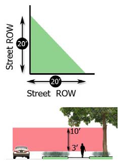
The land adjoining a local street intersection or egress to a local street from off-street parking areas shall be kept clear of obstructions to protect the visibility and safety of motorists and pedestrians. On a corner lot, nothing shall be erected, placed, or allowed to grow in a manner so as materially to impede vision between a height of three feet and ten feet in a triangular area formed by a diagonal line between two points on the right-of-way lines, 20 feet from where they intersect. A clear view shall be maintained on corner lots from three to ten feet in vertical distance. Intersections of or with state maintained streets shall comply with NCDOT sight distance triangle requirements.
(Ord. of 10-9-2018)
SECTION 2.18 - RESERVED.
Editor's note— Amend. of 1-10-2023(3), repealed § 2.18, which pertained to property dedicated for private use and derived from Ord. of 10-9-2018.
SECTION 2.19 - RESERVED.
Editor's note— Amend. of 1-10-2023(3), repealed § 2.19, which pertained to regulation of forestry activities and derived from Ord. of 10-9-2018.
SECTION 2.20 - MEASUREMENT OF DISTANCE.
All measurements for the purpose of the separation of uses shall be from the closest points of property line to property line for the parcels on which the uses are located.
(Ord. of 10-9-2018)
SECTION 2.21 - SIDEWALKS.
All new non-residential and major subdivision construction permitted following the adoption of this Ordinance shall be required to construct five-foot sidewalk(s) on the street right-of-way. The sidewalk(s) shall comply with the Town of Oak Island Standards and Specifications document and NCDOT requirements.
(Ord. of 10-9-2018)
SECTION 2.22 - TENTS AND RECREATIONAL VEHICLES OUTSIDE CAMPGROUNDS.
No tent, shack, or temporary structure shall be located on any lot and no recreational vehicle may be used as a residence on any lot except when in conjunction with construction on the lot, and then only by a nonrenewable permit granted by the town for a period not to exceed 90 days. Brunswick County Health Department sanitary facilities shall be required before a permit can be issued.
(Ord. of 10-9-2018)