
Oak Ridge City Zoning Code
ARTICLE I
- IN GENERAL
Sec. 30-1.- Short title.
This chapter shall be known and may be cited as the "Oak Ridge Development Chapter," except as referred to herein, where it shall be known as "this chapter."
(Ord. of 1-6-2000, § 1-1)
Sec. 30-2. - Purpose.
(a)
General purpose. It is the purpose of this chapter to promote the health, safety, morals, and general welfare of the residents of the town through the regulations of this chapter and to the preservation of the historic district.
(b)
Zoning regulation purpose. The zoning regulations, adopted and prescribed in this chapter, are found by the town council to be necessary and appropriate to:
(1)
Lessen congestion in the streets;
(2)
Secure safety from fire, panic and other dangers;
(3)
Provide adequate light and air;
(4)
Prevent the overcrowding of land;
(5)
Avoid undue concentration of population;
(6)
Facilitate the adequate and economic provision of transportation, water, sewage, schools, park, and other public services;
(7)
Protect water quality within watershed critical areas and/or designated municipal watersheds;
(8)
Preserve and enhance visual attractiveness and economic vitality;
(9)
Require appropriate setbacks for buildings and other structures to facilitate the safe movement of vehicular and pedestrian traffic, provide adequate fire lanes and ensure adequate distance from dust, noise and fumes created by vehicular traffic; and
(10)
Establish a zoning vested right upon the approval of a site-specific vesting plan pursuant to G.S. 160D-102.
(c)
Cluster and zero side setback regulation purpose. The single-family dwelling cluster and zero side setback regulations, adopted and prescribed in this chapter, are found by the town council to be necessary and appropriate to:
(1)
Encourage innovation in residential development by providing efficient, attractive, flexible and environmentally sensitive design;
(2)
Lower the costs of housing by reducing the lot size and the per dwelling unit linear footage of streets, water lines, storm sewers and sanitary sewers;
(3)
Reduce the future cost of infrastructure maintenance and, therefore, the burden upon taxpayers and ratepayers;
(4)
Encourage development in areas which have major streets and utility lines in place, but are experiencing little or no development;
(5)
Protect water quality, preserve wildlife habitats, and protect natural features such as streams, lakes, wetlands, and trees; and
(6)
Reduce the amount of grading necessary for site preparation.
(d)
Planned unit development purpose. The planned unit development regulations, adopted by ordinance and prescribed in this chapter, are found by the town council to be necessary and appropriate to:
(1)
Promote all of the purposes listed in section 30-2(c);
(2)
Allow diversification of uses in developments intended as cohesive, unified projects;
(3)
Allow variation in the relationship of residential and nonresidential uses and structures in such cohesive, unified projects;
(4)
Reduce travel time by providing opportunities for employment and services closer to residences; and
(5)
Encourage innovation by offering flexibility in design and layout requirements to achieve a greater choice of living and working environments.
(e)
Historic district overlay purpose. The historic district overlay regulations, adopted and prescribed in this chapter, are found by the town council to be necessary and appropriate to:
(1)
Protect, safeguard and conserve the heritage of the community;
(2)
Promote the sound and orderly preservation of historic areas as a whole, and of the individual properties therein, which embody important elements of social, economic, political or architectural history for the education, pleasure and enrichment of all citizens; and
(3)
Enhance property values within historic areas.
(f)
Scenic corridor overlay purpose. The scenic corridor overlay regulations, adopted and prescribed in this chapter, are found by the town council to be necessary and appropriate to:
(1)
Preserve and enhance the appearance and operational characteristics of certain designated roadways; and
(2)
Address development issues of special concern with specific requirements which relate to land use, traffic movement, access, environment, signage, landscaping, visual quality and aesthetics.
(g)
Subdivision regulation purpose. The subdivision (including group development) regulations, adopted and prescribed in this chapter, are found by the town council to be necessary and appropriate to:
(1)
Promote orderly growth and development;
(2)
Provide for suitable residential and nonresidential developments with adequate streets and utilities and appropriate building sites;
(3)
Provide for the distribution of population and traffic in a manner which shall avoid congestion and overcrowding;
(4)
Provide for the coordination of streets within subdivisions with existing or planned streets and with other public facilities;
(5)
Provide for the dedication or reservation of rights-of-way or easements for street and utility purposes;
(6)
Provide for the dedication or reservation of adequate spaces for public lands and buildings;
(7)
Encourage design that is protective of environmental quality;
(8)
Provide for the dedication or reservation of recreation, park and greenway areas; and
(9)
Provide proper land records for the convenience of the public and for better identification and permanent location of real property boundaries.
(h)
Sign regulation purpose. The sign regulations, adopted and prescribed in this chapter, are found by the town council to be necessary and appropriate to:
(1)
Encourage the effective use of signs as a means of visual communication;
(2)
Promote a positive community appearance for the enjoyment of all citizens;
(3)
Maintain and enhance the aesthetic environment and the community's ability to attract sources of economic development and growth;
(4)
Protect the public from damage or injury attributable to distractions and/or obstructions caused by improperly designed or located signs; and
(5)
Protect existing property values in both residential and nonresidential areas.
(i)
Off-street parking, stacking, and loading regulation purpose. The off-street parking, stacking, and loading regulations, adopted and prescribed in this chapter, are found by the town council to be necessary and appropriate to:
(1)
Ensure a sufficient amount of off-street parking, stacking, and loading areas for various land uses;
(2)
Ensure easy, convenient circulation of vehicles within parking and loading areas;
(3)
Minimize the potential for conflict with traffic on public streets; and
(4)
Permit the shared use of parking areas by establishments and/or activities which have different hours of operation.
(j)
Planting yard purpose. The planting yard regulations, adopted and prescribed in this chapter, are found by the town council to be necessary and appropriate to:
(1)
Create a better quality of life for the community by encouraging preservation of existing trees and vegetation;
(2)
Provide visual buffering and enhance beautification;
(3)
Establish appropriate separation between land uses;
(4)
Provide the separation necessary to permit certain land uses to coexist harmoniously which might not do so otherwise;
(5)
Safeguard and enhance property values and protect public and private investment;
(6)
Enhance the community's competitive position in economic development and tourism by improving views, particularly along streets; and
(7)
Reduce the negative impact of glare, noise, trash, odors, overcrowding, traffic, lack of privacy, and visual disorder when incompatible land uses adjoin one another.
(k)
Watershed protection purpose. The watershed protection regulations, adopted and prescribed in this chapter, are found by the town council to be necessary and appropriate to:
(1)
Protect those portions of designated water supply watersheds which lie closest to existing and proposed water supply reservoirs from activities which could degrade water quality in the reservoirs;
(2)
Reduce the volume of nutrients and other chemicals which could enter the water supply by reducing the amount of runoff which any given development will generate;
(3)
Minimize land disturbance to reduce the amount of sediment washing into streams and lakes and to enhance the infiltration of runoff into soil, thus alleviating the sedimentation of water supply lakes which reduces their storage capacity, shortens their useful life, and makes them less able to withstand drought;
(4)
Reduce the probability of the release of harmful chemicals into water supply reservoirs, either through natural catastrophe or human error; and
(5)
Provide for natural and engineered methods for managing the stormwater which flushes contaminants off of built-upon areas in the designated water supply watersheds and which may reach water supply reservoirs unless controlled.
(l)
Soil erosion and sedimentation control purpose. The soil erosion and sedimentation control regulations, adopted and prescribed in this chapter, are found by the town council to be necessary and appropriate to:
(1)
Regulate certain land disturbing activity to control accelerated erosion and sedimentation to prevent the pollution of water and other damage to lakes, watercourses and other public and private property by sedimentation; and
(2)
Establish procedures through which the purposes of soil erosion and sedimentation control can be fulfilled.
(m)
Flood damage prevention purpose.
(1)
Purpose: It is the purpose of this ordinance to promote public health, safety, and general welfare and to minimize public and private losses due to flood conditions within flood prone areas by provisions designed to:
a.
Restrict or prohibit uses that are dangerous to health, safety, and property due to water or erosion hazards, or that result in damaging increases in erosion, flood heights or velocities;
b.
Require that uses vulnerable to floods, including facilities that serve such uses, be protected against flood damage at the time of initial construction;
c.
Control the alteration of natural floodplains, stream channels, and natural protective barriers, which are involved in the accommodation of floodwaters;
d.
Control filling, grading, dredging, and all other development that may increase erosion or flood damage; and
e.
Prevent or regulate the construction of flood barriers that will unnaturally divert flood waters or which may increase flood hazards to other lands.
(2)
Objectives:
a.
To protect human life and health;
b.
To minimize expenditure of public money for costly flood control projects;
c.
To minimize the need for rescue and relief efforts associated with flooding and generally undertaken at the expense of the general public;
d.
To minimize prolonged business losses and interruptions;
e.
To minimize damage to public facilities and utilities (i.e. Water and gas mains, electric, telephone, cable and sewer lines, streets, and bridges) that are located in flood prone areas;
f.
To help maintain a stable tax base by providing for the sound use and development of flood prone areas; and
g.
To ensure that potential buyers are aware that property is in a special flood hazard area.
(n)
Rural preservation purpose. The rural preservation district regulations, adopted and prescribed in this chapter, are found by the town council to be necessary and appropriate to:
(1)
Preserve areas with productive soils for continued agricultural and forestry use by preserving blocks of land large enough to allow for efficient operations;
(2)
Preserve areas containing unique and sensitive natural features such as wildlife habitats, migration corridors, steep slopes, streams, wetlands, ground water recharge areas, and floodplains;
(3)
Minimize land disturbance and erosion through retention of existing vegetation and reduction of infrastructure needs;
(4)
Preserve scenic views and elements of the county's rural character including historic and archaeological sites and structures;
(5)
Provide for the active and passive recreational needs of residents;
(6)
Provide for greater efficiency in the sitting of services and infrastructure by reducing street length and utility extensions, thus lowering the cost of housing and future cost of infrastructure maintenance; and
(7)
Create compact neighborhoods accessible to open space amenities and with a strong identity.
(o)
Nonresidential building size limitation purpose. The limitations on nonresidential building size, adopted and prescribed in this chapter, are found by the town council to be necessary and appropriate to:
(1)
Promote a safe and efficient pedestrian scale environment; and
(2)
Foster a competitive and diverse mix of retail establishments.
(Ord. of 1-6-2000, § 1-3; Ord. of 6-7-2007, § 1-3.14; Ord. of 4-1-2010; Ord. No. O-2021-13, § 1, 7-1-2021)
Sec. 30-3. - Jurisdiction.
(a)
Coverage. The provisions of this chapter shall apply to all the territory encompassed in the town, herein referred to as "the jurisdiction," including extraterritorial. This chapter shall govern the development and use of land and structures therein, except for farm land and structures as provided for by House Bill 471 and defined in G.S. 160D-702.
(b)
Establishment of zoning. If for any reason property not previously zoned by the jurisdiction is found to be unzoned or de-annexed, the town shall initiate an original zoning map amendment for the property. Such zoning shall be established within 60 days of the property becoming unzoned. Zoning must be established before any development of the property can occur. The property owner may initiate a zoning map amendment at any time after the county has established original zoning.
(c)
Extraterritorial area. The town shall exercise extraterritorial jurisdiction and may exercise any other power in accordance with G.S. 160D-202 and 160D-307, in the following areas:
(1)
Being that area in Guilford County, beginning at the intersection of County Line Road and the corporate limits of the Town of Oak Ridge, thence along County Line Road in a generally westerly direction to the Forsyth County line, thence north along the county line to the corporate limits of the Town of Stokesdale, then following the corporate limits of the Town of Stokesdale to the point where the corporate limits of the Town of Stokesdale and the Town of Oak Ridge intersect, thence along the corporate limits of the Town of Oak Ridge beginning in a southeasterly direction and following the western side of the corporate limits of the Town of Oak Ridge.
(2)
Being that area in Guilford County west of North Carolina Highway 68 that on March 1, 2009, was entirely surrounded by the corporate limits of the Town of Stokesdale and the Town of Oak Ridge.
(3)
Being those areas in Guilford County west of North Carolina Highway 68 that on March 1, 2009, were entirely surrounded by the corporate limits of the Town of Oak Ridge.
(4)
Property that is located in the town's extraterritorial planning and development regulation jurisdiction and that is used for bona fide farm purposes is exempt from the city's zoning regulation to the same extent bona fide farming activities are exempt from county zoning pursuant to 160D-903. As used in this subsection, "property" means a single tract of property or an identifiable portion of a single tract. Property that ceases to be used for bona fide farm purposes becomes subject to exercise of the city's extraterritorial planning and development regulation jurisdiction under this chapter. For purposes of complying with state or federal law, property that is exempt from municipal zoning pursuant to this subsection is subject to the county's floodplain regulation or all floodplain regulation provisions of the county's unified development ordinance.
(Ord. of 1-6-2000, § 1-4; Ord. of 8-6-2009, § 1; Ord. No. O-2021-13, § 1, 7-1-2021)
Sec. 30-4. - Abrogation.
This chapter is not intended to and does not repeal, abrogate, annul, impair or interfere with any existing easements, covenants, deed restrictions, agreements, rules, regulations, or permits previously adopted or issued pursuant to law.
(Ord. of 1-6-2000, § 1-6; Ord. No. O-2021-13, § 1, 7-1-2021)
Sec. 30-5. - Interpretation.
(a)
Minimum requirements. In the interpretation and application of this chapter, all provisions shall be considered to be minimum requirements and deemed neither to limit nor repeal any other powers granted under state statutes.
(b)
Greater restrictions govern. These regulations shall be the minimum requirements for administration, enforcement, procedures, restrictions, standards, uses, variances, and all other areas addressed by this chapter. If any federal or state law or any other existing ordinance or regulation allows lesser regulation this chapter shall govern so that, in all cases, the more restrictive limitation or requirement shall govern. Whenever regulations imposed by this chapter are less restrictive than regulations imposed by any governmental authority through regulation, rule or restriction, the regulations imposed by that authority shall govern. Regardless of any other provision of this chapter, no land shall be developed or used, and no structure shall be erected or maintained in violation of any state or federal regulation.
(c)
Rounding of numbers. All calculations that result in a part or fraction of a whole number shall be rounded up to the next highest whole number, unless otherwise provided in this chapter.
(d)
Density.
(1)
Rounding. In calculating density, all calculations that result in a part or fraction of a whole number shall be rounded down to the next lowest whole number.
(2)
Dwelling unit equivalence.
a.
Congregate care facilities and private dormitories. For the purpose of calculating density for congregate care facilities and private dormitories, two bedrooms shall be equivalent to one dwelling unit.
b.
Single-room occupancy (SRO) residences. For the purpose of calculating density for single-room occupancy (SRO) residences, a rooming unit of less than 150 square feet shall be equivalent to one-half a dwelling unit and a rooming unit of 150 square feet or more shall be equivalent to one dwelling unit.
(e)
Figures. The figures provided in this chapter are designed to provide a visual explanation to selected sections of the chapter. If any illustration appears to be in conflict with the text of the chapter, the text shall govern.
(Ord. of 1-6-2000, § 1-7)
Sec. 30-6. - Rules of construction.
(a)
Word interpretation. Words not defined in this chapter shall be given their ordinary and common meaning.
(b)
Rules of construction. For the purposes of this chapter, the following rules of construction shall apply:
(1)
Tense. Words used in the present tense include the future tense;
(2)
Singular and plural. Words used in the singular number include the plural number, and the plural number includes the singular number, unless the context of the particular usage clearly indicates otherwise;
(3)
Mandatory meaning. The words "shall," "will," and "must" are mandatory in nature implying an obligation or duty to comply with the particular provision;
(4)
Gender. Words used in the male gender include the female gender; and
(5)
References. Any reference to an article or section shall mean an article or section of this chapter, unless otherwise specified.
(Ord. of 1-6-2000, § 1-8)
Sec. 30-7. - Compliance.
(a)
Compliance. No building, premises, or structure shall be constructed, erected, modified, converted, occupied, placed, maintained or moved, and no land use shall be commenced, maintained, or modified, except as authorized by this chapter.
(b)
Voluntary compliance. Nothing in this section shall be deemed to preclude voluntary compliance with the provisions of this chapter for development approved prior to the effective date of the ordinance from which this article is derived.
(c)
Conformance with requirements. Except as herein provided, no applicable permit shall be issued or granted that does not conform to the requirements of this chapter. If a permit applicant submits a permit application for any type of development and a rule or ordinance changes between the time the permit application was submitted and a permit decision is made, the permit applicant may choose which version of the rule or ordinance will apply to the permit. Developments which have received planning and zoning board approval, staff approval, or enforcement officer approval may proceed in accordance with such approval or permit while such approval or permit remains in effect.
(Ord. of 1-6-2000, § 1-9; Ord. of 3-1-2017)
Sec. 30-8. - Relation to comprehensive plan.
The administration, enforcement and amendment of this chapter shall be accomplished with consideration of recommendations presented in the documents comprising the comprehensive plan, which shall be reasonably maintained. These documents include, but are not limited to the following: land use plan, thoroughfare plan, collector street plan, small area plans, community facilities plan, capital improvement plan, economic development strategies, housing assistance plan, recreation plan, greenways plan, drainage and open space plan and watershed management plan.
(Ord. of 1-6-2000, § 1-10; Ord. No. O-2021-13, § 1, 7-1-2021)
Sec. 30-9. - Definitions.
The following words, terms and phrases, when used in this chapter, shall have the meanings ascribed to them in this section, except where the context clearly indicates a different meaning. These definitions are grouped in the following functional groups: building and structure, drainage and watershed protection, dwelling, easements, erosion and sedimentation control, flood damage prevention, general, hazardous waste, lot, setback, signs, streets, drives, and lanes, historic districts, and adult-oriented uses.
(1)
Building and structure.
Accessory building. A detached subordinate building, the use of which is incidental to that of the principal building and located on the same lot therewith.
Accessory structure. A detached subordinate structure, the use of which is incidental to that of the principal structure and located on the same lot therewith.
Building. Any structure used or intended for supporting or sheltering any use or occupancy.
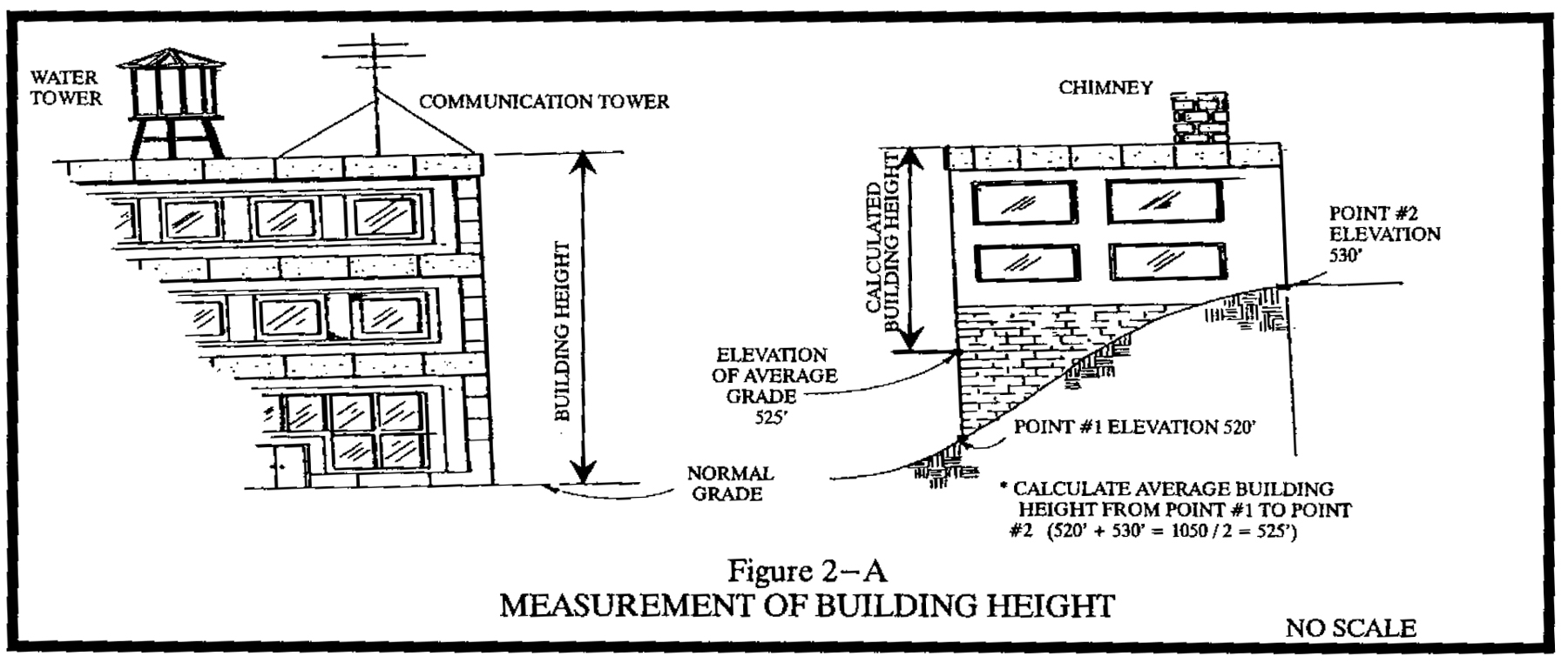
Building height. The vertical distance measured from the average elevation of the finished grade to the topmost section of the roof. See figure 2-A.
FIGURE 2-A MEASUREMENT OF BUILDING HEIGHT
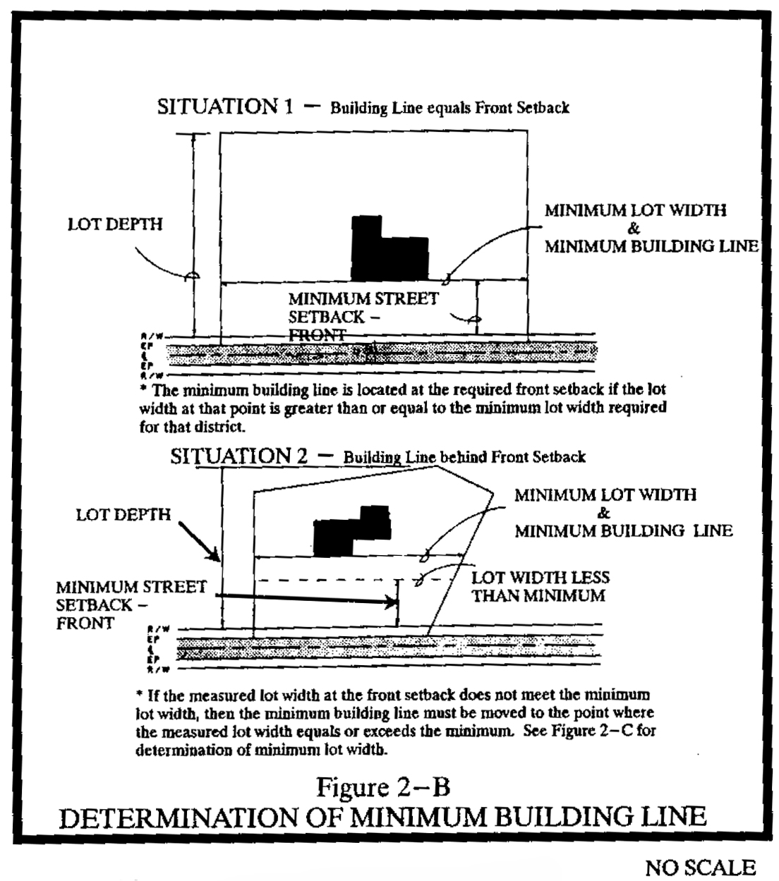
Building line. A line perpendicular to the lot depth which establishes the horizontal distance between the structure and the front property line excluding the outermost steps, uncovered porches, gutters, and similar fixtures. See figure 2-B.
FIGURE 2-B DETERMINATION OF MINIMUM BUILDING LINE
Building separation. The minimum required horizontal distance between buildings.
Principal building A building in which is conducted the principal use of the zone lot on which it is located or, in a group development, of the building site on which it is located. Any dwelling is considered a principal building unless it is an accessory dwelling in compliance with section 30-1013, farm tenant dwelling, or a residence for a pastor, or caretaker dwelling accessory to a nonresidential use (limited to one such residence per lot).
Principal structure. A structure in which is conducted the principal use of the zone lot on which it is located.
Structure. Anything constructed, erected, or placed.
Temporary building. Any building of an impermanent nature, or which is designed for use for a limited time, including any tent or canopy.
Temporary structure. Any structure of an impermanent nature or which is designed for use for a limited time, including any tent or canopy.
(2)
Drainage and watershed protection.
Best management practice (BMP). A structural or nonstructural management-based practice used singularly or in combination to reduce nonpoint source inputs to receiving waters in order to achieve water quality protection goals.
Built-upon area. That portion of a development project that is covered by impervious or partially impervious cover including buildings, pavement, gravel (for pedestrian or vehicular use), recreation facilities (e.g., tennis courts), etc. (Note: wooden slatted decks and the water area of a swimming pool are not considered built-upon area.)
Detention pond. A pond which collects stormwater runoff, filters the water, and releases it slowly over a period of hours or days. It does not have a permanent pool and is sometimes referred to as a dry pond or wet weather pond.
Development, existing. Those projects that are built and those projects that, at a minimum, have established a vested right under state zoning law as of January 1, 1994, based on at least one of the following criteria:
a.
Substantial expenditure of resources (time, labor, money) based on a good faith reliance upon having received a valid local government approval to proceed with the project;
b.
Having a valid outstanding building permit; or
c.
Having expended substantial resources (time, labor, money) and having an approved site-specific (or phased) plan as defined in G.S. 160D-102 and in compliance with G.S. 160D-108. (This definition applies only with respect to watershed protection regulations.)
Development, new. Any land disturbing activity which adds to or changes the amount of built-upon area. (This definition applies only with respect to watershed protection regulations.)
Discharging landfill. A facility with liners, monitoring equipment, and other measures to detect and/or prevent leachate from entering the environment and in which the leachate is treated on site and discharged to a receiving stream. These facilities require approval and a discharge permit from the state department of environmental management for legal operation.
Drainageway and open space area, dedicated. The area designated for floodplain and open space purposes on a recorded subdivision plat, and thereby dedicated to the public for such purposes.
Drainage, dispersed. Drainage spread out, as opposed to collected in channels, so as to effect increased sheet flow and overland flow.
Drainage, enhanced. Drainage carried by existing natural drainageways which have been enhanced to resist soil erosion and stream bank degradation.
Drainage, required channel. The theoretical stream bed section which is required to carry and discharge the runoff from a 100-year storm.
Drainage, typical required channel section. A cross-sectional view of a required drainage channel.
Drainageway. Any natural or manmade channel that carries surface runoff from precipitation.
Drainageway, improved. Drainage channeled by impervious surfaces such as curb and gutter or concrete (gunite, bituminous, etc.) channels.
Drainageway, protected. A natural channel that is protected against stream bank erosion and excessive runoff velocity by any one or a combination of the following:
a.
Rip-rap channel stabilization;
b.
Establishment of soil-stabilizing vegetation;
c.
Velocity reduction structures (stilling pools and drop structures, for example)
Hazardous material. Any material listed as such in: Superfund Amendments and Reauthorization Act (SARA) section 302 Extremely Hazardous Substances (42 USC 1100 et seq.); Comprehensive Environmental Response, Compensation, and Liability Act (CERCLA) Hazardous Substances (42 USC 9601 et seq.); or section 311 of the Clean Water Act, as amended (CWA) (33 USC 1251 et seq., oil and hazardous substances) hereby incorporated by reference including any subsequent amendments and editions
High density option. A density or intensity option for new development wherein the density or intensity exceeds the applicable limit for development under the low density option (see low density option definition and the density and intensity limits for low-density and high-density options table below), thereby imposing a requirement for engineered stormwater controls (runoff control structures) in conformance with the requirements of the water supply watershed protection rules as adopted by the state environmental management commission and the requirements of article X.
Low density option. A density or intensity option for new development wherein the density, expressed in dwelling units per acre, and/or the intensity, expressed in percentage of the land surface covered by built-upon area, does not exceed certain limits established in the water supply watershed protection rules as adopted by the state environmental management commission. The limits vary depending upon the classification of the watershed and upon which overlay zone, or general watershed area (GWA), is applicable. The limits in effect on July 1, 1993 are shown in the density and intensity limits for low-density and high-density options table below.
DENSITY AND INTENSITY LIMITS
FOR LOW-DENSITY AND HIGH-DENSITY OPTIONS
Note:
1 Refer to section 30-1257 for additional allocation options.
Maximum runoff retention. The passage of approximately 100 percent of channelized runoff through permanent retention or wet detention ponds.
Moderate runoff retention. The passage of at least 75 percent of runoff through permanent retention or wet detention ponds.
Retention pond. A pond that has a permanent pool.
Runoff detention in excess of erosion control ordinance. The passage of at least 50 percent of runoff through permanent wet detention or retention ponds.
Runoff detention equal to minimum requirements. Velocity control of runoff.
Sludge. Any solid or semisolid waste generated from a wastewater treatment plant, water treatment plant, or air pollution control facility permitted under authority of the state environmental management commission.
Stabilizing vegetation. Any vegetation that protects the soil against erosion.
Storm drainage facilities. The system of inlets, conduits, channels, ditches and appurtenances which serve to collect and convey stormwater through and from a given drainage area.
Storm, ten-year. The surface runoff resulting from a rainfall of an intensity expected to be equaled or exceeded, on the average, once in ten years and of a duration which will produce the maximum peak rate of runoff for the watershed of interest under average antecedent wetness conditions.
Storm, 100-year. The surface runoff resulting from a rainfall of an intensity expected to be equaled or exceeded, on the average, once in 100 years and of a duration which will produce the maximum peak rate of runoff for the watershed of interest under average antecedent wetness conditions.
Stormwater runoff. The direct runoff of water resulting from precipitation in any form.
Stream. A water course that collects surface runoff.
Stream buffer. A natural or vegetated area through which stormwater runoff flows in a diffuse manner so that the runoff does not become channelized and which provides for infiltration of the runoff and filtering of pollutants. The buffer width is measured landward from the normal pool elevation of impoundments and from the bank of each side of streams or rivers. (This definition applies only with respect to watershed protection regulations.)
Substantially completed. Work has progressed to the point that, in the opinion of the stormwater administrator or designee, it is sufficiently completed in accordance with the approved plans and specifications that the work can be utilized for its intended purposes. For permanent runoff control structures this generally means that the following have been accomplished:
a.
The dam has been constructed to the approved lines and grades;
b.
All slopes have been fine graded, seeded, mulched, fertilized, and tacked to establish permanent ground cover;
c.
Principal and emergency spillways have been installed at the approved elevations and dimensions; and
d.
Permanent velocity controls on the inlet and outlet pipes and channels have been installed.
Undisturbed area. That portion of a lot, tract, or subdivision which has not and will not be occupied and which has not and will not be graded to change land contours or to destroy existing vegetation. Only areas that are wooded or reforested are considered undisturbed for the purposes of watershed protection score-sheet evaluation. (This definition applies only with respect to watershed protection regulations.)
Velocity. The average velocity of flow through the cross section of the main channel at the peak flow of the storm of interest. The cross section of the main channel shall be that area defined by the geometry of the channel plus the area of flow below the flood height defined by vertical lines at the main channel banks. Overload flows are not to be included for the purpose of computing velocity of flow.
Modification, major watershed. Modification of the existing regulations that does not meet the definition of a minor watershed modification.
Modification, minor watershed. Modification of the existing regulations that meets one of the following criteria:
a.
Modification of any standard present in the ordinance from which this article is derived, but not in the state water supply watershed protection rules;
b.
Modification of any standard on which the level of performance required by the ordinance from which this article is derived exceeds that required by the corresponding section of the state water supply watershed protection rules; provided, that approval of the modification does not lower the level of performance below that required by the state regulations; or
c.
Modification of the state regulations by a factor of up to five percent under the high density option or ten percent under the low density option of any standard expressed as a number.
Water dependent structures. Structures for which the use requires access or proximity to or sitting within surface waters to fulfill its basic purpose, such as boat ramps, boat houses, docks, and bulkheads. Ancillary facilities such as restaurants, outlets for boat supplies, parking lots, and commercial boat storage areas are not water dependent structures.
Watershed, water supply. The entire area contributing drainage to Lake Townsend, Lake Brandt, Lake Higgins, Oak Hollow Lake, High Point City Lake, Polecat Creek Lake, Reidsville Reservoir, Lake Mackintosh, Ramseur Reservoir, Madison intake, and the proposed Randleman Dam reservoir.
Watershed critical area. That portion of the watershed within the lake basin of the water supply reservoir as delineated in article X.
Wet detention pond. A pond that has a permanent pool and also collects stormwater runoff, filters the water, and releases it slowly over a period of days.
(3)
Dwelling. A building that contains one or two dwelling units used, intended or designed to be used, rented, leased, let or hired out to be occupied for living purposes.
Accessory dwelling unit. A dwelling unit that exists either as part of a principal dwelling, or as an accessory building, and is secondary and incidental to the use of the property as single-family residential.
Condominium. Portions of real estate which are designated for separate ownership, and the remainder of which is designated for common ownership solely by the owners of those portions. Real estate is not a condominium unless the undivided interests in the common elements are vested in the unit owners.
Dwelling unit. A single unit providing complete, independent living facilities for one or more persons, including permanent provisions for living, sleeping, eating, cooking and sanitation.
Manufactured dwelling. A dwelling that:
a.
Is composed of one or more components, each of which was substantially assembled in a manufacturing plant and designed to be transported to the home site on its own chassis;
b.
Exceeds 40 feet in length and eight feet in width;
c.
Is constructed in accordance with the National Manufactured Home Construction and Safety Standards; and
d.
Is not constructed in accordance with the standards of the North Carolina Uniform Residential Building Code for One- and Two-Family Dwellings.
Class A. A manufactured home constructed after July 1, 1976, that meets or exceeds the construction standards promulgated by the U.S. Department of Housing and Urban Development that were in effect at the time of construction and that meet or the exceed criteria listed in subsections (a), (c)—(e), (g)—(i), (k), and (l) for Class AA manufactured dwellings below.
Class AA. A manufactured home constructed after July 1, 1976, that meets or exceeds the construction standards promulgated by the U.S. Department of Housing and Urban Development that were in effect at the time of construction, and that satisfies the following additional criteria:
a.
Is occupied only as a single-family dwelling;
b.
Has a minimum width of 16 feet;
c.
Has a length not exceeding four times its width, with length measured along the longest axis, and width measured perpendicular to the longest axis at the narrowest part;
d.
Has a minimum of 700 square feet of enclosed and heated living area;
e.
Has the towing apparatus, wheels, axles, and transporting lights removed, and not included in length and width measurements;
f.
Has the longest axis oriented parallel or within a ten degree deflection of being parallel to the lot frontage, unless other orientation is permitted by the board of adjustment following a public hearing;
g.
Is set up in accordance with the standards established by the state department of insurance. In addition, a continuous, permanent masonry foundation or masonry curtain wall constructed in accordance with the standards of the North Carolina Uniform Residential Building Code for One- and Two- Family Dwellings, unpierced except for required ventilation and access, shall be installed under the perimeter;
h.
Has exterior siding, comparable in composition, appearance durability to the exterior siding commonly used in standard residential construction, consisting of one or more of the following:
1.
Vinyl or aluminum lap siding (whose reflectivity does not exceed that of flat white paint);
2.
Cedar or other wood siding;
3.
Wood grain, weather resistant press board siding;
4.
Stucco siding;
5.
Brick or stone siding;
i.
Has a roof pitch minimum vertical rise of 3½ feet for each 12 feet of horizontal run;
j.
Has a roof finished with a class C or better roofing material that is commonly used in standard residential construction;
k.
All roof structures shall provide an eave projection of no less than six inches, which may include a gutter; and
l.
Stairs, porches, entrance platforms, ramps and other means of entrance and exit are installed or constructed in accordance with the standards set by the state building code, attached firmly to the primary structure and anchored securely to the ground. Wood stairs shall only be used in conjunction with a porch or entrance platform with a minimum or 24 square feet. The use of wood stairs only is prohibited at any entrance.
Class B. A manufactured home constructed after July 1, 1976, that meets or exceeds the construction standards promulgated by the U.S. Department of Housing and Urban Development that were in effect at the time of construction, and that meet or exceed the criteria in subsections (e), (g) and (h) for Class AA manufactured dwellings above.
Class C. Any manufactured home that does not meet the above definition and criteria of a Class AA, Class A or Class B manufactured dwelling. Class C manufactured dwellings, except those used as housing for migrant labor as part of a bona fide farm operation and are certified for migrant labor in accordance with department of labor regulations, are not allowed to be located or placed in any zoning district as it does not meet the construction standards of the state building code nor those promulgated by the U.S. Department of Housing and Urban Development.
Modular dwelling. A dwelling constructed in accordance with the standards set forth in the state residential building code and composed of components substantially assembled in a manufacturing plant and transported to the building site for final assembly on a permanent foundation.
Multifamily dwelling. A building or portion thereof used or designed as a residence for three or more families living independently of each other with separate housekeeping and cooking facilities for each, and includes apartment, townhouses and residential condominiums.
Principal dwelling. Any principal building or structure which is used and designed for human habitation including living, sleeping, cooking and eating activities excluding dormitories, hotels, motels, shelters for the homeless or other structures designed for transient residents.
Rooming unit. A room designed, occupied, or intended for occupancy as separate living quarters with sleeping, but not necessarily cooking and sanitary facilities provided therein.
Shelter for the homeless. A facility operating yearround which provides lodging and supportive services including, but not limited to, a community kitchen; assistance in obtaining permanent housing; medical counseling, treatment, and/or supervision; psychological counseling, treatment, and/or supervision; assistance in recuperating from the effects of or refraining from the use of drugs and/or alcohol; nutritional counseling; employment counseling; job training and placement; and child care for indigent individuals and/or families with no regular home or residential address; and which complies with the following requirements:
a.
The facility shall be contained within the building and operated by a government agency or nonprofit organization;
b.
A minimum floor space of 50 square feet shall be provided for each individual sheltered; and
c.
The facility operator shall provide continuous on-site supervision by an employee and/or volunteer during the hours of operation.
Shelter, emergency. A facility providing, without charge, temporary sleeping accommodations, with or without meals, for individuals and/or families displaced from their residences as a result of sudden natural or manmade catastrophe including, but not limited to, earthquake, fire, flood, tornado, hurricane, or the release of hazardous or toxic substances into the environment. Such a natural or manmade catastrophe must be designated by the responsible local, state, or federal official, or an emergency agency such as the American Red Cross or the Emergency Management Assistance Agency.
Shelter, temporary. A facility which provides temporary lodging during times of life-threatening weather conditions for indigent individuals and/or families with no regular home or residential address; and which complies with the following requirements:
a.
The facility shall be contained within the building of and operated by a government agency or nonprofit organization;
b.
A minimum floor space of 50 square feet shall be provided for each individual sheltered; and
c.
The facility operator shall provide continuous on-site supervision by an employee and/or volunteer during the hours or operation.
Single-family detached dwelling. A separate, detached building designed for and occupied exclusively by one family.
Single-room occupancy (SRO) residence. A building containing 25 or more rooming units, which are available for rental occupancy for periods of seven days or longer, in which on-site management is provided on a 24-hour basis. The building shall contain common space such as recreation areas, lounges, living rooms, dining rooms, or other congregate living spaces at a rate of five square feet per rooming unit, but totaling not less than 250 square feet. Bathrooms, laundries, hallways, the main lobby, vending areas, and kitchens shall not be counted as common space. This term does not include boarding houses, tourist homes, motels, hotels, private dormitories, congregate care facilities, family care homes and group care facilities.
Sleeping unit. A room or space in which people sleep, which can also include permanent provisions, for living, eating, and either sanitation or kitchen facilities but not both. Such rooms and spaces that are also part of a dwelling unit are not sleeping units.
Tenant dwelling. A dwelling located on a bona fide farm, and occupied by a farm worker employed for agricultural purposes by the owner, or operator of the farm.
Townhouse dwelling. A building consisting of single-family residences attached to one another, or detached single-family residences consisting of a single unit, in which each unit is located on an individually owned parcel, within a development consisting of multiple units containing private drives, walks, and open space in common area. Townhouses, whether attached or detached, are typically units situated in a row separated by private open space between units. Units generally are more uniform in appearance than small lot detached homes.
Twin home dwelling. A building consisting of two single-family dwelling units, each dwelling unit occupying its own conventional lot and conveyed by deed, connected along a common party wall with no interior circulation between the two.
Two-family dwelling. A building on one zone lot arranged and designed to be occupied by two families living independently of each other.
(4)
Easements.
Access easement. An easement which grants the right to cross property.
Drainage easement. An easement which grants the right of water drainage to pass in open channels or enclosed structures.
Drainage maintenance easement. An easement which grants to the town council the right to alter the typical drainage channel section and/or profile in order to improve water flow.
Easement. A grant of one or more of the property rights, by the property owner, to, or for use by, the public, a corporation, or other entities.
Pedestrian way. A right-of-way or easement dedicated to public use to facilitate pedestrian access to adjacent streets and properties.
Sight distance easement. An easement which grants to the town council the right to maintain unobstructed view across property located at a street or lane intersection.
Utility easement. An easement which grants to the town council or other utility providers the right to install and thereafter maintain any and all utilities including, but not limited to, water lines, sewer lines, septic tank drain fields, storm sewer lines, electrical power lines, telephone lines, natural gas lines and community antenna television systems.
Water quality conservation easement. A permanent easement in which no structures or land disturbing activities are allowed. The natural ground cover and the natural tree canopy must be preserved with the following exceptions:
a.
The cutting or trimming of overcrowded trees is allowed provided that no trees in excess of three inches in diameter as measured 12 inches or less from the ground are removed;
b.
Utilities and erosion control structures can be constructed and maintained;
c.
Normal maintenance by mechanical means is allowed for the removal of dead, diseased, deformed, poisonous, or noxious vegetation and pests harmful to health; and
d.
Mechanical mowing of utilities areas is allowed to control growth.
(5)
Soil erosion and sedimentation control.
Act. The North Carolina Sedimentation Pollution Control Act of 1973, G.S. as 113A-50 et seq., and all rules and orders adopted pursuant to it.
Active construction. Activities which contribute directly to the completion of facilities contemplated or shown on the construction plans.
Being conducted. A land disturbing activity has been initiated and permanent stabilization of the site has not been completed.
Berm, erosion control. A mound of material and/or ditch, the purpose of which is to divert the flow of run-off water.
Borrow. Fill material which is required for on-site construction and is obtained from other locations.
Buffer. An area of land planted or constructed to separate uses.
Buffer zone. The strip of land adjacent to a lake or natural watercourse.
Coastal counties. The following counties are considered coastal counties: Beaufort, Bertie, Brunswick, Camden, Carteret, Chowan, Craven, Currituck, Dare, Gates, Hertford, Hyde, New Hanover, Onslow, Pamlico, Pasquotank, Pender, Perquimans, Tyrrell and Washington.
Commission, sedimentation. The state sedimentation control commission.
Completion of construction or development. No further land disturbing activity is required on a phase of a project except that which is necessary for establishing a permanent ground cover.
Department (DENR). The state department of environment and natural resources.
Director (DENR). The director of the division of land resources of the department of environment and natural resources.
Discharge point. That point at which runoff leaves a tract of land.
District, soil and water conservation. The county soil and water conservation district created pursuant to G.S. 139.
Energy dissipator. A structure or shaped channel section with mechanical armoring placed at the outlet pipes or conduits to receive and break down the energy from high velocity flow.
Erosion. The wearing away of land surface by the action of wind, water, gravity, or any combination thereof.
Erosion, accelerated. Any increase over the rate of natural erosion as a result of land disturbing activities.
Erosion control measure, structure or device, adequate. A device which controls the soil material within the land area under responsible control of the person conducting the land disturbing activity.
Erosion, natural. The wearing away of the earth's surface by water, wind, or other natural agents under natural environmental conditions undisturbed by man.
Grading. Any operation or occurrence by which the existing site elevations are changed, or where any ground cover, natural or manmade, is removed, or any buildings or other structures are removed, or any water course or body of water, either natural or manmade, is relocated on any site, thereby creating an unprotected area. The term "grading" is interchangeable with "land disturbing activity."
Grading, phase of. One of the two types of grading, rough or fine.
Grading plan. The graphic plan, including narrative where appropriate, required by this chapter as a prerequisite for a grading permit, the purpose of which is to explain existing conditions and proposed grading of land including any development, and to describe the activities and measures to be undertaken to control accelerated soil erosion and sedimentation.
Ground cover. Any vegetation, masonry, paving, riprap, or other material or materials which render the soil surface stable against accelerated erosion.
High quality waters. Those classified as such in 15A NCAC 2B.0101(e)(5) general procedures, which is incorporated herein by reference to include further amendments pursuant to G.S. 150B-14(c).
High quality water (HQW) zones. Areas in the coastal counties that are within 575 feet of high quality waters and, for the remainder of the state, areas that are within one mile and drain into HQWs.
Lake or natural watercourse. Any stream, river, brook, swamp, sound, bay, creek, run, branch, canal, waterway, estuary, and any reservoir, lake or pond, natural or impounded, in which sediment may be moved or carried in suspension, and which could be damaged by accumulation of sediment.
Land disturbing activity. Any use of the land by any person or persons in residential, industrial, educational, institutional, or commercial development, highway or road construction or maintenance, that results in a change in natural cover or topography that may cause or contribute to sedimentation.
Person conducting land disturbing activity. Any person who may be held responsible for a violation unless expressly provided otherwise by this chapter, the act, or any order adopted pursuant to this chapter or the act.
Person responsible for land disturbing violation. As used in this chapter, and G.S. 113A-64, a developer or other person who has or holds himself out as having financial or operational control over the land disturbing activity; or the landowner or person in possession or control of the land when he has directly or indirectly allowed the land disturbing activity or has benefited from it, or he has failed to comply with any provision of this chapter, the act, or any order adopted pursuant to this chapter or the act as imposes a duty upon him.
Protected area. Any ground surface area having established cover, artificial or natural, of such density that not more than 20 percent of the soil surface of any square yard of surface is exposed to the physical forces of meteorological elements.
Sediment. Solid particulate matter, both mineral and organic, that has been or is being transported by water, air, gravity, or ice from its site of origin.
Sedimentation. The process by which sediment resulting from accelerated erosion has been or is being transported off the site of the land disturbing activity, or into a lake or natural watercourse.
Siltation. Sediment resulting from accelerated erosion which is settleable or removable by properly designed, constructed, and maintained control measures; and which has been transported from its point of origin within the site of a land disturbing activity, and which has been deposited, or is in suspension in water.
Site or tract. All contiguous land and bodies of water being disturbed or to be disturbed as a unit, regardless of ownership.
25-year storm. The surface runoff resulting from a rainfall of an intensity expected to be equaled or exceeded, on the average, once in 25 years, and of a duration which will produce the maximum peak rate of runoff, from the watershed of interest under average antecedent wetness conditions.
Uncovered. The removal of ground cover from, on or above the soil surface.
Undertaken. The initiating of any activity, or phase of activity, which results or will result in a change in the ground cover or topography of a tract of land.
Unprotected area. Any ground surface area disturbed to such an extent that 20 percent or more of the soil surface of any square is exposed to the physical forces of meteorological elements.
Waste. Surplus materials resulting from on-site construction and disposed of at other locations.
Working days. Days exclusive of Saturday and Sunday during which weather conditions or soil conditions permit land disturbing activity to be undertaken.
(6)
Flood damage prevention.
Addition (to an existing building). An extension or increase in the floor area or height of a building or structure.
Appeal. A request for a review of the floodplain administrator's interpretation of any provision of this ordinance. (This definition applies only with respect to flood hazard regulations.)
Base flood. The flood having a one percent chance of being equaled or exceeded in any given year.
Basement. Any area of the building having its floor subgrade (below ground level) on all sides. (This definition applies only with respect to flood hazard regulations.)
Base flood elevation (BFE). A determination of the water surface elevations of the base flood as published in the flood insurance study. When the BFE has not been provided in a "special flood hazard area", it may be obtained from engineering studies available from a federal or state or other source using FEMA approved engineering methodologies. This elevation, when combined with the "Freeboard", establishes the "regulatory flood protection elevation".
Chemical storage facility. A building, portion of a building, or exterior area adjacent to a building used for the storage of any chemical or chemically reactive products.
Elevated building. A non-basement building which has its lowest elevated floor raised above ground level by foundation walls, shear walls, posts, piers, pilings, or columns.
Encroachment. The advance or infringement of uses, fill, excavation, buildings, permanent structures or development into a floodplain, which may impede or alter the flow capacity of a floodplain. (This definition applies only with respect to flood hazard regulations.)
Existing manufactured home park or manufactured home subdivision. A manufactured home park or subdivision for which the construction of facilities for servicing the lots on which the manufactured homes are to be affixed (including, at a minimum, the installation of utilities, the construction of streets, and either final site grading or the pouring of concrete pads) was completed before the original effective date of the floodplain management regulations adopted by the community.
Flood and flooding. A general and temporary condition of partial or complete inundation of normally dry land areas from the overflow of inland waters, and the unusual and rapid accumulation of runoff of surface waters from any source.
Flood insurance. The insurance coverage provided under the national flood insurance program.
Flood insurance rate map (FIRM). An official map of a community, issued by the Federal Emergency Management Agency, on which both the special flood hazard areas and the risk premium zones applicable to the community are delineated.
Flood insurance study (FIS). An examination, evaluation, and determination of flood hazards, corresponding water surface elevations (if appropriate), flood hazard risk zones, and other flood data in a community issued by the Federal Emergency Management Agency. The flood insurance study report includes flood insurance rate maps (FIRMs) and flood boundary and floodway maps (FBFMs), if published.
Floodplain. Any land area susceptible to being inundated by water from any source.
Floodplain administrator. The individual appointed to administer and enforce the floodplain management regulations.
Floodplain development permit. Any type of permit that is required in conformance with the provisions of this ordinance, prior to the commencement of any development activity.
Floodplain management. The operation of an overall program of corrective and preventive measures for reducing flood damage and preserving and enhancing, where possible, natural resources in the floodplain, including, but not limited to, emergency preparedness plans, flood control works, floodplain management regulations, and open space plans.
Floodplain management regulations. This ordinance and other zoning ordinances, subdivision regulations, building codes, health regulations, special purpose ordinances, and other applications of police power which control development in flood-prone areas. This term describes federal, state or local regulations, in any combination thereof, which provide standards for preventing and reducing flood loss and damage.
Floodproofing. Any combination of structural and nonstructural additions, changes, or adjustments to structures, which reduce or eliminate flood damage to real estate or improved real property, water and sanitation facilities, structures, and their contents.
Floodway. The channel of a river or other watercourse and the adjacent land areas that must be reserved in order to discharge the base flood without cumulatively increasing the water surface elevation more than one foot.
Flood zone. A geographical area shown on a flood hazard boundary map or flood insurance rate map that reflects the severity or type of flooding in the area.
Freeboard. The height added to the base flood elevation (BFE) to account for the many unknown factors that could contribute to flood heights greater that the height calculated for a selected size flood and floodway conditions, such as wave action, bridge openings, and the hydrological effect of urbanization on the watershed The base flood elevation plus the freeboard establishes the "regulatory flood protection elevation".
Functionally dependent facility. A facility which cannot be used for its intended purpose unless it is located in close proximity to water, such as a docking or port facility necessary for the loading and unloading of cargo or passengers, shipbuilding, or ship repair. The term does not include long-term storage, manufacture, sales, or service facilities.
Highest adjacent grade (HAG). The highest natural elevation of the ground surface, prior to construction, immediately next to the proposed walls of the structure.
Lowest adjacent grade (LAG). The elevation of the ground, sidewalk or patio slab immediately next to the building, or deck support, after completion of the building.
Lowest floor. Lowest floor of the lowest enclosed area (including basement). An unfinished or flood resistant enclosure, usable solely for parking of vehicles, building access, or limited storage in an area other than a basement area is not considered a building's lowest floor, provided that such an enclosure is not built so as to render the structure in violation of the applicable non-elevation design requirements of this ordinance.
Manufactured home. A structure, transportable in one or more sections, which is built on a permanent chassis and designed to be used with or without a permanent foundation when connected to the required utilities. The term "manufactured home" does not include a "recreational vehicle". (This definition applies only with respect to flood hazard regulations.)
Manufactured home park or subdivision. A parcel (or contiguous parcels) of land divided into two or more manufactured home lots for rent or sale. (This definition applies only with respect to flood hazard regulations.)
Market value. The building value, not including the land value and that of any accessory structures or other improvements on the lot. Market value may be established by independent certified appraisal; replacement cost depreciated for age of building and quality of construction (actual cash value); or adjusted tax assessed values.
Mean sea level. For purposes of this chapter, the National Geodetic Vertical Datum (NGVD) as corrected in 1929, the North American Vertical Datum (NAVD) as corrected in 1988, or other vertical control datum used as a reference for establishing varying elevations within the floodplain, to which base flood elevations (BFEs) shown on a FIRM are referenced. Refer to each FIRM panel to determine datum used.
New construction. Structures for which the "start of construction" commenced on or after the effective date of the original version of the community's Flood Damage Prevention Ordinance and includes any subsequent improvements to such structures. (This definition applies only with respect to flood hazard regulations.)
New development. This definition shall apply to section 30-993 tree coverage only. Any land development activity that requires one or more of the following:
a.
A special use permit;
b.
A conditional use zoning sketch or site plan;
c.
A planned development unified development plan;
d.
A preliminary plat for a major or minor subdivision;
e.
A major or minor site plan prepared in accordance with section 30-300.
Non-encroachment area. The channel of a river or other watercourse and the adjacent land areas that must be reserved in order to discharge the base flood without cumulatively increasing the water surface elevation more than one foot as designated in the flood insurance study report.
Post-firm. Construction or other development for which the "start of construction" occurred on or after the effective date of the initial flood insurance rate map for the area.
Pre-firm. Construction or other development for which the "start of construction" occurred before the effective date of the initial flood insurance rate map for the area.
Principally above ground. That at least 51 percent of the actual cash value of the structure is above ground.
Recreational vehicle (RV). A vehicle, which is:
a.
built on a single chassis;
b.
400 square feet or less when measured at the largest horizontal projection;
c.
designed to be self-propelled or permanently towable by a light duty truck; and
d.
designed primarily not for use as a permanent dwelling, but as temporary living quarters for recreational, camping, travel, or seasonal use.
Reference level. The top of the lowest floor for structures within special flood hazard areas designated as Zone A1-A30, AE, A, or A99.
Regulatory flood protection elevation. The "base flood elevation" plus the "freeboard". In "special flood hazard areas" where base flood elevations (BFEs) have been determined, this elevation shall be the BFE plus two feet of freeboard. In "special flood hazard areas" where no BFE has been established, this elevation shall be at least two feet above the highest adjacent grade.
Remedy a violation. To bring the structure or other development into compliance with state and community floodplain management regulations, or, if this is not possible, to reduce the impacts of its noncompliance. Ways that impacts may be reduced include protecting the structure or other affected development from flood damages, implementing the enforcement provisions of the ordinance or otherwise deterring future similar violations, or reducing federal financial exposure with regard to the structure or other development. (This definition applies only with respect to flood hazard regulations.)
Riverine. Relating to, formed by, or resembling a river (including tributaries), stream, brook, etc.
Special flood hazard area (SFHA). The land in the floodplain subject to a one percent or greater chance of being flooded in any given year, as determined in section 30-1367(b) of this ordinance.
Specimen tree. Any perennial woody plant, such as a large shade or pine tree, which usually has one main stem or trunk and the following caliper measurement: ten inches or greater measured at a point four and one-half feet above the ground.
Start of construction. Includes substantial improvement and means the date the building permit was issued, provided the actual start of construction, repair, reconstruction, rehabilitation, addition placement, or other improvement was within 180 days of the permit date. The actual start means either the first placement of permanent construction of a structure on a site, such as the pouring of slab or footings, the installation of piles, the construction of columns, or any work beyond the stage of excavation; or the placement of a manufactured home on a foundation. Permanent construction does not include land preparation, such as clearing, grading, and filling; nor does it include the installation of streets and/or walkways; nor does it include excavation for a basement, footings, piers, or foundations or the erection of temporary forms; nor does it include the installation on the property of accessory buildings, such as garages or sheds not occupied as dwelling units or not part of the main structure. For a substantial improvement, the actual start of construction means the first alteration of any wall, ceiling, floor, or other structural part of the building, whether or not that alteration affects the external dimensions of the building. (This definition applies only with respect to flood hazard regulations.)
Structure. A walled and roofed building, a manufactured home, or a gas, liquid, or liquefied gas storage tank that is principally above ground. (This definition applies only with respect to flood hazard regulations.)
Substantial damage. Damage of any origin sustained by a structure during any one-year period whereby the cost of restoring the structure to its before damaged condition would equal or exceed 50 percent of the market value of the structure before the damage occurred. See definition of "substantial improvement." Substantial damage also means flood-related damage sustained by a structure on two separate occasions during a 10-year period for which the cost of repairs at the time of each such flood event, on the average, equals or exceeds 25 percent of the market value of the structure before the damage occurred. (This definition applies only with respect to flood hazard regulations.)
Substantial improvement. Any combination of repairs, reconstruction, rehabilitation, addition, or other improvement of a structure, taking place during any one-year period for which the cost equals or exceeds 50 percent of the market value of the structure before the "start of construction" of the improvement. This term includes structures which have incurred "substantial damage", regardless of the actual repair work performed. The term does not, however, include either:
a.
Any correction of existing violations of state or community health, sanitary, or safety code specifications which have been identified by the community code enforcement official and which are the minimum necessary to assure safe living conditions; or
b.
Any alteration of a historic structure, provided that the alteration will not preclude the structure's continued designation as a historic structure.
(This definition applies only with respect to flood hazard regulations.)
Violation. The failure of a structure or other development to be fully compliant with the community's floodplain management regulations. A structure or other development without the elevation certificate, other certifications, or other evidence of compliance required in subsections 30-292(e) and 30-1397 is presumed to be in violation until such time as that documentation is provided. (This definition applies only with respect to flood hazard regulations.)
Water surface elevation (WSE). The height, in relation to mean sea level, of floods of various magnitudes and frequencies in the floodplains of coastal or riverine areas.
Watercourse. A lake, river, creek, stream, wash, channel or other topographic feature on or over which waters flow at least periodically. Watercourse includes specifically designated areas in which substantial flood damage may occur.
(7)
General.
Address. The official street number assigned by the jurisdiction for a specific lot, building or portion thereof.
Airport and flying field, commercial, principal use. A public or private establishment engaged in operating and maintaining, as a permitted principal use, a general aviation airport or flying field. Such establishment may also service aircraft and provide minor aircraft repair and maintenance; provide aircraft storage and hangar facilities; and furnish coordinated handling services for air freight or passengers.
Assembly. A joining together of completely fabricated parts to create a finished product.
Athletic field. Outdoor sites, often requiring equipment, designed for formal athletic competition in field sports (e.g., softball, soccer, football).
Auto wrecking. A person that provides open storage, disassembling, or salvaging for more than two junked motor vehicles.
Automobile repair services, major. An establishment primarily engaged in one or more of the following activities:
a.
General repair or service;
b.
Engine repair;
c.
Installation or repair of transmissions;
d.
Installation or repair of automotive glass;
e.
Installation or repair or exhaust systems;
f.
Repair of tops, bodies and interiors; and
g.
Automotive painting and refinishing.
Automotive repair services, minor. An establishment primarily engaged in one or more of the following activities:
a.
Diagnostic service and tune-ups;
b.
Installation or repair of air conditioners, brakes, carburetors, electrical systems, fuel systems, generators, starters, and radiators;
c.
Lubricating service; and
d.
Front end and wheel alignment.
Basement. A story of a building or structure having one-half or more of its clear height below grade.
Block. The land lying within an area bounded on all sides by streets.
Board of adjustment. A quasijudicial body, appointed by the town council, that is given certain powers under this chapter.
Boarding house. A dwelling or part thereof, in which lodging is provided by the owner or operator to more than three boarders.
Caliper inches. Quantity in inches of the diameter of trees measured at six inches above the ground for trees four inches or less in trunk diameter and 12 inches above the ground for trees over four inches in trunk diameter.
Canopy tree. A species of tree which normally grows to a mature height of 40 feet or more with a minimum mature crown width of 30 feet.
Certificate of appropriateness. A statement issued by the jurisdiction which states that the work proposed by the applicant is consistent with the architectural and historic standards for the historic district in which the property is located.
Certificate of compliance/occupancy. A statement, signed by the enforcement officer, setting forth either that a building or structure complies with the provisions of this chapter, or that building, structure, or parcel of land may lawfully be employed for specified uses, or both.
Common areas. All areas, including private streets, conveyed to an owner's association within a development, or owned on a proportional undivided basis in a condominium development.
Community well system (private). A system that provides groundwater to 25 or more persons or has 15 or more connections and has not been deeded to the town for operation as a public utility.
Community well system (public). A system that provides groundwater to 25 or more persons or has 15 or more connections and has been deeded to the town and is operated as a public utility.
Congregate care facility. A facility providing shelter and services for ambulatory individuals at least 55 years of age, who by reason of their age, functional impairment, or infirmity may require meals, housekeeping, and personal care assistance. Congregate care facilities do not include nursing homes or similar institutions devoted primarily to the care of the chronically ill or the incurable.
County. Refers to Guilford County, North Carolina.
Critical root zone. The rooting area of a tree established to limit root disturbance, generally defined as a circle with a radius extending from a tree's trunk to the furthest point of the crown dripline.
Day. Any reference to days shall mean calendar days unless otherwise specified. A duration of days shall include the first and last days on which an activity is conducted, and all days in between, unless otherwise specified by state law.
Density credit. The potential for the development or subdivision of part or all of a parcel of real property, as permitted under the terms of this chapter, expressed in dwelling unit equivalents or other measures, or development density or intensity, or a fraction or multiple of that potential that may be transferred to other portions of the same parcel, or to contiguous land that is part of a common development plan.
Developer. A person engaging in development.
Development, density of. The density of development shall be determined using a gross acreage system. The total area of the tract, including areas to be used for new streets, rights-of-way, drives, parking, structures, recreation areas, dedicated areas, and required setbacks, shall be used for density calculations.
Development. Any manmade change to improved or unimproved real estate, including, but not limited, to buildings or other structures, mining, dredging, filling, grading, paving, excavation, or drilling operations or storage of equipment or materials.
Dormitory, private. A multiple unit residential accommodation which is established directly or indirectly in association with a college, business college, trade school or university, for the purpose of housing students registered and attending such as institution. A private dormitory may contain food preparation and eating facilities primarily for the use of its occupants.
Dripline. A vertical line extending from the outermost portion of a tree's canopy to the ground.
Electronic gaming machine. An electronic machine, including but not limited to, computers and gaming materials, used to conduct games of chance, including sweepstakes, and where cash, merchandise or other items of value are redeemed or otherwise distributed, whether or not the value of such distribution is determined by electronic games played or by predetermined odds.
Electronic gaming operation. Any business enterprise, whether as a principal or accessory use, where persons utilize electronic machines, including but not limited to, computers and gaming terminals (collectively the "machines"), to conduct games of chance, including sweepstakes, and where cash, merchandise or other items of value are redeemed or otherwise distributed, whether or not the value of such distribution is determined by electronic games played or by predetermined odds. Electronic gaming operations may include, but are not limited to, internet cafes, internet sweepstakes, electronic gaming machines/operations, or cybercafes. This does not include any lottery approved by the State of North Carolina or any nonprofit operation that is otherwise lawful under state law (for example, church or civic organization fundraisers).
Establishment, adult-oriented. An adult arcade, adult bookstore or adult video store, adult cabaret, adult massage parlor, adult motel, adult motion picture theater, adult theater, escort agency, nude model studio, sexual encounter center, or any combination, or any combination of the foregoing or any like or similar use as same are defined in section 11-39 Guilford County Code, entitled "Ordinance Regulating Adult-Oriented Establishments," as amended.
Family. One or more persons occupying a dwelling unit and living as a single household.
Family care home. A home meeting the state residential building code with support and supervisory personnel that provides room and board, personal care and habilitation services in a family environment for six or less resident handicapped persons, pursuant to G.S. 168-21.
Fence. A physical barrier or enclosure consisting of wood, stone, brick, block, wire, metal or similar material, used as a boundary or means of protection or confinement, but not including a hedge or other vegetation.
Floor area, gross. The sum of the gross horizontal areas of the several floors of a building measured from the exterior face of exterior walls, or from the centerline of a wall separating two buildings, but not including interior parking spaces, loading space for motor vehicles, or any space where the floor-to-ceiling height is less than six feet.
Flying field, private (accessory use). A private airstrip used for individual aircraft takeoff and landing that is:
a.
Located on the same lot with a permitted principal use;
b.
Intended for the exclusive use of the owner;
c.
Subject to all accessory use are requirements of section 30-384; and
d.
That cannot be used or operated as a commercial airport.
Grade, finished. The final elevation of the ground surface after development.
Grade, natural. The elevation of the ground surface in its natural state before manmade alterations.
Greenway. Public open space owned and maintained by the local government which has been designated on an officially adopted greenway plan.
Group care facility. A facility licensed by the state (by whatever name it is called, other than "family care home" as defined by this chapter), with support and supervisory personnel that provides room and board, personal care or habilitation services in a family environment for not more than 30 people.
Group development. A development in which, in lieu of division of a tract of land into separate lots of record for separate principal buildings, a tract of land is divided into two or more principal building sites for the purpose of building development (whether immediate or future), and occupancy by separate families, firms, businesses, or other enterprises.
Historic structure. Any structure that is:
a.
Listed individually in the National Register of Historic Places (a listing maintained by the U.S. Department of Interior), or preliminarily determined by the secretary of interior as meeting the requirements for individual listing on the National Register;
b.
Certified or preliminary determined by the secretary of interior as contributing to the historical significance of a registered historic district, or a district preliminarily determined by the secretary to qualify as a registered historic district;
c.
Individually listed on a state inventory of historic places; and
d.
Individually listed on a local inventory of historic places in communities with historic preservation programs that have been certified:
1.
By an approved state program as determined by the secretary of interior; or
2.
Directly by the secretary of interior in states without approved programs.
Home occupation. Any use conducted entirely within a dwelling and carried on by the occupants thereof, which use is incidental and secondary to the use of the dwelling for residential purposes and does not change the character thereof.
Junk/salvage yard. Any land or area used, in whole or in part, for the storage, keeping, or accumulation of material, including scrap metals, waste paper, rags, or other scrap materials, or used building materials, for the dismantling, demolition or abandonment of automobiles or other vehicles or machinery or parts thereof.
Landfill, beneficial fill area. A disposal site that meets all of the following conditions:
a.
The fill material consists only of inert debris strictly limited to concrete, brick, concrete block, uncontaminated soil, rock, and gravel;
b.
The fill activity involves no excavation;
c.
The fill activity will cover two acres or less and be in operation one year or less;
d.
The purpose of the fill activity is to improve land use potential or other approved beneficial reuses.
Any disposal site not meeting all the requirements listed above shall be considered a land clearing and inert debris (LCID) landfill.
Landfill, construction or demolition debris (C-D), major. A disposal site, other than a minor construction or demolition landfill, for solid waste resulting from construction, remodeling, repair, or demolition operations on pavement, buildings, or other structures, and which complies with all sanitary landfill requirements of section 15.5-5 of the Guilford County Code and with all zoning and special use permit requirements of this chapter.
Landfill, construction or demolition debris (C-D), minor. A disposal site for solid waste that meets the following criteria:
a.
The waste results solely from construction, remodeling, repair or demolition operations on pavement, buildings, or other structures located on the same property and under the same ownership, and does not include inert debris, land clearing, or yard trash.
b.
The disposal site must be one acre or less.
Landfill, land clearing and inert debris (LCID), major. A disposal site other than a minor land clearing and inert debris landfill as defined in this chapter for stumps, limbs, leaves, concrete, brick, untreated wood and uncontaminated earth. Disposal of any other types of wastes must be approved by the state division of solid waste management.
Landfill, land clearing and inert debris (LCID), minor. A disposal site that meets all of the following conditions:
a.
The fill material consists of debris strictly limited to concrete, brick, concrete block, uncontaminated soil, rock, gravel, limbs, leaves, and stumps. Disposal of any other types of wastes must be approved by the state division of solid waste management; and
b.
The fill activity will cover two acres or less, be in operation three years or less, provided that the town council may upon request grant one or more three-year renewals, and have direct access to a state maintained paved road, provided that the town council may grant a waiver to the paving requirement upon reasonable conditions.
Any disposal site not meeting all the requirements listed above shall be considered a major land clearing and inert debris (LCID) landfill.
Landfill, sanitary/solid waste. A site for solid waste disposal from residential, industrial or commercial activities.
Manufactured dwelling park. A group development site with required improvements and utilities for the long-term location of manufactured dwellings which may include services and facilities for the residents.
Manufactured dwelling space. A designated area of land within a manufactured dwelling park designed for the accommodation of a single manufactured dwelling home in accordance with the requirements of this chapter.
Maternal care home. A home for nine or less individuals with support and supervisory personnel that provides room and board, personal care, and habitation services in a family environment for residential females who are pregnant or have recently given birth. For regulatory purposes, children less than one year in age shall not be counted as individuals.
Mixed development. A mixture of residential and permitted office and/or commercial uses in the GB, HB, SC, and CP districts.
Motor vehicle, business and personal use of. A motor vehicle used for transportation at least once every seven days.
Motor vehicle, junked. A motor vehicle that does not display a current license plate and is one or more of the following:
a.
Is partially dismantled or wrecked;
b.
Cannot be self-propelled or moved in the manner in which it originally was intended to move; or
c.
More than five years old and appears to be worth less than $100.00.
Provided that any motor vehicle used on a regular basis for business or personal use shall not be caused to be removed or disposed. Except that a motor vehicle junked, that is not visible from the public right-of-way or from an adjoining property shall be excluded from this definition.
Nonconforming. A lot, structure, sign, or use of land, which is now prohibited under the terms of this chapter, but was lawful at the date of the ordinance's enactment from which this article is derived, or any amendment or revision thereto.
Nonconforming lot. A lot of record that does not conform to the dimensional requirements of the zoning district in which it is located. The nonconformity may result from adoption of the ordinance from which this article is derived or any subsequent amendment.
Nonconforming structure. A structure that does not conform to the requirements of this chapter. The nonconformity may result from adoption of the ordinance from which this article is derived or any subsequent amendment.
Nonconforming use. A use which once was a permitted use on a parcel of land or within a structure, but which is not now a permitted use. The nonconformity may result from adoption of the ordinance from which this article is derived or any subsequent amendment.
Nursing home. An establishment which provides full-time convalescent or chronic care, or both, to persons who are not related by blood or marriage to the operator, or who, by reason of advanced age, chronic illness or infirmity, are unable to care for themselves.
Open space. In any district requiring the provision of open space, that land which meets the following conditions:
a.
The land shall be at least one of the following:
1.
Dedicated to the public and town for parkland, open space, and/or drainageway;
2.
Placed under the control of a land trust or conservancy;
3.
Designated for agricultural use only; or
4.
Designated by the development plan as common elements for the use, benefit, and enjoyment of all residents of the development.
b.
To qualify as open space, land shall be useable for recreation purposes; residential septic treatment or well purposes; provide visual, aesthetic, or environmental amenities; or be agriculturally productive land. Open space may not be occupied by street rights-of-way, drives, parking areas, or structures, other than those associated with passive recreational uses, underground utilities or community well, sewage, or septic systems.
c.
Land within a floodway, floodway fringe zone, or bodies of water greater than one acre in size may be used to provide not more than 50 percent of the open space required in a development. Other areas and rights-of-way for the trail network shall count fully toward the open space requirement.
d.
All open space not containing improvements shall be transferred to the land conservation/trust, owner's association, or dedicated to the town as open space with the recording of the first phase of the development. Open space containing planned improvements shall be provided within each phase of the development in sufficient amounts to serve the expected population of that phase.
e.
Land designated for agricultural use only may be held in private ownership or by an owner's association.
Owner. A holder of any legal or equitable estate in the premises, whether alone or jointly with others, and whether in possession or not.
Person. Any individual, partnership, firm, association, joint venture, public or private corporation, trust, estate, commission, board, or public or private institution, utility, cooperative, interstate body or other legal entity.
Planned unit development. An area of land under unified ownership or control to be developed and improved as a single entity under a unified development plan in accordance with and subject to the requirements of this chapter.
Planning department. The planning department of the town.
Plat. A surveyed map or plan of a parcel of land which is to be, or has been subdivided.
Plat, final. The final map of all or a portion of a subdivision or site, showing the boundaries and location of lots, streets, easements and any other requirements of appendix B to this Code, which is presented for local government approval and subsequent recordation in the county register of deeds office.
Plat, preliminary. A map indicating the proposed layout of the subdivision or site showing lots, streets, water, sewer, storm drainage, and any other requirements of appendix B to this Code, which is presented for preliminary approval.
Plan, sketch. A rough sketch map of a proposed subdivision or site, showing streets, lots, and any other information required in appendix B to this Code of sufficient accuracy to be used for discussion of the street system and the proposed development pattern.
Private sewer. A system which provides for collection and/or treatment of wastewater from a development, or property, and which is not maintained with public funds.
Private water. A system which provides for the supply and/or distribution of potable water for use by a development, project, or owner, and which is not operated or maintained by a government organization or utility district.
Public sewer. A system which provides for the collection and treatment of sanitary sewage from more than one property and is owned and operated by a government organization or sanitary district.
Public water. A system which provides distribution of potable water for more than one property and is owned and operated by a government organization or utility district.
Recreational vehicle. A vehicle which is built on a single chassis, designed to be self-propelled or permanently towable by a light duty vehicle, and designed primarily not for use as a permanent dwelling, but as temporary living quarters for recreational, camping, travel or seasonal use.
Recreational vehicle park. Any site or tract of land, of contiguous ownership, upon which 15 or more recreational vehicles or tent spaces are provided for occupancy according to the requirements set forth in this chapter.
Recreational vehicle space. A plot of land within a recreational vehicle park designed for the accommodation of one recreational vehicle in accordance with the requirements set forth in this chapter.
Recycling collection point. An incidental use that serves as a neighborhood dropoff point for temporary storage of recoverable resources.
Recycling processing center. A facility used for collection and processing of recyclable materials. Processing means the preparation of materials for efficient shipments, or to an end-user's specification, by such means as baling, briquetting, compacting, flattening, grinding, crushing, sorting, shredding, and cleaning.
Reservation. An obligation shown on a plat or site plan to keep property free from development and available for public acquisition for a stated period of time. It is not a dedication or conveyance.
Residentially zoned property. The following shall be considered residential zoning districts: AG agricultural, any RS single-family residential district, TC-R town core residential district, RPD rural preservation district, and the portions of a PD-R or PD-M zone which are designated solely for residential use.
Roof line. The top edge of the roof or the top of the parapet, whichever forms the top line of the building silhouette.
Salvage yard, auto parts. Any establishment listed in the Standard Industrial Classification Manual under Industry Number 5015. Also, any land or area used, in whole or part, for the storage, keeping, accumulation, dismantling, demolition, or abandonment of inoperable vehicles or parts therefrom.
Salvage yard, scrap processing. Any establishment listed in the Standard Industrial Classification Manual under Industry Number 5093. Also, any land or area used, in whole or part, for the storage, keeping, accumulation of scrap or waste materials, including scrap metals, waste paper, rags, building materials, machinery, or other scrap materials.
Seating capacity. The actual seating capacity of an area based upon the number of seats, or one seat per 18 inches of bench or pew length. For other areas where seats are not fixed, the seating capacity shall be determined as indicated by the state building code.
Site-specific vesting plan. A plan of land development submitted to the appropriate approval authority for the purpose of obtaining one of the following zoning or land use permits or approvals pursuant to G.S. as defined in G.S. 160D-102 and in compliance with G.S. 160D-108:
a.
A special use permit;
b.
A conditional zoning sketch or site plan;
c.
A planned development, residential or planned development, mixed unified development plan;
d.
A preliminary plat for a major subdivision;
e.
A major site plan prepared in accordance with section 30-300, but not including a master or common sign plan, a watershed development plan, or a landscaping plan;
f.
A preliminary plat for a minor subdivision;
g.
A plot plan;
h.
A minor site plan in accordance with section 30-300;
i.
A master or common sign plan prepared in accordance with section 30-930;
j.
A watershed development plan prepared in accordance with section 30-1219; or
k.
A landscaping plan prepared in accordance with appendix B to this Code.
Slope. An inclined ground surface, the inclination of which is expressed as a ratio of horizontal distance to vertical distance, commonly expressed as "two to one," (2:1), and "one and one half to one," (1.5:1) etc.
Soil scientist. A soil scientist certified and licensed by the state (G.S. 89F).
Solid waste. Garbage, refuse and other discarded solid materials.
Subdivider. Any person who subdivides land.
Subdivision. All divisions of a tract or parcel of land into two or more lots, building sites, or other divisions when any one or more of those divisions is created for the purpose of sale or building development (whether immediate or future), and includes all division of land involving the dedication of a new street or a change in existing streets; however, the following are not included within this definition and are not subject to any subdivision approval regulations in this chapter:
a.
The combination or recombination of a portion of previously subdivided and recorded lots if the total number of lots is not increased, and the resultant lots are equal to or exceed the standards of this chapter;
b.
The division of land into parcels greater than ten acres if no street right-of-way dedication is involved;
c.
The public acquisition by purchase of strips of land for the widening or opening of streets; and
d.
The division of a tract in single ownership, the entire area of which is not greater than two acres into not more than three lots, if no street right-of-way dedication is involved, and if the resultant lots are equal to or exceed the standards of this chapter.
Subdivision, major. A subdivision involving more than four lots, or requiring new public streets for access to interior property, or requiring extension of public sewer or water line, or requiring a waiver or variance from any requirement of this chapter.
Subdivision, minor, private. A subdivision involving not more than four lots, all or some of which may have access on a private lane.
Subdivision, minor, public. A subdivision involving not more than four lots fronting on an existing approved public street, not requiring any new public street for access to interior property, not requiring extension of public sewer or water line.
Sweepstakes. Any game, advertising scheme or plan, or other promotion, which, with or without payment of any consideration, a person may enter to win or become eligible to receive any prize, including cash, merchandise, or anything else of value, the determination of which is based on chance.
Swimming pool. A water-filled enclosure, permanently constructed or portable, having a depth of more than 18 inches below the level of the surrounding land, or an abovesurface pool, having a depth of more than 30 inches designed, used, and maintained for swimming and bathing.
Swimming pool, nonpermanent. A swimming pool that is so constructed that it may be readily disassembled for storage and reassembled to its original integrity.
Temporary family healthcare structure. A transportable residential structure, providing an environment facilitating a caregiver's provision of care for a mentally or physically impaired person that is primarily assembled at a location other than its site of installation.
Tenant. Any person who alone, or jointly, or severally with others, or occupies a building under a lease or holds a legal tenancy.
Tourist home. A private residence in which accommodations are provided for lodging and may include meals for overnight guests for a fee.
Tract. All contiguous land and bodies of water in one ownership, or contiguous land and bodies of water in diverse ownership, being developed as a unit, although not necessarily all at one time.
Understory tree. A species of tree which normally grows to a mature height of 15 to 35 feet in height.
Use. The purpose or activity for which land or structures is designated, arranged or intended, or for which land or structures are occupied or maintained.
Use, mixed. Occupancy of building or land by more than one use.
Use, accessory. A structure or use that:
a.
Is clearly incidental to and customarily found in connection with a principal building or use;
b.
Is subordinate to and serves a principal building or a principal use;
c.
Is subordinate in area, extent, or purpose to the principal building or principal use served;
d.
Contributes to the comfort, convenience, or necessity of occupants, business, or industry, in the principal building or principal use served; and
e.
Is located on the same zone lot as the principal building or use served.
Use, principal. The primary purpose or function that a lot or structure serves or is proposed to serve.
Variance. Official permission from the board of adjustment to depart from the requirements of this chapter.
Waiver. Official permission from any designated body, other than the board of adjustment, to depart from the requirements of this chapter.
Wall, retaining. A structure, either masonry, metal, or treated wood, designed to prevent the lateral displacement of soil, rock, fill or other similar material.
Zoning district. An area defined by this chapter and delineated on the official zoning map, in which the requirements for the use of land, and building, and development standards are prescribed.
Zoning vested right. A right pursuant to G.S. as defined in G.S. 160D-102 and exercised in compliance with G.S. 160D-108 to undertake and complete the development and use of property under the terms and conditions of an approved site development plan.
(8)
Hazardous waste.
Disposal (of hazardous or toxic substance). The destruction, discharge, deposit, injection, dumping, spilling, leaking, or placing of any hazardous waste or toxic substance into or on any air, land, or water.
Disposal facility. A facility or part of a facility at which hazardous waste or toxic substance is intentionally placed into or on any land or water, and at which hazardous waste or toxic substance will remain after closure.
Hazardous waste generator. Any person whose act or process produces hazardous waste or toxic substance identified or listed in part 261 of the North Carolina Hazardous Waste Management Rules, or whose act first causes a hazardous waste or toxic substance to become subject to regulation, provided that "generator" does not include a facility which accepts hazardous waste or toxic substances for the purpose of treatment, storage, or disposal, and in that process creates a different hazardous waste or toxic substance.
Hazardous or toxic substance. Any solid waste as defined in G.S. 130A-290(18), or any substance regulated under the Federal Toxic Substance Control Act of 1976, (PL 94-476), as amended from time to time, which because of its quantity, concentration, or physical chemical or infectious characteristic may:
a.
Cause or significantly contribute to an increase in serious irreversible or incapacitating illness; or
b.
Pose a substantial present or potential threat to the environment when improperly treated, stored, transported, disposed of, or otherwise managed.
Hazardous waste longterm storage facility. Any facility or any portion of a facility constructed for storage of the residuals of the treatment of hazardous waste, on or in land.
Hazardous waste management. The systematic control of the collection, source separation, storage, transportation, processing, treatment, recovery and disposal of hazardous wastes.
Hazardous waste treatment facility. A facility which is established and operated for the recovery, recycling, treatment, storage during collection and prior to treatment, short term storage after treatment, collection, processing, volume reduction, source separation, or transportation used exclusively in connection with the facility, of hazardous waste; and which facility includes several of the following equipment and processes: incinerators, rotary kilns, drum handling, washing and crushing facilities, raw waste tank storage, reduction, neutralization, detoxification, wastewater treatment facilities, including settling systems, aerobic digesters, anaerobic digesters, clarifiers, neutralization facilities, solidifying facilities, evaporators, reactions to facilitate "reuse" or recycling, analytical capabilities, and other similar appropriate technologies, activities and processes as may now exist or be developed in the future.
Longterm retrievable storage of hazardous waste. The storage in closed containers in facilities (either above or below ground) with adequate lights; impervious cement floors; strong visible shelves or platforms; passageways to allow inspection at any time; adequate ventilation if underground or in closed buildings; protection from the weather; accessible to monitoring with signs on both individual containers and sections of storage facilities; and adequate safety and security precautions for facility personnel, inspectors and invited or permitted members of the community.
(9)
Lot.
Building or zone lot. One or more lots of record in one undivided ownership with sufficient total area, exclusive of easements, flood hazards, well and septic tank fields; sufficient total dimensions; and access to permit construction thereon of a principal building together with its required parking and planting yards.
Corner lot. A lot abutting two or more streets at their intersection.
Flag lot. A lot, created by a subdivision, with less street frontage than is required by article VII, and composed of a narrow "flagpole" strip extending from the street and a much wider "flag" section lying immediately behind a lot or lots having the required street frontage for a conventional lot. In the case of a flag lot, the lot line at the end of the flag pole lying generally parallel to the street to which the flagpole connects shall be considered to be the front lot line for setback purposes.
Lot. A portion of a subdivision or any other parcel of land intended as a unit for transfer of ownership, or for development or both. The word "lot" includes "plot," "parcel," or "tract."
Lot coverage. The portion of a lot covered by buildings and/or structures.
Lot depth. The distance measured along the perpendicular bisector of the smallest possible rectangle enclosing the lot. See figure 2-C.
FIGURE 2-C MEASUREMENT OF LOT DEPTH AND LOT WIDTH
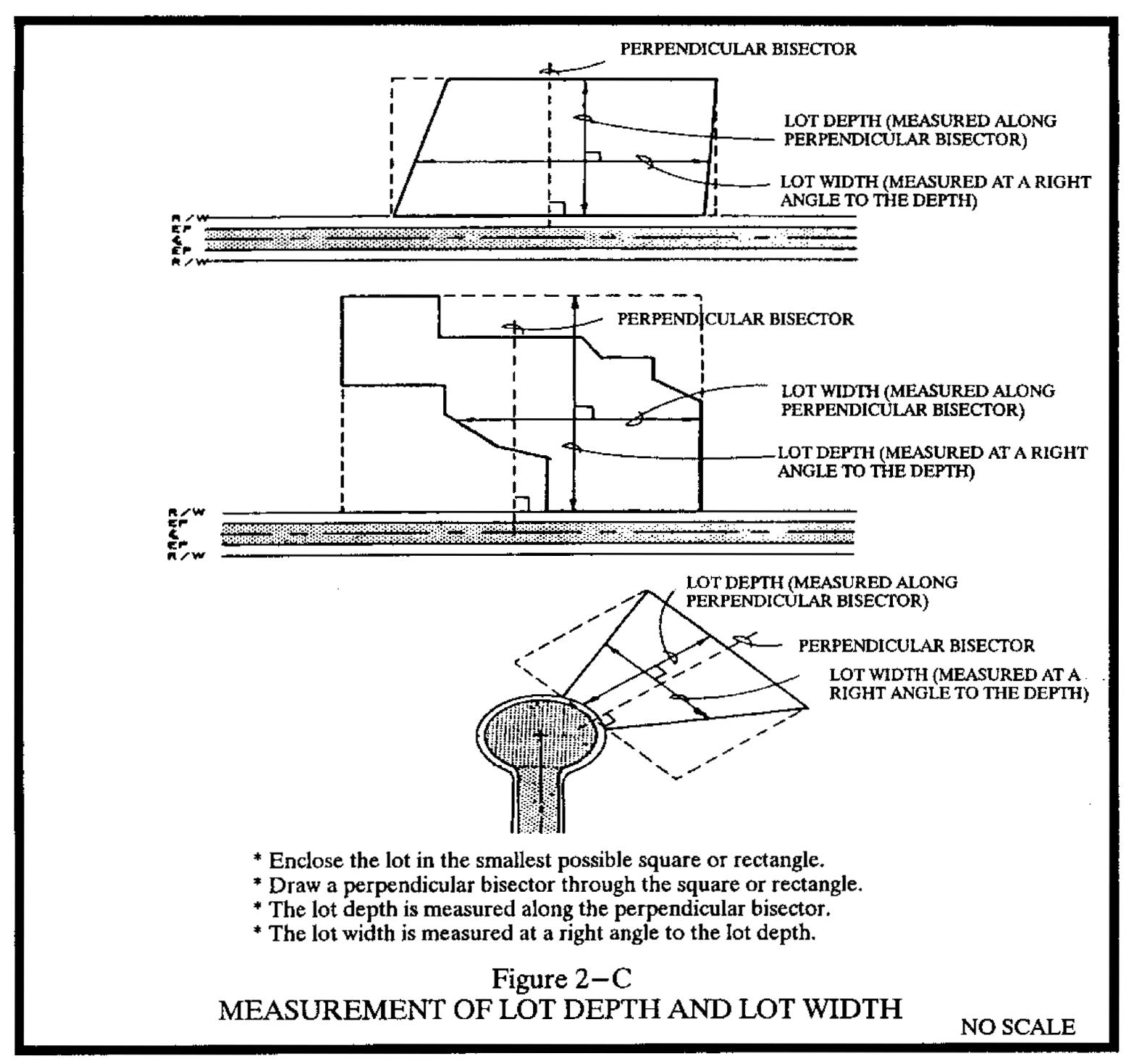
Lot of record. A lot, plot, parcel, or tract recorded in the office of the register of deeds in conformance with the article in effect at the time of recordation.
Lot width. The mean width measured at right angles to its depth at the building line. See figure 2-C.
Reverse frontage lot. A through lot which is not accessible from one of the parallel or non-intersecting streets upon which it fronts.
Through lot. A lot abutting two streets that do not intersect at the corner of the lot.
Townhouse lot. A parcel of land intended as a unit for transfer of ownership, and lying underneath, or underneath and around, a townhouse, patio home, or unit in nonresidential group development.
(10)
Setback, see figure 2-D.
Interior setback. A setback from any property line not alongside a street.
Street setback. Any setback from a street, road, or lane.
Rear setback. A setback from an interior property line lying on the opposite side of the lot from the front street setback.
Setback. The minimum required horizontal distance between a structure or activity and the property line, street right-of-way line, or street centerline.
Side setback. Any interior property line setback other than a rear setback.
Zero side setback. An alternate form of dimensional requirements that allows a dwelling unit to have one side setback of zero from a side property line. This definition does not include townhouses.
FIGURE 2-D DETERMINATION OF BUILDING SETBACKS
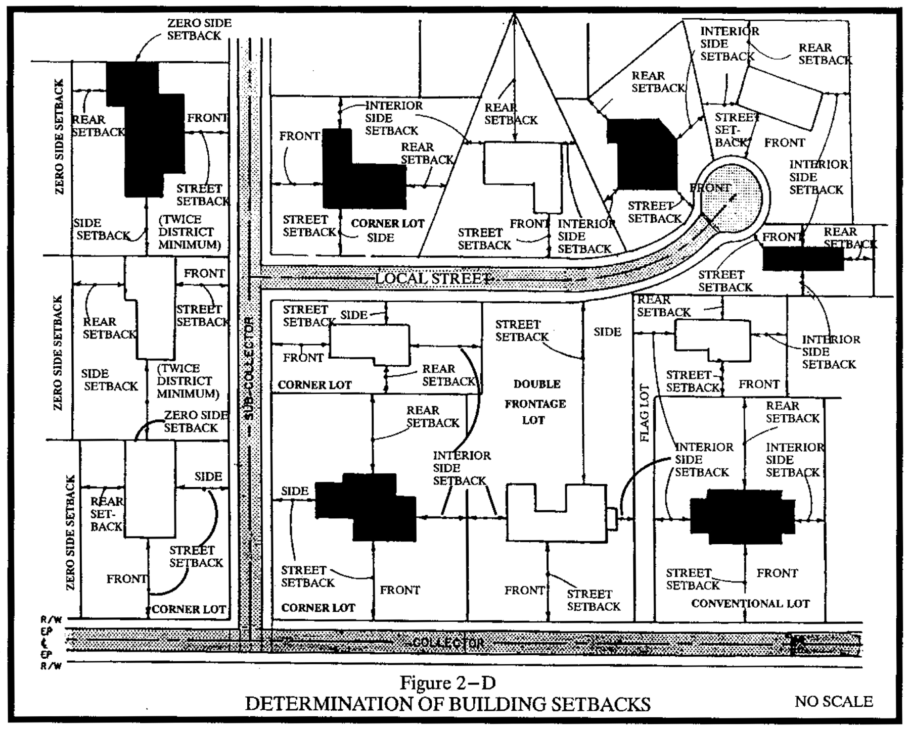
(11)
Signs, see figure 2-E.
Animated sign. Any sign which flashes, revolves, rotates or swings by mechanical means, or which uses a change of lighting to depict action, or to create a special effect or scene.
Banner. A temporary sign of lightweight fabric or similar material which is rigidly mounted to a pole or a building by a rigid frame at two or more edges. National flags, state or municipal flags, or the official flag of any institution or business shall not be considered banners.
Billboard. A freestanding sign designed for the display of information and/or advertising and erected as a principal use in accordance with the provisions of this chapter.
Building marker. A sign indicating the name of a building and date and incidental information about its construction, which sign is cut into a masonry surface, or made of bronze or other permanent material.
Canopy sign. Any sign which is a part of or attached to an awning, canopy or other fabric-like or plastic protective structure which is extended over a door, window, or entranceway. A marquee is not a canopy.
Commercial message. Any sign wording, logo, or other representation that directly or indirectly, names, advertises, or calls attention to a business, product, service, or other commercial activity. This definition does not include company nameplates or logos on instructional signs.
Directional sign. Any sign with no commercial message that indicates the direction to churches, hospitals, colleges and similar institutional uses.
Flashing sign. A type of animated sign which contains an intermittent, blinking, scintillating, or flashing light source, or which includes the illusion of intermittent or flashing light, or an externally mounted intermittent light source. An electronic changeable copy sign is not a flashing sign.
Freestanding sign. Any sign which is supported by structures or supports which are placed on, or anchored in the ground, and which structures or supports are independent from any building or other structure.
Governmental sign. Any sign erected by or on behalf of a governmental body to post a legal notice, identify public property, convey public information, and direct or regulate pedestrian or vehicular traffic.
Identification sign. Any sign used to display: the name, address, logo, or other identifying symbol of the individual, family, business, institution, service, or organization occupying the premises; the profession of the occupant; the name of the building on which the sign is attached; or directory information in group developments or buildings with multiple tenants.
Information board. Signs which display messages in which the copy may be arranged or rearranged by hand.
Instructional sign. Any sign with no commercial message that provides assistance with respect to the premises on which it is maintained, or for the instruction, safety, or convenience of the public such as "entrance," "exit," "one way," "telephone," "parking" and similar information.
Marquee. Any permanent roof-like structure projecting beyond a building or extending along and projecting beyond the wall of the building, generally designed and constructed to provide protection from the weather.
Marquee sign. Any sign attached to, in any manner, or made a part of a marquee.
Multitenant building. A building that is used for two or more occupancies, provided each occupancy is separated by construction having fire-resistive ratings in compliance with the state building code.
Nonconforming sign. Any sign which does not conform to size, height, location, design, construction, or other requirements of this chapter. The nonconformity may result from adoption of the ordinance from which this article is derived or any subsequent amendment.
Pennant. Any lightweight plastic, fabric or other material, whether or not containing a message of any kind, suspended from a rope, wire or string, usually in series, designed to move in the wind.
Playbill. Any sign announcing entertainment offered, or to be offered, at a business location on the site where the sign is displayed.
Portable sign. Any sign not permanently attached to the ground or other permanent structure, or a sign designed to be transported, including but not limited to signs: designed to be transported by means of wheels; converted to A- or T-frames; menu and sandwich board signs; gas or hot-air filled balloons; umbrellas used for advertising; signs attached to or painted on vehicles parked and visible from the public right-of-way, unless said vehicle is used in the normal day to day operation of the business.
Projecting sign. Any sign which is end mounted or otherwise attached to an exterior wall of a building which forms an angle with said wall.
Roof sign. Any sign erected and constructed wholly on and over the roof on a building, supported by the roof structure, and extending vertically above the highest portion of the roof.
Sign. Any object, device, display or structure, or part thereof, which is used to advertise, identify, display, direct or attract attention to an object, person, institution, organization, business, product, service, event or location by any means, including but not limited to words, letters, pennants, banners, emblems, trademarks, tradenames, insignias, numerals, figures, design, symbols, fixtures, colors, illumination or projected images, or any other attention directing device.
Sign owner. Any person holding legal title or legal right to occupy or carry on business in a structure or any facility, and shall include each and every person who shall have title to or benefit of a sign, or for whose benefit any type sign is erected or maintained. Where there is more than one owner, as defined, their duties and obligations under this chapter are joint and several, and shall include the responsibility for such sign.
Special promotion. An advertising activity or circumstance of a business which is not part of its daily activities or normal routine, and in which the display or sale of merchandise, wares, or other tangible items is the sole purpose for the promotion. Special promotions include grand openings or closeout sales, but do not include reoccurring sales advertisements or other similar publicity.
Suspended sign. A sign which is suspended from the underside of a horizontal plane surface and is supported by such surface.
Temporary sign. Any sign that is displayed for a limited period of time and is not permanently mounted.
Temporary event. An activity sponsored by a governmental, charitable, civic, educational, religious, business, or trade organization which is infrequent in occurrence and limited in duration. Examples include arts and crafts shows, athletic events, community festivals, carnivals, fairs, circuses, concerts, conventions, exhibitions, trade shows, outdoor religious events and other similar activities.
Vehicle sign. Any sign on a vehicle which is parked in a location which is visible to the public, and for a period of time which indicates that the principal use of the vehicle is for advertising rather than transport.
Wall sign. Any sign attached parallel to, painted on the wall surface of, or erected and confined within the limits of the outside wall, mansard roof structure, penthouse, or parapet of any building or structure, which is supported by such wall, building, or structure, but does not extend vertically above the highest portion of the roof, and which displays only one sign surface.
Warning sign. Any sign with no commercial message that displays information pertinent to the safety or legal responsibilities of the public such as signs warning or high voltage, "no trespassing," and similar directives.
Window sign. Any sign, pictures, symbols, or combination thereof, designed to communicate information about an activity, business, commodity, event, sale or service, placed inside a window or upon the window panes or glass and which is visible from the exterior of the window.
FIGURE 2-E TYPES OF SIGNS
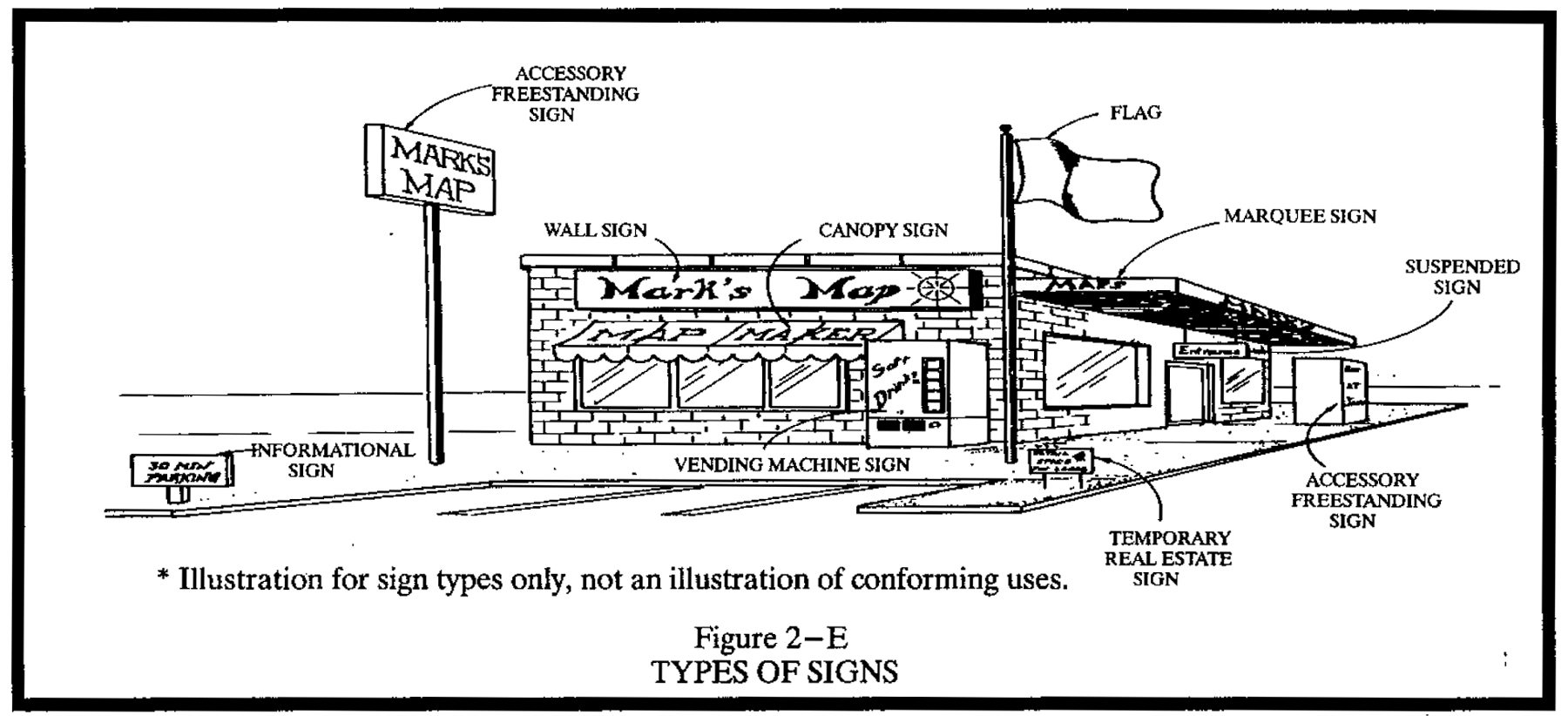
(12)
Streets, drives, and lanes, see figure 2-F.
The numbers in parentheses indicate the street classification, with "1" being the highest and "9" being the lowest.
Alley. A roadway which affords only a secondary means of access to abutting property.
Collector street plan. A plan, adopted by the town council, for streets not shown on the thoroughfare plan, showing collector and, if appropriate, lower classification streets in the planning area.
Collector street (3). A street whose principal function is to carry traffic between cul-de-sac, local, and subcollector streets, and streets of higher classification, but which may also provide direct access to abutting properties.
Cul-de-sac street (6). A short local street having one end open to traffic and the other end permanently terminated by a vehicular turnaround.
Local street (5). A street whose primary function is to provide access to abutting properties.
Major thoroughfare street (1). Major thoroughfares consist of interstate, other freeway, expressway, or parkway links, and major streets that provide for the expeditious movement of high volumes of traffic within and through urban areas.
Minor thoroughfare street (2). Minor thoroughfares collect traffic from collector, subcollector, and local streets and carrying it to the major thoroughfare system. Minor thoroughfares may be used to supplement the major thoroughfare system by facilitating movement of moderate volumes of traffic within and through urban areas and may also serve abutting property.
Private drive (9). A vehicular travelway not dedicated or offered for dedication as a public street, providing access to parking lots for two or more principal buildings in a group housing or group nonresidential development.
Private lane (8). A private cul-de-sac for vehicular traffic serving four or fewer residential lots in a minor subdivision and maintained pursuant to G.S. 136-102.6.
Private street (7). A vehicular travelway not dedicated or offered for dedication as a public street, but resembling a cul-de-sac or a local street by carrying traffic from a series of driveways to the public street system.
Public street. A dedicated public right-of-way for vehicular traffic which has been accepted by NCDOT for maintenance, or is not yet accepted, but in which the roadway design and construction have been approved under public standards for vehicular traffic. Alleys are specifically excluded.
Street right-of-way. A strip of land occupied or intended to be occupied by a travelway for vehicles and also available, with the consent of the appropriate governmental agency, for installation and maintenance of sidewalks, traffic control devices, traffic signs, street name signs, historical marker signs, water lines, sanitary sewer lines, storm sewer lines, gas lines, power lines, and communication lines.
Subcollector street (4). A street whose principal function is to provide access to abutting properties, but which is also designed to be used or is used to connect local streets with collector or higher classification streets.
Thoroughfare plan. A plan adopted by the town council for the development of existing and proposed major streets that will adequately serve the future travel needs of an area in an efficient and cost effective manner.
FIGURE 2-F STREET CLASSIFICATIONS
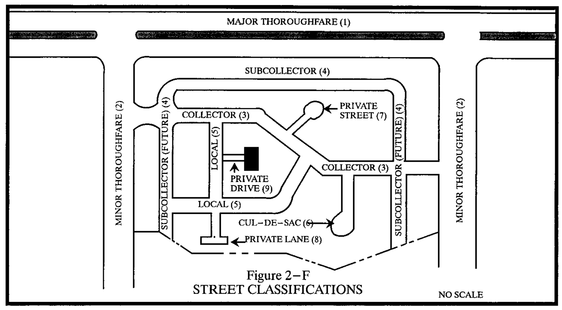
(13)
Historic districts.
Contributing structure. A structure listed as historically and architecturally significant in the town design standards.
Noncontributing structure. A structure listed as not historically and architecturally significant in the town design standards.
Minor work. Work activities which do not result in a substantial or irreversible alteration to the general exterior appearance of a structure, its grounds, or site when viewed from the street right-of-way; therefore not requiring design review by the historic preservation commission, but requiring approval of a certificate of appropriateness by the enforcement officer.
Major work. Work activities which could result in a substantial or irreversible alteration to the general exterior appearance of a structure, its grounds or site when viewed from the street right-of-way; therefore, requiring design review and approval of a certificate of appropriateness by the historic preservation commission.
Routine maintenance. Work activities not already listed under minor or major work and which include ordinary repair and replacement when there is no change in the design, materials, or general exterior appearance of a structure, its grounds or a site when viewed from the street right-of-way; therefore, not requiring design review or application for a certificate of appropriateness.
(14)
Adult-oriented uses.
Adult arcade. Any place to which the public is permitted or invited wherein coin-operated or token-operated or electronically, electrically, or mechanically controlled still or motion picture machines, projectors, or other image-producing devices are maintained to show images to persons in booths or viewing rooms where the images so displayed depict or describe specified sexual activities and/or specified anatomical areas.
Adult bookstore. An establishment having as a substantial or significant portion (25 percent or more) of its stock in trade, for any form of consideration, any one or more of the following materials:
a.
Books, magazines, periodicals or other printed matter, or photographs, films, motion pictures, video cassettes or video reproductions, slides, or other visual representations which are distinguished or characterized by the depiction or description of specified sexual activities and/or specified anatomical areas; or
b.
Instruments, devices, or paraphernalia that are designed for use in connection with specified sexual activities.
Adult cabaret. A nightclub, bar, private club, restaurant or other commercial establishment that regularly features, exhibits or displays as one of its principal business purposes:
a.
Persons who appear nude or semi-nude;
b.
Live performances which are characterized by the exposure of specified anatomical areas or by specified sexual activities; or
c.
Films, motion pictures, video cassettes, slides or other photographic reproductions which depict or describe specified anatomical areas.
Adult-oriented establishment. Such establishments shall include, but are not limited to, adult arcades, adult bookstores or adult video stores, adult cabarets, adult motels, adult motion pictures theaters, adult theaters, escort agencies, nude model studios, sexual encounter centers and any premises to which public patrons or members are invited or admitted and which are so physically arranged so as to provide booths, cubicles, rooms, compartments or stalls separate from the common areas of the premises for the purposes of viewing adult-oriented motion pictures or wherein an entertainer or waiter provided adult entertainment (including entertainment such as described in the definition of adult cabaret) to a member of the public, a patron or a member, whether or not such adult entertainment is held, conducted, operated or maintained for a profit, direct or indirect.
Adult motel. A hotel, motel, or similar commercial establishment that:
a.
Offers accommodations to the public, for any form of consideration, and provides patrons with closed-circuit television transmissions, films, motion pictures, video cassettes, slides or other photographic reproductions that depict or describe specified sexual activities and/or specified anatomical areas as one of its principal business purposes; and
b.
Offers a sleeping room for rent for a period of time that is less than ten hours, or allows a tenant or occupant of a sleeping room to subrent the room for a period of time that is less than ten hours.
Adult motion picture theater. A commercial establishment where, for any form of consideration, films, motion pictures, video cassettes, slides or similar photographic reproductions are regularly shown as one of its principal business purposes which depict or describe specified sexual activities and/or specified anatomical areas and which have not been rated by the Motion Picture Association of America.
Adult theater. A theater, concert hall, auditorium, or similar commercial establishment which regularly features, exhibits, or displays, as one of its principal business purposes, persons who appear in a state of nudity or semi-nudity, or live performances that expose or depict specified anatomical areas and/or specified sexual activities.
Adult video. See "adult bookstore," as defined in this subsection.
Escort. A person who, for tips or any other form of consideration, agrees or offers to act as a date for another person, or who agrees or offers to privately model lingerie or to privately perform a striptease for another person.
Escort agency. A person or business that furnishes, offers to furnish, or advertises to furnish escorts as one of its principal business purposes, for a fee, tip, or any other form of consideration.
Nude model studio. Any place where a person who appears nude or semi-nude, or who displays specified anatomical areas, is provided to be observed, sketched, drawn, painted, sculptured, photographed, or similarly depicted by other persons who pay money or any other form of consideration. Nude model studio shall not include a propriety school licensed by the state or a college, junior college, or university supported entirely or in part by public taxation; a private college or university which maintains and operates educational programs in which credits are transferable to a college, junior college, or university supported entirely or partly by taxation; or in a structure:
a.
That has no sign visible from the exterior of the structure and no other advertising that indicates a nude or semi-nude person is available for viewing;
b.
Where in order to participate in a class a student must enroll at least three days in advance of the class; and
c.
Where no more than one model in a nude or semi-nude condition is on the premises at any one time.
Nude or a state of nudity. The appearance of a human anus, male genitals, or female genitals; or a state of dress which fails to opaquely cover a human anus, male genitals, or female genitals.
Semi-nude or semi-nudity. A state of dress in which clothing covers no more than the genitals, pubic region, and areola of the female breast, as well as portions of the body covered by supporting straps or devices.
Sexual encounter center. A business or commercial enterprise that, as one of its principal business purposes, offers for any form of consideration physical contact in the form of wrestling or tumbling between persons of the opposite sex, or activities between male and female persons and/or persons of the same sex when one or more of the persons is in a state of nudity or semi-nudity.
Specified anatomical areas. Less than completely and opaquely concealed human genitals, pubic region, buttock and female breast below a point immediately above the top of the areola or human male genitals in a discernibly turgid state, even if completely and opaquely covered.
Specified sexual activities. Depiction or display of human genitals in a state of sexual stimulation or arousal or acts of human masturbation, sexual intercourse, sodomy, bestiality, necrophilia, masochism, sadism or sadomasochism, fellatio or cunnilingus or fondling or other erotic touching of human genitals, pubic region, buttock or female breast.
(Ord. of 1-6-2000, §§ 2-1.1—2-1.14; Ord. of 7-6-2006, § 2-1.7; Ord. of 6-7-2007, § 2-1.6; Ord. of 8-2-2007, § 2-1.2; Ord. of 6-4-2009; Amend. of 8-2-2012; Ord. of 3-1-2017; Ord. of 5-4-2017; Ord. No. O-2019-10, 9-5-2019; Ord. No. O-2021-13, § 1, 7-1-2021)