
Oak Ridge City Zoning Code
ARTICLE VII
ZONING
Sec. 30-329. - Districts established.
In order to achieve the purposes of this chapter as set forth, all property within the jurisdiction of the town except property owned by the Piedmont Triad International Airport Authority, is divided into districts with the designations and purposes listed in section 30-330.
(Ord. of 1-6-2000, § 4-1)
Sec. 30-330. - District descriptions.
(a)
General use districts.
(1)
Agricultural. The AG, agricultural district, is primarily intended to accommodate uses of an agricultural nature, including farm residences and farm tenant housing. It also accommodates scattered non-farm residences on large tracts of land. It is not intended for major residential subdivisions. The district is established for the following purposes:
a.
To preserve and encourage the continued use of land for agricultural, forest and open space purposes;
b.
To discourage scattered commercial land uses;
c.
To concentrate urban development in and around area growth centers, thereby avoiding premature conversion of farmland to urban uses; and
d.
To discourage any use which, because of its character, would create premature or extraordinary public infrastructure and service demands.
(2)
Rural preservation, RPD rural preservation district. The RPD, rural preservation district, is intended to accommodate rural developments designed to preserve rural character, significant man-made features, environmentally sensitive areas, and scenic views. The district permits conservation, open space, recreational, agricultural, and residential uses that are part of a unified design.
(3)
Single-family residential. In the following districts the number refers to the minimum lot size in thousands of square feet.
a.
RS-40, residential single-family district. The RS-40, residential single-family district is primarily intended to accommodate single-family detached dwellings on large lots in areas without access to public water and wastewater services. The district is established to promote single-family detached residences where environmental features, public service capacities or soil characteristics necessitate very low density single-family development. The overall gross density in RS-40 areas will typically be 1.0 unit per acre or less.
b.
RS-30, residential single-family district. The RS-30, residential single-family district is primarily intended to accommodate low density single-family detached dwellings on large lots in areas without access to public water and wastewater services. The overall gross density in RS-30 areas will typically be 1.3 units per acre or less.
(4)
TC-R, town core-residential district. The TC-R, town core-residential district is primarily intended to accommodate single-family detached, single-family attached, twin homes, townhouses, cluster housing, and similar residential uses. The overall gross density in TC-R areas shall be limited to a maximum of two units per acre.
(5)
Office and commercial.
a.
LO, limited office district. The LO, limited office district is primarily intended to accommodate low intensity medical, professional, administrative and government office uses on small to mid-sized sites near residential areas.
b.
GO-M, general office moderate intensity. The GO-M, general office moderate intensity district is primarily intended to accommodate moderate intensity office and institutional uses, and supporting service and retail uses.
c.
NB, neighborhood business district. The NB, neighborhood business district is primarily intended to accommodate very low intensity office, retail and personal service uses within residential areas. The district is established to provide convenient locations for businesses which serve the needs of surrounding residents without disrupting the character of the neighborhood. It is not intended to accommodate retail uses which primarily attract passing motorists. Compatibility with nearby residences is reflected in design standards for both site layout and buildings.
d.
LB, limited business district. The LB, limited business district is primarily intended to accommodate moderate intensity shopping and services close to residential areas. The district is established to provide locations for businesses which serve nearby neighborhoods. The district is typically located near the intersection of collectors or thoroughfares in areas which are otherwise developed with residences.
e.
GB, general business district. The GB, general business district is primarily intended to accommodate a wide range of retail, service and office uses. The district is typically located along thoroughfares in areas which have developed with minimal front setbacks.
f.
SC, shopping center district. The SC, shopping center district is primarily intended to accommodate a wide range of high intensity retail and service developments meeting the shopping needs of the community and the region. The district is established on large sites to provide locations for major developments which contain multiple uses, shared parking and drives, coordinated signage and high-quality landscaping.
(6)
Public and institutional,PI public and institutional district. The PI, public and institutional district is intended to accommodate mid- and large-sized public, semipublic and institutional uses which have a substantial land use impact or traffic generation potential. It is not intended for smaller public and institutional uses customarily found within residential areas.
(b)
Planned unit development districts.
(1)
PD-R planned unit development, residential. The PD-R district is intended to accommodate a variety of housing types developed on large tracts in accordance with a unified development plan. The PD-R district also accommodates neighborhood business and office uses which primarily serve nearby residents. PD-R districts are intended only for the town core and the town core transition zone as depicted on the adopted Town of Oak Ridge Future Land Use Map.
(2)
PD-M planned unit development, mixed. The PD-M district is intended to accommodate residential, commercial and light industrial uses developed on large tracts in accordance with a unified development plan. PD-M districts are intended only for the town core and the town core transition zone as depicted on the adopted Town of Oak Ridge Future Land Use Map.
(c)
Conditional zoning.
(1)
Districts established. Conditional zoning, bearing the designation CZ, is hereby established as a companion district for every district established in this section. These districts are CZ-AG, CZ-RS-40, CZ-RS-30, CZ-TC-R, CZ-LO, CZU-GO-M, CZ-NB, CZ-LB, CZ-GB, CZ-SC, CZ-PI, CZ-PD-R, CZ-PDM and CZ-RPD. All regulations which apply to a general use zoning district also apply to the companion conditional zoning. All other regulations, which may be offered by the property owner and approved by the jurisdiction as part of the rezoning process, also apply.
(2)
Application. The conditional zoning classification will be considered only upon request of the property owner for rezoning.
(d)
Overlay districts. Overlay districts establish certain area regulations which are in addition to the underlying general use, planned unit development or conditional zoning.
(1)
GWA, general watershed area district. The GWA overlay district is intended to set forth regulations for the protection of public drinking water supplies and are applicable to all lands which drain toward such supplies and are outside of the WCA overlay district. These regulations are specified in divisions 2 and 3 of article X.
(2)
FH, flood hazard district. The FH overlay district is intended to set forth regulations which will minimize the damage done by floods. These regulations are specified in article XII.
(3)
HD, historic district. The HD overlay district is intended to set forth regulations which will help maintain the historic integrity of certain areas in the town. These regulations are specified in division 10 of article VII.
(4)
SR, scenic corridor district. The SR overlay district is intended to set forth regulations which will enhance the attractiveness of major thoroughfares which enter and/or pass through the town. These regulations are specified in division 10 of article VII.
(5)
AR, airport district. The AR overlay district is intended to prohibit the erection of structures which would, by virtue of their height, interfere with operations at Piedmont Triad International Airport. The district is also intended to keep residential densities near the airport very low so as to minimize the negative effects of aircraft noise on homes. Regulations for the AR overlay district are specified in division 10 of article VII.
(Ord. of 1-6-2000, § 4-2; Ord. of 5-6-2004, § 4-2.1; Ord. of 6-2-2016(1); Ord. of 10-1-2020(1); Ord. No. O-2021-13, § 1, 7-1-2021)
Sec. 30-331. - Permitted uses.
(a)
Permitted use schedule.
(1)
Tabulation of permitted uses. Within each zoning district indicated on the official zoning map and subject to all requirements and conditions specified in this chapter, land, buildings, and structures shall only be used and buildings and structures shall only be erected which are intended or designed to be used for uses listed in the permitted use schedule below. In the appropriate columns of the permitted use schedule below, uses permitted by right in the various districts are indicated with a "P," uses requiring a special use permit are indicated by an "S," uses permitted by right subject to meeting additional development standards as set forth in article IX are indicated with a "D," and uses requiring a manufactured housing overlay zone are indicated with a "Z." The column on the far right labeled "LUC" indicates the land use classification of each use as it relates to planting yard requirements found in division 4 of article IX.
(2)
Formulation of permitted use schedule.
a.
The Standard Industrial Classification Manual 1987 was utilized in the preparation of this table and shall be referred to as a guide for purposes of interpretation by the enforcement officer. SIC codes are used to refer to SIC classifications. Entries with 0000 in the Reference SIC column do not correspond to any classification in the SIC manual.
b.
When a use is not listed in the permitted use schedule below, the enforcement officer shall classify it with that use in the table most similar to it. The SIC manual shall serve as a guide in classifying any unlisted use. If the enforcement officer should determine that a use is not listed and is not similar to a use in the permitted use schedule below, than said use is prohibited.
c.
Rental and leasing of any commodity shall be permitted under the same classification and in the same districts as are sales of that commodity, unless rental or leasing of that commodity is listed separately in the permitted use schedule below.
d.
If an industrial plant or facility involves two (or more) manufacturing activities with different SIC codes on the same zone lot, the industrial plant shall be permitted only in those zoning districts where the more restricted activity is permitted. (For example, an industrial plant preparing canned peanuts and also manufacturing the cans is allowed in those zoning districts permitting can manufacturing.)
(b)
Mixed uses. Two or more permitted uses may occupy the same principal building.
(c)
Prohibited uses. Within certain overlay districts, some uses are prohibited, regardless of the uses permitted in the underlying zoning district. The following uses are prohibited in the overlay districts listed.
(1)
Scenic corridor overlay district. Class A, B, and C manufactured dwellings are prohibited in the scenic corridor overlay district. See section 30-591.
(2)
Airport overlay district. Multifamily housing and single-family housing on lots less than 40,000 square feet are prohibited in the airport overlay district. See section 30-593.
(3)
Flood hazard area. Storage or processing of materials that are flammable, corrosive, toxic or explosive, or which could otherwise be injurious to human, animal or plant life in time of flood shall be prohibited from the flood hazard areas. See section 30-1367(d)(2).
WS-III = New landfills which require a NPDS permit for disposing of treates leachate are prohibited in WS-III (GWA) watersheds.
P = use by right.
D = development standards.
S = special use permit required.
Z = overlay zoning required.
* = additional district requirements, see section 30-353(b).
(Ord. of 1-6-2000, § 4-3; Ord. of 1-6-2000, table 4-3-1; Ord. of 5-6-2004, table 4-3-1; Ord. of 2-4-2010(1); Ord. of 6-2-2016; Ord. of 3-1-2017; Ord. of 10-1-2020(2))
Sec. 30-351. - Agricultural and single-family districts.
The dimensional requirements for agricultural and single-family districts are found in the table below.
AGRICULTURAL AND SINGLE-FAMILY DISTRICT
DIMENSIONAL REQUIREMENTS
Notes:
a Overall density shall not exceed two dwelling units per acre.
b Setback from right-of-way line or property line/setback from street centerline, whichever is greater.
c No more than three full or partial stories entirely above grade.
d May be reduced to 15 feet in townhouse developments with buildings two stories are less.
1. A corner lot has two street setbacks. The setback of lower setback category shall be considered the side street. If both streets are of the same setback category, the property owner shall designate the side street for his lot.
2. A through lot has two street setbacks but no rear setback.
3. On a corner lot of record, the side street setback may be reduced, if necessary, to yield a buildable width equal to 60 percent of the lot width.
4. For any lot of record, the street setback and the rear setback may be reduced, if necessary, to yield a buildable depth equal to 40 percent of the lot depth. The rear setback shall be reduced first, but not below 15 feet and the street setback shall not be reduced by greater than ten feet.
(Ord. of 1-6-2000, § 4-4.1; Ord. of 5-6-2004, table 4-4-1; Ord. of 6-2-2016; Ord. of 5-4-2017)
Sec. 30-352. - Dimensional requirements for permitted single-family district uses and two-family dwellings in the NB and LO districts.
(Ord. of 1-6-2000, § 4-4.2)
Sec. 30-353. - Nonresidential districts.
(a)
Dimensional requirements for nonresidential districts: Dimensional requirements for nonresidential districts are shown in the table below.
Table 4-4-5
NONRESIDENTIAL DISTRICT DIMENSIONAL REQUIREMENTS
a Lots of record having less than minimum required area may be developed pursuant to section 3-14.1 (nonconforming lots of record).
;sup\sup; Maximum district size of three acres (excluding any street right-of-way).
c Setbacks from right-of-way line or property line/street centerline, whichever is greater.
d Zero setback if no setback is provided. If setback is provided it must be a minimum of five feet.
e A through lot has two street setbacks but no rear setback.
f Increase all setbacks by one foot for every foot in height between 50 and 80 feet. No additional setback is required for buildings above 80 feet in height.
g Smaller lots are permitted for residential uses (see tables in division 2).
h No more than three full or partial stories entirely above grade.
;sup\sup; Development perimeter only.
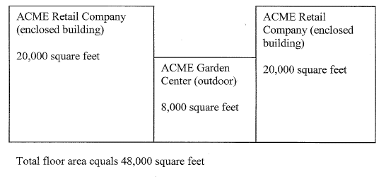
j The 30,000 square feet of floor area includes gross building floor area, outdoor storage areas, and any outside area which provides associated services to the public, such as, but not limited to, outdoor merchandise display, snack bars, etc. The floor area does not include motor vehicle parking and loading areas. For the purposes of determining the applicability of the 30,000 square feet of floor area maximum, the aggregate square footage of all adjacent buildings/outdoor uses which share check stands, store management (not including property management), or storage areas shall be considered one establishment, e.g., a plant nursery associated with a general merchandise store such as a home improvement store, see figure [below]. Any existing structure erected before the enactment of the Oak Ridge Code of Ordinances may be expanded once by no more than 25 percent of the original structure floor area and such expansion shall be exempt from the provisions of section 30-303 of the Code of Ordinances related to the nonconforming use of land and nonconforming structures.
(b)
Additional requirements for nonresidential districts.
(1)
Neighborhood business district (NB).
a.
No more than 3,000 square feet of gross floor area per use shall be permitted on a lot.
b.
Outside storage is prohibited.
c.
Hours of operation shall be restricted to between 6:00 a.m. to midnight.
d.
Drive-through sales and services are not permitted.
e.
Exterior lighting is limited to indirect illumination and safety lighting. All exterior lighting shall be hooded or shielded so that the light source is not directly visible from adjacent streets or properties. No exterior lighting shall be located higher than 15 feet above ground or pavement.
f.
All off-street parking shall be located to the rear of the building.
g.
Buildings must be reflective of the architectural styles, exterior material, and colors of nearby residences.
h.
A maximum of two dwellings units are permitted above each business.
(2)
Limited business (LB).
a.
No more than 50,000 square feet of gross floor area per use shall be permitted on a lot.
b.
No more than 100,000 square feet of gross floor area per development shall be permitted.
c.
Outside storage is prohibited.
(3)
General business (GB). All permitted uses within the wholesale trade category, except market showrooms, shall meet the following standards:
a.
A maximum of 10,000 square feet of gross floor area intended for wholesale trade shall be permitted per establishment; and
b.
No outside storage of materials shall be permitted.
(4)
Shopping center (SC).
a.
No more than 60,000 square feet of gross floor area per use shall be permitted on a lot.
b.
No more than 130,000 square feet of gross floor area per development shall be permitted.
(Ord. of 1-6-2000, § 4-4.3; Ord. of 4-1-2010; Amend. of 5-1-2014; Ord. of 10-1-2020(2))
Sec. 30-380. - Accessory uses, buildings and structures.
The requirements listed in this division are for customary accessory buildings and structures. Other accessory buildings and structures containing specific accessory uses listed in the permitted use schedule in section 30-331 may have additional development requirements found in division 5 of article IX.
(Ord. of 1-6-2000, § 4-5)
Sec. 30-381. - Setback requirements.
(a)
Front. No encroachment by accessory uses, buildings or structures in the front setback is permitted.
(b)
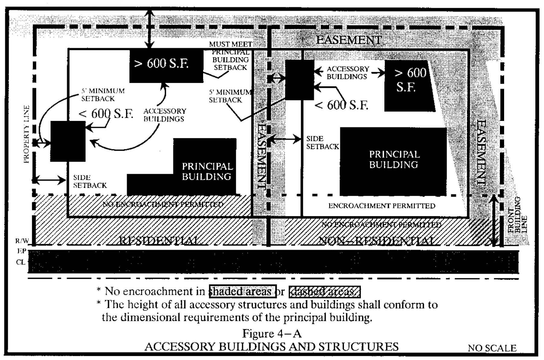
Side and rear. If the gross floor area (GFA) of the accessory structure or building is less than or equal to 600 square feet, the structure or building may be located five feet from a side or rear line. If the GFA is greater than 600 square feet, it must meet the principal building setback requirements.
FIGURE 4-A ACCESSORY BUILDINGS AND STRUCTURES
(Ord. of 1-6-2000, § 4-5.1)
Sec. 30-382. - Location.
(a)
Single-family developments. All accessory structures and buildings must be located behind the front building line of the principal structure, except that in the AG, RS-40, and RS-30 zoning districts, existing accessory structures and buildings with any horizontal dimension greater than 12 feet may be located in front of the front building line of the principal structure.
(b)
Multifamily development. Clubhouses, rental or administrative offices, and mailbox kiosks or shelters may be located in front of the front building line of the principal building, but shall follow the same street setbacks as the principal building. All others accessory buildings and structures shall be located behind the front building line of the principal building.
(c)
Nonresidential zoning districts. Accessory structures and buildings may be in front of the front building line of the principal structure, but must follow the same street setback as the principal building.
(d)
All districts. No accessory structure or building except utility substations shall be erected in any easements.
(Ord. of 1-6-2000, § 4-5.2)
Sec. 30-383. - Height.
The height of all accessory structures and buildings shall conform to the zoning district in which it is located.
(Ord. of 1-6-2000, § 4-5.3)
Sec. 30-384. - Accessory use area.
A nonresidential accessory use shall not exceed 25 percent of any of the following measures: gross sales, building volume, floor area, land area, or any other appropriate measure of usage.
(Ord. of 1-6-2000, § 4-5.4)
Sec. 30-412. - Structures permitted above height limits.
Except as otherwise prohibited by the airport overlay district, the height limitations of this chapter shall not apply to public buildings, church spires, belfries, cupolas and domes not intended for residential purposes, or to monuments, water towers, observation towers, power transmission towers, silos, grain elevators, chimneys, smokestacks, derricks, conveyors, flag poles, radio, television and communication towers, masts, aerials and similar structures, provided such structures meet the required state building code.
(Ord. of 1-6-2000, § 4-6.1)
Sec. 30-413. - Prevailing street setback.
Where 50 percent or more of the lots on the same side of the block as the lot in question are developed with less than the required street setbacks, the average setback of the two principal buildings nearest that lot shall be observed as the required minimum setback.
(Ord. of 1-6-2000, § 4-6.2)
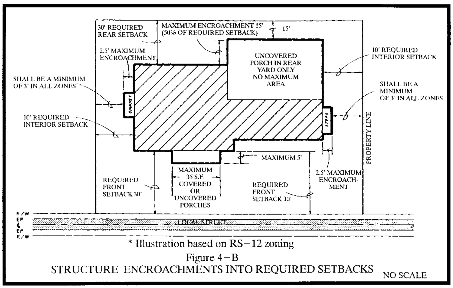
Sec. 30-414. - Encroachments into required setbacks, see figure 4-B.
(a)
Encroachments permitted in required setback. The following are permitted in required setbacks provided there is no interference with any sight area:
(1)
Landscaping features, including but not limited to, ornamental pools, planting boxes, sculpture, arbors, trellises, and birdbaths;
(2)
Pet shelters, at grade patios, play equipment or outdoor furniture, ornamental entry columns and gates, flag poles, lamp posts, address posts, HVAC equipment, mailboxes, outdoor fire places, public utility wires and poles, pumps or wells, and fences or retaining walls subject to the requirements of article IX;
(3)
Handicapped ramps; and
(4)
Gatehouses/guardhouse and bus shelter.
(b)
Structures permitted in required setbacks. The following structures may encroach into any required setback:
(1)
Cornices, steps, overhanging eaves and gutters, window sills, bay windows or similar architectural features, chimneys and fireplaces, fire escapes, fire balconies, and fire towers may project not more than 2½ feet into any required setback, but in no case shall be closer than three feet to any property line; and
(2)
Porches may encroach into the required front and rear setbacks as follows:
(c)
Permitted projections. Canopies, awnings, and marquees or similar covers attached to a building in the GB districts may project into the street right-of-way provided that:
(1)
No portion of the cover is located closer to the face of the street curb than a horizontal distance of three feet;
(2)
No portion of the cover or sign hanging below the cover is less than nine feet above the grade; and
(3)
No cover requiring vertical support to the sidewalk is located over a sidewalk with a total width of less than eight feet.
(d)
Canopy projections. Gas station and convenience store pump canopies may be located in the street setback provided that no equipment or part of a canopy is located closer than 15 feet to a street right-of-way line.
FIGURE 4-B STRUCTURE ENCROACHMENTS INTO REQUIRED SETBACKS
(Ord. of 1-6-2000, § 4-6.3)
Sec. 30-415. - Easement encroachments.
(a)
Utility easements. In addition to the lines, boxes, structures, and substation buildings for which utility easements are intended, fences without foundations may be located within utility easements. (Note: Prior to fence construction the property owner should contact ULOCO.)
(b)
Drainage maintenance and utility easements. Water-related improvements, such as boat docks, may be placed or constructed within drainage maintenance and utility easements.
(c)
Water quality conservation easements. Water-related improvements, such as boat docks and soil erosion and sedimentation control structures, may be placed or constructed within water quality conservation easements.
(Ord. of 1-6-2000, § 4-6.4)
Sec. 30-416. - Setbacks from thoroughfares.
Where proposed street alignments have been established, building setbacks shall be measured from the future right-of-way line or centerline of the proposed street.
(Ord. of 1-6-2000, § 4-6.5)
Sec. 30-446. - Principal buildings per lot.
Every building hereafter erected or moved shall be located on a zone lot; and in no case shall there be more than one principal residential building and its accessory buildings on a zone lot except as provided in this section.
(1)
Nonresidential group development. Two or more principal nonresidential buildings are permitted on a zone lot pursuant to a site plan approved pursuant to section 30-300, provided that an access driveway is maintained to each building in passable condition for service and emergency vehicle.
(2)
Residential group development. Two or more principal buildings are permitted in a multifamily development pursuant to a site plan approved pursuant to section 30-300, provided that an access driveway is maintained to each building in passable condition for service and emergency vehicle.
(Ord. of 1-6-2000, § 4-7.1; Ord. of 3-1-2017)
Sec. 30-447. - Street access requirements.
(a)
Access to public street required. Every zone lot shall abut and have direct access to a publicly maintained street or other public right-of-way legally dedicated, except as provided in this section. No building or structure shall be constructed, erected, or placed on a zone lot that does not abut and have direct access to a publicly maintained street or other public right-of-way legally dedicated, except as provided in this section. The zone lot shall have an open and passable access from the street, where the legally assigned address is located, to the principal building or structure. For corner lots, the access may be from the side street if the access is clearly visible from the street where the address is assigned.
(b)
Dead-end streets. For purposes of this section the terminus of a dead-end street does not provide the required access to a publicly maintained street unless that terminus is a circular turnaround or other turnaround approved and constructed in conformance with article VIII.
(c)
Single-family detached cluster development. Private streets may be used to meet access requirements for lots in single-family detached cluster developments and for single-family or twin home lots in planned unit developments, provided the developments as a whole abuts and has direct access to a publicly maintained street.
(d)
Private lanes. Subdivision lots that abut and have access to private lanes platted in accordance with section 30-860(h).
(e)
Townhouse developments. Individual parcels shall have right of access through common areas containing private streets and/or private drives at least 24 feet in width leading to a publicly maintained street. Individual parcels may have direct access to a publicly maintained street with planning and zoning board approval.
(f)
Unified development. Individual parcels, whether leased or sold, in a unified development shall have shared rights of access along private streets and/or along private drives at least 24 feet in width leading to a publicly maintained street. Maintenance of all private streets and private drives shall be a mandatory responsibility, running with the land, exercised by a single entity which shall be composed of one landowner, an owner's association, or all owners acting collectively pursuant to a binding agreement.
(g)
Exceptions. Special-purpose lots may provide access via easement in accordance with division 7 of this article; and lots served by exclusive access easements in accordance with section 30-859(7)b.
(h)
Access from public street prohibited. Access from a commercial, office, or institutional zoning district shall be prohibited through an RS district, unless it is the sole access.
(i)
Access through districts permitted. Any use located in a zoning district which is also a permitted use in a neighboring zoning district may have access through the neighboring zoning district without additional requirements.
(Ord. of 1-6-2000, § 4-7.2; Ord. of 3-1-2017; Ord. of 10-1-2020(2))
Sec. 30-448. - Unified development.
(a)
Parking and landscaping. A unified development shall be treated as a single zone lot for purposes of providing required off-street parking and required planting yards, even if outparcels for sale are included within the development.
(1)
If the entire development meets the total off-street parking requirements, it is not required that each parcel provide all the required parking for the use thereon.
(2)
If required planting yards are provided along the development perimeter, including street frontages, and requirements for parking lot planting are met, planting yards are not required along property lines and lease lines between two parcels within the unified development.
(b)
Plat and notice requirements. If the owner of a development elects to organize it in a unified development, a plat shall be recorded displaying a prominent note identifying it as such and explaining that the property must be developed with common driveways and off-street parking and be subject to a common signage plan and a common landscaping plan. The note shall further state that should the property cease function as a unified development, the property will then be in violation of this chapter and shall be retrofitted with conventional parking and landscaping, even if doing so requires the removal of previously installed improvements.
(Ord. of 1-6-2000, § 4-7.3)
Sec. 30-480. - Single lot.
No lot shall be reduced in size so that noncompliance with respect to any frontage, building coverage, area, built-upon area, width, setback, parking, planting yard, or signage requirement of this chapter is created, nor shall any existing nonconformity or violation be increased.
(Ord. of 1-6-2000, § 4-8.1)
Sec. 30-481. - Zone lot.
Where two or more contiguous lots in one ownership collectively form a zone lot, that zone lot shall not be reduced in size so that noncompliance with respect to any frontage, building coverage, area, built-upon area, width, setback, parking, planting yard, or signage requirement of this chapter is created, nor shall any existing nonconformity or violation be increased.
(Ord. of 1-6-2000, § 4-8.2)
Sec. 30-482. - Exemption.
These prohibitions shall not apply to county, municipal or state acquisition of land.
(Ord. of 1-6-2000, § 4-8.3)
Sec. 30-503. - Requirements.
Requirements of this division with respect to street frontage, minimum lot area, and minimum lot dimensions shall not apply to lots for family or church cemeteries, sewer lift stations, radio, television, and communication towers, and similar utility uses. Such lots shall comply with the requirements of this division.
(Ord. of 1-6-2000, § 4-9)
Sec. 30-504. - Minimum size.
The special-purpose lot shall be permitted only after the planning and zoning board has determined that the proposed lot has sufficient dimensions to accommodate the intended use and, where required by this chapter, planting yards.
(Ord. of 1-6-2000, § 4-9.1; Ord. of 3-1-2017)
Sec. 30-505. - Access easement.
If the special-purpose lot does not have direct access to a public street, an easement for ingress and egress with a minimum width of ten feet shall be platted.
(Ord. of 1-6-2000, § 4-9.2)
Sec. 30-506. - Platting.
The subdivision to create the lot shall be approved in accordance with article VIII. The final plat shall label the lot as a "Special-Purpose Lot for use as _______."
(Ord. of 1-6-2000, § 4-9.3)
Sec. 30-536. - Applicability.
A planned unit development is an area of land under unified ownership or control to be developed and improved as a whole under a unified development plan in accordance with the requirements of this chapter.
(Ord. of 1-6-2000, § 4-10.1)
Sec. 30-537. - Minimum size and uses allowed.
(a)
Planned unit development, residential (PD-R).
(1)
Minimum size. No PD-R district shall be approved for a site of less than 25 contiguous acres under unified ownership or control.
(2)
Uses allowed. The uses allowed in a PD-R district are those allowed in any residential district, the neighborhood business district (NB) and the limited office (LO) district.
(b)
Planned unit development, mixed (PD-M).
(1)
Minimum size. No PD-M district shall be approved for a site of less than 25 contiguous acres under unified ownership or control.
(2)
Uses allowed. The uses allowed in a PD-M district are those allowed in any zoning district created by this chapter except those uses which must, under the terms of this chapter, be placed in a Heavy Industrial (HI) or Agricultural (AG) district.
(Ord. of 1-6-2000, § 4-10.2)
Sec. 30-538. - Relationship to other applicable regulations.
A planned unit development shall be subject to all of the applicable standards, procedures, and regulations of this chapter except as varied or changed by the express terms of this section.
(Ord. of 1-6-2000, § 4-10.3)
Sec. 30-539. - Development standards.
(a)
Dimensional requirements. The dimensional requirements of this chapter are waived except that:
(1)
No structure of any type which is in excess of 35 feet in height shall be erected within 50 feet of a single-family zoning district or single-family portion of a planned unit development; and
(2)
Lots planned for single-family detached dwelling use shall each contain an area equal to or greater than the minimum area allowed in the RS-5 zoning district or shall have convenient access to nearby open space.
(b)
Access.
(1)
Areas between structures shall be covered by easements where necessary to preserve access and to provide for maintenance and utility service; and
(2)
Primary vehicular access to commercial development shall not be through intervening residential development.
(c)
Commercial areas.
(1)
Commercial areas within planned unit developments shall be arranged to:
a.
Separate pedestrian and vehicular traffic such that pedestrians can safely walk between stores within a development and from parking areas to stores; and
b.
Promote pedestrian access from adjacent residential and office areas into commercial areas.
(2)
Commercial uses in a PD-R district shall be located on and shall face an internal street of the development;
(3)
No more than ten percent of the total land area in a PD-R district may be occupied by or used for commercial purposes; and
(4)
Commercial uses in a PD-R district are permitted if they are designed and located to serve primarily the residents of the planned unit development.
(d)
Local street design. Local streets within a planned unit development shall be located and designed so that they do not provide for through access by traffic with origins and destinations outside of the development.
(e)
Boundary treatment.
(1)
The scale and setbacks of planned unit development improvements within 150 feet of the perimeter of the planned unit development shall be in harmony with development on adjacent lands; and
(2)
No commercial use shall be permitted within 150 feet of the perimeter of a planned unit development unless the same or a similar use exists adjacent to the perimeter at the time of the approval of the planned unit development.
(f)
Signs.
(1)
The size, height, setback, location, design, illumination and number of signs shall be specified in the unified development plan.
(2)
All signs shall use a coordinated color, style and lettering scheme.
(g)
Parking. Off-street parking for each use in a planned unit development shall be provided in accordance with the standards set forth in this chapter for the same use or uses of similar intensity. The town council may reduce the parking spaces if the unified development plan provides convenient pedestrian and/or bicycle access among uses.
(h)
Environmentally sensitive areas. The following shall be left natural and undisturbed except for road crossings, utilities and erosion control devices:
(1)
Land within a floodway or floodway fringe; and
(2)
Wetlands, steep slopes and other critical ecological areas.
(i)
Open space and common recreational facilities.
(1)
In a planned unit development district, open space is only that land dedicated to the public or designated by the development plan for the use, benefit, and enjoyment of all residents of the planned unit development. Open space may be common area owned by an owner's association or parkland or drainageway and open space dedicated to the public.
(2)
To qualify as open space, land shall be useable for recreation purposes or provide visual, aesthetic or environmental amenities, and may not be occupied by street rights-of-way, drives, parking areas or structures other than recreational structures.
(3)
Land within a floodway or floodway fringe zone may be used to provide not more than 50 percent of the open space required in a planned unit development.
(4)
All property owners in the planned unit development shall have access to the open space by means of a public or private street right-of-way or all-weather walkway in an easement a minimum of 20 feet in width.
(5)
The following amount of open space is required:
a.
Two and one-half acres per 100 dwelling units; and
b.
Ten percent of the gross land area for commercial uses.
c.
Open space requirements may be reduced depending upon the nature and extent of active recreation facilities provided.
d.
Open space shall be provided within each phase of the planned unit development in sufficient amounts to serve the expected population of that phase or the gross land area devoted to nonresidential land uses.
(j)
Utilities. Water, sewer, electrical, gas, television and telephone utilities shall be installed in accordance with section 30-863.
(Ord. of 1-6-2000, § 4-10.4; Ord. of 10-1-2020(2))
Sec. 30-540. - Procedures.
(a)
Rezoning to planned unit development.
(1)
Prior to submitting an application for rezoning to PD-R or PD-M the applicant shall submit a sketch plan prepared in accordance with appendix B to this Code that includes:
a.
The general location and amount or land proposed for single-family residential, multifamily residential, office, commercial, open space/recreation, and street use;
b.
The number of dwelling units or gross floor area and the acreage of each tract or area shown on the sketch plan;
c.
The maximum height of buildings and structures in each such tract or area;
d.
The location and amount of land in flood hazard areas and any other lands not suitable for development; and
e.
Proposed watershed protection measures, including their general location, if the development is within a general watershed area.
(2)
The planning and zoning board and the town council shall review the sketch plan for consistency with the requirements of article VIII and other applicable standards in this chapter. The planning and zoning board and the town council, upon finding such consistency, shall approve the sketch plan for submission to the planning and zoning board and the town council in combination with a rezoning application. If the sketch plan is not approved for submission, it shall be returned to the applicant with written reasons for disapproval and/or requests for further information. If it is not approved, the applicant may revise and resubmit the sketch plan.
(3)
The rezoning application shall consist of the following materials:
a.
A rezoning application prepared in accordance with article VI;
b.
The sketch plan approved by the town council;
c.
Written documents which specify:
1.
The amount of land proposed to be used for each of the following uses: single-family residential, multifamily residential, commercial, open space/recreation, or streets;
2.
The amount of land in floodplain and any other lands not suitable for development;
3.
The overall gross density of the development and the specific density of each tract or area shown on the sketch plat. Residential density shall be shown in dwelling units/acre; nonresidential intensity shall be shown in gross floor area (GFA)/acre;
4.
Traffic generation data which shows trips to and from the development, within the development, and through the development on proposed collector or thoroughfare-level streets; and
5.
An overall watershed protection concept plan if the development lies within a general watershed area.
(4)
Once submitted as required herein, the petition for rezoning shall proceed to conclusion in accordance with article VI and other provisions of this chapter. Approval of the rezoning establishes the maximum density and use of each tract or area shown on the sketch plan. Any request for change in use or increase in density shall be considered a change in zoning and shall be subject to all applicable procedures.
(b)
Unified development plan approval.
(1)
Submission. The applicant may submit a unified development plan any time after approval of the sketch plan by the town council. A unified development plan may be processed simultaneously with the petition for rezoning.
(2)
Required materials. The unified development plan shall contain the following materials:
a.
The approved sketch plan with proposed phase lines, if any;
b.
Land use, density and traffic data specified in section (a) of this section;
c.
Preliminary plats for the first phase of development including;
1.
Utilities plan in accordance with appendix B to this Code;
2.
Grading/watershed development plan in accordance with appendix B to this Code; and
3.
Landscaping plan in accordance with appendix B to this Code;
d.
Common sign plan in accordance with article IX; and
e.
Documents which specify proposed setbacks or other regulations governing building placement on the land, height restrictions, architectural controls, and other information which the planning and zoning board and the town council may deem pertinent to plan approval. The applicant may use district regulations provided by this chapter or may propose regulations unique to this development. In no case, shall the unified development plan leave any area proposed for development unregulated.
(3)
Review and approval. The planning and zoning board and the town council shall review the unified development plan and determine if it meets all applicable provisions of this chapter and is consistent with the sketch plan. If the unified development plan is approved, it shall be noted on the zoning map by project name and/or file reference number. The sketch plan, common sign plan and documents specified in subsection (b)(2)e of this section shall also be recorded in the Office of the Guilford County Register of Deeds within 60 days of approval. After approval of a unified development plan, no building or structure may be erected or building permit issued, nor any lots sold, nor any plats recorded unless such building, structure, permit or plat substantially conforms to the unified development plan.
(4)
Phased development of planned unit developments.
a.
Planned unit developments may be developed in phases provided that the following requirements are met:
1.
All phases shall be shown with precise boundaries on the unified development plan and shall be numbered in the expected order of development;
2.
All data required for the project as a whole shall be given for each phase shown on the plan;
3.
Development of the cumulative area of open space in all recorded phases and the total number of dwelling units approved in those phases shall comply with division 4 of this article;
4.
A proportionate share of the project's open space and common facilities shall be included in each phase of development; and
5.
The phasing shall be consistent with the traffic circulation, drainage and utilities plans for the entire planned unit development.
b.
If an approved unified development plan includes phasing provisions, then:
1.
No final plat for a phase of a planned unit development shall be approved unless all open space and common facilities included in previous phases are substantially complete; and
2.
No final plat for a phase of a planned unit development shall be approved if there is any uncorrected violation of the unified development plan, a preliminary plat, a final plat or this article in any previous phase.
(5)
Owner's association documents required. After approval of a unified development plan, no final plat shall be recorded until the owner's association documents prepared in accordance with division 7 of article VIII are recorded in the Office of the Guilford County Register of Deeds.
(Ord. of 1-6-2000, § 4-10.5; Ord. of 10-1-2020(2))
Sec. 30-559. - Applicability.
A development in the rural preservation district (RPD) shall be under unified ownership or control to be developed and improved as a whole under a unified development plan in accordance with the requirements of this chapter.
(Ord. of 1-6-2000, § 4-11.1)
Sec. 30-560. - Minimum district size and uses allowed.
(a)
Minimum size. No RPD shall be approved for a site of less than ten contiguous acres under unified ownership or control.
(b)
Uses allowed. The uses allowed in a RPD are those allowed in any RS residential district.
(Ord. of 1-6-2000, § 4-11.2; Ord. of 6-2-2016(1))
Sec. 30-561. - Relationship to other applicable regulations.
Development in the RPD shall be subject to all of the applicable standards, procedures, and regulations of this chapter except as varied or changed by the express terms of this section.
(Ord. of 1-6-2000, § 4-11.3)
Sec. 30-562. - Development standards.
(a)
Maximum number of lots/dwelling units.
(1)
Base calculation. The maximum number of lots/dwelling units shall be determined by calculating the gross acreage of the tract, excluding any street right-of-way, and rounding the result down.
(2)
Open space credit. For every five acres designated as open space and placed under control of an owner's association, land conservancy/trust, or dedicated to the public as open space, in excess of the area required under subsection (i) of this section, one lot/dwelling unit may be added to maximum number allowed under subsection (a)(1) of this section.
(b)
Single-family detached dwelling dimensional requirements. The dimensional requirements for lots and dwellings shall at a minimum meet the following standards:
(1)
Minimum lot size: 15,000 square feet.
(2)
Minimum width: Interior lot—60 feet, corner lot—75 feet.
(3)
Minimum street frontage: 40 feet.
(4)
Minimum front local or collector street setback: 20 feet.
(5)
Minimum front major or minor thoroughfare street setback: 40 feet.
(6)
Minimum side local or collector street setback: 20 feet.
(7)
Minimum side major or minor thoroughfare street setback: 40 feet.
(8)
Minimum interior setback: Side—10 feet, rear—20 feet.
(c)
Accessory building and structure dimensional requirements. The location and placement of all accessory buildings and structures shall conform to the requirements of division 3 of article VII.
(d)
Access.
(1)
Areas between structures shall be covered by easements where necessary to preserve access and to provide for maintenance and utility service;
(2)
No single-family detached lots shall have access to thoroughfares or scenic corridors unless the lot has a minimum street frontage and lot width of 300 feet and a minimum lot size of three acres.
(e)
Street design.
(1)
Local streets. Local streets within the development shall be located and designed to enhance the local street network and adopted thoroughfare/collector street plan and provide reasonable and efficient access and connections designed to reduce travel time within and through the development. Connections to existing public streets and rights-of-way are required, but should be designed so as to discourage cut-through traffic. Cut-through traffic shall be discouraged by utilizing traffic calming designs such as shorter block lengths, a greater number of intersections, curvilinear street design, and/or other methods. Connecting or through streets shall be public streets. Cul-de-sacs, dead-ends and other nonconnecting streets may be private streets.
(2)
Collector and thoroughfare streets. The planning and zoning board may require a collector or thoroughfare street through the development in response to anticipated traffic generated by the development and consistency with the thoroughfare plan. Collector and thoroughfare streets shall be public streets.
(3)
Internal street network. The internal street network shall be integrated as part of the pedestrian and bikeway trail network required in subsection (j) of this section.
(f)
Signs.
(1)
The size, height, setback, location, design, illumination and number of signs shall be specified in the unified development plan.
(2)
All signs shall use a coordinated color, style and lettering scheme.
(3)
Street signs not installed by the jurisdiction must be approved by the town council and shall contain reflective lettering.
(g)
Environmentally sensitive areas. The development shall be designed to limit disturbance in the following areas:
(1)
Land within the 100-year flood zone;
(2)
Wetlands and stream buffers;
(3)
Slopes greater than 15 percent;
(4)
Critical ecological areas including mature tree stands, wildlife habitats, and migration corridors, except for road crossings, utilities, erosion control and watershed protection devices, and recreational facilities.
(h)
Rural character preservation areas. The development shall incorporate and be designed to preserve the following areas:
(1)
Active pasture land;
(2)
Farm house or "home place," farm structures, and other historical structure or archaeological areas;
(3)
Wood post fences, stone rows and tree lines; and
(4)
Farm roads;
(5)
Scenic vistas, including views of pasture/ open space, mature tree stands and/or specimen trees, woodlands, or historic structures and landscapes.
Areas identified to preserve rural character may be included as open space, under the provisions found in subsection (i) of this section, or included in a lot or lots provided that the areas or structures are identified on the sketch and unified development plan (and protect through zoning conditions). Farm roads should be used as driveway access to dwelling units or as street access into the development.
(i)
Open space. A minimum of 50 percent of the gross land area shall be open space. Open space should be designed to provide for maximum contiguity within and adjacent to the proposed development.
(j)
Pedestrian and bikeway trail network.
(1)
Location and purpose. The development shall provide a pedestrian/bikeway trail network throughout the development linking:
a.
Residential areas to the open space, recreation facilities, and nonresidential areas within the development; and
b.
The development to existing trails or proposed trails, greenways, and sidewalks, including those shown on the future land use plan or pedestrian plan.
(2)
Design standards. The trail network shall be contained within a public or private right-of-way a minimum of 20 feet in width. All sidewalks, and all trails shown on the future land use plan or pedestrian plan shall be public, whereas all other trails may be public or private. Trail surface requirements shall be based on anticipated trail usage, location and terrain, and surfaces of nearby and connecting trails. The width of the travelway shall be a minimum of five feet. When the trail is adjacent to or parallel to a public or private street it shall be separated from the edge of pavement a minimum of six feet. The walkway may be located within a public street right-of-way subject to the approval of the jurisdiction maintaining the public street.
(3)
Maintenance. Maintenance of the trail network shall be the responsibility of an owner's association for all trails located outside a public street right-of-way, if or until such time as the jurisdiction assumes maintenance responsibilities. Trails located within a public street right-of-way may be maintained by the jurisdiction, subject to the jurisdiction's approval. If the jurisdiction does not assume maintenance, the owner's association shall be responsible for maintenance.
(k)
Utilities. Water, sewer, electrical, gas, television and telephone utilities shall be installed in accordance with section 30-863.
(Ord. of 1-6-2000, § 4-11.4; Ord. of 6-2-2016(1); Ord. of 10-1-2020(2))
Sec. 30-563. - Procedures.
(a)
Development preconference. The applicant shall meet with the planning staff, preferably on site to discuss the over-all design of the development and identify the environmentally sensitive and rural character preservation areas that should be incorporated into the development plan prior to filing for rezoning.
(b)
Rezoning process.
(1)
Prior to filing for rezoning to RPD the applicant shall submit a sketch plan prepared in accordance with appendix B to this Code, excluding individual lot layouts but including:
a.
The general location and amount of land proposed for single-family residential, open space, recreational areas, and street use;
b.
The overall gross density of the development and the specific density of each tract or area shown on the sketch plan. Residential density shall be shown in dwelling units/acre;
c.
The location of internal local streets that connect to existing streets or rights-of-ways or that provide future connections and general location of all collector and/or thoroughfare streets planned or required that will be part of the development;
d.
The maximum height of buildings and structures in each such tract or area;
e.
The location and amount of land in flood hazard areas and any other lands not suitable for development; and
f.
Proposed watershed protection measures, including their general location, if the development is within a general watershed area.
(2)
The planning and zoning board shall review the sketch plan for consistency with the requirements of article VIII and other applicable standards in this chapter. The planning and zoning board, upon finding such consistency, shall approve the sketch plan for submission with a rezoning application. If the sketch plan is not approved for submission, it shall be returned to the applicant with written reasons for disapproval and/or requests for further information. If it is not approved, the applicant may revise and resubmit the sketch plan.
(3)
The rezoning application shall consist of the following materials:
a.
A rezoning application prepared in accordance with article VII; and
b.
The approved sketch plan.
(4)
Once submitted as required herein, the petition for rezoning shall proceed to conclusion in accordance with article VII and other provisions of this chapter. Approval of the rezoning establishes the maximum density and use of each tract or area shown on the sketch plan. Any request for changes in use on a tract or area or an increase in density shall be considered a change in zoning and shall be subject to all applicable procedures including a re-submission.
(c)
Unified development plan approval.
(1)
The applicant may submit a unified development plan any time after approval of the sketch plan by the planning and zoning board. A unified development plan may be processed simultaneously with the petition for rezoning.
(2)
The unified development plan shall contain the following materials:
a.
The approved sketch plan with proposed phase lines, if any;
b.
Land use and density specified in subsection (a) of this section;
c.
Common sign plan in accordance with article IX; and
d.
Documents which specify proposed setbacks or other regulations governing building placement on the land, height restrictions, architectural controls, and other information which the town council may deem pertinent to plan approval. The applicant may use district regulations provided by this section or may impose regulations specified in other zoning districts. In no case, shall the unified development plan leave any area proposed for development unregulated.
(3)
The planning and zoning board shall review the unified development plan and determine if it meets all applicable provisions of this chapter and is consistent with the sketch plan. If the unified development plan is approved, it shall be noted on the zoning map by project name and/or file reference number. After approval of a unified development plan, no building or structure may be erected or building permit issued, nor any lots sold, nor any plats recorded unless such building, structure, permit or plat substantially conforms to the unified development plan.
(d)
Phasing of development.
(1)
Development may occur in phases; provided, that the following requirements are met:
a.
All phases shall be shown with precise boundaries on the unified development plan and shall be numbered in the expected order of development;
b.
All data required for the project as a whole shall be given for each phase shown on the plan;
c.
Development of the cumulative area of open space in all recorded phases and the total number of dwelling units approved in those phases shall comply with division 4 of article VII;
d.
A proportionate share of the project's open space and common facilities shall be included in each phase of development; and
e.
The phasing shall be consistent with the traffic circulation, drainage and utilities plans for the entire development.
(2)
If an approved unified development plan includes phasing provisions, then:
a.
No final plat for a phase of the development shall be approved unless all open space and common facilities included in previous phases are substantially complete; and
b.
No final plat for a phase of a planned unit development shall be approved if there is any uncorrected violation of the unified development plan, a preliminary plat, a final plat or this article in any previous phase.
(e)
Owner's association documents required. After approval of a unified development plan, no final plat shall be recorded until the owner's association documents prepared in accordance with division 7 of article VIII are recorded in the Office of the Guilford County Register of Deeds.
(Ord. of 1-6-2000, § 4-11.5; Ord. of 6-2-2016(1); Ord. of 10-1-2020(2))
Sec. 30-590. - Historic district.
(a)
Designation procedure. Historic districts, as provided for in this section, may be designated, amended or repealed through the following procedure:
(1)
An investigation and report describing the significance of the buildings, structures, features, sites or surroundings included in any such proposed district, and a description of the boundaries of such district must be prepared by the historic preservation commission and a recommendation thereon made to the planning and zoning board;
(2)
The state department of cultural resources, acting through the state preservation officer or designee, shall make an analysis of and recommendations concerning such report and the description of proposed boundaries. Failure of the department of cultural resources to submit its written analysis and recommendation to the town council within 30 calendar days after a written request for such analysis has been received shall relieve the town council of any responsibility for awaiting such analysis, and said council may at any time thereafter take any necessary action to adopt or amend this chapter with regard to historic districts;
(3)
The town council may also refer the report and proposed boundaries to any local preservation commission or other interested body for its recommendation prior to taking action;
(4)
Changes in the boundaries of such district subsequent to its initial establishment, or the creation of additional districts within the jurisdiction, shall require the preparation of investigative studies by the historic preservation commission, and they shall be referred to the department of cultural resources for its review and comment according to the procedures of set forth in this section. Changes in the boundaries of district or proposals for additional districts shall also be submitted to the department of cultural resources in accordance with the provisions of this section;
(5)
The planning and zoning board shall review the recommendations and forward its comments and recommendations to the town council; and
(6)
The application shall be processed for the historic district overlay zoning as a zoning map amendment, in the same manner set forth in article VI.
(b)
Dimensional regulations and exceptions. Structures within a historic district shall comply with the regulations of the underlying zoning district, except as follows:
(1)
Structures erected in a historic district may use the prevailing setback of structures on the same side of the street in accordance with section 30-413; and
(2)
All applicable zoning regulations shall apply to property within a historic district unless a variance is approved by the board of adjustment. The variance shall be granted only if it complies with the intent of the architectural and historic standards of the historic district and if first recommended by the historic preservation commission; and
(3)
Where the commission, in considering an application for a certificate of appropriateness, shall find that the number of off-street parking spaces and/or design standards for parking lots specified by this chapter would render the site incompatible with the historic aspects of the district, it may recommend to the board of adjustment a variance, in part, or in whole, of the off-street parking requirements and/or design standards. The board of adjustment may authorize as a variance a reduced standard concerning off-street parking provided:
a.
The board of adjustment finds that the lesser standard will not create problems due to increased on-street parking; and
b.
The board of adjustment finds that the lesser standard will not create a threat to the public safety.
(c)
Certain changes not prohibited. Nothing in this section shall be construed to prevent the following:
(1)
The ordinary maintenance or repair of any exterior architectural feature in a historic district which does not involve a change in design, material, or outer appearance thereof;
(2)
The construction, reconstruction, alteration, restoration, moving or demolition of any such feature which the building inspector or similar official shall certify in writing to the commission is required to protect the public safety because of unsafe or dangerous conditions; and
(3)
The ordinary maintenance or repair of streets, sidewalks, pavement markings, utility service lines, street signs, traffic signs and/or replacement of street light fixtures in the event of equipment failure, accidental damage or natural occurrences such as electrical storms tornadoes, ice storms, and the like.
(d)
Certificate of appropriateness required.
(1)
After the designation of a historic district, no exterior portion of any building or other structure (including but not limited to architectural style; general design; and general arrangement of the exterior of the building or other structure; including the kind and texture of building material, the size and scale of the building, the type and style of all windows, doors, light fixtures, signs, masonry walls, fences, steps and pavement, and other appurtenant features, such as historic signs, colors, significant landscape, archaeological, and natural features of the area), nor aboveground utility structure, nor any type of outdoor advertising sign shall be erected, altered, restored, moved, or demolished within such district until after an application for a certificate of appropriateness as to exterior features has been submitted and approved by the historic preservation commission.
(2)
A certificate of appropriateness shall be issued by the historic preservation commission prior to the issuance of a building permit, zoning permit, or other permit required under this chapter or state or local law for the purposes of constructing, altering, moving, or demolishing buildings, signs, or other structures. The commission may impose standards as may be set forth elsewhere in this section or adopted by the commission. Any permit not issued in conformity with this section shall be invalid.
(3)
A certificate of appropriateness shall be required for all activities specified in this section whether a building permit is otherwise required or not.
(4)
The discontinuance of work or the lack of progress toward achieving compliance with the certificate of appropriateness for a period of one year shall render the certificate null and void and application shall be made for a new certificate. However, in the event the issuance of a certificate is appealed, the one year period shall not commence until a final decision is reached regarding the matter.
(5)
The commission may, after adoption of architectural and historic standards, allow the review and approval of a minor work by the enforcement officer provided, however, that no application for a certificate of appropriateness may be denied without formal action by the historic preservation commission.
(6)
The town and all public utilities, except as provided under this section, shall be required to obtain a certificate of appropriateness prior to initiating in a historic district any changes in the character of street paving, street widths, utility installations or removals, lighting, street trees, walls, fences, sidewalks or exterior of buildings or structures on property or streets in which the town or such public utilities have a fee or other interest.
(e)
Application procedures.
(1)
Application for a certificate of appropriateness shall be made on forms provided by the town. Application for a certificate of appropriateness for a major work shall be filed no later than 30 days prior to the next regularly scheduled meeting of the historic preservation commission. Each application shall be accompanied by scaled drawings and by sketches, photographs, specifications, descriptions, and/or other information of sufficient detail to clearly show the proposed move, exterior alterations, additions, changes, and/or new construction. Other than administrative decisions on minor works, decisions on certificates of appropriateness are quasi judicial and shall follow the procedures of G.S. 160D-406.
(2)
The town staff shall make a reasonable attempt to identify and notify the owners of surrounding property likely to be affected by the application for a certificate of appropriateness. The town shall transmit the application for a certificate of appropriateness, together with the supporting information and material to the historic preservation commission for consideration. The historic preservation commission shall act upon the application within a reasonable time not to exceed 180 days after the filing thereof. The commission's failure to approve or deny the application shall be deemed to constitute approval and a certificate of appropriateness shall be issued. Nothing herein shall prohibit an extension of this deadline mutually agreed upon in open meeting between the commission and the applicant.
(3)
Prior to issuance or denial of a certificate of appropriateness, the historic preservation commission shall give the applicant and other property owners likely to be affected by the application an opportunity to be heard. In cases where the commission deems necessary, it may hold a public hearing concerning the application, and seek the advice of the state department of cultural resources, or other expert advice.
(4)
The Commission shall take no action under this section except the construction, reconstruction, alteration, restoration, moving, or demolition of buildings, structures, appurtenant fixtures, outdoor advertising signs, or other significant features in the district that would be incongruous with the special character of a landmark or district.
(5)
An appeal may be taken to the board of adjustment from the historic preservation commission's action in granting or denying any certificate. The appeal:
a.
May be taken by any aggrieved party;
b.
Shall be taken within 30 days after the decision of the historic preservation commission; and
c.
Shall be in the nature of certiorari.
(6)
Any appeal from the board of adjustment's decision in any such case shall be heard by the superior court of the county.
(f)
Review criteria.
(1)
In granting a certificate of appropriateness, the historic preservation commission shall take into account the historic or architectural significance of the property under consideration and the exterior form and appearance of any proposed additions or modifications to a structure.
(2)
The commission shall not consider interior arrangement.
(3)
The provisions of this section shall not become effective for a historic district until after the historic preservation commission has adopted detailed architectural and historic standards applicable to proposals within a designated historic district. These criteria shall take into account the historic, architectural and visual elements which are unique to the district and shall be reviewed a minimum of every five years. Without limiting the criteria of appropriateness that can be adopted as standards for a specific district such standards for every district shall contain standards addressing the following factors:
a.
Historic significance or quality. The quality or significance in history, architecture, archeology or culture present in districts, sites, structures, buildings, or objects that possess integrity of location, design, setting materials, workmanship, feeling and association, and that are associated with events that have made a significant contribution to the broad patterns of local, state or national history; or that are associated with the lives of persons significant in the past; or that embody the distinctive characteristics of a type, period or method of construction, or that represent the masterful work or that possess high artistic values, or that represent a significant and distinguishable entity whose components may lack individual distinction; or that have yielded, or may be likely to yield, information important in prehistory or local, state or national history; and
b.
Exterior form and appearance. Exterior features include the architectural form and style, general design and general arrangement of a building or other structure including the type and texture of the building material and, the type pattern and style of all windows, doors, light fixtures, signs and other appurtenant features. In considering exterior form and appearance, the historic preservation commission may take into account, but is not limited to, the following elements to ensure that they are consistent with the historic or visual character or characteristics of the district:
1.
Height of the building or structure;
2.
Setback and placement on lot of the building or structure, including area coverage and orientation;
3.
Exterior construction materials, including textures and patterns and may include color;
4.
Architectural detailing, such as lintels, cornices, brick bond, foundation materials, and decorative wooden features;
5.
Roof shapes, forms and materials;
6.
Proportions, shapes, positioning and locations, patterns and sizes of any elements of fenestration;
7.
General form and proportions of buildings and structures;
8.
Appurtenant fixtures and other features such as lighting;
9.
Structural condition and soundness;
10.
Use of local or regional architectural traditions; and
11.
Effect of trees and other landscape elements.
(g)
Delay in demolition of landmarks and buildings.
(1)
An application for a certificate of appropriateness authorizing the demolition or destruction of a designated landmark or a building, structure, or site within the district may not be denied except as provided in this section. However, the effective date of such a certificate may be delayed for a period of up to one year from the date of approval. The maximum period of delay authorized by this section shall be reduced by the historic preservation commission where it finds that the owner would suffer extreme hardship or be permanently deprived of all beneficial use of or return from such property by virtue of the delay. During such period, the historic preservation commission shall negotiate with the owner and with any other parties in an effort to find a means of preserving the building or site. If the historic preservation commission finds that a building or site within a district has no special significance or value toward maintaining the character of the district, it shall waive all or part of such period and authorize earlier demolition or removal.
(2)
If the historic preservation commission has voted to recommend designation of a property as a landmark or designation of an area as a district, and final designation has not been made by the town council, the demolition or destruction of any building, site, or structure located on the property of the proposed landmark or in the proposed district may be delayed by the historic preservation commission for a period of up to one year or until the town council takes final action on the designation, whichever occurs first.
(3)
The town council may enact an ordinance to prevent the demolition by neglect of any designated landmark or any building or structure within an established historic district. Such ordinance shall provide appropriate safeguards to protect property owners from undue economic hardship.
(4)
An application for a certificate of appropriateness authorizing the demolition or destruction of a building, site, or structure determined by the state historic preservation officer as having statewide significance as defined in the criteria of the National Register of Historic Places may be denied except where the historic preservation commission finds that the owner would suffer extreme hardship or be permanently deprived of all beneficial use or return by virtue of the denial.
(h)
Districts established. The following historic districts previously established as overlay districts pursuant to former G.S. 160A, art. 19, part 3C, are reestablished and continued in effect pursuant to G.S. 160D, art. 9, part 2:
(1)
Limits of district. As shown on the map entitled "Proposed Historic District For Oak Ridge Community" dated December 14, 1993.
(2)
Requirements. The minor works listed under subsection (h)(2)a.1 of this section require approval of a certificate of appropriateness by the enforcement officer. The major works listed under subsection (h)(2)a.2 of this section require design review by the historic preservation commission in order to obtain a certificate of appropriateness. Determinations of appropriateness for minor and major works will be based upon the secretary of interior standards and the criteria established in the town design standards handbook approved by the historic preservation commission. Routine maintenance activities are listed in the handbook and are exempt from the historic district regulations.
a.
The following minor works shall require approval of a certificate of appropriateness by the enforcement officer:
1.
Construction of exterior additions to an existing building when such additions are not visible from the street right-of-way;
2.
Repair or replacement of greater than 50 square feet of exterior materials visible from the street right-of-way provided that the design, detailing and materials used are the same as the existing or original used on the structure;
3.
Installation of new windows and doors visible from the street right-of-way provided that the design and materials used are the same as the existing or original used on the structure. Storm doors, screen doors and storm windows are exempt from this requirement;
4.
Construction of fences or walls not visible from the street right-of-way;
5.
Installation or removal of wood siding or simulated wood siding;
6.
Relocation of a noncontributing structure to a lot outside the historic district;
7.
Demolition of all or part of a noncontributing structure when one side is 12 feet long or greater; and
8.
Renewal of an expired certificate of appropriateness where there have been no changes in plans or circumstances under which the certificate was initially approved.
b.
The following major works shall require design review and approval of a certificate of appropriateness by the historic preservation commission:
1.
Construction of any new building that requires a building permit, or is visible from the street right-of-way;
2.
Construction of an exterior addition to any existing building if said addition is visible from the street right-of-way;
3.
Construction, rerouting, or widening of any public roads;
4.
Subdivision layout and nonresidential site plan;
5.
Relocation of any contributing structure;
6.
Demolition of all or part of a contributing structure;
7.
Installation of earth berms or other significant changes to existing topography;
8.
Removal of trees 12 inches or greater in diameter when measured four feet to six feet above grade;
9.
Topping or deep pruning of mature canopy trees visible from street rights-of-way;
10.
Construction of fences or walls visible from the street right-of-way;
11.
Installation of signs or exterior lighting for other than single-family residential use;
12.
Addition or deletion of any architectural feature, such as porches, steps, balconies, or decks if visible from the street right-of-way;
13.
Repair or replacement of greater than 50 square feet of exterior materials visible from right-of-way when such materials will differ in design from the existing or original (installation or removal of wood siding or simulated wood siding is a minor work);
14.
Installation of new doors or windows visible from the street right-of-way when such doors or windows will differ in design or material from the existing or original. Provided that storm doors, screen doors and storm windows are exempt from this requirement;
15.
Replacement of roof covering when the replacement will differ from the existing or original material. This requirement does not apply to a change in shingle color or pattern;
16.
Painting of brick or stone which is currently unpainted;
17.
Installation of new utility poles and related equipment; provided that nothing in this chapter shall be construed to prevent the maintenance, or in the event of emergency, the immediate restoration of any above-ground utility structure without approval by the historic preservation commission; and
18.
Exterior work not listed under minor works and considered routine maintenance.
(3)
Development standards.
a.
Within the historic district accessory freestanding signs shall conform to the following requirements:
1.
Maximum height: six feet.
2.
Maximum area in PI, LO, and NB zoning districts: 25 square feet.
3.
Maximum area in GO-M, GO-H, CP, LB, HB, GB, LI, and HI zoning districts: 32 square feet.
b.
Within the historic district the following plantings are required:
1.
Street yards: minimum width of 15 feet and a minimum planting rate of three canopy trees, five understory trees and 25 shrubs per 100 linear feet of frontage.
2.
Parking lots: minimum of one canopy tree per six parking spaces.
3.
All other landscaping provisions in article VI of this chapter shall apply.
c.
Within the historic district, exterior lighting shall be directed or shielded so as to prevent light from shining beyond the property lines of the property on which the light fixtures are located.
(4)
Noncompliance a violation. Any development activity within the historic district not in compliance with the provisions of this section shall be a violation of this chapter and subject to the remedies found in section 30-256.
(Ord. of 1-6-2000, § 4-12.1; Amend. of 2-7-2013, §§ 2—4; Ord. of 10-1-2020(2); Ord. No. O-2021-13, § 1, 7-1-2021)
Sec. 30-591. - Scenic corridor overlay district.
(a)
Overlay district based on corridor plan. Before a scenic corridor overlay district is established for any particular road, a corridor plan shall be prepared. The plan shall, at a minimum, address the following issues:
(1)
The arrangement of land uses along the corridor which will create a visually pleasing impression;
(2)
The unique qualities of the corridor, such as landmark buildings, views and vistas, and natural features which merit special consideration or protection;
(3)
The value of the corridor as an entryway to the town which reasonably can influence the perception of individuals or firms considering residence or investment in the community;
(4)
The location, size, shape, illumination, spacing, and number of signs; and
(5)
Transportation, including vehicular access, dedication of rights-of-way, driveway limitations, and traffic impact.
(b)
Establishment of scenic corridor overlay zones. Scenic corridor overlay zones may be adopted, amended or repealed through the following procedures:
(1)
A corridor plan shall be prepared by the planning department describing the conditions, boundaries, and requirements for each proposed scenic corridor overlay zone. The plan shall be forwarded, with the recommendation of the planning and zoning board, to the town council for approval.
(2)
The boundaries and requirements of each corridor plan shall be adopted as a separate and distinct scenic corridor overlay zoning district. Adoption, amendment or repeal of the boundaries or requirements of the overlay district shall be in conformance with the procedures and standards established for conventional zoning districts.
(Ord. of 1-6-2000, § 4-12.2; Ord. of 1-4-2007; Ord. of 10-1-2020(2))
Sec. 30-592. - Scenic corridor overlay district requirements.
(a)
General requirements. The following general requirements will apply to the scenic corridor overlay districts:
(1)
Access control.
a.
Allowed access. If any street or routes other than the thoroughfare protected by this section is available for access to any parcel, tract or development, access must be taken from the alternate street. If this access is not adequate to serve the parcel, tract or development, a single access point to the regulated thoroughfare may be allowed provided it is demonstrated to be a necessity by an approved site access study (SAS) and provided all other applicable regulations herein can be met. See subsection (a)(1)g. of this section (Site Access Study [SAS] Requirements). If alternate access is not available, one access point shall be allowed. Two access points may be allowed if property frontage along the regulated thoroughfare avenue exceeds 500 linear feet and an approved SAS is submitted documenting the necessity of the second access point. Three access points may be allowed if property frontage along the regulated thoroughfare equals or exceeds 1,000 feet and an approved SAS is submitted documenting the necessity of the second and third access points. Three access points shall be the maximum number allowed to any street frontage. The subdivision of land shall not result in any increase in the total number of access points permitted along any given segment of road frontage. Joint driveway locations, access easements, and assignment of permitted access points to particular lots shall be shown on final plats as required by the appropriate town council of the jurisdiction involved.
b.
Type of access. Transition tapers and deceleration lanes may be required to any driveway or development, and shall be constructed as approved by the appropriate highway authority and town council.
c.
Technical requirements.
1.
Location and spacing of access. See figure 4-C of this section; and
2.
Corner clearance. No driveway except residential access shall be allowed within 500 feet of the centerline of an intersecting thoroughfare or collector street. No driveway except residential access shall be allowed within 200 feet of the centerline of any other street.
d.
Side clearance. No driveway except residential access shall be allowed within 30 feet of the side property line of any property or development except where a mutual joint access agreement exists between adjoining owners.
e.
Spacing. The spacing of nonresidential driveways shall be as follows:
1.
Distance between two drives shall be 400 feet; and
2.
These dimensions are to be measured along the right-of-way line from the centerline of the driveway to the centerline of the driveway.
f.
Access not prohibited. Any parcel of record on the effective date of the ordinance from which this article is derived that has been prohibited all vehicular access based on the provisions herein shall be allowed one access point to its street frontage.
g.
Site access study (SAS) requirements.
1.
Minimum standards. A site access study shall be performed by a professional engineer registered with the State of North Carolina and familiar with the standard practice and procedure of site access analysis.
2.
Required elements. A site access study shall include:
i.
Peak hour trip generation for proposed land use. Trip generation rates shall be obtained from the current addition Trip Generation Manual, an ITE Publication;
ii.
Trip distribution to major attractors and surrounding areas;
iii.
For a development with greater than or equal to 15,000 square feet gross floor area, capacity analysis of adjacent intersections and all proposed access points in accordance with the current edition of the FHWA Highway Capacity Manual;
iv.
Alternatives analysis for number of access points and any other alternatives proposed by developer or governmental agency;
v.
Recommendations for number and location of access points in accordance with calculated capacity and alternatives analysis; and
vi.
An appendix which shall include all calculations and other applicable information.
FIGURE 4-C LOCATION AND SPACING OF DRIVEWAY ACCESS
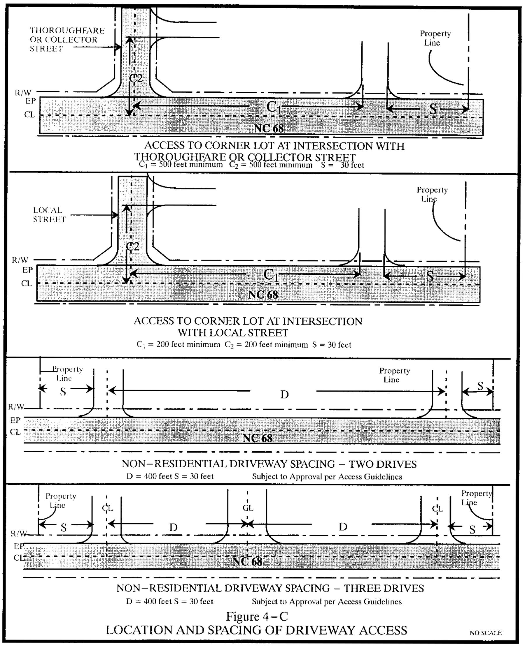
(2)
Permitted uses. All uses permitted in the underlying zoning districts are permitted except:
a.
Class A, B and C manufactured dwellings;
b.
Billboards;
c.
Radio, television (principal use); and
d.
Large buildings (over 30,000 square feet).
(3)
Conditional zoning. Uses which display one or more of the following characteristics may be permitted provided that the following areas or use on the site are completely screened from view of motorists on the scenic corridor highway:
a.
Outside storage of building materials, scrap, pipe, vehicles (including those waiting to be repaired, serviced, or sold) or equipment;
b.
Outside processing or assembly operations; and
c.
Truck parking areas.
(4)
Architectural control.
a.
All nonresidential building and structure exteriors within and visible from the scenic corridor, including fencing shall be brick, stone, wood or other natural material. Corrugated and/or sheet metal are not permitted, except for roofs.
b.
The architectural style of new nonresidential buildings shall be similar to that of existing buildings in the near vicinity and throughout the town.
c.
Large, flat, blank expanses on a facade are not acceptable.
d.
A-frame buildings, round buildings and geodesic domes are not acceptable.
e.
All manufactured dwellings shall have a permanent masonry foundation. Accessory manufactured dwellings shall be not visible from the scenic corridor.
f.
All mechanical and electrical equipment on nonresidential buildings, including ones on rooftops, from view of people on the street shall be screened to not be visible from the scenic corridor.
g.
Colors for nonresidential buildings shall be natural and subdued (earth tones are recommended) and shall reasonably blend in with the natural surroundings. Natural stains or paints that reflect the colors of natural materials should be dominant on large areas such as building facades and elevations.
1.
Prohibited:
(a)
More than three colors and of like materials (principal building and trim).
(b)
Day-glow, iridescent or fluorescent colors.
(c)
Bright colors, including pastels that do not harmonize with natural materials.
(d)
Non-earth tone stains.
(5)
Signage. Signs should be designed to have minimum visual impact on the environment. The following guidelines shall serve as a supplement to article IX, division 2.
a.
Prohibited signs:
1.
Off-premise signs, except where permitted by article IX.
2.
Portable signs.
3.
Directly/internally illuminated signs, or flashing or moving signs.
4.
Day-glow, iridescent or fluorescent signs.
(6)
Lighting. The following guidelines shall serve as a supplement to article IX, division 7:
a.
Ornamental street lights, which match the designated Town of Oak Ridge streetscape lights, shall be incorporated into street designs at such time that street light standards are established.
(7)
Site design.
a.
Parking and loading areas for nonresidential uses shall be:
1.
Designed as a single aisle of parallel or angled parking when located in front of the principal building or structure;
2.
Located behind or to the side of the principal building or structure; or
3.
For group or unified developments parking shall be designed in accordance with the principles illustrated in figure 4-D.
b.
Site design shall be pedestrian and bicycle friendly and shall include:
1.
Sidewalks along street frontage on properties within the town core;
2.
Clearly marked crosswalks to business entrance; and
3.
Accessible bike racks at the rate of one space per 20 automobile parking spaces, installed per the adopted town bike rack standards.
c.
All loading and dock areas shall be screened from view of the scenic corridor.
d.
Pump islands and drive-through facilities shall be located behind the principal building or structure.
(8)
Utilities.
a.
New utility and electrical power lines shall be placed underground, unless deemed unfeasible by the governing body.
b.
Overhead utility lines are discouraged, but if deemed necessary, such lines should be located to minimize visual impact.
c.
Utility poles and supports should be neutral in color.
d.
Utility structures such as cabinets and transformers shall be screened by natural vegetation and shall be located along rear property lines and service areas. However, landscaping should be designed to allow reasonable access for maintenance of the facilities.
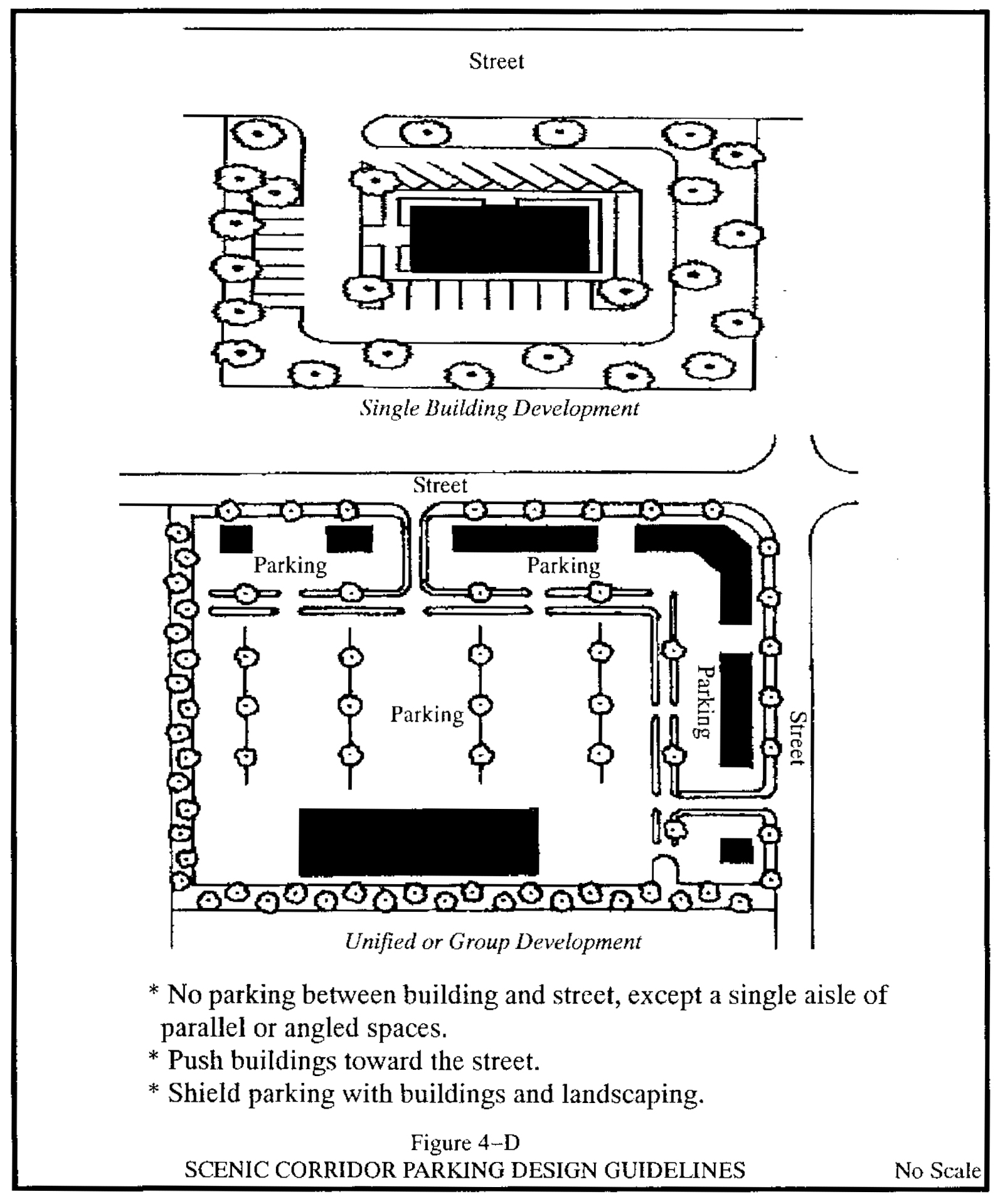
(b)
Districts established. The following scenic corridors are hereby established as overlay districts:
(1)
NC 68:
a.
Limits of district. Extending for a distance of 1,500 feet on either side of the centerline of NC 68 along those portions which lie within the town limits.
b.
Applicable requirements. All general requirements under subsection (a) of this section shall apply to the NC 68 scenic corridor.
(2)
NC 150:
a.
Limits of district. Extending for a distance of 1,500 feet on either side of the centerline of NC 150 along those portions which lie within the town limits and within the town's extraterritorial jurisdiction.
b.
Applicable requirements. All general requirements, except subsection (a)(1), of this section shall apply to the NC 150 scenic corridor.
(3)
Bunch/Brookbank Road:
a.
Limits of district. Extending for a distance of 1,500 feet on either side of the centerline of Bunch Road beginning at the Bunch Road/NC 150 intersection and extending east along Bunch Road to its intersection with Brookbank Road then extending for a distance of 1,500 feet on either side of the centerline of Brookbank Road eastward to the town limits.
b.
Applicable requirements. All general requirements, except subsection (a)(1) of this section shall apply to the Bunch/Brookbank Road scenic corridor.
(Ord. of 1-6-2000, § 4-12.3; Ord. of 1-4-2007; Ord. of 10-4-2007; Ord. of 2-5-2009; Ord. of 2-4-2010(1); Ord. of 2-4-2010(2); Ord. of 10-1-2020(2); Ord. No. O-2021-13, § 1, 7-1-2021)
Sec. 30-593. - Airport overlay district; height limits.
Pursuant to the "Airport Zoning Regulations of the Piedmont Triad International Airport" adopted by the Greensboro - High Point - Winston-Salem Airport Authority, no structure shall be erected which exceeds the height limits set forth on a map titled "Approach and Clear Zone Plan and Profiles," 1974.
(Ord. of 1-6-2000, § 4-12.4)