
Orinda City Zoning Code
CHAPTER 17
7 - RESIDENTIAL MINIMUM LOT SIZE AND HILLSIDE DEVELOPMENT
Sections:
17.7.1 - Intent.
A.
Preservation of the city's semi-rural environment is required by the Orinda general plan. To maintain "visible vacant land within and adjacent to residential areas," "the dominance of wooded and open ridges and hillsides," and to meet the one to two unit per acre density as required by the general plan for future subdivisions, standards for minimum lot size must be established.
B.
In addition, the terrain of certain areas of the city provides a unique and substantial character to the area, and forms an integral part of the city's total environment. Due to the physical prominence of hillsides in the city's landscape, development of hillside areas affects the visual and environmental character of the city. Hillside development should preserve the natural terrain, environmental quality and aesthetic character of the city, while providing creative, innovative and safe residential development with a variety of housing types. These goals can be achieved only when special consideration is given to those developments and subdivisions on and near hillsides, and to variations in conditions, design criteria and other requirements which must be flexible in order to achieve hillside development that is consistent with these objectives. The attractiveness of hillside and ridgeline areas and the other objectives specified in this title are important factors to the general welfare of the citizens of the city, and reasonable control of residential slope density is in the public interest.
(Ord. 99-5 § 2 Exh. A (part))
17.7.2 - Objectives.
The objectives of this chapter are to:
A.
Encourage minimal grading which respects the natural contour of the land and which will round off, in a natural manner, sharp angles at the top and ends of cut-and-fill slopes;
B.
Require retention of trees and other vegetation which stabilize steep hillsides, retain moisture, minimize erosion and enhance the natural scenic beauty, and where necessary, require additional landscaping to enhance the scenic and safety qualities of the hillsides;
C.
Require planting wherever appropriate to maintain necessary cut-and-fill slopes, to stabilize them by plant roots, and to conceal the raw soil from view;
D.
Require retention of natural landmarks and prominent natural features that enhance the character of a particular area of the city;
E.
Achieve land-use residential densities that are in keeping with the city's general plan, with the result that such densities will usually diminish as the slope of terrain increases, in order to retain the significant natural features of hillside area;
F.
Minimize the water runoff and soil erosion problems incurred in adjustment of hillside terrain to meet on-site and off-site development needs;
G.
Retain open hillsides and significant ridgelines in as near a natural state as is feasible as an important community value;
H.
Encourage the planning, design and development of hillside area building sites so as to provide maximum safety and human enjoyment;
I.
Provide for the preservation and maintenance of significant ridgelines, open space and recreational lands; and
J.
Provide minimum lot size standards for future subdivisions while avoiding the characterization of existing legal lots as nonconforming.
(Ord. 99-5 § 2 Exh. A (part))
17.7.3 - General requirement.
Subject to the provisions of Chapter 17.20 of this title and Section 17.7.4, no lot may be created or reconfigured unless it meets the following standards:
(Ord. 99-5 § 2 Exh. A (part))
17.7.4 - Slope limitations.
No lot may be created or reconfigured on sloping terrain unless it conforms to the requirements of this section. These provisions shall apply to all land zoned for RL-6 through RL-40 as shown on the schedule entitled "Allowable Density and Lot Sizes on Sloping Terrain", including any planned development district and RVL district.
A.
Allowed Density. Slope shall be calculated by this formula:
AS = (0.00229)(I)(L) / A
B.
Percent of Slope. For the purposes of the average slope formula, percent of slope is the vertical drop in feet divided by the horizontal distance in feet multiplied by one hundred (100).
C.
Maximum Allowable Unit Per Acre. The "maximum allowable unit per acre" shall be used as a multiplier to determine the maximum number of units on a parcel. A fraction of less than one that result from the multiplication of the lot size and the applicable multiplier shall be discounted.
Schedule 17.7.4
Allowable Density and Lot Sizes on Sloping Terrain
(Ord. 02-03 § 11; Ord. 99-5 § 2 Exh. A (part))
(Ord. No. 14-04, § 2(exh. A), 5-20-14)
17.7.5 - Adjustments.
An adjustment may be granted from the requirements of Section 17.7.4 to allow lot sizes smaller than those shown, if such a plan is found to be in conformance with the intent and development standards of this chapter, subject to the following requirements: (1) no lot may be less than twenty thousand (20,000) square feet in size; and (2) the total number of allowable units per acre may not be exceeded. To grant an adjustment, the Planning Commission must make findings of fact to support each of the following:
A.
The clustering of lots reduces either environmental impact and/or off-site visual impact, and the proposed plan is consistent with any underlying tentative map and/or planned development approval.
B.
The clustering of lots allows for a greater degree of conformity to development standards of the underlying zone.
(Ord. 99-5 § 2 Exh. A (part))
17.7.6 - Multi-lot development standards.
A.
General. The development standards in this chapter are in addition to design review required in Chapter 17.30 and applicable engineering requirements.
B.
Ridge Views. Off- and on-development-site views of significant ridges shall not be substantially impaired. To determine which ridges are subject to this provision, the criteria set forth in the findings and objectives sections of this chapter shall be utilized.
C.
Hillside Streets. Hillside street standards shall reflect a rural rather than urban character. Street alignments, where feasible, should be parallel to contours. Where a street location between a valley and ridge is unavoidable, directional pavements should be separated, with the principle of grading being half cut and half fill. Intermittent widening of streets for parking and turnarounds at appropriate places shall be encouraged.
D.
Street Lighting. Street lighting provided as part of a development in hillside areas shall be of low profile design, unobtrusive and designed to enhance a rural character of the area.
E.
Walkways. When required, walkways shall be provided in accordance with a complete pedestrian circulation plan, and not rigidly appended into every street.
F.
Trails. Bicycle and equestrian trails, if required, shall be integrated into an overall circulation plan for any development.
(Ord. 99-5 § 2 Exh. A (part))
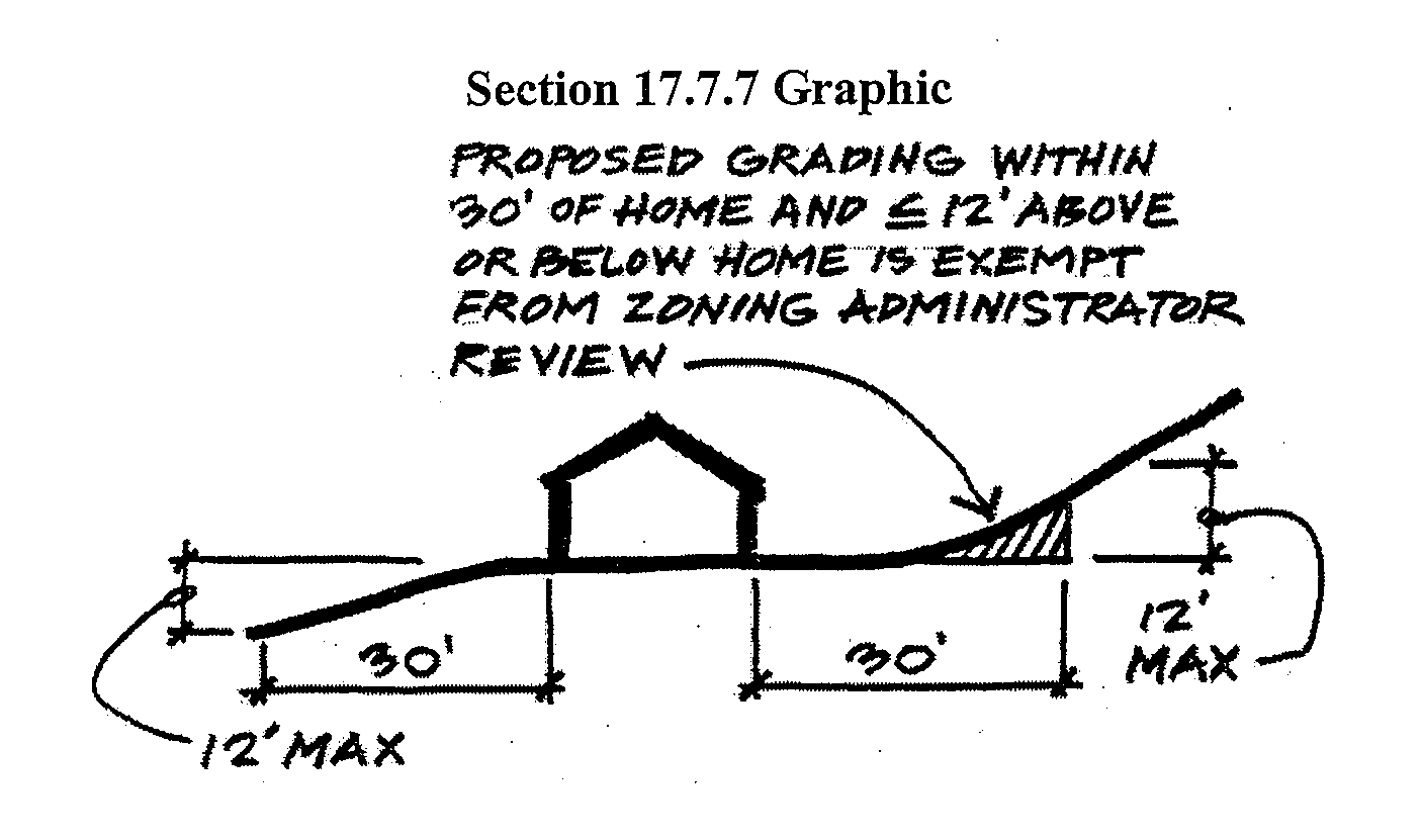
17.7.7 - Grading.
Any developed parcel of land with an average slope of more than fifteen (15) percent or a significant ridgeline and hilltop regardless of the slope, or both, shall not be graded without the specific authorization of the Zoning Administrator (or the Planning Commission when it has jurisdiction). This restriction shall not, however, apply to grading that is located as follows: (1) outside the required yard setbacks, (2) no more than thirty (30) feet from the footprint of the primary residence, and (3) no more than twelve (12) feet above or below the elevation of the existing grade at the closest portion of the residence (see Section 17.7.7 graphic). Approval by the Zoning Administrator (or the Planning Commission when it has jurisdiction) shall be granted only upon a showing that the proposed grading will comply with the objectives and regulations of this chapter, including the standards set forth in this section, and will not have a substantial visual impact when viewed from surrounding community areas.
A.
Design. Grading plans shall take into consideration the environmental characteristics of that land including, but not limited to prominent geological features, existing stream beds and significant tree cover, and shall use the best engineering practices to avoid erosion, slides or flooding, and to have a minimal effect on this environment. The natural appearance of the lot shall be preserved to the greatest extent possible.
B.
Conditions. To keep all graded areas and cuts and fills to a minimum, eliminate unsightly grading, preserve and maximize the natural appearance and beauty of the property, and to implement this chapter, the Zoning Administrator or the Planning Commission may impose limitations on the size of the areas to be graded or to be used for building, on the size, height, and angles of cut slopes and fill slopes, and the shape of resulting land masses. In appropriate cases, retaining walls may be required.
C.
Development Plan Approval. No grading of a lot may occur unless all required approvals for the development of the parcel have been obtained.
(Ord. 02-03 § 12: Ord. 00-08 § 1: Ord. 99-5 § 2 Exh. A (part))
(Ord. No. 10-10, § 2(exh. A), 1-4-11; Ord. No. 14-04, § 2(exh. A), 5-20-14)
17.7.8 - Open areas.
A portion of every proposed residential development located on a parcel of land with an average slope of more than twenty-six (26) percent shall remain in its natural state as an undeveloped open area with no grading, tree or foliage removal, or structure or other development.
A.
Location. The undeveloped open areas required by this chapter shall be located primarily on the upper elevations of any particular residential development site, and shall include significant hilltops and ridges and other topographical landmarks, open exposed hillsides, recreational areas, or areas of environmental significance.
B.
Ownership and Maintenance. Areas to remain as undeveloped open areas may be required to be offered for dedication to be part of a public open space or park system. Where such dedication offer is not to be accepted, the developer shall provide, as required, for the ownership, appropriate access, and necessary care and maintenance of the open area.
(Ord. 99-5 § 2 Exh. A (part))