
Ormond Beach City Zoning Code
ARTICLE II
- DISTRICT REGULATIONS
Sec. 2-06. - Purpose; legislative findings.
(a)
Purpose. The purpose of this article is to promote the health, safety and general welfare of the city by promoting land use compatibility and regulating land use by district. The article also restricts the height, number of stories and size of buildings and other structures, the percentage of the lot which may be occupied by structures, the size of yard and other open spaces, the density of population, and the location of building and structures.
(b)
Legislative findings regarding sexually oriented business uses. The concerns and evidence of secondary adverse effects raised in the "whereas" clauses listed in City of Ormond Beach Ordinance No. 2008-49, Ordinance No. 2008-50, and Ordinance No. 2013-39 are incorporated by reference. Based on the evidence of the adverse secondary effects of adult uses incorporated by reference, presented in hearings and in reports and documents made available to the city commission, and on findings, interpretations and narrowing constructions incorporated in numerous cases, reports of secondary effects occurring in and around sexually oriented businesses, and findings of physical abuse from papers, including, but not limited to: Peek-A-Boo Lounge of Bradenton, Inc. v. Manatee County, Fla., 630 F.3d 1346 (11th Cir. 2011), Ocello v. Koster, 354 S.W.3d 187 (Mo. banc 2011), Flanigan's Enterprises, Inc. of Georgia v. Fulton County, Ga, 596 F.3d 1265 (11th Cir. 2010), Alachua Retail 51, L.L.C. v. City of Alachua, 2012 WL 1313477 (N.D. Fla. 2012), 5634 East Hillsborough Ave., Inc. v. Hillsborough County, FL 294 Fed. Appx. 435 (11th Circ. 2008), City of Littleton, Colo. v. Z.J. Gifts D-4, L.L.C., 541 U.S. 774 (2004), Daytona Grand, Inc. v. City of Daytona Beach, 490 F.3d 860 (11th Cir. 2007), City of Renton v. Playtime Theatres, Inc., 475 U.S. 41 (1986), Young v. American Mini Theatres, 427 U.S. 50 (1976), Barnes v. Glenn Theatre, Inc., 501 U.S. 560 (1991), City of Erie v. Pap's A.M., 529 U.S. 277 (2000), City of L.A. v. Alameda Books, Inc., 535 U.S. 425 (2002), Artistic Entertainment, Inc. v. City of Warner Robins, 223 F.3d 1306 (11th Cir. 2000), Ben's Bar, Inc. v. Village of Somerset, 316 F.3d 702 (7th Cir. 2003), Wise Enters., Inc. v. Unified Gov't of Athens-Clarke County, 217 F.3d 1360 (11th Cir. 2000), BZAPs, Inc. v. City of Mankato, 268 F.3d 603 (8th Cir. 2001), World Wide Video of Washington, Inc. v. City of Spokane, 368 F.3d 1186 (9th Cir. 2004), Gammoh v. City of La Habra, 395 F.3d 1114 (9th Cir. 2005), Ward v. County of Orange, 217 F.3d 1350 (11th Cir. 2000), David Vincent, Inc. v. Broward County, 200 F.3d 1325 (11th Cir. 2000), Sammy's of Mobile, Ltd. v. City of Mobile, 140 F.3d 993 (11th Cir. 1998), Lady J. Lingerie, Inc. v. City of Jacksonville, 176 F.3d 1358 (11th Cir. 1999), Grand Faloon Tavern, Inc. v. Wicker, 670 F.2d 943 (11th Cir. 1982), International Food & Beverage Systems v. Ft. Lauderdale, 794 F.2d 1520 (11th Cir. 1986), FW/PBS, Inc. v. City of Dallas, 493 U.S. 215 (1990), Gary v. City of Warner Robins, 311 F.3d 1334 (11th Circ. 2002), Board of County Commissioners of Lee County v. Dexterhouse, 348 So.2d 916 (Fla. 2d DCA 1977), Survey of Florida Appraisers, Effects of Land Uses on Market Values, Duncan Associates, Palm Beach County, FL (May 2008), Testimony on Illinois SB 3348, Richard McCleary, Ph.D. and Lori Sexton, M.A., Illinois State Senate Public Health Committee, (March 2, 2012), Secondary Effects of Sexually-Orientated Businesses: Report to the City Attorney of Hallandale Beach, FL, Richard McCleary, Ph.D. (October 12, 2010), Do "Off Site" Adult Businesses Have Secondary Effects? Legal Doctrine, Social Theory, and Empirical Evidence by Richard McCleary and Alan C. Weinstein (2009),the Report of the Attorney General's Working Group on the Regulation Of Sexually Oriented Businesses, (June 6, 1989, State of Minnesota), Sexually Oriented Businesses An Insider's View, by David Sherman, presented to the Ohio Senate Judiciary Committee on Civil Justice, December 3, 2002, the Survey of Texas Appraisers on Secondary Effects of Sexually Oriented Businesses on Market Values (June, 2008); The American Law Center for Law and Justice on the Secondary Impacts of Sex Oriented Businesses (March, 1996), studies in other communities including, but not limited to: Garden Grove and Whittier, California; Kansas City, Missouri; New Hanover County, North Carolina; Newport News, Virginia; Manatee County, Florida; El Paso and Houston, Texas; Phoenix, Arizona; and Des Moines, Iowa, the City of Ormond Beach Police Report Numbers: 101000260, 101000259, 101000350, 101000505, 10120190, 110100518, 110200288, 110200444, 110300076, 110300152, 110300171, 110400567, 110600322, 110600378, 110600379, 110600479, 110700543, 110900253, 110900488, 111000459, 111100223, 111100448, 111200148, 111200291, 120100229, 120100376, 120100400, 120100559, 120200179, 120600214, 120700495, 120800257, 121100181, 130300146, the City of Daytona Beach Police Case Numbers: 20120007071, 120021874, 20120005500, 20110001121, 20120003866, 20100024062, 120003627, 2010026018, Channel 13 News, Strip Club Raided for Drugs Prostitution, March 5, 2012, The Orlando Sentinel, Strip-club Raid: Shark Lounge Investigation Continues, March 2, 2012, Fox 13 News, Tampa Police Have Eye on Adult Entertainment Industry, August 18, 2012, Sun Sentinel, Strip Club Shut Down, November 1, 2009, NBC 6 News South Florida, Another SoFla Strip Club Shut Down, November 2, 2009, WFTV.com, Strip Club Raided in Brevard County, October 1, 2010, and WTSP.com, Strip Club Raided After "Sex Spills into Parking Lot," October 1, 2010, the City Commission finds:
(1)
Sexually oriented business establishments are associated with a wide variety of adverse secondary effects, including, but not limited to, personal and property crimes, public safety risks, prostitution, potential spread of disease, lewdness, public indecency, illicit sexual activity, illicit drug use and drug trafficking, undesirable and criminal behavior associated with alcohol consumption, negative impacts on neighboring properties, litter, and sexual assault and exploitation. The city has a substantial government interest in preventing or abating the secondary effects of sexually oriented business establishments.
(2)
The above-mentioned secondary effects constitute a harm that the City of Ormond Beach has a substantial government interest in preventing and/or abating now and in the future. The substantial government interest in preventing these negative secondary effects is the city's rationale for the city's requirements for sexually oriented business establishments. The city's interest in regulating sexually oriented business establishments extends to future secondary effects that could occur in the city related to existing sexually oriented business establishments and future sexually oriented businesses that may locate in the city. The city finds that the cases and secondary effects documentation relied upon in this section are reasonably believed to be relevant to said secondary effects.
(3)
Sexually oriented business establishments have operational characteristics that should be reasonably regulated in order to prevent the above-mentioned secondary effects. A reasonable and simple permit and licensure procedure is an appropriate mechanism to place the burden of that reasonable regulation on the owners and operators of the sexually oriented business establishments. Further, such a permit and licensing procedure will place a heretofore nonexistent incentive on the owner/operator to see that the sexually oriented business establishment is run in a manner that is consistent with the health, safety, and welfare of its patrons and employees, as well as the citizens of the City of Ormond Beach, Florida. It is appropriate to require reasonable assurances that the licensee is the actual owner/operator of the sexually oriented business establishment, fully in possession and control of the premises and the activities occurring therein.
(Ord. No. 2013-38, § 2, 6-18-2013)
Editor's note— Ord. No. 2013-38, § 2, adopted June 18, 2013, changed the title of § 2-06 from "Purpose" to "Purpose; legislative findings." This historical notation has been preserved for reference purposes.
Sec. 2-07. - Zoning district designations.
These district regulations shall apply uniformly to all premises in the following manner:
(1)
Zoning affects all premises. No premises shall hereafter be used or occupied and no principal building or accessory structure shall be hereafter erected, constructed, moved or altered except in conformity with these district regulations.
(2)
Interpretation of uses and structures permitted. If a use or structure is not expressly permitted in any zoning district, the planning director shall not permit such use or structure in the district unless it is substantially similar to a use or structure otherwise permitted in the district.
(3)
Lot area, density, yard requirements, building coverage and building height. Every principal or accessory structure to be erected shall meet all lot area, density, yard, building coverage and building height requirements of the pertinent zoning district of the property.
(4)
Multiple use of required yard, buffers and open space prohibited. No part of a yard, buffer or other required open space for a structure shall be included as part of a yard buffer or open space requirements for any other structure.
(5)
Reduction of lot area and width prohibited. No lot existing on or after the effective date of the ordinance from which this Land Development Code is derived shall be reduced in area and/or width below the minimum requirements of its pertinent zoning district.
(6)
Zoning district classifications. Pursuant to article I of this chapter, the following zoning districts have been created and are designated by the following names and acronyms:
(Ord. No. 2023-41, § 1, 8-1-2023; Ord. No. 2023-56, § 1, 12-19-2023)
Sec. 2-08. - SE, Special Environment Zoning District.
Sec. 2-09. - REA, Rural Estate/Agricultural Zoning District.
| A. PURPOSE: | The purpose of the Rural Estate/Agricultural (REA) Zoning District is to preserve and protect the rural character of certain areas that have some agricultural value and are suitable for rural estate living but have environmental constraints. | |||||||||||
| B. DIMENSIONAL STANDARDS | ||||||||||||
| 1. | 2. | 3. | 4. | 5. | 6. | 7. | 8. | 9. | ||||
| Density | Maximum Building Height | Maximum Building Coverage | Maximum Impervious Lot Coverage | Minimum Lot Size | Minimum Lot Width | Minimum Lot Depth | Minimum Perimeter | Setbacks | ||||
| a. | b. | c. | d. | e. | ||||||||
| Front | Rear | Side | Street Side/Corner | Waterbody | ||||||||
|
1 unit per
5 acres | 30' Barns and Silos may be 45' | 35% | 75% | 5 acres | 150' | 200' | None | 50' | 50' | 25' | 50' |
30'
(See Additional Waterbody Setbacks listed below) |
| 9.e. Additional Waterbody Setbacks: |
Exhibit 9.e.Minimum Viewing Angle
 | |||||||||||
| (1) Tomoka/Halifax River Frontage Lots (Excluding Oceanfront): | ||||||||||||
|
a. The minimum rear yard setback from the mean or ordinary high-water line for properties
abutting a waterbody shall be the average building setback of all existing single-family
dwelling units within 300' of each side lot line of the lot on which the single-family
dwelling unit is proposed to be located, minus 5', or as otherwise established under
Florida Statutes or Chapter 3, Article II, Section 3-16 of this Land Development Code, Surface Waters and Marine Life Habitat, whichever
is greater, provided that in no event shall the setback be less than 30'. The rear
yard setback line may meander to follow the mean high-water line.
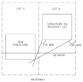
b. In the event there is more than one principle structure, as defined in Chapter 1, Article III, Section 1-22, located on any adjacent lot within the 300', only the setback of the principal structure nearest the mean or ordinary high-water line will be used to calculate the applicable setback. Principle structure means any structure that is occupied by a principle use as defined in this Land Development Code. c. Notwithstanding subsections a. and b. of this section, a single-family dwelling unit that is proposed to replace an existing single-family dwelling unit may be built to the same setback in the same building footprint and height as the dwelling unit that it is replacing. d. Notwithstanding subsections a. through c. of this section, a structure may encroach into a required waterfront yard setback provided that the new structure is so located as to allow a minimum viewing angle to the waterway of not less than 110 degrees from the closest front corner and 130 degrees from the furthest front corner of the closest structure on the adjacent lot, as depicted in Exhibit 9.e., and the 30' setback is met. | ||||||||||||
| C. PERMITTED USES | D. CONDITIONAL USES | E. SPECIAL EXCEPTION USES | F. OTHER STANDARDS | |||||||||
|
1. Community Residential Home
2. Dwelling, Single-Family, Detached 3. School, Public |
1. Adult Family Care Home
2. Agricultural Use, Minor 3. Family Day Care Home 4. Foster Home 5. Garden Center/Nursery 6. Greenhouse 7. Hobby Breeder 8. Hunting Dog 9. Parks and Recreation Facilities, Private 10. Parks and Recreation Facilities, Public 11. Public Facilities 12. Public Utilities 13. Telecommunication Tower or Antenna, Camouflaged 14. Water Survival Instruction 15. Wind Energy System |
1. Agricultural Use, Major
2. House of Worship 3. Kennel 4. Mining and Excavation 5. Riding Stable, Horse 6. School, Private 7. Telecommunication Tower 8. Veterinarian |
All development must comply with the following requirements: 1. Wetlands (chapter 3, article II).2. Special corridors and buffer requirements (chapter 3, article I).3. See conditional and special exception regulations (chapter 2, article IV).4. Use of dwelling units for transient lodging is prohibited in order
to protect and maintain the residential character of the zoning district.
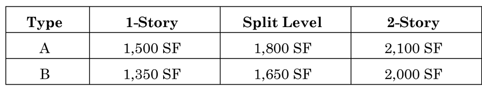
5. Single-family residential buildings shall have the following minimum floor area:
 | |||||||||
| G. PERMITTED ACCESSORY USES: Accessory uses customarily associated with, dependent on and incidental to their permitted principal uses, provided that such uses conform to the regulations set forth in chapter 2, article III. | ||||||||||||
(Ord. No. 2013-13, § 2, 2-5-2013; Ord. No. 2022-15, § 1, 6-7-2022)
Sec. 2-10. - RR, Rural Residential Zoning District.
| A. PURPOSE: | To provide for one acre or larger exurban area home sites to accommodate landowners who desire a semi-rural environment in close proximity to urban facilities and services. This classification can also serve as a transition zone between rural estate uses and areas proposed for development at suburban densities. | |||||||||||
| B. DIMENSIONAL STANDARDS | ||||||||||||
| 1. | 2. | 3. | 4. | 5. | 6. | 7. | 8. | 9. | ||||
| Density | Maximum Building Height | Maximum Building Coverage | Maximum Impervious Lot Coverage | Minimum Lot Size | Minimum Lot Width | Minimum Lot Depth | Minimum Perimeter | Setbacks | ||||
| a. Front | b. Rear | c. Side | d. Street Side/Corner | e. Waterbody | ||||||||
| 1 unit per acre | 30' | 35% | 75% | 1 acre | 120' | 200' | None | 50' | 30' | 20' | 50' |
30'
(see Additional Waterbody Setbacks listed below) |
| 9.e. Additional Waterbody Setbacks: |
Exhibit 9.e. Minimum Viewing Angle
 | |||||||||||
| (1) Tomoka/Halifax River Frontage Lots (Excluding Oceanfront): | ||||||||||||
|
a. The minimum rear yard setback from the mean or ordinary high-water line for properties
abutting a waterbody shall be the average building setback of all existing single-family
dwelling units within 300' of each side lot line of the lot on which the single-family
dwelling unit is proposed to be located, minus 5', or as otherwise established under
Florida Statutes or Chapter 3, Article II, Section 3-16 of this Land Development Code, Surface Waters and Marine Life Habitat, whichever
is greater, provided that in no event shall the setback be less than 30'. The rear
yard setback line may meander to follow the mean high-water line.
b. In the event there is more than one principle structure, as defined in Chapter 1, Article III, Section 1-22, located on any adjacent lot within the 300', only the setback of the principal structure nearest the mean or ordinary high-water line will be used to calculate the applicable setback. Principle structure means any structure that is occupied by a principle use as defined in this Land Development Code. c. Notwithstanding subsections a. and b. of this section, a single-family dwelling unit that is proposed to replace an existing single-family dwelling unit may be built to the same setback in the same building footprint and height as the dwelling unit that it is replacing. d. Notwithstanding subsections a. through c. of this section, a structure may encroach into a required waterfront yard setback provided that the new structure is so located as to allow a minimum viewing angle to the waterway of not less than 110 degrees from the closest front corner and 130 degrees from the furthest front corner of the closest structure on the adjacent lot, as depicted in Exhibit 9.e., and the 30' setback is met. | ||||||||||||
| C. PERMITTED USES | D. CONDITIONAL USES | E. SPECIAL EXCEPTION USES | F. OTHER STANDARDS | |||||||||
|
1. Community Residential Home
2. Dwelling, Single-Family, Detached 3. School, Public |
1. Adult Family Care Home
2. Family Day Care Home 3. Foster Home 4. Golf Course/Country Club 5. Parks and Recreation Facilities, Private 6. Parks and Recreation Facilities, Public 7. Public Facilities 8. Public Utilities 9. Telecommunication Tower or Antenna, Camouflaged 10. Water Survival Instruction 11. Wind Energy System |
1. House of Worship
2. School, Private |
All development must comply with the following requirements:
1. Wetlands (chapter 3, article II). 2. Special corridors and buffer requirements (chapter 3, article I). 3. See conditional and special exception regulations (chapter 2, article IV). 4. Use of dwelling units for transient lodging is prohibited in order to protect and maintain the residential character of the zoning district. 5. Single-family residential buildings shall have the following minimum floor area:  | |||||||||
| G. PERMITTED ACCESSORY USES: Accessory uses customarily associated with, dependent on and incidental to their permitted principal uses, provided that such uses conform to the regulations set forth in chapter 2, article III. | ||||||||||||
(Ord. No. 2022-15, § 2, 6-7-2022)
Sec. 2-11. - SR, Suburban Residential Zoning District.
(Ord. No. 2013-13, § 4, 2-5-2013)
Sec. 2-12. - R-1, Residential Estate Zoning District.
| A. PURPOSE: | The purpose of the Rural Estate (R-1) Zoning District is to provide for both existing and proposed single-family residential development characteristic of the spacious lots currently existing in various areas of the city, particularly along the Halifax River and the Atlantic Ocean, which are considered representative of the original and historic character of the city. | |||||||||||
| B. DIMENSIONAL STANDARDS | ||||||||||||
| 1. | 2. | 3. | 4. | 5. | 6. | 7. | 8. | 9. | ||||
| Density | Maximum Building Height | Maximum Building Coverage | Maximum Impervious Lot Coverage | Minimum Lot Size | Minimum Lot Width | Minimum Lot Depth | Minimum Perimeter | Setbacks | ||||
| a. Front | b. Rear | c. Side | d. Street Side/Corner | e. Waterbody | ||||||||
|
2.17 units
per acre | 30' | 35% | 75% | 20,000 SF | 100' | 150' | None |
30'
(see Additional Front Yard Setbacks listed below) | 25' | 8' total 20' | 20' |
50'
(see Additional Waterbody Setbacks listed below) |
| 9.a. Additional Front Yard Setbacks: In order to preserve the character of the neighborhoods within this district that have been developed with "estate-sized" lots having deeper setbacks than required for the district, the following standards shall apply: |
Exhibit 9.a.Minimum Viewing Angle
 | |||||||||||
|
(1) The required front yard setback shall be the average building setback of all existing
single-family dwelling units within 300' of each side lot line of the lot on which
the single-family dwelling unit is proposed to be located, minus 10', provided that
in no event shall the front yard setback be less than thirty 30'. It shall include
single-family dwelling units separated from the lot in question by any side streets.
In the event no single-family dwelling units are located within three hundred feet
(300') of both sides, the required front yard shall be thirty feet (30'). For the
purpose of this requirement, the three hundred feet (300') shall be measured along
a line parallel with the street right-of-way line, beginning at the corner of the
lot nearest the direction being measured (e.g., for three hundred feet (300') north,
begin at northeast corner), and including any street rights-of-way within the three
hundred-foot (300') distance.
(2) In the event there is more than one principal structure, as defined in Chapter 1, Article III, Section 1-22, located on any adjacent lot within the 300', only the setback of the principal structure nearest the front property line will be used to calculate the applicable setback. Principal structure means any structure that is occupied by a principal use as defined in this Land Development Code. (3) Notwithstanding subsections 9.a.(1) and 9.a.(2) of this section, a single-family dwelling unit that is proposed to replace an existing single-family dwelling unit may be built to the same setback in the same building footprint and height as the dwelling unit that it is replacing. (4) Notwithstanding subsections 9.a.(1) through 9.a.(3) of this section, a structure may encroach into a required front yard setback provided that the new structure is so located as to allow a minimum viewing angle to the right-of-way of not less than 110 degrees from the closest front corner and 130 degrees from the furthest front corner of the closest structure on the adjacent lot, as depicted in Exhibit 9.a., and the 30' setback is met. | ||||||||||||
| 9.e. Additional Waterbody Setbacks: |
Exhibit 9.e. Minimum Viewing Angle
 | |||||||||||
| (1) Ocean Yard Setbacks: Yards adjacent to the ocean shall be considered "rear" yards, and no structure, except
for sun decks and walkways provided in this section and Chapter 3, Article II, Section 3-15, Coastal Management, shall extend beyond a line projected between the average setback
of all buildings within 800' of each side lot line of the lot upon which the proposed
building is to be constructed or within a building setback otherwise established under
Florida Statutes or Chapter 3, Article II of this Land Development Code, whichever
is greater. Such line shall run parallel with the street right-of-way line; or
(2) Tomoka/Halifax River Frontage Lots (Excluding Oceanfront): a. The minimum rear yard setback from the mean or ordinary high-water line for properties abutting a waterbody shall be the average building setback of all existing single-family dwelling units within 300' of each side lot line of the lot on which the single-family dwelling unit is proposed to be located, minus 5', or as otherwise established under Florida Statutes or Chapter 3, Article II, Section 3-16 of this Land Development Code, Surface Waters and Marine Life Habitat, whichever is greater, provided that in no event shall the setback be less than 30'. The rear yard setback line may meander to follow the mean high-water line. b. In the event there is more than one principle structure, as defined in Chapter 1, Article III, Section 1-22, located on any adjacent lot within the 300', only the setback of the principal structure nearest the mean or ordinary high-water line will be used to calculate the applicable setback. Principle structure means any structure that is occupied by a principle use as defined in this Land Development Code. c. Notwithstanding subsections a. and b. of this section, a single-family dwelling unit that is proposed to replace an existing single-family dwelling unit may be built to the same setback in the same building footprint and height as the dwelling unit that it is replacing. d. Notwithstanding subsections a. through c. of this section, a structure may encroach into a required waterfront yard setback provided that the new structure is so located as to allow a minimum viewing angle to the waterway of not less than 110 degrees from the closest front corner and 130 degrees from the furthest front corner of the closest structure on the adjacent lot, as depicted in Exhibit 9.e., and the 30' setback is met. | ||||||||||||
| C. PERMITTED USES | D. CONDITIONAL USES | E. SPECIAL EXCEPTION USES | F. OTHER STANDARDS | |||||||||
|
1. Community Residential Home
2. Dwelling, Single-Family, Detached 3. School, Public |
1. Adult Family Care Home
2. Family Day Care Home 3. Foster Home 4. Group Home 5. Parks and Recreation Facilities, Private 6. Parks and Recreation Facilities, Public 7. Public Facilities 8. Public Utilities 9. Telecommunication Tower or Antenna, Camouflaged 10. Water Survival Instruction 11. Wind Energy System |
1. Historic Preservation Mixed Uses
2. House of Worship |
All development must comply with the following requirements:1. Wetlands (chapter 3, article II).2. Special corridors and buffer requirements (chapter 3, article I).3. See conditional and special exception regulations (chapter 2, article IV).4. Use of dwelling units for transient lodging is prohibited in order
to protect and maintain the residential character of the zoning district. 5. Single-family
residential buildings shall have the following minimum floor area:
| |||||||||
| G. PERMITTED ACCESSORY USES: Accessory uses customarily associated with, dependent on and incidental to their permitted principal uses, provided that such uses conform to the regulations set forth in chapter 2, article III. | ||||||||||||
(Ord. No. 2012-03, § 2, 2-7-2012; Ord. No. 2013-13, § 5, 2-5-2013; Ord. No. 2022-15, § 3, 6-7-2022)
Sec. 2-13. - R-2, Single-Family Low Density Zoning District.
| A. PURPOSE: | The purpose of the Single-Family Low Density (R-2) Zoning District is to protect and encourage the continued development of low density, single-family residential development. | |||||||||||
| B. DIMENSIONAL STANDARDS | ||||||||||||
| 1. | 2. | 3. | 4. | 5. | 6. | 7. | 8. | 9. | ||||
| Density | Maximum Building Height | Maximum Building Coverage | Maximum Impervious Lot Coverage | Minimum Lot Size | Minimum Lot Width | Minimum Lot Depth | Minimum Perimeter | Setbacks | ||||
| a. Front | b. Rear | c. Side | d. Street Side/Corner | e. Waterbody | ||||||||
|
4.3 units
per acre | 30' | 35% | 75% | 10,000 SF | 100' | None | None |
30'
(see Additional Front Yard Setbacks listed below) | 25' | 8' total 20' | 20' |
30'
(see Additional Waterbody Setbacks listed below) |
| 9.a. Additional Front Yard Setbacks: In order to preserve the character of the historic area along the west side of North and South Beach Street between Sanchez Avenue and Lorillard Place, the following standards shall apply to all lots of record as of October 3, 1989, which lots are residentially zoned, abut the west side of North or South Beach Street and lie south of the centerline of Sanchez Avenue and north of the centerline of Lorillard Place: |
Exhibit 9.a. Minimum Viewing Angle
 | |||||||||||
|
(1) The required front yard setbacks for any lot of record as of October 3, 1989,
and to which these regulations apply, shall not be less than the average building
setback of all existing single-family dwelling units within three hundred feet (300')
of each side lot line of the lot on which the single-family dwelling unit is proposed
to be located provided that, in no event shall the front yard setback be less than
thirty feet (30'). It shall include single-family dwelling units separated from the
lot in question by any side streets. In the event no single-family dwelling units
are located within three hundred feet (300') of both sides, the required front yard
shall be thirty feet (30'). For the purpose of this requirement, the three hundred
feet (300') shall be measured along a line parallel with the street right-of-way line,
beginning at the corner of the lot nearest the direction being measured (e.g., for
three hundred feet (300') north, begin at northeast corner), and including any street
rights-of-way within the three hundred-foot (300') distance.
(2) In the event there is more than one principle structure, as defined in Chapter 1, Article III, Section 1-22, located on any adjacent lot within the 300', only the setback of the principal structure nearest the front property line will be used to calculate the applicable setback. Principle structure means any structure that is occupied by a principle use as defined in this Land Development Code. (3) Notwithstanding subsections 9.a.(1) and 9.a.(2) of this section, a single-family dwelling unit that is proposed to replace an existing single-family dwelling unit may be built to the same setback in the same building footprint and height as the dwelling unit that it is replacing. (4) Notwithstanding subsections 9.a.(1) and 9.a.(2) of this section, a structure may encroach into a required front yard setback provided that the new structure is so located as to allow a minimum viewing angle to the right-of-way of not less than 110 degrees from the closest front corner and 130 degrees from the furthest front corner of the closest structure on the adjacent lot, as depicted in Exhibit 9.a., and the 30' setback is met. | ||||||||||||
| 9.e. Additional Waterbody Setbacks: |
Exhibit 9.e. Minimum Viewing Angle
 | |||||||||||
| (1) Ocean Yard Setbacks: Yards adjacent to the ocean shall be considered "rear" yards, and no structure, except
for sun decks and walkways provided in this section and Chapter 3, Article II, Section 3-15, Coastal Management, shall extend beyond a line projected between the average setback
of all buildings within 800' of each side lot line of the lot upon which the proposed
building is to be constructed or within a building setback otherwise established under
Florida Statutes or Chapter 3, Article II of this Land Development Code, whichever
is greater. Such line shall run parallel with the street right-of-way line; or
(2) Tomoka/Halifax River Frontage Lots (Excluding Oceanfront): a. The minimum rear yard setback from the mean or ordinary high-water line for properties abutting a waterbody shall be the average building setback of all existing single-family dwelling units within 300' of each side lot line of the lot on which the single-family dwelling unit is proposed to be located, minus 5', or as otherwise established under Florida Statutes or Chapter 3, Article II, Section 3-16 of this Land Development Code, Surface Waters and Marine Life Habitat, whichever is greater, provided that in no event shall the setback be less than 30'. The rear yard setback line may meander to follow the mean high-water line. b. In the event there is more than one principle structure, as defined in Chapter 1, Article III, Section 1-22, located on any adjacent lot within the 300', only the setback of the principal structure nearest the mean or ordinary high-water line will be used to calculate the applicable setback. Principle structure means any structure that is occupied by a principle use as defined in this Land Development Code. c. Notwithstanding subsections a. and b. of this section, a single-family dwelling unit that is proposed to replace an existing single-family dwelling unit may be built to the same setback in the same building footprint and height as the dwelling unit that it is replacing. d. Notwithstanding subsections a. through c. of this section, a structure may encroach into a required waterfront yard setback provided that the new structure is so located as to allow a minimum viewing angle to the waterway of not less than 110 degrees from the closest front corner and 130 degrees from the furthest front corner of the closest structure on the adjacent lot, as depicted in Exhibit 9.e., and the 30' setback is met. | ||||||||||||
| C. PERMITTED USES | D. CONDITIONAL USES | E. SPECIAL EXCEPTION USES | F. OTHER STANDARDS | |||||||||
|
1. Community Residential Home
2. Dwelling, Single-Family, Detached 3. School, Public |
1. Adult Family Care Home
2. Family Day Care Home 3. Foster Home 4. Group Home 5. Parks and Recreation Facilities, Private 6. Parks and Recreation Facilities, Public 7. Public Facilities 8. Public Utilities 9. Telecommunication Tower or Antenna, Camouflaged 10. Water Survival Instruction 11. Wind Energy System |
1. Bed and Breakfast Inn
2. Golf Course/Country Club 3. Historic Preservation Mixed Use 4. House of Worship |
All development must comply with the following requirements:1. Wetlands (chapter 3, article II).2. Special corridors and buffer requirements (chapter 3, article I).3. See conditional and special exception regulations (chapter 2, article IV).4. Use of dwelling units for transient lodging is prohibited in order
to protect and maintain the residential character of the zoning district. 5. Single-family
residential buildings shall have the following minimum floor area:
 | |||||||||
| G. PERMITTED ACCESSORY USES: Accessory uses customarily associated with, dependent on and incidental to their permitted principal uses, provided that such uses conform to the regulations set forth in chapter 2, article III. | ||||||||||||
(Ord. No. 2013-13, § 6, 2-5-2013; Ord. No. 2022-15, § 4, 6-7-2022)
Sec. 2-14. - R-2.5, Single-Family Low-Medium Density Zoning District.
| A. PURPOSE: | The purpose of the Single-Family Low-Medium Density (R-2.5) Zoning District is to protect and encourage the continued development of the residential single-family development that has occurred at relatively low densities. | |||||||||||
| B. DIMENSIONAL STANDARDS | ||||||||||||
| 1. | 2. | 3. | 4. | 5. | 6. | 7. | 8. | 9. | ||||
| Density | Maximum Building Height | Maximum Building Coverage | Maximum Impervious Lot Coverage | Minimum Lot Size | Minimum Lot Width | Minimum Lot Depth | Minimum Perimeter | Setbacks | ||||
| a. Front | b. Rear | c. Side | d. Street Side/Corner | e. Waterbody | ||||||||
|
4.98 units
per acre | 30' | 35% | 75% | 8,750 SF | 90' | None | None | 30' | 20' | 8' total 20' | 20' | 30' |
| C. PERMITTED USES | D. CONDITIONAL USES | E. SPECIAL EXCEPTION USES | F. OTHER STANDARDS | |||||||||
|
1. Community Residential Home
2. Dwelling, Singe-Family—Detached 3. School, Public |
1. Adult Family Care Home
2. Family Day Care Home 3. Foster Home 4. Group Home 5. Parks and Recreation Facilities, Private 6. Parks and Recreation Facilities, Public 7. Public Facilities 8. Public Utilities 9. Telecommunication Tower or Antenna, Camouflaged 10. Water Survival Instruction 11. Wind Energy System |
1. Bed and Breakfast Inn
2. Golf Course/Country Club 3. Historic Preservation Mixed Use 4. House of Worship 5. School, Private |
All development must comply with setback requirements:1. Wetlands (chapter 3, article II).2. Special corridors and buffer requirements (chapter 3, article I).3. See conditional and special exception regulations (chapter 2, article IV).4. Use of dwelling units for transient lodging is prohibited in order
to protect and maintain the residential character of the zoning district. 5. Single-family
residential buildings shall have the following minimum floor area:
 | |||||||||
| G. PERMITTED ACCESSORY USES: Accessory uses customarily associated with, dependent on and incidental to their permitted principal uses, provided that such uses conform to the regulations set forth in chapter 2, article III. | ||||||||||||
(Ord. No. 2013-11, § 1, 2-5-2013; Ord. No. 2013-13, § 7, 2-5-2013)
Sec. 2-15. - R-3, Single-Family Medium Density Zoning District.
| A. PURPOSE: | The purpose of the Single-Family Medium Density (R-3) Zoning District is to stabilize and protect the residential characteristics of existing medium density, single-family neighborhoods and to promote and encourage a suitable environment for family life. | |||||||||||
| B. DIMENSIONAL STANDARDS | ||||||||||||
| 1. | 2. | 3. | 4. | 5. | 6. | 7. | 8. | 9. | ||||
| Density | Maximum Building Height | Maximum Building Coverage | Maximum Impervious Lot Coverage | Minimum Lot Size | Minimum Lot Width | Minimum Lot Depth | Minimum Perimeter | Setbacks | ||||
| a. Front | b. Rear | c. Side | d. Street Side/Corner | e. Waterbody | ||||||||
|
5.05 units
per acre | 30' | 35% | 75% | 8,625 SF | 75' | 115' | None | 25' | 20' | 8' total 20' | 20' | 30' |
| C. PERMITTED USES | D. CONDITIONAL USES | E. SPECIAL EXCEPTION USES | F. OTHER STANDARDS | |||||||||
|
1. Community Residential Home
2. Dwelling, Singe-Family—Detached 3. School, Public |
1. Adult Family Care Home
2. Assisted Living 3. Cemetery 4. Family Day Care Home 5. Foster Home 6. Group Home 7. Parks and Recreation Facilities, Private 8. Parks and Recreation Facilities, Public 9. Public Facilities 10. Public Utilities 11. Telecommunication Tower or Antenna, Camouflaged 12. Water Survival Instruction 13. Wind Energy System |
1. Adult Day Care
2. Bed and Breakfast Inn 3. Child Care Facilities 4. Historic Preservation Mixed Use 5. House of Worship 6. Nursing Home 7. School, Private |
All development must comply with setback requirements:1. Wetlands (chapter 3, article II).2. Special corridors and buffer requirements (chapter 3, article I).3. See conditional and special exception regulations (chapter 2, article IV).4. Use of dwelling units for transient lodging is prohibited in order
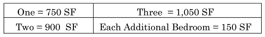
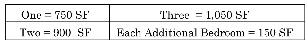
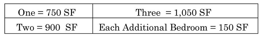
to protect and maintain the residential character of the zoning district. 5. Single-family
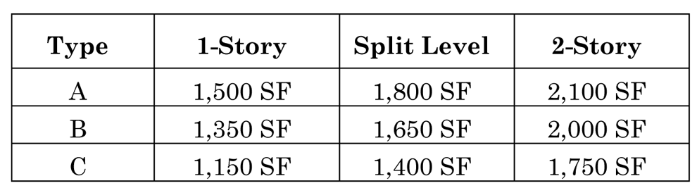
residential buildings shall have the following minimum floor area:
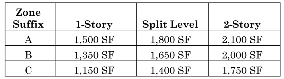
 The required minimum building square footage for residential structures with a "C"
zoning suffix (as shown on the official zoning map), may be reduced by 15% where the
chief building official finds that the proposed building is to be occupied by residents
which qualify for assistance as low- to medium-income as defined by the United States
Department of Housing and Urban Development.
The required minimum building square footage for residential structures with a "C"
zoning suffix (as shown on the official zoning map), may be reduced by 15% where the
chief building official finds that the proposed building is to be occupied by residents
which qualify for assistance as low- to medium-income as defined by the United States
Department of Housing and Urban Development.
| |||||||||
| G. PERMITTED ACCESSORY USES: Accessory uses customarily associated with, dependent on and incidental to their permitted principal uses, provided that such uses conform to the regulations set forth in chapter 2, article III. | ||||||||||||
| H. SPECIAL STANDARDS: Nonconformance: Single-family residential lots located within this district and having a minimum lot area of 7,500 square feet, a minimum width of 75', and are located in areas of the city where established street patterns and lot configurations are generally consistent with the 75'/7,500 square foot standard, shall be deemed to be conforming lots, subject to the setback and buffer requirements of Ordinance No. 78-35, as existed on December 31, 1991. Parcels within such districts may be divided into lots having minimum lot areas of 7,500 square feet and minimum widths of 75', provided the structure on each lot meets the setback and buffer requirements of Ordinance No. 78-35. However, where the recorded plat or covenants indicate front yards in excess of current city standards for principal buildings, said plat or covenants shall first be properly amended prior to the issuance of a building permit. Approved Plats: Setbacks that are less restrictive than the standards listed above are acceptable, provided that they are either shown on the approved plat or a less restrictive standard was in place at the time of recording the original plat. | ||||||||||||
(Ord. No. 2013-11, § 2, 2-5-2013; Ord. No. 2013-13, § 8, 2-5-2013)
Sec. 2-16. - NP, Neighborhood Preservation Zoning District.
| A. PURPOSE: | The purpose of the Neighborhood Preservation (NP) Zoning District is to preserve the character of older neighborhoods by providing for compatible infill development and redevelopment where enforcement of lot dimensions through other residential zoning districts would not be possible and encourage a suitable environment for family life. | |||||||||||
| B. DIMENSIONAL STANDARDS | ||||||||||||
| 1. | 2. | 3. | 4. | 5. | 6. | 7. | 8. | 9. | ||||
| Density | Maximum Building Height | Maximum Building Coverage | Maximum Impervious Lot Coverage | Minimum Lot Size | Minimum Lot Width | Minimum Lot Depth | Minimum Perimeter | Setbacks | ||||
| a. Front | b. Rear | c. Side | d. Street Side/Corner | e. Waterbody | ||||||||
|
8.29 units
per acre | 30' | 35% | 75% | 5,250 SF | 50' | 105' | None |
25'; or
the average dimension for existing structures within 100' of the property (measured along the same side of the roadway frontage), whichever is less | 20' |
Lots 75' wide or greater: 7.5' each side;
Lots less than 75' wide: 5' minimum each side | 20' | 30' |
| C. PERMITTED USES | D. CONDITIONAL USES | E. SPECIAL EXCEPTION USES | F. OTHER STANDARDS | |||||||||
|
1. Community Residential Home
2. Dwelling, Singe-Family—Detached 3. School, Public |
1. Adult Day Care Center
2. Adult Family Care Home 3. Assisted Living Facility 4. Cemetery 5. Family Day Care Home 6. Foster Home 7. Group Home 8. Nursing Home 9. Parks and Recreation Facilities, Private 10. Parks and Recreation Facilities, Public 11. Public Facilities 12. Public Utilities 13. Telecommunication Tower or Antenna, Camouflaged 14. Water Survival Instruction 15. Wind Energy System |
1. Child Care Facilities
2. Historic Preservation Mixed Use 3. House of Worship 4. School, Private |
All development must comply with setback requirements:1. Wetlands (chapter 3, article II).2. Special corridors and buffer requirements (chapter 3, article I).3. Any other special requirements pursuant to this Land Development Code.4.
Use of dwelling units for transient lodging is prohibited in order to protect and
maintain the residential character of the zoning district. 5. Single-family residential
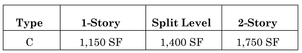
buildings shall have the following minimum floor area:
 The required minimum building square footage for residential structures with a "C"
zoning suffix (as shown on the official zoning map), may be reduced by 15 percent
where the chief building official finds that the proposed building is to be occupied
by residents which qualify for assistance as low- to medium-income as defined by the
United States Department of Housing and Urban Development.
The required minimum building square footage for residential structures with a "C"
zoning suffix (as shown on the official zoning map), may be reduced by 15 percent
where the chief building official finds that the proposed building is to be occupied
by residents which qualify for assistance as low- to medium-income as defined by the
United States Department of Housing and Urban Development.
| |||||||||
| G. PERMITTED ACCESSORY USES: Accessory uses customarily associated with, dependent on and incidental to their permitted principal uses, provided that such uses conform to the regulations set forth in chapter 2, article III. | ||||||||||||
| H. SPECIAL STANDARDS: Nonconformance: Single-family residential lots located within this district and having a minimum lot area of 7,500 square feet, a minimum width of 75', and located in areas of the city where established street patterns and lot configurations are generally consistent with the 7,500 square foot/75' width standard, shall be deemed to be conforming lots, subject to the setback and buffer requirements of Ordinance No. 78-35, as existed on December 31, 1991. Parcels within such districts may be divided into lots having minimum lot areas of 7,500 square feet and minimum widths of 75', provided the structure on each lot meets the setback and buffer requirements of Ordinance No. 78-35. However, where the recorded plat or covenants indicate front yards in excess of current city standards for principal buildings, said plat or covenants shall first be properly amended prior to the issuance of a building permit. Approved Plats: Setbacks that are less restrictive than the standards listed above are acceptable, provided that they are either shown on the approved plat or a less restrictive standard was in place at the time of recording the original plat. | ||||||||||||
(Ord. No. 2013-13, § 9, 2-5-2013)
Sec. 2-17. - R-4, Single-Family Cluster and Townhouse Zoning District.
| A. PURPOSE: | The purpose of the Single-Family Cluster and Townhouse (R-4) Zoning District is to provide for a variety of dwelling units in a highly aesthetic setting. The zoning district attempts to establish an optimum living environment between indoor and outdoor living, to encourage the establishment of on-site recreation areas and open space, and cluster developments on small lots, while maintaining the maximum possible privacy for each unit through quality of design. | ||||||||||||||
| B. DIMENSIONAL STANDARDS | |||||||||||||||
| 1. | 2. | 3. | 4. | 5. | 6. | 7. | 8. | 9. | 10. | 11. | 12. | ||||
| Type | Density (units per acre) | Maximum Building Height | Maximum Parcel Building Coverage | Maximum Lot Building Coverage | Maximum Parcel Impervious Coverage | Maximum Lot Impervious Coverage | Minimum Parcel Size in SF | Minimum Lot Size in SF | Minimum Lot Width | Minimum Lot Depth | Setbacks | ||||
| a. Front | b. Rear | c. Side | d. Street Corner/Corner | e. Waterbody | |||||||||||
| Single-Family | 5.05 | 30' | 35% | 35% | 75% | 75% | 8,625 | 8,625 | 75' | 115' | 25' | 20' |
8'
total 20' | 20' | 30' |
| Cluster | 6.70 | 30' | 35% | 35% | 75% | 75% | 6,500 | 6,500 | 65' | - | 25' | 20' |
8'
total 20' | 20' | 30' |
| Patio | 6.89 | 30' | 35% | 35% | 75% | 75% | 6,325 | 6,325 | 55' | 115' | 25' | 20' |
8'
total 20' | 20' | 30' |
| Zero-Lot-Line | 8.71 | 30' | 35% | 35% | 75% | 75% | 5,000 | 5,000 | 50' | - | 25' | 20' | 0', 20' | 20' | 30' |
| Multi-Family | 8 | 30' | 35% | 35% | 75% | 75% | 43,560 | 43,560 | 125' | - | 25' | 20' | 10' | 20' | 30' |
| Duplex | 8.71 | 30' | 35% | 35% | 75% | 75% | 10,000 | 10,000 | 100' | - | 30' | 20' | 20' | 20' | 30' |
| Triplex | 8.7 | 30' | 35% | 35% | 75% | 75% | 15,000 | 15,000 | 150' | - | 30' | 20' | 20' | 20' | 30' |
| Townhouse | 8 | 30' | 35% | 75% | 75% | 90% | 43,560 | 2,280 | 24' | 95' | 25' | 10' | 0' | 0' (entire building 15') | 30' |
| C. PERMITTED USES | D. CONDITIONAL USES | E. SPECIAL EXCEPTION USES | F. OTHER STANDARDS | ||||||||||||
|
1. Community Residential Home
2. Dwelling, Duplex 3. Dwelling, Single-Family, Detached 4. Dwelling, Triplex 5. School, Public |
1. Adult Day Care Center
2. Adult Family Day Care 3. Assisted Living Facility 4. Cluster Subdivision, Single-Family 5. Dwelling, Multifamily 6. Dwelling, Quadraplex 7. Family Day Care Home 8. Foster Home 9. Group Home 10. Nursing Home 11. Parks and Recreation Facilities, Private 12. Parks and Recreation Facilities, Public 13. Patio Subdivision 14. Public Facilities 15. Public Utilities 16. School, Private 17. Telecommunication Tower or Antenna, Camouflaged 18. Townhouses 19. Water Survival Instruction 20. Wind Energy System 21. Zero Lot Line Subdivision |
1. Bed and Breakfast Inn
2. Child Care Facilities 3. Historic Preservation Mixed Use 4. House of Worship |
All development must comply with setback requirements:1. Wetlands (chapter 3, article II).2. Special corridors and buffer requirements (chapter 3, article I).3. See conditional and special exception regulations (chapter 2, article IV).
4. Use of dwelling units for transient lodging is prohibited in order to protect and
maintain the residential character of the zoning district.
5. Single-family residential buildings shall have the following minimum floor area:
 6. Multifamily, duplex and triplex residential dwelling units shall have the following
minimum square footage per bedroom:
6. Multifamily, duplex and triplex residential dwelling units shall have the following
minimum square footage per bedroom:
 | ||||||||||||
| G. PERMITTED ACCESSORY USES: Accessory uses customarily associated with, dependent on and incidental to their permitted principal uses, provided that such uses conform to the regulations set forth in chapter 2, article III. | |||||||||||||||
| H. SPECIAL STANDARDS: Nonconformance: Single-family residential lots located within this district and having a minimum lot area of 7,500 square feet, a minimum width of 75', and located in areas of the city where established street patterns and lot configurations are generally consistent with the 7,500 square foot/75' width standard, shall be deemed to be conforming lots, subject to the setback and buffer requirements of Ordinance No. 78-35, as existed on December 31, 1991. Parcels within such districts may be divided into lots having minimum lot areas of 7,500 square feet and minimum widths of 75', provided the structure on each lot meets the setback and buffer requirements of Ordinance No. 78-35. However, where the recorded plat or covenants indicate front yards in excess of current city standards for principal buildings, said plat or covenants shall first be properly amended prior to the issuance of a building permit. Approved Plats: Setbacks that are less restrictive than the standards listed above are acceptable, provided that they are either shown on the approved plat or a less restrictive standard was in place at the time of recording the original plat. | |||||||||||||||
(Ord. No. 2012-03, § 3, 2-7-2012; Ord. No. 2013-11, § 3, 2-5-2013; Ord. No. 2013-13, § 10, 2-5-2013; Ord. No. 2022-38, § 1, 1-10-2023; Ord. No. 2024-06, § 1, 5-21-2024)
Sec. 2-18. - R-5, Multifamily Medium Density Zoning District.
| A. PURPOSE: | The purpose of the Multifamily Medium Density (R-5) Zoning District is to provide for a mixture of various residential types ranging from single-family detached homes, to low density multifamily developments designed in such manner as to be highly compatible within the site and the neighborhood through the use of open space, buffering and architectural design. | ||||||||||||||
| B. DIMENSIONAL STANDARDS | |||||||||||||||
| 1. | 2. | 3. | 4. | 5. | 6. | 7. | 8. | 9. | 10. | 11. | 12. | ||||
| Type | Density (units per acre) | Maximum Building Height | Maximum Parcel Building Coverage | Maximum Lot Building Coverage | Maximum Parcel Impervious Coverage | Maximum Lot Impervious Coverage | Minimum Parcel Size in SF | Minimum Lot Size in SF | Minimum Lot Width | Minimum Lot Depth | Setbacks | ||||
| a. Front | b. Rear | c. Side | d. Street Corner/Corner | e. Waterbody | |||||||||||
| Single-Family | 5.05 | 30' | 35% | 35% | 75% | 75% | 8,625 | 8,625 | 75' | 115' | 25' | 20' |
8'
total 20' | 20' | 30' |
| Cluster | 6.70 | 30' | 35% | 35% | 75% | 75% | 6,500 | 6,500 | 65' | - | 25' | 20' |
8'
total 20' | 20' | 30' |
| Patio | 6.89 | 30' | 35% | 35% | 75% | 75% | 6,325 | 6,325 | 55' | 115' | 25' | 20' |
8'
total 20' | 20' | 30' |
| Zero-Lot-Line | 8.71 | 30' | 35% | 35% | 75% | 75% | 5,000 | 5,000 | 50' | - | 20' | 20' | 0', 20' | 20' | 30' |
| Multi-Family | 12 | 30' | 35% | 35% | 75% | 75% | 43,560 | 43,560 | 125' | - | 20' | 20' | 10' | 20' | 30' |
| Duplex | 8.71 | 30' | 35% | 35% | 75% | 75% | 10,000 | 10,000 | 100' | - | 30' | 20' | 20' | 20' | 30' |
| Townhouse | 12 | 30' | 35% | 75% | 75% | 90% | 43,560 | 2,280 | 24' | 95' | 25' | 10' | 0' | 0' (entire building 15') | 30' |
| C. PERMITTED USES | D. CONDITIONAL USES | E. SPECIAL EXCEPTION USES | F. OTHER STANDARDS | ||||||||||||
|
1. Community Residential Home
2. Dwelling, Duplex 3. Dwelling, Single-Family, Detached 4. School, Public |
1. Adult Day Care
2. Adult Family Care Center 3. Assisted Living Facility 4. Cluster Subdivision, Single-Family 5. Community Residential Home 6. Dwelling, Multifamily 7. Family Day Care Home 8. Foster Home 9. Golf Course and Country Club 10. Group Home 11. Nursing Home 12. Parks and Recreation Facilities, Private 13. Parks and Recreation Facilities, Public 14. Patio Subdivision 15. Public Facilities 16. Public Utilities 17. School, Private 18. Telecommunication Tower or Antenna, Camouflaged 19. Townhouses 20. Water Survival Instruction 21. Wind Energy System 22. Zero Lot Line Subdivision |
1. Child Care Facility
2. Historic Preservation Mixed Use 3. House of Worship |
All development must comply with setback requirements:1. Wetlands (chapter 3, article II).2. Special corridors and buffer requirements (chapter 3, article I).3. See conditional and special exception regulations (chapter 2, article IV).
4. Use of dwelling units for transient lodging is prohibited in order to protect and
maintain the residential character of the zoning district.
5. Single-family residential buildings shall have the following minimum floor area:
 6. Multifamily, duplex and triplex residential dwelling units shall have the following
minimum square footage per bedroom:
6. Multifamily, duplex and triplex residential dwelling units shall have the following
minimum square footage per bedroom:
 | ||||||||||||
| G. PERMITTED ACCESSORY USES: Accessory uses customarily associated with, dependent on and incidental to their permitted principal uses, provided that such uses conform to the regulations set forth in chapter 2, article III. | |||||||||||||||
| H. SPECIAL STANDARDS: Nonconformance: Single-family residential lots located within this district and having a minimum lot area of 7,500 square feet, a minimum width of 75', and located in areas of the city where established street patterns and lot configurations are generally consistent with the 7,500 square foot/75' width standard, shall be deemed to be conforming lots, subject to the setback and buffer requirements of Ordinance No. 78-35, as existed on December 31, 1991. Parcels within such districts may be divided into lots having minimum lot areas of 7,500 square feet and minimum widths of 75', provided the structure on each lot meets the setback and buffer requirements of Ordinance No. 78-35. However, where the recorded plat or covenants indicate front yards in excess of current city standards for principal buildings, said plat or covenants shall first be properly amended prior to the issuance of a building permit. Approved Plats: Setbacks that are less restrictive than the standards listed above are acceptable, provided that they are either shown on the approved plat or a less restrictive standard was in place at the time of recording the original plat. | |||||||||||||||
(Ord. No. 2013-11, §§ 3, 4, 2-5-2013; Ord. No. 2013-13, § 11, 2-5-2013; Ord. No. 2022-38, § 2, 1-10-2023; Ord. No. 2024-06, § 2, 5-21-2024)
Sec. 2-19. - R-6, Multifamily Medium-High Density Zoning District.
| A. PURPOSE: | The purpose of the Multifamily Medium-High (R-6) Zoning District is to provide for the development of multiple-family residential developments at medium to high densities. | ||||||||||||||
| B. DIMENSIONAL STANDARDS | |||||||||||||||
| 1. | 2. | 3. | 4. | 5. | 6. | 7. | 8. | 9. | 10. | 11. | 12. | ||||
| Type | Density (units per acre) | Maximum Building Height | Maximum Parcel Building Coverage | Maximum Lot Building Coverage | Maximum Parcel Impervious Coverage | Maximum Lot Impervious Coverage | Minimum Parcel Size in SF | Minimum Lot Size in SF | Minimum Lot Width | Minimum Lot Depth | Setbacks | ||||
| a. Front | b. Rear | c. Side | d. Street Corner/Corner | e. Waterbody | |||||||||||
| Single-Family | 5.05 | 30' | 35% | 35% | 75% | 75% | 8,625 | 8,625 | 75' | 115' | 25' | 20' |
8'
total 20' | 20' |
30'
(See Additional Waterbody Setbacks listed below) |
| Cluster | 6.70 | 30' | 35% | 35% | 75% | 75% | 6,500 | 6,500 | 65' | - | 25' | 20' |
8'
total 20' | 20' | |
| Patio | 6.89 | 30' | 35% | 35% | 75% | 75% | 6,325 | 6,325 | 55' | 115' | 25' | 20' |
8'
total 20' | 20' | |
| Zero-Lot-Line | 8.71 | 30' | 35% | 35% | 75% | 75% | 5,000 | 5,000 | 50' | - | 25' | 20' | 0', 20' | 20' | |
| Multi-Family | 32 | 75' | 35% | 35% | 75% | 75% | 43,560 | 43,560 | 125' | - | 25' | 20' | 10' | 20' | |
| Duplex | 8.71 | 30' | 35% | 35% | 75% | 75% | 10,000 | 10,000 | 100' | - | 30' | 20' | 20' | 20' | |
| Townhouse | 12 | 30' | 35% | 75% | 75% | 90% | 43,560 | 2,280 | 24' | 95' | 25' | 10' | 0' | 0' (entire building 15') | |
| 9.e. Additional Waterbody Setbacks: (1) Ocean Yard Setbacks: Yards adjacent to the ocean shall be considered "rear" yards, and no structure, except for sun decks and walkways provided in this section and Chapter 3, Article II, Section 3-15, Coastal Management, shall extend beyond a line projected between the average setback of all buildings within 800' of each side lot line of the lot upon which the proposed building is to be constructed or within a building setback otherwise established under Florida Statutes or Chapter 3, Article II of this Land Development Code, whichever is greater. Such line shall run parallel with the street right-of-way line. | |||||||||||||||
| C. PERMITTED USES | D. CONDITIONAL USES | E. SPECIAL EXCEPTION USES | F. OTHER STANDARDS | ||||||||||||
|
1. Community Residential Home
2. Dwelling, Duplex 3. Dwelling, Single-Family, Detached 4. School, Public |
1. Adult Day Care Center
2. Adult Family Care Home 3. Assisted Living Facility 4. Cluster Subdivision, Single-Family 5. Community Residential Home 6. Dwelling, Multifamily 7. Family Day Care Home 8. Foster Home 9. Golf Course and Country Club 10. Group Home 11. Nursing Home 12. Parks and Recreation Facilities, Private 13. Parks and Recreation Facilities, Public 14. Patio Home Subdivision 15. Public Facilities 16. Public Utilities 17. School, Private 18. Telecommunication Tower or Antenna, Camouflaged 19. Townhouses 20. Water Survival Instruction 21. Wind Energy System 22. Zero Lot Line Subdivision |
1. Child Care Facility
2. Historic Preservation Mixed Use 3. House of Worship |
All development must comply with setback requirements:1. Wetlands (chapter 3, article II).2. Special corridors and buffer requirements (chapter 3, article I).3. See conditional and special exception regulations (chapter 2, article IV).
4. Use of dwelling units for transient lodging is prohibited in order to protect and
maintain the residential character of the zoning district.
5. Single-family residential buildings shall have the following minimum floor area:
 6. Multifamily, duplex and triplex residential dwelling units shall have the following
minimum square footage per bedroom:
6. Multifamily, duplex and triplex residential dwelling units shall have the following
minimum square footage per bedroom:
 | ||||||||||||
| G. PERMITTED ACCESSORY USES: Accessory uses customarily associated with, dependent on and incidental to their permitted principal uses, provided that such uses conform to the regulations set forth in chapter 2, article III. | |||||||||||||||
| H. SPECIAL STANDARDS: Nonconformance: Single-family residential lots located within this district and having a minimum lot area of 7,500 square feet, a minimum width of 75', and located in areas of the city where established street patterns and lot configurations are generally consistent with the 7,500 square foot/75' width standard, shall be deemed to be conforming lots, subject to the setback and buffer requirements of Ordinance No. 78-35, as existed on December 31, 1991. Parcels within such districts may be divided into lots having minimum lot areas of 7,500 square feet and minimum widths of 75', provided the structure on each lot meets the setback and buffer requirements of Ordinance No. 78-35. However, where the recorded plat or covenants indicate front yards in excess of current city standards for principal buildings, said plat or covenants shall first be properly amended prior to the issuance of a building permit. Approved Plats: Setbacks that are less restrictive than the standards listed above are acceptable, provided that they are either shown on the approved plat or a less restrictive standard was in place at the time of recording the original plat. | |||||||||||||||
(Ord. No. 2013-11, §§ 3, 4, 2-5-2013; Ord. No. 2013-13, § 11, 2-5-2013; Ord. No. 2014-29, §§ 1, 2, 8-19-2014; Ord. No. 2022-15, § 5, 6-7-2022; Ord. No. 2022-38, § 3, 1-10-2023; Ord. No. 2024-06, § 3, 5-21-2024)
Sec. 2-20. - T-1, Manufactured/Mobile Home Zoning District.
(Ord. No. 2013-13, § 13, 2-5-2013; Ord. No. 2015-23, § 2, 6-2-2015)
Sec. 2-21. - T-2, Manufactured Home Zoning District.
(Ord. No. 2013-13, § 14, 2-5-2013; Ord. No. 2015-23, § 2, 6-2-2015; Ord. No. 2023-29, § 1, 6-6-2023)
Sec. 2-22. - B-1, Professional Office/Hospital Zoning District.
| A. PURPOSE: | The purpose of the Professional Office/Hospital (B-1) Zoning District is to provide areas primarily for professional offices, institutional uses, also allowing multifamily residential, and retail uses with special emphasis given to sound architectural design practices, site planning, landscaping and sign location. | |||||||||||
| B. DIMENSIONAL STANDARDS | ||||||||||||
| 1. | 2. | 3. | 4. | 5. | 6. | 7. | 8. | 9. | ||||
| Type | Density | Maximum Building Height | Maximum Building Coverage | Maximum Impervious Lot Coverage | Minimum Lot Size | Minimum Lot Width | Minimum Lot Depth | Setbacks | ||||
| a. Front | b. Rear | c. Side | d. Street Side/Corner | e. Waterbody | ||||||||
|
Nonresidential
Uses | — |
40',
Hospitals may be 55' | 35% | 75% | 20,000 SF | 100' | — | 20 |
20';
30' if abutting residential district; 5' additional combined side yard required for each story over 2. | 10' | 20' | 30' |
| Multifamily | 8 (10 units per acre if 2 stories) | 30' | 35% | 75% | 43,560 SF | 125' | — | 30 |
20';
30' if abutting residential district. |
20';
25' if abutting a single-family residential district; 5' additional combined side yard required for each story over 2. | 20' | 30' |
| C. PERMITTED USES | D. CONDITIONAL USES | E. SPECIAL EXCEPTION USES | F. OTHER STANDARDS | |||||||||
|
1. Adult Day Care Center
2. Assisted Living Facility 3. Business/Professional Office 4. Business Service 5. Cosmetic tattooing 6. Financial Institution 7. Hospital 8. Instructional physical activity 9. Medical Research Laboratory 10. Medical Supply/Rental 11. Nursing Home 12. Pharmacy 13. School, Public 14. Veterinarian |
1. Child Care Facility
2. Community Residential Home 3. Dwelling, Multifamily 4. Family Day Care Home 5. Historic Preservation Mixed Use 6. House of Worship 7. Parks and Recreation Facilities, Private 8. Parks and Recreation Facilities, Public 9. Personal Services 10. Public Facilities 11. Public Utilities 12. Recreation Facilities 13. Restaurant, Type A 14. Restaurant, Type B 15. Retail Sales and Service 16. School, Private 17. Telecommunication Tower/Antennas, Camouflaged 18. Wind Energy System |
1. Cemetery
2. Funeral Home 3. Outdoor Activity 4. Outdoor Storage 5. Recreation Facilities, Outdoor 6. Restaurant Type C |
All development must comply with setback requirements:
1. Wetlands (chapter 3, article II).2. Special corridors and buffer requirements (chapter 3, article I).3. See conditional and special exception regulations (chapter 2, article IV).4. Multifamily residential dwelling units shall have the following minimum square footage per bedroom:  | |||||||||
| G. PERMITTED ACCESSORY USES: Accessory uses customarily associated with, dependent on and incidental to their permitted principal uses, provided that such uses conform to the regulations set forth in chapter 2, article III. | ||||||||||||
(Ord. No. 2015-11, § 2, 4-7-2015; Ord. No. 2015-16, §§ 3—5, 4-21-2015; Ord. No. 2020-41, § 2, 8-18-2020)
Sec. 2-23. - B-2, Neighborhood Commercial Zoning District.
Sec. 2-25. - B-4, Central Business Zoning District.
| A. PURPOSE: | The purpose of the B-4, Central Business Zoning District is to provide for a wide range of uses and facilities in a manner offering optimum design flexibility. Where dimensional or landscape standards cannot be met due to the prevalence of nonconforming lots in this zoning district or at an applicant's option, these requirements may be waived through a city commission monitored process aimed at producing development having design compatibility, meeting required parking to the maximum extent feasible, and achieving a high level of aesthetic appeal through a combination of innovative architecture, landscaping and hardscape materials. It is intended that permitted uses meeting applicable lot and building requirements be approved administratively, and those requiring special approval by the city commission be approved through the special exception process. Chapter 2, article VI, provides design regulations applicable to the Downtown Overlay District. | |||||||||||
| B. DIMENSIONAL STANDARDS | ||||||||||||
| 1. | 2. | 3. | 4. | 5. | 6. | 7. | 8. | 9. | ||||
| Type | Density | Maximum Building Height | Maximum Building Coverage | Maximum Impervious Lot Coverage | Minimum Lot Size | Minimum Lot Width | Minimum Lot Depth | Setbacks | ||||
| a. Front | b. Rear | c. Side | d. Street Side/Corner | e. Waterbody | ||||||||
|
Nonresidential
Uses |
36
(transient lodging) | 75' | 35% | 75% | 20,000 SF | 100' | N/A |
15'
For lots of record existing prior to August 1, 1985, and having a depth of less than 150', the minimum front yard shall be 10% of the average lot depth, but not less than 10'. |
20';
30' if abutting residential district; 5' additional combined side yard required for each story over 2. For lots of record existing prior to August 1, 1985, and having an average lot depth of less than 200', the minimum rear yard shall be 10% of the average lot depth, but not less than 10'. |
10'
Lots of record existing prior to August 1, 1985, and having an average width of less than 50' or having an existing building on an adjacent property built to the lot line shall be exempt from any side yard requirement. | 20' | 30' |
| Multifamily |
10;
12, if 2 stories; 26, if 3 or more stories | 75' | 35% | 75% | 20,000 SF | 100' | N/A |
15'
For lots of record existing prior to August 1, 1985, and having a depth of less than 150', the minimum front yard shall be 10% of the average lot depth, but not less than 10'. |
20';
30' if abutting residential district. For lots of record existing prior to August 1, 1985, and having an average lot depth of less than 200', the minimum rear yard shall be 10% of the average lot depth, but not less than 10'. |
10'
Lots of record existing prior to August 1, 1985, and having an average width of less than 50' or having an existing building on an adjacent property built to the lot line shall be exempt from any side yard requirement. | 20' | 30' |
| C. PERMITTED USES | D. CONDITIONAL USES | E. SPECIAL EXCEPTION USES | F. OTHER STANDARDS | |||||||||
|
1. Adult Day Care Center
2. Assisted Living Facility 3. Business and Professional Office 3. Business and Professional Office 4. Business Service 5. Clubs and Fraternal Organization 6. Convenience Store, Type "A" 7. Cosmetic tattooing 8. Financial Institution 9. Instructional Physical Activity 10. Medical Supply and Rental 11. Mixed Use Development 12. Nursing Home 13. Retail Sales and Services 14. School, Public 15. Transient Lodging 16. Veterinarian |
1. Auction Business
2. Bar 3. Child Care Facility 4. Community Residential Home 5. Convenience Store, Type "B" 6. Convenience Store, Type "C" 7. Dwelling, Multifamily 8. Family Day Care Home 9. Farmer's Market 10. Garden Center and Nursery 11. Historic Preservation Mixed Use 12. House of Worship 13. Instructional Artistic Activity 14. Nightclub 15. Parking Lot 16. Parking Garage |
17. Parks and Recreation Facilities, Private
18. Parks and Recreation Facilities, Public 19. Personal Services 20. Public Facilities 21. Public Utilities 22. Recreational Facilities, Indoor 23. Restaurant, Type "A" 24. Restaurant, Type "B" 25. Restaurant, Type "C" 26. Restaurant, Type "D" 27. School, Private 28. Shopping Center 29. Theater 30. Vehicle Repair, Type "A" 31. Wind Energy System 32. Wine, Beer or Liquor Store |
1. Automatic Amusement Center
2. Nightclub 3. Outdoor Activity 4. Outdoor Storage 5. Recreational Facilities, Outdoor 6. Terminal, Bus |
All development must comply with the following requirements:1. Wetlands (chapter 3, article II).2. Special corridors and buffer requirements (chapter 3, article I).3. See conditional and special exception regulations (chapter 2, article IV).4. Multifamily residential dwelling units shall have the following
minimum square footage per bedroom:
 | ||||||||
| G. PERMITTED ACCESSORY USES: Accessory uses customarily associated with, dependent on and incidental to their permitted principal uses, provided that such uses conform to the regulations set forth in chapter 2, article III. | ||||||||||||
(Ord. No. 2011-14 § 2, 4-20-2011; Ord. No. 2012-03, § 4, 2-7-2012; Ord. No. 2014-39, §§ 1, 2, 1-6-2015; Ord. No. 2015-11, §§ 3, 4, 4-7-2015; Ord. No. 2020-41, § 3, 8-18-2020)
Sec. 2-26. - B-5, Service Commercial Zoning District.
| A. PURPOSE: | The purpose of the B-5, Service Commercial Zoning District is to provide for the sale, service, handling, display, storage of materials and other activities related primarily to automotive uses, construction materials, and warehousing. Such uses are generally not compatible with retail shopping areas and tend to obstruct and interfere with the shopping function. | |||||||||||
| B. DIMENSIONAL STANDARDS | ||||||||||||
| 1. | 2. | 3. | 4. | 5. | 6. | 7. | 8. | 9. | ||||
| Type | Density | Maximum Building Height | Maximum Building Coverage | Maximum Impervious Lot Coverage | Minimum Lot Size | Minimum Lot Width | Minimum Lot Depth | Setbacks | ||||
| a. Front | b. Rear | c. Side | d. Street Side/Corner | e. Waterbody | ||||||||
| Nonresidential Uses |
36 (transient
lodging) | 30' | 30% | 75% | 20,000 SF | 100' | - | 20' |
20';
30' if abutting residential district; 5' additional combined side yard required for each story over 2 | 10' | 20' | 30' |
| Multifamily | 10 | 30' | 35% | 75% | 20,000 SF | 100' | - | 15' |
20'
30' if abutting residential district | 10' | 20' | 30' |
| C. PERMITTED USES | D. CONDITIONAL USES | E. SPECIAL EXCEPTION USES | F. OTHER STANDARDS | |||||||||
|
1. Adult Day Care Center
2. Assisted Living Facility 3. Business and Professional Office 4. Business Service 5. Clubs and Fraternal Organization 6. Convenience Store, Type "A" 7. Cosmetic tattooing 8. Financial Institution 9. Funeral Home 10. Instructional physical activity 11. Medical Supply and Rental 12. Nursing Home 13. Retail Sales and Service 14. School, Public 15. Veterinarian 16. Warehouse, Business 17. Warehouse, Storage |
1. Bar
2. Bingo Parlor 3. Bowling Center 4. Child Care Facility 5. Community Residential Home 6. Convenience Store, Type "B" 7. Convenience Store, Type "C" 8. Dwelling, Multifamily 9. Family Day Care Home 10. House of Worship 11. Outdoor Storage 12. Parking Lot 13. Parking Garage 14. Parks and Recreation Facilities, Private 15. Parks and Recreation Facilities, Public 16. Personal Services 17. Pool Hall/Billiards |
18. Public Facilities
19. Public Utilities 20. Recreational Facilities, Indoor 21. Restaurant, Type "A" 22. Restaurant, Type "B" 23. Restaurant, Type "C" 24. Shopping Center 25. Skating Center 26. Tattoo Parlor 27. Telecommunications Towers, Camouflaged 28. Vehicle Rental 29. Vehicle Repair, Type "A" 30. Vehicle Sales 31. Vehicle Washing or Detailing 32. Warehouse, Mini-Rental 33. Wind Energy System 34. Wine, Beer or Liquor Store |
1. Industrial Use, Light
2. Kennel 3. Outdoor Activity 4. Outdoor Storage 5. Pawnshop 6. Petroleum Product Storage 7. Recreational Facilities, Outdoor 8. Taxi Barn 9. Telecommunication Tower 10. Terminal, Bus Passenger 11. Vehicle Repair, Type "B" 12. Vehicle Sales, Heavy |
All development must comply with the following requirements:
1. Wetlands (chapter 3, article II).2. Special corridors and buffer requirements (chapter 3, article I).3. See conditional and special exception regulations (chapter 2, article IV).4. Multifamily residential dwelling units shall have the following minimum square footage per bedroom:  | ||||||||
| G. PERMITTED ACCESSORY USES: Accessory uses customarily associated with, dependent on and incidental to their permitted principal uses, provided that such uses conform to the regulations set forth in chapter 2, article III. | ||||||||||||
(Ord. No. 2012-03, § 5, 2-7-2012; Ord. No. 2014-39, §§ 3, 4, 1-6-2015; Ord. No. 2015-11, § 5, 4-7-2015; Ord. No. 2020-41, § 4, 8-18-2020)
Sec. 2-27. - B-6, Oceanfront Tourist Commercial Zoning District.
| A. PURPOSE: | The purpose of the B-6, Oceanfront Tourist Commercial Zoning District is specifically designed for oceanfront tourist development as envisioned in the comprehensive plan with the goal of establishing a high-quality environment for the development of oceanfront properties for transient lodging and high-density residential development related to tourism and seasonal occupancy. The district strives for efficient use of the land, preservation of ocean breezes, marine habitats, ocean amenities for and maintenance of view sheds, landscaping, open space and beach access for visitors and residents alike. Architectural and urban design features are also important. | ||||||||||
| B. DIMENSIONAL STANDARDS | |||||||||||
| 1. | 2. | 3. | 4. | 5. | 6. | 7. | 8. | 9. | |||
| Type | Density | Maximum Building Height | Maximum Building Coverage | Maximum Impervious Lot Coverage | Minimum Lot Size | Minimum Lot Width | Minimum Lot Depth | Setbacks | |||
| a. Front | b. Side | c. Street Side/Corner | d. Rear Yard, Oceanfront Yard | ||||||||
|
Single-
Family | 2.2 | 30' | 30% | 75% | 20,000 SF | 100' | N/A | 30' | 8' total 20' | 20' | Yards adjacent to the ocean shall be considered rear yards, and no structure, except for sun decks and walkways provided in this section and chapter 3, article II, coastal management, shall extend beyond a line projected between the average setback of all buildings within 800 feet of each side lot line of the lot upon which the proposed building is to be constructed or within a building setback otherwise established under state statutes or chapter 3, article II of this Land Development Code, whichever is greater. Such line shall run parallel with the street right-of-way line. |
| Duplex | 2.2 | 30' | 35% | 75% | 20,000 SF | 100' | N/A | 30' | 8' total 20' | 20' | |
| Multifamily | 32 | 75' | 40% | 75% | 30,000 SF | 150' | N/A | 30' |
25'
plus 5' additional combined side yard required for each story over 2. | 25' | |
| Commercial | 64 | 75' | 40% | 75% | 30,000 SF | 150' | N/A | 30' |
25'
plus 5' additional combined side yard required for each story over 2. | 25' | |
| Parks and Recreational Facilities | N/A | 45' | 35% | 75% | 20,000 SF | 100' | N/A | 15' | 10' | 10' | 10' |
| C. PERMITTED USES | D. CONDITIONAL USES | E. SPECIAL EXCEPTION USES | F. OTHER STANDARDS | ||||||||
|
1. Adult Day Care Center
2. Clubs and Fraternal Organization 3. Community Residential Home 4. Dwelling, Duplex 5. Dwelling, Single-family, Detached 6. School, Public 7. Transient Lodging |
1. Adult Family Care Home
2. Community Residential Home 3. Dwelling, Multifamily 4. Family Day Care Home 5. Foster Home 6. Group Home 7. Parks and Recreation Facilities, Private 8. Parks and Recreation Facilities, Public 9. Public Facilities 10. Public Utilities 11. Nightclub 12. Recreational Facilities, Indoor 13. Telecommunications Towers, Camouflaged 14. Wind Energy System |
1. Outdoor Activity
2. Outdoor Storage 3. Recreational Facilities, Outdoor 4. Restaurant, Type A |
All development must comply with the following requirements:
1. Wetlands (chapter 3, article II).2. Special corridors and buffer requirements (chapter 3, article I).3. See conditional and special exception regulations (chapter 2, article IV).4. Preservation of breezeway, views, and access to light and air. a. In order that landward properties may continue to enjoy the several ocean amenities, no structural obstruction may completely impede light, air, ocean view and breezes for a distance of more than 100' (except as provided for below) as measured along the front property line parallel to the beach. b. Distance between buildings. No building shall be located closer than 30' to any other building on the same lot. However, a connecting walkway or service connection between buildings is allowed, provided that the ground floor or first story is open and in no way obstructed for a vertical distance of 15' from ground level so as to impede the free flow of light, air, ocean view and breezes. c. Restriction of building mass. The length of the building at its longest point measured along the front lot line parallel to the beach shall not exceed 130% of the depth of the buildable area utilized by the principal structure, measured perpendicular to the front lot line. In order for a building to exceed 100', but not more than 200', in length as measured along the front property line parallel to the beach, the following requirements must be met: (1) The 30' that would have been required between two buildings shall be added to the combined side yard setback. (2) If two or more principal structures, one of which exceeds 100' in length, are constructed on the same lot, the minimum distance between the principal structures shall increase at a rate of 0.3 feet for each foot that the longest building exceeds 100'. 5. Multifamily and duplex residential dwelling units shall have the following minimum square footage per bedroom: 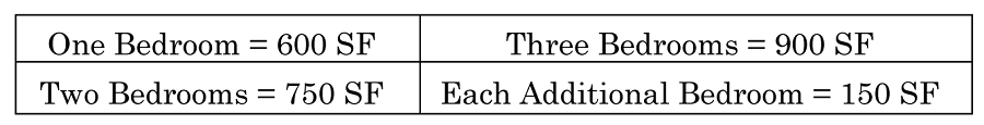 | ||||||||
| G. PERMITTED ACCESSORY USES: Accessory uses customarily associated with, dependent on and incidental to their permitted principal uses, provided that such uses conform to the regulations set forth in chapter 2, article III. | |||||||||||
(Ord. No. 2012-03, § 10, 2-7-2012)
Sec. 2-28. - B-7, Highway Tourist Commercial Zoning District.
| A. PURPOSE: | The purpose of the B-7, Highway Tourist Commercial Zoning District is to provide for a variety of tourist facilities and tourist-related support activities in an attractive setting which will promote pedestrian activity and reinforce positive visitor experience. This district is designed for use within or in close proximity to other districts within which major transient lodging development has occurred or is permitted. | |||||||||||
| B. DIMENSIONAL STANDARDS | ||||||||||||
| 1. | 2. | 3. | 4. | 5. | 6. | 7. | 8. | 9. | ||||
| Type | Density | Maximum Building Height | Maximum Building Coverage | Maximum Impervious Lot Coverage | Minimum Lot Size | Minimum Lot Width | Minimum Lot Depth | Setbacks | ||||
| a. Front | b. Rear | c. Side | d. Street Side/Corner | e. Waterbody | ||||||||
| Nonresidential Uses |
36(transient
lodging) | 50' | 40% | 75% | 20,000 SF | 100' | N/A | 20' |
20';
30' if abutting residential district; 5' additional combined side yard required for each story over 2. |
10';
20' when abutting a multifamily district; 25' when abutting a single-family district; 5' of additional combined yard area required for each story over 2. | 20' | 30' |
| Multifamily | 10 | 50' | 40% | 75% | 20,000 SF | 100' | N/A | 20' |
20';
30' if abutting residential district. | 10' when abutting a multifamily district; 25' when abutting a single-family district. | 20' | 30' |
| C. PERMITTED USES | D. CONDITIONAL USES | E. SPECIAL EXCEPTION USES | F. OTHER STANDARDS | |||||||||
|
1. Adult Day Care Center
2. Assisted Living Facility 3. Business and Professional Office 4. Business Service 5. Clubs and Fraternal Organization 6. Convenience Store, Type A 7. Cosmetic tattooing 8. Financial Institution 9. Funeral Home 10. Instructional Physical Activity 11. Retail Sales and Service 12. School, Public 13. Transient Lodging 14. Veterinarian |
1. Bar
2. Community Residential Home 3. Convenience Store, Type B 4. Convenience Store, Type C 5. Dwelling, Multifamily 6. Family Day Care Home 7. Golf Course, Contoured 8. Hospital 9. House of Worship 10. Nightclub 11. Parking Lot 12. Parking Garage 13. Parks and Recreation Facilities, Private 14. Parks and Recreation Facilities, Public 15. Personal Services 16. Public Facilities 17. Public Utilities 18. Recreational Facilities, Indoor 19. Restaurant, Type "A" 20. Restaurant, Type "B" 21. Restaurant, Type "C" 22. School, Private 23. Shopping Center 24. Telecommunications Towers, Camouflaged 25. Theater 26. Wind Energy System |
1. Automatic Amusement Center
2. Nightclub 3. Outdoor Activity 4. Outdoor Storage 5. Recreational Facilities, Outdoor 6. Telecommunication Tower 7. Vehicle Rental |
All development must comply with the following requirements:1. Wetlands (chapter 3, article II).2. Special corridors and buffer requirements (chapter 3, article I).3. See conditional and special exception regulations (chapter 2, article IV).4. Multifamily residential dwelling units shall have the following minimum
square footage per bedroom:
 | |||||||||
| G. PERMITTED ACCESSORY USES: Accessory uses customarily associated with, dependent on and incidental to their permitted principal uses, provided that such uses conform to the regulations set forth in chapter 2, article III. | ||||||||||||
(Ord. No. 2012-03, § 6, 2-7-2012; Ord. No. 2014-39, §§ 5, 6, 1-6-2015; Ord. No. 2015-11, § 6, 4-7-2015; Ord. No. 2020-41, § 5, 8-18-2020)
Sec. 2-29. - B-8, Commercial Zoning District.
| A. PURPOSE: | The purpose of the B-8, Commercial Zoning District is to provide for the establishment of general commercial activities, other than automotive or heavy commercial uses, on properties that abut arterial roads. Due to the proximity of lands in the district to residential areas, these district regulations are intended to promote the preservation of natural vegetation, increase opportunities for beautification and provide extensive buffering between nonresidential and residential uses not otherwise separated from each other by a collector or arterial road. Multifamily, governmental and institutional uses are also encouraged in such corridors as a relief from extensive strip commercial development, and allowable uses are restricted to those most compatible with residential uses. When used in conjunction with the Planned Business Development District, these regulations are intended to encourage the establishment of totally planned, multiuse, community-level centers having a variety of retail, office, restaurant, recreation and institutional uses. | |||||||||||
| B. DIMENSIONAL STANDARDS | ||||||||||||
| 1. | 2. | 3. | 4. | 5. | 6. | 7. | 8. | 9. | ||||
| Type | Density | Maximum Building Height | Maximum Building Coverage | Maximum Impervious Lot Coverage | Minimum Lot Size | Minimum Lot Width | Minimum Lot Depth | Setbacks | ||||
| a. Front | b. Rear | c. Side | d. Street Side/Corner | e. Waterfront | ||||||||
| Nonresidential Uses |
36
(transient lodging) | 30' | 35% | 75% | 28,000 SF | 100' | N/A |
50';
20' for properties located on U.S. 1 adjacent to Dodson Creek. |
20';
30' if abutting residential district; 5' additional combined side yard required for each story over 2. |
10';
20' when abutting a multifamily district; 25' when abutting a single-family district; 5' of additional combined yard area required for each story over 2. | 20' | 30' |
| Multifamily | 10 | 30' | 35% | 75% | 20,000 SF | 100' | N/A | 50' |
20';
30' if abutting residential district. |
10';
20' when abutting a multifamily district; 25' when abutting a single-family district. | 20' | 30' |
| C. PERMITTED USES | D. CONDITIONAL USES | E. SPECIAL EXCEPTION USES | F. OTHER STANDARDS | |||||||||
|
1. Adult Day Care Center
2. Assisted Living Facility 3. Business and Professional Office 4. Business Service 5. Clubs and Fraternal Organization 6. Convenience Store, Type A 7. Cosmetic tattooing 8. Financial Institution 9. Instructional Physical Activity 10. Nursing Home 11. Retail Sales and Services 12. School, Public 13. Sexually Oriented Business 14. Veterinarian |
1. Bowling Center
2. Child Care Facility 3. Community Residential Home 4. Convenience Store, Type B 5. Convenience Store, Type C 6. Dwelling, Multifamily 7. Family Day Care Home 8. House of Worship 9. Parks and Recreation Facilities, Private 10. Parks and Recreation Facilities, Public 11. Personal Services 12. Public Facilities 13. Public Utilities 14. Recreational Facilities, Indoor 15. Restaurant, Type "A" 16. Restaurant, Type "B" 17. Restaurant, Type "C" 18. School, Private 19. Shopping Center 20. Telecommunications Towers, Camouflaged 21. Theater 22. Virtual Golf Centers 23. Wind Energy System |
1. Automatic Amusement Center
2. Outdoor Activity 3. Outdoor Storage 4. Recreational Facilities, Outdoor 5. Warehouse, Mini-Rental |
All development must comply with the following requirements:1. Wetlands (chapter 3, article II).2. Special corridors and buffer requirements (chapter 3, article I).3. See conditional and special exception regulations (chapter 2, article IV).4. Multifamily residential dwelling units shall have the following minimum
square footage per bedroom:
 5. Sexually oriented business establishments shall comply with the applicable provisions
set forth in article XIV, chapter 12 of the Code of Ordinances, including, but not
limited to, obtaining a sexually oriented business permit pursuant to section 12-410
and a sexually oriented business license pursuant to division 2,article XIV, chapter
12 of the Code of Ordinances when applicable.
5. Sexually oriented business establishments shall comply with the applicable provisions
set forth in article XIV, chapter 12 of the Code of Ordinances, including, but not
limited to, obtaining a sexually oriented business permit pursuant to section 12-410
and a sexually oriented business license pursuant to division 2,article XIV, chapter
12 of the Code of Ordinances when applicable.
| |||||||||
| G. PERMITTED ACCESSORY USES: Accessory uses customarily associated with, dependent on and incidental to their permitted principal uses, provided that such uses conform to the regulations set forth in chapter 2, article III. | ||||||||||||
(Ord. No. 2012-03, § 7, 2-7-2012; Ord. No. 2013-38, § 3, 6-18-2013; Ord. No. 2014-39, §§ 7, 8, 1-6-2015; Ord. No. 2015-11, § 7, 4-7-2015; Ord. No. 2020-41, § 6, 8-18-2020; Ord. No. 2021-36, § 2, 10-19-2021)
Sec. 2-30. - B-9, Boulevard Zoning District.
| A. PURPOSE: | The purpose of the B-9, Boulevard Zoning District is to provide for the maintenance of the character of relatively large and extensively wooded areas abutting major transportation routes. The district provides for large lot uses having setbacks adequate to preserve noticeable amounts of the natural amenities and, at the same time, provide for highly intensive and architecturally significant uses within the district compatible with the density and intensity of the surrounding uses in the corridor. The district is suitable for use along major routes where it is in the interest of the public to minimize access cuts in order to promote safety and avoid traffic congestion. | |||||||||||
| B. DIMENSIONAL STANDARDS | ||||||||||||
| 1. | 2. | 3. | 4. | 5. | 6. | 7. | 8. | 9. | ||||
| Type | Density | Maximum Building Height | Maximum Building Coverage | Maximum Impervious Lot Coverage | Minimum Lot Size in Acres | Minimum Lot Width | Minimum Lot Depth | Setbacks | ||||
| a. Front | b. Rear | c. Side | d. Street Side/Corner* | e. Waterfront | ||||||||
| Nonresidential Uses |
36
(transient lodging) | 75' | 30% | 75% | 1.5 acres |
250'
(see section F.4) | N/A |
75'
(see below) |
20'
30' if abutting residential district; 5' additional combined side yard required for each story over 2 |
20'
25' if abutting a single-family district; 5' additional combined yard area required for each story over 2 |
75'
(see below) | 30' |
| Multifamily | 10 | 75' | 30% | 75% | 1.5 acres |
250'
(see section F.4 of this section) | N/A |
75'
(see below) |
20'
30' if abutting residential district; 5' additional rear yard required for each story over 2 |
20'
25' if abutting single-family residential district; 5' additional rear yard required for each story over 2 |
75'
(see below) | 30' |
|
*Front and side corner yards: The front yard and side corner yard setbacks for properties abutting arterial roads
shall be 75 feet, except as follows:
(1) 40 feet for nonresidential structures erected on lots which have an average lot depth of less than 200 feet and were in existence prior to April 3, 1984, or have been reduced to such depth through an eminent domain proceeding, provided that the landscape buffer area required by the Greenbelt Overlay District (chapter 3, article I) shall be extended to the area directly in front of the building, and provided further that no parking spaces or access drives or stormwater retention areas greater than two in depth shall be allowed in the said 40 feet. (2) 51 feet for nonresidential structures erected on lots which have an average lot depth of 200 feet to 250 feet and were in existence prior to April 3, 1984, or have been reduced to such depth through an eminent domain proceeding. | ||||||||||||
| C. PERMITTED USES | D. CONDITIONAL USES | E. SPECIAL EXCEPTION USES | F. OTHER STANDARDS | |||||||||
|
1. Adult Day Care Center
2. Assisted Living Facility 3. Business and Professional Office 4. Business Service 5. Clubs and Fraternal Organization 6. Cosmetic tattooing 7. Financial Institution 8. Instructional Physical Activity 9. Nursing Home 10. School, Public 11. Veterinarian |
1. Child Care Facility
2. Community Residential Home 3. Dwelling, Multifamily 4. Family Day Care Home 5. House of Worship 6. Parks and Recreation Facilities, Private 7. Parks and Recreation Facilities, Public 8. Personal Services 9. Public Facilities 10. Public Utilities 11. Recreational Facilities, Indoor 12. Restaurant, Type A 13. Restaurant, Type B 14. Retail Sales and Service 15. School, Private 16. Telecommunication Tower/Antennas, Camouflaged 17. Wind Energy System |
1. Outdoor Activity
2. Outdoor Storage 3. Recreational Facilities, Outdoor 4. Restaurant Type "C" |
All development must comply with the following requirements:1. Wetlands (chapter 3, article II).
2. Landscaping and buffering: if the parcel abuts a designated greenbelt corridor,
the standards of chapter 3, article II shall apply with regard to buffering and landscape requirements.
3. Access: access to lots in this district shall be limited to one driveway for every
250 feet of street frontage. Common access for two lots is allowed.
4. Minimum lot width: where direct access is provided by a service road set back at
least 25 feet from the right-of-way or through a common driveway with cross-easements,
the minimum lot width shall be 125 feet. Where a service road is provided, no other
direct vehicle access to the major arterial shall be permitted.
5. All multifamily, duplex and triplex residential dwelling units shall have the following
minimum square footage per bedroom:
 | |||||||||
| G. PERMITTED ACCESSORY USES: Accessory uses customarily associated with, dependent on and incidental to their permitted principal uses, provided that such uses conform to the regulations set forth in chapter 2, article III. | ||||||||||||
(Ord. No. 2012-03, § 8, 2-7-2012; Ord. No. 2015-16, §§ 6—8, 4-21-2015; Ord. No. 2020-41, § 7, 8-18-2020)
Sec. 2-31. - B-10, Suburban Boulevard Zoning District.
| A. PURPOSE: | The purpose of the B-10, Suburban Boulevard Zoning District is to provide for the maintenance of the character of relatively large and extensively wooded areas abutting the city's major transportation routes. The district provides for large lot uses having setbacks adequate to preserve noticeable amounts of the natural amenities and, at the same time, provide for architecturally significant uses within the district that project a lower intensity suburban environment. The district is particularly suitable for use along major entrance routes where it is in the interest to minimize access cuts in order to promote safety and avoid traffic congestion. | |||||||||||
| B. DIMENSIONAL STANDARDS | ||||||||||||
| 1. | 2. | 3. | 4. | 5. | 6. | 7. | 8. | 9. | ||||
| Type | Density | Maximum Building Height | Maximum Building Coverage | Maximum Impervious Lot Coverage | Minimum Lot Size in Acres | Minimum Lot Width | Minimum Lot Depth | Setbacks | ||||
| a. Front | b. Rear | c. Side | d. Street Side/Corner* | e. Waterfront | ||||||||
| Nonresidential Uses | N/A | 45' | 30 percent | 75 percent | 1.5 acres | 250 feet (see subsection F.4) | N/A |
75 feet
(see below) |
20 feet;
30 feet if abutting residential district; 5 feet additional rear yard required for each story over 2. |
20 feet;
25 feet if abutting a single-family residential district; 5 feet additional rear yard required for each story over 2. |
75 feet
(see below) | 30' |
| Multifamily | ten | 75' | 30 percent | 75 percent | 1.5 acres | 250 feet (see subsection F.4) | N/A |
75 feet
(see below) |
20 feet;
30 feet, if abutting residential district; 5 feet additional rear yard required for each story over 2. |
20 feet;
25 feet, if abutting single-family residential district; 5 feet additional rear yard required for each story over 2. |
75 feet
(see below) | 30' |
| *Front and side corner yards: The front yard and side corner yard setbacks for properties abutting arterial roads
shall be 75 feet, except as follows:
(1) 40 feet for nonresidential structures erected on lots which have an average lot depth of less than 200 feet and were in existence prior to April 3, 1984, or have been reduced to such depth through an eminent domain proceeding, provided that the landscape buffer area required by the Greenbelt Overlay District (chapter 3, article I) shall be extended to the area directly in front of the building, and provided further that no parking spaces or access drives or stormwater retention areas greater than two in depth shall be allowed in the said 40 feet. (2) 51 feet for nonresidential structures erected on lots which have an average lot depth of 200 feet to 250 feet and were in existence prior to April 3, 1984, or have been reduced to such depth through an eminent domain proceeding. | ||||||||||||
| C. PERMITTED USES | D. CONDITIONAL USES | E. SPECIAL EXCEPTION USES | F. OTHER STANDARDS | |||||||||
|
1. Adult Day Care Center
2. Assisted Living Facility 3. Business and Professional Office 4. Business Service 5. Clubs and Fraternal Organization 6. Cosmetic tattooing 7. Financial Institution 8. Instructional Physical Activity 9. Nursing Home 10. School, Public 11. Veterinarian |
1. Child Care Facilities
2. Community Residential Home 3. Dwelling, Multifamily 4. Family Day Care Home 5. House of Worship 6. Parks and Recreation Facilities, Private 7. Parks and Recreation Facilities, Public 8. Personal Services 9. Public Facilities 10. Public Utilities 11. Recreational Facilities, Indoor 12. Restaurant, Type A 13. Restaurant, Type B 14. Retail Sales and Service 15. School, Private 16. Telecommunication Tower/Antennas, Camouflaged 17. Wind Energy System |
1. Funeral Home
2. Outdoor Activity 3. Outdoor Storage 4. Recreation Facilities, Outdoor 5. Restaurant Type "C" |
All development must comply with the following requirements:1. Wetlands (chapter 3, article II).
2. Landscaping and buffering: if the parcel abuts a designated greenbelt corridor,
the standards of chapter 3, article II shall apply with regard to buffering and landscape requirements.
3. Access: access to lots in this district shall be limited to one driveway for every
250 feet of street frontage. Common access for two lots is allowed.
4. Minimum lot width: where direct access is provided by a service road set back at
least 25 feet from the right-of-way or through a common driveway with cross-easements,
the minimum lot width shall be 125 feet. Where a service road is provided, no other
direct vehicle access to the major arterial shall be permitted.
5. All multifamily, duplex and triplex residential dwelling units shall have the following
minimum square footage per bedroom:
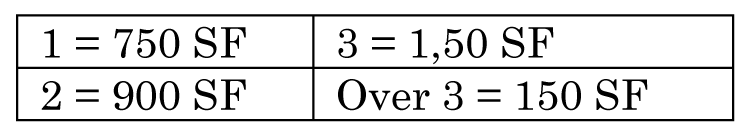 | |||||||||
| G. PERMITTED ACCESSORY USES: Accessory uses customarily associated with, dependent on and incidental to their permitted principal uses, provided that such uses conform to the regulations set forth in chapter 2, article III. | ||||||||||||
(Ord. No. 2012-03, § 9, 2-7-2012; Ord. No. 2015-16, §§ 9—11, 4-21-2015; Ord. No. 2020-41, § 8, 8-18-2020)
Sec. 2-32. - I-1, Light Industrial Zoning District.
(Ord. No. 2013-51, § 2, 9-3-2013; Ord. No. 2015-11, § 8, 4-7-2015; Ord. No. 2022-22, § 2, 8-3-2022; Ord. No. 2024-38, § 2, 1-7-2025)
Sec. 2-33. - Reserved.
Editor's note— Ord. No. 2023-56, § 4, adopted December 19, 2023, repealed § 2-33, which pertained to I-2, heavy industrial zoning district and derived from Ord. No. 2023-41, § 4, 8-1-2023.
Sec. 2-34. - Planned development districts.
(a)
Purpose. These districts are established to implement planned development provisions of the city's comprehensive plan. The planned development districts provide a voluntary management framework for coordinating objectives of the development community which may be inconsistent with conventional zoning district provisions. The planned development districts incorporate a more flexible management structure for negotiating private sector development objectives, which reinforce and further sector goals, objectives and policies for the city's development and resource conservation.
(b)
Intent. The planned development districts are intended to encourage the accomplishment of a more complete living environment through the application of enlightened and imaginative approaches to community planning and design. The planned development alternative permits the introduction of a variety of architectural solutions; provides for historic preservation as well as the preservation of natural features in scenic areas; reduces land consumption by roads; separates vehicular and pedestrian circulation systems; fosters original approaches to meaningful integration of open space and recreation areas within the development; establishes neighborhood identity and focus; and ideally provides for the compatible coexistence of man with his environment. Regulations for planned developments are intended to accomplish the purposes of zoning, subdivision regulations and other applicable city regulations to the same degree as in instances where such city regulations are intended to control development on a lot-by-lot basis rather than on a unified development approach. In view of the substantial advantages of the planned development, it is the intent of the planned development regulations to promote and encourage development in this form. The uses and structures proposed are to be planned and developed as unified and coordinated developments. The purpose of a planned development is to:
(1)
Achieve innovative and creative design and a high level of amenities within residential and nonresidential developments;
(2)
Promote efficient use of land by facilitating more cost effective and environmentally sensitive site planning, including the arrangement of buildings, circulation systems, land use and facilities;
(3)
Stimulate opportunities for varied housing types and diversified economic opportunities;
(4)
Conserve and protect the natural environment including wetlands, natural habitat, drainage corridors, floodprone lands, and other environmentally sensitive lands;
(5)
Provide for more useable and suitably located open space and recreation facilities and other and common facilities than would otherwise be provided under conventional land development procedures; and
(6)
Achieve harmonious building and site designs.
Although planned developments provide opportunities for unique concepts, planned developments shall comply with the community character as promoted by the city commission and shall be designed to limit impacts of the development internally within the confines of the planned development through compliance with the regulations established in the comprehensive plan and as stipulated in this Land Development Code.
Sec. 2-35. - PRD, Planned Residential Development District.
(a)
In general. The purpose of the PRD, Planned Residential Development District classification is to provide more flexibility with regard to land use, density and dimensional standards, and other requirements of this Land Development Code, to encourage developments that incorporate innovative concepts of site planning, coordinated architectural and functional design, higher level of amenities, increased amounts of open space, recreation and landscaping, and a better living environment overall.
(b)
Permitted uses.
(1)
Residential uses.
a.
Permitted uses within PRD districts include all permitted uses listed under the particular zoning district regulations of the district in which the planned development is located.
b.
More intense uses (e.g., townhouses in a single-family district, or apartments in a townhouse district) may be allowed, provided that their visual and functional impact on neighboring districts is minimized by providing adequate buffering and screening, and all the requirements of this section are met.
c.
Multifamily structures may also be allowed in PRD districts that are in single-family districts, provided that the multifamily structures and associated parking areas are not within two hundred feet (200') of any single-family district adjoining the planned development.
d.
For those developments proposed within the SR district, the requirements of that district must also be met.
(2)
Other uses. The following uses may be allowed in a PRD district, provided that the requirements of article IV of this chapter, conditional uses and special exceptions, and this section are complied with:
a.
Clubs and recreation facilities to serve the residents of the project.
b.
Daily needs retail and services.
c.
Houses of worship.
d.
Public schools and parks.
e.
Public uses.
Compatible neighborhood commercial facilities and office uses may be permitted within PRDs having a minimum size of thirty (30) acres; however, no more than twenty percent (20%) of the gross area shall be devoted to these uses, including parking. For the purpose of planned development review, the determination of compatible commercial shall be based on the architectural and spatial design of the proposed facility compared to that of the total development and the relationship of the proposed facility to the retail needs of the planned development residents. Such commercial uses are limited to those listed as principal permitted uses in the B-2, Neighborhood Commercial District. For those developments encompassing land already zoned commercial, a wider range of interpretation will be granted to permit and encourage compatible development. In addition to having adequate access to the thoroughfare system, such commercial area shall, when possible, have internal access to serve the residents of the planned development.
(c)
Density.
(1)
Allowable densities. The maximum allowed gross density level of a planned residential development shall vary according to the land use classification assigned to the property on the city's adopted future land use map, subject to the provisions of this section. Where more than one (1) land use classification is included in the project, the least-dense classification shall apply.
(2)
Density bonus. Except within the SR district, any planned development may qualify for a density increase of up to twenty percent (20%) over the allowed density, as based on the adopted future land use map, provided that the increase will not create the following adverse situations:
a.
Adverse impact on neighboring sites or subject site;
b.
Traffic congestion in the streets which adjoin the development; or
c.
An excessive burden on sewerage, water supply, parks, recreational areas or other facilities which are proposed to serve the development.
(3)
Density and project phasing. Where a PRD is proposed to be constructed in phases, at no point in the development of the project shall constructed density exceed the overall density per acre approved for the entire project.
(4)
Holding capacity; density. Density determined in subsection (c)(1) of this section is for gross density purposes only. A more refined methodology for determining the holding capacity of a particular site proposed for development is derived from a three-tiered system based on soil characteristics related to the high seasonal groundwater tables (as derived from the SCS soil classification study); flooding potential as noted on the FEMA, FIRM maps; and the availability of central water and/or central sewer facilities. Table 2 illustrates the relationship between environmental constraints and water and sewer availability when calculating density. This table lists the coefficients for determining density in a matrix.
The procedure for determining holding capacity is as follows:
Step 1: Applicant prepares environmental constraints map for the parcel proposed for development;
Step 2: Calculate the acreage of property within each particular environmental constraints category;
Step 3: Multiply the acreage in each category by a coefficient determined by site-specific environmental constraints and availability of water and sewer as noted in table 2.
Step 4: Sum the totals for each category to achieve the holding capacity for the parcel in terms of maximum potential density.
Once the holding capacity is determined, the developer must prepare plans that are consistent with the holding capacity and environmental constraints of the subject property.
Five (5) distinct environmental constraint categories have been identified and are described below, together with their density allocations.
a.
Very Low. Areas that lie within the 100-year floodplain and where the seasonal high water table is at or above the surface or areas outside of the 100-year floodplain where the seasonal high water table is six inches (6") or more above the surface. Here, the constraints are seen as being severe, with associated environmental impacts too damaging for community development. Areas in this category are, for the most part, the riverine wetlands and cypress swamps interspersed among the pine flatwoods. Representative soils include the various mucks associated with the wetlands and more established cypress systems. A nominal standard of 0.2 units to the acre (one (1) unit per five (5) acres) is assigned as the maximum achievable density for this category, regardless of the availability of central utilities (facilities are not planned for these areas). In some cases, it is conceivable that a single development site could be located within a five-acre parcel classified entirely as "very low." However, a more likely scenario, particularly for larger parcels, would be the transfer of the density allocation to the more buildable areas of the site.
b.
Low. Includes soil types with a seasonally high water table that, at times, will reach and exceed the surface. This category includes land that falls within designated 100-year floodprone areas and has a seasonal high water table that does not reach the surface and is not greater than six inches (6") below the surface, or lands where the water table will occasionally be at or above the surface (zero (0) to six inches (6") above) but, for various reasons, is not designated as a 100-year floodprone area. The low category encompasses the more subtle depressional features among the flatwoods. The pine/cypress vegetative community and the depressional variety of the Pomona, Immokalee, and Myakka soil series commonly occur in this category. These lands can tolerate a certain amount of mitigated modification without irreversible environmental damage. The maximum density value for this category is 0.5 units per acre (one (1) unit per two (2) acres) regardless of the availability of utilities. As with the very low category, these levels of development can be achieved only under the ideal circumstances consistent with the criteria for protection of wetlands that typically occur within this soil category. Therefore, development is not likely to occur at assigned densities within these areas but will probably be transferred to other more suitable on-site uplands.
c.
Medium Low. These are areas that are within the 100-year floodplain and the seasonal high water table is greater than six inches (6") to twenty-four inches (24") below the surface or those areas that are outside of the floodplain and the seasonal high water table does not reach the surface and is not greater than six inches (6") below the surface. Density ranges in this category are one (1) unit per two (2) acres without infrastructure; one (1) unit per acre with central water only; and three (3) units per acre with both central water and sewer. Depending upon actual vegetative system conditions, these areas may be suitable for limited development or for open space uses with on-site density transfer to more suitable areas.
d.
Medium. The criteria for designating lands in the medium category is the seasonal high water table greater than six inches (6") below the surface to twenty-four inches (24") below and outside of floodprone areas or is twenty-four inches (24") or greater below surface if in floodprone area. Extensive areas in the western and southern portion of the Pamlico Terrace are in this category. Due to the nearly level terrain in those areas within the floodplain, the water table hovers near the surface for two (2) to three (3) months a year. However, with proper drainage design and adequate infrastructure, development potential can reach up to four (4) units per acre with central water and sewer; one (1) unit per two (2) acres with no central utilities; and two (2) units per acre with central water only. Planned unit developments, with net densities in excess of one (1) unit per acre utilizing either well or septic or one (1) unit per two (2) acres utilizing well and septic may be allowed provided that minimum lot size requirements are not reduced, to achieve maximum potential density. Instead, transfer of density to a portion of the site serviced by a central system will be allowed, provided the proposed development is consistent with the zoning district requirements, level-of-service standards, and compatible with the natural resources.
e.
High. This category includes lands that are not within a floodprone area and have a water table deeper than twenty-four inches (24") below the surface. These lands generally consist of deep sandy soils and are the most suited for community development. They are in relatively short supply due to the prevailing high water tables and floodprone conditions in the undeveloped perimeter areas of the city and the early development of the deep, sandy ridge areas. Representative soils of this category include the Tavares, Daytona, and DeLand series. Up to six (6) units to the acre (roughly the equivalent of duplex or zero-lot-line development on five thousand (5,000) square foot lots) is achievable with central utilities. With central water only, the maximum density would be three (3) units per acre if that could be achieved under health department septic standards. The location of package plants is acceptable in the medium and high categories for planned unit developments at the higher densities (e.g., greater than one (1) unit per acre) on an interim basis only where it is not economically feasible (due to and/or sewer service at the time of development. In these cases, the development shall be dry-lined and impact fees paid in advance or bonded for. Without central sewer or water, the maximum density is one (1) unit per two (2) acres (project size in relation to line extension distances) to connect to central water.
Table 1. Density Determinations
* For purposes of computing maximum potential density only; a minimum lot size of 1 acre is required for any development utilizing septic tanks. Connection to central sewer will be required whenever line extensions and appurtenances thereto are deemed economically feasible.
Table 2. Characteristics of Environmental Constraint Categories
(d)
Dimensional requirements.
(1)
Minimum parcel size.
a.
Five acres: SR, R-1, R-2, R-2.5, R-3.
b.
One acre: R-4, R-5, R-6.
(2)
Maximum building height. The maximum building height for a proposed PRD district shall be based on the existing zoning district regulations in which the residential development is located, except that one (1) additional story may be allowed for structures located at least one hundred feet (100') from any development perimeter boundary line abutting a district having a lower height limit. In no case shall any building height exceed seventy-five feet (75') when measured from the average median lot elevation to the highest point of any structure and/or attached services.
(3)
Setbacks. All structures shall be set back a minimum of forty feet (40') from the project's perimeter boundaries unless natural or manmade features, such as lakes, creeks, wooded or conservation areas are present. Where a project abuts a collector or arterial street, the setback requirement may be increased if an effective buffering treatment cannot be provided between the street and residential use.
(4)
Minimum building spacing. Building setbacks shall comply with the individual district requirements. Given the possibilities of innovative architectural design, the city commission may alter the minimum for specific designs, provided that the original intent of the spacing requirements is maintained.
(e)
Interior road system.
(1)
All single-family attached and detached dwelling units on individually platted lots shall have access to a street meeting all street standards; provided, however, that up to three (3) dwelling units may utilize a common driveway as long as spatial requirements for parking in chapter 3, article III of this Land Development Code are met.
(2)
All streets shall meet all street standards for construction and size, including a commonly-owned easement that meets the normal right-of-way requirements for a street. Some of these requirements may be waived or the right-of-way width may be reduced to forty feet (40') if the streets are proposed as private streets, or if the traffic volume in those streets is two hundred average daily trips (200 ADT) or less.
(3)
When a planned development proposes a street which would be a logical extension of the city's collector or arterial street system, the city may require an increase in the right-of-way and/or pavement width and increased construction standards, as necessary.
(f)
Off-street parking. The off-street parking requirements of chapter 3, article IV of this Land Development Code shall be complied with except as follows:
(1)
Single-family dwelling.
a.
The width of the driveway for an individual dwelling unit may be tapered to below the required width if it is clearly shown on the plan that each automobile may be easily maneuvered for ingress and egress without requiring the relocation of the other vehicle.
b.
Up to three (3) single-family cluster-type dwelling units with two-car (2) garages may utilize a common access driveway, provided that the dwelling units shall meet the general parking requirements, and the common utilized portions of the driveway shall not be less than twenty feet (20') wide.
c.
For each single-family dwelling located on a forty-foot (40') right-of-way street with a two-car (2) garage, one (1) guest parking space per four (4) dwellings shall be provided. For single-family dwellings with less than a two-car (2) garage, one (1) guest parking space per two (2) dwelling units shall be provided.
d.
Guest parking shall be distributed throughout the development to adequately serve all dwelling units.
(2)
Multifamily dwelling.
a.
If garages are provided, the requirements of this section for single-family dwellings shall apply.
b.
One (1) guest parking space shall be provided for each two (2) dwelling units, provided, however, if the deed restrictions and covenants prevent the assignment of more than one (1) parking space to each dwelling unit, one (1) guest parking space shall be provided for each four (4) dwelling units.
c.
Common parking areas are only allowed in conjunction with multifamily structures or other developments under single or condominium ownership. The land for the common parking area shall not be subdivided from the land which contains the structures it serves. All common parking lots shall be built to the construction standards utilized for streets.
(3)
Offices.
a.
One (1) parking space for each of the following:
1.
Two hundred (200) square feet of gross floor area on the first floor;
2.
Two hundred fifty (250) square feet of gross floor area on the second story; and
3.
Three hundred (300) square feet of gross floor area on additional stories; or
b.
Vehicle parking deferral. To avoid requiring more parking spaces than is actually needed to serve a development, the city may defer the provision of some portion of the off-street parking spaces required by this Land Development Code if previous experience within the city for such a case or information supplied by the developer suggests that the required number of parking spaces may not be necessary. In such a case, the developer shall provide a deferred parking plan in accordance with the following criteria:
1.
Shall be designed to contain sufficient space to meet the full parking requirements of this Land Development Code, shall illustrate the layout for the full number of parking spaces, and shall designate which are to be deferred.
2.
Shall not assign deferred spaces to areas required for landscaping, transition zones, setbacks, or areas that would otherwise be unsuitable for parking spaces because of the physical characteristics of the land or other requirements of this Land Development Code.
3.
Shall describe how the area of deferred parking plan would remain and be maintained in its natural state, and shall include a landscaping plan for the deferred parking area.
4.
Shall include a written agreement with the city that the deferred spaces will be converted to parking spaces that conform to this Land Development Code at the developer's expense should the city determine from experience that the additional parking spaces are needed.
5.
Shall include a written agreement that the developer shall incur the expense of a traffic study to be undertaken by a registered transportation engineer to determine the advisability of providing the full parking requirement should the city determine from experience that the additional parking spaces are needed.
When presented with evidence that the parking is inadequate, the city shall request a study to determine the need of providing the full parking requirement to satisfy the proven demand for parking as discussed in subsection (f)(3)b.5 of this section. Based upon the study and the recommendations of the transportation engineer, the director of planning, the planning board, and the city commission shall determine if the deferred spaces by the developer or retained as deferred parking area. The developer may, at any time, request that the city approve a revised development plan to allow converting the deferred spaces to operable parking spaces.
(g)
Landscaping and utility lines.
(1)
All common open space, parking lot islands, and all land not otherwise developed shall be landscaped in a manner that enhances the appearance of the project.
(2)
An underground irrigation system shall be installed in all landscaped areas of the planned development. After installation, the system shall be regularly used and maintained. Landscaped buffer areas shall be provided as required in chapter 3, article I of this Land Development Code, if applicable.
(h)
Recreational facilities. Areas for passive and active recreation shall be provided. Such areas shall be designed and improved to serve their intended use and shall reflect the recreational needs of the residents of the development. Recreational areas shall meet the following minimum requirements:
(1)
They shall be located and designed with adequate access to encourage use by the residents;
(2)
Active indoor or outdoor recreation areas, such as swimming pools or community buildings, shall be designed to serve a maximum of three hundred (300) dwelling units;
(3)
Thirty (30) square feet of indoor recreation floor area, including exercise rooms, all-purpose space, dining areas and similar uses shall be provided for each dwelling unit, unless waived by the city commission and replaced at a minimum as follows:
a.
Sixty (60) square feet per unit of outdoor active recreation space in compliance with this section in lieu of the indoor recreation floor area requirement;
b.
The open space and/or additional outdoor facilities must be compatible with adjacent properties and the recreational facilities must be consistent with the needs of the project; and
c.
The planning board and city commission determine, after reviewing the proposed development plan, that the preservation of natural resources and/or provision of additional recreation facilities is appropriate and that indoor recreational facilities can be waived.
(4)
Sixty (60) square feet of outdoor active recreation space (exclusive of parking, landscaping, retention/detention ponds and other site features), including pools, pool decks, shuffleboard courts, tennis courts and fishing piers and similar uses, shall be provided for each dwelling unit. Impact fee credits for any specific outdoor recreation site shall be limited to three hundred (300) dwelling units;
(5)
Recreation sites which include indoor and outdoor activities shall comply with all general site plan design and construction standards with regard to buffer areas, landscaping, interior landscaping, parking arrangement, lighting, signing, and drainage. Up to fifty percent (50%) of the required parking may be designed as overflow spaces;
(6)
The minimum parcel size of any single active recreational area shall be eight thousand (8,000) square feet in area and no less than eighty feet (80') in its smallest dimension. No designated active recreation area shall be closer than thirty feet (30') to a dwelling unit within the development at its closest point and shall be adequately buffered to reduce noise, glare and visual impacts on adjoining homesites. Active recreation facilities shall not be located in any required buffer area;
(7)
Thirty (30) square feet of common accessible, open space shall be provided for each dwelling unit as follows:
a.
Common open space shall be available to all the residents of the development. At the option of the developer, subject to the approval of the city commission, common open space may be dedicated to the use of the general;
b.
Common open space must be adequately landscaped and irrigated;
c.
Natural features worthy of preservation shall be left in a natural state;
d.
Water bodies may be utilized to meet twenty-five percent (25%) of the available open space requirement, provided significant recreational use of the waterbody can be demonstrated. Water retention and wetlands areas may not be included in this calculation;
(8)
Twenty percent (20%) of the project shall be left in a natural state. This may include designated conservation areas within lots or common areas; and
(9)
One (1) on-site parking space shall be provided for each two hundred fifty (250) square feet of indoor recreation area and one (1) such space for each four hundred (400) square feet of active outdoor recreation area. If both types of recreation areas are located on the same site, only the indoor requirement must be met. Applicants requesting a waiver of indoor recreation facilities may request approval of an alternative parking plan as part of the planned residential development application. Alternative parking plans shall be reviewed for consistency with the city's comprehensive plan, this Land Development Code, the Americans with Disabilities Act (ADA) and other applicable regulations.
(i)
Supplemental requirements.
(1)
Fences.
a.
If fences are not prohibited in the deed restrictions and covenants of the project, a schematic fencing plan shall be incorporated in the development plan.
b.
The fencing plans shall clearly illustrate the types of fencing to be allowed and the locations of gates to provide access for safety personnel.
c.
Provisions to ensure adequate maintenance of fencing shall be incorporated into the homeowners' association documents.
(2)
Lighting. Where necessary, additional lighting may be required to supplement street lighting. Where required, such lighting shall be shown on the development plan.
(3)
Deed restrictions and covenants. No amendment to the deed restrictions and covenants which would alter the design or use of the property and structures shall be made without the written permission of the city.
(4)
Unity of title. All land included within a PRD shall be under the control of the applicant, whether that applicant is an individual, partnership, or corporation, or group of individuals, partnerships or corporations. Applicants shall present evidence, at the time of application, of unified control of the entire area within the proposed development. The applicant shall provide:
a.
An agreement to proceed with the proposed development according to all of the provisions of these regulations;
b.
Agreements, contracts, deed restrictions and sureties acceptable to the city commission for completion of the development, or each approved phase of the development, according to the approved plans;
c.
Agreements, through the establishment of a homeowners' association, for the continuing operation and maintenance of all such areas, functions, and facilities which are not to be provided, operated or maintained at expense, acceptable to the city commission;
d.
An agreement to notify the city, at the same time the development owners are notified, of any proposed amendments to the homeowners' association; and
e.
Assurance that binds the applicant's successors in title to any commitments made under subsections (i)(4)b, c and d of this section.
All such agreements and evidence of unified control shall be examined by the city attorney and no approval shall be granted without a certificate by the city attorney that such agreements and evidence of unified control meet the requirements of this section.
(j)
Application and review.
(1)
A written application, consistent with the requirements of article IV of this chapter for PRD shall be made to the planning department, using the application form provided by the city. The application shall be processed as required in chapter 1, article II, administration and enforcement.
(2)
Applications shall include the following:
a.
Complete site plan submittal per chapter 4, article I of this Land Development Code, except that final engineering and construction drawings may be withheld pending the issuance of a development order by the city commission.
b.
Documentation, including written explanations, drawings and illustrations, demonstrating conformance with subsection (j)(4) of this section.
c.
Special studies including, but not limited to, traffic impact study, environmental assessment report, and holding capacity analysis as required by this Land Development Code.
(3)
Following approval of rezoning to PRD and issuance of development order, the applicant may submit final site plan drawings or make application for preliminary plat approval in accordance with chapter 4, article II of this Land Development Code.
(4)
In considering an application for a PRD, the planning board may recommend approval, approval with conditions, or disapproval and the city commission may base its conditions of approval or denial of the issuance of a development order on the extent to which the development offers site amenities above that normally found for permitted uses in the district with regard to the following:
a.
Innovative site design.
b.
Coordinated architectural design.
c.
Open space, recreation, common areas.
d.
Coordinated streetscape elements.
(k)
Adoption/amendments/expiration. The PRD development order shall be adopted by the city commission in accordance with the provisions of chapter 1, article II of this Land Development Code.
(l)
Exceptions. A PRD application involving land in the R-4, R-5 and R-6 zoning districts shall be subject to the following in lieu of the standards contained in this section:
(1)
Recreational standard. None.
(2)
Parking standard. In lieu of the general parking standards and subsection (f) of this section, the number of dwellings is limited by the requirement of one and one-half (1½) spaces per unit. If located on a transit route, the parking standard may be reduced to one (1) space per unit.
(3)
Setback standard. Shall be based upon the underlying zoning district.
(Ord. No. 2015-46, § 1, 11-2-2015; Ord. No. 2025-08, § 3, 2-4-2025)
Sec. 2-36. - PBD, Planned Business Development District.
(a)
Purpose. The objective of the PBD, Planned Business Development District Zoning District is to establish regulatory standards for controlling the location of comprehensively planned business centers accessible to arterial roadways. The PBD is intended to incorporate a flexible management policy which incorporates urban design amenities, including streetscape improvements, and fosters innovative master planning in the design and development of commercial centers. The PBD district provides a diversified mix of permitted, conditional, and special land uses and higher standards of land planning and site design than are available under conventional zoning categories. All planned business developments shall be designed and administered consistent with the criteria and administrative procedures in this Land Development Code.
(1)
Promote innovative site and building design and a high level of amenities, including traditional neighborhood developments.
(2)
Provide efficient location and utilization of infrastructure through orderly and economical development, including a fully integrated network of streets and pedestrian/bicycle facilities.
(3)
Establish open areas set aside for the preservation of natural resources, significant natural features and vistas, and listed species habitats.
(4)
Create usable and suitable located civic spaces, recreational facilities, open spaces and scenic areas; than would otherwise be provided within conventional zoning districts.
(5)
Provide for a coherent and visually attractive physical environment through the creation of focal points and vistas, as well as coordination and consistency of architectural styles, landscaping designs and other elements of the building environment.
(6)
Provide for other limitations, restrictions and requirements as deemed necessary by the city to ensure compatibility with adjacent neighborhoods and effectively reduce potential adverse impacts.
(b)
Land use mix. The specific land use mix within a PBD district development shall be determined by the underlying comprehensive plan future land use map designations.
(c)
Permitted uses. A PBD may incorporate any commercial or residential development allowed as permitted uses in the underlying zoning district designation, as well as any commercial or residential uses allowed under the Land Development Code for any district, provided the following findings are made:
(1)
The use is specifically shown on the site plan and includes a list of all proposed uses not permitted in the underlying zoning district (to the maximum extent known at the time of site plan submittal), a general description of the location, floor area to be occupied by such use, typical hours of operation and other relevant operation characteristics.
(2)
The use, by virtue of its location, vehicular circulation pattern, noise and visual buffering, traffic generation rates and peak traffic hours, odor emission controls, lighting and use of materials will not have an adverse impact on surrounding land uses, particularly where the site abuts areas developed with or zoned primarily for single-family homes.
(3)
Conversion of occupancy from a use approved under a PBD to a permitted use in the underlying district will not require an amendment to the PBD.
(4)
The use does not exceed any size limitations, use restrictions or other requirements provided under article II of this chapter.
(d)
Dimensional requirements.
(1)
Buffer areas. Buffer areas may be reduced to a minimum of six feet (6'), based on a finding that due to the type of adjoining use, natural features (such as water bodies, retention ponds, conservation areas), architecture, fenestration and proposed landscaping and screening, such reduction will not have an adverse impact on any adjoining site or the subject site; provided, however, that a minimum buffer of six feet (6') shall be maintained except where there is a standing body of water.
(2)
Building setbacks. Building setback requirements may be reduced by up to twenty percent (20%) of the required setback in order to achieve site design objectives related to architectural form and visual amenity, provided that such reduction will not have an adverse impact on abutting properties or vehicular safety, nor jeopardize the safety. The minimum setback may be reduced for sites where a bluff of ten feet (10') above the mean high-water mark exists along the Tomoka River or the Little Tomoka River.
(3)
Building height. Height limits may exceed that allowed by district regulations by a maximum of fifteen feet (15'), provided that the structure is so located as to not have an adverse impact on adjoining properties, particularly single-family homes. This additional height allowance will not be awarded for any portion of a structure located within fifty feet (50') of a single-family home or for a vacant site in a zoning district designed primarily for such use. In no case shall any building height exceed seventy-five feet (75') when measured from the average median lot elevation to the highest point of any structure and/or attached services.
(4)
Distance between buildings. The distance requirement between buildings may be reduced to that required by the building and fire prevention codes in order to achieve site design objectives related to architectural form.
(5)
Minimum parcel size. The minimum parcel size shall be the same as for permitted uses within the zoning district in which the site is located. All contiguous properties under the same ownership shall either be included in the PBD or shall be subsequently addended to and included in as part of the original PBD. Individual parcels within a planned business development may be exempt from the minimal parcel size requirement of the underlying zoning district subject to following conditions:
a.
The area that is included within the planned business development is equal to or greater than the minimal dimensional and area requirements associated with the underlying zoning classification.
b.
There is a property owners' association established to maintain common areas.
c.
There are deed restrictions that require that all buildings within the PBD conform to a uniform design standard.
d.
Reduction of the minimum parcel size will not create the need to request a waiver of buffers, building setbacks, building heights or minimum distance between parcels.
e.
The site is developed to ensure safe access such that there are minimal driveway cuts onto rights-of-way and frontage roads/shared access is required.
f.
Approval of subdivision in accordance with chapter 4, article II of this Land Development Code.
g.
In no case shall the minimum size of a parcel be less than three-fourths (¾) of an acre.
(e)
Landscaping and utility lines.
(1)
All common open space, parking lot islands, and all land not otherwise developed shall be landscaped in a manner that enhances the appearance of the project.
(2)
An underground irrigation system shall be installed in all landscaped areas of the planned development. After installation, the system shall be regularly used and maintained. Landscaped buffer areas shall be provided as required in chapter 3, article I of this Land Development Code, if applicable.
(f)
Parking. All development plans shall provide for adequate off-parking and traffic flow as established in chapter 3, article III of this Land Development Code. The availability of parking shall be determined based on the accessibility of these parking areas to the proposed business activity as measured by distance and ease of pedestrian access; the amount of surplus over the current and projected demand for parking; and, any other constraints that may affect the proposed business activity's ability to benefit from the designated parking area. The city commission may approve other standards for required parking subject to a parking study prepared by a registered engineer licensed to practice traffic engineering in the state; and subject to review and approval of the site plan review committee.
(g)
Supplemental requirements.
(1)
Signs. All signs shall comply with chapter 3, article IV of this Land Development Code and shall be integrated with the total project in terms of placement, materials and design. A sign plan shall be required and reviewed with the final plan. The city commission may allow for deviations to maximum height, size or location of signs, if the sign plan and overall development plan indicate that the architectural standards of the buildings and site plan provide for sufficient upgrade above the minimum standards of this Land Development Code such that the requested sign waivers are justified.
(2)
Maintenance. The person or entity with possessory interest in a site within the development must, at all times, keep the site, building, improvements and appurtenances in a safe, clean, wholesome condition and comply in all respects with all government, health and policy requirements. All landscaping and exterior portions of structures shall be maintained in order to keep an attractive appearance, including that portion of the street right-of-way between the paved portion of the street and the property lines.
(3)
Pedestrian circulation. In areas where heavy pedestrian traffic is expected, protection from weather conditions shall be provided, to the maximum extent feasible, through the use of elements such as awnings, canopies, overhangs, covered walkways, trees, etc.
(4)
Accessibility. Commercial business areas shall provide efficient, safe and pleasant accessibility for pedestrians coming from either residential areas within the same development or from the surrounding neighborhoods, to discourage the use of automobiles.
(5)
Unity of title. Where there is more than one (1) principal building, a unity of title agreement or condominium association with covenants describing responsibilities is required.
(h)
Application and review.
(1)
A written application, consistent with the requirements of article IV of this chapter, for PBD shall be made to the planning department, using the application form provided by the city. The application shall be processed as required in chapter 1, article II of this Land Development Code, administration and enforcement.
(2)
Applications shall include the following:
a.
Complete site plan submittal per chapter 4, article I of this Land Development Code, except that final engineering and construction drawings may be withheld pending the issuance of a development order by the city commission.
b.
Documentation, including written explanations, drawings, and illustrations, demonstrating conformance with subsection (g)(4) of this section.
c.
Special studies including, but not limited to, traffic impact study, environmental assessment report, and holding capacity analysis as required by this Land Development Code.
(3)
Public benefit minimums. Applications for a PBD rezoning shall provide a minimum of two (2) of the listed public benefits listed below or propose alternative public benefits which are acceptable to the city commission. For each variance requested, an additional two (2) public benefit items shall be required:
a.
Increase landscaping requirements either by density (twenty-five percent (25%) above the required minimum standards) or through more mature landscaping as measured by increased caliper of tree (twenty-five percent (25%) above minimum standards).
b.
Increase the number of optional architectural attributes (two (2) or more over and above the required minimum of three (3) optional attributes).
c.
Reduce the minimum parking requirement by ten percent (10%) or more and utilize this area for landscaping, reserving this area for parking if necessary.
d.
Provide a sheltered bus stop (applicable only if an existing bus stop exists on-site and VOTRAN provides approval).
e.
Provide elements which enhance the pedestrian walking zones such as arcades, overhangs, awnings, landscape and pedestrian amenities such as outdoor art, benches, tables and umbrellas. For restaurants, provide outdoor dining areas, particularly cafe style.
f.
Provide parking to the side or rear of the building with the building facing the public right-of-way.
g.
Where feasible and practical, provide stormwater treatment for parking lot runoff using bioretention areas, filter strips and/or other LID practices that can be integrated into required landscaping areas and interior landscaped islands.
h.
Increase the street frontage buffer by twenty-five percent (25%) above the minimum requirement.
i.
Direct rooftop runoff to pervious areas such as required yards, vegetated areas or to underground vaults for reuse irrigation.
j.
Incorporate monument signage into enhanced landscaping berms using retaining walls.
k.
Provide a combination of walls, berms and landscaping to define perimeter of the site.
l.
In lieu of a monument sign, provide only wall signage.
m.
Provide monument or walls signs which are twenty-five percent (25%) smaller than the signs permitted based upon lot or occupancy frontage.
n.
Provide loft apartments above ground floor commercial space.
o.
Adopt a transit route that is closest to the site in question by contributing funds to offset the operating costs of the route as determined in the PBD.
p.
Attach dumpsters to primary buildings and integrate the enclosure into the selected architectural theme.
(4)
In considering an application for a PBD, the planning board may recommend approval, approval with conditions, or disapproval and the city commission may base its conditions of approval or denial of the issuance of a development order on the extent to which the development offers site amenities above that normally found for permitted uses in the district with regard to the following:
a.
Building form, architecture and appropriateness of materials with regard to long-term maintenance, relation to the surrounding neighborhood and aesthetics. Architectural drawings shall be approved as part of the development order and adhered to in all development phases.
b.
Landscaping and related site amenities including fountains, plazas, decks, benches and the like.
c.
Mitigation of off-site impacts.
d.
Overall lighting plan, particularly in relation to aesthetics and glare reduction.
e.
Overall signage plans, particularly in relation to aesthetics and readability.
(i)
Adoption/amendments/expiration. The PBD development order shall be adopted by the city commission in accordance with the provisions of chapter 1, article II, of this Land Development Code.
Sec. 2-37. - PID, Planned Industrial Development District.
(a)
Purpose. The objective of the PID, Planned Industrial Development Zoning District is to establish regulatory standards for controlling the location of comprehensively PID located in areas removed from residential areas and accessible to arterial roadways. The PID is intended to incorporate a flexible management policy which fosters innovative master planning in the design and development of large scale industrial areas. The PID district provides for industrial land uses and accessory sales and service activities.
(1)
Promote innovative site and building design and a high level of amenities, including traditional neighborhood developments.
(2)
Provide efficient location and utilization of infrastructure through orderly and economical development, including a fully integrated network of streets and pedestrian/bicycle facilities.
(3)
Establish open area set aside for the preservation of natural resources, significant natural features and vistas, and listed species habitats.
(4)
Create usable and suitable located civic spaces, recreational facilities, open spaces and scenic areas; than would otherwise be provided within conventional zoning districts.
(5)
Proved for a coherent and visually attractive physical environment through the creation of focal points and vistas, as well as coordination and consistency of architectural styles, landscaping designs and other elements of the building environment.
(6)
Provide for other limitations, restrictions and requirements as deemed necessary by the city to ensure compatibility with adjacent neighborhoods and effectively reduce potential adverse impacts.
(b)
Land use mix. The specific land use mix within a PID district development shall be determined by the underlying land uses as shown on the adopted future land use map.
(c)
Dimensional requirements.
(1)
Minimum industrial park size. A minimum of five (5) separate business/industrial facilities situated on a total site area of at least ten (10) acres.
(2)
Setbacks. All setbacks shall comply with the setback requirements of the I-1, Industrial Zoning District. However, in order to provide greater flexibility in building placement, the setbacks may be reduced by twenty percent (20%), provided that impact on adjacent uses be minimized by either providing additional landscaping and buffering or by orienting the building in a way that minimizes its impact on adjacent uses/structures. Electrical transformers and air conditioner compressors may be located in the required front yard nearest the principal building so long as such structures are located in front of the principal building and are screened with a wall that is no more than four (4) feet high and is designed to be compatible with the principal building; provided further, that one (1) access drive, perpendicular to the frontage road shall be allowed in the required front yard or side corner yard.
(3)
Maximum lot coverage: forty percent (40%).
(4)
Maximum building height: as provided in the zoning district regulations for the I-1, Industrial Zoning District.
(5)
Minimum lot frontage: one hundred feet (100').
(6)
Minimum lot size: twenty thousand (20,000) square feet.
(d)
Driveways and access areas.
(1)
Plans shall provide adequate maneuvering areas on-site to accommodate the backing of trucks to their loading berths or garages with a clear view from the cab of the vehicle to shop or other areas as necessary for the operation of the business.
(2)
The edge of a driveway apron shall be no closer than ten feet (10') from the nearest adjacent property line unless a common driveway is utilized. Whenever a driveway is abandoned, the person or entity with possessory interest in the site shall remove all driveway pavement, replace the curb and landscape the area to match the adjacent landscaping. Parking of vehicles in driveways for more than two (2) hours will not be permitted.
(3)
Each parking space shall be directly accessible from a street, alley or other right-of-way or from an adequate access aisle or driveway leading to or from a street, alley or other right-of-way. All off-street parking facilities shall be so arranged that no automobile shall have to back into any street. No entrance or exit driveway shall be permitted closer than fifty feet (50') from a street intersection.
(4)
Access to the site and the structures thereon for firefighting purposes shall be provided in accordance with section 2-51, public safety.
(e)
Loading.
(1)
All loading facilities must be on the site, located only in the rear or side interior yard if feasible, and screened from the street to the maximum extent feasible. No on-street loading is permitted.
(2)
Truck loading aprons and other loading areas shall be paved with type 1 asphalt, bituminous or concrete materials and a suitable subbase as approved by the city engineer. Such areas shall be designed to accommodate the imposed loads of firefighting vehicles/apparatus as required by the fire chief. Two (2) or more uses may be served by a single loading bay or bays, provided each use is readily accessible to the bay that services it.
(f)
Parking. Off-street parking spaces sufficient to accommodate the parking demands as indicated on the site plan shall be provided on the site. No on-street parking is permitted.
(1)
Off-street parking areas shall be constructed to the following standards:
a.
Dimensions. All parking design standards shall meet the requirements of chapter 3, article III of this Land Development Code.
b.
Surface material and drainage. Except as provided in this section, all off-street parking facilities, including access aisles, driveways and maneuvering areas, shall be constructed in accordance with chapter 3, article III of this Land Development Code and maintained in good condition at all times. All off-street parking facilities shall be suitably sloped and drained and shall be of strength adequate for the traffic expected. All parking stalls shown on the site plan shall be clearly marked on the paved surface.
c.
Approval. Plans for parking areas shall be submitted to the SPRC for approval.
(2)
Off-street parking spaces shall be provided with the following minimum requirements:
a.
Two (2) spaces for every three (3) employees on the largest working shift, based on detailed information to be provided by the applicant and generally prevailing parking demand for the type of use proposed, or the parking requirements of chapter 3, article III of this Land Development Code, whichever is greater. Up to fifty percent (50%) of the required parking may remain in natural state until needed.
b.
If future building expansion is contemplated, additional areas shall be reserved for future parking.
c.
If construction vehicles (e.g., dump trucks, end loaders, etc.) are utilized in the normal operations of the business and are expected to customarily or regularly be parked on-site, a separate location shall be indicated for such vehicles on the site plan, which location shall be screened to minimize on- and off-site impacts with either fencing or a wall and/or landscaped materials designed to achieve a seventy-five percent (75%) opacity to a height of six feet (6') within two (2) years of the date of planting.
(3)
When located adjacent to a parking area, the side corner buffer area shall include landscaping materials selected, located and maintained to provide a visual screen of the parking area, which screen will be seventy-five percent (75%) or more opaque within two (2) years from the time of planting.
(g)
Landscaping. Any and all landscaping proposed shall meet the requirements as set forth in chapter 3, article I of this Land Development Code, except as follows:
(1)
The twenty feet (20') of any required side corner yard and the ten feet (10') of any required side interior or rear yard nearest the lot line shall be maintained as a landscaped buffer area.
(2)
Where parking bays abut a retention area, bumper stops or continuous curbing shall be provided at least seven feet (7') from the top of the bank.
(h)
Utilities.
(1)
All utilities shall be underground; provided, however, that utility sources may be placed overhead on the outer perimeter of the park as well as within rear lot line easements. All connections between any allowed overhead source and any building shall be underground. The person or entity with the possessory interest in the site will be responsible for the excess cost of such underground service over and above the cost of overhead service. Pad-mounted electrical transformers shall be located and screened so as to prevent viewing from any street or adjacent property.
(2)
No utility lines or structures, including, but not limited to, poles, wires, and pad-mounted electrical transformers, shall in any manner interfere with or hinder access to required fire hydrants and fire access roads or lanes.
(3)
Easements shall be obtained for all utilities including sewer, storm sewer, water, gas, electricity and telephone. As-built drawings of the underground and overhead utilities within the easement areas shall be furnished to the city after completion of installation.
(i)
Common open space. Common open space shall be as follows:
(1)
Dedicated to and usable by all the owners and/or tenants of the PID. At the option of the developer, and with the approval of the city commission, common open space may be dedicated to the general for its use.
(2)
Suitably improved for its intended use. Common open space containing natural features worthy of preservation may be left unimproved. Appropriate arrangements shall be made to guarantee the continued maintenance of common open space through the establishment of trust funds, creation of a development owners' association or dedication to the city.
(j)
Supplemental requirements.
(1)
Outside storage. No outdoor storage or work area shall be permitted until after the location is shown on the site plan and approved by the site plan review committee. All outdoor storage of raw material, finished products or equipment and outdoor work areas shall be screened from view in all directions utilizing walls, fences and/or landscaping. Any plant materials shall be selected, located and maintained to provide a visual barrier that is seventy-five percent (75%) or more opaque within two (2) years of the date of installation.
(2)
Construction and exterior standards. At least forty percent (40%) of the building facade facing a street, including the facade along a side corner yard which is located closer than fifty feet (50') to the side corner property line, shall be constructed of nonmetal building materials, including, but not limited to, wood, stucco, stone, brick, glass or masonry.
(3)
Signs. All signs shall comply with chapter 3, article IV of this Land Development Code and shall be integrated with the total project in terms of placement, materials and design. A sign plan shall be required and reviewed with the final plan.
(4)
Maintenance. The person or entity with possessory interest in a site within the development must, at all times, keep the site, building, improvements and appurtenances in a safe, clean, wholesome condition and comply in all respects with all government, health and policy requirements. All landscaping and exterior portions of structures shall be maintained in order to keep an attractive appearance, to and including that portion of the street right-of-way between the paved portion of the street and the property lines.
(5)
Unity of title. All land included within a planned industrial development shall be under the control of the applicant, whether that applicant is an individual, partnership, or corporation or group of individuals, partnerships or corporations. Applicants shall present firm evidence, at the time of application, of unified control of the entire area within the proposed development. The applicant shall provide the following:
a.
An agreement to proceed with the proposed development according to all of the provisions of these regulations;
b.
Agreements, contracts, deed restrictions and sureties acceptable to the city commission for completion of the development, or each approved phase of the development, according to the approved plans;
c.
Agreements, through the establishment of an owners' association, for the continuing operation and maintenance of all such areas, functions, and facilities as are not to be provided, operated or maintained at expense, acceptable to the city commission;
d.
An agreement to notify the city, at the same time the development owners are notified, of any proposed amendments to the development owners' associations; and
e.
Assurance that binds the applicant's successors in title to any commitments made under subsections (j)(2), (3) and (4) of this section.
All such agreements and evidence of unified control shall be examined by the city attorney and no development approval shall be granted without a certificate by the city attorney that such agreements and evidence of unified control meet the requirements of this Land Development Code.
(k)
Application and review.
(1)
A written application, consistent with the requirements of article IV of this chapter, for PID shall be made to the planning department, using the application form provided by the city. The application shall be processed as required in chapter 1, article II of this Land Development Code, administration and enforcement.
(2)
Applications shall include the following:
a.
Complete site plan submittal per chapter 4, article I of this Land Development Code, except that final engineering and construction drawings may be withheld pending the issuance of a development order by the city commission.
b.
Documentation, including written explanations, drawings and illustrations, demonstrating conformance with subsection (k)(4) of this section.
c.
Special studies including, but not limited to, traffic impact study, environmental assessment report, and holding capacity analysis as required by this Land Development Code.
(3)
Following approval of rezoning to PID and issuance of development order, the applicant may submit final site plan drawings or make application for preliminary plat approval in accordance with chapter 4, article II of this Land Development Code.
(4)
In considering an application for a PID, the planning board may recommend approval, approval with conditions, or disapproval and the city commission may base its conditions of approval or denial of the issuance of a development order on the extent to which the development offers site amenities above that normally found for permitted uses in the district with regard to the following:
a.
Building form, architecture and appropriateness of materials with regard to long-term maintenance, relation to the surrounding neighborhood and aesthetics. Architectural drawings shall be approved as part of the development order and adhered to in all development phases.
b.
Landscaping and related site amenities including fountains, plazas, decks, benches and the like.
c.
Mitigation of off-site impacts.
d.
Overall lighting plan, particularly in relation to aesthetics and glare reduction.
e.
Overall signage plans, particularly in relation to aesthetics and readability.
(l)
Adoption/amendments/expiration. The PID development order shall be adopted by the city commission in accordance with the provisions of chapter 1, article II of this Land Development Code.
Sec. 2-38. - PMUD, Planned Mixed Use Development.
(a)
Purpose and intent. The purpose of this zoning district is to implement the requirements of the activity center land use category established in the future land use element of the city's comprehensive plan.
(b)
Minimum requirements and applicability. Only properties designated as activity center on the city's future land use map shall be allowed to be zoned PMUD, subject to the following standards:
(1)
PMUDs shall have a minimum area of two thousand (2,000) acres under single ownership.
(2)
PMUDs shall be located adjacent to major transportation systems such as interstate and intrastate highways, transit/bus route, rail lines and/or the municipal airport to ensure access to various modes of travel.
(3)
PMUDs shall incorporate a balanced integration of varied land uses that are interrelated and dependent on each other. For example, multifamily elements in close proximity to retail and work-related uses.
(4)
PMUDs shall provide for a land use pattern that emphasizes employment-based uses (light industrial, manufacturing, distribution, and corporate headquarters), daily and regional retail and various residential uses.
(5)
The land use pattern within PMUDs shall be designed to ensure sufficient connectivity between these uses through various travel opportunities. The intent is to internalize the trips and minimize the length of the home to work, home to school, and home to shopping trips.
(6)
There shall be urban design and architectural standards established in the PMUDs that provide for enhanced value and improved use of space. Typical standards would include, but not be limited to, the regulation and design of signage, tree preservation and landscape buffering, building placement and architectural style, parking arrangement and orientation, and pedestrian/transit opportunities.
(7)
There shall be specific master plans for the protection and enhancement of natural resources, including, but not limited to, wetlands, protected species and protection of the floodplain incorporated into PMUDs.
(8)
PMUDs shall include site development/civil engineering plans that emphasize connection to public supplies of water, sanitary sewer and effluent that provide incentives to projects to develop in areas appropriate for development.
(9)
Traffic circulation and access management that integrate the PMUDs into the local, county, regional and state road system in a manner that maintains the applicable level-of-service. The focus is to ensure that the appropriate facility is being used to move the maximum volume of traffic in the most efficient way.
(10)
Establishing a master plan for recreational, public safety and educational facilities to serve the PMUDs and surrounding areas. Emphasis shall be placed on integration of educational and recreational facilities to better serve the population. Public safety facilities shall be designed to serve the entire project and shall be constructed at a time where there are adequate response times from the various public safety providers.
(c)
Land use. The PMUD must provide for a balance of uses within a framework of transportation, social and economic connectivity. The following guidelines will be applied to all proposed PMUDs:
(1)
There shall be an industrial component located near major transportation facilities to provide for employment opportunities and expansion of the city's economic base. The development within these areas shall focus on manufacturing, distribution, and warehousing. Other ancillary uses may be allowed provided they are compatible with the industrial uses.
(2)
There shall be commercial retail and offices located at critical points to serve local and regional needs. Local retail uses shall be integrated within both residential and nonresidential areas, for example, within industrial and office complexes the integration of convenience shopping and restaurant uses will be encouraged. The development of town centers shall be identified so that vertical integration of office, retail and residential sues shall be massed in a compact urban form. Lastly, the location of regional retail centers should be located and developed in a manner that does not prohibit the development of industrial and office uses, nor shall it be inconsistent with efforts to develop compact town centers.
(3)
There shall be a town center component to provide for a focal point of retail commercial, office and residential uses. The town center shall be located such that it is easily accessible to all of the residential, commercial, office and industrial uses. The town center should reflect a transit oriented design such that parking and automobile oriented uses are discouraged or otherwise redesigned to accommodate pedestrian and transit modes of travel.
(4)
Residential uses shall be integrated throughout the development at varying levels of density to encourage a multitude of residential development. Affordable housing shall be included as a vital part of the project and shall be mixed in with market-rate housing to promote economic and socially diversified communities or neighborhoods. High density residential shall be encouraged in the town center.
(5)
The integration of public sites for recreation, open space and education shall be coordinated to ensure efficiency through joint-use of facilities. The location of the facilities shall also be coordinated with the land use patterns to ensure compatibility and maximize accessibility through different means of travel (pedestrian, bicycle, transit and auto).
(d)
Master development plan and development requirements. There shall be a master development plan (MDP) approved as part of the development order for the PMUD. The PMUD MDP shall identify and establish all development processing and requirements for the project. The MDP shall provide, at a minimum, the follow information:
(1)
Land use plan. A map and table reflecting the location, size and type of land uses allowed within the PMUD. The plan shall reflect the location of roads, public facilities, preservation/conservation areas, and natural geographic features (open water, major stream, etc.). The plan shall provide for specific methods of assessing compatibility between land uses to ensure that the development of one (1) land use will not have a negative impact on an adjoining land use. The compatibility standards will provide for specific methods of buffering lower intensity uses, such as single-family dwellings, from more intense uses, such as a manufacturing/distribution center. The plan shall provide for a method of assessing the potential impacts of more intense uses and establish minimum performance standards to ensure compatibility with any adjoining, less intense uses. The following are minimum methods of assessing the compatibility of uses included within PMUDs. The MDP shall utilize the following for assessment of impacts upon community character and the local roadway network, while identifying potential land use conflicts:
a.
Community character. The MDP shall demonstrate sensitivity to the surrounding environment and adjacent communities relative to design, scale, bulk, height, and orientation.
b.
Traffic impacts. The MDP shall be designed so additional traffic generated does not cause adverse impacts on the road system and surrounding community.
c.
Land use conflicts. Typical land use conflicts between existing and proposed uses frequently involve odors, noise stormwater runoff and placement of facilities handling said stormwater, access, safety, privacy, and nondescript building design. The site and buildings as shown on the MDP shall be appropriately designed so that such conflicts are avoided or effectively mitigated.
d.
Compatibility assessment. Table 1 provides guidance in identifying and quantifying the scale of conflict between different types of uses. The tables should be used as a first tier of assessment of conflicts and nothing herein should be construed to prevent use adjacencies, provided identified impacts are mitigated.
Table 1. Compatibility Matrix
1.
By asking the following questions, initial conflicts between uses can be easily identified by using table 2 as a further screening tool:
(i)
Are traffic/pedestrian access and/or safety problems created?
(ii)
Are unsightly views created for surrounding properties?
(iii)
Is noise created that is not common to adjacent areas?
(iv)
Does the use create glare or light spillover onto adjacent properties?
(v)
Are odors created from dumpsters or other proposed features?
(vi)
Is there a potential for loss of privacy for adjoining properties?
(vii)
Are created shadows blocking natural light intermittent or constant?
Table 2. Potential Conflicts Matrix
2.
Table 3 identifies mitigation techniques that could resolve an identified land use conflict and bring about compatibility.
Table 3. Conflict Mitigation Matrix
(2)
Permitted uses and dimensional standards. The PMUD MDP shall incorporate a section that describes with sufficient details the types of uses allowed within the various land use categories specified on the land use map. There also shall be a listing of accessory uses allowed within the land use categories. The MDP shall also provide for dimensional standards to be used in the development of land within the various land use categories, including, but not limited to, building setbacks, minimum open space, maximum building coverage, minimum landscape buffers and other dimensional standards (densities, FARs, maximum building height).
(3)
Design standards. The MDP shall reflect innovative development standards that emphasize critical needs, such as green development, affordable housing, waterwise and firewise standards. The MDP shall include standards that establish minimum design standards for all of the land use classifications to include, but not be limited to:
a.
Landscape plans. Landscaping plans shall reflect the minimum standards used to integrate and coordinate the landscaped areas for the project.
b.
Architectural and site design standards. There shall be conceptual plans and descriptions to ensure that the buildings and the layout of the sites used for the various uses can be established and carried out throughout the life of the project.
c.
Transportation. The transportation plan shall incorporate sufficient details as to the location and general design of all modes of transportation.
d.
Utilities and public facilities. There shall be plans reflecting the location and general details for all needed public facilities, including, but not limited to, potable water, sanitary sewer, reuse water (if available), stormwater management, garbage and recycling, schools, public safety and general governmental uses. The plan shall also coordinate with franchise utilities such as telephone, electric, gas and/or cable.
e.
Environmental protection. An environmental assessment report is required to ensure that the proposed land use plan is providing for the most effective development of the land that minimizes potential impacts to natural resources within the development. The plan shall provide information as to the location, type and quality of various features, including, but not limited to, wetlands, floodplain, endangered species and resource preservation.
(4)
Development processing and phasing plan. The MDP shall include a phasing plan to reflect the approximate geographic area that will be developed and the timing of the public improvements needed to serve that development. The phasing plan shall ensure that the particular phase is self-sustaining in that all improvements will be in place. The phasing plan will also reflect how the earlier phases shall be designed to provide for the orderly progression of future phases.
(5)
Supplemental standards. The PMUD MDP shall include provisions to ensure the continued maintenance and upkeep of all privately-owned property. The MDP shall also address transfer of property to ensure consistency with the MDP as property is developed and transferred.
(e)
Application and review.
(1)
A written application, consistent with the requirements of chapter 2, article 4 of this Land Development Code, for PMUD shall be made to the planning department, using the application form provided by the city. The application shall be processed as required in chapter 1, article II of this Land Development Code, administration and enforcement.
(2)
Applications shall include the following:
a.
Draft master development plan.
b.
Special studies including, but not limited to, traffic impact study, environmental assessment report, fiscal and economic impact assessments and utility impact assessment and improvement plan as required by this Land Development Code.
(3)
Following approval of rezoning to PMUD and issuance of a development order, the applicant may submit final site plan drawings or make application for preliminary plat approval in accordance with chapter 4, article I of this Land Development Code.
(4)
In considering an application for a PMUD, the planning board may recommend approval, approval with conditions, or disapproval and the city commission may base its conditions of approval or denial of the issuance of a development on the following criteria.
a.
Does the proposed PMUD provide for the integration of land uses in an efficient manner?
b.
Does the plan provide for compatibility between the various uses and are there sufficient standards in place to ensure that all of the use can be developed in a manner that does not have a negative impact on the adjoining land uses?
c.
Does the plan include innovative or alternative standards that will address specific issues pertinent to the city, including, but not limited to, affordable housing, inches green inches development and building standards, low-impact development requirements, transit oriented design, waterwise landscaping, firewise landscaping and design standards, etc.?
d.
Are there urban design and architectural control standards in place that will provide for a sustainable and lasting community?
e.
Does the PMUD MDP provide for a coordinated transportation system that improves accessibility and provides for various modes of travel?
f.
Are there innovative land use standards in the MDP designed to protect and enhance environmental resources?
g.
Does the MDP include provision for a coordinated and orderly provision of public utilities?
h.
Does the MDP include provisions for the coordination and establishment of educational and recreational activities and facilities?
(5)
The following are specific design guidelines that are established to ensure that requests to rezone to PMUD include a balanced and sustainable mix of uses. All development shall, at a minimum, be required to:
a.
Provide visual harmony by including, but not limited to, such mechanisms as sign control (i.e., number, height and copy area), establishing landscape screening/buffering requirements (i.e., width and composition), requiring the use of underground utilities, and establishing building setbacks and height requirements;
b.
Encourage building orientation which promotes interaction between different projects and discourages creating unnecessary separation or the isolation of projects;
c.
Establish shared parking, access and loading facilities, as practical, in an effort to reduce impervious surfaces;
d.
Promote vehicular, pedestrian, and nonvehicular movement throughout the activity center;
e.
Provide a network of unifying open spaces (said open spaces shall be in, or predominantly in, a natural state) which promote linkage with other adjoining developments;
f.
Use common frontage/service roads where appropriate; and
g.
Use shared or joint facilities, such as stormwater, bus stops and utility easements.
(f)
Adoption/amendments/expiration. The PMUD development order shall be adopted by the city commission in accordance with the provisions of chapter 1, article II of this Land Development Code.
Sec. 2-39. - Affordable housing.
(a)
Purpose and intent. The purpose of this section is to address and implement the requirements of the Live Local Act in accordance with Florida Statute Section 125.01055(7) and Section 166.04151(7).
(b)
Implementation. With respect to multifamily and mixed-use residential affordable housing as further described herein, the following eligibility criteria, procedures, and standards shall apply:
(1)
The development rights afforded by this statutory provision, including the right to city administrative approval and the imposition of restrictions on the application of city density, floor area ratio, and height limitations, apply only to properties zoned for commercial or industrial. No other properties are eligible. Among those properties excluded from eligibility are properties subject to any Planned Developments (PD) including Planned Residential Development (PRD), Planned Business Development (PBD), Planned Industrial Development (PID), and Planned Mixed-Use Development (PMUD), unless the planned development agreement for the property specifically provides for such applicability; and properties zoned for or use d primarily or solely as a golf course or developed as a golf course. For purposes herein, the term golf course includes driving ranges, practice putting greens, and golf practice areas, whether developed as part of a golf course or as a stand-alone facility. Properties subject to the airport exception found in Florida Statute Section 333.03(5) are also not eligible.
(2)
An applicant seeking to avail itself of the rights afforded by this statutory provision, shall be required to execute and record a Declaration of Covenants and Restrictions/Land Use Restriction Agreement (LURA) documenting the project's affordability (and where applicable in the city's discretion, providing for verification of documentation at the applicant's cost), in a form provided by or acceptable to the City Attorney, and recorded at the property owner's sole cost. The LURA shall have a 40 (forty) year term naming the city as a party whose release or authorization to modify the LURA shall be required to allow the cancellation or modification to be effective. Proof of recordation in the public records of Volusia County must be provided to the city and shall be a prerequisite to issuance of any building permits.
(3)
Except for density, floor area ratio, and height, a project eligible for the development rights provided by this statutory provision must comply with all other applicable development standards established in the Land Development Code, including, but not limited to, use specific standards, lot and dimensional standards, and all other regulations pertaining to site design, storm water retention, Base Floor Elevation (BFE), and compensating storage. Any project in conflict with an applicable provision of the comprehensive plan, or with applicable development standards, is not eligible for the development rights provided by this statutory provision.
(4)
For a proposed, eligible project using the Live Local Act or any successor legislation's development rights, upon issuance of building permits and for so long as the project is under construction, the developer will post notice on the property using a poster provided by the city which will include a reference to the Live Local Act and affordable housing. The developer shall be responsible for the cost of the poster, reimbursable to the city.
(Ord. No. 2025-08, § 3, 2-4-2025)
Sec. 2-40. - Exceptions and supplemental standards.
(a)
Wetland yard. The required rear yard setback from the wetland boundary line for properties abutting a preserved or protected wetland area shall be as established under chapter 3, article II of this Land Development Code, wetlands protection.
(b)
Height limitations. No structure or portion of a structure, or building or portion of a building, shall be erected within the city to a height which exceeds seventy-five feet (75') when measured from the average median lot elevation to the highest point of any structure and/or attached services, except as follows:
(1)
Public utility storage tanks are not determined to be buildings as defined in this Land Development Code and may be constructed to such height as the city engineer, after consultation with the utilities manager, determines to be the minimum height which will provide adequate pressure to provide quality service to the system users.
(2)
Television, radio and telephone receiving antennas may extend an additional fifteen feet (15') above the maximum building height permitted within the B-1, B-3, B-4, B-5, B-6, B-7, B-8, B-9 and I-1 districts, except that in no situation shall any television, radio and telephone receiving antennas exceed seventy-five feet (75') when measured from the average median lot elevation to the highest point of any part of the structure and/or attached services.
(3)
Amateur radio transmitting/receiving towers may extend an additional ten feet (10') above the maximum building height permitted in any residential district, except that in no situation shall any amateur radio transmitting/receiving tower exceed seventy-five feet (75') when measured from the average median lot elevation to the highest point of any part of the structure and/or attached services. The foregoing notwithstanding, no restriction shall be applied to amateur radio antennas in violation of the limited preemption entitled "Amateur Radio Preemption, 101 FCC 2d 952 (1985)" as issued by the FCC.
(4)
Barns and silos may extend an additional fifteen feet (15') above the maximum building height permitted within the REA district, except that in no situation shall any barn or silo exceed seventy-five feet (75') when measured from the average median lot elevation to the highest point of any part of the structure and/or attached services.
(5)
Telecommunications antennas may extend an additional fifteen feet (15') above the maximum building height permitted within the B-1, B-3, B-4, B-5, B-6, B-7, B-8, B-9 and I-1 districts, provided they are in full compliance with the provisions of article IV of this chapter. In residential zoning districts, antennas may extend an additional ten feet (10') above the maximum building height, provided they are in full compliance with the provisions of article IV of this chapter. Telecommunications towers may exceed the maximum building height for zoning districts where the telecommunications towers are permitted, in accordance with the provisions of article IV of this chapter. A camouflaged telecommunications antenna may be located on an existing structure which lawfully exceeds the maximum building height permitted in the zoning district in which it is located, to the same height as the structure on which it is located, provided it is camouflaged to the maximum possible extent and is in compliance with article IV of this chapter. In no situation shall any telecommunication antennas exceed seventy-five feet (75') when measured from the average median lot elevation. Telecommunication towers are not determined to be buildings as defined in this Land Development Code and are exempt from the maximum height of seventy-five feet (75') as established in the city Charter.
(Ord. No. 2022-15, § 6, 6-7-2022)
Sec. 2-41. - Yard encroachments.
The following are general yard encroachment regulations:
(1)
In all zoning districts, every part of every required yard shall be open and unobstructed above the ground level except as provided for in this article.
(2)
Side yard setbacks for accessory uses and structures shall be the same as the required setback for the principal building in any side yard abutting the right-of-way.
(3)
Sills shall not project more than twelve inches (12") into any required yard.
(4)
Roof overhangs shall not project more than twenty-four inches (24") into any required yard. Where not encumbered by side yard drainage, fire access or utility easements, overhangs may extend up to four feet (4') into any required yard, provided that they are constructed of fire retardant wood.
(5)
Air conditioning units shall not encroach more than four feet (4') into any required yard.
(6)
Signs may be located in required front yards provided such signs are no closer than ten feet (10') to either side lot line.
(7)
Refer to article IV of this chapter for exceptions to yard requirements for service stations.
(8)
Unenclosed stairs and landings may extend up to four feet into any required front or rear yard.
(9)
Except as allowed under a planned development or conditional use permit, whenever any lot abuts a street right-of-way less than fifty feet (50') wide, the minimum depth of the required front yard shall be measured from a point twenty-five feet (25') from the centerline of the street right-of-way.
Sec. 2-42. - Design standards.
(a)
Single-family dwelling exterior infill standards. It is the intent of this section to provide minimum design guidelines for infill single-family units to include manufactured housing so as to ensure harmony and similarity in exterior appearance with established single-family dwellings which have been constructed under these and other lawful regulations on adjacent lots in the same residential district. The following design standards shall be used in determining similarity in appearance for the infill construction of single-family dwellings and manufactured housing:
(1)
Minimum dimension of main body. Minimum dimension of the main body of a dwelling unit shall not be less than twenty feet (20'), as measured across the narrowest portion. This is not intended to prohibit the offsetting of portions of the home;
(2)
Minimum roof pitch; minimum roof overhang; roofing materials. Minimum pitch of the main roof shall be not less than three feet (3') of rise for each twelve feet (12') of horizontal run and minimum roof overhang shall be one foot (1'). In cases where housing generally has been constructed in adjacent or nearby locations with lesser roof pitches and/or roof overhangs of less than one foot (1'), then the proposed infill dwelling may have less roof pitch and overhang. In general, any roofing material other than a built-up composition roof may be used.
(3)
Exterior finish; light reflection. When siding is proposed, all siding shall be nonreflective and shall be installed from the foundation up to the eaves.
(4)
Permanent foundations required in residential districts. No dwelling shall be placed or occupied for residential use on a site in a residential district without a foundation that is similar in appearance to foundations of homes built on adjacent or nearby sites. All homes shall be placed on permanent foundations.
(5)
Site orientation. Dwelling units shall be placed on lots in such a manner as to be compatible with and reasonably similar in orientation to existing housing which has been constructed in the neighborhood.
(6)
Garages, carports in residential neighborhood. All dwellings shall be required to be provided with a garage and/or carport compatible with and similar to garages and/or carports constructed in the neighborhood.
(7)
Infill compatibility with nearby housing. Dwellings shall be compared to existing housing in the neighborhood within the same zoning district. Approval for a dwelling shall not be granted unless it is found that the proposed infill unit is substantially similar in size, siding, material, roof pitch, roof material, foundation and general appearance to existing housing in the neighborhood in the same zoning district.
(b)
Building orientation. Buildings shall in all cases orient their facades toward the front yard as defined in article I of this chapter. However, buildings on lots having frontage on two (2) or more streets shall provide a finished wall toward all streets. No accessory operation, other than parking, where permitted, shall occur between said wall and the street.
(c)
Multiple structures.
(1)
In any single-family residential district, no more than one (1) principal structure housing a permitted principal use shall be erected on a single lot.
(2)
In all other districts, a development project having more than one (1) principal structure may not be subdivided without the prior approval of the city commission, following review and recommendation by the site plan review committee. No such approval shall be given unless, after the division, all principal structures and lots comply with all requirements of the ordinance from which this Land Development Code is derived, including, but not limited to, building setbacks, required yards, buffer areas and other dimensional requirements.
(3)
Whenever a site plan includes either multiple structures on a single parcel, or multiple parcels under one (1) site development plan, the applicants shall record a unity of title agreement for each parcel included in the site plan which will prohibit its division except in accordance with this section.
(d)
Single-family detached residences and planned manufactured home communities. Detached single-family residences and new manufactured homes within planned manufactured home communities, shall conform to the following standards provided that existing single-family detached structures which do not meet these requirements shall not be subject to the nonconforming provisions of article V of this chapter:
(1)
A minimum offset of at least two feet (2') in that part of the house facing a street. A house on a corner lot shall be required to have only one (1) offset.
(2)
A minimum of two (2) parking spaces shall be provided with at least one (1) space in a single car attached or detached garage or carport. Such garage or carport shall not be removed or altered in any way that would prohibit its use for automobile storage nor shall the required number of on-site parking spaces be reduced. This requirement shall not apply to previously existing mobile home parks which were in operation on July 1, 1984, and which have continued in operation without abandonment or closure for six (6) months or more, and which mobile home parks do not comply with one (1) or more of the dimensional requirements set forth in this article.
(3)
A minimum roof pitch of three to twelve (3:12) for the main roof only, excluding flat, mansard or dome roofs or additions to the main roof.
(Ord. No. 2012-25, § 6, 9-4-2012)
Sec. 2-43. - Outdoor Advertising.
The "business of outdoor advertising" is a prohibited land use in all zoning districts of the City. The term "business of outdoor advertising" means the business of constructing, erecting, operating, using, maintaining, leasing, or selling outdoor advertising structures, outdoor advertising signs, or outdoor advertisements.
(Ord. No. 2018-11, § 2, 5-15-2018)