
Ormond Beach City Zoning Code
ARTICLE VI
- OVERLAY DISTRICTS
Sec. 2-69. - In general.
The purpose of this article is to establish certain overlay and special districts that, because of their character or special conditions, need design standards and use regulations that promote and protect the desired character or special conditions, or in the case of the downtown area, also encourage redevelopment.
Sec. 2-70. - Downtown Overlay District.
(a)
Purpose. The purposes of the DOD, Downtown Overlay District are to promote development of a compact, pedestrian-oriented downtown consisting of a high-intensity employment, vibrant and dynamic mixed use areas, and residential living environments that provide a broad range of housing types and tenures; promote a diverse mix of entertainment activities for workers, visitors, and residents; encourage pedestrian-oriented development that is within walking distance of and supports transit opportunities at densities and intensities that will help to support transit usage and town center businesses; create a sense of place that is unique, attractive, and is a memorable destination for visitors and residents; enhance the community's character through the promotion of high quality urban design; and implement the vision expressed in the adopted 2019 Downtown Redevelopment Master Plan update. The land area to which this section applies is the downtown community redevelopment area boundaries.
(b)
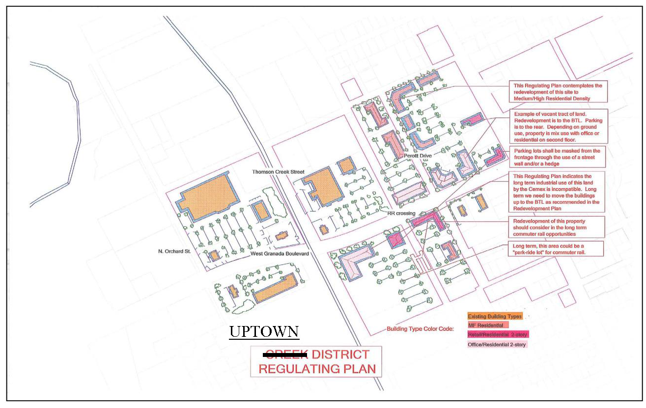
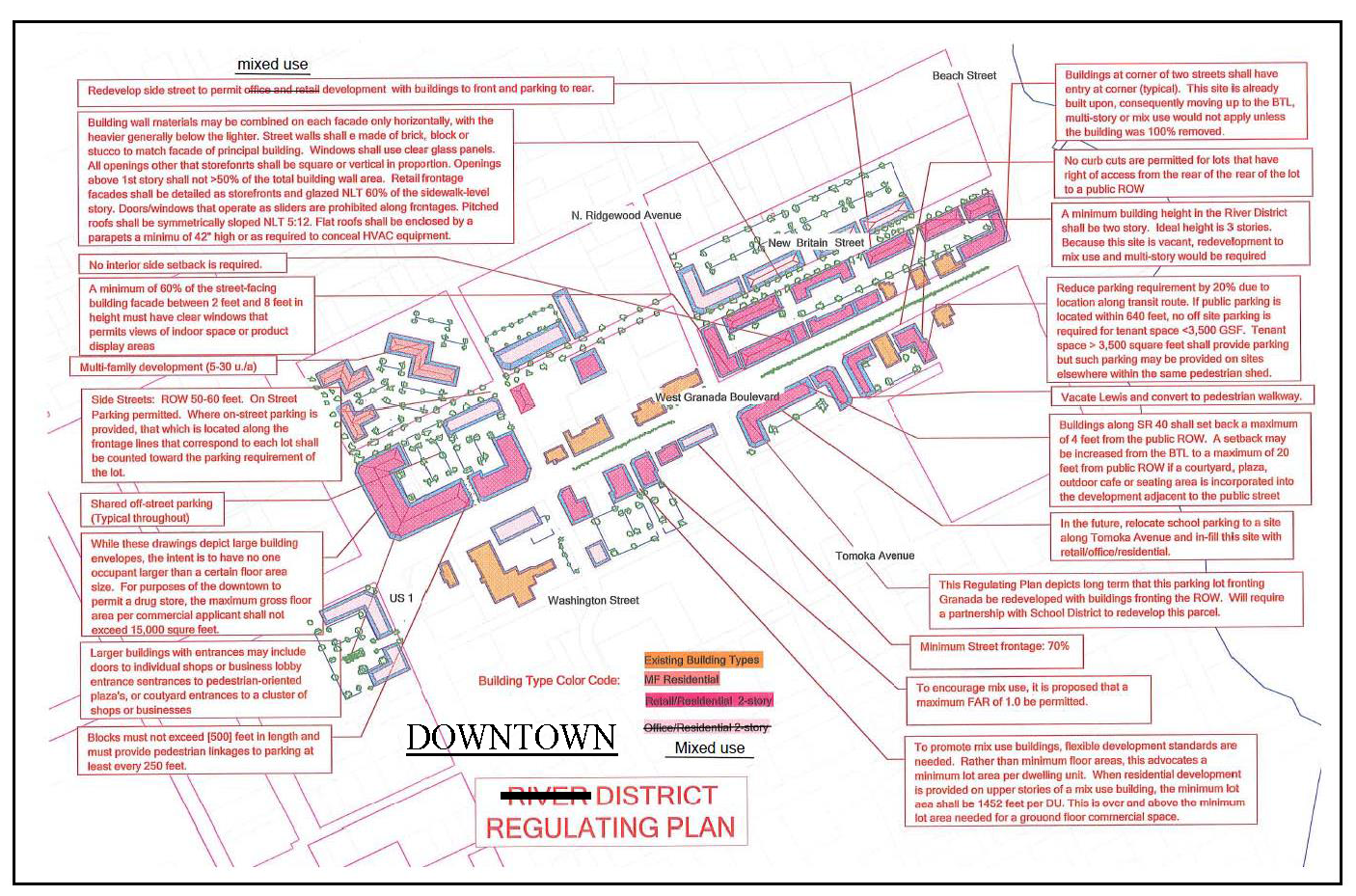
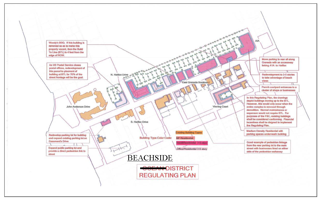
Regulating plan (see regulating plans). The DOD districts consist of regulating plans depicting preferred concepts that reflect the existing and desired building placements articulated for the Uptown, Downtown and Beachside Districts within the downtown redevelopment master plan. The three (3) districts served by transit are the:

(1)
Uptown District. This subdistrict is primarily intended to enhance the existing suburban style development pattern. Uptown acts as the main entry to Ormond Beach. This area is heavily vehicle dominated and house most of the district's major regional retailers. Through enhanced streetscaping, which includes native plants and shade trees, and enhanced painted bike lanes the space can begin to serve pedestrians and multimodal transportation. Long-term, redevelopment of the cement mixing plant to a use that could benefit commuter rail or local transit would be highly desirable;
(2)
Downtown District. This district has a traditional downtown appearance which should be supported and enhanced with similar form and function. The district regulations support the function of the town center's core role as a hub of city importance for business, communications, office, government, retail, culture, education, visitor accommodations and entertainment. The regulations contained herein for this district support a mix of office commercial, public, recreation and entertainment uses. The Downtown District also accommodates mixed use and medium and high density residential projects along the parallel side street system to Granada Boulevard. The side street system and adjacent areas are primarily intended to accommodate medium to high density residential development and small scale ground floor commercial uses with residential units above. This area also accommodates low-intensity office development compatible with the established residential character as well as to adjacent residentially zoned districts. The side street area is considered to be all of the parcels fronting New Britain Avenue from North Beach Street to U.S. 1 and those properties fronting north and south oriented streets. Providing a more pedestrian friendly environment and creating enhanced connectivity could enhance this area; and
(3)
Beachside District. This area is uniquely situated to take advantage of both the Halifax River and the Atlantic Ocean. More intensive infill housing south of Granada Boulevard as well as mixed use development along Granada Boulevard and the side street system incorporating a housing component is needed. . This district encompasses many of the historic assets in Ormond holding the potential to act as "Museum Row".
(c)
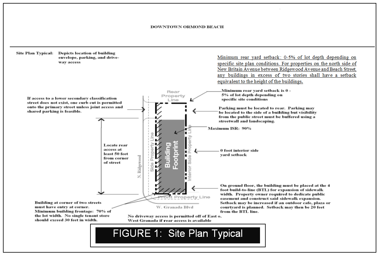
Building envelope layout. (See figure 1, site plan typical.)
(1)
Street frontage: minimum seventy percent (70%).
(2)
Minimum interior side property line setback: zero feet.
(3)
Building frontage in figure 1 should not be construed as preventing the interconnection of on-premises sidewalks, courtyards or outdoor cafes from rear parking lots and secondary streets to the primary frontage street.
(4)
Minimum rear yard setback: zero to five percent (0% to 5%) of lot depth depending on specific site plan conditions. For properties on the north side of New Britain Avenue between Ridgewood Avenue and Beach Street, any building in excess of two stories shall have a setback equivalent to the height of the building.
(5)
Front setback.
a.
Granada Boulevard: four feet (4');
b.
Side streets: five feet (5').
(6)
The following exceptions of the build-to-line (BTL) for front and street side building setbacks apply:
a.
Buildings may be set back from the BTL to provide an articulated facade or accommodate an entrance feature provided the created space does not exceed one (1) square foot for every linear foot of building frontage; or
b.
Buildings may be set back in order to accommodate an outdoor eating area or cafe.
(7)
In order to preserve the continuity of the street wall, no building may be set back more than twenty feet (20') from the BTL regardless of the exceptions provided in subsection (c)(6) of this section.
(8)
Floor area ratio, to encourage mixed use buildings, a FAR of 2.0 shall be permitted for properties in the CRA with a "General Commercial" land use designation.
(9)
Lot area per unit (density). The minimum lot area per dwelling unit shall be one thousand, five hundred (1,500) square feet for mixed use buildings located on the side street system and Granada Boulevard, respectively. (See the downtown design guidelines for an example of how this can be accommodated on a site.) All other buildings shall be subject to the minimum square footage by bedroom in the respective zoning district.
(10)
Landscaped buffers shall not be required for any portion of street frontage. Landscaped buffers and landscaping shall be required to buffer and screen parking lots in accordance with sections 3-05 and 3-06. Any development of property along the north side of New Britain Avenue between Ridgewood Avenue and Beach Street where the proposed building exceeds two (2) stories shall provide a landscape buffer along the rear property line having a minimum width of at least ten feet (10') and a decorative screening wall at least six feet (6') in height.
(11)
Maximum impervious surface: ninety percent (90%).
(d)
Height requirements. (See figure 2, building cross section typical.)
(1)
Building height. Height is measured in stories.
(2)
Table 1 depicts the heights by physical location and the district in which a building is located.
(3)
Redevelopment along that portion of New Britain Avenue adjacent to the Lincoln Avenue Historic District shall not exceed three stories. Redevelopment exceeding three (3) stories in building height, not to exceed five (5) stories in building height, may be permitted with a rezoning to Planned Business Development.
(4)
Floor-to-floor heights and floor area of ground-floor space. All commercial floor space provided on the ground floor of a mixed use building must have a minimum floor-to-ceiling height of eleven feet (11'). All nonresidential floor space provided on the ground floor of a mixed use building must contain at least eight hundred (800) square feet or twenty-five percent (25%) of the lot area, whichever is greater, on lots with street frontage of less than fifty feet (50') or at least twenty percent (20%) of the lot area on lots with fifty feet (50') of street frontage or more.
(5)
Floor heights. Allowable ground floor height is a minimum of eleven feet (11') as measured floor to floor. Upper floor minimums shall be nine feet (9'), maximum eleven feet (11'), as measured floor to floor.
Table 1. Height by Location
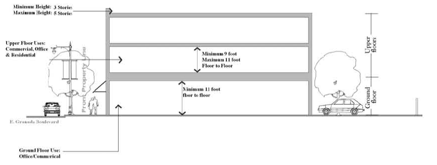
Figure 2. 3-5 Story Building X Section Typical
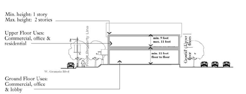
Figure 2. 2-Story Building X Section Typical
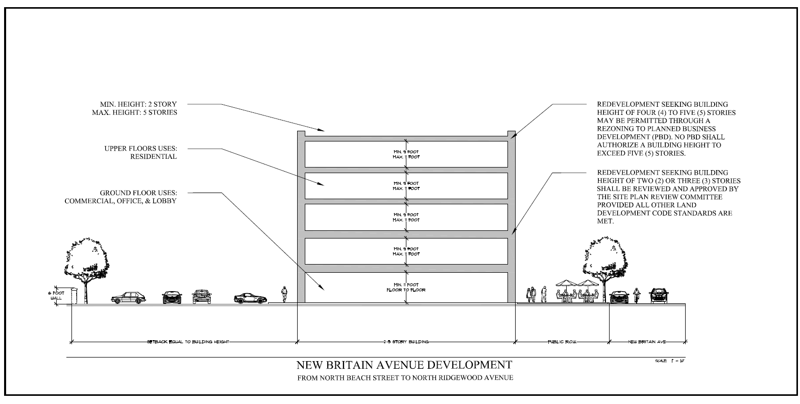
Figure 2. New Britain Avenue Development from North Beach Street to North Ridgewood Avenue
(e)
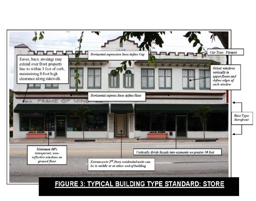
Facade requirements. (See figure 3, building type standard: store.)
(1)
Window transparency. A minimum of sixty percent (60%) of the street-facing building facade between two feet (2') and eight feet (8') in height must comprise clear windows that allow views of indoor nonresidential space or product display areas. Windows shall use clear glass panels.
(2)
Building entrance. Buildings located at the corner of two (2) intersecting streets shall have the building entry located at the corner. Building entrances may include doors to individual shops or businesses, entrances to pedestrian-oriented plazas, or courtyard entrances to a cluster of shops or businesses.
(3)
Facade elements. There is not a specific design style advocated by this Land Development Code. However, all of the following elements should exist regardless of style:
a.
A recognizable storefront base exists. Doors/windows that operate as sliders are prohibited along frontages;
b.
Horizontal expression lines exist to define the cap and base of the building;
c.
Pitched roofs shall be symmetrically sloped not less than (NLT) five to twelve (5:12). Parapet is an allowable cap type, but it must be a minimum of forty-two inches (42") high or as required to screen all HVAC equipment from view on the principal street;
d.
Upper story windows must be oriented vertically and window edges must be defined. All openings other than storefronts shall be square or vertical in proportion. Openings above the first story shall not be greater than fifty percent (50%) of the total building wall area;
e.
The building shall not exceed a three to one (3:1) horizontal to vertical ratio;
f.
The facade shall be vertically divided into segments no larger than thirty feet (30'); and
g.
Building wall materials may be combined on each facade only horizontally, with the heavier generally below the lighter. Street walls shall be made of brick, block or stucco to match facade of principal building.
(4)
Downtown design guidelines incorporated by reference. The downtown design guidelines are incorporated herein for more detailed guidance on specific design elements such as proportion, wall and window pattern, materials, doors, ornamentation, color and skyline articulation.
(f)
Access and parking requirements.
(1)
Access.
a.
Location. On-site surface parking lots are permitted only to the rear of a lot, fully screened from the front property line by a building. Parking may be placed on the side of a building but a street wall with landscaping at the base of the wall must be provided. The street wall must be designed to screen the view of vehicles from the principal street. A three-foot (3') street wall must be designed with the same building materials as the principal building;
b.
Driveways as a general rule shall not be permitted on Granada Boulevard. Access shall be taken from a lower classification street if available; and
c.
Driveway access from a secondary access street must be located at least fifty feet (50') from the front property line on Granada Boulevard.
(2)
Parking.
a.
There shall be provided on the same site with any use, off-street parking spaces for automobiles and bicycles in accordance with the requirements of section 3-26. In all cases where bicycle parking is provided, such parking shall not be more inconveniently located than car parking and attempts should be made to have bicycle parking more convenient;
b.
Off-street parking requirements shall not be considered as providing required off-street parking facilities for any other use except as provided for when shared parking is proposed;
c.
Parking requirements for uses within the DOD districts shall vary according to the size of development, the location of public parking and transit availability. Where parking is required, parking may be provided through the use of shared parking, off-site valet or remote parking, a parking reduction study, a payment in lieu of on-site parking, on-site parking or a combination of these approaches. It is not the intent of this provision to limit the alternative parking approaches to those identified in this section. Other alternative approaches which have been used successfully in other downtown areas similar to the city which are rational and based upon applied science may be considered;
d.
Due to transit availability, and the existence of on-street parking and public parking lots in the Downtown District, the first two thousand (2,000) square feet of floor area for any building within the Downtown District shall be exempt from the minimum parking requirements as calculated in section 3-26;
e.
In all other districts (Uptown and Beachside) such parking may be reduced by twenty-five percent (25%) due to transit availability;
f.
Where parking is required due to the size of the development or type of use, parking may be provided on-site or off-site through valet or remote parking or through shared parking where the city acts as the broker, coordinator and approving authority for the shared parking; and
g.
When parking is provided as a principal or accessory use on-site, parking may remain on a semi-improved surface, such as shale or stone until a master stormwater conceptual permit is approved and implemented for the downtown. This option is at the sole discretion of the city and should not be construed as an entitlement by an individual property owner. Once improvements within the subbasis area where the unimproved parking lot is located, the property shall be constructed and landscaped in accordance with sections 3-28 and 3-05, respectively.
(3)
Alterative parking options to on-site parking provisions.
a.
Valet or remote parking. Upon application to the city, a business may utilize off-site valet parking or provide remote parking to meet the parking requirements. Valet or remote parking need not be located on the same side of the street of the use to be serviced by such parking. If valet parking is to be used, the applicant must provide the location and number of the valet parking spaces, or the location and size of the valet parking zone being requested; the location of the off-street parking area the valet parking operation intends to use for the storing of the vehicles, and a signed contract or agreement showing that the valet parking has acquired the legal right to store the vehicles; and proof of insurance as required by the city;
b.
Payment in lieu of parking. An applicant may elect to make a payment in lieu of parking to the city. Such payment shall be based upon the current construction cost of one (1) surface parking space times the number of parking spaces. Payments shall be deposited to the city tax increment financing account for construction of parking based on demand;
c.
Parking study reduction. A study prepared by a qualified transportation firm or individual may be used to support reduction of parking based upon the known characteristics of the use. It shall be at the city's discretion to accept all, a portion, or none of the parking supported by the study; and
d.
Shared parking. Shared parking may be used, if feasible, to satisfy all or a portion of the minimum off-street parking requirements. Shared parking is permitted between different categories of uses or uses with different hours of operation provided the city acts as the broker, coordinator, and approving authority for the banking of parking arrangement. The planning director may authorize upon application, the allocation, transfer and the use of public parking spaces and private spaces to another land use to serve as the required off-street parking, based upon the percentage of required parking which is anticipated to be available by general use and time of day, as indicated in the following table 2:
TABLE 2. PERCENTAGE OF AVAILABLE PARKING
PERMITTED TO BE SHARED
e.
Shared use parking example. Assume a parcel in the downtown is to have a five thousand (5,000) square foot retail building constructed upon it. This LDC requires twenty-five (25) spaces; however, only twelve (12) spaces can be accommodated on-site. A twenty percent (20%) reduction is permitted because a transit route exists, reducing the required parking to twenty (20) spaces. Based upon table 2, the applicant for the retail establishment would be permitted to share one hundred percent (100%), or twelve (12) spaces, from 12:00 midnight to 7:00 a.m.; no spaces from 7:00 a.m. to 6:00 p.m.; and fifty percent (50%), or six (6) spaces, from 6:00 p.m. to 12:00 midnight. In return for the city's permitting eight (8) spaces from a city-owned fifty (50) space parking lot located within six hundred sixty feet (660') of the use in order for the applicant to meet his parking requirement of twenty (20) spaces during the period of time the most number of parking is needed (7:00 a.m. to 6:00 p.m.), the applicant would be required to permit the use of all twelve (12) parking spaces for the public from 12:00 midnight to 7:00 a.m. and six (6) spaces from 6:00 p.m. to 12:00 midnight. The use of this parking by the public would be establishments which require parking at different hours than the retail use. In this example, the city has leveraged its fifty (50) space parking lot by increasing the number of spaces available in the early morning to sixty-two (62) spaces, forty-two (42) parking spaces during the day, and fifty-six (56) spaces at night. The increased parking made available between 12:00 midnight to 7:00 a.m. supports increased residential densities in the downtown, while providing nighttime uses, such as restaurants, with a supply of parking required between 6:00 p.m. and 12:00 midnight. A public parking easement would be required from the owner of the five thousand (5,000) square-foot retail building, but the easement would only be effective for as long as the shared parking arrangement continued. This easement could be terminated by the owner upon notice to the city; however, the owner will still be required to provide the required parking to meet his day time need. In this example, the city is the banker, broker, coordinator and approving authority for the shared parking arrangement.
(g)
Public space standards.
(1)
Streets within the city's downtown, regardless of jurisdiction, should be inviting public space and integral components of community design. The state and local street network provides for bicycle, pedestrian, and transit accessibility. All side streets parallel to and connecting to Granada Boulevard should continue to connect and not be vacated except for Lewis Street, which should be vacated as a pedestrian connection. These local connections help create a network of public areas to allow free movement of automobiles, bicyclists and pedestrians. In order for this street network to be safe for motorists and pedestrians, all design elements must consistently be applied to calm automobile traffic. Designs should permit comfortable use of the street by motorists, pedestrians, and bicyclists. Pavement widths, design speeds and the number of motor travel lanes should be minimized to enhance safety for motorists and nonmotorists alike. The specific design of any given street must consider the building types which have frontage and the relationship of the street to the overall street network. All new or renovated transportation infrastructure in the city's downtown CRA should achieve safety, comfort and convenience for all modes of travel, including pedestrians, bicyclists and transit riders, in addition to automobile traffic. The following is a checklist of elements that should be incorporated into all new developments or transportation projects in the city's downtown.
a.
Provide sidewalk easements to expand the existing width of the current sidewalk on Granada Boulevard to eleven feet (11'), thus providing pedestrian safety as well as landscaping opportunities.
b.
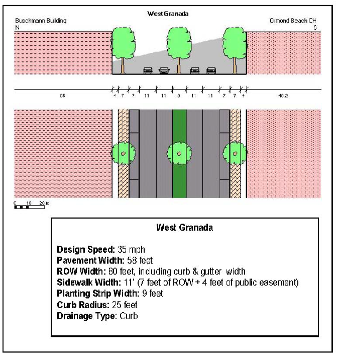
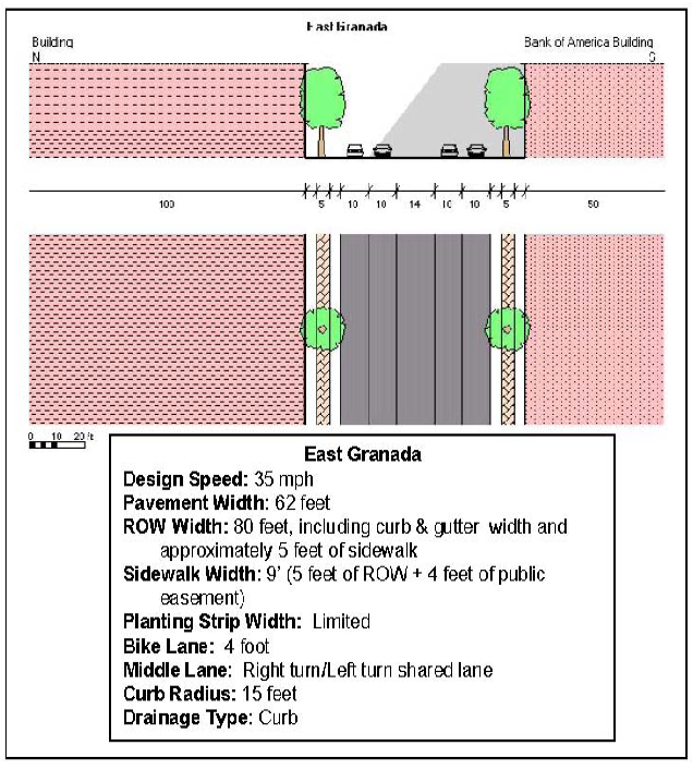
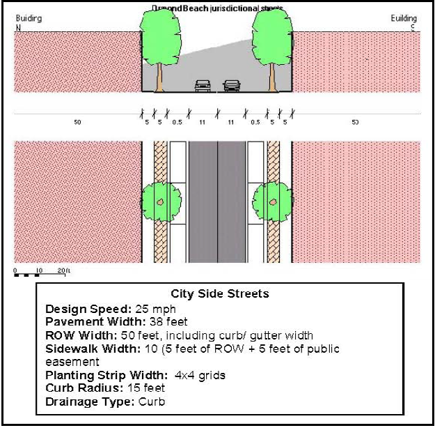
Provide sufficient rights-of-way (fifty-foot (50') width) on all other side streets to ensure required sidewalk width (five feet (5') wide, both sides); on-street parking (eight and one-half feet (8½') wide, both sides), two (2) eleven-foot (11') wide through lanes; and two and one-half-foot (2½') curb and gutter on both sides is accommodated. The additional five-foot (5') setback shall be used to widen the sidewalk through dedication of a public easement.
c.
Include bicycle facilities on local access roadways and retrofit existing roadways with major reconstruction projects where feasible and without loss of on-street parking.
d.
In lieu of concurrency, all new development and redevelopment shall contribute in the form of a fee to be used towards multimodal improvements such as pedestrian sidewalks, bicycle trails and enhancements, and facility/operational improvements along the transit corridors.
e.
Provide full accessibility to all, including kids, seniors and people with disabilities.
(h)
Additional permitted uses. In addition to the permitted, conditional, special exception and accessory uses provided for within section 2-25 for the B-4, Central Business Zoning District, live/work units and residential units above nonresidential ground floor uses are permitted by right.
(i)
Prohibited uses within the Downtown Overlay District. Prohibited uses include: noncamouflaged telecommunication towers, new or used car lots, outdoor storage, and type B and C convenience stores. The current uses located within the Downtown Overlay District which are considered prohibited may remain and re-establish through redevelopment; however, no such new use shall be permitted by right or through a PBD process. Where building use types are depicted on the regulating plan but are not permitted by the underlying land use and zoning, a land use and zoning change shall be required.
(j)
Incentives.
(1)
To support development and redevelopment in the DOD district, the planning director or designee may approve administrative relief of up to twenty percent (20%) to any dimensional requirement, yard or setback standard. In addition, development or redevelopment of uses which further the regulating plans, lot layout and building design standards of this section shall be eligible for financial incentives for property improvement. Use or dimensional nonconformities may be permitted to expand provided the nonconforming conditions are improved and such expansions are consistent with this section.
(2)
Stormwater treatment on parcels involving lot coverage of less than five thousand (5,000) square feet of floor area and less than four thousand (4,000) square feet of impervious road surface, for a total of nine thousand (9,000) square feet, shall not be required if the overall lot coverage is being reduced as a result of redevelopment. For parcels which have lot coverage of less than five thousand (5,000) square feet of floor area and less than four thousand (4,000) square feet of impervious road surface and redevelopment will increase the lot coverage but the floor area and impervious road surface is less than the nine thousand (9,000) square feet of lot coverage, only the additional lot coverage shall require treatment. Financial incentives may be permitted to offset infiltration techniques, such as "filterra boxes" to treat the additional lot coverage.
(k)
Signs. Permitted signs are subject to the requirements contained in chapter 3, article IV of this Land Development Code.
(l)
Administration. All current uses, buildings and lot layouts as of the date the ordinance from which this section is derived are considered conforming regardless of the illustrations depicted in the regulating plan and the text contained herein. Subsections (b) through (j) of this section applies to all new development on vacant parcels or parcels which will have current building improvements removed for redevelopment. A change of use as defined by section 2-64(b), building expansions and other improvements regardless of valuation or a use vacant for greater than six (6) months shall comply with the design guidelines only from subsections (e), (f), (h) and (j) of this section. Compliance with the design guidelines shall make the property eligible for financial assistance. Where the presence or absence of a provision exists in the DOD districts that thwart the implementation of the redevelopment plan, the planning director or designee is authorized to implement a different standard or provision provided the purposes of DOD districts are furthered by the alternative standard or provision. Where planning development is of such a type and nature that the internal and external operations has been demonstrated that the mixed use and upper story construction is inappropriate, relief from these requirements may be granted administratively by the planning director or designee. The granting of relief shall be at the sole discretion of the city and shall not be considered a right by the applicant for development. All development and redevelopment shall be administratively approved through the SPRC committee.
(m)
Redevelopment Plan: Where a project within a non-residential zoning district in the Downtown Overlay District cannot meet the standards of this section or the Land Development Code based on prevalence of nonconforming lots or at an applicant's option, these requirements may be waived through a city commission monitored process as a Special Exception or Planned Development aimed at producing development having design compatibility, meeting required parking to the maximum extent feasible, and achieving a high level of aesthetic appeal through a combination of innovative architecture, landscaping and hardscape materials. The Redevelopment Plan shall demonstrate compliance with the 2019 Downtown Master Plan update.
(n)
Design guidelines. The downtown overlay design guidelines are hereby adopted by reference and shall be utilized in determining both compliance with this Land Development Code section as well as evaluating development proposals for eligibility under any financial incentive program offered by the community redevelopment agency.
(Ord. No. 2017-02, §§ 1, 2, 2-7-2017; Ord. No. 2021-27, § 1, 8-17-2021)
Sec. 2-71. - Historic districts and landmarks.
(a)
Purpose. The purpose of this section is to protect, enhance and perpetuate the existence and use of those grouped and individual archaeological sites and structures of local, state or national historical significance; to stabilize and improve property values near such sites and structures; to protect the city's cultural, archaeological, and social heritage; to foster civic pride in the beauty and accomplishments of the past; to foster social stability; to protect and enhance the city's attractiveness to potential residents and visitors; to strengthen the economy of the city; and to promote the use of the historic preservation process for the education, health and welfare of the people of the city.
(b)
Applicability.
(1)
Except as otherwise provided herein, this section shall apply to those properties approved by ordinance by the city commission as local historic landmarks and any historic districts established by ordinance by the city commission.
(2)
Anything contained in this section to the contrary notwithstanding, no owner of any contributing property located within a designated historic district shall be required to obtain a certificate of appropriateness prior to engaging in any activity with respect to such property until the written request, by all of the owners of the property, to the board to subject the property to all of the applicable regulations of this section.
(3)
An historic district, historic landmark or landmark/archaeological site designation may be placed on any site, natural or improved, including any building, improvement or structure located thereon, or any area of particular historic, architectural or cultural significance to the city, such as historic structures or sites which:
a.
Exemplify or reflect the broad cultural, political, economic or social history of the nation, state or community.
b.
Are identified with historic personages or with important events in national, state or local history.
c.
Embody the distinguishing characteristics of an architectural type specimen, inherently valuable for a study of a period, style, method of construction or of indigenous materials or craftsmanship.
(c)
Designation procedures.
(1)
Historic landmarks and archaeological sites. The designation of an historic landmark, archaeological site, or other such notable feature shall be done by ordinance adopted by the city commission in accordance with the following procedures:
a.
The applicant shall submit a written request, at no cost to the applicant, to the planning department and shall provide studies, documentation, or other evidence regarding the historic significance of the proposed landmark, site or feature. If the applicant is someone other than the property owner, the applicant shall send by regular mail, a copy of the written request, a letter indicating his intention to pursue the historic landmark designation from the city commission, and a copy of all studies, documentation, or other evidence to the property owner demonstrating the historical or archeological significance of the site.
b.
If the applicant is someone other than the property owner, the planning director shall wait fourteen (14) days from the date that notification was sent by regular mail to receive a response from the property owner regarding the written request for a landmark designation. After the fourteen-day (14) period has expired, the planning director shall proceed with city review of the request as set forth herein.
c.
Any initiation of local landmark designation by anyone other than the property owner must be reviewed by the city commission before an application is processed, unless the property owner has no objection to such designation. If the written request is from someone other than the property owner, the planning director shall send by regular mail, notification of the necessary public hearings to the property owner of the proposed landmark, archaeological site, or other such notable feature. Said notification shall be postmarked at least ten (10) days prior to the public hearing. The planning director or designees will prepare a proposed ordinance and schedule public hearings with the Historic Landmark Preservation Board (HLPB) and the city commission to consider the request for an historic landmark designation.
d.
If the property owner submits a request for an historic landmark designation, the planning director shall prepare a proposed ordinance and schedule the necessary public hearings before the Historic Landmark Preservation Board, the planning board and the city commission.
e.
After an initial public hearing, the Historic Landmark Preservation Board shall submit the minutes of the public hearing, the recommendations of the planning department, and a report with its recommendations to the planning board.
f.
After the planning board public hearing, the planning board shall submit the minutes of the public hearing, the recommendations of the planning board, and a final report with its recommendations to the city commission.
g.
The city commission shall, upon receipt of the meeting minutes and recommendations of the planning board, consider an appropriate ordinance adding the proposed property to the local list of historic landmarks, archaeological sites or other such notable features.
h.
The city commission may adopt the ordinance with or without amendments following the necessary public hearings after written notice of the time and place of the hearing has been furnished to the owner of the property proposed to be established as an historic site or landmark, archaeological site or other such notable feature.
i.
Any request to remove an historic landmark from the city's historic landmark list shall follow similar procedures as a request to place a landmark on said list.
(2)
Historic districts. The designation of historic districts shall be consistent with the comprehensive plan and shall be done by ordinance adopted by the city commission in accordance with the following procedure:
a.
The process for the designation of an historic district may be initiated by any property owner) within the proposed district, by the Historic Landmark Preservation Board (hereafter board) or any member thereof, or by the planning director.
b.
The applicants shall submit a written application to the board, through the planning director, which application shall provide at least the following information:
1.
A physical description of the proposed district, accompanied by photographs of buildings, structures, objects or sites which are typical examples of contributing and noncontributing properties within the proposed district.
2.
A description of typical architectural styles, character-defining features and types of buildings, structures, objects or sites within the proposed district.
3.
A map identifying all zoning, appropriate land use information, buildings, structures, objects and sites within the proposed district, with each building or structure in the proposed district being identified on the map as either a contributing or noncontributing property, as such terms are defined in this section.
4.
A statement of the historical, cultural, architectural, archaeological or other significance of the district as defined by subsection (b) of this section.
5.
A statement of incentives requested, if any, and any additional guidelines which should be used in authorizing any alteration, demolition, relocation, excavation or new construction within the boundaries of the district.
6.
Names and addresses of all owners of property in the proposed district.
7.
Any other appropriate information requested by the board.
c.
Upon receipt of a complete application, the board shall schedule a public hearing on the application. Written notice of the time, date and place of such public hearing shall be sent at least ten (10) days prior to the hearing to all owners of record, as determined by the records in the tax assessor's office on the date the application is deemed complete, of property within the proposed district. The written notice to owners of property within the proposed district shall be by first class mail. In addition, a legal notice setting forth the nature of the hearing, the property involved, and the time, date and place of the scheduled public hearing, shall be published once in a newspaper of general circulation in the city at least ten (10) days prior to the hearing.
d.
After conducting the public hearing, the board shall submit the application, the minutes of the public hearing, the recommendations of the planning department, and a final report with the board's recommendations, to the city commission.
e.
The city commission shall, upon receipt of the referenced items and after providing notice in the manner set forth in subsection (c)(2)c of this section, conduct a public hearing and consider an ordinance creating the district and designating each property included therein as either a contributing or a noncontributing property.
f.
Subsequent to the adoption of the ordinance creating the district and making the said designation, any property owner who desires to have the designation on the property owned by such person changed, such owner may apply to the board for a hearing, at which hearing such owner shall present evidence and testimony in support of the application.
g.
The applying owner shall be required to provide at least thirty (30) days' notice by regular mail to each abutting owner of the time, date, place and purpose of the hearing and shall provide proof of such notice to the board secretary prior to the hearing.
h.
Upon conclusion of the hearing, the board shall determine whether or not to recommend approval of the application and, if for approval, shall forward its recommendation to the city commission.
i.
If the board's recommendation is for no change in the designation, the owner may appeal such recommendation to the city commission within thirty (30) days of the board's decision by filing such appeal with the city clerk. If the board's recommendation is to grant the requested change, the city commission shall consider the necessary ordinance amendment at its first available meeting following the board's decision.
j.
Prior to hearing any appeal or finally adopting any ordinance, the city commission shall provide each property owner within the proposed historic district as well as each property owner adjacent to the proposed district with at least ten (10) days' notice by regular mail, of the time, date and place of the meeting at which such appeal shall be heard or such final adoption shall occur. The property owner requesting the change in designation shall bear the cost of such notice.
(d)
Certificates of appropriateness. The purpose of a certificate of appropriateness is to ensure that all construction, alteration, restoration, relocation or demolition of an historic landmark or of structures in an Historic Overlay District is in accordance with standards, values and characteristics of the particular district or landmark. This is in order to protect and preserve the historic resources of the city.
(1)
A certificate of appropriateness, issued by the board, shall be required for any repairs, reconstruction, rehabilitation, alteration, addition or other improvements that would alter the exterior appearance of a structure or site on property which is included in the local list of historic landmarks or within a designated historic, district unless identified below as subject to the approval of the planning director.
a.
The following improvements and maintenance activities shall be approved by the planning director without a certificate of appropriateness when an applicant complies with the applicable historic design regulations:
1.
Repair, replace or install the following:
(i)
Canvas awnings and canopies;
(ii)
Signs;
(iii)
New windows and doors with ones compatible in size and style with original architecture;
(iv)
Mechanical systems including heat and cooling equipment not visible from the right-of-way and irrigation systems;
(v)
Foundation skirting;
(vi)
Exterior lighting; and
(vii)
Landscaping.
2.
Repair or replace the following:
(i)
Cornices, garage doors and front porch columns using same or like materials and duplicating the original design or style and size;
(ii)
Decks with same or like material which do not require alterations to any structure;
(iii)
Gates, fences, driveways, walkways or steps with same or like materials;
(iv)
Roofs with one (1) of similar material or color or material or color appropriate to the time period the structure was constructed;
(v)
Pools and pool enclosures;
(vi)
Siding which duplicates the original appearance; and
(vii)
Skylights.
3.
Install the following:
(i)
New fencing located behind any street facade;
(ii)
Skylights not visible from the right-of-way;
(iii)
Pool and pool enclosures not visible from the right-of-way.
4.
Repair, replace or construct at ground level only deck or patio in the rear yard and docks and associated dock structures;
5.
Remove trees and other landscaping;
6.
Construct small accessory structures under one hundred fifty (150) square feet, such as playground equipment or sheds in the rear yard, not visible from the right-of-way; and
7.
Any other request determined by the planning director to have a minor impact or no potential detriment on the historic structure or district. If the planning director determines that there would be a major impact or potential detriment as a result of the proposed action, a certificate of appropriateness shall be required.
b.
The demolition of any individually designated building or structure or of any contributing property in a designated historic district.
c.
The relocation of any building or structure onto an individually designated site; the relocation of any individually designated building or structure to another site; and the relocation of any building or structure into or out of any designated historic district.
d.
The construction or erection of any principal or accessory building or structure in any designated historic district.
(2)
A certificate of appropriateness, issued by the board, shall only be required for the demolition of any building or structure that was constructed prior to January 1, 1950, if determined by the planning director that the structure meets one (1) or more of the following criteria:
a.
The historic by age building or structure contributes to the overall historic architectural qualities, historic associations or values of an historic district because it was present during the period of historic significance and possesses historic integrity through location, design, setting, materials or workmanship; or, it has yielded or capable of yielding important information about the period of historic significance;
b.
The historic by age building or structure is architecturally significant such that it falls within an architectural style where there exist few buildings or structures of that style within the city. Rare examples of architecturally distinctive styles in the city include, but are not limited to, Mediterranean Revival, Craftsman Bungalow, Queen Anne, Eastlake, Dutch Colonial Revival and Art Moderne.
(3)
Maintenance. Nothing in this section shall be construed to prevent the ordinary maintenance or repair of any exterior feature of any site which does not involve a change in design, material or outer appearance thereof.
(4)
Unsafe structures. Nothing in this section shall prevent the construction, reconstruction, alteration, restoration or demolition of any such feature which the chief building official or designee, shall certify is required because of an unsafe or dangerous condition. Upon the chief building official's certification, in accordance with the unsafe building abatement ordinance, a certificate of appropriateness shall not be required.
(5)
A certificate of appropriateness shall be a condition precedent to the issuance of any other required permits; the issuance of a certificate of appropriateness shall not relieve the applicant of the need to obtain other permits or approvals required by the city.
(6)
Within ten (10) working days of the receipt of any permit application which is determined to require a certificate of appropriateness as a condition precedent, the planning director shall refer such application to the board for review and decision.
(7)
The board shall conduct a public hearing on the application at least twenty-one (21) days following the date of the planning director's referral to the board. Notice of such hearing shall be duly publicized in accordance with the provisions of F.S. § 286.011 and provided by hand delivery or regular mail to the owner of the property in question at least ten (10) days prior to the date of the public hearing.
(8)
In considering a request for a certificate of appropriateness, the board shall give due consideration to the following criteria:
a.
The decision on all certificates of appropriateness, except those for demolition, shall be guided by the Secretary of the Interior's General Standards for Preservation Projects and Specific Standards for Rehabilitation stated as follows:
1.
Every reasonable effort shall be made to provide a compatible use for a property which requires minimal alteration of the building, structure, or site and its environment, or to use a property for its originally intended purpose.
2.
The distinguishing original qualities or character of a building, structure or site and its environment shall not be destroyed. The removal or alteration of any historic material or distinctive architectural features shall be avoided when possible.
3.
All buildings, structures and sites shall be recognized as products of their own time. Alterations that have no historical basis and which seek to create an earlier appearance shall be discouraged.
4.
Changes which may have taken place in the course of time are evidence of the history and development of a building, structure or site and its environment. These changes may have acquired significance in their own right, and this significance shall be recognized and respected.
5.
Distinctive stylistic features or examples of skilled craftsmanship which characterize a building, structure or site shall be treated with sensitivity.
6.
Deteriorated architectural features shall be repaired rather than replaced, wherever possible. In the event replacement is necessary, the new material shall match the material being replaced in composition, design, color, texture and other visual qualities.
7.
Repair or replacement of missing architectural features should be based on accurate duplication of features, substantiated by historic, physical or pictorial evidence rather than on conjectural designs or the availability of different architectural elements from other buildings or structures.
8.
The surface cleaning of structures shall be undertaken with the gentlest means possible. Sandblasting and other cleaning methods that will damage the historic building materials shall not be undertaken.
9.
Every reasonable effort shall be made to protect and preserve archeological resources affected by, or adjacent to, any acquisition, protection, stabilization, preservation, demolition, rehabilitation, restoration or reconstruction project.
10.
Contemporary design for alterations and additions to existing properties shall not be discouraged when such alterations and additions do not destroy significant historical, architectural or cultural material, and such design is compatible with the size, scale, color, material and character of the property, neighborhood or environment.
11.
Wherever possible, new additions or alteration to structures shall be done in such a manner that if such additions or alterations were to be removed in the future, the essential form and integrity of the structure would be unimpaired.
b.
In approving or denying an application of appropriateness for new construction, the board shall require the following features of the proposed building to be visually compatible with the existing contributing structures in a designated historic district:
1.
Height.
2.
Scale.
3.
Massing.
4.
Setbacks.
5.
Fenestration.
6.
Roof shape.
7.
Use of materials.
8.
Directional expression.
9.
Style.
10.
Site plan.
c.
In addition to the guidelines provided in subsection (d)(8)a of this section, issuance of certificates of appropriateness for relocations shall be guided by the following factors:
1.
The historic character and aesthetic interest the building, structure or object contributes to its present setting.
2.
Whether there are definite plans for the area to be vacated and the effect of those plans on the character of the surrounding area.
3.
Whether the building, structure or object can be moved without significant damage to its physical integrity.
4.
Whether the proposed relocation area is compatible with the historical and architectural character of the building, structure or object.
d.
Issuance of certificates of appropriateness for demolitions shall be guided by the following factors:
1.
The historic or architectural significance of the building, structure, or object.
2.
The importance of the building, structure or object to the ambiance of a district.
3.
The difficulty or the impossibility of reproducing such a building, structure or object because of its design, texture, material, detail or unique location.
4.
Whether the building, structure, or object is one (1) of the last remaining examples of its kind in the neighborhood, the county or the region.
5.
Whether there are definite plans for reuse of the property if the proposed demolition is carried out, and the effect of those plans on the character of the surrounding area.
6.
Whether reasonable measures can be taken to save the building, structure or object from collapse.
7.
Whether the building, structure or object is capable of earning a reasonable economic return on its value.
(9)
Following the public hearing on the application, the board shall approve; approve with conditions, which may include a delay in permit issuance; or deny the application for a certificate of appropriateness.
a.
Any delay in permit issuance so ordered may be up to thirty (30) days if the building or structure was constructed prior to January 1, 1950, but is not an individually designated historic landmark and is not in a designated historic district, and up to six (6) months if the building or structure is either an individually designated historic landmark or in a designated historic district.
1.
During any delay required by the board pursuant to this section, the board, in conjunction with such city staff personnel as the city manager may direct, shall seek alternatives to the demolition of the structure.
2.
If, within the period of delay, no alternative to demolition has been arrived at which is acceptable to the owner, and after architectural and historic documentation has been prepared by the applicant and submitted to the city, the chief building official shall then issue the demolition permit upon demand, if all other requirements have been met.
b.
If the board determines that the proposed construction, reconstruction, alteration, moving or demolition is appropriate, it shall approve such application.
c.
If the board determines that a certificate of appropriateness should not be issued, it shall place upon the record the reasons for such determination, a suggested method of preserving the structure, historic site or other notable features, and shall immediately notify the applicant of such determination, furnishing him an attested copy of its findings, and its recommendations, if any, as appearing in the records of the board.
d.
The board may approve such application, with or without conditions or delay issuance of the necessary permit, in any case when the owner demonstrates by clear and convincing evidence, that strict enforcement of this section and denial of the owner's application will effectively deny such owner all economically viable use of the property unless the certificate of appropriateness were issued forthwith.
(10)
Copies of the board's decision shall be provided by mail to the applicant and all abutting property owners within ten (10) days of the date of execution of the order setting forth such decision.
(11)
Any applicant, or abutting property owner, aggrieved by a determination of the board shall first appeal such determination to the city commission by filing written notice with the office of the city manager within thirty (30) days of the date of the execution of the order setting forth such decision. The city commission shall affirm, modify or deny the determination of the board. Further appeal by such person shall be by petition for writ of certiorari to the circuit court, which must be filed within thirty (30) days of the date of the decision by the city commission.
(e)
Consistency with Code. In addition to the requirements of this section, any proposed activity shall be consistent with the underlying zoning district and this Land Development Code.
(f)
Demolition by neglect.
(1)
Purpose and intent. It is the intent of this section to preserve from deliberate or inadvertent neglect, the exterior, structural stability and historic and architectural integrity of sites, landmarks and structures identified on the Ormond Beach Historic Landmarks list codified in subsection (k) of this section and those homes identified as contributing properties in the Lincoln Avenue Overlay District codified in subsection (j)(1) of this section. All such sites, landmarks, structures and homes shall be maintained in accordance with minimum maintenance standards, preserved against decay, deterioration and demolition and kept free from structural defects through prompt and corrective action to any physical defect which jeopardizes a site, landmark, structure or home's historic, architectural and structural integrity.
(2)
Definition. The term "demolition by neglect" means any failure to comply with the minimum required maintenance standards of this section, whether deliberate or inadvertent.
(3)
The owner of any site, landmark or structure identified on the Ormond Beach Historic Landmark list codified in subsection (k) of this section and those homes identified as contributing properties in the Lincoln Avenue Overlay District codified in subsection (j)(1) of this section shall be required to properly maintain and preserve such site, landmark, structure or home in accordance with the standards set forth in this section.
a.
Any one (1) of the following shall be considered demolition by neglect:
1.
Deteriorated and decayed facades or facade elements including, but not limited to, facades that are visibly cracked or crumbling;
2.
Deteriorated foundations including, but not limited to, those that have visibly open cracks or those that are crumbling;
3.
Walls or other vertical structural supports, or members of walls, partitions, floors, ceilings, roofs or other vertical and horizontal supports that split, lean, list or buckle due to defective material or deterioration; and
4.
Exterior access points not properly secured; therefore the structure is accessible to the general public;
b.
Any two (2) or more of the following shall be considered demolition by neglect:
1.
Ineffective waterproofing of exterior walls, roof, foundation or floors or any other fault or defect in the property that renders it not properly watertight and significantly weathered including, but not limited to, lack of paint or other protective covering. The use of plywood to cover windows, doors and other openings during and immediately following storm events shall not be construed as a violation of this article;
2.
Cornices, beltcourses, corbels, terracotta trim, wall facings and similar decorative features in an unsafe condition or not properly anchored to structure;
3.
Exterior walls showing holes, cracks and loose or rotting materials;
4.
Foundation walls showing cracks or breaks or not maintained plumb;
5.
Glazing materials showing cracks and holes;
6.
Spalling (flaking, chipping or fragmentation) of the concrete of any portion of the exterior of the building;
7.
Overhang extensions including, but not limited to, canopies, marquees, signs, metal awnings, fire escapes, soffits, standpipes and exhaust ducts in poor repair or not properly anchored to structure; and
8.
Exposed surfaces of metal or wood rusted or decayed due to lack of periodic application of weather-coating materials, such as paint or similar surface treatment.
c.
Any one (1) of the elements in subsection (f)(3)a.1 of this section, combined with any one (1) of the elements in subsection (f)(3)a.2 of this section, shall be considered demolition by neglect.
(g)
Enforcement.
(1)
Wherever any person has engaged in, or is about to engage in, any act or practice which constitutes, or will constitute, a violation of this section, the chief building official may issue a stop work order, or may make application to the circuit court for the county for an order enjoining such act or practice or requiring such person to refrain from such prospective violations or to remedy such violation by restoring the affected property to its previous condition.
(2)
In addition to the remedies in subsection (g)(1) of this section, any person who demolishes, or is responsible for the demolition of, any building or structure which is either constructed prior to January 1, 1950; is listed on any local, state or national list of historic structures, buildings, or places; or is a contributing property in a designated historic district, without a permit, shall be subject to the penalties provided for in section 1-9 of the Code of Ordinances. Upon the board's determination that such demolition has occurred, the chief building official shall immediately initiate the prosecution of all persons in any way responsible therefor and shall seek the maximum penalties allowed by the said section.
(h)
The Secretary of the Interior's Standards for Rehabilitation. The Secretary of the Interior's Standards for Rehabilitation from the U.S. Department of the Interior, National Park Service, shall be followed. The standards described below are to be applied to specific rehabilitation projects in a reasonable manner, taking into consideration economic and technical feasibility:
(1)
A property shall be used for its historic purpose or be placed in a new use that requires minimal change to the defining characteristic of the building and its site and environment.
(2)
The historic character of a property shall be retained and preserved. The removal of historic materials or alteration of features and spaces that characterize a property shall be avoided.
(3)
The property shall be recognized as a physical record of its time, place and use. Changes that create a false sense of historic development, such as adding conjectural features or architectural elements from other buildings, shall not be undertaken.
(4)
Most properties change over time; those changes that have acquired historic significance in their own right shall be retained and preserved.
(5)
Distinctive features, finishes, and construction techniques or examples of craftsmanship that characterize an historic property shall be preserved.
(6)
Deteriorated historic features shall be repaired rather than replaced. Where the severity of deterioration requires replacement of a distinctive feature, the new feature shall match the old in design, color, textures and other visual qualities and, where possible, materials. Replacement of missing features shall be substantiated by documentary, physical or pictorial evidence.
(7)
Chemical or physical treatments, such as sandblasting, that cause damage to historic materials shall not be used. The surface cleaning of structures, if appropriate, shall be undertaken using the gentlest means possible.
(8)
Significant archeological resources affected by a project shall be protected and preserved. If such resources must be disturbed, mitigation measures shall be undertaken.
(9)
New additions, exterior alterations or related new construction shall not destroy historic materials that characterize the property. The new work shall not be differentiated from the old and shall be compatible with the massing, size, scale and architectural features to protect the historic integrity of the property and its environment.
(10)
New additions and adjacent or related new construction shall be undertaken in such a manner that if removed in the future, the essential form and integrity of the historic property and its environment would be unimpaired.
(i)
Standards for review, design guidelines and design criteria. In considering an application for a certificate of appropriateness, the commission shall be guided by design guidelines, which shall pertain to all historic preservation districts and historic landmarks; and, by the design criteria, which shall apply only to the particular historic district or historic landmark for which they are enacted. Said regulations are as follows:
(1)
Chimneys, alteration area.
a.
Existing brick or stone chimneys shall be retained whenever possible.
b.
New materials shall be consistent with the historic materials in size, design, composition and texture.
c.
Building and fire codes shall be met in regard to proper heights and other requirements.
d.
Chimney construction shall be consistent with the architectural style.
(2)
Chimneys, new construction area.
a.
Chimney construction shall be consistent with the architectural style.
b.
New materials shall be compatible with the historic materials of the particular architectural style in size, design and texture.
(3)
Dormers, alteration area.
a.
Dormers shall be constructed of new materials consistent with the historic materials in size, design, composition and texture.
b.
Dormers shall be constructed in the same shape, style and scale as any historic dormer on the building, or in the same shape, style and scale of dormers on houses of the same architectural style.
c.
Dormers are not typical on certain styles of historic architecture and adding them in this case shall not be permitted.
(4)
Dormers, new construction area.
a.
Dormers shall be constructed of a design and scale that is consistent with the architectural style.
b.
Dormers are not typical on certain styles of historic architecture and using dormers on new construction, in such cases, shall not be permitted.
c.
New materials shall be compatible with the historic materials of the particular architectural style in size, design and texture.
(5)
Exits, second- and third-story, alteration area.
a.
Historic second- and third-story exits shall be retained whenever possible.
b.
New material shall be consistent with the historic materials in size, design, composition and texture.
c.
Exit stairs located on the exterior shall be consistent with the architectural styles.
d.
The stairs shall be constructed in the most compact form.
e.
Exit stairs from upper level apartments shall be accommodated inside the existing building whenever possible.
f.
The new construction of exit stairs in the alteration area is prohibited.
(6)
Exits, second- and third-story, new construction area.
a.
Exit stairs in the new construction area shall be accommodated inside the building whenever possible.
b.
Exit stairs for newly constructed buildings shall be accommodated inside the building.
c.
New construction shall be consistent with the architectural style.
d.
New materials shall be compatible with the historic materials of the particular architectural style in size, design and texture.
e.
Exterior exist stairs shall be placed where least visible, set as far back as possible from any side facing the street and run parallel to and against the wall of the building.
(7)
Fences and retaining walls, alteration area.
a.
Historic retaining walls and perimeter historic fences shall be retained whenever possible.
b.
Alterations to existing retaining walls and perimeter fences shall be done with materials consistent with the historic materials in size, design, composition and texture.
(8)
Fences and retaining walls, new construction area.
a.
New construction shall be consistent with the architectural style.
b.
New materials shall be compatible with the historic materials of the particular architectural style in size, design and texture.
(9)
Foundation, alteration area.
a.
Existing foundations shall be retained whenever possible.
b.
New materials shall be consistent with the historic materials in size, design, composition and texture.
c.
Historic door and window openings and storm cellar entrances in the foundation shall be retained.
d.
The adjacent grade at a foundation shall not be raised to cover any part of the foundation that was historically exposed. Minimal grade changes necessary to solve destructive drainage problems shall be permitted when no reasonable alternative exists.
e.
Masonry and concrete foundations which were never painted shall not be painted.
f.
Historic brick, stone and rusticated masonry foundations shall not be coated with cement plaster or stucco where exposed above grade.
(10)
Foundation, new construction area.
a.
New construction shall be consistent with the architectural style.
b.
New materials shall be compatible with the historic materials in size, design and texture.
c.
Brick used on foundations for additions shall be either reclaimed old brick or new brick, which matches in size, color and texture as closely as possible the brick used on the building.
d.
The amount of exposed foundation on additions shall match that of the existing building.
e.
Foundations using modern materials shall be permitted if the materials are veneered on the exterior with the appropriate historical materials above grade.
f.
Openings in the foundation shall be consistent with the architectural style of the building being added to.
g.
The height of the exposed foundation shall be consistent with that of the particular architectural style.
(11)
Garages and outbuildings, alteration area.
a.
Historic garages and outbuildings shall be retained whenever possible.
b.
New materials shall be consistent with the historic materials in size, design, composition and texture.
c.
The placement, size and shape of the historic windows in garages and other outbuildings shall be maintained.
d.
Replacement of historic garage doors with compatible overhead doors shall be done with two (2) single-size doors rather than one (1) doublewide type.
(12)
Garages and outbuildings, new construction area.
a.
New construction shall be consistent with the architectural style.
b.
New materials shall be compatible with the historic materials of the particular architectural style of the principal structure in size, design and texture.
c.
New garages or other outbuildings shall not exceed the height or bulk of the principal building.
d.
Metal outbuildings are not permitted.
e.
New outbuildings shall use window design and materials that follow that of the principal structure.
f.
Aluminum or steel garage doors may be used as a substitute for wood.
g.
Double garages shall have two (2) single doors rather than one (1) doublewide door.
h.
The roof form of a garage or other outbuilding shall be similar to the roof form of the principal structure.
i.
New outbuildings shall attempt to mimic the architectural style of the house.
(13)
Gutters and downspouts, alteration area.
a.
Built-in gutters and other historic drainage provisions, such as wood gutters, shall be retained whenever possible.
b.
New materials shall be consistent with the historic materials in size, design, composition and texture.
c.
Downspouts and gutters may be added if they have not previously existed.
d.
Metal gutters and downspouts shall be permitted when dealing with a building where a water removal system never existed or where repair of the historic system is not possible.
e.
Half-round gutters and round downspouts or Roman ogee (K-style) gutters and downspouts shall be permitted.
f.
Downspouts shall be run vertically. Diagonals crossing roof planes and walls shall not be permitted.
(14)
Gutters and downspouts, new construction area.
a.
New materials shall be compatible with the historic materials of the particular architectural style in size, design and texture.
b.
Downspouts shall be run vertically. Diagonals crossing roof planes and walls shall not be permitted.
c.
Metal gutters and downspouts shall be permitted when dealing with a building where a water removal system never existed or where repair of the historic system is not possible.
(15)
Massing.
a.
The height of new construction shall be consistent with the height of historic buildings of the same architectural style.
b.
New construction shall be an appropriate height and massing when it is viewed in relation to historic buildings in the district.
c.
Additions shall not exceed the height of the historic building and shall be compatible with the massing of the historic building.
d.
The floor-to-floor heights of new construction shall be consistent with the floor-to-floor heights of historic buildings of the same basic architectural style.
e.
Additions shall have a floor-to-floor height the same as the historic building.
(16)
Moved buildings.
a.
Infill buildings shall be placed on a foundation exposed similarly to that of other buildings of the same architectural style.
b.
Buildings moved into a district shall be consistent with the massing, architectural style, height and materials of buildings in the district.
c.
Historic porches, chimneys or architectural features that were removed during the moving process shall be replaced when the building is at its new location.
(17)
Porches and similar exterior entrance features, alteration area.
a.
Historic porches, verandas, patios or similar exterior entrance features shall be retained whenever possible.
b.
Alterations to existing porches, verandas, patios or similar features shall be consistent with the architectural style of the dwelling.
c.
New materials shall be consistent with the historic materials in size, design, composition and texture.
d.
Enclosing a porch shall be permitted only if consistent with the architectural style.
e.
Second- or third-story sun porches or balconies, historic in design, shall be retained. Doors leading out to these shall also be retained.
f.
Porch balustrades shall be constructed with materials of the same size, height, detailing and baluster spacing, consistent with the historic architectural style.
g.
Handrails required on porch steps, if not of an historic design and materials, shall be a simple metal rail or similar to other balustrade elements on the porch.
h.
When designing and constructing a new entrance feature or porch, if the historic entrance is completely missing, the new one may be a:
1.
Restoration based on historical, pictorial and physical documentation; or
2.
New design that is compatible with the historical character of the building.
i.
When designing enclosures for historic porches required by the new use in a manner that preserves the historic character of the building, this can include using large sheets of glass and recessing the enclosure wall behind existing scrollwork, posts and balustrades.
(18)
Porches and similar exterior entrance features, new construction area.
a.
A porch or similar entrance feature is required where it is necessary to meet the elements of the particular architectural style.
b.
New materials shall be compatible with the historic materials of the particular architectural style in size, design and texture.
c.
New construction shall be consistent with the architectural style.
d.
Porches or similar entrance features shall have a connection to the interior by the use of windows and doors.
e.
A porch or similar entrance feature is permitted on a particular structure if the porch is consistent with the architectural style of the structure.
f.
When designing and constructing a new entrance feature or porch, if the historic entrance or porch is completely missing, the new one may be a:
1.
Restoration based on historical, pictorial and physical documentation; or
2.
New design that is compatible with the historical character of the building.
g.
When designing enclosures for historic porches, required by the new use, in a manner that preserves the historic character of the building, this can include using large sheets of glass and recessing the enclosure wall behind existing scrollwork, posts and balustrades.
(19)
Roofs, alteration area.
a.
The historic roof shape and roof features, including eaves, shall be maintained.
b.
Historic roofing materials and roof features shall be retained whenever possible.
c.
Substitute materials shall be consistent with the historic materials in size, design and texture.
d.
Solar collectors shall not be permitted in the alteration area.
e.
Skylights, roof windows, wind generators and radio and television reception equipment, and other mechanical equipment shall not be permitted in the alteration area.
(20)
Roofs, new construction area.
a.
Roof pitch and roof shape shall be the same as that of historic structures, repeating basic roof forms consistent with architectural styles in the district.
b.
New materials shall be compatible with the historic materials of the particular architectural style in size, design and texture.
c.
New construction shall be consistent with the architectural style.
d.
Elements of solar design (either active collectors, trombe walls or passive collectors) shall be kept to the back or a side away from the street and incorporated into the building design to result in site placement, massing and roof forms which are consistent with the architectural styles in the district.
e.
Solar collectors shall be mounted flush to the roof plane and at the same angle as the roof plane.
f.
Mechanical systems and other devices which are roof-mounted shall be designed in such a way that they are not visible from the street.
g.
Additions shall have a roof pitch compatible with the building being added to.
h.
The roofs of additions shall not interfere with the original roof form by changing its basic shape.
i.
The roof of an addition shall not be higher than the main roof of the existing building.
(21)
Siding/exterior materials, alteration area.
a.
The historic exterior siding material shall be retained whenever possible.
b.
New materials shall be consistent with the historic materials in size, design, composition and texture.
c.
Resurfacing the facades of a building must be done with historic materials or substitute materials.
(22)
Siding/exterior materials, new construction area.
a.
New materials shall be compatible with the historic materials of the particular architectural style in size, design and texture.
b.
New construction shall be consistent with the architectural style.
c.
Resurfacing the facades of a building must be done with historic materials or substitute materials.
(23)
Site features and relationships.
a.
The general historical setback pattern for the design of historic building fronts shall be incorporated into new construction of similar architectural styles.
b.
Additions may be authorized in a portion of the alteration area. Additions shall not be placed on any street side of a building. Additions may be placed on any nonstreet side, so long as that does not radically change, obscure, damage or destroy character-defining features. Additions that protrude in front of, or otherwise obscure the primary street facade shall not be allowed.
(24)
Windows and doors, alteration area.
a.
Historic windows and doors shall be retained whenever possible.
b.
New materials shall be consistent with the historic materials in size, design, composition and texture.
c.
New door and window openings shall follow the pattern of door and window openings of the historic architectural style.
d.
The shape of historic window divisions shall not be changed. New muntin bars and mullions shall duplicate the original in size and profile shape.
e.
Replacement frame profiles shall be consistent with those of the historic frame profiles.
f.
New metallic frames shall be baked enamel or painted. Combination aluminum, steel or vinyl storm may be used as a substitute for wood.
g.
Historic stained glass windows shall be retained. In the case where the window must be replaced, the replacement shall be complementary in design and ornamentation to the historic window.
h.
The addition of stained glass windows into openings which did not historically have stained glass is not permitted.
i.
Historic door and window openings shall not be blocked down to accommodate stock sizes.
j.
Plastic or metal shutters shall not be permitted.
k.
Plastic, metal or wood awnings shall not be permitted.
(25)
Windows and doors, new construction area.
a.
New materials shall be compatible with the historic materials of the particular architectural style in size, design and texture.
b.
New construction shall be consistent with the architectural style.
c.
The windows and doors of new construction shall follow the rhythm (spacing pattern) and the size and shape of windows and door openings found in the walls of similar historic buildings.
d.
Horizontal windows, small windows and modern picture windows shall not be used when vertically oriented and larger windows are used on the historic structure.
e.
Window trim elements shall be used in a manner similar to the architectural styles or in a simplified contemporary version.
f.
Large areas of solid blank wall shall not be created on any highly visible elevations in the historic district.
g.
The use of smoked, mirrored or tinted glass is not permitted in the district.
h.
Exposed metallic frames shall be baked enamel or painted.
i.
Combination aluminum, steel or vinyl storms may be used as a substitute for wood.
(26)
Design criteria for historic structures within the city. Historic structures located throughout the city and new buildings in mandatory participation historic districts shall be representative of one (1) of the following architectural types and have the characteristics hereinafter set out with respect to such architectural types. Alterations and new construction pertaining to an existing building shall be of the same architectural type as said building.
a.
Spanish Eclectic design criteria.
1.
Building height. One (1) or two (2) stories.
2.
Building characteristics. Low pitched or flat roof with little or no overhanging eaves; red clay or concrete barrel or Spanish tile roof covering; one (1) or more prominent arches placed above door or principal window, or beneath porch roof; wall surface usually stucco; facade normally asymmetrical.
3.
Detailing. Plaster and terracotta detailing; wrought-iron balconies and balconets; decorative tiles; window grilles; tile vents and chimney tops; fountains; arcaded walkways; patios.
b.
Queen Anne design criteria.
1.
Building height. Two (2) to two and one-half (2½) stories.
2.
Building characteristics. Steeply pitched roof of irregular shape, usually with a front-facing gable; patterned shingles, cutaway bay windows and other devices to avoid a smooth-walled appearance; asymmetrical facade with partial or full-width porch that is usually one (1) story high and extended along one (1) or both side walls.
3.
Detailing. Delicate turned porch supports or classic columns and spindlework (gingerbread) ornamentation, such as porch balustrades or friezes suspended from the porch ceiling; spindlework (gingerbread) commonly located at gable ends and under wall overhangs; lacy decorative spandrels and knob-like beads in framework; round, square or polygonal towers located on a front facade; window sashes made with a single pane of glass, bounded by smaller, often decorated panes.
c.
Colonial Revival design criteria.
1.
Building height. One (1) to two (2) stories.
2.
Building characteristics. Regular, rectangular or nearly square plan; brick piers or continuous brick foundation; horizontal wood or shingled siding, less frequently brick; hipped roof or hipped dormers, gambrel roof (Dutch Colonial); embossed sheet metal or shingled roof surfacing, with composition asbestos shingles.
3.
Detailing. Accentuated front door, normally with decorative crown normally supported by pilasters or slender columns to form an entry porch; doors commonly having overhead fanlights or sidelights; facing often symmetrically balanced windows and doorway; windows with double-hung sashes, usually with multipane glazing on one (1) or both sides; windows frequently in adjacent pairs.
d.
Tudor design criteria.
1.
Building height. One and one-half (1½) stories.
2.
Building characteristics. Regular, rectangular floor plan; continuous brick or block foundation; bricked first floor exterior, stucco and half-timbered wood second floor exterior; gable roof with composition shingles.
3.
Detailing. Half-timbering; prominent gables, with bracketed bay windows; massive chimneys; pointed elliptical arch work.
e.
Craftsman Bungalow design criteria.
1.
Building height. One and one-half (1½) to two (2) stories.
2.
Building characteristics. Regular or rectangular plan; brick pier or continuous brick or concrete block foundation; horizontal wood siding or shingled exterior, less often stucco; gabled main roof over gabled porch roof; sheet metal or composition asbestos cement shingled roofing.
3.
Detailing. Simple, exposed structural elements (ridge beams, truss work, rafters, purlins); battered porch piers; large sash or multi-paned windows; tapered stone or masonry chimneys.
f.
Folk National design criteria.
1.
Building height. One (1) to two (2) stories.
2.
Building characteristics. Porches with spindlework (gingerbread) detailing (turned spindles and lace-like spandrels or flat, jigsaw cut trim applied to older homes; cornice-line brackets under eaves.
3.
Detailing. Similar to Queen Anne style detailing but less ornate, most often located along cornice or porches; smooth surface (clapboard) exterior walls.
g.
Mediterranean Revival design criteria.
1.
Building height. One and one-half (1½) to two (2) stories.
2.
Building characteristics. Irregular layout; continuous masonry foundation; stucco exterior walls; hip roof, sometimes flat, with curvilinear parapet (Mission style); clay or concrete barrel tile roof, use of interlocking French tiles.
3.
Detailing. Straight or arched windows; iron window grilles and balconies; ceramic tile decorations and low relief carvings; elaborated patios, parapets, courtyards and chimney tops.
h.
Frame Vernacular design criteria.
1.
Building height. One (1) to two and one-half (2½) stories.
2.
Building characteristics. Regular, rectangular floor plan most common; concrete block piers; horizontal wood siding, board and batten construction; gable or hip type roof, sometimes pyramidal; metal or composition and asbestos shingled roof.
3.
Detailing. Simplicity; jig-sawn woodwork on porches or around eaves; open front porch; sash windows.
i.
Masonry Vernacular design criteria.
1.
Building height. One and one-half (1½) to two and one-half (2½) stories.
2.
Building characteristics. More common to commercial structures than to residential structures; regular, rectangular floor plan; continuous or slab foundation for commercial, brick or concrete block piers for residential; brick, concrete block, rusticated rock-face (split-face look) or coquina exterior surfaces; flat roof with parapet (commercial), hip roof (residential); composition shingle or rolled, built-up roofing.
3.
Detailing. Simplicity; cast concrete or rusticated rock face ornamentation; simple columns supporting open front porch on residential structures.
(j)
Historic Overlay Districts. The Lincoln Avenue Overlay District regulations are as follows
(1)
Affected area. Homes facing onto Lincoln Avenue between North Beach Street and North Ridgewood Avenue as follows:
(2)
The Lincoln Avenue Overlay District is a mandatory participation overlay district. As such, properties deemed to be contributing are subject to the detailed design review standards as applicable under subsection (j) of this section. Subsection (b)(2) of this section not applicable to contributing properties within this overlay district.
(3)
Homes shall be no more than two thousand, five hundred (2,500) square feet in net living area. New homes or alterations to existing homes shall be designed to be similar to the architectural styles of existing homes on the street, e.g., Folk National or Craftsman Bungalow type.
(4)
Nothing in this section shall be construed to prevent the ordinary maintenance of any exterior element of any building or structure that does not involve a change of design, appearance or material and that does not require a building permit. If the city commission determines that any historic property or any structure within an historic district is endangered by lack of ordinary maintenance and repair or that any improvement in visual proximity to an historic property or historic district is endangered by lack of ordinary maintenance and repair to such extent that it detracts from the desirable character of the historic property or historic district, the commission may request the building official, the neighborhood improvement officer or any other appropriate official or agency of the city to require correction of such deficiency under the authority and procedures of the applicable ordinances, laws and regulations of the city.
(k)
Ormond Beach Historic Landmarks list.
(1)
25 Riverside Drive, the Casements.
(2)
150 South Beach Street, the Lippincott Mansion.
(3)
42 North Beach Street, the Anderson-Price Memorial Library.
(4)
110 North Beach Street, the Corbin Family Estate.
(5)
104 South Beach Street, the Clements House.
(6)
173 South Beach Street, the Ames House.
(7)
186 South Beach Street, the Last Straw or Oaks Ames House.
(8)
160 East Granada Boulevard, the Old Fire Station No. 91.
(9)
11-23 West Granada Boulevard, the Buschman Building.
(10)
57 West Granada Boulevard, the Hanson Building.
(11)
174 Grove Street, the Wilmer Home.
(12)
253 John Anderson Drive, the Lisnaroe/"By the Water" Estate.
(13)
Reserved.
(14)
31 Lincoln Avenue, the Lawson House.
(15)
61 Lincoln Avenue, the George Cusack Home.
(16)
75 Lincoln Avenue, the Pearson Home.
(17)
156 New Britain Avenue, the American Legion Hall.
(18)
143 Ocean Shore Boulevard, the Treasure Trove.
(19)
175 Orchard Lane, the Delany Cottage House.
(20)
127 Riverside Drive, the Rockefeller House.
(21)
63 Seville Street, the Barbie House.
(22)
115 South Yonge Street, the New Bethel AME Church.
(23)
44 South Halifax Drive, the original St. James Episcopal Church.
(24)
48 Lincoln Avenue, the Ross House.
(25)
195 Riverside Drive, the Bosarve Site.
(26)
70 Highland Avenue, the Jacobson House.
(27)
41 North Beach Street, the Village Improvement Gardens.
(28)
215 Seton Trail, the Hillside Cemetery.
(29)
528 South Beach Street, the Ruth House.
(30)
2 John Anderson Drive, the Hotel Ormond Cupola.
(31)
38 East Granada Boulevard, the Stout-MacDonald House.
(32)
196 South Beach Street, the Indian Mound Park.
(33)
208 Central Avenue, the former Rigby Elementary School.
(34)
195 South Beach Street, the Whim Gardens at Ames Park.
(35)
54 South Ridgewood Avenue, the Wardwell and Penfield Gravesites.
(36)
33 Ocean Shore Boulevard, the Prettyman House.
(37)
791 West Granada Boulevard, the Pilgrim's Rest Cemetery.
(38)
140 S. Orchard Street, the Gethsemane Cemetery.
(39)
106 Marvin Road, the Fagen-Marvin Cemetery.
(40)
380 Tymber Run, the Groover Creek Cemetery.
(41)
242 Tomoka Avenue, the former St. John Missionary Baptist Church.
(42)
63 North Beach Street, the Ormond Yacht Club.
(43)
103 Lincoln Avenue, the site of the first Ormond Beach School.
(44)
39 North Ridgewood Avenue.
(45)
100 Corbin Avenue, the Ormond Elementary School.
(46)
101 Corbin Avenue, the Ormond Elementary School Stone Wall.
(47)
1 North Beach Street, the Pilgrim's Rest Primitive Baptist Church.
(48)
1 Sanchez Avenue, two (2) Coquina Monuments.
(49)
45 South Halifax Drive, the Emmons Cottage.
(50)
715 West Granada Boulevard, the Three Chimneys.
(51)
137 Orchard Lane—the Nathan Cobb Cottage.
(52)
639 John Anderson Drive.
(53)
659 John Anderson Drive.
(54)
78 East Granada Boulevard, the Gardens at the Ormond Memorial Art Museum.
(Ord. No. 2013-41, § 1, 7-30-2013; Ord. No. 2016-03, § 1, 2-2-2016; Ord. No. 2016-13, § 1, 4-19-2016; Ord. No. 2018-06, § 1, 2-6-2018; Ord. No. 2018-09, § 1, 4-3-2018; Ord. No. 2019-13, § 1, 5-7-2019; Ord. No. 2019-36, § 1, 10-1-2019; Ord. No. 2024-16, § 1, 8-6-2024; Ord. No. 2024-22, § 1, 8-20-2024)
Sec. 2-72. - Airport Overlay District.
(a)
Purpose. The purpose of the Airport Overlay District is to protect the public health, safety and welfare in the vicinity of the airport, by minimizing the exposure to hazards and noise levels generated by aircraft operations.
(b)
Intent. The Airport Overlay District is intended to:
(1)
Limit the creation of new residential or intensification of existing residential land uses that may be developed within the Airport Overlay District;
(2)
Ensure that existing legal uses of land and existing zoning entitlements, whether the property is improved or unimproved (as of the date of adoption of this Airport Overlay District) are protected;
(3)
Reduce noise and safety hazards; and
(4)
Encourage future development that protects the operations of the airport and that is consistent with the airport master plan.
(c)
Scope. The Airport Overlay District applies to designated property in the vicinity of the city municipal airport. The district and zone boundaries are defined on map 10-2 (at the end of this section) and the district regulations are imposed in addition to those of the underlying zoning districts. The boundaries are contiguous to the airport, measuring one-half (½) the length of the longest runway on either side of, and at the end of, each runway centerline. The area resembles a large cross, which is centered over the existing runways.
(d)
Principal, conditional and special exception uses. None of the provisions in the Airport Overlay District shall be construed to prohibit the continuance of any existing legal land use within the district boundary. Nonresidential uses and zoning performance standards are not further restricted by this policy. Existing residential uses are protected by this policy, as are existing zoning entitlements.
(1)
Permitted principal uses and structures. Uses permitted in the underlying zoning districts as of the date of the adoption of this Airport Overlay District are permitted. The Airport Overlay District does not affect nonresidential land uses and imposes no additional performance standards than the underlying zoning. No additional performance standards or lot size limitations are imposed for existing residential uses, whether the underlying land is improved or unimproved.
(2)
Conditional uses and structures. The underlying zoning governs the procedures and criteria for conditional uses established in article IV of this chapter. The site plan for the conditional uses must be approved by the city, pursuant to the provisions of chapter 4, article I of this Land Development Code.
(3)
Special exceptions. The underlying zoning governs the procedures and criteria for special exceptions established in article IV of this chapter. The site plan for the special exceptions must be approved by the city, pursuant to the provisions of chapter 4, article I of this Land Development Code.
(4)
Prohibited uses.
a.
Conversion of nonresidential uses for residential purposes or for the uses listed in subsection (d)(4)b and c of this section are prohibited. The intensification of existing residential uses or rezoning to permit residential intensification (smaller lots or multiple units) are prohibited. Garage apartments and accessory residential units are prohibited.
b.
Nursing homes, nursing care facilities and residential retirement facilities are prohibited.
c.
Assisted living facilities are prohibited.
(e)
Height limitations. Height shall be determined by the underlying district regulations and the Federal Aviation Authority clear zone requirements (whichever is the most restrictive). No structure shall be allowed to exceed a height determined to be unsafe for aircraft operations.
(f)
Performance. No uses in the Airport Overlay District shall:
(1)
Cause interference with the operation of radio or electronic facilities at the airport or with radio or electronic communication between the airport and aircraft;
(2)
Include any moving, pulsating, flashing, rotating or oscillating light, other than navigational markings or lights marking potential obstructions in accordance with Federal Aviation Administration requirements;
(3)
Include any lights which endanger or interfere with the landing, takeoff or maneuvering of aircraft intending to use the airport; or
(4)
In any other way endanger aircraft operations.
(g)
Nonconforming uses and structures. The Airport Overlay District does not render existing legal uses, or residential uses that are legally permitted under the existing zoning (as of the date of the adoption of this Airport Overlay District), nonconforming. If a residential use (dwelling unit) is destroyed by any means, it shall be permitted to be reconstructed as provided for in the underlying zoning district. If multiple residential units are destroyed, they can be rebuilt, provided that there is no net increase in the number of units. If an existing use does not conform or a structure does not comply with the underlying zoning district provisions, then it shall be subject to the provisions of article V of this chapter, nonconformance.
(h)
Development approval and permits. All proposed development shall be reviewed, approved and permitted in the manner prescribed by this Land Development Code.
(i)
Public notification requirements. Public disclosure regarding proximity to the airport and potential aircraft operation and noise impacts shall only be required for residential lot splits or newly created residential lots within a subdivision plat.
(1)
The following statement shall be recorded on all newly created residential lots (those created after the adoption of this Airport Overlay District): "This property is located within the Airport Overlay District and is subject to aircraft operations and aircraft noise that may be objectionable, dependent upon the specific location and varying weather conditions. Please contact the planning department for more information on potential impacts and to review the city's Airport Overlay District regulations."
(2)
In addition, the subdivision owner shall provide public notice to all prospective lot purchasers through a written disclosure statement.
(3)
This section shall not apply to the sale of residential sites that do not involve subdivision, or to projects for which a prospectus must be filed with the state under F.S. ch. 723.
Sec. 2-73. - Greenbelt and Gateway Preservation Districts.
(a)
Purpose and intent. The purpose of this section is to provide for the maintenance of the character of thoroughfares leading into the city that serve as corridors and gateways to the city. The district provides for larger front setbacks, specialized signage standards, architectural requirements, and more intense landscaping than would be ordinarily required to preserve noticeable amounts of the natural vegetation abutting the designated greenbelt routes and to promote new landscaping which is compatible with the existing natural vegetation.
(b)
Scope. This section shall apply to all new development and redevelopment projects which abut the following roadways:
(1)
North and south sides of West Granada Boulevard from Orchard Street to the existing and future western city boundaries.
(2)
The east and west sides of Clyde Morris Boulevard from West Granada Boulevard to the southern city limits.
(3)
The east and west sides of U.S. 1 from Melrose Avenue to the northern city limits.
(4)
The east and west sides of I-95.
(5)
Williamson Boulevard from Granada Boulevard to the southern city limits.
(6)
Hand Avenue to the existing and future western city boundaries.
(7)
Tymber Creek Road south of Granada Boulevard to the southern city limits.
(c)
Design criteria.
(1)
Landscape buffer requirements.
a.
The following standards shall apply to single-family residential developments in which access to individual homes is provided from internal streets except for those abutting I-95 (see figure 1):
1.
There shall be a ten-foot (10') wide landscaped buffer on the designated greenbelt route side of a minimum five-foot (5') high wall constructed of brick or other type of finished masonry which is compatible with the architectural design of the development; both the wall and the landscaped buffer shall be in a common area under the ownership and maintenance responsibility of the development's homeowners' association, which responsibility shall be clearly established in the restrictive covenants for the development. Where existing vegetation between the wall and right-of-way line is insufficient, additional predominantly native material is to be planted so that no more than thirty feet (30') of wall remains unbuffered by vegetation. (Each plant grouping between areas of devoid planted wall face shall have a minimum of thirty (30) square feet of planted area.) In situations where placing the wall, as described in this section, will severely impact the existing vegetation, the landscape architect may approve relocating the wall to the rear of the greenbelt landscape buffer.
2.
There shall be a fifteen-foot (15') landscaped buffer, to include trees, on the homeowners' side of the aforesaid wall; this landscaped buffer shall be established as a conservation easement in favor of the homeowners' association, but with the city having the right to enforce the easement in instances when the association may fail or refuse to do so, such enforcement to be at the expense of the association and the owner of the lot on which the enforcement action becomes necessary.
3.
All principal and accessory residential structures and screen enclosures shall be set back a minimum of ten feet (10') from the landscaped buffer.
4.
Except when there is established on the plat a minimum rear yard setback of at least thirty feet (30'), the plat and the restrictive covenants for the development shall prohibit swimming pools in the rear yards of lots abutting designated greenbelt routes; said thirty feet (30') may include the required ten-foot (10') landscaped buffer described in subsection (c)(1)a2 of this section.
5.
The special landscape requirements in subsections (c)(2)a and in (c)(2)d through (2)o of this section, inclusive, shall apply to this section.
b.
The following standards shall apply to all development projects:
1.
A minimum thirty-six-foot (36') wide landscaped buffer area shall be required on those sides of a lot which abut a designated greenbelt route.
2.
For lots in existence prior to April 3, 1984, with an average lot depth of less than two hundred feet (200') and for lots which are reduced to an average lot depth of less than two hundred feet (200') as a result of an eminent domain proceeding, a minimum twenty-five-foot (25') wide landscaped buffer area shall be required on those sides of a lot which abut a designated greenbelt route.
c.
The following standards shall apply to all development projects abutting I-95:
1.
A minimum sixty-foot (60') wide landscape buffer shall be required on those sides of any lot which abut the designated greenbelt route.
2.
A minimum twenty-five-foot (25') wide landscape buffer area shall be provided between any new access road and a designated greenbelt route.
3.
All of the special landscape requirements listed in subsections (c)(2)a through (2)o, inclusive, of this section shall apply to all development projects abutting I-95.
d.
The following standards shall apply to all development projects between U.S. 1 and Dodson's Creek: a minimum twenty-foot (20') wide landscape buffer shall be required on those sides of any lot which abut the designated greenbelt route.
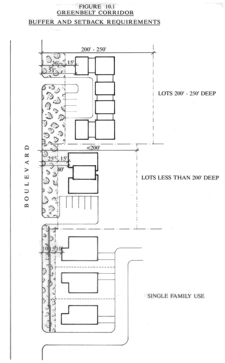
(2)
Special landscape requirements.
a.
The landscaped buffer area shall meet the requirements of this section or chapter 3, article I of this Land Development Code, whichever is more restrictive. Note that in section 3-05(c)(1), sites located in the Greenbelt Overlay District shall have a minimum of thirty percent (30%) of the first two hundred feet (200') of the site measured from the right-of-way line and running parallel thereto as landscaped area.
b.
The landscaped buffer area shall contain no parking or structures, except signs as permitted in subsection (c)(3) of this section.
c.
All principal and accessory residential structures and screen enclosures shall be setback a minimum of fifteen feet (15') from the landscaped buffer, except for those parcels between U.S. 1 and Dodson's Creek.
d.
In all development projects, regardless of the type, development in the greenbelt areas shall be designed to minimize the need for fill material or such other treatment which would remove or harm existing trees or other plant materials within the landscaped buffer areas.
e.
If existing on-site vegetation, such as understory and trees that are well-established and mature, is less than sixty percent (60%) of the proposed unpaved areas, additional predominantly native shrubs and ground cover shall be added to supplement what exists in order to provide a minimum of sixty percent (60%) vegetation. Existing weeds, dead or yellow palm fronds and branches, and any other trees and vegetation deemed undesirable due to condition of plant or species, shall be removed after a site inspection and approval by the landscape architect. Any area not required to be vegetated may be sodded, but in no case shall sodded areas exceed forty percent (40%) of the unpaved area within the greenbelt.
f.
The greenbelt buffer shall be preserved to the maximum extent possible. The property owner, or the owner's designee, may request the removal of existing understory plantings (shrubs, ground cover, etc.). The landscape architect shall review the application and determine the amount of understory coverage existing on-site. The applicant shall submit plans to the landscape architect indicating the existing understory coverage, the amount to be removed, the type, location and amount of replacement understory. The developer shall be required to replant a minimum of sixty percent (60%) of the greenbelt area with native shrub, hedge or other plant material. The remaining forty percent (40%) can be either sod or other landscape material that is integral to the overall design of the buffer. The landscape architect shall review the plans for location and type of material, and shall require the use of native plant material.
g.
Greenbelt landscaped buffer areas shall include a minimum of one (1) tree per two hundred (200) square feet, or fraction thereof. Existing trees located within the required buffer and having a two-inch (2") trunk, four and one-half feet (4½') above grade, may be utilized to meet this requirement. All new trees must be Florida grade No. 1 or better.
h.
If the requirement is not met by existing vegetation and if revegetation is necessary to meet this requirement, seventy-five (75%) of the trees shall be native shade trees. If conflicts occur where shade trees are not appropriate then a native understory tree shall be planted to meet the minimum requirement.
i.
The landscape architect may waive whatever portion of the tree planting that may be necessary if he determines that overcrowding would prevent the trees within the buffer from reaching a mature level of growth for the species involved. Larger caliper trees may be utilized to reduce the number of trees required, as long as the same cross sectional area is met.
j.
If sabal palmettos (cabbage palms) are used to meet tree standards, three (3) shall be deemed as one (1) tree.
k.
Irrigation is required for those areas which are landscaped or revegetated.
l.
Areas within the greenbelt may not be used for retention.
m.
Where existing vegetation is nominal or diminishing, the greenbelt buffer area shall be enhanced to provide ground cover, understory, and tree canopy sufficient to maintain the continuity of the buffer appearance throughout the corridor.
n.
The property owner shall be required to eliminate all noxious or exotic vegetation that detracts from the appearance of the existing or planted vegetation within the buffer area. In all cases, the property owner shall be responsible for the maintenance and upkeep of the landscape buffer in a clean, acceptable manner. The landscape architect, or his designee, shall be responsible for the enforcement of this requirement. The landscape architect shall utilize typical industry standards, such as National Arborist Association standards, in reviewing the maintenance of the landscape buffer.
o.
The landscape architect shall credit existing trees down to two inches (2") in caliper toward meeting minimum requirements pursuant to section 3-05(c)(4), subject to the following situations:
1.
If the greenbelt landscape buffer is designed so that there is no removal of existing vegetation and there are additional plantings that enhance the overall appearance of the buffer.
2.
If the greenbelt landscape buffer is designed so that all understory ground cover is removed, but an equivalent area of ground cover is replanted with native material that improves the overall appearance of the buffer, and the trees are underplanted with vegetation.
3.
If the greenbelt landscape buffer is designed so that all understory ground cover is removed, but sixty percent (60%) of the ground cover is replanted with native material, with the remaining forty percent (40%) being sod, and the overall design improves the appearance of the buffer, and the trees are underplanted with vegetation.
(3)
Signs. The provisions of chapter 3, article IV of this Land Development Code, sign regulations, shall apply to the Greenbelt Preservation District.
(4)
Architecture. All structures for properties within the greenbelt shall comply with the architectural standards in chapter 3, article VI of this Land Development Code.
(Ord. No. 2025-08, § 4, 2-4-2025)