
Owosso City Zoning Code
ARTICLE XVII
LANDSCAPE STANDARDS AND TREE REPLACEMENT
Sec. 38-210.- Purpose.
(1)
The intent of this article is to promote the public health, safety and welfare by establishing minimum standards for the design, installation and maintenance of landscape improvements. Landscaping is viewed as a critical element contributing to the aesthetics, development quality, stability of property values, and the overall character of the city. The standards of this article are intended to help achieve a number of functional and environmental objectives such as:
(a)
Promoting the implementation of the city master plan and subarea studies.
(b)
Defining and articulating outdoor spaces and architectural elements.
(c)
Obscuring, integrating and complementing various site elements.
(d)
Assisting in directing safe and efficient movement of vehicular and pedestrian circulation.
(e)
Screening headlights to reduce glare and incidental pollution.
(f)
Reducing the physical impact between adjacent land uses.
(g)
Providing landscape treatments that are consistent with adjacent sites and parcels within the surrounding area.
(h)
Providing incentives to preserve quality existing plant material and trees.
(i)
Providing reasonable standards to bring developed sites, which existed prior to the adoption of these standards, into compliance with the requirements contained herein.
(j)
Encourage drought-resistant species.
(2)
The standards contained in this article are considered the minimum necessary to achieve the objectives identified above. In several instances these standards are intentionally flexible to encourage flexibility and creative design. Additional landscaping beyond the minimum specified is encouraged to further improve the function, appearance and value of the property.
(3)
The intent of the tree protection removal requirements set forth in this section is to protect to the extent practical, the existing tree cover in the city and when trees must be removed, to sustain tree cover in the city by replacing trees in the community that are removed.
(Ord. No. 844, § 2, 3-18-24)
Sec. 38-211. - Tree protection: removal and replacement, permit required.
(1)
Permit required. If more than twenty-five (25) percent of the trees six (6) inches in caliper or larger on a site are proposed for removal, the property owner must first notify the zoning administrator and obtain approval. The zoning administrator may require submittal of a proposed sketch plan for review and/ or may send to the planning commission for approval.
(2)
Normal maintenance. This article is not intended to prevent the removal of dead or diseased trees on a site, after obtaining a permit from the zoning administrator.
(3)
Tree location survey. If a tree location survey is required by the zoning administrator, it shall be presented in a form acceptable to the city and shall include at least the following information:
(a)
The scale of the tree location survey map shall be drawn at the same scale as the site plan, except a scale shall not be used that will make detail information illegible.
(b)
The shape and dimensions of the lot or parcel, together with the existing and proposed locations of structures and improvements, including existing and proposed utilities.
(c)
The location and related setback dimensions of all buildings, structures and off-street parking areas, along with all existing or proposed easements.
(d)
All such trees shall be tagged in the field with identifying numbers, using non-corrosive metal tags.
(e)
The location of all existing trees measuring six (6) inches or more in diameter at breast height (DBH), including:
1.
All such trees within any adjoining street right-of-way, and
2.
All such trees that may be affected by the development, including all such trees located in any off-site right-of-way or utility easement or other easement in which improvements, including off site utility work necessary to serve the new development will be extended.
3.
All such trees that are proposed to remain, or which are proposed to be relocated, and all such trees that are proposed to be removed shall be clearly identified on the tree location survey map. The tree location survey map shall also contain a list of all of these trees. Their tag number will key the trees on the list to the trees on the survey map. The list shall include the common name of each tree, its DBH number, its condition, and the existing and proposed grade at the base of each tree. The condition of each such tree shall be determined by using the tree-ranking matrix set forth in subsection 38-212.
(f)
All tree location surveys shall be performed on the site as field surveys. A registered land surveyor shall map the location of each such tree, and record the existing and proposed grades at the base of each such tree. The type, size, and condition of each such tree shall be determined in the field by a registered landscape architect, certified arborist or forester. The name, address, and the phone and fax number, and any email address of those performing these responsibilities shall be provided on the tree location survey map, along with the date the field information was obtained.
(g)
Identify existing trees that will be relocated, their new location on the property, along with a statement as to how they will be protected and/or stored during land clearance and construction, and how these trees will be maintained in a living and growing condition, as required by ordinance.
(h)
A statement explaining how trees not included in item (g), in this subsection, and which will remain on site will be protected during land clearance, construction, including the proposed use of tree wells, protective barriers, tunneling or retaining walls, and explaining thereafter, how these trees will be maintained as a permanent part of the site's landscaping.
(i)
Figures that represent the number of trees that are six (6) inches in DBH that will be removed from:
1.
The property;
2.
The public rights-of-way along the property;
3.
Any abutting property, if applicable;
4.
Any affected easements, if applicable; and
5.
Any rights-of-way and/or easements beyond the site in which such trees must be removed to extend services to the site, if applicable.
(j)
A tree location survey may be waived by the city for any area or areas of a development site that lie 50 feet or more outside of the development's construction zone. For the purpose of this section the construction zone shall mean any area of the property that will be disturbed in any way by any new development taking place on the property. Prior to receiving a waiver, the applicant shall submit a statement to the city identifying the most predominant species of trees in the waiver area, the total number of trees in the waiver area, and the estimated predominate tree size in the waiver area. A waiver area shall be physically separated from any designated construction zone on the property by a snow fence prior to any activity taking place on the property.
(4)
Tree protection during site development.
(a)
Prior to the land clearing stage of development and before a tree permit will be issued, the owner, developer, or agent shall do the following:
1.
Clearly identify the on-site trees that are to be removed and those that are to be relocated by fluorescent orange spray paint or by red flagging tape. This responsibility shall be completed before any field inspection shall be conducted by the city or its designee.
2.
Erect barriers of four-foot high wooden fencing or orange snow with metal stakes ten (10) feet on center (OC) which will shield and protect trees, no closer than six (6) feet from the trunk or at the edge of the tree canopy, whichever is greater, of all such trees or groups of trees.
3.
Keep the area within the protective barrier clear of all debris or fill, and any equipment and material.
(b)
During the construction stage of development, the owner, developer or agent shall not cause or permit any activity within the drip line of any protected tree or group of trees including but not limited to the storage of equipment, dumpsters, boulders, dirt and excavated material, building or waste material, or any other material harmful to the life of a tree.
(c)
No damaging attachment, wires (other than cable wires for trees), signs or permits may be fastened to any tree protected by this section.
(d)
The city or its designee shall conduct periodic inspections of the site during land clearing and construction in order to ensure compliance with this section.
(5)
Emergency tree removal. When high winds, storms, tornadoes, floods, freezes, fires, or other manmade or natural disasters damage or destroy trees in the city, making it necessary to expedite the removal of these trees in the interest of promoting the public safety, health and general welfare of the city, the requirements of this article may be suspended by the city for a period of thirty (30) days in the affected areas.
(Ord. No. 844, § 2, 3-18-24)
Sec. 38-212. - Replacement of removed trees.
A tree survey shall be submitted with any site plan for new development. The survey shall identify the location, species and size of existing trees on the proposed site that are to be removed, or are within ten (10) feet of the removal area. Existing landmark trees that are planned to be removed shall be replaced on the site in accordance with the following standards:
(1)
Removed landmark trees between eight (8) and eighteen (18) caliper inches shall be replaced at a rate of fifty (50) percent of the total diameter breast height (DBH).
(2)
Removed landmark trees greater than eighteen (18) caliper inches shall be replaced at a rate of seventy-five (75) percent of the total DBH.
(3)
Removed landmark trees greater than thirty (30) caliper inches shall be replaced at a rate of one hundred (100) percent of the total DBH.
(4)
Landmark trees that are dead or diseased, with no visible growth, as determined by the zoning administrator, are exempt from replacement requirements.
(5)
A summary table of existing trees shall be provided, indicating those trees that will be removed.
(6)
Landmark trees are defined by size and species, as listed in the table below:
(Ord. No. 844, § 2, 3-18-24)
Sec. 38-213. - Tree health condition ranking matrix.
Except as may be otherwise waived herein, the applicant shall be responsible for determining the condition (health) in the field of all trees that are to be removed or relocated. Compliance with the applicable requirements of this subsection may be waived by the city, provided the applicant has properly requested a waiver from the applicable requirements of this section, in the manner set forth in this section:
(1)
The applicant or his designee shall evaluate the condition of the tree trunk, the growth rate of the tree, its general structure, identify any insect infestations and/or diseases, the crown development of the tree, and the life expectancy of the tree. From this evaluation the expert examining the trees shall assign a point value to each such tree using the tree condition rating matrix provided in subsection b, of this section. The rating number shall be placed in the column listing all the trees as outlined in subsection b. of this section.
(2)
The ranking matrix that the expert shall use in the field to calculate the condition (health) of a tree is outlined:
Ranking Matrix
(3)
When the city or its designee evaluates the applicant's tree condition data in the field, the rating matrix set forth in subsection b, of this section shall be used.
(Ord. No. 844, § 2, 3-18-24)
Sec. 38-214. - Incentives to preserve existing trees.
The standards listed below are intended to encourage the preservation of quality and mature landmark trees by providing credits toward required landscape components.
(1)
Trees intended to be preserved shall be indicated on the site plan.
(2)
To obtain credit, the preserved trees shall be arranged to meet the intent of this article, be of high-quality, as confirmed by the city, and at least two and one-half inch caliper in size for deciduous trees and six (6) feet in height for evergreen trees.
(3)
Each deciduous tree preserved that is between two and one-half inches to seven and nine-tenths inches caliper in size and evergreen tree that is between two and one-half inches caliper, to seven and nine-tenths inches caliper in size, and each evergreen tree that is between six feet and 19 feet shall be calculated as one required tree. Two credits shall be given for deciduous tree with eight inch caliper in size or greater and evergreen trees greater than 19 feet.
(4)
The landscape plan shall include a matrix that lists required trees and credits for preserved trees.
(5)
During construction, tree protection fencing shall be placed ten (10) feet beyond the drip-line of the tree. The ground area within the fence line shall be maintained with vegetative landscape material or pervious surface cover. The planning commission may allow pedestrian pathways, driveways or parking within the dripline upon determination that the setback from the trunk of the tree is suitable to reasonably ensure protection of the tree and the public. Storage of soils or other materials within the dripline is prohibited.
(6)
If trees which receive tree credit are lost within three (3) years after completion of the construction, the property owner shall replace with new trees equal to the number of tree credits granted.
(7)
Tree credits may account for up to fifty (50) percent of the required trees and be applied anywhere on the site.
(Ord. No. 844, § 2, 3-18-24)
Sec. 38-215. - Landscape plan specifications.
(1)
A separate detailed landscape plan, prepared by a licensed/registered design professional, shall be submitted as part of the site plan review process.
(2)
The landscape plan shall demonstrate that all requirements of this article are met and shall:
(a)
Illustrate location, spacing, species, and size of proposed plant material.
(b)
Separately identify compliance with the minimum numeric requirements for greenbelts, buffer zones, parking lot trees, detention ponds, and interior landscaping; required trees or materials cannot be double counted.
(c)
If applicable, identify compliance with the numeric requirements for tree replacement and preservation.
(d)
Provide, as determined by the planning commission, typical cross sections to illustrate views from adjacent land uses and the slope, height and width of proposed berms or landscape elements.
(e)
Identify trees and other landscape elements to be preserved.
(f)
Delineate the location of tree protection fence and limits of grading at the perimeter of areas that to be preserved.
(g)
Provide significant construction details to resolve specific conditions such as limits of grading adjacent to areas with trees and vegetative cover to be preserved, tree wells to preserve existing trees or culverts to maintain natural drainage patterns.
(h)
Provide details to ensure proper installation and establishment of proposed plant material.
(i)
Identify grass areas and other methods of ground cover.
(j)
Identify a landscape maintenance program including a statement that all diseased, damaged or dead materials shall be replaced in accordance with standards of this chapter.
(Ord. No. 844, § 2, 3-18-24)
Sec. 38-216. - Design standards.
(1)
Greenbelts. A greenbelt shall be planted or preserved along public rights-of-way, private road easements, and designated frontage roads and access drives. The greenbelt is intended to provide a transition between the roadway and an existing or proposed land use. Greenbelts shall be provided in accordance with the following requirements:
(a)
The width of the greenbelt shall be thirty-five (35) feet in residential districts and twenty (20) feet in nonresidential districts. Greenbelts must have a water source.
(b)
Greenbelts shall include only living materials and planting beds, except for approved sidewalks, bike paths, signs, driveways, and essential services. Greenbelts must have a water source.
(c)
Where sidewalks are located within the greenbelt, plant material shall be provided on each side of the pathway to provide visual and physical separation between the vehicular and pedestrian circulation.
(d)
The greenbelt shall contain a minimum of one (1) canopy tree and six (6) upright shrubs per thirty (30) linear feet, or fraction thereof, of street frontage including any openings for driveways, pathways, or easements. The planning commission may approve the substitution of evergreen trees for up to fifty (50) percent of the required canopy trees when appropriate in consideration of the land use and existing character of adjacent uses. A hedgerow with upright shrubs planted four to five feet on center along the entire road frontage may also be utilized.
(e)
Ornamental trees may be used to diversify greenbelt planting requirements, provided two (2) ornamental trees shall be provided for each one (1) required canopy tree.
(f)
Greenbelt plantings shall be arranged to simulate a natural setting such as massing or staggered rows, except where the planning commission finds a more formal arrangement would be consistent with the established character of the area.
(g)
Greenbelts shall be designed to ensure adequate sight visibility for motorists, adequate clearance for pedestrians and vehicles, clearance from overhead utility lines, adequate separation from underground utilities, and accessibility to fire hydrants. Where such conditions prohibit full compliance, the planning commission may adjust the location of the required materials so as long as the design intent is met.
(2)
Parking lot landscaping. Parking lot landscaping shall be provided in accordance with the following standards:
(a)
Landscaping shall be dispersed evenly throughout the parking lot in order to break up large expanses of pavement and assist with vehicular and pedestrian flow.
(b)
At least one (1) canopy tree shall be provided per eight (8) parking spaces provided.
(c)
All of the required parking lots trees shall be placed within the parking lot envelope as described by the area including the parking lot surface and extending outward ten (10) feet from the edge of the parking lot.
(d)
A minimum of one-third of the trees shall be placed within parking islands located inside the perimeter of the parking lot.
(e)
Parking lot islands shall be curbed and be at least one hundred (100) square feet in area. Islands within parking lots having less than one hundred (100) spaces may be a minimum of ten (10) feet in width, parking areas with more than one hundred (100) spaces shall have islands at least twenty (20) feet in width. The depth of the island shall be two (2) feet shorter than an adjacent parking space.
(f)
Only trees, shrubs, grass or other living ground cover shall be used within parking lot islands.
(g)
The design and layout of the parking lots shall provide appropriate pedestrian circulation and connections to perimeter pedestrian connections.
(3)
Buffer zones.
(a)
A buffer shall be provided between the subject site and all adjacent properties, developed or undeveloped, in accordance with the table on the following page.
(b)
The planning commission shall use the table on the following page as the minimum requirements necessary and determine whether landscaping, a wall, a berm, or combination of these elements are needed to attain the intended screening.
(c)
The use of canopy trees and associated understory are encouraged while walls and berms are discouraged.
(d)
Buffer zones shall include only living materials and planting beds, except for approved sidewalks, bike paths, signs, driveways, and essential services.
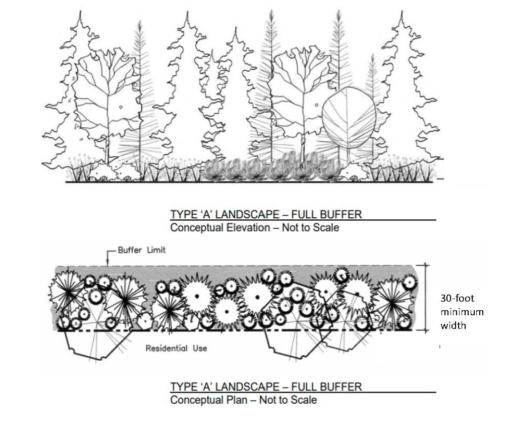
Buffer zone A: Thirty-foot minimum width, along the property line with two (2) canopy trees and four (4) shrubs, or one (1) canopy tree, one (1) evergreen and four shrubs per 20 linear feet, rounded upward, and including a wall, berm or combination of these elements as determined by the planning commission.
Buffer zone B: Ten-foot minimum width, along the property line with one (1) canopy tree and four (4) shrubs, or one (1) evergreen tree and four (4) shrubs per 20 linear feet, rounded upward.
(4)
Detention/retention pond landscaping. Ponds shall be located outside required setbacks and designed to provide a natural appearance. Detention and retention ponds shall be provided in accordance with the following standards:
(a)
Side slopes shall be such that the perimeter of the pond shall not need to be fenced.
(b)
The sides of the pond must be undulating to avoid an "engineered" appearance.
(c)
One canopy or evergreen tree and ten (10) shrubs are required per fifty (50) feet of pond perimeter, as measured along the top of the bank elevation. The required landscaping shall be planted in a random pattern, not limited to the top of the pond bank.
(d)
Wild grasses and wetland plantings should be utilized on the side slopes and bottom of the pond to give it a more natural appearance, minimize ongoing maintenance, and provide improved filtering of sediments.
(e)
Where a natural landscape is found not to be particular or desirable the planning commission may require some type of decorative fencing.
(5)
Interior site landscaping. Site landscaping shall be located near building entrances, along building foundations, along pedestrian walkways, near service areas or as landscaped plazas. Site landscaping must have a water source.
(6)
Residential and site condominium developments. Landscaping for single-family and multiple-family residential developments shall be provided in accordance with the following requirements:
(a)
Street trees shall be provided at a rate of one (1) tree per forty (40) linear feet of frontage, or thereof, along all interior roads. The planning commission may determine that existing trees preserved within ten (10) feet of the road edge may fulfill the street tree requirement for that portion of the road. Trees should generally be planted between the sidewalk and road curb, in consideration of intersection sight distance.
(b)
The landscape plan shall also include details of the cul-de-sac islands, project entrances, accessory buildings and common open space areas.
(7)
Right-of-way landscaping. Public rights-of-way shall be planted with grass or other suitable living plant material and maintained by the owner or occupant of the property. Trees and shrubs may be planted within the right-of-way with permission from the appropriate authority with jurisdiction over the street.
(8)
Accessory site components. In addition to required screens or walls, site elements such as waste receptacles, air conditioner units, utility boxes and other similar components shall be appropriately screened with plant material.
(Ord. No. 844, § 2, 3-18-24)
Sec. 38-217. - Specifications for landscape improvements and plant materials.
(1)
Wall standards. While walls are not necessarily encouraged, certain situations may be appropriate for provision of a wall. When provided, walls shall meet the following requirements:
(a)
Walls shall be located on the lot line or within the required setback when it is desired to have plant material on both sides of the wall.
(b)
Walls shall be continuous except for openings for pedestrian connections as approved by the planning commission.
(c)
Walls shall be constructed of the primary building material of the principal structure horizontal distance.
(d)
Berms require a water source and must be weeded and maintained healthy.
(2)
Plant material. All plant material shall be hardy to the city, be free of disease and insects and conform to the American Standard for Nursery Stock of the American Nurserymen. Landscaped areas shall include only living plant materials and planting beds, no pebbles or stones are permitted.
(3)
Minimum sizes and spacing. The minimum plant sizes and spacing shall be provided in accordance with the following:
(a)
Wherever screening is required, screening shall consist of closely spaced evergreen plantings which can be reasonably expected to form a complete visual barrier. Deciduous plant material may be used for variety to supplement evergreen plantings.
(4)
Mixing of species. The overall landscape plan shall not contain more than thirty-three (33) percent of any one (1) plant species. The use of native species and mixture of trees from the same species association is strongly encouraged.
(5)
Trees not permitted. The following trees are not permitted as they split easily, their wood is brittle, their roots clog drains and sewers, and they are unusually susceptible to disease or insects. The planning commission may however allow trees from this list when associated with an appropriate ecosystem. Trees not permitted are as follows: Box Elder, Elms, Tree of Heaven, Willows, Soft Maples (silver), Poplars, Horse Chestnut (nut bearing), Ash, Ginkgo (female), Cottonwood, Mulberry, Black Locust, Honey Locust (with thorns).
(6)
Planting beds. Bark used as mulch shall be maintained at minimum of two (2) inches deep.
(7)
Topsoil. Topsoil shall consist of a four-inch base for lawn areas and an eight (8) inch to 12-inch base within planting beds.
(8)
Proximity to utilities. Plant material shall not be located in a manner that will interfere with or cause damage to underground utility lines, public roads or other public facilities.
(9)
Lawn grasses. Lawn grasses shall be planted in species normally grown as permanent lawns Shiawassee County. Grasses may be plugged, sprigged, seeded or sodded except that rolled sod, erosion reducing net or suitable mulch shall be used in swales or other areas susceptible to erosion and shall be staked where necessary for stabilization. When complete sodding or seeding is not used, nurse grass seed shall be sown and mulched for immediate protection until permanent coverage is achieved. Grass sod and seed shall be free of weeds and noxious pests or disease.
(Ord. No. 844, § 2, 3-18-24)
Sec. 38-218. - Minimum standards for installation, irrigation and maintenance.
(1)
Timing of planting. All required plant material shall be planted prior to issuing a final certificate of occupancy. In the event that the project is completed during a time of year when planting is impractical, a financial guarantee in the amount of the remaining improvements shall be provided in a form of payment acceptable to the city.
(2)
Completion of improvements. Tree stakes, guy wires and tree wrap shall be removed after completion of the initial growing season.
(3)
Irrigation. All landscaped areas shall be provided with an underground irrigation system.
(4)
Maintenance. Landscaped areas and plant materials required by this article shall be kept free from refuse and debris. Plant materials, including lawn, shall be maintained in a healthy growing condition, neat and orderly in appearance in accordance with the approved site plan. If any plant material dies or becomes diseased, it shall be replaced within thirty (30) days written notice from the city or within an extended time period as specified in said notice.
(5)
Maintenance bond. A maintenance bond for replacement of plant material that may die in a two year period may be required by the city.
(Ord. No. 844, § 2, 3-18-24)
Sec. 38-219. - Standards for compliance for existing sites.
In any case where the building and/or parking area is being increased by at least twenty-five (25) percent over the originally approved site plan or is being changed to a more intense use as determined by the planning commission, the site shall be brought into full compliance with the landscape standards herein. In instances where the increase in building and/or parking area is less than twenty-five (25) percent over the original site plan, the extent of new landscaping shall be equal to four percent of compliance for every one percent of increase in building or parking footprint. For example, a building or parking area increase of ten (10) percent requires forty (40) percent compliance with the landscape standards.
(Ord. No. 844, § 2, 3-18-24)