
Paso Robles City Zoning Code
ARTICLE 8
- ENVIRONMENTAL STANDARDS
Chapter 21.84 - OAK TREE PRESERVATION[3]
Cross reference— Oak tree preservation standards shall be as provided in Chapter 10.01 (Oak Tree Preservation).
21.80.010 - Purpose and applicability.
A.
Purpose. It is the purpose of this chapter to promote the public health, safety, and general welfare, and to minimize public and private losses due to flood conditions in specific areas by legally enforceable regulations applied uniformly throughout the community to all publicly and privately owned land within flood prone, mudslide (i.e., mudflow), or flood related erosion areas. These regulations are designed to:
1.
Protect human life and health;
2.
Minimize expenditure of public money for costly flood control projects;
3.
Minimize the need for rescue and relief efforts associated with flooding and generally undertaken at the expense of the general public;
4.
Minimize prolonged business interruptions;
5.
Minimize damage to public facilities and utilities such as water and gas mains; electric, telephone and sewer lines; and streets and bridges located in areas of special flood hazard;
6.
Help maintain a stable tax base by providing for the sound use and development of areas of special flood hazard so as to minimize future blighted areas caused by flood damage;
7.
Ensure that potential buyers are notified that property is in an area of special flood hazard; and
8.
Ensure that those who occupy the areas of special flood hazard assume responsibility for their actions.
B.
Applicability. This chapter shall apply to all areas of special flood hazards (as defined in Section 21.80.030) within the jurisdiction of the city.
C.
Basis for Establishing the Areas of Special Flood Hazard. The areas of special flood hazard identified by the Federal Emergency Management Agency (FEMA) in the flood insurance study (FIS) for the city of El Paso de Robles, California (San Luis Obispo County) dated March 16, 1981 with accompanying flood insurance rate maps (FIRMs) and flood boundary and floodway maps (FBFMs), dated September 16, 1981, and all subsequent amendments and/or revisions, are adopted by reference and declared to be a part of this chapter. The FIS and attendant mapping is the minimum area of applicability of this chapter and may be supplemented by studies for other areas which allow implementation of this chapter and which are recommended to the city council by the floodplain administrator. The study, FIRMs, and FBFMs are on file at the office of the City Engineer, City Hall, located at 1000 Spring Street, El Paso de Robles, CA 93446.
D.
Abrogation and Greater Restrictions. This chapter is not intended to repeal, abrogate, or impair any existing easements, covenants, or deed restrictions. However, where this chapter and another ordinance, easement, covenant, or deed restriction conflict or overlap, whichever imposes the more stringent restrictions shall prevail.
(Ord. No. 1144 N.S., § 3(Exh. A), 10-1-2024)
21.80.020 - Statutory authorization, findings of fact, and methods of reducing flood losses.
A.
Statutory Authorization. The Legislature of the state of California has in Government Code Sections 65302, 65560, and 65800 conferred upon local government units authority to adopt regulations designed to promote the public health, safety, and general welfare of its citizenry. Therefore, the city council does adopt the following floodplain management regulations.
B.
Findings of Fact.
1.
The flood hazard areas of the city are subject to periodic inundation which results in loss of life and property, health and safety hazards, disruption of commerce and governmental services, extraordinary public expenditures for flood protection and relief, and impairment of the tax base, all of which adversely affect the public health, safety, and general welfare.
2.
These flood losses are caused by uses that are inadequately elevated, floodproofed, or protected from flood damage. The cumulative effect of obstructions in areas of special flood hazards which increase flood heights and velocities also contribute to flood losses.
C.
Methods of Reducing Flood Losses. In order to accomplish its purposes, this chapter includes methods and provisions to:
1.
Restrict or prohibit uses which are dangerous to health, safety, and property due to water or erosion hazards, or which result in damaging increases in erosion, flood heights, or flood velocities;
2.
Require that uses vulnerable to floods, including facilities which serve such uses, be protected against flood damage at the time of initial construction;
3.
Control the alteration of natural floodplain, stream channels, and natural protective barriers which help accommodate or channel flood waters;
4.
Control filling, grading, dredging, and other development which may increase flood damage;
5.
Prevent or regulate the construction of flood barriers which will unnaturally divert flood waters or which may increase flood hazards in other areas.
(Ord. No. 1144 N.S., § 3(Exh. A), 10-1-2024)
21.80.030 - Definitions.
Unless specifically defined below, words or phrases used in this chapter shall be interpreted so as to give them the meaning they have in common usage and to give this chapter its most reasonable application. Definitions included in this section that are also defined in Chapter 21.92 (General Definitions) shall be applicable only to Chapter 21.80 (Floodplain Management).
A.
A Zone. See "Special flood hazard area."
B.
"Accessory structure" means a structure that is either:
1.
Solely for the parking of no more than two cars; or
2.
A small, low cost shed for limited storage, less than one hundred fifty square feet and one thousand five hundred dollars in value.
C.
"Accessory use" means a use which is incidental and subordinate to the principal use of the parcel of land on which it is located.
D.
"Agricultural structure" means a walled and roofed structure used exclusively for agricultural purposes or uses in connection and livestock, including aquatic organisms. Structures that house tools or equipment used in connection with these purposes or uses are also considered to have agricultural purposes or uses.
E.
"Alluvial fan" means a geomorphologic feature characterized by a cone or fan-shaped deposit of boulders, gravel, and fine sediments that have been eroded from mountain slopes, transported by flood flows, and then deposited on the valley floors, and which is subject to flash flooding, high velocity flows, debris flows, erosion, sediment movement and deposition, and channel migration.
F.
"Alteration of watercourse" means a dam, impoundment, channel relocation, change in channel capacity, or any other form of modification which may alter, impede, retard, or change the direction and/or velocity of the riverine flow during conditions of the base flood.
G.
"Apex" means the point on an alluvial fan or similar landform below which the flow path of the major stream that formed the fan becomes unpredictable and alluvial fan flooding can occur.
H.
"Appeal" means a request for a review of the floodplain administrator's interpretation of any provision of this chapter.
I.
"Area of shallow flooding" means a designated AO or AH zone on the flood insurance rate map (FIRM). The base flood depths range from one to three feet; a clearly defined channel does not exist; the path of flooding is unpredictable and indeterminate; and velocity flow may be evident. Such flooding is characterized by ponding or sheet flow.
J.
Area of Special Flood Hazard. See "Special flood hazard area."
K.
"ASCE24" means the standard flood resistant design and construction, referenced by the building code, developed and published by the American Society of Civil Engineers, Reston, VA.
L.
"Base flood" means a flood which has a one percent chance of being equaled or exceeded in any given year (also called the "one-hundred-year flood"). Base flood is the term used throughout this chapter.
M.
"Base flood elevation (BFE)" means the elevation shown on the flood insurance rate map for zones AE, AH, A1-30, VE and V1-V30 that indicates the water surface elevation resulting from a flood that has a one percent or greater chance of being equaled or exceeded in any given year.
N.
"Basement" means any area of the building having its floor subgrade, i.e., below ground level, on all sides.
O.
"Breakaway wall" means a wall that is not part of the structural support of a structure and is intended through its design and construction to collapse under specific lateral loading forces, without causing damage to the elevated portion of the structure or supporting foundation system.
P.
Building. See "Structure."
Q.
"Design flood elevation" means the elevation of the highest flood (generally the base flood elevation including freeboard) that a retrofitting method is designed to protect against. Also referred to as "flood protection elevation".
R.
"Development" means any man-made change to improved or unimproved real estate, including but not limited to buildings or other structures, mining, dredging, filling, grading, paving, excavation, or drilling operations or storage of equipment or materials.
S.
"Encroachment" means the advance or infringement of uses, plant growth, fill, excavation, structures, permanent structures, or development into a floodplain which may impede or alter the flow capacity of a floodplain.
T.
"Exceptional hardship" means for the purpose of variances from these regulations or the building code, the exceptional difficulty that would result from a failure to grant a requested variance. Mere economic or financial hardship is not exceptional. Inconvenience, aesthetic considerations, physical handicaps, personal preferences, or the disapproval of one's neighbors do not, as a rule, qualify as exceptional hardships. All of these circumstances can be resolved through other means without granting variances, even when the alternatives are more expensive or require the property owner to build elsewhere or put the parcel to a different use than originally intended.
U.
"Existing manufactured home park or subdivision" means a manufactured home park or subdivision for which the construction of facilities for servicing the lots on which the manufactured homes are to be affixed (including, at a minimum, the installation of utilities, the construction of streets, and either final site grading or the pouring of concrete pads) is completed before June 30, 1977.
V.
"Expansion to an existing manufactured home park or subdivision" means the preparation of additional sites by the construction of facilities for servicing the lots on which the manufactured homes are to be affixed (including the installation of utilities, the construction of streets, and either final site grading or the pouring of concrete pads).
W.
"Flood," "flooding," or "floodwater" means:
1.
A general and temporary condition of partial or complete inundation of normally dry land areas from the overflow of inland or tidal waters; the unusual and rapid accumulation or runoff of surface waters from any source; and/or mudslides (for example, mudflows), see "mudslides"; and
2.
The condition resulting from flood-related erosion, see "flood-related erosion."
X.
"Flood boundary and floodway map (FBFM)" means the official map on which the Federal Emergency Management Agency or Federal Insurance Administration has delineated both the areas of special flood hazards and the floodway.
Y.
"Flood control project" means a dam or barrier design and constructed to keep water away from or out of a specified area, including but not limited to levees, floodwalls, and channelization.
Z.
"Flood damage-resistant material" means any building product (material, component, or system) capable of withstanding direct and prolonged contact with floodwaters without sustaining significant damage.
AA.
"Flood hazard boundary map" means the official map on which the Federal Emergency Management Agency or Federal Insurance Administration has delineated the areas of flood hazards.
BB.
"Flood insurance rate map (FIRM)" means the official map on which the Federal Emergency Management Agency or Federal Insurance Administration has delineated both the areas of special flood hazards and the risk premium zones applicable to the community.
CC.
"Flood insurance study" means the official report provided by the Federal Insurance Administration that includes flood profiles, the flood insurance rate map, the flood boundary and floodway map, and the water surface elevation of the base flood.
DD.
"Floodplain" or "flood-prone area" means any land area susceptible to being inundated by water from any source, see "flooding."
EE.
"Floodplain administrator" is the community individual appointed by title to administer and enforce the floodplain management regulations.
FF.
"Floodplain management" means the operation of an overall program of corrective and preventive measures for reducing flood damage and preserving and enhancing, where possible, natural resources in the floodplain, including but not limited to emergency preparedness plans, flood control works, floodplain management regulations, and open space plans.
GG.
"Floodplain management regulations" means this chapter and other zoning ordinances, subdivision regulations, building codes, health regulations, special purpose ordinances (such as grading and erosion control), and other application of police power which control development in flood-prone areas. This term describes federal, state, or local regulations in any combination thereof which provide standards for preventing and reducing flood loss and damage.
HH.
"Floodproofing" means any combination of structural and nonstructural additions, changes, or adjustments to structures that reduce or eliminate flood damage to real estate or improved real property, water and sanitary facilities, structures, and their contents. For guidelines on dry and wet floodproofing, see FEMA Technical Bulletins TB 1-93, TB 3-93, and TB 7-93.
II.
"Floodway" means the channel of a river or other watercourse and the adjacent land areas that must be reserved in order to discharge the base flood without cumulatively increasing the water surface elevation more than one foot. Also referred to as "regulatory floodway."
JJ.
"Floodway fringe" is that area of the floodplain on either side of the "regulatory floodway" where encroachment may be permitted.
KK.
"Fraud and victimization" as related to Section 21.80.150 (Appeals) means that the variance granted must not cause fraud on or victimization of the public. In examining this requirement, the city council will consider the fact that every newly constructed structure adds to government responsibilities and remains a part of the community for fifty to one hundred years. Structures that are permitted to be constructed below the base flood elevation are subject during all those years to increased risk of damage from floods, while future owners of the property and the community as a whole are subject to all the costs, inconvenience, danger, and suffering that those increased flood damages bring. In addition, future owners may purchase the property, unaware that it is subject to potential flood damage, and can be insured only at very high flood insurance rates.
LL.
"Functionally dependent use" means a use which cannot perform its intended purpose unless it is located or carried out in close proximity to water. The term includes only docking facilities, port facilities that are necessary for the loading and unloading of cargo or passengers, and ship building and ship repair facilities, and does not include long-term storage or related manufacturing facilities.
MM.
Hardship. See "exceptional hardship."
NN.
"Highest adjacent grade" means the highest natural elevation of the ground surface prior to construction next to the proposed wails of a structure.
OO.
"Historic structure" means any structure that is:
1.
Listed individually in the National Register of Historic Places (a listing maintained by the Department of Interior) or preliminarily determined by the Secretary of the Interior as meeting the requirements for individual listing on the National Register;
2.
Certified or preliminarily determined by the Secretary of the Interior as contributing to the historical significance of a registered historic district or a district preliminarily determined by the Secretary to qualify as a registered historic district;
3.
Individually listed on a state inventory of historic places in states with historic preservation programs which have been approved by the Secretary of Interior; or
4.
Individually listed in the Paso Robles Historic Resources Inventory (Section 21.62.030 [Criteria for Designation of Historic Resources]).
PP.
"Letter of map change" means an official determination issued by FEMA that amends or revises an effective flood insurance rate map or flood insurance study. Letters of map change include:
1.
Letter of map amendment (LOMA): An amendment based on technical data showing that a property was incorrectly included in a designated special flood hazard area. A LOMA amends the current effective flood insurance rate map and establishes that a specific property, portion of a property, or structure is not located in a special flood hazard area.
2.
Letter of map revision (LOMR): A revision based on technical data that may show changes to flood zones, flood elevations, special flood hazard area boundaries and floodway delineations, and other planimetric features.
3.
Letter of map revision based on fill (LOMR-F): A determination that a structure or parcel of land has been elevated by fill above the base flood elevation and is, therefore, no longer located within the special flood hazard area. In order to qualify for this determination, the fill must have been permitted and placed in accordance with the community's floodplain management regulations.
4.
Conditional letter of map revision (CLOMR): A formal review and comment as to whether a proposed flood protection project or other project complies with the minimum NFIP requirements for such projects with respect to delineation of special flood hazard areas. A CLOMR does not revise the effective flood insurance rate map or flood insurance study; upon submission and approval of certified as-built documentation, a letter of map revision may be issued by FEMA to revise the effective FIRM.
QQ.
"Levee" means a man-made structure, usually an earthen embankment, designed and constructed in accordance with sound engineering practices to contain, control or divert the flow of water so as to provide protection from temporary flooding.
RR.
"Levee system" means a flood protection system which consists of a levee, or levees, and associated structures, such as closure and drainage devices, which are constructed and operated in accord with sound engineering practices.
SS.
"Lowest floor" means the lowest floor of the lowest enclosed area, including basement (see "basement" definition). An unfinished or flood resistant enclosure below the lowest floor that is usable solely for parking of vehicles, building access or storage in an area other than a basement area, is not considered a structure's lowest floor provided it conforms to applicable nonelevation design requirements including, but not limited to:
1.
The flood opening standards in Section 21.80.080(C)3. of this chapter;
2.
The anchoring standards in Section 21.80.080(A) of this chapter;
3.
The construction materials and methods standards in Section 21.80.080(B) of this chapter;
4.
The standards for utilities in Section 21.80.090 of this chapter.
TT.
"Manufactured home" means a structure, transportable in one or more sections, which is built on a permanent chassis and is designed for use with or without a permanent foundation when attached to the required utilities. The term "manufactured home" does not include a "recreational vehicle."
UU.
"Manufactured home park or subdivision" means a parcel (or contiguous parcels) of land divided into two or more manufactured home lots for rent or sale.
VV.
"Market value" shall be determined by estimating the cost to replace the structure in new condition and adjusting that cost figure by the amount of depreciation which has accrued since the structure was constructed.
1.
The cost of replacement of the structure shall be based on a square foot cost factor determined by reference to a building cost estimating guide recognized by the building construction industry.
2.
The amount of depreciation shall be determined by taking into account the age and physical deterioration of the structure and functional obsolescence as approved by the floodplain administrator, but shall not include economic or other forms of external obsolescence.
3.
Use of replacement costs or accrued depreciation factors different from those contained in recognized building cost estimating guides may be considered only if such factors are included in a report prepared by an independent professional appraiser and supported by a written explanation of the differences.
WW.
"Mean sea level" means, for purposes of the National Flood Insurance Program, the National Geodetic Vertical Datum (NGVD) of 1929, North American Vertical Datum (NAVD) of 1988, or other datum, to which base flood elevations shown on a community's flood insurance rate map are referenced.
XX.
"New construction," for floodplain management purposes, means structures for which the "start of construction" commenced on or after June 30, 1977, and includes any subsequent improvements to such structures.
YY.
"New manufactured home park or subdivision" means a manufactured home park or subdivision for which the construction of facilities for servicing the lots on which the manufactured homes are to be affixed (including at a minimum, the installation of utilities, the construction of streets, and either final site grading or the pouring of concrete pads) is completed on or after June 30, 1977.
ZZ.
"Nuisance" means that which is injurious to safety or health of an entire community or neighborhood, or any considerable number of persons, or unlawfully obstructs the free passage or use, in the customary manner, of any navigable lake, or river, bay, stream, canal, or basin.
AAA.
"Obstruction" means and includes, but is not limited to, any dam, wall, wharf, embankment, levee, dike, pile, abutment, protection, excavation, channelization, bridge, conduit, culvert, structure, wire, fence, rock, gravel, refuse, fill, structure, vegetation or other material in, along, across or projecting into any watercourse which may alter, impede, retard or change the direction and/or velocity of the flow of water, or due to its location, its propensity to snare or collect debris carried by the flow of water, or its likelihood of being carried downstream.
BBB.
One hundred year flood. See "Base flood."
CCC.
"Program deficiency" means a defect in a community's floodplain management regulations or administrative procedures that impairs effective implementation of those floodplain management regulations.
1.
"Recreational vehicle" means a vehicle which is: Built on a single chassis;
2.
Four hundred square feet or less when measured at the largest horizontal projection;
3.
Designed to be self-propelled or permanently towable by a light-duty truck; and
4.
Designed primarily not for use as a permanent dwelling but as temporary living quarters for recreational, camping, travel, or seasonal use.
DDD.
"Regulatory floodway" means the channel of a river or other watercourse and the adjacent land areas that must be reserved in order to discharge the base flood without cumulatively increasing the water surface elevation more than one foot.
EEE.
"Remedy a violation" means to bring the structure or other development into compliance with State or local floodplain management regulations, or, if this is not possible, to reduce the impacts of its noncompliance. Ways that impacts may be reduced include protecting the structure or other affected development from flood damages, implementing the enforcement provisions of this chapter or otherwise deterring future similar violations, or reducing state or federal financial exposure with regard to the structure or other development.
FFF.
"Riverine" means relating to, formed by, or resembling a river (including tributaries), stream, brook, etc.
GGG.
Sheet flow area. See "area of shallow flooding."
HHH.
"Special flood hazard area (SFHA)" means an area in the floodplain subject to a one percent or greater chance of flooding in any given year. It is shown on an FHBM or FIRM as zone A, AO, A1—A30, AE, A99, or AH.
III.
"Start of construction" means and includes substantial improvement and other proposed new development and means the date the building permit was issued, provided the actual start of construction, repair, reconstruction, rehabilitation, addition, placement, or other improvement was within one hundred eighty days from the date of the permit. The actual start means either the first placement of permanent construction of a structure on a site, such as the pouring of slab or footings, the installation of piles, the construction of columns, or any work beyond the stage of excavation; or the placement of a manufactured home on a foundation. Permanent construction does not include land preparation, such as clearing, grading, and filling; nor does it include preparation, such as clearing, grading, and filling; nor does it include the installation of streets and/or walkways; nor does it include excavation for a basement, footings, piers, or foundations or the erection of temporary forms; nor does it include the installation on the property of accessory structures, such as garages or sheds not occupied as dwelling units or not part of the main structure. For a substantial improvement, the actual start of construction means the first alteration of any wall, ceiling, floor, or other structural part of a structure, whether or not that alteration affects the external dimensions of the structure.
JJJ.
"Structure" means a walled and roofed building that is principally above ground; this includes a gas or liquid storage tank or a manufactured home.
KKK.
"Substantial damage" means:
1.
Damage of any origin sustained by a structure whereby the cost of restoring the structure to its before damaged condition would equal or exceed fifty percent of the market value of the structure before the damage occurred; or
2.
Flood-related damages sustained by a structure on two separate occasions during a ten-year period for which the cost of repairs at the time of each such event, on the average, equals or exceeds twenty-five percent of the market value of the structure before the damage occurred. This is also known as "repetitive loss."
LLL.
"Substantial improvement" means any reconstruction, rehabilitation, addition, or other improvement of a structure, the cost of which equals or exceeds fifty percent of the market value of the structure before the start of construction of the improvement. This term includes structures which have incurred substantial damage, regardless of the actual repair work performed. The term does not, however, include either:
1.
Any project for improvement of a structure to correct existing violations or state or local health, sanitary, or safety code specifications which have been identified by the local code enforcement official and which are the minimum necessary to assure safe living conditions; or
2.
Any alteration of a historic structure, provided that the alteration will not preclude the structure's continued designation as a historic structure.
MMM.
"Utility and miscellaneous group U" means buildings and structures of an accessory character and miscellaneous structures not classified in any special occupancy, as described in the building code.
NNN.
"Variance" means a grant of relief from the requirements of this chapter which permits construction in a manner that would otherwise be prohibited by this chapter.
OOO.
"Violation" means the failure of a structure or other development to be fully compliant with this chapter. A structure or other development without the elevation certificate, other certifications, or other evidence of compliance required in this chapter is presumed to be in violation until such time as that documentation is provided.
PPP.
"Water surface elevation" means the height, in relation to the National Geodetic Vertical Datum. (NGVD) of 1929, North American Vertical Datum (NAVD) of 1988, (or other datum, where specified) of floods of various magnitudes and frequencies in the floodplains of coastal or riverine areas.
QQQ.
"Watercourse" means a lake, river, creek, stream, wash, arroyo, channel, or other topographic feature on or over which waters flow at least periodically. Watercourse includes specifically designated areas in which substantial flood damage may occur.
(Ord. No. 1144 N.S., § 3(Exh. A), 10-1-2024)
21.80.040 - General provisions.
A.
Compliance. No structure or land shall hereafter be constructed, located, extended, converted, or altered without full compliance with the terms of this chapter and other applicable regulations. Violation of the requirements (including violations of conditions and safeguards) shall constitute a misdemeanor. Nothing herein shall prevent the city council from taking such lawful action as is necessary to prevent or remedy any violation.
B.
Interpretation. In the interpretation and application of this chapter, all provisions shall be:
1.
Considered as minimum requirements;
2.
Liberally construed in favor of the city of Paso Robles; and
3.
Viewed neither to limit nor repeal any other powers granted under state statutes.
C.
Warning and Disclaimer of Liability. The degree of flood protection required by this chapter is considered reasonable for regulatory purposes and is based on scientific and engineering considerations. Larger floods can and will occur on rare occasions. Flood heights may be increased by man-made or natural causes. This chapter does not imply that land outside the areas of special flood hazards or uses allowed within such areas will be free from flooding or flood damages. This chapter shall not create liability on the part of the city, city council, any of officer or employee thereof, the state of California, or Federal Emergency Management Agency, for any flood damages that result from reliance on this chapter or any administrative decision lawfully made hereunder.
(Ord. No. 1144 N.S., § 3(Exh. A), 10-1-2024)
21.80.050 - Permits required.
A.
Development Plan Required. A development plan (Chapter 21.16) shall be obtained before any construction or other development begins within any area of special flood hazard established in Subsection 21.80.010(C) of this chapter. An application for a development permit shall be filed and processed on the prescribed application forms in accordance with the procedures in Chapter 21.09 (Application Processing and Common Procedures). In addition to those requirements, the applicant shall provide the following minimum information:
1.
Plans, drawn to scale, in accordance with city engineering standards, showing:
a.
Location, dimensions, and elevation of the area in question, existing or proposed structures, storage of materials and equipment and their location;
b.
Proposed locations of water supply, sanitary sewer, and other utilities;
c.
Grading information showing existing and proposed contours, any proposed fill, and drainage facilities;
d.
Location of the regulatory floodway when applicable;
e.
Base flood elevation information as specified in Section 21.80.010(C) and Section 21.80.070(C) of this chapter;
f.
Proposed elevation in relation to mean sea level, of the lowest floor (including basement) of all structures;
g.
Proposed elevation in relation to mean sea level to which any nonresidential structure will be floodproofed, as required in Section 21.80.080(C)2. of this chapter and detailed in FEMA Technical Bulletin TB 3-93; and
h.
Additional information as required by the floodplain administrator or their delegate.
2.
Certification from a registered civil engineer or architect that the nonresidential floodproofed structure meets the floodproofing criteria in Section 21.80.080(C)2. of this chapter.
3.
For a crawl-space foundation, location and total net area of foundation openings as required in Section 21.80.080(C)3. of this chapter and detailed in FEMA Technical Bulletins 1-93 and 7-93.
4.
Description of the extent to which any watercourse will be altered or relocated as a result of proposed development.
5.
All appropriate certifications listed in Section 21.80.070(E) of this chapter.
B.
Other Permits Required. The applicant shall obtain all other required state and federal permits prior to initiating work authorized by these regulations and shall provide documentation of such permits to the floodplain administrator. Such permits include but are not limited to those required by the California State Water Resources Control Board for activities that affect wetlands and alter surface water flows, in conjunction with the United States Army Corps of Engineers; Section 404 of the Clean Water Act.
(Ord. No. 1144 N.S., § 3(Exh. A), 10-1-2024)
21.80.060 - Designation of the floodplain administrator.
The city engineer is appointed as the floodplain administrator to administer, implement, and enforce this chapter by granting or denying development permits in accord with its provisions.
(Ord. No. 1144 N.S., § 3(Exh. A), 10-1-2024)
21.80.070 - Duties and responsibilities of the floodplain administrator.
The duties and responsibilities of the floodplain administrator shall include, but not be limited to the following:
A.
Permit Review. Review all development permits to determine:
1.
Permit requirements of this chapter have been satisfied, including determination of substantial improvement and substantial damage of existing structures;
2.
All other required state and federal permits have been obtained;
3.
The site is reasonably safe from flooding; and
4.
The proposed development does not adversely affect the carrying capacity of areas where base flood elevations have been determined but a floodway has not been designated. This means that the cumulative effect of the proposed development when combined with all other existing and anticipated development will increase the water surface elevation of the base flood more than one foot at any point within the city of El Paso de Robles; and
5.
All letters of map revision (LOMRs) for flood control projects are approved prior to the issuance of building permits. Building permits must not be issued based on conditional letters of map revision (CLOMRs). Approved CLOMRs allow construction of the proposed flood control project and land preparation as specified in the "start of construction" definition.
B.
Substantial Improvement and Substantial Damage Determinations. For applications for building permits to improve structures, including alterations, movement, repair, additions, rehabilitations, renovations, substantial improvements, repairs of substantial damage, and any other improvement of or work on such structures, the floodplain administrator, in coordination with the building official, shall:
1.
Estimate the market value, or require the applicant to obtain a professional appraisal prepared by a qualified independent appraiser, of the market value of the structure before the start of construction of the proposed work; in the case of repair, the market value of the structure shall be the market value before the damage occurred and before any repairs are made.
2.
Compare the cost to perform the improvement, the cost to repair the damaged structure to its pre-damaged condition, or the combined costs of improvements and repairs, where applicable, to the market value of the structure.
3.
Determine and document whether the proposed work constitutes substantial improvement or repair of substantial damage.
4.
Notify the applicant when it is determined that the work constitutes substantial improvement or repair of substantial damage and that compliance with the flood resistant construction requirements of the building code is required and notify the applicant when it is determined that work does not constitute substantial improvement or repair of substantial damage.
C.
Review and Use of Any Other Base Flood Data. When base flood elevation data has not been provided in accordance with Subsection 21.80.010(C) of this chapter, the floodplain administrator shall obtain, review, and reasonably utilize any base flood elevation and floodway data available from a federal or state agency, or other source, in order to administer Sections 21.80.100 through 21.80.150 of this chapter.
NOTE: A base flood elevation shall be obtained using one of two methods from the FEMA publication, FEMA 265, "Managing Floodplain Development in Approximate Zone A Areas—A Guide for Obtaining and Developing Base (one-hundred-year) Flood Elevations" dated July 1995.
D.
Notification of Other Agencies.
1.
In alteration or relocation of a watercourse:
a.
Notify adjacent communities and the California Department of Water Resources prior to alteration or relocation;
b.
Submit evidence of such notification to the Federal Emergency Management Agency; and
c.
Assure that the flood-carrying capacity within the altered or relocated portion of said watercourse is maintained.
2.
Base flood elevation changes due to physical alterations:
a.
Applicants who submit hydrologic and hydraulic engineering analyses to support permit applications shall submit to FEMA the data and information necessary to maintain the flood insurance rate maps when the analyses propose to change base flood elevations, flood hazard area boundaries, or floodway designations; such submissions shall be made within six months of such data becoming available.
b.
All LOMRs for flood control projects are approved prior to the issuance of building permits. Building permits must not be issued based on conditional letters of map revision (CLOMRs). Approved CLOMRs allow construction of the proposed flood control project and land preparation as specified in the "start of construction" definition.
Such submissions are necessary so that upon confirmation of those physical changes affecting flooding conditions, risk premium rates and floodplain management requirements are based on current data.
3.
Changes in corporate boundaries: Notify FEMA in writing whenever the corporate boundaries have been modified by annexation or other means and include a copy of a map of the community clearly delineating the new corporate limits.
E.
Documentation of Floodplain Development. Obtain and maintain for public inspection and make available as needed the following:
1.
Certification required by Sections 21.80.080(C)1. and 21.80.110 (Standards for Manufactured Homes) of this chapter (lowest floor elevations);
2.
Certification required by Section 21.80.080(C)2. of this chapter (elevation or flood proofing of nonresidential structures);
3.
Certification required by Section 21.80.080(C)3. of this chapter (wet floodproofing standard);
4.
Certification of elevation required by Section 21.80.100(A)3. of this chapter (subdivisions and other proposed development standards);
5.
Certification required by Section 21.80.130(B) of this chapter (floodway encroachments); and
6.
In addition to the requirements of the building code and Appendix G, and regardless of any limitation on the period required for retention of public records, the floodplain administrator shall maintain and permanently keep and make available for public inspection all records that are necessary for the administration of these regulations and the flood provisions of the building code, including flood insurance studies, flood insurance rate maps; documents from FEMA that amend or revise FIRMs; records of issuance of permits and denial of permits; determinations of whether proposed work constitutes substantial improvement or repair of substantial damage; required certifications and documentation specified by the building code and these regulations; notifications to adjacent communities, FEMA, and the state related to alterations of watercourses; assurance that the flood carrying capacity of altered waterways will be maintained; documentation related to variances, including justification for issuance or denial; and records of enforcement actions taken pursuant to these regulations and the flood resistant provisions of the building code.
F.
Map Determinations. Make interpretations where needed, as to the exact location of the boundaries of the areas of special flood hazard, where there appears to be a conflict between a mapped boundary and actual field conditions. The person contesting the location of the boundary shall be given a reasonable opportunity to appeal the interpretation as provided in Section 21.80.150 (Appeals) of this chapter.
G.
Remedial Action. Take action to remedy violations of this chapter as specified in Section 21.80.040(A) of this chapter.
H.
Biennial Report. Complete and submit biennial report to FEMA.
I.
Planning. Ensure community's general plan is consistent with floodplain management objectives herein.
(Ord. No. 1144 N.S., § 3(Exh. A), 10-1-2024)
21.80.080 - Standards of construction.
In all areas of special flood hazards the following standards are required:
A.
Anchoring. All new construction and substantial improvements, including manufactured homes, shall be adequately anchored to prevent flotation, collapse or lateral movement of the structure resulting from hydrodynamic and hydrostatic loads, including the effects of buoyancy.
B.
Construction Materials and Methods. All new construction and substantial improvement of structures, including manufactured homes, shall be constructed:
1.
With flood damage-resistant materials, and utility equipment resistant to flood damage for areas below the base flood elevation;
2.
Using methods and practices that minimize flood damage;
3.
With electrical, heating, ventilation, plumbing and air conditioning equipment and other service facilities that are designed and/or located so as to prevent water from entering or accumulating within the components during conditions of flooding; and
4.
Within zones AH or AO, so that there are adequate drainage paths around structures on slopes to guide floodwaters around and away from proposed structures.
C.
Elevation and Floodproofing.
1.
Residential Construction. All new construction or substantial improvements of residential structures, shall have the lowest floor, including basement:
a.
In AE, AH, A1-30 zones, elevated two feet above the base flood elevation.
b.
In an AO zone, elevated above the highest adjacent grade to a height two feet above the depth number specified in feet on the FIRM, or elevated at least four feet above the highest adjacent grade if no depth number is specified.
c.
In an A zone, without BFEs specified on the FIRM (unnumbered A zone), elevated two feet above the base flood elevation; as determined under Section 21.80.070(C). Upon the completion of the structure, the elevation of the lowest floor, including basement, shall be certified by a registered civil engineer or licensed land surveyor, and verified by the building inspector to be properly elevated. Such certification and verification shall be provided to the floodplain administrator.
2.
Nonresidential Construction. All new construction or substantial improvements of nonresidential structures, shall either be elevated to conform with Subsection C.1. of this section or:
a.
Be floodproofed below the elevation recommended under Subsection C.1. of this section so that the structure is watertight with walls substantially impermeable to the passage of water;
b.
Have structural components capable of resisting hydrostatic and hydrodynamic loads and effects of buoyancy; and
c.
Be certified by a registered professional engineer or architect that the standards of Subparagraphs 21.80.080(C)2.a. and 21.80.080(C)2.b. of this section are satisfied. Such certification shall be provided to the floodplain administrator.
3.
Flood Openings. All new construction and substantial improvements of structures with fully enclosed areas below the lowest floor (excluding basements) that are usable solely for parking of vehicles, building access or storage, and which are subject to flooding, shall be designed to automatically equalize hydrostatic flood forces on exterior walls by allowing for the entry and exit of floodwater. Designs for meeting this requirement must exceed the following minimum criteria:
a.
For non-engineered openings:
i.
Have a minimum of two openings on different sides having a total net area of not less than one square inch for every square foot of enclosed area subject to flooding,
ii.
The bottom of all openings shall be no higher than one foot above grade,
iii.
Openings may be equipped with screens, louvers, valves or other coverings or devices provided that they permit the automatic entry and exit of floodwater, and
iv.
Structures with more than one enclosed area must have openings on exterior walls for each area to allow floodwater to directly enter; or
b.
Be certified by a registered civil engineer or architect.
4.
Manufactured Homes. Manufactured homes shall meet the standards in Section 21.80.110 (Standards for Manufactured Homes) of this chapter.
5.
Garages and Low Cost Accessory Structures.
a.
Attached Garages.
i.
A garage attached to a residential structure, constructed with the garage floor slab below the BFE, shall be designed to allow for the automatic entry of floodwaters. See Paragraph 21.80.080(C)3. of this section. Areas of the garage below the BFE must be constructed with flood damage resistant materials. See Subsection 21.80.080(B) of this section.
ii.
A garage attached to a nonresidential structure shall meet the above requirements or be dry floodproofed. For guidance on below grade parking areas, see FEMA Technical Bulletin TB-6.
b.
Detached Garages and Accessory Structures.
i.
Accessory structures used solely for parking (2 car detached garages or smaller) or limited storage (small, low-cost sheds), as defined in Section 21.80.030 (Definitions), may be constructed such that its floor is below the base flood elevation (BFE), provided the structure is designed and constructed in accordance with the following requirements:
(a)
Use of the accessory structure must be limited to parking or limited storage;
(b)
The portions of the accessory structure located below the BFE must be built using flood damage-resistant materials;
(c)
The accessory structure must be adequately anchored to prevent flotation, collapse and lateral movement;
(d)
Any mechanical and utility equipment in the accessory structure must be elevated or floodproofed to or above the BFE;
(e)
The accessory structure must comply with floodplain encroachment provisions in Section 21.80.130 (Floodways); and
(f)
The accessory structure must be designed to allow for the automatic entry of floodwaters in accordance with Paragraph 21.80.080(C)3.
ii.
Detached garages and accessory structures not meeting the above standards must be constructed in accordance with all applicable standards in this section.
6.
Crawlspace Construction. This paragraph applies to structures with crawl spaces up to two feet below grade. Below-grade crawl space construction in accordance with the requirements listed below will not be considered basements.
a.
The building must be designed and adequately anchored to resist floatation, collapse, and lateral movement of the structure resulting from hydrodynamic and hydrostatic loads, including the effects of buoyancy. Crawl space construction is not allowed in areas with flood velocities greater than five feet per second unless the design is reviewed by a qualified design professional, such as a registered architect or professional engineer;
b.
The crawl space is an enclosed area below the BFE and, as such, must have openings that equalize hydrostatic pressures by allowing for the automatic entry and exit of floodwaters. For guidance on flood openings, see FEMA Technical Bulletin 1-93;
c.
Crawl space construction is not allowed in V zones. Open pile or column foundations that withstand storm surge and wave forces are required in V zones;
d.
Portions of the building below the BFE must be constructed with materials resistant to flood damage. This includes not only the foundation walls of the crawl space used to elevate the building, but also any joists, insulation, or other materials that extend below the BFE;
e.
Any building utility systems within the crawl space must be elevated above BFE or designed so that floodwaters cannot enter or accumulate within the system components during flood conditions; and
f.
Requirements for all below-grade crawl space construction, in addition to the above requirements, to include the following:
i.
The interior grade of a crawl space below the BFE must not be more than two feet below the lowest adjacent exterior grade (LAG), shown as D in figure 3 of Technical Bulletin 11-01,
ii.
The height of the below-grade crawl space, measured from the interior grade of the crawl space to the top of the crawl space foundation wall must not exceed four feet (shown as L in figure 3 of Technical Bulletin 11-01) at any point,
iii.
There must be an adequate drainage system that removes floodwaters from the interior area of the crawl space within a reasonable period of time after a flood event, not to exceed seventy-two hours, and
iv.
The velocity of floodwaters at the site should not exceed five feet per second for any crawl space. For velocities in excess of five feet per second, other foundation types should be used.
(Ord. No. 1144 N.S., § 3(Exh. A), 10-1-2024)
21.80.090 - Standards for utilities.
A.
All new and replacement water supply and sanitary sewage systems shall be designed to minimize or eliminate:
1.
Infiltration of floodwaters into the systems; and
2.
Discharge from the systems into flood hazards.
B.
On-site waste disposal systems shall be located to avoid impairment to them, or contamination from them during flooding.
(Ord. No. 1144 N.S., § 3(Exh. A), 10-1-2024)
21.80.100 - Standards for subdivisions and other proposed development.
A.
All new subdivisions proposals and other proposed development, including proposals for manufactured home parks and subdivisions shall:
1.
Identify the special flood hazard areas (SFHA) and base flood elevations (BFE).
2.
Identify the elevations of lowest floors of all proposed structures and pads on the final plans.
3.
If the site is filled above the base flood elevation, the following as-built information for each structure shall be certified by a registered civil engineer or licensed land surveyor and provided as part of an application for a letter of map revision based on fill (LOMRF) to the floodplain administrator:
a.
Lowest floor elevation;
b.
Pad elevation;
c.
Lowest adjacent grade.
B.
All subdivision proposals and other proposed development shall be consistent with the need to minimize flood damage.
C.
All subdivision proposals and other proposed development shall have public utilities and facilities such as sewer, gas, electrical and water systems located and constructed to minimize flood damage.
D.
All subdivisions and other proposed development shall provide adequate drainage to reduce exposure to flood hazards.
(Ord. No. 1144 N.S., § 3(Exh. A), 10-1-2024)
21.80.110 - Standards for manufactured homes.
A.
All manufactured homes that are placed or substantially improved on sites located:
1.
Outside of a manufactured home park or subdivision;
2.
In a new manufactured home park or subdivision;
3.
In an expansion to an existing manufactured home park or subdivision; or
4.
In an existing manufactured home park or subdivision on a site upon which a manufactured home has incurred "substantial damage" as the result of a flood, shall, within zones A1-30, AH, and AE on the community's flood insurance rate map, be elevated on a permanent foundation such that the lowest floor of the manufactured home is elevated two feet above the base flood elevation and be securely fastened to an adequately anchored foundation system to resist flotation, collapse and lateral movement.
B.
All manufactured homes to be placed or substantially improved on sites in an existing manufactured home park or subdivision within zones A1-30, AH, and AE on the community's flood insurance rate map that are not subject to the provisions of Subsection 21.80.110(A) of this section of this chapter will be securely fastened to an adequately anchored foundation system to resist flotation collapse, and lateral movement, and be elevated so that either the:
1.
Lowest floor of the manufactured home is at least two feet above the base flood elevation; or
2.
Manufactured home chassis is supported by reinforced piers or other foundation elements of at least equivalent strength that are no less than thirty-six inches in height above grade.
Upon the completion of the structure, the elevation of the lowest floor including basement shall be certified by a registered civil engineer or licensed land surveyor, and verified by the community building inspector to be properly elevated. Such certification and verification shall be provided to the floodplain administrator.
(Ord. No. 1144 N.S., § 3(Exh. A), 10-1-2024)
21.80.120 - Standards for recreational vehicles.
All recreational vehicles placed on sites within zones A1-30, AH, and AE will either:
A.
Be on the site for fewer than one hundred eighty consecutive days; or
B.
Be fully licensed and ready for highway use. A recreational vehicle is ready for highway use if it is on its wheels or jacking system, is attached to the site only by quick disconnect type utilities and security devices, and has no permanently attached additions; or
C.
Meet the permit requirements of Section 21.80.050 (Permits Required) of this chapter and the elevation and anchoring requirements for manufactured homes in Subsection 21.80.110(A) of this chapter.
(Ord. No. 1144 N.S., § 3(Exh. A), 10-1-2024)
21.80.130 - Floodways.
Since floodways are an extremely hazardous area due to the velocity of floodwaters which carry debris, potential projectiles, and erosion potential, the following provisions apply:
A.
Until a regulatory floodway is adopted, no new construction, substantial development, or other development (including fill) shall be allowed within zones A1-30 and AE, unless it is demonstrated that the cumulative effect of the proposed development, when combined with all other development, will not increase the water surface elevation of the base flood more than one foot at any point within the city.
B.
Within an adopted regulatory floodway, the city shall prohibit encroachments, including fill, new construction, substantial improvements, and other development unless certification by a registered civil engineer is provided demonstrating that encroachments shall not result in any increase in the base flood elevation during the occurrence of the base flood discharge.
C.
If subsections A. and B. of this section are satisfied, all new construction, substantial improvement, and other proposed new development shall comply with all other applicable flood hazard reduction provisions of Sections 21.80.080 through 21.80.130 of this chapter.
(Ord. No. 1144 N.S., § 3(Exh. A), 10-1-2024)
21.80.140 - Variance procedures for floodplains.
A.
Nature of Variances.
1.
The issuance of a variance is for floodplain management purposes only. Insurance premium rates are determined by statute according to actuarial risk and will not be modified by the granting of a variance. The variance criteria set forth in this section of the chapter are based on the general principle of zoning law that variances pertain to a piece of property and are not personal in nature. A variance may be granted for a parcel of property with physical characteristics so unusual that complying with the requirements of this chapter would create an exceptional hardship to the applicant or the surrounding property owners. The characteristics must be unique to the property and not be shared by adjacent parcels. The unique characteristic must pertain to the land itself, not to the structure, its inhabitants, or the property owners.
2.
It is the duty of the city council to help protect its citizens from flooding. This need is so compelling and the implications of the cost of ensuring a structure built below flood level are so serious that variances from the flood elevation or from other requirements in the flood ordinance are quite rare. The long-term goal of preventing and reducing flood loss and damage can only be met if variances are strictly limited. Therefore, the variance guidelines provided in this chapter are more detailed and contain multiple provisions that must be met before a variance can be properly granted. The criteria are designed to screen out those situations in which alternatives other than a variance are more appropriate.
B.
Conditions for Variances.
1.
Generally, variances may be issued for new construction, substantial improvement, and other proposed new development to be erected on a lot of 0.5 acre or less in size contiguous to and surrounded by lots with existing structures constructed below the base flood level, providing that the procedures of Sections 21.80.050 through 21.80.070 and 21.80.080 through 21.80.130 of this chapter have been fully considered. As the lot size increases beyond 0.5 acre, the technical justification required for issuing the variance increases.
2.
Variances may be issued for the repair or rehabilitation of "historic structures" (as defined in this chapter) upon a determination that the proposed repair or rehabilitation will not preclude the structure's continued designation as an historic structure and the variance is the minimum necessary to preserve the historic character and design of the structure.
3.
Variances shall not be issued within any mapped regulatory floodway if any increase in flood levels during the base flood discharge would result.
4.
Variances shall only be issued upon a determination that the variance is the "minimum necessary" considering the flood hazard, to afford relief. "Minimum necessary" means to afford relief with a minimum of deviation from the requirements of this chapter. For example, in the case of variances to an elevation requirement, this means the city council need not grant permission for the applicant to build at grade, or even to whatever elevation the applicant proposes, but only to that elevation which the city council believes will both provide relief and preserve the integrity of the local ordinance.
5.
Any applicant to whom a variance is granted shall be given written notice over the signature of a community official that:
a.
The issuance of a variance to construct a structure below the base flood level will result in increased premium rates for flood insurance; and
b.
Such construction below the base flood level increases risks to life and property. It is recommended that a copy of the notice shall be recorded by the floodplain administrator in the office of the San Luis Obispo County Recorder and shall be recorded in a manner so that it appears in the chain of title of the affected parcel of land.
6.
The floodplain administrator will maintain a record of all variance actions, including justification for their issuance, and report such variances issued in its biennial report submitted to the Federal Emergency Management Agency.
(Ord. No. 1144 N.S., § 3(Exh. A), 10-1-2024)
21.80.150 - Appeals.
A.
Review Authority. The city council shall hear and decide appeals when it is alleged there is an error in any requirement, decision, or determination made by the floodplain administrator in the enforcement or administration of this chapter.
B.
Decision Factors. In passing upon requests for variances, the city council shall consider all technical evaluations, all relevant factors, standards specified in other sections of this chapter, and the:
1.
Danger that materials may be swept onto other lands to the injury of others;
2.
Danger of life and property due to flooding or erosion damage;
3.
Susceptibility of the proposed facility and its contents to flood damage and the effect of such damage on the existing individual owner and future owners of the property;
4.
Importance of the services provided by the proposed facility to the community;
5.
Necessity to the facility of a waterfront location, where applicable;
6.
Availability of alternative locations for the proposed use which are not subject to flooding or erosion damage;
7.
Compatibility of the proposed use with existing and anticipated development;
8.
Relationship of the proposed use to the comprehensive plan and floodplain management program for that area;
9.
Safety of access to the property in time of flood for ordinary and emergency vehicles;
10.
Expected heights, velocity, duration, rate of rise, and sediment transport of the floodwaters expected at the site; and
11.
Costs of providing governmental services during and after flood conditions, including maintenance and repair of public utilities and facilities such as sewer, gas, electrical, and water system, and streets and bridges.
C.
Decision. Variances shall only be issued upon a:
1.
Showing of good and sufficient cause;
2.
Determination that failure to grant the variance would result in exceptional "hardship" (as defined in Section 21.80.030 of this chapter) to the applicant; and
3.
Determination that the granting of a variance will not result in increased flood heights, additional threats to public safety, or extraordinary public expense, create a nuisance (as defined in section 21.14.050 of this chapter, see "public safety or nuisance"), cause fraud or victimization (as defined in Section 21.80.030 of this chapter) of the public, or conflict with existing local laws or ordinances.
D.
Approval. Variances may be issued for new construction, substantial improvement, and other proposed new development necessary for the conduct of a functionally dependent use provided that the provisions of this section are satisfied and that the structure or other development is protected by methods that minimize flood damages during the base flood and does not result in additional threats to public safety and does not create a public nuisance.
E.
Conditions. Upon consideration of the factors of Section 21.80.140(B)1. of this chapter and the purposes of this chapter, the city council may attach such conditions to the granting of variances as it deems necessary to further the purposes of this chapter.
(Ord. No. 1144 N.S., § 3(Exh. A), 10-1-2024)
21.81.010 - Purpose.
The purpose of this chapter is to establish development standards that conserve the natural character of hillside areas, preserve and enhance the scenic hillside amenities of the city, and minimize the environmental impact resulting from extensive grading in visually sensitive areas. Development on hillsides shall be designed to conform to the topographical contours of the site to the extent feasible. Notwithstanding the provisions of this chapter, grading in hillside areas shall be performed in a manner consistent with the applicable provisions of Title 20 (Grading), the recommendations of a licensed civil engineer, and subject to approval of the city engineer.
(Ord. No. 1144 N.S., § 3(Exh. A), 10-1-2024)
21.81.020 - Applicability.
A.
This chapter applies to all development, grading, and construction projects within the city of Paso Robles.
B.
These hillside development standards are in addition to those development standards established in Chapter 21.33 (Residential Zoning Districts), Chapter 21.34 (Commercial, Industrial, and Airport Zoning Districts), Chapter 21.35 (Public Parks, Open Space and Agricultural Zoning Districts), and Chapter 21.36 (Overlay Zoning Districts), except where the development standards for the primary zoning district are more restrictive than the development standards for hillside areas.
(Ord. No. 1144 N.S., § 3(Exh. A), 10-1-2024)
21.81.030 - Definitions.
A.
"Area of disturbance" means the portion of a project site that is disturbed for development, including any areas disturbed to accommodate structures, foundations, all graded slopes, parking areas, driveways, graded outdoor recreation spaces, and any areas otherwise graded or altered from existing conditions.
B.
"Average slope" shall be calculated consistent with Subsection 21.41.060 (Determining Average Slope).
C.
"Developable area" is defined in Section 21.41.070 (Determining Developable Area).
D.
"Exterior retaining wall" means a retaining wall that faces an exterior property line and/or is not fully screened by a structure.
Figure 21.81.030-1: Exterior Retaining Wall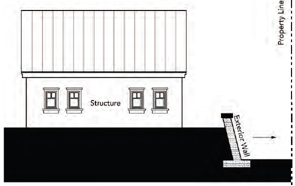
E.
"Hillside" means those net developable areas with existing slopes of over ten percent.
F.
"Interior retaining wall" means a retaining wall that faces a structure on a lot where the retaining wall is fully screened by said structure.
Figure 21.81.030-2: Interior Retaining Wall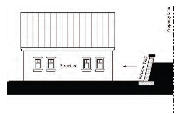
G.
"Mass grading" means the excavation or deposition (cut and fill) of soil across a parcel for the construction of multiple buildings or other improvements. Mass grading sometimes involves the movement of soil across existing or proposed property lines for the purpose of balancing the overall earthwork (the amount of cut and fill) on the site. Mass grading is often used for multiple parcels or pads.
H.
"Pad grading" means the excavation or deposition (cut and fill) of soil to create a relatively flat area on a single parcel for the construction of improvements.
(Ord. No. 1144 N.S., § 3(Exh. A), 10-1-2024)
21.81.040 - Hillside development standards.
A.
General Grading and Building Standards. The area of disturbance (defined in Subsection 21.81.030(A)) shall be limited to the developable area (defined in Section 21.41.070) of a lot.
B.
General Grading Standards.
1.
Grading shall be designed to minimize landform alteration to the extent feasible.
2.
Mass or pad grading is only allowed where it is necessary for the reasonable use of the property and shall be conducted in a manner consistent with the purpose and intent of this chapter, including Paragraph 21.81.040(B)1. and Subsection 21.81.040(C) (Structure Foundations on Slopes).
3.
Grading design shall be based on the concept of contour grading, where the existing landform is maintained or the natural landform pattern is replicated in the case of extensive grading.
4.
The crest of all graded slopes greater than six feet vertical height shall be rounded. Where graded slopes intersect, the ends of each slope shall be horizontally rounded and blended.
C.
Structure Foundations on Slopes. Except as allowed through approval of a modification consistent with Section 21.81.050 (Modification to Hillside Development Standards), foundations for structures and other accessory uses shall be subject to the following standards:
1.
Slopes of Less than Fifteen Percent. Individual pad grading is allowed where the area of disturbance has an existing slope less than fifteen percent.
2.
Slopes Fifteen—Thirty-Five Percent. Where the area of disturbance has an existing slope of between fifteen and thirty-five percent, pad grading is not allowed. Foundations shall incorporate special building techniques designed by a registered engineer or architect, including, but not limited to, split levels, benching, cantilevered, poles, piles, step and stem walls, and other methods designed to minimize soil disruption.
3.
Slopes of More than Thirty-Five Percent. No area of disturbance is permitted on an existing slope greater than thirty-five percent.
D.
Development Standards on Slopes.
1.
Graded Slopes and Retaining Walls.
a.
The maximum vertical height of a graded slope or combination of graded slope and the exposed face of any exterior or interior retaining wall shall not exceed the limits indicated in Table 21.81.040-1 (Slope and Retaining Wall Height).
Table 21.81.040-1: Slope and Retaining Wall Height
b.
The minimum distance required between multiple retaining walls shall be less than or equal to the height of the retaining wall as described in Table 21.81.040-1 (Slope and Retaining Wall Height) and as shown in Figure 21.81.040-1 (Minimum Distance Between Multiple Retaining Walls).
c.
Retaining walls to create building pads shall be constructed of masonry material, textured concrete, or similar material as determined by the review authority.
d.
Setbacks from property lines to graded slopes and retaining walls shall be consistent with the California Building Code.
Figure 21.81.040-1: Minimum Distance Between Multiple Retaining Walls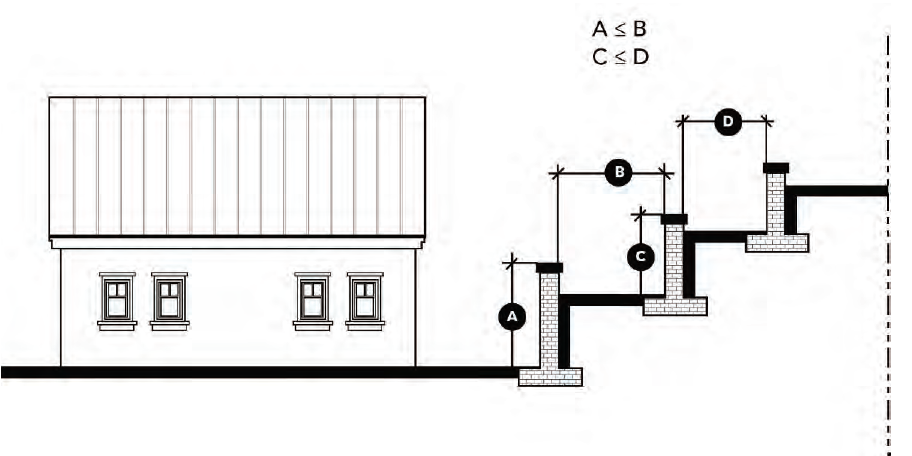
2.
Stem Walls. The exposed face of a building stem wall shall not exceed nine feet in average height and shall consist of a decorative surface finish compatible with the building architecture or natural hillside character.
3.
Roof Materials. Roofing shall be fire-retardant and shall be neither white nor reflective.
4.
Outdoor Flat Area or Deck for Single-Family Residential Structures. Development of new single-family residences shall include an unobstructed existing or manufactured (graded) area of at least ten feet in depth for the length of a building with a slope not more than five percent. Where the structure is designed to be built into the existing slope, this requirement may be met by providing either a five-foot-wide manufactured area no less than the full width of the dwelling unit, or a deck at least ten feet in depth and no less than the full width of the dwelling unit. The underside of a deck that is three feet or higher above grade shall be screened.
5.
Landscaping. In addition to the standards of Chapter 21.45 (Landscaping and Open Space), landscaping in hillside areas shall comply with the following.
a.
Protection and Use of Existing Vegetation. Development shall protect and retain existing vegetation to the maximum extent possible. Existing groundcover and shrubs shall not be removed from lands with steep slopes (thirty-five percent or greater) unless necessary for weed abatement to remove fire hazards. When groundcover is removed on any slope, it shall be replaced with other vegetation. Existing groundcover shall be protected from damage during construction.
b.
New Landscaping. All development shall provide new landscaping as follows:
i.
Erosion Control. All graded slopes or slopes cleared of vegetation shall be landscaped with groundcover or other vegetation designed to retain the slope and to mitigate the visual impacts associated with bare ground.
ii.
Architectural Enhancement. Trees and shrubs shall be planted to provide screening under decks, along walls, and as accent features.
iii.
Street Trees. Street trees shall be planted as required by Title 10 (Vegetation).
iv.
Trees on Graded Slopes. Trees shall be planted within the landscaping on graded slopes at a rate of at least one tree per one thousand square feet of graded slope.
v.
Irrigation. All landscaping required for erosion control, trees, and architectural enhancement shall be irrigated. Irrigation design shall be in compliance with Chapter 21.56 (Water Efficient Landscaping).
vi.
Plant Species. New landscaping shall incorporate plant species that meet the following criteria:
(a)
Planting within thirty feet of buildings shall be fire-ignition resistant to the satisfaction of the fire marshal.
(b)
In compliance with Chapter 21.56 (Water Efficient Landscaping).
(c)
Non-invasive.
(Ord. No. 1144 N.S., § 3(Exh. A), 10-1-2024)
_____
21.81.050 - Modification to hillside development standards.
A.
Allowed Modifications. Modifications to hillside development standards may be allowed through a special planned development (Chapter 21.11), development plan modification (Section 21.16.020), or site plan modification (Section 21.17.020) process. Table 21.81.050-1 (Hillside Modifications) outlines standards for which modifications may be requested.
Table 21.81.050-1: Hillside Modifications
B.
Modification Findings. In addition to the findings associated with the application (Section 21.11.060 [Special Planned Development]; Subsection 21.16.020(D) [Development Plan Modification]; Subsection 21.17.010(C) [Site Plan Modification]), all of the following findings can be made:
1.
The modification preserves oak trees (as applicable); and
2.
The modification does not involve individual pads on slopes over thirty-five percent.
(Ord. No. 1144 N.S., § 3(Exh. A), 10-1-2024)
_____
21.81.060 - Creation of new lots.
A.
General Standards for New Lots. The following standards shall apply to lots created through a tract map, parcel map, or reconfiguration of existing lots by a lot line adjustment:
1.
No new lots shall be created that would necessitate locating the area of disturbance on existing slopes with an average of more than thirty-five percent.
2.
The graded slopes and/or retaining walls between two adjacent lots shall be constructed on the lower lot; and
3.
Between two adjacent lots, the property lines shall be located at the top of slopes.
B.
Development Plan Modification for Multiple Slope Categories. An application for a development plan modification (Section 21.16.020) may be submitted where a proposed tentative tract map includes areas that fall under several slope categories, and one or more of these areas are relatively small or narrow, to allow the application of standards applicable to the nearest predominant slope category rather than strict compliance with the minimum lot size and depth requirements (Table 21.33.030-1 [Development Standards for R-A, R-1, and R-1 Combining Districts]) if, in addition to the findings of Subsection 21.16.020(D), the review authority finds the modification would not result in a subdivision with non-uniform lot areas or non-orderly development.
(Ord. No. 1144 N.S., § 3(Exh. A), 10-1-2024)
21.82.010 - Purpose and applicability.
A.
Purpose. This chapter is intended to minimize artificial light that may have a detrimental effect on the environment and enjoyment of the night sky. These provisions are also intended to reduce the unnecessary illumination of adjacent properties and the use of energy and meet the minimum requirements of the California Code of Regulations for Outdoor Lighting and Signs (Title 24, Chapter 6). Outdoor lighting shall be designed, installed and maintained to be an integral part of the built environment, reflecting a balance for lighting needs with the contextual ambient light level and surrounding nighttime characteristics of the community.
B.
Applicability. The standards of this chapter apply to the following development projects:
1.
New Construction. All new or replacement of exterior light fixtures or systems.
2.
Nonconforming Lighting. Replacement of nonconforming light fixtures and light systems shall be required in the following circumstances:
a.
Commercial Additions and Remodels. All building permits with a valuation more than the amount described in Paragraph 11.12.030(A)1. for requirement of frontage improvements shall bring existing exterior lighting into conformance with the provisions of this chapter. In the event that the improvements are for a single tenant in a multi-tenant center, the zoning administrator shall determine a proportionate share of exterior lights to be replaced with the building permit.
b.
Residential Additions and Remodels. Additions totaling fifty percent or more of the existing gross floor area of a structure or alterations affecting fifty percent or more of existing gross floor area shall bring existing exterior lighting into conformance with the provisions of this chapter.
3.
Exemptions. The following light sources are exempt from the standards of this chapter:
Temporary construction lighting necessary for an allowed use are exempt except that permanent installations at dedicated sites shall conform to the requirements of this chapter;
Sports fields;
Temporary holiday lighting; and
Similar lighting types as determined by the zoning administrator.
4.
Other laws or ordinances may require minimum illumination levels for specific applications and may conflict with these regulations. In such cases, those laws or ordinances shall govern.
C.
Application Materials. All development applications shall include sufficient information to enable the zoning administrator to determine whether the proposed and existing lighting complies with the provisions of this chapter. For projects requiring a development plan (Subsection 21.16.010(B)), the application shall include the following:
1.
A site plan indicating the proposed location of all outdoor lighting fixtures;
2.
A description of each illuminating device, fixture, lamp, support, and shield. This description may include, but is not limited to, manufacturer's catalog cuts and drawings (including sections where required), lamp types, lumen outputs, and kelvin rating/scale;
3.
Photometric plans depicting the location of all light poles and building-mounted lighting fixtures and a maximum ten-foot by ten-foot grid of both the initial and maintained lighting levels on the site, and including impact on adjacent properties;
4.
The project lighting plan shall be coordinated with any associated landscaping plan to prevent site planning conflicts; and
5.
Any other information the zoning administrator may determine is necessary to ensure compliance with the provisions of this chapter.
(Ord. No. 1144 N.S., § 3(Exh. A), 10-1-2024)
21.82.020 - Lighting standards.
A.
Maximum Height.
1.
Within one hundred feet of a residential zoning district: Sixteen feet.
2.
Other Locations: Twenty-five feet.
B.
Design of Fixtures. Outdoor lighting fixtures, either wall mounted or light standards, shall be appropriate to the style and scale of the architecture of the building. Fixtures on buildings shall be attached only to walls or eaves, and the top of the fixture shall not exceed the height of the parapet, roof, or eave of the roof.
C.
Commercial/Industrial Lighting. Fixtures shall be fixed in position.
D.
Timing Controls. All outdoor lighting in nonresidential development shall be on a time clock or photo-sensor system and turned off during daylight hours and during hours when the building or, in the case of shopping centers, all buildings, are not in use. Security lighting shall utilize motion sensors to reduce light intensity or turn lights off when no motion is detected.
E.
Patio Lights. Commercial string lights and other patio lighting shall be turned off no more than thirty minutes after close of business.
F.
Light Trespass. All lights shall be directed, oriented, and shielded to prevent light trespass or glare onto adjacent properties. The light level at property lines shall not exceed 0.3 foot-candle.
G.
Up Lighting. Up-lighting (lighting directed higher than ninety degrees from the ground) is prohibited.
H.
Lighting Shielded.
1.
All outdoor lighting shall be Dark-Sky compliant or equivalent. Light sources shall be designed and adjusted to direct light away from any road or street and away from any property or buildings outside the ownership of the applicant.
2.
Outdoor lighting shall be shielded so that the light source is not visible from off-site. Shielding shall be at least two inches in dimension measured from the lens or light source to direct light toward buildings or the ground and reduce glare.
Figure 21.82.020-1: Light Shielding Dimensions
I.
Parking Lot Lighting.
1.
Lighting Level. Parking lot lighting shall not exceed the levels needed to provide low level safety lighting for parking lot areas, as demonstrated by photometric plans.
2.
Motion Sensors. Lighting shall be on motion sensors to minimize lighting when not in use.
J.
Lighting Color (Chromaticity). All outdoor lighting shall utilize light sources with correlated color temperature not to exceed three thousand Kelvin (K).
K.
Flashing. Outdoor lighting shall not blink, flash, or rotate.
(Ord. No. 1144 N.S., § 3(Exh. A), 10-1-2024)
21.82.030 - Modification to lighting standards.
A.
General. Modifications to lighting standards may be allowed through a development plan modification (Section 21.16.020). An application for a development plan modification (Section 21.16.020) shall set forth all actions taken to comply with this chapter, the reasons why compliance cannot be achieved, and a proposed method for achieving alternative compliance.
B.
Findings and Decision.
1.
Decision and Conditions. The planning commission may grant or deny the application for a development plan modification to lighting standards. If approved, the modification may be for a limited period and may be subject to any other terms, conditions, and requirements as the planning commission may deem reasonable to achieve maximum compliance with the provisions of this chapter. Such terms, conditions and requirements may include, but shall not be limited to, limitations on lighting levels and operating hours.
2.
Findings. In approving such a request, the review authority shall consider whether the lighting modification meets a unique security need and/or serves a community-wide purpose, and shall make the findings required for a development plan modification (Subsection 21.16.020(D)).
(Ord. No. 1144 N.S., § 3(Exh. A), 10-1-2024)
21.83.010 - Purpose and applicability.
The purpose of this chapter is to provide standards to regulate excessive, unnecessary, and annoying noise from all sources within the city subject to the city's police power.
(Ord. No. 1144 N.S., § 3(Exh. A), 10-1-2024)
21.83.020 - Findings.
The city council finds:
A.
The making and creation of excessive, unnecessary, and annoying noises within the limits of the city is a condition which has existed for some time and the extent and volume of such noises is increasing;
B.
Excessive, unnecessary, or annoying noise within the city is detrimental to the public health, safety, welfare, and the peace and quiet of the inhabitants of the city;
C.
Every person in the city is entitled to live in an environment free from excessive, unnecessary, or annoying noise levels;
D.
Noise is recognized as an inherent by-product of many land uses and the economic base of the city is protected by preventing the encroachment of noise-sensitive land uses into areas affected by existing noise-producing uses;
E.
Concerts and tourism-related events contribute to the vitality and character of the city and balancing the acoustical requirements of both residents and such businesses and events is of vital importance to the city; and
F.
The establishment of maximum permissible noise levels will further the public health, safety, welfare, peace, and quiet of city inhabitants.
(Ord. No. 1144 N.S., § 3(Exh. A), 10-1-2024)
21.83.030 - Definitions.
The following words, phrases and terms as used in this chapter shall have the following meanings: "Ambient noise level" means the all-encompassing noise level associated with a given environment, being a composite of sounds from all sources, excluding the alleged offensive noise, at the location and approximate time at which a comparison with the alleged offensive noise is to be made.
"A-weighting" means a frequency-response adjustment of a sound level meter that conditions the output signal to approximate human response. All noise level measurements and noise standards associated with this noise element are provided in terms of A-weighted sound levels.
"Decibel" or "dB" means fundamental unit of sound, defined as ten times the logarithm of the ratio of the sound pressure squared over the reference pressure squared.
"Emergency work" means the use of any machinery, equipment, vehicle, manpower, or other activity in an effort to protect, maintain, provide, or restore safe conditions in the community or for citizenry, or work by private or public utilities when restoring utility service.
"Fixed noise source" refers to sources of noise occurring on private property that are not regulated at the local level. They may be fixed in a certain position or mobile on the private property, but do not include mobile vehicles on public roadways, railroad, or aircraft operations. For example, the city cannot regulate how much noise a car on a public roadway can generate, as such levels are regulated at the state level. However, the city can regulate the level of noise that is generated on private property as it affects other properties. Traffic on public roadways, railroad operations, and aircraft in flight cannot be regulated at the local level.
"Frequency" means the measure of the rapidity of alterations of a periodic acoustic signal, expressed in cycles per second or hertz.
"Hertz" means the unit of measurement of frequency, numerically equal to cycles per second.
"Leq" means equivalent or energy-averaged sound level.
"L max" means the highest root-mean-square (RMS) sound level measured over a given period of time.
"Loudness" means a subjective term for the sensation of the magnitude of sound.
"Noise" means unwanted sound.
"Sensitive outdoor areas" means the primary outdoor activity area associated with any given land use at which noise-sensitivity exists and the location at which the city's exterior noise level standards are applied. Additional definitions of sensitive areas of various residential uses follow.
"Sensitive areas of single-family residential uses" is normally considered to be back yards or distinct rear patio/deck areas. Front yard spaces may be identified as the sensitive exterior area if there are no other clearly identifiable private outdoor activity areas proposed as part of the residential property. Elevated balconies front courtyards, front decks, side yards, etc., are not commonly considered to be sensitive outdoor activity areas. Where the location of outdoor activity areas for large lot residential properties cannot be determined, the city's exterior noise level standards shall be applied within fifty feet of the rear of the residence.
"Sensitive areas of multi-family residential uses" means common outdoor recreation areas, such as pools, tot-lots, tennis courts, etc., of multi-family uses are considered to be the sensitive outdoor area. Individual patios and balconies of multi-family developments are not considered to be sensitive outdoor areas.
"Sensitive areas of residential component of mixed-use developments" means mixed use developments will commonly consist of residential units on elevated floors above office or commercial uses. As a result, such uses may not include a clearly delineated sensitive outdoor area, in which case satisfaction with the city's interior noise level standards will be considered adequate. The exterior noise standards for the residential component of mixed-use developments shall not be applied to patios or balconies facing the noise source (i.e. street).
"Sensitive areas of nonresidential uses" means the noise sensitive area of nonresidential uses should be evaluated on a case-by-case basis. For example, the exterior areas surrounding hospitals, schools, and office buildings are not commonly considered to be noise-sensitive, whereas the interior spaces of such uses are noise sensitive. The noise standards contained in Tables 21.83.060-1 (Exterior Noise Standards for Locally Regulated [Non-Transportation] Noise Sources) and Table 21.83.080-1 (Noise Standards for Outdoor Venues Generating Amplified Music or Speech) should only be applied to locations within a proposed use where noise sensitivity can be demonstrated.
"Simple tone noise" or "pure tone noise" means a noise characterized by the presence of a predominant frequency or frequencies such as might be produced by whistle or hum.
"Sound level meter" means an instrument meeting American National Standard Institute's Standard S1.4-1971 for type 1 or 2 sound level meters or an instrument and the associated recording and analyzing equipment which will provide equivalent data.
"Sound pressure level" means a sound pressure level of a sound, in decibels, as defined in ANSI Standards 51.2-1962 and 51.13-1921; that is, twenty times the logarithm to the base 10 of the ratio of the pressure of the sound to a reference pressure, which reference pressure shall be explicitly stated.
(Ord. No. 1144 N.S., § 3(Exh. A), 10-1-2024)
21.83.040 - General noise regulations.
Notwithstanding any other provisions of this chapter and in addition thereto, it is unlawful for any person to willfully make or continue or cause to be made or continued any excessive, unnecessary, or offensive noise levels, which disturbs the peace and quiet of any neighborhood or which causes discomfort or annoyance to any reasonable person of normal sensitivity residing in the area.
The standards that shall be considered in determining whether a violation of the provisions of this chapter exists shall include, but not be limited to, the following:
A.
The sound level of the objectionable noise;
B.
The sound level of the ambient noise;
C.
The proximity of the noise to residential uses;
D.
The nature and zoning of the area within which the noise emanates;
E.
The density of the inhabitation of the area within which the noise emanates;
F.
The time of day or night the noise occurs;
G.
The duration of the noise and its tonal informational or musical content;
H.
Whether the noise is continuous, recurrent or intermittent; and
I.
Whether the noise is produced by a commercial or noncommercial activity.
(Ord. No. 1144 N.S., § 3(Exh. A), 10-1-2024)
21.83.050 - Sound level measurement generally.
A.
Any noise level measurements made pursuant to the provisions of this chapter shall be performed using a sound level meter as defined herein with the A-weighting network under the "slow" meter response. The meter shall be calibrated immediately prior to use and fitted with a wind screen.
B.
The location selected for measuring exterior noise levels shall be at the location identified as having exterior noise sensitivity as defined above. Where feasible, the microphone shall be at a height of five feet above ground level and shall be at least five feet from walls or similar reflecting surfaces. In the case of interior noise measurements, the windows shall be closed and the measurement shall be made at a point at least five feet from the wall, ceiling, or floor nearest the affected occupied area.
(Ord. No. 1144 N.S., § 3(Exh. A), 10-1-2024)
_____
21.83.060 - Exterior and interior noise standards.
A.
The noise standards contained in Table 21.83.060-1 (Exterior Noise Standards for Locally Regulated [Non-Transportation] Noise Sources) below, unless otherwise specifically indicated in this chapter, shall apply to all noise-sensitive exterior and interior areas within the city.
B.
It is unlawful for any person at any location within the city to create any noise which causes the noise levels on an affected property, when measured in the designated sensitive exterior or interior location, to exceed the noise standards specified below in Table 21.83.060-1 (Exterior Noise Standards for Locally Regulated [Non-Transportation] Noise Sources) and the noise standards contained in Tables N, 1, and 2 in the noise element of the general plan.
Table 21.83.060-1: Exterior Noise Standards for Locally Regulated (Non-Transportation) Noise Sources
Specific Notes:
1.
Noise sensitive areas are defined acoustic terminology section.
2.
Interior noise level standards are applied within noise-sensitive areas of the various land uses, as defined in the acoustic terminology section, with windows and doors closed.
3.
Daytime hours = 7:00 a.m. to 7:00 p.m., evening hours = 7:00 p.m. to 10:00 p.m., nighttime hours = 10:00 p.m. to 7:00 a.m.
4.
Lmax = Highest measured sound level occurring during a given interval of time (Typically one hour).
5.
Leq = Average or "Equivalent" noise level during the worst-case hour in which the building is in use.
6.
Hospitals are often noise-generating uses. The exterior noise level standards for hospitals are applicable only at clearly identified areas designated for outdoor relaxation by either hospital staff or patients.
7.
Exterior areas of school uses are not typically noise-sensitive. As a result, the standards for schools are focused on the interior office and classroom spaces.
General Notes Applicable to All Noise Standards and Land Uses:
a.
Where the noise source in question consists of speech or music, or is impulsive in nature, or contains a pure tone, the noise standards of this table are reduced by five dB.
b.
Where ambient noise levels exceed the noise level standards shown above, the noise standards shall be increased in five dBA increments to encompass the ambient.
c.
Reductions in the noise standards for noise sources identified in general note "A" above shall be applied after any increases warranted by elevated ambient conditions prescribed in general note "B," subject to verification through a noise study.
_____
C.
Due to variations in types of both noise-generating and noise-sensitive land uses, as well as variations in ambient conditions in the city, the city shall have the ability to set noise standards up to five dBA higher or lower than the Table 21.83.060-1 (Exterior Noise Standards for Locally Regulated [Non-Transportation] Noise Sources) standards if determined appropriate by the planning commission and/or zoning administrator.
(Ord. No. 1144 N.S., § 3(Exh. A), 10-1-2024)
21.83.070 - Noise standards applicable to short-term rentals.
Persons utilizing short-term rentals pursuant to Chapter 21.64 (Short-Term Rentals) shall not exceed the noise standards of Table 21.83.060-1 (Exterior Noise Standards for Locally Regulated [Non-Transportation] Noise Sources) at the noise-sensitive areas of any land uses located within the city.
(Ord. No. 1144 N.S., § 3(Exh. A), 10-1-2024)
21.83.080 - Noise standards specifically applicable to outdoor music venues and events.
The following policy is intended to provide event operators the ability to continue to operate while remaining cognizant of the sensitivity of residential and other noise-sensitive receptors located within the city.
A.
The Table 21.83.060-1 (Exterior Noise Standards for Locally Regulated [Non-Transportation] Noise Sources) standards shall apply to existing and proposed venues where amplified music and speech would occur.
B.
For venues within the city's jurisdiction that have been the subject of repeated, legitimate (verifiable) noise complaints, the city shall reserve the right to require ongoing noise monitoring and reporting. Where such reporting indicates that venues existing at the time of adoption of the ordinance from which this title is derived are exceeding the Table 21.83.080-1 (Noise Standards for Outdoor Venues Generating Amplified Music or Speech) noise standards, or venues established after the adoption of the ordinance are exceeding the Table 21.83.080-1 (Noise Standards for Outdoor Venues Generating Amplified Music or Speech) standards, the city shall have the authority to impose sanctions upon the operator, including revocation of use permits.
Table 21.83.080-1: Noise Standards for Outdoor Venues Generating Amplified Music or Speech
Notes:
1.
Leq = Average or "Equivalent" noise level. Represents the energy average of all noise occurring during a given period (typically one hour).
2.
Lmax = Highest measured sound level occurring during a given interval of time (Typically one hour).
3.
Operations of the Mid-State Fairgrounds are not subject to control by the city of Paso Robles. As a result, the mixing booth sound levels are identified as voluntary for this venue. It should be noted, however, that measurements of concert sound at this venue indicated substantial conformity to the mixing booth target levels.
4.
Studies have shown that compliance with the mixing booth sound target levels has resulted in compliance with the Table 21.83.080-1 (Noise Standards for Outdoor Venues Generating Amplified Music or Speech) noise standards at the nearest sensitive receptors during events at the Vina Robles Amphitheater.
5.
Concerts related to events held at the Downtown City Park are subject to obtaining a permit from the city and are exempt from the provisions of this noise element provided they adhere to the city permit conditions.
6.
The mixing booth location is generally defined as being approximately one hundred feet in front of the stage, but this location can vary by venue.
(Ord. No. 1144 N.S., § 3(Exh. A), 10-1-2024)
_____
21.83.090 - Prohibited noise disturbances.
Notwithstanding any of the provisions of this chapter, including full compliance with Table 21.83.060-1 (Exterior Noise Standards for Locally Regulated [Non-Transportation] Noise Sources) and Table 21.83.080-1 (Noise Standards for Outdoor Venues Generating Amplified Music or Speech), the following acts are prohibited within the city, subject to the exceptions cited in this chapter:
A.
Radio, Television Sets, Musical Instruments, and Similar Devices. Operating, playing, or permitting the operation or playing of any radio, stereo, television set, audio equipment, electronic equipment, drum, musical instrument, or device which produces or reproduces sound at any time of day plainly audible over background ambient conditions at a distance of one hundred feet from such device. This section does not apply to places of public entertainment or to events for which a lawful permit has been obtained, provided that the activities producing sound are being conducted in compliance the permit.
B.
Animals. The keeping of any animal or bird, as pet or livestock, which causes noise so loud, so frequently, and continued over so long a period as to deprive persons residing in two or more separate residences in the neighborhood of the comfortable enjoyment of their home. For the purposes of this subsection, the animal noise shall not be deemed a disturbance or nuisance if the noise is in response to a person trespassing or threatening to trespass upon private property in or upon which the animal is situated or if the noise is in response to someone teasing or provoking the animal.
C.
Private Alarm Systems. Sounding or permitting the sounding of any exterior burglar or fire alarm or any motor vehicle burglar alarm unless such alarm is terminated within five minutes of activation.
D.
Loading and Unloading. Loading, unloading, opening, closing or other handling of boxes, crates, containers, building materials, garbage cans, or similar objects between the hours of 9:00 p.m. and 6:00 a.m. in such a manner as to cause a noise disturbance within a noise-sensitive area.
E.
Private Parties. Any noise, commotion or sound resulting from a party between the hours 10:00 p.m. and 7:00 a.m. Sunday through Thursday and 12:00 a.m. and 7:00 a.m. Friday and Saturday that creates sound determined by either code enforcement of city peace officers to be excessive for the time and location, or determined to be in violation of the Table 28.83.060-1 (Exterior Noise Standards for Locally Regulated [Non-Transportation] Noise Sources) standards of this chapter. For purposes of this section, "party" means a gathering for social or entertainment purposes at a private residence or other location but does not include sound generated by a valid commercial use such as a bar or restaurant that is in compliance with all other applicable requirements of local regulations.
F.
Vibration. Operating or permitting the operation of any device that creates a vibration which is above the vibration perception threshold of an individual at any sensitive location if the source is on private property or at one hundred fifty feet from the source if on a public space or public right-of-way.
(Ord. No. 1144 N.S., § 3(Exh. A), 10-1-2024)
21.83.100 - Exemptions.
The following sources of noise shall be exempt from the provisions of this chapter:
A.
Emergency warning devices and equipment operated in conjunction with emergency situations, such as sirens and emergency generators that are activated during power outages. The routine testing of such warning devices and equipment, including generators, is also exempt provided such testing occurs during daytime hours.
B.
All activities occurring at public schools and public school playgrounds and sporting fields, as such activities are not regulated at the local level.
C.
Activities at private schools, parks, or playgrounds, provided such activities occur during daytime hours (7:00 a.m. to 10:00 p.m.).
D.
Activities associated with special events approved by the city.
E.
Construction and demolition activities located within one thousand feet of noise-sensitive land uses provided they occur during normal daytime hours, excluding Sundays and federal holidays, subject to the conditions imposed by city permit. For construction activities, daytime hours are defined as 7:00 a.m. to 7:00 p.m. Construction activities occurring between the hours of 7:00 p.m. and 7:00 a.m. must comply with the interior noise level standards identified in Table 21.83.060-1 (Exterior Noise Standards for Locally Regulated [Non-Transportation] Noise Sources) unless an exception has been granted by the Department. An exception for concrete pours or other construction activities requiring an early morning start time may be authorized by the zoning administrator.
F.
Construction and demolition activities located beyond one thousand feet of noise-sensitive land uses, subject to the conditions imposed by city permit. For construction activities, daytime hours are defined as 7:00 a.m. to 7:00 p.m.
G.
When an unforeseen or unavoidable condition occurs during a construction project and the nature of the project necessitates that work in process be continued until a specific phase is completed, the contractor or owner shall be allowed to continue work outside of the hours delineated above and to operate machinery and equipment necessary until completion of the specific work in progress can be brought to conclusion under conditions which will not jeopardize inspection acceptance or create undue financial hardships for the contractor or owner.
H.
In the event of an emergency involving agricultural activities that requires prompt action to protect crops or equipment, the city can exempt noise generated by such action from the provisions of this chapter.
I.
Noise sources associated with agricultural operations in zones permitting agricultural uses.
J.
Noise sources associated with maintenance of residential area property, provided said activities take place between the hours of 7:00 a.m. and 8:00 p.m. on any day except Saturday or Sunday, or between the hours of 9:00 a.m. and 5:00 p.m. on Saturday or Sunday. Otherwise, the noise standards of Table 21.83.060-1 (Exterior Noise Standards for Locally Regulated [Non-Transportation] Noise Sources) shall apply.
K.
Noise generated by persons authorized to engage in waste disposal service or garbage collection, including any truck-mounted waste or garbage loading and/or composting equipment, or similar mechanical device.
(Ord. No. 1144 N.S., § 3(Exh. A), 10-1-2024)
21.83.110 - Administration.
The zoning administrator shall be responsible for:
A.
Employing individuals trained in acoustical engineering or an equivalent field to assist the zoning administrator in the administration of this chapter;
B.
Training field inspectors;
C.
Procuring measuring instruments and training inspectors in their calibration and operation;
D.
Conducting a public education program in all aspects of noise control; and
E.
Coordinating the noise ordinance with other governmental agencies.
(Ord. No. 1144 N.S., § 3(Exh. A), 10-1-2024)
21.83.120 - Modification to noise standards.
A.
General. Modifications to noise standards may be allowed through a development plan modification (Section 21.16.020). An application for a development plan modification (Section 21.16.020) shall set forth all actions taken to comply with this chapter, the reasons why immediate compliance cannot be achieved, a proposed method for achieving compliance, and a proposed time schedule for its accomplishment.
B.
Findings and Decision.
1.
Decision and Conditions. The planning commission may grant or deny the application for a development plan modification to noise standards. If approved, the modification may be for a limited period and may be subject to any other terms, conditions, and requirements as the Planning commission may deem reasonable to achieve maximum compliance with the provisions of this chapter. Such terms, conditions and requirements may include, but shall not be limited to, limitations on noise levels and operating hours.
2.
Findings. In addition to the findings of Subsection 21.16.020(D) for a development plan modification, in deciding whether to grant a modification, the review authority shall consider all facts relating to whether strict compliance with the requirement of this chapter will cause practical difficulties, unnecessary hardship or unreasonable expense and any other relevant considerations including, but not limited to, the fact that a noise generator in question commenced operations prior to the existence of a noise-sensitive use affected by noise from such facility. The review authority shall consider the magnitude of nuisance caused by the offensive noise, the uses of property within the area affected by the noise, the time factors related to study, design, financing and construction of remedial work, the economic factors related to age and useful life of equipment, and the general public interest and welfare.
(Ord. No. 1144 N.S., § 3(Exh. A), 10-1-2024)
21.83.130 - Violation.
The city will review the complaint and may investigate and assess whether the alleged noise levels exceed the noise standards set forth in this chapter. If the city has reason to believe that any provision(s) of this chapter has been violated, they may cause written notice to be served upon the alleged violator. Such notice shall specify the provision(s) of this chapter alleged to have been violated and the facts alleged to constitute a violation, including dBA readings noted and the time and place of their detection, and shall include an order that corrective action be taken within a specified time. If corrective action is not taken within such specified time or any extension thereof approved by the department, upon conviction, the violation shall constitute enforcement consistent with Title 1 (General Provisions) of this code.
(Ord. No. 1144 N.S., § 3(Exh. A), 10-1-2024)
21.83.140 - Other remedies.
A.
Provisions of this chapter are to be construed as an added remedy of abatement of the public nuisance declared and not in conflict or derogation of any other action, proceedings, or remedies provided by law.
B.
Any violation of the provisions of this chapter shall be, and the same is declared to be unlawful and a public nuisance, and the duly constituted authorities of the city shall, upon order of the city council, immediately commence actions or proceedings for the abatement or enjoinment thereof in the manner provided by law and shall take such steps and shall apply to such court or courts as may have jurisdiction to grant such relief as will abate such nuisance.
(Ord. No. 1144 N.S., § 3(Exh. A), 10-1-2024)
21.85.010 - Purpose and applicability.
A.
Purpose. This chapter establishes performance standards intended to guard against the use of any property or structure in any zoning district in any manner which would create any dangerous, injurious, noxious, or otherwise objectionable condition or element that adversely affects the health and safety of residents, the community, and the surrounding area and adjoining premises.
B.
Applicability. The minimum requirements in this chapter apply to all land uses in all zoning districts, unless otherwise specified.
(Ord. No. 1144 N.S., § 3(Exh. A), 10-1-2024)
21.85.020 - General performance standards for all uses.
A.
General Standard. Land and buildings shall not be used or occupied in a manner creating any dangerous, injurious, or noxious fire, explosive, or other hazard that would adversely affect the surrounding area.
B.
Measurement of Impacts. Measurements necessary for determining compliance with the performance standards of this chapter shall be taken at the property line of the establishment or use that is the source of a potentially objectionable condition, hazard, or nuisance.
C.
Fire and Explosion Hazards. All activities involving and all storage of inflammable and explosive materials shall be provided with adequate safety devices against the hazard of fire and explosion and adequate firefighting and fire-suppression equipment and devices standard in industry and as approved by the fire department. All incineration of inflammable and explosive materials is prohibited.
D.
Radioactivity or Electrical Disturbance. Devices which radiate radio-frequency energy shall be operated in a manner that does not cause interference with any activity carried on beyond the boundary line of the property upon which the device is located. Further, no radiation of any kind shall be emitted which is dangerous to humans. All radio transmissions shall occur in full compliance with Federal Communications Commission (FCC) and other applicable regulations.
E.
Vibration. No vibration shall be produced that is transmitted through the ground and is discernible without the aid of instruments by a reasonable person at the lot lines of the site. Vibrations from temporary construction, demolition, and vehicles that enter and leave the subject parcel (for example, construction equipment, trains, trucks, etc.) are exempt from this standard. Where vibration dampeners are proposed, project applications shall include an engineered study establishing the effectiveness of the dampeners based on actual conditions.
F.
Smoke. No emission shall be permitted at any point which would constitute a violation of standards established by the San Luis Obispo County Air Pollution Control District (APCD).
G.
Odors. Except for fireplaces and barbecues, no emission shall be permitted of odorous gases or other odorous matter in such quantities as to constitute a public nuisance.
H.
Fly Ash, Dust, Fumes, Vapors, Gases and Other Forms of Air Pollution. No emission shall be permitted which can cause damage to health, animals, vegetations or other forms of property, or which can cause any excessive soiling at any point. No emissions shall be permitted in excess of the standards established by the San Luis Obispo County Air Pollution Control District (APCD).
I.
Glare. No direct glare, whether produced by floodlight, high-temperature processes such as combustion or welding or other processes, so as to be visible from any boundary line of the property on which the same is produced shall be permitted. Sky-reflected glare from buildings or portions thereof shall be so controlled by reasonable means as are practical to the end that said sky-reflected glare will not inconvenience or annoy persons or interfere with the use and enjoyment of property in and about the area where it occurs. See also Chapter 21.82 (Lighting and Illumination).
J.
Liquid or Solid Wastes. No discharge shall be permitted at any point into any public sewer, private sewage disposal system or stream, or into the ground, of any materials of such nature or temperature as can contaminate any water supply, interfere with bacterial processes in sewage treatment, or otherwise cause the emission of dangerous or offensive elements, except in accord with standards approved by the California Department of Health or such other governmental agency as shall have jurisdiction over such activities. Manufacturing, processing, treatment and other activities involving use of toxic or hazardous materials shall be designed to incorporate the best available control technologies and wherever technically feasible shall employ a "closed loop" system of containment.
K.
Transportation Systems Impacts. Vehicular, bikeway and/or pedestrian traffic, directly attributable to the proposed land use, shall not increase to a significant extent without implementation of adequate mitigation measures in a form to be approved by the city engineer. In determining significance of impacts, consideration shall be given to cumulative (projected build-out) capacity of streets and highways serving the land use. Mitigation measures required may include but not be limited to curb, gutter, sidewalk, street and/or alley, bikeway, transit related improvements and traffic signalization. Mitigation may be required as pursuant to the California Environmental Quality Act (CEQA), or as a condition of a discretionary review.
(Ord. No. 1144 N.S., § 3(Exh. A), 10-1-2024)
21.86.010 - Purpose.
A.
This chapter is adopted pursuant to Section 2710 et seq. of the California Public Resources Code (Surface Mining and Reclamation Act of 1975), and to that end, the city council finds and declares that:
1.
Mineral extraction is essential to the continued economic well-being of the city and to the needs of the society, and that the reclamation of mined lands is necessary to prevent or minimize adverse effects on the environment and to protect the public health and safety.
2.
Reclamation of mined lands as provided in this chapter will permit the continued mining of minerals and will provide for the protection and subsequent beneficial use of the mined and reclaimed land.
3.
Surface mining takes place in diverse areas where the geologic, topographic, climatic, biological, and social conditions are significantly different and that reclamation operations and the specifications therefore may vary accordingly.
B.
The city is the lead agency for enforcing the State Surface Mining and Reclamation Act of 1975 (SMARA) regulations on all mining operations in the city, and is required to annually inspect each mining operation, ensure adequate financial assurances are secured for reclamation, and oversee mining and reclamation activities to the goals of the SMARA.
C.
It is the intent of the city to create and maintain an effective and comprehensive surface mining and reclamation policy to ensure that:
1.
Adverse environmental effects are prevented or minimized and that mined lands are reclaimed to a usable condition that is readily adaptable for alternate land uses.
2.
The production and conservation of minerals are encouraged while giving consideration to values relating to recreation, watershed, wildlife, range and forage, and aesthetic enjoyment.
3.
Residual hazards to the public health and safety are eliminated.
(Ord. No. 1144 N.S., § 3(Exh. A), 10-1-2024)
21.86.020 - Applicability.
A.
The provisions of this chapter shall apply to surface mining operations on public and private lands in the city, except as exempted in Subsection 21.86.020(B). Any applicable exemption does not automatically exempt a project or activity from the application of other regulations, ordinances, or policies of the city, including the application of the California Environmental Quality Act (CEQA), the requirement of a conditional use permit (CUP), the payment of development impact fees, or the imposition of other dedications and exactions as may be permitted under the law.
B.
The provisions of this chapter are not applicable to:
1.
Excavations or grading conducted for farming or for the purpose of restoring land following a flood or natural disaster.
2.
Onsite excavation and earthmoving activities that are an integral and necessary part of a construction project that are undertaken to prepare a site for construction of structures, including the related excavation, grading, compaction, or the creation of fills, road cuts, and embankments, provided all required permits for the improvements have been approved by the city in accordance with applicable provisions of state law and city plans and ordinances, including, but not limited to, the California Environmental Quality Act (CEQA), as specified in California Public Resources Code Section 2714(b)(1)—(4).
3.
Operation of a mineral processing site, including associated on-site structures, equipment, machines, tools, or other materials, including onsite stockpiling and onsite recovery of mined materials, subject to all of the following conditions:
a.
The plant site is located on lands appropriately designated in the general plan and zoned for mineral processing;
b.
None of the minerals being processed are extracted on-site; and
c.
All reclamation work has been completed pursuant to the approved reclamation plan for any mineral extraction activities that occurred on-site after January 1, 1976.
4.
Prospecting for and extraction of minerals for commercial purpose and the removal of overburden where total amounts are less than one thousand cubic yards in any one location of one acre or less.
5.
Surface mining operations that are required by federal law in order to protect a mining claim, if such operations are conducted solely for that purpose.
6.
Any other mining operations that the state mining and geology board determines to be of an infrequent nature, and which involve only minor surface disturbances.
7.
Surface mining operations and emergency excavations or grading conducted by the California Department of Water Resources or the Reclamation Board as specified in California Public Resources Code Section 2714(i)(1).
8.
Excavations or grading for the exclusive purpose of obtaining materials for roadbed construction and maintenance conducted in connection with timber operations or forest management on land owned by the same person or entity. This exemption is limited to excavation and grading that is conducted adjacent to timber operation or forest management roads and shall not apply to on-site excavation or grading that occurs within one hundred feet of a Class One watercourse or seventy-five feet of a Class Two watercourse, or to excavation for materials that are, or have been, sold for commercial purposes. This exemption shall be available only if slope stability and erosion are controlled in accordance with subdivision (f) of Section 3704 and subdivision (d) of Section 3706 of Title 14 of the California Code of Regulations (CCR) and, upon closure of the site, the person closing the site implements, where necessary, revegetation measures and post closure uses in consultation with the California Department of Forestry and Fire Protection.
9.
Excavations, grading, or other earthmoving activities in an oil or gas field that are integral to and necessary for ongoing operations for the extraction of oil and gas as specified in California Public Resources Code Section 2714(l).
10.
The immediate excavation or grading of lands affected by a natural disaster for the purpose of restoring those lands to their prior condition.
(Ord. No. 1144 N.S., § 3(Exh. A), 10-1-2024)
21.86.030 - Definitions.
A.
"Idle" means that an operator of a surface mining operation has curtailed production at the surface mining operation with the intent to resume the surface mining operation at a future date, for a period of twelve months or more by more than ninety percent of its maximum annual mineral production within any of the last five years during which an interim management plan has not been approved.
B.
"Surface mining" means the mining of minerals on lands by removing overburden and mining directly from the mineral deposits, open-pit mining of minerals naturally exposed, mining by the auger method, dredging and quarrying, or surface work incident to an underground mine. Surface mining operations shall include, but are not limited to, in-place distillation or retorting or leaching; the production and disposal of mining waste; and prospecting and exploratory activities.
C.
"Operator" means any person who is engaged in surface mining operations, or who contracts with others to conduct operations on his/her behalf, except a person who is engaged in surface mining operations as an employee with wages as his sole compensation.
D.
"Overburden" means soil, rock, or other materials that lie above a natural mineral deposit or in between mineral deposits, before or after their removal by surface mining operations.
E.
"Supervisor of mine reclamation" means the director of the Division of Mine Reclamation of the California Department of Conservation.
(Ord. No. 1144 N.S., § 3(Exh. A), 10-1-2024)
21.86.040 - Incorporation of SMARA and other state regulations.
The provisions of the SMARA (California Public Resources Code, Division 2, Chapter 9, Section 2710 et seq.), California Public Resources Code Section 2207, and the California Code of Regulations Section 3500 et seq.,) as those provisions may be amended from time to time, are made a part of this chapter by reference with the same force and effect as if the provisions therein were specifically and fully set out herein, excepting that when the provisions of this chapter are more restrictive than correlative state provisions, this chapter shall prevail.
(Ord. No. 1144 N.S., § 3(Exh. A), 10-1-2024)
21.86.050 - Mineral resource management policies.
California Public Resources Code Sections 2762, 2763 and 2764 and Chapter 14 California Code of Regulations Section 3676, and subsequent amendments regarding mineral classification studies and general plan resource management policies are incorporated into this chapter.
(Ord. No. 1144 N.S., § 3(Exh. A), 10-1-2024)
21.86.060 - Vested rights.
A.
No person who obtained a vested right to conduct surface mining operations prior to January 1, 1976, shall be required to secure a permit to mine, so long as the vested right continues and as long as no substantial changes have been made in the operation except in accordance with SMARA, state regulations, and this chapter. Where a person with vested rights has continued surface mining in the same area subsequent to January 1, 1976, that person shall obtain city approval of a reclamation plan covering the mined lands disturbed by such subsequent surface mining. In those cases where an overlap exists (in the horizontal and/or vertical sense) between pre- and post-SMARA mining, the reclamation plan, shall call for reclamation proportional to that disturbance caused by the mining after the effective date of the SMARA (January 1, 1976).
B.
All other requirements of state law and this chapter shall apply to vested mining operations.
(Ord. No. 1144 N.S., § 3(Exh. A), 10-1-2024)
21.86.070 - Required permit and approvals.
A.
A conditional use permit (CUP) shall be required for a surface mining operation that is determined not to be vested pursuant to Section 21.86.060 (Vested Rights), and shall be required for the expansion of a surface mining operation beyond the boundaries of the vested area.
B.
Except as provided in this chapter, no person shall conduct surface mining operations unless a reclamation plan has been submitted to and approved by, and financial assurances for reclamation have been approved by, the city.
(Ord. No. 1144 N.S., § 3(Exh. A), 10-1-2024)
21.86.080 - Process.
A.
Applications for a conditional use permit or reclamation plan for surface mining or land reclamation projects shall be made on forms provided by the zoning administrator and shall be submitted together in a single application. The forms for a reclamation plan application shall require, at a minimum, each of the elements required by the California Public Resources Code Sections 2772 and 2773, Article 1 (commencing with Section 3500), Article 9 (commencing with Section 3700) of Subchapter 1 of Chapter 8 of Division 2 of Title 14 of the California Code of Regulations, as applicable, and any other requirements determined necessary to facilitate an expeditious and fair evaluation of the proposed reclamation plan, to be established at the discretion of the zoning administrator.
B.
Within thirty days of determination of completeness of an application for a conditional use permit for surface mining operations and/or a reclamation plan as complete, the community development department shall submit the reclamation plan to the supervisor of mine reclamation for review and certify to the supervisor of mine reclamation that the reclamation plan is a complete submission that is consistent with this Chapter, the SMARA, Article 1 (commencing with Section 3500) and Article 9 (commencing with Section 3700) of Subchapter 1 of Chapter 8 of Division 2 of Title 14 of the California Code of Regulations, as applicable. The Supervisor shall have thirty days from the receipt of the reclamation plan to notify the city and operator if the submission does not meet the content requirements of California Public Resources Code Sections 2772, 2773, and 2773.3 and Article 1 (commencing with Section 3500) and Article 9 (commencing with Section 3700) of Subchapter 1 of Chapter 8 of Division 2 of Title 14 of the California Code of Regulations, as applicable, and is incomplete.
C.
The supervisor of mine reclamation shall have thirty days after the date of receipt of the reclamation plan to notify the city if the submission is incomplete and to prepare written comments on the reclamation plan if the supervisor chooses. The community development department shall prepare a written response to the supervisor's comments received describing the major issues raised by the comments. The community development department shall submit its response to the supervisor at least thirty days prior to the intended approval of the reclamation plan. The community development department's response shall either describe how the city proposes to adopt the supervisor's comments on the reclamation plan, or describe in detail the reasons why the city proposes not to adopt the supervisor's comments. The community development department shall promptly forward any written comments received and responses prepared by the community development department to the operator.
D.
Whenever mining operations are proposed in the one-hundred-year floodplain of any stream, as shown in Zone A of the flood insurance rate maps issued by the Federal Emergency Management Agency, and within one mile, upstream or downstream, of any state highway bridge, the community development department shall notify the state department of transportation that an application has been received. The department of transportation shall have a period of not more than forty-five days to review and comment on the proposed surface mining operations, and the city shall not issue or renew the permit until the department of transportation has submitted its comments or until forty-five days from the date the application for the permit was submitted, whichever occurs first.
E.
The community development department shall process the application through environmental review pursuant to the California Environmental Quality Act (CEQA) and the city's CEQA Guidelines.
F.
Subsequent to the appropriate environmental review, the community development department shall prepare a staff report with recommendations for consideration by the planning commission, which incorporates input from any other affected department or agency.
G.
The city shall give the supervisor of mine reclamation at least thirty days written notice of the time, place, and date of the hearing at which the reclamation plan is scheduled to be approved by the city, or, if no hearing is required, the city shall provide thirty days written notice to the supervisor that the city intends to approve the reclamation plan.
H.
The planning commission shall hold at least one noticed public hearing on the conditional use permit and/or reclamation plan.
I.
The city's review of reclamation plans is limited to whether the plan substantially meets the applicable requirements of California Public Resources Code Sections 2772, 2773.3 and Article 1 (commencing with Section 3500), Article 9 (commencing with Section 3700) of Subchapter 1 of Chapter 8 of Division 2 of Title 14 of the California Code of Regulations, as applicable, and this Chapter adopted pursuant to California Public Resources Code Section 2774(a)). Reclamation plans determined to substantially meet these requirements shall be approved by the city for the purposes of this chapter.
J.
The planning commission shall then take action to approve, conditionally approve, or deny the conditional use permit and/or reclamation plan, except where pre-empted by the California Public Resources Code. The planning commission's action shall be final, subject to appeal as provided in Chapter 21.25 (Appeals and Calls for Review).
K.
If a conditional use permit is being processed concurrently with the reclamation plan, the planning commission may also conceptually approve the conditional use Permit at this time. However, the planning commission may defer action on the conditional use Permit until taking final action on the reclamation plan. If necessary to comply with permit processing deadlines, the planning commission may conditionally approve the conditional use permit with the condition the community development department shall not release the mining operation for occupancy until financial assurances have been reviewed by the supervisor of mine reclamation and final action has been taken on the reclamation plan.
L.
Within thirty days following the approval of the reclamation plan, the city shall provide the supervisor of mine reclamation notice of the reclamation plan and conditional use permit approval. The city shall provide as soon as practicable, but no later than sixty days after approval of the reclamation plan, certified copies of all maps, diagrams, or calculations, signed and sealed.
M.
No later than sixty days after the approval of the reclamation plan, the city shall provide to the supervisor of mine reclamation an official copy of the approved reclamation plan. The official copy shall incorporate all approved modifications to the reclamation plan and shall include an index showing any permit conditions or approval or binding mitigation measures adopted or certified pursuant to CEQA that are necessary to meet the requirements of subdivision (c) of California Public Resources Code Section 2772, California Public Resources Code Sections 2773 and 2773.3, and Article 1 (commencing with Section 3500) and Article 9 (commencing with Section 3700) of Subchapter 1 of Chapter 8 of Division 2 of Title 14 of the California Code of Regulations, as applicable. Those conditions of approval and mitigation measures shall be included in an appendix to the reclamation and shall be considered part of the reclamation compliance requirements and subject to the annual inspection.
N.
The city, upon approval of a reclamation plan or an amendment to a reclamation plan, shall record a "notice of reclamation plan approval" with the county recorder. The notice shall read: "Mining operations conducted on the hereinafter described real property are subject to a reclamation plan approved by the city of El Paso de Robles, a copy of which is on file with the city clerk." The notice shall also include the name of the owner of record of the mine operation, the name of the city, and the acknowledged signature of the city representative. A copy of the final approved reclamation plan shall be kept on the mining site at all times.
(Ord. No. 1144 N.S., § 3(Exh. A), 10-1-2024)
21.86.090 - Findings for approval.
In addition to findings for the approval of conditional use permits (Section 21.19.050), approval for surface mining operations shall include a finding that the project complies with the provisions of state law and regulations.
A.
For reclamation plans, the following findings shall be made by the reviewing authority prior to approval:
1.
The reclamation plan and goals and potential use of reclaimed land pursuant to the plan are consistent with this chapter, the city's general plan, and zoning for the area.
2.
The reclamation plan complies with the purpose, intent, and requirements of this chapter.
3.
The project has been reviewed pursuant to CEQA, all adverse impacts related to the reclamation plan have been mitigated by the plan and/or the recommended condition(s) of approval, and the appropriate environmental determination has been adopted.
4.
The reclamation plan complies with the requirements of the State Surface Mining and Reclamation Act of 1975, specifically California Public Resources Code Sections 2772 and 2773, and the Reclamation Standards specified in California Code of Regulations Title 14, Division 2, Chapter 8, Subchapter 1, Article 9, Sections 3700 through 3713.
5.
The reclamation plan has been forwarded to the supervisor of mine reclamation, as prescribed in this chapter, and in accordance with California Public Resources Code Section 2772.1, including all applicable documentation required for submission as outlined in California Public Resources Code Section 2772.1.
6.
Through implementation of the reclamation plan, all significant adverse impacts on lands to be reclaimed as a result of the surface mining operations are mitigated to the maximum extent feasible;
7.
The land and/or resources to be reclaimed will be restored to a condition that is compatible with the surrounding environment;
8.
The reclamation plan and potential use of reclaimed land pursuant to the plan are consistent with any applicable air quality and/or water quality resources plan and/or that suitable off-site development will compensate for related disturbances to resource values existing after reclamation is completed;
9.
The reclamation plan will restore the mined lands to a usable condition which is adaptable for alternative land uses consistent with the general plan and any other applicable plan or element;
10.
A written response to the supervisor of mine reclamation has been prepared, describing the disposition of major issues regarding the reclamation plan raised by the supervisor. Where the city's position is at variance with the recommendations and objections raised by the supervisor, the city has prepared detailed responses regarding why specific comments and suggestions of the supervisor were not accepted.
(Ord. No. 1144 N.S., § 3(Exh. A), 10-1-2024)
21.86.100 - Phasing of reclamation.
A.
Reclamation activities shall be phased with respect to the phasing of the mining operation and shall be initiated at the earliest possible time on those portions of the mined lands that will not be subject to further disturbance. Interim reclamation may also be required for mined lands that have been disturbed and will be disturbed again in future operations if it is determined to be necessary to ensure the success of final reclamation or for health and safety purposes. Reclamation may be done on an annual basis, or in stages compatible with continuing operations, or on completion of all excavation, removal, or fill as approved by the city. Each phase of reclamation shall be specifically described in the reclamation plan and shall include: the approximate length of time for completion of each phase; all reclamation activities required; criteria for measuring completion of specific reclamation activities; and estimated costs as provided in Section 21.84.110 (Financial Assurances). The reclamation schedule shall be approved as part of the reclamation plan pursuant to Section 21.86.080 (Process).
(Ord. No. 1144 N.S., § 3(Exh. A), 10-1-2024)
21.86.110 - Financial assurances.
In order to ensure that reclamation will proceed in accordance with the approved reclamation plan, the city shall require, as a conditional of approval, one or more forms of security which will be released upon satisfactory performance. The applicant shall post security in the form of a corporate surety bond executed by an admitted surety insurer as defined in subdivision (a) of Section 995.120 of the Code of Civil Procedure, trust fund, irrevocable letter of credit from an accredited financial institution, a certificate of time deposit as part of an approved trust fund, or other method acceptable to the city and the department of conservation as specified by the state mining and geology board pursuant to California Public Resources Code Section 2773.1(e). Financial assurances shall be made payable to the city of El Paso de Robles and department of conservation. The financial assurances shall remain in effect for the duration of the surface mining operation and any additional period until reclamation is complete. The financial assurance cost estimates shall be submitted to the city for review on a form developed by the supervisor of mine reclamation and approved by the state mining and geology board.
Prior to approving the financial assurance cost estimate, the city shall submit the financial assurance cost estimate to the supervisor of mine reclamation for review. No later than fifteen days after receiving the estimate, the supervisor shall notify the city and the operator if the submission is incomplete. An incomplete submission is one that does not meet the content requirements of Section 2773.1, Article 11 (commencing with Section 3800) of Subchapter 1 of Chapter 8 of Division 2 of Title 14 of the California Code of Regulations, and the mining and geology board's financial assurance guidelines adopted pursuant to subdivision (f) of Section 2773.1. The supervisor shall specifically identify all aspects of the submission that are incomplete and shall have forty-five days from the date of receipt of the cost estimate to prepare written comments if the supervisor chooses to provide written comments.
The city shall evaluate written comments received from the supervisor of mine reclamation relating to the financial assurance cost estimate and submit written responses on the comments raised to the supervisor at least thirty days prior to the approval of the financial assurance cost estimate. The city's response shall include either a description of how the community development department proposes to adopt the supervisor's comments on the cost estimate, or a detailed description of the reasons why the community development department proposes to not adopt the supervisor's comments. Copies of the written comments received and responses prepared by the community development department shall be provided to the operator.
If the community development department proposes to not adopt the supervisor of mine reclamation's comments relating to the financial assurance cost estimate, the supervisor may within fifteen days of the city's written response request in writing a consultation with the city to discuss the supervisors comments and city's responses, which shall occur not later than thirty days after the supervisor's request for consultation. If the supervisor requests a consultation, the city shall not approve the financial assurance cost estimate until after consulting with the supervisor.
A.
The city shall give the supervisor of mine reclamation at least thirty days notice of the time, place, and date of the hearing before the city at which time the financial assurance is scheduled to be approved by the city. If no hearing is required, the city shall provide thirty days written notice to the supervisor that it intends to approve the financial assurance. The city shall send to the supervisor its final response to the supervisor's comments within thirty days following its approval of the financial assurance. Financial assurances shall be required to ensure compliance with elements of the reclamation plan including, but not limited to, revegetation and landscaping requirements; restoration of water bodies and water quality; slope stability and erosion and drainage control, disposal of hazardous materials; and other mitigation measures. Financial assurances for such elements of the reclamation plan shall be monitored by the community development department.
B.
Financial assurances shall not be released until written notification has been made by the zoning administrator to the mining operator and the supervisor of mine reclamation that reclamation has been completed in accordance with the approved reclamation plan, and the supervisor and city consent to the release of the financial assurance. The amount of financial assurances shall be based upon the estimated costs of reclamation for each year or phase stipulated in the reclamation plan, including any irrigation and maintenance of reclaimed areas as may be required. An operator shall be required to replace an approved financial assurance mechanism to bond for the reclamation of the surface mining operation only if the financial assurance cost estimate identifies a need to increase the amount of the financial assurance mechanism. Cost estimates shall be prepared by a licensed engineer and/or other qualified professionals retained by the operator; such estimates shall be approved by the zoning administrator. Financial assurances may be based upon estimates, including but not necessarily limited to, the volume of earth moved (cubic yards) for each year or phase of reclamation. Financial assurances to ensure compliance with revegetation, restoration of wildlife habitat, and any other applicable element of the reclamation plan shall be based upon cost estimates that include but may not be limited to labor, equipment, materials, mobilization of equipment, administration, and reasonable profit by a commercial operator other than the permittee.
C.
In projecting final costs of financial assurances, it shall be assumed without prejudice or insinuation that the surface mining operation could be abandoned by an operator and, consequently, the city or state may need to construct with a third-party commercial company for mobilization and reclamation on the site.
D.
Where reclamation is accomplished in annual increments, the amount of financial assurances required for any one year shall be adjusted annually and shall be adequate to cover the full estimated costs for reclamation of any land projected to be in a disturbed condition from mining operation by the end of the following year. The estimated costs shall be the amount required to complete the reclamation on all areas that will not be subject to further disturbance, and to provide interim reclamation, as necessary, for any partially excavated areas in accordance with the reclamation plan. Financial assurances for each year shall be released upon successful completion of reclamation (including any maintenance required) of all areas that will not be subject to further disturbance and upon the operator filing additional financial assurances for the succeeding year. Financial assurances for all subsequent years of the operation shall be handled in the same manner.
E.
Financial assurances for reclamation that is accomplished in multiple-year phases shall be handled in the same manner as described for annual reclamation.
F.
If a change of ownership occurs, the existing financial assurances remains in force until a replacement financial assurance is approved by the city.
(Ord. No. 1144 N.S., § 3(Exh. A), 10-1-2024)
21.86.120 - Interim management plans.
A.
Within ninety days of a surface mining operation becoming idle, the operator shall submit to the community development department an interim management plan. The interim management plan shall fully comply with requirements of California Public Resources Code Section 2770(h) and shall provide measures the operator will implement to maintain the site in compliance with SMARA, including, but not limited to, all conditions of the conditional use permit and/or reclamation plan approval. The interim management plan shall be processed as a minor revision to the reclamation plan pursuant to Section 21.86.150 (Revisions to Reclamation Plans), and shall not be considered a project for the purposes of CEQA. The interim management plan shall only provide for the necessary measures the operator will implement during its idle status to maintain the site in compliance with the SMARA, including, but not limited to, all permit conditions.
B.
The financial assurances required by Section 21.86.110 (Financial Assurances) shall remain in effect during the period that the surface mining operation is idle. If the operation is still idle after the expiration of its interim management plan, the operator shall commence reclamation in accordance with its approved reclamation plan.
C.
Within forty-five days of receipt of the interim management plan, the city shall review the interim management plan and determine if it is consistent with this chapter. If the interim management plan is consistent, the city shall forward the plan to the supervisor of mine reclamation for review and certify to the supervisor of mine reclamation that the interim management plan is a complete submission that is consistent with this Chapter, Article 1 (commencing with Section 3500), and Article 9 (commencing with Section 3700) of Subchapter 1 of Chapter 8 of Division 2 of Title 14 of the California Code of Regulations, as applicable. If the city determines that the interim management plan is inconsistent with this chapter, the city shall notify the operator in writing of any deficiencies in the plan. The operator shall have thirty days, or a longer period mutually agreed upon by the operator and the city, to submit a revised interim management plan.
D.
The supervisor of mine reclamation shall have thirty days after receipt to prepare written comments on the interim management plan, if he/she so chooses. The city shall review and evaluate written comments received from the supervisor related to the interim management plan, prepare a written response to the supervisor's comments describing the disposition of the major issues raised by the comments, and shall either:
1.
Describe how the city proposes to adopt the supervisor's comments on the interim management plan; or
2.
Prepare a detailed description of the reasons why the city proposes not to adopt the supervisor's comments. The city shall submit its response to the supervisor and the operator at least thirty days prior to the intended approval of the interim management plan.
E.
Where the supervisor of mine reclamation has commented on the interim management plan, the city shall give the supervisor at least thirty days written notice of the time, place, and date of the hearing at which the interim management plan is scheduled to be approved by the city, or, if no hearing is required, the city shall provide thirty days written notice to the supervisor that the city intends to approve the new interim management plan.
F.
Within thirty days following the approval of the interim management plan, the city shall provide the supervisor notice of the approval and a copy of the approved interim management plan.
G.
The zoning administrator shall approve or deny approval of the interim management plan pursuant to the process in Section 21.86.150 (Revisions to Reclamation Plans) within sixty days of receipt of the supervisor's comments or within ninety days of submitting the interim management plan to the supervisor if no comments are received from the supervisor. If the city zoning administrator denies approval of the interim management plan, the operator may appeal that action to the planning commission, which shall schedule a public hearing within forty-five days of the filing of the appeal or a longer period mutually agreed upon by the operator and the city.
H.
Unless review of an interim management plan is pending before the city or an appeal is pending, a surface mining operation that remains idle for over one year after becoming idle without obtaining approval of an interim management plan shall be considered abandoned and the operator shall commence and complete reclamation in accordance with the approved reclamation plan.
I.
Financial assurances for idle operations shall be continued as addressed in the reclamation plan or as otherwise approved through the idle mine's interim management plan.
J.
The interim management plan may remain in effect for a period not to exceed five years, at which time the planning commission may either:
1.
Renew the plan for another period not to exceed five years which may be renewed for one other five-year period at the expiration of the first five-year renewal period, if the city finds the operator has complied fully with the interim management plan, or
2.
Require the operator to commence reclamation in accordance with its approved reclamation plan.
(Ord. No. 1144 N.S., § 3(Exh. A), 10-1-2024)
21.86.130 - Annual report requirements.
A.
The owner of a surface mining operation shall forward to the community development department and the supervisor of mine reclamation an annual report not later than a date established by the supervisor, upon forms approved by the state mining and geology board, which shall include all items provided in California Public Resources Code Section 2207(a)(1) through (16).
B.
New mining operations shall file an initial surface mining report and any applicable filing fees with the supervisor of mine reclamation within thirty days of permit approval, or before commencement of operations, whichever is sooner.
C.
Any applicable fees, together with a copy of the annual inspection report, shall be forwarded to the supervisor of mine reclamation at the time of filing the annual surface mining report.
(Ord. No. 1144 N.S., § 3(Exh. A), 10-1-2024)
21.86.140 - Inspections.
A.
The community development department shall arrange for inspection of a surface mining operation within six months of receipt of the annual report required in Section 21.86.130 (Annual Report Requirements) to determine whether the surface mining operation is in compliance with the approved site approval and/or reclamation plan, approved financial assurances, and state regulations.
B.
In no event shall more than one inspection be conducted in any twelve-month period. The inspections may be made by a state-registered geologist, state-licensed civil engineer, state-licensed landscape architect, state-registered forester, or other qualified specialist who has not been employed by the mining operation in any capacity during the previous twelve months, as selected by the community development department. All inspections shall be conducted using a form developed by the division of mine reclamation and approved by the state mining and geology board that includes the professional licensing and disciplinary information of the person who conducted the inspection. The community development department shall notify the supervisor of mine reclamation within ninety days of completion of the inspection. The notice shall contain a statement regarding the surface mining operation's compliance with the SMARA and a copy of the completed inspection form, and shall specify the items listed in California Public Resources Code Section 2774(b)(A) through (D). The city shall forward to the operator a copy of the notice, a copy of the completed inspection form, and any supporting documentation, including any inspection report prepared by the inspector. The operator shall be solely responsible for the reasonable cost of such inspection.
(Ord. No. 1144 N.S., § 3(Exh. A), 10-1-2024)
21.86.150 - Revisions to reclamation plans.
A.
Revisions to Approved Plans. Requests for revisions of approved reclamation plans shall be processed in the same manner as original applications for reclamation plan reviews pursuant to Section 21.86.080 (Process) unless they are determined to be minor modifications.
B.
Minor Revisions to Approved Plans. Applications for minor revisions may be submitted for review by the review authority in connection with the following, as long as it is not in incompatible with existing conditions and/or plans:
1.
To allow the minor recontouring of final topography, providing slope stability is maintained and substantiated, affecting no more than ten percent of the site;
2.
To allow minor modification or addition of site access;
3.
To allow a minor substitution in the reclamation plan, provided it does not substantially alter the intended end use described in the approved reclamation plan;
4.
To allow minor technological and/or administrative changes in methods used to achieve reclamation;
5.
To allow measures to be taken that will ensure and/or maintain public safety (such as fences, gates, signs or hazard removal), provided it does not substantially alter the intended end use described in the approved reclamation plan;
6.
To allow minor modifications to a previously approved phasing plan; and/or
7.
To allow interim management plans.
(Ord. No. 1144 N.S., § 3(Exh. A), 10-1-2024)
21.86.160 - Violations and penalties.
If the community development department, based upon an annual inspection or otherwise confirmed by an inspection of the mining operation, determines that a surface operation is not in compliance with this chapter, the applicable permit and/or the reclamation plan, the city may follow the administrative procedures set forth in California Public Resources Code Sections 2774.1 and 2774.2 concerning violations and penalties, including penalties assessed for late reporting pursuant to California Public Resources Code Section 2207; however, such remedy is in addition to all of the provisions and remedies of this code, state law, and any law cognizable at common law or in equity, and nothing in this chapter shall be interpreted or construed to supersede or limit any and all other remedies, whether administrative, civil, or criminal.
(Ord. No. 1144 N.S., § 3(Exh. A), 10-1-2024)
21.86.170 - Fees.
The city shall establish such fees as it deems necessary to cover the reasonable costs incurred in implementing this chapter and the state regulations, including but not limited to processing of applications, annual reports, inspections, monitoring, enforcement and compliance. Reasonable costs include, but are not limited to, the applicant paying the costs of hiring a third-party civil engineer to oversee compliance with the provisions of this chapter.
(Ord. No. 1144 N.S., § 3(Exh. A), 10-1-2024)