
Payson City Zoning Code
13.14 Establishment
Of Zoning Districts
13.14.010 Purpose Of Zoning Districts
In order to accomplish the purposes of this Title, the City Council has divided the City into various zoning districts in accordance with Utah Code § 10-9a-401 et. seq. (1953 as amended). After due and careful consideration of quantities of land needed for each use, suitability of land for various uses, and the probable future conditions of the City, zoning is established according to PCC 13.14.040 through PCC 13.14.300 which are also indicated on the official Zoning Map adopted by the City Council.
The uses listed as permitted, conditional, or accessory uses, respectively, and no others, are allowed in each zone. If a desired use is not listed in the zone, an applicant may attempt to amend the ordinance to allow the desired use. Any amendment to the Zoning Ordinance or the Zoning Map shall occur in accordance with PCC 13.06.080.
The uses listed in the A-5, PO-1, CC-1, GC-1, S-1, I-1, I-2 and R&D Zones are listed as major headings only. Specific land use categories in these zones can be identified by referring to the chart attached hereto as Appendix A – Non-Residential Land Use Categories.
Adopted by Ord. 05-18-2022-D on 5/18/2022
13.14.020 Zoning Map
The Zoning Map is a graphic representation of the zoning districts of Payson City. Any necessary interpretation of the map shall occur in accordance with PCC 13.06.020. The official Zoning Map can be found in the office of the City Recorder and in the Development Services Department. If the Zoning Map is amended in accordance with the requirements found in PCC 13.06.080, previous Zoning Maps are no longer in effect for the purpose of identifying zone district boundaries.
Adopted by Ord. 05-18-2022-D on 5/18/2022
05-18-2022-D
07-05-2023-B
04-15-2026-C
05-18-2022-A
13.14.030.1 Payson City General Plan
The Payson City General Plan is the primary document the City uses to guide and regulate the use of land within its boundaries. Notwithstanding PCC 13.02.080 and PCC 13.06.090, the provisions of this Title are intended to implement the objectives and goals of the General Plan. All projects regulated by this Title will be reviewed for consistency with the General Plan.
Adopted by Ord. 05-18-2022-D on 5/18/2022
13.14.030.2 Appendix A - Non-Residential Land Use Categories
Appendix A is a supplement to PCC 13, Zoning Ordinance and identifies land uses allowed in the non-residential zones of Payson City. It is anticipated that Appendix A will be consistent with §10-9a, Land Use Development and Management Act of Utah Code Annotated and other applicable statutes and laws.
In the event a use is proposed that is not specifically listed therein, an applicant may request a review of the proposed use by the land use committee. It is the applicant’s responsibility to demonstrate the use is consistent with the purpose and zone characteristics and other land uses allowed in the zoning district.
The land use committee must conclude that the use is consistent with the purpose and characteristics of the zone and provide written findings to the City Council. If the proposed use is found to be consistent, staff will process the application as a permitted use. Staff will complete the amendment process as soon thereafter as practicable to include the use in Appendix A to ensure compliance with State and local regulations. The land use committee is not obligated to approve the request and no precedent is set by other approvals. The land use committee comprises of the Mayor, a member of the Planning Commission, City Manager, a member of the Development Services Department, and a representative of the Chamber of Commerce.
Adopted by Ord. 05-18-2022-D on 5/18/2022
13.14.030.3 Planned Residential Development (PRD)
A project approved in accordance with PCC 12.12, Subdivision Ordinance shall take precedence over the requirements of this Chapter. A Planned Residential Development (PRD) may have smaller lot sizes, lot widths, lot frontage, and/or lot coverage. A PRD is allowed at the discretion of the City Council if the applicant can demonstrate that an alternative development layout is preferable to a traditional development layout. If approved, a PRD and the approved lot arrangement, whether consistent with this Chapter or not, will take precedence over the requirements found herein.
Any requirements of this Title not specifically waived by the City Council shall remain in full effect as found herein.
Adopted by Ord. 05-18-2022-D on 5/18/2022
13.14.030.4 Specific Plans
A specific plan is a document designed to implement the goals and policies of the General Plan. Specific plans may contain detailed development standards, distribution of land uses, infrastructure requirements, and implementation measures for the development of a specific geographic area. Although it is the intention of the City Council for specific plans to maintain consistency with the provisions of this Title, there may be occasions when amendments to this Title create inconsistencies between a Specific Plan and this Title. In such an instance, the Specific Plan shall prevail unless adherence to the specific plan would be illegal or result in an unsafe condition.
Adopted by Ord. 05-18-2022-D on 5/18/2022
13.14.040.1 Purpose And Zone Characteristics
The A-5 Agriculture Zone is established to provide areas within the City where agricultural pursuits can be encouraged and supported. Uses permitted in the zone, in addition to agriculture, should be incidental thereto and should not change or inhibit the basic agricultural character of the zone.
In accordance with PCC 13.26 and PCC 13.14.040 A-5 Agriculture Zone, the City Council may assign the Annexation Holding Zone (A-5-H) to all or a portion of an annexation area with the intention of maintaining the existing character of the area until additional studies and analysis are completed through the master planning process.
Adopted by Ord. 05-18-2022-D on 5/18/2022
13.14.040.2 Permitted, Conditional And Accessory Uses
The permitted, conditional and accessory uses for the A-5, Agriculture Zone are indicated below. It should be noted that land uses in the A-5-H Zone are limited to the residential permitted, conditional and accessory uses of this Section. In other words, the non-residential uses as outlined in Appendix A – Non-Residential Land Use Categories are not allowed unless the area has been master planned to accommodate those uses and the appropriate zoning has been assigned.
Permitted Uses Residential. The following land use types are permitted uses in the Agriculture Zone. Unless specifically listed, any other use is not a permitted use in the zone. Uses listed as conditional or accessory uses are allowed in the zone only in accordance with the criteria established in this ordinance.
- Agriculture and horticulture
- Keeping of animals pursuant to PCC 7
- Single family dwellings – detached
- Accessory apartment in accordance with PCC 13.20.220
- Public or private utilities and rights-of-way
- Parks and recreational facilities
- Subdivisions pursuant to:
- PCC 13.14.040 A-5 Agriculture Zone
- PCC 12
- Utah Code § 10-9a-605
- Residential facilities for the elderly or persons with a disability in accordance with Utah Code § 10-9a-516 (1953 as amended).
Conditional Uses Residential. The following land use types are allowed as conditional uses in the A-5 Agriculture Zone. Unless specifically listed, any other use is not allowed as a conditional use in the zone. Each conditional use must be reviewed and approved in accordance with PCC 13.28.
- Ranch or farm employee dwellings (limited to one unit per ten (10) acres of land area which must be reviewed and renewed every three (3) years)
- Cellular and low power towers pursuant to PCC 13.36
- Water storage facilities, drinking or irrigation
- Cemetery grounds and facilities
- Religious buildings and structures
- Educational facilities unless otherwise addressed in State Statute
- Public or private utility maintenance facilities
Accessory Uses Residential. The following land use types are allowed as accessory uses in the A-5 Agriculture Zone. Unless specifically listed, any other use is not allowed as an accessory use in the zone. Any accessory use must be clearly incidental to a permitted or conditional use of the property. Accessory uses are not allowed without the approval of a permitted or conditional use of the parcel unless otherwise noted in this Section.
- Agricultural buildings as defined in PCC 13.04
- Garages - detached
- Stands for selling goods and products produced on the premises as a permitted or conditional use in the zone
- Home occupations in accordance with PCC 3
Non-Residential Uses.
Specific non-residential uses in the A-5 Zone can be identified by referring to the chart attached hereto as Appendix A – Non-Residential Land Use Categories. The chart will specify whether each use is a permitted, conditional or accessory use. Unless specifically listed, any other use is not a permitted use in the zone.
Adopted by Ord. 05-18-2022-D on 5/18/2022
13.14.040.3 Lot Area
Each dwelling in the A-5 Agriculture Zone shall be on a separate lot containing not less than five (5) acres, except that ranch or farm employee housing may be on a smaller parcel in conjunction with a bona fide agricultural use at a ratio of one (1) unit per ten (10) acres that must be reviewed and approved every three (3) years, or unless otherwise approved as part of a Planned Residential Development (PRD) in accordance with PCC 12.12.
Additional acreage may be required to ensure eligibility with the greenbelt provisions of the Utah Farmland Assessment Act. The applicant must consult with the Utah County Greenbelt Specialist to demonstrate compliance with the Act.
The minimum lot area requirement for utility uses, as allowed by this Title, is three thousand five hundred (3,500) square feet.
Adopted by Ord. 05-18-2022-D on 5/18/2022
13.14.040.4 Lot Width
Each lot in the A-5 Agriculture Zone shall have a minimum width of two hundred (200) feet for all of the area within the required front setback of the zone.
Adopted by Ord. 05-18-2022-D on 5/18/2022
13.14.040.5 Lot Frontage
Each lot in the A-5 Agriculture Zone shall abut a public street, or private street if approved by the City Council, for a minimum distance of two hundred (200) feet.
Parcels created for utility uses must maintain at least forty (40) feet of frontage along a public street or approved private street. The City Council may reduce or waive the frontage requirement provided the applicant can demonstrate that perpetual access to the parcel and utility uses has been secured.
Adopted by Ord. 05-18-2022-D on 5/18/2022
13.14.040.6 Lots Created Prior To Adoption Of Ordinance/Annexation
Lots or parcels of land which were created prior to the adoption and application of this zone (December 19, 2001) or prior to annexation shall not be denied the issuance of a building permit for the construction of one (1) single family dwelling solely on the reason of non-conformance with the parcel size requirements of this Chapter. A building permit must be obtained and all requirements of the appropriate building code must be satisfied.
It shall be the burden of the applicant to demonstrate that the parcel legally existed and was recorded in the office of the Utah County Recorder prior to December 19 of 2001 or annexation of the property.
Adopted by Ord. 05-18-2022-D on 5/18/2022
13.14.040.7 Setback Requirements
The following minimum setback requirements shall apply in the A-5 Agriculture Zone. Each setback is measured from the property line of the lot or parcel.
- Front Setback. Each lot or parcel in the A-5 Zone shall have a minimum front setback of twenty-five (25) feet.
- Side Setback. Each lot or parcel in the A-5 Zone, unless otherwise noted below, shall have a minimum side setback of eight (8) feet.
- Side Setback For Corner Lot. Each corner lot or parcel in the A-5 Zone shall have a minimum setback of twenty (20) feet along the public street on the side of the lot not being used as the front setback.
- Side Setback For Driveway. Each side setback, when used for access to a garage, carport, or parking area shall have a minimum setback of twelve (12) feet and shall be hard surfaced as described in the Payson City Development Guidelines.
- Side Setback For Accessory Building. The side setback for any permitted accessory building shall be five (5) feet except when:
- The accessory building is located on a corner lot the structure shall satisfy paragraph A.
- The accessory building(s) houses animals or poultry then the structure shall have a minimum side setback of fifty (50) feet and be located no less than one hundred (100) feet from any dwelling unit.
- Rear Setback. Each lot or parcel in the A-5 Zone shall have a minimum rear setback of twenty-five (25) feet.
- Rear Setback For Accessory Building. An accessory building shall be located at least five (5) feet from the rear property line provided it is not used to house animals or poultry, or the lot is not a double-sided lot (a lot that has a street both in front and in rear).
- Accessory buildings that house animals or poultry shall have a minimum rear setback of fifty (50) feet and be located no less than one hundred (100) feet from any dwelling unit.
- A double-sided lot requires the full twenty-five (25) foot rear setback.
- Rear Setback For Accessory Building. An accessory building shall be located at least five (5) feet from the rear property line provided it is not used to house animals or poultry, or the lot is not a double-sided lot (a lot that has a street both in front and in rear).
Adopted by Ord. 05-18-2022-D on 5/18/2022
13.14.040.8 Projections Into Setbacks
The following structures may project into a required setback upon the completion of a survey to accurately determine the property line:
- Fences and walls in conformance with all applicable City ordinances and resolutions.
- Landscaping and irrigation systems.
- Necessary appurtenances for utility service.
- Cornices, eaves, sills, buttresses, awnings, planter boxes or other similar architectural features may project up to four (4) feet into any required front or rear setback or up to two (2) feet into a side setback.
- Porches, decks, and other structures as specified in PCC 13.20.230.
Adopted by Ord. 05-18-2022-D on 5/18/2022
13.14.040.9 Building Height Requirements
A primary building or structure may not exceed thirty-five (35) feet in height, nor be lower than ten (10) feet in height, except that accessory buildings may not exceed eighteen (18) feet in total height unless it can be shown that the building or structure must be higher to accommodate a bona fide agricultural use.
Exceptions from the building height requirements are limited to the following:
- Religious structures in accordance with the criteria listed in PCC 13.28
- Cellular and low power towers in accordance with PCC 13.36 and overhead utility facilities
- Wind generating facilities
Adopted by Ord. 05-18-2022-D on 5/18/2022
13.14.040.10 Distance Between Buildings
The distance between any accessory building and any dwelling shall not be less than three (3) feet. Accessory buildings that house animals or poultry shall have a minimum side setback of fifty (50) feet and be located no less than one hundred (100) feet from any dwelling unit.
Adopted by Ord. 05-18-2022-D on 5/18/2022
13.14.040.11 Permissible Lot Coverage
The sum total of all buildings, structures, and impervious material on any parcel in the A-5 Zone shall not be greater than twenty (20) percent of the total area of the parcel.
Adopted by Ord. 05-18-2022-D on 5/18/2022
13.14.040.12 Project Plan Approval
Any request for project plan approval in the A-5 Zone is subject to any and all applicable City resolutions and ordinances including the Subdivision Ordinance, Development Guidelines, and the Payson City General Plan.
Adopted by Ord. 05-18-2022-D on 5/18/2022
13.14.040.13 Other Requirements
The following requirements are in addition to the requirements found in this Chapter, the General Provisions or Supplementary Provisions of this ordinance, or any other applicable resolution or ordinance.
- Signs. The following signs, and no others, are allowed in the A-5 Zone:
- Name plates not exceeding two (2) square feet in area to identify the name and address of the occupant.
- One sign advertising the sale of agricultural products produced on the parcel not to exceed four (4) square feet in area.
- Landscaping. Landscaping requirements for lots and parcels in the A-5, Agriculture Zone and A-5-H, Annexation Holding Zone shall satisfy the provisions of this Section.
- The applicant shall provide a landscaping plan that indicates the proposed landscape treatments for all portions of the lot or parcel, including agricultural uses.
- Prior to the issuance of a Certificate of Occupancy and thereafter, all areas within twenty-five (25) feet of the dwelling structure, except driveways, walkways, patios, porches, and other similar hard surfaced areas shall be maintained with suitable landscaping of plants, shrubs, trees, grass and similar landscaping materials. The remaining portions of the property must be planted in agricultural crops or maintained in accordance with PCC 13.44.
- To promote crop production and to maintain Greenbelt status, the yard area surrounding the building structure may be planted with agricultural crops. The planting of agricultural crops surrounding the dwelling structure will satisfy the landscaping requirements of this Section.
- Properties will be irrigated by irrigation systems connected to private water systems, including onsite wells and/or private irrigation companies (i.e. High Line Canal Company, Salem Irrigation and Canal Company). The yard area immediately surrounding the dwelling structure may be irrigated with the Payson City pressurized irrigation system, if available. The city pressurized irrigation system will not be used for irrigating agriculture crops.
- When irrigation systems are shut off and the landscaping cannot be completed prior to issuance of a Certificate of Occupancy, the applicant must post a performance guarantee to ensure the completion of landscaping improvements. The guarantee shall be a sum, no less than the amount specified in the adopted fee schedule as amended from time to time by resolution of the city council, in the form of cash bond or an irrevocable letter of credit.
- Trash, Junk, And Other Debris. No trash, used materials, unsightly storage of any kind, or non-licensed or abandoned vehicles shall be stored in an open area. All such materials shall be enclosed in a building or, if deemed to not be injurious to adjacent properties and appropriate by the City, behind a sight obscuring fence.
Adopted by Ord. 05-18-2022-D on 5/18/2022
13.14.040.14 Annexation Holding Zone (A-5-H)
The provisions of this Section are a supplement to the zoning requirements of the A-5, Agriculture Zone. Development of property in the A-5-H Zone must be consistent with the regulations of PCC 13.14.040. Unlike the other zoning districts included in this Title, the A-5-H Holding Zone is not intended to establish the long-term land use pattern for properties included in the district. Rather, the purpose and intent of the A-5-H Zone is to provide zoning regulations to govern the use of land following annexation and prior to intensification of land use.
In accordance with PCC 13.26, a specific plan and other studies may be required before annexation. In some instances, the City Council may determine it is appropriate to delay the preparation of these studies in order to expedite the annexation process or to broaden the master planning efforts of the City. In these instances, the City Council may choose to annex the property and designate all or a portion of the area as a Holding Zone until a specific plan and associated studies are completed.
The City Council has determined that the most effective method to realize the appropriate land development pattern is to maintain the existing characteristics generally associated with annexed areas until a specific plan is prepared that identifies the long term development pattern of a defined geographical area. Parcels designated as A-5-H Holding Zone are subject to the following:
- Concurrent with approval of an annexation, the details of the A-5-H Zone and the responsibilities of all parties will be established by the City Council and included in an annexation agreement recorded against all properties included in the annexation. The agreement, among other items will include timing of installation of improvements, connection of existing structures to utilities, and satisfaction of the provisions of the agreement between Strawberry Electric Service District and Payson City in regards to electrical service.
- Until a specific plan or development proposal is prepared and adopted by the City Council, development in the annexation area is limited to the following:
- Each original parcel included in the annexation petition is entitled to a single (one-time) division into two separate parcels. Each parcel must satisfy the requirements of the A-5 Zone.
- The provision of infrastructure, access and other typical development improvements will be addressed in a development agreement. While some project improvements may be delayed until more intense development occurs, life safety issues such as fire protection, emergency access, and applicable building codes must be addressed prior to the issuance of any building permit in the subdivision.
- Because the nature of the A-5-H Zone is to avoid development patterns that may be inconsistent with a future specific plan, zone change applications submitted prior to approval of a specific plan are discouraged.
- To protect future rights-of-way, utility corridors and to ensure proper development patterns, Payson City has the authority to modify the location of proposed structures in any annexed area.
- Municipal services such as, but not limited to, garbage collection and snow removal may be provided by other entities if it can be demonstrated that the provision of services would be inefficient or cost prohibitive to Payson City.
- Payson City recognizes that intermittent development (i.e. improvement of lots of record, structure additions, construction of detached garages or outbuildings) may be proposed before the infrastructure studies are completed and a specific plan is adopted. Such intermittent development of property will require connection to Payson City utility systems consistent with the regulations of the Development Guidelines of Payson City. Depending on the situation and location of the property, Payson City may allow the following exceptions until more development occurs in the annexed area:
- Power Services. Payson City reserves the right to provide electrical service to all properties within the boundaries of Payson. Therefore, the Payson power system will need to be expanded to allow connection of all existing and proposed structure(s). The Payson Power Department will determine the appropriate method to provide these services, which may include extension of overhead power lines to provide service on a temporary basis, installation of underground facilities to accommodate future growth in the area, or authorize other utility companies to provide electrical service.
- Drinking Water. The installation of a private drinking water well may or may not be allowed in the A-5-H Zone. A cost analysis will need to be prepared by a licensed engineer, at the expense of the property owner or applicant, that identifies the cost of extending the Payson City water system to the subject property in relation to the costs associated with drilling and installing a water well. Following review of the analysis, the Public Works Director will determine the appropriate means for provision of drinking water. If connection to the Payson City water system is required, the regulations of PCC 4.04, Water Ordinance must be satisfied. The regulations of the Utah Division of Water Rights and the Utah County Health Department must be satisfied if the City determines the installation of a well is acceptable.
- Irrigation Water. The property owner will need to provide information regarding the availability of irrigation water to maintain the property. If a secondary system is available, the applicant may not be required to extend the Payson City pressurized irrigation system until additional development occurs. If connection to the Payson City pressurized irrigation system is required, the regulations of PCC 4.04, Water Ordinance must be satisfied.
- Wastewater Service. Septic tanks may be allowed if the Public Works Director determines that extension of wastewater services is not feasible or cost effective. Installation of a septic tank will be completed in accordance with the regulations of the Utah County Health Department and located in an area that will allow for connection of the structure(s) to the wastewater main line in the future. Connection to the Payson City wastewater system must satisfy the regulations of PCC 4.16, Sewer and Wastewater Ordinance of the Payson City Municipal Code.
- Roadway Improvements. The installation of curb, gutter and sidewalk and connection to city utilities as required in association with lot of record development and the requirements of PCC 13.08.010 may be modified and/or delayed unless the parcel is located near existing systems.
- Fees. The connection and impact fees will need to be submitted prior to connection to the utility systems of Payson City.
- Timing of Connection. The property owner will be responsible to connect to and utilize Payson City utility systems when the system(s) are within three hundred (300) feet of the property, unless otherwise indicated in an annexation agreement.
- Agricultural Uses And Buildings. Agricultural activities must be conducted in accordance with sound agricultural practices and all agricultural buildings must satisfy the adopted building code, unless otherwise exempted by Utah Code.
- Concurrent with the approval and adoption of a specific plan, the Payson City General Plan will be amended to indicate land uses consistent with the specific plan prepared for the annexation area.
- The A-5-H Zone classification may be removed from the annexed area following adoption of a specific plan, development proposal or assignment of the appropriate zoning. Once the holding zone classification is removed, the unique regulations of this Section no longer apply and all regulations of the adopted development ordinances must be satisfied.
Adopted by Ord. 05-18-2022-D on 5/18/2022
13.14.050.1 Purpose And Zone Characteristics
The R-1-A Residential-Agriculture Zone is established to provide areas within the City where agricultural pursuits can be encouraged and supported. Uses permitted in the zone, in addition to agriculture, should be incidental thereto and should not change or inhibit the basic agricultural character of the zone. Rezoning of land in the R-1-A Zone should be accomplished in an orderly manner to avoid undue and inefficient extension of City infrastructure, and “leap-frog” development patterns.
Adopted by Ord. 05-18-2022-D on 5/18/2022
13.14.050.2 Permitted, Conditional And Accessory Uses
Permitted Uses. The following land use types are permitted uses in the Residential-Agriculture Zone. Unless specifically listed, any other use is not a permitted use in the zone. Uses listed as conditional or accessory uses are allowed in the zone only in accordance with the criteria established in this ordinance.
- Agriculture and horticulture
- Keeping of animals pursuant to PCC 7
- Single family dwellings – detached
- Accessory apartment in accordance with PCC 13.20.220
- Municipal governmental facilities
- Public or private utilities and rights-of-way
- Parks and recreational facilities
- Subdivisions pursuant to PCC 12
- Residential facilities for the elderly or persons with a disability in accordance with Utah Code § 10-9a-516 (1953 as amended).
Conditional Uses. The following land use types are allowed as conditional uses in the Residential-Agriculture Zone. Unless specifically listed, any other use is not allowed as a conditional use in the zone. Each conditional use must be reviewed and approved in accordance with PCC 13.28.
- Cellular and low power towers pursuant to PCC 13.36
- Water storage facilities, drinking or irrigation
- Cemetery grounds and facilities
- Religious buildings and structures
- Educational facilities unless otherwise addressed in State Statute
- Resorts and group camps
- Golf courses
- Public or private utility maintenance facilities
Accessory Uses. The following land use types are allowed as accessory uses in the Residential-Agriculture Zone. Unless specifically listed, any other use is not allowed as an accessory use in the zone. Any accessory use must be clearly incidental to a permitted or conditional use of the property. Accessory uses are not allowed without the approval of a permitted or conditional use of the parcel unless otherwise noted in this Section.
- Garages - detached
- Storage facilities for products, machinery and equipment as an accessory use to a permitted or conditional use in the zone
- Buildings used for the confinement or protection of animals used as a permitted or conditional use in the zone
- Stands for selling goods and products produced on the premises as a permitted or conditional use in the zone
- Home occupations in accordance with PCC 3
Adopted by Ord. 05-18-2022-D on 5/18/2022
13.14.050.3 Lot Area
Each dwelling in the Residential-Agriculture Zone shall be on a separate lot containing not less than one (1) acre, unless otherwise approved as part of a Planned Residential Development (PRD) in accordance with PCC 12.12.
The minimum lot area requirement for utility uses, as allowed by this Title, is three thousand five hundred (3,500) square feet.
Adopted by Ord. 05-18-2022-D on 5/18/2022
13.14.050.4 Lot Width
Each lot in the Residential-Agriculture Zone shall have a minimum width of one hundred fifty (150) feet for all of the area within the required front setback of the zone.
Adopted by Ord. 05-18-2022-D on 5/18/2022
13.14.050.5 Lot Frontage
Each lot in the Residential-Agriculture Zone shall abut a public street for a minimum distance of one hundred fifty (150) feet.
If the lot or parcel is located on an approved curve radius or cul-de-sac, the frontage requirement may be reduced to one hundred (100) feet, provided that the width requirement is satisfied at the front setback line.
Parcels created for utility uses must maintain at least forty (40) feet of frontage along a public street. The City Council may reduce or waive the frontage requirement provided the applicant can demonstrate that perpetual access to the parcel and utility uses has been secured.
Adopted by Ord. 05-18-2022-D on 5/18/2022
13.14.050.6 Lots Created Prior To Adoption Of Ordinance
Lots or parcels of land which were created prior to the adoption and application of this zone (January 1983) shall not be denied the issuance of a building permit for the construction of one (1) single family dwelling solely on the reason of non-conformance with the parcel size requirements of this Chapter. A building permit must be obtained and all requirements of the appropriate building code must be satisfied.
It shall be the burden of the applicant to demonstrate that the parcel legally existed and was recorded in the office of the Utah County Recorder prior to January of 1983.
Adopted by Ord. 05-18-2022-D on 5/18/2022
13.14.050.7 Setback Requirements
The following minimum setback requirements shall apply in the Residential-Agriculture (R-1-A) Zone. Each setback is measured from the property line of the lot or parcel.
- Front Setback. Each lot or parcel in the R-1-A Zone shall have a minimum front setback of fifty (50) feet.
- Side Setback. Each lot or parcel in the R-1-A Zone, unless otherwise noted below, shall have a minimum side setback of twenty (20) feet.
- Side Setback For Corner Lot. Each corner lot or parcel in the R-1-A Zone shall have a minimum setback of twenty (20) feet along the public street on the side of the lot not being used as the front setback.
- Side Setback For Driveway. Each side setback, when used for access to a garage, carport, or parking area shall have a minimum setback of twenty (20) feet and shall be hard surfaced as described in the Payson City Development Guidelines.
- Side Setback For Accessory Building. The side setback for any permitted accessory building shall be five (5) feet except when:
- The accessory building is located on a corner lot the structure shall satisfy paragraph B,1.
- The accessory building(s) houses animals or poultry then the structure shall have a minimum side setback of fifty (50) feet and be located no less than one hundred (100) feet from any dwelling unit.
- Rear Setback. Each lot or parcel in the R-1-A Zone shall have a minimum rear setback of twenty-five (25) feet.
- Rear Setback For Accessory Building. An accessory building shall be located at least five (5) feet from the rear property line provided it is not used to house animals or poultry, or the lot is not a double-sided lot (a lot that has a street both in front and in rear).
- Accessory buildings that house animals or poultry shall have a minimum rear setback of fifty (50) feet and be located no less than one hundred (100) feet from any dwelling unit.
- A double-sided lot requires the full twenty-five (25) foot rear setback.
- Rear Setback For Accessory Building. An accessory building shall be located at least five (5) feet from the rear property line provided it is not used to house animals or poultry, or the lot is not a double-sided lot (a lot that has a street both in front and in rear).
Adopted by Ord. 05-18-2022-D on 5/18/2022
13.14.050.8 Projections Into Setbacks
The following structures may project into a required setback upon the completion of a survey to accurately determine the property line:
- Fences and walls in conformance with all applicable City ordinances and resolutions.
- Landscaping and irrigation systems.
- Necessary appurtenances for utility service.
- Cornices, eaves, sills, buttresses, awnings, planter boxes or other similar architectural features may project up to four (4) feet into any required front or rear setback or up to two (2) feet into a side setback.
- Patios, decks, and other structures as specified in PCC 13.20.230.
Adopted by Ord. 05-18-2022-D on 5/18/2022
13.14.050.9 Building Height Requirements
A primary building or structure may not exceed thirty-five (35) feet in height, nor be lower than ten (10) feet in height, except that accessory buildings may not exceed eighteen (18) feet in total height unless it can be shown that the building or structure must be higher to accommodate a bona fide agricultural use.
Exceptions from the building height requirements are limited to the following:
- Religious structures in accordance with the criteria listed in PCC 13.28
- Cellular and low power towers in accordance with PCC 13.36 and overhead utility facilities
- Wind generating facilities
Adopted by Ord. 05-18-2022-D on 5/18/2022
13.14.050.10 Distance Between Buildings
The distance between any accessory building and any dwelling shall not be less than three (3) feet. Accessory buildings that house animals or poultry shall have a minimum side setback of fifty (50) feet and be located no less than one hundred (100) feet from any dwelling unit.
Adopted by Ord. 05-18-2022-D on 5/18/2022
13.14.050.11 Permissible Lot Coverage
The sum total of all buildings, structures, and impervious material on any parcel in the R-1-A Zone shall not be greater than twenty (20) percent of the total area of the parcel.
Adopted by Ord. 05-18-2022-D on 5/18/2022
13.14.050.12 Project Plan Approval
Any request for project plan approval in the R-1-A Zone is subject to any and all applicable City resolutions and ordinances including the Subdivision Ordinance, Development Guidelines, and the Payson City General Plan.
Adopted by Ord. 05-18-2022-D on 5/18/2022
13.14.050.13 Other Requirements
The following requirements are in addition to the requirements found in this Chapter, the General Provisions or Supplementary Provisions of this ordinance, or any other applicable resolution or ordinance.
- Signs. The following signs, and no others, are allowed in the R-1-A Zone:
- Name plates not exceeding two (2) square feet in area to identify the name and address of the occupant.
- One sign advertising the sale of agricultural products produced on the parcel not to exceed four (4) square feet in area.
- Landscaping. Prior to issuance of a Certificate of Occupancy and thereafter, all open areas between the public street, including the planter strip, and the front line of the main building, except driveways, walkways, patios, porches, and other similar hard surfaced areas shall be maintained with suitable landscaping of plants, shrubs, trees, lawn, mulch, and similar landscaping materials, consistent with the provisions of PCC 13.21.
- If a dwelling is located on a corner lot, all areas of the front and side setback areas between the public street, including the planter strip, and the dwelling shall be landscaped with suitable plants, shrubs, trees, lawn, mulch, and similar landscaping materials.
- During the seasonal period, generally between November 1 through April 1, when the City pressurized irrigation system is shut off and the landscaping cannot be completed prior to issuance of a Certificate of Occupancy the applicant may post a performance guarantee. The guarantee shall be a sum, no less than the amount specified on the Payson City Fee Schedule as amended from time to time by resolution of the City Council in the form of a cash bond or an irrevocable letter of credit. The performance guarantee shall not extend beyond June 1 following the seasonal period the bond is posted. Landscaping not completed by June 1 will be turned over to the City Attorney’s Office for legal remedies, which may include the forfeit of all or a portion of the posted bond.
- For the purposes of this requirement, landscaping shall mean complete erosion control, elimination of noxious weeds, and the installation of an automatic sprinkler system. Xeriscape is acceptable landscaping provided weed barrier fabric is installed and complete erosion control and elimination of noxious weeds is accomplished.
- Trash, Junk, And Other Debris. No trash, used materials, unsightly storage of any kind, or non-licensed or abandoned vehicles shall be stored in an open area. All such materials shall be enclosed in a building or, if deemed to not be injurious to adjacent properties and appropriate by the City, behind a sight obscuring fence.
Adopted by Ord. 05-18-2022-D on 5/18/2022
Amended by Ord. 07-05-2023-B on 7/5/2023
13.14.060.1 Purpose And Zone Characteristics
The residential zoning districts are established to preserve and enhance quality of living in residential neighborhoods, to regulate structures and uses which may affect the character or desirability of residential areas, to encourage a variety of dwelling types and locations and a range of population densities consistent with the Payson City General Plan, and to ensure adequate light, air, privacy and open space.
Because many of the characteristics of the single-family zones are similar and it is the intention of this Chapter to create a harmonious transition between adjacent zoning districts, the provisions of the primarily single family zoning districts have been combined in this Chapter. Proper implementation of this Chapter will result in a variety of lot sizes and housing options, while maintaining consistent qualities and amenities in the various zoning districts.
Adopted by Ord. 05-18-2022-D on 5/18/2022
13.14.060.2 Permitted, Conditional And Accessory Uses
Permitted and Conditional Uses. The permitted and conditional uses in the residential zoning districts are identified in the chart below. Unless specifically listed, any other use is not a permitted use in the zone. Uses listed as conditional or accessory uses are allowed in the zone only in accordance with the criteria established in this ordinance.
| LAND USE | ZONING DISTRICTS | ||||||
| R-1-20 | R-1-15 | R-1-12 | R-1-10 | R-1-9 | R-1-75 | R-2-75 | |
| Single family – detached | P | P | P | P | P | P | P |
| Two family dwellings – if approved as an RMO-1 Overlay | P | P | P | ||||
| Accessory apartment in accordance with PCC 13.20.220 | P | P | P | P | P | P | P |
| Residential facilities for the elderly or persons with a disability in accordance with PCC 13.20.230 | P | P | P | P | P | P | P |
| Religious buildings and structures | C | C | C | C | C | C | C |
| Schools (public, private and quasi-public) | C | C | C | C | C | C | C |
| Municipal government facilities | P | P | P | P | P | P | P |
| Parks and recreation facilities (public) | P | P | P | P | P | P | P |
| Parks and recreation facilities (private) | C | C | C | C | C | C | C |
| Water storage facilities, drinking or irrigation | C | C | C | C | C | C | C |
| Cemetery grounds and facilities | P | P | P | ||||
| Public or private utility rights-of-way | P | P | P | P | P | P | P |
| Public or private utility maintenance facilities | C | C | C | C | C | C | C |
| Subdivisions pursuant to PCC 12 | P | P | P | P | P | P | P |
Accessory Uses. The following land use types are allowed as accessory uses in the residential zoning districts. Unless specifically listed, any other use is not allowed as an accessory use in the zone. Any accessory use must be clearly incidental to a permitted or conditional use of the property. Accessory uses are not allowed without the approval of a permitted or conditional use of the parcel unless otherwise noted in this Section.
- Accessory buildings (i.e. carport, garage, outbuilding)
- Storage facilities for machinery and equipment as an accessory use to a permitted or conditional use in the zone and only behind the dwelling unit. The accessory building shall not be larger than ten (10) percent of the total area of the lot or parcel and must meet all setback requirements.
- Except as legal non-conforming uses, accessory structures for the confinement or protection of animals are not permitted, other than incidental shelter for pets as allowed in PCC 7.
- Home occupations pursuant to PCC 3.
Adopted by Ord. 05-18-2022-D on 5/18/2022
13.14.060.3 Lot Configuration
Each dwelling shall be on a separate lot and configured and maintained with the required lot area, lot width, lot frontage and setbacks as indicated below:
| ZONING DISTRICTS | |||||||
| R-1-20 | R-1-15 | R-1-12 | R-1-10 | R-1-9 | R-1-75 | R-2-75 | |
| Lot area | 20,000 | 15,000 | 12,000 | 10,000 | 9,000 | 7,500 | 7,500 |
| Lot area (utility uses) | 3,500 | 3,500 | 3,500 | 3,500 | 3,500 | 3,500 | 3,500 |
| Lot width | 100' | 100' | 100' | 100' | 90' | 75' | 75' |
| Lot frontage | 100' | 100' | 100' | 100' | 90' | 75' | 75' |
| Lot frontage (utility uses) | 40' | 40' | 40' | 40' | 40' | 40' | 40' |
| Max. lot coverage | 40% | 40% | 40% | 45% | 50% | 50% | 50% |
Each lot or parcel shall abut a public street and must maintain the minimum lot width and lot frontage requirements as indicated in the above table. The lot width and lot frontage shall be maintained within the required front setback of the zone, unless otherwise approved as part of a Planned Residential Development (PRD) in accordance with PCC 12.12 or as part of an approved overlay.
If the lot or parcel is located on an approved curve radius or cul-de-sac, the width requirement may be reduced as indicated in the chart below, provided the requirement is satisfied at the front setback line.
| ZONE | MEASUREMENT (at front setback) |
| R-1-20 | 80' |
| R-1-15 | 80' |
| R-1-12 | 80' |
| R-1-10 | 80' |
| R-1-9 | 80' |
| R-1-75 | 65' |
| R-2-75 | 65' |
Parcels created for utility uses must maintain at least forty (40) feet of frontage along a public street. The City Council may reduce or waive the frontage requirement for utility uses provided the applicant can demonstrate that perpetual access to the parcel and utility uses has been secured.
Adopted by Ord. 05-18-2022-D on 5/18/2022
13.14.060.4 Lots Created Prior To Adoption Of Ordinance
Lots or parcels of land which were created prior to the adoption and application of the zoning districts (January 1983) shall not be denied the issuance of a building permit for the construction of one (1) single family dwelling solely on the reason of non-conformance with the parcel size requirements of this Chapter. A building permit must be obtained and all requirements of the appropriate development ordinances and building code must be satisfied. It shall be the burden of the applicant to demonstrate that the parcel legally existed and was recorded in the office of the Utah County Recorder prior to January of 1983.
Adopted by Ord. 05-18-2022-D on 5/18/2022
13.14.060.5 Setback Requirements
Each setback is measured from the property line of the lot or parcel. It is the responsibility of the property owner to ensure the property lines are accurately identified and easily recognized for inspection by the City.
| SETBACKS | ZONING DISTRICTS | ||||||
| R-1-20 | R-1-15 | R-1-12 | R-1-10 | R-1-9 | R-1-75 | R-2-75 | |
| Front setback | 25' | 25' | 25' | 25' | 25' | 25' | 25' |
| Side setback (interior) | 8' | 8' | 8' | 8' | 8' | 8' | 8' |
| Side setback (corner) – along the public street on the side of the lot not used as the front setback | 20' | 20' | 20' | 20' | 20' | 20' | 20' |
| Side setback (driveway) – when used for access to a garage, carport, or parking area | 12' | 12' | 12' | 12' | 12' | 12' | 12' |
| Side setback (accessory structure) – interior/corner measurements | 5'/20' | 5'/20' | 5'/20' | 5'/20' | 5'/20' | 5'/20' | 5'/20' |
| Rear setback | 25' | 25' | 25' | 25' | 25' | 25’ 15’ corner | 25' 15' corner |
| Rear setback (accessory structure) – interior/double sided lot | 5'/25' | 5'/25' | 5'/25' | 5'/25' | 5'/25' | 5’/25’ 15’ corner | 5’/25’ 15’ corner |
| Distance between structures | 3' | 3' | 3' | 3' | 3' | 3' | 3' |
Accessory buildings and structures that house animals or poultry must maintain the minimum setback requirements as outlined in PCC 7, Animal Control Ordinance.
Adopted by Ord. 05-18-2022-D on 5/18/2022
13.14.060.6 Projections Into Setbacks
The following structures may project into a required setback upon the completion of a survey to accurately determine the property line:
- Fences and walls in conformance with all applicable City ordinances and resolutions.
- Landscaping and irrigation systems.
- Necessary appurtenances for utility service.
- Cornices, eaves, sills, buttresses, awnings, planter boxes or other similar architectural features may project up to four (4) feet into any required front or rear setback or up to two (2) feet into a side setback.
- Patios, decks, and other structures as specified in PCC 13.20.230.
Adopted by Ord. 05-18-2022-D on 5/18/2022
13.14.060.7 Building Height Requirements
A primary building or structure may not exceed thirty-five (35) feet in height, nor be lower than ten (10) feet in height, except that accessory buildings may not exceed eighteen (18) feet in total height unless it can be shown that the building or structure must be higher to accommodate a bona fide agricultural use.
Exceptions from the building height requirements are limited to the following:
- Religious structures in accordance with the criteria listed in PCC 13.28
- Cellular and low power towers in accordance with PCC 13.36 and overhead utility facilities
- Wind generating facilities
Adopted by Ord. 05-18-2022-D on 5/18/2022
13.14.060.8 Parking, Loading And Access
Each lot or parcel shall satisfy the off-street parking requirements found in PCC 13.10 and designed and constructed in accordance with the Payson City Development Guidelines.
Adopted by Ord. 05-18-2022-D on 5/18/2022
13.14.060.9 Project Plan Approval
Any request for project plan approval in the residential zones is subject to any and all applicable City resolutions and ordinances including the Subdivision Ordinance, Development Guidelines, and the Payson City General Plan.
Adopted by Ord. 05-18-2022-D on 5/18/2022
13.14.060.10 Other Requirements
The following requirements are in addition to the requirements found in this Chapter, the General Provisions or Supplementary Provisions of this ordinance, or any other applicable resolution or ordinance.
- Signs. Signs are permitted in accordance with PCC 13.32.
- Landscaping. Prior to issuance of a Certificate of Occupancy and thereafter, all open areas between the public street, including the planter strip, and the front line of the main building, except driveways, walkways, patios, porches, and other similar hard surfaced areas shall be maintained with suitable landscaping of plants, shrubs, trees, lawn, mulch, and similar landscaping materials, consistent with the provisions of PCC 13.21.
- If a dwelling is located on a corner lot, all areas of the front and side setback areas between the public street, including the planter strip, and the dwelling shall be landscaped with suitable plants, shrubs, trees, lawn, mulch, and similar landscaping materials.
- During the seasonal period, generally between November 1 through April 1, when the City pressurized irrigation system is shut off and the landscaping cannot be completed prior to issuance of a Certificate of Occupancy the applicant may post a performance guarantee to ensure completion of the landscaping. The guarantee shall be a sum, no less than the amount specified on the Payson City Fee Schedule as amended from time to time by resolution of the City Council, in the form of a cash bond or an irrevocable letter of credit. The performance guarantee shall not extend beyond June 1 following the seasonal period the guarantee is posted. Landscaping not completed by June 1 will be turned over to the City Attorney’s Office for legal remedies, which may include the forfeit of all or a portion of the posted guarantee.
- For the purposes of this requirement, landscaping shall mean complete erosion control, elimination of noxious weeds, and the installation of an automatic sprinkler system. Xeriscape is acceptable landscaping provided weed barrier fabric is installed and complete erosion control and elimination of noxious weeds is accomplished.
- Trash, Junk, And Other Debris. No trash, used materials, unsightly storage of any kind, or non-licensed or abandoned vehicles shall be stored in an open area. All such materials shall be enclosed in a building or, if deemed to not be injurious to adjacent properties and appropriate by the City, behind a sight obscuring fence.
Adopted by Ord. 05-18-2022-D on 5/18/2022
Amended by Ord. 07-05-2023-B on 7/5/2023
13.14.070.1 Purpose And Zone Characteristics
The RMF Multi-Family Residential Zone is established to provide areas within the City for high-density housing and multi-family structures designed to allow economical use of land while creating an attractive, functional and safe residential environment. The RMF Zone is intended to have limited commercial services including home occupations. Rezoning to the RMF Zone should be carefully reviewed to ensure compatibility with existing development and neighborhoods and the land use goals of the City.
Adopted by Ord. 05-18-2022-D on 5/18/2022
13.14.070.2 Permitted, Conditional And Accessory Uses
Permitted Uses. The following land use types are permitted uses in the RMF Multi-Family Residential Zone. Unless specifically listed, any other use is not a permitted use in the zone. Uses listed as conditional or accessory uses are allowed in the zone only in accordance with the criteria established in this ordinance.
- Single family dwellings
- Multi-family structures and dwellings
- Public or private utility rights-of-way
- Parks, trails, open space areas, and other related recreation facilities and project amenities
- Subdivisions pursuant to PCC 12
- Keeping of animals pursuant to PCC 7
Conditional Uses. The following land use types are allowed as conditional uses in the RMF Multi-Family Residential Zone. Unless specifically listed, any other use is not allowed as a conditional use in the zone. Each conditional use must be reviewed and approved in accordance with PCC 13.28.
- Religious buildings and structures
- Educational facilities unless otherwise addressed in Utah Code
- Residential facilities for the elderly or persons with a disability in accordance with State law
- Public and private utility maintenance facilities
Accessory Uses. The following land use types are allowed as accessory uses in the RMF Multi-Family Residential Zone. Unless specifically listed, any other use is not allowed as an accessory use in the zone. Any accessory use must be clearly incidental to a permitted or conditional use of the property. Accessory uses are not allowed without the approval of a permitted or conditional use of the parcel unless otherwise noted in this Section.
- Storage facilities for equipment that is associated with maintenance of the site may be as an accessory use to a permitted or conditional use in the zone. The accessory building shall be constructed of essentially the same materials as the main residential buildings or structures.
- Except as a legal non-conforming use, accessory structures for the housing of animals or poultry is not permitted, other than incidental shelter for pets as allowed in PCC 7.
- Home occupations pursuant to PCC 3.
Adopted by Ord. 05-18-2022-D on 5/18/2022
13.14.070.3 Minimum Project Area
Each development project in the RMF Multi-Family Residential Zone shall be located on a parcel containing not less than five (5) acres.
Adopted by Ord. 05-18-2022-D on 5/18/2022
13.14.070.4 Project Density Calculation
The RMF Zone accommodates a variety of densities for multi-family dwellings. Project Density is calculated based on the type of application submitted, amenities provided and other factors identified herein. In accordance with the provisions of this Chapter, each project will be assigned one of the following density classifications.
RMF-10. Up to 10 units acre
RMF-15. Up to 15 units acre
RMF-20. Up to 20 units acre
In calculating the maximum number of units for a proposed development/project, the assigned density will be multiplied by the total usable acreage and rounded to the nearest whole number. Usable acreage shall be calculated using the Density definition found in 13.04.020 of this Title. Regardless of which density classification is assigned to a project, all of the requirements of this Chapter including, but not limited to, lot coverage, setback, parking, open space, and project amenities must be satisfied.
Adopted by Ord. 05-18-2022-D on 5/18/2022
Amended by Ord. 04-15-2026-C on 4/15/2026
13.14.070.5 Project Width
Each project in the RMF Multi-Family Residential Zone shall have a minimum width of two hundred (200) feet for all of the area within the required front setback of the zone.
Adopted by Ord. 05-18-2022-D on 5/18/2022
13.14.070.6 Project Frontage
Each project in the RMF Multi-Family Residential Zone shall abut a public street for a minimum distance of two hundred (200) feet.
Adopted by Ord. 05-18-2022-D on 5/18/2022
13.14.070.7 Single-Family Frontage And Lot Area
Each single-family lot within a multi-family development in this zone shall have a minimum lot frontage of sixty-five (65) feet. Under no circumstances shall a single-family lot in the RMF Multi-Family Residential Zone be smaller than 6,500 square feet.
Adopted by Ord. 05-18-2022-D on 5/18/2022
13.14.070.8 Setback And Build-To-Line Requirements
The following minimum setback and build-to-line requirements shall apply in the RMF Multi-Family Residential Zone. Each setback or build-to-line is measured from the property line of the lot or parcel.
- Front Setback. Each building or structure shall have a minimum front setback of twenty (20) feet.
- Side Setback. Each building or structure shall have a minimum side setback of ten (10) feet, unless otherwise noted herein.
- Side Setback For Corner Lot. Each corner lot or parcel shall have a minimum setback of fifteen (15) feet along the public street on the side of the lot not being used as the front setback.
- Side Setback For Accessory Building. The side setback for any permitted accessory building shall have a minimum side setback of five (5) feet.
- Rear Setback. Each building or structure shall have a minimum rear setback of fifteen (15) feet. a. Rear setback for accessory building - An accessory building shall be at least five (5) feet from the rear property line.
- The land use authority may impose a build-to-line that represents the distance from the property line that a structure will be constructed. The build-to-line may be imposed on any side of the structure. The build-to-line may be imposed in order to reduce the parking adjacent to the street, improve aesthetics of the site, or for circulation purposes. The imposition of a build-to-line does not reduce the amount of required off-street parking or landscaping.
- When a multi-family housing project is proposed adjacent to a non-multi-family residential zone, the setback requirements of the adjacent residential zone shall be implemented along the perimeter of the development.
Adopted by Ord. 05-18-2022-D on 5/18/2022
13.14.070.9 Projections Into Setbacks
The following structures may project into a required setback, but not beyond the property line, except as noted herein:
- Fences and walls in conformance with all applicable City ordinances and resolutions.
- Landscaping and irrigation systems that shall be extended to the sidewalk or back of curb.
- Necessary appurtenances for utility service.
- Cornices, eaves, sills, buttresses, awnings, planter boxes or other similar architectural features may project up to four (4) feet into any required front or rear setback or up to two (2) feet into a side setback.
Adopted by Ord. 05-18-2022-D on 5/18/2022
13.14.070.10 Building Height Requirements
The allowable building height is a function of the density allowed in the RMF Zone, the regulations of the adopted fire code, and the ability of the Fire Department to provide effective fire protection as determined by the Fire Chief. Regardless of height, each structure must satisfy the regulations of the adopted fire code, which may require an appropriate internal and external fire sprinkler system. In no case shall the height of the structure exceed four (4) stories. Furthermore, the interior ceiling height of a structure shall not exceed forty-three (43) feet (ten feet per story with one foot between floors for joists). Dormers, trusses, and other sloped roofs may exceed forty-three (43) feet. The Fire Chief may reduce building height or roof slope to ensure the ability to protect the structure on a case-by-case basis, if necessary.
An accessory structure in the RMF Zone may not exceed eighteen (18) feet in total height as defined in PCC 13.04.
Adopted by Ord. 05-18-2022-D on 5/18/2022
13.14.070.11 Distance Between Buildings
The distance between any two-story primary residential building or structure and any other residential building or structure shall not be less than ten (10) feet. Any structure that exceeds two stories shall be at least twenty (20) feet from any other primary residential building. The distance between any accessory building and any residential building or structure shall not be less than ten (10) feet.
Adopted by Ord. 05-18-2022-D on 5/18/2022
13.14.070.12 Permissible Lot Coverage
The sum total of all buildings and structures on any parcel in the RMF Zone shall not be greater than forty (40) percent of the total area of the parcel.
Adopted by Ord. 05-18-2022-D on 5/18/2022
13.14.070.13 Open Space
Each project shall contain at least thirty (30) percent permanently maintained outdoor open space exclusive of buildings, parking, roadways, and other impervious surfaces. At least twenty-five (25) percent of the open space requirement must be sited and designed as usable open space for the residents of the project. Landscaped areas between the structures can only contribute up to five (5) percent of the open space requirement. In order to attain adequate open space, an applicant may consider higher structures, underground parking or parking structures.
In general, the acreage set aside for storm water facilities should not be used toward the open space requirement. However, depending on the location, size, design, access and usability of the storm water facility, the City Council may, but is not obligated to, allow the acreage to be used to satisfy the open space requirement. At a minimum, the storm water basin must satisfy the following:
- Placed in a centralized location within the project or reasonably connected to other project amenities.
- The slope of the basin cannot be steeper than 5:1.
- The size of the basin and adjacent landscaped area must be at least ten (10) percent of the required open space requirement.
- The landscaping treatments must be suitable for use by the residents of the project and include amenities as deemed appropriate.
Adopted by Ord. 05-18-2022-D on 5/18/2022
13.14.070.14 Landscaping
Landscaping is an integral part of site development and all open areas not covered by residential buildings or structures, parking, or permitted accessory structures shall be attractively landscaped and maintained. Each multi-family project shall submit a complete landscaping plan consistent with PCC 13.21, prepared by a licensed landscape architect or other qualified landscape professional, for review and approval. At a minimum, the landscaping plan shall include the following:
- As a general rule, the landscape design shall address the following objectives:
- Visual variety and interest to site and buildings;
- Highlighting primary entry to a building and complex (vehicular and pedestrian);
- Shading of gathering areas and buildings;
- Screening of parking areas, undesirable views, providing visual and noise buffer, and sheltering from wind.
- Layered landscaping and a mix of deciduous and evergreen trees should be incorporated into the landscape design. As a guideline, the landscaping plan will need to indicate one (1) tree for every two (2) dwelling units, with the trees being a mixture of coniferous evergreen and deciduous trees. The coniferous trees shall be at least eight (8) feet in height and the deciduous trees shall be at least two (2) inches in caliper. Additionally, there shall be shrubs and other plantings included in the landscaping plan.
- Landscaped areas must contain lawn, mulch, or other acceptable ground cover. Xeriscaping is encouraged, but shall not be used simply to reduce planting materials or overall project or maintenance costs.
- All landscaped areas must be irrigated by an underground automatic sprinkling system connected to the pressurized irrigation system of Payson City.
- Plant materials shall be selected and located to avoid conflicts with underground or above ground utilities.
Adopted by Ord. 05-18-2022-D on 5/18/2022
Amended by Ord. 07-05-2023-B on 7/5/2023
13.14.070.15 Parking, Loading And Access
Each project in the RMF Zone shall provide adequate vehicular access to the site, internal circulation, and parking. Furthermore, pedestrian connections and networks will be integrated into the site and connect to adjoining public facilities. Each applicant must demonstrate the following:
- Projects must provide parking in accordance with PCC 13.10 and the Payson City Development Guidelines.
- Where possible, parking should be interior to the project and generally hidden from the public street. A build-to-line may be imposed to accomplish this design feature.
- Site circulation will allow for and facilitate emergency access to the site and all buildings.
- All required covered parking must be designed consistent with the roof pitch of the primary structures using the same roofing materials a the primary structure.
- Excluding carports, off-street parking structures shall have architectural treatments that are consistent with the features of the primary structures including, but not limited to, roof pitch, roofing materials, and colors. The orientation of the parking should be interior where possible with the primary structures along the outside edges of the project.
- Pedestrian circulation walks and bicycle racks are required in multi-family projects. These facilities must be located in highly visible and convenient areas. Bicycle parking shall be provided at the ratio of 0.5 bicycle spaces per unit.
The parking requirements found listed above represent the minimum parking requirements. Any additional parking, beyond that required above, must be approved by the City Council due to a loss in the amount of landscaping in the project.
Adopted by Ord. 05-18-2022-D on 5/18/2022
13.14.070.16 Project Amenities
Each development approved in the RMF Zone shall include appropriate amenities for the residents of the project and be properly maintained. Because each project will be different in nature, the amenities are likely to be different. For example, playground equipment is appropriate for family apartment projects whereas a putting green is appropriate for a retirement community. As a general rule, active recreation areas will include amenities such as sport courts, shuffleboard, pickle ball courts, bocce ball, horseshoe pits, swimming pools, splash pads, playgrounds, clubhouses etc., and passive recreation (lawn) areas. The amount of amenities required shall be adequate for the proposed number of units in the development.
- Projects With Less Than Thirty (30) Units Shall Furnish.
- Picnic areas with tables and barbecue areas.
- A recreation area with amenities appropriate for the targeted population.
- Projects With Thirty-One (31) To Sixty (60) Units Shall Furnish.
- One (1) picnic area with tables and barbecue area with shade structure.
- A sport court with at least five hundred (500) square feet, or equivalent amenity.
- One (1) recreation area with amenities appropriate for the targeted population.
- Projects With Sixty-One (61) To One Hundred (100) Units Shall Furnish.
- Two (2) picnic areas with tables and barbecue areas with shade structures.
- One (1) sport court with at least five hundred (500) square feet, or equivalent amenity (i.e. pickle ball, racquetball, splash pad, hot tub/spa).
- One (1) recreation area with amenities appropriate for the targeted population.
- A clubhouse used for gatherings of residents not less than one thousand (1000) square feet in size complete with restrooms. The clubhouse may be substituted for an outside social function area, no less than two thousand (2000) square feet in size, with approval by the City Council.
- Projects With More Than One Hundred (100) Units Shall Furnish.
- Three (3) picnic areas with tables and barbecue areas with shade structures.
- Two (2) recreation areas with amenities appropriate for the targeted population.
- A clubhouse used for gatherings of residents not less than two thousand (2000) square feet in size complete with restrooms and indoor amenities and services.
The City Council will be the final authority in determining if the amenity package is appropriate for the project size, location, and target population. The type and quality of amenities will be taken into consideration in determining an acceptable amenity package.
Adopted by Ord. 05-18-2022-D on 5/18/2022
13.14.070.17 Design Standards
Building design should enhance appearance of the buildings from streets and other public view points. All sides of structures shall receive equal design consideration, particularly where they may be readily viewed by pedestrians and motorists, or from adjacent properties.
- Exterior Materials. All buildings in the RMF Zone shall include brick, stucco, stone, or other decorative masonry products, including fiber-cement siding, as approved by the City Council upon recommendation by the Planning Commission. At least two different building materials shall be used on all sides of the building with at least forty (40) percent of the vertical surface containing brick or stone. Garage doors, windows, and doors are not included in the vertical surface calculation. Vinyl and wood siding are not permitted; however, shake shingles may be permitted as an accent material as approved. The types of material will be complementary to the architectural design and heavier materials used lower on the building elevation to form the building base.
- Colors. Varied building colors are essential to a quality project. The use of different colors and materials helps to break up the massing of the building. A minimum of two colors per elevation, plus trim and roof color must be provided for consideration. Contrasting but complementary colors should be used for trim, windows, doors and ornamental features.
- Wall Plane. There shall be a variation in wall plane on all facades visible from a public street or public view. It is expected that the highest level of articulation will occur on the front façade. However, some architectural detailing should be incorporated into all building elevations, as well as courtyards, play areas and similar common areas.
- Architectural Design. Architectural elements, such as balconies, porches, overhangs, trellises, projections, awnings, insets, materials and textures should be used to create shadow patterns that contribute to a building’s character and visual interest. Deep roof overhangs are encouraged to create shadows and add depth to façades, also helping to shade openings and windows.
- Massing. Tall or large structures should emphasize horizontal planes through the use of trim, awnings, eaves, or a combination of complementary colors. The upper story of a multi-story building should be stepped to reduce the scale of façades facing streets or courtyards.
- Roofing Design. Roof forms typical of residential buildings such as gable or hip roofs are encouraged. For row-type townhouses, each unit should be varied in height and setback.
- Development Entrance Features. Pedestrian and vehicular pavement designs will include material and/or color changes at entrances, walkways and crosswalks and other significant areas.
Adopted by Ord. 05-18-2022-D on 5/18/2022
13.14.070.18 Project Plan Approval
Any request for project plan approval in the RMF Zone is subject to any and all applicable City resolutions and ordinances including the Subdivision Ordinance, Development Guidelines, and the Payson City General Plan. Specifically, project plans will be reviewed for consistency with the applicable regulations of PCC 13.18 and PCC 12, Subdivision Ordinance.
- Each applicant shall first submit a Concept Plan of the proposed development. Following review of the Concept Plan and after receiving staff comments, the applicant may prepare a Preliminary Development Plan and Construction Plans in accordance with this Title and the development standards of the Subdivision Ordinance.
- Following review by staff, the Planning Commission will hold a public hearing to receive input about the Preliminary Development Plan. Notice of the public hearing will be in accordance with PCC 13.06.070.
- Following a public hearing, the Planning Commission will forward a recommendation to approve, approve with conditions, or deny the Preliminary Development Plan.
- After receiving a recommendation from the Planning Commission, the City Council may approve, amend and approve, approve with conditions, remand the proposed development back to the Planning Commission for further review, or deny the application for Preliminary Plan approval.
- Following approval of the Preliminary Development Plan by the City Council, the applicant may prepare the Final Development Plan. After their review, the City Council may approve, amend and approve, approve with conditions, or deny the application for Final Plat approval. The City Council, at their discretion, may approve the Preliminary Development Plan and the Final Plat concurrently. A copy of the Final Development Plan will be included in the Planning Commission packet for their review prior to final review by the City Council.
- If the applicant and staff disagree on the architectural design, types of amenities, or determining adequate amenities for the proposed project, the City Council shall render the decision.
Adopted by Ord. 05-18-2022-D on 5/18/2022
13.14.070.19 Other Requirements
The following requirements are in addition to the requirements found in this Chapter, the General Provisions or Supplementary Provisions of this ordinance, or any other applicable resolution or ordinance.
- Signs. Signs shall be consistent with the requirements of PCC 13.32. Sign type and locations should be consistent throughout the project and the sign materials and graphics should complement the project design.
- Fencing Standards. Multi-family projects shall be fenced on at least three sides by a six (6) foot sight-obscuring fence unless it can be demonstrated that the fence is unnecessary to make the proposed project compatible with the surrounding area. All fencing in multi-family projects shall have decorative features and shall be constructed primarily of masonry materials. The use of chain link, vinyl, and wood products will be limited to internal areas that are not visible from the exterior of the project and located in low traffic areas.
- Lighting. Safety and security in the project and its immediate surroundings shall be enhanced through lighting design. Lighting fixtures will be compatible with the architectural style, materials, color, and scale of the project. Lighting sources shall be located to avoid light spillage and glare on adjacent properties and in private spaces.
- Solid Waste And Recycling. All refuse and recycling containers, except individual residential containers, shall be placed within screened storage areas or enclosures. Enclosure materials and colors will be consistent with, and complementary to, building materials and finishes. These containers should be conveniently located throughout the project, yet sufficiently buffered from project entries, main building entries, and main pedestrian paths.
- Development Standards. All projects approved in accordance with this Chapter are subject to all other applicable provisions of the land use ordinances of Payson City.
- Development Agreement. The approval of the City Council and the obligations of the applicant shall be ratified in a development agreement.
- Covenants, Conditions, And Restrictions (CC&Rs). All multi-family projects shall include the establishment of an owners or renters association to address maintenance, parking, enforcement, and other resident related issues.
- If an applicant can clearly demonstrate that one or more unique conditions affecting the land make the literal application of one or more of the design standards impracticable or unduly burdensome, the City Council may modify the standard as may be reasonable. The modification shall not be contrary to the general intent and purposes of this Chapter and the health, safety, general welfare and aesthetics of the neighborhood.
Adopted by Ord. 05-18-2022-D on 5/18/2022
13.14.080.1 Purpose And Overlay Characteristics
The RMO-1 Two-Family Residential Overlay is established to provide desirable and attractive neighborhoods by implementing infill principles to support efficient use of existing infrastructure, increase economic viability, improve neighborhood safety, and enhance neighborhood character. Application for use of the RMO-1 Overlay should be carefully reviewed to ensure enhancement of existing development and neighborhoods. The RMO-1 Overlay may be approved by the City Council in the R-1-9, R-1-75, and R-2-75 Zones.
Adopted by Ord. 05-18-2022-D on 5/18/2022
13.14.080.2 Permitted, Conditional And Accessory Uses
Permitted Uses. The following land use types are permitted uses in the RMO-1 Two-Family Residential Overlay. Unless specifically listed, any other use is not a permitted use in the overlay. Uses listed as conditional or accessory uses are allowed in the overlay only in accordance with the criteria established in this Chapter.
- Single family dwellings
- Two-family dwellings (duplex and twin homes)
- Planned Residential Community
- Public or private utility rights-of-way
- Parks and recreational facilities
- Subdivisions pursuant to PCC 12
- Keeping of animals pursuant to PCC 7
Conditional Uses. The following land use types are allowed as conditional uses in the RMO-1 Two-Family Residential Overlay. Unless specifically listed, any other use is not allowed as a conditional use in the overlay. Each conditional use must be reviewed and approved in accordance with PCC 13.28.
- Water storage facilities, drinking or irrigation
- Religious buildings and structures
- Educational facilities unless otherwise addressed in State Statute
- Residential facilities for the elderly or persons with a disability in accordance with State law
- Public or private utility maintenance facilities
Accessory Uses. The following land use types are allowed as accessory uses in the RMO-1 Two-Family Residential Overlay. Unless specifically listed, any other use is not allowed as an accessory use in the overlay. Any accessory use must be clearly incidental to a permitted or conditional use of the property. Accessory uses are not allowed without the approval of a permitted or conditional use of the parcel unless otherwise noted in this Section.
- Storage facilities for machinery and equipment as an accessory use to a permitted or conditional use in the zone and only behind the dwelling units.
- Except as a legal non-conforming use, accessory structures for the housing of animals or poultry is not permitted, other than incidental shelter for pets as allowed in PCC 7.
Adopted by Ord. 05-18-2022-D on 5/18/2022
13.14.080.3 Lot Area
Twin Home (Separate Ownership). Each twin home unit in the RMO-1 Residential Overlay shall be located on a lot or parcel no less than sixty (60) percent of the minimum lot size for the underlying zone in which the twin home units will be constructed. Therefore, the minimum lot size shall apply for the following zones:
| Zone | Single Family Minimum Lot Size | Twin Home Minimum Lot Size |
| R-1-9 | 9,000 square feet | 5,400 sq. ft. per unit |
| R-1-75 | 7,500 square feet | 4,500 sq. ft. per unit |
| R-2-75 | 7,500 square feet | 4,500 sq. ft. per unit |
Duplex (Single Ownership). Each duplex structure, two living units under single ownership, shall be located on a lot or parcel equal to one hundred and twenty (120) percent of the minimum lot size requirement for the underlying zone. Therefore, each duplex shall meet the following area requirements:
| Zone | Single Family Minimum Lot Size | Duplex Minimum Lot Size |
| R-1-9 | 9,000 square feet | 10,800 sq. ft. |
| R-1-75 | 7,500 square feet | 9,000 sq. ft. |
| R-2-75 | 7,500 square feet | 9,000 sq. ft. |
Planned Residential Community (Separate Ownership With Common Area). A Planned Residential Community shall have a minimum area of one (1) acre. The minimum average area per unit shall be sixty (60) percent of the area required in the underlying zone. If the overall Planned Residential Community meets the area per unit requirement as a whole, exclusive of roads, then individual units are not required to meet individual minimum lot sizes or widths. The area per unit shall meet the following area requirements:
| Zone | Single Family Minimum Area Requirements | Planned Residential Community Area Requirements |
| R-1-9 | 9,000 square feet | 5,400 sq. ft. per unit |
| R-1-75 | 7,500 square feet | 4,500 sq. ft. per unit |
| R-2-75 | 7,500 square feet | 4,500 sq. ft. per unit |
Adopted by Ord. 05-18-2022-D on 5/18/2022
13.14.080.4 Lot Width
Twin Home (Separate Ownership). Each twin home lot in the RMO-1 Residential Overlay shall have a minimum width equal to fifty (50) feet for each lot or parcel for all of the area within the required front setback of the zone.
Duplex (Single Ownership). Each duplex lot in the RMO-1 Residential Overlay shall have a minimum width equal to one hundred (100) feet within the required front setback of the zone.
Adopted by Ord. 05-18-2022-D on 5/18/2022
13.14.080.5 Lot Frontage
Twin Home (Separate Ownership). Each twin home lot in the RMO-1 Residential Overlay shall abut a public street for a minimum distance of fifty (50) feet for each lot or parcel.
Duplex (Single Ownership). Each duplex lot in the RMO-1 Residential Overlay shall abut a public street for a minimum distance equal to one hundred (100) feet.
Planned Residential Community (Separate Ownership With Common Area). The Planned Residential Community shall abut a public street for a minimum total distance of two hundred (200) feet for the entire planned community.
Adopted by Ord. 05-18-2022-D on 5/18/2022
13.14.080.6 Setback Requirements
Twin Home/Duplex. The following minimum setback requirements shall apply in the RMO-1 Residential Overlay. Each setback is measured from the property line of the lot or parcel.
- Front Setback. Each lot or parcel in the RMO-1 Zone shall have a minimum front setback of twenty-five (25) feet.
- Side Setback. Each lot or parcel in the RMO-1 Zone, unless otherwise noted below, shall have a minimum side setback of eight (8) feet.
- Side Setback For Corner Lot. Each corner lot or parcel in the RMO-1 Zone shall have a minimum setback on all areas of road frontage of twenty (20) feet.
- Side Setback For Driveway. Each side setback, when used for access to a garage, carport, or parking area shall have a minimum setback of twelve (12) feet and shall be hard surfaced as described in the Payson City Development Guidelines.
- Side Setback For Accessory Building. The side setback for any permitted accessory building shall be a minimum of five (5) feet.
- Rear Setback. Each lot or parcel in the RMO-1 Zone shall have a minimum rear setback of twenty-five (25) feet, except as noted below.
- Rear Setback For Corner Lot. Each corner lot or parcel shall have a minimum setback of fifteen (15) feet.
- Rear Setback For Accessory Building. An accessory building may not be located less than five (5) feet from the rear property line.
Planned Residential Community (Separate Ownership With Common Area). The perimeter of a Planned Residential Community shall have a setback of no less than the required setback of any adjacent private property. If no adjacent private property, the perimeter setback may be reduced to twenty (20) feet. Internal setbacks within the community shall be appropriate for the neighborhood style and approved by the land use authority.
Adopted by Ord. 05-18-2022-D on 5/18/2022
13.14.080.7 Projections Into Setbacks
The following structures may project into a required setback upon the completion of a survey to accurately determine the property line:
- Fences and walls in conformance with all applicable City ordinances and resolutions.
- Landscaping and irrigation systems.
- Necessary appurtenances for utility service.
- Cornices, eaves, sills, buttresses, awnings, planter boxes or other similar architectural features may project up to four (4) feet into any required front or rear setback or up to two (2) feet into a side setback.
- Patios, decks, and other structures as specified in PCC 13.20.230.
Adopted by Ord. 05-18-2022-D on 5/18/2022
13.14.080.8 Building Height Requirements
A primary building or structure may not exceed thirty-five (35) feet in height, nor be lower than ten (10) feet in height, except that accessory buildings may not exceed eighteen (18) feet in total height unless it can be shown that the building or structure must be higher to accommodate a bona fide agricultural use.
Adopted by Ord. 05-18-2022-D on 5/18/2022
13.14.080.9 Distance Between Buildings
The distance between any residential building or structure and any accessory building shall not be less than three (3) feet.
Adopted by Ord. 05-18-2022-D on 5/18/2022
13.14.080.10 Permissible Lot Coverage
The sum total of all buildings and structures on any parcel in the RMO-1 Overlay shall not be greater than forty (40) percent of the total area of the parcel.
Adopted by Ord. 05-18-2022-D on 5/18/2022
13.14.080.11 Parking, Loading And Access
Each project shall satisfy the off-street parking requirements found in PCC 13.10. Parking spaces shall be accessed from a public road by a hard surfaced, composed of asphalt or concrete, drive approach.
Adopted by Ord. 05-18-2022-D on 5/18/2022
13.14.080.12 Project Plan Approval
Any request for project plan approval in the RMO-1 Overlay is subject to any and all applicable City resolutions and ordinances including the Subdivision Ordinance, Development Guidelines, and the Payson City General Plan.
Use of the RMO-1 Overlay is a request for increased intensity in the permitted uses of the underlying zone. Therefore, any applicant for use of the RMO-1 understands and acknowledges that the development rights on the subject property are those found in the underlying zone until, and unless, approved to use the RMO-1 Overlay. The applicant further understands and acknowledges that denial for the use of the RMO-1 shall not constitute a takings claim in that the applicant shall not be denied the ability to use the property in accordance with the underlying zone. The density figures shown in the tables in PCC 13.14.080.3 are maximum density figures. The applicant understands and acknowledges that the City Council can require the applicant to reduce the number of units or otherwise change the project proposal in order for legislative approval to be granted.
The RMO-1 Residential Overlay may be employed in the R-1-9, R-1-75, and R-2-75 zones. Approval for the use of the RMO-1 Overlay shall be processed in the same manner as a zone change in accordance with PCC 13.06.080, with the exception that approval for the use of the RMO-1 Residential Overlay need not be shown on the Zoning Map.
In order to gain approval for the use of the RMO-1 Overlay, applicants should be willing to present a Concept Plan showing the proposed project. If the use of the RMO-1 Overlay is approved, the applicant will be required to present complete project plans including infrastructure construction plans. Should the applicant choose, the project plans and approval for use of the RMO-1 Overlay can be processed concurrently provided that the applicant acknowledges that all review fees must be paid in full, are non-refundable, and that approval of the RMO-1 Overlay lies at the discretion of the City Council and may not be approved.
Unless otherwise specified by the City Council, approval of the overlay shall be valid for one year. If substantial construction of the proposed structure has not been completed, the approval for use of the overlay shall be null and void.
Adopted by Ord. 05-18-2022-D on 5/18/2022
13.14.080.13 Other Requirements
The following requirements are in addition to the requirements found in this Chapter, the General Provisions or Supplementary Provisions of this ordinance, or any other applicable resolution or ordinance.
- Signs. The following signs, and no others, are allowed in the RMO-1 Overlay:
- Name plates not exceeding two (2) square feet in area to identify the name and address of the occupant.
- Landscaping. Each lot or parcel shall be completely landscaped except those areas used for buildings or parking. The landscaping shall comply with the provisions of PCC 13.21, be maintained using an automatic sprinkling system and shall be completed prior to issuance of a Certificate of Occupancy.
- Trash, Junk, And Other Debris. No trash, used materials, unsightly storage of any kind, or non-licensed or abandoned vehicles shall be stored in an open area. All such materials shall be enclosed in a building or, if deemed to not be injurious to adjacent properties and appropriate by the City, behind a sight obscuring fence.
- Design Guidelines. Approval for the use of the RMO-1 Residential Overlay indicates that the proposed use can be compatible with surrounding uses. Therefore, the City Council may require that certain design guidelines be employed in the project so that the project is compatible. The design guidelines may include, but are not limited to, architectural controls, colors, materials, building mass, innovative design of buildings and access, and any other features deemed appropriate by the City Council.
- Underlying Zoning. Unless otherwise allowed in this Chapter, all requirements of the underlying zone must be satisfied prior to project plan approval or issuance of a building permit.
Adopted by Ord. 05-18-2022-D on 5/18/2022
Amended by Ord. 07-05-2023-B on 7/5/2023
13.14.080.14 Design Standards - Planned Residential Community
- Building Form.
- Building Form Variation. Exterior wall surface(s) that face a street, trail, or side yard greater than twelve (12) feet to property line, or an adjacent building, shall have architectural features that create visual interest. Such approved features include intersecting building forms, porches, chimneys, bay windows, cantilevered structures, roof gables, or other City approved features.
- Attached Unit Variation. Residential units that are attached as a twin home unit to the side or to the rear must have staggered building surfaces of two (2) feet minimum on sides that face a street, trail, or side yard greater than twelve (12) feet to property line or an adjacent building. Attached residential units shall vary from one another in exterior form, but unified by exterior finish materials and color schemes. Abutting residential units may have the same interior floor plan.
- Garages. Side entry or alley-loaded garages that open to the side or rear of residential units are preferred for interior units. Perimeter units shall have side entry or alley loaded garages unless the planned residential community does not have interior units, in which case side entry or alley loaded garages are not required, but preferred. When either an attached or detached garage faces the same direction as the main entry or a street-facing side of the residential unit that it serves, the garage must be set back five (5) feet from the front most portion of the unit on that particular side (See Figure 1-c).
Figure 1-c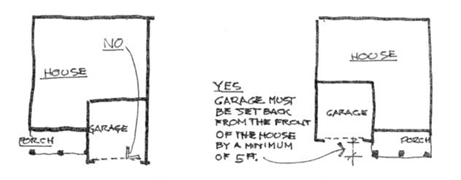
- Minimum Roof Pitch. Main roof structures of all residential units are to be an eight/twelve (8:12) pitch minimum. Minor roof structures such as porch, shed, or dormer roofs may be a three/twelve (3:12) pitch minimum (See Figure 1-d). Flat roof structures may be permitted by City approval when appropriate for the architectural style.
Figure 1-d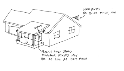
- Window Layout and Design. Windows on all residential units must be vertically proportioned and when appropriate, grouped with adjacent windows of similar sizes (See Figure 1-e).
Figure 1-e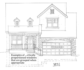
- Column Proportions. When columns are used on porches and decks, they must be designed using correct architectural proportions and materials (See Figure 1-f).
Figure 1-f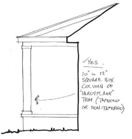
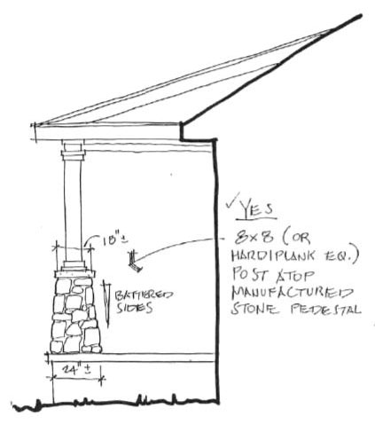
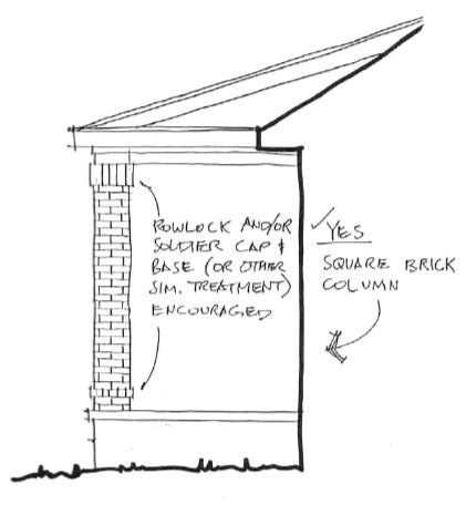
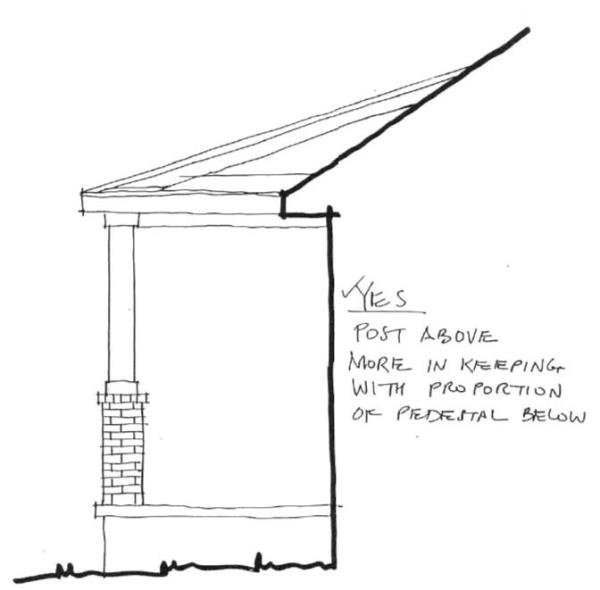
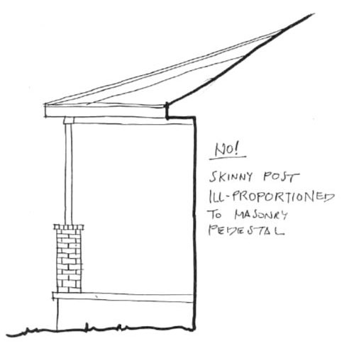
- Accessory Or Detached Structures. Out-buildings, patio structures, pergolas, trellises, sunshades, gazebos, and any other appurtenant buildings or structures shall be constructed of materials consistent with the colors, textures and materials approved for the residential unit and shall be integral to the architecture of the house.
- Exterior Finishes And Materials.
- Exterior Wall Surfaces. Brick, stone, stucco and fiber reinforced cement-based siding are permitted for the exterior finish of residential units and accessory buildings. Plastic or aluminum products are not allowed as exterior finish materials.
- Maximum Stucco Percentage. Stucco may be used to finish up to seventy (70) percent of the street facing exterior wall surface(s) and ninety (90) percent of the overall exterior wall surfaces. Exterior wall surface area excludes windows, doors, and roof structures.
- Minimum Masonry/Stone Percentage. Twenty (20) percent of all street-facing exterior wall surface(s) shall be covered in masonry or stone. Side wrapping masonry may be counted to fulfill the minimum percentage. Exterior wall surface area excludes windows, doors, and roof structures.
- Wrapped Finish Materials. All exterior finish materials (siding, stucco, masonry, stone, etc.) must terminate at an inside corner. Finishes are not allowed to terminate or transition at outside corners or in the middle of flat exterior surfaces. Masonry must wrap around outside corners that are a minimum of one (1) foot and six (6) inches from the adjacent inside corner where it terminates (See Figure 2-d).
Figure 2-d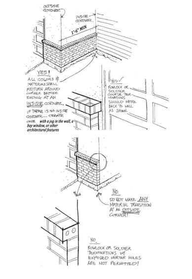
- Roofing Materials. Roof, soffit, and fascia material shall be restricted to wood shingles or shakes, slate, tile, architectural grade asphalt, fiberglass or other materials reviewed and approved by the City.
- Exterior Lighting. All exterior lighting shall be controlled by photocell technology. Appropriate lighting is desirable for nighttime visibility, crime deterrence, and decoration; however, lighting that is too bright or intense creates glare, hinders night vision, and creates light pollution is prohibited. Therefore, all lighting shall be shielded to prevent up-lighting and light escape.
- Rain Gutters And Downspouts. Gutters and downspouts shall be designed and placed to be as inconspicuous as possible. Downspouts shall connect with an underground drain or short runs of underground piping to move the water away from the foundation; they shall not dump or exhaust on top of driveways or walks.
- Chimney, Chimney Caps, And Vents. Chimneys of approved exterior materials may not exceed the height allowed by the City. Other than the direct vent through-the-wall type, exposed metal flues are not acceptable; all chimneys shall be enclosed in a material identical to, or compatible with, the building wall surfaces and covered with a hood to hide the flue system (See Figure 2-h). All front or side external vent stacks shall be colored or painted to harmonize with and/or match the adjacent roof or wall material and the house design shall be planned to exit the roof to the rear of the main ridge line where possible, or in a location with the least visibility from the street.
Figure 2-h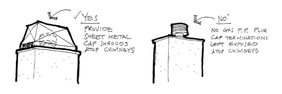
- Satellite Dishes And Antenna. Roof or wall mounted equipment must be placed in the least conspicuous manner. Satellite dishes and mechanical equipment must be planned as part of the roof/eaves design in order to be concealed from most pedestrian viewpoints.
- Gas And Electric Meters. Meter locations are to be designed into the architecture of the dwelling and screened from view. Place the meter in the least conspicuous location allowed by the utility company.
- Each home shall have a strong entry such as a porch, recessed portico, courtyard or other notable front access.
- Site Design And Landscaping.
- Orientation. Each unit fronting a public street shall be oriented to face the street. Interior homes shall be oriented toward common areas, streets, or paths in a way that creates harmony among the units. Any side of a dwelling that abuts a public street, a pedestrian trail, or a common space greater than twelve (12) feet in depth shall have architectural features and windows that engage with the space and effectively give “eyes on the street”.
- Deck Or Patio. Each unit shall have an outdoor patio or deck space of at least one hundred (100) square feet in size.
- Tree Requirement. One (1) street tree is to be planted for every forty (40) feet of public street frontage for the entire project. In addition to public street trees, at least one (1) additional tree for each residential unit in the project is required to be planted in other areas throughout the project. All trees must be 2” caliper, or larger, at the time planted and of a tree type approved by the City. Tree types are to be chosen to not conflict with or encroach on adjacent utility lines or structures.
- Shrubbery Requirement. A minimum of four (4) five-gallon sized shrubs shall be planted in locations that are visible from the street for each residential unit. On corner street-facing lots an additional four (4) five-gallon sized shrubs are required on the additional street-facing side.
- Street Lighting Standards. In areas away from building mounted fixtures, adequate lighting shall be provided along all streets. Appropriate lighting is desirable for nighttime visibility, crime deterrence, and decoration; however, lighting that is too bright or intense creates glare, hinders night vision, and creates light pollution is prohibited. Therefore, all lighting shall be shielded to prevent up-lighting and light escape. A standard list of approved lighting fixture choices will be available as approved by the City.
- Community Design. Units shall be designed to allow for engagement with open space and the surrounding units. There shall be pedestrian connections between the surrounding elements such as units, streets, adjacent trails and paths. Pedestrian routes shall be designed to encourage walkability and provide safe and pleasant walking experiences.
- Amenities. The community shall include common features such as community gardens, gazebo, sports courts, pools, community flower gardens or playgrounds.

Adopted by Ord. 05-18-2022-D on 5/18/2022
13.14.090.1 Purpose And Zone Characteristics
The PO-1 Professional Office Zone is established to provide areas within the City for hospitals and other medical services, office buildings and other professional services. The PO-1 Zone is intended to have limited commercial and retail services directly related to the primary use of the zone. Rezoning to the PO-1 Zone should be carefully reviewed to ensure compatibility with existing development and neighborhoods.
Adopted by Ord. 05-18-2022-D on 5/18/2022
13.14.090.2 Permitted, Conditional And Accessory Uses
Specific uses in the PO-1 Zone can be identified by referring to the chart attached hereto as Appendix A – Non-Residential Land Use Categories. The chart will specify whether each use is a permitted, conditional or accessory use. Special Needs Housing is allowed in accordance with PCC 13.42.100. Any use not specifically listed in Appendix A or PCC 13.42, Special Needs Housing is not permitted in the zone.
Adopted by Ord. 05-18-2022-D on 5/18/2022
13.14.090.3 Lot Area
The minimum parcel size allowed in the PO-1 Zone shall be one half (1/2) acre and shall be in single ownership or single control.
Adopted by Ord. 05-18-2022-D on 5/18/2022
13.14.090.4 Lot Width
Each parcel in the PO-1 Zone shall maintain a width no less than one hundred (100) feet in the required front setback area.
Adopted by Ord. 05-18-2022-D on 5/18/2022
13.14.090.5 Lot Frontage
Each parcel in the PO-1 Zone shall abut a public street for a minimum distance of one hundred (100) feet.
Adopted by Ord. 05-18-2022-D on 5/18/2022
13.14.090.6 Setback Requirements
The following minimum setback requirements shall apply in the PO-1 Zone. Each setback is measured from the property line of the lot or parcel.
- Front Setback. Each lot or parcel in the PO-1 Zone shall have a minimum front setback of twenty-five (25) feet.
- Side Setback. Each lot or parcel in the PO-1 Zone, unless otherwise noted below, shall have a minimum side setback of ten (10) feet.
- Side Setback For Corner Lot. Each corner lot or parcel in the PO-1 Zone shall have a minimum setback on all areas of road frontage of twenty (20) feet.
- Side Setback For Driveway. Each side setback, when used for access to a garage, carport, or parking area shall have a minimum setback of twenty (20) feet and shall be hard surfaced as described in the Payson City Development Guidelines.
- Side Setback For Accessory Building. The side setback for any permitted accessory building shall have a minimum side setback of fifteen (15) feet.
- Any structure in the PO-1 Zone that exceeds thirty-five (35) feet in height shall maintain a twenty (20) foot side setback.
- Rear Setback. Each lot or parcel in the PO-1 Zone shall have a minimum rear setback of twenty (20) feet.
- Rear Setback For Accessory Building. An accessory building shall be at least fifteen (15) feet from the rear property line.
Adopted by Ord. 05-18-2022-D on 5/18/2022
13.14.090.7 Projections Into Setbacks
The following structures may project into a required setback upon the completion of a survey to accurately determine the property line:
- Fences and walls in conformance with all applicable City ordinances and resolutions.
- Landscaping and irrigation systems.
- Necessary appurtenances for utility service.
- Patios, as defined in PCC 13.04, may be extended into a side or rear setback area but must be at least five (5) feet from the property line.
- Decks, as defined in PCC 13.04, may be extended into a rear setback area but must be at least fifteen (15) feet from the property line and satisfy all other setback requirements.
- Cornices, eaves, sills, buttresses, awnings, planter boxes or other similar architectural features may project up to four (4) feet into any required front or rear setback or up to two (2) feet into a side setback.
- Patio covers may be extended into a rear setback area but must be at least fifteen (15) feet from the property line. A patio cover may also extend into a side setback area but must be at least five (5) feet from the property line. If a patio cover is enclosed, the structure shall satisfy all setback requirements.
- In order to provide safe and environmentally controlled passages for patients and employees traveling between buildings on a hospital campus, the City Council may approve enclosed hallways or breezeways that connect two or more buildings. The enclosed hallways or breezeways shall satisfy all adopted building and fire codes.
Adopted by Ord. 05-18-2022-D on 5/18/2022
13.14.090.8 Building Height Requirements
A primary building or structure may not exceed thirty-five (35) feet in height, nor be lower than ten (10) feet in height, unless reviewed and approved by the Fire Chief, in accordance with the adopted building and fire codes. Accessory structures may not exceed eighteen (18) feet in total height as defined in PCC 13.04.
Adopted by Ord. 05-18-2022-D on 5/18/2022
13.14.090.9 Distance Between Buildings
The distance between any building or structure and any other building shall not be less than twenty (20) feet, unless the accessory building is attached to the building or structure.
Adopted by Ord. 05-18-2022-D on 5/18/2022
13.14.090.10 Permissible Lot Coverage
The sum total of all buildings, structures, and impervious material on any parcel in the PO-1 Zone shall not be greater than seventy-five (75) percent of the total area of the parcel. The remaining twenty-five (25) percent shall be landscaped.
Adopted by Ord. 05-18-2022-D on 5/18/2022
13.14.090.11 Parking, Loading And Access
Each project in the PO-1 Zone shall satisfy the off-street parking requirements found in PCC 13.10. For parking design and standards refer to the Payson City Development Guidelines.
Adopted by Ord. 05-18-2022-D on 5/18/2022
13.14.090.12 Project Plan Approval
Any request for project plan approval in the PO-1 Zone is subject to any and all applicable City resolutions and ordinances including the Subdivision Ordinance, Development Guidelines, and the Payson City General Plan.
Projects in the PO-1 Zone will be reviewed and approved in accordance with PCC 13.18, Commercial Development, Site Plans, herein.
Adopted by Ord. 05-18-2022-D on 5/18/2022
13.14.090.13 Other Requirements
The following requirements are in addition to the requirements found in this Chapter, the General Provisions or Supplementary Provisions of this ordinance, or any other applicable resolution or ordinance.
- Signs. Signs are allowed in the PO-1 Zone in accordance with PCC 13.32.
- Landscaping. Each lot or parcel shall be completely landscaped except those areas used for buildings or parking. Given the maximum lot coverage is seventy-five (75) percent, at least twenty-five (25) percent of the parcel shall be landscaped. At least fifteen (15) percent of the lot or parcel shall include landscaping in aggregated area, such as perimeter landscaping and common spaces, while fulfillment of the parking lot landscape requirements found in PCC 13.10.080 may be used to account for no more than the remaining ten (10) percent. Each project application shall be accompanied by a complete landscaping plan, which complies with the provisions of PCC 13.21, detailing the types and sizes of planting materials to be used. The landscaping shall be maintained using an automatic sprinkling system and shall be completed prior to issuance of a Certificate of Occupancy.
- Trash, Junk, And Other Debris. No trash, used materials, unsightly storage of any kind, or non-licensed or abandoned vehicles shall be stored in an open area. All such materials shall be enclosed in a building or, if deemed appropriate by the City, behind a sight obscuring fence.
- Design Guidelines. The City Council may require specific design guidelines be employed in the project. The design guidelines may include, but are not limited to, architectural controls, colors, materials, building mass, innovative design of buildings and access, and any other features deemed appropriate by the City Council. The design guidelines apply to all structures in a development including accessory structures.
- No dust, odor, smoke, vibration, intermittent light, glare, or noise shall be emitted which is discernible beyond the premises, except for normal traffic movements.
Adopted by Ord. 05-18-2022-D on 5/18/2022
Amended by Ord. 07-05-2023-B on 7/5/2023
13.14.090.14 Footprint Lots
The creation of a lot consisting of the footprint of an existing or proposed building (a footprint lot) may be permitted in Professional Office Zone (PO-1) notwithstanding the minimum lot size requirement of that zone, if the following conditions are met:
- The footprint lot is created from a larger parcel that meets all of the zoning requirements of the zone in which it is located (the Original Parcel).
- All parking areas and access on the Original Parcel (not a part of a footprint lot) shall be made available for the common use and enjoyment of the owners of all footprint lots unless they are clearly marked on the plat as limited or reserved for a specific use or owner.
- Prior to the approval of any footprint lot(s), the owner of the Original Parcel must demonstrate that there is adequate space on the Original Parcel to meet the maximum potential parking requirements based on all existing buildings and assuming that each footprint lot will be built to the maximum gross building size as shown on the plat.
- The use of the shared parking area on the Original Parcel is subject to Covenants, Conditions & Restrictions (CC&Rs) and a note to this effect is included in the plat. A shared parking agreement shall be signed by the owners of the Original Parcel and the footprint lot(s) and recorded in the office of the Utah County Recorder.
- All of the footprint lots and the Original Parcel are treated as one parcel for purposes of determining allowable signage and drive accesses.
- The entire building shall be constructed within the footprint lot. The height of the building will be determined by the regulations of the zoning ordinance.
- The Original Parcel and all of the footprint lots shall all be included together as part of one preliminary and one final plat.
- All buildings located on footprint lots shall comply with the setbacks that would ordinarily be required from the boundaries of the Original Parcel. No additional setbacks from the boundaries of the footprint lot shall be required.
- Unless otherwise specified herein, all development ordinances and requirements shall apply to development on the footprint lots and common area as if they were not separate lots.
- The footprint lot shall be measured from the buildings foundation wall and shall extend out from the foundation to include any permanent building components that extend beyond the buildings foundation such as (but not limited to), roof lines, attached canopies, pop-outs, vestibules, etc.
- The footprint owner must meet all landscaping requirements of the zone.
- Each structure on a footprint lot shall have separate utility connections and meters. Ownership, maintenance and payment obligations shall be the responsibility of the footprint owner. Proper easements must be established for all private and public utility services. A utility maintenance agreement between the Original Parcel owner and the Footprint owner may be required.
- The owner of the Original Parcel may add additional footprint lots to the site only by complying with all of the regulations of the zoning ordinance, this Section and the building and fire codes. The original parking and access plan may be changed by the owner of the Original Parcel as long as their required number of parking spaces does not decrease, the access plan is safe and the changes are approved by the city council.
Adopted by Ord. 05-18-2022-D on 5/18/2022
13.14.100.1 Purpose And Zone Characteristics
The CC-1 Central Commercial Zone is established to preserve and grow the commercial heart of Payson. Effective growth is accomplished by enhancing the pedestrian experience and downtown environment. This is done through pedestrian connectivity, transit-oriented development, establishment of third places—or places for people to visit and socialize, architecture that engages with street life, and the creation of a walkable urban core with uses in close proximity. Any development should be consistent with a downtown feel and be compatible with the historic nature of the area. Uses should contribute to vibrant and continuous street life.
Adopted by Ord. 05-18-2022-D on 5/18/2022
13.14.100.2 Permitted, Conditional And Accessory Uses
The zone allows for a mix of commercial and retail with residential uses. Permitted and conditional uses in the CC-1 Zone are listed in Appendix A – Non-Residential Land Use Categories. The ground floor of each building shall not have residential uses and shall have commercial, retail, or business even when other floors are used for residential uses. A use is not permitted in the zone unless authorized in Payson City Code.
Second story and higher or basement residential units are allowed in commercial buildings as a permitted use. Residential units may be limited by the amount of parking available.
Adopted by Ord. 05-18-2022-D on 5/18/2022
13.14.100.3 Lot Area
There is no minimum lot area requirement.
Adopted by Ord. 05-18-2022-D on 5/18/2022
13.14.100.4 Lot Width
There shall be no minimum width requirement, except that any new parcel smaller in width than the average width of the parcels on that block shall be reviewed and approved by the planning commission. If the commission finds that the width is not consistent with the nature of the historic downtown environment, the commission may approve the width if the proposed massing, uses, and design characteristics of all development on the parcel are compatible and consistent with surrounding buildings and uses.
Adopted by Ord. 05-18-2022-D on 5/18/2022
13.14.100.5 Lot Frontage
There shall be no frontage requirement, except that any parcel with less frontage than the average of the parcels on that block shall be reviewed and approved by the planning commission. If the commission finds the frontage is not consistent with the nature of the historic downtown environment, the commission may approve the frontage if the proposed massing, use, and design characteristics of all development on the parcel are compatible and consistent with surrounding buildings and uses.
Adopted by Ord. 05-18-2022-D on 5/18/2022
13.14.100.6 Setback And Build-To-Line Requirements
The following minimum setback requirements and build-to-line requirements shall apply in the CC-1 Zone. Each setback is measured from the property line of the lot or parcel.
- Front Setback. Each lot or parcel shall have a minimum front setback of ten (10) feet. The Development Services Director may grant a front setback reduction if it is determined the property is located along a pedestrian corridor and a reduced setback enhances the pedestrian experience.
- Side Setback. There is no side setback, provided that each building satisfies the building and fire codes in effect at the time of approval, except as follows:
- Side Setback For Structures Constructed Adjacent To Residentially Zoned Areas. The side setback shall be a minimum of ten (10) feet.
- Side Setback For Corner Lot. Each corner lot or parcel shall have a minimum setback on all areas of road frontage of ten (10) feet. The Development Services Director may grant a reduction if it is determined the property is located along a pedestrian corridor and a reduced setback enhances the pedestrian experience.
- Side Setback For Driveway. Each side setback, when used for vehicular access to a garage, carport, or parking area shall have a minimum setback of twenty (20) feet unless a setback reduction is granted by the Development Services Director in accordance with paragraph B as stated above. The access shall be hard surfaced as described in the Payson City Development Guidelines, and placed as far from the intersection as possible.
- Side Setback For Accessory Building. The minimum side setback for an accessory building shall be ten (10) feet, unless it can be determined that all necessary public utility easements, landscaping, and line of sight can be accommodated, in which case the setback may be reduced to zero. In the granting a reduction on a corner side setback, the Development Services Director must also determine the structure is located along a pedestrian corridor and a reduced setback enhances the pedestrian experience and any enhancement outweighs any public harm.
- Rear Setback. Each lot or parcel shall have a minimum rear setback of twenty (20) feet unless it can be clearly demonstrated to the Development Services Director that a structure could be placed nearer to the property line without causing a negative impact on adjacent property owners.
- Rear Setback For Accessory Building. The rear setback for an accessory building shall be no less than five (5) feet of the rear property line, unless it can satisfy the requirements in paragraph B,4, in which case the same provisions as found in paragraph B,4 apply.
- The land use authority may impose a build-to-line that represents the distance from the property line that a structure will be constructed. The build-to-line may be imposed on any side of the structure. The build-to-line may be imposed in order to reduce the parking adjacent to the street, improve aesthetics of the site, for circulation purposes, or decrease impacts on existing development. The imposition of a build-to-line does not reduce the amount of required off-street parking or landscaping.
Adopted by Ord. 05-18-2022-D on 5/18/2022
13.14.100.7 Projections Into Setbacks
After completion of a survey to accurately determine the property line, the following structures may project into a required setback:
- Fences and walls
- Landscaping and irrigation systems
- Necessary appurtenances for utility service
- Patios and decks
- Cornices, eaves, sills, buttresses, awnings, planter boxes or other similar architectural features may project up to four (4) feet into any required front or rear setback or up to two (2) feet into a side setback.
- Patio covers may be extended into a rear setback area but must be at least fifteen (15) feet from the property line. A patio cover may also extend into a side setback area but must be at least five (5) feet from the property line. If a patio cover is enclosed, the structure shall satisfy all setback requirements.
Aesthetic improvements similar to those listed above may be allowed to encroach into the front setback area or public right-of-way at the discretion of the Development Services Director, and after written approval based on, but not necessarily limited to, the following conditions:
- No permanent structure may be erected in the public right-of-way.
- The aesthetic improvement may not impede pedestrian or vehicular safety.
- The property owner is willing to accept all liability in relation to the aesthetic improvement.
- If the improvement is adjacent to a roadway owned by an entity other than Payson City, the applicant will need to obtain approval from that entity.
The Development Services Director is under no obligation to approve the request upon review of the proposed aesthetic improvement and no precedent is set by any approval or denial of such a request.
Adopted by Ord. 05-18-2022-D on 5/18/2022
13.14.100.8 Building Height Requirements
A primary building or structure may not exceed thirty-five (35) feet in height, nor be lower than ten (10) feet in height, unless reviewed and approved by the Fire Chief, in accordance with the adopted building and fire codes. Accessory structures may not exceed eighteen (18) feet in total height as defined in PCC 13.04. Buildings located on 100 North to 100 South along Main Street and 100 West to 100 East along Utah Avenue shall not exceed two stories in height above grade.
Adopted by Ord. 05-18-2022-D on 5/18/2022
13.14.100.9 Distance Between Buildings
The distance between any building or structure shall satisfy the requirements of the building and fire codes in place at the time of approval and Certificate of Occupancy. This is in no way meant to eliminate the use of zero lot line development.
Adopted by Ord. 05-18-2022-D on 5/18/2022
13.14.100.10 Permissible Lot Coverage
The sum total of all buildings, structures, and impervious material on any parcel shall not be greater than eighty (80) percent of the total area of the parcel. However, the Development Services Director can increase permissible lot coverage to ninety-five percent (95%) if the City determines the development enhances the downtown environment and the amount of and type of landscaping is appropriate for the site. All unimproved areas shall be landscaped. Plants shall be limited to those that will not damage sidewalks, buildings, and infrastructure.
Adopted by Ord. 05-18-2022-D on 5/18/2022
13.14.100.11 Parking, Loading And Access
Each project shall satisfy the off-street parking requirements found in PCC 13.10. For parking design and standards refer to the Payson City Development Guidelines.
Loading and unloading areas shall be located in an area that can be secured from public access. Further, loading and unloading shall not occur on a public street.
Adopted by Ord. 05-18-2022-D on 5/18/2022
13.14.100.12 Project Plan Approval
Projects in the CC-1 Zone will be reviewed and approved in accordance with PCC 13.18, Commercial and Industrial Development herein. Any request for project plan approval is subject to any and all applicable City resolutions and ordinances including the Subdivision Ordinance, Development Guidelines, and the Payson City General Plan.
If the project requires city council approval, the city council may replace the planning commission as the legislative authority for any requirement of this zone.
Adopted by Ord. 05-18-2022-D on 5/18/2022
13.14.100.13 Other Requirements
- Signs. Signs are allowed in accordance with PCC 13.32. Signs in specific areas of the CC-1 Zone may be subject to additional review as determined by the City Council.
- Landscaping. Each lot or parcel shall be completely landscaped except those areas used for buildings or parking. Each project application shall be accompanied by a complete landscaping plan detailing the types and sizes of planting materials to be used. The landscaping shall be maintained using an automatic sprinkling system and shall be completed prior to issuance of a Certificate of Occupancy.
- Trash, Junk, And Other Debris. No trash, used materials, unsightly storage of any kind, or non-licensed or abandoned vehicles shall be stored in an open area. All such materials shall be enclosed in a building.
- Design Guidelines. The planning commission may require specific design guidelines be employed in the project. Design is a vital component of downtown development. The design guidelines may include, but are not limited to, architectural controls, colors, materials, building mass, innovative design of buildings and access, and any other features deemed appropriate by the planning commission. The design guidelines apply to all structures in a development including accessory structures.
All buildings shall be oriented toward and facing public streets. This includes doors and large windows oriented toward public streets. Buildings on corner lots shall face both streets. Unless proven impractical, parking shall be located behind, or under, buildings, and buildings shall be located close to public streets, plazas, or other gathering areas. Building design shall enhance the pedestrian experience. Upper floors shall engage with street life through balconies, windows, and architectural features that provide a pleasant pedestrian environment. - Land Use Transition Areas. The planning commission may impose additional architectural and landscaping requirements on parcels adjacent to a land use transition.
- No dust, odor, smoke, vibration, intermittent light, glare, or noise shall be emitted which is discernible beyond the premises, except for normal traffic movements.
Adopted by Ord. 05-18-2022-D on 5/18/2022
13.14.110.1 Purpose And Zone Characteristics
The CAP Commercial, Arts and Preservation Zone is established to create an environment where historic preservation, building restoration, and viable commercial activities can co-exist in a positive manner. In order to accomplish the development goals supported by the City Council for this district, it is recognized that building renovations will need to occur so that the structures can accommodate the latest technological advances. Furthermore, public and private infrastructure will need to be updated to provide efficient and effective municipal services. All of this work must be completed while maintaining a business friendly atmosphere. Obviously, public/private cooperation is critical and all funding opportunities must be explored.
Adopted by Ord. 05-18-2022-D on 5/18/2022
13.14.110.2 Permitted, Conditional And Accessory Uses
Specific uses in the CAP Zone can be identified by referring to the chart attached hereto as Appendix A – Non-Residential Land Use Categories. The chart will specify whether each use is a permitted, conditional or accessory use. Unless specifically listed, any other use is not a permitted use in the zone.
Adopted by Ord. 05-18-2022-D on 5/18/2022
13.14.110.3 Lot Area, Width And Frontage
There is no minimum lot area, width or frontage requirements in the CAP Zone, except that all other regulations of this Title can be satisfied (i.e. clear view areas).
Adopted by Ord. 05-18-2022-D on 5/18/2022
13.14.110.4 Setback And Build-To-Line Requirements
The following minimum setback requirements and build-to-line requirements shall apply in the CAP Zone. Each setback is measured from the property line of the lot or parcel.
- Front Setback. There are no front setback requirements in the CAP Zone. However, all structures shall provide ample space for necessary public utility easements.
- Side Setback. There is no side setback in the CAP Zone provided that each building satisfies the building and fire codes in effect at the time of approval and issuance of a Certificate of Occupancy, except as follows:
- Side Setback For Structures Constructed Adjacent To Residentially Zoned Areas. The side setback for structures constructed adjacent to residentially zoned areas shall be a minimum of ten (10) feet.
- Side Setback For Corner Lot. Each corner lot or parcel in the CAP Zone shall have a minimum setback on all areas of road frontage of ten (10) feet.
- Side Setback For Driveway. Each side setback, when used for access to a garage, carport, or parking area shall have a minimum setback of twenty (20) feet and shall be hard surfaced as described in the Payson City Development Guidelines.
- Rear Setback. Each lot or parcel in the CAP Zone shall have a minimum rear setback of ten (10) feet unless it can be clearly demonstrated to the City Council that a structure could be placed nearer the property line without causing a negative impact on adjacent property owners.
- The land use authority may impose a build-to-line that represents the distance from the property line that a structure will be constructed. The build-to-line may be imposed on any side of the structure. The build-to-line may be imposed in order to reduce the parking adjacent to the street, improve aesthetics of the site, or for circulation purposes. The imposition of a build-to-line does not reduce the amount of required off-street parking or landscaping.
Adopted by Ord. 05-18-2022-D on 5/18/2022
13.14.110.5 Projections Into Setbacks
The following structures may be erected on or projected into any required setback:
- Fences, railings and walls in conformance with all applicable City ordinances and resolutions.
- Landscaping features.
- Necessary appurtenances for utility service.
- Awnings, cornices, eaves, planter boxes, sills, or other similar architectural features that do not impede pedestrian or vehicular circulation.
Following review of any proposed project that contains an existing structure, aesthetic improvements may be allowed to encroach into the public right-of-way at the discretion of the Development Services Director, and after written approval based on, but not necessarily limited to, the following conditions:
- No permanent structure may be erected in the public right-of-way.
- The aesthetic improvement may not impede pedestrian or vehicular safety.
- The property owner is willing to accept all liability in relation to the aesthetic improvement.
- The aesthetic improvement does not have the effect of enlarging the enclosed area of the building.
- The request shall be reviewed by all appropriate staff members and the alteration shall satisfy all conditions of staff.
- If the improvement is adjacent to a roadway owned by an entity other than Payson City, the applicant will need to obtain approval from that entity.
The Development Services Director is under no obligation to approve the request upon review of the proposed aesthetic improvement and no precedent is set by any approval or denial of such a request.
Adopted by Ord. 05-18-2022-D on 5/18/2022
13.14.110.6 Building Height Requirements
A primary building or structure may not exceed thirty-five (35) feet in height, nor be lower than ten (10) feet in height, unless reviewed and approved by the Fire Chief, in accordance with the adopted building and fire codes. Accessory structures may not exceed eighteen (18) feet in total height as defined in PCC 13.04.
Adopted by Ord. 05-18-2022-D on 5/18/2022
13.14.110.7 Distance Between Buildings
The distance between any building or structure shall satisfy the requirements of the building and fire codes in place at the time of a request for development approval. This is in no way meant to eliminate the use of zero lot line development.
Adopted by Ord. 05-18-2022-D on 5/18/2022
13.14.110.8 Parking, Loading And Access
Each project in the CAP Zone shall satisfy the off-street parking requirements found in PCC 13.10. For parking design and standards refer to the Payson City Development Guidelines.
Whenever practical, loading and unloading areas shall be located in an area that can be secured from public access and shall not occur on a public street.
Adopted by Ord. 05-18-2022-D on 5/18/2022
13.14.110.9 Project Plan Approval
Any request for project plan approval in the CAP Zone is subject to any and all applicable City resolutions and ordinances including the Subdivision Ordinance, Development Guidelines, and the Payson City General Plan.
Projects in the CAP Zone will be reviewed and approved in accordance with PCC 13.18, Commercial Development, Site Plans, herein.
Adopted by Ord. 05-18-2022-D on 5/18/2022
13.14.110.10 Other Requirements
The following requirements are in addition to the requirements found in this Chapter, the General Provisions or Supplementary Provisions of this ordinance, or any other applicable resolution or ordinance.
- Signs are allowed in the CAP Zone in accordance with PCC 13.32. Signs in the CAP Zone may be subject to additional review, such as review by the Utah State Historic Architect as determined by the City Council.
- Each lot or parcel shall be completely landscaped except those areas used for buildings or parking. Each project application shall be accompanied by a complete landscaping plan, which complies with the provisions of PCC 13.21, detailing the types and sizes of planting materials to be used. The landscaping shall be maintained using an automatic sprinkling system and shall be completed prior to issuance of a Certificate of Occupancy.
- No trash, used materials, unsightly storage of any kind, or non-licensed or abandoned vehicles shall be stored anywhere in the CAP Zone.
- Each project in the CAP Zone is subject to the design criteria adopted by the City Council. The design guidelines include, but are not limited to, architectural controls, colors, materials, building mass, innovative design of buildings and access, and any other features deemed appropriate by the City Council.
- No dust, odor, smoke, vibration, intermittent light, glare, or noise shall be emitted which is discernible beyond the premises, except for normal traffic movements.
Adopted by Ord. 05-18-2022-D on 5/18/2022
Amended by Ord. 07-05-2023-B on 7/5/2023
13.14.110.11 Parcels Constricted By Land Constraints
In order to effectively utilize existing infrastructure and promote commercial use on existing parcels within the CAP Zone, any project that cannot comply with the requirements on this Section concerning parking, access, landscaping or other constraints based on lot size, location, or configuration will be reviewed on a case-by-case basis. If the applicant can show that the project will be consistent and compatible with surrounding uses and will not negatively impact the purposes and objectives of the CAP Zone or adjacent property owners, the Fire Chief and Development Services Director will review and may approve the project. There shall be a two (2) week review period to receive input from the Planning Commission and City Council prior to a determination being made by the Fire Chief and Development Services Director. The Fire Chief and Development Services Director are under no obligation to approve the request to modify the regulations herein and no precedent is set by any approval or denial of such a request.
This Section in not intended to relieve the applicant from complying with any and all other requirements of this ordinance or any law, code, ordinance or resolution of Payson City.
Adopted by Ord. 05-18-2022-D on 5/18/2022
13.14.110.12 Building Renovation, Demolition And Reconstruction
Due to age, lack of appropriate maintenance, access requirements, or to encourage a safe environment, it may become necessary to significantly renovate or possibly even demolish and reconstruct buildings in the CAP Zone. However, these practices shall be conducted in a manner that reflects the unique historic elements of the district. Each structure shall satisfy the design guidelines established for the district, with special attention given to the following:
- The architectural features shall be incorporated on all sides of the structure.
- All utility appurtenances shall be hidden, screened, or at the very least painted to blend into the design of the building.
- Each structure shall satisfy all regulations of the adopted building (conservation) and fire codes, even if improvements to adjacent structures are required.
- Whenever the primary use of a structure changes from a use that is no longer permitted or from a non-conforming use, the structure shall be modified to satisfy the design guidelines of the zoning district.
Adopted by Ord. 05-18-2022-D on 5/18/2022
13.14.110.13 Relationship With Main Street And Other Historic Preservation Programs
The City Council may authorize the assistance of other entities to aid in the preservation, renovation, and improvement of the CAP Zone. The regulations of this Title are intended to complement the efforts of these entities. Some, but not necessarily all of these groups include:
- The Main Street Program
- The Utah Pioneer Communities Program
- The Certified Local Government Program
During the review process for any project in the CAP Zone, the regulations and requirements of these programs shall be considered and implemented into project approval. Some of these regulations may include project signage, color usage, lighting features, road regulatory signs, and other specific project details beyond basic building design.
Adopted by Ord. 05-18-2022-D on 5/18/2022
13.14.120.1 Purpose And Zone Characteristics
The GC-1 General Commercial Zone is established to provide areas within the City where general retail and service uses can be established. The GC-1 General Commercial Zone is located along the major transportation and circulation routes of the City. The zone allows for a variety of commercial and retail uses. Rezoning to the GC-1 Zone should be carefully reviewed to ensure protection of the existing zone and business district.
Adopted by Ord. 05-18-2022-D on 5/18/2022
13.14.120.2 Permitted, Conditional And Accessory Uses
Specific uses in the GC-1 Zone can be identified by referring to the chart attached hereto as Appendix A – Non-Residential Land Use Categories. The chart will specify whether each use is a permitted, conditional or accessory use. Unless specifically listed, any other use is not a permitted use in the zone.
A commercial presence must be provided along the public right-of-ways. When it can be demonstrated that a commercial business will benefit from the partial use of the building for non-commercial activities (i.e. light manufacturing, distribution, assembly), no more than seventy-five (75) percent of the overall building space may be used for non-commercial uses.
Adopted by Ord. 05-18-2022-D on 5/18/2022
13.14.120.3 Lot Area
There is no minimum lot area requirement in the GC-1 Zone.
Adopted by Ord. 05-18-2022-D on 5/18/2022
13.14.120.4 Lot Width
There shall be no minimum width requirement in the GC-1 Zone, except that any parcel smaller in width than the average of the parcels on that block shall be reviewed and approved by the City Council. If the Council finds that the width is inefficient or undesirable, the Council may require that the massing, uses, and other design characteristics be compatible with surrounding uses.
Adopted by Ord. 05-18-2022-D on 5/18/2022
13.14.120.5 Lot Frontage
There shall be no frontage requirement in the GC-1 Zone, except that any parcel with less frontage than the average of the parcels on that block shall be reviewed and approved by the City Council. If the Council finds that the frontage is inefficient or undesirable, the Council may require that the massing, uses, and other design characteristics be compatible with surrounding uses.
Adopted by Ord. 05-18-2022-D on 5/18/2022
13.14.120.6 Setback And Build-To-Line Requirements
The following minimum setback and build-to-line requirements shall apply in the GC-1 Zone. Each setback is measured from the property line of the lot or parcel.
- Front Setback. Each lot or parcel in the GC-1 Zone shall have a minimum front setback of ten (10) feet.
- Side Setback. There is no side setback in the GC-1 Zone provided that each building satisfies the building and fire codes in effect at the time of approval and issuance of a Certificate of Occupancy, except as follows:
- Side Setback For Structures Constructed Adjacent To Residentially Zoned Areas. The side setback for structures constructed adjacent to residentially zoned areas shall be a minimum of ten (10) feet.
- Side Setback For Corner Lot. Each corner lot or parcel in the GC-1 Zone shall have a minimum setback on all areas of road frontage of ten (10) feet.
- Side Setback For Driveway. Each side setback, when used for access to a garage, carport, or parking area shall have a minimum setback of twenty (20) feet and shall be hard surfaced as described in the Payson City Development Guidelines.
- Side Setback For Accessory Building. The side setback for any permitted accessory building shall have a minimum side setback of fifteen (15) feet.
- Rear Setback. Each lot or parcel in the GC-1 Zone shall have a minimum rear setback of twenty (20) feet unless it can be clearly demonstrated to the City Council that a structure could be placed nearer the property line without causing a negative impact on adjacent property owners.
- Rear Setback For Accessory Building. The rear setback for an accessory building shall be no less than fifteen (15) feet of the rear property line.
- The land use authority may impose a build-to-line that represents the distance from the property line that a structure will be constructed. The build-to-line may be imposed on any side of the structure. The build-to-line may be imposed in order to reduce the parking adjacent to the street, improve aesthetics of the site, or for circulation purposes. The imposition of a build-to-line does not reduce the amount of required off-street parking or landscaping.
Adopted by Ord. 05-18-2022-D on 5/18/2022
13.14.120.7 Projections Into Setbacks
The following structures may project into a required setback upon the completion of a survey to accurately determine the property line:
- Fences and walls in conformance with all applicable City ordinances and resolutions.
- Landscaping and irrigation systems.
- Necessary appurtenances for utility service.
- Patios, as defined in PCC 13.04, may be extended into a side or rear setback area but must be at least five (5) feet from the property line.
- Decks, as defined in PCC 13.04, may be extended into a rear setback area but must be at least fifteen (15) feet from the property line and satisfy all other setback requirements.
- Cornices, eaves, sills, buttresses, awnings, planter boxes or other similar architectural features may project up to four (4) feet into any required front or rear setback or up to two (2) feet into a side setback.
- Patio covers may be extended into a rear setback area but must be at least fifteen (15) feet from the property line. A patio cover may also extend into a side setback area but must be at least five (5) feet from the property line. If a patio cover is enclosed, the structure shall satisfy all setback requirements.
Following review of any proposed project that contains an existing structure, aesthetic improvements similar to those listed in paragraph A and B below immediately listed above may be allowed to encroach into the front setback area or public right-of-way at the discretion of the Development Services Director, upon review by appropriate staff members, and after written approval based on, but not necessarily limited to, the following conditions:
- No permanent structure may be erected in the public right-of-way.
- The aesthetic improvement may not impede pedestrian or vehicular safety.
- The property owner is willing to accept all liability in relation to the aesthetic improvement.
- The aesthetic improvement does not have the effect of enlarging the enclosed area of the building.
- The request shall be reviewed by all appropriate staff members and the alteration shall satisfy all conditions of staff.
- If the improvement is adjacent to a roadway owned by an entity other than Payson City, the applicant will need to obtain approval from that entity.
The Development Services Director is under no obligation to approve the request upon review of the proposed aesthetic improvement and no precedent is set by any approval or denial of such a request.
Adopted by Ord. 05-18-2022-D on 5/18/2022
13.14.120.8 Building Height Requirements
A primary building or structure may not exceed thirty-five (35) feet in height, nor be lower than ten (10) feet in height, unless reviewed and approved by the Fire Chief, in accordance with the adopted building and fire codes. Accessory structures may not exceed eighteen (18) feet in total height as defined in PCC 13.04.
Adopted by Ord. 05-18-2022-D on 5/18/2022
13.14.120.9 Distance Between Buildings
The distance between any building or structure shall satisfy the requirements of the building and fire codes in place at the time of approval and Certificate of Occupancy. This is in no way meant to eliminate the use of zero lot line development.
Adopted by Ord. 05-18-2022-D on 5/18/2022
13.14.120.10 Permissible Lot Coverage
The sum total of all buildings, structures, and impervious material on any parcel in the GC-1 Zone shall not be greater than eighty (80) percent of the total area of the parcel.
Adopted by Ord. 05-18-2022-D on 5/18/2022
13.14.120.11 Parking, Loading And Access
Each project in the GC-1 Zone shall satisfy the off-street parking requirements found in PCC 13.10. For parking design and standards refer to the Payson City Development Guidelines.
Loading and unloading areas shall be located in an area that can be secured from public access. Further, loading and unloading shall not occur on a public street.
Adopted by Ord. 05-18-2022-D on 5/18/2022
13.14.120.12 Project Plan Approval
Any request for project plan approval in the GC-1 Zone is subject to any and all applicable City resolutions and ordinances including the Subdivision Ordinance, Development Guidelines, and the Payson City General Plan.
Projects in the GC-1 Zone will be reviewed and approved in accordance with PCC 13.18, Commercial Development, Site Plans, herein.
Adopted by Ord. 05-18-2022-D on 5/18/2022
13.14.120.13 Other Requirements
The following requirements are in addition to the requirements found in this Chapter, the General Provisions or Supplementary Provisions of this ordinance, or any other applicable resolution or ordinance.
- Signs. Signs are allowed in the GC-1 Zone in accordance with PCC 13.32.
- Landscaping. Each lot or parcel shall be completely landscaped except those areas used for buildings or parking. Given that maximum lot coverage is eighty (80) percent, at least twenty (20) percent of the lot or parcel shall be landscaped. At least fifteen (15) percent of the lot shall include landscaping in aggregated area, such as perimeter landscaping and common spaces, while fulfillment of the parking lot landscape requirements found in PCC 13.10.080 may be used to account for no more than the remaining five (5) percent. Each project application shall be accompanied by a complete landscaping plan, which complies with the provisions of PCC 13.21, detailing the types and sizes of planting materials to be used. The landscaping shall be maintained using an automatic sprinkling system and shall be completed prior to issuance of a Certificate of Occupancy.
- Trash, Junk, And Other Debris. No trash, used materials, unsightly storage of any kind, or non-licensed or abandoned vehicles shall be stored in an open area. All such materials shall be enclosed in a building or, if deemed appropriate by the City, behind a sight obscuring fence.
- Design Guidelines. The City Council may require specific design guidelines be employed in the project. The design guidelines may include, but are not limited to, architectural controls, colors, materials, building mass, innovative design of buildings and access, and any other features deemed appropriate by the City Council. The design guidelines apply to all structures in a development including accessory structures.
- Buildings larger than forty thousand (40,000) square feet - Any building larger than forty thousand (40,000) square feet in the GC-1 zone shall be designed to have main entrances on at least two sides of the building, preferably front and back. This requirement is intended to produce a more attractive building on all sides, not just the front, and to improve traffic flow.
- No dust, odor, smoke, vibration, intermittent light, glare, or noise shall be emitted which is discernible beyond the premises, except for normal traffic movements.
Adopted by Ord. 05-18-2022-D on 5/18/2022
Amended by Ord. 07-05-2023-B on 7/5/2023
13.14.130.1 Purpose And Zone Characteristics
The S-1 Special Highway Service Zone is established to provide high intensity commercial areas that generate significant commercial tax base revenue for the community. The S-1 Zone is typically located near freeway intersections and along the major transportation and circulation routes of the City. The zone allows for a variety of large-scale commercial, service and retail uses. Rezoning to the S-1 Zone should be carefully reviewed to ensure protection of the existing zone and business district and maximize the generation of sales tax revenues.
The intention of the S-1 Zone of Payson City is to attract large-scale commercial uses with structures greater than thirty thousand (30,000) square feet in size. Smaller commercial uses must be approved by the staff or City Council after finding that the proposed use will not have a detrimental impact on the ability of large scale commercial users to provide services in the general vicinity.
It is imperative to have good traffic circulation, appropriate and attractive landscaping, and buildings that relate to one another in scale and design.
Adopted by Ord. 05-18-2022-D on 5/18/2022
13.14.130.2 Permitted, Conditional And Accessory Uses
Specific uses in the S-1 Zone can be identified by referring to the chart attached hereto as Appendix A – Non-Residential Land Use Categories. The chart will specify whether each use is a permitted, conditional or accessory use. Unless specifically listed, any other use is not a permitted use in the zone.
Adopted by Ord. 05-18-2022-D on 5/18/2022
13.14.130.3 Lot Area
The minimum project area requirement in the S-1 Zone is one (1) acre, except for parcels created prior to the adoption of this ordinance.
Adopted by Ord. 05-18-2022-D on 5/18/2022
13.14.130.4 Lot Width
The minimum width requirement in the S-1 Zone shall be one hundred (100) feet for all of the area located in the required front setback area, except for parcels created prior to the adoption of this ordinance. Regardless of the adoption date, if the Council finds that the width is inefficient or undesirable, the Council may require that the massing, uses, and other design characteristics be compatible with surrounding uses.
Adopted by Ord. 05-18-2022-D on 5/18/2022
13.14.130.5 Lot Frontage
All parcels in the S-1 Zone shall abut a public street for at least one hundred (100) feet, except for parcels created prior to the adoption of this ordinance. Regardless of the adoption date, if the Council finds that the frontage is inefficient or undesirable, the Council may require that the massing, uses, and other design characteristics be compatible with surrounding uses.
Adopted by Ord. 05-18-2022-D on 5/18/2022
13.14.130.6 Setback And Build-To-Line Requirements
The following minimum setback and build-to-line requirements shall apply in the S-1 Zone. Each setback is measured from the property line of the lot or parcel.
- Front Setback. Each lot or parcel in the S-1 Zone shall have a minimum front setback of twenty (20) feet.
- Side Setback. There is no side setback in the S-1 Zone provided that each building satisfies the building and fire codes in effect at the time of approval and issuance of a Certificate of Occupancy, except as follows:
- Side Setback For Structures Constructed Adjacent To Residentially Zoned Areas. The side setback for structures constructed adjacent to residentially zoned areas shall be a minimum of ten (10) feet.
- Side Setback For Corner Lot. Each corner lot or parcel in the S-1 Zone shall have a minimum setback on all areas of road frontage of twenty (20) feet.
- Side Setback For Driveway. Each side setback, when used for access to a garage, carport, or parking area shall have a minimum setback of twenty-four (24) feet and shall be hard surfaced as described in the Payson City Development Guidelines.
- Side Setback For Accessory Building. The side setback for any permitted accessory building shall have a minimum side setback of fifteen (15) feet.
- Rear Setback. Each lot or parcel in the S-1 Zone shall have a minimum rear setback of ten (10) feet, unless it can be clearly demonstrated to the City Council that a structure could be placed nearer the property line without causing a negative impact on adjacent property owners.
- Rear Setback For Accessory Building. The rear setback for an accessory building shall be no less than fifteen (15) feet of the rear property line.
- The land use authority may impose a build-to-line that represents the distance from the property line that a structure will be constructed. The build-to-line may be imposed on any side of the structure. The build-to-line may be imposed in order to reduce the parking adjacent to the street, improve aesthetics of the site, or for circulation purposes. The imposition of a build-to-line does not reduce the amount of required off-street parking or landscaping.
Adopted by Ord. 05-18-2022-D on 5/18/2022
13.14.130.7 Projections Into Setbacks
The following structures may project into a required setback upon the completion of a survey to accurately determine the property line:
- Fences and walls in conformance with all applicable City ordinances and resolutions.
- Landscaping and irrigation systems.
- Necessary appurtenances for utility service.
- Patios, as defined in PCC 13.04, may be extended into a side or rear setback area but must be at least five (5) feet from the property line.
- Decks, as defined in PCC 13.04, may be extended into a rear setback area but must be at least fifteen (15) feet from the property line and satisfy all other setback requirements.
- Cornices, eaves, sills, buttresses, awnings, planter boxes or other similar architectural features may project up to four (4) feet into any required front or rear setback or up to two (2) feet into a side setback.
- Patio covers may be extended into a rear setback area but must be at least fifteen (15) feet from the property line. A patio cover may also extend into a side setback area but must be at least five (5) feet from the property line. If a patio cover is enclosed, the structure shall satisfy all setback requirements.
Adopted by Ord. 05-18-2022-D on 5/18/2022
13.14.130.8 Building Height Requirements
A primary building or structure may not exceed thirty-five (35) feet in height, nor be lower than ten (10) feet in height, unless reviewed and approved by the Fire Chief, in accordance with the adopted building and fire codes.
Adopted by Ord. 05-18-2022-D on 5/18/2022
13.14.130.9 Distance Between Buildings
The distance between any building or structure shall satisfy the requirements of the building code in place at the time of approval and Certificate of Occupancy. This is in no way meant to eliminate the use of zero lot line development.
Adopted by Ord. 05-18-2022-D on 5/18/2022
13.14.130.10 Permissible Lot Coverage
The sum total of all buildings, structures and impervious material on any lot or parcel in the S-1 Zone shall not be less than sixty (60) percent nor more than seventy-five (75) percent of the total area of the lot or parcel.
Adopted by Ord. 05-18-2022-D on 5/18/2022
13.14.130.11 Parking, Loading And Access
Each project in the S-1 Zone shall satisfy the off-street parking requirements found in PCC 13.10. For parking design and standards refer to the Payson City Development Guidelines.
Loading and unloading areas shall be located in an area that can be secured from public access. Further, loading and unloading shall not occur on a public street.
Adopted by Ord. 05-18-2022-D on 5/18/2022
13.14.130.12 Project Plan Approval
Any request for project plan approval in the S-1 Zone is subject to any and all applicable City resolutions and ordinances including the Subdivision Ordinance, Development Guidelines, and the Payson City General Plan.
Projects in the S-1 Zone will be reviewed and approved in accordance with PCC 13.18, Commercial Development, Site Plans, herein.
Adopted by Ord. 05-18-2022-D on 5/18/2022
13.14.130.13 Massing Of Buildings
Buildings larger than thirty thousand (30,000) square feet are permitted uses in the S-1 Zone. No building with less than thirty thousand (30,000) square feet shall be constructed in the S-1 Zone unless approved by the staff or City Council in accordance with PCC 13.18, except structures allowed in the transition into residential areas in accordance with PCC 13.14.150.14. Any building with less than thirty thousand (30,000) square feet may be denied on the basis that it is not consistent with the development goals of Payson City.
Adopted by Ord. 05-18-2022-D on 5/18/2022
13.14.130.14 Transition Into Residential Areas
To encourage a transition from the S-1 Zone to residential neighborhoods, any portion of a development within one hundred (100) feet of a residential zone is designated as a “transition area” and subject to the restrictions herein.
Permitted and conditional uses in the transition area shall be the same as those in the S-1 Zone with the exception that any use categorized under amusement park or public assemblies and any restaurant with a drive through shall be a conditional use.
The following are required in transition areas in addition to all other requirements:
- The maximum height shall equal the maximum height in the adjacent residential zone. Where a slope exists between buildings in the transition zone and the adjacent residential zone, the Planning Commission may elect to calculate maximum building height by measuring from the base elevation of the nearest residential building in the adjacent residential zone.
- A landscaped buffer of at least ten (10) feet wide, which at a minimum shall include trees and ground cover.
- A barrier wall, consisting of either a hedgerow at least five (5) feet high at maturity or a six (6) foot tall masonry wall, whenever a driveway behind the front setback line or a parking lot of four (4) or more spaces exists within thirty (30) feet from the property line.
- Shielding all building and parking lot lighting away from residential areas.
- No loading dock, delivery pickup area, or drive through windows within fifty (50) feet and no trash container within twenty-five (25) feet from the property line that adjoins the residential zone. Any drive through speaker or other noise emitting device shall be at least sixty-five (65) feet from any residential zone.
- Screening of all mechanical equipment (i.e. air conditions, fans, pumps, etc.) within twenty-five (25) feet of the property line by a visual/noise barrier that completely surrounds the equipment and extends at least one (1) foot above the equipment.
- A minimum setback of twenty-five (25) feet from any property zoned residential.
Adopted by Ord. 05-18-2022-D on 5/18/2022
13.14.130.15 Design Guidelines And Motif
The Payson City Council encourages the use of a turn-of-the-century design motif for all structures in the S-1 Zone. The Payson City staff shall have on file a design guideline booklet that has been reviewed and approved by the City Council. The booklet shall provide graphic illustrations of the architecture, colors, materials, and general design of the desired buildings in the S-1 Zone. Failure to satisfy the standards of the design guidelines may result in the denial of any proposed project.
Adopted by Ord. 05-18-2022-D on 5/18/2022
13.14.130.16 Landscaping Of Freeway Frontage
Parcels located adjacent to Interstate 15 shall work with the Utah Department of Transportation to provide attractive and appropriate landscaping of the frontage area. The applicant shall provide a complete landscaping plan, which complies with the provisions of PCC 13.21, approved by the Utah Department of Transportation prior to project approval. The Utah Department of Transportation approval shall include information about perpetual maintenance of the landscaping. The landscaping shall be installed prior to issuance of a Certificate of Occupancy and a Payson City business license.
Adopted by Ord. 05-18-2022-D on 5/18/2022
Amended by Ord. 07-05-2023-B on 7/5/2023
13.14.130.17 Footprint Lots
The creation of a lot consisting of the footprint of an existing or proposed building (a footprint lot) may be permitted in the S-1, Special Highway Service Zone notwithstanding the minimum lot size requirement of that zone, if the following conditions are met:
- The footprint lot is created from a larger parcel that meets the zoning requirements of the zone in which it is located (the Original Parcel).
- All parking areas and access on the Original Parcel (not a part of a Footprint Lot) shall be made available for the common use and enjoyment of the owners of all Footprint Lots unless they are clearly marked on the plat as limited or reserved for a specific use or owner.
- Prior to the approval of any Footprint Lot(s), the owner of the Original Parcel must demonstrate that there is adequate space on the Original Parcel to meet the maximum potential parking requirements based on all existing buildings and assuming that each Footprint Lot will be built to the maximum gross building size as shown on the plat.
- The use of the shared parking area on the Original Parcel is subject to Covenants, Conditions & Restrictions (CC&Rs) and a note to this effect is included in the plat. A shared parking agreement shall be signed by the owners of the Original Parcel and the Footprint Lot(s) and recorded in the office of the Utah County Recorder.
- All of the Footprint Lots and the Original Parcel are treated as one parcel for purposes of determining allowable signage and drive accesses.
- The entire building shall be constructed within the Footprint Lot. The height of the building will be determined by the regulations of the zoning ordinance.
- The Original Parcel and all of the Footprint Lots shall all be included together as part of one preliminary and one final plat.
- All buildings located on Footprint Lots shall comply with the setbacks that would ordinarily be required from the boundaries of the Original Parcel. No additional setbacks from the boundaries of the Footprint Lot shall be required.
- Unless otherwise specified herein, all land use ordinances and requirements shall apply to development on the Footprint Lots and common area as if they were separate lots.
- The Footprint Lot shall be measured from the buildings foundation wall and shall extend out from the foundation to include any permanent building components that extend beyond the buildings foundation such as (but not limited to), roof lines, attached canopies, pop-outs, vestibules, etc.
- The Footprint Lot owner must meet all landscaping requirements of the zone.
- Each structure on a Footprint Lot shall have separate utility connections and meters. Ownership, maintenance and payment obligations shall be the responsibility of the Footprint Lot owner. Proper easements must be established for all private and public utility services. A utility maintenance agreement between the Original Parcel owner and the Footprint Lot owner may be required.
- The owner of the Original Parcel may add additional Footprint Lots to the site only by complying with all of the regulations of the zoning ordinance, this Section, and the building and fire codes. The original parking and access plan may be changed by the owner of the Original Parcel as long as their required number of parking spaces does not decrease, the access plan meets all safety regulations, and the changes are approved by the city council.
Adopted by Ord. 05-18-2022-D on 5/18/2022
13.14.130.18 Other Requirements
The following requirements are in addition to the requirements found in this Chapter, the General Provisions or Supplementary Provisions of this ordinance, or any other applicable resolution or ordinance.
- Signs. Signs are allowed in the S-1 Zone in accordance with PCC 13.32. The City Council may impose stricter sign regulations as part of any development in the S-1 Zone. Furthermore, the signs shall satisfy the design guidelines for the S-1 Zone.
- Landscaping. Each lot or parcel shall be completely landscaped except those areas used for buildings or parking. Each project application shall be accompanied by a complete landscaping plan detailing the types and sizes of planting materials to be used. The landscaping plan shall be prepared using trees, shrubs, turf, and ground cover appropriate for the climatic zone of the Payson area. The landscaping shall be maintained using an automatic sprinkling system and shall be completed prior to issuance of a Certificate of Occupancy.
Given that maximum lot coverage is seventy-five (75) percent, at least twenty-five (25) percent of the lot or parcel shall be landscaped. At least fifteen (15) percent of the lot or parcel shall include landscaping in aggregated area, such as perimeter landscaping and common spaces, while fulfillment of the parking lot landscape requirements found in PCC 13.10.080 may be used to account for no more than the remaining ten (10) percent. The landscaping space shall be enclosed by a protective curb and shall be properly maintained. - Trash, Junk, And Other Debris. No trash, used materials, unsightly storage of any kind, or non-licensed or abandoned vehicles shall be stored in an open area. All such materials shall be enclosed in a building or, if deemed appropriate by the City, behind a sight obscuring fence.
- Design Guidelines. In addition to the design guideline booklet for the S-1 Zone, the City Council may require specific design guidelines be employed in the project. The design guidelines may include, but are not limited to, architectural controls, colors, materials, building mass, innovative design of buildings and access, and any other features deemed appropriate by the City Council. The design guidelines apply to all structures in a development including accessory structures.
- Buildings larger than forty thousand (40,000) square feet - Any building larger than forty thousand (40,000) square feet in the S-1 Zone shall be designed to have main entrances on at least two sides of the building, preferably front and back. This requirement is intended to produce a more attractive building on all sides, not just the front, and to improve traffic flow.
- No dust, odor, smoke, vibration, intermittent light, glare, or noise shall be emitted which is discernible beyond the premises, except for normal traffic movements.
Adopted by Ord. 05-18-2022-D on 5/18/2022
13.14.140.1 Purpose And Zone Characteristics
The BPD Business Park Development Zone is established to promote business and employment opportunities to strengthen the economic vitality of the community. The zoning district is intended to provide an aesthetically attractive environment for, and conducive to, the location of offices, light industrial activities, research and development businesses, and related uses in a well-planned architecturally controlled setting. Development will consist of attractively designed buildings and landscaping to create a park-like setting, and land uses that promote the public health, safety, and general welfare of the community. Business activities that create considerable air, ground or water pollution, noise, vibrations or other undesirable impacts are expressly prohibited.
Adopted by Ord. 05-18-2022-D on 5/18/2022
13.14.140.2 Permitted, Conditional, Accessory, And Prohibited Uses
The permitted, conditional, and accessory uses in the BPD Zone may be subject to any stricter requirements included in a development agreement approved by the City Council for an industrial development.
Permitted Uses. The following land use types are permitted uses in the BPD Zone. Unless specifically listed, any other use is not a permitted use in the zone. Uses listed as conditional or accessory uses are allowed in the zone only in accordance with the criteria established in this ordinance.
- Light manufacturing, limited to processing, testing, assembling, packaging, and manufacturing of products from previously prepared materials
- Wholesale distribution of goods, products, cargo, and materials
- Food processing, canning, and packaging
- Professional, business, and administrative offices
- Research offices and laboratories
- Catalog sales and call centers
- Computer software and hardware development
- Communications offices and facilities such as recording and sound studios, motion picture companies, and broadcasting studios
- Automotive, power-sports, and recreational vehicle sales
- Industrial products sales including sale of machinery, equipment, special trade tools, welding supplies, machine parts, store fixtures, and electrical supplies inside of an enclosed building
- Indoor recreational facilities for such sports as gymnastics, martial arts, soccer, basketball, and skating. These facilities may be used for instruction, practice, and competitions. Health and fitness clubs are specifically excluded.
- Public and private parks and trails
- Public or private utility rights-of-way
Conditional Uses. The following land use types are allowed as conditional uses in the BPD Zone. Unless specifically listed, any other use is not allowed as a conditional use in the zone. Each conditional use must be reviewed and approved in accordance with PCC 13.28.
- Restaurants, food courts, and cafes when planned as part of a project to provide service to workers
- Indoor equipment storage and rental businesses accessory to a permitted use located on the premises
- Dining, child care centers, and recreational facilities, as well as professional services such as copying centers, shipping offices, and computer services
- Public transit stations
- Public or private utility maintenance facilities
Accessory Uses. The following land use types are allowed as accessory uses in the BPD Zone. Unless specifically listed, any other use is not allowed as an accessory use in the zone. Any accessory use must be clearly incidental to a permitted or conditional use on the premises. Accessory uses are not allowed without the approval of a permitted or conditional use of the parcel unless otherwise noted in this Section.
- Accessory facilities to package, store and distribute products made on-site
- Indoor storage and maintenance facilities for machinery and equipment
- Pavilions, break rooms, fitness facilities and other gathering areas intended for use by employees
- The growing of crops, flowers, and nursery plants in a manner that allows land to be used in a productive manner prior to development of the land. Slaughterhouses, feed yards and other intensive agricultural uses are not allowed.
Prohibited Uses. To achieve the goals of the BPD Zone, the following land uses are expressly prohibited on property included in the zoning district.
- Any outdoor manufacturing, testing, processing or similar activities
- Outdoor storage
- Automotive and machinery repair and restoration
- Storage units
- Salvage and wrecking yards
- On-site hazardous substance processing and handling or hazardous waste treatment and storage facilities
Adopted by Ord. 05-18-2022-D on 5/18/2022
13.14.140.3 Project Plan Approval
A request for project plan approval in the BPD Zone is subject to any and all applicable City resolutions and ordinances including, but not limited to, the Payson City General Plan, Zoning Ordinance, Subdivision Ordinance, and the Development Guidelines. Projects that include permitted uses will be reviewed and approved in accordance with PCC 13.18, Commercial Development, Site Plans, herein. Each conditional use must be reviewed and approved in accordance with PCC 13.28.
It is uncommon for parcels in the BPD Zone to be improved in phases. When a development proposal does not include the entire parcel, the City may require a conceptual layout for the entire parcel to address building layout, access, drainage, lot coverage, building orientation, and other development factors that apply to the overall development.
Adopted by Ord. 05-18-2022-D on 5/18/2022
13.14.140.4 Project Area And Parcel Size
The minimum project area for the creation of a new business park is twenty (20) acres. Furthermore, each individual parcel in the BPD Zone shall contain at least two (2) acres. The parcel size requirement is not intended to restrict condominium units within a multi-tenant building or project.
Adopted by Ord. 05-18-2022-D on 5/18/2022
13.14.140.5 Lot Width
The minimum width requirement in the BPD Zone shall be one hundred (100) feet for all of the area located in the required front setback area.
Adopted by Ord. 05-18-2022-D on 5/18/2022
13.14.140.6 Lot Frontage
All parcels in the BPD Zone shall abut a public street for at least one hundred (100) feet.
Adopted by Ord. 05-18-2022-D on 5/18/2022
13.14.140.7 Setback Requirements
The following minimum setback requirements shall apply in the BPD Zone. Each setback is measured from the property line of the lot or parcel.
- Front Setback. Each lot or parcel shall have a minimum front setback of thirty (30) feet.
- Accessory structures shall be farther from the property line than the front of the primary structure and the street facing side of the primary structure on a corner lot.
- Side Setback. Each lot or parcel shall have a minimum side setback of ten (10) feet.
- Side Setback For Corner Lot. Each corner lot or parcel shall have a minimum setback on all areas of road frontage of twenty (20) feet.
- Side Setback For Accessory Building. The side setback for any permitted accessory building shall have a minimum side setback of twenty (20) feet.
- Setback In Transition Area. Each lot or parcel adjacent to a residential zone shall maintain a twenty-five (25) foot setback, unless it can be demonstrated that any existing residential dwelling is a minimum of one hundred (100) feet from the setback line. The setback line may be reduced up to ten (10) feet from the property line provided one hundred (100) feet is maintained between said structures.
- Rear Setback. Each lot or parcel in the BPD Zone shall have a minimum rear setback of ten (10) feet.
- Rear Setback For Accessory Building. An accessory building shall be at least twenty (20) feet from the rear property line.
- Setback In Transition Area. Each lot or parcel adjacent to a residential zone shall maintain a twenty-five (25) foot setback, unless it can be demonstrated that any existing residential dwelling is a minimum of one hundred (100) feet from the setback line. The setback line may be reduced up to ten (10) feet from the property line provided one hundred (100) feet is maintained between said structures.
All setbacks are subject to the regulations of the adopted building and fire codes.
Adopted by Ord. 05-18-2022-D on 5/18/2022
13.14.140.8 Projections Into Setbacks
The following structures and features may project into a required setback upon the completion of a survey to accurately determine the property line:
- Fences and walls in conformance with all applicable City ordinances and resolutions.
- Landscaping and irrigation systems.
- Necessary appurtenances for utility service.
- Cornices, eaves, sills, buttresses, awnings, fire escapes, uncovered stairways and landings, planter boxes or other similar architectural features may project up to four (4) feet into any required front or rear setback or up to two (2) feet into a side setback.
Adopted by Ord. 05-18-2022-D on 5/18/2022
13.14.140.9 Building Height Requirements
A primary building or structure may not exceed thirty-five (35) feet in height, unless reviewed and approved by the Building Inspector and Fire Chief in accordance with the adopted building and fire codes. Accessory structures may not exceed twenty-five (25) feet in height nor be taller than the primary building.
Adopted by Ord. 05-18-2022-D on 5/18/2022
13.14.140.10 Distance Between Buildings
The distance between any building or structure and any other building or structure shall be at least twenty (20) feet.
Adopted by Ord. 05-18-2022-D on 5/18/2022
13.14.140.11 Lot Coverage
The sum total of all buildings, structures and parking on any parcel in the BPD Zone shall not exceed eighty (80) percent of the total area of the parcel, provided all landscaping requirements are met.
Adopted by Ord. 05-18-2022-D on 5/18/2022
Amended by Ord. 05-18-2022-A on 5/18/2022
13.14.140.12 Parking, Loading And Access
Each project in the BPD Zone shall satisfy the off-street parking requirements found in PCC 13.10. For parking design and standards refer to the Payson City Development Guidelines.
Loading areas shall be located at the rear or side of the building and shall not occur on a public street. Loading areas shall be recessed, screened, or otherwise designed to buffer this use from public view and adjacent properties. Additional screening methods shall be implemented for projects visible from major transportation facilities, including freeways, highways, and transit corridors.
Adopted by Ord. 05-18-2022-D on 5/18/2022
13.14.140.13 Building Placement And Design
In addition to the architectural requirements outlined in the Design Guidelines, the location and design of all buildings shall provide the following:
- Architectural features on at least forty (40) percent of the front of the building and include features that accentuate public entrances to the building.
- A balance of building proportion and scale, recognizing all structures on the development site and adjacent properties.
- Building design shall be clean and simple. Continuous building wall surfaces shall be relieved with variations of wall planes, materials, textures, and colors.
- Exterior building materials, including all accessory structures, shall be high quality for suitability, permanence, and durability. Acceptable materials include:
- Architecturally treated tilt-up concrete
- Split face and scored block
- Brick and glazed brick
- Stone, cast stone, marble or similar material
- Fiber cement
- Stucco or synthetic stucco
- Metal wall panels, provided:
- The design and materials used on the front façade shall satisfy the requirements of this Section.
- A non-metal base, consisting of acceptable masonry materials, is established which wraps around the sides and rear of the building. The non-metal base must be at least six (6) feet in height or 1/3 of the surface wall area, whichever is greater.
- Architectural features must be incorporated into all sides of the structure to avoid large blank, flat walls without articulation, windows, and design elements. Acceptable architectural features include windows, dormers, awnings, and repeating architectural patterns consisting of color change, texture change, material change, and wall articulation change.
- Architectural metal panels
- Glass
- Office buildings should contain multiple stories, where possible.
- The primary color of each building will be complementary to surrounding buildings and not create a visually distractive environment.
- Buildings along Interstate 15 and other major transportation facilities (i.e. commuter rail) must incorporate architectural features on the exterior walls facing these facilities to avoid the back of the building appearance.
- Cooling towers, mechanical equipment, propane tanks, and other unsightly items which could have an adverse effect upon the aesthetics of the building and adjacent properties will be allowed only if adequately enclosed or screened so as to be an integral part of the architectural design of the building.
Adopted by Ord. 05-18-2022-D on 5/18/2022
Amended by Ord. 05-18-2022-A on 5/18/2022
13.14.140.14 Storage Areas And Fencing
All business activities shall be conducted entirely within a building, except for loading and unloading and vehicle parking. Materials, supplies, equipment, finished or unfinished products, personal items such as boats and recreational vehicles, or similar articles shall not be stored in any area on a site except inside an enclosed building to screen such areas from the view of the public and adjoining properties. Storage of discarded, second-hand or salvage material outside any building or visual barrier is prohibited.
In order to establish a park-like setting, fences are highly discouraged. When an applicant can demonstrate that a fence is absolutely necessary, the quality and materials used for the fence shall complement the design of the primary structure and amenities on the site. All fences shall be constructed with masonry or wrought iron materials. Use of vinyl, chain-link, or other similar fencing materials is prohibited in the BPD Zone.
Adopted by Ord. 05-18-2022-D on 5/18/2022
13.14.140.15 Landscaping
Appropriate landscaping, consistent with the provisions of PCC 13.21, shall be implemented to create and maintain a park-like setting. In addition to the landscaping requirements of PCC 13.18, the following standards must be incorporated into the landscape design of the site.
- A bermed landscaped area in width of at least twelve (12) feet shall be provided and maintained along the right-of-way line of dedicated streets. The landscaping area should include a combination of shrubs, grasses, perennials, and trees. Planting materials shall be suitable for the site conditions and irrigated with an automatic underground sprinkling system. Use of drought tolerant vegetation is encouraged.
- The site shall consist of not less than twenty (20) percent landscaping and/or developed open space, which open space may consist of streetscape requirements, parking lot landscaping, foundation planters, undisturbed native vegetation, or water features.
- At least five (5) percent of the site must be in formal developed landscaping with no less than 2,000 square feet in area and oriented towards the main entrance and public right-of-way. Xeriscape design and water conservation materials are encouraged.
- All uses which adjoin a public street will also provide a landscape corridor of trees, planted no more than thirty (30) feet on center. Such landscaping shall not obscure the clear view area for traffic and pedestrians at the intersection of streets or driveways.
- Appropriate use of entryway, corner, and foundation planters must be incorporated into the landscaping design.
- Undeveloped portions of the property set aside for future expansion or additional development shall be maintained in accordance with PCC 13.44.
Adopted by Ord. 05-18-2022-D on 5/18/2022
Amended by Ord. 05-18-2022-A on 5/18/2022
Amended by Ord. 07-05-2023-B on 7/5/2023
13.14.140.16 Other Requirements
The following requirements are in addition to the requirements found in this Chapter, the General Provisions or Supplementary Provisions of this ordinance, or any other applicable resolution or ordinance.
- Signs are allowed in the BPD Zone in accordance with PCC 13.32.
- No trash, garbage or waste material, used materials, unsightly storage of any kind, or non-licensed or abandoned vehicles or equipment shall be kept, stored, or allowed to accumulate on any portion of the site except in an approved bin or contained within an enclosed structure appropriately screened from view.
- Projects may be required to provide landscaped passive or active open space areas for use by employees. These areas may contain picnic tables, pavilions, athletic equipment for use during work breaks, and other appropriate amenities. The type of amenities and amount of open space will be proportionate to the size of the project and determined using factors such as number of employees and hours of operation.
Adopted by Ord. 05-18-2022-D on 5/18/2022
13.14.150.1 Purpose And Zone Characteristics
The I-1 Light Industrial Zone is established to provide areas within the City for manufacturing, processing, and warehousing of goods and materials. The I-1 Zone is typically located west of Interstate 15. The zone allows for limited commercial and service uses.
Adopted by Ord. 05-18-2022-D on 5/18/2022
13.14.150.2 Permitted, Conditional And Accessory Uses
The permitted, conditional, and accessory uses in the I-1 Light Industrial Zone may be subject to any stricter requirements included in a development agreement approved by the City Council for an industrial development.
Specific uses in the I-1 Zone can be identified by referring to the chart attached hereto as Appendix A – Non-Residential Land Use Categories. The chart will specify whether each use is a permitted, conditional or accessory use. Unless specifically listed, any other use is not a permitted use in the zone.
Adopted by Ord. 05-18-2022-D on 5/18/2022
13.14.150.3 Lot Area
The minimum lot area requirement in the I-1 Zone is one half (1/2) acre, except for parcels created prior to the adoption of this ordinance.
Adopted by Ord. 05-18-2022-D on 5/18/2022
13.14.150.4 Lot Width
The minimum width requirement in the I-1 Zone shall be one hundred (100) feet for all of the area located in the required front setback area, except for parcels created prior to the adoption of this ordinance. Regardless of the adoption date, if the Council finds that the width is inefficient or undesirable, the Council may require that the massing, uses, and other design characteristics be compatible with surrounding uses.
Adopted by Ord. 05-18-2022-D on 5/18/2022
13.14.150.5 Lot Frontage
All parcels in the I-1 Zone shall abut a public street for at least one hundred (100) feet, except for parcels created prior to the adoption of this ordinance. Regardless of the adoption date, if the Council finds that the frontage is inefficient or undesirable, the Council may require that the massing, uses, and other design characteristics be compatible with surrounding uses.
Adopted by Ord. 05-18-2022-D on 5/18/2022
13.14.150.6 Setback Requirements
The following minimum setback requirements shall apply in the I-1 Zone. Each setback is measured from the property line of the lot or parcel.
- Front Setback. Each lot or parcel in the I-1 Zone shall have a minimum front setback of thirty (30) feet.
- Side Setback. Each parcel in the I-1 Zone shall have a minimum side setback of thirty (30) feet.
- Side Setback For Corner Lot. Each corner lot or parcel in the I-1 Zone shall have a minimum setback on all areas of road frontage of thirty (30) feet.
- Side Setback For Driveway. Each side setback, when used for access to a garage, carport, or parking area shall have a minimum setback of thirty (30) feet and shall be hard surfaced as described in the Payson City Development Guidelines.
- Side Setback For Accessory Building. The side setback for any permitted accessory building shall have a minimum side setback of twenty (20) feet.
- Rear Setback. Each lot or parcel in the I-1 Zone shall have a minimum rear setback of thirty (30) feet.
- Rear Setback For Accessory Building. An accessory building shall be at least twenty (20) feet from the rear property line.
Following review of any proposed project, the setbacks for the I-1, Light Industrial Zone may be modified, upon written approval of the City Engineer, Building Official and Fire Chief, if the modified setbacks will improve the layout of the proposed development and allow for more appropriate safety provision. Upon review of a request to reduce a setback, the following issues must be considered:
- The setbacks may not be reduced on projects that are adjacent to another zoning designation or could have negative impact on adjacent properties.
- The applicant shall obtain written approval from the public and private utility providers to encroach the setback area.
- The setbacks may not reduce or eliminate the public utility easement area unless written permission is granted from the adjoining property owner to place the additional public utility easement area on their property. If the public utility easement cannot be provided on the adjoining property, the City Engineer, Building Official and Fire Chief may consider alternate locations for the public utility easement. The preparation of all necessary documentation and recordation fees are the responsibility of the party seeking the reduction.
- The relocation of any utility facilities, fencing or other physical features of the site to accommodate the development proposal is the responsibility of the applicant.
The City Engineer, Building Official and Fire Chief are under no obligation to approve the request to modify the setbacks of this Chapter and no precedent is set by any approval or denial of such a request.
Adopted by Ord. 05-18-2022-D on 5/18/2022
13.14.150.7 Projections Into Setbacks
The following structures may project into a required setback upon the completion of a survey to accurately determine the property line:
- Fences and walls in conformance with all applicable City ordinances and resolutions.
- Landscaping and irrigation systems.
- Necessary appurtenances for utility service.
- Patios, as defined in PCC 13.04, may be extended into a side or rear setback area but must be at least five (5) feet from the property line.
- Decks, as defined in PCC 13.04, may be extended into a rear setback area but must be at least fifteen (15) feet from the property line and satisfy all other setback requirements.
- Cornices, eaves, sills, buttresses, awnings, planter boxes or other similar architectural features may project up to four (4) feet into any required front or rear setback or up to two (2) feet into a side setback.
- Patio covers may be extended into a rear setback area but must be at least fifteen (15) feet from the property line. A patio cover may also extend into a side setback area but must be at least five (5) feet from the property line. If a patio cover is enclosed, the structure shall satisfy all setback requirements.
Adopted by Ord. 05-18-2022-D on 5/18/2022
13.14.150.8 Building Height Requirements
A primary building or structure may not exceed thirty-five (35) feet in height, nor be lower than ten (10) feet in height, unless reviewed and approved by the Fire Chief, in accordance with the adopted building and fire codes. Accessory structures may not exceed eighteen (18) feet in total height as defined in PCC 13.04.
Adopted by Ord. 05-18-2022-D on 5/18/2022
13.14.150.9 Distance Between Buildings
The distance between any building or structure and any other building or structure shall be at least twenty (20) feet.
Adopted by Ord. 05-18-2022-D on 5/18/2022
13.14.150.10 Lot Coverage
The sum total of all buildings, structures and impervious material on any lot or parcel in the I-1 Zone shall not exceed ninety (90) percent of the total area of the lot or parcel, provided all landscaping requirements are met.
Adopted by Ord. 05-18-2022-D on 5/18/2022
13.14.150.11 Parking, Loading And Access
Each project in the I-1 Zone shall satisfy the off-street parking requirements found in PCC 13.10. For parking design and standards refer to the Payson City Development Guidelines.
Loading and unloading areas shall be located in an area that can be secured from public access. Further, loading and unloading shall not occur on a public street.
Adopted by Ord. 05-18-2022-D on 5/18/2022
13.14.150.12 Project Plan Approval
Any request for project plan approval in the I-1 Zone is subject to any and all applicable City resolutions and ordinances including the Subdivision Ordinance, Development Guidelines, and the Payson City General Plan.
Projects in the I-1 Zone will be reviewed and approved in accordance with PCC 13.18, Commercial Development, Site Plans, herein.
Adopted by Ord. 05-18-2022-D on 5/18/2022
13.14.150.13 Storage Units
Storage units are a permitted use in the I-1, Light Industrial Zone. However, the following requirements apply to all storage unit developments:
- There shall be at least ten (10) storage units in each storage unit project and each project shall be located along a public street.
- There shall be interior space adjacent to the public street dedicated to office, retail, service or another permitted or conditional use allowed in this Chapter that is not a storage unit or used as office space for the storage unit business. The amount of office, retail or service use shall be the greater of:
- Seventy-five (75) percent of the frontage area along a public street.
- A floor area ratio of one (1) square foot of office, retail or service space for every one thousand (1,000) square feet of storage area.
- A minimum of two thousand (2,000) square feet.
- In no case shall any storage unit be used for human habitation or the housing of animals.
- No business activity of any kind may be transacted from within a storage unit.
- A caretaker facility may be allowed as a conditional use when the City Council determines the following:
- The dwelling unit is necessary for security purposes and not used to simply obtain approval of a rental unit.
- The dwelling unit must be attached to or located within the principal use, and not have a total square footage that exceeds one-thousand (1,000) square feet or ten percent (10%) of the total area of the building square footage on the site, whichever is less.
- The design of the structure must satisfy the Design Guidelines adopted by the City Council.
- The dwelling unit will not be rented or leased, but may be considered part of compensation for caretaker services for the principle use.
- The dwelling unit must be incidental to and only a minor part of the principle use.
- Occupancy of the dwelling unit is limited to one (1) family.
- The dwelling unit will contain only one (1) kitchen.
- The structure will not be a manufactured dwelling unit.
- At least two (2) parking spaces must be dedicated for the caretaker facility. The City Council may require covered parking.
- If the storage unit facility has more than two hundred fifty (250) storage units and the owner/applicant can demonstrate that an additional on-site living quarter is necessary because of the size of the project and the additional unit will significantly improve the safety and security measures of the project, the City Council may approve a conditional use permit to allow an additional on-site living quarter. In no case shall the number of on-site living quarters exceed two (2) units or eliminate the business space required in paragraph B.
- The caretaker unit(s) shall not be used to replace security devices such as automatic gates, security cameras, or site lighting.
- Any person occupying a caretaker facility shall submit evidence of compliance with this Section upon request of the City.
Adopted by Ord. 05-18-2022-D on 5/18/2022
13.14.150.14 Other Requirements
The following requirements are in addition to the requirements found in this Chapter, the General Provisions or Supplementary Provisions of this ordinance, or any other applicable resolution or ordinance.
- Signs. Signs are allowed in the I-1 Zone in accordance with PCC 13.32.
- Landscaping. Each lot or parcel shall be completely landscaped except those areas used for buildings or parking. Each project application shall be accompanied by a complete landscaping plan, which complies with the provisions of PCC 13.21, detailing the types and sizes of planting materials to be used. The landscaping shall be maintained using an automatic sprinkling system and shall be completed prior to issuance of a Certificate of Occupancy. On larger parcels, an alternative method of landscaping may be presented to the City Council for their consideration and approval.
- Trash, Junk, Outside Storage And Other Debris. No trash, used materials, unsightly storage of any kind, or non-licensed or abandoned vehicles shall be stored in an open area. All such materials shall be enclosed in a building or, if deemed appropriate by the City, behind a sight obscuring fence.
- Design Guidelines. The City Council may require specific design guidelines be employed in the project. The design guidelines may include, but are not limited to, architectural controls, colors, materials, building mass, innovative design of buildings and access, and any other features deemed appropriate by the City Council. The design guidelines apply to all structures in a development including accessory structures.
- Buildings Larger Than Forty Thousand (40,000) Square Feet. Any building larger than forty thousand (40,000) square feet in the I-1 Zone shall be designed to have main entrances on at least two sides of the building, preferably front and back. This requirement is intended to produce a more attractive building on all sides, not just the front, and to improve traffic flow.
- Open Space. Industrial developments one (1) acre or larger may be required to provide landscaped passive or active open space areas for use by employees. These areas may contain picnic tables, pavilions, athletic equipment for use during work breaks, and other appropriate amenities. The type of amenities and amount of open space will be proportionate to the size of the project and determined using factors such as number of employees and hours of operation. In an industrial park, property owners may work together to provide open space areas.
Adopted by Ord. 05-18-2022-D on 5/18/2022
Amended by Ord. 07-05-2023-B on 7/5/2023
13.14.160.1 Purpose And Zone Characteristics
The I-2 Heavy Industrial Zone is established to provide areas within the City for manufacturing, processing, warehousing, and fabrication of goods and materials. These uses are not compatible with residential uses and should be placed in appropriate locations and protected from residential encroachment.
Adopted by Ord. 05-18-2022-D on 5/18/2022
13.14.160.2 Permitted, Conditional And Accessory Uses
Specific uses in the I-2 Zone can be identified by referring to the chart attached hereto as Appendix A – Non-Residential Land Use Categories. The chart will specify whether each use is a permitted, conditional or accessory use. Unless specifically listed, any other use is not a permitted use in the zone.
Adopted by Ord. 05-18-2022-D on 5/18/2022
13.14.160.3 Lot Area
The minimum lot area requirement in the I-2 Zone is one (1) acre.
Adopted by Ord. 05-18-2022-D on 5/18/2022
13.14.160.4 Lot Width
The minimum width requirement in the I-2 Zone shall be one hundred (100) feet for all of the area located in the required front setback area.
Adopted by Ord. 05-18-2022-D on 5/18/2022
13.14.160.5 Lot Frontage
All parcels in the I-2 Zone shall abut a public street for at least one hundred (100) feet.
Adopted by Ord. 05-18-2022-D on 5/18/2022
13.14.160.6 Setback Requirements
The following minimum setback requirements shall apply in the I-2 Zone. Each setback is measured from the property line of the lot or parcel.
- Front Setback. Each lot or parcel in the I-2 Zone shall have a minimum front setback of forty (40) feet.
- Side Setback. Each parcel in the I-2 Zone shall have a minimum side setback of thirty (30) feet.
- Side Setback For Corner Lot. Each corner lot or parcel in the I-2 Zone shall have a minimum setback on all areas of road frontage of thirty (30) feet.
- Side Setback For Driveway. Each side setback, when used for access to a garage, carport, or parking area shall have a minimum setback of thirty (30) feet and shall be hard surfaced as described in the Payson City Development Guidelines.
- Side Setback For Accessory Building. The side setback for any permitted accessory building shall have a minimum side setback of twenty (20) feet.
- Rear Setback. Each lot or parcel in the I-2 Zone shall have a minimum rear setback of thirty (30) feet.
- Rear Setback For Accessory Building. An accessory building shall be at least twenty (20) feet from the rear property line.
Following review of any proposed project, the setbacks for the I-2, Heavy Industrial Zone may be modified, upon written approval of the City Engineer, Building Official and Fire Chief, if the modified setbacks will improve the layout of the proposed development and allow for more appropriate safety provision. Upon review of a request to reduce a setback, the following issues must be considered:
- The setbacks may not be reduced on projects that are adjacent to another zoning designation or could have negative impact on adjacent properties.
- The applicant shall obtain written approval from the public and private utility providers to encroach the setback area.
- The setbacks may not reduce or eliminate the public utility easement area unless written permission is granted from the adjoining property owner to place the additional public utility easement area on their property. The preparation of all necessary documentation and recordation fees are the responsibility of the party seeking the reduction.
- The relocation of any utility facilities, fencing or other physical features of the site to accommodate the development proposal is the responsibility of the applicant.
The City Engineer, Building Official and Fire Chief are under no obligation to approve the request to modify the setbacks of this Chapter and no precedent is set by any approval or denial of such a request.
Adopted by Ord. 05-18-2022-D on 5/18/2022
13.14.160.7 Projections Into Setbacks
The following structures may project into a required setback upon the completion of a survey to accurately determine the property line:
- Fences and walls in conformance with all applicable City ordinances and resolutions.
- Landscaping and irrigation systems.
- Necessary appurtenances for utility service.
- Patios, as defined in PCC 13.04, may be extended into a side or rear setback area but must be at least five (5) feet from the property line.
- Decks, as defined in PCC 13.04, may be extended into a rear setback area but must be at least fifteen (15) feet from the property line and satisfy all other setback requirements.
- Cornices, eaves, sills, buttresses, awnings, planter boxes or other similar architectural features may project up to four (4) feet into any required front or rear setback or up to two (2) feet into a side setback.
- Patio covers may be extended into a rear setback area but must be at least fifteen (15) feet from the property line. A patio cover may also extend into a side setback area but must be at least five (5) feet from the property line. If a patio cover is enclosed, the structure shall satisfy all setback requirements.
Adopted by Ord. 05-18-2022-D on 5/18/2022
13.14.160.8 Building Height Requirements
A primary building or structure may not exceed thirty-five (35) feet in height, nor be lower than ten (10) feet in height, unless reviewed and approved by the Fire Chief, in accordance with the adopted building and fire codes. Accessory structures may not exceed eighteen (18) feet in total height as defined in PCC 13.04.
Adopted by Ord. 05-18-2022-D on 5/18/2022
13.14.160.9 Distance Between Buildings
The distance between any building or structure and any other building or structure shall at least twenty (20) feet.
Adopted by Ord. 05-18-2022-D on 5/18/2022
13.14.160.10 Lot Coverage
The sum total of all buildings, structures and impervious material on any lot or parcel in the I-2 Zone shall not exceed ninety (90) percent of the total area of the parcel, provided all landscaping requirements are met.
Adopted by Ord. 05-18-2022-D on 5/18/2022
13.14.160.11 Parking, Loading And Access
Each project in the I-2 Zone shall satisfy the off-street parking requirements found in PCC 13.10. For parking design and standards refer to the Payson City Development Guidelines.
Loading and unloading areas shall be located in an area that can be secured from public access. Further, loading and unloading shall not occur on a public street.
Adopted by Ord. 05-18-2022-D on 5/18/2022
13.14.160.12 Project Plan Approval
Any request for project plan approval in the I-2 Zone is subject to any and all applicable City resolutions and ordinances including the Subdivision Ordinance, Development Guidelines, and the Payson City General Plan.
Projects in the I-2 Zone will be reviewed and approved in accordance with PCC 13.18, Commercial Development, Site Plans, herein.
Adopted by Ord. 05-18-2022-D on 5/18/2022
13.14.160.13 Other Requirements
The following requirements are in addition to the requirements found in this Chapter, the General Provisions or Supplementary Provisions of this ordinance, or any other applicable resolution or ordinance.
- Signs. Signs are allowed in the I-2 Zone in accordance with PCC 13.32.
- Landscaping. Each lot or parcel shall be completely landscaped except those areas used for buildings or parking. Each project application shall be accompanied by a complete landscaping plan, which complies with the provisions of PCC 13.21, detailing the types and sizes of planting materials to be used. The landscaping shall be maintained using an automatic sprinkling system and shall be completed prior to issuance of a Certificate of Occupancy. On larger parcels, an alternative method of landscaping may be presented to the City Council for their consideration and approval.
- Trash, Junk, Storage And Other Debris. No trash, used materials, unsightly storage of any kind, or non-licensed or abandoned vehicles shall be stored in an open area. All such materials shall be enclosed in a building or, if deemed appropriate behind the City, by a sight obscuring fence.
- Design Guidelines. The City Council may require specific design guidelines be employed in the project. The design guidelines may include, but are not limited to, architectural controls, colors, materials, building mass, innovative design of buildings and access, and any other features deemed appropriate by the City Council. The design guidelines apply to all structures in a development including accessory structures.
- Open Space. Industrial developments one (1) acre or larger may be required to provide landscaped passive or active open space areas for use by employees. These areas may contain picnic tables, pavilions, athletic equipment for use during work breaks, and other appropriate amenities. The type of amenities and amount of open space will be proportionate to the size of the project and determined using factors such as number of employees and hours of operation. In an industrial park, property owners may work together to provide open space areas
Adopted by Ord. 05-18-2022-D on 5/18/2022
Amended by Ord. 07-05-2023-B on 7/5/2023
13.14.170.1 Purpose And Zone Characteristics
The R&D Research and Development Zone is established to provide areas within the City for campus, park-like settings for research and development activities. The zone allows for limited commercial and service uses.
Adopted by Ord. 05-18-2022-D on 5/18/2022
13.14.170.2 Permitted, Conditional And Accessory Uses
Specific uses in the R&D Zone can be identified by referring to the chart attached hereto as Appendix A – Non-Residential Land Use Categories. The chart will specify whether each use is a permitted, conditional or accessory use. Unless specifically listed, any other use is not a permitted use in the zone.
Adopted by Ord. 05-18-2022-D on 5/18/2022
13.14.170.3 Lot Area
The minimum lot area requirement in the R&D Zone is five (5) acres.
Adopted by Ord. 05-18-2022-D on 5/18/2022
13.14.170.4 Lot Width
The minimum width requirement in the R&D Zone shall be two hundred (200) feet for all of the area located in the required front setback area.
Adopted by Ord. 05-18-2022-D on 5/18/2022
13.14.170.5 Lot Frontage
All parcels in the R&D Zone shall abut a public street for at least two hundred (200) feet.
Adopted by Ord. 05-18-2022-D on 5/18/2022
13.14.170.6 Setback And Build-To-Line Requirements
The following minimum setback and build-to-line requirements shall apply in the R&D Zone. Each setback is measured from the property line of the lot or parcel.
- Front Setback. Each lot or parcel in the R&D Zone shall have a minimum front setback of thirty (30) feet.
- Side Setback. Each parcel in the R&D Zone shall have a minimum side setback of thirty (30) feet.
- Side Setback For Corner Lot. Each corner lot or parcel in the R&D Zone shall have a minimum setback on all areas of road frontage of thirty (30) feet.
- Side Setback For Driveway. Each side setback, when used for access to a garage, carport, or parking area shall have a minimum setback of thirty (30) feet and shall be hard surfaced as described in the Payson City Development Guidelines.
- Side Setback For Accessory Building. The side setback for any permitted accessory building shall have a minimum side setback of twenty (20) feet.
- Rear Setback. Each lot or parcel in the R&D Zone shall have a minimum rear setback of thirty (30) feet.
- Rear Setback For Accessory Building. An accessory building shall be at least twenty (20) feet from the rear property line.
- The land use authority may impose a build-to-line that represents the distance from the property line that a structure will be constructed. The build-to-line may be imposed on any side of the structure. The build-to-line may be imposed in order to reduce the parking adjacent to the street, improve aesthetics of the site, or for circulation purposes. The imposition of a build-to-line does not reduce the amount of required off-street parking or landscaping.
Adopted by Ord. 05-18-2022-D on 5/18/2022
13.14.170.7 Projections Into Setbacks
The following structures may project into a required setback upon the completion of a survey to accurately determine the property line:
- Fences and walls in conformance with all applicable City ordinances and resolutions.
- Landscaping and irrigation systems.
- Necessary appurtenances for utility service.
- Patios, as defined in PCC 13.04, may be extended into a side or rear setback area but must be at least five (5) feet from the property line.
- Decks, as defined in PCC 13.04, may be extended into a rear setback area but must be at least fifteen (15) feet from the property line and satisfy all other setback requirements.
- Cornices, eaves, sills, buttresses, awnings, planter boxes or other similar architectural features may project up to four (4) feet into any required front or rear setback or up to two (2) feet into a side setback.
- Patio covers may be extended into a rear setback area but must be at least fifteen (15) feet from the property line. A patio cover may also extend into a side setback area but must be at least five (5) feet from the property line. If a patio cover is enclosed, the structure shall satisfy all setback requirements.
Adopted by Ord. 05-18-2022-D on 5/18/2022
13.14.170.8 Building Height Requirements
A primary building or structure may not exceed thirty-five (35) feet in height, nor be lower than ten (10) feet in height, unless reviewed and approved by the Fire Chief. Accessory structures may not exceed eighteen (18) feet in total height as defined in PCC 13.04.
Adopted by Ord. 05-18-2022-D on 5/18/2022
13.14.170.9 Distance Between Buildings
The distance between any building or structure and any other building or structure shall at least twenty (20) feet.
Adopted by Ord. 05-18-2022-D on 5/18/2022
13.14.170.10 Permissible Lot Coverage
The sum total of all buildings, structures and impervious material on any parcel in the R&D Zone shall not exceed fifty (50) percent of the total area of the parcel.
Adopted by Ord. 05-18-2022-D on 5/18/2022
13.14.170.11 Parking, Loading And Access
Each project in the R&D Zone shall satisfy the off-street parking requirements found in PCC 13.10. For parking design and standards refer to the Payson City Development Guidelines.
Loading and unloading areas shall be located in an area that can be secured from public access. Further, loading and unloading shall not occur on a public street.
Adopted by Ord. 05-18-2022-D on 5/18/2022
13.14.170.12 Project Plan Approval
Any request for project plan approval in the R&D Zone is subject to any and all applicable City resolutions and ordinances including the Subdivision Ordinance, Development Guidelines, and the Payson City General Plan.
Projects in the R&D Zone will be reviewed and approved in accordance with PCC 13.18, Commercial Development, Site Plans, herein.
Adopted by Ord. 05-18-2022-D on 5/18/2022
13.14.170.13 Other Requirements
The following requirements are in addition to the requirements found in this Chapter, the General Provisions or Supplementary Provisions of this ordinance, or any other applicable resolution or ordinance.
- Signs. Signs are allowed in the R&D Zone in accordance with PCC 13.32.
- Landscaping. Each lot or parcel shall be completely landscaped except those areas used for buildings or parking. Each project application shall be accompanied by a complete landscaping plan, which complies with the provisions of PCC 13.21, detailing the types and sizes of planting materials to be used. The landscaping shall be maintained using an automatic sprinkling system and shall be completed prior to issuance of a Certificate of Occupancy. On larger parcels, an alternative method of landscaping may be presented to the City Council for their consideration and approval. The R&D Zone is intended to be a campus or park-like setting.
- Trash, Junk, Storage And Other Debris. No trash, used materials, unsightly storage of any kind, or non-licensed or abandoned vehicles shall be stored in an open area. All such materials shall be enclosed in a building or, if deemed appropriate by the City, behind a sight obscuring fence.
- Design Guidelines. The City Council may require specific design guidelines be employed in the project. The design guidelines may include, but are not limited to, architectural controls, colors, materials, building mass, innovative design of buildings and access, and any other features deemed appropriate by the City Council. The design guidelines apply to all structures in a development including accessory structures.
Adopted by Ord. 05-18-2022-D on 5/18/2022
Amended by Ord. 07-05-2023-B on 7/5/2023
13.14.180.1 Purpose And Zone Characteristics
The NC-1 Neighborhood Commercial Zone is established to provide areas within the City where limited commercial uses conducive to residential uses can be integrated into predominantly residential areas. The hours of operation, noise generated by business activities, emissions, parking, and lighting are all primary concerns in the zone.
Rezoning to the NC-1 Zone should be carefully reviewed to ensure protection of the existing neighborhoods and residential uses. Some, but not necessarily all of the items that will be considered by the Planning Commission and City Council in the determination of a zone change include:
- Whether the proposed use would be more appropriate in another commercial zone or would serve to undermine the intention of other commercial zoning districts.
- The impact the commercial use would have on the circulation pattern of the neighborhood.
- The impact of the commercial use on the infrastructure in the general vicinity.
- The use of the NC-1 Zone should not be granted simply to avoid compliance with any other development regulation or to simply appease a landowner who should be operating a commercial business in a more appropriate location.
- The effect anticipated at the rezone stage is intended to the maximum impact the project will have on the neighborhood. Additional structures, subdivision of property and other development approvals will be strictly limited and only if it can be shown that the additional approval will serve to reduce impact on the neighborhood.
- The configuration of the NC-1 Zone must complement the residential character of the neighborhood. In some instances, the zone will be very compact and located in the heart of residential development and in other locations the area may be larger along an arterial road.
Adopted by Ord. 05-18-2022-D on 5/18/2022
13.14.180.2 Permitted, Conditional And Accessory Uses
The following uses are allowed in the NC-1 Zone. If a use is not listed below, the use is not allowed in the zone. The uses listed are meant to be specific and narrowly defined. If there is any question of whether the use is appropriate, the applicant will be required to process a Zoning Ordinance amendment in conjunction with the request.
- Business and management consulting services
- Travel agencies and arrangement services
- Insurance and real estate services
- Art, crafts and hobby stores
- Local government structures
- Florists
- Gifts and souvenirs shops
- Beauty and barber services
- Health spas
- Physician and dental services
- Chiropractic, massage therapy and osteopath
- Legal services and adoption agencies
- Accounting, auditing and bookkeeping
- Interior design studios, not to include warehousing
- Structures for fruit, vegetable, and flower sales
In order to maintain the residential character of the area, the following uses are expressly prohibited:
- Subdivision of property is not a permitted use in the zone
- Drive-up windows
Adopted by Ord. 05-18-2022-D on 5/18/2022
13.14.180.3 Lot Area
There is no minimum lot area requirement in the NC-1 Zone. However, the parcel must be large enough to accommodate required off-street parking, building setbacks, landscaping, lot improvements and other development regulations. The maximum project area in the NC-1 Zone is one (1) acre.
Adopted by Ord. 05-18-2022-D on 5/18/2022
13.14.180.4 Lot Width
There shall be no minimum width requirement in the NC-1 Zone, except that any parcel smaller in width than the average of the parcels on that block shall be reviewed and approved by the City Council. If the Council finds that the width is insufficient or undesirable, the Council may require that the massing, uses, and other design characteristics be compatible with surrounding uses.
Adopted by Ord. 05-18-2022-D on 5/18/2022
13.14.180.5 Lot Frontage
There shall be no frontage requirement in the NC-1 Zone, except that any parcel with less frontage than the average of the parcels on that block shall be reviewed and approved by the City Council. If the Council finds that the frontage is insufficient or undesirable, the Council may require that the massing, uses, and other design characteristics be compatible with surrounding uses.
Adopted by Ord. 05-18-2022-D on 5/18/2022
13.14.180.6 Setback And Build-To-Line Requirements
The following minimum setback and build-to-line requirements shall apply in the NC-1 Zone. Each setback is measured from the property line of the lot or parcel.
- Front Setback. Each lot or parcel in the NC-1 Zone shall have a minimum front setback of twenty-five (25) feet.
- Side Setback. Each lot or parcel in the NC-1 Zone shall have a minimum side setback of fifteen (15) feet except as follows:
- Side setback for structures constructed adjacent to residentially uses shall be a minimum of twenty (20) feet.
- Side Setback For Corner Lot. Each corner lot or parcel in the NC-1 Zone shall have a minimum setback on the non-frontage side of twenty (20) feet.
- Side Setback For Driveway. Each side setback, when used for access to a parking area shall have a minimum setback of twenty (20) feet and shall be hard surfaced as described in the Payson City Development Guidelines.
- Rear Setback. Each lot or parcel in the NC-1 Zone shall have a minimum rear setback of twenty (20) feet.
- The land use authority may impose a build-to-line that represents the distance from the property line that a structure will be constructed. The build-to-line may be imposed on any side of the structure. The build-to-line may be imposed in order to reduce the parking adjacent to the street, improve aesthetics of the site, or for circulation purposes. The imposition of a build-to-line does not reduce the amount of required off-street parking or landscaping.
Adopted by Ord. 05-18-2022-D on 5/18/2022
13.14.180.7 Projections Into Setbacks
The following structures may project into a required setback upon the completion of a survey to accurately determine the property line:
- Fences and walls in conformance with applicable City ordinances and resolutions.
- Landscaping and irrigation systems.
- Necessary appurtenances for utility service.
- Cornices, eaves, sills, buttresses, awnings, planter boxes or other similar architectural features may project up to four (4) feet into any required front or rear setback or up to two (2) feet into a side setback.
Adopted by Ord. 05-18-2022-D on 5/18/2022
13.14.180.8 Building Height Requirements, Massing And Scale
A primary building or structure may not exceed thirty-five (35) feet in height, nor be lower than ten (10) feet in height. Buildings shall reflect the character of the neighborhood in terms of massing and scale, specifically with immediately adjacent structures. For instance, where single story structures exist, a commercial use should be conducted in a single story structure. Where a mixture of buildings heights and sizes exist, the commercial structure shall provide a transition between the various building scales.
An accessory structure in the NC-1 Zone may not exceed eighteen (18) feet in total height as defined in PCC 13.04.
Adopted by Ord. 05-18-2022-D on 5/18/2022
13.14.180.9 Permissible Lot Coverage
The sum total of all buildings, structures, and impervious material on any parcel in the NC-1 Zone shall not be greater than sixty (60) percent of the total area of the parcel.
Adopted by Ord. 05-18-2022-D on 5/18/2022
13.14.180.10 Parking, Loading And Access
Each project in the NC-1 Zone shall satisfy the off-street parking requirements found in PCC 13.10. For parking design and standards refer to the Payson City Development Guidelines.
Adopted by Ord. 05-18-2022-D on 5/18/2022
13.14.180.11 Project Plan Approval
Projects in the NC-1 Zone will be reviewed and approved in accordance with PCC 13.18, Commercial Development, Site Plans, herein.
Any request for project plan approval in the NC-1 Zone is subject to any and all applicable City resolutions and ordinances including the Subdivision Ordinance, Development Guidelines, and the Payson City General Plan.
Adopted by Ord. 05-18-2022-D on 5/18/2022
13.14.180.12 Other Requirements
The following requirements are in addition to the requirements found in this Chapter, the General Provisions or Supplementary Provisions of this ordinance, or any other applicable resolution or ordinance.
- Signs. Signs shall not distract from the residential character of the area. Sign size, lighting and location must be compatible with surrounding uses. All signs must be consistent with the regulations of PCC 13.32.
- Landscaping. Each lot or parcel shall be completely landscaped except those areas used for buildings or parking. Each project application shall be accompanied by a complete landscaping plan, which complies with the provisions of PCC 13.21, detailing the types and sizes of planting materials to be used. The landscaping shall be maintained using an automatic sprinkling system and shall be completed prior to issuance of a Certificate of Occupancy.
- Accessory structures are not allowed in the NC-1 Zone. Outdoor storage is not allowed and commercial uses shall be wholly conducted within an enclosed building.
- Trash, Junk, And Other Debris. No trash, used materials, unsightly storage of any kind, or non-licensed or abandoned vehicles are allowed on site.
- Design Guidelines. The City Council may require specific design guidelines be employed in the project. The design guidelines may include, but are not limited to, architectural controls, colors, materials, building mass, innovative design of buildings and access, and any other features deemed appropriate by the City Council. The design guidelines apply to all structures in a development including accessory structures.
- No dust, odor, smoke, vibration, intermittent light, glare, or noise shall be emitted which is discernible beyond the premises, except for normal traffic movements.
Adopted by Ord. 05-18-2022-D on 5/18/2022
Amended by Ord. 07-05-2023-B on 7/5/2023
13.14.180.13 Parcels Constricted By Land Constraints
In order to effectively protect the residential character of the surrounding area, any project that cannot comply with the requirements on this Section concerning parking, access, landscaping or other constraints based on lot size, location, or configuration will not be allowed.
Adopted by Ord. 05-18-2022-D on 5/18/2022
13.14.190.1 Purpose And Zone Characteristics
The CT Transition Zone is established to create an appropriate progression between heavy commercial uses near the Interstate 15 interchanges in the City and the less intensive commercial, industrial and residential uses just beyond the properties with heavy commercial viability. The zone allows for a variety of commercial, service, retail, light industrial, and residential uses. As a mixed-use zone, careful consideration of compatibility is critical in the CT Zone.
The intention of the CT Zone of Payson City is to allow properties to be developed in a manner that allows property owners and the City Council to determine the appropriate uses that will support the heavy commercial uses while transitioning into industrial and residential areas. The CT Zone allows mixed-use developments and encourages creative solutions to typically incompatible land uses.
Characteristics of the CT Zone include attractive building design and landscaping, proper pedestrian and vehicular circulation and structures that relate to one another in scale and design features.
Rezone to any CT Zone is limited by the following factors:
- The property proposed for rezoning must be included in the S-1, Special Highway Service Zone prior to the rezone request.
- The applicant for a zone change to any CT Zone will be required to indicate the proposed use of the property proposed for rezoning. The applicant will be required to sign a development agreement that solidifies the anticipated use of the property proposed to be rezoned, design guidelines, densities and any other appropriate items. Failure to develop the property as agreed upon in the development agreement may result in rezoning the property to the S-1 Zone at the discretion of the City Council.
- The applicant must be able to demonstrate how the proposed use of the parcel will promote a transition from the intensive commercial uses in the S-1 Zone to the surrounding zones, existing development and proposed development.
- The City Council may require rezoning to be consistent with the land use designation of the General Plan.
- A parcel may be rezoned into more than one of the Commercial Transition Zones if the arrangement would create a better transition area between the S-1 Zone and surrounding zones.
Adopted by Ord. 05-18-2022-D on 5/18/2022
13.14.190.2 Permitted, Conditional And Accessory Uses
The City Council may allow existing uses, including agricultural pursuits and animal rights, to continue in any CT Zone provided the City Council finds that the continuation of the use will not negatively impact current or future uses of surrounding parcels. However, any right to such use shall be relinquished upon the issuance of a building permit for the subject lot or parcel.
The CT Zone is a mixed-use zone that will accommodate a variety of land uses. In order to accommodate the various uses in the mixed-use zone, the CT Zone has been separated into three distinct categories to provide the appropriate transition between the S-1, Special Highway Service Zone and the less intensive surrounding zones. The CT-1 Zone addresses commercial transitions, the CT-2 Zone addresses industrial transitions, and the CT-3 Zone addresses residential transitions.
An applicant seeking a zone change to one of the CT Zones must designate the specific category being requested.
In order to clarify and define the allowable uses, the permitted, conditional and accessory uses for commercial, industrial and residential development, except as noted above, have been listed separately.
CT-1 Commercial Transition.
Permitted Commercial Uses. The following commercial land uses are permitted uses in the CT-1 Zone. Unless specifically listed, any other use is not a permitted commercial use in the zone. Uses listed as conditional or accessory commercial uses are allowed in the zone only in accordance with the criteria established in this Title. Each of the following permitted commercial uses is subject to the provisions of PCC 13.18.
- General commercial retail sales and services including:
- Antique and art shops
- Clothing, shoes and other apparel shops
- Computer sales and services
- Floral and gift shops
- Office supplies
- Recreational vehicle sales
- Sporting goods
- Restaurants and fast food
- Hotels and motels
- Automobile dealerships
- Recreational or amusement commercial businesses including but not to allow sexually oriented businesses:
- Bowling alleys
- Indoor shooting ranges
- Miniature golf courses
- Sports bars (limited to alcoholic distribution of beer only and in accordance state regulations)
- Tennis courts and racquet clubs
- Roller skating rinks
- Gymnasiums and recreation centers
- Dance halls
- Personal and professional services including:
- Beauty and barber services
- Engineering or architectural offices
- Laundromats and dry cleaning
- Reception centers and mortuaries
- Travel agencies
- Medical and health care offices
- Legal offices
- Financial, insurance and real estate offices
- Educational facilities and services including child care centers and pre-school facilities
- Uses allowed in PCC 13.14.150.14 as transitional uses
- Public or private utility rights-of-way
Conditional Commercial Uses. The following commercial land use types are allowed as conditional uses in the CT-1 Zone. Unless specifically listed, any other use is not allowed as a commercial conditional use in the zone. Each conditional use must be reviewed and approved in accordance with PCC 13.28.
- Service and gasoline stations if it can be shown that environmental issues (ground water and air quality) and safety issues can be addressed
- Grocery stores
- Bars, saloons, and taverns
- Large scale commercial buildings or strip malls if it can be shown that the development will not have a negative impact on surrounding uses or traffic circulation
- Hardware stores if it can be shown that the development will not have a negative impact on surrounding uses or traffic circulation
- Public or private utility maintenance facilities
Accessory Commercial Uses. The following commercial land use types are allowed as accessory uses in the CT-1 Zone. Unless specifically listed, any other use is not allowed as a commercial accessory use in the zone. Any accessory use must be clearly incidental to a permitted or conditional use of the property. Accessory uses are not allowed without the approval of a permitted or conditional use of the parcel unless otherwise noted in this Section.
- Storage facilities for machinery and equipment as an accessory use to a permitted or conditional use
- Trailer rental intended for moving typical household goods or small office equipment
CT-2 Industrial Transition.
Permitted Industrial Uses. The following industrial land uses are permitted uses in the CT-2 Zone. Unless specifically listed, any other industrial use is not a permitted use in the zone. Uses listed as conditional or accessory industrial uses are allowed in the zone only in accordance with the criteria established in this Title. Each of the following permitted industrial uses is subject to the provisions of the I-1, Light Industrial Zone found in PCC 13.14.
- Light industrial uses as defined in PCC 13.04 in structures less than fifteen thousand (15,000) square feet.
- Office buildings
Conditional Industrial Uses. The following industrial land use types are allowed as conditional uses in the CT-2 Zone. Unless specifically listed, any other use is not allowed as an industrial conditional use in the zone. Each conditional use must be reviewed and approved in accordance with PCC 13.28.
- Light industrial uses as defined in PCC 13.04 in structures larger than fifteen thousand (15,000) square feet if it can be shown that the development will not have a negative impact on surrounding uses or traffic circulation
- Storage units if it can be shown that the development will not have a negative impact on surrounding uses or traffic circulation
- Equipment storage and rental businesses
- Public or private utility maintenance facilities
Accessory Industrial Uses. The following industrial land use types are allowed as accessory uses in the CT-2 Zone. Unless specifically listed, any other use is not allowed as an industrial accessory use in the zone. Any accessory use must be clearly incidental to a permitted or conditional use of the property. Accessory uses are not allowed without the approval of a permitted or conditional use of the parcel unless otherwise noted in this Section.
- Storage facilities for machinery and equipment as an accessory use to a permitted or conditional use
CT-3 Residential Transition.
Permitted Residential Uses. Residential uses are not the primary focus of the CT Zone, but may be appropriate in some instances as a transition from heavy commercial uses into residential areas. The following residential land uses are permitted uses in the CT-3 Zone. Unless specifically listed, any other residential use is not a permitted use in the zone. Uses listed as conditional or accessory residential uses are allowed in the zone only in accordance with the criteria established in this Title. Each of the following permitted residential uses is subject to the provisions found in PCC 13.14.
- Less than five (5) second story or higher residential units when approved with retail commercial on the main level of the structure
Conditional Residential Uses. The following residential land use types are allowed as conditional uses in the CT-3 Zone. Unless specifically listed, any other use is not allowed as a residential conditional use in the zone. Each conditional use must be reviewed and approved in accordance with PCC 13.28. Each commercial use in the CT-3 Zone will be required to satisfy the applicable requirements of PCC 13.14.090.
- Multi-family dwellings when it can be shown that the development will not have a negative impact on surrounding uses or traffic circulation and the residential units will serve to transition from heavy commercial uses into residential areas
- One (1) resident apartment for caretakers of a commercial or industrial business
Accessory Residential Uses. The following residential land use types are allowed as accessory uses in the CT-3 Zone. Unless specifically listed, any other use is not allowed as a residential accessory use in the zone. Any accessory use must be clearly incidental to a permitted or conditional use of the property. Accessory uses are not allowed without the approval of a permitted or conditional use of the parcel unless otherwise noted in this Section.
- Storage facilities for maintenance of the residential open space and amenities
Adopted by Ord. 05-18-2022-D on 5/18/2022
13.14.190.3 Lot Area
The minimum project area requirement in the CT Zone is one (1) acre, except for parcels created prior to the adoption of this ordinance.
Adopted by Ord. 05-18-2022-D on 5/18/2022
13.14.190.4 Lot Width
The minimum width requirement in the CT Zone shall be one hundred (100) feet for all of the area located in the required front setback area, except for parcels created prior to the adoption of this ordinance. Regardless of the adoption date, if the Council finds that the width is inefficient or undesirable, the Council may require that the massing, uses, and other design characteristics be compatible with surrounding uses.
Adopted by Ord. 05-18-2022-D on 5/18/2022
13.14.190.5 Lot Frontage
All parcels in the CT Zone shall abut a public street for at least one hundred (100) feet, except for parcels created prior to the adoption of this ordinance. Regardless of the adoption date, if the Council finds that the frontage is inefficient or undesirable, the Council may require that the massing, uses, and other design characteristics be compatible with surrounding uses.
Adopted by Ord. 05-18-2022-D on 5/18/2022
13.14.190.6 Setback And Build-To-Line Requirements
The following minimum setback and build-to-line requirements shall apply in the CT Zone. Each setback is measured from the property line of the lot or parcel.
- Front Setback. Each lot or parcel in the CT Zone shall have a minimum front setback of twenty (20) feet.
- Side Setback. Each lot or parcel in the CT Zone shall have a minimum side setback of twenty (20) feet, except that where the CT Zone is adjacent to a residential zone the minimum side setback shall be thirty (30) feet. The side setback may be reduced if it can be shown that the reduction in the setback will improve the development layout and all regulations of the adopted building and fire codes can be satisfied. However, in no case shall the side setback requirement be reduced when the proposed structure is adjacent to another zoning district.
- Side Setback For Accessory Building. The side setback for any permitted accessory building shall be fifteen (15) feet.
- Rear Setback. Each lot or parcel in the CT Zone shall have a minimum rear setback of thirty (30) feet.
- Rear Setback For Accessory Building. The rear setback for an accessory building shall be fifteen (15) feet.
- The land use authority may impose a build-to-line that represents the distance from the property line that a structure will be constructed. The build-to-line may be imposed on any side of the structure. The build-to-line may be imposed in order to reduce the parking adjacent to the street, improve aesthetics of the site, or for circulation purposes. The imposition of a build-to-line does not reduce the amount of required off-street parking or landscaping.
Adopted by Ord. 05-18-2022-D on 5/18/2022
13.14.190.7 Projections Into Setbacks
The following structures may project into a required setback upon the completion of a survey to accurately determine the property line:
- Fences and walls in conformance with all applicable City ordinances and resolutions.
- Landscaping and irrigation systems.
- Necessary appurtenances for utility service.
- Patios, as defined in PCC 13.04, may be extended into a side or rear setback area but must be at least five (5) feet from the property line.
- Decks, as defined in PCC 13.04, may be extended into a rear setback area but must be at least fifteen (15) feet from the property line and satisfy all other setback requirements.
- Cornices, eaves, sills, buttresses, awnings, planter boxes or other similar architectural features may project up to four (4) feet into any required front or rear setback or up to two (2) feet into a side setback.
- Patio covers may be extended into a rear setback area but must be at least fifteen (15) feet from the property line. A patio cover may also extend into a side setback area but must be at least five (5) feet from the property line. If a patio cover is enclosed, the structure shall satisfy all setback requirements.
Adopted by Ord. 05-18-2022-D on 5/18/2022
13.14.190.8 Building Height Requirements
A primary building or structure may not exceed thirty-five (35) feet in height, nor be lower than ten (10) feet in height, unless reviewed and approved by the Fire Chief, in accordance with the adopted building and fire codes.
Adopted by Ord. 05-18-2022-D on 5/18/2022
13.14.190.9 Distance Between Buildings
The distance between any building or structure shall satisfy the requirements of the building code in place at the time of approval and issuance of a Certificate of Occupancy.
Adopted by Ord. 05-18-2022-D on 5/18/2022
13.14.190.10 Parking, Loading And Access
Each project in the CT Zone shall satisfy the off-street parking requirements found in PCC 13.10. For parking design and standards refer to the Payson City Development Guidelines.
Loading and unloading areas shall be located in an area that can be secured and screened from public view and access. Loading and unloading shall not occur on a public street.
Adopted by Ord. 05-18-2022-D on 5/18/2022
13.14.190.11 Project Plan Approval
Any request for project plan approval in the CT Zone is subject to any and all applicable City resolutions and ordinances including the Subdivision Ordinance, Development Guidelines, and the Payson City General Plan.
Commercial projects in the CT Zone will be reviewed and approved in accordance with PCC 13.18, Commercial Development, Site Plans, herein. Industrial and residential projects will be review and approved in accordance with the applicable sections of PCC 13.14.
Adopted by Ord. 05-18-2022-D on 5/18/2022
13.14.190.12 Massing Of Buildings
Buildings and structures will be reviewed in the context of surrounding uses and structures. Each building or structure shall be compatible, in terms of massing, with surrounding structures.
Adopted by Ord. 05-18-2022-D on 5/18/2022
13.14.190.13 Transition Into Residential Areas
In order to encourage a transition from the heavy commercial uses of the S-1 Zone into the less intensive uses surrounding the S-1 Zone, any parcel in the CT Zone may be limited by the City Council to land uses that are more compatible with the less intensive uses. Within three hundred (300) feet of the zone boundary with any zone other than the S-1 Zone, the City Council may limit the uses to the following transitional uses:
Permitted Uses.
- Professional office buildings no greater than two thousand five hundred (2,500) square feet in size
- Commercial child care centers and pre-school facilities
- Restaurants with no drive through facilities
- Personal and professional services including, or determined by the City Council to be closely similar to:
- Beauty and barber services
- Engineering or architectural offices
- Laundromats and dry cleaning
- Reception centers and mortuaries
- Travel agencies
- Medical and health care offices
- Legal offices
- Financial, insurance and real estate offices
Conditional Uses.
- Retail businesses no greater than two thousand five hundred (2,500) square feet in size
In order to promote compatibility between the CT Zone and any residential zone, the staff or City Council, as the case may be, may require special conditions including but not limited to the following:
- Limited business hours, or hours of operation.
- Restrictions on lighting, emissions, noise, and other potential impacts.
- Appropriate screening through fencing, landscaping, building design, or any combination of the fencing, landscaping or building design.
Adopted by Ord. 05-18-2022-D on 5/18/2022
13.14.190.14 Design Guidelines And Motif
The Payson City Council may impose design guidelines or a design motif for any development in the CT Zone. The design guidelines or design motif should be consistent and compatible with surrounding land uses and development. Failure to satisfy the standards of the design guidelines or design motif may result in the denial of any proposed project. The design guidelines apply to all structures in a development including accessory structures.
Adopted by Ord. 05-18-2022-D on 5/18/2022
13.14.190.15 Landscaping Of Freeway Frontage
Parcels located adjacent to Interstate 15 shall work with the Utah Department of Transportation to provide attractive and appropriate landscaping of the frontage area. The applicant shall provide a complete landscaping plan, which complies with the provisions of PCC 13.21, approved by the Utah Department of Transportation prior to project approval. The Utah Department of Transportation approval shall include information about perpetual maintenance of the landscaping. The landscaping shall be installed prior to issuance of a Certificate of Occupancy and a Payson City business license.
Adopted by Ord. 05-18-2022-D on 5/18/2022
Amended by Ord. 07-05-2023-B on 7/5/2023
13.14.190.16 Other Requirements
The following requirements are in addition to the requirements found in this Chapter, the General Provisions or Supplementary Provisions of this Title, or any other applicable resolution or ordinance.
- Signs. Signs are allowed in the CT Zone in accordance with PCC 13.32. However, because there are several transition zones, signs in the CT-1 Zone shall be consistent with the requirements of the S-1 Zone, the signs in the CT-2, Zone shall be consistent with the requirements of the I-1, Zone and only signs allowed in residential zones shall be allowed in the CT-3 Zone. The City Council may impose stricter sign regulations as part of any development in the CT Zone.
- Landscaping. Each lot or parcel shall be completely landscaped except those areas used for buildings or parking. Each project application shall be accompanied by a complete landscaping plan, which complies with the provisions of PCC 13.21, detailing the types and sizes of planting materials to be used. The landscaping shall be maintained using an automatic sprinkling system and shall be completed prior to issuance of a Certificate of Occupancy.
The landscaping plan shall be prepared using trees, shrubs, turf, and ground cover appropriate for the climatic zone of Payson City. There shall be a minimum of one tree with no less than a two (2) inch caliper for every five hundred (500) square feet of landscaped area. Parking areas shall be landscaped according to the Payson City Development Guidelines. - Trash, Junk, And Other Debris. No trash, used materials, unsightly storage of any kind, or non-licensed or abandoned vehicles shall be stored in an open area. All such materials shall be enclosed in a building or, if deemed appropriate by the City, behind a sight obscuring fence.
- Design Guidelines. The City Council may require that specific design guidelines be employed in the project if it can be reasonably shown that the materials, colors, or elevations of the buildings could have a significant impact on the existing or future atmosphere of the area, and to improve compatibility. The design guidelines may include, but are not limited to, architectural controls, colors, materials, building mass, innovative design of buildings and access, and any other features deemed appropriate by the City Council.
- No dust, odor, smoke, vibration, intermittent light, glare, or noise shall be emitted which is discernible beyond the premises, except for normal traffic movements.
Adopted by Ord. 05-18-2022-D on 5/18/2022
Amended by Ord. 07-05-2023-B on 7/5/2023
13.14.200.1 Purpose And Objectives
The purpose and objectives of the HD-O Historic District Overlay include, but are not limited to, the following:
- To preserve the historic and cultural heritage of the City.
- To encourage reinvestment and maintenance of historic areas.
- To stabilize and enhance property values.
- To foster community pride.
- To educate the public about the City’s past.
- To promote new development that will enhance and protect the existing structures.
- To promote tourism and economic development and redevelopment.
- To strengthen the economy and improve the quality of life.
Adopted by Ord. 05-18-2022-D on 5/18/2022
13.14.200.2 Issuance Of Licenses And Permits
Licenses and permits shall not be issued for the construction or alteration of any building or structure, or the relocation of a building onto a lot, or for the change of the use in any land, building, or structure if the construction, alteration, moving, or change in use would be a violation of any of the provisions of this Chapter.
Adopted by Ord. 05-18-2022-D on 5/18/2022
13.14.200.3 Review Of Applications For Compatibility
Any proposed rezone to the HD-O Overlay shall be reviewed by the Planning Commission and City Council for compatibility with the purposes and objectives of the zone. Using the zone to simply avoid compliance with any building code or any federal, state, county or local law, shall not be approved.
Approval for use of the HD-O Overlay shall be completed in accordance with PCC 13.06.080. Likewise, repeal of the HD-O Overlay shall be completed in accordance with PCC 13.06.080.
Adopted by Ord. 05-18-2022-D on 5/18/2022
13.14.200.4 Relationship To Official Historical Sites
Properties located in the HD-O Overlay are not necessarily listed as official historical sites by the City, State, or any Historical Society. Further, the buildings located in the HD-O Overlay are not necessarily “historic” buildings as defined by age, but could be buildings constructed to simulate a “historic period” or building type.
Adopted by Ord. 05-18-2022-D on 5/18/2022
13.14.200.5 Guidelines For Historical Preservation And Code Compliance
The guidelines found in this Section are in addition to, and do not necessarily take the place of any other adopted ordinance or resolution of Payson City, Utah County, the State of Utah, and the United States Government.
The Payson City Council may adopt any ordinance or resolution that will help property owners satisfy the provisions of this Section. The Council may also adopt the Uniform Conservation Code for areas that have been designated as an HD-O Overlay.
Adopted by Ord. 05-18-2022-D on 5/18/2022
13.14.200.6 Zone Area Requirements
Each HD-O Overlay shall contain no less than one (1) full City block.
Adopted by Ord. 05-18-2022-D on 5/18/2022
13.14.200.7 Permitted, Conditional, And Accessory Uses
Each HD-O Overlay may be different in nature, focus and scope, and thus the permitted, conditional, and accessory uses shall be determined on a case-by-case basis by the City Council.
In order to determine the allowable uses, each application for a Historic District Overlay shall include, at a minimum, the following information:
- The area proposed to be included in the zone.
- The reason for use of the zone in accordance with one or more of the criteria found herein.
- Proposals for special requirements of the zone including architectural controls, materials, uses, themes, or other similar ideas.
- Proposals for any boards, owners associations, review panels, or special approval procedures.
- Any other information that will assist the Planning Commission and City Council to determine appropriate characteristics and controls leading to the success of the proposal.
- Proposed setback, width, frontage, parcel size and other requirements of the zone.
Adopted by Ord. 05-18-2022-D on 5/18/2022
13.14.210.1 Purpose And Objectives
The purpose and objectives of the HR-O Historic Residential Overlay include, but are not limited to, the following:
- To preserve historic and cultural heritage.
- To encourage reinvestment and maintenance of historic homes.
- To stabilize and enhance property values.
- To foster community pride.
- To educate the public about the City’s past.
Adopted by Ord. 05-18-2022-D on 5/18/2022
13.14.210.2 Issuance Of Licenses And Permits
Licenses and permits shall not be issued for the alteration of any building or structure, or the relocation of a building onto a lot, or for the change of the use in any land, building, or structure if the alteration, moving, or change in use would be a violation of any of the provisions of this Chapter.
Adopted by Ord. 05-18-2022-D on 5/18/2022
13.14.210.3 Review Of Applications For Compatibility
Any proposed use of the HR-O Overlay shall be reviewed by the Planning Commission and City Council for compatibility with the purposes and objectives of the zone. Applications for use of the zone to simply avoid compliance with any building code or any federal, state, county or local law shall not be approved.
Approval for use of the HR-O Overlay shall be completed in accordance with PCC 13.06.080. Likewise, repeal of the HR-O Overlay shall be completed in accordance with PCC 13.06.080.
Adopted by Ord. 05-18-2022-D on 5/18/2022
13.14.210.4 Relationship To Official Historical Sites
Properties located in the HR-O Overlay should be listed as official historical sites by the City, State, or Historical Society. Further, the buildings located in the HR-O Overlay should be defined as “historic” buildings as defined by the following criteria:
- It is at least fifty (50) years old.
- It is virtually intact as originally constructed, except for appropriate maintenance and repairs, with limited alterations.
- It is associated with events of historic nature in Payson City, Utah County, the State of Utah, the United States, or any Indian Nation.
Adopted by Ord. 05-18-2022-D on 5/18/2022
13.14.210.5 Guidelines For Historical Preservation
The guidelines found in this Section are in addition to, and do not necessarily take the place of any other adopted ordinance or resolution of Payson City, Utah County, the State of Utah, and the United States Government.
The Payson City Council may adopt any ordinance or resolution that will help property owners satisfy the provisions of this Section. The Council may also adopt the Uniform Conservation Code for areas that have been designated as an HR-O Overlay.
Adopted by Ord. 05-18-2022-D on 5/18/2022
13.14.210.6 Zone Area Requirements
Each HR-O Overlay may be as small as a single home, but may include several homes.
Adopted by Ord. 05-18-2022-D on 5/18/2022
13.14.210.7 Permitted, Conditional, And Accessory Uses
Permitted Uses. The following uses, and no others are permitted uses in the HR-O Overlay:
- Single family dwellings
- Apartments, boarding houses, or condominium units (limited to the existing historic structures)
- Bed and breakfast establishments
- Museums
Conditional Uses. The following uses, and no others are conditional uses in the HR-O Overlay:
- Restaurants, provided there is ample parking and the use is compatible with surrounding uses.
- Antique and other specialty shops.
Accessory Uses. The following uses, and no others are accessory uses in the HR-O Overlay:
- Enclosed storage facilities, only when implemented as an accessory use to a permitted or conditional use as defined in this Section.
Adopted by Ord. 05-18-2022-D on 5/18/2022
13.14.210.8 Parcel Requirements
The parcel requirements are the same as those listed in the underlying zone, unless the parcel qualifies as an existing and legal non-conforming use.
Adopted by Ord. 05-18-2022-D on 5/18/2022
13.14.220.1 Purpose And Objectives
The purpose and objectives of the AGP-O Agricultural Protection Overlay include, but are not limited to, the following:
- To preserve agricultural areas and uses
- To protect agriculture from development
- To maintain a rural atmosphere in the community
Adopted by Ord. 05-18-2022-D on 5/18/2022
13.14.220.2 Issuance Of Licenses And Permits
Licenses and permits shall not be issued for the construction or alteration of any building or structure, or the relocation of a building onto a lot, or for the change of the use in any land, building, or structure if the construction, alteration, moving, or change in use would encroach upon, or inhibit agricultural pursuits.
Adopted by Ord. 05-18-2022-D on 5/18/2022
13.14.220.3 Review Of Rezonings For Compatibility
Any proposed rezone to the AGP-O Overlay shall be reviewed by the Planning Commission and City Council for compatibility with the purposes and objectives of the zone.
Rezoning to the AGP-O Overlay shall be completed in accordance with PCC 13.06.080. Likewise, repeal of the AGP-O Overlay shall be completed in accordance with PCC 13.06.080.
Adopted by Ord. 05-18-2022-D on 5/18/2022
13.14.220.4 Right To Farm Provisions
Properties located in the AGP-O Overlay are entitled to certain right to farm provisions. These provisions include the following:
- Any property located within five hundred (500) feet of an AGP-O Overlay proposed to be developed shall provide information about how the proposed development will affect existing agriculture.
- It is hereby a policy of the City that complaints of normal smells, dust, hours of operation, and similar ordinary agricultural uses shall be discarded unless it can be shown that the agriculture in the area has become unusual since approval of the development.
- Residential developments along the borders of the AGP-O Overlay shall be discouraged.
Adopted by Ord. 05-18-2022-D on 5/18/2022
13.14.220.5 Zone Area Requirements
Each AGP-O Overlay shall contain no less than ten (10) acres.
Adopted by Ord. 05-18-2022-D on 5/18/2022
13.14.220.6 Permitted, Conditional, And Accessory Uses
The following uses, and no others, are permitted uses in the AGP-O Overlay:
- Agriculture and forestry
- Keeping of animals pursuant to PCC 7
- Single family dwellings - detached
- Public or private utility rights-of-way
- Parks and recreational facilities
Conditional Uses. The following list of land use types are allowed as conditional uses in the AGP-O Overlay. Unless specifically listed, any other use is not allowed as a conditional use in the zone. Each conditional use must be reviewed and approved in accordance with PCC 13.28.
- Agricultural support facilities
- Ranch or farm employee dwellings (limited to one unit per ten (10) acres of land area which must be reviewed and renewed every three (3) years)
- Water storage facilities, drinking or irrigation
- Public or private utility maintenance facilities
Accessory Uses. The following list of land use types are allowed as accessory uses in the AGP-O Overlay. Unless specifically listed, any other use is not allowed as an accessory use in the zone. Any accessory use must be clearly incidental to a permitted or conditional use of the property.
- Garages-detached
- Storage facilities for products, machinery and equipment as an accessory use to a permitted or conditional use in the zone
- Buildings used for the confinement or protection of animals used as a permitted or conditional use in the zone
- Stands for selling goods and products produced on the premises as a permitted or conditional use in the zone
Adopted by Ord. 05-18-2022-D on 5/18/2022
13.14.220.7 Parcel Requirements
The parcel requirements are the same as those listed in the underlying zone, unless the parcel qualifies as an existing and legal non-conforming use.
Adopted by Ord. 05-18-2022-D on 5/18/2022
13.14.230.1 Purpose And Objectives
Payson City encourages infill development that is compatible and consistent with existing uses, provided that adequate infrastructure is in place to serve any proposed development. The purpose and objectives of the I-O Infill Overlay include, but are not limited to, the following:
- To allow the orderly development of the established areas of the community.
- To encourage reinvestment and maintenance of existing neighborhoods.
- To stabilize and enhance property values.
- To foster community pride.
- To promote new development that will enhance and protect the existing structures.
- To strengthen the economy and improve the quality of life.
Use of the I-O Infill Overlay is a request for increased intensity in the permitted uses of the underlying zone. Therefore, any applicant for use of the I-O Infill Overlay understands and acknowledges that the development rights on the subject property are those found in the underlying zone until, and unless, approved to use the I-O Infill Overlay, at which time the regulations found in this Chapter may be applied. The applicant further understands and acknowledges that denial for the use of the I-O Infill Overlay shall not constitute a takings claim in that the applicant shall not be denied the ability to use the property in accordance with the underlying zone.
The I-O Infill Overlay may be utilized in the R-1-10, R-1-9, R-1-75, and R-2-75 zones. Approval for the use of the I-O Infill Overlay shall be processed in the same manner as a zone change in accordance with PCC 13.06.080, with the exception that approval for the use of the I-O Infill Overlay need not be shown on the Zoning Map.
Adopted by Ord. 05-18-2022-D on 5/18/2022
13.14.230.2 Review Of Rezoning For Compatibility
Any application for use of the I-O Infill Overlay shall be reviewed by the Planning Commission and City Council for compatibility with the purposes and objectives of the overlay. Applications for the purpose of using the overlay to simply avoid compliance with this ordinance, or any building code or any federal, state, county or local law, shall not be approved.
Adopted by Ord. 05-18-2022-D on 5/18/2022
13.14.230.3 Guidelines For Neighborhood Preservation
Use of the I-O, Infill Overlay to create a flag lot is highly discouraged. A flag lot shall not be permitted in any location where the use of a through street or cul-de-sac would result in a more efficient land use pattern, better emergency access, connectivity, proper installation of infrastructure, or increased harmony in the neighborhood. It is the responsibility of the applicant to demonstrate that a flag lot is preferable to all alternatives, including street alternatives, through streets, and cul-de-sacs; housing alternatives, such as clustered housing or other infill development housing types; and potential future redevelopment alternatives. In assessing redevelopment alternatives, the land use authority shall consider, at the very least, the impact of the flag lot on neighborhood redevelopment cycles, future redevelopment opportunities, and the redevelopment potential of adjoining properties. When alternative development potential exists, or will exist, and the flag lot is not preferable to every alternative, a flag lot shall not be permitted.
The guidelines found in this Section are in addition to, and do not necessarily take the place of any other adopted ordinance or resolution of Payson City, Utah County, the State of Utah, and the United States Government. Each request for the use of the I-O Infill Overlay shall be reviewed separately and judged on its own merits. The intention of the overlay is to allow for infill development that is compatible with existing uses.
Adopted by Ord. 05-18-2022-D on 5/18/2022
13.14.230.4 Zone Area Requirements
Each I-O Infill Overlay will differ in size from a single lot or parcel, to several lots or parcels.
Adopted by Ord. 05-18-2022-D on 5/18/2022
13.14.230.5 Permitted, Conditional, And Accessory Uses
The permitted, conditional, and accessory uses are the same as the underlying zone. The overlay permits site modification, such as modified setbacks and a reduction in lot frontage and lot area requirements.
Each application for an I-O Infill Overlay shall include, at a minimum, the following:
- The lots or parcels proposed to be included in the zone.
- The reason for the overlay request and how the request relates to the purpose and objectives herein.
- Proposals for special requirements of the zone including architectural controls, materials, uses, massing, or other similar ideas.
- A detailed explanation of how the proposed use will be compatible and consistent with the existing neighborhood.
- Any other information that will assist the Planning Commission and City Council determine appropriate characteristics and controls leading to the success of the proposal.
- Proposed setback, width, frontage, parcel size and other requirements of the zone.
Adopted by Ord. 05-18-2022-D on 5/18/2022
13.14.230.6 Duration
Unless otherwise specified by the City Council, approval of the overlay shall be valid for one year. If substantial construction of the proposed structure has not been completed, the approval for use of the overlay shall be null and void.
Adopted by Ord. 05-18-2022-D on 5/18/2022
13.14.230.7 Structure Placement
Because each request for use of the I-O Infill Overlay is unique, the placement of structures will need to be reviewed on a case-by-case basis. However, there are several placement issues that need to be adhered to in the placement of any structure in the I-O Infill Overlay:
- Setbacks. Each structure in the I-O Infill Overlay shall satisfy the setback requirements of the underlying zone except when the land use authority determines a modified setback satisfies the land use goals of the city and is consistent with the neighborhood look and feel. The front setback for a flag lot shall be measured at the point where the access (flag pole) connects to the remaining area (flag portion) of the parcel.
- Frontage. The front of each residential structure approved for use of an I-O Infill Overlay shall face the public right-of-way from which the access is obtained. When possible, each residential structure shall be situated in a manner as to be seen from the public right-of-way from which the access is obtained.
- Public Safety. Access for flag lots shall be at least twenty (20) feet in width and shall be hard surfaced as described in the Payson City Development Guidelines and shall be unobstructed for use by public safety vehicles at all times. Each flag lot shall provide an adequate turn around for public safety vehicles. Each residential structure will be identified at the entrance from the public right-of-way from which access is obtained by a carriage light that includes the address of the residential structure. Furthermore, the Fire Chief or Police Chief may impose additional requirements if deemed necessary to provide proper protection of a flag lot.
- Public Utilities. A public utility easement shall be recorded around the perimeter of the parcel. All utilities outside of the public right-of-way are the ownership and maintenance responsibility of the property owner.
Adopted by Ord. 05-18-2022-D on 5/18/2022
13.14.230.8 Special Considerations
Due to the unique circumstances in the established areas of the community, the following considerations are applicable only in the I-O Infill Overlay:
- The land use authority may authorize a reduced lot width and/or size if the proposed width and/or size fulfills the land use goals of the city and is consistent with the neighborhood look and feel.
- Use of the overlay shall not apply to greenfield development. The overlay shall only apply to lots and parcels in an existing neighborhood.
- All structures must be compatible with surrounding development. Design requirements and other conditions, such as fencing and landscaping, may be placed upon any application to reduce the potential for adverse impact on the existing neighborhood.
- Access to any structure shall be approved by the Fire Chief. At a minimum, the access shall be at least twenty (20) feet in width and hard surfaced with concrete or asphalt.
Adopted by Ord. 05-18-2022-D on 5/18/2022
Amended by Ord. 05-18-2022-A on 5/18/2022
13.14.240.1 Purpose And Objectives
Payson City encourages the effective use of property in all commercial zones in the community. In some instances, due to accessibility, poor commercial space or the need for more consistent clientele there may be some limited opportunities for residential development in the commercial zones of the City. When an applicant is able to demonstrate the need for residential dwellings and that the dwellings will not inhibit the primary objectives of the commercial zone, use of the AD-O Overlay may be granted by the City Council. The objectives of the AD-O Accessory Dwelling Overlay include, but are not limited to, the following:
- To allow the owners of existing commercial buildings with building space not conducive to commercial uses to use the space for residential purposes.
- To allow residential uses on second story or higher levels or in the basement areas of commercial structures where proper accessibility and exiting is a challenge.
- To encourage reinvestment and maintenance of existing commercial structures which contain ineffective commercial space.
- To enhance commercial property values and broaden the market for existing commercial structures.
- When an applicant is able to demonstrate that it is appropriate, it may be acceptable to locate accessory apartments in newly constructed buildings under certain circumstances. However, the residential uses must be ancillary to the commercial use of the structure. Furthermore, all residential uses in new commercial structures shall be located on second story or higher levels.
- Each applicant seeking approval for use of the overlay must demonstrate that the residential use will not inhibit or restrict potential or necessary redevelopment of the site.
- An accessory dwelling unit will not be allowed if it can be shown that a structure is not suitable for the construction of an accessory dwelling.
Use of the AD-O Accessory Dwelling Overlay is a request for increased intensity in the permitted uses of the underlying zone. Applicants for use of the AD-O Overlay are hereby notified that the development rights on the subject property are those found in the underlying zone until, and unless, approval to use the AD-O Overlay is granted by the City Council. Denial of a request to use the AD-O Overlay will not constitute a takings claim because the applicant will not be denied the ability to use the property in accordance with the underlying zone.
The AD-O Accessory Dwelling Overlay may be utilized in the commercial zones of Payson City including the GC-1, General Commercial Zone; S-1, Special Highway Services Zone; NC-1, Neighborhood Commercial, and the CAP, Commercial, Arts and Parks Zone. Approval for the use of the AD-O Overlay shall be processed in the same manner as a zone change in accordance with PCC 13.06.080, with the exception that approval for the use of the AD-O Overlay need not be shown on the Zoning Map.
Adopted by Ord. 05-18-2022-D on 5/18/2022
13.14.240.2 Legislative Deference
Use of the AD-O Overlay is a legislative decision of the City Council. The City Council is under no obligation to approve the use of the overlay and may deny the request for any debatable reason. Furthermore, there is no precedent established by any decision of the City Council in relation to use of the AD-O Overlay.
Adopted by Ord. 05-18-2022-D on 5/18/2022
13.14.240.3 Review For Applicability
In addition to the objectives identified in PCC 13.14.240.1 each application for use of the AD-O Overlay shall be reviewed by the Planning Commission and City Council for applicability with the purposes and objectives of the underlying zone to ensure that residential uses will not inhibit the primary land use goals of the zoning district.
Adopted by Ord. 05-18-2022-D on 5/18/2022
13.14.240.4 Zoning Regulations And Uses
The property in the commercial zones of the City is intended primarily for retail sales tax generation and to provide other commercial services. Therefore, any residential use must be clearly ancillary to the primary, or commercial, use of the building. Use of the AD-O Overlay will not be allowed on any parcel that contains a non-conforming use of the underlying zone. Accessory dwellings that impede commercial purposes should not be approved.
If the City Council determines that an accessory dwelling will not negatively impact the primary objectives of the underlying zone, the City Council may allow use of the AD-O Overlay. The guidelines found in this Section are in addition to, and do not necessarily take the place of any other adopted ordinance or resolution of Payson City, Utah County, the State of Utah, and the United States Government.
The uses allowed in the AD-O Overlay include the following:
- Second story or higher (above grade) or basement (below grade) residential dwelling units provided the residential use of the structure has a floor area ratio of 2:1 (two (2) square feet of commercial space for every square foot of residential space).
- Each accessory dwelling must maintain a private kitchen area and a private bathroom facility that is separated from the commercial area.
- Incidental storage areas for residents must be located within the structure and will be included in the 2:1 commercial use/residential use ratio calculation. Outdoor storage is not permitted.
Each application for an AD-O Overlay shall include, at a minimum, the following information:
- The structures or parcels proposed to be included in the zone.
- The reason for the zone change request in accordance with one or more of the criteria found in PCC 13.14.240.1.
- Proposals for special requirements of the zone including architectural controls, materials, uses, massing, or other similar ideas.
- A detailed explanation of how the proposed use will be compatible and consistent with the uses in the general vicinity.
- Any other information that will assist the Planning Commission and City Council in determining appropriate characteristics and controls leading to the success of the proposal.
- The applicant must demonstrate that the residential use is the only appropriate use for the space occupied by the accessory apartment.
Adopted by Ord. 05-18-2022-D on 5/18/2022
13.14.240.5 Duration
Unless otherwise specified by the City Council, approval of the overlay shall be valid for one year. The City Council may require the applicant to obtain approval on an annual basis, which the City Council is not obligated to approve. If substantial construction of the proposed accessory dwelling has not been completed within one year, the approval for use of the overlay shall be null and void.
Compliance with the regulations of the overlay and the conditions of the City Council will be monitored by review of a recorded Certificate of Present Condition in the office of the Utah County Recorder. The City maintains the right to enter the premises approved for use of the AD-O Overlay to inspect and ensure that the provisions of the Certificate remain intact.
Adopted by Ord. 05-18-2022-D on 5/18/2022
13.14.240.6 Special Considerations
The following issues must be appropriately addressed by each applicant for use of the AD-O Overlay:
- Residential uses must be clearly incidental and ancillary to the commercial uses of the building. Therefore, in order to occupy the residential space in a commercial building, all of the following must apply:
- The commercial space of the building must be completed and ready to occupy.
- The residential space may not exceed the floor area ratio established in PCC 13.14.240.4.
- The parking required in this Section shall not reduce the parking available or impede patron parking for the commercial portion of the structure.
- Access to each dwelling unit is critical. The following access regulations must be satisfied:
- All access to the residential units shall be kept unobstructed for use by public safety personnel at all times.
- The access for the residential structure shall not be the same access as used for the commercial business, nor shall it be on the same side of the structure unless it can be shown that the residential access will have no detrimental effect on the current or future commercial business.
- The owner of each residential unit shall obtain approval for an address and conform to any regulations of the United States Postal Service. The address shall be posted in a location approved by the public safety providers of Payson City.
- Each residential unit shall have, at a minimum, private kitchen, bathroom and sleeping quarters.
- All applicable local, state and federal habitation standards established for minimum size of living spaces must be satisfied.
- Each residential unit must be assigned parking spaces that do not interfere with the primary purposes of the zoning district. An applicant must be able to demonstrate or create adequate parking for both the commercial uses of the structure and each additional dwelling unit in accordance with PCC 13.10.
- Each structure that contains an accessory structure shall satisfy the provisions of the adopted building and fire codes.
Adopted by Ord. 05-18-2022-D on 5/18/2022
13.14.250.1 Purpose And Objectives
The Transit Station Overlay is established to promote transit-oriented development in areas that are generally located within an approximate one-half (1/2) mile of heavy or light rail transit stations or bus rapid transit stations.
The Transit Station Overlay shall consist of a Transit Community Station located near an existing or future commuter rail transit stop, bus rapid transit, light rail, or other mass transit modes of transportation in the City as set forth on the General Plan map. The Transit Station Overlay is intended to work as an incentive to create a high-density mixed-use and pedestrian-friendly neighborhood with transit service. The purposes and objectives of the overlay are as follows and these purposes and objectives shall be considered pursuant to any rezone request or use of the overlay:
- Permit and support higher development densities to encourage the utilization of mass transit, and modes of transportation other than the automobile.
- Allow for mixed land uses that contain a flexible arrangement of residential, commercial and mixed-use developments, while adopting detailed urban development standards to ensure compatibility between the uses and pedestrian activity.
- Minimize distances between destinations by providing for a number of conveniences and uses, which are compatible with one another and which are within an approximate 1/2-mile walking distance of each other, (i.e., home to office, home to retail service, or office to retail service).
- Promote pedestrian-friendly street design and architectural structuring that encourages walking and bicycling.
- Reduce transportation spending and increase housing through the lessening of transportation development and maintenance costs.
- Decrease auto dependency by providing alternative methods of transportation, and provide planning methods that take into consideration walking and biking.
- Create and enhance cultural use areas that promote neighborhood and local social activities.
- Integrate open spaces, plazas, courtyards and pocket parks and connect these areas to all other uses in the project and continue on into the existing community of Payson.
- Provide for a development plan that has economic viability, where the City will benefit from the project as a whole in the form of sales tax generation, private investment and the creation of new jobs by the extension of the rapid commuter rail line and potentially light rail lines, bus rapid transit lines or trolley service into the City.
- Allow for greater flexibility in street and road infrastructure features that distinguish the area as unique and create a distinctive ambiance to the development.
- Create a connection over I-15 to the established areas and areas of interest in Payson. Provide a visual and physical connection between East and West.
Adopted by Ord. 05-18-2022-D on 5/18/2022
13.14.250.2 Establishment
The Transit Station Overlay is a use designation applied in addition to the established underlying zoning Zone currently in place. However, it is unique to a specific area within the City. The regulations of the Transit Station Overlay may modify or override the regulations of the underlying zone.
Adopted by Ord. 05-18-2022-D on 5/18/2022
13.14.250.3 Transit Station Boundaries
The Payson City Commuter Rail Station Community located within the Transit Station Overlay is a small area development. The Community Plan and project within an approximate 1/2-mile radius of the proposed transit station site shall contain a mix of compact but compatible uses. The multiple uses in this station community consist primarily of multi-family, commercial, retail, office, and mixed uses. The highest development densities within the overlay area shall be allowed within this station community. All land uses are to be pedestrian oriented and well-connected to open spaces, parks, plazas and social gathering areas. A large multi-transit station hub will be located within the station community. This station is also intended to serve the light industrial and commercial work force in and around the City. Transit riders served by this transit station will primarily be going to, or coming from work. It will be necessary to serve the area with improved pedestrian network systems for safe walking, and it will be vital for this station to accommodate a park-and-ride lot and additional transportation opportunities. It may also benefit some of the large businesses in the area to serve their transit riders with shuttles.
Adopted by Ord. 05-18-2022-D on 5/18/2022
13.14.250.4 Use Regulations
- Permitted Principal Uses. Principal uses permitted in the Transit Station Overlay are those permitted by the provisions of the underlying zone.
- Permitted Accessor Uses. Accessory uses permitted in the Transit Station Overlay shall be the same as for the underlying zone.
- Uses. Uses allowed in the Transit Station Overlay are listed below. Those uses identified as “permitted” are allowed by right provided that they comply with all other requirements of this Chapter, and all other requirements of the development ordinances of Payson City. Uses identified as “conditional” are to be approved by the Planning Commission and City Council pursuant to the standards and procedures for conditional uses set forth in PCC 13.28, and shall comply with all other applicable requirements of this Title. Permitted and Conditional Uses in the Transit Station Overlay are the same as those in the underlying zone, and in addition the uses shown in the applicable tables below. Uses not specifically listed in this Section or in the underlying zone shall not be allowed.
Permitted Uses.
- Permitted principal uses (see above)
- Banks, credit unions without drive-up service windows integrated into a multi-tenant structure.
- Bed and breakfast establishments
- Farmers market
- Retail establishments up to 30,000 square feet
- Hotel and motel
- Medical and dental offices
- Mixed-use development, including high density residential
- Municipal facilities and services
- Office, professional and service businesses
- Restaurants and outdoor dining
- Park and Ride lots
- Parking structures
- Produce and flower stands
- Transit station structures and facilities
- Recreational facilities (indoor and outdoor)
Conditional Uses (Within 1/4-Mile Radius).
- Auditorium or stadium
- Club or service organization
- Drive-up automated teller machines
- Health & fitness facility
- Liquor store
- Off-site parking
- Restaurant (drive-through)
Adopted by Ord. 05-18-2022-D on 5/18/2022
13.14.250.5 Density
The following Density requirements shall apply to all residential uses in the applicable Transit Station Overlay. The Payson Transit Station Overlay shall allow for a minimum of fifteen (15) units per acre of residential Density with a maximum of twenty-five (25) units per acre. The actual Density allowed pursuant to any development application shall be subject to the approval of the development plan by the Planning Commission and City Council.
Adopted by Ord. 05-18-2022-D on 5/18/2022
Amended by Ord. 04-15-2026-C on 4/15/2026
13.14.250.6 Street Standards
All streets developed and maintained within the Transit Station Overlay development shall be developed to technical standards established by the City for the class of street being constructed. However, in instances where the developer can show that, due to severe topography, security requirements, or other special circumstances, that dedication or development to City standards is impractical or undesirable, the City Council, after receiving recommendation from the Planning Commission, may approve modified street standards as part of the final development plan, which may include a reduced street width to facilitate the walkable community.
Adopted by Ord. 05-18-2022-D on 5/18/2022
13.14.250.7 Streetscapes
Building line frontages contribute to the public streetscape and therefore are subject to more regulation than the rest of the lot. Buildings shall be placed as close to the street space as possible with orientation to the pedestrian.
Park strips are required on all streets, within each right-of-way. Within commercial areas, park strips shall serve the purpose of allowing for quick stops and shopping. In residential areas, park strips shall serve as buffers between pedestrian walkways and streets.
Adopted by Ord. 05-18-2022-D on 5/18/2022
13.14.250.8 Sidewalk And Pedestrian Circulation
Convenient pedestrian circulation systems shall be provided to minimize pedestrian-auto conflicts, and shall be provided continuously throughout each use integrated into the development plan. Pedestrian walkways shall connect building entrances to each other and connect sidewalks and public streets to existing or planned transit stops. Pedestrian crosswalks shall be clearly discernable and have a different color and texture, and material from the adjacent pavement/concrete utilized for vehicular circulation.
Adopted by Ord. 05-18-2022-D on 5/18/2022
13.14.250.9 Parking Requirements
In order to encourage transit-oriented development throughout the community, maximum-parking requirements should be reduced. Parking within the Transit Station Overlay shall be shared parking areas or multi-level parking structures as necessary. The following requirements shall apply to all uses allowed in the Transit Station Overlay if there is an existing heavy or light rail station:
- Reductions in minimum required parking shall apply only after a fixed transit stop has been constructed. Until then, all developments shall be required to follow standard minimum parking requirements. However, developers are encouraged to plan developments near future transit stations to allow for infill development that corresponds to the parking requirements outlined in this Section. Once a transit stop has been constructed, an applicant may submit a parking study, completed by a licensed transportation engineer, to define the existing parking demand. If the parking demand has decreased with the implementation of transit, excess parking areas may be redeveloped, if approved by the City Council.
- Multi-family uses must provide one (1) parking space for every dwelling unit plus 0.5 parking space(s) for each additional bedroom after the first. A maximum of two (2) parking spaces is permitted for each multi-family unit.
- A maximum of three (3) parking spaces per 1,000 square feet of office and retail space is permitted.
- On-street parking is permitted and encouraged for commercial and retail uses, and can be included in the total development required parking calculations. On-street parking can be included in the required parking calculations for a commercial or retail use or structure which fronts, and is adjacent to the on-street parking stall.
- Ingress and egress for parking lots shall be from side streets for commercial uses.
- A parking lot or garage may not be adjacent to or opposite a street intersection, nor may any portion of a parking lot front an arterial street without specific City approval.
- A developer may request a reduction in the number of parking spaces by City approval, providing that the developer submit information as to the forecasted trips generated in contrast to what is forecasted for transit ridership. Requests for reductions should include the commitment of additional amenities such as development supplied transit passes to 100% of units, car or bike share, unbundled parking for 100% of units, bike lockers/storage, etc. Requests for a reduction in parking spaces shall be reviewed by the City Council.
- Tandem parking spaces for all single-family residential attached, residential duplex, and residential townhouse units are permitted. Tandem parking may be used at feasible multi-family developments when the use of tandem parking spaces can be assigned to individual units, and can be under the control of single households.
- Parking structures are encouraged as a way to maximize usable land as well as consolidate parking lots and surface lots. Structures should provide for shared parking. Parking structures should also be located away from the immediate streetscape. Options for placement include center of block, aboveground, and below ground.
- Parking structures shall include pedestrian walkways and connections to continuous pedestrian paths/sidewalks.
- Parking structures shall be architecturally integrated or designed in accordance with the same theme as the entire community or to adjacent main buildings.
- Blank facades and solid walls at grade are not permitted.
- In addition to the parking requirements listed above, the Planning Commission and City Council shall determine, based upon proximity to the transit facilities, site planning and other considerations any additional parking to be provided by the applicant based upon density, types of uses and appropriate exaction limits in order to ensure that the area covered by the Transit Station Overlay provides an appropriate number of parking spaces required by the appropriate transit facility.
Adopted by Ord. 05-18-2022-D on 5/18/2022
13.14.250.10 Architectural, Building And Site Design Standards
A variety of architectural features and building materials is encouraged to give each building or group of buildings a distinct character.
- Height. New structures within the boundaries of a Transit Station Overlay shall be no more than four (4) stories for all structures. An increase to the maximum height requirement for a structure may be granted by the City Council.
- Building Facades And Entry Ways.
- All buildings must provide a main entrance on the façade of a building nearest to and facing a street that connects to the transit station, a walkway to the transit station or the particular uses on the street.
- Building facades must be aesthetically interesting and pleasing and should avoid a uniform building style.
- Architectural style, colors and materials shall be compatible throughout the community and shall include varied window shapes and rooflines to provide for a varied and interesting architectural look.
- The style and materials shall complement the surrounding environment and not detract from any visual corridor views.
- The architectural features, materials and articulation shall be continuous along all sides visible from any street or pedestrian path. The following is a list of encouraged, but non-inclusive, architectural features:
- Cornices
- Pediment entry
- Columns and pillars
- Overhang
- Window molding and varied window sizes and shapes
- Recessed fenestration
- Portico
- Porte-cochere
- The use of varied building materials to offset the entryways to residential and commercial uses.
- The front façade of all principle buildings shall face onto the street, and not be oriented toward a parking lot or parking structure.
- Porches, roof overhangs, hooded front doors, and other architectural façade elements shall define the front entrance to all principle structures.
- For commercial, retail, and office buildings, a minimum of fifty (50) percent of the front façade on the ground floor shall be transparent, consisting of true window or door opening allowing views into and out of the interior of the building.
- Planters and window boxes for flowers and climbing vines are required as building façade enhancement features.
- Rooflines with visible ornamental features are required. Features may include cornices and parapets. They should demonstrate a commonsense recognition of the climate by utilizing appropriate pitch, drainage, and materials in order to provide visual coherence to the Transit Station Overlay.
- Massing. Buildings should have a visually distinct base that creates a welcoming environment for pedestrians. The lowest level of the building should have more mass and bulk in order to be clearly delineated and scaled.
Adopted by Ord. 05-18-2022-D on 5/18/2022
13.14.250.11 Open Space Requirements
The development plan shall provide at least fifteen percent (15%) of the total development area for usable open space purposes. Included, as part of the open space requirement can be pocket parks, mini parks, courtyards, and landscaped social gather areas. Non-landscaped gathering areas such as plazas and fountain areas shall count toward this open space requirement. Each open space shall provide for at least three (3) of the following six (6) conditions through its design, placement, or provisions:
- Public art
- Sitting areas (i.e. stairs, planter boxes, benches, or chairs)
- Food (either through immediate restaurants, eateries, vendors, or stores)
- Furniture
- Water features
- Natural light of at least 4-hours of exposure
Design of the open space shall be provided by the applicant and is subject to final review and approval by the Planning Commission and City Council.
Adopted by Ord. 05-18-2022-D on 5/18/2022
13.14.250.12 Landscaping Standards
Overall composition and location of landscaping shall complement the scale of the development and its surroundings. In general, larger, well-placed contiguous planting areas shall be preferred to smaller, disconnected areas. The following site landscaping standards shall apply to all new development and all landscaping shall be subject to review and final approval by the Planning Commission and City Council and any applicant for development shall provide a complete landscaping plan.
- Street trees shall be provided on all street frontages, at a minimum of one (1) tree for every twenty (20) feet of public or private right-of-way. Street trees may be clustered and need not be evenly spaced. Trees should preferably be placed between the sidewalk and curb in a landscaped strip, or in tree wells installed in paved pedestrian path, at least eight (8) feet in diameter.
- A minimum of twenty (20) percent of a residential, office or public/semi-public development site shall be landscaped. Decorative pavement within a public plaza, excluding sidewalks, may account for one-third of the landscaping provided to meet this requirement. Outdoor play areas may be considered as open space up to one-half of the landscaping provided to meet this requirement.
Adopted by Ord. 05-18-2022-D on 5/18/2022
13.14.250.13 Lighting Standards
Street lighting shall be provided along all streets. Moreover, smaller pedestrian grade lights, as opposed to fewer high-intensity lights, shall be utilized. Streetlights shall be installed on both sides of the street with spacing no greater than seventy-five (75) feet per fixture. Street lighting design shall meet the minimum standards developed by the Illumination Engineering Society. Materials and equipment chosen for lighting fixtures should be durable and weather well. Appropriate lighting is desirable for nighttime visibility, crime deterrence, and decoration; however, lighting that is too bright or intense creates glare, hinders night vision, and creates light pollution is prohibited. Therefore, all lighting shall be shielded to prevent up-lighting and light escape. A standard list of approved lighting fixture choices will be available as approved by the City.
Adopted by Ord. 05-18-2022-D on 5/18/2022
13.14.250.14 Sign Regulation
A comprehensive sign program is required for any development in the Transit Station Overlay that establishes a uniform sign theme. Signs shall share a common style (e.g., size, shape, material). In the mixed-use area, all signs shall be wall signs, cantilever signs, ‘A’ frames, or in the form of awnings. Cantilever signs shall be mounted perpendicular to the building face and shall not exceed eight (8) square feet. Billboards, banners, and pole signs are not permitted. Window signs will be allowed under the conditions that they only cover twenty-five (25) percent of the window area. Signage shall be subject to approval of the Planning Commission and City Council and shall be set forth in the site plan request.
Adopted by Ord. 05-18-2022-D on 5/18/2022
13.14.250.15 Development Plan
A development plan is to be prepared for the Transit Station Overlay area at the time that the land is proposed for development or at the time of a zoning request whichever is appropriate. The plan may modify the boundaries of the overlay as authorized by the City Council and shall provide for the physical design of the Transit Station Overlay area relative to public improvements, development standards, design criteria, and public incentives. The development plan shall consist of the following:
- Existing land uses, property ownership, development character and the relative character of existing uses within 1/2 mile of the proposed transit station.
- Analysis of potential impacts to existing infrastructure, including a traffic study.
- A preliminary and final development plan for Planning Commission and City Council review and approval showing the station community and project boundaries, building placement, parking, pedestrian and bicycle paths, plazas, social gathering centers, and building elevations. Such preliminary site plan shall comply with all other sections of the City Code and is subject to approval by the Planning Commission and the City Council.
- An implementation and phasing timetable.
Adopted by Ord. 05-18-2022-D on 5/18/2022
13.14.260.1 Purpose, Intent And Objectives
It is a finding of the Payson City Council that development in mountainous areas or on hillsides requires additional guidance and consideration than typical urban or suburban development. The purpose of this Chapter is to provide adequate development standards to address the unique environmental, geologic, and aesthetic characteristics of present and future development in the mountainous and hillside areas of Payson City. In general, property assigned the MH-1, Mountain and Hillside Zone should be protected in its natural state and serve to preserve the natural features of the area with limited development.
It is the intention of the City Council to control the development pattern in mountainous and hillside areas so that development is safe, efficient, and compatible with natural and built surroundings. The objectives of the MH-1 Zone include, but are not limited to the following:
- To protect and preserve unique and valuable characteristics of the natural environment.
- To limit residential density and allow development only in appropriate locations.
- To create efficient and practical development patterns in sensitive terrain.
- To promote new development that is compatible with natural surroundings.
- To minimize excavation and disturbance of natural terrain and vegetation.
- To avoid inappropriate lighting, colors, reflective materials, and other disturbances of the natural environment experience.
- To avoid development becoming the primary feature of the mountainous and hillside areas.
- To use creative and unique development standards to address unusual circumstances and challenges.
- To encourage the use of appropriate materials compatible and consistent with mountain or hillside development.
Applicants proposing development in the MH-1 Zone must be aware that development proposals in the zone may be reviewed by not only Payson City, but also other stakeholders. Other organizations that may review, at the discretion of the City Council, proposed development include, but are not limited to:
- The United States Forest Service
- The Bureau of Land Management
- Army Corps of Engineers
- Utah Department of Natural Resources
- Utah County, Utah
- Utah County, Utah Search and Rescue
- Elk Ridge City, Utah
- Santaquin City, Utah
- Strawberry Electric Service District
- Strawberry Water Users Association
- Highline Canal Company
Due to the location and environmental considerations, development in the MH-1 Zone is likely to be carefully reviewed for environmental impact during the development review process. Areas such as the Nebo Loop National Scenic Byway, Payson Canyon, and “P” Mountain are valuable for their aesthetics and natural terrain. If it cannot be clearly shown that a proposed development will not have a detrimental effect on the environment, geologic hazards, or aesthetic characteristics of the area, the proposed development will be denied.
Adopted by Ord. 05-18-2022-D on 5/18/2022
13.14.260.2 Applicability
Generally, the location of the MH-1 Zone includes the following although the City Council may include any appropriate area in the MH-1 Zone:
- Parcels located south of the intersection of Canyon Road and 600 East at the north portal of the Nebo Loop National Scenic Byway. The MH-1 Zone is not established to encourage annexation and subsequent development in Payson Canyon, rather annexation should be for preservation efforts only.
- Parcels located south and west of Gladstan Golf Course.
- Parcels located higher in elevation than the “P” on “P” Mountain.
- Inaccessible parcels of property that would require significant road cut and fill practices, extensive utility extension, slopes visible from great distances, areas of faulting and poor soils, and other highly sensitive visual and environmental areas.
It is the intention of the City Council that the requirements of this Chapter be consistent with the provisions of PCC 12 Subdivision Ordinance and PCC 14 Sensitive Lands. However, if inconsistencies between this Chapter and either/both PCC 12 or PCC 14 are found, the requirement applying the stricter standard shall apply
Adopted by Ord. 05-18-2022-D on 5/18/2022
13.14.260.3 Permitted, Conditional And Accessory Uses
Permitted Uses. The following land use types are permitted uses in the MH-1, Mountain and Hillside Zone. Unless specifically listed, any other use is not a permitted use in the zone. Uses listed as conditional or accessory uses are allowed in the zone only in accordance with the criteria established in this ordinance.
- Agriculture and forestry
- Single family dwellings – detached
- Single family dwellings – attached
- Public or private utility rights-of-way
- Parks and recreational facilities
- Subdivisions pursuant to PCC 12
- Keeping of animals pursuant to PCC 7
- Residential care facilities for the elderly and persons with a disability in accordance with PCC 13.42.
Conditional Uses. The following land use types are conditional uses in the MH-1, Mountain and Hillside Zone. Unless specifically listed, any other use is not a conditional use in the zone. Uses listed as conditional uses must be reviewed and approved in accordance with the criteria established in PCC 13.28.
- Water storage facilities either drinking or irrigation
- Resorts and group camps
- Golf courses
- Public or private utility maintenance facilities
Accessory Uses. Given the nature of the area included in the MH-1 Zone, it is possible that some property owners will desire to have an accessory structure without the construction of a primary structure or in conjunction with a permitted use. However, an accessory structure will not be allowed without the construction of a primary structure or in conjunction with a permitted use. Each accessory structure shall be constructed in a manner that satisfies all regulations of this Chapter including the use of materials and colors, access, fencing, and other requirements.
The following land use types are accessory uses in the MH-1, Mountain and Hillside Zone. Unless specifically listed, any other use is not an accessory use in the zone. An accessory use must be clearly incidental to a permitted or conditional use of the property. Accessory uses are not allowed without the approval of a permitted or conditional use of the parcel unless otherwise noted in this Section.
- Storage facilities (non-commercial) for machinery and equipment as an accessory use to a permitted or conditional use in the zone, not to include storage units.
Adopted by Ord. 05-18-2022-D on 5/18/2022
13.14.260.4 Permitted Density, Width And Frontage
Residential development in the MH-1 Zone is strictly limited to avoid overcrowding of land in sensitive areas. Density in the MH-1 Zone shall not exceed one (1) unit per ten (10) acres. Each development in the zone will be unique to protect or take advantage of the unique characteristics of the site. There are no lot size requirements except that all provisions of the adopted development ordinances must be satisfied including those that may limit lot sizes.
The width of individual lots may vary according to the development layout and design. Regulations for adequate fire protection, access, environmental protection and other layout considerations will determine lot width.
Each development in the MH-1 Zone shall obtain primary access from a publicly owned and maintained street. Specific frontage requirements on the public street shall be determined on an individual case-by-case basis. Multiple development proposals shall not obtain access from a single private access from a publicly owned and maintained street.
Adopted by Ord. 05-18-2022-D on 5/18/2022
Amended by Ord. 04-15-2026-C on 4/15/2026
13.14.260.5 Setback Requirements
Setbacks may vary in individual developments, however, the following setback standards must be satisfied by each proposed development in the MH-1 Zone.
- Setback From The Nebo Loop Scenic Byway. No structure shall be located less than one hundred (100) feet from the Nebo Loop Scenic Byway except traffic regulatory signs and development entrance features.
- Setback From Publicly Maintained Street. No structure shall be located less than twenty-five (25) feet from any publicly maintained street.
- Setback From Other Structures. Each structure shall be a minimum of twenty (20) feet from any other structure.
- Setback From River, Stream, Spring, Or Well. No structure shall be located less than two hundred (200) feet or the minimum distance indicated in a source protection plan from any river, stream, spring, or well.
- Setback From Geologic Hazard. No structure shall be located in any area deemed to present a geologic hazard.
- Setback From Ridgeline. No structure shall be located in a ridgeline protection area as defined in this Chapter.
- Setback From Viewshed. No structure shall be located in a viewshed protection area as defined in this Chapter.
Adopted by Ord. 05-18-2022-D on 5/18/2022
13.14.260.6 Circulation And Access, Roads
Circulation and access are important considerations in the MH-1 Zone. Developments are likely to be low density, rural developments. Emergency response in these areas is critical due to location and terrain. Applicants and the City must work together to reach an agreement on adequate and appropriate circulation and access. If adequate and appropriate circulation and access for safety, provision of services, protection of the natural environment and other access issues cannot be achieved, the development will not be approved.
- Roads And Access. The design requirements for roadways and access facilities in the MH-1 Zone may vary according to topography, the number of units, the types of units, location to public safety facilities and other considerations. However, in no case shall the road width within any development be less than twenty-eight (28) feet. Furthermore, turn around facilities and backing areas for public safety vehicles, snow removal vehicles, and other oversize vehicles will be required in logical and appropriate areas as determined in coordination with the City Engineer, Fire Chief and Police Chief. In accordance with PCC 12, Subdivision Ordinance, each development will be required to have at least two points of ingress and egress for more than ten (10) residential units or ten (10) equivalent residential units. If approved by the City Council, developments may incorporate private roads, but at least one access to the proposed development must be from a publicly maintained road. All private roads must satisfy all design standards of public streets with the exception of width as addressed herein. In the event of very steep slopes, the City Engineer may require grade separated travel lanes to reduce the amount of cut and fill in the MH-1 Zone. Other ideas and considerations intended to provide safe, proper and effective traffic circulation that will result in more environmentally friendly road construction may be reviewed by the City Council during the review process.
- Curb And Sidewalk. Curb in the MH-1 Zone may be a rolled curb thirty (30) inches wide designed to satisfy the storm drainage requirements of Payson City. Sidewalks are not required in the MH-1 Zone, but are allowed. However, each development must include a pedestrian plan for safe and convenient pedestrian movement. Sidewalks, trails, paths, or any combination may be used to satisfy this requirement.
- Bridges. Bridges in the MH-1 Zone shall be avoided where possible. If bridges are found necessary, bridge design shall incorporate natural materials where possible. For instance, bridge rails shall be constructed of wood rather than steel beams. Applicants are responsible for approval of bridges from the Utah Department of Natural Resources, The U.S. Department of the Interior, Army Corps of Engineers, and any other regulatory body.
- Parking. To ensure proper traffic circulation and safety, there shall be no on-street parking on streets that are twenty four (24) feet wide or less in the MH-1 Zone. Each development shall satisfy the off-street parking requirements found in PCC 13.10, including adequate parking for anticipated guests and visitors, together with parking for service vehicles and other vehicles.
Adopted by Ord. 05-18-2022-D on 5/18/2022
13.14.260.7 Landscaping And Vegetation
Landscaping and existing vegetation are primary concerns in the MH-1 Zone. It is the intention of Payson City to encourage landscaping and vegetation that is natural and native to the surrounding environment. Each building site plan in the MH-1 Zone shall include a landscaping plan that indicates the number and size of trees and shrubs to be planted, lawn and turf areas, and irrigation plans. Plans found to be inappropriate for the reasons of wasting water, destruction of the natural environment, introduction of species that could threaten native vegetation, or other justifiable reason will be denied by the City. Each landscaping plan shall be reviewed by a member of the American Society of Landscape Architects to ensure that the plan is appropriate for the specific location in terms of planting materials, introduction of species, climate, drought tolerance, fire resistance and other applicable considerations. If development of the site will affect the ability of the existing vegetation to receive water, the plan must include a method of watering the existing vegetation.
- Preservation Of Existing Vegetation. Where possible, efforts must be made to protect existing vegetation. Applications for excavation permits in the MH-1 Zone must be accompanied by a limits of disturbance (LOD) preservation plan indicating the extent of disturbance. The LOD shall be limited to the minimum area necessary to construct a structure and provide adequate fire protection, together with an entrance to the structure no wider than twenty-four (24) feet. Protective fencing shall be installed at the edges of the LOD to protect the remainder of the site from disturbance and erosion. Disturbance beyond the area indicated on the LOD may result in revocation of any development permit. At a minimum, disturbance beyond the area indicated on the LOD will be mitigated by the replacement of vegetation by the applicant.
- Introduction Of New Vegetation. Any vegetation introduced on any parcel shall be approved by the City. The City shall review the proposed introduction to determine if the proposed vegetation is appropriate for the location. The vegetation should be native to the area and not present a threat to existing native vegetation. The City may hire, at the applicant’s expense, a botanist or other appropriate professional to determine the effect of the proposed vegetation introduction.
- Landscaping Limitations. Lawn and turf areas shall be limited to the extent possible. Each building site plan shall include a landscaping plan indicating all lawn and turf areas. The introduction of plant species that could threaten native vegetation will not be allowed.
Adopted by Ord. 05-18-2022-D on 5/18/2022
13.14.260.8 Design Guidelines
- Acceptable Materials. Developments in the MH-1 Zone are proposed in an area that is unique and in the case of Payson Canyon, nationally significant as evidenced by the establishment of the Nebo Loop National Scenic Byway. In order to preserve the critical nature of development in areas designated MH-1, more specific development standards will be enforced. Developments in the MH-1 Zone shall use appropriate materials and colors throughout the development.
- Materials acceptable for construction in the MH-1 Zone include only the following:
- Logs, timber and wood siding (not to include wood simulated vinyl or aluminum, or masonite siding)
- Rock and stone
- Wood simulated masonry siding, not to exceed fifty (50) percent of the total exterior of the structure
- Stucco not to exceed twenty-five (25) percent of the total exterior of the structure
- Cedar shake shingles, must satisfy fire code
- Asphalt shingles, architecturally compatible with the design of the structure and rated for the specific climate
- Concrete or slate tiles
- Corrugated metal (roofing only)
- Aluminum or vinyl flashing may be used around doorways, windows, and eaves only.
- Brick structures are not allowed.
- Colors acceptable for construction in the MH-1 Zone include only the following unless it can be shown that other colors will blend in a particular location:
- Muted earth tones
- Dark green or brown accents
- Roofing materials must be gray, green, brown or tan
- Materials acceptable for construction in the MH-1 Zone include only the following:
- Fencing Considerations. In general, fencing of any type is highly discouraged in the MH-1 Zone. Fencing can inhibit the free movement of wildlife, cause the removal of mature trees and other native vegetation, and contribute to difficulty of access for fire protection. Any development in the MH-1 Zone should result in a partnership with the natural environment, not an attempt to alter the natural setting. However, if fencing is proposed, a fencing plan shall be submitted for review and the following guidelines should be considered:
- Wherever possible, fencing materials shall be natural and consistent with products found in the vicinity. For instance, log rail fences should be used in wooded areas.
- Fencing should be flexible to avoid the removal of native trees and shrubs rather that follow strict property lines. If the exact identification of property lines is important to the property owner, the location of the fence should be surveyed or identified using global positioning (GPS) and the boundaries of the adjoining properties should be adjusted to preserve as much of the natural setting as possible.
- All fences in the MH-1 Zone shall be reviewed by the Utah Division of Wildlife Resources (DWR). Protection of migration routes, feeding and watering travel routes and other modifications suggested by DWR shall be incorporated into the fencing plan.
- Payson City will not be responsible for trespass, damage or other action by the public enemy. Appropriate municipal efforts to protect private property notwithstanding, property owners in the MH-1 Zone should realize the isolated location and access challenges of public safety entities. While fencing is often thought to reduce criminal activity, it is the experience of Payson City that fencing has very little effect on such actions. Therefore, claims for fencing needs for protection are not necessarily a reason to install fencing.
- Three Hundred Sixty Degree Architecture. Due to the visibility and sensitive nature of the property in the MH-1 Zone, all structures shall incorporate three hundred sixty-degree architecture. In other words, the architectural details included on the façade of the structure will be incorporated into the design of the other exterior walls of the structure.
- Project Details. Project details such as community mailbox units, street lighting, road identification and regulatory signs, pavilions, entry signs, security gates, and all other details should be consistent with the design theme of the project and the surrounding natural environment. Specific details for all project features will need to be provided to the City for review and approval.
Adopted by Ord. 05-18-2022-D on 5/18/2022
13.14.260.9 Building Considerations
- Screening Of Development. The area included in the MH-1 Zone is visually sensitive. It is a finding of the City Council that these areas remain, as much as possible, in a natural state. All structures in the MH-1 Zone will be hidden from view from major transportation corridors to the extent possible. In areas where natural screening is unavailable, the development shall provide natural screening for the development through the use of trees, berming, and other acceptable methods. Clustering of units will be required if there is a possibility of hiding units from public view. Additionally, all utility facilities must be screened from public view.
- Structures Built To Complement Natural Topography. Structures shall be designed to complement the natural topography. Excessive grading, cuts and fills should be avoided. Structures should blend into the environment not stand out or be obvious. Primary pitch lines of the structure must be parallel to the primary slope of the surrounding mountains and hills. The use of reflective materials, such as glass, should be kept to a minimum in the design of the structure.
- Engineered Plans. The topography, soils, snow load, and other building considerations vary greatly in the areas designated as MH-1. Therefore, the foundation, snow load and other structural details for all structures built in the MH-1 Zone shall be designed by a registered engineer and include the stamp of the engineer.
Adopted by Ord. 05-18-2022-D on 5/18/2022
13.14.260.10 Project Lighting
Project lighting in the MH-1 Zone shall complement the development through the use of appropriate materials and colors. Streetlights should be hooded and direct light toward the ground to avoid light spillage into sensitive areas. Light poles should be no higher than is necessary to provide safety and should be a color that will blend into the surrounding environment. All undue lighting shall be eliminated from the development.
Adopted by Ord. 05-18-2022-D on 5/18/2022
13.14.260.11 Height Requirements, Fire Issues
No structure in the MH-1 Zone shall exceed thirty-five (35) feet unless approved by the Fire Chief. The Fire Chief shall also be hereby empowered to regulate the height or location of any structure in order to provide adequate fire protection. Furthermore, structures shall not be constructed where the roofline extends above the natural ridgeline as defined in PCC 14, Sensitive Lands and the regulations of this Chapter.
Each development or individual structure in the MH-1 Zone shall satisfy the regulations of the Payson City Wildland Interface Zone administered by the Payson City Fire Department. Any special considerations will be included in a development agreement approved by the City Council.
Adopted by Ord. 05-18-2022-D on 5/18/2022
13.14.260.12 Wildlife Considerations
Each development in the MH-1 Zone shall provide evidence, approved by the Utah Department of Natural Resources, that the proposed development will not be detrimental to wildlife in the area proposed for development. If wildlife mitigation is required, it shall be the sole responsibility of the applicant. Payson City will require that all suggestions of the Department of Natural Resources be satisfied.
Adopted by Ord. 05-18-2022-D on 5/18/2022
13.14.260.13 Ridgeline Protection
Developments in the MH-1 Zone are not permitted to encroach upon any prominent ridgeline. For the purposes of this Chapter, ridgeline protection areas shall consist of prominent ridgelines that are highly visible from any major roadway classified as collector or greater in intensity. A ridgeline shall also include the crest of any ridgeline and the land located within one hundred (100) feet horizontally (map distance) on either side of the crest
Adopted by Ord. 05-18-2022-D on 5/18/2022
13.14.260.14 Viewshed Protection
Developments in the MH-1 Zone are not permitted to encroach upon any viewshed area. Because the area covered by the MH-1 Zone is diverse, the viewshed area shall be determined by the staff and the applicant on a case-by-case basis. Once the viewshed area has been determined, the applicant will propose ways to protect the viewshed through the placement of structures, the use of color and materials, enhancement through vegetation, clustering, screening, or other appropriate methods. If the applicant and staff are unable to agree upon the viewshed area, the applicant may request that the City Council make a final determination.
Adopted by Ord. 05-18-2022-D on 5/18/2022
13.14.260.15 Clustering And Placement Of Structures
Clustering of development through the use of a Planned Residential Development (PRD) as allowed in PCC 12, Subdivision Ordinance is generally recommended and may be required by the City Council to achieve the objectives of this Chapter. The Density for any PRD within the MH-1 Zone shall be in accordance with the Density requirements of PCC 13.14.260.4. Whether proposed by the applicant or required by the City Council, clustering of development shall lead to satisfaction of the following objectives in addition to the objectives required by PCC 12:
- Clustering will further the policies and objectives of this Chapter, such as providing more open space, preserving existing trees and vegetation coverage, and preserving sensitive environmental areas such as stream corridors, slide areas, wetlands, wildlife habitat, and steep slopes.
- The architecture, height, building materials, building colors, and other design features of the development blend with the surrounding natural landscape.
The placement of structures on any lot must be approved by Payson City. Staff shall determine the location of each structure concentrating on the issues cited in this Chapter, the geotechnical report prepared for the development, the visual impact of the structure, and other general site considerations. If an applicant is in disagreement with the location determined by staff, the applicant may appeal the decision to the City Council whose decision shall be final.
Adopted by Ord. 05-18-2022-D on 5/18/2022
Amended by Ord. 04-15-2026-C on 4/15/2026
13.14.260.16 Provision Of Utilities
Payson City is under no obligation to provide drinking water, pressurized irrigation, wastewater disposal, solid waste collection, or any other public utility service to any property located within the MH-1 Zone. Furthermore, each property owner will be required to provide, at their own expense, the utility services necessary to properly serve any and all structures in the development. Individual wells, water tanks, septic tanks, privies, and other internal or project specific utility services are subject to the regulations of all development ordinances of Payson City.
Adopted by Ord. 05-18-2022-D on 5/18/2022
13.14.260.17 Protection Of Dedicated Open Space Or Preservation Areas
Development in accordance with the provisions of this Chapter will result in the dedication of open space or undeveloped preservation areas. It is the objective of the Section to ensure that these areas remain unaltered and as intended in the establishment of this Chapter and the creation of the open space or preservation area in perpetuity. Therefore, prior to the approval of any development in accordance with the provisions of this Chapter, the applicant for development approval shall prepare an open space conservation plan. The open space conservation plan shall be submitted prior to approval of any development proposal and shall be in addition to any other requirements of any development ordinance of Payson City. At a minimum, the open space conservation plan shall include the following:
- A legal description of each parcel proposed to be preserved as open space, park land, or otherwise left in its natural state.
- The proposed ownership of the open space or park land.
- The proposed method to ensure that the open space or park land will remain in its intended state in perpetuity which may include one or more of the following:
- A deed restriction upon the property indicating the allowable uses of the property. The deed shall be recorded in the office of the Utah County Recorder.
- A conservation easement in favor of Payson City or another qualified not for profit agency approved by Payson City indicating the allowable uses of the property. The conservation easement shall be recorded in the office of the Utah County Recorder.
- Dedication of ownership to Payson City or another recipient approved by Payson City.
- Dedication or recordation of a conservation easement in favor of a qualified land trust or other organization approved by Payson City.
- A maintenance plan for the open space or park land. The maintenance plan will need to include:
- The anticipated needs for and proposed method of perpetual maintenance of the open space or park land including fencing, irrigation, restoration, fire protection, and any other issue determined by the City Council to be a maintenance concern.
- The proposed funding mechanism necessary to complete proper maintenance of the open space or park land.
In an effort to protect dedicated open space or preservation areas, it is anticipated that more than one of the strategies listed above may be employed by the applicant.
Adopted by Ord. 05-18-2022-D on 5/18/2022
13.14.260.18 Other Requirements
All applications for development approval, building permit, or other improvement of property in the MH-1 Zone shall satisfy all applicable requirements of PCC 13, Zoning, PCC 12, Subdivision Ordinance, PCC 14, Sensitive Lands, and all other development ordinances of Payson City.
An applicant for development approval in the MH-1 Zone may be required to submit additional information in order for the Planning Commission and City Council to make well-informed decisions. The cost of these additional studies is the responsibility of the applicant. Staff will make an effort to inform the applicant of any additional studies as early in the development process as possible.
Adopted by Ord. 05-18-2022-D on 5/18/2022
13.14.270.1 Purpose, Intent And Objectives
It is a finding of the Payson City Council that development in mountainous areas or on hillsides requires additional guidance and consideration than typical urban or suburban development. The purpose of this Chapter is to provide adequate development standards to address the unique environmental, geologic, and aesthetic characteristics of present and future development in the mountainous and hillside areas of Payson City while allowing the use of private property to establish a development pattern that is consistent with the objectives of this Chapter.
Unlike the MH-1, Mountain and Hillside Zone, which is created to limit development to protect or preserve the natural environment, the MH-2 Zone anticipates development of the property in the MH-2 Zone that is in harmony with and may even enhance the natural surroundings in the vicinity. Rather than strictly limiting the density and discouraging development, the intent of the MH-2 Zone is to regulate the development pattern to produce an attractive and appropriate result. However, many similarities between the two zones exist. Similar to the MH-1 Zone, it is the intention of the City Council to control the development pattern in mountainous and hillside areas so that development is safe, efficient, and compatible with natural and built surroundings. The objectives of the MH-2 Zone include, but are not limited to the following:
- To protect and preserve unique and valuable characteristics of the natural environment.
- To encourage appropriate development with appropriate densities, design and character in proper locations.
- To create efficient and practical development patterns in sensitive terrain.
- To promote new development that is compatible with natural surroundings.
- To minimize excavation and disturbance of natural terrain and vegetation.
- To avoid inappropriate lighting, colors, reflective materials, and other disturbances of the natural environment experience.
- To avoid development becoming the primary feature of the mountainous and hillside areas.
- To use creative and unique development standards to address unusual circumstances and challenges.
- To encourage the use of appropriate materials that is compatible and consistent with mountain or hillside development.
Applicants proposing development in the MH-2 Zone must be aware that development proposals in the zone may be reviewed by not only Payson City, but also other stakeholders. Other organizations that may review, at the discretion of the City Council, proposed development include, but are not limited to:
- The United States Forest Service
- The Bureau of Land Management
- Army Corps of Engineers
- Utah Department of Natural Resources
- Utah County, Utah
- Utah County, Utah Search and Rescue
- Elk Ridge City, Utah
- Santaquin City, Utah
- Strawberry Electric Service District
- Strawberry Water Users Association
- Highline Canal Company
Due to the location and environmental considerations, development in the MH-2 Zone is likely to receive a high amount of scrutiny in the development review process. Areas such as the Nebo Loop National Scenic Byway, Payson Canyon and “P” Mountain are valuable for their aesthetics and natural terrain. If it cannot be clearly shown that a proposed development will not have a detrimental effect on the environment, geologic hazards, or aesthetic characteristics of the area, the proposed development will be denied.
Adopted by Ord. 05-18-2022-D on 5/18/2022
13.14.270.2 Applicability
The location of the MH-2 Zone generally includes the following although the City Council may include any appropriate area in the MH-2 Zone:
- Readily accessible and developable parcels located south of the intersection of Canyon Road and 600 East at the north portal of the Nebo Loop National Scenic Byway.
- Readily accessible and developable parcels located above the Highline Canal on the east, west and south sides of the City.
- Readily accessible and developable parcels located west and south of Goosenest Drive south of the intersection with Salem Canal Road.
- Readily accessible and developable parcels located near Gladstan Golf Course.
It is the intention of the City Council that the requirements of this Chapter be consistent with the provisions of PCC 13, Zoning; PCC 12, Subdivision Ordinance; and PCC 14, Sensitive Lands; and all other development ordinances of Payson City. However, if inconsistencies between this Chapter and either/both PCC 12 or PCC 14 are found, the requirement applying the stricter standard shall apply.
Adopted by Ord. 05-18-2022-D on 5/18/2022
13.14.270.3 Permitted, Conditional And Accessory Uses
Permitted Uses. The following land use types are permitted uses in the MH-2, Mountain and Hillside Zone. Unless specifically listed, any other use is not a permitted use in the zone. Uses listed as conditional or accessory uses are allowed in the zone only in accordance with the criteria established in this ordinance.
- Agriculture and forestry
- Single family dwellings – detached
- Single family dwellings – attached
- Public or private utility rights-of-way
- Subdivisions pursuant to PCC 12
- Keeping of animals pursuant to PCC 7
- Residential care facilities for the elderly and persons with a disability in accordance with PCC 13.42.
Conditional Uses. The following land use types are conditional uses in the MH-2, Mountain and Hillside Zone. Unless specifically listed, any other use is not a conditional use in the zone. Uses listed as conditional uses must be reviewed and approved in accordance with the criteria established in PCC 13.28.
- Hotel, motel, lodges and similar nightly rental units, not to include continuous occupancy for more than seven (7) consecutive days.
- Conference and convention centers
- Golf courses
- Restaurants, only when associated with a hotel, motel, lodge, bed and breakfast, conference or convention center or golf course
- Bed and breakfast establishments provided:
- The owner resides within the business.
- Occupancy is limited to seven (7) consecutive days or less.
- There are five (5) or fewer rental units within the business.
- The structure will maintain a residential appearance.
- Adequate off-street parking can be accommodated on the site.
- The business will obtain and maintain a valid tax identification number, commercial cooking facilities, and a current business license.
- The structure may not be used as a boarding house or rental units for more than seven (7) consecutive days. If it can be demonstrated that the structure is or has been used as a boarding house, long term rental units or any similar use, the City Council may revoke any license to operate the bed and breakfast establishment.
- Time-share units when approved as a condominium project consistent with the density requirements herein.
- Gift shops, only when associated with a hotel, motel, lodge, bed and breakfast, conference or convention center or golf course
- Seasonal access cabins and vacation homes
- Parks and recreational facilities
- Ranch or farm housing for bona fide agricultural uses limited to one (1) residential unit with no more than six (6) total residents per one hundred (100) acres
- Public or private utility maintenance facilities
Accessory Uses. Given the nature of the area included in the MH-2 Zone, it is possible that some property owners will desire to have an accessory structure without the construction of a primary structure or in conjunction with a permitted use. However, an accessory structure will not be allowed without the construction of a primary structure or in conjunction with a permitted use. Each accessory structure shall be constructed in a manner that satisfies all regulations of this Chapter including the use of materials and colors, access, fencing, and other requirements.
The following land use types are accessory uses in the MH-2, Mountain and Hillside Zone. Unless specifically listed, any other use is not an accessory use in the zone. An accessory use must be clearly incidental to a permitted or conditional use of the property. Accessory uses are not allowed without the approval of a permitted or conditional use of the parcel unless otherwise noted in this Section.
- Garages. Detached
- Storage facilities (non-commercial) for machinery and equipment as an accessory use to a permitted or conditional use in the zone, not to include commercial storage units.
Adopted by Ord. 05-18-2022-D on 5/18/2022
13.14.270.4 Permitted Density, Width And Frontage
- Residential Density. Residential Density in the MH-2 Zone shall not exceed one (1) unit per net acre. Each development in the zone will be unique to protect or take advantage of the unique characteristics of the site. A great deal of flexibility will be given to an applicant for development approval in relation to individual parcel size provided that the applicant is able to demonstrate that the size of the parcels are compatible with the natural features and topography of the property, undue crowding of any portion of the property will not occur, the visual impact of the development is appropriately addressed, and all provisions of the adopted development ordinances are satisfied including those that may limit lot sizes. The width of individual lots may vary according to the development layout and design. Regulations for adequate fire protection, access, environmental protection and other layout considerations will be considered in the determination of lot width.
- Allowable Units For Nightly Rental Establishments. With the exception of a bed and breakfast business which is further regulated by this Chapter, the number of nightly rental units allowed in the MH-2 Zone shall be calculated by multiplying the total number of net acres in the proposed development by three (3). For instance, if a nightly rental establishment is situated on a ten (10) acre parcel, the applicant for development approval may be allowed to construct a structure with up to thirty (30) rental units. All design requirements of this Chapter shall apply to the construction of any nightly rental establishment.
- Size Limitations For Non-Residential Structures Other Than Nightly Rental Establishments. Non-residential structures other than nightly rental establishments shall be limited to no more than ten thousand (10,000) square feet per acre. Each story of a multi-story structure shall be included in the size limitation of the structure.
Adopted by Ord. 05-18-2022-D on 5/18/2022
Amended by Ord. 04-15-2026-C on 4/15/2026
13.14.270.5 Setback Requirements
Setbacks may vary in individual developments, however, the following setback standards must be satisfied by each proposed development in the MH-2 Zone.
- Setback From The Nebo Loop Scenic Byway. A structure shall not be located less than one hundred (100) feet from the Nebo Loop National Scenic Byway except traffic regulatory signs and development entrance features.
- Setback From Streets. A structure shall not be located less than twenty-five (25) feet from any publicly maintained street.
- Setback From Other Structures. Each structure shall be a minimum of twenty (20) feet from any other structure.
- Setback From River, Stream, Spring, Well or Other Watercourse. A structure shall not be located less than two hundred (200) feet or the minimum distance indicated in a source protection plan from any river, stream, spring, well or other watercourse.
- Setback From Geologic Hazard. A structure shall not be located in any area deemed to present a geologic hazard.
- Setback From Ridgeline. A structure shall not be located in a ridgeline protection area as defined in this Chapter.
- Setback From Viewshed. A structure shall not be located in a viewshed protection area as defined in this Ordinance or PCC 14, Sensitive Lands.
- The side setback from any property line will be at least ten (10) feet.
Adopted by Ord. 05-18-2022-D on 5/18/2022
13.14.270.6 Circulation And Access, Roads
Circulation and access are important considerations in the MH-2 Zone. Developments are likely to be low density, rural developments. Emergency response in these areas is critical due to location and terrain. Applicants and the City must work together to reach an agreement on adequate and appropriate circulation and access. If adequate and appropriate circulation and access for safety, provision of services, protection of the natural environment and other access issues cannot be achieved, the development will not be approved.
- Roads And Access. The design requirements for roadways and access facilities in the MH-2 Zone may vary according to topography, the number of units, the types of units, location to public safety facilities and other considerations. However, in no case shall the road width within any development be less than twenty-eight (28) feet. Furthermore, turn around facilities and backing areas for public safety vehicles, snow removal vehicles, and other oversize vehicles will be required in logical and appropriate areas as determined in coordination with the City Engineer, Fire Chief and Police Chief. In accordance with PCC 12, Subdivision Ordinance, each development will be required to have at least two points of ingress and egress for more than ten (10) residential units or ten (10) equivalent residential units. If approved by the City Council, developments may incorporate private roads, but at least one access to the proposed development must be from a publicly maintained road. All private roads must satisfy all design standards of public streets with the exception of width as addressed herein. In the event of very steep slopes, the City Engineer may require grade separated travel lanes to reduce the amount of cut and fill in the MH-2 Zone. Other ideas and considerations intended to provide safe, proper and effective traffic circulation that will result in more environmentally friendly road construction may be reviewed by the City Council during the review process.
- Curb And Sidewalk. Curb in the MH-2 Zone may be a rolled curb thirty (30) inches wide designed to satisfy the storm drainage requirements of Payson City. Sidewalks are required where appropriate in the MH-2 Zone, but may be eliminated in some instances if it can be shown that sidewalks would be detrimental to environmental protection or would distract from the natural setting. However, each development must include a pedestrian plan for safe and convenient pedestrian movement. Sidewalks, trails, paths, or any combination may be used to satisfy this requirement.
- Bridges. Bridges in the MH-2 Zone shall be avoided where possible. If bridges are found necessary, bridge design shall incorporate natural materials where possible. For instance, bridge rails shall be constructed of wood rather than steel beams. Applicants are responsible for approval of bridges from the Utah Department of Natural Resources, The U.S. Department of the Interior, Army Corps of Engineers, and any other regulatory body.
- Parking. To ensure proper traffic circulation and safety, there shall be no on-street parking on streets that are twenty four (24) feet wide or less in the MH-2 Zone. Each development shall satisfy the off-street parking requirements found in PCC 13.10, including adequate parking for anticipated guests and visitors, together with parking for service vehicles and other vehicles.
Adopted by Ord. 05-18-2022-D on 5/18/2022
13.14.270.7 Landscaping And Vegetation
Landscaping and existing vegetation are primary concerns in the MH-2 Zone. It is the intention of Payson City to encourage landscaping and vegetation that is natural and native to the surrounding environment. Each building site plan in the MH-2 Zone shall include a landscaping plan that indicates the number and size of trees and shrubs to be planted, lawn and turf areas, and irrigation plans. Plans found to be inappropriate for the reasons of wasting water, destruction of the natural environment, introduction of species that could threaten native vegetation, or other justifiable reason will be denied by the City. Each landscaping plan shall be reviewed by a member of the American Society of Landscape Architects to ensure that the plan is appropriate for the specific location in terms of planting materials, introduction of species, climate, drought tolerance, fire resistance and other applicable considerations. If development of the site will affect the ability of the existing vegetation to receive water, the plan must include a method of watering the existing vegetation.
- Preservation Of Existing Vegetation. Where possible, efforts must be made to protect existing vegetation. Applications for excavation permits in the MH-2 Zone must be accompanied by a limits of disturbance (LOD) preservation plan indicating the extent of disturbance. The LOD shall be limited to the minimum area necessary to construct a structure and provide adequate fire protection, together with an entrance to the structure no wider than twenty-four (24) feet. Protective fencing shall be installed at the edges of the LOD to protect the remainder of the site from disturbance and erosion. Disturbance beyond the area indicated on the LOD may result in revocation of any development permit. At a minimum, disturbance beyond the area indicated on the LOD will be mitigated by the replacement of vegetation by the applicant.
- Introduction Of New Vegetation. Any vegetation introduced on any parcel shall be approved by the City. The City shall review the proposed introduction to determine if the proposed vegetation is appropriate for the location. The vegetation should be native to the area and not present a threat to existing native vegetation. The City may hire, at the applicant’s expense, a botanist or other appropriate professional to determine the effect of the proposed vegetation introduction.
- Landscaping Limitations. Lawn and turf areas shall be limited to the extent possible. Each building site plan shall include a landscaping plan indicating all lawn and turf areas. The introduction of plant species that could threaten native vegetation will not be allowed.
Adopted by Ord. 05-18-2022-D on 5/18/2022
13.14.270.8 Design Guidelines
- Minimum Dwelling Size. In order to generate the revenue necessary to provide municipal services in a more difficult terrain, the Payson City Council finds that it is necessary to establish a minimum dwelling size for residential structures in the MH-2 Zone. Each single family dwelling in the MH-2 Zone shall include at least three thousand (3,000) square feet of finished floor space. Each multi-family dwelling in the MH-2 Zone shall include at least two thousand five hundred (2,500) square feet of finished floor space.
- Acceptable Materials. Developments in the MH-2 Zone are proposed in an area that is unique and in the case of Payson Canyon, nationally significant as evidenced by the establishment of the Nebo Loop National Scenic Byway. In order to preserve the critical nature of development in areas designated MH-2, more specific development standards will be enforced. Developments in the MH-2 Zone shall use appropriate materials and colors throughout the development.
- Materials acceptable for construction in the MH-2 Zone include only the following:
- Logs, timber and wood siding (not to include wood simulated vinyl or aluminum, or masonite siding)
- Rock and stone
- Wood simulated masonry siding, not to exceed fifty (50) percent of the total exterior of the structure
- Stucco not to exceed twenty-five (25) percent of the total exterior of the structure
- Cedar shake shingles, must satisfy fire code
- Asphalt shingles, architecturally compatible with the design of the structure and rated for the specific climate
- Concrete or slate tiles
- Corrugated metal (roofing only)
- Aluminum or vinyl flashing may be used around doorways, windows, and eaves only
- Brick structures may only be allowed if it can be demonstrated that the brick structure is consistent the mountainous setting desired by Payson City
- Colors acceptable for construction in the MH-2 Zone include only the following unless it can be shown that other colors will blend in a particular location:
- Muted earth tones
- Dark green or brown accents
- Roofing materials must be gray, green, brown or tan
- Materials acceptable for construction in the MH-2 Zone include only the following:
- Fencing Considerations. In general, fencing of any type is highly discouraged in the MH-2 Zone. Fencing can inhibit the free movement of wildlife, cause the removal of mature trees and other native vegetation, and contribute to difficulty of access for fire protection. Any development in the MH-2 Zone should result in a partnership with the natural environment, not an attempt to alter the natural setting. However, if fencing is proposed, a fencing plan shall be submitted for review and the following guidelines should be considered:
- Wherever possible, fencing materials shall be natural and consistent with products found in the vicinity. For instance, log rail fences should be used in wooded areas.
- Fencing should be flexible to avoid the removal of native trees and shrubs rather that follow strict property lines. If the exact identification of property lines is important to the property owner, the location of the fence should be surveyed or identified using global positioning (GPS) and the boundaries of the adjoining properties should be adjusted to preserve as much of the natural setting as possible.
- All fences in the MH-2 Zone shall be reviewed by the Utah Division of Wildlife Resources (DWR). Protection of migration routes, feeding and watering travel routes and other modifications suggested by DWR shall be incorporated into the fencing plan.
- Payson City will not be responsible for trespass, damage or other action by the public enemy. Appropriate municipal efforts to protect private property notwithstanding, property owners in the MH-2 Zone should realize the isolated location and access challenges of public safety entities. While fencing is often thought to reduce criminal activity, it is the experience of Payson City that fencing has very little effect on such actions. Therefore, claims for fencing needs for protection are not necessarily a reason to install fencing.
- Three Hundred Sixty Degree Architecture. Due to the visibility and sensitive nature of the property in the MH-2 Zone, all structures shall incorporate three hundred sixty-degree architecture. In other words, the architectural details included on the façade of the structure will be incorporated into the design of the other exterior walls of the structure.
- Project Details. Project details such as community mailbox units, street lighting, road identification and regulatory signs, pavilions, entry signs, security gates, and all other details should be consistent with the design theme of the project and the surrounding natural environment. Specific details for all project features will need to be provided to the City for review and approval.
Adopted by Ord. 05-18-2022-D on 5/18/2022
13.14.270.9 Building Considerations
- Screening Of Development. The area included in the MH-2 Zone is visually sensitive. It is a finding of the City Council that these areas remain, as much as possible, in a natural state. All structures in the MH-2 Zone will be hidden from view from major transportation corridors to the extent possible. In areas where natural screening is unavailable, the development shall provide natural screening for the development through the use of trees, berming, and other acceptable methods. Clustering of units will be required if there is a possibility of hiding units from public view. Additionally, all utility facilities must be screened from public view.
- Structures Built To Complement Natural Topography. Structures shall be designed to complement the natural topography. Excessive grading, cuts and fills should be avoided. Structures should blend into the environment not stand out or be obvious. Primary pitch lines of the structure must be parallel to the primary slope of the surrounding mountains and hills. The use of reflective materials, such as glass, should be kept to a minimum in the design of the structure.
- Engineered Plans. The topography, soils, snow load, and other building considerations vary greatly in the areas designated as MH-2. Therefore, the foundation, snow load and other structural details for all structures built in the MH-2 Zone shall be designed by a registered engineer and include the stamp of the engineer.
Adopted by Ord. 05-18-2022-D on 5/18/2022
13.14.270.10 Project Lighting
Project lighting in the MH-2 Zone shall complement the development through the use of appropriate materials and colors. Streetlights should be hooded and direct light toward the ground to avoid light spillage into sensitive areas. Light poles should be no higher than is necessary to provide safety and should be a color that will blend into the surrounding environment. All undue lighting shall be eliminated from the development.
Adopted by Ord. 05-18-2022-D on 5/18/2022
13.14.270.11 Height Requirements, Fire Issues
No structure in the MH-2 Zone shall exceed thirty-five (35) feet unless approved by the Fire Chief. The Fire Chief shall also be hereby empowered to regulate the height or location of any structure in order to provide adequate fire protection. Furthermore, structures shall not be constructed where the roofline extends above the natural ridgeline as defined in PCC 14, Sensitive Lands and the regulations of this Chapter.
Each development or individual structure in the MH-2 Zone shall satisfy the regulations of the Payson City Wildland Interface Zone administered by the Payson City Fire Department. Any special considerations will be included in a development agreement approved by the City Council.
Adopted by Ord. 05-18-2022-D on 5/18/2022
13.14.270.12 Wildlife Considerations
Each development in the MH-2 Zone shall provide evidence, approved by the Utah Department of Natural Resources, that the proposed development will not be detrimental to wildlife in the area proposed for development. If wildlife mitigation is required, it shall be the sole responsibility of the applicant. Payson City will require that all suggestions of the Department of Natural Resources be satisfied.
Adopted by Ord. 05-18-2022-D on 5/18/2022
13.14.270.13 Ridgeline Protection
Developments in the MH-2 Zone are not permitted to encroach upon any prominent ridgeline. For the purposes of this Chapter, ridgeline protection areas shall consist of prominent ridgelines that are highly visible from any major roadway classified as collector or greater in intensity. A ridgeline shall also include the crest of any ridgeline and the land located within one hundred (100) feet horizontally (map distance) on either side of the crest.
Adopted by Ord. 05-18-2022-D on 5/18/2022
13.14.270.14 Viewshed Protection
Developments in the MH-2 Zone are not permitted to encroach upon any viewshed area. Because the area covered by the MH-2 Zone is diverse, the viewshed area shall be determined by the staff and the applicant on a case-by-case basis. Once the viewshed area has been determined, the applicant will propose ways to protect the viewshed through the placement of structures, the use of color and materials, enhancement through vegetation, clustering, screening, or other appropriate methods. If the applicant and staff are unable to agree upon the viewshed area, the applicant may request that the City Council make a final determination.
Adopted by Ord. 05-18-2022-D on 5/18/2022
13.14.270.15 Clustering And Placement Of Structures
Clustering of development through the use of a Planned Residential Development (PRD) as allowed in PCC 12, Subdivision Ordinance is generally recommended and may be required by the City Council to achieve the objectives of this Chapter. The base density for any PRD within the MH-2 Zone shall be in accordance with the density requirements of PCC 13.14.270.4. Whether proposed by the applicant or required by the City Council, clustering of development shall lead to satisfaction of the following objectives in addition to the objectives required by PCC 12:
- Clustering will further the policies and objectives of this Chapter, such as providing more open space, preserving existing trees and vegetation coverage, and preserving sensitive environmental areas such as stream corridors, slide areas, wetlands, wildlife habitat, and steep slopes.
- The architecture, height, building materials, building colors, and other design features of the development blend with the surrounding natural landscape.
The placement of structures on any lot must be approved by Payson City. Staff shall determine the location of each structure concentrating on the issues cited in this Chapter, the geotechnical report prepared for the development, the visual impact of the structure, and other general site considerations. If an applicant is in disagreement with the location determined by staff, the applicant may appeal the decision to the City Council whose decision shall be final.
Adopted by Ord. 05-18-2022-D on 5/18/2022
13.14.270.16 Provision Of Utilities
Each project in the MH-2 Zone shall be required to connect to all Payson City public utility services consistent with the requirements of PCC 13, Zoning Ordinance, PCC 12, Subdivision Ordinance, and the Development Guidelines. Individual wells, water tanks, septic tanks, privies, and other internal or project specific utility services are not allowed for subdivisions and new developments.
Private on-site utility systems may be allowed by the City Engineer for a single-family dwelling constructed on a legal lot of record, provided the following requirements and standards are properly addressed.
- The parcel shall have frontage on and direct access on an existing public street.
- The parcel must be at least 1000 feet from the existing public utility system (i.e. drinking water, irrigation water, power, sewer, storm drainage). Each utility connection will be evaluated independently to determine the suitability of the on-site system(s) or connection to services provided by other entities. For example, if a drinking water line is located within 1000 feet, but an irrigation line is not, the drinking water line must be extended along the frontage of the parcel and the new dwelling connected to the utility system.
- Private drinking water wells and septic tank sewage disposal systems will require approval from other agencies. The owner must satisfy the requirements of the Utah Division of Water Rights; Utah Department of Environmental Quality; the Utah County Health Department; and any other agency having authority to regulate private on-site utility systems. Written documentation must be provided certifying that the proposed on-site system conforms to the pertinent state and county health regulations. A building permit will not be issued until the required approvals have been granted.
- Utility services may be provided by another entity, provided a utility service agreement or interlocal agreement is approved by the City Council.
- The owner or applicant will need to provide a public safety plan consistent with the regulations of the adopted fire code and local ordinances. At a minimum, the plan must demonstrate compliance with fire flow requirements, fire suppression, ingress/egress, and other general fire protection standards.
- A Deferral Agreement shall be signed by the owner(s) of property and recorded in the office of the Utah County Recorder. At a minimum, the agreement will include the following:
- Details regarding the future connection to public utility systems and disconnection of on-site systems. The timing of connection will be included in the agreement. The connection shall occur within the timeframe identified in the agreement regardless of the age or condition of the on-site system(s).
- The transfer of adequate water for indoor and outdoor use consistent with the regulations of PCC 4.04, Water Ordinance.
- The installation of curb, gutter, and sidewalk and asphalt along the frontage of the parcel.
- Completion of other improvements to satisfy the requirements of the Payson Municipal Code.
The regulations outlined in this Section are limited to the provision of utilities for new construction. The owner or applicant must satisfy all applicable requirements of the Payson Municipal Code, including, but not limited to:
- Zoning requirements, such as setbacks, off-street parking, and access.
- The conditions outlined on the Lot of Record checklist.
- Slope stabilization and erosion control.
- Accommodation, and potential dedication, of right-of-way to satisfy roadway requirements.
Adopted by Ord. 05-18-2022-D on 5/18/2022
13.14.270.17 Protection Of Dedicated Open Space Or Preservation Areas
Development in accordance with the provisions of this Chapter will result in the dedication of open space or undeveloped preservation areas. It is the objective of the Section to ensure that these areas remain unaltered and as intended in the establishment of this Chapter and the creation of the open space or preservation area in perpetuity. Therefore, prior to the approval of any development in accordance with the provisions of this Chapter, the applicant for development approval shall prepare an open space conservation plan. The open space conservation plan shall be submitted prior to approval of any development proposal and shall be in addition to any other requirements of any development ordinance of Payson City. At a minimum, the open space conservation plan shall include the following:
- A legal description of each parcel proposed to be preserved as open space, park land, or otherwise left in its natural state.
- The proposed ownership of the open space or park land.
- The proposed method to ensure that the open space or park land will remain in its intended state in perpetuity which may include one or more of the following:
- A deed restriction upon the property indicating the allowable uses of the property. The deed shall be recorded in the office of the Utah County Recorder.
- A conservation easement in favor of Payson City or another qualified not for profit agency approved by Payson City indicating the allowable uses of the property. The conservation easement shall be recorded in the office of the Utah County Recorder.
- Dedication of ownership to Payson City or another recipient approved by Payson City.
- Dedication or recordation of a conservation easement in favor of a qualified land trust or other organization approved by Payson City.
- A maintenance plan for the open space or park land. The maintenance plan will need to include:
- The anticipated needs for and proposed method of perpetual maintenance of the open space or park land including fencing, irrigation, restoration, fire protection, and any other issue determined by the City Council to be a maintenance concern.
- The proposed funding mechanism necessary to complete proper maintenance of the open space or park land.
In an effort to protect dedicated open space or preservation areas, it is anticipated that more than one of the strategies listed above may be employed by the applicant.
Adopted by Ord. 05-18-2022-D on 5/18/2022
13.14.270.18 Other Requirements
All applications for development approval, building permit, or other improvement of property in the MH-2 Zone shall satisfy all applicable requirements of PCC 13, Zoning, PCC 12, Subdivision Ordinance, PCC 14, Sensitive Lands, and all other development ordinances of Payson City.
An applicant for development approval in the MH-2 Zone may be required to submit additional information in order for the Planning Commission and City Council to make well-informed decisions. The cost of these additional studies is the responsibility of the applicant. Staff will make an effort to inform the applicant of any additional studies as early in the development process as possible.
Adopted by Ord. 05-18-2022-D on 5/18/2022
13.14.280.1 Purpose, Intent And Objectives
It is a finding of the Payson City Council that residential development near Gladstan Golf Course requires additional guidance and consideration than typical development. The purpose of this Section is to provide adequate development standards to address the unique characteristics of placing residential dwellings near a municipal golf course.
It is the intention of the City Council to encourage a development pattern that is safe, efficient, and compatible with the operation of a golf course. The objectives of the GCD Zone include, but are not limited to the following:
- To enhance and gain benefit from the unique and desirable characteristics of property located adjacent to a golf course.
- To encourage housing that will support the golf course in terms of daytime play, but only in proper locations.
- To create efficient and practical development patterns adjacent to the golf course.
- To promote new development that is compatible with the operation of a municipal golf course.
- To avoid inappropriate lighting, colors, reflective materials, and other development features that could result in disturbance of the golfing experience at a golf course.
- To avoid development becoming the primary feature of the golf course area rather than the course itself.
- To use creative and unique development standards to address unusual circumstances and challenges.
- To encourage the use of appropriate materials compatible and consistent with the surrounding natural environment and the operation of the golf course.
Due to the location and unique golf course environment, development in the GCD Zone will be reviewed for impact on golf course operations. If it cannot be clearly shown that a proposed development will not have a detrimental effect on the environment or characteristics of the golf course, the proposed development will be denied.
Adopted by Ord. 05-18-2022-D on 5/18/2022
13.14.280.2 Applicability And Minimum Project Size
Generally, the location of the GCD Zone includes property immediately adjacent and partially surrounded by the Gladstan Golf Course. However, the golf course is located in an environmentally sensitive area where high density housing may not be appropriate. Therefore, in reaching a decision of whether or not a zone change is appropriate, the Planning Commission and City Council will consider, at a minimum, the following:
- The presence of any geologic hazard including landslide potential, steep slope, collapsible or expandable soils, wetlands or other similar vulnerability.
- The physical impact the development will have on ball flight, interference, and general playability of the golf course.
- The visual impact the development will have on the views and vistas from the golf course.
- The visual impact on hillsides and ridgelines created by road cuts, rooflines, lighting, and other development items.
- Proper transportation facility to provide access for residents, guests and emergency personnel.
- Adequate infrastructure to provide efficient municipal services to the project site.
The minimum project size in the GCD Zone is three (3) acres. Therefore, any rezone application to the GCD Zone must include at least three (3) contiguous acres. Existing parcels less than three (3) acres in size are not eligible for the GCD Zone.
Each project in the GCD Zone shall be consistent with the provisions of PCC 12 Subdivision Ordinance and PCC 14 Sensitive Lands. However, if inconsistencies between this Chapter and either/both PCC 12 or PCC 14 are found, the requirement applying the stricter standard shall apply.
Adopted by Ord. 05-18-2022-D on 5/18/2022
13.14.280.3 Permitted, Conditional And Accessory Uses
Permitted Uses. The following land use types are permitted uses in the GCD, Golf Course Development Zone. Unless specifically listed, any other use is not a permitted use in the zone. Uses listed as conditional or accessory uses are allowed in the zone only in accordance with the criteria established in this Title.
- Single family dwellings – detached
- Two, three and four family dwellings – attached
- Public or private utility rights-of-way
- Accessory recreational amenities
- Subdivisions pursuant to PCC 12
- Animals pursuant to PCC 7 – indoor only
Conditional Uses. The following land use types are conditional uses in the GCD Zone. Unless specifically listed, any other use is not a conditional use in the zone. Uses listed as conditional uses must be reviewed and approved in accordance with the criteria established in PCC 13.28.
- Water storage facilities either drinking or irrigation
- Private recreational facilities
- Public or private utility maintenance facilities
Accessory Uses. The following land use types are accessory uses in the GCD Zone. Unless specifically listed, any other use is not an accessory use in the zone. An accessory use must be clearly incidental to a permitted or conditional use of the property. Accessory uses are not allowed without the approval of a permitted or conditional use of the parcel unless otherwise noted in this Section.
- Storage facilities (non-commercial) for machinery and equipment as an accessory use to a permitted or conditional use in the zone, not to include storage units.
Adopted by Ord. 05-18-2022-D on 5/18/2022
13.14.280.4 Permitted Density, Width And Frontage
Residential development in the GCD Zone is strictly limited to areas where development can enhance the golf course without interfering with play. Each development in the zone will be designed to complement the golf course and take advantage of the unique characteristics of the site.
Each development in the GCD Zone may be allowed, but is not required, to have up a Density of to ten (10) units per net acre.
Individual ownership of residential units is highly encouraged. The width of individual lots may vary according to the development layout and design. Regulations for adequate fire protection, access, environmental protection and other layout considerations will determine lot width.
Each development in the GCD Zone shall obtain primary access from a publicly owned and maintained street. Specific frontage requirements on the public street shall be determined on an individual case-by-case basis. Multiple development proposals shall not obtain access from a single private access from a publicly owned and maintained street.
Adopted by Ord. 05-18-2022-D on 5/18/2022
Amended by Ord. 04-15-2026-C on 4/15/2026
13.14.280.5 Setback Requirements
Setbacks may vary in individual developments, however, the following setback standards must be satisfied by each proposed development in the GCD Zone.
- Setback From The Gladstan Golf Course. Structures shall not be located less than fifty (50) feet from any area in play of the golf course.
- Setback From Publicly Maintained Street. Structures shall not be located less than twenty-five (25) feet from any publicly maintained street.
- Setback From Other Structures. Each structure shall be a minimum of twenty (20) feet from any other structure.
- Setback From River, Stream, Spring, or Well. Structures shall not be located less than two hundred (200) feet or the minimum distance indicated in a source protection plan from any river, stream, spring, or well.
- Setback From Geologic Hazard. Structures shall not be located in any area deemed to present a geologic hazard.
- Setback From Ridgeline. Structures shall not be located in a ridgeline protection area as defined in this Chapter.
- Setback From Viewshed. Structures shall not be located in a viewshed protection area as defined in this Chapter.
Adopted by Ord. 05-18-2022-D on 5/18/2022
13.14.280.6 Circulation And Access, Roads
Due to the configuration and general characteristics of the golf course, circulation and access are important considerations in the GCD Zone. Emergency response in these areas is critical due to location and lack of ample access. Applicants and the City must work together to reach an agreement on adequate and appropriate circulation and access. If adequate and appropriate circulation and access for safety, provision of services, protection of the natural environment and other access issues cannot be achieved, the development will not be approved.
- Roads And Access. The design requirements for roadways and access facilities in the GCD Zone may vary according to topography, access constraints near the golf course and other considerations. However, in no case shall the road width within any development be less than thirty (30) feet. Furthermore, turn around facilities and backing areas for public safety vehicles, snow removal vehicles, and other oversize vehicles will be required in logical and appropriate areas as determined in coordination with the City Engineer, Fire Chief and Police Chief. In accordance with PCC 12, Subdivision Ordinance, each development will be required to have at least two points of ingress and egress for more than ten (10) residential units or ten (10) equivalent residential units. If approved by the City Council, developments may incorporate private roads, but at least one access to the proposed development must be from a publicly maintained road. All private roads must satisfy all design standards of public streets with the exception of width as addressed herein. In the event of very steep slopes, the City Engineer may require grade separated travel lanes to reduce the amount of cut and fill in the GCD Zone. Other ideas and considerations intended to provide safe, proper and effective traffic circulation that will result in more environmentally friendly road construction may be reviewed by the City Council during the review process.
- Curb And Sidewalk. Curb in the GCD Zone may be a rolled curb thirty (30) inches wide designed to satisfy the storm drainage requirements of Payson City. Sidewalks are not required in the GCD Zone, but are allowed. Each development must include a pedestrian plan for safe and convenient pedestrian movement. Sidewalks, trails, paths, or any combination may be used to satisfy this requirement. In particular, the plan should consider the possibility of errant golf shots, interruption of golfing activities, and inadvertent wandering into the play of golf.
- Bridges. Bridges in the GCD Zone shall be avoided where possible. If bridges are found necessary, bridge design shall incorporate natural materials where possible. For instance, bridge rails shall be constructed of wood rather than steel beams. Applicants are responsible for approval of bridges from the Utah Department of Natural Resources, The U.S. Department of the Interior, Army Corps of Engineers, and any other regulatory body.
- Parking. To ensure proper traffic circulation and safety, there shall be no parking on streets that are twenty four (24) feet wide or less in the GCD Zone. Each development shall satisfy the off-street parking requirements found in PCC 13.10, including adequate parking for anticipated guests and visitors, together with parking for service vehicles and other vehicles.
Adopted by Ord. 05-18-2022-D on 5/18/2022
13.14.280.7 Landscaping And Vegetation
Landscaping and existing vegetation are primary concerns in the GCD Zone. It is the intention of Payson City to encourage landscaping that is consistent with and complementary to the golf course vegetation. In order to protect the operation of the golf course, trees that could interfere with play should be planted in alternative locations, grasses should not be invasive varieties that could harm the turf of the course, and other landscaping considerations should be reviewed and approved by the golf course superintendent. Each building site plan in the GCD Zone shall include a landscaping plan that indicates the number and size of trees and shrubs to be planted, lawn and turf areas and varieties, and irrigation plans. Plans found to be inappropriate due to interference with the operation of the golf course, introduction of species that could threaten the vegetation of the course, or other justifiable reason will be denied by the City.
- Preservation Of Existing Vegetation. Where possible, efforts must be made to protect desirable existing vegetation. This is not intended to allow an applicant to avoid appropriate landscaping, but rather retain some of the more attractive native species such as Gamble Oak, oak brush, Mountain Maple, and a variety of shrubs. Native grass, cheat grass and other invasive ground cover is not desirable vegetation and should be replaced with an appropriate ground cover. The City may require a limits of disturbance (LOD) preservation plan indicating the extent of anticipated disturbance. The LOD shall be limited to the minimum area necessary to construct a structure and provide adequate fire protection, together with an entrance to the structure no wider than twenty-four (24) feet. Protective fencing shall be installed at the edges of the LOD to protect the remainder of the site from disturbance and erosion. Disturbance beyond the area indicated on the LOD may result in revocation of any development permit.
- Introduction Of New Vegetation. Any vegetation introduced on any parcel shall be approved by the City. The City shall review the proposed introduction to determine if the proposed vegetation is appropriate for the location and will not have detrimental impact on the golf course.
- Landscaping Limitations. When lawn and turf areas extend to the edge of the golf course, water considerations, mow lines, and other limitations may be introduced by the City. Furthermore, Payson City shall approve the placement and trimming schedule of trees that could impact the operation of the golf course.
- Entire Area To Be Landscaped. All areas of the development shall be appropriately landscaped, except those areas used for structures or visitor parking prior to the issuance of any Certificate of Occupancy.
Adopted by Ord. 05-18-2022-D on 5/18/2022
13.14.280.8 Design Guidelines
- Acceptable Materials. Developments in the GCD Zone are proposed in an area where land values have been greatly enhanced by the investment of Payson City in a golfing facility. Therefore, it is appropriate for the City to expect that housing around the golf course will be of the highest quality and reflect the atmosphere created by the golf course. In order to ensure the retention of these high property values, more specific development standards will be enforced. Developments in the GCD Zone shall use appropriate materials and colors throughout the development.
- Materials acceptable for construction in the GCD Zone include only the following:
- Brick structures are highly encouraged
- Timber and wood siding (not to include wood simulated vinyl or aluminum, or masonite siding)
- Rock and stone
- Wood simulated masonry siding, not to exceed fifty (50) percent of the total exterior of the structure
- Stucco not to exceed twenty-five (25) percent of the total exterior of the structure
- Cedar shake shingles that satisfy fire code or concrete or slate tile roofs that are architecturally compatible with the design of the structure and rated for the specific climate
- Aluminum or vinyl flashing may be used around doorways, windows, and eaves only.
- Colors acceptable for construction in the GCD Zone include only the following unless it can be shown that other colors will blend in a particular location:
- Muted earth tones
- Dark green or brown accents
- Roofing materials must be gray, brown or tan
- Materials acceptable for construction in the GCD Zone include only the following:
- Fencing Considerations. In general, fencing of any type is highly discouraged in the GCD Zone. Fencing can inhibit the open atmosphere of the golf course, cause the removal of mature trees and other native vegetation, and contribute to difficulty of access for fire protection. Any development in the GCD Zone should result in a partnership with the golf course, not an attempt to remove residents from the golf course setting. However, if fencing is proposed, a fencing plan shall be submitted for review and the following guidelines should be considered:
- Fencing materials are limited to wrought iron with concrete or stone pillars.
- Fencing should be flexible to avoid the removal of native trees and shrubs rather that follow strict property lines. If the exact identification of property lines is important to the property owner, the location of the fence should be surveyed or identified using global positioning (GPS) and the boundaries of the adjoining properties should be adjusted to preserve as much of the natural setting as possible.
- Payson City will not be responsible for trespass, damage or other action by the public enemy. Residents choosing to live adjacent to a golf course are, or should be, aware of the nature of public facilities. Appropriate municipal efforts to protect private property notwithstanding, the applicant shall prepare documentation for each property owner to acknowledge the inherent risks of damage and trespass near a public golf facility.
- Netting or screening along fairways will not be permitted. Therefore, dwellings should be situated far enough from potential ball flights to avoid damage. If necessary and appropriate, vegetation may be used to screen homes from errant golf shots.
- Three Hundred Sixty Degree Architecture. Due to the visibility of the dwellings and given the fact that most dwellings will back onto the golf course, all structures shall incorporate three hundred sixty degree architecture. In other words, the architectural details included on the façade of the structure will be incorporated into the design of the other exterior walls of the structure.
- Project Details. Project details such as community mailbox units, street lighting, road identification and regulatory signs, pavilions, entry signs, security gates, and all other details should be consistent with the design theme of the project and satisfy the applicable provisions of this Section. Specific details for all project features will need to be provided to the City for review and approval.
Adopted by Ord. 05-18-2022-D on 5/18/2022
13.14.280.9 Building Considerations
- Screening Of Development. Development in the GCD Zone will visually impact the golf course. During the development review process, each development will be reviewed for visual impact on the golf course from strategic locations such as tee boxes and greens. When necessary to preserve a view shed or aesthetic feature of the golf course, project screening through appropriate vegetation, placement of dwellings and other structures, or other appropriate solutions will be incorporated into the design of the project. All utility facilities must be screened from public view.
- Structures Built To Complement The Golf Course. All structures in the GCD Zone are expected to complement the golf course and reflect the increased land values created by their location near the golf course. Although each project will have specific design elements, there are several architectural considerations that must be employed in each development in the zone including, but not limited to:
- Window orientation must be sensitive to golf ball flight paths and account for errant shots.
- Playgrounds, swimming pools, and other public gathering areas should be placed away from greens, fairways, and tee boxes to reduce interference with golf play.
- Wrought iron fencing shall be installed along all common property with the golf course limiting pedestrian, children, animals and other access to the golf course to avoid conflict with golf play.
- Each development shall have an active homeowner’s association that will ensure that homeowners maintain adequate insurance to cover potential damage from errant golf shots.
- Through the imposition of appropriate legal documentation, Payson City shall be held harmless from any damage to structures or property resulting from typical golfing activities.
- Protective netting along the golf course will not be allowed. Structures should be carefully placed to avoid damage and screening should be accomplished with heavy landscaping and other aesthetically pleasing methods.
Adopted by Ord. 05-18-2022-D on 5/18/2022
13.14.280.10 Project Lighting
Project lighting in the GCD Zone shall complement the golf course and shall not be placed in a location where the lighting may distract golfers or interfere with play. All lighting elements shall be compatible with the architectural features of the primary structures in the development through the use of appropriate materials and colors.
Adopted by Ord. 05-18-2022-D on 5/18/2022
13.14.280.11 Height Requirements, Fire Issues
Structures shall not exceed thirty-five (35) feet unless approved by the Fire Chief. The Fire Chief shall also be hereby empowered to regulate the height or location of any structure in order to provide adequate fire protection. Furthermore, structures shall not be constructed where the roofline extends above the natural ridgeline as defined in PCC 14, Sensitive Lands.
Adopted by Ord. 05-18-2022-D on 5/18/2022
13.14.280.12 Special Golf Course Considerations
The proximity to the golf course raises several issues for residents to who choose to live in this location. It is the responsibility, and will be required in each development agreement, of the developer to inform the prospective residents of these and other identified issues. Some, but certainly not all, of these concerns include:
- Residents will not be allowed to walk onto the golf course to play golf or for exercise purposes. Payson City does not extend golfing privileges to any development adjacent to the course and walking on the course during even early morning or late afternoon hours can be hazardous.
- Residents living near the golf course are subject to the same restrictions during the off-season as members of the general public in relation to snow machines, sleds or other recreational mechanisms. Damage to sprinkling systems, surfaces of greens and other golf course features can occur without knowledge of the person causing the damage.
- Pets are not allowed on the golf course. Furthermore, dogs shall not be kenneled or kept in locations adjacent to the course where barking could interfere with play.
- The golf course is not an extended yard of those living adjacent to the course. Residents shall not use the course for play area, picnicking, landscaping, or any other activities typical in private yard areas.
- Golf play can begin early and end late in the day. It is important for residents in the zone to realize that it may be possible to hear the speaker system at the clubhouse during early morning and late evening hours.
- Maintenance of the golf course can occur at almost any time day or night. In some instances, maintenance continues throughout the night and into the morning hours. Unless the noise or odors are excessive and unnecessary, Payson City will not respond to complaints of noise, smells, or other activities associated with the normal maintenance of the golf course.
- Any special considerations will be included in a development agreement approved by the City Council.
Adopted by Ord. 05-18-2022-D on 5/18/2022
13.14.280.13 Ridgeline Protection
Developments in the GCD Zone are not permitted to encroach upon any prominent ridgeline. For the purposes of this Chapter, ridgeline protection areas shall consist of prominent ridgelines that are highly visible from any major roadway classified as collector or greater in intensity. A ridgeline shall also include the crest of any ridgeline and the land located within one hundred (100) feet horizontally (map distance) on either side of the crest.
Adopted by Ord. 05-18-2022-D on 5/18/2022
13.14.280.14 Viewshed Protection
Development review in the GCD Zone must be particularly sensitive to the protection of the viewshed areas created by the golf course and those that make the golf course such a unique facility. Because the area covered by the GCD Zone is diverse, the viewshed area shall be determined by the staff and the applicant on a case-by-case basis. Once the viewshed area has been determined, the applicant will propose ways to protect the viewshed through the placement of structures, the use of color and materials, enhancement through vegetation, clustering, screening, or other appropriate methods. If the applicant and staff are unable to agree upon the viewshed area, the applicant may request that the City Council make a final determination.
Adopted by Ord. 05-18-2022-D on 5/18/2022
13.14.280.15 Placement Of Structures
Payson City reserves the right to alter the placement of any structures on a development plan if it can be demonstrated that the alternative placement will result in a development layout that is more consistent with the objectives of the golf course. Clustering of development through the use of a Planned Residential Development (PRD) as allowed in PCC 12, Subdivision Ordinance is generally recommended and may be required by the City Council to achieve the objectives of this Chapter. Whether proposed by the applicant or required by the City Council, clustering of development shall lead to satisfaction of the following objectives in addition to the objectives required by PCC 12; clustering must further the policies and objectives of this Chapter, such as providing a more pleasing golf experience, preservation of open space, existing trees and vegetation coverage, and preserving sensitive environmental areas such as stream corridors, slide areas, wetlands, wildlife habitat, and steep slopes.
Placement may be altered due to the findings of the geotechnical report prepared for the development, the visual impact of the structure, and other general site considerations. If an applicant is in disagreement with the location determined by staff, the applicant may appeal the decision to the City Council whose decision shall be final.
Adopted by Ord. 05-18-2022-D on 5/18/2022
13.14.280.16 Provision Of Utilities
Payson City is under no obligation to provide drinking water, pressurized irrigation, wastewater disposal, solid waste collection, or any other public utility service to any property located within the GCD Zone. Furthermore, each property owner will be required to provide, at their own expense, the utility services necessary to properly serve any and all structures in the development. Individual wells, water tanks, septic tanks, privies, and other internal or project specific utility services are subject to the regulations of all development ordinances of Payson City.
Adopted by Ord. 05-18-2022-D on 5/18/2022
13.14.280.17 Dedicated Open Space
Development in accordance with the provisions of this Chapter may result in the dedication of open space or undeveloped preservation areas. It is the objective of the Section to ensure that these areas remain unaltered and as intended in the establishment of this Chapter and the creation of the open space or preservation area in perpetuity. Therefore, prior to the approval of any development that contains open space in accordance with the provisions of this Chapter, the applicant for development approval shall prepare an open space conservation plan. The open space conservation plan shall be submitted prior to approval of any development proposal and shall be in addition to any other requirements of any development ordinance of Payson City. At a minimum, the open space conservation plan shall include the following:
- A legal description of each parcel proposed to be preserved as open space, park land, or otherwise left in its natural state.
- The proposed ownership of the open space or park land.
- The proposed method to ensure that the open space or park land will remain in its intended state in perpetuity which may include one or more of the following:
- A deed restriction upon the property indicating the allowable uses of the property. The deed shall be recorded in the office of the Utah County Recorder.
- A conservation easement in favor of Payson City or another qualified not for profit agency approved by Payson City indicating the allowable uses of the property. The conservation easement shall be recorded in the office of the Utah County Recorder.
- Dedication of ownership to Payson City or another recipient approved by Payson City.
- Dedication or recordation of a conservation easement in favor of a qualified land trust or other organization approved by Payson City.
- A maintenance plan for the open space or park land. The maintenance plan will need to include:
- The anticipated needs for and proposed method of perpetual maintenance of the open space or park land including fencing, irrigation, restoration, fire protection, and any other issue determined by the City Council to be a maintenance concern.
- The proposed funding mechanism necessary to complete proper maintenance of the open space or park land.
In an effort to protect dedicated open space or preservation areas, it is anticipated that more than one of the strategies listed above may be employed by the applicant.
Adopted by Ord. 05-18-2022-D on 5/18/2022
13.14.280.18 Other Requirements
All applications for development approval, building permit, or other improvement of property in the GCD Zone shall satisfy all applicable requirements of PCC 13, Zoning Ordinance, PCC 12, Subdivision Ordinance, PCC 14, Sensitive Lands, and all other development ordinances of Payson City.
An applicant for development approval in the GCD Zone may be required to submit additional information in order for the Planning Commission and City Council to make well-informed decisions. The cost of these additional studies is the responsibility of the applicant. Staff will make an effort to inform the applicant of any additional studies as early in the development process as possible.
Adopted by Ord. 05-18-2022-D on 5/18/2022
13.14.290.1 Purpose And Zone Characteristics
In recognition of the desirability of holistic long-range planning for larger properties, the P-C, Planned Community Zone establishes a process for landowners and the City to work together to determine and plan the potential capacity, intensity, and general types of uses early in the planning process for large-scale developments, while allowing flexibility to respond to changes in market forces and technology over long build-out periods, with provision for allowance of interim uses, such as agriculture. The P-C Zone is established to facilitate development that:
- Establishes neighborhoods that provide a variety of housing types and that also provide ready access to facilities for the social, religious, educational, and recreational needs of the residents;
- Establishes parks, trails, open space, recreational facilities, and civic facilities to provide recreational opportunities, gathering places, cultural opportunities, and government services to residents;
- Where market conditions permit, provides employment centers and other employment opportunities balanced over time with appropriate residential uses; and
- Where market conditions permit, establishes mixed-use centers at appropriate locations to meet the needs of residents within close proximity to their homes, with suitable design to shorten auto trips and facilitate walking, biking, and transit use.
Adopted by Ord. 05-18-2022-D on 5/18/2022
13.14.290.2 Zone Area
Each P-C Zone designation shall be applied only to an area of at least 500 acres. Each landowner application for P-C Zone designation shall be made by a single owner of property at least 500 acres in size, or contiguous land parcels of 500 acres or more owned by multiple owners combined by such owners for zoning, planning, and development purposes for a common community development proposal. Notwithstanding the foregoing, owners of property that is already zoned as P-C Zone who also owns contiguous property may apply to expand such P-C Zone by applying for rezoning of such contiguous property as P-C Zone and for amendment of any previously adopted P-C Zone Plan, if any, to accommodate such additional property, regardless of the size of the additional acreage.
Adopted by Ord. 05-18-2022-D on 5/18/2022
13.14.290.3 Master Development Agreement
Payson City and all applicants for P-C Zone designation shall become parties to a Master Development Agreement or Annexation Agreement for the entire area proposed to be designated as P-C Zone at or before the time the P-C Zone designation is approved by the City Council. The Master Development Agreement or Annexation Agreement shall specify the entitlements of residential units and square footage for nonresidential uses and the infrastructure and services, or adequate assurance of provision thereof, to be provided before development (other than development permitted under PCC 13.14.290.11 entitled “Interim Uses”) may occur. The properly executed Master Development Agreement or Annexation Agreement shall be recorded in the records of the Utah County Recorder and shall create benefits and obligations that run with the land.
Adopted by Ord. 05-18-2022-D on 5/18/2022
13.14.290.4 P-C Zone Development Approval Process
For uses other than existing or interim uses specified in PCC 13.14.290.11, development within the P-C Zone will require a series of plans to be prepared and submitted for approval. The purpose of this process is to establish the development plans for property within the P-C Zone while recognizing the large-scale nature of the development and the need for and benefits of integrated planning combined with long-term flexibility. The process is outlined as follows:
- Zoning. The first step is the zoning of the property as P-C Zone, which is initiated by property owner application or by Payson City. Zoning shall occur in accordance with, or concurrent with approval of, the Master Development Agreement or Annexation Agreement. The procedure for zoning of the property shall occur consistent with the policies and procedures of this Title.
- P-C Zone Plan. A P-C Zone Plan is required to be submitted concurrent with or subsequent to application for designation of property as P-C Zone, for approval concurrent with such designation of the property. The P-C Zone Plan establishes, for the entire P-C Zone area, the development program, a unifying system of open space, and land envelopes for the locations of conceptual land use designations (e.g., mixed-use centers, residential areas, recreational areas, employment areas, and other proposed use areas). The P-C Zone Plan shall include the total residential dwelling units and total floor area square footage or acreage of nonresidential uses for the P-C Zone Plan area.
- Community Plan. Following approval of a P-C Zone Plan, a Community Plan may be submitted for the entire P-C Zone Plan area, or any portion of a P-C Zone Plan area that has or will have a common or independent land use pattern, street system, open space system or other infrastructure system. A Community Plan may be approved at any time concurrent with or following approval of a P-C Zone Plan. Each Community Plan shall establish the circulation and open space networks and shall designate with more specificity the allowed land uses for the community. Each Community Plan shall also establish the infrastructure and services required for development of the community to the degree of detail appropriate to the size and nature of the proposed community. The Community Plan shall include Development Standards specific to that Community Plan.
- Subdivision Plat, Site Plan, Etc. Prior to construction of any improvements on land within a P-C Zone, the developer must comply with any subdivision, condominium, building permit, or similar submittal requirements contained in the Payson City Code, unless waived by the City Council as noted hereafter in PCC 13.14.290.7.
Prior to completion of steps paragraphs A through C above, public notices shall be provided in accordance with PCC 13.06.070, and a public hearing shall be held. For step 4, applications and approvals shall be processed in accordance with the applicable section(s) of the Payson City Code. The P-C Zone planning and approval process is summarized in a table at the end of PCC 13.14.290.
Adopted by Ord. 05-18-2022-D on 5/18/2022
13.14.290.5 P-C Zone Plan
A P-C Zone Plan shall be submitted for review and recommendation by the Planning Commission and approval by the City Council for an entire area that is designated as a P-C Zone area. The plan shall govern development within the P-C Zone Plan area, as set forth in PCC 13.14.290. The following information shall be provided by the applicant for a P-C Zone Plan:
- Name of planned development;
- Names, addresses and phone numbers of applicant(s) and owner(s);
- P-C Zone Plan area parcel location, legal description, acreage, boundary, scale and north arrow;
- A land use table showing the number of dwelling units and areas of the various nonresidential land uses (in floor area square footage or acreage) proposed in the P-C Zone Plan area;
- Major existing land uses, roads, waterways, utilities, easements and floodplain boundary;
- Adjacent parcels, owners, owners’ addresses, and existing uses;
- Topography and significant features on or adjacent to the property;
- Envelopes for the locations of conceptual land use designations (e.g., mixed-use centers, residential areas, employment areas, major open space); and
- Other aspects of the development program for the property as desired by the applicant.
The information shall be submitted on one or more dated 24” x 36” sheets and on one or more 11” x 17” reduced copies of each page. An applicant may submit the required information and documentation electronically as the City directs. The City may require additional information to be submitted as necessary to evaluate the application due to site-specific conditions.
The Planning Commission shall hold a public hearing to review a proposed P-C Zone Plan and make a recommendation to the City Council. The Planning Commission and City Council shall review a P-C Zone Plan for consistency with the standards, requirements, and purposes of this zone. The City Council may reject an application, or approve it with or without conditions. Approval of the P-C Zone Plan vests the entitlement to develop the P-C Zone Plan area property in accordance with the P-C Zone Plan, subject to all related Development Agreements, subject to any infrastructure and service requirements, and in accordance with the procedures set forth in PCC 13.14.290. The landowner(s) shall be entitled to but not required to construct the number of dwelling units and the square footage of nonresidential uses as reflected in the P-C Zone Plan.
Adopted by Ord. 05-18-2022-D on 5/18/2022
13.14.290.6 Community Plan
One or more Community Plans may be submitted at any time to the Planning Commission for review and recommendation and to the City Council for approval. A Community Plan may include an entire P-C Zone Plan area or a portion thereof. A Community Plan must be submitted for each area to be developed, although all Community Plans for the various portions of the P-C Zone Plan area need not be submitted or developed simultaneously. A Community Plan may also address issues related to areas adjacent to, but not within, the P-C Zone, if those areas contain elements expedient for establishing connections to infrastructure, transit, nearby open lands, public improvements, or adjacent communities.
The Community Plan shall be submitted on one or more dated 24” x 36” sheets and on one or more reduced 11” x 17” sheets and shall show the following:
- Name of community;
- Names, addresses and phone numbers of applicant(s) and owner(s);
- Community location, acreage, general legal description, boundary, scale and north arrow,
- Location of land use designations (mixed-use centers, residential areas, and/or employment areas), boundaries, and acreage;
- A table showing the number of dwelling units, gross open space acreage, and floor area square footage of the various nonresidential land uses;
- A master vehicular, pedestrian, and bicycle circulation system plan showing collector level and larger roadways and major pedestrian and bicycle routes;
- Existing and proposed waterways and water bodies, major utilities and easements, floodplain boundaries, and flood control facilities;
- Existing surface improvements to be retained, improved or removed;
- Adjacent parcels, owners, and uses;
- Topography and significant features on or adjacent to the property, including any man-made or natural hazards along with areas of special interest and special environmental value;
- Open space plan that provides general description and approximate locations of major open space;
- Existing and proposed major infrastructure systems (including water, sanitary sewer, storm drainage, and collector and larger street improvements), service adequacy analysis, and infrastructure required for development of the Community Plan area to a level of detail sufficient to provide adequate assurances that all of the required infrastructure and services will be provided;
- Common area and open space maintenance provisions;
- Design guidelines and mechanisms for review, approval, and enforcement of such design guidelines, which mechanisms may include the use of one or more owners’ associations;
- Proposed site specific Development Standards; and
- Other information as needed and consistent with the level of detail corresponding to a given Community Plan.
An applicant may submit the required information and documentation electronically as the City directs. The City may require additional information to be submitted as necessary to evaluate the application due to site-specific conditions.
The Planning Commission shall hold a public hearing to review a proposed Community Plan and make a recommendation to the City Council. The City Council may reject an application, or approve it with or without conditions. The Planning Commission and City Council shall review a Community Plan for (i) consistency with the standards, requirements, and purposes of this zone, (ii) capability of the proposed master circulation system and other infrastructure to adequately serve the community which is the subject of the Community Plan, (iii) general consistency with the approved P-C Zone Plan, (iv) compatibility of adjacent uses, and (v) whether there are satisfactory proposed mechanisms for funding needed infrastructure and governmental services. Approval of the Community Plan vests the entitlement to develop the Community Plan area in accordance with the Community Plan, subject to the terms of all related Development Agreements, subject to any infrastructure and service requirements, and in accordance with the procedures set forth in PCC 13.14.290; provided, however, that no such condition of approval or requirement may limit, restrict, or abridge the vested development rights granted in the Master Development Agreement or any earlier Development Agreement. The applicant shall be entitled but shall not be required to construct the maximum number of dwelling units and the square footage of nonresidential uses as reflected in the Community Plan.
Adopted by Ord. 05-18-2022-D on 5/18/2022
13.14.290.7 Subdivision Approvals
Prior to commencing development, a developer within the P-C Zone shall comply with any applicable requirements set forth in PCC 12. Any required subdivision or other submittals under PCC 12 may be submitted simultaneously with the Community Plan. Notwithstanding the foregoing, in acting on requests for approval of an application under the P-C Zone development approval process, to the extent permitted by applicable law, and if the City Council finds that such action is appropriate to further the intent and purposes of this zone, the City Council may waive any limitations on intensity of use, use restrictions and limitations, development standards or similar limitations on development or construction contained in other portions of the Payson City Code, in which case the developer shall comply with the requirements approved as part of the P-C Zone development approval process rather than with the waived requirements of the City Code. In the case of a conflict between other requirements of City Code and the provisions of PCC 13.14.290 or any approvals thereunder, the latter shall control.
Adopted by Ord. 05-18-2022-D on 5/18/2022
13.14.290.8 Development Standards
A Community Plan application must include proposed Development Standards. Development within a P-C Zone will be governed by the Development Standards. The Planning Commission shall review each application and make a recommendation to the City Council. The City Council may reject an application, or approve it with or without conditions. The Planning Commission and City Council shall review proposed Development Standards for (i) consistency with the standards, requirements, and purposes of this Chapter as set forth herein, (ii) consistency with the applicable approved P-C Zone Plan and Community Plan, (iii) avoidance of incompatible adjacent uses and significant risks to health or safety; (iv) consistency with good planning practice; (v) and adequate provision to ensure a well-planned, high-quality, and aesthetically pleasing community environment.
Specific standards for location, compatibility, types, and spatial arrangement of specific uses within a Community Plan shall be proposed by the applicant as part of a Development Standards application and shall be subject to the Development Standards review and approval processes described herein. The City Council may disapprove or modify a proposed standard during the Development Standards approval process if the City Council finds that the proposed standard or use (i) is inconsistent with the criteria established in this Ordinance for approval of Development Standards; (ii) is not appropriate at a particular location due to incompatibility with other surrounding existing or approved uses; (iii) is not supported by sufficient capital facilities or demonstrated ability to fund and provide all necessary public facilities and services; or (iv) is clearly contrary to the health, safety, or general welfare of the citizens of Payson City.
The Development Standards shall address (at a minimum) the following:
- Minimum lot dimensions and areas;
- Minimum yard requirements and restrictions;
- Building placement restrictions;
- Building height restrictions;
- Parking, driveways and access;
- Streets;
- Walkways, trails and long term open space;
- Permitted, prohibited, and conditional uses;
- Other use restrictions; and
- Other items required by the City Council.
The applicant may propose in the Development Standards that specifically identified standards or requirements of the City Code be waived, modified, or overridden with respect to the property subject to the Development Standards, and approval of such proposed Development Standards shall constitute waiver, modification, or overriding as set forth in the approved Development Standards.
Adopted by Ord. 05-18-2022-D on 5/18/2022
13.14.290.9 Amendments
Modifications to a P-C Zone Plan or Community Plan may occur by application of the master developer in accordance with the following amendment process:
- Major Amendments. Major amendments will be processed in the same manner as the original P-C Zone Plan or Community Plan. Major amendments are modifications that change the intent of the P-C Zone Plan or Community Plan such as:
- Those that increase or significantly reallocate residential density and nonresidential intensity beyond what is contemplated by the P-C Zone Plan or Community Plan;
- Those that materially reduce the amount of land dedicated to parks, trails, community use space, natural areas, or public facilities as shown on the approved P-C Zone Plan or Community Plan; or
- Material modifications to Development Standards contained in a Community Plan.
- Minor Amendments. Minor amendments are accomplished administratively by the Development Services Director. The Development Services Director’s decision may be appealed by the applicant to the City Council. Minor amendments include simple modifications to text or exhibits, including any amendments that are not major amendments. Minor amendments may include:
- Minor changes in the conceptual location of streets, public improvements, parks, open space, or infrastructure;
- Minor modification of land use boundaries; and
- Interpretations that facilitate or streamline the approval of unlisted uses similar in nature and impact to listed uses.
Adopted by Ord. 05-18-2022-D on 5/18/2022
13.14.290.10 Permitted Uses
The following uses shall be permitted in the P-C Zone if consistent with the land use designations and Development Standards of an approved Community Plan (or if permitted under PCC 13.14.290.11 entitled “Interim Uses”), if conducted in compliance with the standards and requirements of the P-C Zone, and, where City Council review is required hereunder, if found by the City Council to be in compliance with the standards and requirements set forth for approval hereunder:
- Residential uses of all types on a range of lot or parcel sizes, including, without limitation, single-family detached; single-family attached; multi-family residential; town homes; loft and mother-in-law apartments; residential units above ground floor retail, commercial, or office uses; condominiums; and group homes as allowed by law; and any accessory structures or uses which are ancillary to any of the foregoing;
- Retail, service, office, hotel, restaurant, day care, medical care, long-term care, entertainment, and all other commercial and similar governmental uses of any type;
- Public uses, quasi-public uses, and civic uses;
- Mixes of permitted uses (including, without limitation, office/commercial, office/residential, and retail/residential) within individual structures, including home-based businesses that otherwise comply with the City Code;
- Open space, including, without limitation, landscaped areas and areas in natural vegetation, agricultural areas, golf courses, parks, trails, reservoirs and recreational areas and facilities;
- Industrial;
- Utility and transportation facilities and systems, including water and sewer treatment and transmission facilities; and
- Agricultural uses.
The above permitted uses are subject to the P-C Zone Plan and Community Plan review and approval requirements and standards in this ordinance and the requirements of other applicable City ordinances.
Adopted by Ord. 05-18-2022-D on 5/18/2022
13.14.290.11 Interim Uses
Existing legal uses and new legal agricultural uses are permitted to continue prior to approval of a Community Plan for the area in which the uses occur and may continue subsequent to approval of a Community Plan if so permitted under the Community Plan. Prior to approval of a Community Plan for an area, agricultural uses within that area shall be governed by the provisions of the A-5 zone, except that new residential uses shall not be allowed prior to the approval of a Community Plan for an area.
P-C Zone Planning and Approval Process
| Approval Step | Scale (Area Covered by Application) | What is Described and Approved | Approval Level |
| STEP 1 | |||
| Zoning | Total land area to be zoned P-C. | Land area to be zoned; Master Development Agreement or Annexation Agreement. | Planning Commission public hearing and recommendation; City Council review and approval |
| STEP 2 | |||
| P-C Zone Plan | Total land area zoned P-C. | Development program, a unifying system of open space, and envelopes for the locations of conceptual land use designations. A land use table outlining number of dwelling units and square feet of nonresidential development. | Planning Commission public hearing and recommendation; City Council review and approval |
| STEP 3 | |||
| Community Plan | All or any portion of the P-C Zone Plan area that has a common land use pattern, street system, open space system or other infrastructure system. | A land use table outlining number of dwelling units and square feet of nonresidential development; circulation system; open space plan; land uses; Development Standards. | Planning Commission public hearing and recommendation; City Council review and approval |
| STEP 4 | |||
| Subdivision plat, site plan, etc. | One or more phases of development. | As required by PCC 13 and PCC 12. | As required by PCC 13 and PCC 12. |
Adopted by Ord. 05-18-2022-D on 5/18/2022
13.14.300.1 Purpose And Zone Characteristics
The Planned Reclamation Zone is established to provide areas within the City suitable for development and operation of non-hazardous solid waste landfills, composting facilities, mining processes, and other high impact uses, provided there is an acceptable reclamation plan and timeframe to rehabilitate the land to a stable and productive condition. Land uses must be developed and maintained in a manner to prevent, to the extent possible, potential negative impacts on the natural environment and properties within the City.
These uses are not compatible with residential uses, and potentially non-residential uses, and should be placed in appropriate locations and protected from encroachment of development that would be adversely impacted by their operation.
Adopted by Ord. 05-18-2022-D on 5/18/2022
13.14.300.2 Permitted, Conditional And Accessory Uses
The following land use types are permitted uses in the PRZ Zone. Unless specifically listed, any other use is not allowed in the zone. Uses listed as conditional or accessory uses are allowed in the zone only in accordance with the criteria established in this ordinance.
Permitted Uses.
- Municipal solid waste, and construction and demolition waste landfills
- Organic composting (clean green waste only)
- Recycling collection, sorting, storage, and shipping preparation
- Agricultural uses including grazing and livestock raising, but not to include feed lots, rendering plants, or slaughterhouses
- Public or private utility rights-of-way
Conditional Uses. The following land use types are allowed as conditional uses in the PRZ Zone. Unless specifically listed, any other use is not allowed as a conditional use in the zone. Each conditional use must be reviewed and approved in accordance with PCC 13.28.
- Commercial solid waste, and construction and demolition waste landfills
- Open pit extraction and crushing of earth materials
- Cellular and low power towers
- Alternative energy generation facilities
- Designated gun ranges, shooting areas and gun clubs
Accessory Uses. The following land use types are allowed as accessory uses in the PRZ Zone. Unless specifically listed, any other use is not allowed as an accessory use in the zone. Any accessory use must be clearly incidental to a permitted or conditional use of the property. Accessory uses are not allowed without the approval of a permitted or conditional use of the parcel unless otherwise noted in this Section.
- Maintenance buildings
- Agricultural storage buildings
- Truck scales
- Restroom facilities
Adopted by Ord. 05-18-2022-D on 5/18/2022
13.14.300.3 Project Plan Approval
Any request for project plan approval in the Planned Reclamation Zone is subject to any and all applicable City resolutions and ordinances including the Subdivision Ordinance, Development Guidelines, and the Payson City General Plan. Additionally, all projects in the Planned Reclamation Zone will be reviewed and approved in accordance with the applicable provisions of PCC 13.18, Commercial Development, Site Plans, herein.
Permitted uses will be reviewed and approved by staff. Staff may defer the review and approval of the project to the City Council. Conditional uses must be processed in accordance with PCC 13.28.
The location of buildings, height, design, setbacks, and other similar zoning requirements will be reviewed by use and on a case-by-case basis. Staff is authorized to determine the most appropriate layout of the project. The decision of staff may be appealed to the City Council.
Adopted by Ord. 05-18-2022-D on 5/18/2022
13.14.300.4 Project Standards And Reclamation Plan
Every project in the Planned Reclamation Zone shall include a generalized land use plan prepared in accordance with the provisions of this Section. The land use plan shall include, at a minimum, the following:
- An ownership plat map.
- A vicinity map indicating ownership and existing or proposed uses within five hundred (500) feet of the proposed project.
- The location and extent of any mining, grading or other surface disturbance.
- The location of all roadways and access to the project site (on-site and off-site), water courses, lakes, existing utility facilities, drainage ways and other prominent features.
- The proposed land use for the property and any anticipated future use (i.e. surface mining to be later used as a landfill).
- The proposed timeframe for the anticipated land use prior to any reclamation activities.
- The project initiation date and time measurements or milestones to determine if the reclamation plan will be implemented on schedule.
A detailed reclamation plan that sets forth the process of rehabilitation and provides details of how and when reclamation will be accomplished shall also be submitted that includes, at a minimum, the following:
- The existing condition of the project site displayed in photographs and on a detailed map with surveyed contour lines prepared in increments not more than two (2) feet.
- The anticipated topography, landscaping, features and other improvements that indicate how the property will appear following reclamation.
- If a lake or pond will be created, the protection measures implemented to eliminate ground water pollution, improper seepage, potential flood damage and proper environmental protections.
- Calculations of the volume of excavation and fill necessary for operations and reclamation.
- Identification of the volume of excavation material that will be removed on a weekly or monthly basis.
- A drawing to scale depicting the height in feet of any proposed landfill in proportion to and in relationship to existing natural buffers and the ground elevation (cross-section intervals). A landfill shall be visually screened from a public road or street to the extent reasonably possible.
- The method of financial assurance for the implementation of the reclamation plan. This may be accomplished through a cash bond, irrevocable line of credit, gross profit set aside or any other arrangement acceptable to the City Council.
The City Council following a review of the above data along with any potential environmental concerns shall set the time for the completion of all landfill and/or surface mining activities.
Adopted by Ord. 05-18-2022-D on 5/18/2022
13.14.300.5 Specific Development Plan
Following a review and implementation of the land use plan, the applicant will prepare a specific development plan for review by staff and the designated land use authority. At a minimum, the specific development plan will include the following:
- A scale drawing of the site including adjacent property and location of all buildings and existing and proposed land uses within five hundred (500) feet of the proposed project.
- The location of proposed and existing surface and subsurface mining and landfill areas located on the site including type and quantity of materials proposed to be handled at each area.
- The location and condition of abutting roads and proposed principal route to and from the site and the location of on-site roads to serve areas of activity and points of ingress and egress at the site. An inspection of the principal routes is required to determine if the roadway conditions are adequate to handle the weight and frequency of the proposed truck traffic. The City Council may require existing roadways to be upgraded prior to operation, maintained by applicant during operation, and/or repaired once the operation concludes.
- The type and location of buffers including permanent open spaces and retention of vegetation cover.
- A storm drainage plan capable of handling the twenty-four (24) hour, one hundred (100) year storm event. If deemed appropriate by the City Engineer, a project plan may be approved that does not require curb, gutter and sidewalk, but in all cases, proper management of storm water must be addressed.
- The specific topography of the area including contours at not more than two (2) feet, easements and all prominent features.
- Existing and proposed land use plan, including the identification of any excavated portions of the site.
- A time schedule for start and completion of the project and the implementation schedule for project reclamation.
- All provisions for erosion control.
- Final grading plans with surveyed contour lines prepared in increments not more than two (2) feet.
Adopted by Ord. 05-18-2022-D on 5/18/2022
13.14.300.6 Parking, Loading And Access
Each project in the Planned Reclamation Zone shall satisfy the off-street parking requirements found in PCC 13.10, if applicable. Due to the very nature of the uses in the zone, off-street parking and access on the site may change throughout the duration of the operation. Therefore, the location, number, and design of the parking area will be considered on a project-by-project basis and the City Council may allow non-traditional surface materials for the parking areas and on-site access. Access within the project site is subject to the regulations of the Payson Fire Department and the adopted fire code.
Loading and unloading areas shall be located in an area that can be separated from public access. Further, loading and unloading shall not occur on a public street.
Adopted by Ord. 05-18-2022-D on 5/18/2022
13.14.300.7 Provision Of Utilities
It is likely that these uses will be located in an area that does not have access to municipal services or the proposed use does not necessitate the need for municipal services. The City Council may, but is not obligated to, modify or waive the utility requirements of Payson City. At a minimum, each project in the Planned Reclamation Zone shall demonstrate the following:
- Adequate facilities for fire suppression. If fire hydrants that satisfy the spacing, flow and volume requirements of Payson City are not available, individual custom suppression systems must be incorporated into the project design for all flammable structures consistent with the adopted fire code.
- Adequate sanitary relief facilities. The provision of drinking water, restrooms and protection from adverse weather conditions must be provided for anticipated employees and patrons. If water and sewer services are not available at the project site, information about portable facilities and the ongoing maintenance of the facilities must be submitted by the applicant.
- Emergency communication facilities. Telephones, radios or other communication facilities must be available for emergency communications.
Adopted by Ord. 05-18-2022-D on 5/18/2022
13.14.300.8 Project Signage
Projects in the Planned Reclamation Zone are not subject to the signage provisions of PCC 13.32. Instead, each project plan shall include a sign package that adequately addresses the following:
- Site Identification. One (1) monument sign immediately adjacent to the main access point to the site from a public street shall be installed. The sign shall include the address, contact information for the owner/operator, and hours of operation.
- Way Finding. Each project shall include adequate way finding signs to allow patrons and public safety providers to navigate the site during both daylight and nighttime hours.
- Caution Signs. If the operation of the applicant’s business is hazardous or could bring harm to the public, adequate warning, caution and emergency contact signs shall be placed in conspicuous locations.
Adopted by Ord. 05-18-2022-D on 5/18/2022
13.14.300.9 Landscaping
The City may require the frontage along any public street be landscaped in a manner that creates an attractive entry to the business and provides adequate screening. If required, a landscaping plan including details of the types and sizes of planting materials will need to be submitted. The applicant will need to demonstrate how the landscaping will be maintained, including access to a water source.
The parcels included in the PRZ Zone are located in the Wildland Urban Interface area and is prone to wildland fires. To protect existing and future land uses from fire, the Fire Chief may impose setback restrictions and use limitations and/or require improved defensible spaces, fuel breaks and other safety measures to prevent or defend the area from fire.
Adopted by Ord. 05-18-2022-D on 5/18/2022
13.14.300.10 Open Pit Extraction Of Earth Products
This Section is intended to provide for the extraction of earth products using surface mining methods, for stockpiling mined materials, and for the placement of overburden and leftover earth materials in mining waste dumps, while protecting the environment, the rights of neighboring property owners, and roads and other public facilities from unusual wear or damage. Sites having a valid, current permit at the time of passage of this ordinance shall be completed according to the terms of such permit and any bonding agreements appurtenant thereto. Any expansion of pits, waste dumps, storage pits or operation areas beyond the existing permit is subject to all provisions of this Section.
All operations and rehabilitation shall comply with the following requirements:
- A land use plan and specific development plan as described herein must be prepared and submitted for review and approval.
- An accurate reclamation plan must be submitted for review and approval that indicates the topography, utilities, roads and structures on the site after completing the excavation and restoration of the pit.
- Only the portion of the parcel covered by the required rehabilitation bond may be disturbed or involved in the extraction process.
- The standards for rehabilitating the site shall be:
- The sidewalls of a pit or mound shall be smoothed and evenly contoured, and the floor of a pit or top of a mound shall be flattened and leveled.
- Mounds of fill shall not remain after rehabilitation of an extraction operation, except for mounds around utility poles. Mounds may be permitted in conjunction with a mine waste dump.
- Impoundments, pits, and ponds, must be approved as part of a post mining land use and reclamation plan by the Public Works Director. Natural drainage patterns should be restored or realigned whenever possible.
- No slope shall be steeper than the critical angle of repose (e.g. 33 degrees for gravel deposits).
- All disturbed areas shall be covered with not less than a one-inch thick layer of topsoil, reseeded with a hardy plant species, and the hardy plant species shall be established with sufficient concentration of vegetation to screen at least twenty-five (25) percent of the exposed surface from view.
- The operator shall place clearly identifiable survey markers on the outer boundaries of the bonded area and shall maintain such until the bond is released by Payson City. The City Council may request an annual on-site investigation and report of the Public Works Director to determine whether the terms of the grading plan, reclamation plan and bond agreement are being met.
- Dust generated in the extraction and processing of the earth products shall be kept under control by the operator by keeping the extraction area, main roads in the pit, and loaded trucks, watered down. Placing berms or landscape screening for protection from the prevailing winds, and other suitable measures, may also be used. Any unpaved access road to the pit from the paved road system shall be maintained by the pit operator for dust control by watering down the access road surface or placing dust-inhibiting material on the surface of the access road.
- All cuts and fills shall be set back from the property boundary and from the boundary of the approved bonded extraction site a distance of at least fifteen (15) feet; except that when a bonded extraction boundary crosses a property line, extraction may take place through the property line.
- The pit and/or extraction operation shall not constitute a nuisance according to the Payson Municipal Code or Utah Code.
- The following items must be submitted for review and approval by the Public Works Director:
- An accurate travel route site plan for the operation that includes designated travel routes to and from the extraction site in relation to the major transportation system that will be used to transport the material. Verification of the status of all public roads utilized for the haul routes shall be required from all agencies with jurisdiction over the roads. The operator shall require that all material haul vehicles coming to and leaving the extraction site use the designated travel routes, and shall submit a travel route enforcement plan.
- A traffic analysis that includes the estimated trips per day coming to and leaving the extraction point on the various travel routes. This analysis shall include the vehicle type and average weight per vehicle both to and from the extraction point.
- A travel route roads analysis, prepared and signed by a Utah licensed engineer, detailing the integrity, vehicle volume capacity, weight capacity, pavement thickness and quality, sub-base thickness and quality, and other features of the travel route roads and appurtenant facilities, and the anticipated effects on such roads and facilities resulting from the use of the travel routes both during the operation as well as upon completion of the extraction process, including a comparison of the current vehicular traffic at the current rate of growth with the proposed increased vehicular traffic generated by the extraction operation at the proposed rate of growth and its effects on the current and expected life of the road structures before failure is eminent. The analysis shall establish that the designated travel routes have the durability and capacity sufficient to accommodate the additional vehicular traffic generated by the extraction site, both during the operation as well as upon completion of the extraction process, or, if the analysis shows that the designated travel routes are not sufficient, the analysis shall specify the road improvements which are required to make the roads sufficient. The travel route roads analysis may be waived, in writing, by the Public Works Director, if the Director determines that sufficient data exists to confirm that the designated travel route roads have the durability and capacity sufficient to accommodate the additional vehicular traffic generated by the extraction site, both during the operation as well as upon completion of the extraction process.
- If the travel route roads analysis shows, or the Public Works Director determines, that the designated travel route roads are insufficient, the application shall not be approved until the deficient roads are improved to the required durability and capacity standards, at the applicant’s expense, or the applicant has entered into an agreement with the entity having jurisdiction of the deficient roads to address the deficient roads, which may include the posing of a cash bond based on an engineered estimated cost for the construction and restoration of the roads and appurtenant facilities.
- Financial assurance must be provided to ensure the site is rehabilitated consistent with the approved reclamation plan. The bonding requirements may be satisfied by submission of a properly executed Reclamation Contract for Surety under the Mining Operations requirements as found in Utah Code or by providing a bond and bond agreement that includes the following requirements:
- A cash or surety bond in the amount of $3,000 per acre, in 2014 dollars, with an increase of four (4) percent per annum for each year after 2014, or such larger amount as the Public Works Director determines if required to rehabilitate the site, shall be posted by the applicant and property owner to guarantee compliance with the provisions of this Section. A violation of this Section, or of the rehabilitation bond agreement, shall be sufficient grounds for forfeiture of the bond to Payson City. If the bond is over the minimum bond amount per acre and the owner disputes the cost of reclamation set by the Public Works Director, the City Council may determine the cost and set the bond amount, upon appeal by the owner or applicant.
- The maximum term of the bond shall be seven (7) years, after which time the bond amount shall be reevaluated based on inflation, the current costs of rehabilitation, and the amount of rehabilitation or excavation that has occurred during the elapsed time.
- Any bond shall be accompanied by an agreement among Payson City, the applicant, and the property owner wherein the City agrees to return the bond at the completion of work if the standards of this Section have been met, and the applicant and property owner agree that the bond shall be forfeited in the event of noncompliance and to permit the City to enter upon the land to close operations and rehabilitate the excavated or filled areas. The agreement does not need to include the property owner for lands owned by the federal government.
- Rehabilitation of the site shall be completed on or before the earliest to occur of the following dates: (i) six months prior to the date of termination or expiration of the rehabilitation bond, (ii) one year after the date of cessation of operations, (iii) one year after the last date that any earth product materials are extracted from the site, (iv) December 31st of any year in which a business license has not been issued by Payson City for such operations, and (v) December 31st of any year in which a valid Payson City zoning compliance permit is not in effect for the operation.
- Notwithstanding the forfeiture of the bond, the applicant and the property owner shall retain individual responsibility to fully comply with this ordinance, the terms of the permits issued thereunder, and the balance of any expense not covered by the bond to rehabilitate the property.
Adopted by Ord. 05-18-2022-D on 5/18/2022
13.14.300.11 Other Requirements
The following requirements are in addition to the requirements found in this Chapter, the General Provisions or Supplementary Provisions of this ordinance, or any other applicable resolution or ordinance.
- All project operations are subject to the provisions of federal, state and local laws including, but not limited to, air quality permits, drainage abatement, erosion control, mine safety, and the issuance of a business license.
- Scavenging shall not be permitted.
- The operator shall be responsible for the control and proper disposal of incidental litter by providing fencing or other physical barriers as necessary and by policing the site at approved intervals.
- The operator shall be responsible for the control of rodents and insects.
Adopted by Ord. 05-18-2022-D on 5/18/2022
13.14.310.1 Purpose And Objectives
The Senior Housing Facility Overlay provides standards for development that recognize and accommodate varied housing and lifestyle needs and desires of persons fifty-five (55) years of age or older (55+). The overlay shall be used to promote independence and a high quality of life to meet the physical and social needs of aging adults. Building a sense of community is important to achieve this goal. Some of the elements that help create this atmosphere include:
- Proximity to services, including civic centers, shopping centers, and other community support services.
- Proximity to recreational facilities and parks.
- Integration of public transit stations and stops.
- A walkable design with safe pedestrian access to services and amenities that reduces reliance on automobiles.
- Specialized design features, architectural styles, and a built environment that creates a sense of place.
The applicant shall be responsible to demonstrate how the proposed project achieves each of these objectives and how the overall neighborhood design will help promote a healthy lifestyle.
Adopted by Ord. 05-18-2022-D on 5/18/2022
13.14.310.2 Definitions: Senior Housing Facility Overlay
SENIOR HOUSING FACILITY as used in this Chapter shall mean residential housing for persons fifty-five (55) years of age or older (55+) in a multi-unit development under a single ownership that consists of age restricted apartment or independent living facilities.
INDEPENDENT LIVING FACILITY as used in this Chapter shall mean residential housing for individuals who live in their own private units and have access to common areas where they can gather with other members of the community. This definition does not include assisted living facilities for persons who need around-the-clock supervision.
Adopted by Ord. 05-18-2022-D on 5/18/2022
13.14.310.3 Permitted Uses
The following land use types are permitted uses in the overlay. Unless specifically listed, any other use is not a permitted use. The overlay is not for non-age restricted residential housing of any type.
- Any use permitted in the underlying zone
- Senior housing facility as defined herein
Adopted by Ord. 05-18-2022-D on 5/18/2022
13.14.310.4 Location And Zoning
- The Senior Housing Facility Overlay may be utilized in the PO-1, Professional Office Zone. The overlay is site specific and does not apply to the entire underlying zone.
- The request for use of the overlay shall be processed in the same manner as a zone change in accordance with PCC 13.06.080, with the exception that approval of the overlay need not be shown on the Zoning Map.
- Use of the overlay is a request for increased intensity in the permitted uses of the underlying zone. Applicants for use of the overlay are hereby notified that the development rights on the subject property are those found in the underlying zone until, and unless, approval to use the overlay is granted by the city council. Denial of a request will not constitute a takings claim because the applicant will not be denied the ability to use the property in accordance with the underlying zone.
- Use of the overlay is a legislative decision of the city council. The city council is under no obligation to approve the use of the overlay and may deny the request for any debatable reason. Furthermore, there is no precedent established by any decision of the city council in relation to use of the overlay.
Adopted by Ord. 05-18-2022-D on 5/18/2022
13.14.310.5 Specific Requirements
Requests for use of the overlay must include, at a minimum, the following:
- Compliance With City Ordinances and Policies. Except as otherwise listed in this Chapter, a Senior Housing Facility shall comply with all applicable ordinances and policies required in the Payson City Municipal Code for development in the underlying zone, as well as other state and federal laws, including laws related to access.
- Conformity. The facility shall conform to all applicable building, fire, health and safety codes and requirements for facilities of this type.
- Project Acreage Requirement. Project acreage shall be a minimum of 2.5 acres but not larger than 5 acres.
- Density. The Senior Housing Facility Overlay may have up to a maximum Density of thirty (30) dwelling units per net acre if full-time onsite management is present and one (1) indoor and one (1) outdoor common area/recreation space is provided within the facility. If full-time onsite management is not present or the two common area/recreation spaces are not provided, the maximum Density shall be twelve (12) dwelling units per net acre. The location, size, and type of common area/recreation spaces may vary from project to project and will be determined through the approval process.
- Concept Plan and Building Elevations. A concept plan and building elevations/renderings showing the project proposal for the site. The overlay is tied to the concept plan and building elevations, and any conditions imposed by the planning commission and city council. Any significant changes to the concept plan and/or building elevations requires additional approvals by the city. Significant changes include, but are not limited to, changes in density, parking ratios, landscaped open space, building height, mass, and location.
- Setbacks. The following minimum setback requirements shall apply. Each setback is measured from the property line of the lot or parcel.
Front setback 25 feet Side or rear yard setback when adjacent to a non-residential zone 20 feet Side or rear yard setback when adjacent to a residential use or a residential zone 25 feet
40 feet—if building is taller than 35 feetStreet-side yard setback (corner lot) determined by type of adjacent street Local street = 25 feet
Collector street = 40 feet
Arterial street = 40 feet - Landscaping And Open Space.
- Except as otherwise listed in this Chapter, and regardless of the underlying zone, landscaping requirements shall be the same as those found in PCC 13.18, Commercial and Industrial Development herein.
- A minimum of twenty percent (20%) of each project shall be maintained in permanent landscaped open space.
- Fencing. Six (6) foot high, site-obscuring fencing may be installed along the perimeter of the property, regardless of whether it abuts existing residential or commercial properties or uses. The fence shall be constructed and maintained by the owner of the senior housing facility. Installation of fencing should not limit pedestrian access to vehicular access points and natural pedestrian access points. Such fencing will be constructed in a manner consistent with the residential character of the senior housing structure.
- Parking.
- No portion of the senior housing facility’s open space shall be used to provide parking spaces as required by this Section.
- Projects are encouraged to provide covered parking and shall provide adequate ADA stalls to accommodate the residents and guests of the facility.
- Maximum Building Height. The maximum primary building height shall be approved with the overlay request. Accessory buildings shall not exceed twenty (20) feet in height.
- Occupancy Restrictions. The units are restricted to three (3) persons, regardless of familial relationship, as the maximum number of occupants with a maximum unit size of three (3) bedrooms, with the following restrictions:
- In one (1) bedroom units, the maximum number of occupants shall be two (2) persons;
- Minimum dwelling unit size shall be six hundred (600) square feet.
- The units are intended for, and to be occupied by, at least one person fifty-five (55) years of age or older per unit with all occupants being at least 18 years of age;
- A unit may be occupied by the surviving spouse of a household, regardless of age, if the fifty-five (55) years of age or older qualifying person has passed away, provided the surviving spouse was a resident of the unit at the time of that qualifying person's death;
- Dependents of the deceased qualifying person may continue to reside in the unit if a surviving spouse of the qualifying person is remaining in the unit under the circumstances outlined in paragraph K,4. Otherwise, dependents shall have a ninety (90) day transition period during which they are able to remain in the unit following the qualifying person’s death.
- A deed restriction shall be recorded on the property indicating the occupancy restrictions listed herein.
- Lighting. All outside lighting shall be arranged and shielded as to prevent glare, nuisance, inconvenience or hazardous interference on adjoining streets or property. Streetlights shall be installed on all public roads according to standards established in the Payson City Municipal Code and Development Guidelines.
- Accessory Buildings and Facilities. Allowable accessory buildings and facilities include free standing club facilities for member use; garage structures, carports, and sheds; pools and hot tubs/spas; recreation facilities such as game rooms, fitness facilities, basketball courts, tennis courts, and similar structures. A minimum separation distance of ten (10) feet shall be maintained between all buildings.
- Architectural Design. The architectural design of a Senior Housing Facility shall comply with architectural design guidelines as established in the RMF, Multi-Family Residential Zone and any additional design standards imposed by the city council.
- Unified Ownership. Senior housing development projects within the zone shall be under a single ownership, with respect to each development. Individual dwelling units may not be developed or converted to condominiums and may not be sold separately from the rest of the development.
Adopted by Ord. 05-18-2022-D on 5/18/2022
Amended by Ord. 04-15-2026-C on 4/15/2026
13.14.310.6 Overlay Approval And Limitations
- The Payson City Council shall be the final land use authority for all Senior Housing Facility applications. The city council shall not render a decision on an application until the planning commission has reviewed the application and provided a recommendation to the city council.
- Upon approval of the overlay, the applicant shall apply for and obtain Development Plan approval to ensure compliance with the land use and development ordinances. This application may be processed concurrently with the overlay.
- Unless otherwise specified by the city council, approval of the overlay shall be valid for one year. If substantial construction of the project has not been completed, the approval for use of the overlay shall be null and void.
Adopted by Ord. 05-18-2022-D on 5/18/2022
13.14.310.7 Maintenance Of Premises
- No excessive or offensive noise, dust, odor, smoke, or light, shall be emitted which is discernible beyond the site or parcel boundary lines in question, except that which emanates from the movement of motor vehicles. Premises shall be maintained in such a manner to avoid unreasonable interference with adjacent uses and to avoid public nuisances.
- No person shall store junk, unlicensed and/or inoperable vehicles, partially or completely dismantled vehicles, or salvaged materials outside a building.
- All solid waste storage facilities shall be enclosed with a masonry wall and constructed as per adopted City standards. The minimum access width to a solid waste storage facility shall be fifteen (15) feet.
- No trash, rubbish, or weeds shall be allowed to accumulate on any lot in the Senior Housing Overlay. The space around buildings and structures in these zones shall be kept free from refuse, debris, and weeds. All waste shall be concealed from view from adjacent property.
- The architecture, appearance, and aesthetics of all buildings, structures, and edifices shall be maintained to reasonable upkeep and maintenance standards.
- Landscaping shall be maintained in a living, growing, and reasonable condition.
Adopted by Ord. 05-18-2022-D on 5/18/2022
13.14.320.1 Purpose And Overlay Characteristics
The NC Neighborhood Commercial Overlay is established to provide areas within the city where limited commercial uses can be integrated into residential areas. These uses are limited in scope to those the city has determined conducive to the nature of the residential neighborhood, especially those uses that provide local services. The application is project and use specific.
To determine whether application of the overlay is appropriate, the city council shall weigh all factors listed herein that could impact the neighborhood and determine that the overlay will not detrimentally impact the neighborhood and will be in the best interest of the city. The council shall err on the side of protecting the existing neighborhood and residential uses. Among any other factors the council determines helpful to analyze whether to apply the overlay, Council shall analyze building design, massing, and orientation, hours of operation, maximum potential number of employees on site and square footage of the buildings on site, noise generated by business activities, proximity to similar services, nature of vehicular access, impact on and increase in traffic, emissions, parking, lighting, signage, landscaping, projections into setbacks, build-to-lines, lot size, accessory structures, and neighborhood characteristics. Other considerations include:
- Whether the proposed use, layout, or design will disrupt or otherwise negatively impact the residential character of the neighborhood.
- Whether the proposed use would be more appropriate in a commercial zone or would serve to undermine the intention of other commercial zoning districts.
- The impact the commercial use would have on vehicular and pedestrian safety and the traffic pattern of the neighborhood and how the transportation network could accommodate any increase in traffic.
- The impact of the commercial use on the infrastructure in the general vicinity.
- The use of the overlay should not be granted simply to avoid compliance with any other development regulation or to simply appease a landowner who should be operating a commercial business in a more appropriate location.
- The maximum potential impact the project could have on the neighborhood. The overlay is limited to the approved use and concept plan. Site plan modifications or other land use applications shall require additional approvals.
- The configuration and design of the project must complement the residential character of the neighborhood. In some instances, the overlay area could be very compact and located in the heart of residential development and in other instances the area may be larger.
Adopted by Ord. 05-18-2022-D on 5/18/2022
13.14.320.2 Permitted Uses And Structures
The NC Overlay only may be applied to operate the following uses. The overlay shall not be applied to operate a use not listed below. The listed uses are to be construed narrowly.
- Business and management consulting services
- Travel agencies and arrangement services
- Insurance and real estate services
- Art, crafts and hobby shops
- Florists
- Gift and souvenir shops
- Beauty and barber services
- Health spas
- Physician and dental services
- Chiropractic, massage therapy and osteopath
- Legal services, therapists, and adoption agencies
- Accounting, auditing and bookkeeping
- Interior design studios, not to include warehousing
- Structures for fruit, vegetable, and flower sales
- Reception centers
- Any use permitted under the base zone
To maintain the residential character of the area, drive-throughs are expressly prohibited.
Accessory structures are only allowed for greenhouses and fruit stands, or as otherwise approved by City Council as part of the overlay request. Outdoor storage is not allowed and commercial uses shall be wholly conducted within an enclosed building, unless otherwise specifically approved, in which case the applicant will need to describe the nature of any outdoor commercial activity.
Adopted by Ord. 05-18-2022-D on 5/18/2022
13.14.320.3 Lot Area
There is no minimum lot area requirement, however, the parcel must be large enough to accommodate required off-street parking, building setbacks, landscaping, lot improvements and other development regulations. The maximum overlay area is one (1) acre, except to allow significant outdoor landscaping for a reception center.
Adopted by Ord. 05-18-2022-D on 5/18/2022
13.14.320.4 Lot Width And Frontage
Any parcel smaller in width and/or frontage than the base zone and the average on that block shall only be approved if the legislative body finds that the smaller lot width and/or frontage is necessary under the circumstances and would not detract from the neighborhood.
Adopted by Ord. 05-18-2022-D on 5/18/2022
13.14.320.5 Setback And Build-To-Line Requirements
The following setback and build-to-line requirements shall apply for primary and accessory structures:
- Front Setback. twenty (20) feet
- Side Setback. fifteen (15) feet except as follows:
- Side setback for structures constructed adjacent to residentially uses shall be a minimum of twenty (20) feet.
- Corner lot side setback--twenty (20) feet.
- Side setback for driveway - twenty (20) feet.
- Rear Setback. twenty (20) feet.
- The land use authority may impose a build-to-line that represents the distance from the property line that a structure will be constructed. The build-to-line may be imposed on any side of the structure. The build-to-line may be imposed to reduce the parking adjacent to the street, improve aesthetics of the site, or improve circulation. The imposition of a build-to-line may override required setbacks but does not reduce the amount of required off-street parking or landscaping.
Adopted by Ord. 05-18-2022-D on 5/18/2022
13.14.320.6 Projections Into Setbacks
The following structures may project into a required setback upon the completion of a survey, or other acceptable means, to accurately determine the property line:
- Cornices, eaves, sills, buttresses, awnings, planter boxes or other similar architectural features may project up to four (4) feet into any required front or rear setback or up to two (2) feet into a side setback.
- Any projection allowed under PCC 13.20.230 “Projections into Setbacks.”
- Any projection approved by the legislative authority when the projection consists primarily of architectural features or other elements that help the project blend into the residential neighborhood.
Adopted by Ord. 05-18-2022-D on 5/18/2022
13.14.320.7 Building Requirements, Massing And Scale
A primary building or structure may not exceed thirty-five (35) feet in height, nor be lower than ten (10) feet in height. Buildings shall reflect the character of the neighborhood in terms of massing and scale, specifically with immediately adjacent structures. For instance, where single story structures exist, a commercial use should be conducted in a single story structure. Where a mixture of buildings heights and sizes exist, the commercial structure shall provide a transition between the various building scales.
An accessory structure may not exceed eighteen (18) feet in total height as defined in PCC 13.04 and shall not be larger than the primary structure. If an accessory structure is larger than 200 square feet it shall incorporate design elements that substantially match or complement the primary structure and cause it to blend into the site.
Adopted by Ord. 05-18-2022-D on 5/18/2022
13.14.320.8 Permissible Lot Coverage
The sum total of all buildings, structures, and impervious material on any parcel shall not be greater than sixty (60) percent of the total area of the parcel.
Adopted by Ord. 05-18-2022-D on 5/18/2022
13.14.320.9 Parking, Loading And Access
Each project shall satisfy the off-street parking requirements found in PCC 13.10. For parking design and standards refer to the Payson City Development Guidelines. The city council may authorize the use of on-street or off-site parking to help meet the parking requirements if the applicant can demonstrate the arrangement will have minimal to no detrimental impacts on adjacent properties and the neighborhood at large and that any potential parking needs will not interfere with snow removal.
Adopted by Ord. 05-18-2022-D on 5/18/2022
13.14.320.10 Project Plan Approval
Any request for project plan approval in the NC Overlay is subject to all applicable City resolutions and ordinances including, but not limited to, PCC 13.18, “Commercial and Industrial Development”, the Subdivision Ordinance, Development Guidelines, and the Payson City General Plan.
Application of the NC Overlay is a request for a use that the city views as an increase in intensity compared to the residential uses allowed in the underlying zone. The development rights on the subject property are those found in the underlying zone until, and unless, city council approves the overlay. After approval, the overlay remains tied to the specific proposal and is site specific. In other words, the overlay will not transfer to another property if the business relocates nor will the overlay allow a new business with a different use or allow a site modification without new approvals.
The NC Overlay may be employed in any residential zone. Approval for the use of the NC Overlay shall be processed in the same manner as a zone change in accordance with PCC 13.06.080, with the exception that approval for the use of the overlay need not be shown on the Zoning Map.
To obtain overlay approval, applicants shall present a concept plan showing the proposed project. If the overlay is approved, the applicant will submit complete project plans.
Unless otherwise specified by the city council, approval of the overlay shall lapse after one year if substantial construction of the proposed structure has not been completed. If this occurs, the approval for use of the overlay shall be null and void.
Adopted by Ord. 05-18-2022-D on 5/18/2022
13.14.320.11 Other Requirements
The following requirements are in addition to all other requirements:
- Signs. Signs shall not distract from the residential character of the area. Sign size, lighting and location must be compatible with surrounding uses. Sign locations shall be shown on the concept plan and approved with the overlay. Electronic signs are not permitted. All signs must be consistent with the regulations of PCC 13.32.
- Landscaping. The applicant shall submit a complete landscaping plan, which complies with the provisions of PCC 13.21, that details the types and sizes of planting materials to be used. Each lot or parcel shall be completely landscaped except those areas used for buildings or parking. The landscaping shall be maintained using an automatic sprinkling system and shall be completed prior to issuance of a Certificate of Occupancy.
- Trash, Junk, And Other Debris. No trash, used materials, unsightly storage of any kind, or non-licensed or abandoned vehicles are allowed on site.
- Design Guidelines. The City Council may require specific design guidelines. The design guidelines may include, but are not limited to, architectural controls, colors, materials, building mass and orientation, innovative design of buildings and access, and any other features deemed appropriate by the City Council. The design guidelines apply to all structures in a development including accessory structures.
- No dust, odor, smoke, vibration, intermittent light, glare, or noise shall be emitted which is discernible beyond the premises, except for normal traffic movements.
Adopted by Ord. 05-18-2022-D on 5/18/2022
Amended by Ord. 07-05-2023-B on 7/5/2023
13.14.320.12 Parcels Constricted By Land Constraints
To effectively protect the residential character of the surrounding area, any project that cannot comply with the requirements on this Section concerning parking, access, landscaping or other constraints based on lot size, location, or configuration will not be allowed.
Adopted by Ord. 05-18-2022-D on 5/18/2022
13.14.330.1 Purpose And Objectives
The MU-1 Mixed-Use Overlay is established to provide and encourage a compatible mix of commercial and residential uses, rather than a separation of uses, on a single parcel or contiguous parcels that are consistent with the objectives of the Payson City General Plan. Effective growth in a mixed use center is accomplished by providing a diversity of uses in a pedestrian friendly and vibrant commercial environment. This is done through pedestrian connectivity, access to transit, establishment of places that allow people to visit and socialize, architecture that connects and encourages an active street life, and the creation of a walkable urban core with uses in close proximity. Mixing housing in tenant-friendly ways among retail, office and services uses provides for a lively atmosphere and will contribute to a vibrant urban center and create healthy, thriving neighborhoods.
Adopted by Ord. 05-18-2022-D on 5/18/2022
13.14.330.2 Compatibility And Review
All uses and structures shall be placed and designed to be compatible with other structures and amenities in the project as well as surrounding uses. To determine compatibility, a review, including, but not limited to, the following characteristics of the uses and structures shall be conducted relative to other affected uses and structures: location, orientation, operation, massing, scale and visual and sound privacy. Rules and regulations relating to the compatibility of uses and structures based upon the above listed characteristics may be required by the city. The plan review processes set forth herein and the associated rules and regulations will assure that adjacent uses are compatible and consistent to the extent feasible. Flexibility shall be allowed in the compatibility review process, provided that adherence with the intents and purposes of the mixed use overlay and associated rules and regulations are met.
The MU-1 Overlay may only be applied in the S-1, Special Highway Service Zone. The applicant must demonstrate the proposed layout is preferable to the development pattern anticipated in the underlying zone. A request for use of the overlay shall be processed in the same manner as a zone change in accordance with PCC 13.06.080, with the exception that the use of the overlay need not be shown on the Zoning Map.
Adopted by Ord. 05-18-2022-D on 5/18/2022
13.14.330.3 Allowable Land Uses
The project will include an appropriate mix of land uses, including retail, service, office and residential. The allowable uses, and those not permitted, are listed below. Uses allowed in the underlying zone, but not listed herein may be allowed by the Development Services Director if the applicant can adequately demonstrate the use is consistent with other permitted uses in the project.
Permitted Uses.
- Art Galleries and Museums
- Banks and Credit Unions
- Bed and Breakfast Establishments
- Business, Professional Offices, Outpatient Medical Facilities
- Farmers Market
- Fitness and Recreation Facilities
- High Density Residential – Condominium and Apartment Style
- Hotel and Motels
- Live/Work Residential
- Municipal Facilities and Services
- Parking Structures
- Produce and Flower Stands
- Restaurants and Outdoor Dining
- Retail Establishments, under 20,000 square feet
- Transit Facilities, including park and ride lots
- Universities and Colleges
- Accessory Buildings in support of public infrastructure or community amenities
- Drive-up Service Windows
- E-Bike, Scooter, etc. rental and sales
- Pool Maintenance Rooms and Restrooms
- Dumpster Enclosures
Not Permitted.
- Amusement Parks
- Automobile, Recreational Vehicles, Marine Sales
- Construction Materials, Yards, Storage
- Fuel Centers and Vehicle Service/Repair
- Hospitals, Inpatient Medical Facilities
- Sexually Oriented Businesses
- Single-Family Detached Homes, Townhomes, Duplexes, Triplexes, Fourplexes, and Similar Residential Structures
Adopted by Ord. 05-18-2022-D on 5/18/2022
13.14.330.4 Density Calculations
In a mixed-use project, there are no residential density calculations. Rather, the allowable number of units will be identified through the design of the project. If the number of residential units is too high, the project will be denied because of the lack of balance between commercial and residential uses in the project. Calculating the number of allowable units will require the applicant to:
- Demonstrate that the structures in the project can be effectively served by the public safety providers in the city including the fire, police, and ambulance departments.
- Demonstrate that the project can be served by existing or upgraded infrastructure without placing a burden on existing infrastructure. The applicant for development approval is responsible for all upgrades to city utility and infrastructure systems to support the more intense use of the property.
- Demonstrate that the mixture of uses will create a desirable project with proper balance between residential and non-residential uses, amenities, transportation facilities and access, open space and other appropriate uses. To the extent possible, the non-residential uses should provide specific services for the residents of the project.
- Demonstrate that there is adequate parking for residents, employees, patrons and visitors of the project.
- Demonstrate that the project will be compatible with surrounding uses even if that requires design modifications at the edges of the project adjacent to other development patterns.
- Demonstrate that the units are designed to serve the anticipated residents in terms of size, amenities and features. For instance, student housing will include smaller bedrooms with adequate restrooms, storage, gathering area, laundry facilities, etc. As another example, senior housing will include smaller units, fewer stairs or inclusion of elevators, nursing facilities, etc.
- Demonstrate compliance with height, setback, parking, open space and other regulations of the development ordinances of the city.
- At least fifty percent (50%) of the ground floor area, or the equivalent, along the primary arterial corridor shall be dedicated to non-residential uses excluding parking.
Adopted by Ord. 05-18-2022-D on 5/18/2022
13.14.330.5 Lot Area, Lot Width, Lot Frontage
There is no minimum lot area, except that any new parcel smaller in lot area of the parcels on the block shall be reviewed and approved by the city council. If the city council finds the lot or parcel is not consistent with the nature of the urban center environment, the city council may impose requirements to ensure uses, building mass and scale, and the design characteristics of all development on the parcel are compatible and consistent with surrounding buildings and uses.
Lot width and lot frontage must be at least one hundred fifty (150) feet along the primary arterial corridor. Flag lots or lots without street frontage are not permitted. Projects along other streets within the development must have at least eighty (80) feet of frontage.
Adopted by Ord. 05-18-2022-D on 5/18/2022
13.14.330.6 Setback Requirements
The following setback requirements shall apply. Each setback is measured from the property line of the lot or parcel. All buildings shall satisfy the adopted building and fire code requirements.
- Front Setback. Buildings shall have a minimum front setback of zero (0) feet and a maximum of ten (10) feet from the property line. The city council may grant a front setback addition if it is determined the property is located along a pedestrian corridor and the greater setback enhances the pedestrian experience. Refer to design guidelines for examples of how pedestrian experiences can be enhanced with greater setbacks such as sidewalk cafes, etc.
- Side Setback. There is no minimum side setback, except as follows:
- Side Setback For Structures Adjacent To Residentially Zoned Areas. Minimum of twenty (20) feet with a maximum of fifty (50) feet.
- Side Setback For Corner Lot. Minimum setback on all areas of road frontage of zero (0) feet and a maximum setback of ten (10) feet. The city council may grant or require an increased setback if it is determined the property is located along a pedestrian corridor and the greater setback enhances the pedestrian experience or if the increased setback is necessary to protect clear view areas.
- Rear Setback. Buildings shall have a minimum rear setback of ten (10) feet. If lot or parcel is adjacent to a residentially zoned lot, the building shall have a minimum setback of twenty (20) feet.
Nothing in this Section is intended to alter or waive the requirements of the adopted building and fire codes. Furthermore, adjustments to the setback requirements may be necessary to protect clear view areas and enhance pedestrian and vehicular safety at intersections.
Adopted by Ord. 05-18-2022-D on 5/18/2022
13.14.330.7 Projections Into Setbacks
The following structures may project into a required setback:
- Fences and decorative walls
- Landscaping
- Porches, patios and balconies
- Cornices, eaves, sills, awnings, planter boxes and other similar architectural features
- Bay windows and cantilevers cannot exceed 20% of the wall from which they project
Aesthetic improvements similar to those listed above may be allowed to encroach into the front setback or public right-of-way at the discretion of the Development Services Director, and after written approval based on, but not necessarily limited to, the following conditions:
- No permanent structure may be erected in the public right-of-way.
- The aesthetic improvement does not impede pedestrian or vehicular safety.
- The building owner is willing to accept all liability in relation to the aesthetic improvement.
- If the improvement is adjacent to a roadway owned by an entity other than Payson City, the applicant will need to obtain approval from that entity.
Adopted by Ord. 05-18-2022-D on 5/18/2022
13.14.330.8 Building Height Requirements
The primary building or structure may not exceed five (5) stories. Furthermore, the interior ceiling height of a structure shall not exceed fifty-eight (58) feet to allow for taller retail ceilings on the first level (retail/commercial only). Decorative architectural elements, parapet walls, trusses, and other sloped roofs may exceed fifty-eight (58) feet. Portions of the structure within thirty (30) feet of a residential zone shall be limited to one story greater than the maximum allowed in the abutting residential zone.
Accessory buildings are limited to the following: pool equipment and restroom buildings, gazebos, or other amenity buildings as approved by the Development Services Director. The style, colors, and materials shall relate to the primary building. Accessory building height shall not exceed ten (10) feet in height.
Adopted by Ord. 05-18-2022-D on 5/18/2022
13.14.330.9 Distance Between Buildings
The distance between any building or structure shall satisfy the requirements of the adopted building and fire codes. This is in no way meant to eliminate the use of zero lot line development.
Adopted by Ord. 05-18-2022-D on 5/18/2022
13.14.330.10 Permissible Lot Coverage
The sum total of all buildings, structures and impervious material on any parcel shall not be greater than eighty percent (80%) of the total area of the parcel. However, the city council can increase permissible lot coverage to ninety percent (90%) if the City determines the increased cover enhances the urban center environment and the amount of and type of landscaping is adequate and appropriate for the site. Areas not used for building or parking shall be landscaped. Planting materials shall be limited to those that will not damage sidewalks, buildings, utilities, and infrastructure.
Adopted by Ord. 05-18-2022-D on 5/18/2022
13.14.330.11 Parking, Loading And Access
Because the number of parking stalls will vary based on project size, land uses, number and size of units, and other site-specific factors, a parking study will be prepared by a professional planner or engineer for review by staff and consideration by the city council. The parties may agree to complete more than one study to ensure the parking ratios are ample to accommodate enough off-street parking for the project. Ultimately, the amount of parking is the decision of the city council.
Each project shall provide adequate vehicular access to the site, internal circulation, and parking. Furthermore, pedestrian connections and networks will be integrated into the site and connect to adjoining public facilities. Project layout and design must incorporate the following:
- Where possible, the orientation of the parking should be interior to the project with primary structures along the outside edges of the project.
- Site circulation will allow for and facilitate emergency access to the site and all buildings.
- Parking beneath buildings and parking structures are encouraged. Parking structures shall have architectural treatments that are consistent with the features of the primary structures.
- Pedestrian circulation walks and bicycle racks are required and must be in highly visible and convenient areas.
- Loading and unloading areas shall be located in an area that can be secured and screened from public access. Further, loading and unloading shall not occur on a public street. Exception: Delivery to small street facing shops is allowed from marked street-side parking stalls during designated hours only as determined by the city.
Adopted by Ord. 05-18-2022-D on 5/18/2022
13.14.330.12 Project Plan Approval
Any request for project plan approval is subject to any and all applicable regulations of the Payson City Code. Use of the MU-1 Overlay is a request for increased intensity in the permitted uses of the underlying zone. Therefore, any applicant for use of the MU-1 Overlay understands and acknowledges that the development rights on the subject property are those found in the underlying zone until, and unless, approved to use the overlay. The applicant further understands and acknowledges that denial for the use of the overlay shall not constitute a takings claim in that the applicant shall not be denied the ability to use the property in accordance with the underlying zone.
Entitlements will occur at different stages of the development process. The applicant must first obtain approval of the MU-1 Overlay to define the planning framework for the mixed-use project (project master plan) and establish additional standards or regulations to achieve the goals of the general plan. Overlay approval is intended to establish the vision of the project, uses and potential densities, the transportation and pedestrian network, design guidelines, parking requirements, and open space for the project. Technical issues including, but not limited to, engineering, utilities and infrastructure, and amenity details will be addressed during the Preliminary and Final Development Plan review process. Approval of the overlay does not waive or modify any requirements of the Payson City Code. If the technical review of the project identifies inconsistencies between the project master plan and the adopted regulations, the project master plan must be amended.
The intent of the project master plan is to establish a framework for the development of large or phased projects. In conjunction with project phasing, each phase shall be consistent with the project master plan approved with the MU-1 Overlay.
The issues that relate to the following areas shall be identified with the overlay request:
- Map and written narrative of project master plan area and sub-projects, or phases;
- Land use and the mixture of residential and nonresidential uses, including market analysis;
- Parking lots and structures;
- Transportation, mobility and connectivity;
- Pedestrian facilities, including drop off locations, walkways, sidewalks, bike racks, etc.;
- Open space and wetlands;
- Major utilities; and
- Storm water management, drainage and grading.
The Preliminary and Final Development Plan will include details regarding land use, utility and infrastructure systems, engineering design, public safety, and other similar development related items required by the Payson City Code. The Development Plan will be processed as follows:
- Following review by staff, the planning commission will hold a public hearing to receive input about the Preliminary Development Plan. Notice of the public hearing will be in accordance with PCC 13.06.070.
- Following a public hearing, the planning commission will forward a recommendation to approve, approve with conditions, or deny the Preliminary Development Plan.
- After receiving a recommendation from the planning commission, the city council may approve, amend and approve, approve with conditions, remand the proposed development back to the planning commission for further review, or deny the application.
- Following approval of the Preliminary Development Plan, the applicant may prepare the Final Development Plan. After their review, the city council may approve, amend and approve, approve with conditions, or deny the application. The city council, at their discretion, may approve the Preliminary Development Plan and the Final Development Plan concurrently.
Adopted by Ord. 05-18-2022-D on 5/18/2022
13.14.330.13 Duration
Unless otherwise specified by the city council, approval of the overlay shall be valid for three years. If the applicant does not obtain and maintain a current building permit within three years of any development plan approval, the overlay approval shall be null and void. This time period may be extended for additional twelve (12) month periods by the Development Services Director if it is determined the extension is in the best interest of the city and there are compelling reasons to do so. In any case, the extension shall not be unreasonably withheld. The applicant must petition for an extension, prior to the expiration of the original three (3) years, or an extension previously granted. An extension may be granted only if it is determined that it will not be detrimental to the city.
Adopted by Ord. 05-18-2022-D on 5/18/2022
13.14.330.14 Special Considerations
- A market analysis must be prepared to provide details and justification for the proposed balance of land uses, number of residential units, and specifies the number of studio, 1-bedroom, 2-bedroom, and 3-bedroom units. The findings of this analysis will be used to determine an adequate amount of parking in the project (i.e. parking study).
- Fencing is discouraged in mixed-use projects. The following guidance is provided for fencing within and surrounding mixed-use projects:
- Internal fencing to protect against apparent safety hazards such as a swimming pool or other body of water is allowed.
- Fencing between sub-projects is not allowed.
- Perimeter fencing may be required to transition to an adjacent residential zone.
- Any proposed fencing will need to be compatible with the surrounding area and requires approval by the city council.
Adopted by Ord. 05-18-2022-D on 5/18/2022
13.14.330.15 Design Standards
Design is a vital component of mixed-use development and specific design standards will be created for each mixed-use project. Because project design will have the effect of creating interesting and unique spaces, building and site design, open space, and streetscapes must be considered as part of the overlay request. Design details and the design standards booklet with graphic illustrations are requirements of overlay approval. A written description of the architectural standards will be submitted with the overlay submittal for consideration by the planning commission and city council. In no case will Preliminary Development Plan approval be granted without a completed booklet.
The design standards may include, but are not limited to, architectural controls, colors, materials, building mass, innovative design of buildings and access, and any other features deemed appropriate by the land use authority. The design standards apply to all structures in the project. All buildings shall be oriented toward and facing public streets. This includes doors and large windows oriented toward public streets. Buildings on corner lots shall face both streets. Unless proven impractical, parking shall be located behind, or under, buildings, and buildings shall be located close to public streets, plazas, courtyards, or other gathering areas. Building design shall enhance the pedestrian experience. Upper floors shall engage with street life through balconies, windows, and architectural features that provide a pleasant pedestrian environment.
Adherence to the design standards will personify development of the mixed use project and facilitate the creation of vibrant areas and pedestrian friendly neighborhoods where the private development frames the public space of the streets and, along with integrated streetscape and landscaping elements, will help to create a cohesive community. Public amenities such as streets with detached sidewalks and park strips, parkways, parks, creek corridors, connected open spaces and direct access to permanent and future mass transit facilities should also be used to organize private development in mixed use areas.
Adopted by Ord. 05-18-2022-D on 5/18/2022
13.14.330.16 Open Space And Landscaping
The following site landscaping standards shall apply to all new development:
- Required Percentage. At least twenty percent (20%) of a master development site shall be devoted to open space or landscaping, exclusive of required park strips and walks. Wetlands may count toward one-third (1/3) of such open space or landscape requirement. Additional landscaping should be provided where needed to buffer and achieve compatibility between different adjoining uses.
- Approved Landscaping Plan. All areas of a developed site not occupied by buildings, required parking, driveways, walkways or service areas shall be landscaped according to an approved landscaping plan, which complies with the provisions of PCC 13.21. These areas may also incorporate hardscape for patios, plazas and courtyards, which areas shall be credited against the required landscaping percentage.
- Street Trees. Street trees shall be provided on all street frontages at a maximum spacing of thirty (30) feet on center. Street trees shall be planted within a landscape strip of at least six (6) feet in width, between the roadway and sidewalk where feasible. Street trees shall be planted no closer than twenty five (25) feet to light standards.
- Parking Areas. Parking areas shall be shaded by large broadleaf canopied trees placed at a rate of one tree for each twelve (12) parking spaces. Parking shall be adequately screened and buffered from adjacent uses.
- Open Space. Open space should be an integral part of the development project. The open space within a project should be integral to the site design, not small, leftover pieces of land. Open space may also be used as a buffer between adjacent properties and uses.
- Outdoor Lighting. Outdoor lighting should provide for the illumination of buildings and grounds for safety purposes, but in an aesthetically pleasing manner. Lighting should be focused downward, and placed and screened to limit the emission of light beyond the development boundaries. A condition of approval may be the certain lighting be extinguished after certain hours.
Adopted by Ord. 05-18-2022-D on 5/18/2022
Amended by Ord. 07-05-2023-B on 7/5/2023
13.14.330.17 Project Amenities
Project amenities in a mixed-use setting will vary based on land use, proximity to employment centers and public open space, and business amenities and activities. The amenity package shall be provided by the applicant and is subject to final review and approval by the city council.
As an alternative to individual project amenities, mixed-use projects may be organized into a Master Project and sub-projects. A Master Project shall be at least ten (10) acres and shall be divided into two or more sub-projects. Each sub-project shall have a minimum area of one-half (1/2) acre. The intent is to allow different kinds of unit type groupings with small amenities while sharing some larger common amenities that are governed by a Master Project Owners Alliance (OA). A sub-project, for example, could be a retail center in one sub-project; in another, there could be a multistory apartment with office spaces. Each sub-project shall have a sub-project OA to provide limited control and maintenance of its defined area only.
Master Project shall have amenities which shall be available for use by all sub-projects, and include, at a minimum, the following:
- Clubhouse which is a minimum of ten (10) square feet per unit;
- Swimming pool and/or hot tub of at least one (1) square feet of water surface area per unit;
The size of these amenities shall be based on a minimum project size of at least 150 units, regardless of the actual number of units. The clubhouse/pool size requirement may be met with the combined areas of amenities in more than one location. Two or more projects may jointly fulfill their amenity requirements in combined facilities. The Master Projects Owners Alliance (OA) shall enter into agreements for the operation and maintenance of the shared facilities. All projects shall be organized as non-profit organizations with a master OA. The OA shall have the responsibility to maintain facilities as required above.
At a minimum, sub-projects are required to have amenities as follows:
- Up to 30 units: See PCC 13.14.070.16 paragraph A
- 31 to 60 units See PCC 13.14.070.16 paragraph B
- 61 units and above See PCC 13.14.070.16 paragraph C. Exception: clubhouse shall not be required when part of a Master Project.
- Sub-projects shall meet the requirements of PCC 13.14.330.14, except when fulfilled by the common amenities.
Each Master Project shall abut a public street for a minimum distance of four hundred (400) feet. Sub-projects shall have no minimum width at the public street set-back line. Each sub-project shall be completely enclosed within the Master Project boundaries.
Adopted by Ord. 05-18-2022-D on 5/18/2022
13.14.330.18 Transition To Transit Oriented Development
Integrating heavy or light-rail transit stations or bus rapid transit stations into a mixed use development can considerably reduce vehicle miles traveled as residents and workers have more transit mode options. This could also allow for further reduction in required parking stalls. Applicants requesting use of the MU-1 Overlay are encouraged to integrate transit facilities, acceptable to the local transit authority, within mixed use projects. Once a fixed transit stop has been constructed, the applicant may apply for use of the TS-O, Transit Station Overlay to potentially increase the amount of building square footage and decrease the amount of required parking stalls. Any request to transition from a mixed use project to a transit oriented development must include qualified studies that demonstrate the proposed land use mix, increased square footage, and parking reduction will benefit the overall development and the transit network.
Adopted by Ord. 05-18-2022-D on 5/18/2022