
Pine Knoll Shores City Zoning Code
ARTICLE 3
- DEFINITIONS, ABBREVIATIONS AND SYMBOLS
Words and terms defined for the purpose of use in this Ordinance may appear in italics from time to time to assist with identifying such words and terms with special definitions. However, italic fonts are for convenience and do not limit the application of the definition. Words and/or terms specifically defined herein but not appearing in italic font shall nonetheless have the meaning ascribed herein.
Words and terms not specifically defined herein shall have their generally accepted meanings as determined from standard dictionaries and common usage.
Additional terms may be defined within the various Articles of this Ordinance.
The following words and terms shall have the meaning ascribed to them below.
ABANDONED.
Not occupied or in use for 60 or more consecutive days, without regard to reason or intent, except where occupancy is split between two (2) or more primary locations for seasonal residential occupancy.
ABUTTING.
Having property or district lines in common. Lots are also considered to be abutting if they are directly opposite each other and separated by a street or alley.
ACCESS.
A way of approaching and entering a property. Access also includes ingress, the right to enter, and egress, the right to leave.
ACCESSORY BUILDING.
A detached subordinate building, the use of which is incidental to that of the principal building and located on the same lot.
ACCESSORY DWELLING UNIT.
See Dwelling, Accessory Unit.
ACCESSORY USE.
A use incidental to and customarily associated with a specific principal use, located on the same lot or parcel.
ACTIVE RECREATIONAL ELEMENTS.
Recreational facilities which provide opportunities for more than passive enjoyment of open space and natural areas, including but not limited to parks, playgrounds, athletic fields, basketball or tennis courts, swimming pools, clubhouses, covered decks or pavilions, and sheltered picnic facilities.
ADAPTIVE REUSE.
The conversion of an existing building built for one use to another use, typically to address some aspect of physical or functional obsolescence.
ADDITION (TO AN EXISTING BUILDING).
An extension or increase in the floor area or height of a building or structure.
ADULT ESTABLISHMENT/USES.
The definition of "adult establishment" for purposes of this Ordinance shall be consistent with Chapter 14, Article 26A of the N.C. General Statutes as currently written or hereafter amended. Adult establishments include adult bookstores, adult motion picture and mini motion picture theaters, adult video sales and rentals, adult live entertainment business and massage businesses as those terms are defined by G.S. 14-202.10, and adult motels and adult cabarets. The following separate definitions individually and collectively define this term.
"Adult Bookstore" is defined as a bookstore which:
(A)
receives a majority of its gross income during any calendar year from the sale of publications (including books, magazines and other periodicals) which are distinguished or characterized by their emphasis on matter depicting, describing or relating to sexual activities or anatomical areas; or
(B)
has a preponderance of its publications, books, magazines and other periodicals distinguished or characterized by their emphasis on matter depicting or relating to sexual activities or anatomical areas.
"Adult Cabaret" is defined as a nightclub, bar, restaurant or other commercial establishment that regularly features, exhibits or displays as one of its principal business purposes:
(A)
persons who appear nude or semi-nude; or
(B)
live performances which are characterized by the exposure of "specified anatomical areas" or by "specified sexual activities"; or
(C)
films, motion pictures, video cassettes, slides or other photographic reproductions which depict or describe "specified anatomical areas."
"Adult Motel" is defined as a hotel, motel or similar commercial establishment that:
(A)
offers accommodations to the public for any form of consideration; provides patrons with closed circuit television transmissions, films, motion pictures, video cassettes, slides or other photographic reproductions that depict or describe "specified sexual activities," or "specified anatomical areas" as one of its principal business purposes; or
(B)
offers a sleeping room for rent for a period of time that is less than ten hours; or
(C)
allows a tenant or occupant of a sleeping room to subagent the room for a period of time that is less than ten hours.
"Adult Motion Picture Theater," as defined in this Ordinance and in G.S. 14-202.10, is any building used for presenting motion pictures, a preponderance of which are distinguished or characterized by an emphasis on matter depicting, describing, or relating to sexual activities or anatomical areas.
ADVERSE IMPACT.
Any modification, alteration or effect on a feature or characteristic of community waters or wetlands, including their quality, quantity, hydrodynamics, surface area, species composition, living resources, aesthetics or usefulness for human or natural uses which are or may potentially be, harmful or injurious to human health, welfare, safety or property, to biological productivity, diversity, or stability or which unreasonably interferes with the enjoyment of life or property, including outdoor recreation. The term includes secondary and cumulative as well as direct impacts.
ALLEY.
A roadway which affords only a secondary means of access to abutting property.
ALONG DRAINAGE.
The area parallel to and within fifty (50) feet of the drainage channel.
ALTERNATIVE HEIGHT MEASUREMENT.
Trees within the following categories will be measured as described herein to determine if they are regulated trees:
Forked tree: Where the trunk of a tree forks below measurement height, the tree diameter will be measured just below the fork.
Leaning tree: Where a tree leans at more than a 22.5 degree angle to the horizontal plane, regardless of location, measure the diameter at 4.5 feet natural grade.
Measuring trunk/stem: Where there are multiple trunks or stems of a tree extending from grade, measure the diameter of each trunk or stem at measurement height.
Straight tree on a slope: Measure at measurement height on the upper side of the slope
APARTMENT HOUSE.
See Dwelling, Multi-family.
APPEAL, FLOODPLAIN.
A request for a review of the floodplain administrator's interpretation of any provision of this Ordinance. (This definition applies to flood hazard regulations. See Article 18.)
APPEAL, ZONING.
A request for a review of the Planning Administrator's interpretation of any provision of this land development ordinance.
APPEARANCE COMMISSION.
The Pine Knoll Appearance Commission as authorized in G.S. 160D-304 and as organized and empowered in Article 4, Section 4.4 of this Ordinance.
APPRAISED VALUE.
The value assigned to a structure by the Carteret County Tax Assessor or by an MAI-certified real estate appraiser whichever is greater for purposes of interpreting this Ordinance.
ATTACHED.
Any of the following:
(1)
Sharing at least one necessary structural member;
(2)
Sharing a common roof system;
(3)
Sharing at least one load-bearing wall; or
(4)
Sharing an enclosed passageway for ingress and egress.
AREA OF SHALLOW FLOODING.
A designated Zone AO on a community's Flood Insurance Rate Map (FIRM) with base flood depths determined to be from one (1) to three (3) feet. These areas are located where a clearly defined channel does not exist, where the path of flooding is unpredictable and indeterminate, and where velocity flow may be evident.
AREA OF SPECIAL FLOOD HAZARD.
See "Special Flood Hazard Area (SFHA)."
(This definition applies to flood hazard regulations. See Article 18.)
ASSEMBLY.
A joining together of completely fabricated parts to create a finished product.
ATHLETIC FIELD.
Outdoor sites, often requiring equipment, designed for formal athletic competition in field sports (e.g., softball, soccer, football).
AVERAGE SLOPE.
Shall mean the maximum inclination of the land surface from the horizontal as measured in percentage slope. The average slope shall be determined for the entire lot, tract, or subdivision before development.
AWNING.
A cloth, plastic, or other nonstructural covering permanently attached to a building that may be raised or retracted to a position against the building when not in use.
BALLOON, ACCENT.
A small balloon (or group of small balloons) displayed at heights of less than eight feet.
BALLOON, TETHERED.
A large balloon (or group of balloons of any size) intended for commercial promotion and tethered at a business location.
BAR.
An establishment primarily engaged in the retail sale of alcoholic spirits, beer or wine for consumption on the premises. Such establishment must obtain an ABC license for on-premises consumption of alcoholic spirits, beer or wine only. The establishment may also be engaged in the retail sale of prepared food for on-premises consumption.
BASE FLOOD.
The flood having a one percent chance of being equaled or exceeded in any given year (a.k.a. "100-year flood").
BASE FLOOD ELEVATION (BFE).
The elevation to which structures and uses regulated by this Ordinance are required to be elevated or flood proofed. The determination of the water surface elevations of the base flood is published in the Flood Insurance Study. When the BFE has not been provided in a "Special Flood Hazard Area," it may be obtained from engineering studies available from a Federal, State, or other source using FEMA approved engineering methodologies. This elevation, when combined with the "Freeboard," establishes the "Regulatory Flood Protection Elevation."
BASEMENT.
Any area of the building having its floor subgrade (below ground level) on all sides. (This definition applies only with respect to flood hazard regulations.)
BEACH CLUB.
A private membership facility, or a facility open to the public, that features a clubhouse which may provide food and beverage service and may have an outdoor swimming pool and/or tennis courts. A beach club may provide a place for assembly of public or private groups for meetings or entertainment. Excluded from this definition are clubhouses, swimming pools, and/or tennis courts that are facilities of owners' associations on common areas of a project and available for use by only members of the association and their guests. Clubhouses, swimming pools, and/or tennis courts that are facilities of owners' associations and located on common areas of the association are accessory uses of the association.
BEACHFRONT VEGETATION.
All maritime vegetation on a property that borders the ocean.
BED-AND-BREAKFAST INN.
A private residence that offers sleeping accommodations to lodgers in 14 or fewer rooms for rent, is the innkeeper's (owner or operator) principal residence while renting rooms to lodgers, and may or may not serve breakfast to its lodgers. For the purpose of this definition, a lodger means a person who rents a room in a bed-and-breakfast inn for fewer than 30 consecutive days. See Tourist Home.
BERM, EROSION CONTROL.
A mound of material and/or ditch the purpose of which is to divert the flow of run-off water.
BEST MANAGEMENT PRACTICES (BMP).
Conservation practices or systems of practices and management measures that: (a) control soil loss and reduce water quality degradation caused by nutrients, animal waste, toxins, and sediment; (b) minimize adverse impacts to surface water and groundwater flow, circulation patterns, and to the chemical, physical, and biological characteristics of surface water bodies and wetlands; and (c) properly manage use and storage of fertilizers/pesticides. May use a structural or nonstructural management-based practice used singularly or in combination to reduce nonpoint source inputs to receiving waters in order to achieve water quality protection goals.
BLOCK.
The land lying within an area bounded on all sides by streets.
BLOCKFACE.
That portion of a block or tract of land facing the same side of a single street and lying between the closest intersecting streets.
BOARD OF ADJUSTMENT.
A quasi-judicial body, appointed by the Board of Commissioners, which is given certain powers under this Ordinance.
BOARDING HOUSE.
A dwelling or part thereof, in which lodging is provided by the owner or operator to more than three boarders.
BOOKSTORE, ADULT.
See Adult Establishment.
BORROW.
Fill material which is required for on-site construction and is obtained from other locations.
BREAKAWAY WALL.
A wall that is not part of the structural support of the building and is intended through its design and construction to collapse under specific lateral loading forces without causing damage to the elevated portion of the building or the supporting foundation system.
BREWPUB.
A facility that prepares handcrafted natural beer with consumption on the premises.
BUFFER.
An area of land planted or constructed to separate uses. Also, an area of natural or planted vegetation through which stormwater runoff flows in a diffuse manner so that the runoff does not become channelized and which provides for infiltration of the runoff and filtering of pollutants.
BUFFER EASEMENT.
An easement intended to permanently maintain an area of land, including landscaping, berms, walls, fences, and building setbacks, that is located between land uses of different character and is intended to mitigate negative impacts of the more intense use on a residential or vacant parcel.
BUFFER PLANTS.
Plants that serve as a buffer.
BUFFER ZONE.
The strip of land adjacent to a watercourse, the width of which is measured from the edge of the water to the nearest edge of the disturbed area, with 25 percent of the strip nearer the land-disturbing activity containing natural or artificial means of confining visible siltation.
BUILDABLE or ZONING LOT.
One or more lots of record in one undivided ownership with sufficient total area, exclusive of easement, flood hazards, well and septic tank fields, total dimensions, and street access to permit construction thereon of a principal building together with its required parking and planting yards. See Tract.
BUILDING.
Any structure having a roof supported by walls or columns constructed or used for residence, business, industry or other public or private purposes. See also Structure.
BUILDING ENVELOPE.
The interior area of a lot established by the minimum front, side and rear yard area requirements of this Ordinance.
BUILDING, HEIGHT OF.
The height of a building (or "building height") which is determined by establishing the highest and lowest points of proposed grade elevation, whether natural or approved grade, at the exterior foundation walls, pilings, or columns of the building as proposed and after construction, exclusive of decks, patios, etc. Using these two elevations, the average elevation shall be calculated. The resultant average elevation shall be the point from which the building height is measured in a vertical plumb line to the highest point of the building above the calculated average grade elevation. Chimneys extended less than six feet above the highest point of a building are excluded from the calculation of building height.
BUILDING INSPECTOR.
An official appointed by the Town Manager to enforce the North Carolina Building Code within the Town. The Town Manager may also assign duties to the Building Inspector in addition to enforcing the building code. In cases of absence of the Building Inspector, the Town Manager may appoint a temporary building inspector to serve in the place and stead of the Building Inspector; further, the Town Manager may enter standing or ad hoc mutual aid agreements with other units of local governments to provide building inspection services within the Town and the individuals assigned by such local government(s) shall have all authority and immunity as the Building Inspector when acting within the course and scope of his duties.
BUILDING LINE.
A line perpendicular to the lot depth which establishes the horizontal distance between the structure and the front property line.
BUILDING PERMIT.
A permit issued by the Building Inspector authorizing construction, expansion, renovation, improvement to, or demolition of, Buildings or Structures in accordance with applicable provisions of all state statutes or regulations including, but not limited to, the North Carolina Building Code.
BUILDING PLANS.
The detailed architectural drawings and specifications of a building proposed to be erected on a lot, showing dimensions, elevations, interior layout, type of construction, exterior appearance, design and finish and impervious surface calculation.
BUILDING SETBACK LINE.
A line measured parallel to the applicable property line beyond which no structure shall be erected.
BUILDING SEPARATION.
The minimum required horizontal distance between buildings.
BUILD-TO LINE.
An alignment establishing a specific distance from the curb line to where the principal structure shall be built.
BULKHEAD.
A wall constructed for the purpose of preventing the erosion of land into a canal, the sound, or adjacent property.
BUILT-UPON AREA.
That portion of a development project that is covered by impervious or partially impervious cover including buildings, pavement, gravel (for pedestrian or vehicular use), recreation facilities (e.g., tennis courts), etc. Slatted decks and the water area of a swimming pool are not considered Built-Upon Area.
CALIPER INCHES.
Quantity, in inches, of the diameter of trees measured at the height of six (6) inches above the ground for trees four (4) inches or less in trunk diameter, and if greater than four (4) inches, then measurement is taken twelve (12) inches above the ground.
CAMPGROUND.
See Recreational Vehicle Park.
CANOPY.
A permanent, unattached roofed structure that shelters a use or activity from the weather.
CARPORT.
A permanent structure attached to the front, rear or side wall of a main building, having one or more sides open except for customary architectural features.
CELLULAR COMMUNICATIONS.
See Wireless Telecommunications Facilities.
CERTIFICATE OF COMPLIANCE.
A statement, signed by the Building Inspector, setting forth either that a building, structure or subdivision complies with the provisions of this Ordinance, or that building, structure, or parcel of land may lawfully be employed for specified uses, or both.
CERTIFICATE OF OCCUPANCY.
The official certification issued by the Building Inspector when the premises conform to provisions of the zoning chapter and building code and may be used or occupied.
CLEAR CUT/CLEAR CUTTING.
The removal of the majority of naturally occurring vegetation, including Regulated Trees, from a parcel of land or an area on a parcel of land.
CLEARING.
The removal of vegetation including trees and underbrush from a lot, but shall not include the ordinary mowing of grass. Includes the term "cleared."
CLUB or LODGE.
An association of persons, who are bona fide members paying dues, which owns, hires, or leases a building, or portion thereof; the use of such premises being restricted to members, their guests and invitees.
CHANNEL LETTERING.
A sign design technique involving the installation of three-dimensional lettering against a background, typically a sign face or building façade.
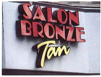
Example of Channel
Lettering
CHANNELIZATION.
Any improvements or other construction activity which occurs within or in the vicinity of an existing natural drainageway or perennial stream which directs or relocates said waterway along some desired course, by increasing its depth or by the use of piping or any other man-made storm drainage structures.
CHEMICAL STORAGE FACILITY.
A building, portion of a building, or exterior area adjacent to a building used for the storage of any chemical or chemically reactive products (applicable in Flood Hazard regulations).
CHEMICAL BULK STORAGE STRUCTURE or AREA.
A building, portion of a building, or exterior area adjacent to a building used for the bulk storage of any chemical or chemically reactive products, hazardous or toxic materials.
CLUSTER DEVELOPMENT.
A development design technique that concentrates buildings on a portion of the site to allow the remaining land to be used for recreation, open space, or preservation of environmentally-sensitive land areas. Buildings are grouped together in order to conserve land resources and provide for innovation in the design of the project. This term includes non-residential development as well as single-family subdivisions and multi-family developments that may or may not involve the subdivision of land.
CODE ENFORCEMENT OFFICIAL.
A person(s) charged with the duty of enforcing the Town Code. The term, as required by context, may refer to the building inspector, or the Planning Administrator.
COLLECTOR STREET PLAN.
A plan, adopted by the local governing body, for streets not shown on the Thoroughfare Plan and showing collector and, if appropriate, lower classification streets in the planning area.
CO-LOCATION.
The placement or installation of wireless facilities on existing structures, including electrical transmission towers, water towers, buildings, and other structures capable of structurally supporting the attachment of wireless facilities in compliance with applicable codes.
COMMERCIALLY IMPRACTICAL.
The inability to perform an act on terms that are reasonable in commerce. The inability to achieve a satisfactory financial return on investment or profit, standing alone, shall not deem a situation to be commercially impracticable.
COMMON AREA(S).
All areas, including private streets, conveyed to an owners' association within a development or owned on a proportional undivided basis in a condominium development. The term is synonymous with "common element" under NC Condominium Act and the NC Planned Community Act.
COMMON OPEN SPACE.
Open space that is (1) owned in common and maintained by the owners of lots in a subdivision (i.e., a homeowner's association), or (2) owned by a private individual or entity but managed and maintained for common use by residents, occupants or customers of the development.
COMPLETED.
Work has progressed to the point that, in the opinion of the Planning Administrator, it is sufficiently completed in accordance with the approved plans and specifications that the work can be utilized for its intended purposes.
COMPOSTING FACILITY.
A facility in which only stumps, limbs, leaves, grass and untreated wood collected from land clearing or landscaping operations are deposited.
CONDITIONED SPACE.
Building space completely enclosed and Protected from outside elements and typically provided with heating and ventilation as opposed to carports and open-air venues.
CONDOMINIUM.
Real estate that is developed pursuant to either the Unit Ownership Act, North Carolina General Statute Chapter 47A or the North Carolina Condominium Act, North Carolina General Statute Chapter 47C.
CONGREGATE CARE FACILITY.
A facility providing shelter and services for ambulatory individuals at least fifty-five (55) years of age who by reason of their age, functional impairment, or infirmity may require meals, housekeeping and personal care assistance. Congregate care facilities do not include nursing homes or similar institutions devoted primarily to the care of the chronically ill or the incurable.
CONSERVATION EASEMENT.
A non-possessory interest of a holder in real property imposing limitations or affirmative obligations, the purposes of which include retaining or protecting natural, scenic, or open space values of real property, assuring its availability for agricultural, recreational, or open space use, protecting natural resources, maintaining or enhancing air or water quality, or preserving historical, architectural, archaeological, or cultural aspects of real property.
CONSERVATION SUBDIVISION.
A subdivision in which the lot sizes are reduced below those normally required in the zoning district in which the development is located, in return for the provision of permanent open space.
CONTRACTOR, GENERAL.
A business which contracts for and assumes responsibility for undertaking a construction project.
CONTRACTORS, SERVICE.
The office of a business providing a specific trade or service, including but not exclusive of plumbing, electricity, carpentry, flooring, pest control, cleaning, restoration, painting and other trades predominately conducted at the customers premises.
COTTAGE DEVELOPMENT.
A cluster of small detached single-family residences constructed to specific design standards and arranged around common open space, generally at higher density than the underlying zoning would allow for traditional detached single-family residential development.
COTTAGE HOME.
A small detached single-family residence constructed to specific design standards and arranged around common open space as part of a cottage development.
COUNTRY CLUB.
A club with both social and designated sporting facilities. Sporting facilities are limited to an 18-hole championship golf course, tennis courts, swimming pools, and exercise and weight training rooms. A country club may have all or any of the following open to its members and/or the public: event room, restaurant or dining and beverage facility, administrative offices, locker rooms, equipment buildings, and "pro-shops" for the retail sale or rental of items related to the sporting facilities.
COUNTY.
Refers to the governing authority of Carteret County, North Carolina.
CRITICAL AREA.
The area adjacent to a water supply intake or reservoir where risk associated with pollution is greater than from the remaining portions of the watershed. The critical area is defined as extending either one-half mile from the normal pool elevation of the reservoir in which the intake is located or to the ridge line of the watershed (whichever comes first); or one-half mile upstream from the intake located directly in the stream or river (run-of-the-river), or the ridge line of the watershed (whichever comes first). Major landmarks such as highways or property lines may be used to delineate the outer boundary of the critical area if these landmarks are immediately adjacent to the appropriate outer boundary of one-half mile.
CRITICAL ROOT ZONE or CRZ.
The rooting area of a tree established to limit root disturbance, generally defined as a circle with a radius extending from a tree's trunk to the furthest point of the crown drip-line.
CROWN CANOPY.
The cover formed by the top branches of trees.
CUL-DE-SAC.
A short local street having one end open to traffic and the other end permanently terminated by a vehicular turnaround.
CURB BULB.
An extension of the curb into the street, beyond the standard edge of the curb, which narrows the width of the roadway and is used to slow the speed of traffic on Town streets. The curb bulb may be used for landscaping, pedestrian crosswalk, or for a combination of uses. Sometimes referred to as a "bulb out."
DAY CARE CENTER.
A facility licensed by the State of North Carolina for the care of children or adults for periods of less than 24-hours per day.
DAY CARE FACILITY.
Any child care arrangement which provides day care on a regular basis for more than four hours per day for more than five children, wherever operated and whether or not operated for profit, except that the following are not included: Public schools; nonpublic schools whether or not accredited by the North Carolina State Department of Public Instruction, which regularly and exclusively provide a course of grade school instruction to children who are of public school age; summer camps having children in full-time residence; summer day camps; and bible schools normally conducted during vacation periods.
DENSITY CREDIT.
Allocation of the density from within exacted land areas to other developable portions of a parcel. Gross density calculation includes this allocation.
DETENTION.
The collection and storage of surface water for subsequent gradual discharge.
DETENTION POND.
A wet or dry stormwater holding area, either natural or man-made, which filters and releases stormwater to nearby or adjoining water bodies in a gradual fashion, also means a pond which collects stormwater runoff, filters the water, and releases it slowly over a period of hours or days. It does not have a permanent pool and is sometimes referred to as a dry pond. Also see definition of Best Management Practices.
DETENTION POND, DRY.
A pond which collects stormwater runoff, holds the water, and releases it slowly over a period of hours or days. It does not have a permanent pool and is sometimes referred to as a dry pond or wet weather pond.
DETENTION POND, WET.
Means a pond that has a permanent pool and also collects stormwater runoff, filters the water, and releases it slowly over a period of days.
DEVELOPER.
A person engaging in development.
DEVELOPMENT.
Any of the following:
a.
The construction, erection, alteration, enlargement, renovation, substantial repair, movement to another site, or demolition of any structure.
b.
The excavation, grading, filling, clearing, or alteration of land.
c.
The removal or destruction of any Native Plants between NC Highway 58 and the Atlantic Ocean except non-native vegetation or shrubs, flowers, vegetables and grass planted on property as landscaping or for gardening.
d.
The subdivision of land as defined in G.S. 160D-802.
e.
The initiation or substantial change in the use of land or the intensity of use of land.
f.
Any Land-disturbing Activity.
Redevelopment of a lot or parcel is Development.
DEVELOPMENT ADMINISTRATOR.
The Planning Administrator.
DEVELOPMENT AGREEMENT.
An agreement between the Town of Pine Knoll Shores and a developer pursuant to Article 10 of G.S. 160D for a large-scale development with a lengthy build-out period and having a public-private partnership component involving mutual financial interests.
DEVELOPMENT, DENSITY OF.
The number of units within a defined area of land. For residential development, density is normally the number of residential units within the total land area of the project. For hotels and motels, the density is normally the number of hotel or motel rooms within the total land area of the project. For offices and commercial development, the density is normally the number of distinct offices or shops within the total land area of the project.
DISPOSAL.
As defined in G.S. 130A-290(a)(6), the discharge, deposit, injection, dumping, spilling, leaking, or placing of any solid waste into or on any land or water so that the solid waste or any constituent part of the solid waste may enter the environment or be emitted into the air or discharged into any waters, including groundwater.
DISPOSAL OF HAZARDOUS OR TOXIC SUBSTANCE(S).
The destruction, discharge, deposit, injection, dumping, spilling, leaking, or placing of any hazardous waste or toxic substance into or on any air, land, or water.
DISPOSAL FACILITY.
A facility or part of a facility at which hazardous waste or toxic substance is intentionally placed into or on any land or water, and at which hazardous waste or toxic substance will remain after closure.
DIVERTER.
A constructed feature designed to prevent left turns or through movements into a residential area, used as method to calm traffic on Town streets.
DORMITORY STRUCTURE.
A residential structure as defined in section 201 of North Carolina State Building Code, Volume I.
DOMESTIC WASTEWATER DISCHARGE.
The discharge of sewage, non-process industrial wastewater, other domestic wastewater, or any combination of these items. It includes liquid waste generated by domestic water-using fixtures and appliances from any residence, place of business, or place of public assembly even if it contains no sewage. Examples of domestic wastewater include once-through noncontact cooling water, seafood packing facility discharges, and wastewater from restaurants.
DOWN-ZONING.
Means a zoning ordinance that affects an area of land in one of the following ways:
(1)
By decreasing the development density of the land to be less dense than was allowed under its previous usage.
(2)
By reducing the permitted uses of the land that are specified in a zoning ordinance or land development regulation to fewer uses than were allowed under its previous usage.
DRAINAGE, DISPERSED.
Drainage spread out, as opposed to collected in channels, so as to effect increased sheet flow and overland flow.
DRAINAGE, ENHANCED.
Drainage carried by existing natural drainageways which have been enhanced to resist soil erosion and stream bank degradation. An enhanced natural drainageway is achieved with the installation of an engineered measure (i.e., netting, riprap) which will resist soil erosion and allow infiltration within the natural drainageway.
DRAINAGE FACILITY.
Any component of the drainage system.
DRAINAGE SYSTEM.
The system through which water flows from the land. It includes all watercourses, waterbodies and wetlands.
DRAINAGEWAY.
Any natural or man-made channel that carries surface runoff from precipitation.
DRAINAGEWAY AND OPEN SPACE AREA, DEDICATED.
The area designated for floodplain and open space purposes on a recorded subdivision plat and thereby dedicated to the public for such purposes and, where approved by the Town, for utilities.
DRAINAGEWAY, IMPROVED.
Drainage channeled by impervious surfaces such as curb and gutter or concrete channels.
DRAINAGEWAY, PROTECTED.
Drainage channeled by pervious devices such as sod waterways, berms, channels, or swales which have been stabilized with vegetation, riprap, or a combination of these, to resist soil erosion.
DRAINAGEWAY (CHANNEL), PROTECTED.
Where drainage is channeled by pervious devices such as sod waterways, berms, channels or swales which have been constructed to resist soil erosion by either vegetating, netting, riprapping, or a combination of those, and which allows infiltration of water into the soil.
DRIPLINE.
A vertical line extending from the outermost portion of a tree's canopy to the ground.
DUNE.
Frontal and Primary Dunes are defined by 15A NCAC 07H .0305 as follows:
FRONTAL DUNES.
The Frontal Dune is the first mound of sand located landward of ocean beaches that has stable and natural vegetation present.
PRIMARY DUNES.
The Primary Dunes are the first mounds of sand located landward of the ocean beaches having an elevation equal to the mean flood level (in a storm having a one percent chance of being equaled or exceeded in any given year) for the area plus six feet. Primary dunes extend landward to the lowest elevation in the depression behind that same mound of sand commonly referred to as the "dune trough."
DUPLEX.
A structure having two (2) dwelling units within a single structure.
DWELLING, ACCESSORY UNIT.
A dwelling that exists either as part of a principal dwelling or as an accessory building that is secondary and incidental to the use of the property as single-family residential.
DWELLING, ATTACHED HOUSE (TOWNHOUSE).
A dwelling unit located within a building and attached to other similar dwelling units in which each unit is located on an individually owned parcel, generally within a development containing facilities and areas owned in common.
DWELLING, MANUFACTURED/MOBILE HOME.
For manufactured/mobile homes built before June 15, 1976, "manufactured/mobile home" means a portable manufactured housing unit designed for transportation on its own chassis and placement on a temporary or semi-permanent foundation having a measurement of over 32 feet in length and over seven feet in width.
DWELLING, MANUFACTURED HOME - TYPE 1.
A structure, transportable in one or more sections, which in the traveling mode is eight body feet or more in width, or 40 body feet or more in length, or, when erected on-site, is 320 or more square feet; and which is built on a permanent chassis and designed to be used as a dwelling, with or without a permanent foundation when connected to the required utilities, including the plumbing, heating, air conditioning and electrical systems contained therein.
DWELLING, MANUFACTURED HOME - TYPE 2.
A double-wide manufactured home, which is two or more portable manufactured housing units designed for transportation on their own chassis that connect on-site for placement on a temporary or semi-permanent foundation having a measurement of over 32 feet in length and over eight feet in width. The term "manufactured home" does not include a recreational vehicle.
DWELLING, MODULAR.
A dwelling constructed in accordance with the standards set forth in the N.C. State Residential Building Code and composed of components substantially assembled in a manufacturing plant and transported to the building site for final assembly on a permanent foundation.
DWELLING, MULTI-FAMILY.
A building or portion thereof used or designed for three or more dwelling units; the term includes apartments, and condominiums.
DWELLING, SINGLE-FAMILY.
A detached building designed for living or sleeping purposes for one family, containing one kitchen, and occupied exclusively by one family. "Kitchen," as used in this definition, shall mean an area within a dwelling used for the preparation of food and containing a cooking stove. Excluded from this definition are: mobile homes, Manufactured Homes of all types, motorhomes, and/or recreational vehicles. Further, no property held in time share (as defined by the General Statutes) or interval form of ownership or fractional share ownership where one or more persons through a recorded document have the exclusive right to possess the property for a specified period of less than a year to the exclusion of all others, shall be within the definition of a single-family dwelling.
DWELLING PARK, MANUFACTURED HOME.
Any place, area, lot, parcel, or space of land maintained, offered or used for the placement of two (2) or more manufactured homes; said space may be used or intended for use as a residential dwelling whether or not compensation is paid for any or all accommodation; and said space may be occupied under various ownership or lease arrangements. The term manufactured home park/court shall include the term mobile home park/court.
DWELLING UNIT.
One or more rooms, designed, occupied or intended for occupancy as separate living quarters for one family, with a separate entrance and cooking, sleeping and sanitary facilities provided therein. Units in dormitories, hotels, motels, shelters for the homeless or other structures designed for transient residents are not dwelling units. (See G.S. 160D-706(b))
EASEMENT.
A grant of one or more of the property rights, such as right of access, by the property owner to, or for use by the public, an individual, a corporation, or other entity.
ELECTRONIC GAMING OPERATION.
Any business enterprise, whether as a principal or accessory use, where persons utilize electronic machines, including, but not limited to computers and gaming terminals to conduct games including but not limited to sweepstakes, lotteries, games, and/or games of chance, and where cash or merchandise, or other items of value are redeemed or otherwise distributed, whether or not the value of such distribution is determined by electronic games played or by predetermined odds, which have a finite pool of winners. The term includes, but is not limited to internet sweepstakes, video sweepstakes, or cybercafés. This definition does not include any lottery endorsed, approved, or sponsored by the State of North Carolina, or arcade games of skill.
ELIGIBLE FACILITIES REQUEST.
A request for modification of an existing wireless tower or base station that involves collocation of new transmission equipment or replacement of transmission equipment but does not include a substantial modification.
ELEVATED BUILDING.
A non-basement building which had its lowest elevated floor raised above ground level by foundation walls, shear walls, posts, piers, pilings, or columns.
ENCROACHMENT.
The advance or infringement of uses, fills, excavation, buildings, permanent structures or development into a floodplain, which may impede or alter the flow capacity of a floodplain. (This definition applies only with respect to flood hazard regulations.)
ENFORCEMENT, COMPLAINT-BASED.
Enforcement action initiated on the basis of information provided by a third-party complainant.
ENFORCEMENT OFFICER.
The Planning Administrator with respect to this Ordinance, but where involving the NC Building Code and required by context, the Building Inspector.
ENFORCEMENT, PROACTIVE.
Enforcement action initiated at the discretion of the Planning Administrator independent of any third-party complaint.
EQUESTRIAN USE.
Paddocks, fields, stables, barns, riding ring, and other facilities provided for the care and use of horses.
EROSION.
The wearing of land surface by the action of wind, water, gravity or any combination thereof.
EROSION, ACCELERATED.
Any increase over the rate of natural (i.e., undisturbed by human intervention) erosion as a result of land-disturbing activities.
EXISTING CONDITIONS.
The current conditions which exist at the site as a result of prior development of the site, including, but not limited to, any structures, impervious surfaces, drainage facilities, and other disturbances of the site. In cases in which no prior development of the site has occurred, the existing conditions are the predevelopment conditions, as defined in this section.
EXISTING DEVELOPMENT.
Those projects that are built or those projects that at a minimum have established a vested right under North Carolina zoning based on at least one (1) of the following criteria:
(A)
Substantial expenditure of resources (time, labor, money) based on a good faith reliance upon having received a valid local government approval to proceed with the project; or
(B)
Having a valid outstanding building permit; or
(C)
Having an approved site specific or phased development plan in compliance with N.C.G.S. 160D-108.
EXISTING LOT OF RECORD.
A lot which is part of a subdivision, a plat of which has been recorded in the Office of the Register of Deeds prior to the adoption of this Ordinance or a lot described by metes and bounds, the description of which has been so recorded prior to December 31, 1999.
FAIR MARKET VALUE.
The price that would be agreed to between a willing buyer and a willing seller, with neither being required to act, and both having reasonable knowledge of the relevant facts.
FAMILY.
One or more persons related by blood or marriage, or up to three unrelated adults, occupying a dwelling unit and living as a single household.
FEDERAL AVIATION ADMINISTRATION (FAA).
The government agency responsible for regulating aviation in the United States.
FEDERAL COMMUNICATIONS COMMISSION (FCC).
The government agency responsible for regulating telecommunications in the United States.
FAMILY CARE HOME.
A home meeting the North Carolina Residential Building Code with support and supervisory personnel that provides room and board, personal care and habilitation services in a family environment for six or fewer resident handicapped persons, pursuant to G.S. 160D-907.
FARM.
See Agricultural Use.
FARMER'S MARKET.
An open-air market at a regularly scheduled venue, includes seasonal and year-round markets.
FEDERAL LAW REFERENCE.
National pollutant discharge elimination system (NPDES) permits (applies to watershed standards only).
FENCE.
A physical barrier or enclosure consisting of wood, stone, brick, block, wire, metal or similar material used as a boundary or means of protection or confinement, but not including a hedge or other vegetation.
FIXTURE, FULL CUT-OFF.
An outdoor light fixture shielded in such a manner that all light emitted by the fixture, either directly from the lamp or indirectly from the fixture, is projected below the horizontal plane as determined by photometric test or certified by the manufacturer.
FIXTURE, PARTIAL CUT-OFF.
An outdoor light fixture shielded in such a manner that more than zero (0) but less than ten (10) percent of the light emitted directly from the lamp or indirectly from the fixture is projected at angles above the horizontal plane, as determined by photometric test or certified by the manufacturer.
FLOOD AND FLOODING.
A general and temporary condition of partial or complete inundation of normally dry land areas from the overflow of the ocean, sound, canals or the unusual and rapid accumulation of runoff of surface waters from any source.
FLOOD INSURANCE.
The insurance coverage provided under the National Flood Insurance Program.
FLOOD INSURANCE RATE MAP (FIRM).
An official map of the Town of Pine Knoll Shores on which the Federal Emergency Management Agency has delineated both the areas of special flood hazard and the risk premium zones applicable to the Town of Pine Knoll Shores and its ETJ.
FLOOD INSURANCE STUDY.
The official report provided by the Federal Emergency Management Agency (FEMA). The report contains flood profiles, as well as the Flood Boundary/Floodway Map and the water surface elevation of the base flood.
FLOODPLAIN.
Any land area susceptible to being inundated by water from any source.
FLOODPLAIN ADMINISTRATOR.
The individual appointed to administer and enforce the floodplain management regulations. Until and unless the Town Manager appoints a different officer, the Planning Administrator is the Floodplain Administrator.
FLOODPLAIN DEVELOPMENT PERMIT.
Any type of permit that is required in conformance with the provisions of this Ordinance, prior to the commencement of any development activity.
FLOODPLAIN MANAGEMENT.
The operation of an overall program of corrective and preventive measures for reducing flood damage and preserving and enhancing, where possible, natural resources in the floodplain, including, but not limited to, emergency preparedness plans, flood control works, floodplain management regulations, and open space plans.
FLOODPLAIN MANAGEMENT REGULATIONS.
This Ordinance and other zoning ordinances, subdivision regulations, building codes, health regulations, special purposed ordinances, and other application of police power which control development in flood prone areas. This term describes federal, state or local regulations, in any combination thereof, which provide standards for preventing and reducing flood loss and damage.
FLOOD PRONE AREA.
See Floodplain.
FLOODPROOFING.
Any combination of structural and nonstructural additions, changes, or adjustments to structures which reduces or eliminates flood damage to real estate or improved real property, water and sanitation facilities, structures, and their contents.
FLOODWAY FRINGE.
The land area located between the floodway and maximum elevation subject to inundation by the base flood as defined in these Definitions.
FLOODWAY.
The channel of a river or other watercourse and the adjacent land areas that must be reserved in order to discharge the base flood without cumulatively increasing the water surface elevation more than one foot.
FLOOD ZONE.
A geographical area shown on a Flood Hazard Boundary Map or Flood Insurance Rate Map that reflects the severity or type of flooding in the area.
FLOOR AREA, GROSS.
The sum of the gross horizontal areas of the several floors of a building measured from the exterior face of exterior walls, or from the centerline of a wall separating two buildings, but not including interior parking spaces, loading space for motor vehicles or any space where the floor-to-ceiling height is less than six feet. Additionally, gross floor area includes areas covered by canopies and like structures under which an active use is occurring such as drive-through service, gasoline pumping, loading and/or storage of materials, and similar activities.
FLOOR.
The top surface of an enclosed area in a building (including basement), i.e., top of slab in concrete slab construction or top of wood flooring in wood frame construction. The term does not include the floor of a garage used solely for parking vehicles.
FOOD TRUCK.
See Market, Tailgate.
FOREST DUNE.
A natural land formation north of frontal and primary dunes that is composed of mounds or hills of sand potentially topped with organic soil and generally covered, or formerly covered with trees or Native Plants. In Pine Knoll Shores, Forest Dunes may be referred to as relic dunes.
FOREST LAND.
Land that is a part of a forest unit that is actively engaged in the commercial growing of trees under a sound management program. Forestland includes wasteland that is a part of the forest unit, but the wasteland included in the unit must be appraised under the use-value schedules as wasteland. A forest unit may consist of more than one tract of forestland, but at least one of the tracts must meet the requirements in G.S. 105-277.3(a)(3), and each tract must be under a sound management program.
FORESTRY ACTIVITY.
Any activity associated with the growing, managing, harvesting, and related transportation, reforestation, or protection of trees and timber, provided that such activity complies with existing state regulations pertaining to forestry. This definition does not include activity associated with development.
FORESTRY MANAGEMENT PLAN.
A document defining the landowner's forest management objectives and the measures to be taken to achieve those objectives. The plan shall include: (1) silvicultural practices for the purpose of growing commercial timber through the establishment of forest stands; (2) insuring the proper regeneration of forest stands to commercial production levels following the harvest of mature timber; (3) insuring both optimal forest productivity and environmental protection of the land.
FREEBOARD.
The height added to the Base Flood Elevation (BFE) to account for the many unknown factors that could contribute to flood heights greater than the height calculated for a selected size flood and floodway conditions, such as wave action and the hydrological effect of urbanization on the watershed. The Base Flood Elevation plus the freeboard establishes the "Regulatory Flood Protection Elevation."
FRONTAGE.
The boundaries of property bordering on a street.
FULLY SHIELDED LIGHTING FIXTURE.
A light fixture that is shielded in such a manner that light rays emitted by the fixture, either directly from the lamp or indirectly from the fixture, are projected below a horizontal plane running through the lowest point on the fixture where light is emitted.
FUNCTIONALLY DEPENDENT FACILITY.
A facility which cannot be used for its intended purpose unless it is located in close proximity to water. The term does not include long-term storage, manufacture, sales, or service facilities. This definition applies only to the Flood Damage Prevention standards.
GATED COMMUNITY.
A subdivision, neighborhood, or residential development to which entry is restricted to residents and their guests. Often includes barriers such as gates, security personnel, fences and/or walls.
GARAGE, PRIVATE.
A building or space used as part of a building permitted in any residential district, providing for the storage of motor vehicles.
GROUND SIGN.
Any sign which is supported by the ground or by uprights or braces placed upon the ground, and which sign is not attached to any structure.
GIFT SHOP.
A retail space in which miscellaneous articles that are appropriate as gifts are sold.
GRADE.
The surface of the ground.
GRADING.
Any operation or occurrence by which the existing site elevations are changed, or where any ground cover, natural or man-made, is removed, or any buildings or other structures are removed, or any watercourse or body of water, either natural or man-made, is relocated on any site, thereby creating an unprotected area. The term "grading" is interchangeable with "land-disturbing activity."
GRADING PLAN.
The graphic plan, including narrative where appropriate, required by this Ordinance as a prerequisite for a Landscaping Permit, the purpose of which is to explain existing conditions and proposed grading of land including any development and to describe the activities and measures to be undertaken to control accelerated soil erosion and sedimentation.
GRANDFATHERED.
Not affected by a change in this Ordinance absent physical modification or abandonment. Buildings, land uses, and lots or parcels of property that do not meet the standards of this Ordinance but legally existed prior to the effective date of this Ordinance, and complied with prior ordinances, regulations, and or standards, shall not be affected by this Ordinance absent physical modification or abandonment.
GRAND OPENING.
A promotional activity not exceeding 30 calendar days used by newly established businesses, within 60 calendar days after initial occupancy, to inform the public of their location and services available to the community.
GRAVEL.
A clean or washed, loose aggregation of small, rounded, water-worn or pounded stones ranging in size from .08" to 3.0" in size. Gravel is not crushed stone or rock.
GREENWAY.
A linear open space managed for public use that has been designated on an officially adopted greenway plan. Greenways typically link parks, nature preserves, cultural features or historic sites with each other and/or with neighborhoods and commercial districts.
GROUP CARE FACILITY.
A facility licensed by the State of North Carolina (by whatever name it is called, other than "Family Care Home" as defined by this Ordinance), with support and supervisory personnel that provides room and board, personal care or habilitation services in a family environment.
HANGING SIGN.
Any nonportable sign suspended from a brace, arm, ceiling, or other overhead support, including a sign projecting beyond the surface of a building.
HERITAGE TREE.
(1)
Any tree listed in the N.C. Champion Big Trees List;
(2)
Any tree listed on the American Forest Association's Champion Tree List that measures 80 percent of the points of a tree on the N.C. Champion Big Trees List; and
(3)
Individual trees of any size or species that are designated as a heritage tree by the Pine Knoll Shores Board of Commissioners. See www.dfr.state.nc.us/urban/pdf/eligible.
HAZARDOUS MATERIAL.
Any material listed as such in: Superfund Amendments and Reauthorization Act (SARA) section 302, Extremely Hazardous Substances (42 USC 1100 et seq.); Comprehensive Environmental Response, Compensation and Liability Act (CERCLA) Hazardous Substances (42 USC 9601 et seq.); or section 311 of the Clean Water Act, as amended (CWA) (33 USC 1251 et seq.; oil and hazardous substances) hereby incorporated by reference including any subsequent amendments and editions.
HAZARDOUS or TOXIC SUBSTANCE.
Any solid waste as defined in G.S. 130A-290, or any substance regulated under the Federal Toxic Substance Control Act of 1976 (PL 94.476), as amended from time to time, which because of its quantity, concentration, or physical chemical or infectious characteristic(s) may: 1) cause or significantly contribute to an increase in serious irreversible or incapacitating illness, or; 2) pose a substantial present or potential threat to the environment when improperly treated, stored, transported, disposed of, or otherwise managed.
HIGHEST ADJACENT GRADE (HAG).
The highest natural elevation of the ground surface, prior to construction, immediately next to the proposed walls of the structure.
HIGHWAY.
U.S. and/or N.C. designated highway. Also see Streets.
HEIGHT, BUILDING.
Building height is determined by establishing the highest and lowest points of proposed grade elevation, whether natural or approved grade, at the exterior foundation walls, pilings, or columns of the building as proposed and after construction. Using these two elevations, the average elevation shall be calculated. The resultant average elevation shall be the point from which the building height is measured in a vertical plumb line to the highest point of the building above the calculated average grade elevation. Chimneys extended less than six feet above the highest point of a building are excluded from the calculation of building height. (See definition below for freestanding sign height.)
HEIGHT, FREESTANDING SIGN.
The vertical distance between the highest part of the sign or its supporting structure, whichever is higher, and finished grade at the midpoint of the base of the sign.
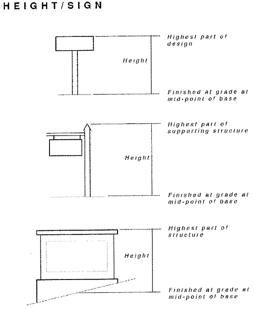
HEIGHT, OTHER STRUCTURE.
The vertical distance from the existing grade to the highest point of the structure above such existing grade.
HOME OCCUPATION.
Any business use conducted entirely within a dwelling and carried on by the occupants thereof, which use is incidental and secondary to the use of the dwelling for residential purposes and does not change the character of the dwelling or the neighborhood. This definition shall not however, permit embalmers, funeral directors, undertakers, funeral homes, barbers, beauticians, or veterinarians to operate within the residential zones. They are specifically excluded.
HOTEL or MOTEL.
A building or other structure kept, used, maintained, advertised as or held out to the public to be a place where sleeping accommodations are supplied for pay to transient or permanent guests or tenants, where rooms are furnished for the accommodation of tenants or such guests, and having or not having one or more dining rooms, restaurants, or cafes where meals are served to such transient or permanent guests.
ILLICIT CONNECTION.
Any unlawful connection which allows the discharge of non-stormwater to the stormwater conveyance system or waters of the state in violation of this Ordinance.
ILLICIT DISCHARGE.
Any unlawful disposal, placement, emptying, dumping, spillage, leakage, pumping, pouring, emission, or other discharge of any substance other than stormwater into a stormwater conveyance, the water of the state, or upon the land in such proximity to the same, such that the substance is likely to reach a stormwater conveyance or the waters of the state.
IMPACT.
The effect of one land use upon another as measured by traffic or noise generation, site activity, hours of operation, site lighting, vibration, smoke or odor emissions, or similar factors.
IMPERVIOUS SURFACE.
Improvements including street pavement, driveways, gravel areas, buildings, and other structures which cover the soil surface and substantially prevent infiltration of water into the soil.
IMPERVIOUS SURFACE COVERAGE.
That portion of a lot covered by buildings, structures, paving or other impervious surface materials.
INTEGRATED MULTIPLE USE DEVELOPMENT (IMUD).
A development containing three or more stores, service establishments, offices, or other permitted uses planned, organized, and managed to function as a unified whole and featuring all of the following: 1) common driveways, 2) common parking, 3) common signage plan, and 4) common landscaping plan. Examples are shopping centers and office parks having the characteristics listed above. Such integrated developments may include outparcels for lease or for sale. Any such integrated development may be organized as a condominium or in a manner analogous to that of a City-house development (with ownership parcels beneath the building units and with parking and driveways being in common elements owned and maintained by an Owners' Association).
INITIAL DEVELOPMENT MEETING.
An early informal meeting between an applicant for a permit required for Development and the Planning Administrator for a discussion of the proposed Development, the Town's general regulations for the Development including the applications and permits required to authorize the Development, state or federal permits that may be needed for the Development, any other matters that relate to the proposed Development. The owner of the property for which Development is proposed is encouraged to attend the Initial Development Meeting, and it is required that an owner's agent attend the meeting. Other Town representatives and officials may attend and participate in the Initial Development Meeting. The Planning Administrator may require the Initial Development Meeting before accepting applications for permits for Development required for the construction of new buildings or the enlargement of existing buildings. Where Development does not involve new construction, the Planning Administrator may call for the Initial Development Meeting after an application has been filed.
INOPERATIVE VEHICLE.
See Motor Vehicle, Junked.
INTERDUNAL TROUGH.
A naturally occurring depression between adjacent relict dunes. Such areas afford natural recharge of groundwater and may also be classified as wetlands (see definition herein). All significant interdunal troughs are shown on base topographic maps located at the Town Hall.
JUNK/SALVAGE YARD.
Any land or area used, in whole or in part, for the storage, keeping, or accumulation of material, including scrap metals, waste paper, rags, or other scrap materials, or used building materials, for the dismantling, demolition or abandonment of automobiles or other vehicles or machinery or parts thereof.
JUNKED AUTOMOBILE.
See Motor Vehicle, Junked.
LAND-DISTURBING ACTIVITY.
Any activity that materially changes the surface of land, or natural vegetation thereon, including grading, excavating, filling, construction and removal of trees and vegetation. Land-disturbing activity does not include the following:
(1)
Insignificant land-disturbing activities including, but not limited to: home gardening, lawn care, and planting of trees and shrubbery that does not materially alter the topography; underground utility repairs; home utility repairs; and minor repairs and maintenance work.
(2)
Installation of a fence, sign, utility poles, and other structures of similar nature.
(3)
Emergency work to protect life, limb or public property.
LANDFILL.
A site or facility used for the disposal of solid waste on land. Excluded from this definition is a site designated by the Town for the temporary collection of vegetative or construction demolished debris following a storm for later removal to an approved facility for permanent disposal.
LANDSCAPE PLAN.
A scaled representation of property for which the owner proposes Development that includes, among other things, such matters as the location on a site of proposed Development, areas proposed for excavation or fill, the location of existing structures and new structures, the location of additions to existing structures, the location of existing and proposed impervious surfaces, the location of existing Native Plants including Regulated Trees, the location of proposed destruction of Native Plants including Regulated Trees, the location of proposed plantings. The specific requirements for Landscape Plans are detailed in Article 11 of this Ordinance.
LANDSCAPING PERMIT.
The authorization form issued by the Planning Administrator for the work described in the permit and associated approved plans.
LIGHTING, ACCENT.
Lighting intended to accentuate an architectural feature such as a window, roofline, or other vertical or horizontal element and consisting of small, non-flashing white lights.
LIVESTOCK.
Animals, poultry or aquatic life bred and/or raised for food or to assist with work. Traditional domesticated house pets limited to dogs, cats, small caged birds, and fish in aquariums, are not livestock.
LIVING UNIT.
See Dwelling.
LOADING SPACE, OFF STREET.
A space logically and conveniently located for bulk pickups and deliveries, scaled to delivery vehicles expected to be used, and accessible to such vehicles. Required off-street loading space is not to be included as off-street parking space in computation of required off-street parking space.
LOT.
A portion of a subdivision or any other parcel of land intended as a unit for transfer of ownership or for development or both. The word "lot" includes "plot," "parcel," or "tract."
LOT, CORNER.
A lot abutting two or more streets at their intersection.
LOT, DEPTH.
The distance measured along the perpendicular bisector of the smallest possible rectangle enclosing the lot.
LOT, INTERIOR.
A lot other than a corner lot.
LOT LINE.
A line dividing one lot from another or from a street, public place, or other tract or parcel of land.
LOT, EASEMENT-ACCESS.
An Existing Lot of Record recorded in the Office of the Register of Deeds with an established residential use not abutting a public street where an access easement of at least fifteen (15) feet in width for the entire length of said easement has also been recorded in the Office of the Register of Deeds.
LOT OF RECORD.
A lot, plot, parcel or tract recorded in the Office of the Register of Deeds in conformance with the ordinance(s) in effect at the time of recordation, see "Existing Lot of Record."
LOT, REVERSE FRONTAGE.
A through lot which is not accessible from one of the parallel or nonintersecting streets upon which it fronts.
LOT, THROUGH.
A lot abutting two streets that do not intersect at the corner of the lot.
LOT WIDTH.
The mean width measured at right angles to its depth at the building front setback line.
LOWEST ADJACENT GRADE (LAG).
The elevation of the ground, sidewalk or patio slab immediately next to the building, or deck support, after completion of the building.
LOWEST FLOOR.
Lowest floor of the lowest enclosed area (including basement). An unfinished or flood resistant enclosure, usable solely for parking of vehicles, building access, or limited storage in an area other than a basement area is not considered a building's lowest floor, provided that such an enclosure is not built so as to render the structure in violation of the applicable non-elevation design requirements of this Ordinance.
MAINTENANCE.
Work that is done regularly to keep a structure or lot in good condition or repair.
MAINTENANCE (OF A SIGN).
Cleaning, painting, repairing, or replacing defective parts in such a manner that does not alter the basic structure of a sign. This definition includes the changing of the copy or listings on a changeable copy, civic event, sandwich board, or directory sign and the replacement of sign copy with other sign copy of the same or smaller size on other permitted signs.
MAINTENANCE (OF A TREE).
All operations including trimming, pruning, spraying, injecting, fertilizing, treating, bracing, and doing surgery work on a tree.
MAJOR WATERSHED VARIANCE.
A variance from the minimum statewide watershed protection rules that results in the relaxation by a factor greater than five (5) percent of any buffer, density or built-upon area requirement under the high density option; any variation in the design, maintenance or operation requirements of a wet detention pond or other approved stormwater management system; or relaxation by a factor greater than ten (10) percent of any management requirement under the low density option.
MANUFACTURED HOME.
A structure, transportable in one or more sections, which is built on a permanent chassis and designed to be used with or without a permanent foundation when connected to the required utilities. The term "manufactured home" does not include "recreational vehicle." (This definition applies to flood hazard regulations. See Article 18.) See "Dwelling, Manufactured Home."
MANUFACTURED HOUSING AND WOOD BUILDINGS.
An industrial process that involves the production and assembling of manufactured housing and other wooden buildings utilizing parts that are pre-made and fabricated elsewhere.
MARKET, TAILGATE.
The periodic offering for sale of fresh agricultural and/or prepared food products directly to the consumer at an open-air venue, including the term "Food Truck."
MARKET VALUE.
The building value, not including the land value, and that of any accessory structures or other improvements on the lot. Market value may be established by independent certified appraisal; replacement cost depreciated for age of building and quality of construction (Actual Cash Value); or adjusted tax assessed values.
MAXIMUM ALLOWABLE DENSITY.
See Development, Density of.
MAXIMUM RUNOFF CONTROL.
Means approximately one hundred (100) percent of Built-Upon Area runoff must pass through permanent wet detention pond(s).
MEAN SEA LEVEL.
For purposes of this Ordinance, the National Geodetic Vertical Datum (NGVD) as correct in 1929, the North American Vertical Datum (NAVD) as correct in 1988, or other vertical control datum used as a reference for establishing varying elevations within the floodplain, to which Base Flood Elevations (BFEs) shown on a FIRM are referenced. Refer to each FIRM panel to determine datum used.
MEASUREMENT HEIGHT.
The point on a tree for measuring diameter to determine if a tree is a Regulated Tree.
MINOR WATERSHED VARIANCE.
A variance from the minimum statewide watershed protection rules that results in the relaxation by a factor of up to five percent of any buffer, density or built-upon area requirements under the high-density option; or relaxation by a factor of ten (10) percent of any management requirement under the low-density option.
MIXED DEVELOPMENT.
A mixture of residential, office, commercial, and/or institutional uses.
MIXED USE DEVELOPMENT.
The combination of complementary land uses in an integrated fashion through the development of a tract of land, building or structure.
MOBILE HOME.
See Dwelling, Manufactured Home.
MOBILE HOME PARK.
See Dwelling Park, Manufactured Home.
MOBILE HOME SPACE.
A plot of land designed for the accommodation of one mobile home. See Dwelling Park, Manufactured Home.
MOBILE OFFICE.
A structure identical to a mobile home except that it has been converted, or originally designed and constructed, for commercial or office use. Such structure may be permitted on property when needed (other than as a dwelling) during the period of construction of improvements upon the property upon which the unit is located.
MODERATE RUNOFF CONTROL.
Means at least seventy-five (75) percent of Built-Upon Area runoff must pass through permanent wet detention pond(s).
MODULAR HOUSING.
See, Dwelling, Modular.
MOTEL.
See Hotel or Motel.
MOTOR VEHICLE, JUNKED or ABANDONED.
A motor vehicle that is not currently registered and does not display a current license plate and one or more of the following applies: 1) the vehicle is partially dismantled or wrecked; or 2) the vehicle cannot be self-propelled or moved in the manner in which it originally was intended to move; or 3) the vehicle is more than five years old and appears to be worth less than five hundred dollars ($500.00).
MULTI-FAMILY DWELLING.
See Dwelling, Multi-family.
MUNICIPAL SEPARATE STORM SEWER SYSTEM (MS4).
A stormwater conveyance or unified stormwater conveyance system (including without limitation: roads with drainage systems, municipal streets, catch basins, stormwater detention facilities, curbs, gutters, ditches, natural or man-made channels, or storm drains), that:
(1)
Is located within the corporate limits of the Town of Pine Knoll Shores, North Carolina;
(2)
Is owned or operated by the State, county, the Town, or other public body; and
(3)
Discharges to waters of the State, excluding publicly owned treatment works, and lawful connections thereto, which in turn discharge into the waters of the State.
NATIONAL POLLUTANT DISCHARGE ELIMINATION SYSTEM.
A permitting system established pursuant to 402 of the Clean Water Act.
NATIVE PLANT.
Trees, plants and shrubs, whether existing naturally or planted by man, endemic, indigenous or naturalized within the Town's corporate limits and acclimated to the salt spray, sandy conditions and temperature extremes within the Town. Excluded from this definition are vegetable gardens, flower gardens, shrubs and flowers planted as landscaping features around structures, plants in pots, and yard grasses; however, under no circumstances will sea oats or American beachgrass on the south side of Highway 58 be considered yard grasses. See the vegetation list in the appendix for a list of native plant species. The Planning Administrator has the responsibility to periodically update this list with new information.
NATURAL SYSTEMS.
Systems which predominantly consist of or use those communities of plants, animals, bacteria and other flora and fauna which occur endogenously on the land, in the soil or in the water.
NECKDOWN.
Constructed features designed and placed to narrow the width of traffic lanes in order to slow the speed of traffic on Town streets. Curb bulbs and chicanes may be used for this purpose.
NEIGHBORHOOD.
An area of the Town with characteristics which distinguish it from others including distinct economic bases, housing types, development styles or patterns, or boundaries defined by distinct physical barriers such as arterial streets and natural areas. Typically a neighborhood will have its own Owners' Association.
NEIGHBORHOOD PLAN.
The plan officially adopted by the Pine Knoll Shores Board of Commissioners for a particular neighborhood or district that provides specific design standards and guidelines regulating the development and use of the property.
NEPA.
The National Environmental Policy Act of 1969.
NEW CONSTRUCTION.
Structures for which the "start of construction" commenced on or after the effective date of the original version of the community's Flood Damage Prevention Ordinance and includes any subsequent improvements to such structures. (This definition applies only with respect to flood hazard regulations.)
NEW DEVELOPMENT.
Any land-disturbing activity which adds to or changes the amount of built-upon area. (This definition applies only with respect to watershed protection regulations.)
NONCONFORMING USE.
Any current legal use of property not otherwise permitted under current zoning regulations. This may include, without limitation: 1) a use legally established under requirements at the time of installation or construction but not now permitted in the zoning district in which it is located, or 2) a use conditionally allowed in the zoning districts in which it is located but for which no special use permit has been obtained. See Grandfathered.
NONCONFORMITY, DIMENSIONAL.
Any current legally constructed improvement on property not otherwise permitted under current zoning regulations, involving a dimensional or numerical development requirement. This definition does not include Signs, Nonconforming, which are defined herein and addressed in Article 17. Dimensional nonconformities may include, without limitation, nonconformities associated with density, landscaping, buffering, lot size, lot width, lot depth, setbacks, height, structure size standards, impervious surface standards, open space, number of parking spaces, or separation requirements between particular uses or zoning districts. See Grandfathered.
NONCONFORMITY, LAWFUL.
Any current legal lot, structure, or use of property not otherwise permitted under current zoning regulations constructed or established in conformity with the then-applicable development requirements of the Town, but subsequently not permitted by action of the Town through a zoning map or unified development code text amendment. See Grandfathered.
NONENCROACHMENT AREA.
The channel of watercourse and the adjacent land areas that must be reserved in order to discharge the base flood without cumulatively increasing the water surface elevation more than one (1) foot as designated in the Flood Insurance Study report.
NORTH AMERICAN INDUSTRY CLASSIFICATION SYSTEM.
The most current edition of the North American Industry Classification System (NAICS) used by Federal statistical agencies in classifying business establishments for the purpose of collecting, analyzing, and publishing statistical data related to the U.S. business economy.
NUISANCE.
Anything that materially interferes with the use or enjoyment of property, endangers personal health or safety, or is offensive to the senses.
NURSING HOME.
An establishment which provides full-time convalescent and/or chronic care, including food, shelter, and caregiver or nursing care, for persons who are not related by blood or marriage to the operator or who, by reason of advanced age, chronic illness or infirmity, are unable to care for themselves. This term includes assisted care facility, convalescent home, home for the aging, sanitarium, rest home, or any similar facility.
OCEANFRONT PARCEL.
The entirety of a lot or parcel of land adjacent to the ocean or the public trust ocean beach, and, for condominiums, includes the entirety of all common areas adjacent to the ocean or the public trust ocean beach.
OCEANFRONT VEGETATION.
(a)
All trees or shrubs growing in the ground on an oceanfront parcel with diameters less than regulated trees, and
(b)
All indigenous vegetation growing in the ground on an oceanfront parcel not considered a tree or shrub except for: (i) typical lawn grasses (but under no circumstances are American beach grass or sea oats to be considered "lawn grasses"), (ii) shrubs planted within ten feet of an exterior wall of a dwelling, (iii) planted flowers (as opposed to wild flowers), (iv) planted vegetables, and (v) poison ivy.
OCCUPANCY.
A separately leased or owned area within a building having ground level frontage on a right-of-way or parking facility.
OFF-PREMISES.
Not located on the property to which it pertains.
OFFICE, PROFESSIONAL.
The office of a member of a recognized profession maintained for the conduct of that profession, including, but not limited to, the offices of doctors, lawyers, dentists, landscape architects, architects, stockbrokers and financial analysts, chiropractors, engineers, surveyors, or town planners.
OFFICE-WAREHOUSE.
A land use that includes offices that support showroom or warehouse uses.
ONE-YEAR, 24-HOUR STORM.
The surface runoff resulting from a 24-hour rainfall of an intensity expected to be equaled or exceeded, on average, once in 12 months and with a duration of 24-hours.
ON-PREMISES.
Located on the property to which it pertains.
OPEN SPACE.
Any publicly dedicated or privately-owned area of land or water that is permanently preserved and maintained and on which no building is located. Such an area may be predominately in a natural condition or modified for uses such as recreation, education, aesthetics, cultural or natural resource management or public health and safety.
OWNER.
The person in whom is vested the fee ownership, dominion, or title of property (i.e., the proprietor). This term may also include a tenant, if chargeable under his lease for the maintenance of the property, and any agent of the owner or tenant including a developer.
PARCEL.
An area of land, designated by a property owner as an area for unified development, as shown on a recorded subdivision plat.
PARKING AREA or LOT.
A lot, or an area of land other than a street or public way, used for the parking of motor vehicles and trailers other than vehicles for exhibition, permanent storage or sale.
PARKING SPACE.
A marked area designed and used for parking a single vehicle. Public parking areas shall include spaces for standard vehicles nine feet by 18 feet, and vehicles carrying handicapped persons 12 feet by 18 feet.
PASSIVE RECREATION ELEMENT.
Trails, open space, uncovered picnic areas, and similar facilities provided for recreational use.
PERENNIAL AND INTERMITTANT STREAMS.
Those streams as indicated on the following:
(A)
On the most recent version of the United States Geological Survey 1:24,000 scale (7.5-minute quadrangle) topographical map;
(B)
On the most recent version of the Soil Survey of Carteret County developed by the United States Department of Agriculture (USDA) Natural Resource Conservation Service (formerly the USDA Soil Conservation Service);
(C)
By other site-specific evidence that indicates to the North Carolina Division of Water Quality (DWQ) the presence of such waters not shown on either of these two (2) maps or evidence that no actual stream or water-body exists; or
(D)
Upon determination following field inspection by a qualified professional.
PERSON.
Any and all persons, natural or artificial and includes any individual, firm, corporation, government agency, business trust, estate, trust, partnership, association, two or more persons having a joint or common interest or other legal entity.
PERSONAL COMMUNICATIONS SERVICES (PCS).
Two-way, personal, wireless communications systems.
PET HOUSE.
An outdoor shelter or structure (excluding fence) for pets that is no larger than three feet by four feet by four feet and is located at the rear of residential property.
PLAN, SKETCH.
A rough sketch map of a proposed subdivision or site showing streets, lots, and any other information required by the Town of sufficient accuracy used for discussion of the street system and the proposed development pattern.
PLANNED COMMUNITY.
Real estate with respect to which any person, by virtue of that person's ownership of a lot, is expressly obligated by a declaration to pay real property taxes, insurance premiums, or other expenses to maintain, improve, or benefit other lots or other real estate described in the declaration. For purposes of this act, neither a cooperative nor a condominium is a planned community, but real estate comprising a condominium or cooperative may be part of a planned community. "Ownership of a lot" does not include holding a leasehold interest of less than 20 years in a lot, including renewal options.
PLANNED UNIT DEVELOPMENT.
An area of land under unified ownership or control to be developed and improved as a single entity under a Unified Development Plan in accordance with and subject to the requirements of this Ordinance.
PLANNING ADMINISTRATOR.
The official appointed by the Town Manager to interpret, administer, and enforce this Pine Knoll Shores Development Ordinance. In the absence of the Planning Administrator, the Town Manager may appoint one or more individuals to serve temporarily as the planning administrator and when so serving, such substitute will have all authority and immunity as the Planning Administrator.
PLAT.
A surveyed map or plan of a parcel of land which is to be, or has been subdivided.
PLAT, FINAL.
The final map of all or a portion of a subdivision or site plan, showing the boundaries and location of lots, streets, easements and other improvements required by the Town, which is presented for approval by the Town and subsequently recorded in the Carteret County Register of Deeds Office.
PLAT, PRELIMINARY.
A map indicating the proposed layout of the subdivision or site showing lots, streets, water, sewer, storm drainage and any other improvements required by the Town, which is presented for preliminary approval.
POLLUTION.
Man-made or man-induced alteration of the chemical, physical, biological, thermal, and/or radiological integrity of air or water.
PORCH.
An open structure attached to and projecting from the front, side or rear wall of a building, whether or not covered by a roof.
PORTABLE STORAGE UNIT (POD).
A transportable unit designed and used for the temporary storage of household goods, personal items and other materials which is placed on a site for the use of occupants of a dwelling or building on a limited basis. Such containers are uniquely designed for their ease of loading to and from a transport vehicle.
POST-FIRM.
Construction or other development for which the "start of construction" occurred on or after the effective date of the initial Flood Insurance Rate Map for the area.
POWELL BILL MAP.
A map showing the length, width and surface improvement type (pavement, dirt, gravel, etc.) of municipal streets submitted annually by North Carolina Municipalities to NCDOT for purposes of determining each municipality's share of N.C. gasoline taxes for street maintenance purposes.
PREDEVELOPMENT CONDITIONS.
Those conditions which existed before alteration, resulting from human activity, of the natural topography, vegetation and rate, volume or direction of surface water or groundwater flow, as indicated by the best available historical data.
PRE-FIRM.
Construction or other development for which the "start of construction" occurred before the effective date of the initial Flood Insurance Rate map for the area.
PRINCIPALLY ABOVE GROUND.
That at least 51 percent of the actual cash value of the structure is above ground.
PRINCIPAL STRUCTURE.
A structure (or structures) in which the principal use of the lot or property is conducted.
PRINCIPAL USE.
The primary use of any lot or property.
PROFESSIONAL OFFICE.
See Office, Professional.
PROJECT.
A tract or parcel of land under single ownership utilized, or intended by the owner to be utilized, for purposes of condominium, motel, hotel, apartment or commercial use, or some combination of the above, as well as the facilities appurtenant to such uses, and on which all buildings and structures are maintained by a single homeowners' association, if a condominium, or by a single landlord or owner, if a hotel, motel, apartment house or other commercial use. A project may consist of two or more phases, constructed independently whether or not planned at the time of construction of the initial improvement, but each such phase constructed after July 1, 1984, shall be considered, for the purposes of code compliance, an independent project. The maximum allowable density within a total project, regardless of the number of phases, shall not exceed the sum of the maximum allowable density for all its phases and, regardless of the number of units within any phase constructed prior to July 1, 1984, this definition shall not be interpreted to limit the maximum allowable density of a total project to less than that allowed by this chapter for the total project.
PROTECTED ROOT ZONE.
An undisturbed, protected area surrounding a tree or group of trees where adequate measures are required to be taken to protect tree roots and save trees during construction.
PROTECTION PLAN.
A description of the methods used to protect trees during the development and construction processes.
PUBLIC OPEN SPACE.
Open space that is accessible to the general public and maintained by the Town.
PUBLIC SAFETY NUISANCE.
Anything which is injurious to the safety or health of an entire community or neighborhood, or any considerable number of persons, or unlawfully obstructs the free passage or use, in the customary manner, of any navigable waterbody or basin.
PUBLIC SERVICES DIRECTOR.
The Town official appointed by the Town Manager with supervisory authority over the water system, municipal streets, and Town property.
QUALIFIED LAND.
All land within a project except marshland, public roadways and natural bodies of water.
RECEIVING BODIES OF WATER.
Any waterbodies, watercourses or wetlands into which surface waters flow either naturally, in man-made ditches, or in a closed conduit system.
RECREATIONAL FACILITY.
A park with a majority of its area open space, a children's playground with non-mechanical equipment, an outdoor tennis court, an outdoor basketball court, a swimming pool, or a gazebo. Recreational facilities may not have rides operated by mechanical means and may not have permanent seating devices such as bleachers.
RECREATIONAL VEHICLE.
A vehicle which is built on a single chassis, 400 square feet or less when measured at the largest horizontal projection, designed to be self-propelled or permanently towable by a light duty vehicle, and designed primarily for use not as a permanent dwelling but as temporary living quarters for recreational, camping, travel or seasonal use.
RECREATIONAL VEHICLE PARK (including CAMPGROUND).
Any site or tract of land, of contiguous ownership, upon which 15 or more recreational vehicles or tent spaces are provided for occupancy according to the requirements set forth in this Ordinance.
REDEVELOPMENT.
New Development after the abandonment of a use on property subsequent to the adoption of this Ordinance and the demolition of one or more structures existing at the time of adoption of this Ordinance. It is the process of developing land which is, or has been, previously developed.
REFERENCE LEVEL.
The top of the lowest floor for structures within Special Flood Hazard Areas designated as Zone AO, AE, or A.
REGULATORY FLOOD PROTECTION ELEVATION.
The "Base Flood Elevation" plus the "Freeboard." In "Special Flood Hazard Areas" where Base Flood Elevations (BFEs) have been determined, this elevation shall be the BFE plus two (2) feet of freeboard. In "Special Flood Hazard Areas" where no BFE has been established, this elevation shall be at least two (2) feet above the highest adjacent grade.
REGULATED TREE.
Any tree three inches in diameter or greater at 36" above adjacent grade. In the event a tree has been cut before it was measured, and there is no reliable evidence of its diameter at measurement height, but a stump remains, the tree is deemed a Regulated Tree if the stump equals or exceeds 3.5 inches in diameter.
REGULATING PLAN.
A master development plan for a site, parcel, or property, meeting the standards of the Town of Pine Knoll Shores and identifying building, parking, and landscape locations, open spaces, trails, other amenities, and other features as required by the Town. Upon its approval by the Pine Knoll Shores Board of Commissioners, the plan becomes the guide for the development of the property and all development activity on the property must comply with the plan.
RELIGIOUS AND EDUCATIONAL ORGANIZATIONS.
Those religious or educational organizations qualified as tax exempt under section 501(c)(3) of the U.S. Internal Revenue Code of 1954.
REMEDY A VIOLATION.
To bring the structure or other development into compliance with State and community floodplains management regulations, or, if this is not possible, to reduce the impacts of its noncompliance. Ways that impacts may be reduced include protecting the structure of other affected development from flood damages, implementing the enforcement provisions of the ordinance or otherwise deterring future similar violations, or reducing Federal financial exposure with regard to the structure or other development. (This definition applies only with respect to flood hazard regulations.)
RENOVATION.
The repairing or remodeling of a structure in which the exterior walls, foundation and roof are maintained structurally intact.
REQUIRED DRAINAGE CHANNEL.
The theoretical streambed section which is required to carry and discharge the runoff from a 100-year storm.
RESEARCH AND TECHNOLOGY PRODUCTION USES.
Uses such as medical, optical and scientific research facilities, software production and development, clinics and laboratories, pharmaceutical compounding and photographic processing facilities, and facilities for the assembly of electronic components, optical equipment, and precision instruments.
RESIDENTIAL DEVELOPMENT.
Buildings for use as residences such as attached and detached single-family dwellings, apartment complexes, condominiums, townhouses, cottages, etc., and their associated outbuildings such as garages, storage buildings, gazebos, etc., and customary home occupations.
RETAINING WALL.
As distinguished from a bulkhead, a wall, unconnected structurally to the principal structure, constructed for the sole purpose of retaining soil or sand from eroding or shifting, and which wall extends no more than 12 inches in height above the grade of the soil or sand being retained.
RETENTION.
The collection and storage of runoff with subsequent discharge to surface or subsurface waters.
RETENTION POND.
A stormwater holding area, either natural or man-made, which has a permanent pool and does not release stormwater to nearby or adjoining water bodies. Also means a pond that has a permanent pool and also collects stormwater runoff, filters the water, and releases it slowly over a period of days. Also see Best Management Practices definition.
RIGHT-OF-WAY.
The portion of the street and adjacent area controlled by the town or the state.
RIVERINE.
Relating to, formed by, or resembling a river (including tributaries), stream, brook, etc.
ROOF LINE.
Either the top edge of the roof or the top of the parapet, whichever forms the top line of the building silhouette.
RUNOFF CONTROL IN EXCESS OF MINIMUM REQUIREMENTS OF EROSION CONTROL ORDINANCE.
Means at least fifty (50) percent of Built-Upon Area runoff must pass through permanent wet detention pond(s).
RUNOFF DETENTION EQUAL TO MINIMUM REQUIREMENTS.
Velocity control of runoff.
RURAL MARKET.
Place of business serving primarily rural areas and trading in primarily rural products, produce, crafts, and commodities. Does not include convenience stores, gasoline and/or fuel sales.
SALVAGE YARD.
Any non-residential property used for the storage, collection, and/or recycling of any type of equipment, and including but not limited to vehicles, appliances and related machinery.
SCENIC CORRIDOR.
An area providing scenic vistas visible from a highway or roadway that is designated by the Town of Pine Knoll Shores as having special importance to the character of the Town and meriting special protection and preservation measures.
SEASONAL WATER TABLE LEVEL.
The elevation to which the groundwater level can be expected to rise during a normal wet season.
SECONDARY USE.
A permissible use that is not allowed as the principal use of a property, but is allowed as an additional use on a property and said use is not ancillary or accessory to the principal use.
SEARCHLIGHT.
A device that emits an upwardly-directed beam of light to attract commercial attention.
SEDIMENT.
Solid particulate matter, both mineral and organic, that has been or is being transported by water, air, gravity, or ice from its site of origin.
SEDIMENTATION.
The process by which sediment resulting from accelerated erosion has been or is being transported off the site of the land-disturbing activity or into a lake or natural watercourse.
SEDIMENTATION/RETENTION FACILITY.
Any structure or area which is designed to hold runoff water until suspended sediments have settled.
SETBACK.
The minimum required horizontal distance between a structure and the lesser of either the lot line or the line that marks the beginning of street right-of-way maintenance by the Town of Pine Knoll Shores or the North Carolina Department of Transportation, as determined by the Town of Pine Knoll Shores.
SETBACK, REAR.
A setback from an interior property line lying on the opposite side of the lot from the front street setback.
SETBACK, SIDE.
Any interior property line setback other than a rear setback.
SETBACK, STREET.
Any setback from a street, road or lane right-of-way line.
SETBACK, ZERO SIDE.
An alternate form of dimensional requirements that allows a dwelling unit to have one side setback of zero feet from a side property line. This definition does not include townhouses.
SHOPPING CENTER.
A group of retail and other commercial establishments that are planned, developed, owned and managed as a single property. On-site parking is provided. The center's size and orientation are generally determined by the market characteristics of the trade area served by the center.
SHEAR WALL.
Walls used for structural support but not structurally joined or enclosed at the end (except by breakaway walls). Shear walls are parallel or nearly parallel to the flow of the water.
SHORT-TERM RENTAL.
The rental of any dwelling for a period of fewer than 30 consecutive calendar days. "Dwelling," for purposes of this definition, includes a detached single-family home, attached townhouse unit, duplex or triplex unit, apartment unit, and condominium unit. Short-Term Rental may be referred to as STR.
SIGN.
A communications medium, method, device, structure, or fixture that incorporates motion, lighting, graphics, symbols, or written copy intended to (a) promote the sale of a product, commodity, or service, (b) identify people or organizations, (c) express messages or ideas, or (d) to provide direction to or identification of a premises, event, facility, or neighborhood.
SIGN ALTERATION.
Any change to the size, shape, illumination, position, location, or construction of a sign or the supporting structure of a sign. Maintenance or change of copy which does not entail replacement of the sign face is not included in this definition.
SIGN AREA.
The size of a sign in square feet as computed by the area of not more than two standard geometric shapes (specifically circles, squares, rectangles, or triangles) that encompass the shape of the sign exclusive of the supporting structure.
Example Illustrating Measurement of the Area of an Irregularly Shaped Sign
SIGN COPY.
Any graphic design, letter, numeral, symbol, figure, device or other media used separately or in combination that is intended to advertise, identify or notify, including the panel or background on which such media is placed.
SIGN FACE.
The side or sides of a sign on which a message is placed.
SIGN ILLUMINATION, TYPES OF.
(A)
AMBIENT. Illumination of a sign by light from the sign's general surroundings, such as daylight or nearby street lights.
(B)
EXTERNAL. Illumination of a sign by a source of light located exterior to the sign, such as a floodlight.
(C)
INTERNAL. Illumination of a sign by a source of light contained within the sign itself.
SIGN, NONCONFORMING.
A sign legally consistent with the standards in place at the time of installation but which now does not meet one or more current standards.
SIGN TYPES.
(A)
SIGN, AWNING. A sign incorporated into or attached to an awning.
(B)
SIGN, BLADE (or PROJECTING). A sign attached to and projecting from the building façade, typically at right angles to the building.
(C)
SIGN, CANOPY. A sign incorporated into or attached to a canopy.
(D)
SIGN, CHANGEABLE COPY. A sign or portion thereof designed to accommodate frequent copy changes through manual, mechanical or digital means.
(E)
SIGN, DIRECTIONAL. An on-premises sign whose message is exclusively limited to guiding the circulation of motorists or pedestrians entering, exiting, or on a site, including signs marking entrances and exits, parking areas, loading zones, or circulation patterns.
(F)
SIGN, DIRECTORY. A sign listing the names, uses, or locations of the discrete uses or activities conducted within a building or group of buildings that is intended to provide on-site directions.
(G)
SIGN, EXEMPT. A sign identified in Article 17, section 6 that is exempt from the requirements of this Ordinance, either conditionally or unconditionally.
(H)
SIGN, FLAT (or WALL). A sign attached directly to and generally parallel with the façade of a building.
(I)
SIGN, GOVERNMENT. A sign installed by an active domestic unit of government, or by a contracted installer on behalf of the unit of government.
(J)
SIGN, INCIDENTAL. A sign, generally informational, whose purpose is secondary to the use of the premises on which it is located, such as the date of building erection, the building address, the hours of operation, the open or closed status of the operation, the credit cards honored, and similar incidental information, and containing no commercial message.
(K)
SIGN, MACHINE. A sign attached to a machine such as a gasoline pump, a drive-through menu kiosk, a soft drink dispensing machine, or an ATM.
(L)
SIGN, MONUMENT (or GROUND). A freestanding sign supported by a structure that is at least as wide as the sign to which it is attached.
(M)
SIGN, OFF PREMISES. Any sign that depicts a message, whether commercial or not, that does not relate solely and exclusively to the property, or activity thereon, on which it is located.
(N)
SIGN, OUTDOOR ADVERTISING (or BILLBOARD). A type of off-premises sign that contains a commercial message.
(O)
SIGN, PERMANENT. A sign intended, designed and/or constructed for permanent display and permitted as such.
(P)
SIGN, POLE. A freestanding sign supported by a structure consisting of not more than two poles.
(Q)
SIGN, SANDWICH BOARD (or A-FRAME). A temporary freestanding sign designed and displayed to provide information to pedestrians.
(R)
SIGN, SNIPE. A temporary sign not otherwise defined in this Article that is tacked, nailed posted, glazed, or otherwise affixed to a light fixture, utility pole, public building, fence, railing, public telephone pole, traffic control device, or tree.
(S)
SIGN, TEMPORARY. A sign not intended, designed and/or constructed for permanent display and permitted as such.
(T)
SIGN, TIME AND TEMPERATURE. A sign that displays time and temperature information as its only message.
(U)
SIGN, V-TYPE. An attached sign consisting of two separate faces arranged in a "V" pattern and having an angle of 120 degrees or less as measured from the side attached to the building.
(V)
SIGN, WINDOW. A sign attached to a display window or door window that is intended to be viewed from the exterior. This definition shall include signs attached to the interior of a display window or door window.
SILTATION.
Sediment resulting from accelerated erosion which is separable or removable by properly designed, constructed, and maintained control measures; and which has been transported from its point of origin within the site of a land-disturbing activity, and which has been deposited, or is in suspension in water.
SINGLE-FAMILY RESIDENTIAL.
Any development where: 1) no building contains more than one dwelling unit, 2) every dwelling unit is on a separate lot, and 3) where no lot contains more than one dwelling unit, except for the permitted accessory dwelling unit.
SITE PLAN.
A plan, drawn to scale, showing uses and structures proposed for a tract or buildable or zoning lot as required by the regulations, such as lot lines, streets, building sites, reserved open space, buildings, major landscape features both natural and man-made and the locations of proposed utility lines.
SITE SPECIFIC DEVELOPMENT PLAN.
A plan that has been submitted to the Town by a landowner describing with reasonable certainty the type and intensity of use for a specific parcel or parcels of property and which establishes vested rights for a specific period of time, per North Carolina General Statutes. Such plan may be in the form of, but not limited to, any of the following plans or approvals: A subdivision plat, a preliminary or general development plan, a special use permit, a conditional district zoning plan, or any other land-use approval designation as may be utilized by the Town. Such a plan shall include the approximate boundaries of the site; significant topographical and other natural features affecting development of the site; the approximate location on the site of the proposed buildings, structures and other improvements; the approximate dimensions, including height, of the proposed building and other structures; the approximate location of all existing and proposed infrastructure on the site, including water, sewer, roads, and pedestrian walkways; and any other information required by the Town for the type of plan or approval requested by the landowner. A variance shall not constitute a site-specific development plan. Neither a sketch plan nor any other document which fails to describe with reasonable certainty the type and intensity of use for a specific parcel or parcels of property may constitute a site-specific development plan.
SLUDGE.
Any solid or semisolid waste generated from a wastewater treatment plant, water treatment plant, or air pollution control facility permitted under authority of the North Carolina Environmental Management Commission.
SPECIAL FLOOD HAZARD AREA (SFHA).
The land in the floodplain subject to a one (1) percent or greater chance of being flooded in any given year, as determined in Section 18.3(B) of this Ordinance.
STABILIZING VEGETATION.
Any vegetation that prevents accelerated soil erosion. Also means any vegetation that protects the soil against erosion.
START OF CONSTRUCTION.
Includes substantial improvement, and means the date the building permit was issued, provided the actual start of construction, repair, reconstruction, rehabilitation, addition placement, or other improvement was within 180 days of the permit date. The actual start means either the first placement of permanent construction of a structure on a site, such as the pouring of slab or footings, the installation of piles, the construction of columns, or any work beyond the stage of excavation; or the placement of a manufactured home on a foundation. Permanent construction does not include land preparation, such as clearing, grading, and filling; nor does it include the installation of streets and/or walkways; nor does it include excavation for a basement, footings, piers, or foundations or the erection of temporary forms; nor does it include the installation on the property accessory buildings, such as garages or sheds not occupied as dwelling units or not part of the main structure. For a substantial improvement, the actual start of construction means the first alteration of any wall, ceiling, floor, or other structural part of the building, whether or not that alteration affects the external dimensions of the building. (This definition applies only with respect to flood hazard regulations.)
STEALTH ANTENNA.
Telecommunications antenna designed to blend into the surrounding environment or the structure on which it is located.
STORM, 100-YEAR.
The surface runoff resulting from a rainfall of an intensity expected to be equaled or exceeded, on the average, once in 100 years and of a duration which will produce the maximum peak rate of runoff for the watershed of interest under average antecedent wetness conditions.
STORM, 10-YEAR.
The surface runoff resulting from a rainfall of an intensity expected to be equaled or exceeded, on the average, once in 10 years and of a duration which will produce the maximum peak rate of runoff for the watershed of interest under average antecedent wetness conditions.
STORM DRAINAGE FACILITIES.
The system of inlets, conduits, channels, ditches, and appurtenances which serve to collect and convey stormwater through and from a given drainage area.
STORMWATER.
Any flow resulting from, and occurring during or following, any form of natural precipitation.
STORMWATER CONVEYANCE or STORMWATER CONVEYANCE SYSTEM.
Any feature, natural or man-made, that collects and transports stormwater, including but not limited to roads with drainage systems, streets, catch basins, curbs, gutters, ditches, man-made or natural channels, pipes, culverts, and storm drains and any other natural or man-made feature or structure designed or used for collecting or conveying stormwater.
STORMWATER PERMIT.
A permit issued by the Planning Administrator indicating a Stormwater Plan submitted by or on behalf of a property owner where Development will take place complies with the Stormwater management provisions of Article 19 of this Ordinance and authorizing the owner to install any Stormwater management features in the approved Stormwater Plan when all other permits for the Development are issued.
STORMWATER PLAN.
A plan submitted by or on behalf of a property owner where Development is proposed to manage Stormwater on the site according to the provisions of Article 19 of this Ordinance.
STORMWATER RUNOFF.
The direct runoff of water resulting from precipitation in any form.
STORY.
A horizontal division of a building extending from a floor to the ceiling directly above it.
STREAM.
A watercourse that collects surface runoff.
STREAM BUFFER.
A natural, or vegetated, area through which stormwater runoff flows in a diffuse manner so that the runoff does not become channelized and which provides for infiltration of the runoff and filtering of pollutants. The buffer width is measured landward from the normal pool elevation of impoundments and from the bank of each side of streams or rivers.
STREET, LOCAL.
A street whose primary function is to provide access to abutting properties.
STREET, MAJOR THOROUGHFARE.
Major thoroughfares consist of major streets that provide for the expeditious movement of high volumes of traffic within and through urban areas. Such roadways are designated on transportation plans adopted by the Town of Pine Knoll Shores.
STREET, MINOR THOROUGHFARE.
Minor thoroughfares collect traffic from collector, sub-collector, and local streets and carry it to the major thoroughfare system. Minor thoroughfares may be used to supplement the major thoroughfare system by facilitating movement of moderate volumes of traffic within and through urban areas and may also serve abutting property. Such roadways are designated on transportation plans adopted by the Town of Pine Knoll Shores.
STREET, PRIVATE.
A vehicular travelway not dedicated or offered for dedication as a public street but resembling a cul-de-sac or a local street by carrying traffic from a series of driveways to the public street system.
STREET, PUBLIC.
A dedicated public right-of-way for vehicular traffic which: (1) has been accepted by either the Town or NCDOT for maintenance, or (2) is not yet accepted, but in which the roadway design and construction have been approved under public standards for vehicular traffic. Alleys are specifically excluded from this definition.
STREET, RIGHT-OF-WAY.
The full width of strip of land used or intended to be used as a travelway for vehicles including, without limitation, the area of any pavement and the area outside of any pavement. A street right-of-way may exist as an easement or in separate fee title. A street right-of-way "line" is the edge of the strip of land. With the written consent of the appropriate governmental agency in control of the street right-of-way (either the Town or the NC Department of Transportation, or in the case of a private street, the owners' association with jurisdiction over the street, the right-of-way may be used for installation and maintenance of sidewalks, traffic control devices, traffic signs, street name signs, historical marker signs, water lines, sanitary sewer lines, storm sewer lines, gas lines, power lines, communication lines, and other infrastructure as approved by the governmental agency or owners' association in control of the street.
STRUCTURAL ALTERATIONS.
Any change, except for repair or replacement, in the supporting members of a building, such as bearing walls, columns, beams or girders.
STRUCTURE (GENERAL).
That which is built or constructed, an edifice or building of any kind, or any piece of work artificially built up or composed of parts joined together in some definite manner and affixed permanently or semi-permanently to land. Excluded from this definition are mailboxes, flagpoles, and lampposts.
STRUCTURE (FLOOD HAZARD REGULATIONS).
When applying the flood hazard regulations in this Ordinance, the general definition of Structure and exclusions shall apply, but additionally, the definition shall not include signs or fences. Further, for purposes of the flood hazard regulations, Structure includes a manufactured home, or a gas, liquid, or liquefied gas storage tank that is principally above ground.
SUBDIVISION.
All divisions of a tract or parcel of land into two or more lots, building sites, or other divisions when any one or more of those divisions is created for the purpose of sale or building development, whether immediate or future, and shall include all divisions of land involving the dedication of a new street or change in existing streets; except as exempted by G.S. 160D-802(a) listed in Article 16 of this Ordinance.
SUBDIVISION, ADMINISTRATIVE.
A category of subdivision established under North Carolina State Statutes requiring expedited administrative approval.
SUBDIVISION ADMINISTRATOR.
The Planning Administrator.
SUBDIVISION, MAJOR.
Any non-residential subdivision; or a residential subdivision establishing more than three new lots, or requiring new public street(s) for access to interior property, or requiring extension of public water line, or requiring a waiver or variance from any requirement of this Ordinance.
SUBDIVISION, MANUFACTURED HOME.
A residential subdivision with manufactured homes on individual lots.
SUBDIVISION, MINOR.
A residential subdivision involving three or fewer lots fronting on an existing approved public street(s), not requiring any new public or private street(s) for access to interior property, not requiring extension of public sewage or water line and not requiring a waiver, modification, or variance from any requirement of this Ordinance provided all of the following criteria are met:
(1)
The tract or parcel to be divided is not exempted under Article 16 of this Ordinance.
(2)
No part of the tract or parcel to be divided has been divided under this definition in the 10 years prior to division.
(3)
The entire area of the tract or parcel to be divided is greater than 5 acres.
(4)
After division, no more than three lots result from the division.
(5)
After division, all resultant lots comply with all of the following:
a.
All lot dimension size requirements of the applicable land-use regulations, if any.
b.
The use of the lots is in conformity with the applicable zoning requirements, if any.
c.
A permanent means of ingress and egress is recorded for each lot.
SUBSTANTIAL DAMAGE.
Damage of any origin sustained by a structure during any one-year period whereby the cost of restoring the structure to its before damaged condition would equal or exceed 50 percent of the market value of the structure before the damage occurred. See definition of "substantial improvement." Substantial damage also means flood-related damage sustained by a structure on two separate occasions during a 10-year period for which the cost of repairs at the time of each such flood event, on the average, equals or exceeds 25 percent of the market value of the structure before the damage occurred. (This definition applies only with respect to flood hazard regulations.)
SUBSTANTIAL IMPROVEMENT.
Any combination of repairs, reconstruction, rehabilitation, addition, or other improvement of a structure, taking place during any one-year period for which the cost equals or exceeds 50 percent of the market value of the structure before the "start of construction" of the improvement. This term includes structures which have incurred "substantial damage," regardless of the actual repair work performed. The term does not, however, include either:
(A)
Any correction of existing violations of State or community health, sanitary, or safety code specifications which have been identified by the community code enforcement officials and which are the minimum necessary to assure safe living conditions; or
(B)
Any alteration of a historic structure, provided that the alteration will not preclude the structure's continued designation as a historic structure.
SUBSTANTIAL MODIFICATION (TELECOMMUNICATION TOWER).
The mounting of a proposed wireless facility on a wireless support structure that substantially changes the physical dimensions of the support structure. A mounting is presumed to be a substantial modification if it meets any one or more of the criteria listed below. The burden is on the town to demonstrate that a mounting that does not meet the listed criteria constitutes a substantial change to the physical dimensions of the wireless support structure.
(1)
Increasing the existing vertical height of the structure by the greater of: (i) more than ten percent; or (ii) the height of the additional antenna array with separation from the nearest existing antenna not to exceed 20 feet. Changes in height should be measured from the original support structure in cases where deployments are or will be separated horizontally, such as on building rooftops; in other circumstances, changes in height should be measured from the dimensions of the tower or base station, inclusive of originally approved appurtenances and any modifications that were approved prior to February 22, 2012.
(2)
Except where necessary to shelter the antenna from inclement weather or to connect the antenna to the tower via cable, adding an appurtenance to the body of a wireless support structure that protrudes horizontally from the edge of the wireless support structure the greater of: (i) more than 20 feet; or (ii) more than the width of the wireless support structure at the level of the appurtenance.
(3)
Increasing the square footage of the existing equipment compound by more than 2,500 square feet.
SUBSTANTIALLY SIMILAR.
The same or significantly the same as a prior plan or application as determined by the associated land area, the intensity of development proposed, the range of proposed uses, the type, variety and scale of signage, and other relevant factors.
SUBURBAN OPEN SPACE AMENITIES.
Land available for and containing active and passive recreational elements, including parks, trails, clubhouses, playgrounds, athletic fields and courts, picnic facilities, benches, community gardens, and pools. It can include natural areas including floodplains, water bodies, wetlands, woodlands, land used for stormwater retention, and slopes over 15 percent.
SURFACE WATER BUFFER.
A natural, vegetated, or re-vegetated area through which stormwater runoff flows in a diffuse manner so that the runoff does not become channelized and which provides for infiltration of the runoff and filtering of pollutants. The buffer width is measured landward from the normal pool elevation of impoundments and from the bank of each side of streams or rivers. (This definition applies only with respect to Watershed Protection regulations.)
TELECOMMUNICATION ANTENNA.
A structure, either freestanding or attached to a building, principally intended to radiate and/or receive a source of nonionizing electromagnetic radiation (NIER), and accessory equipment related to broadcast services, private radio services, cellular or digital telephone services, pagers, beepers, data, and common carriers (as regulated by the Federal Communications Commission), including AM, FM, two-way radio, fixed point microwave, commercial satellite, cellular and PCS communication systems. The term "telecommunication antenna" does not include electrical or telephone transmission lines or supporting structures, antennas or amateur radio (HAM) operators, amateur club services licensed by the Federal Communications Commission, satellite dishes, and antennas less than 60 ft. in height with transmitting power to 250 watts or less.
TELECOMMUNICATIONS TOWER.
A tower, pole, or similar structure that supports a telecommunications antenna operated for commercial purposes above ground in a fixed location, freestanding, guyed, or on a building or other structure.
THOROUGHFARE PLAN.
A plan adopted in the Town of Pine Knoll Shores and other governments in the regions for the planning and development of major transportation improvements in the region in an efficient and cost-effective manner.
TOTAL LAND AREA OF A LOT.
When calculating the percentage of impervious surface area coverage, parking coverage, building coverage, or natural state coverage is the area included within the property lines defining the lot.
TOURIST HOME.
A private residence in which accommodations are provided for lodging and may include meals for overnight guests for a fee. This term includes "Bed & Breakfast" and "Air Bed & Breakfast" (a.k.a. "Air B&B").
TOWER, GUYED.
A type of wireless transmission tower that is supported by guy wires.
TOWER, LATTICE.
A self-supporting three- or four-sided, open steel frame structure used to support telecommunications equipment.
TOWER, STEALTH.
A tower which is designed to blend into the surrounding environment such as a tower designed to resemble a tree or, if erected on an existing structure, an integral part of the building.
TOWN.
The Town of Pine Knoll Shores.
TOWNHOUSE.
See Dwelling, attached house (townhouse).
TOWNHOUSE LOT.
A parcel of land intended as a unit for transfer of ownership and lying underneath, or underneath and around a townhouse, patio home, or unit in a nonresidential group development.
TOXIC SUBSTANCE.
Any substance or combination of substances (including disease causing agents), which after discharge and upon exposure, ingestion, inhalation, or assimilation into any organism, either directly from the environment or indirectly by ingestion through food chains, has the potential to cause death, disease, behavioral abnormalities, cancer, genetic mutations, physiological malfunctions (including malfunctions or suppression in reproduction or growth) or physical deformities in such organisms or their offspring, or other adverse health effects.
TRACT.
All contiguous land and bodies of water in one ownership, or contiguous land and bodies of water in diverse ownership being developed as a unit, although not necessarily all at one time. See Buildable or zoning lot.
TREE.
All woody vegetation including shrubs.
TREE, CANOPY.
A tree which normally grows to a mature height of 40 feet or more with a minimum mature crown of 30 feet.
TREE, RARE.
A rare tree is:
(A)
Any healthy living pine tree that has a trunk diameter of thirty-six (36) inches or more;
(B)
Any tree other than a pine tree with a trunk diameter at DBH of twenty-four (24) inches or more;
(C)
Any tree other than a pine tree with a trunk DBH of twelve (12) inches or more in the case of North Carolina native species from the list of genera in this section;
(D)
Any tree listed as a State or National Champion by the North Carolina Forest Service or the American Forestry Association;
(E)
Any tree that provides unique habitat for any endangered or threatened wildlife species protected by federal law; or
(F)
Any tree that has been cited by the town council as being historically significant.
TREE, SPECIMEN.
A specimen tree is:
(A)
Any healthy living pine tree that has a trunk diameter at DBH of eighteen (18) inches or more;
(B)
Any tree other than a pine tree with a trunk diameter at DBH of twelve (12) inches or more; or
(C)
Any tree other than a pine tree with a DBH of six (6) inches or more in the case of the North Carolina native species from a following list of genera:
North Carolina Native Genera: Aesculus (Buckeye), Amelanchier (Serviceberry), Asimina (Pawpaw), Carpinus (Hornbeam), Cercis (Redbud), Chionanthus (Fringetree), Cornus (Dogwood), Crataegus (Hawthorn), Diospyros (Persimmon), Fagus (Beech), Halesia (Silverbell), Hamamelis (Witch-hazel), Ilex (Holly), Juniperus (Cedar), Ostrya (Hophornbeam), Oxydendrum (Sourwood), Sassafras (Sassafras), Tsuga (Hemlock).
TREE, UNDERSTORY.
A tree which normally grows to a mature height of 15 to 35 feet in height.
TYPICAL REQUIRED DRAINAGE CHANNEL SECTION.
A cross-sectional view of a required drainage channel.
UNDISTURBED AREA.
That portion of a lot, tract, or subdivision which has not and will not be occupied and which has not and will not be graded to change land contours or to destroy existing vegetation. Only areas that are wooded or reforested are considered undisturbed for the purposes of watershed protection score sheet evaluation. (This definition applies only with respect to watershed protection regulations.)
URBAN OPEN SPACE AMENITIES.
Facilities for active and passive recreational use located in urban areas that include sidewalks widened beyond what is required by code, plazas, street furniture, outdoor eating or gathering areas, fountains, rooftop gardens, areas featuring public art, or other urban-related amenities.
USE.
A continuing or repetitive occupation or activity taking place upon a parcel of land or within a building including, but not limited to, residential, manufacturing, retailing, offices, public services, recreation and educational.
USE, LISTED.
A use identified in the Table of Uses in this Ordinance and shown as allowed within one or more of the zoning districts provided the basic standards and requirements of the zoning district and the required provisions of this Ordinance are met. Listed Use is synonymous with "permitted use" in zoning ordinances of many zoning jurisdictions.
USE, LISTED WITH ADDITIONAL STANDARDS.
A listed use requiring additional standards be met to ensure that the use fits the intent of the zoning districts within which it is permitted and that the use is compatible with other development permitted within the zoning district.
USE, SPECIAL.
A use which is generally compatible with other land uses allowed in a zoning district but which, because of its unique characteristics or potential impacts on the surrounding neighborhood and the Town of Pine Knoll Shores, requires individual consideration of its location, design, configuration, and/or operation at the particular location proposed.
VACATION RENTAL.
See Short-Term Rental.
VARIANCE.
Official permission from the Board of Adjustment to depart from the dimensional requirements of this Ordinance.
VEGETATION.
Plant growth, including trees, shrubs, vines, ferns, mosses and grasses.
VEGETATIVE BUFFER.
An area meeting regulatory buffer requirements consisting entirely of plant materials that form a screen.
VELOCITY.
The average velocity of flow through the cross section of the main channel at the peak flow of the storm of interest. The cross section of the main channel shall be that area defined by the geometry of the channel plus the area of flow below the flood height defined by vertical lines at the main channel banks. Overland flows are not to be included for the purpose of computing velocity of flow.
VESTED RIGHT.
A right pursuant to G.S. 160D-108 to undertake and complete the development and use of property under the terms and conditions of an approved site development plan.
VITEX ROTUNDIFOLIA.
An invasive non-native noxious plant which is unlawful to introduce, plant, or maintain in Pine Knoll Shores. See section 38-12.
VIOLATION.
The failure of a structure or other development to be fully compliant with the community's floodplain management regulations. A structure or other development without the elevation certificate, other certificates, or other evidence of compliance required in Article 18 is presumed to be in violation until such time as that documentation is provided. (This definition applies only with respect to flood hazard regulations.)
WATERBODY.
The Atlantic Ocean, Bogue Sound, and the canals, basins, and ponds in Town whether man-made or naturally occurring.
WATER DEPENDENT STRUCTURES.
Structures for which the use requires access or proximity to or citing within surface waters to fulfill its basic purpose, such as boat ramps, docks, and bulkheads. Ancillary facilities such as restaurants, outlets for boat supplies, parking lots, and commercial boat storage areas are not water dependent structures.
WATER QUALITY CONSERVATION EASEMENT.
See Easements.
WATER SURFACE ELEVATION (WSE).
The height, in relation to mean sea level, of floods of various magnitudes and frequencies in the floodplains of coastal or riverine areas.
WATERCOURSE.
See Waterbody.
WATERS OF THE STATE.
Surface waters within or flowing through the boundaries of the state including the following: any intermittent or perennial stream, river, creek, brook, swamp, lake, sound, tidal estuary, bay, reservoir, wetland, or any other surface water or any portion thereof that is mapped as solid or dashed blue lines on United States Department of the Interior Geological Survey 7.5-minute series topographic maps. Treatment systems, consisting of man-made bodies of water, which were not originally created in waters of the state, which are not the result of impoundment of waters of the state, are not waters of the state.
WATERSHED AREA.
That portion of the watershed within the basin of the water supply as delineated in Article 19.
WET RETENTION POND.
A natural or man-made water body that provides for the storage of stormwater runoff by means of a permanent pool of water. See Best Management Practices definition.
WETLANDS.
Those areas that are inundated or saturated by surface or ground water at a frequency and duration sufficient to support under normal circumstances a prevalence of vegetation typically adapted for life in saturated soil conditions.
WHOLESALE TRADE.
An establishment primarily engaged in selling durable and nondurable goods to retailers; to industrial, commercial, institutional, farm, construction contractors, or professional business uses; or to other wholesalers. Merchandise may be stored inside enclosed buildings or outside. On-site activities include physically assembling, sorting, and grading goods in large lots and breaking bulk for redistribution in smaller lots.
WIND ENERGY SYSTEM.
Equipment consisting of a wind turbine and associated components, its supporting tower or other structure, and associated control or conversion electronics that converts and then stores or transfers energy from the wind into usable forms of energy. Small wind generators with a total rotor and blade diameter of 24 inches or less located on seaworthy boats in navigable water are excluded from this definition.
WIND ENERGY SYSTEM, TOTAL HEIGHT.
The vertical distance from natural grade at the base of a tower or other structure supporting the wind energy system to the uppermost extension of the wind energy system including the tip of a turbine or rotor blade when such blade or rotor is in its uppermost vertical position.
WIRELESS FACILITY.
See G.S. 160D-931(22).
WIRELESS SUPPORT STRUCTURE.
A new or existing structure, such as a monopole, lattice tower, or guyed tower that is designed to support or capable of supporting wireless facilities. A utility pole is not a wireless support structure.
WIRELESS TELECOMMUNICATION SERVICE FACILITY.
Any equipment used in connection with the commercial operation of "wireless telecommunication services," as defined herein, and as the term "personal wireless services facilities" is defined in the Communications Act of 1934, as amended by the Telecommunications Act of 1996, 47 USC 332(c)(7)(C), or as hereafter amended, to transmit and/or receive frequencies, including, but not limited to, antennas, transmitters, base stations, power supplies, cabling and associated equipment, appurtenances and support structures.
WIRELESS TELECOMMUNICATION SERVICES.
Commercial mobile telecommunications service, unlicensed telecommunications services, and common carrier wireless telecommunications exchange access services.
YARD.
An open space on the same lot with a building, unoccupied and unobstructed from the ground upward, except by trees or shrubbery or as otherwise provided herein.
YARD, FRONT.
A yard across the full width of the lot, extending from the front line of the building to the front line of the lot, including the area of steps, eaves, and uncovered porches, but not including the areas of covered porches.
YARD, REAR.
A yard extending across the full width of the lot and measured between the rear line of the lot and the rear line of the main building.
YARD, SIDE.
An open unoccupied space on the same lot with a building between the building and the side line of the lot extending through from the front building line to the rear yard or, where no rear yard is required, to the rear line of the lot.
YARD SALE (or GARAGE SALE).
The sale of items outdoors or from a garage or other accessory building, on property belonging to one or more sponsors of the sale.
ZONING DISTRICT.
An area defined by this Ordinance and delineated on the Official Zoning Maps in which the requirements for the use of land and building and development standards are prescribed.
ZONING PERMIT (or ZONING COMPLIANCE PERMIT).
A written document approved by the planning administrator, or his authorized designee, indicating compliance with the provisions of this Ordinance and entitling the applicant to proceed with subsequent activities authorized by said permit provided all requisite approvals have also been secured in accordance with this Ordinance and/or all other applicable requirements.
ZONING VESTED RIGHT.
See Vested Right.
ABBREVIATIONS
ABC - Alcoholic Beverage Commission.
ADA - Americans with Disabilities Act.
ANSI - American National Standards Institute.
ATM - Automatic Teller Machine.
BFE - Base Flood Elevation.
BMP - Best Management Practices.
BOCA - Building Officials and Code Administrators.
C-58 - NC Highway 58 Commercial District.
CAMA - Coastal Area Management Act.
CERCLA - Comprehensive Environmental Response, Compensation and Liability Act.
CLG - Certified Local Government.
CN - Conservation District.
CO - Certificate of Occupancy.
CRZ - Critical Root Zone.
CWA - Clean Water Act.
DFIRM - Digital Flood Insurance Rate Map.
DWQ - Division of Water Quality.
EA - Environmental Assessment.
EIS - Environmental Impact Statement.
EPA - Environmental Protection Agency.
EPCRA - Emergency Planning and Community Right-to-Know Act.
ETJ - Extraterritorial Jurisdiction.
FAA - Federal Aviation Authority.
FBFM - Flood Boundary and Floodway Map.
FCC - Federal Communication Commission.
FEMA - Federal Emergency Management Agency.
FHBM - Flood Hazard Boundary Map.
FIRM - Flood Insurance Rate Map.
G.S. - North Carolina General Statutes.
HUD - Housing and Urban Development.
HVAC - Heating, Ventilation and Air Conditioning.
INCL - Includes and/or Including.
ISA - International Society of Arboriculture.
I - Institutional Zone abbreviation.
LCID - Land Clearing Inert Debris.
LEPC - Local Emergency Planning Committee.
LOMA - Letter of Map Amendment.
LOMC - Letter of Map Change.
MAX - Maximum.
MHO - Manufactured Home Overlay District.
MIN - Minimum.
MLS - Multiple Listing Service.
MPH - Miles Per Hour.
MS - Municipal Service District.
MSDS - Material Safety Data Sheets.
MU-1 - Mixed Use 1 District.
MU-2 - Mixed Use 2 District.
NAVD - North American Vertical Datum.
NAICS - North American Industrial Classification System.
NCAC - North Carolina Administrative Code.
NCDEQ - North Carolina Department of Environmental Quality.
NCDOT - North Carolina Department of Transportation.
NCGS - North Carolina General Statutes.
OPA - Otherwise Protected Area.
OSHA - Occupational Safety and Health Administration.
PKSDO - Pine Knoll Shores Development Ordinance.
PEV - Plug-in Electric Vehicles.
PIN - Property Identification Number.
POD - Portable Storage Unit.
R-1 - Single-Family Residential 1 District.
R-2 - Single-Family Residential 2 District.
R-3 - Single-Family Residential 3 District.
REC-1 - Recreational 1 District.
REC-2 - Recreational 2 District.
ROW - Right-of-Way.
RV - Recreational Vehicle.
SARA - Superfund Amendment and Reauthorization Act.
SERC - Smithsonian Environmental Research Center.
SFHA - Special Flood Hazard Area.
TRI - Toxic Release Inventory.
USDA - U.S. Department of Agriculture.
VUA - Vehicular Use Area.
WSE - Water Surface Elevation.
SYMBOLS
(Symbols Used in the Text)
Ac. - Acre
a.k.a. - Also Known As
@ - At
= - Equals
′ - Foot
Ft. - Foot
″ - Inch
lf or LF - Linear feet
% - Percent
r/w - Right-of-Way
Sq. - Square
w/ - with