
Pinecrest City Zoning Code
ARTICLE 9
- RULES OF CONSTRUCTION AND DEFINITIONS
Div. 9.1.- Rules of construction.
The village hereby adopts the following rules of construction for the land development code.
(a)
The particular shall control the general and, in case of any difference of meaning or implication between the text of this land development code and any caption, illustration, summary table, or illustrative table, the text shall control.
(b)
The word "may" is permissive, but the words "shall" and "will" are always mandatory and not discretionary.
(c)
When consistent with the context, words used in the present tense include the future. Words in the singular number include the plural and words in the plural number include the singular number.
(d)
The word "structure" shall include the word "building." The phrase "used for" shall include "arranged for," "designed for," "maintained for," or "occupied for." The word "lot" includes the word "plot," "tract," and "building site." The word "area" and "district" may indicate and include the meaning "zone." When consistent with the context, the word "unit" shall mean, "dwelling unit." The word "person" includes an individual, corporation, unincorporated association, partnership or other legal entity The word "includes" shall not limit a term to the specified examples, but is intended to extend its meaning to all other instances or circumstances of like, kind, or character.
(e)
When this land development code refers to other ordinances, codes, or statutes the reference shall imply the most up-to-date ordinance, code, or statutes, as amended.
(f)
Words and terms not otherwise defined in this article shall be interpreted first by reference to other sections of this land development code, the Code of Ordinances, the comprehensive development master plan, or the building codes; and secondly, by reference to generally accepted engineering, planning, or other professional terminology if technical; and otherwise according to common usage.
(g)
When any requirement of this land development code results in a fraction of a dwelling unit or other measurement, the fraction will be disregarded and the nearest lower whole number shall apply. Whenever, a density calculation for a legal lot of record results in less than one dwelling unit being permitted, the fractional requirement will be disregarded and one dwelling unit will be permitted subject to compliance with this Code. Whenever a calculation of green space, parking, pervious surfaces, or open space required herein results in a fractional number, such number shall be rounded to the next higher number or unit. When calculating requirements for off-street parking, landscape and open space, impervious surfaces, and similar regulatory measures, any fraction of a unit shall be rounded up to the nearest whole number. When calculating density or floor area ratios, any fraction of a unit shall be rounded down to the nearest whole number.
(h)
Requirements in the land development code are cumulative and a provision in one section shall not be interpreted as the only provision applicable to development.
(i)
More specific provisions of this Code shall be followed in lieu of more general provisions that may be more lenient than or in conflict with the more specific provision. Where the provisions of the Code appear to conflict with another provision in this Code or another applicable law, the most restrictive provision shall govern. This land development code is not intended to interfere with or abrogate or annul any easements, covenants or other agreements between parties; provided, however, where the land development code imposes a greater restriction upon the use of building or premises, or upon the height of buildings, or requires larger open spaces than are imposed or required by other ordinances, rules or regulations or by easements, covenants, or agreements, the provisions of this Code shall control.
(Ord. No. 2002-8, § 3, 11-13-02)
Div. 9.2. - Definition of terms.
For the purpose of administering this Code, the following words shall have the following meanings:
Accessory unit. A detached building separate from the principal building, which is used by temporary guests of the principal residence. A guesthouse or worker housing not to be rented. An affidavit stating the limited purpose of the dwelling shall be signed and the owner shall certify that the accessory dwelling unit shall remain compliant with the land development code.
Accessory structure (appurtenant structure). A structure which is located on the same parcel of property as the principal structure and the use of which is incidental to the use of the principal structure. Accessory structures should constitute a minimal initial investment, and may not be used for human habitation and be designed to have minimal flood damage potential. Examples of accessory structures are detached garages, carports, storage sheds, swimming pools and enclosures, and chickee huts. A guest house shall not be considered an accessory structure for purposes of the flood regulations.
Accessory use. See "Use, accessory."
Accessways shall mean vehicular ingress/egress points from a right-of-way, private street easement, or other vehicular travel way.
Addition (to an existing building). An extension or increase in floor area or height of a building or structure. For purposes of flood regulations, addition shall mean any walled and roofed expansion to the perimeter of a building in which the addition is connected by a common load-bearing wall other than a firewall. Any walled and roofed addition which is connected by a fire wall or is separated by independent perimeter load-bearing walls is considered new construction.
Administrative official. The administrative official shall mean the village manager or those persons to whom he has charged the enforcement or interpretation of this land development code or selected provisions thereof.
Adult congregate living facilities. See "Homes, special facilities."
Adult entertainment establishment. A site or premises, or portion thereof, upon which certain adult use activities or operations are conducted, such as, but not limited to adult bookstore, adult theater, adult night club, adult video store, massage establishment, adult modeling establishments and encounter studios.
Advertise or advertising. Any form of public announcement intended to aid directly or indirectly in the sale, use or promotion of a commercial product, commodity, service, activity, or entertainment.
Aggregate area or aggregate width. The sum of two or more designated areas or widths to be measured, limited, or determined under these regulations.
Aggrieved party. A real property owner who is entitled to receive notice from the village of a procedure affecting his/her property.
Agricultural activities, bona fide shall mean land used for the growing of food crops, nurseries for the growing of landscape material, the raising of livestock, horse farms, and other good faith agricultural uses, except any portion of the property not eligible for agricultural exemption.
Alcoholic beverage. Beverages containing alcohol as defined by the state.
Alcoholic beverage establishment. Any establishment devoted primarily to the retail sale of alcoholic beverages for consumption on the premises.
Alley. A public or private right-of-way that is not generally used as a thoroughfare by pedestrians and vehicles, affords only a secondary means of access to abutting property, and is not designated as a street.
Alteration. Any change, rearrangement, enlargement, extension, reduction of any structure or part thereof on the same site.
Amortization. The installment costs of a use or structure extended throughout a predetermined life of such use or structure.
Animal hospital. See "Veterinary clinic."
Animated sign/electronic message board. A sign with a fixed or changing display/message composed of a series of lights that may be changed through electronic means.
Antenna. Any exterior transmitting or receiving device used in communications that radiates or captures electromagnetic waves, digital signals, analog signals, radio frequencies (excluding radar), wireless communications signals or other communication signals, including directional antennae, such as panel and microwave dish antennae, whip and omni-directional antennae, but excluding radar antennae, amateur radio antennae and satellite earth stations.
Apartment. A room or a suite of rooms within an apartment house, arranged, intended or designed to be used as a home or residence of one family with kitchen facilities for the exclusive use of one family. Apartments shall not be permitted to have to bedrooms with doors that lead to a means of egress, exclusive of balconies.
Apartment building. A building which is used or intended to be used as a home or residence for three or more families living in separate apartments, in which the yard areas, hallways, stairways, balconies and other common areas and facilities are shared by families living in the apartment units.
Arborist standards. The standards developed by the ANSI (American-National Standards Institute) and published in ANSI Publication #300, as well as other commonly accepted best management principles and practices published through ANSI.
Architect. A person licensed by the state to practice architecture.
Area of shallow flooding. A designated AO or VO zone on the village flood insurance rate map (FIRM) with base flood depths from one to three feet where a clearly defined channel does not exist, where the path of flooding is unpredictable and indeterminate, and where velocity flow may be evident.
Area of special flood hazard. The land in the floodplain within the village subject to a one percent or greater chance of flooding in any given year.
Assembly occupancies. Occupancies that include, but are not limited to all buildings or portions of buildings used for gatherings of persons, for such purposes as seminars, schools, conventions, conferences, deliberation, entertainment, dining, amusement or awaiting transportation.
Awning. A roof-like cover extended over a window, door or an opening of a structure, including garage or porte-cochere vehicle openings, being fastened, in a manner provided for such fastening, to the structure of which it is a part and design; and used for the purpose of shielding such window, door or opening from the rays of the sun, rain and like elements of weather.
Awning sign. Any sign that is part of or attached to an awning, canopy, or other fabric, plastic or structural protective cover over a door, entrance, window, or outdoor service area. A marquee sign is not an awning sign.
Banner. A temporary sign possessing characters, letters, illustrations, or ornamentations, if any, applied to cloth, paper, fabric, or like kind material with only such material for backing. A banner may or may not have a frame, and is not of permanent construction requiring compliance with the building code. A banner is not designed to fly from a flagpole and cannot be considered a flag.
Base flood. The flood having a one percent chance of being equaled or exceeded in any given year.
Base flood elevation. The elevation of the flood having a one percent chance of being equaled or exceeded in a year as depicted on the flood insurance rate map (FIRM).
Basement. See "Cellar." That portion of a building between floor and ceiling which is so located that one-half or more of the clear height from floor to ceiling is below grade.
Beekeeping. A use not to exceed five hives, provided the same are located no closer than 150 feet to a street line nor closer than 150 feet to a residential structure.
Billboard. A commercial sign that directs attention to a business, commodity, service, or entertainment conducted, sold or offered at a location other than the premises on which the sign is located.
Breakaway wall. A wall that is not part of the structural support of the building and is intended through its design and construction to collapse under specific lateral loading forces without causing damage to the elevated portion of the building or the supporting foundation system.
Buffer/buffer yard. A strip of land with natural or planted vegetation extending the full length of the property lines located between a use or structure and a front, side or rear property line intended to separate and partially obstruct the view of two abutting land uses or properties from one another or to screen a use from public view.
Buffer, perimeter landscape. An area of land which is set aside along the perimeter of a parcel of land in which landscaping is required to provide an aesthetic transition between different land uses and to reduce the adverse environmental impact, and incompatible land use impacts through the use of visual screening.
Building. A roofed and walled structure that is completely enclosed, except as otherwise provided in the land development code, the use of which demands a permanent location on the land.
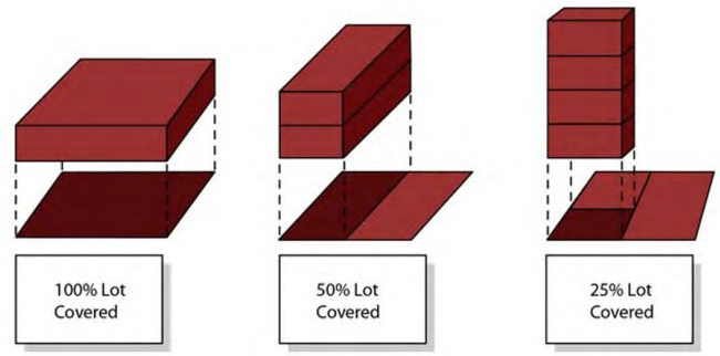
Building coverage. The area of the lot expressed as a percentage of the total lot area covered by the ground floor of all principal and accessory uses and structures, including all areas covered by the roof of such uses and structures, measured along the exterior faces of the walls located within required building setback limits and or between the exterior faces of exterior supporting columns or from the centerline of walls separating two buildings or a combination of the foregoing whichever produces the greatest total ground coverage for such uses and structures. Exterior unenclosed private balconies above the first floor, areas covered by overhead trellises greater than 600 square feet in area, and overhangs extending more than 60 inches from the face of the building or column, shall be included in building coverage.
Building frontage. See "Frontage, building."
Building height. See "Height, building."
Building permit. See "Permit."
Building setback line. See "Setback."
Building site. A building site shall be as follows:
(a)
A parcel of land having not less than the minimum area permitted by the land development code for a building to be erected thereon, including such open spaces as this Code requires.
(b)
A parcel of land heretofore approved by the village or the county as a building site inclusive of properties reflected on Map I-1 Future Land Use Map-2015 dated February 9, 1999.
Business establishment. Any individual person, nonprofit organization, partnership, corporation, other organization or legal entity, required to hold a valid occupational license.
Cafe, outdoor. See "Restaurant, outdoor."
Cafeteria. See "Restaurant."
Caliper. For trees under four inches in diameter, the trunk diameter measured at a height of six inches above natural grade. For a tree diameter four inches or greater (i.e. monocot), the trunk diameter measured at 12 inches above natural grade.
Canopy. See "Awning."
Capacity. Refers to the availability of a public service or facility to accommodate users, expressed in an appropriate unit of measure, such as gallons per day or average daily trips.
Capacity, available. Capacity which can be reserved or committed to future users for a specific public facility.
Capacity, committed. The amount of capacity, which has been committed to accommodate existing developments, developments which have been issued a final development order, committed development, and vested developments.
Capacity, reserved. Capacity which has been removed from the available capacity pool and allocated to a particular property for a set period of time.
Carnival. An exhibition or amusement consisting of rides, side shows, games, or exhibits.
Carport. A roofed structure that provides space for parking of vehicles and is not enclosed on more than three sides.
Cellar. See "Basement."
Certificate of occupancy. A document prepared by the administrative official certifying that a specific development has been designed and constructed in a manner consistent with applicable terms of the land development code and applicable building codes, so long as uses associated with the development are carried out consistent with all applicable laws and ordinances.
Certificate of use. A document prepared by the administrative official certifying that a specific use as designed and proposed is consistent with applicable terms of the land development code so long as the operation of the use is carried out consistent with all applicable laws and ordinances.
Child care or family care, private. Also see "Homes/special facilities. As used in this article, the term "child care" or "family care" shall include, but is not limited to, the following when the same do not come under the direct operation and administration of the county school board or the state. Such facilities shall be regulated pursuant to the Code. The terms "child," "student," "pupil," and their plurals are used interchangeably in this article.
1.
After school care: Child care and recreation for children above the age of five when no formal schooling program is conducted and where the care provided is generally after school, on weekends, school holidays and vacations.
2.
Day nurseries: Child care for infants and children up to and including age six.
3.
Child and family day care homes: Child and family day care and recreation with a maximum of six persons including the day care operator's own children.
Clear story. That area within a building whose height extends from the first finished floor level to the underside of a ceiling where that ceiling is 14 feet or higher from finished floor.
Clinic, medical, dental or optical. A facility which does not provide for overnight accommodations wherein professional services concerning personal health of humans are administered by medical doctors, chiropractors, osteopaths, optometrists, dentists or any other such profession, which may lawfully be practiced in the state.
Clinic, veterinary. A facility that provides for care of animals wholly within a soundproof, air-conditioned structure and wherein overnight boarding of animals is accommodated for medical reasons.
Club, private. A building and facilities owned or operated by a corporation, association, person or persons for social, educational or recreational purpose, open only to bona fide members and guests of the private organization operating the facility.
Cluster development. A form of residential development that concentrates buildings or lots on a part of the site to allow the remaining land to be used for common open space, recreation and preservation of natural and environmentally sensitive features. The concentration of lots is facilitated by a reduction in lot size.
Coastal high hazard area. The area subject to high velocity waters caused by, but not limited to, hurricane wave wash. The area is designated on a FIRM as Zone VI-30, VE or V.
Colonnade. A roof or building structure, extending over the sidewalk, open to the street and sidewalk, except for supporting columns or piers.
Commercial message. Any sign wording, logo, or other representation or image that directly or indirectly names, advertises, or calls attention to a product, service, sale or sale event or other commercial activity.
Commercial recreation use. A use of the property for a commercial purpose for, which a fee is charged where the use of the property by the customer is for a recreational use, such as but not limited to a miniature golf course, health club or a commercial swimming pool.
Commercial vehicle. Category 2 - A vehicle that is eight feet or less in height that displays externally stored or mounted equipment either in a fixed or temporary manner including but not limited to food vending equipment, ladders, paint cans, lawn care equipment. Category 3 - A vehicle other than a recreational vehicle exceeding 20 feet in length or more than eight feet in height from the ground, including but not limited to tow trucks, dump trucks, construction or earth moving vehicles or equipment and semi-tractors and trailers.
Common facilities and land. All the real property and improvements set aside for the common use and enjoyment of the residents of a cluster development, including, but not limited to, buildings, common open space, private streets, parking areas, walkways, recreation areas, easements, and utilities.
Common lot line. A line dividing one lot or parcel from another lot or parcel.
Common open space. Undeveloped land within a cluster development that has been designated, dedicated, reserved, or restricted in perpetuity from further development and is set aside for the use and enjoyment by residents of the development. Common open space shall not be part of individual lots, and shall be substantially free of structures, and shall not include conservation and preservation areas otherwise set aside under this division.
Comprehensive plan. The village comprehensive plan, as hereafter may be amended, adopted pursuant to F.S. ch. 163, Part II, by the council and which consists of several maps, data, analysis, and other descriptive matter, for the physical development of the village, including any amendments, extensions or additions thereto, indicating the general location for major streets, parks, public utilities, land use or other similar information.
Concurrency. The necessary public facilities and services that must be available to maintain the adopted level of service standards when the impacts of development occur.
Concurrency facilities. Public facilities and services for which a level of service must be met concurrent with the impacts of development or an acceptable deadline, as mandated in the comprehensive development master plan pursuant to F.S. ch. 163, and F.A.C. § 9J-5.0055, shall include: Potable water, recreation, sanitary sewer, solid waste, drainage and roads.
Concurrency management monitoring system. The data collection, processing and analysis performed by the village staff to determine available capacity for concurrency facilities. Data utilized shall be the most current reliable information available to the village.
Concurrency review. Evaluation by the village planner and designated staff based on adopted level of service standards to ensure that public facilities and services needed to support development are available concurrent with the impacts of such development as defined in this concurrency management system and if such facilities are not available, that the developer of a proposed development shall bear a cost of providing public services and facilities at a level of service defined by the comprehensive development master plan and concurrent with the impacts of a proposed development.
Concurrency status report. A status report prepared by the village identifying available concurrency facility capacity. The status report shall be produced, modified and adjusted from time-to-time as a result of the reservation of capacity or other act, which alters the availability of concurrency facility capacity.
Condominium. A form of real property ownership as defined by state statutes.
Conservation easement. A voluntary restriction placed by the landowner on the use of his or her property to protect resources such as wildlife habitat, preservation areas, conservation lands, natural areas, scenic views, historic structures, or open spaces. The landowner retains title to the property, and the easement is donated to a qualified conservation organization, such as a land trust, or a government agency.
Construction/subdivision sign. A temporary sign displayed on property only during the progress of actual construction work. It is erected and maintained by the property owner/tenant, or on the owner/tenant's behalf by an architect, contractor, developer, finance organization, subcontractor, or materials vendor that is furnishing labor, services, or material on the premises.
County. Miami-Dade County.
Courtyard. An open, unoccupied, unobstructed space, other than a yard, on the same lot as a building, which may have trees or shrubs.
Coverage. See "Lot coverage."
Cul-de-sac. A minor street intersecting another street at one end and terminating at the other end by a vehicular turn-around area with a minimum radius of 50 feet.
Customer service area (patron area). Customer service area is the area of an establishment available for food or beverage service or consumption, or both, calculated by measuring all waiting areas and areas covered by customer tables and bar surfaces, and any floor area within five feet of the edge of said tables and bar surfaces, measured in all directions where customer mobility is permitted. "Customer service area" shall include any outdoor or patio floor area used or designed for food or beverage service or consumption, or both, including customer waiting areas, measured as specified above. Areas between tables or bars, which overlap in measurement with another table, shall only be counted once.
Day care. See "Childcare."
Density. The number of dwelling units permitted on a particular lot or parcel of property calculated by dividing the number of dwelling units by the total number of acres. Density shall be determined by dividing the "dwelling units on the site" by the "net acres on the site." (i.e., dwelling units/residential land acres). All residential densities denoted on the land use district map stipulate the maximum densities permitted for development on the land. In calculating residential density, land area shall only include contiguous land area proposed for residential development, which is under unity of title. Gross residential acreage for determining estate density in EU-1C, EU-1 and EU-S shall include the land area assigned to residential use plus one-half of the adjacent right-of-way.
Depth, lot. See "Lot."
Design capacity. The potential or suitability for holding, storing or accommodating the demands upon a concurrency facility.
Detached sign. Any sign not attached to or painted on a building, but which is permanently attached to the ground.
Developer's agreement. An agreement between the village and a party associated with the development of land, including agreements associated with development orders issued pursuant to F.S. § 380.01.
Development (development activity). The use of any structure, land, or water; or the change, expansion or addition to any use, land, or water; or the carrying out of any building activity; or the making of any change in the appearance of any structure, land or water; or the subdividing of land into two or more parcels; provided, however, that building activity that is carried out exclusively within a previously constructed structure which does not affect the intensity of use or affects only the exterior color of the structure shall not be considered development. Development activity includes, but is not limited to the following activities:
(a)
Construction, clearing, filling, excavating, grading, paving, dredging, drilling or otherwise significantly disturbing the soil of a site.
(b)
Building, installing, enlarging, replacing or substantially restoring a structure, impervious surface, or water management system, and including the long-term storage of materials.
(c)
Subdividing land into two or more parcels.
(d)
Removal of a tree for which authorization is required under this Code.
(e)
Erection of a sign for which authorization is required under this Code.
(f)
Alteration of a historic property for which authorization is required under this Code.
(g)
Change of use and/or tenant of a site so that the need for parking is increased.
(h)
Construction, elimination or alteration of a driveway on to a public street.
Development order. Any order granting, denying or granting with conditions an application for a development permit or any other official action of the village having the effect of permitting the development of land.
Development permit. See "Permit."
Distance requirements. Unless otherwise provided herein, distances shall be measured in accordance with the following:
(a)
When the land development code requires a distance between uses or developments on different development sites or there are requirements in the land development code for a development which is located within a certain distance from another development the distance shall be measured using a straight line measurement from property line to property line using the closest property line of the parcels of land involved.
(b)
When the land development code imposes requirements on a development which is located within a certain distance of a land use district, the distance shall be measured using a straight line measurement from the land use district line lying closest to the closest property line of the parcel of land involved.
(c)
When there is a distance requirement between a structure or building on the same development site, the distance shall be measured from the exterior of the building's walls or columns or the exterior of the said structure, using a straight line measurement from the closest points between the structures being measured.
(d)
When a portion of a parcel or development site lies within a certain distance of a land use district or development and the land development code imposes requirements or regulations on a development or parcel within such distance, the requirements and regulations shall be applicable to the entire parcel or development site and not just to the portion within the specified distance.
District. Any certain described area to which these regulations apply and within which the land use regulations are uniform and consistent with the comprehensive plan.
Drip line. An imaginary vertical fine extending from the outermost horizontal circumference of a tree's branches to the ground.
Driveway. An area on a site used for ingress and egress of vehicles.
Dry cleaning. A process of removing dirt, grease, paint and other stains from wearing apparel, textiles, fabrics, rugs, and similar materials which complies with all state and county requirements.
Dwelling, multiple-family. A building occupied or intended to be occupied by more than two families, living separately and with separate kitchens or facilities for cooking on the premises.
Dwelling, residential. A single-family, two-family, or multiple-family dwelling, which is not a dwelling used for transients or tourists and which contains one cooking area/kitchen per dwelling unit.
Dwelling, single-family. A building designed for and/or containing only one dwelling unit with one cooking facility which is designed for the use of one family. Its living and sleeping area shall be arranged so that all spaces are interconnected wholly within the building and has only one electrical service meter.
Dwelling, two-family (duplex). A building designed for and/or containing two dwelling units.
Dwelling unit. A single unit consisting of living area providing complete, independent living facilities for one family, including permanent provisions for living, sleeping, eating, cooking and sanitation, but not including recreation vehicles, tents, hotels, motels or boardinghouses.
Easement. A grant to another party by a property owner of the right to use the owner's land for a specific purpose such as, but not limited to drainage, placement of utility lines, or ingress/egress.
Effectively destroy. Effectively destroy means to cause, suffer, allow, or permit any act that will cause a tree to die or go into a period of unnatural decline within one year from the date of the act. Acts that may effectively destroy a tree include, but are not limited to, excessive pruning, changing the natural grade above the root system or around the trunk, applying herbicides or other chemical agents to a tree, intentionally setting a tree on fire, permitting a tree to remain infected, allowing a tree to remain infested with pests, inflicting tree trunk wound(s) that cumulatively equal or exceed 20 percent or greater of the circumference of the trunk, or removing sufficient tree canopy to cause the unnatural decline of the tree.
Effluent. The emission of pollutants from any source.
Electronic sign. Any type of electronic display board, electronic message board, digital, LED, programmable ink or other sign capable of displaying words, pictures, symbols, video or images including, but not limited to, any electronic, laser, digital, or projected images display that can be changed electronically or mechanically by remote or automatic means. Architectural lighting that is designed to illuminate building walls, architectural features or landscaping is not a sign.
Elevated building. A nonbasement building built to have the lowest floor elevated above the ground level by means of fill, solid foundation perimeter walls, pilings, columns (posts and piers) or shear walls.
Elevation certificate. A certificate from a registered architect, professional engineer or land surveyor indicating the elevation of the finished floor, base flood elevation and highest crown of road.
Energy conservation zone. A zone located no more than 30 feet from a structure in a 180-degree band from due east of the northeast point of the structure, to due south, to due west of the northwest point of the structure.
Engineer. A person professionally licensed by the state to practice engineering.
Essential services. Public utility facilities which are related to the water, sanitary sewer, storing drainage, solid waste, telephone, cable television, gas and electrical collection or distribution systems that service the village but not including buildings housing employees; or administrative or recreational facilities.
Established grade. Established grade means, with reference to a building, structure or part thereof, the average elevation of the grade of the ground immediately surrounding such building or structure.
Excavations. Unearthing, scraping, digging or grading of earth material for any purposes.
Existing construction. Any construction for which the start of construction commenced before May 12, 1998 based upon specific technical base flood elevation data which establishes the area of special flood hazard (i.e. FIRM).
Existing development. A residential or nonresidential site with structures that are currently present on the site and which were legally approved through the issuance of a certificate of use and certificate of occupancy or a certificate of completion, as of September 5, 2001.
Existing manufactured home park or subdivision. A manufactured home park or subdivision for which the construction of facilities for servicing the lots on which the manufactured homes are to be affixed (including at a minimum the installation of utilities, the construction of streets, and either final site grading or the pouring of concrete pads) is completed May 12, 1998.
Expansion to an existing manufactured home park or subdivision. The preparation of additional sites by the construction of facilities for servicing the lots on which the manufactured homes are to be affixed (including the installation of utilities, the construction of streets, and either final site grading or the pouring of concrete pads).
Facultative. Plants with a similar likelihood of occurring in both wetlands and uplands, which are not recognized indicators of either wetland or upland conditions.
Fair market value. The value of property or structures, as used in the definition of substantial improvement, as determined by the county property appraiser, or M.A.I. or S.R.A. appraisal, either before the improvement was started, or if the structure has been damaged and is being restored, before the damage occurred.
Family. One person or a group of two or more persons living together and interrelated by bonds of consanguinity, marriage, domestic partnership or legal adoption, or a group of persons not more than three in number who are not so interrelated, occupying the whole or part of a dwelling as a separate housekeeping unit with a single set of culinary facilities. The persons thus constituting a family may also include gratuitous guests and domestic servants. Any person under the age of 18 years whose legal custody has been awarded to the state Department of Children and Family Services (DCF) or to a child-placing agency licensed by DCF, or who is otherwise considered to be a foster child under the laws of the state, and who is placed in foster care with a family, shall be deemed to be related to and a member of the family for the purposes of this chapter. Nothing herein shall be construed to include any roomer or boarder as a member of a family.
Fence. See "Wall." Any construction of wood, metal, wire mesh, masonry or other materials, erected for the purpose of privacy, protection or aesthetics.
Fill. Any material, such as earth, clay, sand, top soil, gravel, rock, concrete, rubble, wood chips or material of any kind, that is placed, stored, or dumped upon the surface of the ground resulting in an increase in the natural surface elevation.
Finished floor. The first floor of a structure established by either the base flood elevation or eight inches above the highest crown of the adjacent road(s) as reflected on a current survey or elevation certificate. This elevation establishes the measuring point for building height.
Flag. A piece of fabric with a color or pattern that represents a government, or other noncommercial organization or idea designed to be flown from a flagpole. Banners are not included in this definition.
Flood or flooding. A general and temporary condition of partial or complete inundation of normally dry land areas from the overflow of inland or tidal waters and/or the unusual and rapid accumulation or runoff of surface waters from any source.
Flood hazard boundary map (FHBM). An official map of the village, issued by the Federal Emergency Management Agency (FEMA), where the boundaries of the areas of special flood hazard have been defined as Zone A.
Flood insurance rate map (FIRM). An official map of the village on which the Federal Emergency Management Agency has delineated the areas of special flood hazard and/or risk premium zones applicable to the village, as may be amended from time to time.
Flood insurance study. The official report provided by the Federal Emergency Management Agency. The report contains flood profiles, as well as the flood boundary floodway map and the water surface elevation of the base flood.
Floodplain. Any land area susceptible to flooding.
Floodway. The channel of a river or other watercourse and the adjacent land areas that must be reserved in order to discharge the base flood without cumulatively increasing the water surface elevation more than a designated height.
Floor. Also see "Finished floor." The top surface of an enclosed area in a building (including basement), i.e., top of slab in concrete slab construction or top of wood flooring in wood frame construction.
Floor area ratio (FAR). The maximum intensity permitted for residential and nonresidential activities is stated in terms of floor area ratio. A mathematical expression determined by dividing the gross floor area of a building by the area of the lot on which it is located. FAR computations shall include all uses on the lot, parcel or site, including both residential and nonresidential floor area.
Floor Area Ratio (FAR) Illustration
1 acre site: 43,560 square foot
Site FAR = 0.3
FAR = TOTAL BUILDING FLOOR AREA
TOTAL LOT AREA
When a roof height exceeds that permitted for a one-story building, that portion of the roof exceeding the maximum height shall be counted toward the second floor, floor area ratio calculation. Exterior unenclosed balconies or terraces above the first floor shall be counted in the FAR calculation. FAR not utilized on the ground floor of a single-family home may be transferred to the second floor of the home to be used for unenclosed balconies and/or terraces. A property owner transferring FAR pursuant to this section shall record a covenant in the public records of Miami-Dade County, on a form approved by the village attorney, prohibiting such unenclosed balconies and/or terraces from being enclosed in the future.
Frontage. The length of the property line for a parcel that runs parallel to, and along, a road right-of-way or public or approved private street, exclusive of alleyways.
Frontage, building. The single facade constituting length of building or that portion of a building occupied by a single office, business or enterprise abutting a street, parking area or other means of customer access such as an arcade, mall or walkway.
Functionally dependent facility. A facility which cannot be used for its intended purpose unless it is located or carried out in close proximity to water, such as a docking or port facility necessary for the loading and unloading of cargo or passengers, shipbuilding, or ship repair. The term does not include long-term storage, manufacturing, sales, or service facilities.
Garage, parking. A building or structure designed or used for the parking or storage of vehicles.
Glass sign. A sign located on the glazed area of a building facing the exterior.
Governing body. The village council of the village as constituted in the village charter.
Government facilities. Public services and facilities provided by the village, state or federal government.
Grade, established. The established grade, as applied to any building site shall be the average elevation of the sidewalk abutting such building site or, if there is no sidewalk, the average elevation of the crown of the road or street abutting such building site. Where a building site abuts more than one road and /or street, the established grade shall be the average elevation of the sidewalks abutting upon such building sites, or if there are not sidewalks, the average elevation of the crown of the road and/or streets abutting such building site. Where an existing residential site has a floor level below the crown of the road due to topography, but which is not subject to flooding, grade shall be established as existing site grade.
Grade existing. The vertical elevation of the ground surface prior to excavation or filling.
Grade, finished. The elevation of a site after all fill, land balancing or site preparations have been completed as may be required by the National Flood Insurance Act of 1968. The first inch of rainfall must be contained on-site.
Green space (pervious area). A permeable area or areas open to the sky (except for roof overhangs up to five feet) including beautification strips, consisting of those materials such as, but not limited to hedges, trees, planted ground cover, grassed areas, and planted floral installations, all of which must be composed of natural plantings only; and lakes, ponds, and retention areas, provided such plantings and water bodies are privately owned and included in the description of the subject property. Green space or landscaped area excludes artificial grass and artificial landscaping, swimming pools, fountains, tennis courts and other similar impervious improvements.
Gross floor area. See "Floor area, gross/total."
Group home. See "Homes/special facilities."
Guest/worker housing. Living quarters, excluding kitchen facilities, either attached or detached from the principal structure, used as a residence by persons employed to provide domestic services to the occupants of the principal structure or their guests.
Hatrack. To flat-cut or prune the top of a tree, severing the leader or leaders or the removal of any branch three inches or greater in diameter at any point other than the branch collar hedge. A dense row of shrubs or bushes placed to form a boundary or barrier.
Height (excluding building).
1.
For signs. The vertical distance measured from ground level nearest the base of the sign to the highest point of the sign.
2.
For structures other than buildings. When referring to a tower, antenna or other structure, the distance measured from the finished grade of the parcel to the highest point on the tower or other structure, even if the highest point on the tower or structure is an antenna.
Height, building.
Non-Flood Hazard Areas The vertical measurement from eight inches above the highest crown of the adjacent street(s)
In instances where the established grade is more than 12 inches above the highest elevation of the adjoining crown of road, building height shall be measured from 8 inches above the established grade.
In instances where the established grade is more than 12 inches below the highest elevation of the adjoining crown of road, building height shall be measured from the elevation of the highest crown of road.
Flood Hazard Areas The vertical measurement from the base flood elevation plus one foot, or the back of the sidewalk elevation plus one foot, or if there is no sidewalk, the elevation of the highest crown of road or street abutting such building site plus one foot, whichever is greater.
Highest adjacent grade. The highest natural elevation of the ground surface, prior to construction, next to the proposed foundation walls of a building.
Historic structure. Any structure that is:
1.
Listed individually in the National Register of Historic Places (a listing maintained by the department of interior) or preliminarily determined by the secretary of the interior as meeting the requirements for individual listing on the National Register;
2.
Certified or preliminarily determined by the secretary of the interior as contributing to the historical significance of a registered historic district or a district preliminarily determined by the Secretary to qualify as a registered historic district;
3.
Individually listed on a state inventory of historic places in states with historic preservation programs which have been approved by the secretary of the interior; or
4.
Individually listed on a local inventory of historic places in communities with historic preservation programs that have been certified either:
5.
By an approved state program as determined by the secretary of the interior;
6.
Directly by the secretary of the interior in states without approved programs; or
7.
Individually listed on a local inventory of sites designated by the village or county as historically significant.
Holidays. Any of the following: New Year's Day, Martin Luther King Day, Memorial Day, Juneteenth, Independence Day, Labor Day, Veterans' Day, Thanksgiving Day, and Christmas Day.
Homes/special facilities. The following uses are types of special facilities and home care services:
Adult congregate living facility. Any state licensed institution, building(s), residence, private home, boarding home, home for the aged, or other place whether operated for profit or not, which undertakes through its ownership or management to provide for a period exceeding 24 hours, one or more personal service for four or more adults, not related to the owner or administrator by blood or marriage, who require such services. A facility offering personal services for fewer than four adults will be within the meaning of this definition if it holds itself out to the public to be an establishment which regularly provides such service.
Adult congregate living facility unit. Any room or interconnected rooms with one main entrance, in an adult congregate living facility, containing one or more beds.
Community residential facility. A residential facility licensed as a community residential facility by the state department of children and family service (CFS) which provides a community living environment for seven to 14 persons and includes supervision and care necessary to meet the physical, emotional, and social needs of its residents. The capacity of such a facility shall not be more than allowed pursuant to state law.
Child and family day care. See "Child and family day care, private." Public child and family day care facilities are regulated as government facilities. See "Government facilities."
Foster care. A residential facility licensed as a foster care home by the state department of children and family service (CFS) which provides a family living environment for up to six children and includes supervision and care necessary to meet the physical, emotional, and social needs of its residents. The capacity of such a facility shall not be more than allowed pursuant to state law.
Group home. A residential facility licensed as a group home by the state department of children and family service (CFS) which provides a family living environment for up to six children and includes supervision and care necessary to meet the physical, emotional, and social needs of its residents. The capacity of such a facility shall not be more than allowed pursuant to state law.
Homeowners association (HOA). An association combining individual home ownership with shared use, ownership, maintenance, and responsibility for common property or facilities, including common facilities and land (but excluding conservation and preservation areas) within a cluster development.
Hydromulch. A sprayed application of seed, mulch and water.
Illegal sign. Any of the following:
1.
A sign erected without first obtaining a permit and complying with all regulations in effect at the time of its construction or use;
2.
A sign that was legally erected but whose use ceased because the business it identifies is no longer conducted on the premises which now shows neglect or has become dilapidated;
3.
A nonconforming sign for which the amortization period has expired;
4.
A sign that was legally erected but which later became nonconforming and then was damaged to the extent of 50 percent or more of its current replacement value;
5.
A sign that is a danger to the public or is unsafe; or
6.
A temporary sign that has remained in place longer than the allowed term specified in the applicable Special Conditions of Div. 7.16(b).
Impervious surface. A surface that has been compacted or covered with a layer of material so that it is highly resistant to or prevents infiltration by stormwater. It includes surfaces such as compacted lime rock, gravel, or clay, as well as most conventionally surfaced streets, roofs, sidewalks, parking lots, artificial grass and artificial landscaping, and other similar surfaces.
Impervious surface ratio (ISR). A measure of the intensity of hard surfaced development on a site. An impervious surface ratio is the relationship between the total impervious surface area on a site and the net land area. The ISR is calculated by dividing the square footage of the area of all impervious surfaces on the site by the square footage of the net land area.
IMPERVIOUS SURFACE RATIO (ISR) ILLUSTRATION

Incidental. Subordinate and minor in area, purpose and significance, and serving or bearing a reasonable relationship to the primary use.
Intersection visibility triangle. The triangle portion of a lot formed by the street or alley frontage of such lot and a line drawn between the points along such street or alley frontage 50 feet distant from their point of intersection.
Irrigation plan. A plan drawn at the same scale as the landscape plan indicating location and specification of irrigation system components and other relevant information as required by landscape regulations of this Code.
Junk. Inoperative, dilapidated, abandoned or wrecked materials, including but not limited to vehicles, trucks, tractors, wagons, boats and other kinds of vehicles and parts thereof, scrap materials, scrap building material scrap contractors' equipment, tanks, casks, cans, barrels, boxes, drums, piping, bottles, glass, old iron, machinery and similar materials having no intrinsic value.
Junkyard. A place where junk, waste, discarded or salvaged materials are bought, sold, exchanged, stored, baled, packed, disassembled or handled, including vehicle wrecking yards where vehicles are dismantled or wrecked and the used parts are stored and/or sold, house wrecking, and structural steel materials and equipment but not including the purchase or storage of used furniture and household equipment, used cars in operable condition, used or salvaged materials as a part of manufacturing operations.
Kennel. The keeping of any domestic animal, regardless of number, for sale, breeding, boarding or treatment purposes, except in a animal hospital, animal parlor or pet shop, as permitted by law, or the keeping of five or more domesticated animals, six months or older, on premises used for residential purposes, or the keeping of more than one domesticated animal on vacant property or on property used for business or commercial purposes.
Landscape plan. A plan indicating all landscape areas, stormwater retention/detention areas, site grades, areas which qualify to be excluded from maximum permitted lawn area existing vegetation to be retained, proposed plant material landscape legend, landscape features, planting specifications and details, and all other relevant information in compliance with the landscape regulations of this Code.
Landscape architect. A person licensed by the state to practice landscape architecture.
Landscaped area. See "Green space".
Lawn area. An area planted with lawn grasses.
Level of service. An indicator of the operational efficiency of service provided by a concurrency facility.
Level of service standard. The adopted volume of demand required for each concurrency facility in order to achieve acceptable operational efficiency.
Livestock, limited. Keeping and maintaining any combination of horses or cows, not to exceed two such horses and cows, or five poultry, or birds provided:
1.
Such use is incidental to an existing residential use;
2.
The area used to keep and maintain such animals is part of the residential site;
3.
Such animals are fenced at least 50 feet from property under different ownership; except that no separation from the property line shall be required for hens; and
4.
Structures for the keeping of any limited livestock shall be considered general accessory structures and shall be located in compliance with applicable general accessory structure setback requirements; except that structures for the limited keeping of hens, when such structures are 150 square feet or smaller in area, may be located ten feet from the side and rear property lines.
Living level. The number of floors in a building above the finished floor.
Loading space (berth). A space which provides for the loading or unloading of service vehicles and has a minimum size of 12 feet in width, 30 feet in length and 14 feet in height with a backup space of 32 feet.
Local governing body. The village council of the Village of Pinecrest as constituted in the Village Charter.
Local planning agency. An advisory body to the village council as legally established by ordinance with designated power as referenced by the land development code and Florida Statutes.
Lot. (See "Parcel"). A parcel of land meeting minimum district requirements for size, width, and area and capable of providing such yards and other open spaces as are required in the land development code and may consist of:
1.
A single lot of record;
2.
A portion of a lot of record;
3.
A combination of complete lots of record, and portions of lots of record; and
4.
A parcel of land described by metes and bounds.
Lot area. The horizontal plane area within the lot lines, excluding right-of-way, expressed in these regulations in square feet or acres.
Lot, corner. A lot abutting upon two or more streets, alleys or other public way at their intersection or at a street corner having an interior angle not greater than 135 degrees along the right-of-way. The boundary with the smallest frontage on the street shall be designated as the front yard. The yard opposite to the front yard shall be designated as the rear yard. The side yard along the other street shall be designated as the side street yard. The side opposite shall be designated as the side yard (see figure 9-4 at the end of this division). In instances where a principal structure has been permitted and constructed on a lot with a required side street yard setback adjacent to the boundary with the smallest frontage, subsequent additions and modifications to an extent less than 50 percent of the floor area of such structure may be continue to be permitted in accordance with the established setbacks.
Lot coverage. The total of impervious surface area and green space.
Lot depth. The horizontal distance between the front and rear lot lines measured in the mean direction of the side lines of the lot from the midpoint of the front lot line to the midpoint of the opposite mean rear line of the lot. For through lots, the lot depth is the distance between the adjacent streets.
Lot, interior. A lot other than a corner lot with a frontage on one street only (see figure 9-1 at the end of this division).
Lot line. The line bounding a lot as herein defined as established by ownership except that where a lot line lies within a private street or waterway the edge of the private street right-of-way or waterway shall be considered to be the lot line for the purposes of calculating net density, lot, yard and bulk requirements.
Lot line, front. That line running adjacent and parallel to the street (see figures 9-2—9-7 at the end of this division).
Lot line, rear. The line opposite and parallel to the front line (see figures 9-2—9-7 at the end of this division).
Lot lines, side. Those lines connecting the street frontage with a rear lot line and generally running perpendicular thereto (see figures 9-2—9-7 at the end of this division).
Lot lines, side street. That line on a corner lot parallel to the side street (see figure 9-4 at the end of this division).
Lot, nonconforming. A single lot, tract or parcel of land shown on either a recorded or unrecorded map, plat, drawing or survey, where such map, plat, drawing or survey was in existence as of November 27, 2000, or subsequent amendment thereto, such lot failing to meet the requirements for area, width or depth for any permitted use within the district in which it is located.
Lot of record. A lot which is a part of a subdivision, the map of which has been duly approved and recorded in the public records of the county or a lot described by metes and bounds, the description of which has been thus recorded.
Lot, through (double frontage lot). An interior lot having a street, alley or other public way on each end (see figure 9-3 at the end of this division).
Lot width. The distance between the side lot lines measured along the required front right-of-way line.
Lowest floor. The lowest floor of the lowest enclosed area (including basement). An unfinished or flood resistant enclosure, used solely for parking of vehicles, building access, or storage in an area other than a basement is not considered a building's lowest floor, provided that such enclosure is not built so as to render the structure in violation of this Code.
Maintenance services provided by itinerant service companies. Maintenance services provided by itinerant service companies shall include services provided from a mobile vehicle including locksmith services, mobile car wash services, emergency automobile and roadside assistance services, exterior power washing and painting services, landscaping services, and other customary maintenance and repair services provided at the location of the required service.
Mandatory requirements. Requirements or provisions of the land development code not subject to relaxation or waiver by the variance process.
Mangrove stand. An assemblage of mangrove trees which is mostly low trees noted for a copious development of interlacing adventitious roots above the ground and which contain one or more of the following species: black mangrove (Avicennia nitida); red mangrove (Rhizophora mangle); white mangrove (Longuncularia racemosa); and buttonwood (Conocalpus erecta).
Manually changeable copy sign. A sign or portion thereof which has a readerboard for the display of text information that can be changed or rearranged manually without altering the face or surface of the sign.
Manufactured home. A building, transportable in one or more sections, which is built on a permanent chassis and designed to be used with or without a permanent foundation when connected to the required utilities. The term also includes park trailers, travel trailers and similar transportable structures placed on a site for 180 consecutive days or longer and intended to be improved property.
Marquee sign. A sign affixed to a permanent roof-like structure and projecting over the entrance of the building generally designed and constructed to provide protection from the weather.
Master-planned development entrance sign. A sign in a master-planned development, not attached to or affixed to or painted on a building, but which is permanently attached to the ground within common areas that are dedicated to a property owners' association for maintenance, and which are used to identify uses or locations and direct traffic.
Mean sea level. The average height of the sea for all stages of the tide. It is used as a reference for establishing various elevations within the floodplain. For purposes of this chapter, the term is synonymous with national geodetic vertical datum (NGVD).
Medical marijuana retail center. A retail establishment, licensed by the Florida Department of Health as a "medical marijuana treatment facility," "medical marijuana treatment center," "dispensing organization," "dispensing organization facility" or similar use, that sells and dispenses medical marijuana, but does not engage in any other activity related to preparation, wholesale storage, distribution, transfer, cultivation, or processing of any form of marijuana or marijuana product, and does not allow on-site consumption of marijuana.
Mezzanine. An intermediate level placed between the floor and ceiling in any story or room which does not exceed one-third the gross area of the room or story on which it is superimposed.
Monument sign. A freestanding sign where the foundation and supporting structure are visually an integral part of the sign creating a continuous form from the ground to the top of the sign. Monument signs shall be an integral and complementary element of the overall architectural and streetscape composition and shall be integrated with the building and landscape design.
Moisture and rain sensor switches. Devices which have the ability to switch off an automatic irrigation controller after receiving a predetermined amount of rainfall or moisture content m the soil.
National geodetic vertical datum (NGVD). A vertical control used as a reference for establishing varying elevations within the floodplain as corrected in 1929.
Native habitat. An area enhanced or landscaped with an appropriate mix of native tree, shrub and groundcover species that resembles a native plant community or natural forest community in structure and composition or is naturally occurring.
Native plant species. Plant species with a geographic distribution indigenous to all or part of the county, including the village, that are not introduced by man. Plants which are described as native to the county in botanical manuals such as, but not limited to, "A Flora of Tropical Florida" by Long and Lakela and "The Biology of Trees Native to Tropical Florida" by P.B. Tomlinson, are native plant species within the meaning of this definition.
Net acre. The unit of land area which comprises an acre, less that portion of land area within public ownership. Public land area shall include public rights-of-ways, public waterways, and other publicly dedicated areas.
Net site square feet. The square footage of the existing or proposed lot, less that portion of land area within public ownership. Public land area shall include public rights-of-ways and public waterways and other publicly dedicated areas.
New construction, for purposes of flood regulation, shall mean any structure for which the "start of construction" commenced after May 12, 1998, based upon specific technical base flood elevation data, which establishes the area of special flood hazard (i.e. FIRM). The term also includes any subsequent improvements to such structure.
New manufactured home park or subdivision. A manufactured home park or subdivision for which the construction of facilities for servicing the lots on which the manufactured homes are to be affixed (including at a minimum, the installation of utilities, the construction of streets, and either final site grading or the pouring of concrete pads) is completed on or after May 12, 1998.
Noise. A subjective description to an undesirable or unwanted sound.
Noncommercial message. Any message which is not a commercial message.
Noncommercial on-site directional sign. A sign that is permanently erected and used to provide direction or information to pedestrian or vehicular traffic on the premises and not displaying a commercial message, e.g., "entrance," "exit," "one-way only," and the like.
Nonconforming structure or use. A structure or land use legally existing by the virtue of a permit, variance or other government action at the time of the passage of this Code or subsequent amendment thereto, which currently does not conform to the provisions, requirements, and regulations of the districts in which it is located.
Nuisance. An act, which is committed by a person or persons, or a condition which is allowed to exist on a property by a person or persons, which has an adverse economic effect on neighboring properties or which threatens the public health, safety or welfare.
Nursery school or kindergarten. Any premises or portion thereof used for educational work or parental care of nonresident children of less than the age required for enrollment in the public school system whether or not for compensation, as licensed by the state.
Nursing home or convalescent home. A home for the aged or infirm in which three or more persons not of the immediate family are received, kept or provided with food and shelter or care for compensation, but not including hospitals, clinics, or similar establishments devoted primarily to the diagnosis and treatment of the sick or injured as licensed by the state.
Occupants. The total number of persons that may occupy a building or portion thereof or other areas designated for occupancy or use at any one time. The term "other areas designated for occupancy or use" shall be deemed to include, but not be limited to, decks, patios or other improved areas of the site for use by the patrons.
Odor. Stimulus affecting the olfactory nerves.
Off-premise sign. A sign that directs attention to a commercial business, commodity, service, or entertainment not exclusively related to the premises where such sign is located or to which it is affixed. Also referred to as "billboard."
Office. A room or group of rooms used for conducting the affairs of a business, profession, service industry or government.
Official zoning map. The official zoning map of the village that depicts the zoning district classifications of this Code.
Open space, common. An area required as open space under the Code for the various zoning districts.
Open space. That portion of property consisting of green space and other impervious areas but excluding all buildings.
Parcel. See "Lot."
Parking area light standard sign. A sign consisting of two dual-face signs extending horizontally and projecting from opposite sides of a light standard located in the parking lot of a shopping center or use in the PS, public service district, used to identify the location of the parking areas. No advertising is permitted on the sign.
Parking lot. An off-street, surfaced, ground level open area, for the temporary parking or storage of motor vehicles.
Parking space. An area, enclosed or unenclosed, sufficient in size to store one motor vehicle and permitting the necessary ingress and egress of a motor vehicle.
Patron area. See "Customer service area."
Permanent sign. Any sign intended for permanent use. For the purposes of this chapter, any sign with an intended use of 90 days or more shall be deemed a permanent sign.
Permit. A document issued by the building and planning department of the village allowing a person to begin an activity provided for in these regulations.
Permit, development. A permit signifying compliance with the provisions of these regulations as to design, use, activity, height, setbacks, density, site planning, special use status or planned unit development status.
Personal service store. An establishment which provides personal services directly to the consumer, such as, but not limited to, barbershop, beauty salon, dry cleaning, shoe repair shop and tailor shop, but which does not have as its primary function the sale of retail goods.
Pervious area (green space). Any portion of a lot or parcel not required, designated for or encumbered by either principal or accessory uses, buildings and structures and other site uses, including driveways, decks, walkways, stepping stones, tennis courts, swimming pools, or other such amenities.
Plant species controlled. Those plant species, which tend to become nuisances because of their ability to invade proximal native plant communities or native habitats, but which, if located and cultivated properly may be useful or functional as elements of landscape design.
Planting detail. A graphic representation of the plant installation depicting the materials to be used and dimensions to be met in the placement of landscape materials.
Plat. A map depicting the division or subdivision of land, tracts or portions thereof, however the same may be designated.
Plat of record. A plat which conforms to all the requirements of the applicable laws of the state, the county and this Code and has been filed and recorded in the office of the clerk of the circuit court for the county.
Point of sale sign. A sign identifying the premises of a commercial establishment.
Pole sign. A detached sign with a visible support structure, such that the sign face and support structure do not appear as one solid monolithic appearance, or otherwise having a support structure that is not architecturally integrated into the overall design of the sign, but not including a flag on a flagpole.
Pool, available capacity. The total unused capacity of concurrency facilities existing at any point in time.
Portable sign. Any sign not attached to or painted on a building and not affixed or permanently attached to the ground. A sign that is tied down with metal straps, chaining, or otherwise temporarily anchored to the ground or an existing structure. Portable signs may also be described as sandwich/sidewalk signs.
Premises. Any lot and/or all buildings and structures thereon.
Principal use. See "Use, principal."
Proceeding in good faith. Tangible and continuing actions taken by an applicant of an approved final development order to perform actual project construction and implementation leading to completion of a final development plan within a reasonable period of time. More over, a certificate of completion for the development of infrastructure must be received within three years of the date from which the construction was authorized in order to satisfy the definition of this term. This provision can only be modified through a development agreement approved by the village council.
Professional planner. A person who is engaged in the profession of urban planning who possesses appropriate education and professional experience.
Prohibited plant species. Those plant species listed in the county or village landscape manual or Code of Ordinances that are demonstrably detrimental to native plants native wildlife, ecosystems, or human health, safety, and welfare.
Projecting sign. Any sign which is an independent structure, which is attached to the building wall and which extends at any angle from the face of the wall. No projecting sign shall extend above the roof.
Property. The overall area represented by the outside boundaries of a parcel of land or development.
Property line. See "Lot line."
Property owners' association. A nonprofit organization recognized as such under the laws of the state operated under recorded land agreements through which each owner of a portion of a subdivision, be it a lot, home, property or any other interest, is automatically subject to a charge for a prorated share of expenses either direct or indirect for maintaining common properties within the subdivision, such as roads, parks, recreational areas, common areas or other similar properties. Within the text of this Code, a property owners' association is considered a single entity for property ownership.
Public facilities and services (concurrency facilities). Those facilities covered by the comprehensive development master plan required by F.S. § 163.3177, and for which level of service standards must be adopted under F.A.C. ch. 9J-5. The facilities are:
1.
Roads;
2.
Sanitary sewer;
3.
Solid waste;
4.
Drainage;
5.
Potable water;
6.
Parks and recreation.
Public notice. The legal advertisement given of an action or proposed action of the village as set forth in these regulations or applicable state statutes.
Public service uses (PS). Uses such as governmental buildings, public and not-for-profit schools, hospitals and supportive health care units, arts and cultural or civic facilities, essential public services, utilities, fire and emergency operations facilities, and places of worship and accessory facilities.
Public utilities. Public and quasi-public services regulated by the state for purposes of providing essential infrastructure to residential and/or nonresidential areas in order to further the public health, safety, and welfare.
Real estate sign. Any sign which indicates real property that is for sale, rent, or lease.
Rear lot lines. Those lines connecting the side lot lines at the opposite end of a lot from the street frontage line and generally running perpendicular to the side lot lines and parallel to the street frontage line.
Recreation area or space (private). An accessory use consisting of one or more areas, enclosed within a structure and/or open space, devoted to the active and/or passive recreational enjoyment of one or more persons residing within the principal use to which it is accessory. When developed and/or equipped for various recreational pursuits, the areas shall not be allowed for any other required site uses except open and/or rear building setback areas.
Recreational accessory uses. Uses which are customarily incidental to and subordinate to a principal residential land use, including a private swimming pool, tennis court, shuffle board court, or similar accessory residential structures for the recreation on family members and their guests.
Restaurant, consumption on premises. An establishment where food is ordered from a menu, prepared and served for pay, for consumption on the premises but not a drive-in restaurant.
Restaurant, drive-in. Any food or beverage dispensing operation at retail to the general public where the public is served while remaining in vehicles or other motor vehicles.
Restaurant, fast casual. A type of restaurant positioned between fast food and full-service dining that does not offer full table service. Counter service accompanied by handmade food (often visible via an open kitchen) is typical. The menu is usually limited to an extended overcounter display, and options in the way the food is prepared are emphasized. While full table service is not offered, conveniences like utensils and plates are common.
Restaurant, fast food. A type of restaurant characterized both by its fast food cuisine and by minimal table service. Food served is offered from a limited menu; is cooked in bulk in advance and kept hot; is finished and packaged to order; and is usually available ready to take away, though seating may be provided. Fast food restaurants are typically part of a restaurant chain or franchise operation, which provisions standardized ingredients and/or partially prepared foods and supplies to each restaurant through controlled supply channels.
Restaurant, outdoor. A use approved by the village council characterized by outdoor table service of food and beverages prepared for service in an adjacent restaurant.
Restaurant, take-out. Any food or beverage dispensing operation at retail to the general public where the public purchases food and beverages at a counter and consumption occurs only off premises.
Retention or to retain. The prevention of, or to prevent the discharge of a given volume of stormwater runoff into surface waters of the state by complete on-site storage where the capacity to store the given volume of stormwater is again provided within 72 hours following the storm event. The required storage volume must be provided by a decrease of stored water caused by percolation through soil, evaporation, transpiration, or spray irrigation. Retention shall be "off-line" (i.e. outside of the primary drainage path), unless it is demonstrated by the applicant that water quality in the receiving waters will not be adversely impacted by "on line" retention. Wet retention refers to an area the lowest elevation of which penetrates the dry season groundwater table. Dry retention refers to an area the lowest elevation of which lies at least two feet above the wet season groundwater table.
Right-of-way. The area of a highway, road, street, way or parkway or other such strip of land reserved for public use, whether established by prescription, easement, dedication, gift, purchase, eminent domain or any other legal means.
Roof sign. Any sign, which is painted on, fastened to, or supported by the roof or erected over the roof.
Rooming house shall mean any dwelling, or part of any dwelling, containing one or more rooming units in which space is let by the owner or operator on a predominantly permanent basis to three or more persons who are not husband or wife, son or daughter, mother or father, sister or brother of the owner or operator. For the purpose of this Code, boardinghouses are included in this category.
Rotating sign. A sign that rotates or revolves.
Sale of homegrown produce limited to production and sale of produce grown on the premises. Fruit growing incidental to an existing residential use, provided that no more than one sign which is no greater that four square feet is posted during the fruit growing season and no more than one fruit stand, which is no greater than 16 square feet horizontal surface area, is temporarily located on the property. Such use shall be confined to an area no closer than ten feet to an official street right-of-way line.
Satellite antenna. Any parabolic or spherical antenna, which receives television or other signals from orbiting satellites or other devices. The height of a groundmounted antenna shall be the maximum height to which it is capable of being raised and shall be measured from the highest point of the finished grade of the roof adjacent to the structure. A satellite antenna shall be considered as an accessory structure when it is not part of a public utility. A web or mesh type antenna is an antenna primarily constructed of a web or mesh material so that it does not substantially impair visibility. A ground mounted or "short pole" installation denotes a pole of nine feet or less in height. A "long pole" installation denotes a pole of greater than nine feet in height that is braced to the side of a building for added rigidity.
School or educational facility, private. An institution which provides instruction from kindergarten level through the college level and which does not come under the direct operation and administration of the county school board or the state.
Sediment. The mineral or organic particulate material that is in suspension or has settled in surface water or groundwater.
Service station. See "Vehicular service station."
Setback. The required minimum horizontal distance between the front, rear or side lines of a lot and the front, rear and side lines of a building, or, in the case of open structures, to the face of the structural columns; including those structures specifically permitted to extend beyond the height of the building.
Shopping center. An area zoned for business where at least 250 feet of street frontage has been zoned for commercial purposes under one application and one ownership, and where it contains off-street parking containing two or more retail uses.
Shrub. A self-supporting woody perennial plant normally growing to a height of 24 inches or greater, characterized by multiple stems and branches continuous from the base.
Sign. Any display of characters, letters, logos, illustrations, or any other ornamentation designed or used as advertisement, announcement or to indicate direction. This term shall not be interpreted to include traffic control devices or warning signs. A sign that is not visible from any nearby public or private property is not a sign subject to regulation under Division 7.
Snipe sign. A sign that is tacked, nailed, posted, pasted, glued or otherwise attached to trees, poles, stakes, fences, or to other objects.
Specimen tree. A tree with any individual trunk which has a measured diameter at breast height (DBH) of 18 inches or greater, but not including the following:
(1)
All trees listed in the list of tree species that do not require a removal permit; and
(2)
All multi-trunk trees in the palm family, except Accelorrhaphe wrightii, which have a minimum overall height of 15 feet.
Spot zoning. An illegal rezoning which occurs when: (1) a small parcel of land is singled out for special and privileged treatment; (2) the singling out is not in the public interest but only for the benefit of the land owner; and (3) the action is not in accord with the adopted comprehensive development master plan.
State. The State of Florida and all its duly appointed agencies.
Store, convenience. A small retail establishment, which sells a general line of goods and products, intended for the convenience of surrounding residents and whose gross floor area does not exceed 3,000 square feet.
Store, retail. An establishment which sells goods or products directly to the public for compensation.
Stormwater. The flow of water that results from, and that occurs immediately following a rainfall.
Stormwater management system. The system, or combination of systems, designed to treat stormwater, or collect, convey, channel, hold, inhibit, or divert the movement of stormwater on, through and from a site.
Stormwater retention/detention area. An area designed, built and used for temporary storage of stormwater. For purposes of this Code, these areas are intended to be permanently exempt from wetland regulations.
Stormwater runoff. That portion of the stormwater that flows from the land surface of a site either naturally, in manmade ditches, or in a closed conduit system.
Story. That portion of a building included between the upper surface of any floor and the lower surface of the floor next above or any portion of a building used for human occupancy between the topmost floor and the roof. A basement or cellar shall not be counted as a story. Mezzanine shall be counted as a story.
Street. Any thoroughfare, street, avenue, boulevard, highway, parkway or space which may or may not be dedicated or deeded to the public for use and which affords the principal means of access to abutting property for the purposes of vehicular travel.
Street, collector. Streets penetrating neighborhoods, collecting traffic from local streets in the neighborhoods, and channeling it onto the arterial system.
Street, expressway. A street that is to be used only for the movement of vehicles providing for no vehicular or pedestrian access to abutting property except at permitted, authorized and controlled points.
Street, local. Streets not classified in a higher system, primarily providing direct access to abutting land and to the higher systems, offering the lowest level of mobility and usually carrying no bus routes.
Street, major arterial. A designated street or highway on the DOT functional classification system that carries high traffic volumes and interconnects regions of the county or the state such as US 1 (South Dixie Highway/Pinecrest Parkway).
Street, marginal access. A street parallel and adjacent to an expressway, arterial or limited access street or in the immediate vicinity of such streets and which has as its principal purpose of relieving such street from local service of abutting property by providing protection from conflicts with through traffic.
Street, minor arterial. Streets and highways interconnecting with and augmenting the urban principal arterial system and providing service to trips of moderate length at a somewhat lower level of travel mobility. The system places more emphasis on land access and distributes travel to geographic areas smaller than those identified with the higher system.
Street, private. Any street existing prior to or at the time of adoption of these regulations which has not been dedicated for public use and not accepted for ownership or maintenance by the appropriate public agency.
Street, public. Any road, street or right-of-way designed to serve more than one property owner which is dedicated to the public use and accepted for ownership and maintenance by the appropriate public agency; includes any street right-of-way dedicated to the public prior to or at the time of adoption of the ordinance from which this chapter was derived.
Structural alteration. Any change in the supporting members of a building such as bearing walls, columns, beams or girders; or the rearrangement of interior partitions, floors, ceilings, roof, and similar structural features.
Structure. Anything built, constructed or erected, the use of which requires a more or less permanent location on the land, or attached to something having a permanent location on the land. Structure includes any composition, artificially built up or composed of parts joined together in some definite manner or any rooflike structure or storage apparatus whether movable or nonmovable which may or may not be self-supporting or may or may not be affixed to a "structure," or to a building. Structure shall also include swimming pools, tennis courts, decks, patios, driveways, sidewalks, chickee huts, gazebos, screened-in rooms, recreational equipment, sheds, and accessory buildings.
Subdivision. The division of real property into two or more lots, parcels, tracts, tiers, blocks, sites, units or any other division of land, or if the establishment of new streets and alleys is involved, any division of such parcel. The term includes re-subdivisions and, when appropriate to the text, relates to the process of subdividing or to the lands or area subdivided.
Submerged land. The land area situated below the ordinary high water line of a standing body of water, including lake, pond, river, canal or stream. For the purpose of this definition retention areas that are a function of development and wetlands shall not be considered submerged land.
Survey, certified. A survey, sketch, plan, map or other exhibit containing a written statement regarding its accuracy or conformity to specified standards certified, signed and sealed by a state registered land surveyor under whose supervision the survey was prepared.
Survey, current. A certified survey performed or updated within the past five years. A certified survey performed more than five years ago with an affidavit submitted by the owner attesting to the accuracy of the survey, including all existing conditions shall be acceptable as a current survey.
Surveyor. A person licensed by the state to practice land surveying.
Temporary. A time period of not more than 90 days.
Temporary noncommercial sign. A temporary sign with a message that is not commercial in nature. Unless otherwise provided for in these regulations, a temporary noncommercial sign shall not remain in place for longer than 90 days.
Temporary signs. Any sign intended for use not permanent in nature. For the purposes of this chapter, any sign with an intended use of 90 days or less shall be deemed a temporary sign.
Tent. Any portable or removable shelter made of canvas and/or some other similar fabric either natural or synthetic.
Tower. Any structure that is designed and constructed primarily for the purpose of supporting one or more antennas, including self-supporting lattice towers, guyed towers or monopole towers. The term includes radio and television transmission/relay towers, microwave towers, common-carrier towers, cellular telephone towers, alternative tower structures and the like. The term includes the structure and any support thereto.
Townhouse. A building or structure designed for and/or containing one dwelling unit and/or intended for occupancy by not more than one family or household and attached to other similar buildings or structures by not more than two party walls extending from the foundation to the roof and providing two direct means of access from the outside. For the purpose of this land development code, a townhouse may include a building or structure in fee simple, condominium, cooperative or leasehold ownership or any combination thereof.
Traffic control device. A sign located within the right-of-way and that is used as a traffic control device and described and identified in the Manual on Uniform Traffic Control Devices approved by the Federal Highway Administration as the National Standard and as may be revised from time to time. A traffic control device includes those signs that are classified and defined by their function as regulatory signs (that give notice of traffic laws or regulations), warning signs (that give notice of a situation that might not readily be apparent), and guide signs (that show route designations, directions, distances, services, points of interest, and other geographical, recreational, or cultural information). These devices are not regulated as signs under this article.
Tree abuse shall include:
(a)
Damage inflicted upon any part of a tree, including the root system, by machinery, construction equipment, cambium layer penetration, storage of materials, soil compaction, excavation, chemical application or spillage, or change to the natural grade.
(b)
Hatracking.
(c)
Girdling or bark removal of more than one-third of the tree diameter.
(d)
Tearing and splitting of limb ends or peeling, and stripping of bark resulting from improper pruning techniques not in accordance with the current ANSI -A300 Standards.
(e)
Cutting of a tree which destroys its natural shape.
(f)
Use of climbing spikes unless for the purpose of removing the entire tree.
(g)
Flush cuts that cut into the branch collar.
Tree canopy cover. The aerial extent of the branches and foliage of a tree measured in width at the drip line.
Triangle of visibility. A triangular area of land occurring at the intersection of a driveway and street right-of-way which is maintained free of visual obstructions so as to provide visibility of vehicles and pedestrians.
Understory. The complex of woody, fibrous, and herbaceous plant species that are typically associated with a natural forest community, native plant community, or native habitat.
Use, accessory. A subordinate use that is incidental to and associated with the principal building or use and which is located on the same lot with the principal building or use. An accessory use cannot be used to authorize a use otherwise not permitted in the district. The term "other accessory uses" refers to additional accessory uses, as herein defined, any one of which is not specifically cited in the list of accessory uses appearing the regulations for each district but which is compliant with applicable provisions of the land development code.
Use, conditional. A use that would not be appropriate generally or without restriction throughout the land use district, but which, if controlled as to number, area, location, and relation to the neighborhood or impacted vicinity, would promote the public health, safety, welfare, order, comfort, convenience, appearance, or prosperity of the neighborhood.
Use, permitted. A use permitted in a district upon satisfaction of the standards and requirements of the land development regulations.
Use, principal. The primary use of any lot.
Variance. A grant of relief from this Code by the village council or zoning board that permits construction in a manner otherwise prohibited by this Code.
Vehicle. A device in, upon, or by which any person or property is or may be transported upon a highway, except devices moved exclusively by human power.
Vehicular paint and body shop (major repair). Any building, structure or land used primarily for the major repair of vehicle chassis, outer surfaces, and the painting or coating of the same.
Vehicular service station. Any building, structure or land used primarily for the dispensing, or sale of any vehicle fuels, oils, accessories or goods and which may provide repairs to vehicles, excluding paint or body work vehicular use area (referred to as VUA). Any area used by vehicles including, but not limited to, areas for parking, display, storage or traverse of any and all types of motor vehicles, bicycles, watercraft, trailers, or construction equipment.
Vested rights. A concurrency system development order shall be deemed "vested" and not subject to requirements of concurrency management if development circumstances meet criteria for common law or statutory vesting, as defined below. All nonvested development or development orders are subject to all requirements of the concurrency management system.
Vested rights, common law. A right not created by statute or the provisions of the comprehensive development master plan which would authorize the development of real property or the continued development of real property notwithstanding the provisions of the comprehensive development master plan. The village may find such vesting to exist whenever the applicant proves by a preponderance of evidence that the real property owner, acting in good faith upon some act or omission of the village has made a substantial change in its position or has incurred such extensive obligations and expenses that it would be highly inequitable and unjust to destroy the right to develop or to continue the development of the real property. The assignment of the particular district classification or the assignment of a particular land use designation to parcel of real property does not guarantee or vest any specific development rights to any person or entity as to said real property.
Vested rights, statutory. A statutory right to develop or to continue the development of real property pursuant to the provisions of F.S. § 163.3187(8), or its successor provisions. Such vesting may be found to exist if a valid and unexpired final development order was issued by the village prior to the effective date of this Code, if construction has commenced on the subject development and the development is in the process of being completed or further development is continuing in good faith. Statutory vesting does not occur unless all material requirements, conditions, limitations and regulations of the development order have been met and are being maintained.
Vine. A plant with a flexible stem that normally requires support to reach mature form.
Wall sign. A flat sign affixed to an exterior building wall (including glass) which is used to identify a use.
Window sign. A sign posted, painted, placed, or affixed in or on a window exposed to public view. The word window shall be construed to mean any glass that comprises part of the surface of the wall, regardless of its movability.
Yard. An open space at grade between a building and adjoining lot lines, unobstructed from the ground upward, except as otherwise provided herein.
Yard, required front. The minimum distance required by this land development code extending across the full width of the lot or parcel measured along the street frontage line and the front building setback line.
Yard, required rear. The minimum distance required by this land development code between the rear of a principal building or structure and the lot line farthest from the street.
Yard, required side. The minimum distance required by this land development code extending along and parallel to the side line and building setback line and located between the required front and rear property lines.
Yard, required side street. The minimum distance required by this land development code extending along the side street and parallel to the side yard and building set back line, located between the front and rear property lines.
Yard, required waterfront. Any lot that abuts a waterway shall have the required yard that abuts said waterway designated as the required waterfront yard.
Zoning board. A board appointed by the village council as legally established by ordinance with designated power as referenced in this Code.
Zoning district. An area of the village designated by a single zoning classification with uniform use and development regulations throughout.
(Ord. No. 2004-7, § 4, 10-12-04; Ord. No. 2005-3, § 1, 3-15-05; Ord. No. 2014-02, § 2, 4-8-14; Ord. No. 2015-8, § 2, 9-8-15; Ord. No. 2015-9, § 2, 9-8-15; Ord. No. 2015-14, § 2, 12-8-15; Ord. No. 2016-5, § 3, 5-10-16; Ord. No. 2018-1, § 3, 1-9-18; Ord. No. 2018-5, § 2(Exh. A), 5-8-18; Ord. No. 2018-8, § 2, 7-17-18; Ord. No. 2018-12, § 2, 9-11-18; Ord. No. 2021-10, § 2(Exh. A), 10-19-21; Ord. No. 2022-3, § 2, 1-11-22; Ord. No. 2022-11, § 2, 6-8-22; Ord. No. 2023-6, § 3, 4-11-23; Ord. No. 2022-15, § 2(Exh. A), 12-13-22)
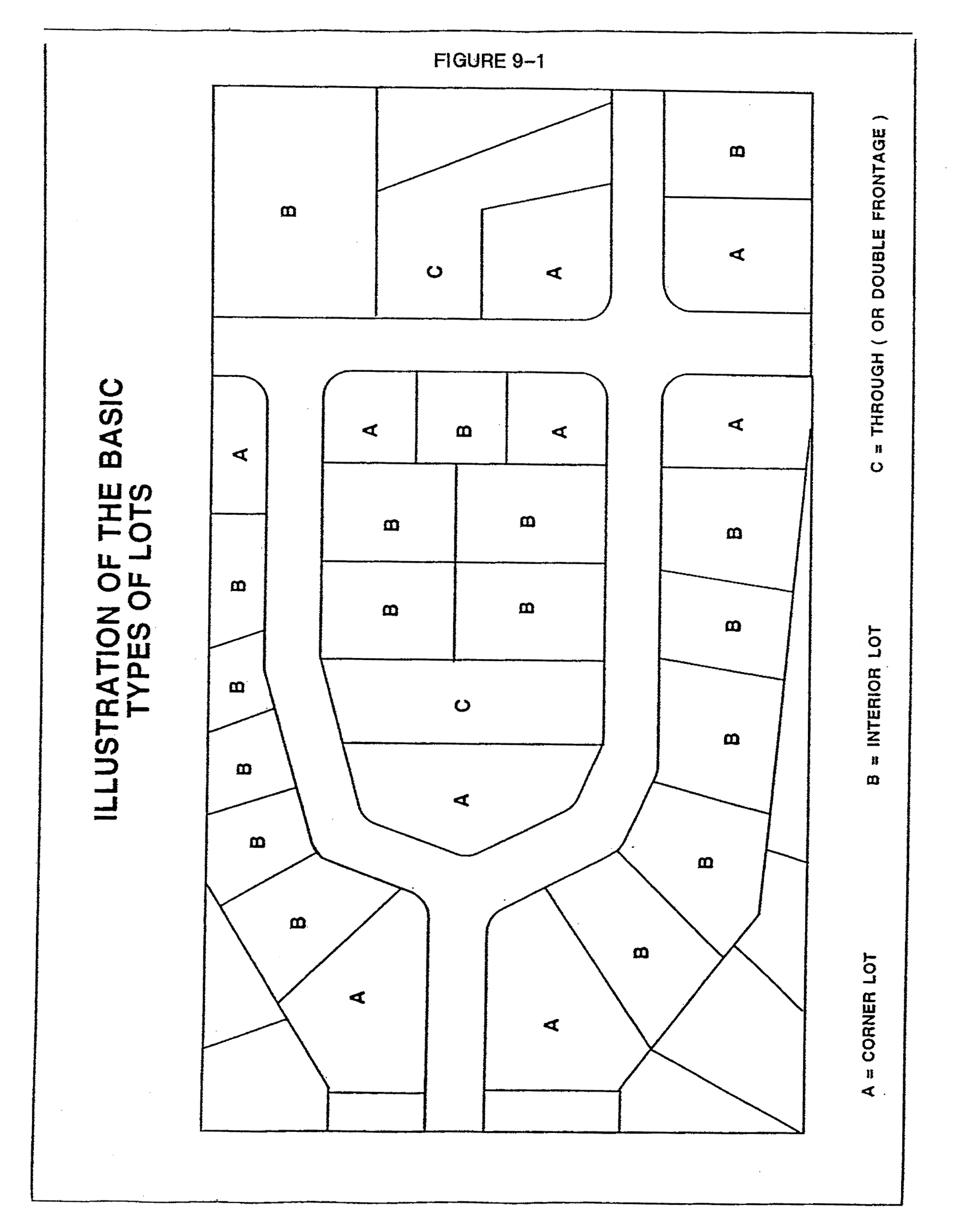
Basic Types of Lots
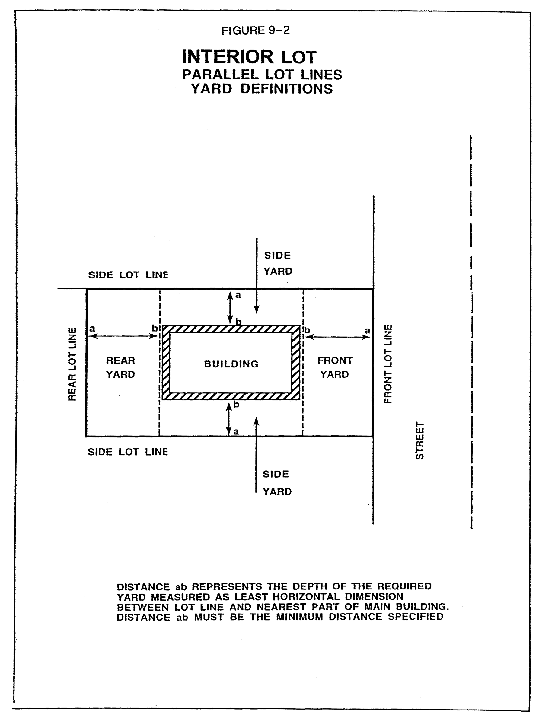
Interior Lots
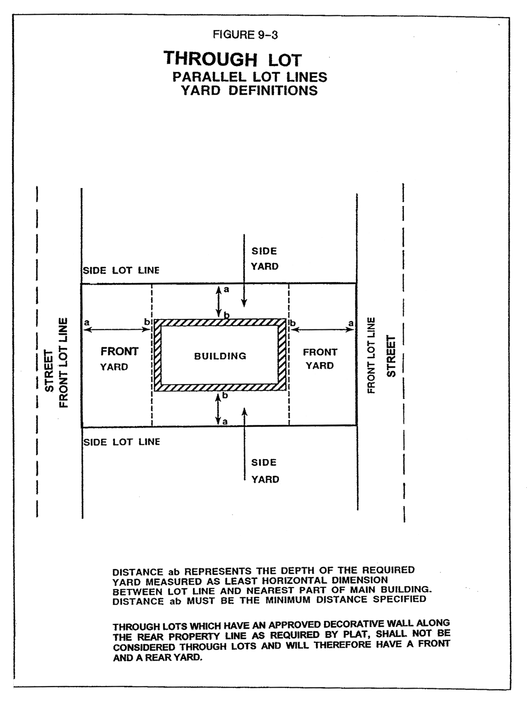
Through Lots
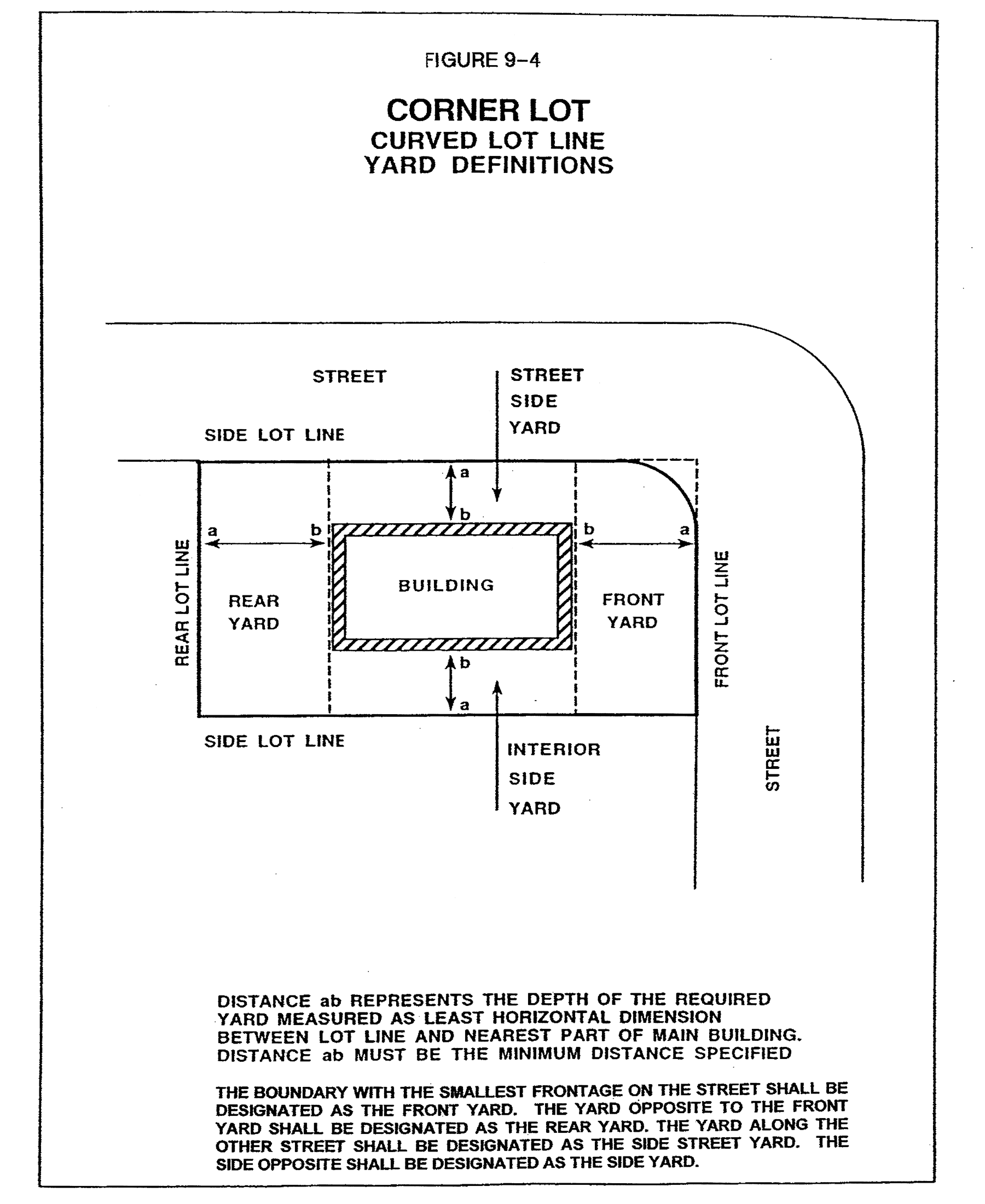
Corner Lots
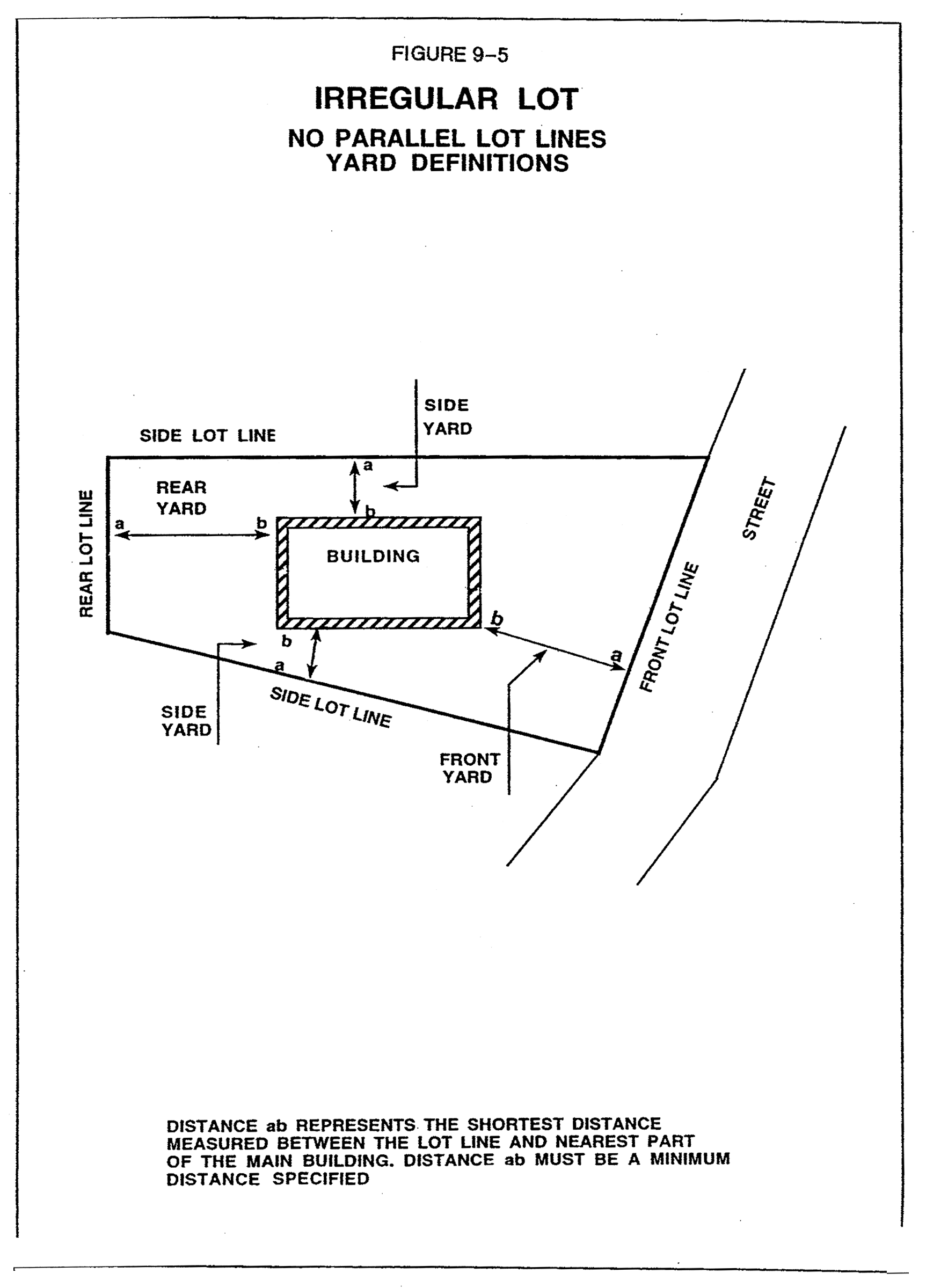
Irregular Lots (No Parallel Lot Lines)
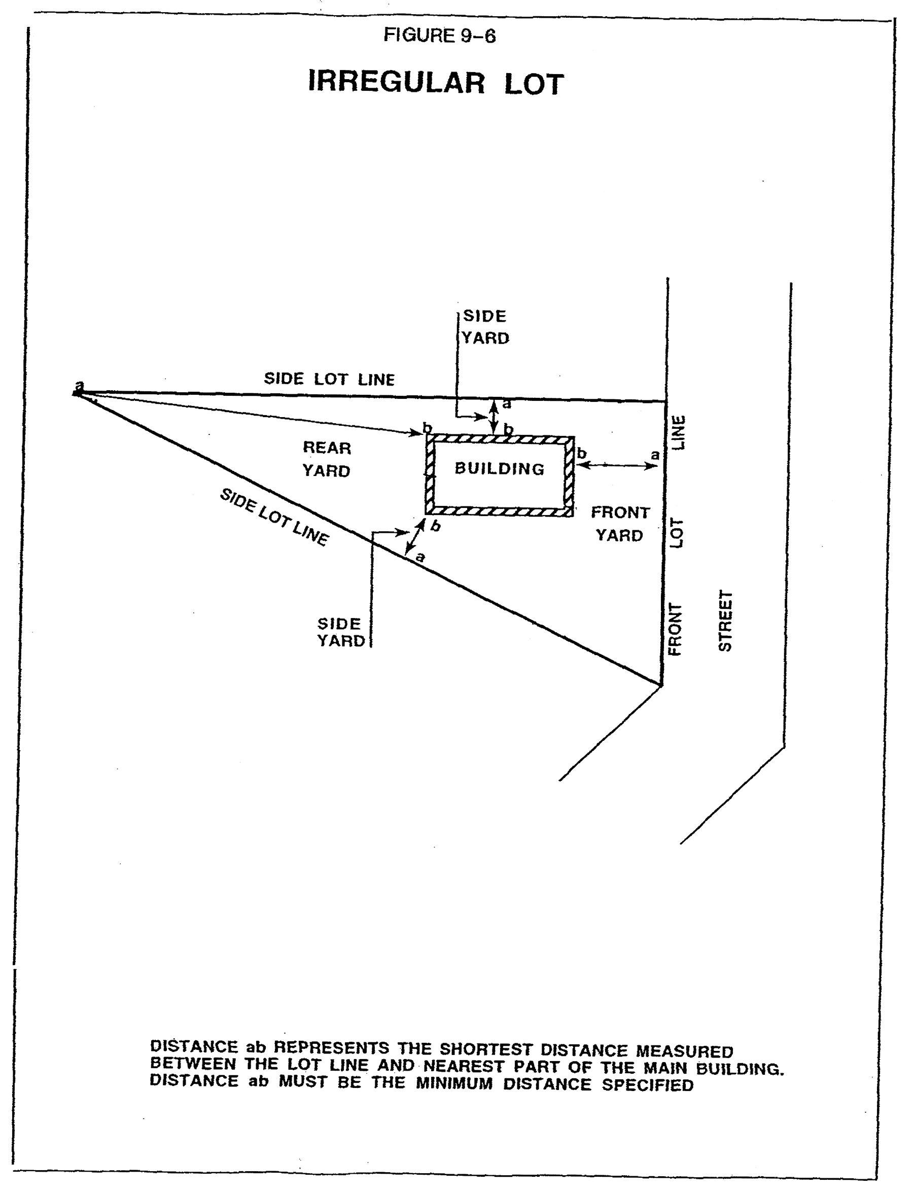
Irregular Lots
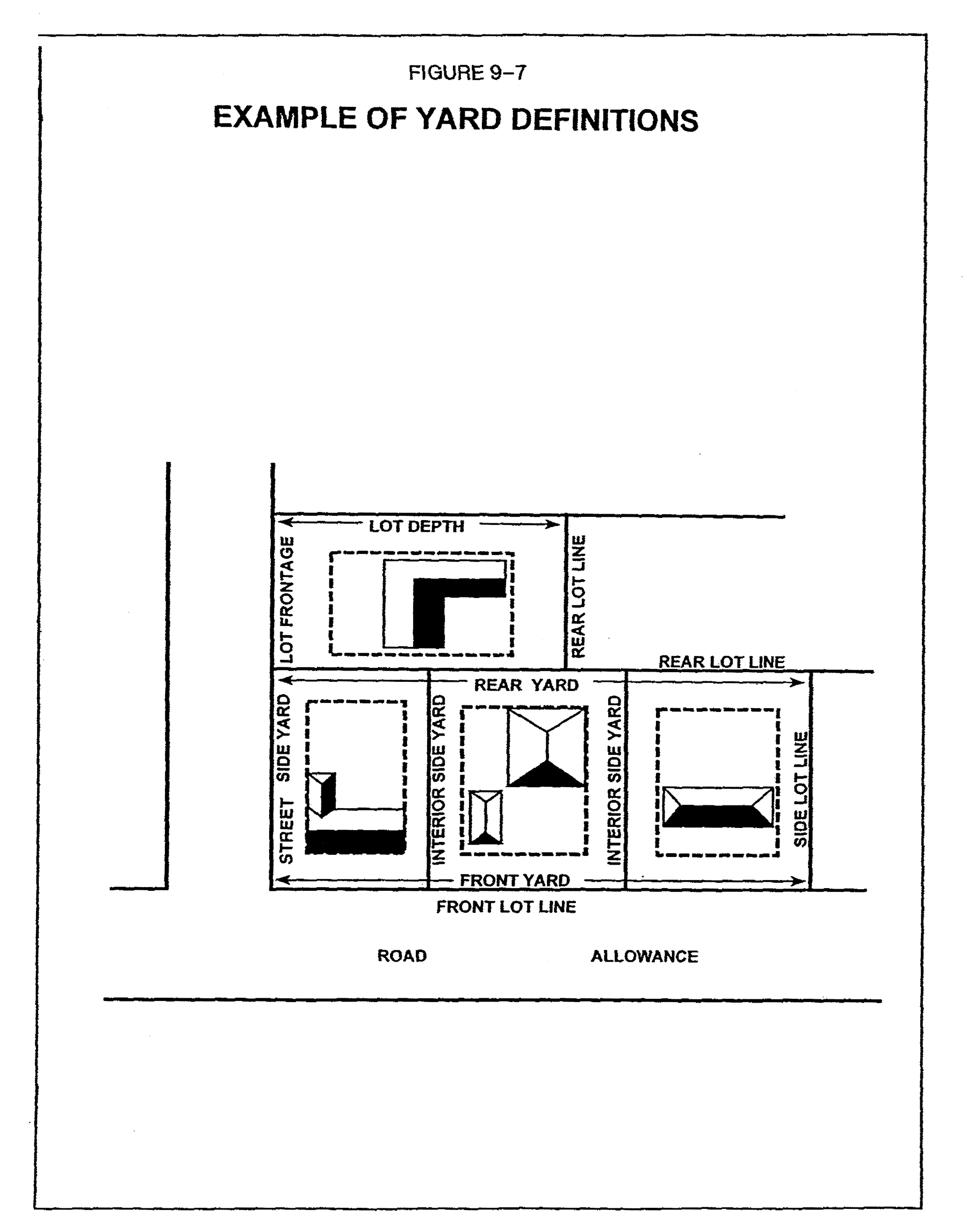
Example of Yard Definitions