
Port Allen City Zoning Code
ARTICLE 5
- TRADITIONAL NEIGHBORHOOD DEVELOPMENT DISTRICT
Section 5.1. - Purpose.
The purpose of a traditional neighborhood development zoning district ("TND district") is to encourage mixed-use, compact development and facilitate the efficient use of services. A TND district diversifies and integrates land uses within close proximity to each other, and it provides for the daily recreational and commercial needs of the residents. A TND district is a sustainable, long-term community that provides economic opportunity and environmental and social equity for the residents. This article's intent is to encourage its use by providing incentives, rather than prohibiting conventional development. A traditional neighborhood development:
A.
Is designed for the human scale;
B.
Provides a mix of uses, including residential, commercial, civic, and open space uses in close proximity to one another within the neighborhood;
C.
Provides a variety of housing types and sizes to accommodate households of all ages, sizes, and incomes;
D.
Coordinates transportation systems with a hierarchy of appropriately designed improvements for pedestrians, bicycles, and vehicles, which incorporates a system of relatively narrow, interconnected streets, roads, drives, and other thoroughfare types, and provides for the connections of those thoroughfare types to existing and future developments;
E.
Includes compatibility of buildings and other improvements as determined by their arrangement, bulk, form, character and landscaping to establish a livable, harmonious and diverse environment;
F.
Incorporates environmental features into the design;
G.
Provides a range of open space configured by squares, plazas, greens, landscaped streets, preserves, greenbelts and parks woven into the pattern of the neighborhood;
H.
Incorporates architecture, landscape, lighting and signage standards integrated with the zoning provisions that respond to the unique character of the region; and
I.
Provides an increased range of options than are allowed by conventional zoning.
(Ord. No. 1-2016, § 4-13-2016)
Section 5.2. - Overview.
A.
A TND district consists of an area of not less than 50 contiguous acres. In this article, property is considered contiguous even if separated by a public roadway.
B.
A TND district is divided into at least two types of areas, and each type of area has different land use and site development regulations. A TND district must have one neighborhood center area (also sometimes referred to as town center or village center) and at least one mixed residential area. A TND district may also have a neighborhood edge area, civic spaces and green spaces.
C.
A "neighborhood center area" serves as the focal point of a TND district, containing retail, commercial, civic, and/or public services to meet the daily needs of community residents. A "neighborhood center" is pedestrian-oriented, and it is designed to encourage pedestrian movement. A square may be located in a neighborhood center area. Retail and commercial uses should generally be located adjacent to a square. The neighborhood center uses include retail shops, restaurants, offices, banks, hotels, post office, governmental offices, churches, community centers, and attached residential dwellings.
D.
A "mixed residential area" includes a variety of residential land uses, including single-family residential, duplex, townhome, and multifamily. Residential scale retail and commercial uses are permitted within a mixed residential area with strict architectural and land use controls. Retail and commercial uses in a mixed residential area are required to blend into the residential character of the neighborhood. A mixed residential area includes open spaces including small squares, pocket parks, community parks, and/or greenbelts. A mixed residential area promotes pedestrian activity through well-designed and varied streetscapes that also provide for the safe and efficient movement of both pedestrian and vehicular traffic. Mixed residential area uses include single-family homes, condominiums, townhomes, apartments, offices, restaurants, neighborhood scale retail, and civic uses. Mixed residential areas often utilize alleys either public or private. Varying lot sizes are encouraged within the mixed residential area.
E.
A "neighborhood edge area" is the least dense portion of a TND district, with larger lots and greater setbacks than the rest of the neighborhood. Alleys are not required, and direct vehicular access to streets is permitted. Only single-family residential dwellings are permitted. A neighborhood edge area is appropriate along the perimeter of the neighborhood. A portion of a TND district that adjoins existing or platted conventional low density housing must be designated as a neighborhood edge area.
F.
Large office, low-impact manufacturing uses and industrial uses that are not appropriate for a neighborhood center area or a mixed residential area but which serve the local residents may be located in a specified district.
G.
Civic uses that are oriented to the general public are permitted in a neighborhood center area and a mixed residential area. These uses are essential components of the social and physical fabric of a TND district. Civic space shall be integrated in residential and commercial areas in the TND district. TND districts shall incorporate civic common open spaces to be maintained by the municipality and/or private open spaces to be maintained by the community or landowners within the TND district. Special attention should be paid to the location of government offices, libraries, museums, schools, churches, and other prominent public buildings to create focal points and landmarks for the community. The locations of these major public civic uses are designated on the general implementation plan at the time of planning commission approval of a particular development.
H.
Open space is a significant part of a TND district design. Formal and/or informal open spaces are required. These serve as areas for community gatherings, landmarks, and as organizing elements for the neighborhood. Open space includes squares, plazas, greens, preserves, parks, and greenbelts.
I.
A TND district is designed to be pedestrian oriented. To accomplish this goal, pattern and design of the various thoroughfare types are used to reduce vehicle travel speeds and encourage pedestrian activity. An interconnected and diverse network of streets, and other thoroughfare types, is required. Streets may be smaller than in conventional development and more varied in size and form to control traffic and give character to the neighborhood.
J.
Thoroughfares and utilities in TND districts shall connect to existing thoroughfares and utilities, or dead-end as stubs intended for connection to future thoroughfares, unless otherwise prohibited by topography, environmental constraints or other considerations.
(Ord. No. 1-2016, § 4-13-2016)
Section 5.3. - TND district design requirements.
A.
Association.
1.
Conditions, covenants, and restrictions for all the property within a TND district must be filed and recorded in the office of the clerk of court of West Baton Rouge Parish, Louisiana by the developer before a lot in the TND district is sold and/or a building permit is issued.
2.
In addition to other terms and conditions acceptable to the applicant, the conditions, covenants, and restrictions must create one or more property owners' association (the "association") with mandatory membership for each property owner, governed by articles of incorporation and bylaws, which shall:
a.
Be organized by the applicant and operated with a financial subsidy from the applicant before the sale of any lots within the TND district;
b.
Provide for the conditions and timing of transferring control of the association from the applicant to the property owners;
c.
Be responsible for maintenance of insurance and taxes on all common open space, enforceable by liens placed on the association by the city, as provided in the association bylaws;
d.
At all times, cause all owners to have access to the common open space within the TND district;
e.
Establish architectural standards that are in conformity with the requirements of this section which shall be subject to review and approval by the board of directors of the association or the architectural control committee, as described below;
f.
Create an architectural control committee to review development for compliance with the design standards, to issue certificates of approval, and to review and approve the development's architect, designer, and/or other professionals contributing to the development;
g.
Provide for the ownership, development, management, and maintenance of private open space (except plazas owned by individual property owners), community parking facilities, community meeting hall, and other common areas;
h.
Provide for a maintenance program for all property within the TND district, including landscaping and trees within the streetscape;
i.
Require the collection of assessments from members in an amount sufficient to pay for its functions; and
j.
Be effective in perpetuity.
B.
Land use allocations. Each lot within a TND district must be allocated particular permitted land use categories. The identification of permitted land uses within all or a portion of a TND district may be made by reference to other zoning districts available within the city ordinances. Areas which would permit the sale or consumption of alcohol must be approved for an alcohol license by the mayor and city council.
C.
Neighborhood uses. In order to achieve the proximity necessary to make neighborhoods walkable, it is important to mix land uses throughout the TND district and not to separate uses. A TND district shall consist of a mix of residential uses, a mixed use area, and open space as provided below.
D.
A mix of residential uses. For new construction or infill development, the mix of residential uses may be satisfied by existing residential uses adjacent to the TND district by including some and/or all of the following:
1.
Single-family detached dwellings;
2.
Single-family attached dwellings, including duplexes, townhomes, row houses;
3.
Multifamily dwellings, including senior housing;
4.
Secondary dwelling units;
5.
"Special needs" housing, such as community living arrangements and assisted living facilities;
6.
Residential units above commercial uses, which shall be considered multifamily units.
E.
Mixed-use area, of commercial, residential, civic or institutional, and open space uses as identified below. Most of the residents shall be generally within approximately one-quarter-mile distance from existing or proposed commercial, civic, and/or open space areas.
1.
Commercial uses may include the following:
a.
Food services (including without limitation, neighborhood grocery stores; butcher shops; bakeries; restaurants (including the sale and consumption of alcohol), not including drive-throughs; cafes; coffee shops; neighborhood taverns, bars or pubs); delis, ice cream parlors, specialty foods, and/or outside dining patios and areas;
b.
Retail uses (including without limitation, retail sales, florists or nurseries; gas stations, hardware stores; stationery stores; book stores; galleries, studios and shops of artists and artisans, drug stores, apparel, antiques, furniture, music, pets, farmers market, and toys);
c.
Services (including without limitation, child care centers; music, dance or exercise studios; offices, including professional and medical offices; financial and banks; medical clinics, barber; laundromats; educational, hair salon; dry cleaning, health or fitness, dry cleaners, tailor shops, repair and service shops, and postal);
d.
Accommodations (bed and breakfast establishments, small hotels or inns); and
e.
Clubs and organizations, including fraternal organizations.
2.
Residential uses may include the following, for sale or rent:
a.
Single-family attached dwellings, including duplexes, townhomes, row houses;
b.
Multifamily dwellings, including senior housing;
c.
Residential units located on upper floors above commercial uses or to the rear of storefronts;
d.
Live/work units that combine a residence and the resident's workplace; and
e.
"Special needs" housing, such as community living arrangements and assisted living facilities.
3.
Civic or institutional uses may include the following:
a.
Municipal offices, fire stations, libraries, museums, community meeting facilities, and post offices;
b.
Places of worship;
c.
Transit shelters;
d.
Philanthropic institutions; and
e.
Educational facilities.
4.
Office which may include the following:
a.
Art galleries and studios;
b.
Banks;
c.
Child care centers;
d.
Clubs;
e.
Offices; and
f.
Medical clinics.
5.
Open space uses may include the following:
a.
Central square;
b.
Neighborhood parks;
c.
Recreational facilities; and
d.
Playgrounds.
F.
Open space. Uses identified below should be incorporated in the TND district as appropriate. Large outdoor recreation areas (such as playgrounds and fields, not large neighborhood centers) should be located at the periphery of neighborhoods rather than central locations. Common open space is more particularly described in section 5.3.H below.
1.
Environmental corridors dedicated for preservation;
2.
Protected natural areas dedicated for preservation;
3.
Community parks;
4.
Streams, ponds, and other water bodies.
G.
Development units. The number of residential dwelling units and the amount of nonresidential development, excluding open spaces, shall be determined as follows, provided that single-family detached dwellings shall account for at least 50 percent of the total number of residential units in the TND district, and two-family units, townhomes, and multifamily units shall comprise less than 50 percent of the units:
1.
In areas devoted to mixed residential uses:
a.
The number of single-family attached and detached units permitted shall be five to eight dwelling units per net acre;
b.
The number of multifamily units shall be eight to 40 dwelling units per net acre.
c.
Secondary dwelling units shall be permissible in addition to the number of dwelling units authorized under this section. However, the total number of secondary dwelling Units shall not be more than 20 percent of the total number of single-family attached and detached units. The developer or association shall be responsible for advising the department of public works as to whether the number of approved permits for secondary dwelling units meets or exceeds the total number permissible under this section.
2.
In mixed-use areas:
a.
The number of single-family and multifamily dwelling units permitted shall be calculated the same as above plus an additional number of units not to exceed ten percent of the amount permitted above.
b.
The total ground floor area of nonresidential development uses, including off-street parking areas, shall not exceed 25 percent of the TND district.
c.
All dwelling units constructed above commercial uses shall be permissible in addition to the number of dwelling units authorized under this section. However, the total number of dwelling units shall not be increased by more than ten dwelling units or ten percent, whichever is greater. The developer or association shall be responsible for advising the department of public works as to whether the number of approved permits for dwelling units constructed above commercial uses meets or exceeds the total number permissible under this section.
H.
Additional common open space requirements. At least 20 percent of the gross acreage of the TND district must be common open space. Ninety percent of the lots within the areas devoted to mixed residential uses shall be within a one-quarter-mile distance from common open space. At least 25 percent of common open space shall be dedicated as parkland.
1.
The following uses may account for common open space with the stated limitations:
a.
Parks, open greenbelt areas, and other recreational space which are readily accessible must account for not less than 25 percent of the common open space.
b.
Trees along thoroughfare types located within designated landscape common areas or landscape servitude and located within a street right-of-way may only constitute 25 percent of the common open space. There shall be a minimum average of one street tree on both sides of the street per 40 feet of frontage. However, common open space within vehicle use areas or any noncontiguous green area of less than 500 square feet may not be included.
c.
Unpaved lakes, ponds, bayous, streams, or creeks, including storm water wet detention basins provided that they are designed so that a minimum of 20 percent of the abutting shoreline is made accessible for the common use of the development, but in no event less than 300 feet of frontage.
d.
Stormwater dry detention basins of not less than one acre; but may not exceed 25 percent of the common open space and must be designed to provide for acceptable maintenance and upkeep of the detention basin.
e.
Golf courses may account for up to 50 percent of the common open space provided that the course is open to the public.
f.
Natural wetlands shall not exceed 50 percent of common open space plus any natural wetlands reasonably visible from interpretive walkways provided in and through the wetland.
g.
Hard surface recreation areas such as recreational courts and pedestrian plazas may account for up to 25 percent of the common open space.
h.
Servitudes with existing below ground utilities and/or facilities with a width of not less than 30 feet.
i.
Electrical transmission line servitudes with a width not to exceed 150 feet in commercial and residential areas only, and must be improved, recreational use areas available to the public.
j.
School sites, library sites, outside hard surface recreational area, not to exceed 20 percent of the common open space, excluding the area devoted to buildings.
k.
An existing building or buildings that have historical or cultural significance may be located in a common area space; however, the enclosed building area may not be included in the common open space requirement.
2.
Common open space shall not include:
a.
Yards which are not accessible for the common use of the development;
b.
Parking areas;
c.
Drives;
d.
Except as provided in subsection 5.3.H.1.i above, utility with above-ground improvements or road easements/servitudes;
e.
Paved lakes, ponds, bayous, streams, or creeks;
f.
Structures (unless a part of the open space such as gazebos);
g.
Required unimproved drainage ditches or canals; and
h.
Areas reserved for the exclusive use and benefit of an individual tenant or owner.
3.
Common open space shall be permanently set aside for the sole benefit, use, and enjoyment of present and future occupants of the TND district through covenant, deed restriction, open space servitude, or similar legal instrument; or, if agreed to by governmental agency, the open space may be conveyed to a governmental agency for the use of the general public.
4.
In the event land shown on a specific implementation plan (as hereinafter defined) as common open space is dedicated to the city, the city council may, but shall not be required to, accept the open space provided:
a.
Such land is accessible to the residents of the city;
b.
There is no cost of acquisition other than the costs incidental to the transfer of ownership; and
c.
The city agrees to and has access to maintain such lands.
5.
Common open space shall be protected against building development and environmental damage by conveying to the municipality, city, association, or land trust an open space servitude restricting the area in perpetuity against any future building and against the removal of soil, trees and other natural features, except as the planning commission determines is consistent with conservation or recreational purposes.
I.
Stormwater management. The design and development of the TND district should minimize off-site stormwater runoff, promote on-site filtration, and minimize the discharge of pollutants to ground and surface water. Natural topography and existing land cover should be maintained/protected to the maximum extent practicable. New development and redevelopment shall meet the following requirements:
1.
Untreated, direct stormwater discharges to wetlands or surface waters are not allowed.
2.
A drainage analysis shall be submitted in conformance with the city's regulations.
3.
Erosion and sediment controls must be implemented.
4.
Redevelopment stormwater management systems should improve existing conditions and meet standards to the extent practicable.
5.
All treatment systems or best management practices ("BMP") must have operation and maintenance plans to ensure that systems function as designed.
J.
Lot and block standards.
1.
Block and lot size diversity. Thoroughfare layouts should provide for perimeter blocks that are generally in the range of 200 feet to 400 feet deep by 400 feet to 800 feet long. Block length shall not exceed 2,000 feet in perimeter. The planning commission may approve block perimeters of more than 2,000 feet if required because of existing topography. The applicant should consider where and when appropriate, a block longer than 500 feet in length may be traversed near the midpoint by a pedestrian path. A variety of lot sizes should be provided to facilitate housing diversity and choice and meet the projected requirements of people with different housing needs.
2.
Lot widths. Lot widths should create a relatively symmetrical street or road cross section that reinforces the public space of the street or road as a simple, unified public space.
3.
Building setback, front—Mixed use area. Structures in the mixed-use area have no minimum setback. Commercial and civic or institutional buildings should abut the sidewalks in the mixed-use area.
4.
Building setback, front—Areas of mixed residential uses. Single-family detached residences shall have a building setback in the front between zero feet and 25 feet. Single-family attached residences and multifamily residences shall have a building setback in the front between zero feet and 15 feet.
5.
Building setback, rear—Areas of mixed residential uses. The principal building on lots devoted to single-family non-alley-loaded detached residences shall be setback no less than five feet from the rear lot line.
6.
Side setbacks. Provision for zero foot lot-line single-family dwellings should be made, provided that a reciprocal access easement is recorded for both lots and townhomes or other attached dwellings, provided that all dwellings have pedestrian access to the rear yard through means other than the principal structure.
K.
Thoroughfare network.
1.
The circulation system shall allow for different modes of transportation.
2.
The circulation system shall provide functional and visual links within the residential areas, mixed-use area, and open space of the TND district and shall be connected to existing and proposed external development. The circulation system shall provide adequate traffic capacity, provide connected pedestrian and bicycle routes, especially off-street bicycle or multi-use paths or bicycle lanes on the streets where required and Americans With Disabilities Act ("ADA")-approved crosswalks and sidewalks, control through traffic, provide adequate transit stops, limit lot access to streets of lower traffic volumes, and promote safe and efficient mobility through the TND district.
3.
Pedestrian circulation. Convenient pedestrian circulation systems that minimize pedestrian-motor vehicle conflicts shall be provided continuously throughout the TND district. Where feasible, any existing pedestrian routes through the site shall be preserved and enhanced. All streets, except for alleys, shall be bordered by sidewalks on both sides. The following provisions also apply:
a.
Sidewalks in residential areas. Sidewalks shall be a minimum five feet in width. Sidewalks shall be provided along both sides of each street in residential areas. For pedestrian safety, sidewalks shall be separated at least three feet from the curb in areas of single-family detached dwelling units. In areas of multifamily and attached single-family dwellings, pavement may extend between the required pedestrian sidewalk and the street curb, provided a five-foot unobstructed pedestrian sidewalk is provided.
b.
Sidewalks in mixed-use areas. Sidewalks shall be a minimum of five feet in width. Sidewalks shall be provided along both sides of each thoroughfare type located within a mixed-use area. Within mixed-use areas, pavement may extend between the required pedestrian sidewalk and the street curb provided a five-foot unobstructed pedestrian sidewalk is provided, and the there be a minimum six-foot street tree buffer between the pedestrian sidewalk and the curb on both sides of the roadway.
c.
Disabled accessibility. Sidewalks shall comply with the applicable requirements of the ADA.
d.
Crosswalks. Intersections of sidewalks with thoroughfares shall be designed with clearly defined edges. Crosswalks shall be well lit and clearly marked with contrasting paving materials or texture at the edges.
4.
Bicycle circulation. Bicycle circulation shall be accommodated on streets and/or on dedicated bicycle paths. Where feasible, any existing bicycle routes through the site shall be preserved and enhanced. Facilities for bicycle travel may include off-street bicycle paths (generally shared with pedestrians and other non-motorized users) and separate, striped, five-foot bicycle lanes on streets. If a bicycle lane is combined with a lane for parking, the combined width should be 14 feet.
5.
Public transit access. Where public transit service is available or planned, convenient access to transit stops shall be provided. Where transit shelters are provided, they shall be placed in highly visible locations that promote security through surveillance, and shall be well lighted.
6.
Motor vehicle circulation. Motor vehicle circulation shall be designed to minimize conflicts with pedestrians and bicycles. Traffic calming features such as "queuing streets", curb extensions, traffic circles, and medians shall be used to encourage slow traffic speeds.
7.
The thoroughfare network of the TND district shall be connected to existing thoroughfares. TND district streets should be laid out to allow extensions to future neighborhoods. Dead-end streets are prohibited.
8.
Design of thoroughfares.
a.
General.
i.
Thoroughfares consist of moving lanes, parking lanes, curbs or swales, planters, trees, street lights and sidewalks.
ii.
Thoroughfare types shall be designated in the specific implementation plan.
iii.
Roads, streets, and commercial streets may be modified to become avenues, boulevards and drives.
iv.
Thoroughfares passing from one use area to another shall change appropriately except those designated as a "connector" in the specific implementation plan.
v.
The exact locations of trees and lights along thoroughfares may be adjusted for specific conditions, such as building entrances.
vi.
Thoroughfares that exist in or near a TND district at the time of rezoning and are consistent with the intent of this article may become an approved standard for use in that TND district. An example of such a condition is commonly found in a nearby historic neighborhood.
vii.
If striped, on-street parallel parking spaces shall be striped collectively, not individually.
viii.
The full width of all paths, passages, rural lanes, lanes and alleys shall be designated a utility easement. Only in the absence of these thoroughfare types are utility easements permitted elsewhere.
ix.
All thoroughfares within a TND district shall terminate at other thoroughfares, forming a network. Cul-de-sacs shall be granted only when justified by site conditions.
b.
Design of thoroughfares in commercial areas.
i.
All lots shall front on a thoroughfare, except that a maximum of 20 percent of lots served by a rear alley may front a path or passage.
ii.
Thoroughfares may intersect at non-orthogonal angles as acute as 30 degrees.
c.
Design of thoroughfares in civic areas. Thoroughfares affronting civic buildings or civic spaces shall follow the standards of the underlying use area.
9.
The standards and regulations in this section 5.3 shall be the only standards and regulations governing the design of thoroughfares in the TND district.
L.
Parking requirements. The requirements for parking spaces shall be as listed in the specific implementation plan. Parking areas for shared or community use should be encouraged. On-street parking shall count toward the parking requirements. Side and rear parking shall be allowed. In addition:
1.
In the mixed-use area, the primary parking lot shall be located at the rear or side of a building. If located at the side, screening shall be provided as specified in subsection 5.3.P.
2.
A parking lot or garage in most instances should not be adjacent to or opposite a street or other thoroughfare, intersection.
3.
In the mixed-use area, a commercial use must provide one parking space for every 400 feet of gross building area.
4.
Parking lots or garages must provide not less than one bicycle parking space for every ten motor vehicle parking spaces.
5.
Adjacent on-street parking may apply toward the minimum parking requirements.
6.
In the mixed residential areas, parking may be provided on-site. One off-street parking space with unrestricted ingress and egress shall be provided for each secondary dwelling unit.
7.
Multifamily uses must provide one parking space for every first bedroom and one-half parking space for each additional bedroom.
8.
In residential areas, garage doors which face the front of a lot shall be placed 20 feet beyond the setback of the principal structure. However, the planning commission may modify this requirement for no more than 20 percent of the dwelling units if warranted by topography or other environmental conditions.
9.
In nonresidential areas, parking lots in most instances should be located to the rear or side of buildings. Side parking lots shall account for no more than 25 percent of parking per site, and shall be screened from sidewalks by a combination of low walls or fences and landscaping.
10.
In the case of commercial or office uses which have shop or store fronts adjacent to sidewalks and thoroughfares, parking along the thoroughfare directly in front of the lot shall count toward fulfilling the parking requirements.
11.
The required number of spaces for commercial and office uses may be further reduced by demonstrating the use of shared parking.
12.
If a developer desires additional customer parking for nonresidential uses, it shall be provided on grassy, pervious surfaces (of reinforced/plastic grid, reinforced block or similar material) which are adequate to sustain parked vehicles.
13.
Off-street parking shall be located in mid-block parking lots located behind the buildings.
14.
Parking shall be accessed by alley or rear lane, when available. However, there shall be no parking in an alley or lane.
15.
Parking shall be prohibited within 30 feet of intersections to enable public service and emergency vehicles adequate turning radii, and in mid-block sections such that emergency vehicles can park and operate within 125 feet of all buildings on the block.
16.
Required parking must be provided within a five minute (one-quarter-mile) radius of the site which it serves.
17.
The location of permitted parking along thoroughfares should be coordinated to allow access to mail boxes. A central mail delivery location for all or portion of the lots may be provided as opposed to individual deliveries to lots.
18.
Parking lots greater than two double loaded parking rows shall be carefully arranged to minimize breaks between pedestrian destinations.
19.
Shared parking.
a.
If an office use and a retail use share parking, the parking requirement for the retail use may be reduced by 20 percent, provided that the reduction shall not exceed the minimum parking requirement for the office use.
b.
If a residential use shares parking with a retail use other than lodging uses, eating and drinking establishments or entertainment uses, the parking requirement for the residential use may be reduced by 30 percent, provided that the reduction does not exceed the minimum parking requirement for the retail and service use.
c.
If an office and a residential use share off-street (or other thoroughfare) parking, the parking requirement for the residential use may be reduced by 50 percent, provided that the reduction shall not exceed the minimum parking requirement for the office use.
d.
The required number of spaces for commercial, office, civic, and multifamily uses may be further reduced by demonstrating the use of shared parking.
20.
Parking structures may have adjacent commercial liners.
M.
Architectural standards. A variety of architectural features and building materials is encouraged to give each building or group of buildings a distinct character. In order to achieve harmonious design throughout the TND district, architectural design guidelines for the residential, commercial, office, civic and institutional uses shall be submitted to the planning commission and used in creating the development by the developer. The architectural features and guidelines are illustrative and conceptual and may be altered by the developer from time to time with the approval of the architectural control committee, it being understood that market conditions, social changes, building costs, change in demographics, other building codes and regulation and other reasons may require the need to alter the architectural features and concepts.
1.
Guidelines for existing structures.
a.
Existing structures or sites, if determined to be historic or architecturally significant by the Louisiana State Historic Preservation Office, or listed on the National Register of Historic Places, shall be protected from demolition or encroachment by incompatible structures or landscape development.
b.
The U.S. Secretary of the Interior's Standards for alterations to historic properties shall be used as the criteria for rehabilitation and treatment of historic or architecturally significant structures or sites.
2.
Guidelines for new structures.
a.
Height. New structures within a TND district shall be no more than three occupied stories for single-family residential, or five occupied stories for commercial, multifamily residential, or mixed-use.
b.
Entries, façades, windows, doors and roofs.
i.
The architectural features, materials, and the articulation of a facade of a building shall be continued on all sides visible from a public thoroughfare.
ii.
The front facade of the principal building on any lot in a TND district in most instances shall face onto a public thoroughfare. Corner lots are required to face onto one public thoroughfare.
iii.
The front facade shall not be oriented to face directly toward a parking lot.
iv.
Porches, pent roofs, roof overhangs, hooded front doors or other similar architectural elements shall define the front entrance to all residences.
v.
For commercial buildings, a minimum of 50 percent of the front facade on the ground floor shall be glass (transparent), including window or door openings allowing views into and out of the interior.
vi.
New structures on opposite sides of the same thoroughfare should follow similar design guidelines. This provision shall not apply to buildings bordering civic uses.
vii.
Building and parking placement within the neighborhood center, or town center, should be arranged to create appropriately scaled continuous building facades with as few non-pedestrian oriented breaks as possible.
viii.
Walls along thoroughfares shall be made of brick, or block and stucco, or other material to match the facade of the principal building.
ix.
Windows shall use clear glass panels.
x.
All openings including porches, galleries, arcades and windows, with the exception of storefronts, shall be square or vertical in proportion.
xi.
Openings above the first story shall not exceed 50 percent of the total building wall area, with each facade being calculated independently.
xii.
The facades on retail frontages shall be detailed as storefronts and glazed no less than 50 percent of the sidewalk-level story.
xiii.
Doors and windows that operate as sliders are prohibited along frontages.
xiv.
Flat roofs shall be enclosed by parapets a minimum of 42 inches high, or as required to conceal mechanical equipment to the satisfaction of the developer, association board of directors and architectural control committee.
xv.
Lots may front green space.
c.
Dwelling units may be constructed above the ground floor in commercial and office buildings.
d.
Commercial and office development within the TND district shall have an architectural design compatible with the design of residential buildings. As stated in subsection 5.3.A.2, the board of directors of the association or the architectural control committee establishes architectural standards for the TND district.
e.
Utilities. All utilities shall be placed underground.
3.
Guidelines for garages and secondary dwelling units. Garages and secondary dwelling units may be placed on a single-family detached residential lot within the principal building or an accessory building provided that the secondary dwelling unit shall not exceed 800 square feet. Garage doors shall have a minimum setback of 20 feet behind the facade of the principal structure when accessed from the front property line, and shall have a minimum setback of nine feet from the rear property line when accessed from a rear alley.
N.
Guidelines for exterior signage. Comprehensive sign guidelines are required for the entire TND district. Such guidelines shall be submitted to the planning commission. Signs shall share a common style, as to sizes, shapes, and materials permitted within the TND district.
O.
Guidelines for lighting.
1.
Lighting along thoroughfares, including pedestrian scale lighting and exterior lighting, shall be provided along all thoroughfares. Lighting along thoroughfares, including pedestrian scale lighting and exterior lighting design, shall meet the minimum standards developed by the illumination engineering society, maximum spacing between lighting shall not be greater than 150 feet. Generally more, smaller lights, as opposed to fewer, high-intensity lights, should be used.
2.
Comprehensive exterior lighting guidelines which establish coordinated exterior lighting guidelines are required for the entire TND district. Such guidelines shall be submitted to the planning commission. Where appropriate, exterior lighting shall generally share a common style, as to sizes, shapes, and materials permitted within the TND district. Lighting structures shall be architecturally compatible with the surrounding area. Lighting shall be shielded and directed downward in order to reduce glare onto adjacent properties.
P.
Landscaping and screening standards.
1.
Overall composition and location of landscaping shall complement the scale of the development and its surroundings. In general, larger, well-placed contiguous planting areas shall be preferred to smaller, disconnected areas. Where screening is required by this section, it shall be at least three feet in height, unless otherwise specified. Required screening shall be at least 50 percent opaque throughout the year. Required screening shall be satisfied by one or some combination of a decorative fence not less than 50 percent behind a continuous landscaped area, a masonry wall, or a hedge.
2.
Trees along thoroughfares.
a.
A minimum of one deciduous canopy tree per 40 feet of frontage, or fraction thereof, shall be required. Trees can be clustered and do not need to be evenly spaced, subject to further provisions as set forth herein.
b.
Trees should preferably be located between the sidewalk and the curb, within the landscaped area of a boulevard, or in tree wells installed in pavement or concrete.
c.
Native shade trees which grow to a minimum height of 40 feet at maturity shall be planted along all streets at a maximum average spacing which is appropriate for the specified trees.
d.
Trees shall have a minimum caliper of two and one-half inches at the time of planting.
e.
If placement of trees within the right-of-way will interfere with utility lines, trees may be planted within the front yard setback adjacent to the sidewalk.
3.
Parking area landscaping and screening for surface parking lots.
a.
All parking and loading areas fronting public thoroughfares or sidewalks, and all parking and loading areas abutting residential districts or users, shall provide a landscaped area at least five feet wide along the public thoroughfare or sidewalk; screening at least three feet in height and not less than 50 percent opaque; and one tree for each 25 linear feet of parking lot frontage.
b.
The corners of parking lots, "islands," and all other areas not used for parking or vehicular circulation shall be landscaped. Vegetation may include turf grass, native grasses or other perennial flowering plants, vines, shrubs or trees. Such spaces may include architectural features such as benches, kiosks or bicycle parking.
c.
For all parking lots with more than six spaces, the landscaped area shall be comprised of a minimum of 20 percent of the total parking lot area.
4.
A landscaping plan is required for structured parking.
5.
A comprehensive landscaping plan is required for the entire TND district which establishes coordinated landscaping guidelines.
Q.
Environmental standards. All uses in the TND district shall conform to all applicable federal, state and local laws and regulations regarding the environment such as laws and regulations concerning noise, air quality, water quality, radiation, and radioactivity.
(Ord. No. 1-2016, § 1, 4-13-2016)
Section 5.4. - Fees.
The city council may, by resolution, establish criteria for fees required for the administration of this article.
(Ord. No. 1-2016, § 1, 4-13-2016)
Section 5.5. - Other code and ordinances applicability.
A.
Other codes and ordinances for the city apply to a TND district unless:
1.
This article expressly provides otherwise; and
2.
Only as long as such other codes and ordinances do not impede the accomplishment of the stated purpose of the TND district as described in this section.
B.
The requirements of this section supersede any inconsistent provision of any other codes and ordinances.
C.
Procedures for approval of planning and zoning items before the planning commission and the city council are applicable notwithstanding any conflict with provisions allowed for in this section for the development of TND district.
D.
A TND district is a separate and distinct zoning district which shall allow the permitted uses as provided in the general implementation plan, notwithstanding any limitation, restriction and/or conflict contained in other zoning classification provided in other codes and ordinances.
(Ord. No. 1-2016, § 1, 4-13-2016)
Section 5.6. - Unified control.
All land included in any TND district shall be under the complete, unified and legal control of the applicant, whether the applicant be an individual, partnership, limited liability company, corporation and/or other person. Upon request by the city, the applicant shall furnish the city sufficient evidence to the satisfaction of the city that the applicant is in the complete, legal and unified control of the entire area of the proposed TND district. Upon request by the city, the applicant shall provide the city all agreements, contracts, guarantees and other necessary documents and information that may be required by the city to assure the city that the development project may be lawfully completed according to the plans sought to be approved.
(Ord. No. 1-2016, § 1, 4-13-2016)
Section 5.7. - Application procedure and approval process.
A.
General. Prior to city approval for development within a TND district, subject to the appeal process provided in this section, the following six steps shall be completed according to the procedures outlined in this section:
1.
Pre-application conference. Pre-application conference is more particularly described in section 5.8 below.
2.
Rezoning request. Rezoning is more particularly described in section 5.9 below.
3.
Approval of a general implementation plan by the planning commission and the city council for the entire TND district. General implementation plan more particularly described in section 5.10 below.
4.
Approval of a specific implementation plan for each phase of development by the planning commission and the city council. Specific implementation plan more particularly described in section 5.11 below.
5.
Approval of construction plans by city for each phase of development. Approval of construction plans more particularly described in section 5.12 below.
6.
Approval of a final plat for each phase of development by the planning director and the city council. Approval of final plat more particularly described in section 5.19 below.
B.
If the development includes the division of property into lots, the specific implementation plan shall be approved concurrently with a preliminary plat for each phase of development.
C.
Subdivisions of property within a TND district after general implementation plan approval, but prior to specific implementation plan approval, shall meet the zoning requirements of the most restrictive zoning district allowed for each designated use for that portion of the general implementation plan. These subdivisions shall require planning commission and city council approval and will not allow development or building permit approval until a specific implementation plan is approved.
D.
Where the development is to be developed in phases, the general implementation plan that is presented for review and approval shall be the general implementation plan for the entire development and shall provide the proposed phasing, which may change from time to time. Unless specifically mandated by the planning commission's approval of the particular phases of the general implementation plan, the developer is free to change the sequencing of phases to adapt to market conditions or other circumstances. Any such change shall be considered a minor change. Each phase of a development shall have an individual specific implementation plan.
(Ord. No. 1-2016, § 1, 4-13-2016)
Section 5.8. - Pre-application conference.
A.
The pre-application conference shall be held with the planning director for the purpose of exchanging information, providing guidance to the applicant and determining the eligibility of the request for consideration as a TND district.
B.
A request for a pre-application conference shall be made to the planning director. As part of the pre-application conference, the applicant shall submit two copies of a conceptual plan, at least ten days in advance of the pre-application conference, which shows the property location, boundaries, significant natural features, thoroughfare network (vehicular and pedestrian circulation), and land use(s) for the entire site.
C.
The planning director shall advise the applicant of the conformance of the TND district concept with the intent and objectives of a TND district, whether it appears to qualify under the minimum requirements of sections 5.1, 5.2 and 5.3, and whether the general concept appears to be substantially consistent with the city codes and the city's land use plan. No formal action will be taken at a pre-application conference, nor will statements made at the pre-application conference be considered legally binding commitments.
(Ord. No. 1-2016, § 1, 4-13-2016)
Section 5.9. - Rezoning to traditional neighborhood district.
A.
Following required public notice, the planning commission shall hold a public hearing on the proposed TND district. Following the hearing, the planning commission shall review the TND district request and any comments submitted by any adjoining property owners and shall make a recommendation to the city council to approve, approve with conditions, or deny the TND district rezoning request. In its recommendation to the city council, the planning commission shall include the reasons for such recommendation.
B.
Upon approval of the rezoning request, the property shall be designated "TND CONCEPT" on the official zoning map.
(Ord. No. 1-2016, § 1, 4-13-2016)
Section 5.10. - General implementation plan.
Following the pre-application conference and rezoning of the property to a "TND CONCEPT," the applicant shall submit a completed application (general implementation plan) to the planning director. The general implementation plan shall contain all information required in the general implementation plan checklist as shown below, including general architectural design features and concepts as described in section 5.3.M. herein (which may be subject to change by the developer in the future). Once the planning director determines the application is complete, the application shall be sent to the planning commission for a public hearing. The applicant shall be responsible for conducting a public workshop for residents of the area in which the project in proposed to be located. The workshop requirements ensure: The applicant is fully aware of the process, the workshop is conducted at a place and time convenient to the residents, and residents are properly notified of its intent. The applicant is required to conduct the workshop and document the results to the planning director before the application is deemed complete.
A.
General implementation plan checklist.
1.
A general location map of suitable scale, but no less than one inch = 200 feet, which shows the location of the property within the community and adjacent parcels including locations of any public streets, railroads, major streams or rivers and other major features within 1,000 feet of the site.
2.
A site inventory to identify site assets or resources, and constraints, including but not limited to floodplains, wetlands and soils classified as "poorly drained" or "very poorly drained," soils with bedrock at or within 42 inches of the surface, utility easements for high-tension electrical transmission lines (> 69KV), steep slopes greater than 15 percent and brownfields.
3.
A conceptual site plan, at a scale of no less than one inch = 100 feet, which indicates topography in two-foot contours for sites with 15 feet or more of local relief, or one-foot contours for local sites with less than 15 feet of local relief, consisting of a map with proposed features and existing site features and uses that will remain. These features should include general representations of the location of streets. The general location of existing to remain trees and shrubs should also be included, along with any other significant features.
4.
A conceptual stormwater management plan identifying the proposed patterns of major stormwater runoff, locations of stormwater infiltration areas, and other significant stormwater best management practices.
5.
Identification of the architectural style(s) of the TND district. The design style of the TND district shall be conveyed with drawings or computer simulations of typical proposed building elevations.
6.
A written report that provides general information about the covenants, conservation easements, or agreements which will influence the use and maintenance of the proposed development. The report shall also describe the site conditions and the development objectives.
7.
Phasing plans, where applicable.
8.
Any other information deemed reasonably necessary by the city council or planning commission in order to evaluate the plans.
B.
Procedures for general implementation plan approval. All applications for TND districts shall be processed in the following manner:
1.
The general implementation plan shall follow the procedures for approval of planning and zoning items before the planning commission and the city council which are not in conflict with this section 5.10. Notice of the time and place of the public hearing shall be mailed by certified mail to the owner/subdivider and all abutting property owners 15 days prior to the planning commission meeting. For the purpose of the notice requirement to adjoining property owners, the names and addresses of such owners shall be deemed to be those on the current tax records in the office of the West Baton Rouge Parish Assessor. The public hearing shall also be advertised in the official journal. All abutting property owners shall be given an opportunity to submit written comments. The legal advertisement must run three times in the city's official journal at least ten days prior to the planning commission meeting.
2.
Following required public notice, the planning commission shall hold a public hearing on the proposed TND district general implementation plan. Following the hearing, the planning commission shall review the TND district request and the general implementation plan and any comments submitted by any adjoining property owners and shall make a recommendation to the city council to approve, approve with conditions, or deny the TND district general implementation plan. In its recommendation to the city council, the planning commission shall include the reasons for such recommendation.
3.
Approval of a general implementation plan. After receiving the recommendation of the planning commission, the city council shall review the application, including the general implementation plan, the record of the planning commission proceedings and the recommendation, and shall approve, approve with conditions, or deny the application in accordance with the standards and purposes set forth in sections 5.1, 5.2 and 5.3. An approval with conditions shall not be considered final until the applicant submits a written acceptance of the conditions and all necessary revisions to the general implementation plan to the city council. If approved by the city council, the general implementation plan and all other information and material formally submitted with the application shall be adopted as an amendment to the city's ordinances and shall become the standards of development for the TND district. All future development within the TND district shall conform to the standards adopted for the TND district regardless of changes in ownership.
(Ord. No. 1-2016, § 1, 4-13-2016)
Section 5.11. - Specific implementation plan and preliminary plat for each phase of development.
A.
Submittal. Within 36 months of the city council's approval of the general implementation plan, and except as permitted under general implementation plan approval, the applicant shall submit a specific implementation plan to the planning director prior to commencing construction on property zoned "TND CONCEPT." The applicant may request an extension of up to 12 additional months from the city council if the specific implementation plan has not been approved. If the applicant fails to submit a specific implementation plan, then the general implementation plan (not the rezoning) shall be determined to be invalid. If the TND district is to be developed in phases, the applicant must submit a specific implementation plan for the first phase within 36 months of the city council's approval of the general implementation plan, and within consecutive 24-month periods thereafter for each subsequent phase. If the applicant fails to submit a specific implementation plan, then the general implementation plan incorporating all phases not already approved as a specific implementation plan shall be determined to be invalid. The specific implementation plan shall contain all information required in the specific implementation plan checklist.
B.
Certification. The following design professionals shall certify direct involvement in the preparation of the specific implementation plan:
1.
Licensed surveyor or licensed civil engineer; and
2.
Licensed landscape architect.
C.
Specific implementation plan checklist.
1.
A general location map of suitable scale which shows the phase of development in reference to the boundaries and dimensions of the property within the context of the city/village and adjacent parcels, including locations of any public streets, railroads, major streams or rivers and other major features within 1,000 feet of the site, along with a legal description of the property.
2.
A site inventory to identify site assets or resources, and constraints, including but not limited to floodplains, wetlands and soils classified as "poorly drained" or "very poorly drained," soils with bedrock at or within 42 inches of the surface, utility easements for high-tension electrical transmission lines (> 69KV), slopes greater than 15 percent, and brownfields.
3.
A site plan, including proposed topographic contours at one-foot intervals, with the following information: The location of proposed structures and existing structures that will remain, with height and gross floor area noted of existing structures; the location of street and pedestrian lighting, the location of proposed open space; the circulation system indicating pedestrian, bicycle, and motor vehicle movement systems, including existing and proposed public streets or rights-of-way; transit stops; easements or other reservations of land on the site; the location and dimensions of existing and proposed curb cuts, off-street parking and loading spaces, include service access for receiving and trash removal; sidewalks and other walkways; location of all trees, shrubs, and ground cover (proposed or existing) to remain on the site.
4.
A stormwater management plan for the site. The grading plan shall show existing and proposed ground elevations with contours (one-foot contour interval) and spot elevations at significant high points, low points, and transition points. The grading plan shall indicate requirements for the finished ground floor elevations of all buildings. The plan shall also show the locations of all storm drainage sewers and structures, and infiltration or detention/retention structures; and all wetlands on the site, using the Federal Manual for Identifying and Delineating Jurisdictional Wetlands, and copies of documents completed in making the wetlands identification.
5.
A utilities plan showing underground and aboveground lines and structures for sanitary sewers, electricity, gas, telecommunications, etc.
6.
A written report which completely describes the proposal and indicates covenants or agreements that will influence the use and maintenance of the proposed development. The report also shall describe the analysis of site conditions and the development objectives.
7.
Any other information deemed necessary by the planning director in order to evaluate plans.
D.
Preliminary plat for each phase of development. A preliminary plat shall be submitted and contain the information required by the city's subdivision ordinances. It shall be certified by a Louisiana licensed surveyor. The title of the preliminary plat shall read "Preliminary Plat of [Name of TND], [Section, Township, and Range]." Where the TND district is of unusual size or shape, the planning commission may permit a variation in the scale or size of the preliminary plat.
E.
Landscape plan for each phase of development. A landscape plan is required for all TND district specific implementation plans. A landscape plan must be stamped and certified by a registered landscape architect.
F.
Substantial compliance of specific implementation plan for each phase of development. The specific implementation plan shall be in substantial compliance with the general implementation plan. It is not intended that the TND district so approved shall be inflexibly applied, but rather, the TND district shall be in conformance with the general implementation plan subject to modification due to changed economic, social, market or demographic conditions. The burden shall be upon the applicant to show the planning commission good cause for major change (as defined below) between the general implementation plan and the specific implementation plan as submitted for final approval. If the specific implementation plan, as submitted, contains substantial variations from the general implementation plan, or major changes as defined in section 5.15 herein, the planning director may, after a meeting with the applicant, within 14 days of such meeting, advise the applicant in writing why said variations are not in the public interest, and deny the proposed variations. Nothing contained herein shall prohibit an applicant from requesting a change to an approved TND district as set forth in section 5.15 herein.
G.
Procedure for approval. The specific implementation plan and preliminary plat shall follow the procedure for planning items going to the planning commission with a public hearing. A record of information and materials presented at the public hearing shall be kept and maintained by the planning commission as part of the applicant's permanent record. Procedure for approval of a specific implementation plan for a TND district shall be processed in the following manner:
1.
Following required public notice, the planning commission shall hold a public hearing on the proposed specific implementation plan. Following the hearing, the planning commission shall review the specific implementation plan request and any comments submitted by any adjoining property owners and shall approve, approve with conditions, or deny the request.
2.
After receiving the recommendation of the planning commission, the city council shall review the proposed specific implementation plan, the record of the planning commission proceedings and the recommendation, and shall approve, approve with conditions, or deny the specific implementation plan. An approval with conditions shall not be considered final until the applicant submits a written acceptance of the conditions and all necessary revisions to the specific implementation plan to the city council.
3.
If approved by the city council, the specific implementation plan and all other information and material formally submitted with the application shall be adopted as an amendment to the city's ordinances and shall become the standards of development for the TND district in the area affected by the specific implementation plan. All future development within the area affected by the specific development plan shall conform to the standards adopted in the specific development plan regardless of changes in ownership.
4.
Any other proposed modifications, including yard variances and/or setback waivers, affecting the TND district's legal description shall require a review and approval of the TND specific implementation plan by the planning director, the mayor and the city council. The burden shall be upon the applicant to demonstrate to the planning commission and the city council justification for any variation from the approved specific implementation plan.
5.
Upon approval of a specific implementation plan, the property shall be re-designated from "TND CONCEPT" to "TND" on the official zoning map. Once land is rezoned to "TND," the provisions of this article are mandatory.
(Ord. No. 1-2016, § 1, 4-13-2016)
Section 5.12. - Construction plans.
A.
The department of public works shall review and approve the construction plans for any improvements shown on the specific implementation plan prior to any construction. Improvements may be completed or bonded for final approval in the same manner as required under the city's ordinances.
1.
Statement to be furnished indicating financial responsibility sufficient to complete the public improvements shown on the approved construction plans.
2.
Bond in lieu of immediate construction. In lieu of immediate construction of improvements, the developer may file with the planning director an agreement and bond securing to the Port Allen City Council the actual satisfactory construction of proposed improvements within a period of not more than two years from the date of such agreement and bond. The mayor shall approve the amount of the bond (surety bond shall be based on 125 percent of construction costs), and the city attorney shall approve the form of the bond. The bond may be canceled only upon written approval of the mayor.
B.
Upon such approval of construction plans for each phase of development and all preconstruction requirements are met, construction may proceed for public and/or approved private thoroughfares, utility installations, common open space, recreational facilities, governmental structures, and similar uses provided that a preliminary subdivision plat has also been approved for the development in accordance with the city subdivision ordinances.
(Ord. No. 1-2016, § 1, 4-13-2016)
Section 5.13. - Consolidated general implementation plan and specific implementation plan.
The specific implementation plan and general implementation plan may be heard simultaneously by both the planning commission and the city council at their respective meetings.
(Ord. No. 1-2016, § 1, 4-13-2016)
Section 5.14. - Additional regulations for phased developments.
A TND district may be developed in phases or stages in accordance with the following requirements:
A.
Boundaries. The boundaries of all proposed TND district phases shall be shown on the general implementation plan.
B.
Data. All data required for the project, as a whole, shall be given for each phase shown on the general implementation plan.
C.
Improvements. The phasing plan shall be consistent with the traffic circulation, drainage, common open space, and utilities plans for the entire TND district. TND districts that are to be developed in phases or stages shall be required to provide public improvements, common open space, and other amenities attributed to such phase at the same time as or before the construction of principal buildings and structures associated with individual phases. The nature, type, and amount of public improvements, common open space, and other project amenities provided during an individual phase of the project shall be commensurate with and proportionate to the overall development of the phase.
(Ord. No. 1-2016, § 1, 4-13-2016)
Section 5.15. - Changes to an approved general or specific implementation plan.
A.
Types of changes. There are three types of changes: Major use change, major site change, and minor change. A major use change and a major site change are collectively referred to herein as a "major change."
B.
Major use change. A major use change ("major use change") is one that will have significant impacts on the approved uses within the TND district, or on the site surrounding the TND district. Major use changes include, but are not limited to:
1.
An increase in the development site area of more than 20 percent;
2.
An increase in density of any permitted land use, including the number of housing units, by more than 20 percent;
3.
In residential areas, a change in the mix of single-dwelling and multi-dwelling structures by more than 20 percent;
4.
An increase in the amount of land in nonresidential uses by more than 20 percent;
5.
Involve any land use not specified on the approved general implementation plan or the list of permitted uses;
6.
Substantial and material reduction in the amenities proffered by the applicant; and/or
7.
Material changes in the permitted land use authorized in the TND district which in the opinion of the planning director will have a material adverse change with the TND district or on the site surrounding the TND district.
C.
Major site change. A major site change ("major site change") is a major change (other than a major use change) that will have significant impact on the site and layout of the development in the TND district which is not a major use change, or on the site surrounding the TND district. Major site changes include, but are not limited to:
1.
Changes that vary the individual lot area requirement as submitted in the general implementation plan by more than 20 percent;
2.
Changes in nonresidential floor areas by more than 20 percent of the total floor area within a component of the TND district;
3.
Deleting or changing the purpose of flood hazard servitudes or easements;
4.
Changes to the thoroughfare network which result in a significant adverse change in the amount or location of thoroughfares and shared driveways, common parking areas, circulation patterns, and access to the TND district;
5.
Changes in the allocation of prescribed land uses such that it would result in an increase in the number of vehicle trips generated in excess of 20 percent;
6.
Changes which are material in the typical sections of thoroughfare design;
7.
Changes in the designation of thoroughfares between private and public; and/or
8.
Material changes in the approved overall layout of the site plan and/or matters related to onsite and/or offsite infrastructure requirements authorized in the TND district which in the opinion of the planning director will have a material adverse change with the TND district or on the site surrounding the TND district.
D.
Minor change. A minor change ("minor change") is a change that will not alter the basic design and character of the TND district, nor any specified conditions imposed as part of the original approval. Minor changes include, but are not limited to:
1.
Changes in location of the neighborhood center area, a mixed residential area, a neighborhood edge area, a civic area, green area, common open space or other designated areas, if the planning director determines that (a) the basic layout of the TND district remains the same, and (b) the TND district functions as well as before the revision;
2.
Changes in size of a neighborhood center area, a mixed residential area, a neighborhood edge area, a civic area, green area, common open space or other designated areas, if the size is increased or decreased by not more than 20 percent, and the planning director determines that (a) the basic layout of the TND district remains the same, and (b) the district functions as well as before the revision;
3.
Changes in the general location of a major civic use, if the planning director determines that (a) the revised location is appropriate, and (b) the thoroughfare network, the infrastructure, and the overall land use mix are not adversely affected. The planning commission may not approve a revision that includes the addition of a major civic use within 500 feet of an area that is part of a final plat in a mixed residential area or neighborhood edge area;
4.
Changes in the location of a commercial use in a mixed use area, if the planning director determines that the revised location is appropriate;
5.
Change in the layout of a thoroughfare network, if the planning director determines that (a) the basic layout remains the same, and (b) the revised layout functions as well as the previous layout;
6.
Change in the location or size of a common open space, if the overall amount of common open space acreage does not decrease by more than 20 percent, and the planning director determines that the quality and functionality of the revised common open space is the same or better. The planning director may not approve a revision that includes the deletion of a common open space within 500 feet of an area that is part of a final plat in a mixed residential area or neighborhood edge area;
7.
Change in the location or description of a major private open space improvement, if the planning director determines that the revised improvement is as beneficial to the residents as the previous improvement;
8.
Change in the location or type of a drainage or water quality control, if the planning director determines that (a) the basic layout of the TND district remains the same, and (b) the revised location or type of control functions as well as the previous location or type of control, provided that there are no objections from the department of public works;
9.
Change in a construction phasing plan for major private open space improvements if the change extends a deadline by not more than 24 months;
10.
Change in the location of a 100-year floodplain, if the planning director determines that revision more accurately describes the location of the floodplain, provided that there are no objections from the office of community planning and development;
11.
Change in the locations of major utility facilities and easements, if the planning director determines that the revised locations are more appropriate or functional, provided that there are no objections from the utility department;
12.
Movement of buildings and/or signs by no more than ten feet, but in no event in required buffers and/or setbacks;
13.
Landscaping approved in the specific implementation plan that is replaced by similar landscaping to an equal or greater extent;
14.
Internal rearrangement of a parking lot that does not affect the number of parking spaces or alter access locations or design;
15.
Changes required or requested by the city and other state or federal authorities in order to conform to other laws or regulations;
16.
On balance, compared to the approved TND district, the change will equally or better meet the purposes and approval criteria set forth in sections 5.1, 5.2 and 5.3 above in the opinion of the planning director;
17.
Any adverse impacts caused by the change are mitigated to the satisfaction of the planning director; and/or
18.
Material change in preliminary architectural features and concepts may be made by the developer unless there is complete change in the features and concepts if the planning director determines that the revised standard is consistent with the architectural character of the TND district.
E.
Permitted uses. Any changes to the permitted uses within the TND district must be approved by the planning commission and the city council.
F.
Review procedures. Requests for changes to an approved TND district are processed as follows:
1.
Major use changes.
a.
Application for major use changes. The owner(s) of record of the property shall file an application with the planning director, upon a form prescribed therefore, which shall contain the reason for the classification of the change as a major use change, as described in section 5.15.B, and the resulting impacts from the major use change on the development.
b.
Public hearing. Upon receipt and verification of the completion of the application by the planning director, the planning commission shall issue a notice of public hearing by posting the affected site in a conspicuous place at least ten days prior to the hearing. A record of information and materials presented at the public hearing shall be kept and maintained by the planning commission as part of the applicant's permanent record.
c.
Findings and recommendations. The planning commission shall make their findings on the major use change based on the information set forth in the application and the approval criteria set forth in section 5.15.B, and submit recommendations to the council within 48 hours (excluding holidays) following the hearing date. The planning commission shall forward a copy of their findings and recommendations to the applicant.
d.
Adoption of major use change. The city council shall adopt or reject the proposed major use change at the next scheduled council meeting from receipt of the recommendations from the planning commission. The city council shall submit reasons for its decision to the applicant.
2.
Major site changes.
a.
Application for major site changes. The owner(s) of record of the property shall file an application with the planning director, upon a form prescribed therefore, which shall contain the reason for the classification of the change as a major site change, as described in section 5.15.C, and the resulting impacts from the major site change on the development.
b.
Public hearing. Upon receipt and verification of the completion of the application by the planning director, the planning commission shall issue a notice of public hearing by posting the affected site in a conspicuous place at least 15 days prior to the hearing. A record of information and materials presented at the public hearing shall be kept and maintained by the planning commission as part of the applicant's permanent record.
c.
Findings and recommendations. The planning commission shall make its findings on the major site change based on the information set forth in the application and the approval criteria set forth in section 5.15.C. The planning commission shall forward a copy of its findings and recommendations to the applicant.
d.
Adoption of major site change. The city council shall adopt or reject the proposed major use change at the next scheduled city council meeting from receipt of the recommendations from the planning commission. The city council shall submit reasons for its decision to the applicant.
e.
Appeal. The applicant may appeal the decision by the planning commission pursuant to section 5.22 herein.
3.
Minor changes.
a.
Application. The owner(s) of record of the property shall file an application with the planning director, upon a form prescribed therefore, which shall contain the reason for the classification of the change as a minor change, as described in section 5.15.D, and the resulting immaterial impacts from the change on the development, if any.
b.
Findings and recommendations. Upon receipt and verification of the completion of the application by the planning director, the planning director shall make a finding based on the information set forth in the application and the approval criteria set forth in section 5.15.D, and notify the applicant of the decision. If the planning director determines the change to be a minor change, the planning director's decision shall be final and no appeal shall be available.
G.
Appeal of classification as major use change or major site change. If the planning director determines the change to be a major use change or a major site change, the applicant may appeal the decision by the planning director to the planning commission. The applicant may appeal the decision by the planning commission pursuant to section 5.22 herein.
(Ord. No. 1-2016, § 1, 4-13-2016)
Section 5.16. - Subdivision of land.
If the TND district involves the subdivision of land as defined in the city's subdivision code, the applicant shall submit all required land division documents in accordance with the requirements of the same. If there is a conflict between the design standards of the city's subdivision code and the design guidelines of this article, the provisions of this article shall apply. It being understood that the size and configuration of lots within a TND district may otherwise be disallowed under the city's subdivision code, but encouraged and permitted within a TND district.
(Ord. No. 1-2016, § 1, 4-13-2016)
Section 5.17. - Maintaining a specific implementation plan.
A.
Ownership and maintenance of public space. Provision shall be made for the ownership and maintenance of public thoroughfares, squares, parks, open space, and other public spaces in a TND district by dedication to the city and/or association(s).
B.
Construction. Construction may take place only within such portion(s) of a TND district for which a current specific implementation plan is in effect.
C.
Development agreement. All "TND" zoning granted on the basis of specific implementation plan approval shall be subject to a city/applicant agreement prior to or contemporaneous with final plat approval. Prior to final approval, the applicant shall be required to enter into a city/applicant agreement with the city. This agreement is designed and intended to reflect the agreement of the city and the applicant as to the phasing of construction to insure the timely and adequate provisions of public works facilities and public type improvements. This city/applicant agreement is also intended to insure balanced intensity of development to avoid overloading existing public facilities during the construction phase. This city/applicant agreement will be individually negotiated for each project, but should address the following issues:
1.
Any agreement on cost sharing for the installation or oversizing of major utility systems, lines or facilities.
2.
Any agreement on cost sharing for the installation of interior or perimeter roadways or thoroughfare network.
3.
Any agreement as to a mandatory construction or dedication schedule for common open space area or improvements, school site(s), landscaping or greenbelt development or other comparable items to be dedicated or constructed for each acre of property within the traditional neighborhood development released for construction by specific implementation plan approval. This requirement is intended to allow the city to insure that pre-planned public type facilities, improvements or amenities are installed concurrently with other development on the basis of a negotiated formula.
D.
Development schedule. The development schedule shall contain the following information:
1.
The order of construction of the proposed phases delineated in the general implementation plan.
2.
The proposed schedule for the beginning of construction of each phase, subject to modification due to changed economic, market, weather conditions and/or delays caused by others.
3.
The proposed schedule for the completion of construction of each phase, subject to modification due to weather conditions and/or delays caused by others.
4.
The proposed schedule for the construction and improvement of common area within each phase including any accessory buildings.
E.
Enforcement of the development schedule.
1.
The construction and provision of all common open spaces and public facilities and infrastructure which are shown on the specific implementation plan must proceed at no slower a rate than the construction of dwelling units or other structures of a commercial nature.
2.
The planning director may, at any time, compare the actual development accomplished with the approved development schedule. If the planning commission staff finds that the rate of construction of dwelling units or other commercial structures is substantially greater than the rate at which common open spaces and public facilities and infrastructure have been constructed and provided, then either or both of the following actions may be taken:
a.
The city council shall cease to approve any additional specific implementation plans for subsequent phases; and/or
b.
The city shall discontinue issuance of building permits.
3.
In any instance where the above actions are taken, the city council shall gain assurance that the relationship between the construction of dwellings or structures of a commercial nature and the provision of common open spaces and public facilities and infrastructure are brought into adequate balance prior to the continuance of construction.
F.
Permits.
1.
No building permit for a structure other than a temporary developer and/or contractor's office or temporary storage building shall be issued for a lot or parcel within an approved TND district prior to a determination by the fire marshal or designee that adequate fire protection and access for construction needs exists.
2.
No occupancy permit for a structure other than a temporary contractor's office or other approved temporary building shall be issued for a structure on a lot or parcel within an approved TND district prior to final inspection and approval of all required improvements which will serve such lot or parcel to the satisfaction of the city.
(Ord. No. 1-2016, § 1, 4-13-2016)
Section 5.18. - Expiration and lapse of specific implementation plans for each phase of development.
Specific implementation plan approval shall expire if work stops for a period of time beyond 24 months. In this event, the applicant will be required to submit an updated specific implementation plan to the planning commission for approval. Nothing herein shall be construed to limit the time limitations for phased developments as set forth in section 5.11.A.
(Ord. No. 1-2016, § 1, 4-13-2016)
Section 5.19. - The final plat for each phase of development.
A.
Final plat. A final plat shall be submitted, drawn in ink to a scale of one inch equals 100 feet in one or more sheets whose dimensions are 24 inches by 36 inches, and contain the information required by the city subdivision ordinances.
B.
Development restrictions and/or any other conditions, as required by the planning commission and/or the city council, shall be recorded by the applicant with the office of the Clerk of Court of West Baton Rouge Parish, Louisiana within 15 days of the date of the final approval of the final plat. Certified copies of these documents shall also be filed with the city. The applicant shall record development restrictions and other required documents, which pertain to a subdivision within the approved specific implementation plan, with the office of the Clerk of Court of West Baton Rouge Parish, Louisiana within 15 days of the signing of the final plat, as provided in this section 5.19.
(Ord. No. 1-2016, § 1, 4-13-2016)
Section 5.20. - Filing and distribution of final plat for each phase of development.
The applicant shall have a total of seven blackline prints of the approved final plat to be disbursed as required by the planning director.
(Ord. No. 1-2016, § 1, 4-13-2016)
Section 5.21. - Violations.
Any violation of the general implementation plan and/or specific implementation plan or any other phase or plan adopted as part of the amendment to the development code shall constitute a violation of the development code. Any person, firm, or corporation violating any provision of this article, upon conviction, shall be punished for each separate offense committed after the initial 30-day abatement period by a fine not exceeding $500.00. Each day during which the violation is committed, continued, or permitted shall constitute a separate offense. Any continued failure, refusal or neglect to comply with the requirements of this section shall be prima facie evidence of the fact that a public nuisance has been committed in connection with the erection, construction, enlargement, alteration, repair, movement, improvement, or conversion of a structure erected, constructed, enlarged, altered, repaired, moved, improved, or converted contrary to the provisions of this article.
(Ord. No. 1-2016, § 1, 4-13-2016)
Section 5.22. - Appeal.
Notwithstanding anything in this section to the contrary, an applicant may appeal the findings and recommendations of the planning commission, as applicable, by filing an objection in writing to the city council within five days of receipt of the planning commission's recommendations. The city council shall grant or deny the appeal with a two-thirds vote, and the city council's decision shall be final. If the city council grants the appeal, the city council shall submit a notice to the planning commission stating reasons for its grant of the appeal. The city council's reversal of a planning commission's decision to deny shall thereafter be deemed an approval of the planning commission for purposes of this section.
(Ord. No. 1-2016, § 1, 4-13-2016)
Section 5.23. - Rezoning from "TND" district to prior zoning district.
The planning director shall request that the city council initiate the rezoning of the property back to the zoning district existing immediately preceding the "TND CONCEPT" and/or "TND" zoning within a TND district, only as to that portion of the property which has not been developed, if:
A.
A specific implementation plan for any portion of the property is not approved within three years after the effective date of the ordinance approving "TND CONCEPT" for the property unless extended by the city council for up to one additional year; or
B.
An approved specific implementation plan expires as stipulated in the specific implementation plan.
(Ord. No. 1-2016, § 1, 4-13-2016)
Section 5.24. - Relation to zoning districts.
An approved TND district shall be considered to be a separate zoning district in which the development plan, as approved, establishes the restrictions and regulations according to which development shall occur, and may depart from the normal procedures, standards, and other requirements of the other sections of the zoning ordinance and subdivision regulations to the extent provided herein. Upon approval, the official zoning map will be changed to indicate the area as "TND CONCEPT," or if final approval granted then as "TND." Every approval of a TND district shall be considered an amendment to the zoning ordinance.
(Ord. No. 1-2016, § 1, 4-13-2016)
Section 5.25. - Street cross sections.
TND district street cross sections are featured below. The applicant may propose additional street cross sections specific to their development with their final development plan. Any proposed street cross sections differing from those contained below shall be required to be reviewed and approved by the mayor and the city council.
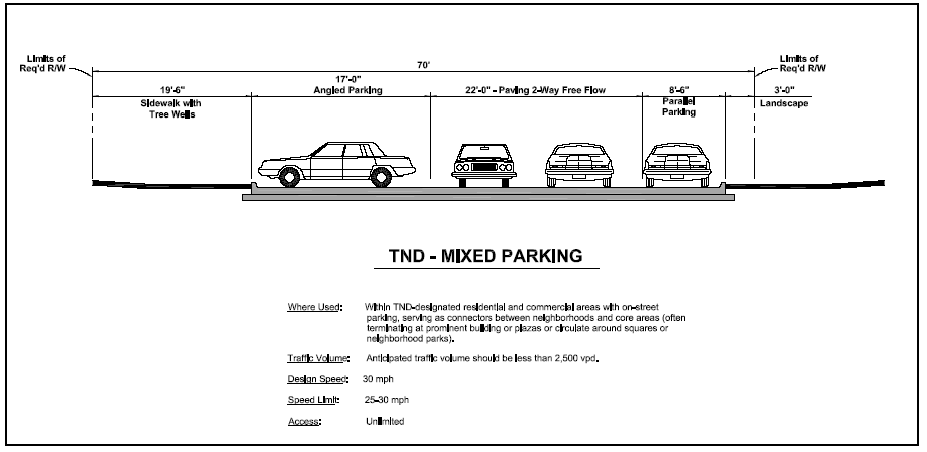
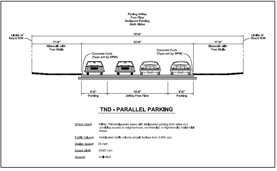
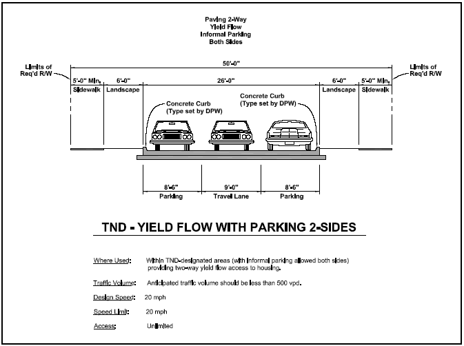
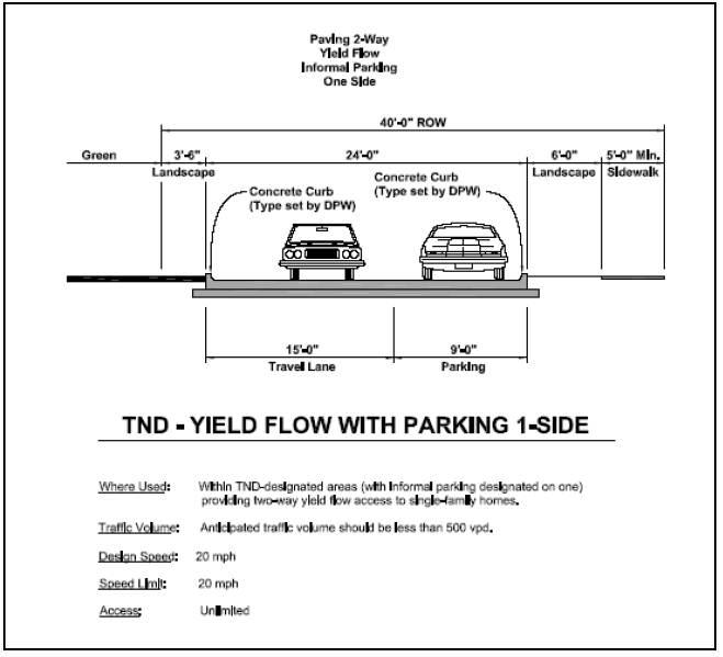
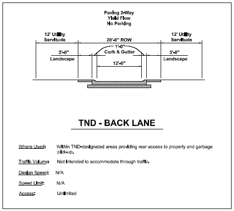
Notwithstanding the reference to a 12-foot utility servitude on the illustration above, the TND-back lane shall only be required to have a five-foot utility servitude on either side of the lane.
(Ord. No. 1-2016, § 1, 4-13-2016)
Section 5.26. - District definitions.
The following definitions shall be observed and applied for purposes of article 5, traditional neighborhood development, except when the context clearly indicates otherwise. Words used in the present tense shall include the future tense. Words used in the singular form shall include the plural form. Words used in the plural form shall include the singular. The word "shall" is mandatory and the word "may" is permissive.
Accessory building. A detached subordinate structure, the use of which is incidental to that of the principal structure and located on the same lot.
Alley. A public or private way permanently reserved as a secondary means of access to abutting property.
Application. An application filed by the developer for TND zoning.
Association. The homeowner's association of the TND district.
Block. A unit of land bounded by streets or by a combination of streets and public land, railroad rights-of-way, waterways, or any other barrier to the continuity of development.
Boulevard. A major street for carrying a large volume of through traffic in the area normally controlled by traffic signs and signals with relatively few intersections and/or drives.
Building height. The limit to the vertical extent of a building. The building height may be prescribed as a maximum number of stories or as a dimension from sidewalk grade to the eave. The height limit shall not apply to attics, raised basements, chimneys, machine rooms, or similar structures.
Building scale. The relationship between the mass of a building and its surroundings, including the width of street, open space, and mass of surrounding buildings. Mass is determined by the three-dimensional bulk of a structure: height, width, and depth.
Building setback, front. The distance from the street right-of-way line to the closest point of the foundation of a building or projection thereof.
City. City of Port Allen, Louisiana.
City council. The Port Allen City Council.
Collector. A street designed to carry moderate volumes of traffic from local streets to boulevard streets or from boulevard to boulevard. Collectors are also referred to as avenues.
Curb radius. The curved edge of streets at an intersection measured at the outer edge of the street curb or of the parking lane.
Lot. A parcel of land occupied or intended for occupancy by a use permitted in this section, including one main building, together with any accessory buildings, open spaces, and parking spaces required by this section and having its principal frontage upon a street or upon an officially approved place.
Lot line. The property lines bounding the lot.
Lot width. The horizontal distance between side lot lines measured at the front setback.
Mayor. The mayor of the city.
Net acre. An acre of land excluding street rights-of-way and other publicly dedicated improvements such as parks, open space, and stormwater detention and retention facilities.
Planning commission. The city's planning commission.
Planning director. The chief administrator of the city or other person designated by the city to coordinate and oversee planning-related activities or designated as the planning director for the purpose of this section.
Principal building. A building in which the primary use of the lot on which the building is located is conducted.
Queuing. The use of one travel lane on local streets with parking, usually an intermittent parking pattern, on both sides.
Secondary dwelling unit. An additional dwelling unit located within the principal dwelling on the lot, in a freestanding building or above a residential garage.
Story. A space in a building between the surface of any floor and the surface of the next floor above, or if there is no such floor above, then the space between such floor and the ceiling or roof above.
Street. A strip of land, including the entire right-of-way, publicly or privately owned, serving as a means of slow vehicular travel, and furnishing access to abutting properties, which may also be used to provide space for sewers, public utilities, shade trees, and sidewalks.
Traditional neighborhood. A compact, walkable, mixed-use neighborhood where residential, commercial and civic buildings are within close proximity to each other.
Zoning map. A map provided as a component of the general implementation plan which sets forth the permitted land uses for each of the areas within the TND district. In addition to or in lieu of a specific listing of permitted uses, the applicant may refer to other existing zoning districts designations for the description of permitted uses within such zoning districts for any one or more of the areas within the TND district.
(Ord. No. 1-2016, § 1, 4-13-2016)