
Providence City Zoning Code
CHAPTER 10
8 AREA REGULATIONS AND PARKING REQUIREMENTS
10-8-1 Area Regulations
Except as herein provided, no building, structure or part thereof shall be erected, altered or converted for any use permitted in the district in which it is located unless it is in conformance with all of the minimum regulations specified on the space requirement chart show below.
SPACE REQUIREMENT CHART
| AGR | R-1-1 | R-1-20 | R-1-12 | R-1-10 | R-1-8 | R-1-6 | MHD | |
| Min. lot area, square feet | 5 ac | 1 ac | 20,500 | 12,000 | 10,000 | 8,000 | 6,000 | 5,000 |
| Min. lot width (measured at setback line) | 150 | 120 | 100 | 95 | 80 | 70 | 60 | 50 |
| Min. lot area increase ea. add'l. unit, square feet | See PCC chapter 10-13 | |||||||
| Max. units/ac excluding ROW, infrastructure^ | 0.2 | 1 | 2.13 | 3.75 | 4.5 | 5.5 | 5.5 | 8.5 |
| Min. lot area per ea. twin home, square feet^^ | 6,000 | 6,000 | ||||||
| Min. lot width, each unit (measured at setback line) | 47.5 ft. | 47.5 ft. | ||||||
| Setbacks | ||||||||
| Principal Structure | ||||||||
| Front yard, ft. | 20 | 20 | 20 | 20 | 20 | 20 | 20 | 20 |
| Side yard, interior | 10 | 10 | 10 | 10 | 10* | 10 | 7.5 | 7.5 |
| Side yard, street | 20 | 20 | 20 | 20 | 20 | 20 | 15 | 15 |
| Rear yard | 15 | 15 | 15 | 15 | 15 | 15 | 15 | 10 |
| Detached Accessory Dwelling Unit (ADU) | ||||||||
| Front yard, ft | 20 | 20 | 20 | 20 | 20 | 20 | 20 | 20 |
| Side yard, interior | 10 | 10 | 10 | 10 | 10 | 10 | 10 | 7.5 |
| Side yard, Street | 20 | 20 | 20 | 20 | 20 | 20 | 20 | 15 |
| Rear yard | 15 | 15 | 15 | 15 | 15 | 15 | 15 | 15 |
Detached Accessory Buildings and Detached Accessory Structures | ||||||||
| Front yard, ft. | 25 | 30 | 30 | 30 | 30 | 25 | 25 | 20 |
| Side yard, interior | 10 | 5**** | 5**** | 5**** | 5**** | 5**** | 5**** | 5**** |
| Side yard, street | 20 | 20 | 20 | 20 | 20 | 20 | 20 | 20 |
| Rear yard | 10 | 5 | 5 | 5 | 5 | 5 | 5 | 5 |
| Detached Accessory Building (Small) | ||||||||
| Front yard, ft. | 25 | 30 | 30 | 30 | 30 | 25 | 25 | 20 |
| Side yard, interior | Must be placed in such a manner that runoff from the roof does not spill onto adjacent property. | |||||||
| Side yard, street | 20 | 20 | 20 | 20 | 20 | 20 | 20 | 20 |
| Rear yard | Must be placed in such a manner that runoff from the roof does not spill onto adjacent property. | |||||||
| Distance between residential structures on same lot | 15 | 15 | 15 | 15 | 15 | 15 | 15 | 10 |
| Height | ||||||||
| Principal use, max. hgt. ft. | 35 | 35 | 35 | 35 | 35 | 35 | 35 | 35 |
| Accessory Dwelling Unit (ADU) ft. max | #### | #### | #### | #### | #### | #### | #### | #### |
| Accessory use, ft. max. | 35 | 35 | 35 | 35 | 35 | 35 | 35 | 35 |
| Principal use, ft. min. | 10 | 10 | 10 | 10 | 10 | 10 | 10 | 10 |
| Accessory bldg. (small) ft. max | 15 | 15 | 15 | 15 | 15 | 15 | 15 | 15 |
| Accessory Dwelling Unit (ADU) ft. min. | 10 | 10 | 10 | 10 | 10 | 10 | 10 | 10 |
| Fences – nongame (max. height) | ||||||||
| (All fences are subject to PCC 10-9-2) | ||||||||
| Front yard, ft. | 4 | 4 | 4 | 4 | 4 | 4 | 4 | 4 |
| Side yard, interior | 8 | 6 | 6 | 6 | 6 | 6 | 6 | 8 |
| Side yard, street | 6^^^ | 6^^^ | 6^^^ | 6^^^ | 6^^^ | 6^^^ | 6^^^ | 6^^^ |
| Rear yard | 8 | 6 | 6 | 6 | 6 | 6 | 6 | 8 |
| Fences – game | ||||||||
| (All fences are subject to PCC 10-9-2) | ||||||||
| Front yard, ft. | Not allowed | Not allowed | Not allowed | Not allowed | Not allowed | Not allowed | Not allowed | Not allowed |
| Side yard, interior | 8 | 8 | 8 | 8 | 8 | 8 | 8 | 8 |
| Side yard, street | 8^^^ | 8^^^ | 8^^^ | 8^^^ | 8^^^ | 8^^^ | 8^^^ | 8^^^ |
| Rear yard | 8 | 8 | 8 | 8 | 8 | 8 | 8 | 8 |
*See PCC 10-4-4.D.3&4
**See PCC 10-8-3 C.4, 5, & 8 for further regulation and explanation.
***See PCC 10-8-3D.6 for further regulation and explanation.
****See PCC 10-8-3.C.6 for further regulation and explanation.
#See PCC 10-8-3C.3 for further regulation and explanation.
##See PCC 10-8-3D.2, D.3, D.4 for further regulation and explanation.
###See PCC 10-8-3C.10 for further regulation and explanation.
####See PCC 10-8-4.A. For further regulations and explanation.
^Infrastructure is defined to include rights-of-way, PUB and REC districts within development.
| R-M-7 | R-M-12 | R-M-18 | CGD | CHD | MXD | PUB | REC |
Min. lot area, square feet (single-family detached unit) | 10,000 |
|
|
|
|
|
|
|
Min. lot width (measured at setback line) | 80 |
|
|
|
|
|
|
|
Min. lot area increase ea. add't unit, square feet |
|
|
|
|
|
|
|
|
Max. units/ac excluding ROW, infrastructure^ | 7.25 | 12 | 18 |
|
| * |
|
|
Max. lot area per ea. twin home, square feet^^ | 5,000 |
|
|
|
|
|
|
|
Min. lot width, each unit (measured at setback line) | 40.0' |
|
|
|
|
|
|
|
| ||||||||
Setbacks |
|
|
|
|
|
|
|
|
Principal Structure |
|
|
|
|
|
|
|
|
Front yard, ft. | 25 | 25 | 25 | 35 | 35 | 25 |
|
|
Side yard, interior | 10** | 10** | 10** | # | # | ### | # | # |
Side yard, street | 20** | 20** | 20** | # | # | ### | # | # |
Rear yard | 20*** | 10*** | 10*** | # | # |
| ## | ## |
| ||||||||
Detached Accessory Buildings and Detached Accessory Structures |
|
|
|
|
|
|
|
|
Front yard, ft. | 25 | 25 | 25 | 35 | 35 | 35 |
|
|
Side yard, interior | 5 | 5 | 10 | 10 | 10 | 10 | # | # |
Side yard, street | 20 | 20 | 25 | 10 | 10 | 10 | # | # |
Rear yard | 5 | 5 | 5 | 10 | 10 | 10 | ## | ## |
| ||||||||
Detached Building Accessory (Small) | ** | ** | ** |
|
| ** |
|
|
Front yard, ft | 25 | 25 | 25 | 35 | 35 | 35 |
|
|
Side yard, interior | Must be placed in such a manner that runoff from the roof does not spill onto adjacent property. | |||||||
Side yard, street | 20 | 20 | 20 | 20 | 20 | 20 |
|
|
Rear yard | Must be placed in such a manner that runoff from the roof does not spill onto adjacent property. | |||||||
| ||||||||
Distance between residential structures on same lot | ** | ** | ** |
|
| ** |
|
|
| ||||||||
Height |
|
|
|
|
|
|
|
|
Principal use, max, hgt. ft. | 45 | 50 | 50 | 50 | 50 | 45 | 50 | 50 |
Accessory use, ft. max | 35 | 35 | 35 | 50 | 50 | 45 | 50 | 50 |
Accessory bldg (Small) ft. max | 15 | 15 | 15 | 15 | 15 | 15 | 15 | 15 |
Principal use, ft. min. | 10 | 10 | 10 | 10 | 10 | 10 | 10 | 10 |
| ||||||||
Fences (max. height) |
|
|
|
|
|
|
|
|
Front yard, ft. | 6^^^ | 6^^^ | 6^^^ | C^^^ | C^^^ | 6^^^ | 8^^^ | 8^^^ |
Side yard, interior | 8^^^ | 8^^^ | 8^^^ | 8^^^ | 8^^^ | 8^^^ | 8^^^ | 8^^^ |
Side yard, street | 8** | 8** | 8** | C^^^ | C^^^ | 8^^^ | 8^^^ | 8^^^ |
Rear yard | 8*** | 8*** | 8*** | 8 | 8 | 8 | 8 | 8 |
*See PCC 10-4-4.D.3&4
**See PCC 10-8-3C.4, 5 & 8 for further regulation and explanation.
***See PCC 10-8-3D.6 for further regulation and explanation.
****See PCC 10-8-3.C.6 for further regulation and explanation
#See PCC 10-8-3C.3 for further regulation and explanation.
##See PCC 10-8-3D.2, D.3, D.4 for further regulation and explanation.
###See PCC 10-8-3C.10 for further regulation and explanation.
^Infrastructure is defined to include rights-of-way, PUB and REC districts within development.
^^Lots of record for twin homes are limited to 20 percent of total lots in development.
^^^See PCC 10-9-2.
(Code 1998, § 10-8-1; Ord. No. 033-2004, 11-23-2004; Ord. No. 004-2005, 1-18-2005; Ord. No. 011-2009, 12-8-2009; Ord. No. 007-2010, 8-10-2010; Ord. No. 006-2011, 7-26-2011; Ord. No. 014-2012, 9-25-2012; Ord. No. 015-2013, 11-7-2013; Ord. No. 005-2014, 9-23-2014; Ord. No. 2015-015, 6-9-2015; Ord. No. 2015-016, 7-14-2015; Ord. No. 023-2016, 10-11-2016; Ord. No. 2018-004, 4-24-2018; Ord. No. 2018-011, 10-23-2018; Ord. No. 2020-003, 2-19-2020)
Adopted by Ord. 06-2022 on 9/21/2022
Amended by Ord. 11-2024 ADUs IADUs on 5/28/2024
10-8-2 Lot Size
- Lot areas, flexibility exception.
- The individual lot size must meet the minimum square footage requirements as indicated in the space requirement chart, as set forth in PCC 10-8-1. The following exception applies in a subdivision of six lots or more in R-1-1, R-1-20 and R-1-12 Zones.
- Purpose. To provide a means for desirable development, utilizing public facility space and open space, through the use of variations in lot size and frontage width. This is not intended to increase density.
- The average of all lots must be equal to or greater than the minimum lot size for the zone, excluding nonresidential uses such as schools, churches, etc.
- The number of lots cannot exceed the maximum units for the zone.
- A limit of ten percent of the lots can be less than the minimum lot size and/or reduced frontage width, but no lot can be less than 12,000 square feet in the subdivision and the frontage requirement at the setback line must be a minimum of 80 feet.
- In areas that contain sensitive areas and hazard zoned (see PCC chapter 10-5) 30 percent of the lots can be less than the minimum lot size and/or reduced frontage width, but no lot can be less than 12,000 square feet in the subdivision and the frontage requirement at the setback line must be a minimum of 80 feet.
- Lots having less area than required, which were officially recorded with the county recorder's office at the effective date of the ordinance from which this chapter is derived, may continue to be used, provided that all other requirements set forth herein are satisfied. No lot may hereafter be reduced in area below the minimum requirements set forth, except for the provisions of averaging listed in subsection A.1 of this section.
- A twin home lot size must meet the minimum square footage requirements as indicated in the space requirement chart, as set forth in this chapter, with the following exceptions:
- Lot size average may be used as listed in subsection A.1 of this section.
- Two adjacent lots with combined area meeting the minimum lot area shown in PCC 10-8-1 plus the minimum lot area for one additional unit may be used to build a single-family attached dwelling on each lot. The dwellings area joined at the boundary between the two lots. This applies to zones where single-family attached dwellings are permitted.
- The individual lot size must meet the minimum square footage requirements as indicated in the space requirement chart, as set forth in PCC 10-8-1. The following exception applies in a subdivision of six lots or more in R-1-1, R-1-20 and R-1-12 Zones.
- Lot width. The minimum lot width for uses in each of the zoning districts shall be in accordance with the information indicated on the space requirement chart shown in PCC 10-8-1. A lot having less width than herein required which was a lot officially on record in the office of the county recorder at the effective date of the ordinance from which this chapter is derived shall be acceptable, provided that all other requirements set forth herein are satisfied. No lot may hereafter be reduced in width below the minimum requirements set forth.
- Where an allowed side yard setback of a dwelling occurs five feet from the property line, the adjacent dwelling shall maintain a minimum side yard of ten feet, for a cumulative total dwelling separation of 15 feet. Each residential lot allowing five-foot side yard setback shall be required to have one side yard setback of ten feet.
- Restricted lots.
- A restricted lot which meets all the requirements of this title for a lot, but the creation of which has caused any adjacent lot, from which it was severed, to be insufficient in area, width, setback, yard, space or other requirements may be considered otherwise by adding or designating sufficient acreage to the adjacent lot to meet all the requirements of this title for a lot. The added or designated land must be duly recorded in the county recorder's office before a building permit may be issued.
- Building permits will not be issued for construction on restricted lots.
(Code 1998, § 10-8-2; Zon. Ord., 5-8-1991; Ord. No. 98-021, 10-13-1998; Ord. No. OM 011-99, 4-13-1999; Ord. No. 033-2004, 11-23-2004; Ord. No. 004-2005, 1-18-2005; Ord. No. 011-2009, 12-8-2009; Ord. No. 007-2010, 8-10-2010; Ord. No. 006-2011, 7-26-2011; Ord. No. 014-2012, 9-25-2012; Ord. No. 015-2013, 11-7-2013; Ord. No. 005-2014, 9-23-2014; Ord. No. 2015-015, 6-9-2015; Ord. No. 2015-016, 7-14-2015; Ord. No. 023-2016, 10-11-2016; Ord. No. 2018-004, 4-24-2018; Ord. No. 2018-011, 10-23-2018; Ord. No. 2020-003, 2-19-2020)
Adopted by Ord. 06-2022 on 9/21/2022
10-8-3 Setbacks
Required setbacks describe areas on lots where no buildings, structures, or additions to them may be located, and which thereby become yard areas. Setbacks may be required between buildings, structures and property lines; between structures and road easements; between buildings and structures themselves; between buildings, structures and natural features such as watercourses; or between other features of site development. The setback requirements of this title are listed for each zone district in the space requirements chart found in PCC 10-8-1.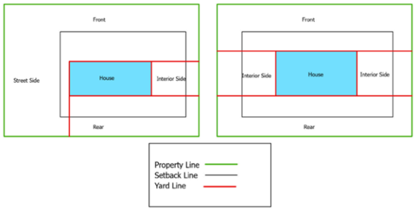
- General setback requirements.
- Subdivision setbacks. Where a setback line is called for or shown on a recorded subdivision plat or on a recorded development plan, the required setback shall be the setback line shown on the subdivision plat or development plan.
- Setbacks adjacent to alley. See PCC 10-4-6F.3.
- Use of setbacks. Every part of a setback shall be unobstructed from the ground to the sky, except as otherwise provided in this title; and except for the ordinary projections of sills, buttresses, cornices, chimneys, eaves, and window wells; but in no case shall such projections exceed the distance restrictions for each yard type. In all cases, if a public utility easement (PUE) is included in the setback, projections cannot extend into the PUE.
- Projections into rights-of-way. In any area where a building can be legally constructed on or closely adjacent to the right-of-way line of a public street, eaves and roof overhangs, sills, belt courses, fire escapes, balconies, and unroofed and unenclosed porches my project into a street right-of-way not more than 30 inches, provided that all such encroachments shall be at least eight feet above any area used by pedestrians, and at least 14 feet above any area used for vehicular traffic; and provided further, an encroachment permit for such projections is obtained from the city engineer.
- Porches, stoops, stairs that are 30 inches in height or greater. A porch, stoop or stairs which are 30 inches or greater in height shall be regarded as part of the building. Such porch, stoop or stairs require a railing of not less than 30 inches in height. This requirement applies to front, side, and rear yards.
- Exception. A landing, as defined in UCA 10-9a-504, or walkout porch that is no more than 32 square feet in size; and is used for ingress and egress from the rear of the residential dwelling, may extend into the rear setback.
- The above exception does not apply to a historic structure.
- Exception. A landing, as defined in UCA 10-9a-504, or walkout porch that is no more than 32 square feet in size; and is used for ingress and egress from the rear of the residential dwelling, may extend into the rear setback.
- Window wells.
- Window wells, as defined in UCA 10-9a-504 may encroach into the required rear yard and may encroach up to a maximum of two feet into a required side yard.
- The maximum amount of all window wells located along any wall may not exceed 40 percent of the length of that wall.
- When more than one window well is installed along a wall, each shall be separated at least three feet from one another.
- Window wells used for egress shall comply with the provisions of the building code for an emergency escape window.
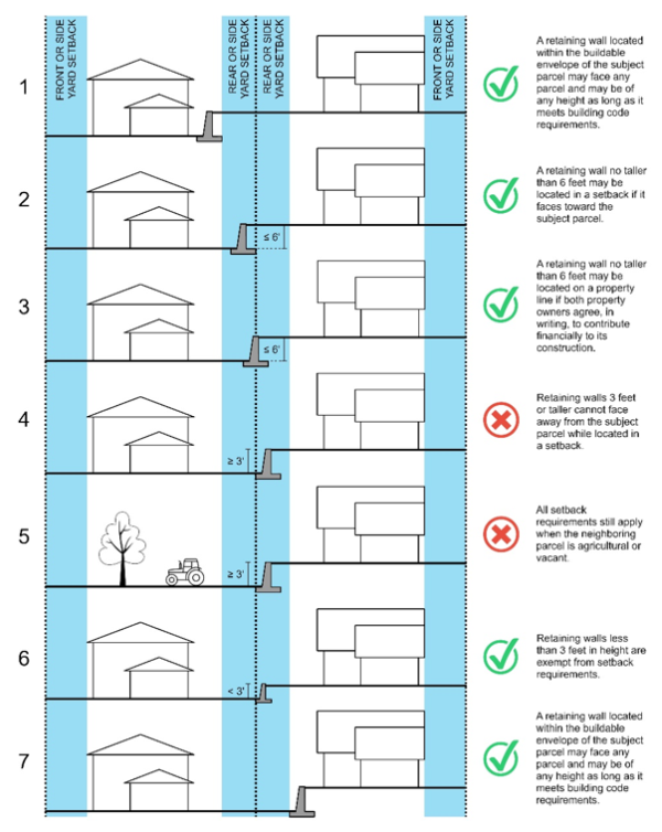
- Retaining walls.
- Less than three feet (3') in height. Retaining walls less than three feet (3') in height are exempt from setback requirements. See Illustration 6.
- Three feet (3') to six feet (6') in height. Retaining walls from three feet (3') to six feet (6') in height may be located within a required non-street side or rear setback area in residential zones and any setback area in nonresidential zones provided the exposed side of the wall faces into the subject parcel. See Illustrations 2, 4, 5. Proposed graphic.
- Greater than six feet )6') in height. Rear and non-street side setbacks for retaining walls greater that six feet (6') in height, or where the exposed side of the wall faces out from the subject parcel, is three feet in height or greater, shall be subject to the same requirements as the main structure in the applicable zoning district. See Illustrations 7.
- See Chapter 5-4 Fence Regulations of this code for additional retaining wall requirements.
- Walls in the graphic are shown on the applicant's property.
- Elements that are placed directly upon the finish grade.
- Elements that are placed directly upon the finish grade that do not exceed 30 inches in height at any point above the surrounding finish grade in front and street side setbacks areas are exempt as follows:
- Driveways, walks, and steps. The driveway shall be limited to the area necessary to provide safe and efficient ingress and egress from the required off-street parking spaces located behind a setback area.
- Decks, patios, and terraces. See subsection D.5 of this section.
- One flagpole that does not exceed 15 feet in height and is set at least five feet from the property line.
- Lamp posts adjacent to walkways, stairways, and driveways that do not exceed six feet in height.
- Landscape accent lighting that does not exceed 18 inches in height.
- Public utility vaults, including footings, if completely underground. Any mechanical or electrical equipment shall be subject to the setback requirements.
- Elements that are placed directly upon the finish grade that do not exceed 30 inches in height at any point above the surrounding finish grade in front and street side setbacks areas are exempt as follows:
- Front yard.
- The front yard shall be measured from the property line to the front face of the building, attached accessory building, accessory building, covered porch or covered terrace. Steps, uncovered porches, eaves and roof extensions may project into the required front yard for a distance not to exceed four feet; and placed so as to not obstruct light or ventilation of building or ready use of the yards for ingress or egress, and where allowed by the building code.
- For existing homes, that do not meet the building code for entry landings:
- A covered, unenclosed, entry may extend further than four feet into the required front yard; but shall not extend further than the minimum to meet the requirements in the building code for entry landings.
- Ramps that are added to allow for ADA access may extend into the required front yard; but shall not extend further than the minimum to meet the grade and landing requirements for ADA access.
- A site plan shall be submitted for zoning approval.
- For existing homes, that do not meet the building code for entry landings:
- Gasoline service station pump islands may not be located closer than 50 feet to the front property line.
- The front yard shall be measured from the property line to the front face of the building, attached accessory building, accessory building, covered porch or covered terrace. Steps, uncovered porches, eaves and roof extensions may project into the required front yard for a distance not to exceed four feet; and placed so as to not obstruct light or ventilation of building or ready use of the yards for ingress or egress, and where allowed by the building code.
- Side yard.
- Every part of the required side yard shall be open and unobstructed, except for normal projections of landings and steps, windowsills, belt courses, cornices, chimneys and other architectural features projecting no more than 36 inches into the required side yard, roof eaves projecting no more than 36 inches into the required side yard and accessory buildings occupying no more space of any principal use side yard than that permitted in PCC 10-9-6.
- Where a fire wall of a dwelling, garage or carport is located on a property line, the roof shall be so designed and constructed so as not to drain water onto the adjoining lot and except for properties located in the Mixed-Use District abutting other properties also located in the Mixed-Use District, there shall be one side yard of at least 20 feet.
- Whenever any use or district not normally requiring a side yard adjoins a use or district requiring a side yard, a minimum ten-foot side yard shall be maintained. Nonresidential uses which have a side lot line adjacent or contiguous to another nonresidential use requires no minimum side yard, provided the side wall satisfies fire wall standards. Nonresidential uses which have a side lot line adjacent to an alley or other public right of way that is at least 20 feet in width requires a minimum 10-foot side yard.
- A single-family attached dwelling unit separated by a fire or party wall need not provide a side yard on the fire or party wall side, except that no complex of attached dwelling units shall exceed 300 feet in length. A minimum side yard of ten feet on the separated side of any attached dwelling unit shall be required so that the end of any two building complexes shall be at least 20 feet apart.
- A complex of multiple-family dwelling units shall maintain a minimum side yard of ten feet so that any two adjacent complexes shall be at least 20 feet apart and maintain an open corridor for fire and other emergency vehicle access.
- In residential districts, accessory buildings shall maintain a minimum side yard equal to 25 percent of the building height or a minimum of five feet to the side property line if adjacent to a separate lot of record, nor less than 20 feet if adjacent to a public street or road, whichever is greater.
- Gasoline service station pump islands shall be located no closer than 20 feet from the side yard line if adjacent to a separate lot of record, nor less than 50 feet if adjacent to a public street or road.
- Residential structures exceeding 45 feet in height as determined in PCC 10-8-4B shall maintain a minimum side yard of equal to 50 percent of the building height.
- Where an allowed side yard setback of a dwelling occurs five feet from the property line, the adjacent dwelling shall maintain a minimum side yard of ten feet, for a cumulative total dwelling separation of 15 feet. Each residential lot allowing five-foot side yard setback shall be required to have one side yard setback of ten feet.
- Property in a Mixed-Use District may have lots which contain no side yards when the buildings on the adjoining lots utilize shared party walls. If the adjoining properties do not share party walls than a minimum of 30 feet is required between adjoining buildings (15-foot side yard on each property). In the Mixed-Use District a 30-foot alley is required a minimum of every 500 feet for access to parking located behind the buildings.
- Rear yard.
- Nonresidential uses which have a rear lot line adjacent to an alley or other public right-of-way that is at least 20 feet in width requires no minimum rear yard.
- Nonresidential uses which have a rear lot line adjacent or contiguous to another nonresidential use requires no minimum rear yard, provided the rear wall satisfies fire wall standards.
- Nonresidential uses abutting or adjacent to a residential district shall maintain a minimum rear yard of 20 feet.
- Normal projections of windowsills, belt courses, cornices, chimneys and may project no more than 24 inches into the required rear yard and roof eaves projecting no more than 36 inches into the required rear yard.
- A deck is considered as an exterior floor system supported on at least two opposing sides by adjoining structures and/or posts, piers or other independent supports.
- A deck which is less than 120 square feet and less than 30 inches above adjacent grade, and independently supported, will not require a building permit and is not considered part of the main structure.
- An attached, covered deck is considered part of the main dwelling and required to meet the associated setbacks.
- A portion of an attached uncovered deck may project into the required rear yard no more than one-half of the distance of the required rear yard (i.e., required rear yard is 20 feet, the deck can project no more than ten feet into the required yard); and the projection may take up no more than 50 percent the required rear yard. The projection of the deck is included in the overall 25 percent limitation in PCC 10-9-6.
- Detached decks (designed and constructed having no physical connection to the primary structure) are considered an accessory use; and must be a minimum of five feet from the primary structure.
- No portion of any deck is permitted to be located within an easement or within five feet of a property line.
- Structures containing four-family dwelling units or more shall maintain a minimum rear yard equal to 50 percent of the building height, but in no case less than 20 feet.
- Double frontage, interior, and odd-shaped lots.
- Double frontage lots. Rather than a front and rear yard, there shall be two front yard setbacks for the purpose of computing setbacks.
- Interior lots. The setback requirements for the applicable zone district shall apply. The setback shall be measured from the property lines of the interior lot for the respective yards. If the access to the property is included in the property (not an easement through adjacent property), the access property lines are not considered for setback determination.
- Odd-shaped lots. In the case of odd-shaped lots, the administrative land use authority (ALUA) shall determine the required setbacks, which widths and depths shall approximate as closely as possible the required widths and depths of corresponding setbacks on rectangular lots in the applicable zone district. In determining the required setbacks for odd-shaped lots, the ALUA shall consider the following:
- The setback will not be detrimental to the health, safety, comfort, convenience, and general welfare of the neighborhood and will not be incompatible with the surrounding areas.
- The setback conforms with other applicable provisions of this title.
- The setback will not conflict with any easements required for public access through, or the public use of, a portion of the property.
(Code 1998, § 10-8-3; Zon. Ord., 5-8-1991; Ord. No. 98-021, 10-13-1998; Ord. No. 011-99, 4-13-1999; Ord. No. 033-2004, 11-23-2004; Ord. No. 004-2005, 1-18-2005; Ord. No. 011-2009, 12-8-2009; Ord. No. 007-2010, 8-10-2010; Ord. No. 006-2011, 7-26-2011; Ord. No. 014-2012, 9-25-2012; Ord. No. 015-2013, 11-7-2013; Ord. No. 005-2014, 9-23-2014; Ord. No. 2015-015, 6-9-2015; Ord. No. 2015-016, 7-14-2015; Ord. No. 2015-020, 11-17-2015; Ord. No. 023-2016, 10-11-2016; Ord. No. 2018-004, 4-24-2018; Ord. No. 2018-011, 10-23-2018; Ord. No. 2020-003, 2-19-2020)
Adopted by Ord. 06-2022 on 9/21/2022
Adopted by Ord. 06-2024 Retaining Walls on 4/1/2024
Amended by Ord. 11-2024 ADUs IADUs on 5/28/2024
Amended by Ord. 19-2024 Ordin. on 10/21/2024
10-8-4 Height
- Established. The maximum and minimum heights for principal (or main) structures and the maximum height for accessory structures in each of the zoning districts shall be in accordance with information provided on the space requirement chart shown in PCC 10-8-1. There shall be no minimum height required of accessory structures. Where a lawfully existing building at the effective date of the ordinance from which this chapter is derived has a greater or lesser height than allowed herein, said height may be altered if said alteration in no way increases the degree of nonconformity, and provided all other requirements are satisfied.
- The maximum height of an accessory dwelling unit (ADU) may not exceed the height of the existing primary residential structure.
- The maximum height of an accessory dwelling unit (ADU) may not exceed the height of the existing primary residential structure.
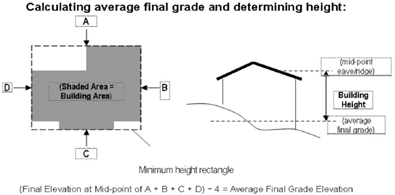
- Determination. The height of a building or structure shall be determined as the vertical distance as measured from the highest point of the roof of the building or structure down to a point representative of the average finished grade of the land around the perimeter of the building or structure. Graphic added.
(Code 1998, § 10-8-4; Zon. Ord., 5-8-1991; Ord. No. 033-2004, 11-23-2004; Ord. No. 004-2005, 1-18-2005; Ord. No. 011-2009, 12-8-2009; Ord. No. 007-2010, 8-10-2010; Ord. No. 006-2011, 7-26-2011; Ord. No. 014-2012, 9-25-2012; Ord. No. 015-2013, 11-7-2013; Ord. No. 005-2014, 9-23-2014; Ord. No. 2015-015, 6-9-2015; Ord. No. 2015-016, 7-14-2015; Ord. No. 023-2016, 10-11-2016; Ord. No. 2018-004, 4-24-2018; Ord. No. 2018-011, 10-23-2018; Ord. No. 2020-003, 2-19-2020)
Adopted by Ord. 06-2022 on 9/21/2022
Amended by Ord. 11-2024 ADUs IADUs on 5/28/2024
10-8-5 Commercial Zoned Districts; Site Development
All site development and landscaping in the commercial zoned districts shall conform to the minimum regulations specified herein.
- Site plan required. A site plan is an architectural plan, landscape architecture document, and a detailed engineering drawing of proposed improvements to a given lot. A site plan shows a building footprint, travelways, parking, drainage facilities, sanitary sewer lines, water lines, trails, lighting, and landscaping and garden elements. Commercial site plans must include:
- Show north arrow, scale, building location, property lines, setbacks, abutting rights-of-way, parking layout, ADA parking and ramps, entrances to site, curbs, water and sewer lines, fire hydrants, fire lanes, storm drain lines and appurtenances.
- Show all existing fire hydrants within 300 feet.
- Show parking/loading computations for proposed use.
- Show connectivity with adjacent parking lots and interior private roadways.
- Show landscaping computations for proposed use.
- Provide elevations with rendered elevations for all elevations; include color renderings of design concept or intent, site elements, and building facades.
- Provide floor plans; include the proposed low floor elevation.
- Provide cross sections of the site showing spatial relationships between all vertical elements (building, trees, berms, light standards, etc.) as they relate to activities and use of streetscape, pedestrian, and parking areas.
- Provide lighting and signage plan for the entire site; indicate how signs will be illuminated, their design and spatial relationship to other site amenities, including buildings, and a graphic example of each type of sign. This does not take the place of a sign permit application.
- Provide stormwater pollution prevention plan if the site disturbs an acre or more, or is part of a larger development.
- Provide cost estimates for site development, including, but not limited to, landscaping, parking/loading areas, pedestrian areas.
- Summary data indicating the area of the site in the following classification: total area of the lot, total area and percentage of the site utilized by buildings, total area and percentage of the site in landscape area, total area and percentage of the site for parking areas (including the number of parking spaces).
- Parking/parking lots. Private parking lots within any development shall provide interior access to adjacent parking lots and interior private roadways. When new developments are being constructed adjacent to existing businesses the project shall join existing drives and parking lots at property lines. When new developments are proposed adjacent to undeveloped land or underdeveloped areas, the new developments shall construct connections which will allow joining of future roads or parking lots. All accesses between interior lots and roads shall be open to the public for customer parking and access.
- Visitor, guest or customer drop-off zones and parking shall be provided near visitor or customer entrances into buildings and shall be separated from all-day employee parking.
- Parking will not be permitted closer than 15 feet to the property line unless it is decided by the land use authority to be in the best interest of the city to permit parking to be closer than 15 feet. A business that locates the parking in the rear of the building rather than the front will be allowed a front yard setback of 15 feet. The standard front yard setback will be used when a business locates the parking in the front of the building. When parking is allowed on the street adjacent to the building the standard front yard setback applies.
- Parking aisles shall not exceed 40 cars in a row. Total parking area shall be broken down into sections not to exceed 100 cars. Each section shall be separated by internal drives to improve traffic circulation.
- All parking spaces must be designated properly by painter lines or other city-approved methods.
- Minimum aisle dimensions (from face of curb to face of curb) shall be:
90-degree parking 64 feet 60-degree parking 60 feet 45-degree parking 53 feet - One access shall be allowed per lot, as exists on the effective date of the ordinance from which this chapter is derived, or one access shall be allowed for each 150 feet of frontage with a maximum of two accesses per street frontage. Minimum distance between accesses shall be 100 feet and the minimum distance from the street intersection shall be 100 feet, except for service stations which are approved conditional uses where only two accesses are allowed per lot with one frontage. A third access shall be allowed for the other street frontage on corner lots as long as it meets the frontage and distance requirements above.
- Handicap parking. All private, public and city parking lots shall provide accessible handicap parking. Minimum design, sign and identification of handicap parking spaces shall be as specified in the state building board planning and design criteria to prevent architectural barriers for the aged and physically handicapped.
- Landscaping. All landscaped area shall be planted with live plant material and include a permanent automatic irrigation system. The owner, tenant and agent shall be jointly and individually responsible for the maintenance of all landscaping in good condition and free from refuse and debris so as to present a healthy, neat and orderly appearance. The landscaped public area between the curb, gutter, and sidewalk is not used to meet the landscape requirements. See PCC 7-1-8 for park strip requirements.
- Design initiatives.
- To establish landscape themes that include street trees and streetscape designs throughout the city to promote and overall character and identity to the community.
- Promote innovative and cost-conscious approaches to the design, installation, and maintenance of landscaping while encouraging water and energy conservation.
- Promote planting techniques that ensure long-term health of plant materials.
- Screen unsightly building structures, equipment or materials from the view of persons on public streets or adjoining properties of incompatible land uses.
- Large retail buildings (15,000 square feet and larger) shall require at least ten percent of the total lot be landscaped.
- Retail buildings (detached, less than 15,000 square feet) shall require at least ten percent of the total lot be landscaped.
- A ten-foot-wide minimum landscaped area shall be provided around the entire building, with the exception of where loading docks, ramps, etc., are located. Up to five feet of said ten-foot minimum may be sidewalk. The administrative land use authority may provide for an exception to this requirement if soil types make it inadvisable to have irrigation near the building. In such case, the required amount of landscaping shall be provided elsewhere on the property.
- Professional/office buildings shall require at least 15 percent of the total lot be landscaped.
- A ten-foot-wide minimum landscaped area shall be provided around the entire building, with the exception of where loading docks, ramps, etc., are located. Up to five feet of said ten-foot minimum may be sidewalk. The administrative land use authority may provide for an exception to this requirement if soil types make it inadvisable to have irrigation near the building. In such case, the required amount of landscaping shall be provided elsewhere on the property.
- Industrial/warehouse buildings shall require at least ten percent of the total lot be landscaped.
- A ten-foot-wide minimum landscaped area shall be provided around the entire building, with the exception of where loading docks, ramps, etc., are located. Up to five feet of said ten-foot minimum may be sidewalk. The administrative land use authority may provide for an exception to this requirement if soil types make it inadvisable to have irrigation near the building. In such case, the required amount of landscaping shall be provided elsewhere on the property.
- Parking areas. Landscaping in parking area shall be designed to provide the following:
- Incorporate appropriate plantings that are in scale with their surroundings.
- Separate roadways, travel paths, pedestrian paths etc., using landscaped islands and/or planter strips.
- Define area where pedestrians are safely separated from the travel path/roads.
- Reinforce way-finding by emphasizing entrances and circulations patterns.
- Add aesthetic value, provide canopy shade, reduce radiant hear from the surface, reduce headlight glare, and add seasonal interest.
- When possible, preserve mature trees and other significant landscape features which help define the character of the city.
- When planted parking medians are used, they shall be a minimum of ten feet, six inches wide.
- Planted islands shall be a minimum of 25 square feet.
- Xeriscape. Xeriscape is landscaping that reduces or eliminates the need for supplemental water from irrigation. It is different from natural landscaping, because the emphasis is on selection of plants for water conservation, not necessarily selecting native plants. Xeriscape landscaping can work well in the state's desert climate. Xeriscape landscape is not zero-scape; it is an area filled with color, scent and variety. Trees can be used effectively in xeriscape and with property planning, planting, and care, they will thrive in low-water landscape.
- Low impact development (LID). LID is a stormwater management approach with a basic principle that is modeled after nature: manage rainfall at the source using uniformly distributed decentralized micro-scale controls. LID's goal is to mimic a sites predevelopment hydrology by using design techniques that infiltrate, filter, store, evaporate, and detain runoff close to its source. Developments are encouraged to implement LIDs.
- Trees. One tree (minimum two-inch caliper, minimum ten feet in height) shall be planted and maintained for each 1,000 square feet of landscaped area. Trees in portable planters shall not qualify to meet the tree requirements.
- Trees within overhead utility easements shall be of a type that customarily grows to a height not exceeding 15 feet.
- Plants. The selection of plant materials should consider public health and safety. Plants to be avoided include those with poisonous fruits, large thorns, or invasive growth patterns. The ultimate form and height of plantings as they mature should be considered so they will not create unsafe conditions or block sight lines for pedestrians, bicyclists, or motorists.
- Planting beds may be mulched with bark chips, decorative stone, or similar materials. Mulch shall not be used as a substitute for plants.
- Landscaped buffer. The term "landscaped buffer" means a landscaped area whereby trees and other plan materials are used to create a wide, landscaped park- or garden-like area around the perimeter, or in the side and/or rear yard, of a property in order to physically and visually separate and mitigate undesirable environmental impacts (such as noise, dust, stormwater, etc.) between commercial zones and residential zones. Generally accepted scale for landscape buffers. The following minimum and maximum width of transitional yards and screening should be used between commercial and residential uses:
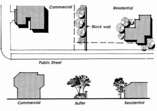
- Minimum width: Ten feet.
- Maximum width: 50 feet.
- Where commercial buildings are less than 5,000 square feet in area, a minimum ten feet buffer is substantial. Otherwise, if the building area is greater than 5,000 square feet in area, a landscape buffer should be a minimum 25 feet.
- Planting materials in the landscape buffer.
- Choose plants that will naturally grow to the desired form or height to reduce maintenance. No limbing up (this will lessen the life and strength of the tree).
- Tree canopies should have a natural growth height of at least eight feet from the ground when located around areas in the clear-view area (see PCC chapter 10-9). Tree canopies should have a natural growth height of at least four feet from the ground when located around parking areas, walkways, etc.
- New trees and shrubs should be evenly spaced at planting, with trees having an eight-foot minimum installed height, and shrubs having a 36-inch minimum installed height.
- Landscaping in the landscape buffer should consist of a minimum of six large maturing trees (minimum 50 percent evergreen) and 40 medium shrubs (minimum 75 percent evergreen) for each 100 linear feet, to provide continuous coverage. For dimensions of less than 100 feet, plantings and spacing will be in proportion to the basic ratio.
- Snow storage. Landscape materials surrounding parking lots and in islands and medians should be able to tolerate large quantities of snow stored during winter months. Delicate plant material should not be used in area where they are likely to be damaged by snow.
- Lighting. The intent of lighting is to provide the necessary lighting to ensure pedestrian safety, night vision for pedestrians and automobiles, add aesthetic value to the city appearance, and not create or cause excessive glare onto adjacent properties.
- Lighting height and location shall be designed to illuminate the site only. Light cutoffs are required to prevent spillover of direct light.
- Pedestrian street lights or lamp posts located within the public right-of-way are required in all commercial zones.
- Pedestrian street lights or lamp posts located within the public right-of-way shall be mounted between eight feet to 16 feet above grade to provide illumination of street sidewalks.
- Pedestrian street lights or lamp posts shall reflect the architectural design characteristic of the surrounding area.
- Up-lighting is not permitted, except as approved through the site plan review for highlighting signature landscape features or building elements.
- HID or fluorescent tube lights (except compact fluorescent bulbs) are not permitted as exterior building lights.
- Floodlights or directional lights permitted for the lighting of alleys, parking garages and outdoor working areas must be shielded or directed to prevent the source of light (bulb or lamp) from being seen from adjacent properties or public rights-of-way.
- All landscape plans submitted for approval shall contain the following information unless specifically waived by the city. At the discretion of the city a final landscaped plan may require a stamp from a state licensed landscape architect.
- The location and dimensions of all existing and proposed structures, property lines easements, parking lots and drives, roadways and rights-of-way, sidewalks, bicycle paths, ground signs, bicycle parking areas, fences, freestanding electrical equipment, tot lots, and other recreation facilities.
- The location, quantity, size and name, both botanical and common names, of all proposed plants.
- The location, size and common names, of all existing plants including trees and other plants in the parkway and indicating plants to be retained and removed.
- The locations of existing buildings and structures on adjacent property within 20 feet of the site.
- Location and heights of fences and retaining walls proposed on the site.
- At the discretion of the city a final irrigation plan may require a stamp from a state licensed landscape architect.
- Completion; performance security. No requests for any building, structure or other improvements shall be approved until site and landscape plans have been approved by the administrative land use authority; and a preconstruction meeting held.
- Preconstruction meeting. A pre-construction meeting will be held with the developer, general contractor for the development, and city staff prior to beginning any construction in the development, including grading and trenching.
- It is the developer's responsibility to notify the general contractor and all appropriate subcontractors for the development of their required attendance at the preconstruction meeting and that no construction can commence until after that meeting.
- The stormwater notice of intent (NOI) and stormwater pollution prevention plan (SWPPP) must be in place prior to the preconstruction meeting.
- Landscaping and site developments in accordance with the approved plans shall be installed within 30 days following occupancy of the building.
- If said completion date is impossible due to adverse weather conditions, a mutually agreed-upon completion date shall be determined by the city and the applicant, but in no case shall the completion date be more than 150 days from the date of occupancy. The developer (or owner) shall hereby deposit a security of performance as specified in PCC 11-5-7B through C as security to ensure compliance with all landscaping and site requirements. If the developer or an agent of the developer fails to comply with the above installation and time requirements, the security of performance may be foreclosed upon by the city to cover costs of installing, repairing or replacing said landscaping and site developments.
- Preconstruction meeting. A pre-construction meeting will be held with the developer, general contractor for the development, and city staff prior to beginning any construction in the development, including grading and trenching.
- Design initiatives.
- Undeveloped area. All areas of the parcel on which development is taking place shall be regulated by this chapter. Land which is not covered by the building, parking lots, roads, landscaping or otherwise improved shall, as a minimum, be restored with natural vegetation and maintained so as not to create a weed nuisance (see PCC chapter 2-4), or the area may be maintained in agricultural production.
(Code 1998, § 10-8-5(part); Zon. Ord., 5-8-1991; Ord. No. OM 019-99, 7-27-1999; Ord. No. 009-2002, 6-11-2002; Ord. No. 033-2004, 11-23-2004; Ord. No. 004-2005, 1-18-2005; Ord. No. 006-2005, 2-8-2005; Ord. No. 011-2009, 12-8-2009; Ord. No. 007-2010, 8-10-2010; Ord. No. 006-2011, 7-26-2011; Ord. No. 014-2012, 9-25-2012; Ord. No. 015-2013, 11-7-2013; Ord. No. 005-2014, 9-23-2014; Ord. No. 2015-015, 6-9-2015; Ord. No. 2015-016, 7-14-2015; Ord. No. 023-2016, 10-11-2016; Ord. No. 2018-004, 4-24-2018; Ord. No. 2018-011, 10-23-2018; Ord. No. 2020-003, 2-19-2020)
Adopted by Ord. 06-2022 on 9/21/2022
10-8-6 Parking Regulations
Except as herein provided, no building or structure shall be constructed, altered or converted for or to any use unless there shall be provided on the lot or parcel vehicle parking of at least the following ratio of vehicle spaces for the uses specified in the designated districts and that all roadways comply with the standards contained herein. The exception being that an established use lawfully existing at the effective date of the ordinance from which this chapter is derived need not provide parking or roadways as herein set forth and that no existing vehicle parking or roadways be reduced or further reduced below the minimum standards herein required.
- Schedule. In all districts, the following off-street parking schedule shall apply:
- Dwelling unit.
- Single-family, detached. Three spaces for each unit, except as provided in subsection A.1.b of this section.
- Dwelling unit occupied by four or more individuals unrelated by blood, marriage or adoption; one space per each licensed driver.
- Multiunit residences for persons with disabilities and/or residential facility for the aged; when evidence presented by the applicant warrants, the land use authority may allow a number less than two space per dwelling unit; but not less than 1.5 spaces per dwelling unit.
- Single-family, attached. See PCC 10-8-9.7, Design Standards for Attached and Multifamily Residential
Development, Parking Plan.
- Duplex. See PCC 10-8-9.7, Design Standards for Attached and Multifamily Residential Development, Parking Plan.
- Four-family. See PCC 10-8-9.7, Design Standards for Attached and Multifamily Residential Development, Parking Plan.
- Multi-family. See PCC 10-8-9.7, Design Standards for Attached and Multifamily Residential Development, Parking Plan.
- Dwellings in Mixed-Use District (MXD). See PCC 10-4-4.G.5 Mixed-Use District, Parking areas
- Single-family, detached. Three spaces for each unit, except as provided in subsection A.1.b of this section.
- Clinic or doctor's office. Ten spaces per clinic or four spaces per doctor or dentist, whichever is greater, plus three additional spaces for each doctor or dentist over three.
- Restaurant or cafeteria. One space for each four fixed seats and one space for each 40 square feet of floor area for moveable seating under maximum seating arrangement.
- Office, general.
- Offices providing on-site customer services, one space for each 200 square feet in use
- Offices not providing on-site customer service, one space for each 300 square feet in use.
- Commercial.
- Recreation and amusement. One space for each 250 square feet in use.
- Retail or personal service. One space for each 250 square feet in use.
- Churches, meeting rooms, public assembly. One space for each five fixed seats and one space for each 50 square feet of floor area for moveable seating under maximum seating arrangement.
- Storage or warehouse. One space for each 5,000 square feet or floor area.
- Manufacturing, process or repair. One space for each two employees working the shift with the greatest number of employees.
- Dwelling unit.
- General requirements.
- Buildings, developments; computation. In computing the parking requirements for any building or development, the total parking requirements shall be the sum of the specific parking space requirements of all of the buildings, structures or uses in the development.
- Area – square feet. Unless otherwise specified, square feet refers to the gross building square footage, including outdoor areas use for the same of accessory use, e.g., outdoor eating area of a restaurant.
- Fractions. When the total number of all required spaces results in a fractional number of parking spaces, one space shall be provided for a fraction of one-half or more, and no space shall be required for a fraction less than one-half.
- Single-family dwelling. Single-family dwelling unit (detached) parking shall be provided only in a private garage, driveway, or in an area properly designed as a parking pad.
- Plan approval. Prior to the issuance of any building permit, a plan which clearly and accurately designates parking spaces, access aisles, driveways and the relationship to the use to be served by the off-street parking shall be forwarded to the land use authority for the process of city approval. Approval shall be based on:
- Adequate number of spaces, including accessible parking spaces if required;
- Relationship of parking to use;
- All parking spaces being usable and accessible by adequate roadway/parking configuration; and
- Parking stalls being nine feet in width by 20 feet in length and on a hard paved surface (see section 10-8-5B for parking requirements for individuals with disabilities.). Access to all stalls shall also be of a hard-paved surface.
- Location. Parking space, as required above, shall be on the same lot with the main building, or in the case of nonresidential buildings, it may be located no further than 300 feet therefrom. Location of parking in nix-use developments or single-family attached and multi-family developments shall follow the regulations list in Chapter 10-4 and Section 9 of this Chapter, respectively.
- Parking areas are not allowed in clear-view areas and site-triangles as defined in Chapter 10-9.
- Parking areas are not allowed in clear-view areas and site-triangles as defined in Chapter 10-9.
- Buildings, developments; computation. In computing the parking requirements for any building or development, the total parking requirements shall be the sum of the specific parking space requirements of all of the buildings, structures or uses in the development.
(Code 1998, § 10-8-6; Zon. Ord., 5-8-1991; Ord. No. 033-2004, 11-23-2004; Ord. No. 004-2005, 1-18-2005; Ord. No. 011-2009, 12-8-2009; Ord. No. 007-2010, 8-10-2010; Ord. No. 006-2011, 7-26-2011; Ord. No. 014-2012, 9-25-2012; Ord. No. 015-2013, 11-7-2013; Ord. No. 005-2014, 9-23-2014; Ord. No. 2015-015, 6-9-2015; Ord. No. 2015-016, 7-14-2015; Ord. No. 023-2016, 10-11-2016; Ord. No. 2018-004, 4-24-2018; Ord. No. 2018-011, 10-23-2018; Ord. No. 2020-003, 2-19-2020)
Adopted by Ord. 06-2022 on 9/21/2022
Adopted by Ord. 10-2024 Parking Regulations on 5/28/2024
10-8-7 Site Requirements For Seasonal Business Facility, Semi-Permanent Business Facility, And Temporary Business Facility
- Purpose. Provide a variety of business opportunities and increase sales revenue.
- Approval authority. The administrative land use authority shall be the approving authority for site approvals for seasonal, semi-permanent, and temporary business facilities.
- Site plan agricultural and residential zones. Seasonal business facility and temporary business facility in agricultural and residential zones shall comply with the requirements for a home business.
- Site plan commercial zones. Seasonal business facility and temporary business facility may be located on improved sites or unimproved sites in CHD, CGD, CND, MXD zones with the following conditions:
- Improved site. Utilities (if required); parking must be asphalt; restrooms (may be portable units).
- Unimproved site. Utilities (if required); parking and access must be an all-weather surface to prevent tracking of mud and debris on the city right-of-way; if restrooms are required, portable units may be used.
- Must provide a signed statement from the property owner or assigns that the business may occupy the space and has permission to use the amenities listed in subsection F.1 or 2 of this section from the existing on-site or adjacent permanent facility.
- If a parking lot is used to house a temporary or seasonal business, the spaces used must be in excess of those spaces required for the permanent facility.
- Must comply with applicable city, county, state, and/or federal codes, rules, and policies (including, but not limited to, building, fire, health). Zoning codes for setbacks and landscaping may not apply.
- Tents and temporary signs must be secured in such a manner that they not pose a hazard for buildings, vehicles, and/or pedestrians.
- If selling from a car, truck, van, trailer, tent, etc., it must not be located in a manner that blocks required building entrances/exits, ingress and egress, pedestrian and/or vehicular flow and visibility.
- Must not be located in or on city-owned property, including park strips and right-of-way, without written consent from the city or as part of a city-sponsored event.
- Any facility structures, tents, trailers, vehicles, etc., must be removed within ten calendar days after the site approval expires. Temporary signs must be removed within 24 hours after the site approval expires.
- Semi-permanent business facility shall be located on improved sites in CHD, CGD, CND, MXD zones with the following conditions:
- Must provide a signed statement from the property owner or assigns that the business may occupy the space and has permission to use their utilities (other than culinary water and sewer), stormwater facilities, and parking from the existing on-site or adjacent permanent facility. On-site or adjacent permanent facility must have enough parking to meet its requirements and excess to share with the semi-permanent business facility.
- Must have a separate culinary water connection as shown on the approved construction drawings for the development or as approved by the public works director. If portable restrooms are used, a separate sewer connection will not be required.
- Must comply with applicable city, county, state, and/or federal codes, rules, and policies (including, but not limited to, building, fire, and health). Must comply with zoning codes for setbacks and landscaping.
- Tents and temporary signs must be secured in such a manner that they not pose a hazard for buildings, vehicles, and/or pedestrians.
- Any structures, tents, trailers, debris, etc., must be removed within 30 calendar days after the site approval expires. Temporary signs advertising the business activity must be removed within 24 hours after the site approval expires.
(Code 1998, § 10-8-7(part); Ord. No. OM 002-02, 3-26-2002; Ord. No. 033-2004, 11-23-2004; Ord. No. 004-2005, 1-18-2005; Ord. No. 011-2009, 12-8-2009; Ord. No. 007-2010, 8-10-2010; Ord. No. 006-2011, 7-26-2011; Ord. No. 014-2012, 9-25-2012; Ord. No. 015-2013, 11-7-2013; Ord. No. 005-2014, 9-23-2014; Ord. No. 2015-015, 6-9-2015; Ord. No. 2015-016, 7-14-2015; Ord. No. 023-2016, 10-11-2016; Ord. No. 2018-004, 4-24-2018; Ord. No. 2018-011, 10-23-2018; Ord. No. 2020-003, 2-19-2020)
Adopted by Ord. 06-2022 on 9/21/2022
10-8-8 Low Power Towers And Antennas For Radio Communication
- This section addresses planning issues resulting from the rapid growth in demand for low-power radio services within the city. It distinguishes low-power radio from other broadcasting type telecommunication technologies and established provision relating to demand, visual mitigation, noise, engineering, residential impact, health, safety and facility siting. The requirements of this section apply to both commercial and private low power radio services such as cellular or PCS (personal communication system) communications and paging systems (hereinafter referred to as "cellular facilities"). All cellular facilities shall comply with the regulations set forth in this section, other applicable ordinances of the city, and any pertinent state and federal regulations, including Federal Communications Commission and the Federal Aviation Administration.
- All cellular facilities descripted herein shall be allowed as a conditional use subject to the conditions set forth in PCC 10-3-5. No other cellular facilities shall be allowed. A site plan is required as part of the conditional use application, see PCC 10-8-5; except that when installing a stealth or monopole structure, the fenced area around the structure shall be considered the building for the ten-foot landscape requirement, not the structure or individual buildings within the fenced area. A minimum of one parking space and access drive will be required.
- Wall-mounted antennas. A wall-mounted antenna shall comply with the following development standards:
- Wall-mounted antennas shall not extend above the roof line of the building more than four feet.
- Wall-mounted antennas may have a maximum area of 40 square feet, as determined by drawing straight lines between the outermost portions of the antenna until enclosed.
- All equipment associated with the operation of the antenna shall be located within the structure to which the antenna is attached or screened from public view.
- If associated equipment is located on the ground, it shall be appropriately landscaped.
- Whip antennas shall not be permitted.
- Roof-mounted antennas. A roof-mounted antenna shall comply with the following development standards:
- A roof-mounted antenna shall be screened, constructed, and/or colored to match the structure to which it is attached.
- A roof-mounted antenna shall be set back from the building edge one foot for every one foot of antenna height and shall not exceed 15 feet in height.
- Stealth-fixture antennas. A stealth antenna shall be subject to the following development standards:
- A stealth-fixture antenna may be attached to an existing or replacement power pole or light pole or disguised as a flagpole, manmade tree, clock tower, steeple or structure used primarily for another use so long as any antenna located on the structure does not detract visually from the primary use.
- When a stealth-fixture antenna is attached to an existing or replacement power pole or light pole the following conditions shall be met:
- The antenna shall not exceed the height of an existing pole by more than:
- Ten feet; or
- 20 feet and shall not be located closer to a residential zone boundary than two times the height of the pole;
- If a replacement pole is proposed, the pole shall be installed in the same location as the pole being replaced unless the land use authority specifically approves a different location as provided in a conditional use permit; and
- Any existing light or power pole located in a public right-of-way or in a required front or side yard shall not be increased in height to accommodate a cellular facility antenna;
- Any replacement pole located in a public right-of-way or in a required front or side yard shall not be higher than the pole that it is replacing;
- Each installation shall be approved by the power utility company (or other utility company, as applicable), including approval and acceptance of any applicable agreements and payment of any required fees. Such approvals shall be received prior to final approval of a conditional use permit;
- A structure to which a stealth-fixture antenna is attached shall be designed by a state-certified engineer to verify that the structure can support the stealth-fixture antenna;
- The overall height of any structure proposed to be used for a stealth-fixture antenna shall be consistent with any similar structure being used as a model for the stealth structure. Except as otherwise provided in subsection E.2.a.(2) of this section, a stealth-fixture shall be no more than ten feet higher than the structure to which it is attached, provided the fixture and the structure to which it is attached is consistent with the character of similar structures located in the same area, as determined by the land use authority. The land use authority shall make specific findings to support its determination;
- A stealth-fixture antenna, including the mounting structure, shall not exceed 30 inches in diameter; provided, however, that antennas exceeding 30 inches, including the mounting structure, may be permitted if the antenna is a stealth-fixture antenna located on or within a clock tower, steeple, manmade tree, or other similar structure;
- Equipment and/or equipment shelters used in connection with stealth-fixture antennas shall be camouflaged behind an effective year-round landscape buffer and/or wooden fence equal to the height of the proposed equipment. Equipment shelters shall not be located within a utility easement;
- Stealth-fixture antennas and all associated equipment visible to public view shall be painted to match the color of the structure to which it is attached; or
- Electrical wiring shall be located within the pole whenever possible and shall be required when a metal replacement pole is provided.
- If a stealth-fixture antenna becomes obsolete or the structure to which it is attached is vacated by the operator of the cellular facility, then within 90 days thereafter the cellular facility operator shall remove the antenna and all associated equipment and shall restore the structure to its original condition. If the requirements of this subsection are not met, the city shall have the right to enter the subject property and remove the equipment or pole at the expense of the cellular facility operator.
- A project plan application for a stealth-fixture shall include the following:
- A letter from the applicant stating the applicant will conform to the requirements of subsection E.2.d of this section; and
- Verification that the applicant owns the property where the stealth-fixture antenna is proposed to be located or a copy of a lease agreement with the property owner indicating the antenna may be located on the property.
- If all the conditions set forth in this subsection cannot be met, the requirements of subsection F of this section shall apply.
- The antenna shall not exceed the height of an existing pole by more than:
- Monopole structures.
- A monopole structure shall comply with the following development standards:
- All tower structures shall be of monopole construction. No lattice constructed towers of any kind shall be allowed.
- All monopole structures shall be designed by a state-certified engineer to allow co-location of antennas owned by at least three separate users on a single pole.
- No monopole structure shall be located closer to a residential zone boundary than two times the height of the monopole.
- A monopole with antennas and antenna support structures shall not be located in a required front setback, front landscaped area, buffer area, or required parking area.
- If a monopole antenna becomes obsolete, then within 90 days thereafter the operator of the cellular facility shall remove the antenna, the top three feet of antenna footing and all associated equipment and shall restore the site to its original condition. If the requirements of this subsection are not met, the city shall have the right to enter the subject property and remove the equipment at the expense of the cellular facility operator.
- No monopole structure shall exceed 150 feet in height.
- An application for a monopole structure shall include the following:
- A letter from the applicant stating that the applicant will conform to the requirements of subsection F.1.e of this section, and that the monopole structure is capable of supporting co-located antennas; and
- Verification that the applicant owns the property where the monopole structure is proposed to be located, or a copy of a lease agreement with the property owner indicating the antenna may be located on the property.
- Co-location on an existing monopole structure shall be a conditional use and shall be handled administratively.
- A monopole structure shall comply with the following development standards:
- Temporary monopole structures. A temporary monopole structure may be allowed for a maximum of 60 days subject to the following requirements:
- A temporary monopole structure shall be located in a zone that allows for the placement of a monopole structure as a conditional use.
- An application shall be filed with the city for the placement of a permanent monopole structure prior to the placement of a temporary monopole structure.
- The placement of a temporary monopole structure shall meet the height requirement set forth in subsection F.1.f. of this section.
- A bond in the amount of $500.00 shall be posted to guarantee removal of a temporary monopole structure when:
- A permanent monopole structure is constructed; or
- 60 days have elapsed, and a temporary monopole structure has not been removed. One 15-day extension may be granted to the 60-day period if an applicant can reasonably demonstrate a need for additional time to complete construction of the monopole structure.
- Additional requirements.
- Each cellular facility shall be considered as a separate use; and an annual business license shall be required for each such facility.
- In addition to the conditional use standards set forth in PCC 10-3-5, the land use authority shall make the following findings for any cellular facility subject to a conditional use permit:
- That the proposed structure is compatible with the height and mass of existing building and utility structures;
- That co-location of the antenna or other existing structures in the same vicinity such as other towers, buildings, water towers, utility poles etc., are possible without significantly impacting antenna transmission or reception;
- That the antenna location blends with existing vegetation, topography and buildings;
- That the location approval of monopoles will not create a detrimental impact to adjoining properties; and
- That location of cellular facility will not interfere with existing transmission signals.
(Code 1998, § 10-8-8(part); Ord. No. 033-2004, 11-23-2004; Ord. No. 004-2005, 1-18-2005; Ord. No. 011-2009, 12-8-2009; Ord. No. 007-2010, 8-10-2010; Ord. No. 006-2011, 7-26-2011; Ord. No. 014-2012, 9-25-2012; Ord. No. 015-2013, 11-7-2013; Ord. No. 005-2014, 9-23-2014; Ord. No. 2015-015, 6-9-2015; Ord. No. 2015-016, 7-14-2015; Ord. No. 023-2016, 10-11-2016; Ord. No. 2018-004, 4-24-2018; Ord. No. 2018-011, 10-23-2018; Ord. No. 2020-003, 2-19-2020)
State law reference—Regulation of amateur radio antennas, U.C.A. 1953, § 10-9a-515.
Adopted by Ord. 06-2022 on 9/21/2022
10-8-9 Design Standards For Attached And Multifamily Residential Development
- Purpose and intent. It is the intent of these design standards to ensure that single-family attached and multifamily development, is developed in a manner that provides attractively designed, constructed and landscaped housing.
- Compliance with standards. Substantial compliance with the regulations and other provisions of this title in requiring adequate standards related to the public health, safety and general welfare shall be observed, without unduly inhibiting the advantages of large-scale site planning for residential and related purposes. Additionally, all plans related to the development of the site, including, but not limited to, landscaping and irrigation plans, shall comply with the city standards and specifications.
- Applicability. These guidelines shall govern all single-family attached and multifamily residential development in the city, without regard to the underlying zoning designation. In cases where traditional single-family detached housing is developed as part of a mixed-housing type development, the standards contained herein relative to exterior materials and colors, as well as proposed elevations for single-family detached housing shall apply.
- Development standards. Projects shall be developed under the following standards and guidelines.
- Submittals. Each phase of application and approval of projects shall require certain submittals. The various phases of approval, that phase's required submittals, and the details contained in each submittal are as follows:
- Concept plan. Concept plan submittals shall consist of a general site plan showing approximate building locations, proposed road layouts, proposed open space, general parking layouts, anticipated public and private amenities and their locations. All conceptual plans shall be clearly marked as a conceptual plan.
- Preliminary plat. Preliminary plat submittals shall consist of preliminarily engineered items required in the concept plan submittal, as well as preliminary architectural plans, a preliminary landscaping plan and a preliminary site plan for the overall development of the project. All preliminary plans shall be clearly marked as a preliminary plan.
- The preliminary architectural plans shall include elevations for all buildings and color renderings of the design concept or intent, site elements, building facades, and a project data sheet listing the proposed exterior materials and the front facade percentages of the materials.
- The preliminary landscaping plan shall consist of the general location and type of plants to be used, as well as the preliminary calculations demonstrating that landscaping requirements have been met.
- The preliminary parking plan shall show parking layout detailing resident parking, visitor parking, covered parking, bicycle parking, electrical vehicle charging stations, and include a data sheet demonstrating that plan meets or exceeds the parking requirements per housing type.
- Final plat. Final plat submittals shall consist of the fully designed and engineered drawings for the site plan, architectural plan, landscaping plan and parking plan for the project, with the plans meeting all of the requirements outlined herein and which may be added as a condition of conceptual or preliminary approval. This is in addition to any plats and construction drawings which may be required as part of the subdivision of property. All final plans shall be clearly marked as a final plan and shall be stamped with the appropriate professional stamp and signed by the professional.
- Site plan. Site plans shall contain the following information:
- Summary data indicating the area of the site in the following classification: total area of the entire project site, total area and percentage of the site utilized by buildings, total area and percentage of the site in landscape area, total area and percentage of the site for parking areas.
- Show north arrow, scale, building location, property lines, setbacks, abutting rights-of-way, parking layout, ADA parking and ramps, entrances to site, curbs, water and sewer lines, fire hydrants, fire lanes, storm drain lines and appurtenances.
- Show all existing fire hydrants within 300 feet.
- Show connectivity with adjacent parking lots and interior private roadways.
- Show any and all proposed traffic control measures for the project.
- Provide lighting and signage plan for the entire site. Indicate how signs will be illuminated, their design and spatial relationship to other site amenities including buildings, and a graphic example of each type of sign.
- Provide cross sections of the site showing spatial relationships between all vertical elements (building, trees, berms, light standards, etc.) as they relate to activities and use of streetscape, pedestrian, and parking areas.
- Provide stormwater pollution prevention plan if the site disturbs an acre or more or is part of a larger development.
- Provide cost estimates for site development, including, but not limited to, landscaping, publicly-owned infrastructure, parking/loading areas, pedestrian areas.
- Architectural plan.
- Provide rendered elevations for all buildings, both publicly-owned and privately-held, which the applicant proposes to construct on the property. Include color renderings of design concept or intent, site elements, and all building facades.
- Provide proposed floor plans for all buildings on the site.
- Architectural design standards. All buildings within a development subject to this chapter shall be designed and built to the following design standards, unless specifically exempted. The city recognizes that architectural trends change from time to time.
- Exterior materials.
- All exterior materials shall be above average grade quality, suitable for the climate and exposure in which the development is located, and maintenance free to the greatest degree possible. The city reserves the right to reject any proposed building material it feels is not in harmony with this requirement.
- Elevations. The exterior elevation of each group of single-family attached townhomes, condominium units, and multifamily units shall meet or exceed the following standards:
- Exterior finishes. Exterior building materials shall be natural or cultured brick, rock, or stone over at least 50 percent of the entire building facade (not including windows and doors), the remaining 50 percent being brick, rock, stone, stucco, clapboard, wood, and/or block. At least 75 percent of the 50 percent shall be on the front building facade. All building facades that face a public right-of-way or exterior street shall utilize at least 40 percent of these allowable materials. The use of aluminum siding is prohibited.
- Front elevation. Where possible, front elevations shall include a minimum of two windows per above-grade floor. Trim and/or shutters is required on all windows, unless the design of the building is such that trim and/or shutters is not compatible with the overall architectural style.
- Side elevation. With the exception of interior attached townhome units, each side elevation shall include a minimum of two windows per above-grade floor. Trim and/or shutters is required on all windows unless the design of the building is such that trim and/or shutters is not compatible with the overall architectural style.
- Exterior finishes. Exterior building materials shall be natural or cultured brick, rock, or stone over at least 50 percent of the entire building facade (not including windows and doors), the remaining 50 percent being brick, rock, stone, stucco, clapboard, wood, and/or block. At least 75 percent of the 50 percent shall be on the front building facade. All building facades that face a public right-of-way or exterior street shall utilize at least 40 percent of these allowable materials. The use of aluminum siding is prohibited.
- Roofs. Pitched roofs are encouraged but not required.
- Garages.
- Attached townhome/duplex. Each attached single-family townhome and duplex is required to have a minimum one-car garage which shall be attached to the main structure and shall be of the same or complimentary architectural materials as the primary residence.
- Apartment. Apartments may have garages but are not required to have garages, provided that at least one covered parking spot is provided for each dwelling unit.
- Garages may be attached or detached from the primary structures, but the use of attached, recessed garages is strongly encouraged.
- Front-loading garages may not protrude beyond the front-plane of the main building facade by more ten feet or 50 percent of the depth of the garage, whichever is less.
- Detached garages for apartments shall not exceed 50 percent of the total square footage of the apartment.
- If the garage entrance abuts a street, road, or sidewalk, a driveway is required; and must be a minimum of 18 feet in length, measured from the street or road to the garage door. Where a sidewalk exists, it must be a minimum of 18 feet in length, measured from the interior sidewalk edge to the garage door.
- Accessory buildings. Accessory buildings privately owned by an individual homeowner shall not be permitted in any commonly held area.
- Porches, decks and overhangs. In order to provide architectural variety to the development, the use of covered porches, decks and overhangs is encouraged. Such porches, decks and overhangs shall be integrated into the design of the structure in order to avoid the appearance of add-on elements.
- Exterior materials.
- Landscaping/irrigation plan.
- Show landscaping and irrigation plans for the entire site, specifically, those areas which will be held in common ownership. The landscaping plans shall include any and all requirements outlined in this chapter.
- The applicant must submit a landscape plan documentation package, which shall be prepared by a licensed landscape architect. The documentation package shall be submitted to and approved by the city prior to the issue of any permit. A copy of the approved documentation package shall be provided to the property owner or site manager. The plan documentation package shall consist of the following items:
- Project data sheet. The project data sheet shall contain the following:
- Project name and address;
- Applicant or applicant's agent's name, address, phone and fax number;
- Landscape designer's name, address, phone and fax number; and
- Landscape contractor's name, address, phone and fax number, if known.
- Landscaping plan. A detailed landscaping plan shall be drawn at a scale that clearly identifies the following:
- Location of all plant materials, a legend with botanical and common names, and size of plant materials;
- Property lines and street names;
- Existing and proposed buildings, walls, fences, utilities, paved areas and other site improvements;
- Existing trees and plant materials to be removed or retained;
- Designation of landscape zones; and
- Details and specification for tree staking (trees less than a two-inch caliper must be double staked until the trees mature to two-inch caliper), soil preparation, and other planting work.
- Irrigation plan. A detailed irrigation plan shall be drawn at the same scale as the planting plan and shall contain the following information:
- Layout of the irrigation system and a legend summarizing the type and size of all components of the system;
- Static water pressure in pounds per square inch (psi) at the point of connection to the public water supply;
- Flow rate in gallons per minute and design operating pressure in psi for each valve and precipitation rate in inches per hour for each valve with sprinklers; and
- Installation details for irrigation components.
- Grading plan. A grading plan shall be drawn at the same scale as the planting plan and shall contain the following information:
- Property lines and street names, existing and proposed buildings, walls, fences, utilities, paved areas and other site improvements;
- Existing and finished contour lines and spot elevations as necessary for the proposed site improvements;
- Grade shall slope away from the structure as required by the International Building Code.
- Plan review and construction inspection.
- As part of the site plan review process, a copy of the plan documentation package shall be submitted to the city for review and approval.
- Following construction and prior to issuing the approval for occupancy, an inspection shall be scheduled with the planning department to verify compliance with the approved landscape plans.
- The city reserves the right to perform site inspections at any time before, during or after the irrigation system and landscape installation, and to require corrective measures if requirements of this section are not satisfied.
- Project data sheet. The project data sheet shall contain the following:
- Landscaping standards. All required landscaping shall be installed prior to the city's issuance of any certificate of occupancy on the property, unless seasonal conditions make installation unfeasible, in which case the applicant shall provide cash security or its approved alternative for all landscaping, which landscaping shall be installed by the following May 31.
- Applicability. This section applies to all front and rear yard landscaping for multifamily townhome and apartment projects, as well as any common area landscaping which is referenced herein.
- Minimum landscaped area. The applicant shall landscape all common area landscaping and, in the case of single-family attached and duplex housing, all areas which may be privately owned. Landscaped areas shall not be less than five feet wide.
- Children's play areas are places specifically designed to enable children to play, such as a playground or play park; and often contain recreational equipment such as slides and swings. The applicant shall provide children's play area at a minimum of 800 square feet per the first ten units, plus an additional ten square feet per unit above the first ten units. To ensure safety of the children, play areas should be placed in locations that are near the dwelling units and provide good visibility of the play area.
- The applicant shall provide open space equal to or greater than 25 percent of the overall project area. The children's play area can be included in the open space percentage.
- Rooftop landscaping is considered a private amenity and is not eligible for inclusion in the required landscaping percentage.
- Materials. Areas requiring landscaping shall be planted with substantial live plant material, including plants, shrubs, trees, sod, etc., for the purpose of buffering, screening, and improving the visual quality of the site. Wherever possible on the project, developers are encouraged to use low-impact development (LID) techniques and materials.
- Types of vegetation. Up to 25 percent of the landscaping may be evergreen. Up to 25 percent of the landscape area can include specialty paving, street furniture, and outdoor seating areas. Trees that are planted in the park strip shall meet the specifications described in the standard construction specifications of the city.
- Plant selection. Plants selected for landscape areas shall consist of plants that are suited to the climate and soil conditions at the project site. Plants with similar water needs shall be grouped together as much as possible. Drought tolerant plants are encouraged. Areas with slopes greater than 20 percent shall be landscaped with deep-rooting, water-conserving plants for erosion control and soil stabilization.
- Mulch. After completion of all planting, all irrigated nonturf areas shall be covered with a minimum four-inch layer of mulch to retain water, inhibit weed growth, and moderate soil temperature.
- Size of trees. The following standards apply to trees used in the required landscaping of the development.
- Deciduous trees. Deciduous trees shall have a minimum caliper size of two inches.
- Ornamental trees. Ornamental trees shall have a minimum caliper size of 1.5 inches.
- Evergreen trees. Evergreen trees shall have a minimum height of six feet.
- Xeriscaping. The developer is encouraged to use xeriscaping for a portion of the required landscaping.
- Vegetation protection. The property owner must protect existing significant vegetation during any development activity. Development plans must show all significant vegetation within 20 feet of a proposed development.
- Removal. No landscaping may be removed without replacement of equal quality. This shall include the installation of healthy plant materials as well as a tree for tree replacement as governed by this section. Utilities and others that disturb landscaped areas shall restore disturbed landscaping to previous condition.
- Parking plan. Show parking/loading computations for proposed use. Developments shall provide adequate parking, both for residents and their guests, based on the following standards:
- Garage parking. Attached housing shall provide a minimum of one garage parking space for each unit, which shall be owned by the person who owns the housing unit.
- Off-street parking. Housing within the development shall provide the following off-street parking spaces.
- Single-family detached; four per unit.
- Single-family attached/townhome; two per unit plus 0.25 guest spot per unit.
- Duplex; two per unit.
- Apartments (zero to one bedroom); 1.5 per unit plus 0.25 guest spots per unit.
- Apartments (two or more bedroom); two per unit plus 0.25 guest spots per unit.
- At least one of the required parking spaces for apartment shall be a designated, covered parking space.
- Required visitor parking shall be spaced throughout the development in order to provide ease of access to all dwelling units.
- Parking space dimensions. Dimensions for all required parking, both on- and off-street, as well as any required handicapped parking, are outlined in the city engineering design standards.
- Bicycle parking. New construction of and additions to retail/commercial structures and multiunit dwellings must provide bicycle parking spaces.
- Multiunit dwellings must provide at least one space per four units if units do not have a private garage or private storage space for bike storage, or ten percent of the required off-street parking spaces, whichever is greater.
- Bicycle spaces must accommodate bicycle storage medium security racks, in which the user may lock both the bicycle frame and the wheels. The spaces must be designed to prevent damage to the bicycle and to facilitate easy and secure storage without interference from or to adjacent bicycles. Bicycle racks or lockers must be anchored and of solid construction, resistant to rust, corrosion, hammers, and saws.
- Bicycle spaces must be compatible in design and function with the surrounding buildings and with surrounding street fixtures.
- Bicycle repair and maintenance station. A minimum of one bicycle repair station per development or one per 25 bicycle parking spaces, whichever is greater, must be installed.
- Bicycle facilities must be located in convenient, highly visible, active well-lighted areas, but shall not interfere with pedestrian movements and snow storage.
- Mailboxes. Developer shall be required to coordinate placement of clustered mailboxes with the United States Postal Service.
- Miscellaneous site development standards.
- Walkways and paths. Each development shall include common area pedestrian-friendly walkways and paths. Where possible, such walkways and paths shall connect to a larger trail system. The general location and design of such walkways and paths shall be presented as part of the preliminary site plan. The construction type, size and exact location shall be part of the final development of each phase. All walkways and paths shall be provided with adequate safety lighting.
- Fixtures and appurtenances. The type and location of any fixtures or appurtenances (lighting, benches, bike racks, etc.) shall be submitted as part of the final development of each phase and shall be reviewed/approved by the city planning commission.
- Public infrastructure. All public infrastructure improvements shall be constructed according to the city design standards and specifications.
- Lighting. In order to maintain the residential character in order to shield the lighting from shining on to another residence or lot, all lighting within a development governed by these standards shall be Dark Sky compliant.
- Signage. All signage within an LCR shall be in accordance with the city code regulating signage.
- Electric vehicle charging station requirements (EVCS).
- Electric vehicle charging stations. Electric vehicle charging stations are an allowed accessory use in all zoning districts.
- Infrastructure. An applicant shall provide electric vehicle charging station infrastructure for five percent of the first 100 required off-street parking spaces for multiunit dwellings and nonresidential development and for five percent of required off-street parking spaces above 100.
- The electric vehicle charging station infrastructure shall be identified on all construction documents submitted for review.
- To put future property owners on notice of the electric vehicle charging station infrastructure, an applicant shall provide information in covenants, conditions, and restrictions or other documents governing a homeowners' or master owners' association for the development and/or on the breaker panel.
- Installation. An applicant shall install electric vehicle charging stations for five percent of required off-street parking spaces for multiunit dwellings and nonresidential development for the first 200 parking spaces.
- The first electric vehicle charging station installed shall be a dual-port with one charging station that is ADA accessible. This dual-port shall count as one charging station. Dual-port charging stations installed thereafter shall count as two charging stations.
- Standards.
- Location. Electric vehicle charging stations shall not obstruct:
- Building access;
- Rights-of-way;
- Sidewalks or pathways;
- Parking space dimensions; or
- The sight distance triangle.
- Location. Electric vehicle charging stations shall not obstruct:
- Solar energy systems. Solar energy systems may be installed on permanent parking area structures for electric vehicle charging stations. Solar energy systems shall be incorporated in the roof of the permanent structure and shall be mounted to the roof plane. Solar panels, solar devices, and solar energy systems and mounting equipment shall use nonreflective finishes such as an anodized finish.
- Phasing. The development shall be phased to provide both public and private infrastructure, facilities, amenities, and services in a timely and orderly manner and provide the city the ability to protect and promote public health, safety, and welfare.
- Phases shall be planned to ensure the efficient and consecutive construction of adjacent (those phases immediately next to the subject phase, sharing a common boundary line) and future phases, and ensure that phased development does not allow for leapfrog development.
- Generally, each proposed phase shall provide not less than a proportionate share and may be required to provide more of required open space, recreation facilities, and/or dedications for public use concurrent with development.
- If an amenity cannot be built and utilized in phases (e.g., swimming pool), construction of the entire improvement is required when 30 percent of the units are complete.
- When 75 percent of the units are complete, 100 percent of the amenity improvements must be complete.
- All phases shall be required to be stand-alone. No proposed prior phase shall be dependent on the completion of subsequent phases to be consistent with any required approvals and/or conditions, including, but not limited to, the looping of roads and utilities, the provision of fire flow and the mitigation of transportation, recreation and/or public services impacts. Landscaping and parking improvements shall be provided within each phase as required.
- Infrastructure improvements that are required to serve the entire project may be constructed within a nonadjacent phase.
- Phasing plans shall include the following information:
- Illustrative maps for each proposed phase which clearly mark in heavy lines the boundaries of the subject phase, label the phase alphabetically (to avoid confusion with lot numbers) and depict roads, lots, infrastructure, easements, dedications, and open space, should be shown on the map shaded or gray-scaled. All phasing maps shall be drawn at the same scale.
- A narrative description or table that describes each phase and its associated improvements. In addition, the narrative or table shall demonstrate that each phase would comprise a stand-alone development which, should no subsequent phases be constructed, would meet or exceed the standards of this title and all other conditions of approval. The narrative should also describe the proposed timeline for completion of the entire project and any proposals to bond for required unbuilt or yet-to-be constructed improvements.
- Choosing to phase a development does not relieve the developer of the requirement to present the entire development in its phases for preliminary approval by the planning commission. Nor does it relieve the developer of the requirements to extend all public infrastructure to the boundary lines of the development.
- Submittals. Each phase of application and approval of projects shall require certain submittals. The various phases of approval, that phase's required submittals, and the details contained in each submittal are as follows:
- Project approval process.
- Procedure. In addition to the actions and considerations listed in this section, developers shall be required to follow the approval procedures outlined in this Code.
- Development considerations. In approving with conditions, denying or approving an LCR proposal, the planning commission shall consider whether or not the proposed project meets the standards and conditions outlined in this chapter.
- Planning commission action. The planning commission, subject to the requirements of this chapter, may approve the project, deny the project, or approve the project with conditions.
- Revisions. In the event an approved preliminary or final site plan requires revision by the developer, the site plan and any revision will be submitted for approval to the planning commission. In the event revision is for a final site plan, all property owners in the development shall be notified in writing by the planning commission that a revision has been submitted and will be considered by the planning commission.
- Approved plans.
- Upon approval of a preliminary plan or revised preliminary plan, the applicant shall prepare a copy of the approved plan for signature of the owner, the applicant, and the land use authority.
- Upon approval of a final plan or a revised final plan, the applicant shall prepare a copy of the approved plan for signature of the owner, the applicant, and the land use authority.
- Infrastructure minimum improvements. Infrastructure minimum improvements shall be completed and in place before the city will issue a building permit for any lot within the proposed development.
- The city considers the following public and/or private infrastructure minimum improvements essential or required to meet the building code, fire code, flood or stormwater management provisions, street and access requirements.
- All grading of roads and/or that portion of parking area (including pit run and road base) that serve as access to buildings as shown on the approved construction drawings, and all curb, gutter, and all utility trenches that lay inside the roadway;
- All stormwater (excluding finish grades and landscaping), water, sewer, and other improvements that may be deemed essential necessary public safety improvements; and
- Egress and ingress to provide acceptable and safe travel to and from each proposed structure in the approved development plan.
- Inspection. All required testing results and redline drawings must be turned in to the city before the minimum improvement inspection takes place. An inspection of the minimum improvements shall be made, and the city engineer will certify to the city, in writing, that the minimum improvements are complete prior to the issuance of any building permits.
- Asphalt shall not be laid prior to a minimum improvement inspection approval.
- The city considers the following public and/or private infrastructure minimum improvements essential or required to meet the building code, fire code, flood or stormwater management provisions, street and access requirements.
- Improvement completion assurance; improvement warranty.
- Improvement completion assurance. Before an applicant conducts any development activity or records a plat, the applicant shall:
- Complete any required landscaping or infrastructure improvements; or
- Post an improvement completion assurance for any required landscaping or infrastructure improvements (does not include infrastructure that is required to be private) of 100 percent of the incomplete or unaccepted landscaping or infrastructure.
- Improvement warranty. Up on acceptance of the landscaping and infrastructure improvements (does not include infrastructure that is required to be private) by the city, the applicant shall post a surety bond, letter of credit, or other similar security in an amount of ten percent of the lesser of the:
- Municipal engineer's original estimated cost of completion; or
- Applicant's reasonable proven cost.
- Improvement completion assurance. Before an applicant conducts any development activity or records a plat, the applicant shall:
- Building permit issuance. The building inspector shall not issue any permit for the proposed building or use within the project unless such building or use is in accordance with the approved development plan and any conditions imposed. Approved development plans shall be filed with the city.
- Time limit. Unless there is substantial action leading toward completion of an HD project or an approved phase thereof within one year from the date of approval, such approval shall expire unless after reconsideration of the progress of the project an extension is approved. Only one extension shall be granted and shall be limited to one additional year.
(Code 1998, § 10-8-9; Ord. No. 033-2004, 11-23-2004; Ord. No. 004-2005, 1-18-2005; Ord. No. 011-2009, 12-8-2009; Ord. No. 007-2010, 8-10-2010; Ord. No. 006-2011, 7-26-2011; Ord. No. 014-2012, 9-25-2012; Ord. No. 015-2013, 11-7-2013; Ord. No. 005-2014, 9-23-2014; Ord. No. 2015-015, 6-9-2015; Ord. No. 2015-016, 7-14-2015; Ord. No. 023-2016, 10-11-2016; Ord. No. 2018-004, 4-24-2018; Ord. No. 2018-011, 10-23-2018; Ord. No. 2020-003, 2-19-2020; Ord. No. 013-2021, att.(10-8-9), 10-20-2021)
Adopted by Ord. 06-2022 on 9/21/2022
10-8-10 Affordable Housing Incentives
10-8-10 Affordable Housing Incentives
A. Purpose. The Providence City General Plan 2020 Initiative #6: Various Housing
Opportunities states, encourage housing options to meet the needs of
residents of all ages, income level and family size, regardless of their stage
of life. The overall goal for the moderate income housing element of the
general plan is to plan housing opportunities for all people, regardless of
income level, while maintaining the aesthetic qualities and public service
levels Providence residents currently enjoy; improve access to housing
opportunities for low and moderate income housing residents; improve fair
housing practices; and encourage and support the provision of affordable
housing units.
B. Intent. It is the intent of this section to support the overall goal of the moderate
income housing element of the general plan by promoting development that
provides attractively designed and constructed housing that increases the
availability of housing, promotes affordable housing, promotes home ownership
and promotes conservation of resources, such as water, through efficient land
use.
C. Base standards. The base standards for density, lot size, and setbacks are listed in the Space Requirement Chart in Section 1 of this Chapter.
D. Density incentive.
1. Consideration. To be considered for a density
incentive, a minimum of 20% of the proposed units must meet the requirements
for moderate-income housing. Meaning housing occupied or reserved for
households with a gross income of no more than 80% of the median gross income
for households of the same size in Cache County.
a. Sunset Provision. Consideration for affordable
housing incentives shall expire on March 18, 2027, unless extended by the City
Council. Applications for affordable housing incentives must be submitted on or
before that date. After March 19, 2027, no new applications shall be accepted
under this section unless an extension is approved by the City Council.
2. Deed restriction. A property owner benefiting
from affordable housing incentives must record a deed restriction on the
property with the Cache County Recorder’s Office; which deed restriction shall
bind all assigns, heirs, and successors of the property owner.
a. Owner-occupied dwelling unit. A deed restriction
for an owner-occupied dwelling unit shall restrict both income and housing
payments for a period of not less than 5 years.
b. Rental occupied dwelling unit. A deed
restriction for an owner-occupied dwelling unit shall restrict both income and
rental payments for a period of not less than 15 years.
3. Applicable zoning districts. A density bonus
that increases the number of residential units per net acre may be considered
for a development in the R-1-12, R-1-10, R-1-8, R-1-6 single-family residential
zones; the R-M-7, R-M-12, R-M-18 multifamily residential zones; and life cycle
residential (LCR 4-12) and mixed use district (MXD) zones.
4. Density. Qualifying developments are eligible
for a 20% density increase.
5. Lot size and setbacks. Lots for the
moderate-income housing units can be no less than 80% of the base lot size.
Front, street side, and rear setbacks must meet the base minimums; the interior
side yard must be no less than 80% of the base interior side yard setback or 5
feet whichever is more, except in the case of a twin-home which may have one
zero-foot interior side setback.
6. Planned Unit Development (PUD). Chapter 10-14 of
this Title lists the regulations for PUDs. In addition to the 110% density
allowed, a PUD meeting the requirements in Items 1 and 2 above may receive an
additional 15% density increase. All other regulations in Chapter 10-14 apply.
7. Life-cycle residential development. Chapter 10-4
of this Title lists the requirements for life-cycle residential development. For
LCR 4-12 development meeting the requirements in Items 1 and 2 above the
maximum density shall be 15 units per net acre. All other LCR 4-13 regulations
apply.
8. Mixed-use district development. Chapter 10-4 of
this Title lists the regulations for mixed-use development. For horizontal
design mixed-use development, the maximum density of shall be no more than 29
units per net acre. For vertical design mixed-use development, the maximum
density shall be no more than 40 units per net acre. All other MXD regulations
apply.
E. Property owner annual report. Managers, property owners, and landlords of affordable
housing units shall submit an annual report to the Community Development
Director demonstrating compliance with this chapter. This report is due on
March 1 for the previous year’s information and shall include the following
information:
1. Property location, tax ID number, and legal description.
2. Property owner name, mailing address, and email address.
3. Information on the affordable housing units and the tenants of the property receiving the
incentives that includes:
a. The total number of dwelling units.
b. The number of bedrooms of each dwelling unit.
c. The rental rate of each dwelling unit.
d. A statement regarding whether the affordable housing units are in compliance with
the approval requirements and the requirements of this chapter.
e. Any change in occupancy to the units that is necessary to bring the units into
compliance with this chapter, including a change in the number of people
residing in each unit and any change in tenant. Personal data is not required
to be submitted.
f. Confirmation that income verification for all
tenants was performed for the previous year.
g. Any differences in rent between the agreed upon rental rate in the approval to use
the incentives and the actual rent received for the identified affordable
housing units.
h. Any instance where an affordable housing unit was no longer rented at the agreed
upon level of affordability, the length of time the dwelling unit was not in
compliance with the agreed upon level of affordability, and any remedy that was
taken to address the noncompliance.
4. Failure to file a report shall trigger an audit by the city
5. Audit by city. Managers, property owners, and landlords of affordable housing units
shall allow the City or its representative to conduct an audit on all
affordable housing developments and affordable housing units to ensure
compliance.
F.F. Home ownership promotion zone. An area of 10
contiguous acres or less, located entirely within the boundaries of the city,
may be considered for a home ownership promotion zone pursuant to Utah Code
Chapter 10-21 Part 5.
G. G. Violations of this Section shall be subject to fines/penalties as established in Section 10-2-2
Adopted by Ord. 01-2026 Aff. Housing Ordin on 3/23/2026