
Providence City Zoning Code
CHAPTER 10
9 SUPPLEMENTARY REGULATIONS WITHIN ALL DISTRICTS
Definitions can be found in Chapter 1-3 Definitions and Construction.
10-9-1 Applicability
The regulations in this chapter shall supplement all regulations of all districts in this title, unless otherwise specifically detailed herein.
(Code 1998, § 10-9-1; Zon. Ord., 5-8-1991; Ord. No. 011-2009, 12-8-2009; Ord. No. 2018-012, 10-23-2018)
Adopted by Ord. 06-2022 on 9/21/2022
10-9-2 Clear View Areas Obstruction
A. Purpose: To prevent the obstruction of field of vision on all corner lots in the interest of pedestrian and driver safety.
B. Clear view areas should be designed to provide adequate vision of vehicular and pedestrian traffic. A clear view area shall be maintained at the intersection of every street, whether public or private, and at the intersection of every driveway with a public or private street. The clear view provisions are considered life-safety standards and shall supersede any conflicting provisions of this Title.
C. No provision of this section shall be construed to permit the continuance of any nonconforming tree, shrub, plant or plant growth, fence, wall, other screening material, or other obstruction which interferes with the safety of pedestrians, cyclists or vehicle traffic.
D. Obstruction of vision on corner lots within 30 feet of said corner right-of-way shall not be permitted from two feet to eight feet above finished grade of road. Open-work fences at least 70 percent transparent, light or telephone poles or other small vertical protrusions not more than 12 inches in diameter shall be permitted within the clear-view area.
1. Obstruction of vision within ten feet of intersection of a private drive with a city right-of-way will not be permitted. Open-work fences at least 50 percent transparent, light or telephone poles or other small vertical protrusions not more than 12 inches in diameter shall be permitted within the clear-view area. However, vertical protrusions of up to 24 inches in width may be allowed in driveway clear-view area.
2. Obstruction of vision within 20 feet of intersection in a MX district will not be permitted. Open-work fences at least 70 percent transparent, light or telephone poles or other small vertical protrusions not more than 12 inches in diameter shall be permitted within the clear-view area. Nonpermanent street signs greater than two feet in height are not permitted within the clear-view area.
3. Fence height is measured from the finished grade on its uphill side, where there is a grade difference.
4. Trees shall not be located within the clear view areas. Trees may be planted in the front or street side setbacks outside of the clear view area. However, if tree canopies extend into the clear view area the bottom of the canopy must be trimmed at least eight feet above the sidewalk and 14 feet above the street.
5. Tree canopies or other growth shall not block signs, or signals, or street lights.
6. Ground cover, including landscaping boulders and raised planters, cannot increase the finished grade of the property more than two feet above the finished grade of the street. Items planted in a raised area must meet the clear view area height restriction when measured from the street level.
7. Finished grade of the property. The property in the clear view area must be graded in a manner that preserves the clear view area. The finished elevation of the property in the clear view area cannot exceed two feet in height from the finished grade of the street. Items planted must meet the clear view area height restriction when measured from the street level.
8. Determining the clear view area. A drawing showing how to determine the clear view area can be found in the Standard Construction Drawings included in the Standards and Specifications Manual.
9. The city acknowledges that occasionally a public right-of-way overlaps private property. When this occurs, the clear view will be measured from the right-of-way line rather than the property line. 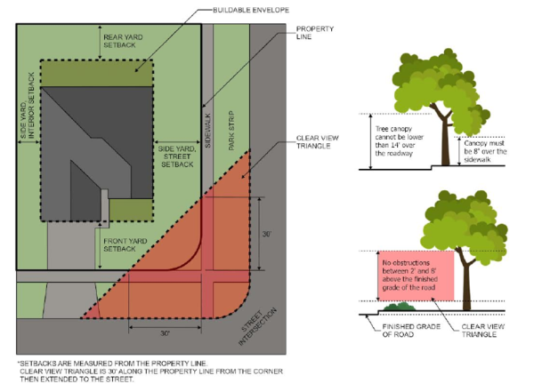 E. Clear view area, sight triangles for intersections near curves. It is the intent of the city to provide drivers of vehicles, cyclists, and pedestrians approaching intersections, with an unobstructed view of the intersection and sufficient lengths along the intersecting roads to permit them to safely anticipate and avoid potential conflicts. In some areas of the city, in addition to the corner lot and driveway clear-view areas, sight triangles involving nearby curves may be included.
 ![]()
This Graphic is for illustration purposes only. The design engineer for the project will determine the actual design triangles.
(Code 1998, § 10-9-2; Ord. No. 98-OM006, 3-24-1998; Ord. No. 011-2009, 12-8-2009; Ord. No. 2018-012, 10-23-2018)
Adopted by Ord. 06-2022 on 9/21/2022
10-9-3 Irrigation Waters
Changes in any irrigation water system, including the rerouting or alteration of open ditches, shall be approved by the city and the associated water company before any alteration or construction begins.
(Code 1998, § 10-9-3; Zon. Ord., 5-8-1991; Ord. No. 011-2009, 12-8-2009; Ord. No. 2018-012, 10-23-2018)
Adopted by Ord. 06-2022 on 9/21/2022
10-9-4 Frontages; Curb, Gutter And Sidewalk
Unless specifically exempted, any project requiring a development and/or building permit for a primary structure (constructed after November 1, 2018) shall require that the owner and/or their agents and assigns construct, improve, or install frontage improvements in accordance with city standards, including, but not limited to, the city standards and specifications manual.
- Required improvements may include one or more of the following:
- Dedication of right-of-way. Refer to the city department of public works standards and specifications manual for street right-of-way width.
- Grading to future right-of-way.
- Design of structures to accommodate future right-of-way.
- Sidewalks. Sidewalks shall be concrete and a minimum five feet wide and a minimum four inches thick. All sidewalks that cross residential driveways shall be six inches thick minimum. All sidewalks that cross commercial driveways shall be eight inches thick minimum. Sidewalks at all intersections of public streets shall conform to adopted American Disabilities Act standards.
- Curb and gutter or swales. Refer to the city department of public works standards and specifications manual for streets requiring curb and gutter or swales.
- Minimum grades for curb and gutters and streets shall not be less than 0.5 percent, and from the crown of road to the lip of the curb shall be a minimum of two percent.
- Swales may be designed to replace curb and gutter. Designs shall include, but are not limited to, providing methods and planting materials that will be used to ensure the integrity of the swale is maintained in a manner that will prevent erosion of soils and infiltration of silt and other materials along the swale area and into storm retention systems, streets, and other properties. The developer is responsible to maintain the swales for a warranty period of two years.
- Park strips. Park strips shall be at least seven feet wide. At the sole discretion of the city engineer, when connecting with existing infrastructure, the required width of the park strip may be increased or reduced to match the existing infrastructure.
- Stormwater. The developer shall have the responsibility of providing for on-site stormwater retention/detention. If off-site retention/detention is required, the developer shall have the responsibility of providing off-site storm drain extensions in order to satisfactorily dispose of drainage.
- Planting of street trees and other landscaping. Refer to PCC 7-1-8 for park strip requirements.
- Setbacks from the property line or dedication of right-of-way to accommodate required improvements.
- Determining the frontage to be improved. It is the city's intent that the entire length of frontage for the property shall be improved.
- Exception. When a parcel is larger than the surrounding parcels and/or lots the city may reduce the frontage improvement requirement. In determining the reduced improvement requirement, the city will consider the greater of the following:
- Minimum frontage for the property zone.
- Minimum frontage for the structure and required side setback.
- Gaps and distance to street corner or property line. If the distance to the street corner or property line and or amount to complete a gap is 50 percent or less than the length of the required frontage, completion of the gap or to the corner will be required.
- Where curb, gutter and/or sidewalk previously installed by the city exists on a proposed building lot or development, then compensation of said improvements at current installation costs shall be made by the owner and/or their agents and assigns to the city. The city reserves the right to negotiate the placement and compensation requirements described in this section. Compensation shall be as follows: 100 percent of the pro rata share during the first five years following the date of completion of the improvements by the city. The pro rata share shall be depreciated 20 percent per year thereafter, and no pro rata share shall be due to the city after ten years following the completion date of the improvements by the city.
- Preconstruction meeting. A preconstruction meeting will be held with the owner and/or the owner's agents and assigns, the general contractor for the project, and city staff prior to beginning any construction on the project.
- It is the owner's and/or their agents and assigns responsibility to notify the general contractor and all appropriate subcontractors for the project of their required attendance at the preconstruction meeting.
- If applicable, the stormwater notice of intent (NOI) and stormwater pollution prevention plan (SWPPP) must be in place prior to the preconstruction meeting.
- Exception. When a parcel is larger than the surrounding parcels and/or lots the city may reduce the frontage improvement requirement. In determining the reduced improvement requirement, the city will consider the greater of the following:
(Code 1998, § 10-9-4; Ord. No. 97-OM001, 1-28-1997, eff. 1-29-1997; Ord. No. 011-2009, 12-8-2009; Ord. No. 2018-012, 10-23-2018)
Adopted by Ord. 06-2022 on 9/21/2022
10-9-5 Residential Driveways
A. Individual driveways shall be provided for all residential building lots.
1. A primary drive access may serve no more than two parcels. However, if the lots are part of a cluster, inner block, or PUD development, a shared driveway to parking access may be allowed.
B. The drive approach for the driveway shall be a minimum width of twelve feet (except for driveways required to meet emergency vehicle access) and shall not exceed the maximum width of thirty five feet (35'). A secondary drive approach may be permitted in accordance with the Providence City Standard Construction Drawings.
C. No down sloping driveways shall be permitted unless otherwise approved by the city due to unusual topographic constraints. If a down slope is allowed, to prevent flooding of the property, provisions for storm water must be included in the design. The driveway must maintain a positive slope away from the home as required by applicable building codes.
D. The minimum grade at which a driveway shall be built is two percent (2%) slope, and a driveway shall not exceed a slope of twelve percent (12%).
E. Residential driveways shall be constructed with asphalt or concrete through the area in the city right-of-way in accordance with Providence City Department of Public Works Standards and Specifications.
1. Driveways required to meet emergency vehicle access. If a driveway, or a portion of a driveway, is deemed necessary to meet the fire code, as a minimum it must be 20’ wide, constructed and maintained to support the imposed load of fire apparatus weighing up to 75,000 pounds so as to provide all-weather driving capabilities. Fire apparatus access driveways shall not exceed ten (10%) in grade, unless approve by the fire code official. Driveways required to meet fire apparatus access may also require an approved turnaround.
2. Approaches shall be constructed in accordance with Providence City Department of Public Works Standards and Specifications.
(Code 1998, § 10-9-5; Zon. Ord., 5-8-1991; Ord. No. 011-2009, 12-8-2009; Ord. No. 2018-012, 10-23-2018)
Adopted by Ord. 06-2022 on 9/21/2022
10-9-6 Lot Area; Other Buildings
No portion of a lot area, open space, off-street parking area or yard required about or in connection with any building or use for the purpose of complying with this title may be included as part of a lot area, open space, off-street parking area or yard similarly required for any other building or use, except as permitted in Mixed-Use Districts.
(Code 1998, § 10-9-6; Zon. Ord., 5-8-1991; Ord. No. 011-2009, 12-8-2009; Ord. No. 2018-012, 10-23-2018)
Adopted by Ord. 06-2022 on 9/21/2022
10-9-7 Lot Area; Accessory Buildings
See Chapter 10-12
10-9-8 Mining And Similar Actvities
The purpose of this section is to allow for the use of certain natural resources in the city by regulating mining and similar activities within the city; to protect citizens and the environment from potential hazards or negative impacts that may result from these activities; and to establish a standard method and form of application and approval for a conditional use permit for mining and similar activities. A. Permitted zoning districts. Mining and similar activities shall not be permitted in any zoning district in the City, unless expressly approved by the administrative land use authority. If approved as detailed herein, said use shall operate as a conditional use, subject to annual review by the administrative land use authority. Mining and similar activities shall not be permitted which might violate the provisions of any city master plan. B. Sensitive areas. 1. Mining and similar activities shall not be permitted in any non-developable sensitive area as designated in and subject to Chapter 5 of this title. 2. Mining and similar activities may be permitted in potentially developable sensitive areas as designated in and subject to Chapter 5 of this title. C. Standards for safety. Mining and similar activities are subject to applicable Mine Safety and Health Administration (MSHA) standards and Occupational Safety and Health Administration (OSHA) standards. D. Mining area. The mining area includes the entire area to be used for the mining operation, including but not limited to, staging areas, crushing areas, stockpile areas, storm water and dust control ponds, etc. 1. Distance from residential structures. a. All sections of the mining area must be a minimum of 200 feet from the nearest residential structure property line. b. The crusher or similar machinery must be a minimum of 500 feet from the nearest residential structure. 2. Security, fencing and signage. a. Fencing. The perimeter entire mining area must be fenced. Fences for areas where active mining is occurring must be a minimum of 6 feet in height with locking gates and reasonably deters children from entering the property. b. Signage. No trespassing signs are required. Additional signage such as, trucks entering roadway, speed limit, and hours of operation may be required. E. Temporary gravel pit. In conjunction with an approved development or subdivision, the administrative land use authority may approve a temporary gravel pit and associated crusher as a conditional use, subject to annual review. Said gravel pit shall be permitted to: 1. provide materials to be used on the approved development or subdivision site related to infrastructure, improvement installation or individual lot improvements; 2. export excess materials to an off-site location. 3. In addition to the application requirements listed below, the application for a temporary gravel pit shall also include a crushing schedule and the volume of material to be used on-site and the volume of material to be exported to achieve final grading plans. F. Complete application. A complete conditional use application shall include the following: 1. Application and payment of application fee. a. Development fees are established by resolution of the city council. The approved fee schedule is posted on the city's website or available at the city offices. 2. Completed, signed and initialed conditional use information form. 3. The property owner’s affidavit, if other than the applicant. 4. A list of the names and addresses for any adjacent property owner as defined in Chapter 1-3 Section 2 Definitions of this code. 5. A business plan with detailed description of the specific use, including hours of operation and safety plans. 6. A site plan prepared and certified by a licensed surveyor and/or engineer detailing the location of: a. all proposed uses on the site; b. proposed berms or landscaping to be used for visual and/or noise buffer; c. a metes and bounds description of the proposed extraction areas and limits of disturbance; d. storm drainage, dust control, and a notice of intent (NOI) and stormwater pollution prevention plan (SWPPP); e. an air quality plan approved by the Utah Division of Air Quality f. an emergency vehicle access and fire prevention/suppression plan; and g. any other requested applicable information. 7. A traffic plan, if exporting material, that includes the following: a. haul routes (map and narrative),including precautions used on steep grades (grades over 8%), brake checks, and prohibiting shifting on hills; b. traffic safety measures; c. hours of operation for on-site work; d. hours of operation for truck routes; e. roadway protection and maintenance; f. truck staging and idling plan; g. communication and coordination procedures; and h. compliance and monitoring plan. 8. If applicable, a detailed reclamation plan for the site, including extraction, staging, stockpiling and crushing areas. Said plan shall be prepared and certified by a licensed surveyor and/or engineer and shall indicate proposed final slopes, placement and depths of topsoil, soil and slope stability calculations and proposed vegetation materials to be used; and a. An estimated reclamation budget prepared by a qualified individual, including projections for inflation based on the proposed length of operation; and b. A bond or escrow meeting the requirements in Chapter 11-5 Section 7 Improvement Completion Assurance of this code. G. Criteria for Approval. The administrative land use authority shall make specific findings to confirm that mitigation strategies for any proposed mining or similar activity for which an annual conditional use permit is requested fully complies with the following criteria: 1. A determination as to whether the property is located within any waterway, floodplain, or wetland, and if so, all federal and state regulations must be satisfied. 2. A determination that there is adequate emergency vehicle access to and through the area and fire hydrants for a water supply. 3. A determination that, to the extent possible, truck routes avoid school zones and periods of high volume school traffic, and have safety precautions for steep grades. 4. A determination that mining operations (including extraction, stockpiling, staging, crushing) shall meet the standards for a conditional use permit listed in Chapter 10-3 Section 5 of this title.
Adopted by Ord. 08-2025 Mining on 12/19/2025