
Rancho Palos Verdes
City Zoning Code
City Zoning Code
ARTICLE VI
USE AND DEVELOPMENT STANDARDS
CHAPTER 17.49.- LOTS, SETBACKS, OPEN SPACE AREA AND BUILDING HEIGHT[2]
Editor's note— Ord. No. 678U, § 4(Att. B), adopted April 16, 2024, renumbered the former Ch. 17.48, §§ 17.48.010—17.48.080 as Ch. 17.49, §§ 17.49.010—17.49.080 as set out herein. The historical notation has been retained with the amended provisions for reference purposes.
17.49.010. - Purpose.
This chapter clarifies, amplifies and makes certain exceptions to district development standards pertaining to lot area and dimensions, setbacks, open space area and building height. This chapter also provides certain general development standards which apply to more than one zoning district.
(Code 1981, § 17.48.010; Ord. No. 78(part), 1975; Ord. No. 320, § 7(part), 1997)
Editor's note— Ord. No. 678U, § 4(Att. B), adopted April 16, 2024, renumbered the former § 17.48.010 as § 17.49.010 as set out herein. The historical notation has been retained with the amended provisions for reference purposes.
17.49.020. - Lot area and dimensions.
A.
No lot shall be created with, or reduced to an area or dimension, less than the minimum lot area and dimensions required in the respective base zoning district, except as provided in chapter 17.42 (Residential Planned Development). Existing lots which have an area or dimension less than the minimum required shall not be reduced in area or in the insufficient dimension.
B.
Lot width shall be the distance from side property line to side property line, measured at a point midway between the front and rear property lines, along a line parallel to a straight front property line or to a tangent at the midpoint of a curved front property line.
C.
Lot depth shall be the distance from the midpoint of the front property line to the midpoint of the rear property line.
D.
For lots with no rear property line, lot depth shall be the distance from the midpoint of the front property line to the point where the side property lines intersect.
(Code 1981, § 17.48.020; Ord. No. 78(part), 1975; Ord. No. 158, § 1(part), 1982; Ord. No. 320, § 7(part), 1997)
Editor's note— Ord. No. 678U, § 4(Att. B), adopted April 16, 2024, renumbered the former § 17.48.020 as § 17.49.020 as set out herein. The historical notation has been retained with the amended provisions for reference purposes.
17.49.030. - Setbacks.
Except as otherwise provided in this chapter, no building, structure or portion of any building or structure, located under or above the ground, shall be constructed or extended closer to any street side, interior side, front or rear property line than the respective front, side or rear setback required in the district in which the property is located. On lots abutting a private street, setbacks shall be measured from the street easement line for measuring setbacks.
A.
Property line designation. The following methods for determining a property line designation (front, side, street side or rear) shall apply to all lots in the city. In cases of uncertainty, the director shall determine the appropriate property line designations. The director's decision may be appealed to the planning commission and the planning commission's decision may be appealed to the city council pursuant to chapter 17.80 (Hearing notice and appeal procedures).
1.
Front. For interior lots, the front property line shall be that property line abutting the primary public or private street of access. For corner lots, the front property line shall be the shorter property line abutting the primary public or private street of access. For corner lots where the front and street side property lines intersect on a curve, the front property line shall begin and the street side property line shall end at the midpoint of the curve. For flag lots, the front property line shall be that property line which most nearly parallels the public or private street of access and which abuts the pole, not including the pole.
2.
Street side. For corner lots, any property line other than the front or rear property line which abuts the public or private right-of-way shall be a street side property line. For wedge or triangular shaped lots with a straight or curved front property line, no rear property line shall exist.
3.
Rear. The rear property line shall be the property line opposite and most distant from the front property line.
4.
Interior side. An interior side property line shall be any property line which does not abut a public or private right-of-way and which is not a front or rear property line.
B.
Future right-of-way lines. If any future street right-of-way line has been established by plan adopted by the city council, this line shall be considered to be the property line for purposes of determining setbacks.
C.
Hillside setbacks.
1.
Front setbacks. Any lot having a grade of more than 25 percent, as measured from the curbline to a point midway between the side lot lines and over a distance of 50 feet from the front lot line, may have a front yard setback which is not less than 50 percent of the depth required for a front yard setback in the district in which said lot is located. Garages with driveways which directly access the street shall not be less than 20 feet from the front or street side property line.
2.
Side and rear setbacks. If the following conditions occur:
a.
There is a slope between building pads of adjoining lots held under separate ownership;
b.
The difference in vertical elevation between the top and the toe of the slope is six feet or more; and
c.
Unless alternate setbacks are approved by the building official, when the grade of the slope between the top and toe of an ascending slope is two feet horizontal to one foot vertical (2:1 or 50 percent) or greater, or the grade of a descending slope is three feet horizontal to one foot vertical (3:1 or 33 percent) or greater, then the following hillside setbacks shall apply:
i.
On the downslope lot, the minimum distance between the toe of the slope and any portion of the main building shall not be less than one-half the vertical height of the slope (as measured from toe to top of slope), with a minimum of three feet and a maximum of 15 feet; and
ii.
On the upslope lot, the minimum distance between the top of the slope and any portion of the main building shall not be less than five feet.
D.
Landscaping. In Single-Family Residential (RS) Districts, except for driveways, paved walkways and parking areas, all of the required front and street-side setback areas shall be landscaped. In Single-Family Residential (RS) Districts, driveways, paved walkways and parking areas shall not cover more than 50 percent of the required front or street-side setback areas. Any pervious or semi-pervious surface which is part of or within a driveway or parking area shall not be considered to be landscaping.
E.
Exceptions.
1.
Architectural features. Cornices, belt courses and other similar architectural features may project into the required setback area not more than four inches for each foot of the required setback, provided that no portion of such an architectural feature is located or projects below eight feet above grade; and provided, that there are no vertical supports or members within the required setback area.
2.
Garden windows and window coverings. Garden windows and window coverings, including retractable awnings, may project into the required interior side and rear year setback areas not more than four inches for each foot of the required setback, provided that there are no vertical supports within the required setback area.
3.
Roof eaves. Roof eaves may project into the required setback not more than six inches for each foot of the required setback; provided that there are no vertical supports within the required setback areas. Roof eaves shall not be calculated towards lot coverage as defined in section 17.02.040(A)(5).
4.
Fireplace chimneys. Chimneys may project two feet into any required setback.
5.
Minor structures and mechanical equipment. Trash enclosures, storage sheds or playhouses less than 120 square feet, doghouses, play/sports equipment, fountains, light fixtures on a standard or a pole, flagpoles, enclosed water heaters, barbecues, outdoor kitchens, garden walls, air conditioners, pool filters, vents and other minor structures or mechanical equipment shall not be located in any setback area in residential districts except as specified below:
a.
Minor structures and equipment less than six inches in height, as measured from adjacent finished grade, may be located in any required front, side or rear setback;
b.
Minor structures and mechanical equipment which exceed six inches in height, as measured from adjacent finished grade, may be permitted within an interior side or rear setback area by the director, through a site plan review application, unless the minor structure is a playhouse less than 120 square feet, a dog house, or play/sports equipment, then a site plan review application shall not be required; provided that no significant adverse impacts will result and provided that:
i.
Noise levels from mechanical equipment do not exceed 65 dBA as measured from the closest property line;
ii.
No part of any minor structure or mechanical equipment, exceeds six feet in height (as measured from adjacent finished grade);
iii.
If located within a rear setback area which abuts a public or private street, the minor structure or mechanical equipment is not visible from the public or private street;
iv.
No part of any mechanical equipment, including, but not limited to, pool/spa equipment and air conditioning/heating equipment, extends within three feet of the property line; and
v.
No part of any minor structure extends within three feet of the property line. However, minor structures (not mechanical equipment) may be allowed to abut the side or rear property line, provided that the minor structure:
(A)
Is placed adjacent to an existing solid wall;
(B)
Does not exceed the maximum height of the adjacent solid wall, up to a maximum of six feet;
(C)
Is less than 120 square feet in size; and
(D)
Is located a minimum of three feet from an adjacent structure, unless the structures are parallel and abutting each other, as determined by the director.
c.
The following minor structures shall be permitted within a front yard setback area provided that the minor structure does not exceed 42 inches in height, as measured from adjacent pre-construction grade:
i.
Balustrades and columns;
ii.
Light fixtures, including light fixtures attached to a standard, a pole or a column;
iii.
Fountains, provided that the fountain is within the maximum front yard landscape requirement and is not operated between the hours of midnight and 7:00 a.m.;
iv.
Ornamental ponds less than 18 inches deep; and
v.
Decorative landscape elements, including, but not limited to, rocks, boulders, raised planter beds, pilasters and statuary.
6.
Decks, walkways and paving. Decks, asphalt paving, concrete walkways or similar ground surfacing less than six inches in height (as measured from adjacent finished grade), shall not be subject to setback requirements. Decks (including any railing), six inches to 30 inches in height (as measured from adjacent finished grade), may be permitted in any setback area upon determination by the director, through a site plan review application, that no significant adverse impacts will result.
7.
Swimming or ornamental pools. Swimming pools, spas, ornamental pools and any other body of water measuring 18 inches or more deep, may be located within an interior or rear yard setback, provided that no portion of said pool is located closer than three feet from the property line. Ornamental ponds less than 18 inches deep may be located within any required setback and may abut any property line.
8.
Foundations and footings. Below grade foundations and/or footings for above ground main buildings may be located in any setback, provided that no portion of the foundation or footing is located closer than three feet from the property line.
9.
Subterranean structures. Subterranean structures, including holding tanks, which are located entirely below grade shall not be extended any closer than half of the required setback to any property line or three feet from the property line, whichever is greater.
10.
Fences, walls and hedges. Fences, walls and hedges may be permitted within any front, interior side, street side or rear yard setback pursuant to section 17.76.030 (Fences, Walls and Hedges).
F.
Easements. Setbacks from legal easements, other than street right-of-way easements, shall not be required. In addition to the appropriate review and approval by the city, no construction of any structure or improvement is allowed within a legal easement without written authorization from the legal holder of the easement. Such authorization shall be in a form that can be recorded and shall be reviewed by the city attorney.
G.
Garages. An applicant shall apply for a setback reduction through a variance application, as per chapter 17.64 (Variances), for converting a legally existing indirect access driveway to a direct access driveway, even in the case where no new square footage is to be added to the residence or garage.
(Code 1981, § 17.48.030; Ord. No. 78(part), 1975; Ord. No. 90, § 5(part), 1977; Ord. No. 158, §§ 1, 2, 1982; Ord. No. 194, § 9(part), 1985; Ord. No. 320, § 7(part), 1997; Ord. No. 510, § 15, 6-29-2010; Ord. No. 529, § 11, 11-15-2011)
Editor's note— Ord. No. 678U, § 4(Att. B), adopted April 16, 2024, renumbered the former § 17.48.030 as § 17.49.030 as set out herein. The historical notation has been retained with the amended provisions for reference purposes.
17.49.040. - Open space area.
An open space area shall be provided on each lot with a residential structure. Open space area shall not include any portion of a lot or building site which is within the definition of lot coverage, as defined in section 17.02.040(A). Lot coverage shall not exceed the maximum area requirements established in the district development standards (see table 02-A in chapter 17.02). For purposes of calculating lot coverage, a private street easement area shall not be considered a part of the lot area. For flag lots, the pole portion of any flag lot that is encumbered by an access easement benefiting another property shall not be considered a part of the lot area. In no case shall any hardscape or other improvements within a private street easement or a flag-lot pole that is encumbered by an access easement be counted as lot coverage. In multiple-family residential units, private outdoor decks and balconies with one minimum horizontal dimension of seven feet which are designated for the exclusive use of the occupants of an individual unit may comprise up to 30 percent of required open space.
(Code 1981, § 17.48.040; Ord. No. 78(part), 1975; Ord. No. 320, § 7(part), 1997; Ord. No. 355, § 9, 2000; Ord. No. 510, § 10, 6-29-2010)
Editor's note— Ord. No. 678U, § 4(Att. B), adopted April 16, 2024, renumbered the former § 17.48.040 as § 17.49.040 as set out herein. The historical notation has been retained with the amended provisions for reference purposes.
17.49.050. - Building height.
A.
No portion of any building or structure shall exceed the maximum building height listed in the district development standards except as follows:
1.
Antennas and satellite dishes and associated screening pursuant to section 17.76.020 (Antennas) of this Code.
2.
In nonresidential zoning districts, penthouses or roof structures for the housing of elevators, stairways, tanks, ventilating fans or similar equipment required to operate and maintain the building, fire or parapet walls, skylights, dormers, towers, church steeples, flagpoles, silos, water tanks or similar structures, upon determination by the director through a site plan review application, that the roof equipment or structures:
a.
Will not exceed the maximum ridgeline of the existing structure;
b.
May be erected above the height limits prescribed in this section pursuant to the requirements of the building code; and
c.
Will not cause significant view impairment from adjacent property.
No penthouse, roof structure or any space above the height limit shall be allowed for the purpose of providing additional living or floor space.
3.
In residential zoning districts, skylights and vents/ducts required by the California Building Code, may exceed the height limits prescribed in this chapter, upon determination by the director, through a site plan review application, that the skylights and/or vents/ducts will not exceed the maximum ridgeline or the existing residence and will not cause a significant view impairment from adjacent property, as defined in chapter 17.02 (Single-Family Residential (RS) Districts). Chimneys, attached to the main residence or to an accessory structure, which can be safely erected and maintained at a height that exceeds the maximum ridgeline of the structure to which it is attached, may be approved by the director, provided that they do not exceed the minimum height requirements of the building code as determined by the building official.
B.
Any roof mounted equipment and/or architectural features, excluding renewable energy systems such as photovoltaic systems (solar panels) and/or solar water heating systems, which are addressed in section 17.83.050 of this title, that exceed the maximum building height listed in the district development standards and do not meet the review criteria listed in section 17.48.050(A) of this chapter may be permitted upon determination by the planning commission, through a site plan review application, that the equipment and/or features:
1.
May be erected above the height limits pursuant to the requirements of the building code; and
2.
Will not cause significant view impairment from adjacent property, as defined in section 17.02 (Single-Family Residential Districts).
C.
Notification of a site plan review application to the planning commission shall be given to the owners of all parcels located adjacent to the parcel on which the proposed roof-mounted equipment and/or architectural feature is located. Notification shall also include all parcels which are located directly across any public or private right-of-way from the subject parcel. Notification shall be done using the last-known county assessor tax roll. Upon approval by the planning commission of any structure or architectural feature pursuant to subsection (B) of this section, the director shall provide written notice of that decision pursuant to section 17.80.040 (Hearing notice and appeal procedures) of this title. Notice of denial shall be given to the applicant. Any interested person may appeal the planning commission's decision to the city council pursuant to chapter 17.80 (Hearing notice and appeal procedures) of this title.
D.
Accessory structures. Decks, playhouses, treehouses, detached garages, pools or bathhouses, dressing rooms, saunas, jacuzzi and pool enclosures, gazebos, flagpoles, stand-alone chimneys or any structures or buildings which are physically detached and incidental to the use of the main building are considered accessory structures. Such accessory structures shall be limited to 12 feet in height, as measured from the lowest preconstruction grade adjacent to the foundation wall to the ridge. Treehouses shall be measured from the lowest base of the tree to the roof ridge or railing, whichever is higher. In cases of uncertainty, the director shall determine whether a structure is detached and incidental to the use of the primary structure. The director's decision may be appealed to the planning commission, and the planning commission's decision may be appealed to the city council pursuant to chapter 17.80 (Hearing notice and appeal procedures). Upon a finding by the director that a detached garage, stand-alone chimney, treehouse, or a flagpole will have no significant impact on views from adjacent properties, the garage, standalone chimney, treehouse, or flagpole may be exempted from the 12-foot height limitation, but shall comply with any other height limitations of this Code.
(Code 1981, § 17.48.050; Ord. No. 78(part), 1975; Ord. No. 90, § 5(part), 1977; Ord. No. 119, § 1, 1979; Ord. No. 150, § 14, 1982; Ord. No. 166, §§ 6, 7, 1983; Ord. No. 226, §§ 8, 9, 1988; Ord. No. 320, § 7(part), 1997; Ord. No. 481, §§ 12, 13, 2008; Ord. No. 529, §§ 12, 13, 11-15-2011; Ord. No. 655, § 3, 12-7-2021)
Editor's note— Ord. No. 678U, § 4(Att. B), adopted April 16, 2024, renumbered the former § 17.48.050 as § 17.49.050 as set out herein. The historical notation has been retained with the amended provisions for reference purposes.
17.49.060. - Extreme slope.
No development or construction of any structure shall be allowed on any extreme slope (grade of 35 percent or greater), except as follows:
A.
Trash enclosures, enclosed mechanical equipment or pool equipment located within an area of less than 50 square feet, provided that the structures and/or equipment are not located more than six feet from the top or toe of the slope and are adequately screened from view from adjacent properties and the public right-of-way to the satisfaction of the director;
B.
Structures and improvements allowed pursuant to section 17.76.060 (Extreme Slope Permit);
C.
Satellite dish antennas allowed pursuant to section 17.76.020 (Antennas);
D.
Grading and retaining walls allowed pursuant to section 17.76.040 (Grading Permit);
E.
Fences, walls and hedges allowed pursuant to section 17.76.030 (Fences, Walls and Hedges);
F.
At grade steps or stairs less than six inches in height, as measured from adjacent existing grade; and
G.
Construction of new residences (including habitable and non-habitable space) on previously undeveloped, recorded and legally subdivided lots existing as of November 25, 1975, or if within Eastview, existing as of January 5, 1983, which are not currently zoned open space/hazard, if the director or planning commission finds that such construction, as conditioned, will not threaten the public health, safety and welfare, provided that such structures are consistent with the permitted and uses and development standards for the underlying zoning designations of the lots.
H.
Renewable energy systems (photovoltaic and solar water heating) pursuant to section 17.83.050 (Application Procedures for Renewable Energy Systems (photovoltaic and solar water heating)).
(Code 1981, § 17.48.060; Ord. No. 194, § 9(part), 1985; Ord. No. 226, § 10, 1988; Ord. No. 320, § 7(part), 1997; Ord. No. 463, § 11, 2007; Ord. No. 481, § 14, 2008)
Editor's note— Ord. No. 678U, § 4(Att. B), adopted April 16, 2024, renumbered the former § 17.48.060 as § 17.49.060 as set out herein. The historical notation has been retained with the amended provisions for reference purposes.
17.49.070. - Intersection visibility.
On corner lots located at the intersection of two or more highways, streets or common driveways or combinations thereof, in all districts, no fence, wall, hedge, sign, structure, shrubbery, mound of earth or other visual obstruction over 30 inches in height, as measured from the adjacent street curb elevation, shall be erected, placed, planted or allowed to grow within the triangular space referred to as the "intersection visibility triangle." The intersection visibility triangle shall be the area formed by the intersection of extended curblines and a line joining points on the curb 60 feet (measured along the curblines) from the point of intersection of the curbline extensions.
A.
In districts where the required front or street-side setbacks allow a building to be constructed within the intersection visibility triangle, fences, walls, structures or shrubbery may be allowed to exceed the prescribed height limit, if they are setback from the property line a distance equal to the setback of the allowed building.
B.
Trees located within the intersection visibility triangle which are trimmed to the trunk up to a minimum branch height of six feet above the adjacent street curb elevation are exempt from these regulations.
C.
The intersection visibility triangle shall be shown on all landscaping plans, grading plans and tentative tract maps for related intersections when required by the director. In cases where an intersection is located on a vertical curve, a profile of the sight line may also be required by the director. Any landscape plan submitted shall show the common name, locations and mature dimensions plotted to scale of all proposed trees, shrubs and plants within the intersection visibility triangle.
D.
Proposed improvements or structures which exceed the 30 inches height limit may be permitted in the intersection visibility triangle by the director through a site plan review application, upon determination by the director of public works that the location and/or height of the existing or proposed structure within the intersection visibility triangle allows for the safe view of oncoming traffic by a driver approaching an intersection, and thus no intersection visibility impacts would result. Upon approval of any such structure or improvement, the director shall provide written notice of the decision pursuant to section 17.80.040 (Notice of decision by director) of this title. Notice of denial shall be given to the applicant. Any interested person may appeal the director's decision to the planning commission pursuant to chapter 17.80 (Hearing notice and appeal procedures) of this title, and the planning commission's decision may be appealed to the city council.
(Code 1981, § 17.48.070; Ord. No. 132, § 3(part), 1980; Ord. No. 175, § 18, 1983; amended during 11-97 supplement; Ord. No. 320, § 7(part), 1997; Ord. No. 540, § 5, 11-20-2012)
Editor's note— Ord. No. 678U, § 4(Att. B), adopted April 16, 2024, renumbered the former § 17.48.070 as § 17.49.070 as set out herein. The historical notation has been retained with the amended provisions for reference purposes.
17.49.080. - Treehouse.
A.
Definitions. The following words, terms and phrases, when used in this section, shall have the meanings ascribed to them in this subsection, except where the context clearly indicates a different meaning:
Treehouse means a structure, including, but not limited, to a playhouse or decks with or without vertical supports in or on top of the ground, built among the branches of a tree, or which is built around or against a tree.
B.
Treehouses up to 64 square feet with the floor of the treehouse less than eight feet above adjacent grade and with a roof ridge not to exceed 12 feet above adjacent grade, as measured from the lowest base of the tree, will be exempt from subsection (C) of this section.
C.
Treehouses exceeding 64 square feet located on trees are allowed in single-family residential zoning districts through a site plan review application, provided that the treehouse meets all the following requirements:
1.
It does not exceed 120 square feet with no more than one treehouse per half acre.
2.
It has no electrical or plumbing connections.
3.
It complies with the required setbacks and accessory structure height standards for the designated zoning district.
4.
It will not have a significant impact on views from adjacent properties per section 17.02.040 or from public viewing areas identified in the city's general plan or coastal specific plan and will not create an unreasonable infringement of privacy on the occupants of abutting residences. A silhouette may be required to conduct a view impact and/or privacy assessment at the discretion of the director.
(Ord. No. 655, § 3, 12-7-2021)
Editor's note— Ord. No. 678U, § 4(Att. B), adopted April 16, 2024, renumbered the former § 17.48.080 as § 17.49.080 as set out herein. The historical notation has been retained with the amended provisions for reference purposes.
17.50.010. - Purpose.
This chapter ensures the provision of adequate off-street parking facilities in conjunction with any nonresidential use or development. These standards should be considered the minimum required to preserve the public health, safety and welfare, and more extensive parking provisions may be warranted in particular circumstances.
(Code 1981, § 17.50.010; Ord. No. 78(part), 1975; Ord. No. 320, § 7(part), 1997)
17.50.020. - Parking requirements.
Parking shall be provided in accordance with the list of uses under this section. Where the standards result in a fraction, the next larger whole number shall be the number of spaces required. For additions to existing developments, the increased parking requirement shall be based only on the addition. A minimum of two spaces shall be provided for any use or development regardless of the size or scope of the use or development. If the specific use is not listed in the following table 50-A, the parking requirements listed in table 12-A of chapter 17.12 (Commercial Districts) shall apply. Disabled parking shall be provided in accordance with the current state amended California Building Code. The number of disabled parking spaces required by the current state amended California Building Code shall constitute a portion of the total parking required under this section.
Table 50-A
(Code 1981, § 17.50.020; Ord. No. 78(part), 1975; Ord. No. 320, § 7(part), 1997)
_____
17.50.030. - Joint use and common parking facilities.
The planning commission may permit the joint use of parking facilities to meet the standards for certain uses under the following conditions:
A.
Up to one-half of the parking facilities required for a primarily daytime use may be used to meet the requirements of a primarily nighttime use and up to one-half of the parking facilities required for a primarily nighttime use may be used to meet the requirements of a primarily daytime use, provided that such reciprocal parking arrangement shall comply with subsection (C) of this section.
B.
The parking facilities required for a primarily daytime use or for specific days of use may be used to satisfy up to 50 percent of the requirements for a church or school auditorium subject to requirements set forth in subsection (C) of this section.
C.
The parties concerned shall show that there is no substantial conflict in the principal operating hours of the building or uses for which the joint use is proposed and shall evidence agreement for such use by a proper legal instrument to which the city is a party.
D.
The planning commission may reduce parking requirements for common parking facilities in shopping centers or other commercial areas where a parking lot with common access and joint use is provided, if a parking demand study that justifies any proposed deviation from the parking requirements listed under table 50-A of this chapter is submitted and approved by the city.
(Code 1981, § 17.50.030; Ord. No. 78(part), 1975; Ord. No. 90, § 5(part), 1977; Ord. No. 320, § 7(part), 1997; Ord. No. 529, § 14, 11-15-2011)
17.50.040. - Development standards.
The following development standards shall apply to all parking areas with six or more spaces:
A.
Parking lot permit. Anyone constructing a parking lot containing six stalls or more, whether separate or in conjunction with a structure, shall obtain a parking lot permit as per section 17.76.010 (Parking Lot Permit).
B.
Transportation demand management parking requirements. New nonresidential developments shall be subject to the applicable transportation demand management parking requirements specified in section 10.28.030 (Transportation Demand Management and Trip Reduction Measures) of this Code.
C.
Location.
1.
Required parking facilities shall be on the same lot as the structure they are intended to serve; except, that with proper legal agreement, the planning commission may approve parking on a separate lot. For sleeping or boarding facilities, including rest homes, dormitories, hotels and motels, the required parking shall be within 150 feet of the building it is to serve. For all other uses, the required parking shall be within 300 feet of the building it is to serve. The above distances are to be measured along a legal and safe pedestrian path from the parking space to the nearest entrance of the building or use for which the parking is required.
2.
The required parking spaces may be located in interior side and rear setbacks. No parking space, either required or otherwise, shall be located in any required front or street-side setback area, unless the base zoning district regulations provide otherwise.
D.
Access. There shall be a minimum ten-foot-wide, four-inch-thick concrete, slab vehicular accessway from a public street or alley to off-street parking facilities. Such accessway shall be designed to specifications approved by the director of public works.
E.
Screening.
1.
Where a parking area abuts a residential district, the parking area and residential district shall be separated by a solid masonry wall not less than five feet in height; except, that this wall shall be 42 inches in height where it is in prolongation of the front setback area of an abutting residential use or district. The planning commission may waive this requirement if additional setback and screening planting or landscaped berms are to be provided.
2.
Where a parking area is across the street from a residential district, there shall be a border of appropriate landscaping not less than ten feet in width, measured from the street right-of-way line, along the street frontage.
F.
Layout and paving.
1.
Parking areas shall provide for a 25-foot outside turning radius within the facility and a 30-foot outside turning radius into public alleys.
2.
Parking spaces shall be arranged so that vehicles need not back onto or across any public sidewalk.
3.
Off-street parking facilities shall be designed so that a vehicle within a parking facility shall not be required to enter a street to move from one location to any other location within that parking facility. Separate noncontiguous parking facilities may be provided with independent entrances for employees and visitor parking, provided the designated use of each lot is clearly identified on proposed plans and at the entrances to each lot.
4.
No dead-end parking aisles serving more than five stalls shall be permitted, unless the aisle is provided with a turnaround area installed in a manner meeting the approval of the director.
5.
Bumpers, tire stops or any other device deemed appropriate by the director, shall be provided along all pedestrian ways, access or street or alley adjacent to any off-street parking area except where screening is located.
6.
All parking areas shall be surfaced with asphaltic or cement concrete paving which is at least three inches thick.
7.
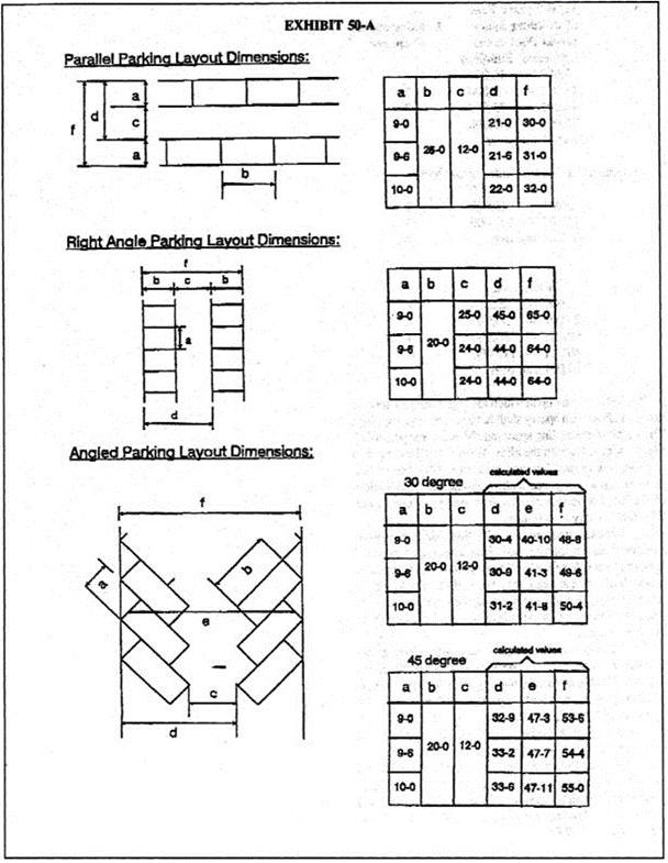
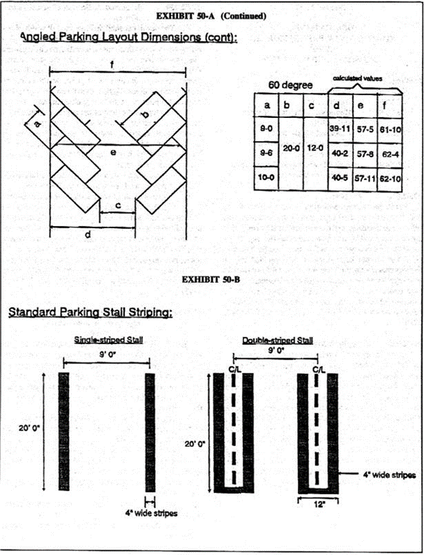
Standard parking stalls shall be designed in accordance with the standards and dimensions specified in the parking lot layout diagrams and tables contained in exhibit 50-A of this section. All parking stalls shall be clearly marked with lines, and access lanes shall be clearly defined with directional arrows to guide traffic. The appropriate parking lot striping, including whether parking stalls shall be single or double striped, as shown in the diagram contained in exhibit 50-B of this section titled "standard parking stall striping", shall be determined by the director. Except for parallel parking stalls, standard parking stalls shall be a minimum of nine feet (width) by 20 feet (depth) in area. Parallel parking stalls shall be a minimum of 26 feet in depth. Compact stalls shall be a minimum of eight feet (width) by 15 feet (depth) in area and shall not exceed 20 percent of the total number of approved spaces, unless a different size stall is authorized or required by the director or planning commission. Compact stalls shall be marked for compact use only.
8.
All off-street parking spaces shall be clearly outlined with lines either painted on the pavement or indicated with special paving materials on the surface of the parking facility.
9.
Parking aisle widths shall be in accordance with the dimensions and standards specified in the parking lot layout diagrams contained in exhibit 50-A of this section. Deviations from the diagrams' standards may be approved by the director, if it is demonstrated to the satisfaction of the director of public works that alternative dimensions and standards will not result in adverse parking lot traffic circulation impacts.
10.
Disabled parking spaces shall be in accordance with the dimensions and specifications of the California Building Code.
G.
Landscaping.
1.
A landscaped planter bed of at least five feet in width shall be installed along the entire parking lot perimeter except for those areas devoted to perpendicular accessways.
2.
A minimum of five percent of the paved parking area shall be devoted to interior planting areas. The extensive use of trees is encouraged to the extent that the trees do not significantly impair views from surrounding properties. All planting areas shall be at least three feet wide. Perimeter planting shall not be considered part of this required interior planting.
3.
Where topography and grading permit, parking lots shall be depressed and/or screened from view by landscaped berms and hedges. Where this is impractical, the use of decorative screening walls and hedges shall be provided.
4.
Where trees already exist on the property, the design shall make the best use of this growth and shade. Such trees shall be protected by a tree well with a diameter sufficient to ensure their continued growth. The five percent interior lot area landscaping standard included in this chapter may be reduced to compensate for the retention of such trees.
5.
Planting areas shall be distributed throughout the lot as evenly as possible, but variations from this pattern may be granted by the staff when a different pattern would result in the overall aesthetic improvement of the project. Innovation in design and materials is encouraged.
6.
Wherever a center divider separates parking stalls facing each other, tree wells shall be established not more than 50 feet apart for large trees (exceeding 20 feet spread at maturity), or not more than 30 feet for small and medium-sized trees.
7.
A full-coverage, permanent irrigation system shall be installed. Hose bibs shall be located at not less than 200-foot intervals to allow for reinforcement of the system by hose watering.
8.
All plantings shall be maintained free of debris and in conformity with the accepted practices for landscape maintenance.
9.
A six-inch-high cement concrete curb shall be constructed at the edge of all landscaped areas.
H.
Drainage and lighting.
1.
All drainage from parking areas for six or more cars shall be taken to a public street, alley, storm drain or natural drainage course to the satisfaction of the director of public works and shall not pass over any public sidewalk.
2.
Lighting provided to illuminate a parking area shall be hooded and arranged and controlled so as not to cause a nuisance either to highway traffic or to adjacent properties; and a lighting plan shall be provided as per chapter 17.56 (Environmental Protection) of this title.
I.
Seasonal or peak parking areas. With the approval of the planning commission, the above development standards may be waived or conditionally waived for a portion of the required parking spaces where:
1.
The applicant can show what portion of the required spaces are required only on a periodic basis, such as seasonal or once a week;
2.
The parking area is planted in turf of a wear-resistant type; and
3.
Provision is made for irrigation and maintenance of the turf.
J.
Signs. The provisions of section 17.75.040 (Sign Permit) shall apply.
K.
Usability. The required off-street parking facilities shall not be used for any purpose other than as required by this chapter. Unless otherwise provided by an approved conditional use permit, no owner or tenant shall lease, rent or otherwise make such required parking available to any person who does not occupy the premises for which the parking is required.
(Code 1981, § 17.50.040; Ord. No. 78(part), 1975; Ord. No. 194, § 11, 1985; Ord. No. 320, § 7(part), 1997)
17.50.050. - Loading.
The following off-street loading spaces shall be provided and maintained for all institutional and commercial uses other than office buildings. The loading spaces shall be not less than ten feet in width, 20 feet in length, and with 14 feet of vertical clearance.
A.
Loading spaces required per total square feet of building space (gross floor area).
B.
When the lot upon which loading spaces are located abuts an alley, such spaces shall have access from the alley. The length of the loading space may be measured perpendicular to or parallel with the alley. Where such loading area is parallel with the alley and said lot is 50 feet or less in width, the loading area shall extend across the full width of the lot. The length of a loading area need not exceed 50 feet for any two spaces.
C.
Loading space required by this title may occupy a required rear or interior side setback, but not a required front or street side setback. Where the loading is permitted in a setback, said setback may be used in calculating the area required for loading, providing that there be no more than one entry or exit per 60 feet of lot frontage or fraction thereof.
D.
All loading spaces shall be separate, striped spaces in addition to the required parking spaces and shall not be located within a required parking lot driveway, backout space or aisle; except, that for commercial buildings with a gross floor area of less than 15,000 square feet, the loading space may be located within a parking lot driveway, back-out space or aisle.
E.
No loading space shall be located on a dead-end driveway, accessway, aisle or alley unless a turn-around circle with a minimum radius of 90 feet is provided adjacent to the loading space.
(Code 1981, § 17.50.050; Ord. No. 78(part), 1975; Ord. No. 320, § 7(part), 1997)
17.52.010. - Purpose.
This chapter ensures dedication of street rights-of-way and the provision of all right-of-way improvements and off-site improvements, to the extent permitted by law, which are necessary and lacking along the street frontage of any lot, at the time of any construction on the lot. Such dedications and off-site improvements, as supported by the findings contained in this chapter and by individual findings when specified herein, are deemed to be reasonably necessary to meet the burdens created by the development and to ensure public safety in access to, and use of, the facilities being constructed.
(Code 1981, § 17.52.010; Ord. No. 78(part), 1975; Ord. No. 320, § 7(part), 1997)
17.52.020. - Applicability.
The necessary dedications and improvements, as described in this chapter, shall be dedicated, provided or their provision guaranteed by bond, cash deposit or other security acceptable to the director of public works, by the property owner prior to issuance of a certificate of occupancy for any new building or for any addition to an existing building which adds 25 percent or more to the building's gross floor area. Additions to single-family residential buildings are exempted from the requirements of this chapter. The provision of right-of-way and off-site improvements may also be a condition of a conditional use permit or variance regardless of whether construction requiring a building permit is involved.
(Code 1981, § 17.52.020; Ord. No. 78(part), 1975; Ord. No. 320, § 7(part), 1997)
17.52.030. - Required dedication of street right-of-way.
A.
The developer shall dedicate the full width of any abutting street right-of-way wherever the existing right-of-way is less than that indicated in the city's general plan or less than the city standard for the street classification, as specified in the city's street standards study report, provided the director of public works makes an individualized determination based upon the proposed project that both of the following elements are satisfied:
1.
The type and extent of the required dedication is reasonably necessary to meet the burdens created by the development, based on traffic to be generated by the development and the nature and quantity of other public burdens created by the development that relate to the need for the dedication; and
2.
There is not a less extensive dedication that would serve the public needs created by the development.
B.
In situations where the findings specified in subsection (A) of this section cannot be made, the required dedication shall be reduced in scale so that the extent of the dedication is reasonably necessary to meet the burdens created by the development. In situations where the findings specified in subsection (A) of this section can be made, the required dedication shall provide for a continuous right-of-way line at the location necessary for the full width right-of-way.
(Code 1981, § 17.52.030; Ord. No. 78(part), 1975; Ord. No. 320, § 7(part), 1997)
17.52.040. - Required right-of-way improvements and off-site improvements.
The following right-of-way improvements and off-site improvements shall, unless existing in an acceptable condition as determined by the director of public works, be provided per city standards and specifications, as filed with the director of public works, or their provision is guaranteed by the applicant in accordance with section 17.52.020 of this chapter:
A.
Street or alley paving. Street or alley paving or repaving, not to exceed the area from the centerline to the curb for the length of the lot frontage. The city finds that this requirement is reasonably related both in type and extent to the impact of the proposed development based upon any one or more of the following:
1.
The impacts of construction vehicles coming to and from the site;
2.
The anticipated traffic generated by the project once completed; and
3.
The project's proportional traffic impact on area roadways.
B.
Sidewalks. Sidewalks, where required by the director of public works, based on the city's street standards study report, not to exceed the length of the lot frontage, or the total length of the front and street-side property lines for corner lots. The city finds that this requirement is reasonably related both in type and extent to the impact of the proposed development based upon any one or more of the following:
1.
The need to provide safe pedestrian access to and from the adjacent properties and the site;
2.
The need, from the perspective of safety, to separate pedestrian traffic from vehicular traffic coming to and from the site; and
3.
The increase in pedestrian traffic generated by the proposed development.
C.
Curbs and gutters. Curbs and gutters, where required by the director of public works, based on the city's street standards study report, not to exceed the length of the lot frontage, or the total length of the front and street-side property lines for corner lots. The city finds that this requirement is reasonably related both in type and extent to the impact of the proposed development based upon any one or more of the following:
1.
The increase in impervious coverage on the property created by the development;
2.
The need to protect down-stream properties from uncontrolled runoff from the site; and
3.
The need to protect vehicles and pedestrians coming to and from the site from uncontrolled and unchanneled stormwater runoff from the site.
D.
Street trees. Street trees, 15-gallon can minimum size (unless a smaller size is specified by the city) at the spacing standards established by the director of public works. The city finds that this requirement is reasonably related both in type and extent to the impact of the proposed development based upon any one or more of the following:
1.
The reduction in existing landscaping and/or open space and natural vegetation on the site;
2.
The need to reduce the aesthetic impacts of the proposed development on the existing streetscape design; and
3.
The need to screen the proposed development from the street.
E.
Ornamental streetlights. Ornamental streetlights, in accordance with the type and spacing requirements designated for the particular street by the director of public works. The city finds that this requirement is reasonably related both in type and extent to the impact of the proposed development based upon any one or more of the following:
1.
The need created by the development to provide safe pedestrian and vehicular access to and from the site at night;
2.
The need to reduce the risk of increased crime to and from persons coming onto the site at night or in early morning hours; and
3.
The need to mitigate the aesthetic impacts of the project by providing for consistency and compatibility with surrounding developments and streetscape design.
F.
Sewer and drainage facilities. Sewer and drainage facilities, as required by the director of public works. The city finds that this requirement is reasonably related both in type and extent to the impact of the proposed development based upon any one or more of the following:
1.
The increase in sewage and/or stormwater runoff generated by the development; and
2.
The need created by the development to provide safe and proper disposal of sewage and stormwater runoff from the site to protect the subject property and surrounding properties.
(Code 1981, § 17.52.040; Ord. No. 78(part), 1975; Ord. No. 320, § 7(part), 1997)
17.52.050. - Relief from required dedication and improvements.
Any applicant for a project subject to the requirements of this chapter may request that the city make additional findings regarding the need for the dedication or improvements required by this chapter or request a reduction in, or the alteration or elimination of, the requirement in accordance with the provisions of this section.
A.
Time for request and fee. A request pursuant to this section shall be made prior to or at the hearing on the related land use approval. If no hearing is required for the land use approval, the request shall be made no later than ten days after the city has informed the applicant of the imposition of the condition or planned imposition of a requirement under this chapter. The request shall be in writing, shall be filed with the director of public works, and shall be accompanied by a processing fee in an amount established by resolution of the city council.
B.
Hearing, notice and determination.
1.
Reviewing body and notice. Where there is a related land use approval requiring a hearing, the request shall be considered by the applicable reviewing body at the time of that hearing. Where there is no related land use approval requiring a hearing, upon receipt of a properly completed request under this section, the director of public works shall set the matter for public hearing before the director and notice that hearing in accordance with the noticing requirements specified in section 17.80.090 (Notice of Hearing).
2.
Criteria for determination. The reviewing body or the director of public works, whichever is applicable under subsection (B)(1) of this section shall, based upon information provided by staff, determine whether the challenged dedication or improvement (requirement) is reasonably related in nature (type) and extent (degree and amount) to the likely impacts of the proposed development project. If the reviewing body or the director of public works determines that the requirement is reasonably related in nature and extent to the likely impacts of the proposed development project, the reviewing body shall affirm the requirement. If the reviewing body or the director of public works determines the requirement is not related in nature (type) to the impacts of the proposed project, the requirement shall be eliminated with respect to that project. If the reviewing body or the director of public works determines that the extent (degree or amount) of the requirement is not reasonably related to the impact of the proposed project, the reviewing body or director of public works shall adjust the dedication or improvement requirement as necessary to ensure a reasonable relationship between the requirement and the project's impacts on the need for that requirement.
C.
Appeal to planning commission or city council. Any interested person may appeal a determination of the director of public works to the planning commission in accordance with the procedures specified in section 17.80.050 (Appeal to Planning Commission). The planning commission's determination may be appealed to the city council in accordance with the procedures specified in section 17.80.070 (Appeal to city council). Any appeal must state the reason for the appeal and be accompanied by an appeal processing fee in an amount established by resolution of the city council. A decision of the city council on such matter shall be final.
(Code 1981, § 17.52.050; Ord. No. 320, § 7(part), 1997)
17.54.010. - Purpose.
This chapter ensures that, in conjunction with new developments, all utility service lines are placed underground and that certain areas and types of equipment are screened from public view. The provisions of this chapter are deemed necessary for the protection of property values and the general welfare.
(Code 1981, § 17.54.010; Ord. No. 78(part), 1975; Ord. No. 320, § 7(part), 1997)
17.54.020. - Underground utilities.
A.
All utility lines installed to serve new construction shall be placed underground from an existing power pole or other point of connection off-site. The planning commission and/or city council may waive the requirements of this section if the nature of the development makes such installations unreasonable or if there are existing overhead lines and the underground location is not consistent with a likely future utility undergrounding project. For any addition to an existing building which adds at least 25 percent to the building's gross floor area, the existing utility service lines to the building shall be placed underground prior to issuance of a certificate of occupancy for the addition. Additions to single-family residential buildings are exempted.
B.
Underground cable television shall be installed in all new, multiple-family, residential planned developments and single-family subdivisions.
(Code 1981, § 17.54.020; Ord. No. 78(part), 1975; Ord. No. 166, § 9, 1983; Ord. No. 320, § 7(part), 1997)
17.54.030. - Trash receptacle enclosures.
A trash receptacle enclosure shall be provided for all developments except single-family residential developments. Existing developments shall provide such enclosures within 180 days after notification by the director. Such enclosure shall be built to city specifications as filed with the director of public works and shall be of a size capable of holding the number of trash receptacles required to adequately serve the development, as estimated by the director of public works. Any receptacle, dumpster or container used for the collection and/or storage of recyclable materials such as paper, cardboard, glass, plastic or cans, shall be designed and maintained in accordance with the guidelines and specifications described in section 17.58.030 (Requirements and Guidelines for Collecting and Loading of Recyclable Materials in Development Projects).
(Code 1981, § 17.54.030; Ord. No. 78(part), 1975; Ord. No. 320, § 7(part), 1997)
17.54.040. - Screening of mechanical equipment, storage areas and loading docks.
All mechanical equipment, such as air conditioners, heaters and exposed ducting and plumbing, and all outside storage areas and loading docks shall be screened from view of public areas, public streets and affected properties. The design of proposed screening devices shall be approved by the director. Such screening shall not significantly impair views as set forth in section 17.02.040 (View preservation and restoration). The minimum distance between the screening and the equipment shall be according to the manufacturer's specifications. The director's decision may be appealed to the planning commission and the planning commission's decision may be appealable to city council pursuant to chapter 17.80 (Hearing notice and appeal procedures) of this title. For any addition to an existing building which adds at least 25 percent to the building's gross floor area, all existing mechanical equipment and existing storage areas and loading docks shall be so screened. Additions to single-family residential buildings are exempted. Such screening shall be accomplished prior to issuance of a certificate of occupancy for any building or addition. In appropriate circumstances, the director may approve an alternative method of reducing the visual impact in lieu of providing screening.
(Code 1981, § 17.54.040; Ord. No. 78(part), 1975; Ord. No. 320, § 7(part), 1997)
17.56.010. - Purpose.
This chapter protects properties and persons from environmental nuisances and hazards and sets tolerance levels for adverse environmental effects created by any use or development of land.
(Code 1981, § 17.56.010; Ord. No. 78(part), 1975; Ord. No. 320, § 7(part), 1997)
17.56.020. - Conduct of construction and landscaping activities.
A.
Dust control. All grading, landscaping and construction activities shall exercise effective dust control techniques, either through screening and/or watering. It is unlawful to cause or allow airborne dust or particles to leave a property and settle on, or otherwise significantly impact in any way, surrounding properties. Dry sand-blasting shall be prohibited. Only wet sand-blasting methods which meet the standards of the Southern California Air Quality Management District (SCAQMD) shall be utilized.
B.
Hours of operation. It is unlawful to carry on construction grading or landscaping activities or to operate heavy equipment except between the hours of 7:00 a.m. and 6:00 p.m. Monday through Friday and between 9:00 a.m. to 5:00 p.m. on Saturday. No such activity shall be permitted on Sunday or the legal holidays listed in section 17.96.920 (Holiday, Legal) of this Code, unless a special construction permit is obtained from the director. Said special construction permit must be requested at least 48 hours before such work is to begin. Emergency work, as defined in section 17.96.630 (Emergency Work), and typical residential activities, such as lawn mowing, gardening (without the use of weed and debris blowers), and minor home repair/maintenance, shall be exempted from these time and day restrictions. The hours of operation for weed and debris blowers are specified in chapter 8.16 (Weed and Debris Blowers) of this Code.
C.
Temporary construction fencing. Construction projects that are accessible from a street right-of-way or an abutting property and which remain in operation or expect to remain in operation for over 30 calendar days shall provide temporary construction fencing, as defined in section 17.96.710 (Fence, temporary construction). Unless required to protect against a safety hazard, temporary construction fencing shall not be erected sooner than 15 days prior to commencement of construction. Once erected, temporary construction fencing shall be subject to the following standards and conditions:
1.
The temporary construction fencing shall surround all safety hazards, as required by the building official, and shall prevent unauthorized entry to the subject parcel;
2.
During construction, the subject temporary fencing shall be maintained in a condition that is consistent with the city's property maintenance standards described in chapter 8.24 (Property Maintenance) of this Code; and
3.
Temporary construction fencing shall be maintained in a condition that is consistent with the city's property maintenance standards, which are set forth in chapter 8.24 (Property Maintenance), and shall be removed, unless such removal would create a safety hazard, as determined by the director or the city's building official, within 30 days of the following occurrences:
a.
The expiration or withdrawal of the building/grading permit for development of the fenced parcel; or
b.
Issuance of the final building/grading permit approval or certificate of occupancy for the development of the fenced parcel.
4.
If temporary construction fencing is determined by the director or the city's building official to be necessary to protect against a safety hazard or attractive nuisance, the temporary fencing may be erected for a period of 180 days or for a longer period, as permitted by the building official until the hazard or nuisance is abated, after which the property owner shall either remove the temporary fencing or replace the temporary fencing with permanent fencing.
D.
Construction site maintenance. All construction sites shall be maintained in a secure, safe, neat and orderly manner, to the satisfaction of the city's building official. All construction waste and debris resulting from a construction, alteration or repair project shall be removed on a weekly basis by the contractor or property owner. Existing or temporary portable bathrooms shall be provided during construction. Portable bathrooms shall be placed in a location that will minimize disturbance to the surrounding property owners, to the satisfaction of the city's building official. Trash dumpsters placed in the public right-of-way shall require prior approval from the city's department of public works.
E.
Construction-related cargo containers. Cargo containers may be used in any zone for temporary storage in conjunction with construction allowed through an active building permit, provided that the city's building official determines that the active building permit warrants the use of a cargo container for temporary storage and is needed to facilitate construction. For purposes of this section, an active building permit shall mean a building permit that has not expired, has not been revoked, and has not been finaled. In the event that an active building permit is finaled, revoked, or expired, any cargo containers used for temporary storage shall be removed from the property within ten calendar days of said expiration, revocation, or finalization. The number and location of cargo containers on construction sites shall be subject to the approval of the city's building official and shall be placed in a location that will minimize disturbance to the surrounding property owners to the satisfaction of the city's building official.
F.
Construction vehicles. During demolition, construction and/or grading operations, trucks shall not park, queue and/or idle at the project site or in the adjoining street rights-of-way before 7:00 a.m. Monday through Friday and before 9:00 a.m. on Saturday, in accordance with the permitted hours of construction stated in subsection B of this section. When feasible to do so, the construction contractor shall provide staging areas on-site to minimize off-site transportation of heavy construction equipment. These areas shall be located to maximize the distance between staging activities and neighboring properties, subject to approval by the building official.
(Code 1981, § 17.56.020; Ord. No. 555, § 5, 2-4-2014)
17.56.030. - Outdoor lighting for residential uses.
No outdoor lighting shall hereafter be installed or used in the single-family residential (RS) or multiple-family residential (RM) zones, except in accordance with the provisions of this section.
A.
Except as hereinafter provided, no outdoor lighting shall be permitted where the light source is directed toward or results in direct illumination of a parcel of property or properties other than that upon which such light source is physically located. Individual, nonreflective light bulbs, not exceeding 2,200 lumens each, or an aggregate of 16,000 lumens for each lot or parcel shall be permitted. On lots exceeding 15,000 square feet, an additional 1,600 lumens in the aggregate shall be permitted for each 1,500 square feet of area or major fraction thereof, by which the lot or parcel exceeds 15,000 square feet, provided that in no event shall the aggregate exceed 32,000 lumens. As used herein, the term "lumen" is irrespective of the voltage.
B.
No outdoor lighting shall be permitted where the light source or fixture, if located on a building, above the line of the eaves, or if located on a standard or pole, more than ten feet above grade.
C.
Notwithstanding the requirements of this section, outdoor lighting may be installed and used in a manner not permitted by this section upon the issuance of a conditional use permit pursuant to chapter 17.60 (Conditional Use Permits).
(Code 1981, § 17.56.030; Ord. No. 78(part), 1975; Ord. No. 320, § 7(part), 1997; Ord. No. 667, § 2, 11-1-2022)
17.56.040. - Outdoor lighting for nonresidential uses.
A.
In order to protect the semi-rural character of the city and reduce excessive glare, light trespass, or over-lighting, no outdoor lighting shall be installed in any nonresidential district, including city parks and city facilities, except in accordance with the provisions of this section.
B.
Prior to installation of any new lighting, a lighting plan shall be reviewed and approved by the director. Said lighting plan shall include a photometric plan identifying the areas designed and intended for lighting and indicating the maximum illumination levels of less than a 0.01 footcandle at all property lines. Additionally, the lighting plan shall provide lighting descriptions, including manufacturers catalog specifications, for all proposed light fixtures, lamps and poles. The lighting plan shall be prepared by a lighting contractor, and shall include the location, height, number of lights on the entire property, lumens of each light bulb, and shall be in conformance with the following standards and criteria:
1.
Fixture orientation. No outdoor lighting shall be permitted where the light source is directed toward or results in direct illumination of a parcel of property or properties, other than that upon which such light source is physically located. Accent lighting of buildings, trees or other landscape features may be permitted, provided the lighting only accentuates those individual features, and not an entire structure or landscaped area. Said accent lighting shall be directed onto the building facade or tree, with no spillover beyond the facade of the building or tree, and all lighting fixtures shall be fully shielded and mounted as close as possible to the architectural feature of the building or tree being illuminated.
2.
Illumination limits. No one fixture or luminaire shall exceed 1,600 lumens. Accent lighting described in subsection (B)(1) of this section shall not exceed 800 lumens.
3.
Correlated color temperature (CCT). All outdoor lighting shall be of a low color temperature, commonly referred to as neutral or warm color temperature. The maximum CCT for each luminaire shall not exceed 4,000 Kelvin (K). Outdoor lights that exceed 4,000 K, commonly referred to as cool color temperatures, are strictly prohibited.
4.
Fixture height. No outdoor lighting shall be permitted where the light source or fixture, if located on a building, is above the line of the eaves. If the light source or fixture is located on a building with no eaves, or if located on a standard or pole, the light source or fixture shall not be more than 16 feet above existing grade, adjacent to the building or pole.
5.
Light trespass. The maximum illumination level at any property line shall be less than a 0.01 footcandle, as measured at grade. Light trespass that results in glare to neighboring properties or public/private streets is prohibited unless the director determines that there is no other alternative to provide security lighting required by the California Building Code, or approves the use of alarm or motion-activated security lighting. For the purposes of this section, the term "glare" means stray, unshielded light striking the eye that results in discomfort, such as bright light causing squinting of the eyes; and/or disabling glare, such as bright light that reduces the ability to drive or see into shadows in certain instances where the glare from a light fixture will create an impact to neighboring properties or public/private streets, the applicant shall be required to comply with these standards to the fullest extent possible. All estimates or testing shall be done with the entire facility illuminated.
6.
Fixture types. All light fixtures, including pole-mounted and wall-mounted light fixtures, shall be fully shielded so that the light bulb is not visible from the adjacent neighbors or streets. Said light fixtures shall be cut off where lenses, refractors or lamp sources do not extend below the surface of the fixture housing, and no light shall be directed at or above the lowest horizontal plane of the light fixture, as depicted in the examples established by this section, or as approved by the director. Louvered light fixtures shall not qualify as fully shielded fixtures.
7.
Extinguishment of lights. With the exception of approved security lighting, or operational lighting conditions approved through a conditional use permit, all exterior lighting and parking lot lighting shall be extinguished by 10:00 p.m.
C.
Exemptions. The following outdoor lights shall be exempted from the requirements of this section:
1.
Temporary construction or emergency lighting.
2.
Holiday lighting.
3.
Exterior lighting for a temporary activity that is permitted through a special use permit, pursuant to chapter 17.62 (Special Use Permits).
4.
Low voltage, landscape lighting that does not require a permit from building and safety.
D.
The planning commission may approve deviations which exceed the standards set forth in subsections (A)(1) through (4) of this section when the planning commission finds that such deviations are required for public safety, pursuant to the California Building Code. Said lighting shall be depicted on a security lighting plan that is reviewed and approved by the planning commission through a site plan review application, prior to installation of said security lighting.
(Code 1981, § 17.56.040; Ord. No. 320, § 7(part), 1997; Ord. No. 579, § 2, 3-15-2016; Ord. No. 667, § 3, 11-1-2022)
17.56.050. - Residential neighborhood protection.
A.
No commercial vehicles weighing in excess of 6,000 pounds shall be parked or stored in any residential district, except during residential construction or in conjunction with residential deliveries within the hours stated in subsection (B) of this section.
B.
Deliveries involving commercial vehicles weighing in excess of 6,000 pounds shall be allowed in residential districts only between the hours of 7:00 a.m. and 7:00 p.m., Monday through Saturday.
C.
No building materials, machinery or other materials or equipment shall be stored outdoors in any residential district, except during construction on the lot.
D.
All mechanical equipment, such as air conditioners, heaters and exposed ducts or plumbing located in residential districts shall be screened from view of the public right-of-way and adjacent properties to the satisfaction of the director.
E.
Except for mechanized skylights and/or solar panels allowed pursuant to section 17.48.050 (Building Height), vents or ducts required by the California Building Code, and satellite dish antennas allowed pursuant to section 17.76.020(B), no mechanical equipment, such as air conditioning/heating units, shall be placed on the roof of a main building or accessory structure in residential districts.
(Code 1981, § 17.56.050; Ord. No. 78(part), 1975; Ord. No. 320, § 7(part), 1997)
17.56.060. - Slope drain maintenance.
It is unlawful for any person owning, leasing, occupying or having possession of any property in the city on which a slope drain exists to interfere with, impede the flow of, or reduce the effectiveness in any manner, of said slope drain. The construction of any structure over a slope drain and the accumulation of trash, debris, overgrown vegetation, earth or any other materials within a slope drain is prohibited.
(Code 1981, § 17.56.060; Ord. No. 320, § 7(part), 1997)
17.58.010. - Purpose.
The purpose of this chapter is to establish procedures and standards for the placement or construction of recycling centers and small collection facilities in the city in order to protect the health, safety and welfare of the community; and to establish requirements and guidelines for collecting and loading recyclable materials in development projects within all zoning districts in the city, in order to facilitate the diversion of solid waste and recyclable materials from landfills.
(Code 1981, § 17.58.010; Ord. No. 230, § 7(part), 1988; Ord. No. 320, § 7(part), 1997)
17.58.020. - Recycling centers, recycling drop-off or collection facilities, and community service recycling programs.
A.
Recycling centers. Recycling centers, as defined in chapter 17.96 (Definitions), are permitted in commercial, institutional and open space-recreational zoning districts subject to the director's approval of a special use permit, pursuant to chapter 17.62 (Special Use Permits), to ensure compliance with the following standards:
1.
Not more than 50 square feet of outdoor area may be used for any machine, group of machines, and machine enclosure, unless a conditional use permit is obtained by the applicant. Enclosures shall not exceed 12 feet in height.
2.
Each machine shall be located within 30 feet of the public entrance to the primary use on the site, shall comply with all required building setbacks, and shall not obstruct pedestrian or vehicular circulation, nor occupy any parking spaces designated for the primary use.
3.
Each machine shall accept from customers all types of redeemable beverage containers except refillable beer and malt beverage containers.
4.
Each machine shall be clearly and permanently marked to identify the material accepted, operating instructions, and the identity and telephone number of the operator. A maximum of three square feet of signage for each machine is permitted in addition to operating instructions. The following operating instructions shall be clearly posted on each machine, in a conspicuous location which can easily be seen by the public:
a.
A legible sign indicating its hours of operation;
b.
A refund price sign or decal indicating the prices paid by weight or per container for each material type accepted by that machine. The refund price sign or decal shall be a minimum of 15 square inches, with lettering of at least three-eighths inch in height; and
c.
A sign which specifies the method for redeeming empty beverage containers which are odd-sized, made of materials other than aluminum, glass and plastic, or otherwise not accepted by the machine.
5.
Outdoor lighting of the machines is permitted, provided that such lighting is shielded to prevent the direct or indirect illumination of adjacent residentially zoned or occupied property.
6.
Each machine shall be in operation a minimum of 30 hours per week, and at least five hours per week shall be other than 9:00 a.m. to 5:00 p.m. on Monday through Friday. The machine may be serviced only during the hours of 7:00 a.m. to 7:00 p.m., Monday through Saturday. The area around the machines must be kept clean and litter free. At least one alternative disposal device must be properly screened and located adjacent to each machine or group of machines to control any accumulation of trash if the facility becomes overloaded or broken.
7.
The facility shall be located conveniently close to a water source and a maintenance schedule shall be submitted and approved by the director for proper maintenance to ensure a healthful environment.
8.
Prior to operation of a single-feed reverse-vending machine and/or mobile recycling unit, the operator shall obtain certification of the recycling center from the state department of conservation, division of recycling.
9.
Noise levels from operation of the machines shall not exceed 65 dBA, as measured from the closest property line.
10.
In addition to the enforcement remedies prescribed by chapter 17.86 (Enforcement) of this title, the director may revoke approval for any machine and cause its removal as a public nuisance pursuant to chapter 8.12 (Hazards) of this Code for violation of any of the above standards.
B.
Recycling drop-off or collection facilities and community service recycling programs. The installation or development of recycling drop-off or collection facilities and any other community service recycling programs is permitted within commercial general (CG) and institutional zoning districts, subject to approval of a conditional use permit by the planning commission, pursuant to chapter 17.60 (Conditional Use Permits). Recycling drop-off or collection facilities and community service recycling programs shall be developed in conformance with the following standards.
1.
The facility shall comply with all building setback and lot coverage requirements that apply to the primary use on the site. The height of the facility or any enclosure shall not exceed 12 feet.
2.
Facility identification signage shall be permanent in character and be limited to ten percent of the areas of each side of the facility, not to exceed a maximum of 50 square feet of signage per facility. Signage must be consistent with the character of the location and may be illuminated during the hours of operation upon the approval of the planning commission.
3.
Mobile recycling units and/or reverse-vending machines within the facility shall comply with the operating and development standards described in subsection (A) of this section.
4.
All recyclable materials deposited at the facility shall be contained entirely within the facility and shall not at any time be left outside of the facility in public view. Recyclable materials shall be picked up on an approved schedule to prevent accumulation of materials in public view. Retrieval and delivery of recycling containers shall only occur between the hours of 7:00 a.m. and 7:00 p.m., Monday through Saturday. An alternative disposal device for materials that cannot be accepted by the facility shall be placed adjacent to the facility to discourage dumping and to control any accumulation of trash if the facility becomes overloaded or broken. This device, and the entire facility, shall be monitored daily by the operator to maintain the cleanliness of the site.
5.
Facilities providing for the 24-hour donation of materials shall be at least 100 feet from any property zoned or occupied for residential use, unless a smaller setback is warranted by the topography of the site or the design of the facility.
6.
The facility shall be located conveniently close to a water source and a maintenance schedule shall be submitted and approved by the director for proper maintenance to ensure a healthful environment.
7.
Facilities shall be in operation a minimum of 30 hours per week, and at least five hours per week shall be other than 9:00 a.m. to 5:00 p.m. on Monday through Friday. Facilities located within 100 feet of a property zoned for or occupied by a residential use shall operate only between the hours of 9:00 a.m. and 7:00 p.m., Monday through Saturday.
8.
A facility which is staffed shall have an employee present during its posted hours and shall display a sign having a minimum size of two feet by two feet informing the public that the location is open for business. The sign shall contain, at a minimum, the word "OPEN" in lettering at least ten inches in height. One parking space shall be provided for the attendant.
9.
If a facility consists of drop-off receptacles with redemption occurring at an alternate location on the property, the operator of the recycling center shall take the following actions:
a.
A sign shall be placed on or at the front of the receptacles with lettering of at least three-eighths inch in height which informs the customer of the exact location on the property where all types of empty beverage containers may be redeemed;
b.
A person shall be present at the exact location during the hours posted at the recycling center to inspect the empty beverage containers and pay customers the refund value; and
c.
A sign shall be posted at the exact location during the hours open for business where the public may redeem beverage containers, informing the public that the redemption location is open for business. The sign shall contain, at a minimum, the words "OPEN" and "RECYCLING CENTER." The word "OPEN" shall consist of lettering at least ten inches in height. The words "RECYCLING CENTER" shall be on a separate line and consist of lettering at least 3½ inches in height.
10.
If there is no reasonable alternative location for the facility, it may be located in the parking area of the primary use. If the reduction in the number of parking spaces causes the number of available parking spaces to be less than the minimum number required for the primary use, the planning commission may reduce parking requirements for the primary use by not more than five spaces. This reduction shall only be granted under the following conditions:
a.
The facility is located in a convenience zone as designated by the state department of conservation, division of recycling;
b.
A parking study shows that existing parking capacity is not already fully utilized during the time the recycling will be on the site; and
c.
At least 25 parking spaces were designated for the primary use prior to installation of the facility.
11.
Operation of the facility shall not increase the ambient noise level at the property line of the nearest property zoned for or occupied by a residential use to more than 65 dBA at any time.
12.
Outdoor lighting for the facility is permitted only if such lighting is shielded to prevent the direct or indirect illumination of adjacent residentially zoned or occupied property.
13.
The design and location of the facility shall be reviewed by the planning commission to ensure that the facility is screened, to the extent practical, from the view of adjacent residentially zoned or occupied property, while remaining clearly identifiable to patrons of the facility. Landscaping, fences, walls, structural enclosures and coloring may be required to accomplish this purpose.
14.
Prior to operation of a recycling drop-off or collection facility and/or any other community service recycling program, the operator shall obtain certification of the recycling center from the state department of conservation, division of recycling.
15.
The conditions of approval for the facility shall be enforced pursuant to section 17.76.080(F) (Convenience Stores).
16.
Approval of a recycling drop-off or collection facility and/or any other community service recycling program shall be denied if the planning commission cannot make the findings for approval of a conditional use permit specified in section 17.60.060 (Conditional Use Permits) of this title or if the planning commission finds the facility would be detrimental to the public health, safety or welfare.
C.
Appeals. Any interested person may appeal any decision of the director or the planning commission under this section pursuant to chapter 17.80 (Hearing notice and appeal procedures) of this title.
(Code 1981, § 17.58.020; Ord. No. 230, § 7(part), 1988; Ord. No. 320, § 7(part), 1997)
17.58.030. - Requirements and guidelines for collecting and loading of recyclable materials in development projects.
A.
Applicability. The following development projects shall include adequate, accessible and convenient areas for collecting and loading recyclable materials, in accordance with the guidelines specified in section 17.58.030(C) of this chapter:
1.
New commercial or institutional developments of 10,000 square feet or more, marinas and multiple-family residential projects with five or more units approved on or after September 1, 1994;
2.
Existing commercial or institutional developments of 10,000 square feet or more, marinas and multiple-family residential projects with five or more units for which an application is submitted on or after September 1, 1994, for the following:
a.
A single alteration which adds 30 percent or more to the existing floor area of the development project; or
b.
Multiple alterations which are conducted within a 12-month period and which, collectively, add 30 percent or more to the existing floor area of the development project; and
3.
Any new public facility, including, but not limited to, buildings, accessory structures, marinas or any recreation area owned by a local agency, where solid waste is collected and loaded; and any improvement to a public facility used for the collecting and loading of solid waste, which adds to the value of the facility, prolongs its useful life or adapts it to new uses.
B.
Exemptions. The following development projects are exempt from the requirements of this section:
1.
Single-family dwellings which:
a.
Are located in tracts or subdivisions which do not contain a specified area for the collection and loading of solid waste serving five or more dwelling units; and
b.
Participate in the city's curbside recycling program;
2.
Individual tenants of multiple-family developments; and
3.
New occupancies within existing developments of 10,000 square feet or more.
C.
Recycling area design guidelines. Space allocated for collecting and loading recyclable materials shall have the ability to accommodate receptacles for recyclable materials. Such areas shall be accessible and convenient for those who deposit recyclable materials, as well as those who collect and load any recyclable materials placed therein. The following design guidelines shall apply to all development projects for the purpose of allocating and constructing a recycling area:
1.
Recycling areas shall comply with all building setback, lot coverage and applicable height requirements that apply to the primary use on the site.
2.
Recycling areas shall be designed to be architecturally compatible with abutting and or adjacent structures, and with the existing topography and vegetation.
3.
The design and construction of recycling areas shall not jeopardize the security of any recyclable materials placed therein.
4.
The design, construction and location of recycling areas shall not be in conflict with any applicable federal, state or local laws relating to fire, building, access, transportation, circulation or safety.
5.
Recycling areas shall not be located in any area required to be constructed or maintained as unencumbered according to any applicable federal, state or local laws relating to fire, building, access, transportation, circulation or safety.
6.
Recycling areas or the bins or containers placed therein must provide protection against adverse environmental conditions, such as rain, which might render the collected materials unmarketable.
7.
Travel aisles which access recycling areas shall, at a minimum, conform to local building code requirements for garbage collection access and clearance. In the absence of such building code requirements, travel aisles should provide unobstructed access for collection vehicles and personnel.
8.
A sign clearly identifying all recycling and solid waste collection and loading areas and the materials accepted therein shall be posted adjacent to all points of direct access to the recycling areas.
9.
Developments and transportation corridors adjacent to recycling areas shall be adequately protected for any adverse impacts, such as noise, odor, vectors or glare through measures, including, but not limited to, maintaining adequate separation, fencing and landscaping.
10.
Any and all recycling areas shall be located so they are at least as convenient for those persons who deposit, collect and load the recyclable materials placed therein as the locations where solid waste is collected and loaded. Whenever feasible, areas for collecting and loading recyclable materials shall be adjacent to the solid waste collection areas.
11.
Recycling areas located within single-tenant development projects shall conform to the following additional guidelines:
a.
Areas designated for recycling shall be adequate in capacity, number and distribution to serve the development project;
b.
Dimensions of the recycling area shall accommodate receptacles sufficient to meet the recycling needs of the development project; and
c.
An adequate number of bins or containers to allow for the collection and loading of recyclable materials generated by the development project shall be located within the recycling area.
12.
Recycling areas located within multiple-tenant development projects shall conform to the following additional guidelines:
a.
Recycling areas shall, at a minimum, be sufficient in capacity, number and distribution to serve that portion of the development project leased by the tenants who submitted an application or applications resulting in the need to provide recycling areas pursuant to this section;
b.
Dimensions of recycling areas shall accommodate receptacles sufficient to meet the recycling needs of that portion of the development project leased by the tenant who submitted an application or applications resulting in the need to provide recycling areas pursuant to this section; and
c.
An adequate number of bins or containers to allow for the collection and loading of recyclable materials generated by that portion of the development project leased by the tenants who submitted an application or applications resulting in the need to provide recycling areas pursuant to this section shall be located within the recycling area.
(Code 1981, § 17.58.030; Ord. No. 320, § 7(part), 1997)