
Ridgeland City Zoning Code
ARTICLE 6
- STANDARDS AND TABLES
TABLE 2. - TRANSECT ZONE DESCRIPTIONS
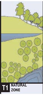
 | NATURAL ZONE |  |
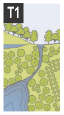
| Consists of lands approximating or reverting to a wilderness condition, including lands unsuitable for development due to topography, hydrology or vegetation. The general character of T-1 consists of natural landscapes with some agricultural use as well as public access to greenways and blueways. Human settlement within T-1 is not permitted. | ||
| Permitted uses: | ||
| By right: Grain storage, greenhouse, stable, rest stop, roadside stand | ||
| By warrant: Livestock pen, electric substation, wireless transmitter. | ||
| Civic spaces: Parks & playgrounds. | ||
| Base residential density: Not applicable. | ||
| Block size: No maximum. | ||
| Permitted thoroughfares: See Thoroughfare Standards for T1 types. | ||
| Permitted building disposition: Edgeyard. | ||
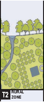
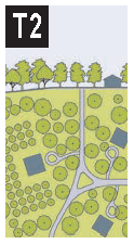 | RURAL ZONE |
Consists of sparsely settled lands in open or cultivated states. These include woodland, agricultural land, and grassland. Typical buildings include farmhouses, plantations, cabins, agricultural buildings, family compound, and hunting lodge. The T2 zone is recommended for those areas outside the edge of sub-urban and urban settlement.
Permitted uses:
By right:
House, accessory unit, open-market building, bus shelter, fountain or public art,
playground, religious assembly, grain storage, greenhouse, kennel, stable, rest stop,
roadside stand, cemetery, childcare center.
By warrant: Inn (up to 12 rooms), bed & breakfast (up to 5 rooms), outdoor auditorium, livestock pen, gasoline, electric substation, wireless transmitter.
Civic spaces: Parks & playgrounds.
Base residential density: 1 unit/25 acres average.
Block size: No maximum.
Permitted thoroughfares: See thoroughfare standards for T2.
Lot width and coverage: By warrant.
Permitted private frontages: Common yard.
Building function: Restricted residential, restricted lodging, restricted office, restricted retail.
Building disposition:
Edgeyard: Permitted.
Sideyard: Not Permitted.
Rearyard: Not Permitted.
Courtyard: Not Permitted.
Building configuration:
Principal building: 2 stories max.
Outbuilding: 2 Stories max.
Setbacks:
Principal building:
(G.1) Front Setback (Principal): 48 ft. min.
(G.2) Front Setback (Secondary): 48 min.
(G.3) Side Setback: 96 ft.
(G.4) Rear Setback: 96 ft.
Frontage buildout: Not applicable.
Outbuilding:
(H.1) Front setback: 20 min. + bldg. setback.
(H.2) side setback: 3 or 6 ft.
(H.3) rear setback: 3 ft. min.
|
Building configuration
1. Building height shall be measured in number of Stories, excluding Attics and raised basements. 2. Stories may not exceed 14 feet in height from finished floor to finished ceiling, except for a first floor Commercial function which must be a minimum of 11 ft. with a maximum of 25 feet. 3. Height shall be measured to the eave or roof deck as specified on Table 8. | 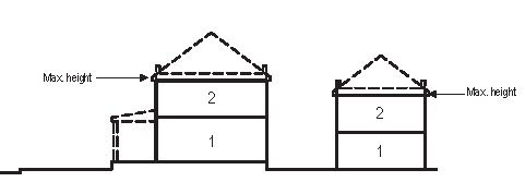 |  |
|
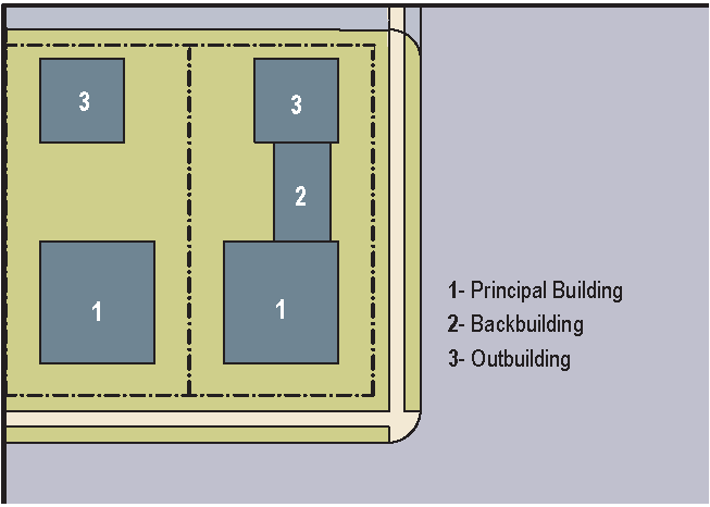
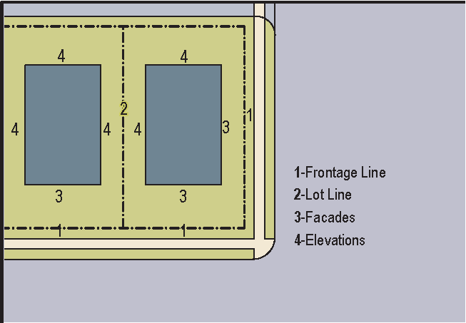
Setbacks - Principal Bldg.
1. The Facades and Elevations of Principal Buildings shall be distanced from the Lot lines as shown. 2. Facades shall be built along the Principal Frontage to the minimum specified width in the table. | 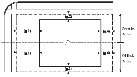 | |
|
Setbacks - Outbuilding
1. The Elevation of the Outbuilding shall be distanced from the Lot lines as shown. | 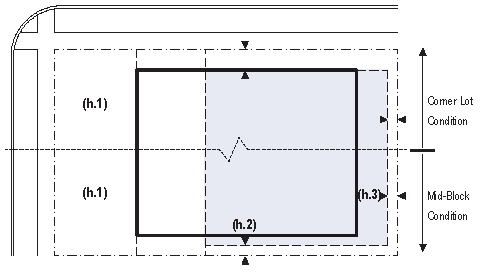 | |
 | ||
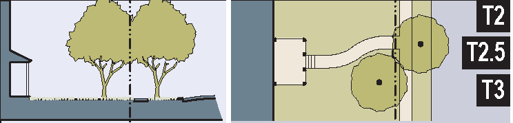
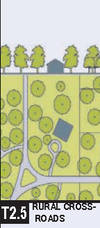
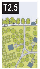 | RURAL CROSSROADS |
T2.5 is also known as a rural gathering place, consisting of a handful of single-family and mixed use structures located at the intersection of two or three primary rural thoroughfares. This zone provides essential goods and services to the residents of T2 and is accessible primarily by vehicle. Ridgeland precedent of T2.5: Cooler's Exxon Station and Old House Restaurant Settlement Area. Rural crossroads are defined as an area that is 8 acres centered on the aforementioned section.
Permitted uses:
By right:
House, accessory unit, open-market building, bus shelter, fountain or public art,
playground, religious assembly, grain storage, greenhouse, kennel, stable, rest stop,
roadside stand, cemetery, childcare center, retail building, country store.
By warrant: Inn (up to 12 rooms), bed & breakfast (up to 5 rooms), outdoor auditorium, livestock pen, gasoline, electric substation, wireless transmitter.
Civic spaces: Parks, green, & playgrounds.
Base residential density: 3 dwelling units per acre maximum.
Block size: No maximum.
Permitted thoroughfares: See Thoroughfare Standards for T2.5.
Lot width and coverage: By warrant.
Permitted private frontages: Common yard.
Building function: Restricted residential, restricted lodging, restriction office, restricted retail.
Building configuration:
Principal building:
2 stories max.
Outbuilding:
2 stories max.
Setbacks:
Principal building:
(G.1) Front setback (principal): 10—30 ft. min.
(G.2) Front setback (secondary): 30 ft. min.
(G.3) Side setback: By warrant.
(G.4) Rear setback: By warrant.
Frontage buildout: Not applicable.
Outbuilding:
(H.1) Front setback: 20 min. + bldg. setback.
(H.2) Side setback: 3 or 6 ft.
(H.3) Rear setback: 3 ft. min.
Building disposition:
Edgeyard: Permitted.
Sideyard: By warrant.
Rearyard: Not permitted.
Courtyard: Not permitted.
|
BUILDING CONFIGURATION
1. Building height shall be measured in number of Stories, excluding Attics and raised basements. 2. Stories may not exceed 14 feet in height from finished floor to finished ceiling, except for a first floor Commercial function which must be a minimum of 11 ft. with a maximum of 25 feet. 3. Height shall be measured to the eave or roof deck as specified on Table 8. | 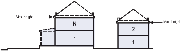 |  |
|
SETBACKS - PRINCIPAL BLDG.
1. The Facades and Elevations of Principal Buildings shall be distanced from the Lot lines as shown. 2. Facades shall be built along the Principal Frontage to the minimum specified width in the table. | 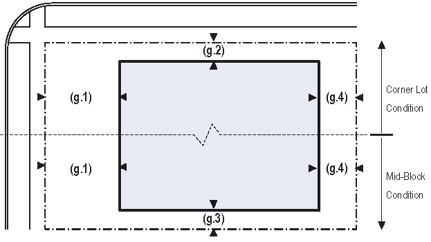 | |
|
SETBACKS - OUTBUILDING
1. The Elevation of the Outbuilding shall be distanced from the Lot lines as shown. | 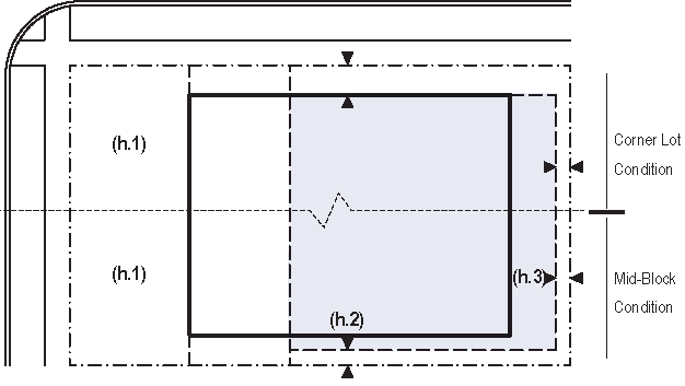 | |
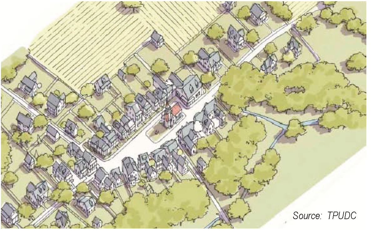 | ||
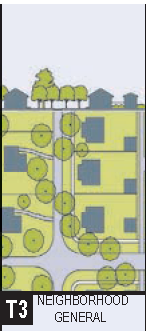
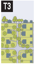 | NEIGHBORHOOD GENERAL |
T3, Neighborhood General, consists of a medium density residential area, adjacent to Neighborhood Core (T4) areas that contain some mixed use. Home occupations and accessory buildings are permitted. T3 contains a wide array of building types and is characterized by its dappled sunlight and shade illuminating its thoroughfares with soft edges. Medium-sized blocks define neighborhood general and are typically serviced by rear lanes/alleys similar to the originally platted lots of Ridgeland.
Permitted uses:
By right:
Live/work unit, bungalow, sideyard house, cottage, bed & breakfast (up to 5 rooms),
house, accessory unit, openmarket building, bus shelter, fountain or public art, outdoor
auditorium, playground, library, religious assembly, childcare center, fire station,
funeral home.
By warrant: Greenhouse, kennel, stable, electric substation, cemetery, elementary school.
Civic spaces: Parks, green, & playgrounds.
Base residential density: 6 dwelling units per acre maximum.
Block size/perimeter: 2,200 feet.
Permitted thoroughfares: See thoroughfare standards for T3.
Lot width:
60 ft. min. and 120 ft. max.
Lot coverage:
60%.
Permitted private frontages: Common yard, porch & fence.
Building configuration:
Principal building:
2 stories max.
Outbuilding:
2 stories max.
Setbacks:
Principal building:
(G.1) Front setback (principal): 6—12 ft. min.
(G.2) Front setback (secondary): 6—12 ft. min.
(G.3) Side setback: 0 ft. or 5 ft.
(G.4) Rear setback: 5 ft.
Frontage buildout: 50% minimum.
Outbuilding:
(H.1) Front setback: 24 min. + bldg. setback
(H.2) Side setback: 0 or 3 ft.
(H.3) Rear setback: 3 ft. min.
Building disposition:
Edgeyard: Permitted.
Sideyard: Permitted.
Rearyard: Not permitted.
Courtyard: Not permitted.
Building function:
Restricted residential, restricted lodging, limited office, restricted retail.
|
BUILDING CONFIGURATION
1. Building height shall be measured in number of Stories, excluding Attics and raised basements. 2. Stories may not exceed 14 feet in height from finished floor to finished ceiling, except for a first floor Commercial function which must be a minimum of 11 ft. with a maximum of 25 feet. 3. Height shall be measured to the eave or roof deck as specified on Table 8. | 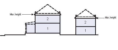 | 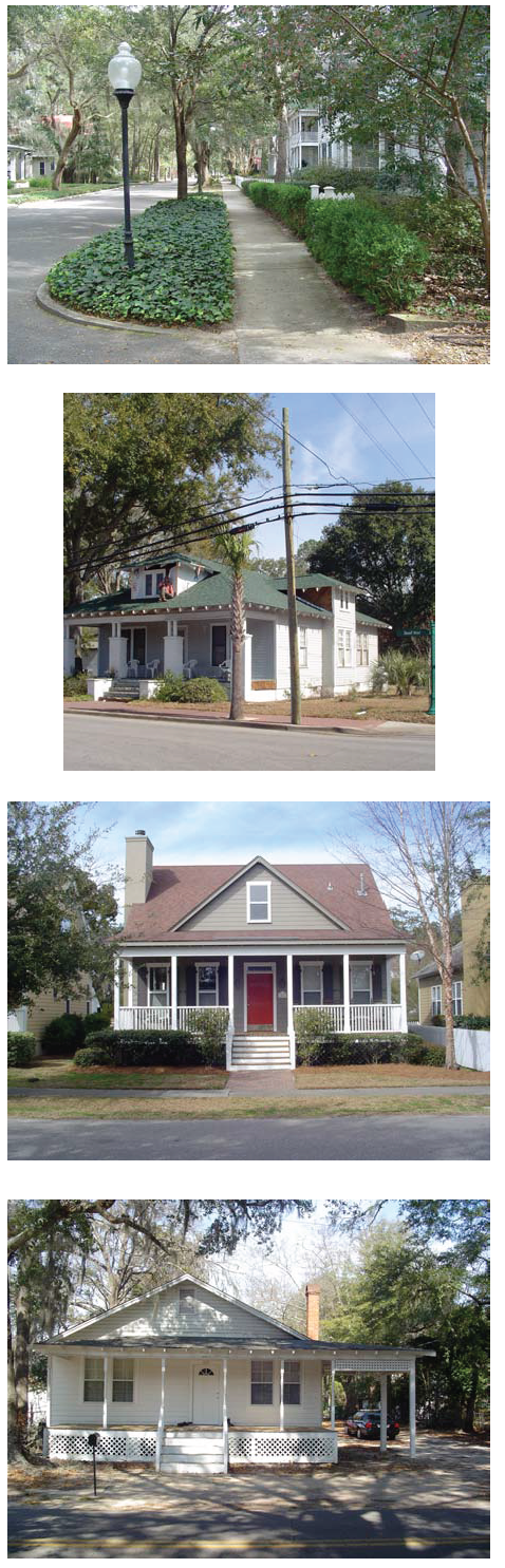 |
|
SETBACKS - PRINCIPAL BLDG.
1. The Facades and Elevations of Principal Buildings shall be distanced from the Lot lines as shown. 2. Facades shall be built along the Principal Frontage to the minimum specified width in the table. | 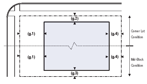 | |
|
SETBACKS - OUTBUILDING
1. The Elevation of the Outbuilding shall be distanced from the Lot lines as shown. | 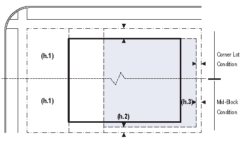 | |
|
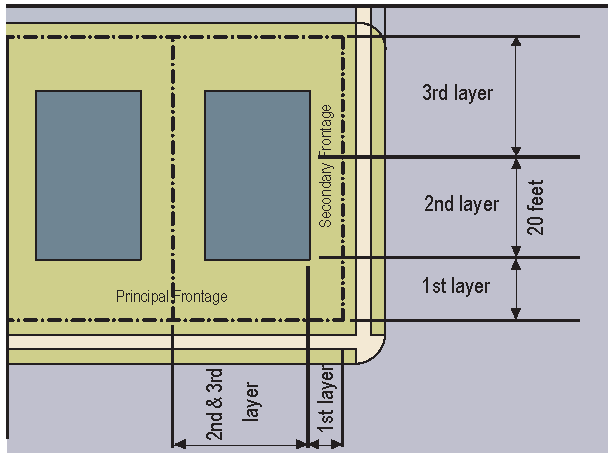
PARKING PLACEMENT
1. Uncovered parking spaces may be provided within the second and third Layer as shown in the diagram (see Table 17d). 2. Covered parking shall be provided within the third Layer as shown in the diagram (see Table 17d). Side- or rear-entry garages may be allowed in the first or second Layer by Warrant. 3. Trash containers shall be stored within the third Layer. | 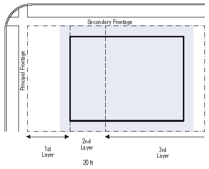 |
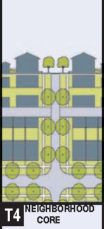
 | NEIGHBORHOOD CORE |
T4, neighborhood core, represents a low intensity mixed-use district primarily in the form of secessional residential fabric. A wide range of building types exist in T4, including, but not limited to, rowhouses, corner stores, and single family attached and detached housing. Single-family detached housing is typically set back from the front property line to allow for porch and fence frontage, while attached housing maintains a front stoop frontage.
Permitted uses:
By right:
Flex building, apartment building, row house, duplex house, courtyard house, live/work
unit, bungalow, sideyard house, cottage, bed & breakfast (up to 5 rooms), inn (up
to 12 rooms), office building, retail building, display gallery, house, accessory
unit, open-market building, bus shelter, fountain or public art, playground, library,
religious assembly, childcare center, fire station, elementary school, police station,
funeral home.
By warrant: Restaurant, movie theater, live theater, museum, surface parking lot, greenhouse, kennel, electric substation, cemetery, medical clinic, high school, mixed use block.
Civic spaces: Parks, green, playgrounds, and square.
Base residential density: 8 dwelling units per acre maximum.
Block size/perimeter: 2,000 feet.
Permitted thoroughfares: See Thoroughfare Standards for T4.
Building configuration:
Principal building:
3 stories max.
Outbuilding:
2 stories max.
Setbacks:
Principal building:
(G.1) Front setback (principal): 0—8 ft. min.
(G.2) Front setback (secondary): 0—8 ft. min.
(G.3) Side setback: 0 ft.
(G.4) Rear setback: 5 ft.
Frontage buildout: 65% minimum.
Outbuilding:
(H.1) Front setback: 40 ft. from rear property line.
(H.2) Side setback: 0 ft. min.
(H.3) Rear setback: 3 ft. min.
Building disposition:
Edgeyard: Not permitted.
Sideyard: Permitted.
Rearyard: Permitted.
Courtyard: Permitted.
Building function: Restricted residential, restricted lodging, open office, open retail.
Lot width:
28 ft. min. and 90 ft. max.
Lot coverage:
70%.
Permitted private frontages: Porch & fence, terrance or LC, forecourt, stoop, shopfront & awning, gallery.
|
BUILDING CONFIGURATION
1. Building height shall be measured in number of Stories, excluding Attics and raised basements. 2. Stories may not exceed 14 feet in height from finished floor to finished ceiling, except for a first floor Commercial function which must be a minimum of 11 ft. with a maximum of 25 ft. 3. Height shall be measured to the eave or roof deck as specified on Table 8. | 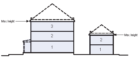 |  |
|
SETBACKS - PRINCIPAL BLDG.
1. The Facades and Elevations of Principal Buildings shall be distanced from the Lot lines as shown. 2. Facades shall be built along the Principal Frontage to the minimum specified width in the table. | 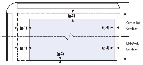 | |
|
SETBACKS - OUTBUILDING
1. The Elevations of the Outbuilding shall be distanced from the Lot lines as shown. | 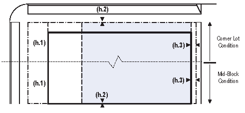 | |
|
PARKING PLACEMENT
1. Uncovered parking spaces may be provided within the third Layer as shown in the diagram (see Table 17d). 2. Covered parking shall be provided within the third Layer as shown in the diagram (see Table 17d). 3. Trash containers shall be stored within the third Layer. | 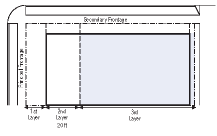 |
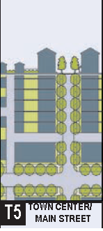
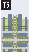 | TOWN CENTER/ MAIN STREET |
T5, Town Center/Main Street, consists of higher density, mixed-use buildings that accommodate retail, rowhouses, offices, and apartments. A tight network of streets defines the transect zone as a highly walkable area. Buildings are set very close to the frontages in order to define the public realm. Wide sidewalks and regular plantings and street furniture combine to form the public realm.
Permitted uses:
By right:
Mixed-use block, live/work unit, bungalow, sideyard house, bed & breakfast (up to
5 rooms), accessory unit, openmarket building, bus shelter, fountain or public art,
outdoor auditorium, playground, library, religious assembly, childcare center, fire
station, school dormitory, live theater, movie theater, apartment building, flex building,
row house, duplex house, courtyard house, inn (up to 12 rooms), office building, retail
building, restaurant, display gallery, parking structure, police station, funeral
home, medical clinic, elementary school.
By warrant: Hotel (no room limit), greenhouse, kennel, stable, electric substation, push cart, liquor selling establishment, conference center, passenger terminal, gasoline, drive-through facility, college, high school, trade school.
Civic spaces: Plazas, squares, parks, green, & playgrounds.
Base residential density: 10 dwelling units per acre.
Block size/perimeter: 2,000 feet.
Building configuration:
Principal building:
3 stories max., 2 stories min.
Outbuilding: 2 stories max.
Setbacks:
Principal building:
(G.1) Front setback (principal): 0 ft. min.
(G.2) Front setback (secondary): 0 ft. min.
(G.3) Side setback: 0 ft.
(G.4) Rear setback: 5 ft.
Frontage buildout: 80% minimum.
Outbuilding:
(H.1) Front setback: Not applicable.
(H.2) Side setback: Not applicable.
(H.3) Rear setback: Not applicable.
Building disposition:
Edgeyard: Not permitted.
Sideyard: Not permitted.
Rearyard: Permitted.
Courtyard: Permitted.
Permitted private frontages: Terrance or LC, forecourt, stoop, shopfront & awning, gallery, arcade.
Building function: Open residential, open lodging, open office, open retail.
Permitted thoroughfares: See Thoroughfare Standards for T5.
Lot width:
18 ft. min. and 180 ft. max.
Lot coverage:
80%.
|
BUILDING CONFIGURATION
1. Building height shall be measured in number of Stories, excluding Attics and raised basements. 2. Stories may not exceed 14 feet in height from finished floor to finished ceiling, except for a first floor Commercial function which must be a minimum of 11 ft. with a maximum of 25 ft. 3. Height shall be measured to the eave or roof deck as specified on Table 8. | 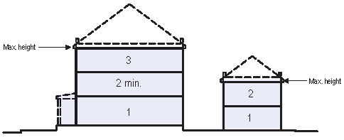 | 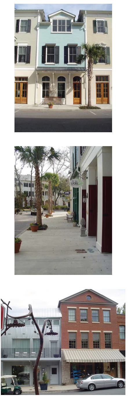 |
|
SETBACKS - PRINCIPAL BLDG.
1. The Facades and Elevations of Principal Buildings shall be distanced from the Lot lines as shown. 2. Facades shall be built along the Principal Frontage to the minimum specified width in the table. | 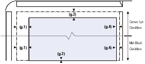 | |
|
SETBACKS - OUTBUILDING
1. The Elevations of the Outbuilding shall be distanced from the Lot lines as shown. | 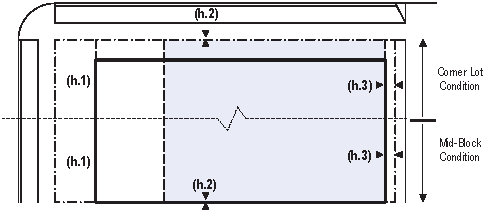 | |
|
PARKING PLACEMENT
1. Uncovered parking spaces may be provided within the third Layer as shown in the diagram (see Table 17d). 2. Covered parking shall be provided within the third Layer as shown in the diagram (see Table 17d). 3. Trash containers shall be stored within the third Layer. | 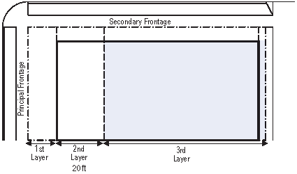 |
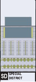
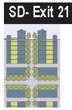 | SPECIAL DISTRICT: EXIT 21 |
SD-Exit 21 special district represents the context which surrounds Exit 21 off of I-95. A mix of building types, including but not limited to automotive, office and lodging uses. Active uses within the building shall be located along the primary frontage with transparent windows facing the street. Parking lot design shall include stormwater management, design, and landscaping features for heat island effect reduction, hedges or walls to contain them at street side frontage.
Permitted uses:
By right:
Live/work unit, bed & breakfast (up to 5 rooms), inn (up to 12 rooms), hotel (no room
limit), SRO hostel, school dormitory, office building, retail building, open-market
building, retail building, restaurant, liquor selling establishment, bus shelter,
convention center, conference center, exhibition center, fountain or public art, playground,
library, live theater, movie theater, museum, outdoor auditorium, parking structure,
passenger terminal, sports stadium, surface parking lot, religious assembly, gasoline,
automobile service, truck maintenance, drive-through facility, rest stop, roadside
stand, shopping center, shopping mall, childcare center, fire station, elementary
school, police station, funeral home, hospital, medical clinic, cemetery, college,
high school, trade school, light industrial facility, truck depot, laboratory facility,
electric substation, warehouse, produce storage, mini-storage.
By warrant: Kiosk, push cart, water supply facility.
Civic spaces: Parks, green, playgrounds, and square.
Base residential density: 10 dwelling units per acre maximum.
Block size/perimeter: 3,000 feet.
Permitted thoroughfares: See thoroughfare standards for T4 and T5.
Building configuration:
Principal building:
3 stories max.
Outbuilding:
2 stories max.
Setbacks:
Principal building:
(G.1) Front setback (principal): 0—80 ft. min.
(G.2) Front setback (secondary): 0—80 ft. min.
(G.3) Side setback: 0 ft. min.
(G.4) Rear setback: 5 ft. min.
Frontage buildout: 65% minimum.
Outbuilding:
(H.1) Front setback: 40 ft. from rear property line.
(H.2) Side setback: 0 ft. min.
(H.3) Rear setback: 3 ft. min.
Building disposition:
Edgeyard: Permitted.
Sideyard: Permitted.
Rearyard: Permitted.
Courtyard: Permitted.
specialized: Permitted.
Lot width:
40 ft. min. and 200 ft. max.
Lot coverage:
70%.
|
BUILDING CONFIGURATION
1. Building height shall be measured in number of Stories, excluding Attics and raised basements. 2. Stories may not exceed 14 feet in height from finished floor to finished ceiling, except for a first floor Commercial function which must be a minimum of 11 ft. with a maximum of 25 ft. 3. Height shall be measured to the eave or roof deck as specified on Table 8. |  |
|
SETBACKS - PRINCIPAL BLDG.
1. The Facades and Elevations of Principal Buildings shall be distanced from the Lot lines as shown. 2. Facades shall be built along the Principal Frontage to the minimum specified width in the table. |  |
|
SETBACKS - OUTBUILDING
1. The Elevations of the Outbuilding shall be distanced from the Lot lines as shown. |  |
|
PARKING PLACEMENT
1. Uncovered parking spaces may be provided within the first, second, or third Layer as shown in the diagram (see Table 17d). 2. Covered parking shall be provided within the third Layer as shown in the diagram (see Table 17d). 3. Trash containers shall be stored within the third Layer. |  |
 | Special district: Genesis |
| Special district Genesis applies to those lands subject to the existing Genesis PUD. The development regulations are available at the Planning Office. | |
 | Special district: Good Hope |
| Special district Good Hope applies to those lands subject to the existing Good Hope PUD. The development regulations are available at the Planning Office. | |
 | Special district: Moultrie |
| Special district Moultrie applies to those lands subject to the existing Moultrie PUD. The development regulations are available at the Planning Office. | |
 | SPECIAL DISTRICT: INDUSTRIAL |
SD-Industrial special district represents the context which is a mix of building types, including but not limited to automotive, office, industrial, and loding uses. Parking lot design shall include stormwater management, design, and landscaping features for heat island effect reduction, hedges or walls to contain them at street side frontage.
Permitted uses:
By right:
Live/work unit, bed & breakfast (up to 5 rooms), inn (up to 12 rooms), hotel (no room
limit), SRO hostel, school dormitory, office building, retail building, open-market
building, retail building, restaurant, liquor selling establishment, bus shelter,
convention center, conference center, exhibition center, fountain or public art, playground,
library, live theater, movie theater, museum, outdoor auditorium, parking structure,
passenger terminal, sports stadium, surface parking lot, religious assembly, gasoline,
automobile service, truck maintenance, drive-through facility, rest stop, roadside
stand, shopping center, shopping mall, childcare center, fire station, elementary
school, police station, funeral home, hospital, medical clinic, cemetery, college,
high school, trade school, light industrial facility, truck depot, laboratory facility,
electric substation, warehouse, produce storage, mini-storage, water supply facility,
sewer and waste facility, wireless transmitter, cremation facility, heavy industrial
facility.
By warrant: Kiosk, push cart.
Civic spaces: Parks, green, playgrounds, and square.
Base residential density: 10 dwelling units per acre maximum.
Block size/perimeter: 5,000 feet.
Permitted thoroughfares: See Thoroughfare Standards for T4 and T5.
Building configuration:
Principal building:
3 stories max.
Outbuilding:
2 stories max.
Setbacks:
Principal building:
(G.1) Front setback (principal): 0—150 ft. min.
(G.2) Front setback (secondary): 0—150 ft. min.
(G.3) Side setback: 0 ft. min.
(G.4) Rear setback: 5 ft. min.
Frontage buildout: 65% minimum.
Outbuilding:
(H.1) Front setback: 40 ft. from rear property line.
(H.2) Side setback: 0 ft. min.
(H.3) Rear setback: 3 ft. min.
Building disposition:
Edgeyard: Permitted.
Sideyard: Permitted.
Rearyard: Permitted.
Courtyard: Permitted.
Specialized: Permitted.
Lot width:
40 ft. min. and 600 ft. max.
Lot coverage:
70%.
|
BUILDING CONFIGURATION
1. Building height shall be measured in number of Stories, excluding Attics and raised basements. 2. Stories may not exceed 14 feet in height from finished floor to finished ceiling, except for a first floor Commercial function which must be a minimum of 11 ft. with a maximum of 25 ft. 3. Height shall be measured to the eave or roof deck as specified on Table 8. | 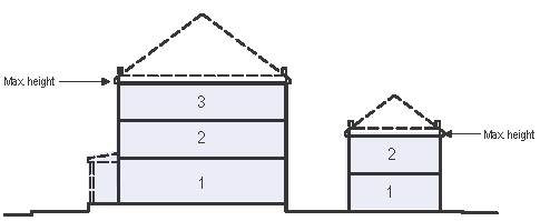 |
|
SETBACKS - PRINCIPAL BLDG.
1. The Facades and Elevations of Principal Buildings shall be distanced from the Lot lines as shown. 2. Facades shall be built along the Principal Frontage to the minimum specified width in the table. | 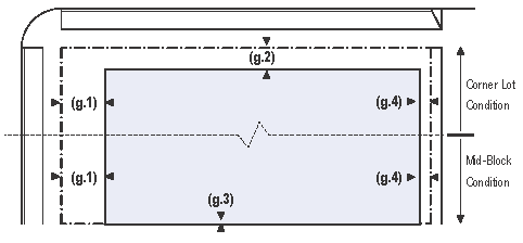 |
|
SETBACKS - OUTBUILDING
1. The Elevations of the Outbuilding shall be distanced from the Lot lines as shown. | 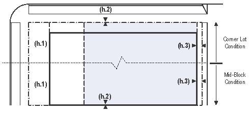 |
|
PARKING PLACEMENT
1. Uncovered parking spaces may be provided within the first, second, or third Layer as shown in the diagram (see Table 17d). 2. Covered parking shall be provided within the third Layer as shown in the diagram (see Table 17d). 3. Trash containers shall be stored within the third Layer. | 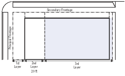 |
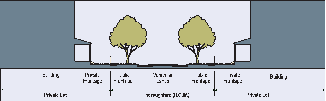
TABLE 3A. - PUBLIC FRONTAGES - GENERAL
The Public Frontage is the area between the private Lot line and the edge of the vehicular lanes. Dimensions are given in Table 3B.
 | |
| a. (HW) For Highway: This Frontage has open Swales drained by percolation, Bicycle Trails and no parking. The landscaping consists of the natural condition or multiple species arrayed in naturalistic clusters. Buildings are buffered by distance or berms. | 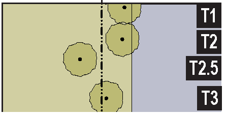 |
| b. (RD) For Road: This Frontage has open Swales drained by percolation and a walking Path or Bicycle Trail along one or both sides and Yield parking. The landscaping consists of multiple species arrayed in naturalistic clusters. | 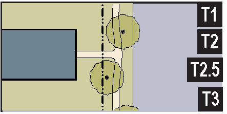 |
| c. (ST) For Street: This Frontage has raised Curbs drained by inlets and Sidewalks separated from the vehicular lanes by individual or continuous Planters, with parking on one or both sides. The landscaping consists of street trees of a single or alternating species aligned in a regularly spaced Allee, with the exception that Streets with a right-of-way (R.O.W.) width of 40 feet or less are exempt from tree requirements. | 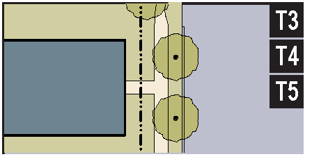 |
| d. (DR) For Drive: This Frontage has raised Curbs drained by inlets and a wide Sidewalk or paved Path along one side, related to a Greenway or waterfront. It is separated from the vehicular lanes by individual or continuous Planters. The landscaping consists of street trees of a single or alternating species aligned in a regularly spaced Allee. | 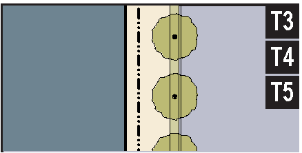 |
| e. (AV) For Avenue: This Frontage has raised Curbs drained by inlets and wide Sidewalks separated from the vehicular lanes by a narrow continuous Planter with parking on both sides. The landscaping consists of a single tree species aligned in a regularly spaced Allee. | 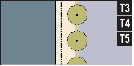 |
| f. (CS)(AV) For Commercial Street or Avenue: This Frontage has raised Curbs drained by inlets and very wide Sidewalks along both sides separated from the vehicular lanes by separate tree wells with grates and parking on both sides. The landscaping consists of a single tree species aligned with regular spacing where possible, but clears the storefront entrances. | 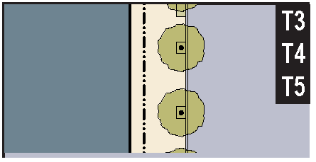 |
| g. (BV) For Boulevard: This Frontage has Slip Roads on both sides. It consists of raised Curbs drained by inlets and Sidewalks along both sides, separated from the vehicular lanes by Planters. The landscaping consists of double rows of a single tree species aligned in a regularly spaced Allee. | 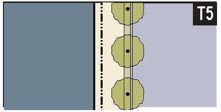 |
TABLE 3B. - PUBLIC FRONTAGES - SPECIFIC
This table assembles prescriptions and dimensions for the Public Frontage elements - Curbs, walkways and Planters - relative to specific Thoroughfare types within Transect Zones. Table 3B-a assembles all of the elements for the various street types. Locally appropriate planting species should be filled in to the calibrated Code.
| TRANSECT ZONE Public Frontage Type | ||||||
| T1 T2 T3 T2.5 | T1 T2 T3 T2.5 | T3 T4 | T4 T5 | T5 | T5 | |
| HW & RD | RD & ST | ST-DR-AV | ST-DR-AV-BV | CS-DR-AV-BV | CS-DR-AV-BV | |
| a. Assembly: The principal variables are the type and dimension of Curbs, walkways, Planters and landscape. | 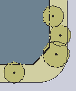 | 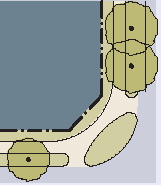 | 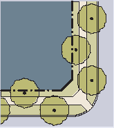 | 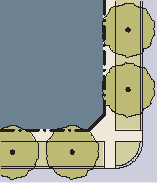 | 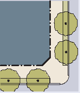 | 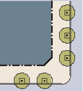 |
| Total Width | 16-24 feet | 12-24 feet | 12-18 feet | 12-18 feet | 18-24 feet | 18-30 feet |
| b. Curb: The detailing of the edge of the vehicular pavement, incorporating drainage. |  |  | 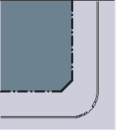 | 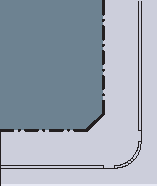 |  |  |
| Type Radius |
Open Swale
10-30 feet |
Open Swale
10-30 feet |
Raised Curb
5-20 feet |
Raised Curb
5-20 |
Raised Curb
5-20 feet |
Raised Curb
5-20 feet |
| c. Walkway: The pavement dedicated exclusively to pedestrian activity. | 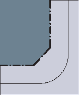 | 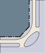 |  |  |  | 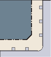 |
| Type Width |
Path Optional
n/a |
Path
4-8 feet |
Sidewalk
4-8 feet |
Sidewalk
4-8 feet |
Sidewalk
12-20 feet |
Sidewalk
12-30 feet |
| d. Planter: The layer which accommodates street trees and other landscape. | 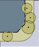 | 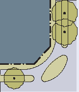 | 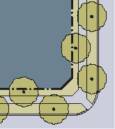 | 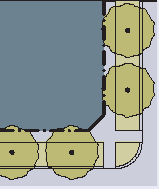 | 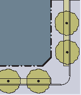 | 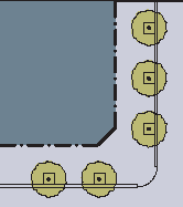 |
| Arrangement Species Planter Type Planter Width |
Clustered
Multiple Continuous Swale 8 feet-16 feet |
Clustered
Multiple Continuous Swale 8 feet-16 feet |
Regular
Alternating Continuous Planter 8 feet-12 feet |
Regular
Single Continuous Planter 8 feet-12 feet |
Regular
Single Continuous Planter 4 feet-6 feet |
Opportunistic
Single Tree Well 4 feet-6 feet |
TABLE 3C. - THOROUGHFARE ASSEMBLIES
THOROUGHFARE DESIGN STANDARDS
A.
General requirements: Thoroughfares shall be designed to balance safety, mobility, community goals and the environment. Thoroughfares shall provide appropriate pedestrian and vehicle mobility options, shall provide appropriate locations for utilities and shall be designed to support adjacent future development. Thoroughfares addressed in this section are to have low to moderate vehicular speed (25 mph or less), varying traffic volumes and shall serve a range of land uses. The layout of thoroughfares as to arrangement, character, width, grade, and location may be required to conform to the general plan of the entire tract where completed, to adjoining thoroughfare systems of adjoining properties, to the major thoroughfare plans of the city, and to the topography, natural features, and drainage systems to be provided.
B.
Contextual design & transect zones: Thoroughfares shall be designed in context with the urban form, intended users (motorists, pedestrians, bicyclists, transit users) and desired design speed of the transect zone through which the thoroughfares pass. The transect zones shall be utilized when determining the appropriate context sensitive thoroughfare design for thoroughfare assemblies and corresponding land use areas). Several thoroughfare types may be allowed in each transect zone.
C.
Emergency/service vehicle access and Building Code and Fire Code compliance: Emergency and service vehicle access shall be considered in the design of thoroughfares and thoroughfare systems and minimum requirements shall be met for the proposed subdivision to be approved. Failure to satisfy all emergency vehicle access requirements of ratified building codes and fire codes in the design of thoroughfares and thoroughfare systems will result in additional requirements when constructing buildings to include, but not be limited to, a requirement for installation of a building fire sprinkler system.
D.
Public transit: Thoroughfares shall be designed to accommodate existing, planned and future public transit. Design accommodations may include provisions for transit pull off areas and modified curb radii. Curb radii may be tested with turn simulation software for feasibility.
E.
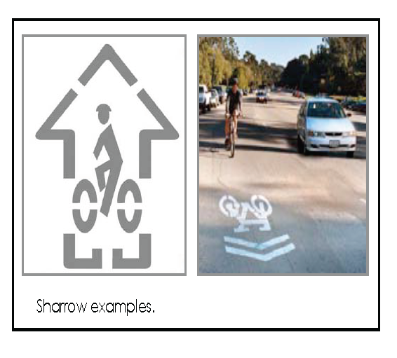
Bicycle provisions: Thoroughfares and community design should provide an opportunity for bicycle travel via a network of bicycle routes, lanes and trails. Bicycle travel networks shall be connected to existing or proposed regional networks wherever possible. A bicycle route shall be provided within the vehicular thoroughfare where suitable for shared use of bicycles and vehicles traveling at low speeds and may be indicated with the use of "sharrows" (see Figure 821.1). A dedicated and marked bicycle lane shall be provided within a moderate-speed vehicular thoroughfare. A bicycle trail may be provided separately from the vehicular thoroughfare.
F.
Accessibility: Thoroughfares shall be designed to accommodate ADA requirements.
G.
Utilities: Thoroughfares shall be designed to accommodate utilities within the right-of-way including, but not limited to, stormwater drainage, lighting, water, sewer, electric, gas, telephone, cable, etc.
H.
Gates and thoroughfare access restrictions: Reserve strips or parcels controlling access to thoroughfares shall be prohibited. Gates shall not be permitted to block thoroughfares.
I.
Thoroughfare narrowing devices: Thoroughfare narrowing devices including, but not limited to, curb extensions, bulbouts, neckdowns and corner bulges shall not be permitted unless approved by the SCDOT.
J.
Thoroughfare construction requirements: All thoroughfares shall be paved in accordance with minimum requirements on file in the office of the SCDOT engineer.
K.
Existing thoroughfares: Thoroughfares of an existing subdivision shall not be used as the sole means of ingress and egress in developing a new subdivision or extending an existing one, when other access can be made available and when in the opinion of the town engineer such use would create a safety hazard.
L.
Jurisdictional wetlands and critical area: No thoroughfare shall be located within a critical area or freshwater or saltwater wetland unless the applicant shall supply to the SCDOT written approval of OCRM or the U.S. Army Corps of Engineers, or both, as appropriate.
M.
Connectivity: Thoroughfares shall be designed as an interconnected thoroughfare system. An interconnected thoroughfare system is necessary in order to provide for access between developments without returning to major roadways, in order to provide access for emergency and service vehicles, in order to enhance and encourage non-vehicular travel, in order to plan for future development and transportation needs and in order to create neighborhoods. The following thoroughfare connectivity requirements shall apply:
N.
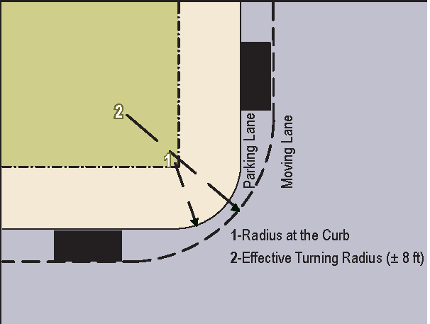
Curb radius modifications & intersection sight triangles:
1.
The dimensions for curb radii standards are provided to accommodate pedestrians as well as emergency and service vehicles. Smaller curb radii provide for a narrower street crossing, reduces vehicle travel speed. Larger curb radii allow higher turning speeds which compromise community walkability. The following graphic illustrates the difference between the curb radius and effective turning radius.
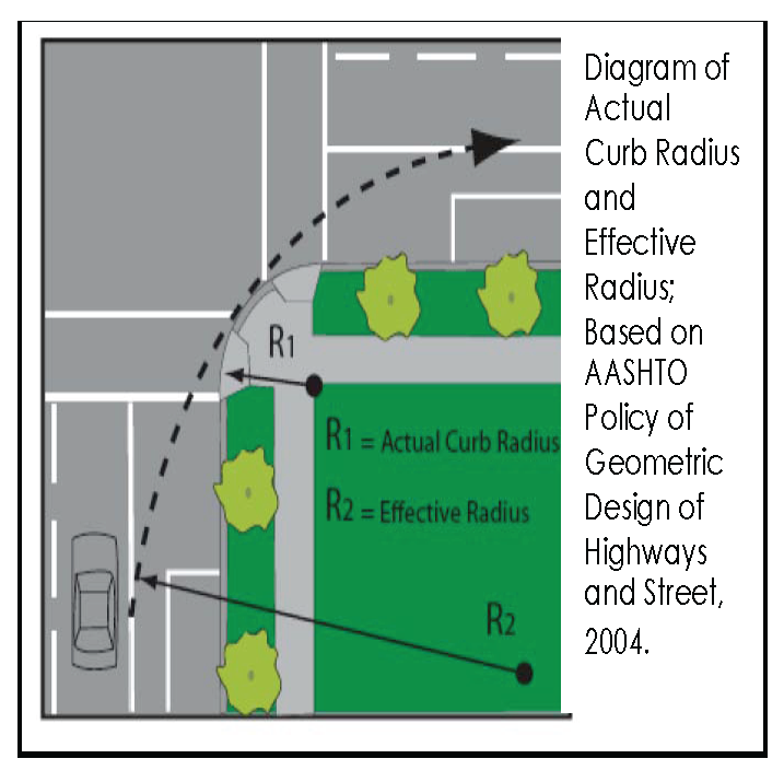
In the event that a curb radius needs to be modified to accommodate emergency and service vehicles, turn simulation software should be used and the radius should be increased incrementally until it is just large enough to allow safe, slow passage of the design emergency or service vehicle.
2.
Standard minimum sight triangle for stop conditions at street intersections shall be accommodated for on all thoroughfares and shall be reviewed by the SCDOT engineer at the time of thoroughfare construction plan submittal.
O.
Garbage service: For properties platted after the effective date of this ordinance, garbage service shall only be provided to the nearest thoroughfare.
P.
Pavement and parking markings and signage: The SCDOT engineer shall determine when and where pavement markings and on-street parking related signs will be installed on all thoroughfares. Pavement markings include but are not limited to parking delineation lines, lane delineation lines and arrows. Final determination of pavement markings and parking signs, including location and type, will be made during thoroughfare construction plan review.
Q.
Lots abutting major thoroughfares: Subdivisions which abut or have included within the proposed area to be subdivided any limited access, or major thoroughfare shall provide:
1.
A marginal access thoroughfare, or
2.
Reverse frontage with screen planting contained in a non-access reservation along the rear property line, or
3.
Lots with rear service drives, or
4.
Other treatment as may be necessary for adequate protection of residential properties and to afford separation of through and local traffic.
The SCDOT shall specify which of the above requirements apply to each individual case based upon adequate service to the public interest.
R.
Thoroughfare types: Thoroughfares types shall be defined as follows:
Avenue (AV): A thoroughfare of high vehicular capacity and low to moderate speed, acting as a short distance connector between urban centers and usually equipped with a landscaped median.
Bicycle lane (BL): A dedicated lane for cycling within a moderate speed vehicular thoroughfare, demarcated by striping.
Bicycle route (BR): A thoroughfare suitable for the shared use of bicycles and automobiles moving at slow speeds.
Bicycle trail (BT): A bicycle way running independently of a vehicular thoroughfare.
Boulevard (BV): A thoroughfare designed for high vehicular capacity and moderate speed, traversing an urbanized area. Boulevards are usually equipped with slip roads buffering sidewalks and buildings.
Drive (DR): A thoroughfare along the boundary between an urbanized and a natural condition, usually along a waterfront, park or promontory. One side has the urban character of a thoroughfare, with sidewalk and building, while the other side has the qualities of a road or parkway, with naturalistic planting and rural details.
Park street (PS): A sub-urban, urban general or urban center thoroughfare with a wide center median (width may vary) that may serve as an open space feature.
Path (PT): A pedestrian way traversing a park or rural area, with landscape matching the contiguous open space, ideally connecting directly with the urban sidewalk network.
Rear alley (RA): A vehicular way located to the rear of lots providing access to service areas, parking, and outbuildings and containing utility easements. Rear alleys should be paved from building face to building faces or lot lines.
Rear lane (RL): A vehicular way located to the rear of lots providing access to service areas, parking, and outbuildings and containing utility easements. Rear lanes may be paved lightly to driveway standards. The streetscape consists of gravel or landscaped edges.
Road (RD): A local, rural and sub-urban thoroughfare of low-to-moderate vehicular speed and capacity. This type is allocated to more rural areas.
Slip road (SR): An outer vehicular lane or lanes of a thoroughfare designed for slow speeds while inner lanes carry higher speed traffic and separated from them by a planted median. (Syn: Access lane, service lane)
Street (ST): Sub-urban and urban thoroughfare of low speed and capacity.
Yield (Y): Characterizing a thoroughfare that has two-way traffic but only one effective travel lane because of parked cars, necessitating slow movement and driver negotiation.
TABLE 4. - PRIVATE FRONTAGES
The Private Frontage is the area between the building Facades and the Lot lines.
 | |
| a. Common Yard: A planted Frontage wherein the Facade is set back substantially from the Frontage Line. The front yard created remains unfenced and is visually continuous with adjacent yards, supporting a common landscape. The deep Setback provides a buffer from the higher speed Thoroughfares. | |
| b. Porch & Fence: A planted Frontage wherein the Facade is set back from the Frontage Line with an attached porch permitted to Encroach. A fence at the Frontage Line maintains street spatial definition. Porches shall be no less than 8 feet deep. | 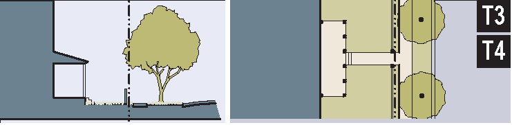 |
| c. Terrace or Lightwell: A Frontage wherein the Facade is set back from the Frontage line by an elevated terrace or a sunken Lightwell. This type buffers Residential use from urban Sidewalks and removes the private yard from public Encroachment. Terraces are suitable for conversion to outdoor cafes Syn: Dooryard. | 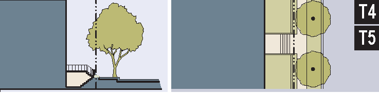 |
| d. Forecourt: A Frontage wherein a portion of the Facade is close to the Frontage Line and the central portion is set back. The Forecourt created is suitable for vehicular drop-offs. This type should be allocated in conjunction with other Frontage types. Large trees within the Forecourts may overhang the Sidewalks. | 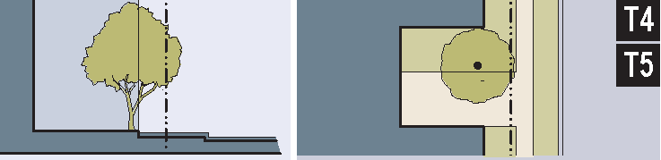 |
| e. Stoop: A Frontage wherein the Facade is aligned close to the Frontage Line with the first Story elevated from the Sidewalk sufficiently to secure privacy for the windows. The entrance is usually an exterior stair and landing. This type is recommended for ground-floor Residential use. | 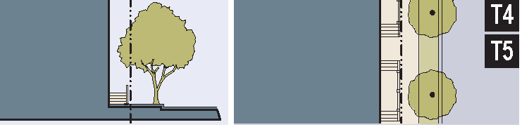 |
| f. Shopfront: A Frontage wherein the Facade is aligned close to the Frontage Line with the building entrance at Sidewalk grade. This type is conventional for Retail use. It has a substantial glazing on the Sidewalk level and an awning that should overlap the Sidewalk to within 2 feet of the Curb. Syn: Retail Frontage. | 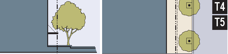 |
| g. Gallery: A Frontage wherein the Facade is aligned close to the Frontage line with an attached cantilevered shed or a lightweight colonnade overlapping the Sidewalk. This type is conventional for Retail use. The Gallery shall be no less than 10 feet wide and should overlap the Sidewalk to within 2 feet of the Curb. | 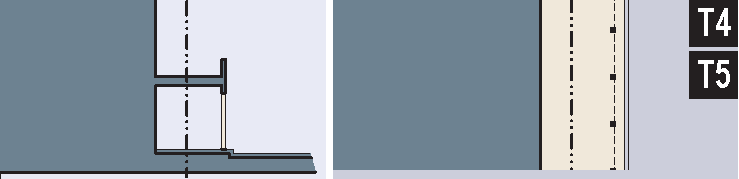 |
| h. Arcade: A colonnade supporting habitable space that overlaps the Sidewalk, while the Facade at Sidewalk level remains at or behind the Frontage Line. This type is conventional for Retail use. The Arcade shall be no less than 12 feet wide and should overlap the Sidewalk to within 2 feet of the Curb. See Table 8. | 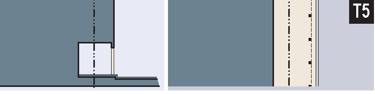 |
TABLE 5. - BUILDING DISPOSITION
This table approximates the location of the structure relative to the boundaries of each individual Lot, establishing suitable basic building types for each Transect Zone.
| a. Edgeyard: Specific Types - single family House, cottage, villa, estate house, urban villa. A building that occupies the center of its Lot with Setbacks on all sides. This is the least urban of types as the front yard sets it back from the Frontage, while the side yards weaken the spatial definition of the public Thoroughfare space. The front yard is intended to be visually continuous with the yards of adjacent buildings. The rear yard can be secured for privacy by fences and a well-placed Backbuilding and/or Outbuilding. | 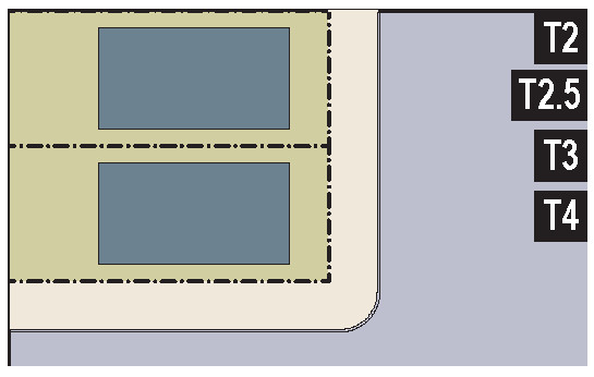 |
| b. Sideyard: Specific Types - Charleston single house, double house, zero lot line house, twin. A building that occupies one side of the Lot with the Setback to the other side. A shallow Frontage Setback defines a more urban condition. If the adjacent building is similar with a blank side wall, the yard can be quite private. This type permits systematic climatic orientation in response to the sun or the breeze. If a Sideyard House abuts a neighboring Sideyard House, the type is known as a twin or double House. Energy costs, and sometimes noise, are reduced by sharing a party wall in this Disposition. | 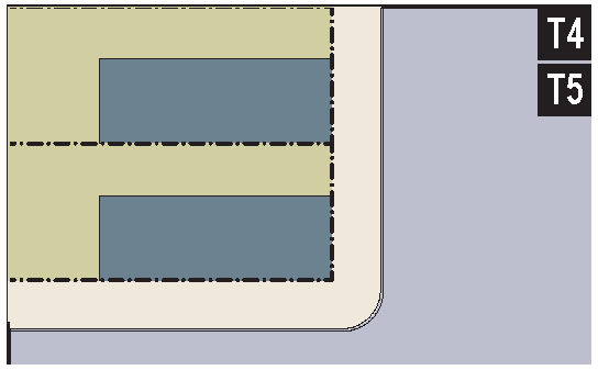 |
| c. Rearyard: Specific Types - Townhouse, Rowhouse, Live-Work unit, loft building, Apartment House, Mixed Use Block, Flex Building, perimeter Block. A building that occupies the full Frontage, leaving the rear of the Lot as the sole yard. This is a very urban type as the continuous Facade steadily defines the public Thoroughfare. The rear Elevations may be articulated for functional purposes. In its Residential form, this type is the Rowhouse. For its Commercial form, the rear yard can accommodate substantial parking. | 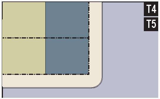 |
| d. Courtyard: Specific Types - patio House. A building that occupies the boundaries of its Lot while internally defining one or more private patios. This is the most urban of types, as it is able to shield the private realm from all sides while strongly defining the public Thoroughfare. Because of its ability to accommodate incompatible activities, masking them from all sides, it is recommended for workshops, Lodging and schools. The high security provided by the continuous enclosure is useful for crime-prone areas. | 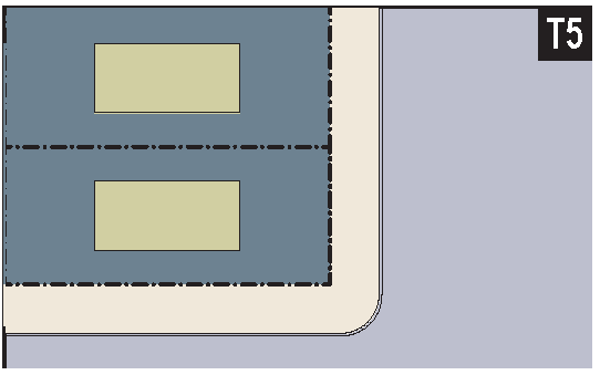 |
| e. Specialized: A building that is not subject to categorization. Buildings dedicated to manufacturing and transportation are often distorted by the trajectories of machinery. Civic buildings, which may express the aspirations of institutions, may be included. | 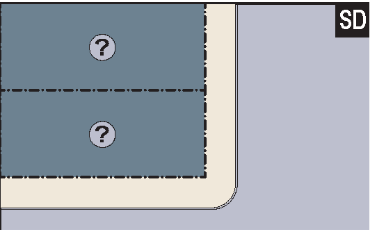 |
TABLE 6. - BUILDING FUNCTION
This table categorizes Building Functions within Transect Zones. Parking requirements are correlated to functional intensity. For Specific Function and Use permitted By Right or by Warrant, see Table 8.
TABLE 7. - PARKING CALCULATIONS
The Shared Parking Factor for two Functions, when divided into the sum of the two amounts as listed on the Required Parking table below, produces the Effective Parking needed for each site involved in sharing. Conversely, if the Sharing Factor is used as a multiplier, it indicates the amount of building allowed on each site given the parking available.
| REQUIRED PARKING (See Table 6) | SHARED PARKING FACTOR | |||
| T2 T2.5 T3 | T4 | T5 | 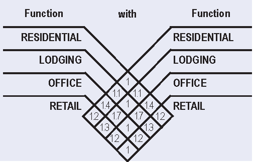 | |
| RESIDENTIAL | 2.0/dwelling | 1.5/dwelling | 1.0/dwelling | |
| LODGING | 1.0/bedroom | 1.0/bedroom | 1.0/bedroom | |
| OFFICE | 3.0/1,000 sq. ft. | 3.0/1,000 sq. ft. | 2.0/1,000 sq. ft. | |
| RETAIL | 4.0/1,000 sq. ft. | 4.0/1,000 sq. ft. | 3.0/1,000 sq. ft. | |
| CIVIC | To be determined by Warrant | |||
| OTHER | To be determined by Warrant | |||
TABLE 8. - SPECIFIC FUNCTION & USE
Specific Function & Use. This table expands the categories of Table 6 to delegate specific Functions and uses within Transect Zones. Table 8 should be customized for local character and requirements.
■ BY RIGHT
□ BY WARRANT
TABLE 9. - CIVIC SPACE
| a. Park: A natural preserve available for unstructured recreation. A park may be independent of surrounding building Frontages. Its landscape shall consist of Paths and trails, meadows, waterbodies, woodland and open shelters, all naturalistically disposed. Parks may be lineal, following the trajectories of natural corridors. | 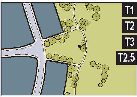 |
| b. Green: An Open Space, available for unstructured recreation. A Green may be spatially defined by landscaping rather than building Frontages. Its landscape shall consist of lawn and trees, naturalistically disposed. The minimum size shall be ½ acre and the maximum shall be 8 acres. | 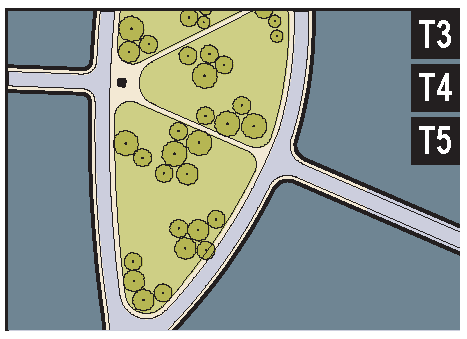 |
| c. Square: An Open Space available for unstructured recreation and Civic purposes. A Square is spatially defined by building Frontages. Its landscape shall consist of paths, lawns and trees, formally disposed. Squares shall be located at the intersection of important Thoroughfares. The minimum size shall be ½ acre and the maximum shall be 5 acres. | 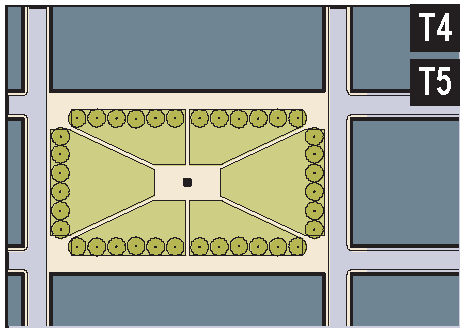 |
| d. Plaza: An Open Space available for Civic purposes and Commercial activities. A Plaza shall be spatially defined by building Frontages. Its landscape shall consist primarily of pavement. Trees are optional. Plazas should be located at the intersection of important streets. The minimum size shall be ½ acre and the maximum shall be 2 acres. | 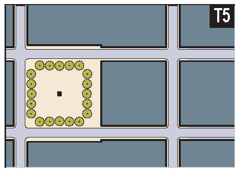 |
| e. Playground: An Open Space designed and equipped for the recreation of children. A playground shall be fenced and shall include an open picnic shelter. Playgrounds shall be interspersed within Residential areas and may be placed within a Block. Playgrounds may be included within parks and greens. There shall be no minimum or maximum size. |  |
TABLE 10. - SMARTCODE SUMMARY
 |  |  |  |  |  |  | ||||
| a. ALLOCATION OF ZONES per Pedestrian Shed (applicable to Article 3 only) | (see T-Zone Descriptions) | |||||||||
| CLD requires | no minimum | 50% min | 10 - 30% | 20 - 40% | not permitted | not permitted | ||||
| TND requires | no minimum | no minimum | 10 - 30% | 30 - 60 % | 10 - 30% | not permitted | ||||
| RCD requires | no minimum | no minimum | not permitted | 10 - 30% | 10 - 30% | 40 - 80% | ||||
| b. BASE RESIDENTIAL DENSITY (see Section 3.4) | ||||||||||
| By Right | not applicable | 1 unit/25 ac avg. | 3 units/ac. gross max. | 6 units/ac. gross | 8 units/ac. gross | 10 units/ac. gross | ||||
| By TDR | by Variance | by Variance | 6 units/ac. gross max. | 8 units/ac. gross | 9 units/ac. gross | 15 units/ac. gross | ||||
| Other Functions | by Variance | by Variance | 10 - 20% | 20 - 30% | 30 - 50% | 50 - 70% | ||||
| c. BLOCK SIZE | ||||||||||
| Block Perimeter | no maximum | no maximum | no maximum | 2,420 ft. max | 2,000 ft. max | 2,000 ft. max. * | ||||
| d. THOROUGHFARES (see Table 3) |
*
3000 ft. max. with parking structures
| |||||||||
| HW | permitted | permitted | permitted | not permitted | not permitted | not permitted | ||||
| BV | not permitted | not permitted | permitted | permitted | permitted | permitted | ||||
| AV | not permitted | not permitted | permitted | permitted | permitted | permitted | ||||
| CS | not permitted | not permitted | not permitted | not permitted | permitted | permitted | ||||
| DR | not permitted | not permitted | permitted | permitted | permitted | permitted | ||||
| ST | not permitted | not permitted | permitted | permitted | permitted | not permitted | ||||
| RD | permitted | permitted | permitted | not permitted | not permitted | not permitted | ||||
| Rear Lane | permitted | permitted | permitted | permitted | not permitted | not permitted | ||||
| Rear Alley | not permitted | not permitted | permitted | required | required | required | ||||
| Path | permitted | permitted | permitted | permitted | not permitted | not permitted | ||||
| Passage | not permitted | not permitted | permitted | permitted | permitted | permitted | ||||
| Bicycle Trail | permitted | permitted | permitted | not permitted * | not permitted | not permitted | ||||
| Bicycle Lane | permitted | permitted | permitted | permitted | not permitted | not permitted | ||||
| Bicycle Route | permitted | permitted | permitted | permitted | permitted | permitted | ||||
| e. CIVIC SPACES (see Table 9) | * permitted within Open Spaces | |||||||||
| Park | permitted | permitted | permitted | permitted | permitted | by Warrant | ||||
| Green | not permitted | not permitted | permitted | permitted | permitted | not permitted | ||||
| Square | not permitted | not permitted | not permitted | not permitted | permitted | permitted | ||||
| Plaza | not permitted | not permitted | not permitted | not permitted | not permitted | permitted | ||||
| Playground | permitted | permitted | permitted | permitted | permitted | permitted | ||||
| f. LOT OCCUPATION | ||||||||||
| Lot Width | not applicable | by Warrant | by Warrant | 60 ft. min. 120 ft. max | 28 ft. min. 90 ft. max | 18 ft. min. 180 ft. max | DISPOSITION | |||
| Lot Coverage | not applicable | by Warrant | by Warrant | 60% max | 70% max | 80% max | ||||
| g. SETBACKS - PRINCIPAL BUILDING (see Table 11) | ||||||||||
| (g.1) Front Setback (Principal) | not applicable | 48 ft. min | 10-30 ft. min | 6 ft. min. 12 ft. max | 0 - 8 ft. min | 0 ft. min | ||||
| (g.2) Front Setback (Secondary) | not applicable | 48 ft. min | 30 ft. min | 6 ft. min. 12 ft. max | 0 - 8 ft. min | 0 ft. min | ||||
| (g.3) Side Setback | not applicable | 96 ft. min | by Warrant | 0 ft. min | 0 ft. | 0 ft. min | ||||
| (g.4) Rear Setback | not applicable | 96 ft. min | by Warrant | 5 ft. min. * | 5 ft. min. * | 5 ft. min | ||||
| Frontage Buildout | not applicable | not applicable | not applicable | 50% min | 65% min | 80% min | ||||
| h. SETBACKS - OUTBUILDING (see Table 11) | ||||||||||
| (h.1) Front Setback | not applicable | 20 ft. min. +bldg. setback | 20 ft. min. +bldg. setback | 24 ft. min. +bldg. setback | 40 ft. max. from rear prop | not applicable | ||||
| (h.2) Side Setback | not applicable | 3 ft. or 6 ft. | 3 ft. or 6 ft. | 0 ft. min. or 3 ft. | 0 ft min | not applicable | ||||
| (h.3) Rear Setback | not applicable | 3 ft. min | 3 ft. min | 3 ft. | 3 ft. max | not applicable | ||||
| i. BUILDING DISPOSITION (see Table 5) | ||||||||||
| Edgeyard | permitted | permitted | permitted | permitted | not permitted | not permitted | ||||
| Sideyard | not permitted | not permitted | by Warrant | permitted | permitted | not permitted | ||||
| Rearyard | not permitted | not permitted | not permitted | not permitted | permitted | permitted | ||||
| Courtyard | not permitted | not permitted | not permitted | not permitted | permitted | permitted | ||||
| j. PRIVATE FRONTAGES (see Table 4) | ||||||||||
| Common Yard | not applicable | permitted | permitted | permitted | not permitted | not permitted | CONFIGURATION | |||
| Porch & Fence | not applicable | not permitted | not permitted | permitted | not permitted | not permitted | ||||
| Terrace or Dooryard | not applicable | not permitted | not permitted | not permitted | permitted | not permitted | ||||
| Forecourt | not applicable | not permitted | not permitted | not permitted | permitted | permitted | ||||
| Stoop | not applicable | not permitted | not permitted | not permitted | permitted | permitted | ||||
| Shopfront & Awning | not applicable | not permitted | not permitted | not permitted | permitted | permitted | ||||
| Gallery | not applicable | not permitted | not permitted | not permitted | permitted | permitted | ||||
| Arcade | not applicable | not permitted | not permitted | not permitted | permitted | permitted | ||||
| k. BUILDING CONFIGURATION | ||||||||||
| Principal Building | not applicable | 2 Stories max | 2 Stories max | 2 Stories max | 3 Stories max | 3 Stories max, 2 min | ||||
| Outbuilding | not applicable | 2 Stories max | 2 Stories max | 2 Stories max | 2 Stories max | not applicable | ||||
| l. BUILDING FUNCTION (see Table 6 & Table 8) | ||||||||||
| Residential | not applicable | restricted use | restricted use | limited use | restricted use | open use | FUNCTION | |||
| Lodging | not applicable | restricted use | restricted use | limited use | restricted use | open use | ||||
| Office | not applicable | restricted use | restricted use | limited use | open use | open use | ||||
| Retail | not applicable | restricted use | restricted use | limited use | open use | open use | ||||
| ARTICLE 5 | ||||||||||
| ARTICLES 2, 3, 4 | ||||||||||
TABLE 11. - SPECIAL DISTRICT STANDARDS
The metrics for each Special District are available at the Planning Office. Special Districts that do not have provisions within this Code shall be governed by the standards of the pre-existing zoning.
TABLE 12. - DEFINITIONS ILLUSTRATED
| a. THOROUGHFARE & FRONTAGES | |
 | |
| b. TURNING RADIUS | c. BUILDING DISPOSITION |
 |  |
| d. LOT LAYERS | e. FRONTAGE & LOT LINES |
 |  |
| f. SETBACK DESIGNATIONS | g. NETWORK-BASED PEDESTRIAN SHED |
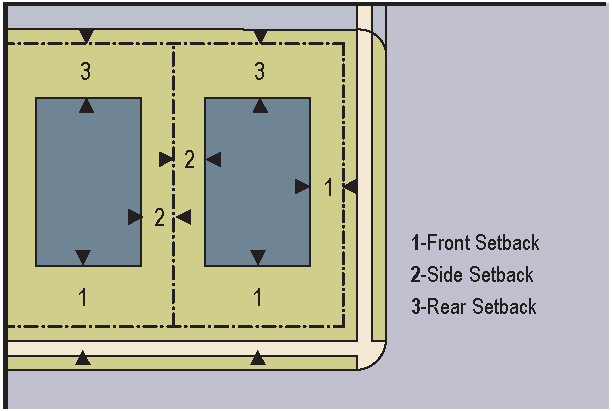 | 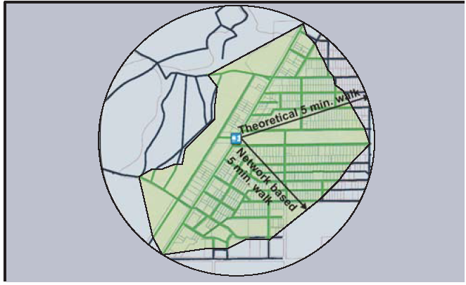 |
TABLE 13. - SUSTAINABILITY
Developers are encouraged to include alternative energy production systems if their plans permit.