
Ridgeland City Zoning Code
ARTICLE 3
- NEW COMMUNITY SCALE PLANS
3.1 - INSTRUCTIONS.
3.1.1
If the subject property is located within the Restricted Growth Sector (G-1), Controlled Growth Sector (G-2), or Intended Growth Sector (G3) as shown on the Town of Ridgeland Regional Plan, and the property is at least 30 acres in size, the provisions of Article 3 and this Code in general shall be available by right, upon request by the property owner.
3.1.2
New community plans may be prepared in the absence of a Regional Plan or a Comprehensive Plan by approval of the Town of Ridgeland Planning Commission and Town Council. New community plans may contain more than one community unit and/or more than one community unit type.
3.1.3
Once the CRC or Town of Ridgeland Planning Commission and Town Council approves a new community plan, the parcel/subject property shall be marked as such on the Town of Ridgeland Regulating Plan (or Zoning Map if optional code). Within the community planning area, this Code shall be the exclusive and mandatory zoning regulation, and its provisions shall be applied in their entirety.
3.1.4
New community plans submitted in accordance with the provisions of this Code, for the appropriate sector of a Regional Plan requiring no variances, shall be approved administratively by the CRC.
3.1.5
New community plans may be prepared by an owner or by the Planning Department.
3.1.6
New community plans shall include a Regulating Plan consisting of one or more maps showing the following for each community unit in the plan area, in compliance with the standards described in this article:
A.
Transect Zones.
B.
Civic Zones.
C.
Thoroughfare Network.
D.
Special districts, if any.
E.
Special requirements, if any.
F.
Numbers of warrants or variances, if any.
3.1.7
New community plans shall include one set of preliminary site plans for each Transect Zone, as provided by Section 5.1.3A.
3.2 - Sequence of Community Design.
3.2.1
The site shall be structured using one or several pedestrian sheds, which should be located according to existing conditions, such as traffic intersections, adjacent developments, and natural features. The site or any community unit within it may be smaller or larger than its pedestrian shed.
3.2.2
The pedestrian sheds may be adjusted to include land falling between or outside them, but the extent of each shall not exceed the acreage limit specified in Section 3.3 for the applicable community unit type. An adjusted pedestrian shed becomes the boundary of a community unit.
3.2.3
Areas of Transect Zones (Section 3.4) shall be located within the boundaries of each community unit as appropriate to its type. See Section 3.3. and Table 3A.
3.2.4
Civic Zone shall be assigned according to Section 3.5.
3.2.5
Special districts, if any, shall be assigned according to Section 3.6.
3.2.6
The Thoroughfare Network shall be laid out according to Section 3.7.
3.2.7
Density shall be calculated according to Section 3.8.
3.2.8
Remnants of the site outside the adjusted pedestrian shed(s) shall be assigned to Transect Zones or civic space by warrant or by special district by variance.
3.3 - Community Unit Types.
3.3.1
Clustered Land Development (CLD).
A.
A Clustered Land Development (CLD) shall be permitted within the G-1 Restricted Growth Sector and the G-2 Controlled Growth Sector.
B.
A CLD shall be structured by one standard pedestrian shed and shall consist of no fewer than 30 acres and no more than 80 acres.
C.
A CLD within either the G-1 Restricted Growth Sector or the G-2 Growth Sector shall include Transect Zones as follows:
1.
50% minimum of the community unit shall be allocated to T1 Natural Zone and/or T2 Rural Zone.
2.
10—30% of the community unit shall be allocated to T3 Neighborhood General Zone.
3.
20—40% of the community unit shall be allocated to T4 Neighborhood Core Zone.
3.3.2
Traditional Neighborhood Development (TND).
A.
A Traditional Neighborhood Development (TND) shall be permitted within the G-2 Controlled Growth Sector, the G-3 Intended Growth Sector and the G-4 Infill Growth Sector.
B.
A TND within the G-2 Controlled Growth Sector and the G-3 Intended Growth Sector shall be structured by one standard or linear pedestrian shed and shall be no fewer than 80 acres and no more than 160 acres. See Article 4 for infill TND acreage requirements in the G-4 Infill Growth Sector.
C.
A TND within either the G-2 Controlled Growth Sector or the G-3 Intended Growth Sector shall include Transect Zones as follows:
1.
10—30% of the community unit shall be allocated to T3 Neighborhood General Zone.
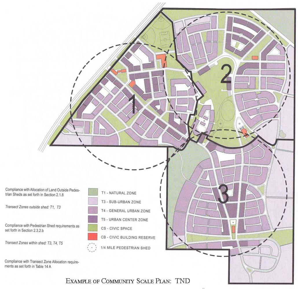
2.
30—60% of the community unit shall be allocated to T4 Neighborhood Core Zone.
3.
10—30% of the community unit shall be allocated to T5 Town Center/Main Street Zone.
D.
Larger sites shall be designed and developed as multiple communities, each subject to the individual Transect Zone requirements for its type as allocated on Table 1 and Table 14A. The simultaneous planning of adjacent parcels is encouraged.
E.
In the T-4 Neighborhood Core Zone, a minimum residential mix of three building disposition types (none less than 20%) shall be required, selected from Table 5.
3.3.3
Transit Oriented Development (TOD).
A.
Any TND on an existing or projected rail or Bus Rapid Transit (BRT) network may be redesignated in whole or in parts at TOD and permitted the higher density represented by the effective parking allowance in Section 5.9.2D.
B.
The use of a TOD overlay requires approval by variance.
3.4 - TRANSECT ZONES.
3.4.1
Transect Zones shall be assigned and mapped on each new community plan according to the percentages allocated on Tables 1 and 14A.
3.4.2
A Transect Zone may include any of the elements indicated for its T-Zone number throughout this Code, in accordance with intent described in the Transect Zone descriptions and the metric standards summarized in Table 10.
3.5 - CIVIC ZONES.
3.5.1
General.
A.
Civic Zones dedicated for public use shall be required for each community unit and designated on the new community plan as Civic Space (CS) and Civic Building (CB).
B.
Civic Space Zones are public sites permanently dedicated to open space.
C.
Civic Building Zones are sites dedicated for buildings generally operated by not-for-profit organizations dedicated to culture, education, religion, government, transit and municipal parking, or for a use approved by the CRC.
D.
A Civic Zone may be permitted by warrant if it does not occupy more than 20% of a pedestrian shed, otherwise it is subject to the creation of a special district. See Section 3.6.
E.
Parking for Civic Zones shall be determined by warrant. Civic parking lots may remain unpaved if graded, compacted and landscaped.
3.5.2
Civic Zones specific to T1 and T2 Zones.
A.
Civic buildings and civic spaces within T1 Natural and T2 Rural Zones shall be permitted only by variance.
B.
Lands in any special flood hazard area that are designated to be set aside for the purpose of hazard mitigation shall become permanent civic space regardless of size, subject to the special district provision herein, shall be designated civic space hazard mitigation on the community plan, and shall count toward the required civic space allotment for pedestrian sheds including them. Areas too small to be coded as special district shall conform to the civic space standards of Table 9 for one or more of any adjacent habitable Transect Zone(s).
3.5.3
Civic Space (CS) specific to T2.5—T5 Zones.
A.
Each pedestrian shed shall assign at least 5% of its urbanized area to civic space.
B.
Civic spaces shall be designed as generally described in Table 9, approved by warrant, and distributed throughout Transect Zones as described in Table 14E.
C.
Those portions of the T1 Natural Zone that occur within a development parcel shall be part of the civic space allocation and shall conform to the civic space types specified in Table 9 a. or 9 b.
D.
Each pedestrian shed shall contain at least one main civic space. The main civic space shall be within 800 feet of the geographic center of each pedestrian shed, unless topographic conditions, pre-existing thoroughfare alignments or other circumstances prevent such location. A main civic space shall conform to one of the types specified in Table 9 b., 9 c., or 9 d.
E.
Within 800 feet of every lot in residential use, a civic space designed and equipped as a playground shall be provided. A playground shall conform to Table 9 e.
F.
Each civic space shall have a minimum of 50% of its perimeter enfronting a thoroughfare, except for playgrounds.
G.
Civic spaces may be permitted within special districts by warrant.
H.
Parks may be permitted in Transect Zones T4 and T5 by warrant.
3.5.4
Civic Buildings (CB) specific to T2.5—T5 Zones.
A.
The owner shall covenant to construct a meeting hall or a third place in proximity to the main civic space of each pedestrian shed. Its corresponding public frontage shall be equipped with a shelter and bench for a transit stop.
B.
One Civic Building lot shall be reserved for an elementary school. Its area shall be one (1) acre for each increment of 100 dwelling units provided by the community plan, with a minimum of three (3) acres. The school site may be within any Transect Zone. Any playing fields should be outside the pedestrian shed.
C.
One Civic Building lot suitable for a childcare building shall be reserved within each pedestrian shed. The owner or a homeowners' association or other community council may organize, fund and construct an appropriate building as the need arises.
D.
Civic Building sites shall not occupy more than 20% of the area of each pedestrian shed.
E.
Civic Building sites should be located within or adjacent to a civic space, or at the axial termination of a significant thoroughfare.
F.
Civic Buildings shall not be subject to the standards of Article 5. The particulars of their design shall be determined by warrant.
G.
Civic Buildings may be permitted within special districts by warrant.
3.6 - SPECIAL DISTRICTS.
3.6.1
Special district designations shall be assigned to areas that, by their intrinsic size, function, or configuration, cannot conform to the requirements of any Transect Zone or combination of zones. Conditions of development for special districts shall be determined by the Town Council subsequent to a public hearing by the Planning Commission.
3.7 - THOROUGHFARE STANDARDS.
3.7.1
General.
A.
Thoroughfares are intended for use by vehicular and pedestrian traffic and to provide access to lots and open spaces.
B.
Thoroughfares shall generally consist of vehicular lanes and public frontages.
C.
Thoroughfares shall be designed in context with the urban form and desired design speed of the Transect Zones through which they pass. The public frontages of thoroughfares that pass from one Transect Zone to another shall be adjusted accordingly or, alternatively, the Transect Zone may follow the alignment of the thoroughfare to the depth of one lot, retaining a single public frontage throughout its trajectory.
D.
Within the most Rural Zones (T1 and T2/T2.5) pedestrian comfort shall be a secondary consideration of the thoroughfare. Design conflict between vehicular and pedestrian generally shall be decided in favor of the vehicle. Within the more urban Transect Zones (T3 through T5) pedestrian comfort shall be a primary consideration of the thoroughfare. Design conflict between vehicular and pedestrian movement generally shall be decided in favor of the pedestrian.
E.
The thoroughfare network shall be designed to define blocks not exceeding the size prescribed in Table 14C. The perimeter shall be measured as the sum of lot frontage lines. Block perimeter at the edge of the development parcel shall be subject to approval by warrant.
F.
All thoroughfares shall terminate at other thoroughfares, forming a network. Internal thoroughfares shall connect wherever possible to those on adjacent sites. Cul-de-sacs shall be subject to approval by warrant to accommodate specific site conditions only.
G.
Each lot shall enfront a vehicular thoroughfare, except that 20% of the lots within each transect zone may enfront a passage.
H.
Thoroughfares along a designated b-grid may be exempted by warrant from one or more of the specified public frontage or private frontage requirements. See Table 4.
I.
Standards for paths and bicycle trails shall be approved by warrant.
J.
The standards for thoroughfares within special districts shall be determined by variance.
3.7.2
Vehicular lanes.
A.
Thoroughfares may include vehicular lanes in a variety of widths for parked and for moving vehicles, including bicycles. The standards for vehicular lanes shall be as shown in Table 3A.
B.
A bicycle network consisting of bicycle trails, bicycle routes and bicycle lanes should be provided throughout as defined in Article 7 definitions of terms and allocated as specified in Table 14D. Bicycle routes should be marked with sharrows. The community bicycle network shall be connected to existing or proposed regional networks wherever possible.
3.7.3
Public frontages.
A.
General to all Zones T1, T2, T2.5, T3, T4, T5.
I.
The public frontage contributes to the character of the Transect Zone, and includes the types of sidewalk, curb, planter, bicycle facility, and street trees.
II.
Public frontages shall be designed as shown in Table 3A and Table 3B and allocated within Transect Zones as specified in the Transect Zone descriptions.
III.
Within the public frontages, the prescribed types of public planting and public lighting shall be as shown in Table 3A, Table 3B. The spacing may be adjusted by warrant to accommodate specific site conditions.
B.
Specific to Zones T1, T2, T2.5, T3.
I.
The public frontage shall include trees of various species, naturalistically clustered, as well as understory.
II.
The introduced landscape shall consist primarily of native species requiring minimal irrigation, fertilization and maintenance. Lawn shall be permitted only by warrant.
C.
Specific to Zone T4, T5.
I.
The introduced landscape shall consist primarily of durable species tolerant of soil compaction.
D.
Specific to Zone T4.
I.
The public frontage shall include trees planted in a regularly-spaced allee pattern of single or alternated species with shade canopies of a height that, at maturity, clears at least one story.
E.
Specific to Zone T5.
I.
The public frontage shall include trees planted in a regularly-spaced allee pattern of single species with shade canopies of a height that, at maturity, clears at least one story. At retail frontages, the spacing of the trees may be irregular, to avoid visually obscuring the shopfronts.
II.
Streets with a right-of-way width of 40 feet or less shall be exempt from the tree requirement.
3.8 - DENSITY CALCULATIONS.
3.8.1
All areas of the new community plan site that are not part of the O-1 Preserved Sector shall be considered cumulatively the net site area. The net site area shall be allocated to the various Transect Zones according to the parameters specified in Table 14A.
3.8.2
Density shall be expressed in terms of housing units per acre as specified for the area of each Transect Zone by Table 14B. For purposes of density calculation, the Transect Zones include the thoroughfares but not land assigned to civic zones. Ten percent (10%) should be in the affordable housing range.
3.8.3
The base density of the community unit may be increased by the transfer of development rights (TDR) up to the amount specified for each zone by Table 10 b. Fifteen percent (15%) of the increase in housing units by TDR shall be in the affordable housing range.
3.8.4
Within the percentage range shown on Table 14B for other functions, the housing units specified on Table 14B shall be exchanged at the following rates:
A.
For lodging: 2 bedrooms for each unit of net site area density.
B.
For office or retail: 1,000 square feet for each unit of net site area density.
C.
The number of units exchanged shall be subject to approval by warrant.
3.8.5
The housing and other functions for each Transect Zone shall be subject to further adjustment at the building scale as limited by Table 6, Table 7 and Section 5.9.
3.9 - SPECIAL REQUIREMENTS.
3.9.1
A new community plan may designate any of the following special requirements:
A.
A differentiation of the thoroughfares as A-grid and B-grid. Buildings along the A-grid shall be held to the highest standard of this Code in support of pedestrian activity. Buildings along the B-grid may be more readily considered for warrants allowing automobile-oriented standards. The frontages assigned to the B-grid shall not exceed 30% of the total length of frontages within a pedestrian shed.
B.
Designations for mandatory and/or recommended retail frontage requiring or advising that a building provide a shopfront at sidewalk level along the entire length of its private frontage. The shopfront shall be no less than 70% glazed in clear glass and shaded by an awning overlapping the sidewalk as generally illustrated in Table 4 and specified in Article 5. The first floor shall be confined to retail use through the depth of the second layer. (Table 12 d.)
C.
Designations for mandatory and/or recommended gallery frontage, requiring or advising that a building provide a permanent cover over the sidewalk, either cantilevered or supported by columns. The gallery frontage designation may be combined with a retail frontage designation.
D.
Designations for mandatory and/or recommended arcade frontage, requiring or advising that a building overlap the sidewalk such that the first floor facade is a colonnade. The arcade frontage designation may be combined with a retail frontage designation.
E.
A designation for coordinated frontage, requiring that the public frontage (Table 3A) and private frontage (Table 4) be coordinated as a single, coherent landscape and paving design.
F.
Designations for mandatory and/or recommended terminated vista locations, requiring or advising that the building be provided with architectural articulation of a type and character that responds visually to the location, as approved by the CRC.
G.
A designation for cross block passages, requiring that a minimum 8-foot-wide pedestrian access be reserved between buildings.
H.
A designation for buildings of historic significances, requiring that such buildings and structures may be altered or demolished only in accordance with Town of Ridgeland Municipal Code.
3.9.2
Source water protection standards:
A.
A new community plan must adhere to the distance (no closer than 100 feet) and contaminants of concerns in relation to existing production wells in the Town of Ridgeland. Source water protection standards are as set forth in Ridgeland Code Chapter 51.