Ridgeland City Zoning Code
ARTICLE 2
- REGIONAL SCALE PLANS
2.1 - INSTRUCTIONS.
2.1.1
This article governs the preparation of Regional Scale Plans ("regional plans") that allocate sectors. For lands within the Town of Ridgeland, South Carolina that have been mapped pursuant to this article, Sections 2.5 et seq. prescribe the community unit types permitted in each growth sector. Articles 3 and 4 regulate the standards of those community unit types.
2.1.2
Regional plans shall integrate the largest practical geographic area, overlapping property lines as necessary and municipal boundaries if possible.
2.1.3
Regional sectors are defined in Article 2 and are comprised of open space and growth areas of the town. Growth areas are intended for the development of community units, defined in Articles 3 and 4, which in turn are comprised of Transect Zones, defined by elements appropriate to them in Article 5 and Article 6.
2.1.4
Regional plans shall be prepared by the Planning Department and/or consultants under its supervision. The process shall involve citizen participation and the approval of the Planning Commission and Town Council.
2.2 - SEQUENCE OF SECTOR DETERMINATION.
Determination of sector designations shall be made in the following sequence:
2.2.1
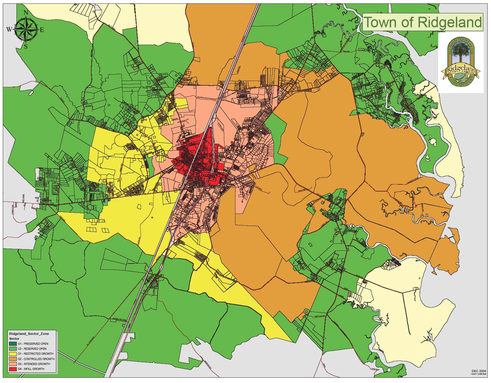
The areas to be designated preserved open sector (O-1) shall be mapped using the criteria cited within the respective heading of this article. The outline of this sector is effectively the rural boundary line, which is permanent.
2.2.2
The areas to be designated Reserved Open Sector (O-2) shall be mapped using the criteria cited within the respective heading of this article. The outline of this sector is effectively the urban boundary line which is to be adjusted by the ongoing permitting of new community plans or infill community plans in accordance with this Code.
Determining Sectors (Article 2)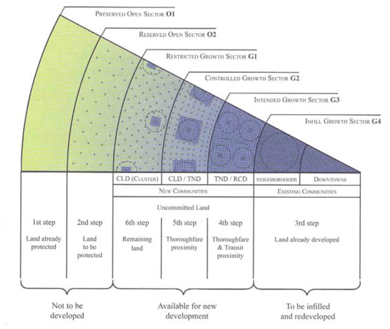
2.2.3
The areas to be designated Infill Growth Sectors (G-4) shall be mapped using the criteria cited within the respective heading of this article. The areas may be redeveloped according to Article 4 of this Code.
2.2.4
All remaining areas shall be available for new development pursuant to new community plans submitted and approved in accordance with Article 3 of this Code. These areas shall be assigned to the Restricted Growth Sector, the Controlled Growth Sector, or the Intended Growth Sector using the criteria listed in this article. Within these sectors, the community unit types of CLD (Clustered Land Development) and TND (Traditional Neighborhood Development) shall be permitted to the extent set forth in the table within this article.
2.2.5
Those areas that cannot or should not conform to one of the community unit types shall be allocated to special districts as described within this article.
TABLE 1. - SECTOR/COMMUNITY ALLOCATION.
Table 1 defines the geography, including both natural and infrastructure elements, determining areas that are or are not suitable for development. Specific community types of various intensities are allowable in specific sectors. This table also allocates the proportions of transect zones within each community type.
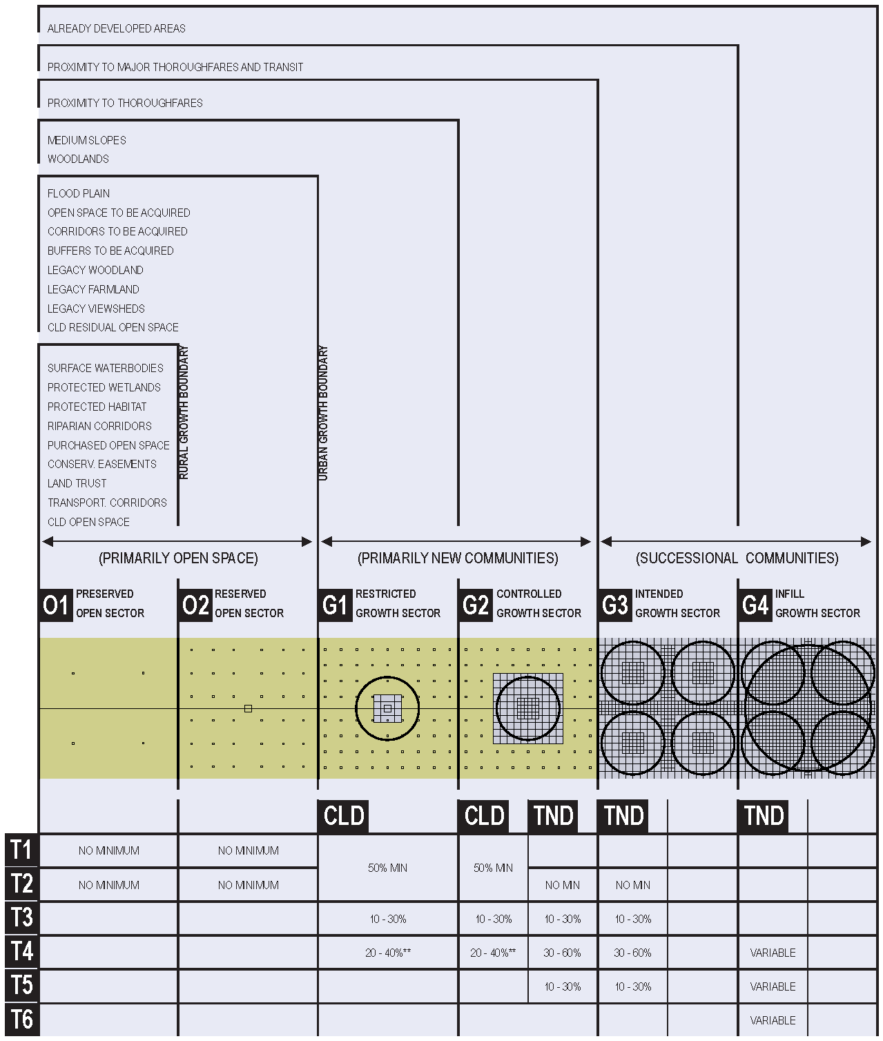
**CLD's may opt for T2.5, Rural Crossroads, instead of T4.
SECTOR DESCRIPTIONS
2.3 - (O-1) PRESERVED OPEN SECTOR.
This sector shall consist of open space that is protected from development in perpetuity. The Preserved Open Sector includes areas under environmental protection by law or regulation, as well as land acquired from conservation through purchase, by easement, or by past transfer of development rights. Consists of the aggregate of the following: Surface waterbodies, protected wetlands, protected habitat, riparian corridors, purchased open space, conservation easements, transportation corridors, and areas residual to Clustered Land Development (CLD). Development and construction within the Preserved Open Sector and the specifications required to do so shall be determined on an individual project basis by public hearings of the Town of Ridgeland Planning Commission and Town Council.
2.4 - (O-2) RESERVED OPEN SECTOR.
The Reserved Open Sector shall consist of open space that should be, but is not yet, protected from development. O-2 shall consist of the aggregate of the following categories: Floodplain (including special flood hazard areas), steep slopes, open space to be acquired, corridors to be acquired, buffers to be acquired, legacy woodland, legacy farmland, legacy viewsheds.
2.5 - (G-1) RESTRICTED GROWTH SECTOR.
The Restricted Growth Sector shall be assigned to areas that have value as open space but nevertheless are subject to development, either because the zoning has already been granted or because there is no legally defensible reason, in the long term, to deny it. Permitted community type by right: Clustered Land Development (CLD).
2.6 - (G-2) CONTROLLED GROWTH SECTOR.
The Controlled Growth Sector shall be assigned to those locations that can support mixed use by virtue of proximity to an existing or planned thoroughfare. Permitted community type by right: Clustered Land Development (CLD) and Traditional Neighborhood Development (TND)** any TND on an existing or projected rail or Bus Rapid Transit (BRT) network may be redesignated in whole or in part as TOD and permitted the higher density represented by the effective parking allowance in Section 5.9.2D. The use of a TOD overlay requires approval by variance.
2.7 - (G-3) INTENDED GROWTH SECTOR.
The Intended Growth Sector shall be assigned to those locations that can support substantial mixed use by virtue of proximity to an existing or planned regional thoroughfare and/or transit. Permitted community type by right: Regional Center Developments (RCD) and TNDs. **Any TND on an existing or projected rail or Bus Rapid Transit (BRT) network may be redesignated in whole or in part as TOD and permitted the higher density represented by the effective parking allowance in Section 5.9.2D. The use of a TOD overlay requires approval by variance.
2.8 - (G-4) INFILL GROWTH SECTOR.
The Infill Growth Sector shall be assigned to those areas already developed, having the potential to be modified, confirmed, or completed in the pattern of infill TNDs.
2.9 - (SD) SPECIAL DISTRICTS.
Special district designations shall be assigned to areas that, by their intrinsic size, function, or configuration, cannot conform to the requirements of a CLD or a TND as set forth in Article 3. Conditions of development for special districts shall be determined in a public hearing of the Town Council and recorded within the respective Transect Zone description. Alternatively, the provisions of the existing local codes shall remain applicable to special districts.