
Rockford City Zoning Code
CHAPTER 13
24 SUBDIVISION REGULATIONS
State law references—Boundaries and plats, RCW 58.04.001 et seq.; subdivision and plats, RCW 58.17.010 et seq.
ARTICLE VI PLAT VACATION, BOUNDARY LINE ADJUSTMENTS AND ELIMINATIONS
State law reference—Vacation of subdivision, RCW 58.17.212.
Sec 13.24.010 Purpose
Pursuant to the purposes set forth in RCW 58.17.010, the regulations in this chapter are necessary to:
- Promote the health, safety, and general welfare in accordance with standards established by the state and the Town;
- Promote effective use of land by preventing the overcrowding or scattered development which would be detrimental to health, safety, or the general welfare due to the lack of water supplies, sanitary sewer, drainage, transportation, or other public services, or excessive expenditure of public funds for such services;
- Avoid congestion and promote safe and convenient travel by the public on streets and highways through the proper planning and coordination of new streets within subdivisions with existing and planned streets in the surrounding community;
- Provide for adequate light and air;
- Provide for adequate water, sewage, drainage, parks and recreational areas, sites for schools and school grounds, and other public requirements;
- Provide for proper ingress and egress;
- Provide for housing and commercial needs of the community;
- Require uniform monumentation of land divisions and conveyance of accurate legal descriptions;
- Protect environmentally sensitive areas;
- Provide for flexibility in site design to accommodate view enhancement and protection, protection of streams and wetlands, protection of steep slopes, and other environmentally significant or sensitive areas;
- To ensure consistency with and to further the goals and policies of the comprehensive plan; and
- To provide a process for the division of land for the following:
- Short subdivision. The division of land into nine or fewer lots, tracts, parcels, sites or divisions with a level of review that is proportional to the effect those lots may have on the surrounding area;
- Subdivision. The division of land into ten or more lots, tracts, parcels, sites or divisions with a level of review that is proportional to the effect those lots may have on the surrounding area;
- Binding site plan. An alternative method of dividing property interests and applying to the phased division of any land for sale or lease which is zoned for commercial, business, office, or industrial development, or which is to be developed as condominiums or a manufactured home park.
(Ord. No. 19-03, § 5.1.01, 9-4-2019)
Sec 13.24.020 Exemptions
- The provisions of this chapter shall not apply to:
- Cemeteries and other burial plots while used for that purpose (RCW 58.17.040(1));
- Divisions made by testamentary provisions or laws of descent (RCW 58.17.040(3));
- A division of land for the purpose of leasing land for facilities providing personal wireless services while used for that purpose (RCW 58.17.040(8)).
- The provisions of this chapter shall not apply to the following, provided that an exemption application and drawing consistent with subsection (c) of this section is provided to the Town:
- Division of land into lots or tracts if such division is a result of subjecting a portion of the parcel or tract of land to either RCW ch. 64.32 (Horizontal Regimes Act) or RCW ch. 64.34 (Condominium Act) subsequent to the recording of a binding site plan for all such land (RCW 58.17.040(7));
- Division of land due to condemnation or sale under threat thereof, by an agency or division of government vested with the power of eminent domain;
- Division or acquisition of land for public rights-of-way;
- A division of land into lots or tracts of less than three acres that is recorded in accordance with RCW ch. 58.09, used or to be used for construction and operation of consumer- or investor-owned electric utilities to meet the electrical needs of a utility's existing and new customers as set forth in RCW 58.17.040(9).
- An application made pursuant to subsection (b) of this section shall be processed to determine that the division is exempt with a minimum review for conformance to adopted Town regulations and ordinances. The application will be determined to be complete upon the submittal of the following materials:
- An application; and
- Maps, plans, and/or exhibits containing all applicable information.
(Ord. No. 19-03, § 5.1.02, 9-4-2019)
Sec 13.24.030 Legal Lot
Development shall be permitted only on legally created lots. A lot is created in compliance with applicable state and local land segregation statutes or codes in effect at the time the lot was created or the binding site plan was approved, including, but not limited to, demonstrating the lot was created through one of the following:
- Lots created through subdivision, a plat approved by the Town or County separately describing the lot in question;
- Lots created through short subdivision, a short plat approved by the Town or County separately describing the lot in question;
- Lots created pursuant to a binding site plan process in effect at the time the binding site plan was approved by the Town or County;
- A deed, contract of sale, mortgage, property tax segregation, plat, or recorded survey describing the lot in question if the instrument was:
- Executed prior to March 24, 1980, for subdivisions (effective date of County's first subdivision ordinance) while the lot in question was under County jurisdiction;
- Executed prior to March 13, 1978 (effective date of County's first short subdivision ordinance), for short subdivisions while the lot in question was under County jurisdiction; or
- Executed prior to July 1, 1969 (effective date of RCW ch. 58.17).
(Ord. No. 19-03, § 5.1.03, 9-4-2019)
Sec 13.24.040 Approval Required Prior To Recordation
Any map, plat or plan, unless previously exempt, hereafter made of a proposed short subdivision, subdivision or binding site plan, or any part thereof, shall be presented for approval and be recorded. No such map, plat or plan shall be recorded or have any validity unless or until it has the approval of the Town Council.
(Ord. No. 19-03, § 5.1.04, 9-4-2019)
Sec 13.24.050 Prohibition Against Sale, Lease Or Transfer Of Property
No person shall sell, lease or offer to sell or transfer any lot, tract or parcel subject to the requirements of this chapter without first receiving approval hereunder by the Town and recording the approved division with the County, provided that if performance of an offer or agreement to sell, lease or otherwise transfer a lot, tract or parcel of land is expressly conditioned on the recording of the subdivision, short subdivision or binding site plan containing the lot, tract, or parcel, the offer or agreement does not violate any provision of this chapter.
(Ord. No. 19-03, § 5.1.05, 9-4-2019)
Sec 13.24.060 Vertical Datum
Where topography is required to be shown, the land survey data must be based on the North American Vertical Datum (NAVD-88).
(Ord. No. 19-03, § 5.1.06, 9-4-2019)
Sec 13.24.070 Monumentation
Right-of-way, street centerline and street intersection monumentation shall be established as described by Town-adopted street standards. In addition, for short subdivision, subdivision or binding site plans, every lot corner shall be marked or referenced in a permanent manner with the registration number of the professional land surveyor in charge of the survey in accordance with state law.
(Ord. No. 19-03, § 5.1.07, 9-4-2019)
Sec 13.24.080 Professional Land Surveyor
The preparation of all preliminary and final short subdivisions, subdivisions and binding site plans shall be made by or under the supervision of a professional land surveyor licensed in the state. The professional land surveyor shall certify on the final plat that it is a true and correct representation of the lands actually surveyed. A survey is required on all final plats. All surveys shall comply with RCW ch. 58.09 and WAC ch. 332-130.
(Ord. No. 19-03, § 5.1.08, 9-4-2019)
Sec 13.24.090 General Design
- The design of short subdivisions, subdivisions and binding site plans shall conform to the requirements of all applicable Town plans, regulations, and design and development standards.
- In addition:
- Lot specifications. The design, shape, size, and orientation of the lots should be appropriate for the use for which the divisions are intended, and the zoning and land use classification identified in the comprehensive plan of the area in which they are located.
- Lot arrangement.
- Side lot lines. Side lot lines shall generally be perpendicular to public street rights-of-way, but may be within 20 degrees of perpendicular, or radial to the right-of-way in the case of curvilinear streets or culs-de-sac.
- Corner lots.
- The lot lines at the intersection of two public streets shall be located a minimum of two feet behind the back of the curb.
- At the intersection of two arterial streets (collector, minor or principal), the applicant shall provide a widened border easement area behind the pedestrian ramp landing for the placement of street lights, traffic signals, etc., and their related appurtenances (see Figure 15).
- This area shall extend a minimum of 15 feet behind the landing.
- The boundary of this area shall be defined by an arc that is tangent at each end to the standard border easement, typically located behind the back of the sidewalk, or the right-of-way if there is no border easement in the vicinity.
- If this area is already fully contained within the right-of-way, then no additional border easement width will be required.
- The only utilities allowed within this area are those necessary for the function of the proposed lights, signals, etc.
- Corner lots in single-family or two-family residential development shall have an average width at least 15 percent greater than the width of interior lots along both adjacent streets to permit building setback and orientation to both streets.
Figure 15. Lot Arrangement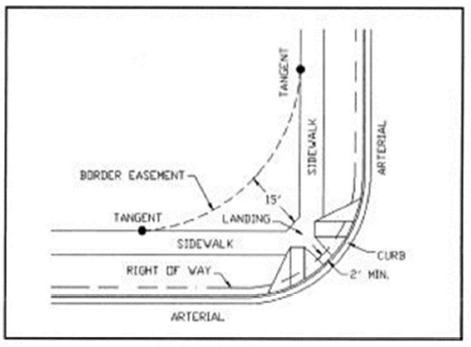
- Lot dimensions.
- Lot dimensions shall comply with the established minimum standards.
- Flag lots are prohibited. Reverse flag lots providing access to alleys or amenities located to the rear of the property are permitted.
- No lot shall have an average depth greater than three times its average width.
- Double frontage residential lots.
- Double frontage and reverse frontage lots shall be avoided except where necessary to separate residential development from an arterial roadway or to overcome specific disadvantages of topography and orientation;
- When lots back to arterials, a screening device shall be installed on the lots limiting visibility between the arterial and the adjoining lots in accordance with RMC ch. 13.12, art. III;
- No building, except buildings designed and constructed as two-family dwellings or one-family attached dwellings, shall be constructed on or across existing lot lines. Where buildings are designed and constructed on or across lot lines, the building shall be located so that the common wall separating the individual living units is located on and along the common lot lines of the adjoining lots.
- Block dimensions. Block dimensions should reflect due regard to the needs of convenient access, public safety, connectivity, emergency vehicle access, topography, road maintenance, and the provision of suitable sites for the land use planned.
- Block length. Block length shall be per the adopted street standards.
- Block and lot labeling. Blocks and lots shall be identified in sequential numerical order.
- Street alignments. Street alignments shall be designed and constructed with appropriate consideration for existing and planned streets, anticipated traffic patterns, topographic and drainage conditions, public safety, adopted street standards, comprehensive plan and the proposed use of the land so divided.
- Lots of one acre or more in size. When a tract is subdivided into lots of one acre or more in size, the Public Works Director or designee may require an arrangement of the lots and streets in conformance with adopted arterial and local access street master plans or areas.
- Prohibited boundaries. Lots should not be divided by the boundary of any town, county, zoning designation, or public right-of-way.
- Street access. Every lot shall have direct access to a paved public street, private street, or an easement for a private driveway.
- Provisions to ensure street access. Prior to filing the final short subdivision, subdivision or binding site plan application, the applicant shall improve or make appropriate provisions for the construction of the public or private streets, alleys or private driveways that provide access to lots being created through the short subdivision, subdivision, or binding site plan consistent with applicable Town-adopted standards.
- Wastewater design. Wastewater design shall be in compliance with all applicable Town regulations and other jurisdictional agency regulations.
- Fire protection. Adequate public domestic water supply and/or fire protection shall be provided in compliance with all applicable Town regulations and other jurisdictional agency regulations.
- Road design. All road designs shall be in conformance with adopted street standards.
- Stormwater management. Provisions for stormwater runoff shall be in compliance with Town regulations for stormwater management.
- Utilities easements. Existing and proposed easements for electric, water, sewer, gas, and similar utilities shall be illustrated on the short plat, plat, or binding site plan. The Public Works Director shall indicate in writing that the easements are adequate for their service needs.
- Underground utilities. The short subdivision, subdivision, or binding site plan shall provide for the location of underground utilities within public rights-of-way, border easements, alleys or utility easements, including, but not limited to, those for electricity, communications and street lighting. When conditions make underground installation impractical, the Public Works Director may waive the requirement for underground utilities.
(Ord. No. 19-03, § 5.1.09, 9-4-2019)
Sec 13.24.100 Findings
Prior to approval of any preliminary short subdivision, subdivision or binding site plan, the Town Clerk/Treasurer or designee shall determine and make written findings of fact that appropriate provisions are made for the following:
- The public health, safety, and general welfare;
- Open spaces;
- Drainageways;
- Streets or roads, alleys, sidewalks, and other public ways;
- Transit stops;
- Public potable water supplies;
- Sanitary sewer;
- Parks and recreation;
- Playgrounds;
- Sidewalks and other planning features that ensure safe walking conditions for students who only walk to and from school bus stops;
- Whether the public interest will be served by the short subdivision, subdivision, and binding site plan;
- The proposed short subdivision, subdivision or binding site plan is in conformity with all applicable provisions of this title; and
- Other requirements found to be necessary and appropriate, and for which written standards and policies have been adopted.
(Ord. No. 19-03, § 5.1.10, 9-4-2019)
Sec 13.24.110 Attached Single-Family Subdivisions
Applications for an attached single-family subdivision consisting of nine or fewer lots shall be submitted and processed according to the requirements for content and form for preliminary and final short subdivisions and process. Applications for an attached single-family subdivision consisting of ten or more lots shall be submitted and processed according to the requirements for content and form for preliminary and final subdivisions. Applications for alteration of any preliminary short subdivision or subdivision shall be submitted and processed according to the requirements of this chapter. Applications for alterations of any final short subdivision or subdivision shall be submitted and processed according to the requirements of this chapter. Applications for vacation of any plat shall be submitted and reviewed according to the requirements of this chapter.
(Ord. No. 19-03, § 5.1.11, 9-4-2019)
Sec 13.24.210 Application
Prior to filing an application for a preliminary subdivision, short subdivision, or binding site plan, a preapplication conference is required unless this requirement is waived by the Town Clerk/Treasurer or designee.
(Ord. No. 19-03, § 5.2.01, 9-4-2019)
Sec 13.24.220 Contents Of Application
Every preliminary short subdivision, subdivision or binding site plan shall consist of the appropriate application form, applicable fees and the following:
- Maps and exhibits.
- Ten copies of the preliminary short plat, plat or binding site plan which shall be a legibly drawn map, 18 inches by 24 inches in size for short plats (24 inches by 36 inches in size for plats and binding site plans) at a scale of one inch equals 50 feet or one inch equals 100 feet. If approved by the Town Clerk/Treasurer, an alternative appropriate scale may be used;
- One reduced (8 1/2 inches by 11 inches or 11 inches by 17 inches) copy of the preliminary short plat, plat or binding site plan;
- One copy of the County Assessor's half-section map clearly indicating the subject property. Additionally, all adjacent properties with parcel numbers must be indicated on the half-section map. Assessor's maps for preliminary subdivisions shall indicate the parcel numbers of all properties within 400 feet of the subject property, unless the applicant owns adjacent property, in which case the map shall show the location and parcel number of all properties within 400 feet of the applicant's ownership;
- A written narrative describing the proposal, including, but not limited to, the number of proposed lots, nature of surrounding properties, proposed access, zoning, utility providers, method of sewerage, and timing of phasing of the development (if any). The narrative shall also address compliance to applicable sections of this title and other applicable regulations;
- Public notice packet. The assessor's maps and the title company search shall be current within 60 days of issuing the notice of application. If the information is more than 60 days old at the time the notice of application is issued, the applicant shall provide current information;
- State Environmental Policy Act (SEPA) environmental checklist for preliminary subdivisions and binding site plans. An environmental checklist will be required for a preliminary short plat if the construction of improvements will involve more than 1,000 cubic yards of grading, excavation or fill, or if critical areas exist on site; and
- A plat certificate dated within 30 days of the application filing date confirming that the title of the lands as described and shown on the short plat, subdivision, or binding site plan is in the name of the owners signing.
- Other information. Preliminary short subdivision, subdivision or binding site plan data (to be included on the preliminary short plat, plat or binding site plan):
- Name, address and telephone number of the owner of the subject property and the person with whom official contact should be made regarding the short plat, plat, or binding site plan;
- Title of the proposed division;
- Location of subject property by quarter-quarters of the section, township and range;
- Legal description of the subject property with the source of the legal description clearly indicated;
- A vicinity map at a scale of not more than 400 feet to one inch, except that the Town Clerk/Treasurer or designee may approve an alternative scale if requested. The vicinity map shall show all adjacent parcels. It shall show how the streets and alleys in the proposed subdivision connect with existing and proposed streets and alleys in neighboring subdivisions or unplatted property;
- North arrow, scale and boundary of the proposed short plat, plat, or binding site plan, and the date the map is prepared;
- Boundaries of all blocks, lot numbers, lot lines along with their dimensions and areas in square feet;
- Location and identification of existing utilities;
- Location, names and widths of all existing and proposed streets, roads and access easements within the proposed short subdivision, subdivision, or binding site plan and within 100 feet thereof, or the nearest Town street if there is no Town street within 100 feet of the subject property;
- All easements, including border easements, or tracts proposed to be dedicated for any public purpose or for the common use of the property owners of the short plat, plat or binding site plan;
- All existing easements that affect the subject property;
- Location of any natural features, such as wooded areas, streams, drainageways, special flood hazard areas, identified on the flood insurance rate map, or critical areas;
- Location of existing buildings, septic tanks, drain fields, wells or other improvements, and a note indicating if they will remain or be removed;
- Whether adjacent property is platted or unplatted. If platted, give the name of the subdivision. If the proposed short subdivision, subdivision or binding site plan is the subdivision of a portion of an existing plat, the approximate lines of the existing plat are to be shown and a copy of the existing plat, along with the recording numbers of any recorded covenants and easements;
- Topographic information at five-foot maximum contour intervals, or at two-foot intervals where overall site topography is too flat to be depicted by five-foot intervals. Delineate areas with any slopes that are greater than 30 percent; and
- Site data table showing number of proposed lots, existing zoning, and method of sewerage.
(Ord. No. 19-03, § 5.2.02, 9-4-2019)
Sec 13.24.230 Distribution Of Plans
When the Town Clerk/Treasurer or designee determines that the application is complete, the Town Clerk/Treasurer shall distribute the application materials to affected agencies. The Public Works Director or reviewing agencies may request additional information during the review process.
(Ord. No. 19-03, § 5.2.03, 9-4-2019)
Sec 13.24.240 Expiration Of Preliminary Approval
Approval of a preliminary short subdivision, subdivision, or binding site plan shall automatically expire five years from the date of approval unless a complete application for a final short subdivision, subdivision, or binding site plan meeting all requirements under this chapter is submitted to the Town. Extension of time may be granted.
(Ord. No. 19-03, § 5.2.04, 9-4-2019)
Sec 13.24.250 Time Extensions
- An application form and supporting data for time extension requests shall be submitted to the Town Clerk/Treasurer at least 30 days prior to the expiration of the preliminary short subdivision, subdivision, or binding site plan.
- The Town Council may approve an extension provided there are no significant changed conditions or changed development regulations which would render recording of the short subdivision, subdivision or binding site plan contrary to the public health, safety or general welfare.
- The Town Council may grant an initial three-year time extension. Additional one-year extensions may be granted by the Town Council beyond the initial three-year extension. Prior to granting time extensions, the Town Clerk/Treasurer shall circulate the time extension request to affected agencies for comments. Additional or altered conditions recommended by the staff or affected agencies may be required as a condition of this extension. This may include new or updated Town regulations deemed necessary to protect the public health, safety, or general welfare.
- The Town Clerk/Treasurer or designee shall issue a written decision approving or denying the time extension request and provide copies to affected agencies, the applicant, and those parties requesting a copy of such decision. Appeals of a time extension shall be filed in a manner consistent with the provisions of this Code.
(Ord. No. 19-03, § 5.2.05, 9-4-2019)
Sec 13.24.310 Final Submittal
- The final short subdivision, subdivision, or binding site plan shall incorporate all conditions of the preliminary approval. The final short subdivision, subdivision, or binding site plan shall incorporate all conditions of approval imposed by the Town Council.
- All final subdivision, short subdivision or binding site plan submittals shall include the following:
- A minimum of ten copies of the proposed final short plat, plat or binding site plan;
- Appropriate fees;
- Three copies of a plat certificate dated within 30 days of the application filing date confirming that the title of the lands as described and shown on the short plat, subdivision, or binding site plan is in the name of the owners signing;
- Maps shall also be submitted in one of the following electronic file formats at the time the Mylar copies are submitted, unless this requirement is waived by the Town Clerk/Treasurer or designee:
- Portable document format (.pdf);
- Other commonly used format as approved by the Town Clerk/Treasurer;
- Electronic submittals shall be in accordance with the following criteria:
- Submittals shall utilize a file name using the Town submittal number. For example, SUB-08-06.xxx or SHP-22-07.xxx;
- Lines, text and details shall be complete, clear and crisp and at a resolution that enables the smallest detail to be recognized and understood when magnified;
- The electronic files shall be delivered on a CD or DVD that is legibly labeled with the subdivision name and phase; submittal number; file creation date; and contact information (firm name, address and phone number). As an option, an email submittal is acceptable and shall include a letter transmittal with the same information.
- The final short plat, plat or binding site plan shall show:
- All monuments found, set, reset, replaced or removed and not replaced, describing their kind, size and location and giving other data relating thereto;
- Bearing trees, corner accessories or witness monuments, basis of bearings, bearing and length of lines, scale of map with graphic bar scale and north arrow;
- Any other data necessary for the interpretation of the various items and locations of the points, lines and areas shown;
- Reference and show adjoining surveys of record and plats;
- The allowable error of mathematical closure for the final plat map shall not exceed one foot in 80,000 feet or 0.04 foot, whichever is greater;
- Bearings and lengths are to be shown for all lines; no ditto marks are to be used;
- Arrows shall be used to show limits of bearings and distances whenever any chance of misinterpretation could exist;
- Plat boundary and street centerlines having curves shall show radius, arc, central angle and tangent for each curve and radial bearings where curve is intersected by a non-tangent line. Spiral curves shall show two spiral curve elements in addition to the chord bearing and length;
- Lots along curves shall show arc length and radius. For lot corners that are on non-tangent or non-perpendicular curves, the radial bearing shall be shown. If a curve table is provided, it shall show the angle for each segment of the curve along each lot, arc length, tangent length, and radius;
- All dimensions shall be shown in feet and hundredths of a foot. All bearings and angles shall be shown in degrees, minutes and seconds. All partial measurements shown shall equal the total overall measurements shown;
- The final short plat, plat or binding site plan shall indicate the actual net area for each platted lot exclusive of dedicated or private road right-of-way. Lots one acre and over shall be shown to the closest hundredth of an acre, and all other lots shall be shown in square feet to the nearest square foot.
(Ord. No. 19-03, § 5.3.01, 9-4-2019)
Sec 13.24.320 Contents Of Final Plat
- All surveys shall comply with the Survey Recording Act (RCW ch. 58.09), minimum standards for survey and land descriptions (WAC ch. 332-130), and any applicable Town standards.
- The contents of a final short subdivision, subdivision or binding site plan shall include the following:
- The final short plat, plat or binding site plan shall be a legibly drawn, printed, or reproduced permanent map. Final short plats shall measure 18 inches by 24 inches. Final plats and binding site plans shall measure 24 inches by 36 inches. A two-inch margin shall be provided on the left edge, and a one-half-inch margin shall be provided at the other edges of the plat. If more than one sheet is required, each sheet shall show sheet numbers for the total sheets.
- The file number of the short plat, plat or binding site plan, location by quarter-quarter of a section, township and range shall be shown.
- The scale shall be 50 feet or 100 feet to the inch. If approved by the Town Clerk/Treasurer, an appropriate scale may be used which does not exceed 200 feet to the inch, provided a reduced copy, 400 feet to the inch, is also submitted. The scale shall be shown in a text form as well as a graphic bar scale.
- A bold boundary line shall delineate the existing perimeter boundary of the short plat, plat or binding site plan prior to any dedication to the public.
- The locations and widths of streets, alleys, rights-of-way, and easements serving the property, parks and open spaces proposed within the division and those platted easements existing immediately adjacent to the division shall be shown and or identified. Areas to be dedicated to the public must be labeled.
- Layout and names of adjoining subdivisions, subdivision lots or portions thereof shall be shown within and adjacent to the subdivision boundary.
- The layout, lot and block numbers, and dimensions of all lots shall be shown.
- Street names shall be shown.
- Street addresses for each lot shall be shown.
- Plat restrictions required as conditions of preliminary short subdivision, subdivision or binding site plan approval shall be shown.
- Existing easements and utility easements shall be identified, shown and labeled. Recording information for the easements shall be provided on the survey. Any easement and/or utility easement being created by the division shall be so identified, shown and labeled.
- Any special statements of approval required from governmental agencies, including those pertaining to flood hazard areas, shorelines, critical areas, and connections to adjacent state highways, shall be shown.
- A notarized certification and acknowledgements by the owners and beneficiary, if other than the Town, as shown on a current plat certificate shall be provided dedicating streets, areas intended for other public use, and granting of easements for slope and utilities.
- A certification signed by a professional land surveyor registered in the state stating that the final short plat, plat or binding site plan was surveyed and prepared by him, or under his supervision; that the plat is a true and correct representation of the subject land; and that monumentation has been established as required by Town standards. Certification must be consistent with RCW ch. 58.09.
- The Town Council authorizes final approval of any final plat, short plat, or binding site plan. If the plat contains multiple sheets, the first sheet shall contain the required signatures. The plat must be reviewed and signed by the following:
- Town contract engineer;
- Town Mayor;
- Town Public Works Director;
- Spokane Regional Health District (only where septic systems and/or private wells are required to serve the development);
- County Treasurer;
- County Assessor.
(Ord. No. 19-03, § 5.3.02, 9-4-2019)
State law reference—Survey Recording Act, RCW 58.09.010 et seq.
Sec 13.24.330 Filing Final Short Plat, Plat Or Binding Site Plan
The final short plat, plat or binding site plan shall be submitted to the Town Clerk/Treasurer for review. It shall be routed to appropriate departments and agencies in order to review for compliance with the conditions of approval. Once all reviewing departments and agencies are satisfied that all conditions have been met or appropriate bonding and surety obtained, the final short plat, plat or binding site plan shall be submitted to the Town Clerk/Treasurer for obtaining the required signatures. Final plats and short plats shall be approved, disapproved, or returned to the applicant within 30 days from the date of receipt thereof, unless the applicant consents to an extension of such time period.
(Ord. No. 19-03, § 5.3.03, 9-4-2019)
State law reference—Limitation for approval or disapproval of plats, RCW 58.17.140.
Sec 13.24.340 Recordation
The Town Clerk/Treasurer shall record the completed final short plat, plat, or binding site plan with the County Auditor's office and submit copies of the recorded documents to the County Assessor's office. All fees for such recording shall be paid by the applicant prior to recording.
(Ord. No. 19-03, § 5.3.04, 9-4-2019)
Sec 13.24.350 Surety In Lieu Of Construction Limitations
- Street improvements. Street improvements include sidewalks, drainage, and approaches.
- Non-street improvements. In lieu of the completion of the actual construction of any required non-street improvements prior to the approval of the final plat, short plat or binding site plan, the Town Clerk/Treasurer may accept a surety in an amount and with conditions satisfactory to the Town Council consistent with the provision of RCW 58.17.130, and the criteria listed below. Non-street improvements may include, but are not limited to, fencing, landscaping, and trails.
- The improvements will be completed within one year of the date of final approval;
- The applicant for the surety does not have any outstanding improvements that have not been timely completed within other plats, short plats, or binding site plans within the Town;
- The surety is in the form of a cash savings assignment or irrevocable letter of credit in an amount of at least 125 percent of the Town-estimated value of the outstanding improvements.
(Ord. No. 19-03, § 5.3.05, 9-4-2019)
Sec 13.24.360 Phasing
- Any subdivision or binding site plan may be developed in phases or increments. Phasing of short subdivisions is not permitted. A master phasing plan shall be submitted with the preliminary subdivision or binding site plan for approval by the Town Council. The phasing plan may be approved by the Town Council, provided that:
- The phasing plan includes all land identified within the legal notice;
- The sequence of phased development is identified by a map;
- Each phase has reasonable public or private infrastructure to support the number of dwelling units or proposed commercial or industrial development contained in that phase;
- Each phase constitutes an independent planning unit with facilities, adequate circulation, and any requirements established for the entire subdivision or binding site plan, provided that any non-finalized portion meets the minimum lot size of the underlying zone for the proposed use; and
- The contract engineer approves the necessary documents so that all road improvement requirements are assured for that phase.
- A phasing plan may be amended following preliminary approval. Said plan may be approved administratively, provided the criteria in this section are met.
(Ord. No. 19-03, § 5.3.06, 9-4-2019)
Sec 13.24.410 Applications
An application may be submitted for any proposed alteration to a preliminary plat, preliminary short plat or binding site plan. The application shall contain the signatures of the persons having an ownership interest in the plat or binding site plan.
(Ord. No. 19-03, § 5.4.01, 9-4-2019)
Sec 13.24.420 Notice, Decision, Filing Plan
- Any request for a proposed modification to a preliminary short subdivision, subdivision, or binding site plan which has received preliminary approval shall be submitted to the Town Clerk/Treasurer.
- Any proposed modification which would amend conditions established administratively shall be circulated to affected agencies for review and comment. An amended decision or amended conditions of approval may be required based on comments received from affected agencies.
- The Town Clerk/Treasurer or designee may waive formal processing if it is determined that the proposed modification would not have a substantial impact on adjacent properties or conditions of approval. This process shall not apply to amending site plans or conditions thereof established by the Town Council that would constitute a change of condition.
- Alterations may be approved by the Town Clerk/Treasurer or designee, if the Town Clerk/Treasurer or designee determines that the public use and interest will be served by the alteration.
- Following approval of an alteration, the applicant shall produce a revised drawing of the approved alteration which shall be signed by the Mayor or designee and filed with the Town Clerk/Treasurer.
- Any proposed modification which would significantly amend conditions established by the Town Council shall be processed as a change of conditions.
(Ord. No. 19-03, § 5.4.02, 9-4-2019)
Sec 13.24.510 Application
An application may be submitted for any proposed alteration to a final plat, final short plat, or final binding site plan. The application shall contain the signatures of the majority of those persons having an ownership interest in lots, tracts, parcels, sites or divisions in the subject subdivision or portion to be altered. If the subdivision is subject to restrictive covenants which were filed at the time of approval of the subdivision, and the application for alteration would result in the violation of a covenant, the application shall contain an agreement signed by all parties subject to the covenants, providing that the parties agree to terminate or alter the relevant covenants to accomplish the purpose of the vacation of the subdivision or binding site plan, or portion thereof.
(Ord. No. 19-03, § 5.5.01, 9-4-2019)
Sec 13.24.520 Final Plat Alterations; Notice, Public Hearing, Decision, Filing Requirements
- Upon receipt of a completed application for a final plat alteration, the Town Clerk/Treasurer shall provide notice of the application to all owners of property within the subdivision, publication in the Town's official newspaper and to those owners of property within 400 feet of that portion of the plat proposed for alteration. The notice shall include a statement that a public hearing will not be required unless specifically requested within the time frame indicated subsection (b) of this section.
- If a public hearing is requested within 14 days of receipt of the notice, notice of the hearing shall be provided.
- Alterations to final plats may be approved if it is determined that the public use and interest will be served by the alteration.
- Following approval of an alteration, the applicant shall produce a revised drawing of the approved alteration of the final plat, which shall be signed by the Mayor or designee and filed with the County Auditor's office to become the lawful plat of the property.
(Ord. No. 19-03, § 5.5.02, 9-4-2019)
Sec 13.24.530 Final Short Plat And Binding Site Plan Alterations; Notice, Decision, Filing Requirements
- Upon receipt of a completed application for a final short plat or binding site plan alteration, the Town Clerk/Treasurer shall provide notice of the application to all owners of property within the subdivision, through publication in the Town's official newspaper, and to those owners of property adjacent to that portion of the short plat or binding site plan proposed for alteration.
- Alterations to final short plats or binding site plans may be approved by the Town Clerk/Treasurer or designee, if the Town Manager or designee determines that the public use and interest will be served by the alteration.
- Following approval of an alteration, the applicant shall produce a revised drawing of the approved alteration of the final short plat or binding site plan, which shall be signed by the Mayor or designee and filed with the County Auditor's office to become the lawful plat or binding site plan of the property.
(Ord. No. 19-03, § 5.5.03, 9-4-2019)
Sec 13.24.540 Record Of Survey To Establish Lots Within A Binding Site Plan
- A record of survey may be filed subsequent to the recording of a final binding site plan to establish lots within the boundaries of the final binding site plan. The record of survey shall be approved by the Town Council. The following information shall be provided on the record of survey:
- The binding site plan file number shall be referenced.
- The scale shall be 50 feet or 100 feet to the inch. If approved by the Town Clerk/Treasurer or designee, an appropriate scale may be used which does not exceed one inch equals 200 feet, provided a reduced, one inch equals 400 feet, 8 1/2-inch by 11-inch copy is provided.
- A district-wide boundary line shall delineate the boundary of the lots being created. The boundary of the binding site plan shall be indicated and any lots that have been created by filing of the final binding site plan and/or record of survey.
- Each lot shall be numbered consecutively, and the size of each lot shall be indicated on the record of survey.
- The location and widths of streets, alleys, rights-of-way, and easements within the binding site plan and those existing immediately adjacent to the lot being created shall be shown.
- Street names shall be shown.
- Street addresses shall be shown.
- Restrictions required as conditions of preliminary approval shall be shown.
- Appropriate utility easements shall be shown.
- Certification of the professional land surveyor licensed in the state shall be included.
- The following signatures are required on the record of survey:
- Town Mayor or designee;
- Town contract engineer;
- Property owner.
- Any existing buildings located on the lot which is being created or altered shall be illustrated.
- The Town Clerk/Treasurer shall record approved record of surveys with the County Auditor's office and submit copies of the recorded documents to the County Assessor's office. All fees for such recording shall be paid by the applicant prior to recording.
(Ord. No. 19-03, § 5.5.04, 9-4-2019)
Sec 13.24.710 Application
An application may be submitted for the proposed vacation of part or all of a plat. The application shall contain the signatures of the majority of those persons having an ownership interest of lots, tracts, parcels, sites or divisions in the subject subdivision or a portion to be vacated.
(Ord. No. 19-03, § 5.6.01, 9-4-2019)
Sec 13.24.720 Process
Upon submittal of a complete application for vacation of plat, the Town Council shall process the plat vacation request in a manner consistent with RCW 58.17.212.
(Ord. No. 19-03, § 5.6.02, 9-4-2019)
Sec 13.24.810 Scope And Purpose
- Boundary line adjustments shall be a minor alteration in the location of lot or parcel boundaries on existing lots or parcels.
- In this division, the term "lot" means a parcel of land having fixed boundaries described by reference to a recorded plat, a recorded binding site plan, by metes and bounds, or by section, township, and range, and be of sufficient area to meet minimum zoning requirements.
- The purpose of the boundary line elimination process is to remove interior lot lines of a parcel comprised of two or more separate lots with contiguous ownership.
(Ord. No. 19-03, § 5.7.01, 9-4-2019)
Sec 13.24.820 Conditions
Boundary line adjustments must be consistent with the following:
- Such alteration shall not increase the number of lots nor diminish in size open space or other protected environments;
- Such alteration shall not diminish the size of any lot so as to result in a lot of less square footage than prescribed in this title;
- Such alteration shall not result in a building setback violation or site coverage to less than that prescribed by this title;
- All lots resulting from the boundary line alteration shall be in conformance with the design standards of this chapter.
(Ord. No. 19-03, § 5.7.01, 9-4-2019)
Sec 13.24.830 Application And Drawing Requirements
Application for a boundary line adjustment or elimination shall be made on forms provided by the Town Clerk/Treasurer and shall provide the following information:
- Existing conditions site plan. Produce a to-scale site plan on an 8 1/2-inch by 11-inch sheet with one-inch margins on all sides showing the following information:
- The existing dimensions and square footage of the existing properties involved;
- The location and setbacks of any permanent improvements (i.e., structures, septic systems, etc.) from all property lines;
- The identification, location and dimension of all access and utility easements;
- The location, dimensions and names of public and/or private streets abutting the properties; and
- North arrow and scale shall be noted.
- Proposed adjustment/elimination site plan. Produce a to-scale plan on an 8 1/2-inch by 11-inch sheet with one-inch margins on all sides showing the following information:
- The location and setbacks of any permanent improvements (i.e., structures, septic systems, etc.) after the proposed boundary line adjustment or elimination from the new property lines;
- The identification, location and dimension of any access or utility easements after the proposed boundary line adjustment or elimination;
- The location, dimensions and names of public and/or private streets abutting the properties after the proposed boundary line adjustment or elimination;
- Indicate the existing property lines to be revised with a dashed line and the proposed property lines with a solid line, if applicable; and
- North arrow and scale shall be noted.
- On a separate sheet of paper (8 1/2-inch by 11-inch) a written legal description for the existing parcels and the proposed adjusted or eliminated parcels with one-inch margins on all sides.
- One copy each of all involved property owners' recorded deeds, verifying current ownership of the subject properties.
- If available, submit a copy of an original plat for the subject property. A copy of the general land office plat is not required.
- A record of survey of the property may be required by the Town Clerk/Treasurer or designee. The need for a survey will be determined based on an evaluation of the number of parcels, legal descriptions, appurtenances, disputed or apparent lines of ownership, and setbacks. If required, the survey must be completed by a professional land surveyor licensed in the state.
(Ord. No. 19-03, § 5.7.02, 9-4-2019)
Sec 13.24.840 Recordation
- The Town Clerk/Treasurer shall record approved boundary line adjustments and eliminations with the County Auditor's office and submit copies of the recorded documents to the County Assessor's office. All fees for such recording shall be paid by the applicant prior to recording. The Town Clerk/Treasurer will also ensure that all of the then-current year's property taxes are paid.
- When a lot segregation or merging of lots is being done, the Town Clerk/Treasurer shall sign and approve the County Assessor's form and give to the applicant to record. No fee will be submitted to the Town Clerk/Treasurer for this proposal, but the Town Clerk/Treasurer will ensure that all of the then-current year's property taxes are paid.
(Ord. No. 19-03, § 5.7.03, 9-4-2019)
Sec 13.24.910 Purpose
It is the intent and purpose of this article to:
- Encourage imaginative design and the creation of permanent open space by permitting greater flexibility in zoning requirements than is generally permitted by other sections of this title.
- Preserve or create environmental amenities superior to those generally found in conventional developments.
- Create or preserve usable open space for the enjoyment of the residents.
- Preserve, to the greatest extent possible, the natural characteristics of the land, including, but not limited to, topography, natural vegetation, waterways, and views.
- Encourage development of a variety of housing types.
- Provide for maximum efficiency in the layout of streets, utility networks, and other public improvements and infrastructure.
(Ord. No. 19-03, § 5.8.01, 9-4-2019)
Sec 13.24.920 Where Permitted
Planned residential developments (PRDs) are permitted in all residential zoning districts in the Town.
(Ord. No. 19-03, § 5.8.02, 9-4-2019)
Sec 13.24.930 Permitted Uses
The following uses are permitted in a planned residential development (PRD), provided that they meet the standards and criteria established in this chapter:
- Those uses permitted as a matter of right in the underlying zoning district;
- Residential developments of all types as defined by RMC ch. 13.20.
(Ord. No. 19-03, § 5.8.03, 9-4-2019)
Sec 13.24.940 Relationship To Other Development Provisions
- Zoning and development regulations. The provisions of this title pertaining to land use of the underlying zoning district shall govern the use of land in a planned residential development (PRD). The specific setback, lot size, height limits, and other dimensional requirements are waived and the regulations for PRDs shall be those indicated in division 2 of this article.
- Subdivision requirements. A PRD shall be exempt from the specific design requirements of this chapter except that when any parcel of land in a PRD is intended for individual ownership, sale, or public dedication, the subdivision and procedural requirements of this chapter and applicable state laws pertaining to subdivision, conveyance of land, and the preparation of maps shall be followed.
- Permit processing procedures. A PRD is a Type III permit type and shall require a public hearing before the Town Council consistent with the provisions of RMC ch. 13.28.
(Ord. No. 19-03, § 5.8.04, 9-4-2019)
Sec 13.24.1010 Relationship Of Planned Residential Development Site To Adjacent Areas
The design of a planned residential development (PRD) shall take into account the relationship of the site to the surrounding areas. The perimeter of the PRD shall be designed to minimize adverse impact of the PRD on adjacent properties and, conversely, to minimize adverse impact of adjacent land use and development characteristics on the PRD.
(Ord. No. 19-03, § 5.8.05(A), 9-4-2019)
Sec 13.24.1020 Site Acreage Minimum
The minimum site shall be five acres.
(Ord. No. 19-03, § 5.8.05(B), 9-4-2019)
Sec 13.24.1030 Minimum Lot Size
The minimum lot size provisions of other sections in this title shall apply to planned residential developments (PRDs).
(Ord. No. 19-03, § 5.8.05(C), 9-4-2019)
Sec 13.24.1040 Density
The Town Council may authorize a dwelling unit density up to 20 percent greater than that permitted by the underlying zone, rounded to the nearest whole number.
(Ord. No. 19-03, § 5.8.05(D), 9-4-2019)
Sec 13.24.1050 Maximum Coverage
Lot coverage shall not exceed the percentage permitted by the underlying zone.
(Ord. No. 19-03, § 5.8.05(E), 9-4-2019)
Sec 13.24.1060 Landscaping Required
All common open space shall be landscaped in accordance with the landscaping plan submitted by the applicant and approved by the Town Council. Natural landscape features which are to be preserved, such as existing trees, drainageways, rock outcrops, etc., may be accepted as part of the landscaping plan.
(Ord. No. 19-03, § 5.8.05(F), 9-4-2019)
Sec 13.24.1070 Setback And Side Yard Requirements
- Setbacks from the exterior boundary line of the planned residential development (PRD) area shall be comparable to or compatible with those of the existing development of adjacent properties, or, if adjacent properties are undeveloped, the type of development which may reasonably be expected on such properties given the existing zoning.
- The standard setbacks and yard requirements between buildings may be waived in a PRD. Buildings may have common walls.
(Ord. No. 19-03, § 5.8.05(G), 9-4-2019)
Sec 13.24.1080 Off-Street Parking
Off-street parking shall be provided in accordance with RMC ch. 13.12, art. IV.
(Ord. No. 19-03, § 5.8.05(H), 9-4-2019)
Sec 13.24.1090 Secondary Use Limitations
- Commercial uses shall comply with RMC ch. 13.28, art. III. Site plans shall be included in the application for the planned residential development (PRD).
- The gross floor area of the commercial use shall not exceed the product of 50 square feet multiplied by the number of dwelling units within the development.
- Construction of at least 35 percent of the residences in the PRD shall be completed before issuing any building permits for the construction of commercial uses, except this shall not prohibit a sales office.
(Ord. No. 19-03, § 5.8.05(I), 9-4-2019)
Sec 13.24.1110 Common Open Space
Each planned residential development (PRD) shall dedicate at least 30 percent of the gross land area for common open space for the use of its residents. Common open space areas shall meet the criteria in this division.
(Ord. No. 19-03, § 5.8.06(intro. ¶), 9-4-2019)
Sec 13.24.1120 Location
The open space shall be entirely within the planned residential development (PRD) and within reasonable walking distance of all dwelling units in the PRD. Where practical, the common open space shall be located adjacent to other established or planned park and recreational areas in adjacent developments, schools, or Town parks, provided that such dedication would increase the overall benefit to the residents of the PRD and conform to other criteria in this chapter.
(Ord. No. 19-03, § 5.8.06(A), 9-4-2019)
Sec 13.24.1130 Access
All dwelling units within the planned residential development (PRD) shall have legal access to the proposed common open space at the time of final PRD approval. Private or access streets, trees, or other landscaping may separate the common open space area; however, access may not be blocked by major obstacles such as arterial or collector streets, or significant natural features such as rivers, streams, or topographic features. Active recreational open space areas shall have reasonable access from street frontages.
(Ord. No. 19-03, § 5.8.06(B), 9-4-2019)
Sec 13.24.1140 Types Of Open Space
- Land dedicated for open space in a planned residential development (PRD) shall be usable for either greenbelts that serve as a buffer between land uses, using existing vegetation, or an aesthetic amenity such as boulevard trees, active recreational activities, or for protecting critical areas.
- Except as provided in subsection (d) of this section, a minimum of 30 percent of the required common open space area shall be suitable for active recreation. The topography, soils, hydrology, and other physical characteristics of the active recreation area shall provide a dry, obstacle-free space in a configuration which is suitable for active recreation.
- The percentage of active recreational areas may be increased to as high as 50 percent if it is determined that anticipated recreational needs require a larger percentage. In increasing this percentage, the following standard shall be used: the ratio of one acre to 125 residential units.
- The percentage of active recreational area may be decreased to as low as 15 percent if it is determined that:
- Inclusion of buffers or critical areas better meet the open space needs of the residents of the PRD; or
- A higher percentage would lead to the detrimental grading or other disturbance of the natural setting.
(Ord. No. 19-03, § 5.8.06(C), 9-4-2019)
Sec 13.24.1150 Features Not To Be Included
Open space area shall not include the following:
- Accessory buildings and areas reserved for the exclusive use and benefit of an individual tenant or owner.
- Public rights-of-way, private streets, residential driveways, parking areas, loading or storage areas, or setback areas.
- Floodplain (100-year), floodprone areas, drainage easements, natural drainage areas, or creeks.
(Ord. No. 19-03, § 5.8.06(D), 9-4-2019)
Sec 13.24.1160 Implementation
- The open space area shall be dedicated in common to the property owners within the plat or to a property owners' or homeowners' association.
- Maintenance and operation of the open space shall be the responsibility of the property owners' or homeowners' association.
- The Town may choose to accept dedication, maintenance, and operation responsibilities when the common open space area is in the public interest and complies with at least one of the following:
- Is greater than ten acres;
- Is adjacent to an established or future Town park or school grounds;
- Is an access to a body of water greater than three acres in size; or
- Is a critical area.
- The dedication shall be identified on the planned residential development (PRD) plan.
- The Town may choose to accept dedication, maintenance, and operation responsibilities when the common open space area is in the public interest and complies with at least one of the following:
(Ord. No. 19-03, § 5.8.06(E), 9-4-2019)
Sec 13.24.1170 Improvements
The following improvements to the open space area may be required prior to final approval of the planned residential development (PRD):
- Removal of construction debris and hazards; and
- Rough grading and establishment of grass cover over those portions of the site suitable for playfields.
(Ord. No. 19-03, § 5.8.06(F), 9-4-2019)
Sec 13.24.1180 Equivalent Facilities
- When proposed open space areas do not meet the criteria for dedication, such land may be improved by grading, filling, landscaping, or with installation of recreation equipment so as to be equivalent in result to the intent of this chapter.
- The Town Clerk/Treasurer or designee shall determine if the proposal is equivalent based on the following guidelines:
- The proposed land and improvements shall create recreational opportunities generally equivalent to or greater than the land required for the residents within the planned residential development (PRD); and
- The proposed land and improvements shall not significantly disturb or alter a critical area, unless otherwise allowed by the Town.
(Ord. No. 19-03, § 5.8.06(G), 9-4-2019)
Sec 13.24.1190 Stormwater Facilities
Stormwater facilities may be allowed by the Town as open space subject to the following criteria:
- The stormwater facility shall drain fully within 72 hours after a storm event unless the facility is designed as an aesthetic amenity;
- The side slope of the stormwater facility shall not exceed 3:1 unless slopes are existing, natural, and vegetated;
- If the stormwater facilities are located adjacent to or near a natural, year-round stream or wetland, these systems shall be left in natural or near to natural condition;
- The stormwater facilities shall be landscaped in a manner which is both aesthetic and able to withstand the inundation expected;
- The stormwater facility shall not be fenced or otherwise rendered unsuitable or unavailable for recreation use during dry weather; and
- In the case of joint use of open space for stormwater and recreation, the property owners' or homeowners' association shall be responsible for maintenance of the stormwater facilities.
(Ord. No. 19-03, § 5.8.06(H), 9-4-2019)
Sec 13.24.1200 Rights And Duties
The owners of open space shall have the following rights on the common open area, subject to restrictive covenants or other restrictions:
- The right to locate recreational facilities, such as tennis courts, swimming pools, picnic tables, and fireplaces (accessory to picnic tables) for the exclusive use of residents of the planned residential development (PRD) and their guests;
- The right to locate pedestrian, bicycle, and bridle paths;
- The right to protect and maintain the common space area or to correct a hazardous condition posing a threat to life or limb;
- The right to regulate access to the open space land and the duty to maintain it.
(Ord. No. 19-03, § 5.8.06(I), 9-4-2019)
Sec 13.24.1310 Permit Issuance
- Administration. Building permits and other required permits for the development of property under the provisions of RMC ch. 13.28, art. III shall be issued only when, in the opinion of the Town Clerk/Treasurer or designee, the work to be performed meets the requirements of the final plan and program elements of the planned residential development (PRD).
- Minor and major adjustments.
- Minor adjustments may be made and approved by the Town Clerk/Treasurer or designee when a building permit is issued. Minor adjustments are those which may affect the precise dimensions or siting of buildings, but which do not affect the basic character or arrangement of buildings approved in neither the final plan, the density of the development, nor the open space requirements. Such dimensional adjustments shall not vary more than ten percent from the original.
- Major adjustments are those which, in the opinion of the Town Clerk/Treasurer or designee, substantially change the basic design, density, open space or other requirements of the PRD. When, in the opinion of the Town Manager or designee, a change constitutes a major adjustment, a building or other permit shall not be issued without prior review and approval by the hearing examiner of such adjustment.
- Parties bound. Once the preliminary development plan is approved, all persons and parties, their successors, heirs, or assigns, who own, have, or will have by virtue of purchase, inheritance, or assignment, any interest in the real property within the proposed PRD, shall be bound by the conditions attending the approval of the development and the provisions of this chapter.
(Ord. No. 19-03, § 5.8.07, 9-4-2019)
Sec 13.24.1410 Required
In a planned residential development (PRD), a property owners' or homeowners' association shall be established for the purpose of ownership, maintenance, and management of open spaces, common areas, and private streets as required by the provisions of this title.
(Ord. No. 19-03, § 5.8.08, 9-4-2019)