
Rockford City Zoning Code
CHAPTER 13
32 ENVIRONMENTAL STANDARDS
Sec 13.32.110 Purpose
This article implements the State Environmental Policy Act (SEPA), RCW 43.21C.120, and WAC ch. 197-11.
(Ord. No. 19-03, § 7.1.01, 9-4-2019)
Sec 13.32.120 Designation Of Responsible Official
For those proposals for which the Town is lead agency, the responsible official shall be the Mayor or designee. The responsible official shall make the threshold determination, supervise scoping and preparation of any required environmental impact statement (EIS), and perform any other function assigned to the lead agency or responsible official.
(Ord. No. 19-03, § 7.1.02, 9-4-2019)
Sec 13.32.130 Lead Agency Determination And Agency Responsibilities
- When an application is filed for a nonexempt action or the Town initiates a nonexempt action, the responsible official shall determine the lead agency for that proposal pursuant to WAC 197-11-050 and 197-11-922 through 197-11-940, unless a lead agency has been previously identified or the responsible official is aware that another department or agency is in the process of determining the lead agency.
- When the Town is not the lead agency for a proposal, all departments of the Town shall use and consider as appropriate either the DNS or the final EIS of the lead agency in making decisions on the proposal. No Town department shall prepare or require preparation of a DNS or EIS in addition to that prepared by the lead agency unless the responsible official determines a supplemental environmental review is necessary under WAC 197-11-600.
- If the Town, or any of its departments, receives a lead agency determination made by another agency that appears inconsistent with the criteria of WAC 197-11-922 through 197-11-940, it may object to the determination. Any objection must be made to the agency originally making the determination or the Town must petition the state department of ecology for a lead agency determination under WAC 197-11-946 within the 15-day time period. Any such petition on behalf of the Town shall be initiated by the responsible official.
- The responsible official is authorized to make agreements as to lead agency status or shared lead agency's duties for a proposal under WAC 197-11-942 and 197-11-944.
- The responsible official shall require sufficient information from the applicant to identify other agencies with jurisdiction.
(Ord. No. 19-03, § 7.1.03, 9-4-2019)
Sec 13.32.140 Categorical Exemptions
Categorical exemptions are set forth in WAC 197-11-800.
- Application. If a proposal fits within any of the exemptions set forth in this section, the proposal shall be categorically exempt from the threshold determination requirements of WAC 197-11-720, except as follows:
- The proposal includes an activity that is not exempt under WAC 197-11-908 (Critical areas);
- The proposal is a segment of a proposal that includes a series of actions, physically or functionally related to each other, some of which are categorically exempt and some of which are not; or
- The proposal includes, or is a part of, a series of exempt actions that are physically or functionally related to each other and that together may have a probable significant adverse impact in the judgment of an agency with jurisdiction.
- Flexible thresholds. The Town adopts the following exempt levels for new construction pursuant to WAC 197-11-800(1)(c):
- For single-family residential dwelling units, up to 30 dwelling units.
- For multifamily residential dwelling units, up to 60 units.
- For barn, loafing shed, farm equipment storage, produce storage, or packing structure buildings, up to 40,000 square feet.
- For office, school, commercial, recreational, service, or storage buildings, up to 30,000 square feet of gross floor area and with associated parking facilities designed for up to 90 parking spaces. This exemption includes stand-alone parking lots.
- For landfills and excavations, up to 1,000 cubic yards.
- Procedure for use of categorical exemptions. The agency or applicant may proceed with the exempt aspects of a proposal prior to conducting environmental review of the nonexempt aspects of a proposal, provided that the requirements of WAC 197-11-070 are met.
- Written findings. The lead agency is not required to document that a proposal is categorically exempt; however, the lead agency may note on an application that a proposal is categorically exempt or place such a determination in the agency's files.
(Ord. No. 19-03, § 7.1.04, 9-4-2019)
Sec 13.32.150 Environmental Checklist
- A completed environmental checklist shall be filed prior to or at the same time as an application for a permit, license, certificate, or other approval not categorically exempt. A checklist is not needed if the Town and the applicant agree an environmental impact statement (EIS) is required, State Environmental Policy Act (SEPA) compliance has been completed, or SEPA compliance has been initiated by another agency.
- For private proposals, the Town will require the applicant to complete the environmental checklist. For public proposals, the department initiating the proposal shall complete the environmental checklist for that proposal. During the review of the environmental checklist, the staff will review and, if necessary, return the checklist to the applicant for revisions and/or additional information. Town staff may also make minor changes or additions to the environmental checklist.
(Ord. No. 19-03, § 7.1.05, 9-4-2019)
Sec 13.32.160 Threshold Determination--Generally
A threshold determination is required pursuant to WAC 197-11-310. Within 90 days of issuing a letter of completeness for the application and environmental checklist, the responsible official shall either make a threshold determination or notify the applicant that a determination of significance (DS) is likely and indicate the areas of likely impact. The applicant may request that the decision be postponed for an additional 30 days to allow the responsible official to evaluate mitigation measures proposed by the applicant. The responsible official shall grant such extension, if requested.
(Ord. No. 19-03, § 7.1.06, 9-4-2019)
Sec 13.32.170 Threshold Determination--Determination Of Non-Significance (DNS)
- The responsible official may issue a determination of non-significance (DNS) pursuant to WAC 197-11-340 if there will be no probable significant adverse impacts from a proposal. The lead agency shall prepare and issue a DNS substantially in the form provided in WAC 197-11-970.
- When a DNS is issued for any of the proposals listed in subsection (b)(1) of this section, the requirements of this subsection (b) shall be met. The requirements of this subsection (b) do not apply to a DNS issued when the optional DNS process set forth in RMC 13.32.190 is used.
- An agency shall not act upon a proposal for 14 days after the date of issuance of a DNS if the proposal involves:
- Another agency with jurisdiction;
- Demolition of any structure or facility not exempted by WAC 197-11-800(2)(f) or 197-11-880;
- Issuance of clearing or grading permits not exempted under RMC 13.32.140;
- A DNS under WAC 197-11-350(2) or (3) or 197-11-360(4); or
- An action related to the requirements of the Growth Management Act.
- The responsible official shall send the DNS and environmental checklist to agencies with jurisdiction, the state department of ecology, affected tribes, and each local agency or political subdivision whose public services would be changed as a result of implementation of the proposal, and shall give notice pursuant to RMC 13.32.230.
- Any person, affected tribe, or agency may submit comments to the lead agency within 14 days of the date of issuance of the DNS.
- The date of issue for the DNS is the date the DNS is sent to the state department of ecology and agencies with jurisdiction and is made publicly available.
- An agency with jurisdiction may assume lead agency status only within the 14-day comment period pursuant to WAC 197-11-948.
- The responsible official shall reconsider the DNS based on timely comments and may retain or modify the DNS or, if the responsible official determines that significant adverse impacts are likely, withdraw the DNS and/or supporting documents. When a DNS is modified, the lead agency shall send the modified DNS to agencies with jurisdiction.
- An agency shall not act upon a proposal for 14 days after the date of issuance of a DNS if the proposal involves:
- The lead agency shall withdraw a DNS if:
- There are substantial changes to the proposal so that the proposal is likely to have significant adverse environmental impacts;
- There is significant new information indicating, or on, a proposal's probable significant adverse environmental impacts; or
- The DNS was procured by misrepresentation or lack of material disclosure; if such DNS resulted from actions of an applicant, any subsequent environmental checklist on the proposal shall be prepared directly by the lead agency or a consultant at the expense of the applicant.
- If the lead agency withdraws a DNS, the lead agency shall make a new threshold determination and notify other agencies with jurisdiction of the withdrawal and new threshold determination. If a determination of significance (DS) is issued, each agency with jurisdiction shall commence action to suspend, modify, or revoke any approvals until the necessary environmental review has occurred (WAC 197-11-070).
(Ord. No. 19-03, § 7.1.07, 9-4-2019)
Sec 13.32.180 Threshold Determination--Mitigated Determination Of Non-Significance (MDNS)
- The responsible official may issue a mitigated determination of non-significance (MDNS) based on conditions attached to the proposal by the responsible official or on changes to or clarification of the proposal made by the applicant in a manner consistent with WAC 197-11-350.
- An applicant may request in writing early notice of whether a determination of significance (DS) is likely under WAC 197-11-350. The request must:
- Follow submission of a complete permit application and environmental checklist for a nonexempt proposal for which the department is lead agency; and
- Precede the agency's actual threshold determination for the proposal.
- The responsible official or a designee shall respond in writing to the request for early notice within 14 days unless otherwise agreed to. The response shall:
- Be in writing;
- State whether the Town currently considers issuance of a determination of significance (DS) likely, and if so, indicate the general or specific areas of concern leading the Town to consider a DS; and
- State that the applicant may change or clarify the proposal to mitigate the indicated impacts, revising the environmental checklist and/or permit application as necessary to reflect the changes or clarifications.
- The Town's written response under subsection (c) of this section shall not be construed as a DS. In addition, preliminary discussions of clarifications or changes to a proposal shall not bind the Town to consider the clarifications or changes in its threshold determination.
- When an applicant submits a changed or clarified proposal, along with a revised or amended environmental checklist, the responsible official shall base the threshold determination on the changed or clarified proposal.
- If the responsible official indicated specific mitigation measures in the response to the request for early notice and the applicant changed or clarified the proposal to include those specific mitigation measures, the responsible official shall issue and circulate a DNS pursuant to WAC 197-11-340(2).
- If the responsible official indicated areas of concern but did not indicate specific mitigation measures that would allow the issuance of a DNS, the responsible official shall make the threshold determination, issuing a determination of non-significance (DNS) or determination of significance (DS), as appropriate.
- The applicant's proposed mitigation measures (clarifications, changes, or conditions) must be in writing and must be specific.
- Mitigation measures which justify issuance of a mitigated DNS may be incorporated in the DNS by reference to agency staff reports, studies, or other documents.
- A MDNS is issued either under WAC 197-11-340(2) requiring a 14-day comment period unless otherwise established by agency procedure and public notice pursuant to RMC 13.32.230 or under WAC 197-11-355, which may require no additional comment period beyond the comment period on the notice of application.
- Mitigation measures incorporated in the MDNS shall be deemed conditions of approval of the permit decision and may be enforced in the same manner as any term or condition of the permit or enforced in any manner specifically prescribed by the Town.
(Ord. No. 19-03, § 7.1.08, 9-4-2019)
Sec 13.32.190 Threshold Determination--Optional DNS Process
- If the Town has a reasonable basis for determining significant adverse environmental impacts are unlikely, it may use a single integrated comment period to obtain comments on the notice of application and the likely threshold determination for the proposal. If this process is used, a second comment period will typically not be required when the determination of non-significance (DNS) is issued; refer to subsection (d) of this section.
- If the lead agency uses the optional DNS process specified in subsection (a) of this section, the lead agency shall:
- State on the first page of the notice of application that it expects to issue a DNS for the proposal and that:
- The optional DNS process is being used;
- This may be the only opportunity to comment on the environmental impacts of the proposal;
- The proposal may include mitigation measures under applicable codes, and the project review process may incorporate or require mitigation measures regardless of whether an environmental impact statement (EIS) is prepared; and
- A copy of the subsequent threshold determination for the specific proposal may be obtained upon request. In addition, the lead agency may choose to maintain a general mailing list for threshold determination distribution.
- List in the notice of application the conditions being considered to mitigate environmental impacts, if a MDNS is expected.
- Comply with the requirements for a notice of application in RMC 13.28.200 and public notice in RMC 13.28.210(b).
- Send the notice of application and environmental checklist to:
- Agencies with jurisdiction, the state department of ecology, affected tribes, and each local agency or political subdivision whose public services would be changed as a result of implementation of the proposal; and
- Anyone requesting a copy of the environmental checklist for the specific proposal.
- State on the first page of the notice of application that it expects to issue a DNS for the proposal and that:
- If the lead agency indicates on the notice of application that a DNS is likely, an agency with jurisdiction may assume lead agency status during the comment period on the notice of application pursuant to WAC 197-11-948.
- The responsible official shall consider timely comments on the notice of application and take one of the following actions:
- Issue a determination of non-significance (DNS) or mitigated determination of non-significance (MDNS) with no comment period using the procedures in subsection (e) of this section;
- Issue a DNS or MDNS with a comment period using the procedures in subsection (e) of this section, if the lead agency determines a comment period is necessary;
- Issue a determination of significance (DS); or
- Require additional information or studies prior to making a threshold determination.
- If a DNS or MDNS is issued under subsection (d)(1) of this section, the lead agency shall send a copy of the DNS or MDNS to the state department of ecology, agencies with jurisdiction, those who commented, and anyone requesting a copy. A copy of the environmental checklist need not be recirculated.
(Ord. No. 19-03, § 7.1.09, 9-4-2019)
Sec 13.32.200 Threshold Determination--Determination Of Significance (DS)
If the responsible official determines that a proposal may have a probable significant adverse environmental impact, the responsible official shall prepare and issue a determination of significance (DS) substantially in the form provided in WAC 197-11-980. The DS shall contain the information as set forth in WAC 197-11-360. An environmental impact statement (EIS) shall be prepared for projects for which a DS threshold determination has been issued consistent with the appropriate sections of this chapter and referenced sections of the Washington Administrative Code.
(Ord. No. 19-03, § 7.1.10, 9-4-2019)
Sec 13.32.210 Environmental Impact Statement--Generally
An environmental impact statement (EIS) is required for project and non-project actions that may have a significant adverse impact on the environment as more specifically set forth in WAC 197-11-330 and shall be prepared pursuant to WAC 197-11-400 through 197-11-460.
(Ord. No. 19-03, § 7.1.11, 9-4-2019)
Sec 13.32.220 Environmental Impact Statement--Preparation
- Any person, firm, or corporation assisting in the preparation of an environmental impact statement (EIS) for private projects shall have expertise and experience in preparing EISs and shall be approved in writing by the responsible official before participating in the EIS process.
- Preparation of an EIS, a supplement EIS, and other environmental documentation shall be under the direction of the responsible official. The documents may be prepared by the Town staff, or by a consultant approved and directed by the Town; however, all costs involved in the preparation of an EIS shall be borne by the applicant. The responsible official shall notify the applicant of the Town's procedure for preparation, distribution of the draft, and final EIS.
- The Town may require an applicant to provide information the Town does not possess, including specific investigations relating to elements of the environment, if such information is required under this article, another statute, or ordinance.
- Before the Town issues a preliminary or final EIS, the responsible official shall be satisfied that it complies with this article and WAC ch. 197-11.
- The Town may create and maintain an EIS list of qualified consultants to assist in determining the expertise and experience of consultants using, but not limited to, the following procedures:
- Annually or biannually placing a legal notice in a newspaper of local circulation requesting statement of qualifications (SOQ) from qualified consultants.
- The Town will review the SOQs and require interested consultants to submit an application package to be placed on the list.
- The Town will review the submitted materials and place those consultants who are determined to meet the minimum qualifications on the list. Those qualifications include, but are not limited to:
- Possessing a thorough and comprehensive knowledge of the procedural and substantive requirements of the State Environmental Policy Act (SEPA) and related regulations; and
- Possessing adequate technical and administrative capacity to produce EIS documents and/or associated technical documents.
- The table of contents shall include a list of elements of the environment as set forth in WAC 197-11-44, indicating those elements or portions of elements that do not involve significant adverse impacts.
- The Town may include, at its discretion, in an EIS or its appendix, the analysis of any impact relevant to the Town's decision, whether or not the impact is an environmental one. This inclusion of such analysis may or may not be based upon comments received during the scoping process. The provision for combining documents may be used as set forth in WAC 197-11-640. The EIS shall comply with the formatting requirements of WAC 197-11-400 through 197-11-500. The decision whether to include such information and the adequacy of any such additional analysis shall not be used in determining whether an EIS meets the requirements of the SEPA.
- If the Town chooses to include a cost/benefit analysis in an EIS, such analysis shall be consistent with WAC 197-11-450.
(Ord. No. 19-03, § 7.1.12, 9-4-2019)
Sec 13.32.230 Commenting
The rules for consulting, commenting, and responding on all environmental documents under the State Environmental Policy Act (SEPA), including rules for public notice and hearings, are set forth below as well as in WAC 197-11-500 through 197-11-570.
- Public notice. Whenever possible, the Town shall integrate the public notice requirement of this section with existing notice procedures for the Town's nonexempt permits or approvals required for the proposal. When the Town issues a determination of non-significance (DNS) under WAC 197-11-340(2) or a determination of significance (DS) under WAC 197-11-360(3), the Town shall give public notice as follows:
- If public notice is required for a nonexempt license by other regulations, that notice shall state whether a DS or DNS has been issued and when comments are due.
- If an environmental document is issued concurrently with the notice of application, the public notice requirements as set forth in RMC 13.28.200 will suffice to meet the public notice requirements in WAC 197-11-510(1).
- If no public notice is otherwise required for the permit or approval, the lead agency shall give notice of the DNS or DS as provided in WAC 197-11-510 and locally adopted rules and regulations.
- If a DNS is issued using the optional DNS process, the public notice requirements for a notice of application as set forth in RMC 13.28.200 as supplemented by the requirements in WAC 197-11-355 will suffice to meet the public notice requirements in WAC 197-11-510(1)(b).
- Whenever the Town issues a draft environmental impact statement (DEIS) under WAC 197-11-455(5) or a supplemental environmental impact statement (SEIS) under WAC 197-11-620, notice of the availability of these documents shall be given by the following:
- Indicating the availability of the DEIS in any public notice required for the nonexempt license subsequently published after the issuance of the DEIS and prior to the first public hearing regarding a nonexempt license.
- Selecting one or more of the following notification methods:
- Posting the property for site-specific proposals pursuant to the administrative procedures for the underlying action;
- Publishing a legal notice in a newspaper of general circulation;
- Notifying public or private groups which have expressed an interest in a certain proposal, or in the type of proposal being considered;
- Notifying the news media;
- Placing notices in appropriate regional, neighborhood, ethnic, or trade journals;
- Publishing notice in newsletters and/or sending notice to agency mailing lists (either general lists or lists of specific proposals for subject areas).
- The Town may require an applicant to complete the public notice requirements for the proposal at his expense or otherwise may charge a fee sufficient to cover the lead agency's entire cost of meeting the public notice requirements.
- Response to a consultation request. The Town Clerk/Treasurer or designee with appropriate expertise shall be responsible for preparation of written comments for an agency in response to a consultation request prior to a threshold determination, participation in scoping, and reviewing a DEIS in a manner consistent with WAC 197-11-550.
(Ord. No. 19-03, § 7.1.13, 9-4-2019)
Sec 13.32.240 Using Existing Environmental Documents
Existing environmental documents prepared under the State Environmental Policy Act (SEPA) or the National Environmental Policy Act (NEPA) may be used for an agency's own environmental compliance in a manner consistent with WAC 197-11-164 through 197-11-172 and 197-11-600 through 197-11-640.
(Ord. No. 19-03, § 7.1.14, 9-4-2019)
Sec 13.32.250 SEPA Agency Decisions, Conditions, And Appeal
- State Environmental Policy Act (SEPA) decisions to mitigate anticipated impacts or deny proposals shall be made in a manner consistent with WAC 197-11-650 and 197-11-660. The Town, in making its determination, shall consider relevant environmental documents, alternatives, and mitigation measures as set forth in WAC 197-11-655.
- The Town may attach conditions to a permit or approval for a proposal so long as:
- Such conditions are necessary to mitigate specific probable adverse environmental impacts identified in environmental documents prepared with regard to the license;
- Such conditions are in writing;
- The mitigation measures included in such conditions are reasonable and capable of being accomplished;
- The Town has considered whether other local, state, or federal mitigation measures applied to the proposal are sufficient to mitigate the identified impacts; and
- Such conditions are based on one or more policies in subsection (d) of this section and cited in the license or other decision document.
- The Town may deny a permit or approval for a proposal on the basis of the SEPA, provided that:
- A finding is made that approving the proposal would result in probable significant adverse environmental impacts that are identified in a final environmental impact statement (EIS) or final supplemental environmental impact statement (SEIS) prepared pursuant to this article;
- A finding is made that there are no reasonable mitigation measures capable of being accomplished that are sufficient to mitigate the identified impact; and
- The denial is based on one or more policies identified in subsection (d) of this section and identified in writing in the decision document.
- Pursuant to RCW 43.21.060 and WAC 197-11-060(a) and 197-11-902, the Town adopts the following policies as the basis for the imposition of mitigating conditions as set forth in this article:
- The Town shall use all practicable means consistent with other essential considerations of state policy to improve and coordinate plans, functions, programs, and resources to the end that the state and its citizens may:
- Fulfill the responsibilities of each generation as trustee of the environment for succeeding generations;
- Ensure for all people of the state safe, healthful, productive, and aesthetically and culturally pleasing surroundings;
- Attain the widest range of beneficial uses of the environment without degradation, risk to health or safety, or other undesirable and unintended consequences;
- Preserve important historic, cultural, and natural aspects of our national heritage;
- Maintain, wherever possible, an environment which supports diversity and variety of individual choice;
- Achieve a balance between population and resource use which will permit high standards of living and a wide sharing of life's amenities; and
- Enhance the quality of renewable resources and approach the maximum attainable recycling of depletable resources.
- The Town recognizes that each person has a fundamental and inalienable right to a healthful environment and that each person has a responsibility to contribute to the preservation and enhancement of the environment.
- The Town shall use all practicable means consistent with other essential considerations of state policy to improve and coordinate plans, functions, programs, and resources to the end that the state and its citizens may:
- Except for permits and variances issued pursuant to RCW ch. 90.58 (the Washington State Shorelines Management Act) and rules promulgated thereto, appeals of decisions or actions conditioned or denied on the basis of the SEPA by a nonelected official shall be appealable in accordance with the Town's appeal process.
(Ord. No. 19-03, § 7.1.15, 9-4-2019)
Sec 13.32.260 Definitions
Uniform usage and definitions of terms under State Environmental Policy Act (SEPA) are set forth in WAC 197-11-700 through 197-11-792.
(Ord. No. 19-03, § 7.1.16, 9-4-2019)
Sec 13.32.270 Forms
The Town adopts by reference the applicable State Environmental Policy Act (SEPA) forms in substantially the form set forth in the applicable sections of the SEPA rules, WAC ch. 197-11, as now promulgated or hereafter amended, for use in carrying out local SEPA policies and procedures.
(Ord. No. 19-03, § 7.1.17, 9-4-2019)
Sec 13.32.910 Basis For Establishing The Areas Of Special Flood Hazard
The areas of special flood hazard identified by the Federal Insurance Administration in a scientific and engineering report entitled "The Flood Insurance Study for Spokane County, Washington and Incorporated Areas" dated July 6, 2010, and any revisions thereto, with an accompanying flood insurance rate map (FIRM), and any revisions thereto, are hereby adopted by reference and declared to be a part of this article. The flood insurance study (FIS) and the FIRM are on file at 20 West Emma, Rockford, Washington. The best available information for flood hazard area identification as outlined in RMC 13.32.380 shall be the basis for regulation until a new FIRM is issued that incorporates data utilized under RMC 13.32.380.
(Ord. No. 19-03, § 7.3.1, 9-4-2019)
Sec 13.32.920 Interpretation
In the interpretation and application of this article, all provisions shall be:
- Considered as minimum requirements;
- Liberally construed in favor of the Town Council; and
- Deemed neither to limit nor repeal any other powers granted under state statutes.
(Ord. No. 19-03, § 7.3.2, 9-4-2019)
Sec 13.32.930 Warning And Disclaimer Of Liability
The degree of flood protection required by this article is considered reasonable for regulatory purposes and is based on scientific and engineering considerations. Larger floods can and will occur on rare occasions. Flood heights may be increased by manmade or natural causes. This article does not imply that land outside the areas of special flood hazards or uses permitted within such areas will be free from flooding or flood damages. This article shall not create liability on the part of the Town, any officer or employee thereof, or the Federal Insurance Administration, for any flood damages that result from reliance on this article or any administrative decision lawfully made hereunder.
(Ord. No. 19-03, § 7.3.3, 9-4-2019)
Sec 13.32.940 Administration
A development permit shall be obtained before construction or development begins within any area of special flood hazard established in RMC 13.32.910. The permit shall be for all structures including manufactured homes, as set forth in RMC ch. 13.40, and for all development including fill and other activities, also as set forth in RMC ch. 13.40.
(Ord. No. 19-03, § 7.3.4, 9-4-2019)
Sec 13.32.950 Application For Development Permit
Application for a development permit shall be made on forms furnished by the Town and may include, but not be limited to, plans in duplicate drawn to scale showing the nature, location, dimensions, and elevations of the area in question; existing or proposed structures, fill, storage of materials, drainage facilities; and the location of the foregoing. Specifically, the following information is required:
- Elevation in relation to mean sea level, of the lowest floor (including basement) of all structures recorded on a current elevation certificate (FF 81-31) with certificate section B completed by the local official;
- Elevation in relation to mean sea level to which any structure has been floodproofed;
- Certification by a registered professional engineer or architect that the floodproofing methods for any nonresidential structure meet floodproofing criteria in RMC 13.32.1000(b);
- Description of the extent to which a watercourse will be altered or relocated as a result of proposed development.
(Ord. No. 19-03, § 7.3.5, 9-4-2019)
Sec 13.32.960 Designation Of The Local Administrator
The Town Council is hereby appointed to administer and implement this article by granting or denying development permit applications in accordance with its provisions.
(Ord. No. 19-03, § 7.3.6, 9-4-2019)
Sec 13.32.970 Duties And Responsibilities Of The Local Administrator
Duties of the Town Council shall include, but not be limited to:
- Review all development permits to determine that the permit requirements of this article have been satisfied.
- Review all development permits to determine that all necessary permits have been obtained from those federal, state, or local governmental agencies from which prior approval is required.
- Review all development permits to determine if the proposed development is located in the floodway. If located in the floodway, ensure that the encroachment provisions of RMC 13.32.1020(a) are met.
- When base flood elevation data has not been provided (A and V zones) in accordance with RMC 13.32.910, the Town Council shall obtain, review, and reasonably utilize any base flood elevation and floodway data available from a federal, state or other source, in order to administer RMC 13.32.1000 and 13.32.1020.
- Where base flood elevation data is provided through the FIS, FIRM, or required as in subsection (d) of this section, the actual elevation (in relation to mean sea level) of the lowest floor (including basement) of all new or substantially improved structures, and whether or not the structure contains a basement shall be recorded on a current elevation certificate (FF 81-31) with certificate section B completed by the local administrator.
- For all new or substantially improved floodproofed structures where base flood elevation data is provided through the FIS, FIRM, or as required in subsection (d) of this section, the local administrator shall:
- Obtain and record the elevation (in relation to mean sea level) to which the structure was floodproofed;
- Maintain the floodproofing certifications required in RMC 13.32.950(c); and
- Maintain for public inspection all records pertaining to the provisions of this article.
- The local administrator shall:
- Notify adjacent communities and the state department of ecology prior to any alteration or relocation of a watercourse and submit evidence of such notification to the Federal Insurance Administration.
- Require that maintenance is provided within the altered or relocated portion of said watercourse so that the flood carrying capacity is not diminished.
- The local administrator shall make interpretations where needed as to exact location of the boundaries of the areas of special flood hazards (for example, where there appears to be a conflict between a mapped boundary and actual field conditions). The person contesting the interpretation of the floodplain administrator in relation to the boundary shall be given a reasonable opportunity to appeal pursuant to the procedures outlined in the Town's appeal process.
(Ord. No. 19-03, § 7.3.7, 9-4-2019)
Sec 13.32.980 Conditions For Variances
- Generally, the only condition under which a variance from the elevation standard may be issued is for new construction and substantial improvements to be erected on a small or irregularly shaped lot contiguous to and surrounded by lots with existing structures constructed below the base flood level. As the lot size increases the technical justification required for issuing the variance increases.
- Variances shall not be issued within a designated floodway if any increase in flood levels during the base flood discharge would result.
- Variances shall only be issued upon a determination that the variance is the minimum necessary, considering the flood hazard, to afford relief.
- Variances shall only be issued upon:
- A showing of good and sufficient cause;
- A determination that failure to grant the variance would result in exceptional hardship to the applicant;
- A determination that the granting of a variance will not result in increased flood heights, additional threats to public safety, extraordinary public expense, create nuisances, cause fraud on or victimization of the public, or conflict with existing local laws or ordinances.
- Variances as interpreted in the National Flood Insurance Program are based on the general zoning law principle that they pertain to a physical piece of property; they are not personal in nature and do not pertain to the structure, its inhabitants, economic or financial circumstances. They primarily address small lots in densely populated residential neighborhoods. As such, variances from flood elevations should be quite rare.
- Variances may be issued for nonresidential buildings in very limited circumstances to allow a lesser degree of floodproofing than watertight or dry-floodproofing, where it can be determined that such action will have low damage potential, complies with all other variance criteria except subsection (b) of this section, and otherwise complies with RMC 13.32.990(a).
- Any applicant to whom a variance is granted shall be given written notice that the permitted structure will be built with its lowest floor below the base flood elevation and that the cost of flood insurance will be commensurate with the increased risk.
(Ord. No. 19-03, § 7.3.8, 9-4-2019)
Sec 13.32.990 General Standards For Flood Hazard Reduction
- General standards.
- Anchoring.
- All new construction and substantial improvements shall be anchored to prevent flotation, collapse, or lateral movement of the structure.
- All manufactured homes shall be anchored to prevent flotation, collapse, or lateral movement, and shall be installed using methods and practices that minimize flood damage. Anchoring methods may include, but are not limited to, use of over-the-top or frame ties to ground anchors (reference FEMA guidebook Manufactured Home Installation in Flood Hazard Areas for additional techniques).
- Construction materials and methods.
- All new construction and substantial improvements shall be constructed with materials and utility equipment resistant to flood damage.
- All new construction and substantial improvements shall be constructed using methods and practices that minimize flood damage.
- Electrical, heating, ventilation, plumbing, and air conditioning equipment and other service facilities shall be designed and/or otherwise elevated or located so as to prevent water from entering or accumulating within the components during conditions of flooding. Locating such equipment below the base flood elevation may cause annual flood insurance premiums to be increased.
- Utilities.
- All new and replacement water supply systems shall be designed to minimize or eliminate infiltration of floodwaters into the systems;
- Water wells shall be located on high ground that is not in the floodway (WAC 173-160-171);
- New and replacement sanitary sewage systems shall be designed to minimize or eliminate infiltration of floodwaters into the systems and discharges from the systems into floodwaters;
- On-site waste disposal systems shall be located to avoid impairment to them or contamination from them during flooding.
- Subdivision proposals.
- All subdivision proposals shall be consistent with the need to minimize flood damage;
- All subdivision proposals shall have public utilities and facilities, such as sewer, gas, electrical, and water systems, located and constructed to minimize or eliminate flood damage;
- All subdivision proposals shall have adequate drainage provided to reduce exposure to flood damage;
- Where base flood elevation data has not been provided or is not available from another authoritative source, it shall be generated by a civil engineer licensed in the state for all short subdivision and subdivision proposals and binding site plans.
- Anchoring.
- Review of building permits. Where elevation data is not available either through the FIS, FIRM, or from another authoritative source (RMC 13.32.970(d)), applications for building permits shall be reviewed to ensure that proposed construction will be reasonably safe from flooding. The test of reasonableness is a local judgment and includes use of historical data, high water marks, photographs of past flooding, etc., where available. Failure to elevate at least two feet above the highest adjacent grade in these zones may result in higher insurance rates.
(Ord. No. 19-03, § 7.3.9, 9-4-2019)
Sec 13.32.1000 Specific Standards For Flood Hazard Reduction
In all areas of special flood hazards where base flood elevation data has been provided as set forth in RMC 13.32.910 or 13.32.970(d), relating to use of other base flood data, the following provisions are required:
- Residential construction.
- New construction and substantial improvement of any residential structure shall have the lowest floor, including basement, elevated one foot or more above the base flood elevation.
- Fully enclosed areas below the lowest floor that are subject to flooding are prohibited or shall be designed to automatically equalize hydrostatic flood forces on exterior walls by allowing for the entry and exit of floodwaters. Designs for meeting this requirement must either be certified by a registered professional engineer or architect or must meet or exceed the following minimum criteria:
- A minimum of two openings having a total net area of not less than one square inch for every square foot of enclosed area subject to flooding shall be provided.
- The bottom of all openings shall be no higher than one foot above grade.
- Openings may be equipped with screens, louvers, or other coverings or devices, provided that they permit the automatic entry and exit of floodwaters.
- Nonresidential construction. New construction and substantial improvement of any commercial, industrial or other nonresidential structure shall either have the lowest floor, including basement, elevated one foot or more above the base flood elevation; or, together with attendant utility and sanitary facilities, shall:
- Be floodproofed so that below one foot or more above the base flood level the structure is watertight with walls substantially impermeable to the passage of water;
- Have structural components capable of resisting hydrostatic and hydrodynamic loads and effects of buoyancy;
- Be certified by a registered professional engineer or architect that the design and methods of construction are in accordance with accepted standards of practice for meeting provisions of this subsection based on their development and/or review of the structural design, specifications and plans. Such certifications shall be provided to the official as set forth in RMC 13.32.970(f);
- Nonresidential structures that are elevated, not floodproofed, must meet the same standards for space below the lowest floor as described in subsection (a)(2) of this section;
- Applicants who are floodproofing nonresidential buildings should be notified that flood insurance premiums will be based on rates that are one foot below the floodproofed level (e.g., a building floodproofed to the base flood level will be rated as one foot below). Floodproofing the building an additional foot will reduce insurance premiums significantly.
- Manufactured homes. All manufactured homes in the floodplain to be placed or substantially improved on sites shall be elevated on a permanent foundation such that the lowest floor of the manufactured home is elevated one foot or more above the base flood elevation and be securely anchored to an adequately anchored foundation system to resist flotation, collapse and lateral movement.
- Recreational vehicles. Recreational vehicles placed on sites are required to:
- Be on the site for fewer than 180 consecutive days;
- Be fully licensed and ready for highway use, on wheels or jacking system, attached to the site only by quick disconnect type utilities and security devices, and have no permanently attached additions; or
- Meet the requirements of subsection (c) of this section and the elevation and anchoring requirements for manufactured homes.
(Ord. No. 19-03, § 7.3.10, 9-4-2019)
Sec 13.32.1010 AE And A1-30 Zones With Base Flood Elevations But No Floodways
In areas with base flood elevations (but a regulatory floodway has not been designated), no new construction, substantial improvements, or other development (including fill) shall be permitted within Zones AE and A1-30 on the community's FIRM, unless it is demonstrated that the cumulative effect of the proposed development, when combined with all other existing and anticipated development, will not increase the water surface elevation of the base flood more than one foot at any point within the community.
(Ord. No. 19-03, § 7.3.11, 9-4-2019)
Sec 13.32.1020 Floodways
Located within areas of special flood hazard established in RMC 13.32.910 are areas designated as floodways. Since the floodway is an extremely hazardous area due to the velocity of floodwaters that can carry debris, and increase erosion potential, the following provisions apply:
- Prohibit encroachments, including fill, new construction, substantial improvements, and other development unless certification by a registered professional engineer is provided demonstrating through hydrologic and hydraulic analyses performed in accordance with standard engineering practice that the proposed encroachment would not result in any increase in flood levels during the occurrence of the base flood discharge.
- Construction or reconstruction of residential structures is prohibited within designated floodways, except for:
- Repairs, reconstruction, or improvements to a structure which do not increase the ground floor area; and
- Repairs, reconstruction or improvements to a structure, the cost of which does not exceed 50 percent of the market value of the structure either:
- Before the repair or reconstruction is started; or
- If the structure has been damaged, and is being restored, before the damage occurred. Any project for improvement of a structure to correct existing violations of state or local health, sanitary, or safety code specifications which have been identified by the local code enforcement official and which are the minimum necessary to ensure safe living conditions, or to structures identified as historic places, may be excluded in the 50 percent.
- FEMA endorses the more restrictive state floodway standard adopted in WAC 173-158-070.
- If subsection (a) of this section is satisfied, all new construction and substantial improvements shall comply with all applicable flood hazard reduction provisions of RMC 13.32.990 through 13.32.1030.
(Ord. No. 19-03, § 7.3.12, 9-4-2019)
Sec 13.32.1030 Critical Facility
Construction of new critical facilities shall be, to the extent possible, located outside the limits of the special flood hazard area (SFHA) (100-year floodplain). Construction of new critical facilities shall be permissible within the SFHA if no feasible alternative site is available. Critical facilities constructed within the SFHA shall have the lowest floor elevated three feet above base flood elevation or to the height of the 500-year flood, whichever is higher. Access to and from the critical facility should also be protected to the height utilized above. Floodproofing and sealing measures must be taken to ensure that toxic substances will not be displaced by or released into floodwaters. Access routes elevated to or above the level of the base flood elevation shall be provided to all critical facilities to the extent possible.
(Ord. No. 19-03, § 7.3.13, 9-4-2019)
Sec 13.32.1110 Purpose
- The Town's shoreline management master plan update, approved and published by the Town Council on August 27, 2021, copies of which have been placed on file in the office of the Town Clerk/Treasurer, is hereby adopted by this reference as the 2020 Town of Rockford Shoreline Master Program Update, and is made part hereof as fully set forth herein. The purpose of this article is to promote measures that preserve the natural character, the resources and ecology of the shoreline.
- Based on the goals and policies established for the shoreline master program (SMP), the following regulations apply to all new uses, developments, and activities within the Town's shoreline jurisdiction regardless of environmental designation.
- These regulations are in addition to other adopted ordinances and rules. Where conflicts exist between regulations, those that provide more substantive protection to the shoreline area shall apply. These regulations are intended to make shoreline development responsive to specific needs and opportunities within the Town's shorelines, protect the public's interest in the shorelines' recreational and aesthetic values and ensure, at a minimum, no net loss of ecological functions necessary to sustain shoreline natural resources. These provisions address the elements of a SMP as required by RCW 90.58.100(2) and implement the governing principles of the SMP guidelines as established in WAC 173-26-186.
(Ord. No. 19-03, § 7.4.01, 9-4-2019; Ord. No. 21-10, 8-4-2021)
Sec 13.32.1120 Regulations
- Archaeological and historic resources.
- Applicability. The following provisions apply to archaeological and historic resources that are either recorded at the state historic preservation office and/or by local jurisdictions or have been inadvertently uncovered. Archaeological sites located both in and outside shoreline jurisdiction are subject to RCW ch. 27.44 (Indian graves and records) and RCW ch. 27.53 (Archaeological sites and records). Development or uses that may impact such sites shall comply with WAC ch. 25-48 as well as the provisions of this article.
- Regulations.
- Developments that propose to alter historic or culturally significant resources identified by the National Trust for Historic Preservation, the state department of archeology and historic preservation, or the Town or resources that could potentially be designated as historically or culturally significant, shall follow applicable federal, state, County, or local review processes.
- If historic, cultural, and/or archaeological resources are uncovered during excavation, developers and property owners shall immediately stop work and notify the Town, the state department of archeology and historic preservation and affected tribes.
- Permits issued in areas with probable or documented cultural and archaeological resources require a site inspection or evaluation by a professional archaeologist in coordination and consultation with affected tribes.
- Critical areas.
- Applicability.
- This shoreline master program (SMP) provides for the management of critical areas designated under RCW 36.70A.170(1)(d) located within the shoreline jurisdiction pursuant to the provisions of RCW 90.58.090(4) and 36.70A.480(3) as amended by chapter 107, Laws of 2010 (EHB 1653).
- Critical area protection measures within shoreline jurisdiction shall be consistent with the County critical areas ordinance (August 27, 2013).
- Regulations.
- Critical areas within the shoreline jurisdiction are managed through the provisions of this shoreline master program (SMP). Critical areas are specified in the following sections of the County critical areas ordinance (August 27, 2013) which are hereby adopted by reference as use regulations of this SMP:
- Section 11.20.050, Wetlands.
- Section 11.20.060, Fish and Wildlife Habitat and Species Conservation Areas.
- Section 11.20.070, Geologically Hazardous Areas.
- Section 11.20. 075, Critical Aquifer Recharge Areas.
- Section 11.20.090, Appendix O--Critical Areas Maps.
- Portions of the regulations and provisions of the County critical areas are herein adopted as regulations in the shoreline master program as follows:
- If provisions of the County critical areas ordinance and other parts of this shoreline master program (SMP) conflict, the provisions of the SMP shall apply.
- Provisions of the County critical areas ordinance adopted as regulations of this shoreline master program shall be administered exclusively through subsection (h) of this section, and in accordance with the goals, policies and all other provisions of this master program.
- Specific provisions of the County critical areas ordinance are adopted by reference as use regulations of the Town SMP and include:
- Section 11.20.050, Wetlands;
- Section 11.20.070, Geologically Hazardous Areas;
- Section 11.20.075, Critical Aquifer Recharge Areas;
- Section 11.20.080, Incentives of the County critical areas ordinance; and
- Section 11.20.090, Appendix O--Critical Areas Maps.
- Specific provisions of the County critical areas ordinance not adopted as use regulations of the Spokane County Shoreline Management Plan (SCSMP) include:
- Section 11.20.010, Title, Purpose and Intent;
- Section 11.20.020, Definitions;
- Section 11.20.030, General Provisions;
- Section 11.20.040, Emergency Permits, Reasonable Use Exception;
- Subsection 11.20.050C.6.c, Stormwater Management Facilities;
- Subsection 11.20.060C.1.g, reference to WAC 222-16-031; and
- Subsection 11.20.060C.1.h, Buffer Widths for Type S Streams.
- The provisions of the County critical areas ordinance, as adopted into this shoreline master program, shall apply to any use, modification or development within jurisdiction of this master program.
- For development within critical areas within shoreline jurisdiction, the following shall apply:
- Any use, modification, or development within critical areas shall result in no net loss of ecological functions.
- Any use, modification, or development shall only be approved, and shall only proceed after meeting the requirements for mitigation sequencing as specified in subsection (f) of this section.
- Reasonable use exceptions pursuant to the County critical areas ordinance are not applicable within the jurisdiction of this shoreline master program.
- Critical areas within the shoreline jurisdiction are managed through the provisions of this shoreline master program (SMP). Critical areas are specified in the following sections of the County critical areas ordinance (August 27, 2013) which are hereby adopted by reference as use regulations of this SMP:
- Applicability.
- Flood hazard reduction.
- Applicability.
- The provisions of this subsection (c) apply to actions taken within that portion of the 100-year floodplain that is located within the Town's shoreline jurisdiction. This subsection (c) regulates uses, development, and shoreline modifications to reduce flood damage or hazard and that may increase flood hazards. Flood hazard reduction measures may consist of nonstructural measures, such as setbacks, land use controls, wetland restoration, dike removal, use relocation, biotechnical measures, and stormwater management programs, and of structural measures, such as dikes, levees, revetments, floodwalls, channel realignment, and elevation of structures consistent with the National Flood Insurance Program and RCW ch. 86.12. Most flood hazard reduction projects will require additional permits from state and federal agencies.
- Flood hazard reduction measures within shoreline jurisdiction shall be consistent with the FEMA Region X Flood Damage Prevention Ordinance for the Town (Ordinance No. 10-02), adopted on May 13, 2004.
- Regulations.
- Development in floodplains should not significantly or cumulatively increase flood hazard or be inconsistent with an adopted comprehensive flood hazard management plan.
- New development or new uses in the shoreline jurisdiction, including the subdivision of land, should not be established when it would be reasonably foreseeable that the development or use would require structural flood hazard reduction measures within the channel migration zone or floodway unless there is a community benefit related to flood protection, economic development, or for critical municipal uses.
- The following uses and activities may be appropriate and/or necessary within the channel migration zone or floodway:
- Actions that protect or restore ecosystem-wide processes or ecological functions.
- Actions that reduce flood hazard including dredging for flood management purposes and repair and maintenance of existing dikes including vegetation removal if needed for dike stability or to maintain the design river flow. Flood hazard reduction measures must be included in an adopted comprehensive flood hazard management plan.
- Existing and ongoing agricultural practices, provided that no new restrictions to channel movement occur.
- Bridges, utility lines, and other public utility and transportation structures where no other feasible alternative exists, or the alternative would result in unreasonable and disproportionate cost. Where such structures are allowed, mitigation shall address impacted functions and processes.
- Repair and maintenance of an existing legal use, provided that such actions do not cause significant ecological impacts or increase flood hazards to other uses.
- Modifications or additions to an existing nonagricultural legal use, provided that channel migration is not further limited, and that the new development includes appropriate protection of ecological functions.
- Measures to reduce shoreline erosion, provided that it is demonstrated that the erosion rate exceeds that which would normally occur in a natural condition, that the measure does not interfere with fluvial hydrological and geomorphological processes normally acting in natural conditions, and that the measure includes appropriate mitigation of impacts to ecological functions associated with the river or stream.
- New structural flood hazard reduction measures are allowed in the shoreline jurisdiction only when it can be demonstrated by a scientific and engineering analysis that they are necessary to protect existing structures or provide a community benefit related to flood protection, economic development, or for critical municipal uses, that nonstructural measures are not feasible, that impacts on ecological functions and priority species and habitats can be successfully mitigated so as to ensure no net loss, and that appropriate vegetation conservation actions are undertaken consistent with WAC 173-26-221(5).
- New structural flood hazard reduction measures are allowed landward of associated wetlands, and vegetation conservation areas, except for actions that increase ecological functions, such as wetland restoration. The need for, and analysis of feasible alternatives to, structural improvements shall be documented through an engineering and scientific analysis.
- New structural public flood hazard reduction measures, such as dikes and levees, shall dedicate and improve public access unless public access improvements are considered infeasible in accordance with subsection (d)(7) of this section.
- The Town may require from the applicant as appropriate during its review of shoreline flood management projects and programs the following information:
- Stream channel hydraulics and floodway characteristics, up and downstream from the project area;
- Description of existing shoreline stabilization and flood protection works within the area;
- Physical, geological, and soil characteristics of the area;
- Biological resources and predicted impact to the ecology, including fish, vegetation, and animal habitat;
- Predicted impact upon area, shore, and hydraulic processes, adjacent properties, and shoreline and water uses; and
- Analysis of alternative flood protection measures, both nonstructural and structural.
- The Town shall require engineered design of flood protection works where such projects may cause interference with normal geo-hydraulic processes, off-site impacts, or adverse effects to shoreline resources and uses. The Town may retain consultants at the applicant's expense to assist in the review of the technical studies if needed.
- Applicability.
- Public access.
- Applicability. The term "public access" includes the ability of the general public to reach, touch, and enjoy the water's edge, to travel on the waters of the state, and to view the water and the shoreline from adjacent locations.
- Regulations.
- Public access shall be required for all public shoreline development and uses, except where it is demonstrated to be infeasible.
- Dedicated and improved public access sites shall be required for all new development and for subdivisions of land into more than four parcels except:
- Where it is demonstrated to be infeasible due to reasons of incompatible uses, safety, security, or impact to the shoreline environment or due to constitutional or other legal limitations that may be applicable.
- For individual single-family residences not part of a development planned for more than four parcels.
- New development. New development shall consider visual public access to the shorelines from public rights-of-way and shall minimize blocking views from a substantial number of residences.
- Development. Public access sites shall be fully developed and available for public use at the time of occupancy or use of the development or activity.
- Requirement. Requirement of public access to shorelines does not confer the right to enter upon or cross private property, except for within dedicated and marked public easements.
- Design. Public access sites shall be designed to result in no net loss of shoreline ecological functions.
- Determination of infeasibility. Public access may be considered infeasible if the applicant can show that a shoreline development or use demonstrates and the Town determines that one or more of the following provisions apply:
- Unavoidable health or safety hazards to the public;
- Inherent security requirements of the development or use cannot be satisfied through alternative design;
- The cost of providing the access, easement, or an alternative amenity is unreasonably disproportionate to the total long-term cost of the development;
- Unacceptable environmental harm will result from the public access which cannot be mitigated; or
- Significant undue and unavoidable conflict between the proposed access and adjacent uses will occur and it cannot be mitigated.
- Shoreline vegetation conservation.
- Applicability. Per WAC 173-26-221(5), the term "vegetation conservation" includes activities to protect and restore vegetation along or near shorelines that contribute to shoreline ecological functions. The term "vegetation conservation" also protects human safety and property, increases the stability of riverbanks, reduces the need for structural shoreline stabilization measures, improves the visual and aesthetic qualities of the shoreline, protects plant and animal species and their habitats, and enhances shoreline uses. Vegetation conservation regulations do not apply retroactively to existing uses and structures, activities related to the establishment or maintenance of yards or gardens associated with residential development, noxious weed removal, or dead or hazardous tree removal.
- Regulations.
- Vegetation conservation standards shall comply with and implement the principles in WAC 17326-221(5)(b).
- Clearing and grading activities and related alteration of the natural landscape shall only be allowed in association with a permitted shoreline use or development with limited exceptions as set forth below:
- Removal of noxious weeds as listed by the state in WAC ch. 16-750, provided such activity shall be conducted in a manner consistent with best management practices. Native vegetation shall be promptly reestablished in the disturbed area.
- Removal of vegetation along flood control dikes if needed for dike stability or to maintain the design river flow.
- Visual access to Rock Creek may consist of the development of a view corridor. An established view corridor may include a physical access trail or walking path to enable an approach to Rock Creek. To create or establish a view corridor, vegetation clearing would be allowed up to a 20-foot-wide corridor per individual parcel. Vegetation clearing shall not result in a change of the natural topography, except in the case where it involves the development of a physical access trail in conjunction with the view corridor. Clearing of native vegetation shall be limited to the minimum necessary to accommodate a view corridor and/or physical access trail.
- Pruning consistent with accepted arboricultural practices, maintenance of existing ornamental landscapes and other activities are allowed pursuant to these regulations, if said modification is conducted in a manner consistent with this master program and results in no net loss of ecological functions.
- The design, construction and location of new development and uses shall, wherever feasible, avoid and minimize the removal or damage of existing native vegetation.
- Land clearing, grading, filling and alteration of natural drainage features and landforms shall be limited to the minimum necessary for development. Significant trees and other vegetation shall be replaced at an appropriate ratio to ensure no net loss is achieved. The Town may require a revegetation plan and a report prepared by a qualified professional to ensure impacts are mitigated for new development. The following revegetation requirements shall be followed:
- Surfaces cleared of vegetation and not developed must be replanted with native species or other species as approved by the Town within one year. Replanted areas shall be planned and maintained such that within three years the vegetation is at least 90 percent established.
- In all cases where clearing is followed by revegetation, native plants shall be required. Native vegetation with similar species in quantities designed to achieve no net loss of ecological function shall be required for revegetation of cleared areas that contain existing native vegetation. Existing ornamental landscapes, including grass, may be replaced with similar species, unless mitigation is necessary to address project impacts.
- The application of herbicides or pesticides in lakes, rivers, streams, wetlands, or ditches requires a permit from the state department of ecology and may require preparation of a State Environmental Policy Act (SEPA) checklist for review by other agencies. The individuals involved must obtain a pesticide applicator license from the state department of agriculture.
- Mitigation sequencing.
- Applicability. The provisions of this section are intended to achieve no net loss of shoreline ecological functions for all proposed uses, modifications, or developments with the shoreline jurisdiction. All proposals shall analyze the impacts on shoreline ecological functions and include measures to mitigate environmental impacts not otherwise avoided or mitigated by compliance with these regulations or other applicable regulations, including the State Environmental Policy Act (SEPA).
- Regulations. Mitigation shall occur in the following prioritized order:
- Avoiding the impact altogether by not taking a certain action or parts of an action;
- Minimizing impacts by limiting the degree or magnitude of the action and its implementation, by using appropriate technology, or by taking affirmative steps to avoid or reduce impacts;
- Rectifying the impact by repairing, rehabilitating or restoring the affected environments;
- Reducing or eliminating the impact over time by preservation and maintenance operations during the life of the action;
- Compensating for the impact by restoring, rehabilitating, or enhancing substitute shoreline environments; or
- Monitoring the impacts and the compensation project and taking appropriate corrective measures.
- Mitigation may include a combination of the measures in this subsection (f)(2).
- As a condition of any permit or approval allowing alteration of shoreline ecological functions, the applicant shall engage in the restoration, rehabilitation, or enhancement of the shoreline environment in order to offset the impacts resulting from the applicant's actions.
- Water quality, stormwater, and nonpoint pollution.
- Applicability. The provisions of this subsection (g) apply to all development and uses in shoreline jurisdiction that affect water quality.
- Regulations.
- All shoreline development, both during and after construction, shall minimize impacts related to surface runoff through control, treatment and release of surface water runoff such that there is no net loss of receiving water quality in the shoreline environment.
- Stormwater control and discharges shall be in compliance and maintained according to the Spokane Regional Stormwater Manual, Spokane County, April 2008.
- Shoreline use and development shall minimize the need for chemical fertilizers, pesticides or other similar chemical treatments to prevent contamination of surface water and groundwater and/or soils and adverse effects on shoreline ecological functions and values.
- Shoreline development and uses shall adhere to all required setbacks and buffers. Low-impact stormwater facilities may be allowed within the shoreline setback.
- The release of oil, chemical, or hazardous materials onto or into the water is prohibited. Equipment for the transportation, storage, handling, or application of such materials shall be maintained in a safe and leak-proof condition. If there is evidence of leakage, the further use of such equipment shall be suspended until the deficiency has been satisfactorily corrected. During construction, vehicle refueling and vehicle maintenance shall occur outside of regulated shoreline areas.
- The bulk storage of oil, fuel, chemical, or hazardous materials, on either a temporary or a permanent basis, is prohibited, except for uses allowed by the zoning classification. For the purpose of this subsection, heating oil, small boat fuel, yard maintenance equipment fuel, propane, sewage sumps, and similar items common to single-family residential uses are not included in this definition.
- Introduction, specific shoreline uses. The regulations of this section apply to specific common uses and types of development within the shoreline jurisdiction area. The regulations provide criteria to implement the goals, policies and intent of the SMA and this shoreline master program when evaluating shoreline permit applications.
- General use provisions.
- Applicability. The provisions in this subsection (h) apply to all uses and development within the shoreline jurisdiction.
- Regulations.
- All shoreline uses will result in no net loss of shoreline ecological function.
- Shoreline uses are allowed only if the underlying zoning allows the use.
- All existing uses are allowed per WAC 173-27-080.
- Uses on adjacent lands outside of the immediate shoreline jurisdiction area shall protect the preferred shoreline uses from being impacted by incompatible uses in accordance with RCW 90.58.340.
- All development and uses shall conform to Table 13.32.1120-1 unless otherwise stated.
- All uses not explicitly covered in this shoreline master program require a conditional use permit. The Town may impose conditions on such projects to ensure that the proposed development meets the intent of this shoreline master program.
- Shorelines not otherwise designated are assigned an urban conservancy designation.
- Shoreline uses and dimensional standards tables. Table 13.32.1120-1 identifies typical shoreline uses and the level of approval required for shoreline uses and activities described in this shoreline master program as well as dimensional standards and limits for height, buffers, and building setbacks for each shoreline environmental designation. Requirements related to each use are described subsequently.
Table 13.32.1120-1. Shoreline UsesKEY E = Exempted use (subject to requirements of the underlying zoning; shoreline permits are not required) SD = Shoreline substantial development permit required CU = Conditional use permit required X = Prohibited N/A = Not applicable Shoreline Environmental Designation Shoreline Uses Shoreline Residential Mixed-Use Urban Conservancy Aquatic Commercial: Water-dependent commercial uses X SD X CU Water-related commercial uses X SD X X Water-enjoyment commercial uses X SD X X Non-water oriented commercial uses X SD X X Industrial development: Water-dependent industrial uses X SD X CU Water-related industrial uses X SD X X Non-water oriented industrial uses X SD X X Residential development: Single-family residences E E E X Multifamily residences SD SD X X Recreational development: Water-dependent recreation SD SD SD CU Water-related recreation SD SD SD CU Water-enjoyment recreation SD SD SD CU Non-water-oriented recreation SD SD CU X Agriculture (new) X E E X In-stream structures CU CU CU CU Transportation: New arterial streets and bridges CU CU X CU New local access streets or street expansions SD SD SD X Pedestrian and bicycle linkages to existing or planned transportation networks SD SD SD X Maintenance roads accessory to a permitted use SD SD SD X New railroad lines X SD X X Expansion of existing railroad lines and bridges X SD X CU Parking: Commercial parking or parking facility as primary use X X X X Parking, accessory to a permitted use SD SD SD X Utilities: Primary SD SD CU CU Accessory E E E X Routine maintenance activities E E E E Shoreline Dimensional Standards:(1) Maximum building height 35 feet 35 feet 35 feet N/A Shoreline buffer(2), (3) 50 feet 25 feet 100 feet N/A Building setback from shoreline buffer 10 feet 10 feet 15 feet N/A Notes:
(1)Wetlands located within the shoreline jurisdiction shall comply with section 11.20.050 of the County critical areas ordinance.
(2)The shoreline buffer is measured horizontally from the ordinary high water mark.
(3)Shoreline buffers may be reduced via a variance if a hardship exists per RMC 13.32.980 and the property precludes, or significantly interferes with, reasonable use of the property if these buffer widths and mitigation sequencing as described in subsection (f) of this section is followed.
- Commercial development.
- Applicability. The term "commercial development" means those uses that are involved in wholesale, retail, service and business trade. The provisions in this subsection (j) apply to all commercial uses permitted within the mixed-use environmental designation. Commercial development in other environmental jurisdictions is prohibited.
- Regulations.
- Commercial development shall not result in a net loss of shoreline ecological functions, to the greatest extent feasible, or have significant adverse impact to other shoreline uses, resources and values provided for in RCW 90.58.020 such as navigation, recreation, and public access.
- Commercial uses shall be required to provide public access where feasible based on subsection (d) of this section.
- Non-water-oriented commercial uses shall be prohibited unless:
- The use is part of a mixed-use project that includes a water-oriented use and provides a public benefit with respect to SMA objectives, such as providing public access or ecological restoration; or
- The site is physically separated from the shoreline by another property or public right-of-way.
- Industrial development.
- Applicability. The term "industrial development" means facilities for processing, manufacturing and storage of finished or semi-finished goods and food stuffs. The provisions in this subsection (j) apply to all industrial uses permitted within the mixed-use shoreline jurisdiction. Industrial development is prohibited in other environmental designations. These provisions also apply to critical municipal uses not described elsewhere in this shoreline master program.
- Regulations.
- Industrial development shall not result in a net loss of shoreline ecological functions, to the greatest extent feasible, or have significant adverse impact to other shoreline uses, resources and values provided for in RCW 90.58.020 such as navigation, recreation, and public access.
- Applicants for industrial uses shall incorporate public access, with exceptions noted in subsection (d) of this section or as provided in WAC 173-26-221(4).
- New industrial uses and redevelopment shall be encouraged to locate where environmental cleanup and restoration of impacted sites can be accomplished where feasible.
- New non-water-oriented industrial development shall be prohibited unless:
- The use is part of a mixed-use project that includes water-oriented uses; and
- Provides a significant public benefit with respect to SMA objectives, such as providing public access and ecological restoration; or
- The site is physically separated from the shoreline by another property or public right-of-way.
- Industrial activity shall utilize the best techniques in design and siting to prevent the release of contaminants into the adjoining water bodies in order to comply with the water quality standards promulgated under the provisions of RCW ch. 90.48 and subsection (g) of this section.
- Residential development.
- Applicability.
- The term "residential development" means one or more buildings, structures, lots, parcels, or portions thereof, which are designed for and used or intended to be used to provide a place of abode for human beings. This includes the creation of new residential lots through land division and single-family residences and other detached dwellings together with accessory uses and structures normally applicable to residential uses located landward of the ordinary high water mark (OHWM), including, but not limited to, swimming pools, garages, sheds, fences and saunas. Single-family and multifamily development is limited to those underlying zones that allow it and subject to the requirements therein.
- A shoreline substantial development permit is not required for construction by an owner, lessee or contract purchaser of a single-family residence for his own use or the use of his family. However, such construction and all normal accessory structures must otherwise conform to this shoreline master program.
- Regulations.
- Single-family residential development is permitted in all shoreline environments subject to the standards of the underlying zoning regulations and the general shoreline regulations of this shoreline master program.
- New residential development, including accessory uses and structures, shall be sufficiently set back from steep slopes and shorelines vulnerable to erosion so that structural improvements, including bluff walls and other stabilization structures, are not required to protect structures and uses.
- All additions to residential structures must comply with standards in this shoreline master program.
- Uses and facilities associated with residential development, which are identified as separate use activities in this shoreline master program, such as land disturbing activities, are subject to the regulations established for those uses.
- New single-family residential accessory structures, excluding accessory dwelling units, may be located waterward of the shoreline building setback, provided that all of the following criteria are met:
- The combined building footprint of all accessory structures does not exceed ten percent of the lot area;
- Structures are located outside of wetlands, streams, and their associated buffers; and
- Potential impacts are managed consistent with this shoreline master program. Where environmental impacts cannot be otherwise avoided or mitigated in compliance with this shoreline master program, mitigation sequencing in accordance with subsection (f) of this section shall be implemented.
- Residential development shall be located and designed to avoid the need for structural shore defense and flood protection works.
- Storm drainage facilities shall include provisions to prevent the direct entry of uncontrolled and untreated surface water runoff into receiving waters as specified in the Spokane County Regional Stormwater Regulations, April 2008.
- Subdivisions and planned unit developments of more than four waterfront lots/units shall dedicate, improve, and provide maintenance provisions for a pedestrian easement that provides area sufficient to ensure usable access to and along the shoreline for all residents of the development.
- Applicability.
- Recreational development.
- Applicability. The term "recreational uses" means and includes passive activities, such as walking, viewing and fishing and active uses, such as swimming, boating, and other outdoor recreation uses. This subsection (l) applies to both public and private noncommercial shoreline recreational facilities (excluding private residences). Commercial recreational development shall be consistent with the provisions for commercial development as water-orientated use.
- Regulations. All recreational developments should make adequate provisions for:
- Vehicular and pedestrian access, both on site and off site;
- Proper water, solid waste, and sewage disposal methods;
- Security and fire protection for the use itself and for any use-related impacts to adjacent private property;
- The prevention of trespass onto adjacent properties, including, but not limited to, landscaping and fencing; and
- Buffering of development from adjacent private property or natural areas.
- Valuable shoreline resources and fragile or unique areas, such as wetlands and accretion shore forms, shall be used only for low impact and nonstructural recreation activities.
- For recreation developments that require the use of fertilizers, pesticides, or other chemicals, the property owner shall submit plans demonstrating the methods to be used to prevent these chemical applications and resultant leachate from entering adjacent water bodies.
- No recreational buildings or structures shall be built waterward of the ordinary high water mark (OHWM), except water-dependent and/or water-enjoyment structures such as bridges, viewing platforms, and nonmotorized boat ramps.
- Recreational buildings and structures shall be the minimum size necessary to support the structures and intended uses.
- Proposals for recreational development shall include adequate facilities for water supply, sewage, and garbage disposal.
- Agriculture.
- Applicability. The term "agriculture" includes, but is not limited to, the commercial production of horticultural, viticulture, floricultural, dairy, apiary, vegetable, or animal products or of berries, grain, hay, straw, turf, seed, or Christmas trees not subject to the excise tax imposed by RCW 84.33.100 through 84.33.140; or livestock, that has long-term commercial significance, as well as the other definitions of agricultural use found in WAC 173-26-020(3). In all cases, the use of agriculture-related terms shall be consistent with the specific meanings provided in WAC 173-26-020. This master program applies only to new agricultural activities and shall not require modification of or limit existing and ongoing agricultural activities within the shoreline jurisdiction, consistent with WAC 17-26-241.
- Regulations.
- Ongoing agricultural uses are exempt from this shoreline master program.
- New agricultural uses or a change in agricultural use within the shoreline jurisdiction is not exempt and are subject to the requirements identified in WAC 173-26-241.
- Agricultural development shall conform to applicable state and federal policies and regulations, provided they are consistent with the SMA and this shoreline master program.
- All agricultural activities shall occur outside of the established shoreline buffer and setback.
- The removal of native vegetation within the shoreline buffer and setback to accommodate agricultural activities shall be prohibited.
- A buffer of natural or planted permanent native vegetation not less than 20 feet in width, measured perpendicular to the shoreline, shall be maintained between areas of new development for crops, grazing, or other agricultural activity and adjacent waters and associated wetlands.
- Water withdrawals from regulated water bodies for irrigation purposes shall be subject to the state department of ecology rules and regulations.
- In-stream structures.
- Applicability. For the purposes of this shoreline master program, the term "in-stream structure" means a structure placed by humans within a stream or river waterward of the ordinary high water mark that either causes or has the potential to cause water impoundment or the diversion, obstruction, or modification of water flow. Instream structures may include those for hydroelectric generation, irrigation, water supply, flood control, transportation, utility service transmission, fish habitat enhancement, recreation or other purposes.
- Regulations.
- In-stream structures shall provide for the protection and preservation of ecosystem-wide processes, ecological functions, and cultural resources, including, but not limited to, fish and fish passage, wildlife and water resources, shoreline critical areas, hydrogeological processes, and natural scenic vistas.
- The location and planning of in-stream structures shall give due consideration to the full range of public interests, watershed functions and processes, and environmental concerns, with special emphasis on protecting and restoring or enhancing priority habitats and species.
- In-stream structures shall be sited and designed consistent with appropriate engineering principles, including guidelines of the state department of fish and wildlife, the natural resource conservation service, the U.S. Army Corps of Engineers, and this shoreline master program.
- In-stream structures shall be constructed and maintained in a manner that does not degrade the quality of affected waters.
- Natural in-stream features such as snags, uprooted trees or stumps should be left in place unless it can be demonstrated that they are actually causing bank erosion or higher flood stages.
- In-stream structures shall allow for normal groundwater movement and surface runoff.
- In-stream structures shall preserve or enhance valuable recreation resources and aesthetic values.
- No in-stream structure may be constructed without the developer having obtained all applicable federal, state, and local permits and approvals.
- Transportation.
- Applicability. The term "transportation facilities" means those structures and developments that aid in land, air, and water surface movement of people, goods, and services. They include roads and highways, bridges (including pedestrian bridges), bikeways, trails, railroads, and other related facilities.
- Regulations.
- New road and bridge construction in the shoreline jurisdiction shall be allowed only when related to and necessary for the support of permitted shoreline activities.
- Transportation facilities and services shall utilize existing transportation corridors wherever possible.
- Shoreline transportation facilities shall be located and designed to avoid steep or unstable areas and fit the existing topography to minimize cuts and fills.
- New transportation facilities shall be located and designed to minimize or prevent the need for shoreline modifications.
- All bridges must be built large enough to allow the passage of water and debris during a 100-year return storm event. Bridge abutments and piers shall be located outside of the floodways if feasible.
- Where feasible bridges and transportation corridors shall be designed to support multiple uses including utilities and pedestrian use.
- Expansion of existing transportation facilities within the shoreline jurisdiction shall be allowed only when the applicant demonstrates that:
- No alternative route is feasible;
- The roadway is constructed and maintained to cause the least possible adverse impact on the land and water environment; and
- The roadway is found to be in the public interest.
- Transportation facility development shall result in no net loss of shoreline ecological functions. Mitigation shall be provided as necessary to meet this requirement.
- Parking.
- Applicability. The term "parking" means the temporary storage of automobiles or other motorized vehicles. The following provisions apply only to parking that is accessory to a permitted shoreline use. Parking as a primary use and parking which serves a use not permitted in shoreline jurisdiction is prohibited.
- Regulations.
- Parking areas within the shoreline jurisdiction shall be located outside shoreline buffers and setbacks for the applicable shoreline environmental designation.
- Parking in the shoreline jurisdiction must directly serve an approved shoreline use.
- Parking shall be located on the landward side of the development if feasible.
- Landscape screening is required between the parking area and adjacent shorelines and properties and shall consist of native vegetation.
- The requirement for screening may be waived if screening would obstruct a significant view from public property or public roadway.
- Parking or storage of recreational vehicles or travel trailers as a primary use shall be prohibited in the shoreline jurisdiction.
- Utilities.
- Applicability.
- The term "utilities" means services and facilities that produce, transmit, store, process or dispose of electric power, gas, water, sewage, and communications. Utilities in this SMP are divided into primary and service, based on type of use.
- The term "primary utilities" includes substations, pump stations, treatment plants, sanitary sewer outfalls and lift stations, high voltage electrical transmission lines and facilities, water, sewer or storm drainage mains greater than eight inches in diameter, gas and petroleum transmission lines, and submarine telecommunications cables.
- The term "service utilities" means the smaller utilities that provide service to permitted uses. Service utilities include water, electric, natural gas distribution, public sewer collection, cable and telephone service, and appurtenances.
- Regulations.
- Utility development shall provide for compatible, multiple uses of sites and rights-of-way when feasible.
- Utility production and processing facilities, such as power plants and sewage treatment plants, or parts of those facilities that are non-water-oriented, are prohibited in shoreline jurisdiction. If no other feasible option is available, these uses may be permitted as a conditional use.
- New solid waste disposal sites and facilities are prohibited.
- For new primary utilities in areas where no current utility corridors exist, or the substantial expansion of existing utility corridor rights-of-way, undergrounding is preferred. Existing utility corridors within the shoreline jurisdiction can be used for upgrades to facilities, if the right-of-way corridors are not altered.
- Transmission and distribution facilities shall cross the shoreline jurisdiction by the shortest most direct route feasible, unless such route would cause increased environmental damage.
- Utilities shall be located and designated so as to avoid the use of any structural or artificial shoreline modification.
- Underwater utilities are discouraged if other feasible alternatives exist.
- Applicability.
- Unclassified uses and activities.
- Applicability. In the event that a proposed shoreline use or activity is not identified or classified in this shoreline master program, the following regulations shall apply.
- Regulations. All uses and activities proposed in the shoreline management area that are not classified by provisions in this shoreline master program shall require a conditional use permit.
- Introduction, shoreline modifications.
- Shoreline modification activities are those actions that modify the physical configuration or qualities of the shoreline area. Shoreline modification activities are, by definition, undertaken in support of or in preparation for a permitted shoreline use. A single use may require several different shoreline modification activities.
- Shoreline modification activity policies and regulations are intended to ensure, at a minimum, no net loss of ecological functions necessary to sustain shoreline natural resources and to prevent, reduce and mitigate the negative environmental impacts of proposed shoreline modifications consistent with the goals of the SMA.
- Applicability. The following provisions apply to shoreline modification activities. Additional permits and requirements from state and federal agencies may apply. Where a general standard, environment standard or use standard conflicts with provisions contained in this shoreline master program, the more restrictive shall apply.
- Regulations.
- Shoreline modifications must be in support of a permitted shoreline use or provide for human health and safety.
- Shoreline development shall be located and designed to prevent or minimize the need for shoreline modification activities.
- In reviewing shoreline modification permit applications, the Town shall require mitigation to reduce significant ecological impacts in accordance with subsection (f) of this section.
- The Town shall base all shoreline modification decisions on available scientific and technical information and a comprehensive analysis of site-specific conditions provided by the applicant, as stated in WAC 173-26-231.
- Shoreline uses and modifications not specifically identified in Tables 13.32.1120-1 and 13.32.1120-2 shall be evaluated as a shoreline conditional use and consistent with the management policies and character of the shoreline environment in which they are proposed.
- Table of shoreline modification activities. Table 13.32.1120-2 identifies shoreline modifications and the required level of approval needed. See the standards following the table for an explanation of activities and required conditions for permitted modifications.
Table 13.32.1120-2. Shoreline ModificationsKEY E = Exempted Use (subject to requirements of the underlying zoning; shoreline permits are not required) SD = Shoreline Substantial Development Permit CU = Conditional Use X = Prohibited N/A = Not Applicable Shoreline Environmental Designation Shoreline Modification Activity Shoreline Residential Mixed-Use Urban Conservancy Aquatic Shoreline stabilization: "Hard," such as bulkheads CU CU CU CU "Soft," such as bioengineering SD SD SD CU Land disturbing activities: Piers and docks SD CU X CU Fill: Fill upland of OHWM CU CU CU X Fill waterward of OHWM CU CU CU CU Breakwaters, jetties, groins, and weirs: X CU X CU Clearing and grading SD SD X CU Dredging and disposal CU CU CU CU Maintenance dredging (1) X SD X SD Shoreline habitat and natural systems enhancement projects SD SD SD SD Notes: (1) Maintenance dredging only applies to previously dredged areas within Rock Creek. Dredging activities must be limited to the minimum extent deemed necessary. Dredging spoils shall not be deposited within shoreline jurisdiction.
- Shoreline stabilization.
- Applicability. The term "shoreline stabilization" includes actions taken to address erosion impacts to property and dwellings, businesses, or structures caused by natural processes, such as current, flood, tides, wind, or wave action. These actions include structural and nonstructural methods. Hard structural stabilization measures refer to those with solid, hard surfaces, such as concrete bulkheads, while soft structural measures rely on less rigid materials, such as bioengineered vegetation measures. Nonstructural methods include building setbacks, relocation of the structure to be protected, groundwater management, and planning and regulatory measures to avoid the need for structural stabilization.
- New development regulations.
- New development, including subdivision of land, shall be designed and located to prevent the need for future shoreline stabilization, based upon hydrological or geotechnical analysis.
- New development on steep slopes or bluffs shall be set back from the slope to ensure that shoreline stabilization is unlikely to be necessary during the life of the structure, as demonstrated by a geotechnical analysis.
- New development that would require shoreline stabilization which causes significant impacts to adjacent or down-current properties and shoreline areas shall be prohibited.
- Subdivision of property that would require significant vegetation removal or shoreline modification that adversely impacts ecological functions shall be prohibited.
- New structural stabilization regulations.
- New structural stabilization measures shall not be allowed except when necessary, as demonstrated in the following manner:
- To protect existing primary structures.
- New or enlarged structural shoreline stabilization measures for an existing primary structure, including residences, should not be allowed unless there is conclusive evidence, documented by a geotechnical analysis, which demonstrates that the structure is in danger from shoreline erosion. Normal sloughing, erosion of steep bluffs, or shoreline erosion itself, without a scientific or geotechnical analysis, is not demonstration of need. The geotechnical analysis should evaluate on-site drainage issues and address drainage problems away from the shoreline edge before considering structural shoreline stabilization.
- The erosion control structure will not result in a net loss of shoreline ecological functions.
- To protect existing development from flooding. Flooding needs to be documented and new structural stabilization structures need to be identified in the Town's flood management program.
- The proposed stabilization shall not result in a net loss of ecological functions or impact sediment transport.
- New stabilization structures in support of projects for the restoration of ecological functions or hazardous substance remediation projects pursuant to RCW ch. 70.105D shall be allowed when consistent with the environmental designation or when all of the following conditions apply: nonstructural measures, planting vegetation, or installing on-site drainage improvements are not feasible or not sufficient; and the stabilization structure shall not result in a net loss of shoreline ecological functions.
- Shoreline stabilization structures shall be limited to the minimum size necessary. Soft approaches shall be used unless demonstrated not to be sufficient to protect structures, dwellings, and businesses.
- Soft shoreline stabilization measures that provide restoration of shoreline ecological functions may be permitted waterward of the ordinary high water mark subject to state and federal approvals.
- Public access shall be required as part of publicly financed shoreline erosion control measures except where such access is determined to be infeasible because of incompatible uses, safety, security, or harm to ecological functions.
- Professional engineering design of all shoreline stabilization or modification structures is required per WAC 173-26-231(3)(iii).
- New structural stabilization measures shall not be allowed except when necessary, as demonstrated in the following manner:
- Land disturbing activities.
- Applicability. All land disturbing activities shall only be allowed in association with a permitted shoreline development.
- Regulations.
- All land disturbing activities shall be limited to the minimum necessary for the intended development, including any clearing and grading approved as part of a landscape plan. Clearing invasive, non-native, shoreline vegetation listed on the County noxious weed list is permitted, provided best management practices are used as recommended by a qualified professional, and native vegetation is promptly reestablished in the disturbed area.
- Mature native trees and intact stands of native vegetation shall be retained if feasible. If infeasible the native vegetation shall be replaced at a 2:1 ratio of the stems. Native plant areas and trees shall be shown on the project site plan.
- All shoreline development and activities shall use measures identified in the Spokane Regional Stormwater Manual, Spokane County, April 2008. Stabilization of exposed surfaces subject to erosion along shorelines shall, whenever feasible, utilize soil bioengineering techniques.
- For land disturbing activities that require a shoreline permit, a plan prepared by a qualified professional shall be provided that addresses species removal; revegetation; irrigation; erosion and sedimentation control; and methods of shoreline protection.
- Piers and docks.
- Applicability.
- The term "piers and docks" means structures which abut the shoreline and are used as a landing or moorage place for recreational watercraft. Piers are built on fixed platforms supported by piles above the water, while docks generally float upon the water. Docks serving four or fewer single-family residences are excluded from these regulations. Viewing platforms that are built above or which float upon the water are regulated per the requirements below.
- Piers for private, noncommercial pleasure craft, common to a single-family residence, and costing less than $10,000.00 are exempt from the requirement for a shoreline substantial development permit pursuant to RCW 90.58.030(3)(e)(vii) and WAC 173-27-040(2)(h). The $10,000.00 threshold may be adjusted for inflation by the state office of financial management. Any changes to this monetary threshold adopted by the state office of financial management are hereby incorporated by reference.
- Regulations.
- New piers, viewing platforms, and docks shall only be allowed to provide for public water-dependent uses, public access, and single-family residences.
- New piers and docks will be permitted only when a specific need is demonstrated except for docks accessory to single-family residences.
- New piers and docks are restricted to the minimum size necessary to serve a proposed water-dependent use based upon a needs analysis provided by the applicant.
- Location, design and construction of all new piers, viewing platforms and docks shall result in no net loss of ecological processes and functions, to the greatest extent feasible, and avoid, minimize and mitigate for ecological impacts.
- Wood treated with toxic compounds shall not be used for decking or other in-water components.
- Applicability.
- Fill.
- Applicability. The term "fill" means the placement of soil, sand, rock, gravel, sediment, earth retaining structure or other material to an area waterward of the ordinary high water mark (OHWM), in wetlands, or on shorelands in a manner that raises the elevation or creates dry land.
- Regulations.
- Fill proposals must demonstrate, at a minimum, that they will result in no net loss of shoreline ecological functions.
- Fills waterward of the OHWM shall be restricted to the minimum necessary to:
- Support water-dependent uses;
- Provide public access;
- Allow for the remediation and disposal of contaminated sediments as part of an interagency clean-up plan;
- Provide for the expansion or alteration of transportation facilities when no other alternatives are feasible; and,
- Accomplish mitigation actions, environmental restoration and enhancement projects, and only when other solutions would result in greater environmental impact.
- Fills shall be designed, constructed, and maintained to prevent, minimize, and control all material movement, erosion, and sedimentation from the affected area.
- Fills shall be located, designed and constructed to protect ecological functions including channel migration.
- Fills shall be subject to the provisions of subsection (f) of this section.
- All perimeters of fills shall be provided with vegetation and bank stabilization to provide erosion control and sediment capture.
- Fill shall be permitted only where it is demonstrated that the proposed action will not:
- Result in significant damage to water quality, fish, aquatic habitat, and/or wildlife habitat; or
- Adversely alter natural drainage and circulation patterns, or significantly reduce floodwater holding capabilities.
- Any placement or removal of materials landward of the OHWM shall comply with the provisions of the shoreline vegetation conservation section of this SMP.
- Dikes and levees, groins, and weirs.
- Applicability. The term "dikes and levees" means flood protection structures placed generally parallel to the stream flow. The term "groins" means obstructions projecting into a stream that control deposition and scour by deflecting current away from the bank. The term "weirs" means structures that control water elevation and measure and regulate flow.
- Regulations.
- Dikes and levees, groins and weirs located waterward of the OHWM shall be allowed only where necessary to support flood protection, water-dependent uses, public access, shoreline stabilization, or publicly owned and/or maintained projects which do not degrade natural channel morphology or river processes, or cause adverse impacts to aquatic and terrestrial wildfire.
- Dikes and levees, groins, and weirs are allowed only with a shoreline conditional use permit, except for those structures installed to protect or restore ecological functions, such as woody debris installed in streams.
- Dikes and levees shall be limited to the minimum height required to protect adjacent lands from predicated flood stage as identified in the flood management plan or as required by FEMA for dike recertification.
- Levees, groins and weirs shall be designed to protect critical areas and shall provide for mitigation according to subsection (f) of this section.
- Dredging and dredge material disposal.
- Applicability. The term "dredging" means the removal or displacement of earth or sediments such as gravel, sand, mud or silt and/or other materials or debris from any stream, or lake and associated shorelines, side channels, and wetlands.
- Regulations.
- Dredging shall be permitted only for activities associated with shoreline or aquatic restoration, remediation or flood control.
- No in-stream work may be initiated without having obtained all applicable federal, state, and local permits and approvals.
- Maintenance dredging associated with a water-dependent use or flood control shall be restricted to maintaining previously authorized dredging areas for the same location, depth and width.
- New development siting and design shall avoid the need for new and maintenance dredging.
- Dredging for the primary purpose of obtaining fill or construction material is prohibited, except for projects associated with MTCA or CERCLA habitat restoration, or for other approved restoration efforts.
- Dredging and dredge spoil disposal shall not occur in wetlands unless for approved maintenance or enhancement.
- Dredging shall be timed so that it does not interfere with aquatic life.
- Depositing dredge materials waterward of the ordinary high water mark (OHWM) shall be prohibited.
- Dredge material disposal shall be permitted in the shoreline jurisdiction only as part of an approved shoreline habitat and natural systems enhancement or fish habitat enhancement or watershed restoration project or for flood control.
- Dredging and spoil disposal shall be permitted only where it is demonstrated that the proposed actions will not:
- Result in significant damage to water quality, fish, and other essential biological elements;
- Adversely alter natural drainage and circulation patterns, currents, or reduce floodwater capacities;
- Adversely impact properly functioning conditions for proposed, threatened, or endangered species; or
- Adversely alter functions and values of the shoreline and associated critical areas and the channel migration zone.
- Shoreline habitat and natural systems enhancement projects.
- Applicability. Shoreline habitat and natural systems enhancement projects include those activities proposed and conducted specifically for the purpose of establishing, restoring, or enhancing shoreline habitat. Such projects may include shoreline modification actions such as modification of vegetation, removal of nonnative or invasive plants, shoreline stabilization, dredging, and filling, provided that the primary purpose of such actions is clearly restoration of the natural character and ecological functions of the shoreline.
- Regulations.
- Shoreline habitat and natural systems enhancement projects, including those activities proposed and conducted specifically for the purpose of establishing, restoring, or enhancing habitat for listed species in shorelines, are encouraged, provided such project's primary purpose is clearly enhancing or restoring the shoreline natural character and ecological functions. The project shall address legitimate enhancement or restoration needs and priorities and facilitate implementation of the restoration plan developed pursuant to WAC 173-26-201(2)(f) and with applicable federal and state permit provisions.
- Watershed restoration projects as defined in WAC 173-27-040(2)(o) are exempt from substantial development permitting.
Figure 16. Shoreline Environmental Designations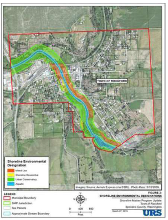
(Ord. No. 19-03, § 7.4.02, 9-4-2019)
Sec 13.32.310 Authority
This article is adopted pursuant to the authority of the Town under RCW ch. 35.63 and in accordance with RCW ch. 36.70A, known as the Growth Management Act, and its amending legislation.
Ord. No. 19-03, § 7.2.01, 9-4-2019)
Sec 13.32.320 Purpose
The purpose of this article is to designate, classify and protect the functions and values of existing areas and provide for public safety in a manner consistent with state law, while allowing for reasonable use of private property. By adopting the ordinance from which this article is derived, the Town acknowledges that critical areas provide a variety of important biological and physical functions that benefit the community and its residents or may pose a threat to human safety or property.
(Ord. No. 19-03, § 7.2.02, 9-4-2019)
Sec 13.32.330 Purpose
- The purpose of this article is to designate and classify environmentally sensitive and hazardous areas as critical areas and to protect, maintain, and restore these areas and their functions and values; and protect the health, safety, and welfare of the general public, while also allowing reasonable use of public and private property. Critical areas include wetlands, areas of critical recharging effect on aquifers, fish and wildlife habitat conservation areas, special flood hazard areas, and geologically hazardous areas as set forth in WAC 365-196-485, as now promulgated or hereafter amended.
- The regulations of this article are intended to implement the goals, policies, guidelines, and requirements of the Town's comprehensive plan and to protect critical areas in accordance with the Growth Management Act (RCW ch. 36.70A). Critical areas occurring within the shoreline jurisdiction shall be regulated pursuant to the Town's shoreline master program (SMP) as set forth in article V of this chapter. When the provisions of this article conflict with other provisions or with federal or state laws and regulations, the provision that is the most protective of critical areas shall apply.
(Ord. No. 19-03, § 7.2.03, 9-4-2019)
Sec 13.32.340 Applicability
- The provisions of this article shall apply to any activity, use, modification, or development that is located within or adjacent to a critical area or within its buffer, is likely to create a net loss of ecological functions necessary to sustain the critical area or is likely to otherwise detrimentally impact a critical area, such as reduce stability or safety. Except as exempted in RMC 13.32.350, critical areas and associated buffers shall not be altered except as consistent with the purposes and requirements of this article.
- Compliance with the provisions of this article does not constitute compliance with other federal, state, and local regulations and permit requirements that may be required (for example, shoreline substantial development permits, Washington Department of Fish and Wildlife (WDFW) hydraulic project approval permits, U.S. Army Corps of Engineers section 404 or 401 permits, or National Pollution Discharge Elimination System permits). The applicant is responsible for complying with these requirements apart from the process established pursuant to this article.
(Ord. No. 19-03, § 7.2.04, 9-4-2019)
Sec 13.32.350 Exemptions From Critical Area Review And Reporting Requirements
Activities exempt from critical area review and reporting requirements shall be conducted consistent with performance standards identified in this article, including mitigation sequencing.
- The following activities are exempt from critical area review and reporting requirements:
- Conservation or enhancement of native vegetation;
- Outdoor recreational activities which do not involve disturbance of the resource or site area, including fishing, hunting, bird watching, hiking, horseback riding, and bicycling;
- Education, scientific research, surveying, and use of nature trails;
- Normal and routine maintenance and repair of:
- Legally constructed irrigation and drainage ditches, utility lines, and appurtenances;
- Existing, legally constructed streets, structures, and facilities within an existing right-of-way, excluding actions that expand or change the character of an existing feature; or
- Town parks, including noxious weed control and removal of hazard trees where the potential for harm to humans exists;
- Emergency construction necessary to protect property from damage by the elements;
- Routine maintenance, repair, and minor modifications (such as construction of a balcony or second story) of existing structures where the modification does not extend the structure further into or adversely impact the functions of the critical area;
- Drilling for utilities/utility corridors under a critical area, with entrance/exit portals located completely outside of the critical area and its buffer, provided that the drilling does not interrupt the groundwater connection to the wetland or percolation of surface water down through the soil column; and
- In Category III or IV wetlands only, stormwater dispersion outfalls and bioswales associated with stormwater management facilities that are located within the outer 25 percent of the buffer, provided that no other location is feasible.
- Any incidental damage to or alteration of a critical area or its buffers resulting from exempt activities shall be restored, rehabilitated, or replaced at the expense of the responsible party within one growing season.
(Ord. No. 19-03, § 7.2.05, 9-4-2019)
Sec 13.32.360 Maps And Inventories
- The approximate location and extent of known critical areas are depicted on the critical areas and priority habitats maps updated and maintained by the Town. The maps are a reference tool, not an official designation or delineation. The exact location of a critical area boundary shall be determined through field investigation by a qualified professional.
- In addition to the critical areas and priority habitats map, the Town may review additional reference materials to determine whether a proposed development has the potential to affect a critical area within the Town. Reference materials may include, but are not limited to, the following:
- USDA Soil Survey for Spokane County, Washington, 2012, as amended;
- USGS 7.5-Minute Series Digital Elevation Model;
- FEMA Flood Insurance Rate Maps (FIRM) for Spokane County, Washington, and Incorporated Areas, July 6, 2010;
- USFWS National Wetlands Inventory;
- Aerial photos;
- 2015 LiDAR data;
- DNR stream typing maps;
- WDFW priority habitats and species and wildlife heritage maps and data; and
- Town critical area designation maps.
(Ord. No. 19-03, § 7.2.06, 9-4-2019)
Sec 13.32.370 Critical Area Review
If critical area review is applicable to a proposed project, the Town:
- Shall require and review a critical area report for each applicable critical area per RMC 13.32.380.
- Shall determine if the proposed project adequately addresses and mitigates impacts to the critical area and is consistent with the requirements of this article.
- May consult with agencies with expertise or jurisdiction to assist with project review, analysis, and identification of appropriate performance measures that adequately safeguard critical areas and ensure that measures are properly implemented.
- May consult with qualified professionals to assist with review of a critical areas report and/or during the implementation of recommended measures. The Town may, at its sole discretion, require the applicant to pay for or reimburse the Town for such consultant fees incurred by the Town.
- May require mitigation pursuant to RMC 13.32.390 and 13.32.400 where there is an impact to the critical area or its buffer that is likely to result in net loss of ecological functions.
(Ord. No. 19-03, § 7.2.07, 9-4-2019)
Sec 13.32.380 Critical Area Report Requirements For All Critical Areas
- Unless otherwise provided in this article, when critical areas review is deemed applicable, the applicant shall submit a critical area report subject to the requirements of this section and any other additional reporting requirements for each relevant critical area type, as addressed in RMC 13.32.560 (wetlands), RMC 13.32.630 (fish and wildlife habitats), RMC 13.32.650 (special flood hazards), and RMC 13.32.700 (geologic hazards).
- The following generally applicable standards apply to all critical area reports:
- All critical area assessments, investigations, studies, plans, and reports shall be completed by a qualified professional.
- At a minimum, all critical area reports shall contain the following:
- The name and contact information of the applicant, a description of the proposal, and identification of the permits requested.
- The dates, names, and qualifications of the persons preparing the report and documentation of any fieldwork performed on the site.
- A statement from the qualified professional certifying that the report meets the critical area requirements set forth in this article.
- A description of the proposed use or activity in sufficient detail to allow analysis of such proposal upon the identified critical area.
- List of all references and assumptions.
- A scaled site plan with dimensions showing:
- Critical areas and their buffers;
- Ordinary high water mark (as applicable);
- Proposed and existing structures and related infrastructure;
- Clearing and grading limits and erosion control measures;
- Location of temporary and/or permanent construction signage and fencing to protect critical areas and buffers;
- Topographic contours at applicable intervals and/or spot elevations that clearly depict the existing and proposed topography;
- Fill and material storage locations;
- Staging areas;
- Proposed and existing drainage facilities and stormwater flow direction arrows; and
- Title, date, scale, north arrow, and legend.
- Identification and characterization of all critical areas, water bodies, and buffers located on site, adjacent, and within 200 feet of proposed project areas. If buffers for two contiguous critical areas overlap (such as buffers for a stream and a wetland), the wider buffer applies.
- Any additional information required by the Town to adequately evaluate the potential impacts and required mitigation, if applicable. The Town Clerk/Treasurer or designee may modify the required contents of the report where, in the judgment of a qualified professional, more or less information is required to adequately evaluate the potential impacts and required mitigation.
- The Mayor or designee may limit the scope of the required critical area report to include only that part of a site affected by a development proposal.
- If a critical area or associated buffer impacts are proposed, or if a project has the potential to indirectly affect a critical area or buffer, such as by changing drainage pathways upslope of a critical area, the critical area report shall also contain the following:
- A mitigation plan that contains a description of the application of mitigation sequencing and offsetting of impacts pursuant to RMC 13.32.390 and 13.32.400. The approved plan shall contain clear and measurable standards and a schedule for achieving compliance with the specific provisions of the plan.
- An erosion and sediment control plan and drainage plan to demonstrate minimization of impacts.
- Cost estimate for required mitigation when a financial surety is required pursuant to RMC 13.32.400(d).
- A discussion of the performance standards applicable to the critical area and proposed activity.
- A mitigation monitoring plan pursuant to RMC 13.32.400(c).
(Ord. No. 19-03, § 7.2.08, 9-4-2019)
Sec 13.32.390 Mitigation Sequencing
Applicants shall demonstrate that all reasonable efforts have been made to avoid and minimize impacts to critical areas and buffers. When an activity impacting a critical area is proposed, applicants shall follow the mitigation sequencing order of preference, as follows, to ensure no net loss of function within the critical area.
- Avoid the impact altogether by not taking a certain action or parts of an action.
- Minimize impacts by limiting the degree or magnitude of the action and its implementation by using appropriate technology, or by taking affirmative steps, such as project redesign, relocation, or timing, to avoid or reduce impacts. All impacts shall be compensated for and monitored as described in RMC 13.32.400.
- Rectify the impact by repairing, stabilizing, rehabilitating, or restoring the affected area to at least the conditions existing at the time of the initiation of the project so that the impact is temporary in duration.
- Compensate for the impact by replacing, enhancing, or providing substitute resources or environments.
(Ord. No. 19-03, § 7.2.09, 9-4-2019)
Sec 13.32.400 Compensatory Mitigation
- All impacts to critical areas or critical area buffers shall be mitigated to result in no net loss of ecological function. Mitigation shall be based on the most current, accurate, and complete scientific or technical information available and provide an equivalent or better level of protection of ecological functions, affected species, and safety conditions, as applicable to the affected critical area.
- Unless specifically addressed in RMC 13.32.510 through 13.32.690, compensatory mitigation is to be provided by any of the following means, in order of preference:
- Impacts mitigated on or contiguous to the development site through resource expansion, enhancement, protection, or restoration.
- Off-site mitigation.
- Off-site mitigation may be allowed if an applicant demonstrates that mitigation on or contiguous to the development proposal site cannot be achieved and that off-site mitigation achieves equivalent or greater ecological functions.
- When off-site mitigation is authorized, priority shall be given to the following locations within the same drainage sub-basin as the project site:
- Mitigation banking sites and resource mitigation reserves;
- Private mitigation sites that are established in compliance with the requirements of this section and approved by the Town Clerk/Treasurer or designee;
- Public mitigation sites that have been ranked supported by ecological assessments, including wetland and aquatic areas established as priorities for mitigation in an approved sub-basin or watershed plan; or
- Off-site mitigation consistent with Selecting Wetland Mitigation Sites Using a Watershed Approach (Eastern Washington) (Publication No. 10-06-07, Olympia, WA, November 2010), as the same now exists or may be amended.
- Any mitigation site shall be permanently preserved by property restrictions, such as deed restrictions or conservation easements. Such restrictions shall be recorded for mitigation sites to avoid impacts from future development or alteration to the function of the mitigation.
- Monitoring.
- The applicant shall monitor the performance of the required mitigation and submit performance monitoring reports annually, or as specified in the permit conditions.
- A monitoring plan shall:
- Demonstrate compliance with the provisions of this article and specific permits and approvals;
- Describe the objectives and methods for monitoring and quantifying critical area performance relative to success standards specified by the mitigation plan;
- Provide results with an estimate of statistical precision;
- Identify the reporting requirements;
- Recommend management actions based upon the monitoring results; and
- Provide a contingency plan to address potential unexpected outcomes, circumstances observed during site monitoring, or failure of mitigation.
- Duration.
- Mitigation monitoring shall be required for a minimum of two years for temporary impact restoration and five years for compensatory mitigation or a time frame as otherwise determined by the Town.
- At the end of a monitoring period, a qualified professional shall verify if the mitigation objectives have been satisfied.
- If the mitigation objectives are not obtained within the initial monitoring period, the applicant shall remain responsible for restoration of the natural values and functions until the mitigation goals agreed to in the mitigation plan are achieved.
- If monitoring reveals a significant deviation from predicted objectives or a failure of mitigation at the end of the duration, the applicant shall implement the approved contingency plan. The contingency plan constitutes new mitigation and is subject to additional monitoring and surety requirements.
- Sureties.
- Performance surety.
- The applicant shall complete all planned mitigation and improvements prior to the acceptance of the project. If approved by the Town, a performance surety may be submitted in lieu of the completion of the required work prior to project acceptance. The performance surety shall be in substantially the same form as provided for in the Town's street standards including applicable requirements (completion schedule, amount, etc.) as adopted or hereafter amended.
- The performance surety shall be released when the following conditions have been met:
- The installation of the required mitigation is approved by the Town; and
- The applicant has submitted a warranty surety pursuant to subsection (d)(2) of this section.
- Warranty surety.
- All projects with required mitigation shall submit a warranty surety to ensure the success of the mitigation project, as required by the Town. The warranty surety shall be in substantially the same form as provided for in the Town's street standards including applicable requirements as adopted or hereafter amended.
- The warranty surety shall be for 40 percent of the total mitigation construction, planting costs, and annual maintenance/monitoring for the required duration, including, but not limited to, costs for the maintenance and replacement of dead or dying plant materials; failures due to site preparation, plant materials, and construction materials; installation oversight, monitoring, reporting, and contingency actions expected through the end of the required monitoring period.
- The warranty surety shall remain in effect for the required duration. The applicant shall have a qualified professional inspect the mitigation site within 30 to 60 days prior to the expiration of the warranty. Any deficiencies noted shall be repaired prior to the release of the surety. If the inspection is not conducted and/or the deficiencies are not repaired, the warranty surety shall be renewed by the applicant until all deficiencies are corrected. The Town shall conduct an inspection prior to releasing the warranty surety.
- If any deficiencies identified while the warranty surety is in effect are not corrected in the time frame specified by the Town Clerk/Treasurer or designee, the Town may choose to conduct the necessary repairs. The Town shall then either invoice the applicant or collect from the surety for all costs for the related work, plus a $500.00 administrative fee.
- Performance surety.
- Alternative mitigation. The Town may approve alternative mitigation provided such mitigation is based on the most current, accurate, and complete scientific or technical information available and provides an equivalent or better level of protection of ecological functions, affected species, or safety conditions, as applicable by affected critical area, than would be provided by the strict application of this article. The Mayor or designee shall consider the following for approval of an alternative mitigation proposal:
- The applicant proposes creation or enhancement of a larger system of natural areas and open space in lieu of preserving many individual habitat areas;
- On-site mitigation is not feasible due to site constraints such as parcel size, stream type, wetland category, or geologic hazards;
- There is clear potential for success of the proposed mitigation at an alternate proposed site; and
- The approved plan contains clear and measurable standards for achieving compliance with the specific provisions of the plan.
(Ord. No. 19-03, § 7.2.10, 9-4-2019)
Sec 13.32.410 Violations
- The following constitute violations of this article:
- Failure to comply with any provision of this article or with any term of any permit condition or approval issued pursuant to this article.
- Failure to comply with any order issued pursuant to this article or to remove or deface any sign, notice, complaint, or order required by or posted in accordance with this article.
- Misrepresentation of any material fact in any application, on plans, or in any other information submitted to obtain any determination, authorization, permit condition, or approval under this article.
- The Town may order mitigation measures at the expense of the person responsible for the violation, which shall include the owner, whenever a critical area or its buffer has been altered or impacted in violation of this article.
- When a violation of this article occurs, the person responsible for the violation, which shall include the owner, shall meet the following minimum performance standards to achieve restoration of affected critical area conditions, as applicable:
- A restoration plan shall be prepared by a qualified professional and shall address the following:
- Restoration of historical structural and functional values, including water quality and habitat functions;
- Replication of the historical soil types and configuration;
- Replacement of native vegetation within the critical area and buffers with native vegetation that replicates the vegetation historically found on the site in species types, sizes, and densities; and
- Replication of the historical functions and values at the location of the alteration.
- The following additional performance standards shall be met for restoration of frequently flooded areas and geological hazards and shall be included in the restoration plan:
- The hazard shall be reduced to a level equal to, or less than, the pre-development hazard;
- Any risk of personal injury resulting from the alteration shall be eliminated or minimized; and
- The hazard area and buffers shall be replanted with native vegetation sufficient to minimize the hazard.
- Restoration plan shall include a monitoring plan pursuant to RMC 13.32.400(c) and an implementation schedule.
- Annual performance monitoring reports demonstrating compliance with restoration plan requirements shall be submitted for a minimum two-year period.
- As-built drawings and other information demonstrating compliance with other applicable provisions of this article shall be submitted to the Town.
- The Town Clerk/Treasurer or designee shall, at the violator's expense, seek qualified professional advice to determine if the restoration plan adequately compensates for affected critical area functions and physical resources. Inadequate plans shall be returned to the violator for revision and resubmittal.
- A restoration plan shall be prepared by a qualified professional and shall address the following:
- The Town Clerk/Treasurer or designee is authorized to make site inspections and take such actions as are necessary to enforce this article. The Town Clerk/Treasurer or designee shall present proper credentials and make a reasonable effort to contact any property owner before entering onto private property.
(Ord. No. 19-03, § 7.2.11, 9-4-2019)
Sec 13.32.510 Wetlands--Generally
- RMC 13.32.510 through 13.32.560 apply to all clearing, uses, modifications, or development activities within or adjacent to wetlands, unless specifically exempted pursuant to RMC 13.32.350.
- Wetlands are those areas that are inundated or saturated by surface water or groundwater at a frequency and duration sufficient to support, and that under normal circumstances do support, a prevalence of vegetation typically adapted for life in saturated soil conditions.
- Wetlands generally include swamps, marshes, bogs, and similar areas. Wetlands do not include those artificial wetlands intentionally created from non-wetland sites, including, but not limited to, irrigation and drainage ditches, grass-lined swales, canals, detention facilities, wastewater treatment facilities, farm ponds, and landscape amenities, or those wetlands created after July 1, 1990, that were unintentionally created as a result of the construction of a road, street, or highway.
- Wetlands may include those artificial wetlands intentionally created from non-wetland areas to mitigate conversion of wetlands.
(Ord. No. 19-03, § 7.2.12, 9-4-2019)
Sec 13.32.520 Wetlands--Delineation And Classification
- Delineation. Wetland identification and delineation of wetland boundaries shall be determined by a qualified professional through a field investigation based on the protocols of the 1987 U.S. Army Corps of Engineers Delineation Manual and applicable regional supplement, as adopted by the state department of ecology and as hereafter amended. Wetland delineations are valid for five years, after which the Town shall determine whether a boundary verification study or additional assessment is necessary.
- Classification.
- Rating. Wetlands shall be rated pursuant to the state department of ecology wetland rating system as set forth in the Washington State Wetland Rating System for Eastern Washington (Ecology Publication No. 14-06-030, or as amended and approved by the state department of ecology), which contains the definitions and methods for determining wetland categorical ranking and scores based on functions and values.
- Categories. Wetland categories are defined as follows:
- Category I: perform functions at very high levels as evidenced by scoring between 22 and 27 points on Ecology's wetland rating system; includes alkali wetlands, bogs, and forests with stands of aspen.
- Category II: provide high levels of some functions, with a rating score between 19 and 21 points; difficult, though not impossible, to replace; includes forested wetlands in the floodplains of rivers, mature and old-growth forested wetlands over one-quarter acre in size with fast-growing trees, and vernal pools.
- Category III: provide a moderate level of functions, with a rating score between 16 and 18 points; can be adequately replaced with a well-planned mitigation project.
- Category IV: provide lowest level of functions, with a rating score less than 16 points; often heavily disturbed but may provide some important functions including groundwater recharge and the removal of pollutants from surface water.
(Ord. No. 19-03, § 7.2.13, 9-4-2019)
Sec 13.32.530 Wetlands--Buffer Areas
- Wetland buffer areas shall be required adjacent to all wetlands except isolated Category IV wetlands of less than 1,000 square feet that:
- Are not associated with riparian areas or buffers;
- Are not part of a wetland mosaic (a patchwork of nearby, small wetlands);
- Do not contain habitat identified as essential for local populations or priority species identified by Washington State Department of Fish and Wildlife (WDFW) or natural heritage plant species identified by the state department of natural resources;
- Are not a vernal pool;
- Are not an alkali wetland; and
- Do not contain aspen stands.
- Wetland buffers shall apply to any wetland created, restored, or enhanced as compensation for approved wetland alterations in the same manner as natural wetlands.
- Except as otherwise specified or allowed in this section, wetland buffers shall be retained in their natural condition. Where buffer disturbances have occurred before or during construction, revegetation with native vegetation and restoration of the hydrologic condition shall be required.
- Buffer widths.
- All buffers shall be measured perpendicular from the wetland boundary.
- The width of the wetland buffer area shall be determined pursuant to Table 13.32.530 based upon the associated wetland category and impact intensity category of the proposed use. Widths shall be increased pursuant to subsection (d)(3) of this section and may be reduced pursuant to subsection (d)(4) of this section. Wetland categories shall be assigned in accordance with RMC 13.32.520(b) and consistent with the state department of ecology's Wetlands in Washington State, Volume 2; Protecting and Managing Wetlands, Guidance on Buffers and Ratios (Appendix 8-D), as may be amended. Land use intensity shall be determined as follows (uses not specifically listed shall be considered based upon the most similar use listed):
Table 13.32.530-1. Wetland Impact Intensity CategoriesTable 13.32.530-2. Standard Wetland Buffer WidthsImpact Intensity Category
(Impact from Proposed Change in Land Use)Types of Land Use High impact Commercial, industrial, and institutional Residential (more than 1 unit/acre) High-intensity recreation (golf courses, ball fields, etc.) Moderate impact Residential (1 unit/acre or less) Moderate-intensity active open space (parks with biking, jogging, etc.) Paved trails Utility corridor with access/maintenance road Low impact Passive open space (hiking, bird watching, etc.) Unpaved trails Utility corridor without road or vegetation management Wetland Category Minimum Buffer Width (in feet) Low Impact Moderate Impact High Impact I 125 190 250 II 100 150 200 III 75 110 150 IV 25 40 50 - Increase in standard wetland buffer width. If the land adjacent to a wetland has an average slope of 30 percent or more, the minimum buffer width shall either:
- Be extended 1 1/2 times; or
- Extend to the upper break in slope (where the slope gradient is less than 30 percent for 20 feet or more perpendicular to the wetland, whichever is less).
- Reduction of standard wetland buffer width. The standard wetland buffer width for wetlands may be reduced to the next, lower land use intensity buffer width (e.g., from high to moderate), or reduced by no more than 25 percent if:
- A relatively undisturbed vegetative corridor of at least 100 feet in width is protected between the wetland and any other priority habitats and the corridor is preserved by means of easement or covenant; or
- All measures identified in Table 13.32.530-3 are taken to minimize the impact of any proposed land use.
Table 13.32.530-3. Wetland Impact Minimization MeasuresDisturbance Required Measures to Minimize Impacts Lights Direct lights away from wetland. Noise Locate activity that generates noise away from wetland. If warranted, enhance existing buffer with native vegetation plantings adjacent to noise source. For activities that generate relatively continuous, potentially disruptive noise, such as certain heavy industry or mining, establish an additional 10-foot-wide, heavily vegetated buffer strip immediately adjacent to the outer wetland buffer. Chemical use Establish covenants limiting use of pesticides within 150 feet of wetland. Apply integrated pest management. Stormwater runoff Route all untreated runoff away from wetland while ensuring wetland is not dewatered. Retrofit older stormwater facilities to meet current standards. Prevent channelized flow that directly enters the buffer. Infiltrate or treat, detain, and disperse into buffer new runoff from impervious surfaces and new lawns. Pets and human disturbance Use privacy fencing or plant dense, thorny vegetation to delineate buffer edge and to discourage disturbance using vegetation appropriate for the Town. Dust Use best management practices to control dust. Disruption of corridors or connections Maintain connections to off-site areas that are undisturbed. Restore corridors or connections to off-site habitats by replanting. Vegetation alteration Protect and maintain native plant communities in buffers.
- Standard buffer width averaging.
- Standard wetland buffer width may be averaged (reduced in width near a parcel or development but widened elsewhere along the parcel or development to retain the overall area of the standard wetland buffer) if all of the following conditions are met:
- The buffer is increased adjacent to the higher-functioning area of habitat or more sensitive portion of the wetland, and decreased adjacent to the lower-functioning or less sensitive portion;
- The total area of the buffer after averaging is equal to or greater than the area required without averaging; and
- The buffer at its narrowest point is never less than 75 percent of the standard buffer width.
- Standard wetland buffer width may be averaged to allow reasonable use of a parcel when all of the following are met:
- The averaged buffer does not result in overall degradation of the wetland's functions and values as demonstrated by a report from a qualified professional; and
- The buffer at its narrowest point is never less than 75 percent of the required width, or 75 feet for Category I and II, 50 feet for Category III, and 25 feet for Category IV, whichever is greater.
- Standard wetland buffer width may be averaged (reduced in width near a parcel or development but widened elsewhere along the parcel or development to retain the overall area of the standard wetland buffer) if all of the following conditions are met:
(Ord. No. 19-03, § 7.2.14, 9-4-2019)
Sec 13.32.540 Wetlands--Signs And Fencing
- Temporary.
- The outer perimeter of wetland buffers and the clearing limits shall be fenced to ensure that no unauthorized intrusion occurs during construction. Temporary fencing shall be designed and installed to effectively prevent construction and related impacts.
- Temporary signs and fencing shall be placed prior to beginning permitted activities and maintained throughout construction.
- Permanent.
- The Town Clerk/Treasurer or designee may require installation of permanent signs and/or fencing along the boundary of a wetland or buffer where public or high traffic pedestrian uses may occur to protect critical areas.
- Where required, permanent signs shall be made of an enamel-coated metal face and attached to a metal post or another nontreated material of equal durability. Signs shall be posted at an interval of one per lot or every 50 feet, whichever is less, and shall be maintained in perpetuity by the property owner. Any modification of the location or materials required for permanent signs shall be approved by the Town Clerk/Treasurer or designee. The obligation to maintain permanent signs shall be recorded against the property in a form acceptable to the Town.
- The signs shall be worded as follows or with alternative language approved by the Town Clerk/Treasurer or designee:
Protected Wetland Area
Do Not Disturb
Contact the Town Regarding Uses, Restrictions, and Opportunities for Stewardship - Permanent fence shall be installed around the wetland buffer when domestic grazing animals are present or may be introduced on site.
- Fencing shall be constructed in a manner that minimizes impacts to the wetland and associated habitat and designed to not interfere with species migration, including fish runs. Fencing materials shall not be made or treated with toxic chemicals.
(Ord. No. 19-03, § 7.2.15, 9-4-2019)
Sec 13.32.550 Wetlands--Mitigation
- Mitigation ratios.
- Impacts resulting from alteration to wetlands shall be mitigated using the ratios specified below:
Table 13.32.550. Wetland Mitigation Area RatiosCategory I 4:1 8:1 16:1 Category II 3:1 6:1 12:1 Category III 2:1 4:1 8:1 Category IV 1.5:1 3:1 6:1 Refer to Wetland Mitigation in Washington State, Part 1: Agency Policies and Guidance (state department of ecology Publication No. 06-06-011a, March 2006), for further information on wetland creation, reestablishment, rehabilitation, and enhancement. - Impacts to buffers shall be mitigated at a 1:1 ratio. Only vegetated buffer areas may be included in mitigation calculations. Lawns, walkways, driveways, and other mowed or developed areas shall be excluded from buffer area calculations.
- Credit/debit method. As an alternative to the mitigation ratios provided in this section, the Town Clerk/Treasurer or designee may allow mitigation based on the credit/debit method developed by the state department of ecology in Calculating Credits and Debits for Compensatory Mitigation in Wetlands of Eastern Washington: Final Report (state department of ecology Publication No. 11-06-015, August 2012, as adopted or as amended).
- Impacts resulting from alteration to wetlands shall be mitigated using the ratios specified below:
- Off-site mitigation.
- Wetland mitigation may be permitted off site if the primary drainage basin will not be substantially damaged by the loss of affected wetland hydrologic, water quality, or habitat functions as determined by a qualified professional; and:
- On-site mitigation is not scientifically feasible due to problems with hydrology, soils, or other factors such as other potentially adverse impacts from surrounding land uses;
- Existing functions off site are significantly greater than lost wetland functional values; or
- Goals for flood storage, flood conveyance, habitat, or other wetland functions have been established and off-site mitigation is strongly justified by meeting such goals.
- Wetland mitigation banks and fee-in-lieu programs.
- Credits from a wetland mitigation bank or fee-in-lieu program may be approved as off-site mitigation for unavoidable impacts to wetlands when:
- The bank or fee-in-lieu program is certified under state rules;
- The Town Clerk/Treasurer or designee determines that the wetland mitigation bank provides appropriate compensation for the authorized impacts; and
- The proposed use of credits is consistent with the terms and conditions of the certified bank instrument.
- Replacement ratios for projects using bank credits shall be consistent with replacement ratios specified in the certified bank instrument.
- Credits from a certified wetland mitigation bank may be used to compensate for impacts located within the service area specified in the certified bank instrument. In some cases, the service area of the bank may include portions of more than one adjacent drainage basin for specific wetland functions. The use of bank credits out of the established service area of the nearest available bank must be approved by the Town, WDFW, and the state department of ecology.
- When applying for a wetland mitigation bank or fee-in-lieu program, the applicant shall prepare a wetland mitigation bank credit use plan that documents consistency with these criteria and shows how the identified wetland type and associated functions will be compensated for by purchase of the credits.
- Credits from a wetland mitigation bank or fee-in-lieu program may be approved as off-site mitigation for unavoidable impacts to wetlands when:
- Wetland mitigation may be permitted off site if the primary drainage basin will not be substantially damaged by the loss of affected wetland hydrologic, water quality, or habitat functions as determined by a qualified professional; and:
- Design.
- Design of wetland mitigation projects shall be appropriate for its landscape position. Compensatory mitigation shall result in the creation, restoration, or enhancement of a wetland that matches the geomorphic setting of the site.
- The design of a wetland that has a different Cowardin or hydrogeomorphic classification than the impacted wetland may be justified if supported by a demonstrated need for, or scarcity of, the wetland type being designed.
- Timing.
- To minimize temporal loss of wetland ecological functions, compensatory mitigation shall be completed prior to activities that disturb wetlands where feasible.
- Where mitigation cannot be completed prior to wetland impacts, compensatory mitigation shall be completed immediately following disturbance and prior to use or occupancy of the action or development.
- Understanding that construction of mitigation projects should be timed to reduce impacts to existing fisheries, wildlife, and flora, the Town may authorize a delay of mitigation when the applicant provides a compelling written rationale for the delay with recommendations from a qualified wetland professional. In such cases, the delay shall not:
- Create or perpetuate hazardous conditions;
- Create environmental damage or degradation; or
- Be injurious to the health, safety, or general welfare of the public.
(Ord. No. 19-03, § 7.2.16, 9-4-2019)
Sec 13.32.560 Wetlands--Additional Critical Area Report Requirements
In addition to the critical area report requirements in RMC 13.32.380, wetland reports shall include the following:
- Documentation of any fieldwork performed on the site, including, but not limited to, field data sheets for delineations, function assessments, ratings, and baseline hydrologic data;
- A description of the methodologies used to conduct the wetland delineations, function assessments, or impact analyses including references;
- For each wetland identified on site, adjacent to, and within 200 feet of the project site, provide:
- Required buffers;
- Wetland rating, hydrogeomorphic classification, Cowardin classification of vegetation communities, on-site wetland acreage, and ecological function of the wetland and buffer based on a professional survey from the field delineation. All assessments shall be based on entire wetland complexes, not only the portion present on the proposed project site;
- Estimates of acreage and boundary for the entire wetland area where portions of the wetland extend off site;
- Description of habitat elements;
- Soil conditions based on site assessment and/or soil survey information; and
- To the extent possible, hydrologic information such as location and condition of inlets/outlets (if they can be legally accessed), estimated water depths within the wetland, and estimated hydroperiod patterns based on visual cues (e.g., algal mats, drift lines, flood debris);
- A description of the proposed actions and survey and an analysis of site development alternatives including a no-development alternative;
- An assessment of the probable impacts to the wetlands and buffers resulting from the proposed development, including:
- An estimation of acreages of impacts to wetlands and buffers based on the field delineation;
- Impacts associated with anticipated hydroperiod alterations from the project; and
- Impacted wetland functions;
- A description of how mitigation sequencing was applied pursuant to this article;
- A discussion of mitigation measures, proposed to preserve existing wetlands and restore any wetlands that will be degraded by the current proposed land use activity;
- Methods to protect and enhance on-site habitat and wetland functions;
- A site plan, drawn to scale, with the following information:
- Delineated wetlands and required buffers for on-site wetlands as well as off-site critical areas that extend onto the project site;
- Areas of proposed impacts to wetlands and/or buffers (include square footage estimates); and
- Proposed stormwater management facilities and outlets for the development, including estimated areas of intrusion into the buffers of any critical areas; and
- A mitigation plan, if required.
- The plan shall address mitigation site selection criteria and goals and objectives in relation to the functions and values of the impacted critical area. Details in the mitigation plan shall include, but not be limited to:
- The proposed construction method, sequence, timing, and duration;
- Grading and excavation details;
- Erosion and sediment control features;
- Dates for beginning and completion of mitigation activities;
- A planting plan, if applicable, specifying plant species, quantities, locations, size, spacing, and density; and measures to protect and maintain plants until established; and
- Detailed site diagrams, scaled cross sectional drawings, topographic maps showing slope percentage and final grade elevations, and any other drawings appropriate to show construction techniques or anticipated final outcome.
- The mitigation plan shall include a monitoring plan to ensure success of the mitigation plan. The plan shall conform to the monitoring requirements outlined in RMC 13.32.400.
- The plan shall address mitigation site selection criteria and goals and objectives in relation to the functions and values of the impacted critical area. Details in the mitigation plan shall include, but not be limited to:
(Ord. No. 19-03, § 7.2.17, 9-4-2019)
Sec 13.32.570 Fish And Wildlife Habitat Conservation Areas--Generally
RMC 13.32.570 through 13.32.620 apply to all clearing, uses, modifications, or development activities within designated fish and wildlife habitat conservation areas (FWHCA) and associated buffers.
(Ord. No. 19-03, § 7.2.18, 9-4-2019)
Sec 13.32.580 Fish And Wildlife Habitat Conservation Areas--Designation
All areas meeting one or more of the following criteria, regardless of any formal identification, are hereby designated fish and wildlife habitat conservation areas (FWHCA):
- Areas where the following species and/or habitats have a primary association:
- Federally designated endangered and threatened species. The U.S. Fish and Wildlife Service (USFWS) and the National Marine Fisheries Service shall be consulted for current listing status.
- State-designated endangered, threatened, and sensitive species pursuant to WAC 232-12-014 (state endangered species) and WAC 232-12-011 (state threatened and sensitive species). The Washington Department of Fish and Wildlife (WDFW) maintains the most current listing and shall be consulted for current listing status.
- State priority habitats and areas associated with state priority species. Priority habitats and species (PHS) are managed by the WDFW. Priority habitat maps are amended from time to time by WDFW. Within the Town, priority habitats include wetlands, open waterways, riparian areas, urban open space, and the habitat associated with individual native species. Priority habitat data is included in the Town's fish and wildlife habitat critical areas map.
- Naturally occurring ponds under 20 acres and their submerged aquatic beds that provide fish or wildlife habitat, including those artificial ponds intentionally created from upland areas for mitigation purposes. Naturally occurring ponds do not include ponds deliberately designed and created from dry sites, such as stormwater treatment or detention facilities, wastewater treatment facilities, temporary construction ponds, and landscape amenities. To distinguish between ponds and wetlands, refer to current state or federal definitions and guidance.
- Ponds or lakes artificially created as a result of mining once mining is complete and the mine reclamation plan has been implemented and deemed complete by DNR.
- Waters of the state. Waters of the state include lakes, rivers, ponds, streams, inland waters, underground waters, salt waters, and all other surface waters and watercourses, including wetlands, within the jurisdiction of the state, as classified in WAC 222-16-030. Water type classifications are as follows:
- The term "Type S water" means all waters, within their bankable width, as inventoried as "shorelines of the state" pursuant to RCW ch. 90.58 and the rules promulgated pursuant to RCW ch. 90.58 including periodically inundated areas of their associated wetlands. Type S waters have mean annual flows averaging 20 or more cubic feet per second. Type S waters are regulated pursuant to the Town's shoreline master program (SMP) and article V of this chapter.
- The term "Type F water" means segments of natural waters other than Type S waters, which are within the bank full widths of defined channels and periodically inundated areas of their associated wetlands, or within lakes, ponds, or impoundments having a surface area of one-half acre or greater at seasonal low water and which in any case contain fish habitat or are described by one of the following four categories:
- Waters that are diverted for domestic use by more than ten residential or camping units or by a public accommodation facility licensed to serve more than ten persons, where such diversion is determined by the Town to be a valid appropriation of water and the only practical water source for such users. Such waters shall be considered to be Type F water upstream from the point of such diversion for 1,500 feet or until the drainage area is reduced by 50 percent, whichever is less.
- Waters that are diverted for use by federal, state, tribal, or private fish hatcheries. Such waters shall be considered Type F water upstream from the point of diversion for 1,500 feet, including tributaries, if highly significant for protection of downstream water quality. The Town may allow additional harvest beyond the requirements of Type F water designation provided the Town determines, after a landowner-requested on-site assessment by the WDFW, the state department of ecology, the affected tribes, and interested parties that:
- The management practices proposed by the landowner adequately protect water quality for the fish hatchery; and
- Such additional harvest meets the requirements of the water type designation that would apply in the absence of the hatchery.
- Waters that are within a federal, state, local, or private campground having more than ten camping units, provided that the water shall not be considered to enter a campground until it reaches the boundary of the park lands available for public use and comes within 100 feet of a camping unit, trail, or other park improvement.
- Riverine ponds, wall-based channels, and other channel features that are used by fish for off-channel habitat. These areas are critical to the maintenance of optimum survival of fish. This habitat shall be identified based on the following criteria:
- The site is connected to a fish habitat stream and accessible during some period of the year; and
- The off-channel water is accessible to fish.
- The term "Type Np water" means all segments of natural waters within the bank full width of defined channels that are perennial non-fish habitat streams. Perennial streams are waters that do not go dry any time of a year of normal rainfall. However, for the purpose of water typing, Type Np waters include the intermittent dry portions of the perennial channel below the uppermost point of perennial flow. If the uppermost point of perennial flow cannot be identified with simple, nontechnical observations then Type Np waters begin at a point along the channel where the contributing basin area is at least 300 acres.
- The term "Type Ns water" means all segments of natural waters within the bank full width of the defined channels that are not Type S, F, or Np waters. These are seasonal, non-fish habitat streams in which surface flow is not present for at least some portion of a year of normal rainfall and that are not located downstream from any stream reach that is a Type Np water. Type Ns waters must be physically connected by an above-ground channel system to Type S, F, or Np waters.
- State natural area preserves and natural resource conservation areas. Natural area preserves and natural resource conservation areas are defined, established, and managed by the DNR.
- Areas of rare plant species and high-quality ecosystems. Areas of rare plant species and high-quality ecosystems are identified by the DNR through the Natural Heritage Program.
- Lands designated on state, regional, or local government agency plans (e.g., parks or transportation) as useful or essential for preserving connections between habitat blocks and open spaces.
(Ord. No. 19-03, § 7.2.19, 9-4-2019)
Sec 13.32.590 Fish And Wildlife Habitat Conservation Areas--Habitat Buffers And Riparian Management Zones
- Buffers to protect shoreline Type S waters are mapped by the Town and regulated pursuant to the Town's shoreline master program (SMP) and article V of this chapter.
- Buffers to protect state- or federally-designated sensitive wildlife fish and wildlife habitat conservation areas (FWHCA) shall be based on the recommendations of a FWHCA critical area report prepared by a qualified professional pursuant to RMC 13.32.620. Habitat buffers shall not exceed 100 horizontal feet from the edge of the FWHCA.
- Riparian management zones for waters of the state.
- Designation. Riparian management zones (RMZs) are based on the water type classification as described in RMC 13.32.580(d). RMZs are measured perpendicular to the ordinary high water line or bank full channel width boundary of a delineated stream. RMZ widths are summarized as follows:
Table 13.32.590. Riparian Management Zones Buffer WidthsStream Classification RMZ Width Type S – Shorelines of the state See SMP Type F – Natural waters not classified as shorelines of the state with fish (e.g., Chester and Saltese Creeks) 150' Type Np – Non-fish, perennial 50' Type Ns – Non-fish, seasonal 30' - RMZ requirements.
- RMZs shall be retained or maintained in a natural condition, and vegetation within RMZs shall be conserved as feasible to provide shade, habitat, and water quality functions for the associated stream.
- Where activities are proposed within a RMZ, mitigation measures shall be specified in a habitat management plan and may include but are not limited to, one or more of the following:
- Fencing of riparian buffer area to protect remaining vegetation;
- Nonnative/noxious weed removal and maintenance; and/or
- Enhancement of RMZ through planting of native vegetation.
- Proposed pedestrian/bike trails shall demonstrate through best available science that the location and width of the trail minimizes any adverse impacts on habitat and that measures to reduce effects during construction are implemented.
- Off-road motorized vehicle use in riparian management zones is prohibited.
- Designation. Riparian management zones (RMZs) are based on the water type classification as described in RMC 13.32.580(d). RMZs are measured perpendicular to the ordinary high water line or bank full channel width boundary of a delineated stream. RMZ widths are summarized as follows:
(Ord. No. 19-03, § 7.2.20, 9-4-2019)
Sec 13.32.600 Fish And Wildlife Habitat Conservation Areas--Performance Standards
All development and uses shall be prohibited within fish and wildlife habitat conservation areas (FWHCA) and their buffers, except when they are in accordance with RMC 13.32.590.
- No net loss. A FWHCA buffer may be altered only if the proposed alteration of the habitat or the mitigation proposed does not create a net loss of the quantitative and qualitative ecological functions necessary to sustain the FWHCA.
- No plant, wildlife, or fish species not indigenous to the region shall be introduced into a FWHCA unless authorized by a state or federal permit or approval.
- Contiguous functioning habitat corridors are preferred to minimize the isolating effects of development on habitat areas.
- Vegetation.
- Vegetation shall be maintained in its natural state and shall be disturbed only as minimally necessary for the development.
- Riparian vegetation shall not be removed unless there are no other alternatives available, as documented in a habitat management plan prepared by a qualified professional. When it is necessary, only those areas of vegetation that are absolutely unavoidable may be cleared and shall be re-vegetated with natural riparian vegetation as soon as possible.
- The subdivision of land shall comply with the following provisions:
- Plat area that is located wholly within an FWHCA or its buffer may not be subdivided;
- Plat area that is located partially within an FWHCA or its buffer may be divided, provided that an accessible and contiguous portion of each new lot is located outside of the FWHCA or its buffer; and
- Access roads and utilities serving the proposal may be permitted within the FWHCA and associated buffers only if the Town determines that no other feasible alternative exists and when consistent with this article.
- A project may be conditioned to minimize or mitigate any potential adverse impacts. Conditions may include, but are not limited to, the following:
- Establishment of buffer zones;
- Preservation of critically important vegetation and requirements for re-vegetation of disturbed areas with native plants;
- Vegetation screenings to reduce the potential for harassment from people and/or domesticated animals;
- Limitation of access to the habitat area during critical times of the year;
- Fencing to protect wildlife and deter unauthorized access;
- Dedication of all or part of the required open space to fish and wildlife habitat conservation; and
- Seasonal restriction of construction activities.
- FWHCAs with endangered, threatened, or sensitive species.
- No development shall be allowed within a FWHCA or buffer where state or federal endangered, threatened, or sensitive species have a primary association without state and federal consultation and approval from WDFW and USFWS, respectively.
- Approval for alteration of land or activities adjacent to a FWHCA having a primary association with state or federally endangered, threatened, or sensitive species shall not occur prior to consultation with the WDFW.
- Bald eagle habitat shall be protected consistent with the federal Bald and Golden Eagle Protection Act and the Migratory Bird Treaty Act, which may require coordination with the USFWS.
(Ord. No. 19-03, § 7.2.21, 9-4-2019)
Sec 13.32.610 Fish And Wildlife Habitat Conservation Areas--Adjustment Of Habitat Buffer Areas
- Habitat buffer areas may be reduced by the Town Clerk/Treasurer or designee up to a maximum of ten percent if the buffer area is enhanced using native plants, including trees and shrubs, according to a habitat management plan prepared in consultation with the Spokane County Conservation District and the Washington Department of Fish and Wildlife (WDFW).
- The habitat buffer width may be averaged (reduced in width near a development but widened elsewhere to retain the overall area of the habitat buffer) if all of the following conditions are met:
- The FWHCA has significant differences in characteristics that affect its habitat functions, such as a native forested component adjacent to a degraded herbaceous component;
- The buffer is increased adjacent to the higher-functioning area of habitat or more sensitive portion of the FWHCA and decreased adjacent to the lower-functioning or less sensitive portion;
- The total area of the buffer, after averaging, is equal to or greater than the area required without averaging; and
- The buffer at its narrowest point is never less than 75 percent of the original habitat buffer width.
- Reductions for functionally isolated RMZ areas.
- RMZs shall not extend beyond linear roadways or large paved areas (e.g., parking lots) where the intersecting development results in habitats that are functionally isolated from the stream area by the intervening feature. This applies only to paved roads and gravel roads that receive more than one vehicle per hour average daily traffic (does not apply to infrequently used driveways, trails, etc.).
- Habitat buffer areas may be increased by the Town Clerk/Treasurer or designee up to a maximum of 25 percent if:
- The land adjacent to water is susceptible to severe erosion and other erosion control measures will not prevent adverse impacts; or
- The land adjacent to the water has minimal vegetative cover or slopes greater than 30 percent.
- The provisions of RMC 13.32.600 shall not apply to areas regulated by the Town pursuant to its shoreline master program (SMP) and article V of this chapter.
(Ord. No. 19-03, § 7.2.22, 9-4-2019)
Sec 13.32.620 Fish And Wildlife Habitat Conservation Areas--Mitigation
- When necessary, fish and wildlife habitat mitigation shall be documented in a habitat management plan as described in RMC 13.32.610(a).
- Mitigation sites shall be located:
- Preferably to achieve contiguous functioning habitat corridors that minimize the isolating effects of development on habitat areas; and
- Within the same aquatic ecosystem as the area disturbed.
- Where available, irrigation shall be installed for mitigation plantings to ensure survival during the first two years of plant growth.
- Landscaping plans shall be informed by local reference riparian and shrub-steppe vegetation conditions and be prepared by a qualified professional or landscape architect. Only native vegetation may be used in habitat mitigation plans, excluding sterile vegetation used for temporary erosion control.
- Mitigation shall be installed no later than the next growing season after completion of buffer impacts, unless otherwise approved by the Town Clerk/Treasurer or designee.
- Mitigation sites shall be maintained to ensure that the mitigation and management plan objectives are successful.
- Maintenance shall include corrective actions to rectify problems, including rigorous, as-needed elimination of undesirable plants; protection of shrubs and small trees from herbivory and competition by grasses and herbaceous plants; and repair and replacement of any dead woody plants.
- Areas proposed for mitigation shall be maintained so they have no more than 20 percent total plant cover consisting of invasive species. Invasive species include any species on the state noxious weed list.
- Monitoring required. An applicant shall monitor the performance of any required mitigation and submit performance monitoring reports annually to the Town.
- Mitigation sites shall be monitored for a period of time appropriate to the proposed mitigation as determined in a habitat management plan prepared by a qualified professional.
- At the end of the monitoring period, the qualified professional shall be required to verify that the conditions of approval and provisions in the habitat management plan have been satisfied.
- Mitigation planting survival shall be 100 percent for the first year and 80 percent for each subsequent year.
- If the final annual monitoring report clearly demonstrates that the site has achieved all goals and objectives set forth in the approved habitat management plan, the applicant shall be released from additional mitigation obligations. If, however, performance objectives are not met, additional maintenance, adaptive management, and performance monitoring shall be required until all objectives are met.
(Ord. No. 19-03, § 7.2.23, 9-4-2019)
Sec 13.32.630 Fish And Wildlife Habitat Conservation Areas--Additional Critical Area Report Requirements
- Report contents. In addition to the critical area report requirements of RMC 13.32.380, fish and wildlife habitat conservation areas (FWHCA) reports shall include:
- Habitat assessment, including:
- Detailed description of vegetation on and adjacent to the project area;
- Identification of any plant or animal species of local importance, priority habitats and species (PHS), or endangered, threatened, sensitive, or candidate species that have a primary association with habitat on or adjacent to the project area, and assessment of potential project impacts to the use of the site by the species;
- A discussion of any federal, state, or local special management recommendations, including Washington Department of Fish and Wildlife (WDFW) habitat management recommendations, that have been developed for species or habitats located on or adjacent to the project area;
- A discussion of measures, including mitigation sequencing, proposed to preserve existing habitats or restore any habitat that was degraded prior to the current proposed land use activity; and
- A discussion of ongoing management practices that will protect habitat after the project site has been developed, including proposed monitoring and maintenance programs.
- Habitat management plan. Any proposal in a FWHCA, associated buffer area, or within one-quarter mile of a priority species den or nest site shall provide a habitat management plan which includes at least the following:
- A plan, drawn to scale, that identifies:
- The location of the proposed site;
- The relationship of the site to surrounding topography and developed areas;
- The nature and intensity of the proposed use or activity;
- Proposed improvements locations and arrangements;
- The location of the ordinary high water mark, shoreline master program (SMP), and riparian management zone (RMZ) boundary lines;
- The legal description and the total acreage of the parcel;
- Existing structures and landscape features including the name and location of all waters within 300 feet of the proposal; and
- The location of priority habitat types or priority species point locations within one-quarter mile of the proposal.
- An analysis of the effect of the proposed use or activity upon FWHCAs or associated species and riparian habitat area.
- A mitigation plan that may include, but is not limited to:
- Establishment of perpetual buffer areas;
- Preservation and/or restoration of native flora;
- Limitation of access to habitat area;
- Seasonal restriction of construction activities;
- Clustering of development and preservation of open space;
- Signs marking habitats or habitat buffer areas;
- Use of low impact development techniques;
- Recorded deed, plat, binding site plan or planned unit development covenant, condition, or restriction legally establishing FWHCA for subject property;
- Conservation or preservation easements; and
- Dedication or conveyance of title of a FWHCA to a public entity for the purpose of conservation.
- A summary of consultation with the WDFW. If the habitat management plan recommends mitigation involving federally listed threatened or endangered species, migratory waterfowl, or wetlands, the USFWS shall receive a copy of the draft habitat management plan and their review comments shall be included in the final report. The Town Clerk/Treasurer or designee shall have the authority to approve habitat management plans or require additional information.
- A plan, drawn to scale, that identifies:
- Habitat assessment, including:
- Conditions established by an approved habitat management plan shall be included as a condition of approval for a permit.
(Ord. No. 19-03, § 7.2.24, 9-4-2019)
Sec 13.32.640 Special Flood Hazard Areas--Generally
Article IV of this chapter is incorporated by reference herein and governs all uses, activities, and structures within special flood hazard areas.
(Ord. No. 19-03, § 7.2.25, 9-4-2019)
Sec 13.32.650 Special Flood Hazard Areas--Additional Critical Areas Report Requirements For Special Flood Hazard Areas
- In addition to the critical area report requirements in RMC 13.32.380, critical area reports for special flood hazard areas shall include a site plan, showing:
- All areas of a special flood hazard within 200 feet of the project area, as indicated on the currently adopted flood insurance maps;
- The 100-year flood elevation, the ten- and 50-year flood elevations (if available), and floodway;
- Critical areas, buffers, and shoreline areas; and
- Elevation of the lowest floor (including basement) of all structures, and the level to which any nonresidential structure has been floodproofed.
- Alteration of natural watercourses shall be avoided, if feasible. If unavoidable, the critical area report shall include:
- A description of and plan showing the extent to which a watercourse will be altered or relocated;
- A maintenance plan that provides maintenance practices for the altered or relocated portion of the watercourse to ensure that the flood-carrying capacity is not diminished, and downstream or upstream properties are not impacted; and
- A description of how the proposed watercourse alteration complies with the requirements of fish and wildlife habitat conservation areas (FWHCA), the shoreline master program (SMP), and other applicable state or federal permit requirements.
(Ord. No. 19-03, § 7.2.25, 9-4-2019)
Sec 13.32.660 Geologically Hazardous Areas--Generally
RMC 13.32.660 through 13.32.690 shall apply to all clearing, uses, modifications, or development activities within or possibly impacting designated geologically hazardous areas and associated buffers.
(Ord. No. 19-03, § 7.2.26, 9-4-2019)
Sec 13.32.670 Geologically Hazardous Areas--Exemptions
The following shall be exempt from the provisions of RMC 13.32.680 through 13.32.700:
- Operation, maintenance, or repair activities that do not require construction permits and do not alter the topography or the hydrology, and do not significantly alter the vegetation so long as the activity does not further alter or increase impact to, or encroach further within, the critical area or buffer and there is no increased risk to life or property as a result of the proposed operation, maintenance or repair.
- Work directly related to ending a condition that:
- Is an immediate threat to the public health, safety, and welfare, or creates an immediate risk of damage to public or private property; and
- Requires remedial or preventive action in a time frame too short to allow compliance with the application provisions of RMC 13.32.680 through 13.32.700, provided that the work is the minimum work necessary to end the condition and the work is consistent with the development standards of this article to the extent practicable.
- Low-impact activities such as passive recreation, scientific research, conservation practices, harvesting of wild crops, noxious weed control, and pedestrian/bike trails.
(Ord. No. 19-03, § 7.2.27, 9-4-2019)
Sec 13.32.680 Geologically Hazardous Areas--Designation And Classification
- Areas susceptible to one or more of the following types of hazards shall be classified as geologically hazardous areas:
- Erosion hazard. Often associated with steep slopes, unconsolidated soils, severe rill, and interrill erosion potential per U.S. Department of Natural Resource Conservation Service (NRCS), sparse vegetation;
- Landslide hazard. Often associated with steep slopes such as 30 percent or greater with vertical relief of ten or more feet, undercut slopes, groundwater over relatively impermeable substrate, areas of historic failures, Latah formation (sedimentary layers of clay interlain between basalt flows);
- Seismic hazard. Often associated with severe risk of damage as a result of earthquake-induced ground shaking, slope failure, settlement or subsidence, soil liquefaction, surface faulting. The Town is not in an area of severe risk for seismic hazards; therefore, no designation of these areas is warranted at this time; or
- Areas subject to other geological events such as surface mine hazards, volcanic hazards, mass wasting, debris flows, rock falls, and differential settlement. Initial research and investigations have determined that these hazards do not currently exist in the Town at a level warranting designation.
- The approximate location and extent of geologically hazardous areas are shown on the adopted critical area maps and data as obtained from pertinent agencies such as the following:
- U.S. Geological Survey;
- Natural Resource Conservation Service (NRCS);
- State department of natural resources (DNR);
- FEMA flood insurance maps; and
- Locally adopted maps.
- Areas exhibiting the characteristics of geologically hazardous areas pursuant to subsection (a) of this section that are not designated on the geologic hazard inventory maps listed in subsection (b) of this section may be designated as critical areas by Town staff or a qualified professional at the time of project review.
- Due to the uncertainties in delineating geological hazards, buffers shall be established from all edges of geologically hazardous areas.
- The minimum buffer shall be 50 feet and shall extend to the top of the slope above the hazard area.
- The buffer may be reduced to a minimum of ten feet when a qualified professional demonstrates that the reduction will adequately protect the proposed development, adjacent developments and uses, and the subject critical area.
- The buffer may be increased where the Town determines a larger buffer is necessary to prevent risk of damage to proposed and existing development.
(Ord. No. 19-03, § 7.2.28, 9-4-2019)
Sec 13.32.690 Geologically Hazardous Areas--Performance Standards
- Unless specifically exempt in RMC 13.32.670 or otherwise waived by the Town, the applicant of any proposed activity in a parcel with boundaries within 50 feet of a geologic hazard area and/or its buffer (if designated) or in area determined by a qualified professional to be a potential geologic hazard, especially those activities that alter the topography, vegetation, or hydrology, shall:
- Attend a pre-development conference with the Town on the project;
- If applicable, meet the requirements of the Spokane Regional Stormwater Manual (SRSM) and shall apply for and meet the requirements of an engineered grading permit;
- Retain a geologist currently licensed in the state or a qualified geotechnical engineer (a professional engineer currently licensed by the state with geotechnical engineering as a specialty) to:
- Review all aspects of the project's design (topography, landscaping, stormwater, etc.), construction (clearing, grubbing, grading, erosion, phasing, etc.), operation, and maintenance;
- Provide recommendations, with copies of the review comments and recommendations provided to the Town. Recommendations may specify that no activity may occur or that some or all may occur. For any proposed activity that the geologist or geotechnical engineer states may occur, the recommendations shall ensure that the proposed activity, both in short-term and in long-term:
- Minimizes impacts;
- Shall not result in any damage to other property;
- Shall not increase the risk or threat of the geological hazard to adjacent properties beyond pre-development conditions;
- Shall not result in a need for increased buffers on neighboring properties;
- Shall not adversely impact other critical areas;
- Is designed using best management practices and best available science;
- Is designed so that the hazard is eliminated or mitigated to a level equal to or less than pre-development conditions;
- Is determined to be safe as designed and under anticipated conditions; and
- Locates structures and improvements such that the most critical portion of the site and its natural landforms and vegetation are preserved;
- Prepare a geotechnical study that addresses the following:
- A detailed description of the project, its relationship to the geologic hazards, and its potential impact upon the hazard area, the subject property, and affected adjacent properties;
- A description of the surface and subsurface geology, hydrology, soils, and vegetation found in the project area and in all hazard areas addressed in the report;
- Vegetation needing to be retained or removed;
- The present stability of the proposed development, stability of the proposed site during construction, stability after all development activity is completed, and a discussion of the relative risks and slide potential relating to adjacent properties during each stage of development;
- Proposed location of buildings, roadways, and other improvements that reflect careful consideration of geohazards and efforts to avoid or minimize impacts;
- Grading and earthwork, including compaction and fill material requirements; use of site soils as fill or backfill, imported fill or backfill requirements; height and inclination of both cut and fill slopes, terracing, and erosion control; and wet weather considerations and/or limitations;
- A detailed overview of the field investigations, published data, and references; data and conclusions from past assessments of the site; and site-specific measurements, tests, investigations, or studies that support the identification of geologically hazardous areas;
- A description of the vulnerability of the site to seismic and other geologic events;
- Recommendations for the minimum no-disturbance buffer and minimum building setback from any geologic hazard based upon the geotechnical analysis;
- A mitigation plan addressing how the activity maintains or reduces the preexisting level of risk to the site and adjacent properties on a long-term basis (equal to or exceeding the projected lifespan of the activity or occupation); specific mitigation measures for impacts to all critical areas and related buffers before, during, and after construction;
- Location and methods of drainage and surface water management. A plan and schedule to monitor stormwater runoff discharges from the site shall be included if there is a significant risk of damage to downstream properties or receiving waters;
- Locations and methods of erosion control, a vegetation management and/or replanting plan, and/or other means for maintaining long-term soil stability;
- Impacts of landslide run-out on downslope properties;
- Recommendations for building limitations, structural foundations, and an estimate of foundation settlement;
- An analysis of proposed surface and subsurface drainage and the vulnerability of the site to erosion;
- Documents findings, recommendations, and concerns; and
- Observe and assess mitigation performance during monitoring period.
- The Town shall review the proposals, recommendations, and geotechnical study and may condition the project based upon its review to ensure the applicant provides all necessary mitigation to ensure there are no remaining safety concerns associated with alteration of the geologically hazardous area. To expedite review, the Town may hire a qualified professional for this review, which would be paid for at the applicant's expense.
(Ord. No. 19-03, § 7.2.29, 9-4-2019)
Sec 13.32.700 Geologically Hazardous Areas--Additional Critical Areas Report Requirements
- Report requirements. In addition to the critical area report requirements in RMC 13.32.380, geologically hazardous area reports shall include a site plan showing the following:
- The location of all geologic hazard areas, springs, seeps, or other surface expressions of groundwater on or within 200 feet of the project area;
- Location and boundaries of all critical areas and related buffers on the site and on adjacent lands within 25 feet of the site's property lines, noting both total square footage and percentage of site covered by critical areas and related buffers;
- Location and identification of all riparian corridors and wetlands within 100 feet of the site's property lines;
- Location and boundaries of all existing and proposed site improvements on the site, on adjacent lands within 25 feet of the site's property lines, and on the full width of abutting public rights-of-way and private easements. This shall include the amount of proposed land disturbing activities, including amounts of developmental coverage, impervious surfaces, and construction activity areas (noting total square footage and percentage of site occupied);
- Stormwater flow characteristics within the site, on adjacent sites within 25 feet of the site's property lines, and on the full width of abutting public rights-of-way and private easements;
- Location of all grading activities in progress, and all natural and artificial drainage control facilities or systems in existence or on adjacent lands or on the site or within 25 feet of the site's property lines, and on the full width of abutting public rights-of-way and private easements;
- Location of all existing utilities (water, sewer, gas, electric, phone, cable, etc.), both above and below ground, on the site, on adjacent lands within 25 feet of the site's property lines, and on the full width of abutting public rights-of-way;
- For a proposal potentially affecting or affected by an erosion or landslide hazard area:
- The height of slope, slope gradient, and cross section of the project area within the hazard area; and
- Stormwater runoff disposal location and flow patterns.
- Geologically hazardous area reports shall be prepared by a geologist currently licensed in the state or a qualified geotechnical engineer (a professional engineer currently licensed by the state with geotechnical engineering as a specialty).
- A geotechnical report, prepared within the last five years for a nearby and applicable site, and where the proposed land use activity and surrounding site conditions are unchanged, may be incorporated into the required critical area report for reference. The applicant shall submit a geotechnical assessment detailing any changed environmental conditions associated with the site.
(Ord. No. 19-03, § 7.2.30, 9-4-2019)
Sec 13.32.810 Reasonable Use Determination
- The standards and regulations of this article are not intended and shall not be construed or applied in a manner to deny all reasonable economic use of private property. If an applicant demonstrates to the satisfaction of the Town Clerk/Treasurer or designee that strict application of the standards of this article would deny all reasonable economic use of their property, development may be permitted subject to appropriate conditions, derived from this article, as determined by the Town Clerk/Treasurer or designee.
- An applicant requesting relief from strict application of these standards shall demonstrate the following:
- That no reasonable use with less impact on the critical area and buffer or setback is feasible and reasonable;
- That there is no feasible and reasonable on-site alternative to the activities proposed, considering possible changes in site layout, reductions in density, and similar factors;
- That the proposed activities, as conditioned, will result in the minimum possible impacts to critical area and buffer or setback;
- That all reasonable mitigation measures have been implemented or assured; and
- That the inability to derive reasonable economic use is not the result of the applicant's actions.
- Decision. The Town Clerk/Treasurer or designee shall include findings on each of the evaluation criteria listed in subsection (b) of this section in a written decision. The written decision shall be mailed to the applicant and adjacent property owners, including property owners across public rights-of-way or private easements. The written decision shall include conditions necessary to serve the purposes of this article.
(Ord. No. 19-03, § 7.2.31, 9-4-2019)