
Rohnert Park City Zoning Code
CHAPTER 17
06 - LAND USE REGULATIONS
Article XII. - Station Center Planned Development District Zoning District[1]
Editor's note— Ord. No. 978, § 4(Exh. C), adopted July 11, 2023, repealed Art. XII, §§ 17.06.680 and 17.06.690, which pertained to Station Center Planned Development District Zoning District, and derived from Ord. No. 897, (Exh. B), adopted Apr. 12, 2016.
Article XIII. - Downtown District Amenity Zone (DDAZ) Overlay Districts[2]
Editor's note—Ord. No. 927, § 4 (Exhs. 2—4), adopted Nov. 27, 2018, amended Art. XIII in its entirety to read as herein set out. Former Art. XIII, §§ A—D, pertained to similar subject matter and derived from Ord. No. 897, Exh. B, 4-12-2016.
Article XV.A. - Sonoma Mountain Village Planned Development Zoning District[3]
Editor's note— Ord. No. 952, § 4(Exh. A), adopted Mar. 23, 2021, amended Art. XV.A in its entirety to read as herein set out. Former Art. XV.A, §§ 17.06.810—17.06.870, pertained to similar subject matter, and derived from Ord. No. 824, § 2(Exh. A), adopted Sept. 14, 2010.
17.06.010 - Purpose.
The residential districts are intended to achieve the following purposes:
A.
Reserve residential areas for a broad range of dwelling types and densities, which meet the diverse economic and social needs of the residents consistent with sound standards of public health and safety.
B.
Ensure the provision of light, air, privacy, and open space.
C.
Protect residential neighborhoods from excessive noise, illumination, unsightliness, odors, dust, dirt, smoke, vibration, heat, glare, and other objectionable influences.
D.
Minimize congestion and avoid the overloading of public services and utilities. (Ord. 695 § 3, 2003)
(Ord. No. 854, § 2(Exh. A), 7-9-2013; Ord. No. 897, (Exh. B), 4-12-2016)
17.06.020 - Districts.
A.
R-R: Rural Residential. This district is intended for very low-density residential development on large lots of typically forty thousand square feet or more that convey a "rural" or agricultural character. These districts are located at the perimeter of the city and provide a transition from the more urban development to the open space/agricultural areas outside of the city. This district is consistent with the "Estate Residential" general plan designation.
B.
R-E: Estate Residential. This district is intended for very low-density residential development on large estate size lots of typically seventeen thousand square feet or more. This district also is located at the perimeter of the city to provide a transition from the more urban development to the open space/agricultural areas outside the city. This district is consistent with the "Estate Residential" general plan designation.
C.
R-L: Residential-Low Density. This district is intended to promote the development of single-family detached dwellings in a suburban setting with a variety of minimum lot sizes. This district is consistent with the "Low Density" general plan designation. The floor area ratio for this district is 0.40.
D.
R-M: Residential-Medium Density. This district is intended for attached and detached single-family housing and duplexes as part of a planned residential development with a minimum lot size of three thousand seven hundred square feet. Multi-family housing is not permitted. Side-by-side duplexes not separated by a property line or without individual heating systems are permitted. This district is consistent with the "Medium Density" general plan designation. The floor area ratio for this district is 0.55.
E.
R-H: Residential-High Density. This district is intended to permit a wide range of housing types, ranging from single-family attached to multi-family, and are intended for specific areas where higher densities may be appropriate. This district is consistent with the "High Density" general plan designation. The floor area ratio for this district is 1.15.
F.
DTR-H: Downtown Residential-High Density. This district is located within the Central Rohnert Park PDA planning area as identified in the general plan and is intended to allow for residential development proximate to the downtown area. This district is consistent with the "High Density" general plan designation. Unless otherwise specified, all special provisions, development standards and other requirements and limitations shall be the same as the R-H district.
(Ord. No. 695, § 3, 2003; Ord. No. 854, § 2(Exh. A), 7-9-2013; Ord. No. 897, (Exh. B), 4-12-2016; Ord. No. 991, § 4(Exh. A, § 13), 1-27-2026)
17.06.030 - Permitted uses.
The following is a list of land uses and the residential districts within which they are permitted as follows:
P = Permitted.
C = Conditionally-permitted by planning commission.
A = Administrative permit.
Z = Certificate of zoning compliance.
T = Temporary conditional use permit.
I = Uses allowed as incidental to a primary use.
Land uses that are not specifically listed are not permitted unless determined, by the development services director, to be substantially similar to a listed use. If the listed land use contains a code section reference in the right column, that reference directs the reader to the additional provisions which apply to that use.
(Ord. 739 § 2 (part), 2005; Ord. 695 § 3, 2003; Ord. No. 844, § 2(Exh. A), 3-13-2012; Ord. No. 854, § 2(Exh. A), 7-9-2013; Ord. No. 897, (Exh. B), 4-12-2016; Ord. No. 906, § 6, 4-11-2017; Ord. No. 908, § 6, 8-8-2017; Ord. No. 991, § 4(Exh. A, § 14), 1-27-2026)
17.06.040 - Purpose.
The commercial districts are intended to provide appropriate areas for office uses and retail and service establishments that serve the needs of the city and area communities, as well as for mixed residential/commercial development where appropriate. The districts are designed to provide for the effective integration of commercial areas with adjacent uses, so that impacts related to traffic, noise, illumination and other potential concerns are minimized. The commercial districts are also intended to foster the development of employment-generating uses that will benefit existing and future residents of the city and the surrounding region. (Ord. 790 § 4, 2007: Ord. 695 § 3, 2003)
(Ord. No. 854, § 2(Exh. A), 7-9-2013)
17.06.050 - Districts.
A.
C-O: Professional/Administrative Office District. This district allows for the development of administrative, financial, business, professional, medical and public offices. Retail uses within this district are generally limited to those that provide support services to the office uses. This district is consistent with the "Office" general plan designation. The floor area for this district is 1.0.
B.
C-N: Neighborhood Commercial District. This district is intended to accommodate businesses that provide goods and services to nearby residential neighborhoods, generally within an area of a one-mile radius or less. Typical uses found in this district include limited commercial offices, and retail stores and service establishments that are compatible with, and dependent upon, nearby residential developments. This district is consistent with the "Neighborhood Commercial" general plan designation. The floor area ratio for this district is 0.4.
C.
C-R: Regional Commercial District. This district allows operations that provide goods and services that serve the community and outlying areas within an eight to twenty mile radius. It is primarily reserved for larger shopping centers and can accommodate "big box" retailers. This district is consistent with the "Regional Commercial" general plan designation. The floor area ratio for this district is 0.4, and 1.5 for hotel and motel projects. (Ord. 695 § 3, 2003)
(Ord. No. 854, § 2(Exh. A), 7-9-2013)
17.06.060 - Permitted uses.
The following is a list of land uses and the commercial districts within which they are permitted as follows:
P = Permitted.
C = Conditionally-permitted by planning commission.
A = Administrative permit.
Z = Certificate of zoning compliance.
T = Temporary conditional use permit.
I = Uses allowed as incidental to a primary use.
Uses involving chemicals may also be subject to requirements regarding hazardous materials (Section 17.07.100), in which case more restrictive requirements shall apply. Land uses that are not specifically listed are not permitted unless determined, by the development services director, to be substantially similar to a listed use. If the listed land use contains a code section reference in the right column, that reference directs the reader to the additional provisions apply to that use.
(Ord. 790 § 5, 2007; Ord. 781 § 5, 2007; Ord. 751 § 2 (part), 2005; Ord. 739 § 2 (part), 2005; Ord. 695 § 3, 2003)
(Ord. No. 813, § 4B, 4-28-2009; Ord. No. 844, § 2(Exh. A), 3-13-2012; Ord. No. 854, § 2(Exh. A), 7-9-2013; Ord. No. 887, § 4(Exh. A), 5-26-2015; Ord. No. 896, § 4(Exh. A), 2-9-2016; Ord. No. 991, § 4(Exh. A, § 15), 1-27-2026)
17.06.070 - Miscellaneous provisions.
A.
In any commercial district, all operations shall be conducted entirely within a completely enclosed structure, except for off-street parking and loading areas, exhibits of goods sold or manufactured on the premises, automobile service stations, outdoor dining areas, nurseries and garden shops, temporary uses/events, utility substations, and equipment installations.
B.
In the C-N district all products produced on the site of any of the permitted uses shall be sold primarily as retail on the site where produced.
C.
In the C-N district any retail and/or entertainment commercial uses that are within five hundred feet of any residential district, measured from the property lines, whose hours of operation are before 6:00 a.m. and/or after 10:00 p.m. must obtain a conditional use permit. (Ord. 695 § 3, 2003)
(Ord. No. 854, § 2(Exh. A), 7-9-2013)
17.06.080 - Purpose.
The industrial district is intended to provide appropriate areas for businesses that manufacture, process, assemble, repair, or otherwise create and maintain goods, merchandise and equipment. The district is designed to provide for the effective integration of industrial areas with adjacent uses, so that impacts related to traffic, noise, illumination, smoke, hazardous materials and other potential concerns are minimized. The industrial district is also intended to foster the development of an industrial base that will benefit existing and future residents of the city and the surrounding region. (Ord. 695 § 3, 2003)
(Ord. No. 854, § 2(Exh. A), 7-9-2013)
17.06.090 - Districts.
I-L: Limited Industrial District. This district allows for campus-like environments for corporate headquarters, research and development facilities, offices, light manufacturing and assembly, industrial processing, general service, warehousing, storage and distribution, and service commercial type use. Retail activities are generally limited to those that support the industrial type uses. This district is consistent with the "Industrial" general plan designation. The floor area ration for this district is 0.5, or 1.0 for projects that meet specific criteria specified in the city's design guidelines. (Ord. 695 § 3, 2003)
(Ord. No. 854, § 2(Exh. A), 7-9-2013)
17.06.100 - Permitted uses.
The following is a list of land uses and the limited industrial district within which they are permitted as follows:
P = Permitted.
C = Conditionally-permitted by planning commission.
A = Administrative permit.
Z = Certificate of zoning compliance.
T = Temporary conditional use permit.
I = Uses allowed as incidental to a primary use.
Uses involving chemicals may also be subject to requirements regarding hazardous materials (Section 17.07.100), in which case more restrictive requirement shall apply. Land uses that are not specifically listed are not permitted unless determined, by the development services director, to be substantially similar to a listed use. If the listed land use contains a code section reference in the right column, that reference directs the reader to the additional provisions which apply to that use.
(Ord. 751 § 2 (part), 2005; Ord. 739 § 2 (part), 2005; Ord. 695 § 3, 2003)
(Ord. No. 854, § 2(Exh. A), 7-9-2013; Ord. No. 887, § 4(Exh. A), 5-26-2015; Ord. No. 905, § 4(Exh. A), 3-28-2017; Ord. No. 991, § 4(Exh. A, § 16), 1-27-2026)
17.06.110 - Purpose.
The Mixed Use District and the Downtown Mixed Use District encourage the siting of compatible businesses, stores, institutions, service organizations, and residences in close proximity to one another so as to create self-sufficient neighborhoods within the city. The district promotes such neighborhood development in order to minimize reliance on the automobile, resulting in a reduction in vehicle miles traveled and traffic congestion. These districts are intended to create pedestrian-oriented environments that provide access to residents' basic everyday requirements, foster an active street life, enhance the vitality of local businesses, and provide employment opportunities close to home for residents of the city. The preferred pattern of development will be ground floor commercial uses, with residential and/or office uses located on the upper floor(s). Special urban design amenities (pedestrian facilities, landscaping, public spaces, etc.) would be included in the district to create recognizable, pedestrian friendly activity centers. On-site parking would be provided for residential uses and parking for businesses would generally be on-street and in parking garages or off-site parking lots. Convenient vehicular and pedestrian/bicycle access from surrounding neighborhoods and transit service would also be components of this district. (Ord. 695 § 3, 2003)
(Ord. No. 854, § 2(Exh. A), 7-9-2013; Ord. No. 897, (Exh. B), 4-12-2016)
17.06.120 - District descriptions.
A.
M-U: Mixed Use District. This district allows for the development of integrated centers that combine a supportive mix of land uses, either within the same building or in clusters of buildings. This district is consistent with the "Mixed Use" general plan designation. The floor area ratio for this district is 1.5 for non-residential projects, and 2.0 for mixed residential/residential projects. (Ord. 695 § 3, 2003)
B.
DTM-U: Downtown Mixed Use District. This district allows for the development of integrated centers that combine a supportive mix of land uses, either within the same building or in clusters of buildings. This district is consistent with the "Downtown Mixed Use" general plan designation. The floor area ratio for this district is 1.5 for non-residential projects, and 2.0 for mixed residential/residential projects. Non-residential development is required within this designation and residential development is only permitted as part of a mixed use project.
(Ord. No. 854, § 2(Exh. A), 7-9-2013; Ord. No. 897, (Exh. B), 4-12-2016)
17.06.130 - Permitted uses.
The following is a list of land uses and the Mixed Use District within which they are permitted as follows:
P = Permitted.
C = Conditionally-permitted by planning commission.
A = Administrative permit.
Z = Certificate of zoning compliance.
T = Temporary conditional use permit.
I = Uses allowed as incidental to a primary use.
Uses involving chemicals may also be subject to requirements regarding hazardous materials (Section 17.07.100), in which case more restrictive requirements shall apply. Land uses that are not specifically listed are not permitted unless determined, by the development services director, to be substantially similar to a listed use. If the listed land use contains a code section reference in the right column, that reference directs the reader to the additional provisions which apply to that use.
(Ord. 781 § 6, 2007; Ord. 695 § 3, 2003)
(Ord. No. 844, § 2(Exh. A), 3-13-2012; Ord. No. 854, § 2(Exh. A), 7-9-2013; Ord. No. 897, (Exh. B), 4-12-2016; Ord. No. 991, § 4(Exh. A, § 17), 1-27-2026)
17.06.140 - Purpose.
The public/institutional district is intended to provide sites for public uses, such as government centers and educational facilities. This district also allows for public and private facilities that are necessary to the functioning of the city, such as water and wastewater treatment plants, well sites, and other infrastructure. (Ord. 695 § 3, 2003)
(Ord. No. 854, § 2(Exh. A), 7-9-2013)
17.06.150 - District.
PI: Public/Institutional District.
This district allows for schools, government offices, transit sites, religious facilities, and other land uses that have a unique public character, as well as Sonoma State University. Public infrastructure facilities are also permitted in this district. This district is consistent with the "Public/Institutional" general plan designation. (Ord. 695 § 3, 2003)
(Ord. No. 854, § 2(Exh. A), 7-9-2013)
17.06.160 - Permitted uses.
The following is a list of land uses and the public/institutional district within which they are permitted as follows:
P = Permitted.
C = Conditionally-permitted by planning commission.
A = Administrative permit.
Z = Certificate of zoning compliance.
T = Temporary conditional use permit.
I = Uses allowed as incidental to a primary use.
Uses involving chemicals may also be subject to requirements regarding hazardous materials (Section 17.07.100), in which case more restrictive requirements shall apply. Land uses that are not specifically listed are not permitted unless determined, by the development services director, to be substantially similar to a listed use. If the listed land use contains a code section reference in the right column, that reference directs the reader to the additional provisions which apply to that use.
(Ord. 695 § 3, 2003)
(Ord. No. 854, § 2(Exh. A), 7-9-2013; Ord. No. 991, § 4(Exh. A, § 18), 1-27-2026)
17.06.170 - Purpose.
The open space districts are intended to ensure that land is maintained beyond the city's developed areas as open space. This open space helps to define the edge of the city and its transition into the adjacent rural areas. The districts are designed to preserve areas that reflect the county's agricultural heritage and to preserve scenic view corridors that may be enjoyed from within the city, as well as to protect areas that have unique and/or sensitive environmental features, such as wetlands, vernal pools, and creek channels.
(Ord. 695 § 3, 2003)
17.06.180 - District.
OS-EC: Open Space for Environmental Conservation. This district includes sites with environmental and/or safety constraints, such as riparian corridors, sensitive habitats, and wetlands. This district is consistent with the "Open Space—Environmental Conservation" general plan designation.
(Ord. 695 § 3, 2003)
(Ord. No. 991, § 4(Exh. A, § 19), 1-27-2026)
17.06.190 - Permitted uses.
The following is a list of land uses and the open space and recreational districts within which they are permitted as follows:
P = Permitted.
C = Conditionally-permitted by planning commission.
A = Administrative permit.
Z = Certificate of zoning compliance.
T = Temporary conditional use permit.
I = Uses allowed as incidental to a primary use.
Land uses that are not specifically listed are not permitted unless determined, by the development services director, to be substantially similar to a listed use. If the listed land use contains a code section reference in the right column, that reference directs the reader to the additional provisions which apply to that use.
(Ord. 739 § 2 (part), 2005; Ord. 695 § 3, 2003)
(Ord. No. 991, § 4(Exh. A, § 20), 1-27-2026)
17.06.200 - Purpose.
The Planned Development Zoning District is intended to accommodate a wide range of residential, commercial and industrial land uses, which are mutually-supportive and compatible with existing and proposed development on surrounding properties. P-D zoning districts shall encourage the use of flexible development standards designed to appropriately integrate a project into its natural and/or manmade setting and shall typically be intended for projects that provide for a mix of land uses to serve identified community needs. Furthermore, the P-D zoning process may be used to implement the various specific plans adopted by the city. Once established, the P-D zoning district becomes, in effect the zoning for the area within its respective boundaries.
(Ord. 695 § 3, 2003; Ord. No. 897, (Exh. B), 4-12-2016)
17.06.210 - General provisions.
A.
P-D zoning districts with commercial and/or industrial components may be established on a parcel or parcels of land having a contiguous area of at least three acres or, if in a M-U District, at least one and one-half acres. P-D zoning districts for residential developments may be established on a parcel or parcels of land having a contiguous area of at least one acre. Within a specific plan area, a P-D zoning district may be designated for properties totaling less than three acres in size, provided the district is consistent with the specific plan.
B.
Each P-D zoning district shall include specific development standards designed for that particular district, including minimum lot sizes, setbacks and open space requirements, architectural and landscaping guidelines, and maximum building heights and lot coverage. In establishing these standards, the requirements for existing zoning and P-D zoning districts may be reviewed and modifications to these standards may be made as appropriate. Varying residential densities may be established for specific areas within each district. Once approved, as part of a final development plan (see Section 17.06.250), all standards, densities, and other requirements shall remain tied to that plan and to the property designated by that district, unless formally amended by city council action (see Section 17.06.280.) If no specific standards are proposed for any or all portions of a P-D district, the applicable general standards of the zoning ordinance shall apply.
C.
A P-D zoning district may include a combination of residential, industrial, and commercial uses within either the same or adjacent buildings within the district, so long as such mixed uses are consistent with the general plan and any applicable specific plan. Industrial, commercial and residential components within the same P-D districts shall share a similar or compatible architectural theme and maximize pedestrian access between the two.
D.
In situations where a subdivision of land (e.g., a tentative map) is undertaken in conjunction with the establishment or implementation of a P-D zoning district, such subdivisions shall be processed concurrently.
(Ord. 695 § 3, 2003; Ord. No. 897, (Exh. B), 4-12-2016)
17.06.220 - Uses permitted.
Any and all uses otherwise permitted in the city of Rohnert Park may be included in a P-D zoning district, provided such uses are permitted or conditionally-permitted by the zoning ordinance and are shown on the approved final development plan for that district.
(Ord. 695 § 3, 2003)
17.06.230 - Relationship to existing general and specific plans.
All standards, requirements, densities, land use designations and other contents of an approved final development plan shall be consistent with the city's general plan and any applicable specific plan.
(Ord. 695 § 3, 2003; Ord. No. 897, (Exh. B), 4-12-2016)
17.06.240 - Application.
Application for a P-D zoning district shall be made by a person, or the authorized agent of a person, having a legal or equitable interest in the affected property. In addition to the required application submittal forms available from the planning department and specified supporting materials including the fee pre scribed by the city council, the following shall also be required for all requests to establish a P-D zoning district and shall be submitted at the preliminary development plan and final development plan stages, as outlined in Section 17.06.250:
A.
A listing of the development standards proposed for the P-D zoning district (e.g., setbacks, lot sizes, building heights);
B.
A listing of the uses that will be permitted and/or conditionally-permitted in the P-D zoning district;
C.
A phasing plan indicating the approximate date when construction of the first development phase of the P-D zoning district is scheduled to begin and tentative completion dates for the remaining phases.
(Ord. 695 § 3, 2003; Ord. No. 897, (Exh. B), 4-12-2016)
17.06.250 - Procedure.
A.
Preliminary Development Plan. In establishing a P-D district, a preliminary development plan shall be prepared for the proposed P-D zoning district.
1.
Parks and Recreation Commission Recommendation. The preliminary development plan shall be submitted to the parks and recreation commission for a recommendation with regards to any proposed parkland dedication. The recommendation of the parks and recreation commission to the planning commission shall be based upon the criteria listed in Section 16.14.020(K)(1)(a) of this code.
2.
Planning Commission Approval. The planning commission will hold a public hearing to consider the preliminary development plan, the recommendation of the parks and recreation commission with regard to any dedicated parkland, and whether the land uses proposed and their interrelationships are generally acceptable and consistent with the general plan and any applicable specific plan. The commission shall indicate conceptual approval or disapproval of the preliminary development plan. Such conceptual approval shall not bind the planning commission to approval of the final development plan, which shall be subject to environmental analysis and public hearings.
B.
Final Development Plan. Once a preliminary development plan has been approved by the planning commission, a final development plan to rezone the property to P-D district may be submitted to the city. If subdivision within the district is necessary, then a tentative map may also be applied for at this time.
1.
Parks and Recreation Commission Review. If any changes to dedicated parkland have been proposed since preliminary development plan approval, staff will schedule a public hearing before the parks and recreation commission after receipt of a complete application. The recommendation of the parks and recreation commission to the planning commission shall be based upon the criteria listed in Section 16.14.020(K)(1)(a) of this code.
2.
Planning Commission Approval. Following appropriate environmental review of the plan, the planning commission shall consider the application for a final development plan at a public hearing. After the hearing, the planning commission shall forward any new recommendation of the parks and recreation commission with regard to any dedicated parkland. The planning commission will also make a recommendation to the city council based on a review of the environmental impacts of the plan, the appropriateness and interrelationships of the proposed uses, any effects on traffic circulation due to development of the plan, the quality of the suggested site plan design, consistency with the general plan and any applicable specific plan, and other details of the proposed district. A favorable recommendation must include the findings listed in this title for a final development plan (see Section 17.06.260).
3.
City Council Approval. At the city council's public hearing, it may approve or deny the final development plan or return the matter to the planning commission for further evaluation. If the application for a final development plan is approved, the property shall be rezoned as a P-D zoning district and so indicated on the zoning map for the city.
C.
A use permit shall be required prior to the construction of any phase of an approved P-D zoning district. A use permit for any or all phases of the development may be processed concurrently with the final development plan. It is the intent of the use permit to further clarify the details of the development phase being considered and to ensure that each component complies with the established provisions of the district. The use permit is intended to refine the final development plan and implement the conditions of approval attached to the final development plan. Use permit approval shall be required prior to final map recordation for all projects within a P-D zoning district.
The planning commission may grant a use permit, provided that the proposed development phase is in substantial conformance with any approved final development plan for that property and the conditions thereof. In approving a use permit for a phase of the P-D zoning district the planning commission may add conditions of approval, which are consistent with the intent and provisions of an approved P-D zoning district and help to implement that district. For P-D zoning districts containing commercial and/or industrial components, a Master Use Permit may be approved which will generally or specifically describe those tenants that may utilize those components.
(Ord. 787 § 4, 2007; Ord. 695 § 3, 2003; Ord. No. 897, (Exh. B), 4-12-2016)
17.06.260 - Findings.
The planning commission shall recommend approval of a final development plan to the city council, provided the planning commission finds the following:
A.
Each individual component of the development can exist as an independent unit capable of creating an environment of sustained desirability and stability, and the uses proposed will not be detrimental to present and potential surrounding uses but instead will have a beneficial effect which could not be achieved under another zoning district;
B.
The streets and thoroughfares proposed meet the standards of the city and adequate infrastructure can be supplied to all phases of the development;
C.
Any commercial component complements other uses in the development;
D.
Any residential component will be in harmony with the character of the surrounding neighborhood and community and will result in densities within the P-D district that are no higher than that permitted by the general plan;
E.
Any industrial component conforms to applicable desirable standards and will constitute an efficient, well-organized development with adequate provisions for railroad and/or truck access and necessary storage and will not adversely affect adjacent or surrounding development;
F.
Any deviation from the standard zoning requirements is warranted by the design and additional amenities incorporated in the final development plan, which offer certain unusual redeeming features to compensate for any deviations that may be permitted;
G.
The P-D zoning district is consistent with the general plan of the city and any applicable specific plan.
(Ord. 695 § 3, 2003; Ord. No. 897, (Exh. B), 4-12-2016)
17.06.270 - Lapse of approval extension and renewal.
A.
A final development plan shall expire two years after date of approval or at an alternate time specified as a condition of approval, unless there has been any activity in that P-D zoning district (e.g., a use permit has been approved or a building permit issued for any development phase of the P-D zoning district) or an extension has been granted. Preliminary development plans shall expire one year after date of approval unless application for final development plan approval is submitted. If a final development plan expires and is not extended, the property shall revert to its prior zoning.
B.
A final development plan approval may be extended by the planning commission for a two-year period at a noticed planning commission public hearing, if the findings required remain valid and application is made at least thirty days prior to expiration. The planning commission may modify the final development plan and/or add conditions of approval at this time based on this review.
(Ord. 695 § 3, 2003; Ord. No. 897, (Exh. B), 4-12-2016)
17.06.280 - Changed plans and new applications.
A.
A request for modifications to the conditions of approval for an approved final development plan shall be treated as a new application, unless the planning and community development director finds that the changes proposed do not involve substantial alterations or additions to the plan, and are consistent with the original approval and the general plan and any applicable specific plan.
B.
If an application for a final development plan is denied, no new application for the same, or substantially the same, final development plan shall be filed within one year of the date of last denial, unless the denial was made without prejudice.
(Ord. 695 § 3, 2003; Ord. No. 897, (Exh. B), 4-12-2016)
17.06.290 - Purpose.
The purpose of this section is to:
A.
Facilitate the general plan provisions for the preparation, adoption and implementation of specific plans in certain areas of the community pursuant to Government Code Section 65450 et seq.
B.
Provide the city with the ability to require specific plans when the city council finds it necessary and appropriate.
C.
Ensure that large developing areas of the city are master planned and compatible with the existing community; and, that each phase of a multi-year development is compatible with and integrated into each of the past and future phases of the development.
D.
Ensure that the extensive information needed by the city to process applications is submitted at appropriate times during the preparation of a specific plan and that early public input is obtained prior to adoption of a specific plan.
E.
Provide the city with flexibility to regulate the design phases that are inherent in large master planned developments and to allow variations from the zoning ordinance standards and provisions as may be appropriate for a master planned area.
(Ord. 695 § 3, 2003)
17.06.300 - Application.
The regulations set forth in this section apply to all SP - Specific Plan Districts. The Specific Plan District shall apply to all areas designated in the general plan for a specific plan and any other area of the city where the city council may determine that because of a project's size, mixed uses, adverse environmental impacts, or other factors, a specific plan should be considered. Consistent with the general plan, these regulations may be modified by the planning and community development director for the Wilfred-Dowdell specific plan area, for which one draft specific plan has been prepared. The purpose of the modifications would be to facilitate final resolution of a specific plan for this area.
An initiation by the city council or planning commission or a request to rezone a parcel or parcels to a SP District shall be processed as a rezoning application pursuant to Chapter 17.25, Article VII and may be initiated in the same manner as a specific plan or as part of a specific plan application.
(Ord. 695 § 3, 2003)
17.06.310 - Permitted uses.
Certain uses may be specifically permitted or permitted by use permit or may be disallowed from a specific plan area in accordance with provisions specified in the specific plan and consistent with the general plan.
(Ord. 695 § 3, 2003)
17.06.320 - Initiation of specific plans and amendments to specific plans.
A.
Preparation and adoption of a new specific plan or amendment of an existing specific plan may be initiated by either of the following actions:
1.
Resolution of the city council; or
2.
An application from a property owner(s) with control of a majority of the acreage within the existing or proposed SP District or his/her agent. The city shall only process one preliminary application and one specific plan application at a time for a specific plan district.
3.
An application from property owners who control less than a majority of the acreage within the existing or proposed SP District if the city council, by resolution, determines that it is in the best interest of the city to allow the minority property owners to proceed with the specific plan process and if the property owned by the minority property owner(s) is contiguous to the city's incorporated boundaries.
B.
If the property for which a specific plan or specific plan amendment is proposed is located in unincorporated territory, the SP District designation will serve as prezoning for the property pursuant to Government Code Section 65859.
(Ord. 695 § 3, 2003)
17.06.330 - Procedure for applying for a specific plan or an amendment to a specific plan—Generally.
Applications for a specific plan shall include two separate stages. The first stage is submittal of the preliminary application and the second stage is submittal of the draft specific plan. Applications for development within a SP District shall include a development area plan, pursuant to Section 17.06.400. The preliminary application stage shall not be required for an amendment to a specific plan unless it is determined by the planning director that the amendment constitutes a new specific plan (e.g., fifty percent or more of the text or land use map are proposed to be amended).
(Ord. 695 § 3, 2003)
17.06.340 - Preliminary application—Purpose and submittal.
A.
The first stage of a specific plan application shall be submittal of a preliminary application. Due to the size of the SP District areas and their potential impact on the community, the preliminary application will provide the opportunity for staff, the public, the planning commission and the city council to review the preliminary proposal prior to the preparation of a full draft specific plan.
B.
The preliminary application shall include the following:
1.
Completed planning application form and required fee and attachments.
2.
A general description of the proposed development, including a legal description of the property in the district.
3.
Definitions of the land use designations (including density ranges and, in the case of residential designation, sample product types).
4.
Schematic maps, illustrative material and narrative sufficient to describe the general relationships between on-site and surrounding land uses, circulation system, and the intended design character and scale of principal features including, but not limited to, public buildings, schools, parks, and open space.
5.
A preliminary time schedule for development, including quantitative data, such as population, housing units, land use acreage, preliminary ranges of water consumption and wastewater generation, and other data sufficient to illustrate phasing of development and potential impact on public service requirements.
6.
General description of possible financing mechanisms for on- and off-site infrastructure improvements.
7.
A preliminary map showing the natural resources, as well as the opportunities and constraints of the district (e.g., wetlands, creeks, view corridors), including wetlands, habitat areas, and creeksides by a qualified biologist and a preliminary program for conservation/mitigation to the extent feasible. The map shall indicate the potential for candidate, sensitive, or special status species identified in the general plan (e.g., the California tiger salamander), other local or regional plans, policies, or regulations, or by the California Department of Fish and Game or U.S. Fish and Wildlife Service and possible mitigation. Included with the map shall be a preliminary biological assessment, by a qualified biologist, indicating whether any biological surveys are required for potential candidate, sensitive, or special status species identified in the general plan (e.g., the California tiger salamander), other local or regional plans, policies, or regulations, or by the California Department of Fish and Game or U.S. Fish and Wildlife Service.
8.
Schematic maps of two conceptual land use and/or land use and circulation alternatives considered in the development of the preliminary plan.
C.
The number of copies of the application and attachments to be submitted shall be determined by the planning and community development director.
D.
If the property within an existing or proposed specific plan district is owned by more than one owner and not all owners join in the application, the planning and community development director may modify the requirements for a preliminary application to require, on a site-specific basis, less detailed information regarding property owned by persons not joining in the application.
(Ord. 695 § 3, 2003)
17.06.350 - Preliminary application—Review procedure.
A.
Within thirty days of submittal, the community development director shall respond in writing to the applicant regarding the completeness of the preliminary application. Following initial application review, the community development director may require other documentation and information he or she deems necessary for the parks and recreation commission and planning commission to make a recommendation to the city council regarding conformance with the general plan.
B.
Parks and Recreation Commission Report. The application shall be submitted to the parks and recreation commission for a report with regards to any proposed parkland dedication. The report of the parks and recreation commission to the planning commission shall include the criteria listed in Section 16.14.020(K)(1)(a) of this code.
C.
Planning Commission and City Council Public Hearings. The planning commission and city council will each hold a public hearing to receive public input on the preliminary plan. Additional public meetings and workshops may be required if necessary to determine general plan conformance as determined by the community development director.
D.
Following completion of the public meetings, but not more than ninety days following the determination that the preliminary application is complete, the community development director will provide the applicant(s) and all property owners within the SP District with a copy of the staff report and any adopted resolutions.
E.
Preliminary application review shall not constitute any representation on the part of the city that a specific plan will be prepared or approved for the property or that any other application pending or otherwise will be approved.
F.
Final Development Plan. Once a preliminary development plan has been approved by the planning commission, a final development plan to rezone the property to SP District may be submitted to the city. If subdivision within the district is necessary, then a tentative map may also be applied for at this time. Once the application has been deemed complete by staff, a public hearing before the planning commission shall be scheduled following appropriate environmental review of the plan. The planning commission shall make any new recommendations to the city council based on a review of the environmental impacts of the plan, the appropriateness and interrelationship of the proposed uses, any effects on traffic circulation due to development of the plan, the quality of the suggested site plan design, consistency with the general plan and any applicable specific plan, and other details of the proposed district. A favorable recommendation must include the findings listed in this title for a final development plan (see Section 17.06.260). At its public hearing, the city council may approve or deny the final development plan or return the matter to the planning commission for further evaluation. If approved, the property shall be rezoned as a SP zoning district and so indicated on the zoning map for the city.
(Ord. 787 § 5, 2007: Ord. 695 § 3, 2003)
17.06.360 - Application—Request for development agreement.
A specific plan application may include a request that the city enter into a development agreement with the property owner(s) or applicant for development within the specific plan area. To the extent practicable, the development agreement application shall be processed concurrently with the specific plan application. Provisions of this chapter may be varied if expressly authorized through approval of a development agreement.
(Ord. 695 § 3, 2003)
17.06.370 - Application—Submittal.
A.
Applications for a specific plan or specific plan amendment shall contain the following:
1.
Completed planning application form and required fee and attachments.
2.
Two copies of a preliminary title report dated within the last six months.
3.
A master copy of a draft specific plan or proposed revisions to an adopted specific plan in the case of an amendment, both in print and electronic format, if available. Additional copies of the draft documents shall be submitted for public review purposes, as determined by the planning and community development director.
4.
A comparison of the standards and provisions of the specific plan to the standards and provisions of the zoning ordinance.
B.
The draft specific plan shall include the following, subject to the satisfaction of the planning and community development director:
1.
Text and tables providing:
a.
A general description of the proposed development, including a legal description of the property in the district.
b.
A statement of the relationship of the specific plan to the general plan.
c.
A boundary survey map of the area within the specific plan and a calculation of the gross land area within the district.
d.
Definitions of the land use designations (including density ranges and, in the case of residential designation, sample product types) shown on the specific plan graphics (as required by subsection 2 of this section).
e.
A land use program in table format setting forth, by area and in total, the minimum and maximum total dwelling units, the minimum and maximum nonresidential square footage, and the minimum acreage for open space, public uses, and any other uses for the district at buildout.
f.
A description of each land use sub-area in terms of uses and compatibility, and the zoning district regulations that shall apply to that sub-area to the extend not otherwise specified in the specific plan.
g.
A public facilities financing plan that explains how streets, water, wastewater, solid waste, and parks, all meeting city standards, will be provided to the project including quantitative data, such as population, housing units, land use acreage, engineering calculations for projected water consumption and wastewater generation, and other data sufficient to illustrate phasing of development and potential impact on public service requirements. The plan must demonstrate, to the satisfaction of the city manager, that completion of all necessary infrastructure and public facility improvements concurrently with completion of the specific plan is economically, physically, and legally feasible. The city manager shall base the determination of completeness by reviewing the following components:
(1)
Identification of public improvements required to complete each phase of the project as well as the entire project in accordance with the general plan and city standards.
(2)
Detailed cost analysis of required public improvements.
(3)
Method of financing required public improvements.
(4)
Implementation and phasing schedule correlated with project buildout.
(5)
Plan for receiving approval of all regulatory agencies including proposed timeline for submittal and approvals.
(6)
Evidence of ability to complete improvements in a satisfactory and timely manner.
(Note: Pursuant to general plan policies GM-10, GM-11, and GM-12, a public facilities plan that provides for the project's fair share of the financing for the necessary public facilities, but does not provide for the completion of the public facilities prior to completion of the development due to lack of contribution by other responsible parties, will be deemed complete but will not be sufficient to receive approval as part of a specific plan unless either one or both of the following exceptions apply:
(i)
A statement of public policy considerations is adopted by the city council to allow certain required public facilities to be deferred for a specific time period. The statement of public policy considerations shall include findings that specific and offsetting community goals and objectives are achieved by the project that balance not meeting the goal of providing necessary public facilities concurrently with development. A time period shall be specified in which the improvements must be completed. Such findings shall be supported by substantial evidence in the record of the public hearing.
(ii)
For projects subject to a development agreement, the city council may grant an exception for streets/highways/intersections only, if it can be demonstrated that although adequate street/highway/intersections are unable to be provided for the development at the time occupancy is projected, such facilities will be provided within two years of the time occupancy is projected. The determination that such facilities will be provided within two years of the time occupancy is projected shall be based upon the approved public facilities financing plans submitted by other projects that contribute to the need for the street/highway/intersection improvement.).
h.
Description of proposed water supply (Note: information will be used toward determining the adequacy of water supply consistent with general plan policies PF-11 and PF-14, relating to water supply.).
i.
If based on the preliminary biological assessment and mapping submitted as part of the preliminary application, surveys are required, a complete site-specific biological assessment of wetlands, habitat areas, and creeksides by a qualified biologist and a proposed program for conservation/mitigation to the extent feasible. The biological assessment shall include a survey, conducted in accordance with established California Department of Fish and Game guidelines, for potential candidate, sensitive, or special status species identified in the general plan (e.g., the California tiger salamander), other local or regional plans, policies, or regulations, or by the California Department of Fish and Game or U.S. Fish and Wildlife Service, both in breeding habitat and adjacent upland estivation habitat, with appropriate mitigation, including avoidance and minimization measures.
If a survey has not been completed at the time of application submittal, it shall be completed prior to completion of a draft environmental impact report. A specific plan application shall not be considered complete until any required surveys are complete, except as may be modified pursuant to subsection 17.06.370(C).
If surveys are determined not to be required, documentation for this determination prepared by a city-approved biologist shall be submitted.
j.
Proposed program for conservation of the natural resources along creeks and standards for the conservation, development and utilization of natural resources where applicable.
k.
A preliminary traffic study prepared by a qualified traffic/transportation planner or engineer and reasonable mitigation measures to mitigate traffic impacts resulting from the development.
l.
An affordable housing program showing how the proposed development will comply with the city's inclusionary housing requirement, if applicable.
m.
Other plans and programs, as may be necessary, to address general plan and city requirements regarding traffic, natural resource conservation and management, parks and open space (including a description of the acreage, layout, and configuration of proposed parkland dedication), hydrology, drainage and storm water runoff.
2.
Graphics showing generally:
a.
Land use designations for each distinct use in the SP District (each such designated area is hereinafter referred to as a "land use area") and in adjacent areas outside the district.
b.
Public circulation system (including street standards and cross sections, pedestrian paths and bikeways, and linkages to adjacent properties, where appropriate).
c.
Public buildings, schools, open space, and park.
d.
A Preliminary Public Infrastructure Plan including the proposed location and capacity of major infrastructure components, including wells, sewerage, water, drainage, solid waste disposal, energy and other essential facilities proposed to be located within the area covered by the draft specific plan.
e.
A map showing the natural resources as well as the opportunities and constraints of the district (e.g., wetlands, creeks, view corridors).
f.
Diagram of how the development within the area covered by the specific plan is to be phased.
3.
Standards and criteria by which development will be phased.
4.
Standards for the conservation, development, and utilization of natural resources.
5.
A topographic map and, if applicable, a general grading concept plan for the property, shown at contour intervals not to exceed two feet for natural slopes over two percent or less. For natural slopes of two percent or more, contour intervals shall not exceed five feet.
6.
Development standards, including, but not limited to, the following:
a.
Permitted uses;
b.
Conditionally permitted uses;
c.
Site coverage;
d.
Floor-area ratios;
e.
Setbacks;
f.
Building heights;
g.
Accessory structures;
h.
Private and public outdoor areas, including open space and parks;
i.
Parking; and
j.
Fencing.
7.
Design guidelines, including, but not limited to, the following:
a.
Site guidelines.
(i)
Streetscape,
(ii)
Parking,
(iii)
Pedestrian connections,
(iv)
Landscape and street tree palette, and
(v)
Lighting;
b.
Building guidelines.
(i)
Porches and entries,
(ii)
Scale,
(iii)
Architectural character,
(iv)
Materials/colors,
(v)
Landscaping, and
(vi)
Signage.
8.
A program of implementation measures, including regulations, programs, public works projects, and financing mechanisms necessary to carry out the specific plan. In cases where the application for a specific plan is not joined by all property owners in the district, the implementation program may address any additional information or procedures required for development of those properties, and may establish mechanisms for the allocation of specific plan fees and public facility and infrastructure costs among property owners within the district.
9.
Any other information required by state law or the general plan to be included in a specific plan.
10.
Any other subjects that, in the judgment of the planning commission or city council, are relevant to the application and are necessary and desirable for implementation of the general plan.
C.
If the property within a proposed specific plan district is owned by more than one owner and not all owners join in the application, the planning and community development director may modify the requirements for a draft specific plan to require, on a site-specific basis, less detailed information regarding property owned by persons not joining in the application.
(Ord. 787 § 6, 2007; Ord. 695 § 3, 2003)
17.06.380 - Specific plan approval procedure.
A.
Parks and Recreation Commission Report. Upon receipt of a complete application, the parks and recreation commission shall consider the application at a public hearing and report on the proposed acreage, layout, and configuration of parkland dedication and report to the planning commission on the project's compliance with the city's general plan requirements and any other city policies for parkland dedication.
B.
Planning Commission Review. Following completion of environmental documentation as required by the California Environmental Quality Act, a public hearing shall be scheduled before the planning commission.
1.
Notice. At least ten days prior to the planning commission hearing, the community development director shall cause to be mailed a notice to the applicant and to all owners within the existing or proposed SP District and within three hundred feet of the boundaries of the district as shown on the latest equalized property tax assessment roll, publish a notice in a newspaper of general circulation, and post a notice in at least three public places in the city.
2.
Recommendation. The planning commission shall forward the report of the parks and recreation commission to the city council and indicate by resolution, with recommended findings (see Section 17.06.390), whether the specific plan or specific plan amendment is recommended to the city council for approval, approval in modified form, or disapproval. Following the planning commission's recommendation, the community development director shall forward said recommendation to the city clerk for scheduling before the city council.
C.
City Council Review. The city council shall conduct a public hearing on the specific plan or the specific plan amendment.
1.
Notice. At least ten days prior to the city council hearing, the community development director shall cause to be mailed a notice to the applicant and all owners of property within three hundred feet of the boundaries of the proposed district as shown on the latest equalized assessment roll, publish a notice in a newspaper of general circulation, and post a notice in at least three public places in the city.
2.
Approval. Approval of the specific plan or specific plan amendment shall be by resolution. The city council may approve, approve with modifications, or disapprove any proposed specific plan or specific plan amendment. If the city council approves the specific plan with modifications, the applicant shall be responsible for the reprinting of the approved specific plan with all city council approved changes and amendments. A master copy, both in print and electronic form, and a certain number of copies, as determined by the community development director, shall be provided to the city within thirty days of the city council's approval of the specific plan.
(Ord. 787 § 7, 2007: Ord. 695 § 3, 2003)
17.06.390 - Findings required for approval.
A.
The city council may approve a specific plan or an amendment to a specific plan only if it can make all of the following findings of fact:
1.
The specific plan or specific plan amendment is consistent with the city's general plan;
2.
The specific plan or specific plan amendment will not adversely affect the public health and safety or result in incompatible land uses;
3.
The specific plan or specific plan amendment provides the framework to phase and pace growth within the specific plan area so as to ensure completion of all necessary public facilities concurrently with completion of the specific plan; or, alternately, a statement of public policy consideration can be adopted and/or an exception granted in accordance with general plan policies GM-10, GM-11, and GM-12.
4.
The specific plan or specific plan amendment identifies adequate financing mechanisms for the infrastructure and public facilities required to support the development.
5.
In the case of a specific plan amendment, the following additional finding shall be made: The proposed specific plan amendment will not create internal inconsistencies within the specific plan and is consistent with the purpose and intent of the specific plan it is amending.
6.
In the case of a specific plan located within unincorporated territory, the following additional finding shall be made: The proposed specific plan is consistent with the planning and prezoning designation provided for the specific plan area, pursuant to Government Code Sections 65300 and 65859, or alternatively functions as prezoning for the unincorporated territory.
(Ord. 695 § 3, 2003)
17.06.400 - Development area plans—Submittal and approval procedure.
A.
The specific plan shall include procedures and other requirements for development area plans for development within specified land use areas of the specific plan district. The development area plan may be submitted in phases or all at once. The development area plan application(s) may be submitted at any time subsequent to submittal of the specific plan application, except that the entire project area or the first phase of a multi-year development may be submitted concurrently with the specific plan application. Other applicable project applications (e.g., subdivision map, lot line adjustment, conditional use permit) may be submitted concurrently with development area plan application(s).
B.
A development area plan shall consist of at least one land use area and a minimum of twenty percent of the total acreage of the project or ten acres, whichever is less, unless otherwise provided for in the specific plan or the development area includes property designated for a public use or is proposed for use as affordable housing, in which case no minimum acreage shall apply.
C.
Consideration of development area plans shall include notification by the planning and community development director to surrounding property owners and neighbors in the same fashion as the specific plan hearings.
D.
The planning commission shall consider a development area plan application concurrent with or after its consideration of the specific plan application or after council action on the specific plan, and shall make a written recommendation on the development area plan to the city council.
E.
In order to approve a development area plan application, the city council shall find the proposed development conforms to the specific plan; and
1.
Public infrastructure and services can be provided concurrently with the development; or
2.
A statement of public policy consideration and/or an exception can be granted pursuant to Subsection 17.06.370B.l.g. of this chapter.
F.
The area of a single land use area in a development area plan may vary by up to fifteen percent from the area shown on the specific plan graphics, provided that the overall minimum and maximum residential units, the overall minimum and maximum non-residential square footage and the overall minimum public use open space acreage designated on the specific plan graphics are maintained.
G.
In the case of a residential land use area, the development area plan may allow for residential uses that are more or less dense than the density designated on the specific plan graphics, provided that the overall residential density ranges designated for that land use area are maintained.
(Ord. 695 § 3, 2003)
17.06.410 - Development area plan—Contents.
The development area plan application shall include the following information, subject to the satisfaction of the planning and community development director:
1.
A summary, including a table of specific plan standards and proposed plan standards, showing how the development area plan conforms to the specific plan, including but not limited to the following matters: the total dwelling units in the development area plan by type (such as detached single family, multifamily and the like), the square footage of nonresidential uses and a parking calculation of required and provided spaces by use and stall size.
2.
Development area plan graphics showing:
a.
Areas of proposed land use, including open space;
b.
All streets, pedestrian ways and bike ways;
c.
A preliminary infrastructure plan;
d.
A proposed plot plan for each building site in the plan (or, in the case of single family residences, a typical plot plan) showing the existing and/or proposed buildings (indicating maximum and minimum distances between buildings, between building and property or building site boundaries, percentage of building coverage and percentage of landscaping, if applicable), paving and areas to be landscaped;
e.
A parking and/or loading plan drawn to scale;
f.
Preliminary elevations of all proposed structures drawn to scale. The purpose of such drawings is to indicate the building heights, materials, fenestration, colors, and the general appearance of the existing and/or proposed structures so that the entire development will not detract from and will preserve the integrity of the surrounding developments;
g.
Preliminary floor plans of the proposed structures;
h.
Preliminary landscaping plan; and
i.
Fencing, trash disposal and recycling storage areas.
3.
A tentative subdivision map or vesting tentative map for the development area plan, if appropriate.
4.
A map showing the existing natural resources of the district.
(Ord. 695 § 3, 2003)
17.06.420 - Development schedule.
Construction in each development area must begin within two years of final development area plan approval by the city council or the approval will expire and must be re-applied for. For good cause shown by the developer, the planning commission may, at a public hearing, grant extensions of time for up to two years for each extension. An application for an extension must be filed within two years of the date of council approval of the development area plan.
(Ord. 695 § 3, 2003)
17.06.430 - Architectural and design review not required.
Notwithstanding Chapter 17.25, Article III Site Plan and Architectural Review, no site plan and architectural review shall be required for any approvals or permits granted for development within a SP District to the extent that they substantially conform to the development area plan. The review of the development area plans by the planning commission and city council shall constitute an equivalent of the review envisioned by Chapter 17.25, Article III.
After the initial approval and construction of the development area plan, remodels and additions to the buildings and sites in the specific plan area shall be handled through the usual site plan and architectural review requirements of Chapter 17.25, Article III.
(Ord. 695 § 3, 2003)
17.06.440 - Modifications to development area plan.
The planning and community development director shall have the authority to grant minor modifications to a development area plan not to exceed ten percent of the number proposed for modification, limited to lot area, lot width, building height, setbacks, parking number or dimensions, building coverage, landscaping and fencing dimensions, and facade changes. Major modifications to a development area plan shall be made in accordance with the procedures set forth in Section 17.06.400, Development Area Plans—submittal and approval procedures.
(Ord. 695 § 3, 2003)
17.06.450 - Fees.
A.
The city council may by resolution, adopt reasonable fees and a reasonable fee schedule for costs incurred by the city in the processing of preliminary applications, specific plan applications, and development area applications.
B.
Specific plan reimbursement fees shall be imposed as a condition of development approval to reimburse the applicant(s) or, if city initiated, the city for costs in incurred in the preparation, adoption, and implementation of a specific plan including the preliminary application and costs incurred pursuant to CEQA. Reimbursable costs incurred by the applicant(s) shall be based on a prior city-approved budget and documented expenditures. The reimbursement fees shall be calculated and collected for all development in accordance with the applicable fee schedule adopted by resolution of the city council at the time a specific plan is approved, and as may be amended from time to time, based on documented and city approved costs incurred in the preparation, adoption and implementation of a specific plan including the preliminary application.
C.
Reimbursement fees shall be collected at the time a subdivision or parcel map or building permit is applied for, whichever comes first, unless otherwise stated in the adopting resolution. In the case of development requiring multiple development approvals, the specific plan fee requirement shall be applicable only once, to any particular property.
D.
Appeal of any reimbursement fee imposed pursuant to this chapter shall be made in accordance with the appeal procedures established in this title for to the city council.
E.
Reimbursement fees are intended to reimburse the applicant or the city for costs associated with the preparation, adoption and administration of each specific plan. All reimbursement fees collected shall be placed in a separate fund designated for the preparation, adoption, and administration of each specific plan.
F.
At least once every year prior to, or at the time of, city council adoption of the annual budget, staff shall prepare a report to the city council on the subject of reimbursement fees which report shall include the following for each specific plan area:
1.
Itemization of costs incurred by the applicant or the city in the preparation, adoption and administration of the specific plan, including costs incurred pursuant to CEQA.
2.
Itemization of specific plan fees collected in the preceding budget year and cumulatively; and
3.
Additions to (by annexation or otherwise) and deletions of land from the specific plan area.
(Ord. 695 § 3, 2003)
17.06.460 - Purposes.
The purposes of the MHP Mobile Home Park Overlay District are to:
A.
Recognize the importance of existing mobile home parks as a valuable city resource providing affordable housing and stable communities, protected from speculative pressures to convert to other land use types.
B.
Provide appropriate areas for residential mobile home park development that are consistent with the general plan and with standards of the public health and safety as established by state or city code.
C.
Ensure adequate light, air, privacy and open space for each dwelling, and protect residents from the harmful effects of excessive noise, population density, traffic congestion and other environmental effects.
D.
Achieve design compatibility with surrounding neighborhoods and promote and encourage orderly residential development with appropriate physical amenities.
(Ord. 695 § 3, 2003)
17.06.470 - Overlay districts.
A mobile home park overlay district may be combined with any residential district, which allows compatible densities, by a change of district to include the overlay in accordance with the provisions of Chapter 17.25, Article VII. A mobile home park overlay district shall be designated by the letters "MHP" following the residential district designation. For definitions of words and phrases refer to Chapter 17.23, Mobile Home Park Conversions.
(Ord. 695 § 3, 2003)
17.06.480 - Allowable uses.
A.
Permitted Uses.
The following uses may be allowed in the MHP Overlay District through a site and architectural review approval:
1.
Mobile home park.
2.
Accessory structures and recreational facilities related to mobile home parks.
3.
Living units for resident managers.
B.
Conditionally-Permitted Uses.
The following uses may be allowed in the MHP Overlay District through approval of a conditional use permit:
1.
Mobile home subdivision.
2.
The permitted and conditionally permitted uses allowed in the underlying base zoning district.
C.
Mobile home Park Conversion.
All requests to convert a mobile home park or subdivision to another land use requires a rezoning to eliminate the overlay district and compliance with the city's conversion of mobile home parks.
(Ord. 695 § 3, 2003)
17.06.490 - Development standards.
A.
Project Area.
A site proposed for a mobile home park or subdivision shall be a minimum of ten acres.
B.
Density and Site Area.
1.
The minimum and maximum overall density of a mobile home park or subdivision shall conform to the site's general plan land use designation and the underlying base zone district.
2.
Individual mobile home sites or lots shall have a minimum area of three thousand six hundred eighty square feet.
C.
Site Width.
Individual mobile home sites or lots shall have a minimum width of forty-six feet.
D.
Perimeter Buffer Area.
A landscaped area with a minimum width of twenty feet shall be maintained along the exterior boundaries of a mobile home park or subdivision site as a buffer between the mobile home units and the adjoining property, except when located adjacent to any public roadway, where a landscaped buffer area with a minimum width of thirty feet shall be maintained.
E.
Minimum Yards.
1.
Side and rear yards. A five-foot minimum setback from the outer edge of any structure or mobile home to the mobile home side or rear space or lot line shall be maintained.
2.
Front yard. A fifteen-foot minimum setback from the outer edge of any structure or mobile home to the mobile home front space or lot line shall be maintained.
3.
Cornices, eaves, canopies, fireplaces and other similar architectural features, but not including any flat wall or window surface, may extend up to two feet into any yard. No other encroachments shall be permitted.
F.
Maximum Height.
The maximum height in the MHP Overlay District shall be twenty-five feet and structures, other than recreational facilities, shall be limited to one story.
G.
Common Areas.
Common areas shall be provided within a mobile home park or subdivision for recreation and other activities. The size and type of facilities required will be based on project size and location.
H.
Circulation and Parking.
All streets, access drives, parking bays and connections to public roads shall be in accordance with plans reviewed and approved by the city engineer.
1.
Access.
a.
All mobile home spaces shall be served from internal private streets within the mobile home park or subdivision, and there shall be no direct access from a mobile home space to a public street or alley.
b.
Private streets shall have a clear and unobstructed access to a public thoroughfare.
2.
Street widths.
a.
The minimum width for any interior street within a mobile home park shall be no less than twenty-five feet, curb to curb, with exceptions below.
b.
No interior street shall be less than thirty-two feet in width, curb to curb, if parking is allowed on one side and not less than forty feet in width if parking is allowed on both sides.
3.
Pedestrian Circulation Sidewalks and pedestrian pathways shall be incorporated into the park design to allow normal circulation patterns to take place between adjacent parcels and common areas.
4.
Parking. Parking shall be provided in accordance with Chapter 17.16, Off-Street Parking Standards.
I.
Boat and Trailer Storage.
1.
All pleasure boats, trailers, campers and motor coaches shall be stored in an approved area set aside for such storage.
2.
Said areas shall be screened from view and shall provide a minimum of one boat or trailer space for every five mobile home sites.
3.
Such storage shall not be allowed on any street or individual mobile home space.
J.
Landscaping.
1.
A detailed landscaping plan shall be submitted for consideration with each application for a mobile home park or subdivision, in accordance with Chapter 17.14.080, Required Landscape Plans. All open areas except driveways, parking areas, walkways, utility areas, decks, patios and porches shall be landscaped and maintained.
2.
Substantial trees shall be planted throughout the mobile home park or subdivision, and one street tree, of a variety approved by the planning commission, shall be provided on each lot. Specimen trees of not less than five-gallon container size or one inch in trunk diameter shall be planted.
K.
Utilities.
1.
All utilities in a mobile home park or subdivision shall be installed underground.
L.
Fences.
1.
The approving authority may require that the park or subdivision property be enclosed at the rear and sides by a six-foot fence and/or thick screen planting for control of view, light, sound and adequate security.
2.
Fences up to six feet in height may be permitted in the front setback area provided an average setback of ten feet from the street property line is observed and the area between the fence and property line is well landscaped and maintained. The height of fencing and landscaping located at intersections of streets, driveways and pedestrian walkways may be limited to provide clear lines-of site.
M.
Other Standards.
Additional development standards may be prescribed as conditions of approval when such requirements are determined to be necessary to ensure the protection of the character of neighboring properties, the compatibility of land uses, and the health and safety of mobile home development occupants and other city residents.
N.
Continued Maintenance.
All recreation facilities, common open spaces, common area landscaping, perimeter walls and streets/driveways established under permits approved prior to adoption of this chapter shall be maintained and repaired by management on an ongoing basis to ensure that said facilities serve the purpose intended under the original or subsequent permit approvals.
O.
Signs.
1.
Mobile home park or subdivision signs shall be limited to one twenty-four square foot sign per major entrance, not to exceed a height of six feet.
2.
Each mobile home park or subdivision shall maintain a directory sign showing the location and house number of each unit.
3.
Signs shall be subject to the permit procedures and standards set forth in Chapter 17.27, Signs, except as noted herein.
(Ord. 695 § 3, 2003)
17.06.500 - Plans to be approved.
No building permit for a new structure or a major alteration or enlargement of an existing structure, shall be issued until the site plan and the landscape plan for the entire proposed mobile home park has been reviewed and approved by the planning commission and city council pursuant to Chapter 17.25, Article VII of this title.
The site plan shall be drawn to scale, showing the proposed layout of structures, lots, mobile home pads, and other improvements including, where appropriate, accessory buildings, boat and trailer storage areas, utilities, driveways, pedestrian walks, off-street parking for residents, managers and visitors, landscaped areas, fences, walls, and signs. The site plan shall indicate the locations of entrances and exits and the direction of traffic flow into and out of off-street parking, the location of each parking space, and areas for turning and maneuvering vehicles.
The landscape plan shall be drawn to scale, showing the locations of existing trees proposed to be retained on the site or sites, the location and design of landscaped areas and, of plant material to be planted therein, and other landscape features.
(Ord. 695 § 3, 2003)
17.06.510 - Legal nonconforming mobile home parks.
Mobile home parks existing at the time of adoption of this chapter shall be deemed to be nonconforming relative to the use, development, and design standards established by this chapter, and may be continued, except as otherwise provided in Chapter 17.25, Article VIII of this title.
(Ord. 695 § 3, 2003)
17.06.520 - Purpose.
The Office Overlay District is intended to recognize the existing pattern of development within areas designated for industrial use that include a large number of established office uses and buildings designed to support such uses, such as the Commerce Boulevard and Redwood Drive corridors. The district would ensure that there are locations for new office users within such areas and would allow for their timely approval as principally-permitted uses, while continuing to provide space for uses that are more industrial in nature.
(Ord. 695 § 3, 2003)
17.06.530 - Overlay districts.
An Office Overlay District may be combined with an Industrial Zoning District by a change of district to include the overlay in accordance with the provisions of Chapter 17.25.070 of this title. An Office Overlay District shall be designated by the letter "O" following the industrial district designation.
(Ord. 695 § 3, 2003)
17.06.540 - Permitted uses.
In addition to the uses allowed in the underlying zoning district, the "O" Office Overlay District shall allow professional/administrative office district uses as permitted or conditionally permitted as outlined for the C-O District in Section 17.06.060.
(Ord. 695 § 3, 2003)
17.06.550 - Development standards.
Projects within the "O" Office Overlay District shall conform to the development standards of the underlying zoning district, as provided for in Chapter 17.10 of this title. Off-street parking and other requirements particular to an office use shall be as provided for as specified in this title.
(Ord. 695 § 3, 2003)
17.06.620 - Purpose.
The Commercial Overlay District is intended to permit additional commercial development with existing industrial areas which are proximate to Highway 101, such as the Commerce Boulevard. The district would ensure that there are locations for new commercial users within such areas and would allow for their timely approval as principally-permitted uses, while continuing to allow for uses that are more industrial in nature.
(Ord. No. 897, (Exh. B), 4-12-2016)
17.06.630 - Overlay districts.
A Commercial Overlay District may be combined with an Industrial Zoning District by a change of district to include the overlay in accordance with the provisions of Chapter 17.25.070 of this title. A Commercial Overlay District shall be designated by the letter "C" following the industrial district designation.
(Ord. No. 897, (Exh. B), 4-12-2016)
17.06.640 - Permitted uses.
In addition to the uses allowed in the underlying zoning district, the following is a list of permitted land uses within the commercial overlay designation. Permitted as follows:
P
= Permitted.
C
= Conditionally-permitted by planning commission.
A
= Administrative permit.
Z
= Certificate of zoning compliance.
T
= Temporary conditional permit.
I
= Uses allowed as incidental to a primary use.
Uses involving chemicals may also be subject to requirements regarding hazardous materials (footnote 11), in which case more restrictive requirements shall apply. Land uses that are not specifically listed are not permitted unless determined, by the planning and community development director, to be substantially similar to a listed use. If the listed land use is followed by a number or a section reference in parenthesis, that number or reference directs the reader to the corresponding land use footnote or special provision which follow this chapter.
(Ord. No. 897, (Exh. B), 4-12-2016)
17.06.700 - Introduction.
17.06.700.A: General Provisions
17.06.700.A.1. Purpose and Intent
The Downtown District Amenity Zone Form-Based Code Overlay (DDAZ FBC Overlay) is established to implement the 2015 Central Rohnert Park Priority Development Area (PDA) Plan's vision to create an attractive and vibrant mixed-use downtown for the heart of Rohnert Park. It provides regulations that govern the form, use, and character of private development, as well as public realm elements including thoroughfares and civic spaces. This Chapter responds to the PDA Plan's guidance to support the development of a mixed-use downtown core that is attractive, vibrant, walkable, and transit-oriented.
17.06.700.A.2. Applicability
a.
The standards and procedures of this Chapter will be applied to any development within the boundaries of the DDAZ FBC Overlay as shown on the City of Rohnert Park Zoning Map when one or more of the following occur:
1)
The project requires new or modified vehicular access to the site;
2)
The project includes new construction of two thousand square feet or greater;
3)
The project includes addition(s) over ten percent of existing gross floor area of the building; and/or
4)
All or part of the project site lies within the Station Center Planned Development (P-D) Zoning district.
b.
For all buildings and site improvements, including those not subject to "a." above, any changes to the exterior of a building or site plan elements are subject to the Design Review process established by Section 17.06.740.D of this code.
c.
Notwithstanding Section 17.06.700.A.2(a) above, the standards in Section 17.06.710.A (General to Walkable Neighborhood Design) only apply to developments greater than two acres in size, and/or requiring new of modified thoroughfares.
d.
For any project site zoned with the Planned Development or Station Center Planned Development (P-D) zoning district, the standards and procedures of this Chapter must be utilized instead of the specific development standards described in 17.06.210.B (General Provisions).
17.06.700.A.3. Relationship to Central Rohnert Park Priority Development Area Plan
While the Priority Development Area (PDA) Plan establishes a series of land use designations and design guidelines for the DDAZ area, this Chapter establishes a series of Zones (DDAZ zones) that implement the land use goals and policies of the PDA Plan and standards and allowable land uses in these Zones as described in Section 17.06.720 (Specific to Zones). Standards include, but are not limited to, the layout of thoroughfares, blocks, and civic spaces, the placement and mass, height, and bulk of buildings, and the design of frontages and building types.
The PDA Plan provides non-regulatory guidance for community character, architectural style, lighting, paving, loading and service, building massing, materials, colors, finishes, sustainable design, common facilities, street furnishings, fencing, walls, and entry monuments.
In the event of any conflict between the standards of this Chapter and the standards and guidelines in the PDA Plan, the standards in this Chapter shall govern.
17.06.700.A.4. Relationship to Other City Ordinances and Laws
a.
If a provision of this Chapter is inconsistent with another provision of Title 17 (Zoning) of the Rohnert Park Municipal Code, or with a provision found in other adopted codes or ordinances of the City, the more restrictive provision shall govern, unless the terms of the more restrictive provision specify otherwise.
b.
Relationship to Article XV (Form-Based Codes for Special Areas). As a Form-Based Code, this chapter utilizes terms found and defined in Article XV (Form-Based Codes for Special Areas), however the standards found in Article XV do not apply within the DDAZ area.
c.
Relationship to Design Guidelines. The Rohnert Park Design Guidelines for Commercial, Mixed-use, and Multifamily Buildings apply as a supplement to the design guidance found in the PDA Plan. In the event of any conflict between the Design Guidelines and the guidelines found in the PDA Plan, the PDA Plan shall apply.
17.06.700.A.5. How to Use the DDAZ Overlay
Figure 17.06.700.A.5.a provides an overview describing how to use the regulations in this Chapter.
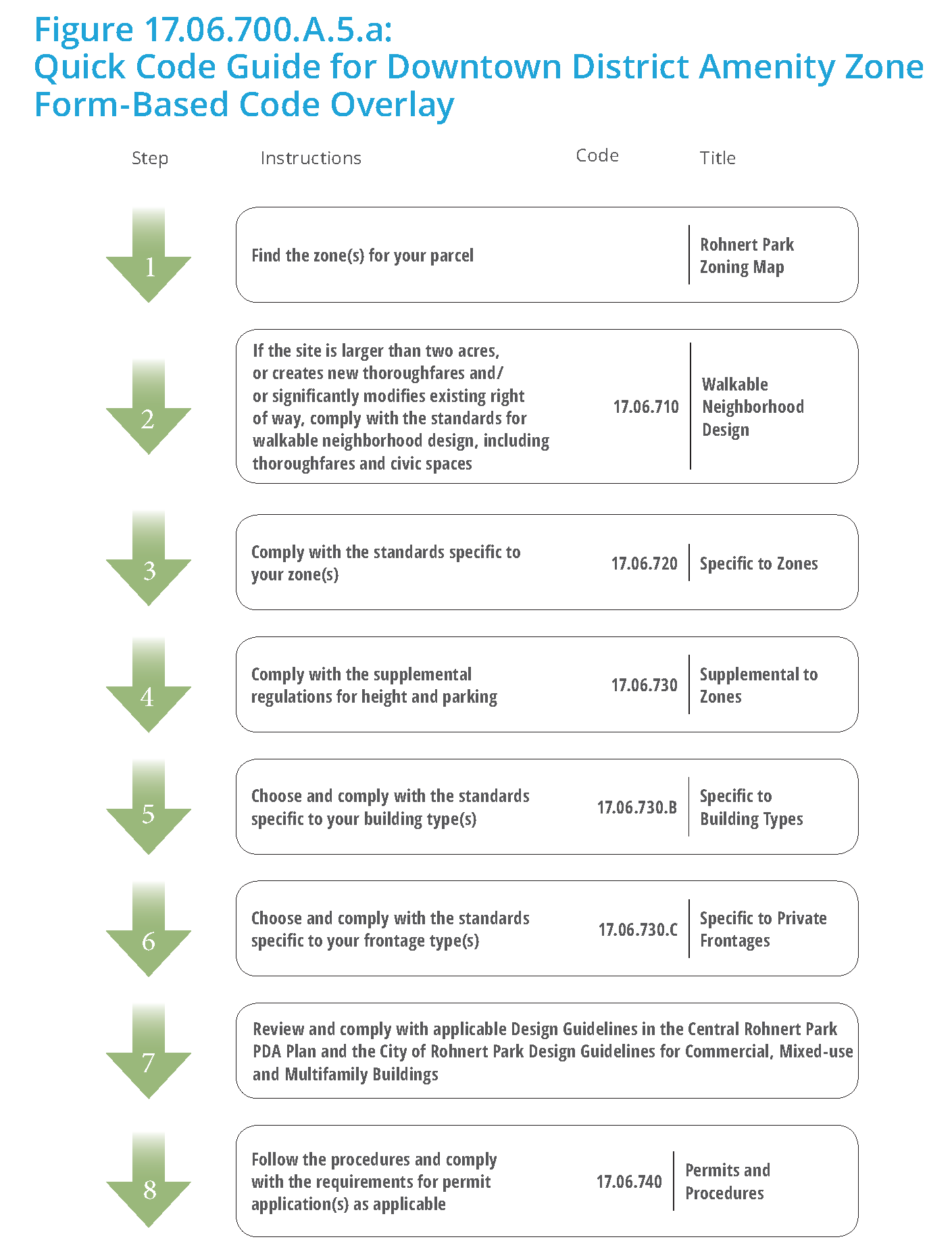
(Ord. No. 927, Exh. 2, 11-27-2018; Ord. No. 929, § 4 (Exh. 1), 2-12-2019)
17.06.710 - Walkable neighborhood design.
17.06.710.A: General to Walkable Neighborhood Design
17.06.710.A.1 Purpose and Applicability
This Section sets forth standards for walkable neighborhood design and is applicable to development sites greater than two acres in size, and/or requiring new or modified thoroughfares.
17.06.710.A.2 Walkable Urban Community Design
The project area shall be designed in compliance with the following process and requirements:
a.
Organization
(1)
The project area shall consist of a walkable neighborhood design that:
(i)
Organizes a block and thoroughfare network in compliance with the standards in Subsections b and c, using the allowed thoroughfare types in 17.06.710.C (Thoroughfare Standards);
(ii)
Allocates civic spaces in compliance with the standards in 17.06.710.B.1 (Design of Civic and Open Spaces);
(iii)
Provides a mix of primary building types allowed by the zone(s);
(iv)
Provides appropriate physical transitions to the scale and character of the surrounding area;
(v)
Suits specific environmental, site layout, and design constraints unique to the site or its location;
(vi)
Identifies the proposed blocks and thoroughfares, transect zones, civic space types, and building types on a project regulating plan per 17.06.740 (Permits and Procedures); and
(vii)
Identifies the proposed physical character of the walkable neighborhood design on a project illustrative plan by showing the typical buildings and roofs on each block in plan view and the proposed trees and landscaping along streets and in civic spaces.
b.
Thoroughfares. Thoroughfares define the streets that refine large sites into walkable urban environments and provide multiple routes for vehicular circulation.
(1)
Design
(i)
Thoroughfares shall meet the standards established in 17.06.710.C (Thoroughfare Standards).
(ii)
The thoroughfare network shall be mapped on the project regulating plan and shall indicate a layout of thoroughfares and blocks in compliance with standards in this Subsection. The location of thoroughfares is flexible provided that the standards in Subsection B and Table 17.06.710.A.2.a (Block Size) are met.
(2)
External Connectivity
(i)
The arrangement of thoroughfares shall provide for the alignment and continuation of existing or proposed thoroughfares into adjoining lands where the adjoining lands are undeveloped and intended for future development, or where the adjoining lands are developed and include opportunities for such connections.
(ii)
Thoroughfare rights-of-way shall be extended to or along adjoining property boundaries to provide a roadway connection or thoroughfare stub for development in compliance with the standards in Subsection c (Block Size).
(iii)
The project regulating plan shall identify all stubs for thoroughfares and include a notation that all stubs shall connect with future thoroughfares on adjoining undeveloped property.
(iv)
Dead-end streets and cul-de-sacs are not allowed.
c.
Block Size
(1)
Individual block faces and the total block perimeter shall meet the standards established in Table 17.06.710.A.2.a (Block Size). For minor modifications refer to Section 17.06.740 (Permits and Procedures) in Table 17.06.740.C.2.a
(2)
Blocks shall be a minimum width, to result in two tiers of developable design sites that comply with the allowed building types in the zone(s).
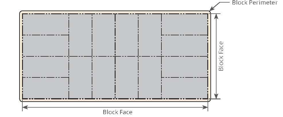
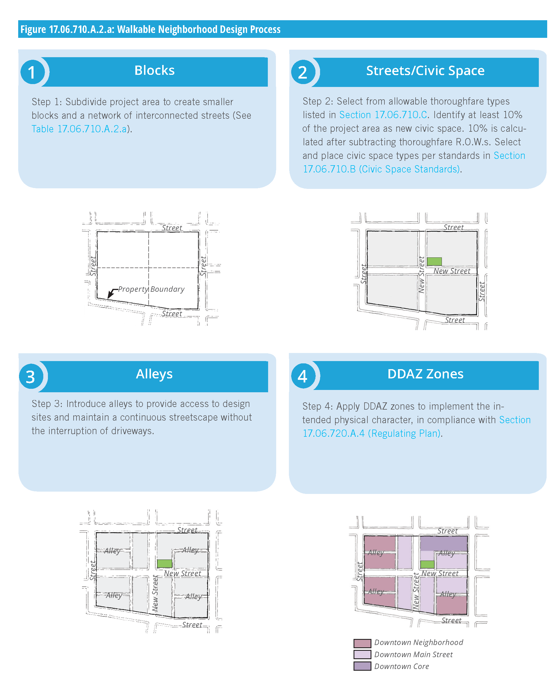
17.06.710.B: Civic Space Standards
17.06.710.B.1 Design of Civic and Open Spaces
This Section sets forth the standards applicable to existing and new civic spaces and civic buildings. These standards supplement the standards for each transect zone. Civic space is land that is improved for civic gathering purposes per one of the allowed types in this section. For each civic space type, a description, a statement of the type's intent, and design standards are provided. These standards are intended to ensure development that establishes or reinforces the intended character and scale of the DDAZ.
a.
Civic Space Allocation
(1)
The development shall set aside a minimum of ten percent of the project area as civic space using the types allowed in DDAZ zones. The 10 percent shall be calculated after street rights-of-way are subtracted from the project area.
(2)
The required amount of civic space shall be distributed throughout the neighborhood. Neighborhood means the area approximately within 1,500 feet of the site that is also not separated by freeway or railroad.
b.
Building Frontage. The relationship along property lines of a civic space to adjacent buildings and design sites shall be regulated as follows:
(1)
The facades on design sites attached to or across a thoroughfare from a civic space shall be designed as a "front" on to the civic space for at least three quarters of the civic space perimeter, in compliance with the allowed frontages.
c.
Public Access. Public access and visibility along public parks, civic uses, and natural open spaces, including creeks and drainages, shall be maintained through the use of:
(1)
Single-loaded frontage streets (those with development on one side and open space on the other);
(2)
Houses that front directly onto a bike or pedestrian path along the natural open space.
(3)
Other methods of frontage that provide similar access and visibility to the open space appropriate in the transect zone.
d.
Accessory Structure Standards. Accessory structures within civic spaces, including, but not limited to, restrooms, open-air pavilions, gazebos, picnic shelters and outdoor theaters, are subject to the applicable standards of the zone in Section 17.06.720 (Specific to Zones).
17.06.710.B.2 Civic Space Types
a.
This Section identifies the allowed civic space types in DDAZ zones.
b.
Civic Space Types. Multiple civic space types are defined in Table 17.06.710.B.2.a (Civic Space Type Overview). Two of the civic space types, Playgrounds and Community Gardens, may be incorporated into any of the other types or may stand alone. The illustration and description of each civic space type are illustrative and not regulatory.
c.
Location and Size. The service area, size, frontage, and disposition of standards of each civic space type are regulatory.
(1)
Service Area. Describes how the civic space relates to the city as a whole and the intended area to be served by the civic space.
(2)
Size. The overall range of allowed sizes of the civic space. The minimum size of the civic space may be adjusted per the procedures in Table 17.06.740.C.2.a (Minor Modifications).
(3)
Character. Civic spaces shall be designed and furnished to be consistent with the character of the zone in which they are located. Such consistency may require accessory structures to maintain building setbacks, frontage, massing, disposition and character similar to adjacent development as determined by the Director.
(4)
Disposition of Elements. The placement of objects within the civic space.
(i)
Natural. Civic spaces with natural character shall be designed in a natural manner with no formal arrangement of elements.
(ii)
Formal. Civic spaces with a formal character shall be designed in a more rigid layout that follows geometric forms and has trees and other elements arranged in formal patterns.
(iii)
Informal. Civic spaces with an informal character shall be designed to have a mix of formal and natural characteristics.
d.
Typical Facilities. Each type identifies the allowed types of accessory structures provided within the civic space. This list is not intended to be a complete list of structures allowed nor is it intended that every civic space contain each of the structures listed. Proposed structures larger than the indicated gross square footage (gsf) require review and approval by the Director.
e.
The civic spaces specified in Table 17.06.710.B.2.a (Civic Space Type Overview) are allowed as follows:
(1)
Allowed. Allowed if in compliance with the standards.
(2)
By Director. Allow as determined by the Director
(3)
Not Allowed. The type is not allowed in the transect zone.
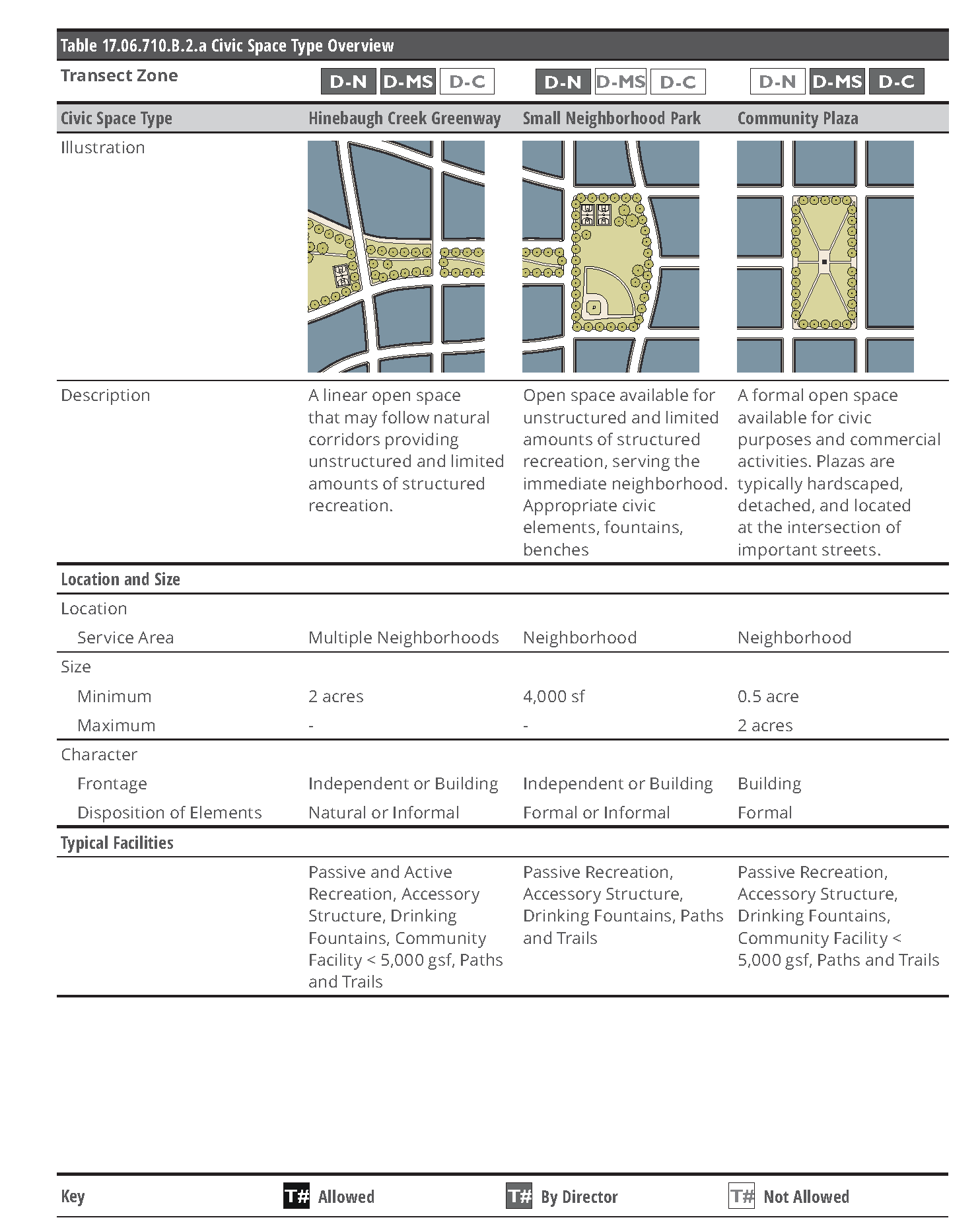
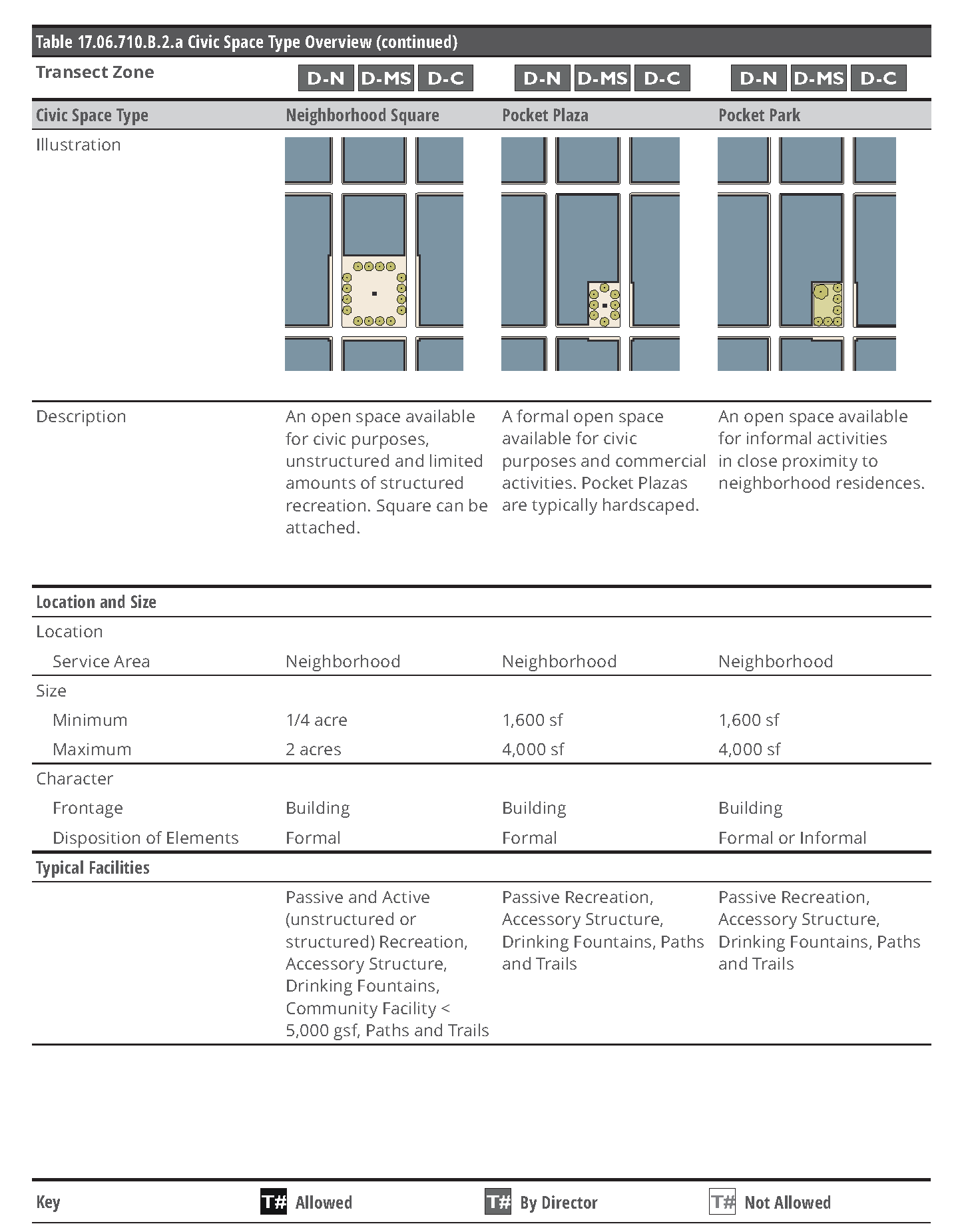
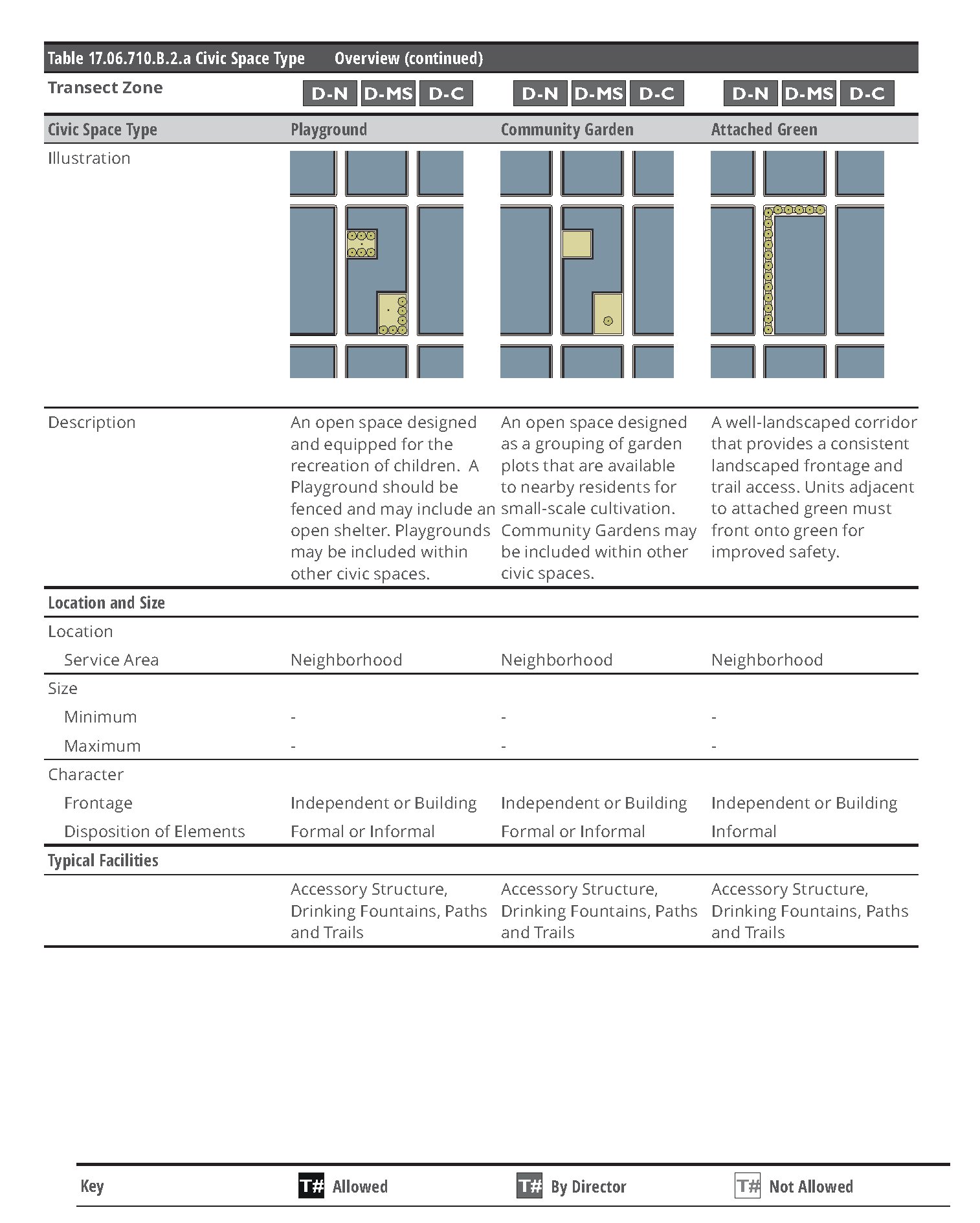
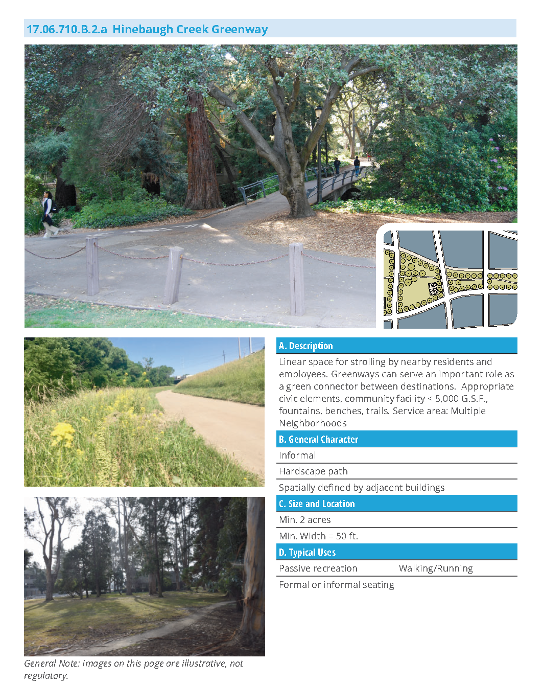
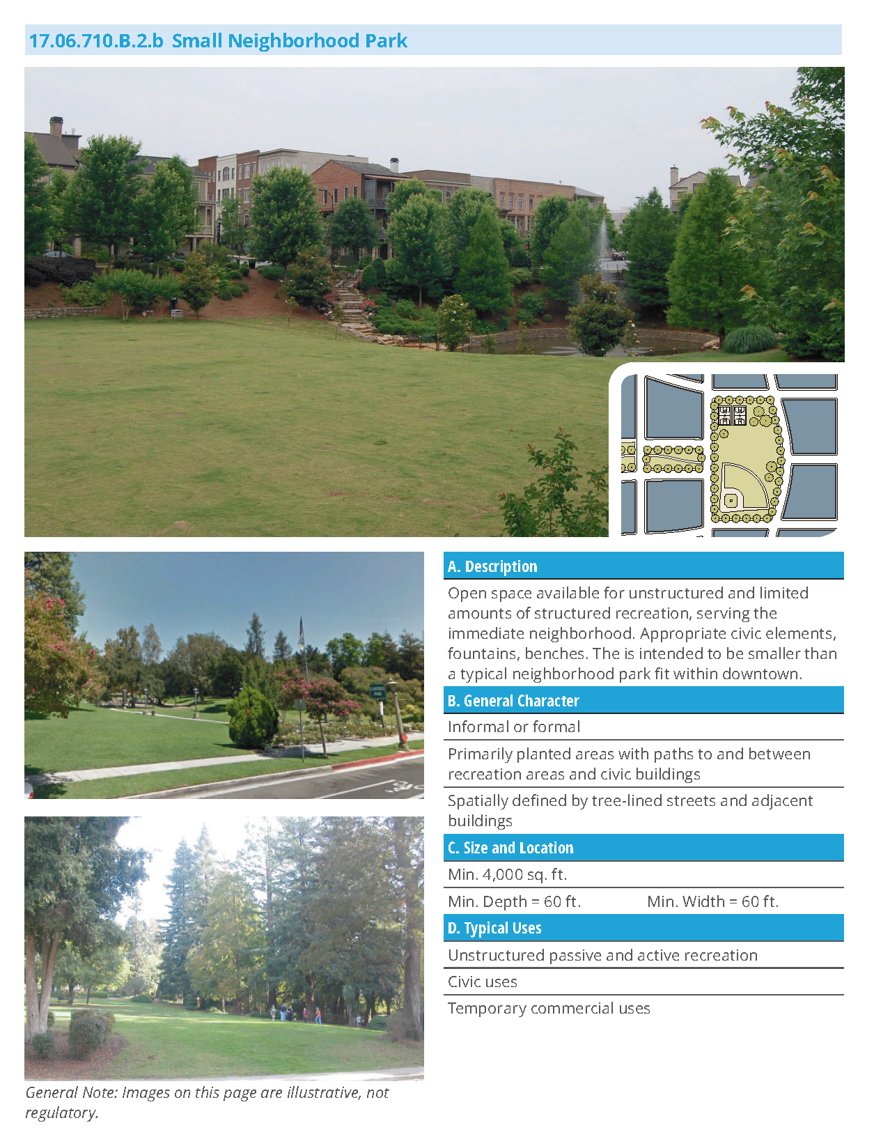
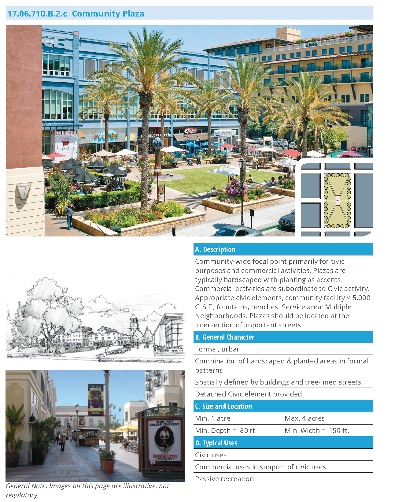
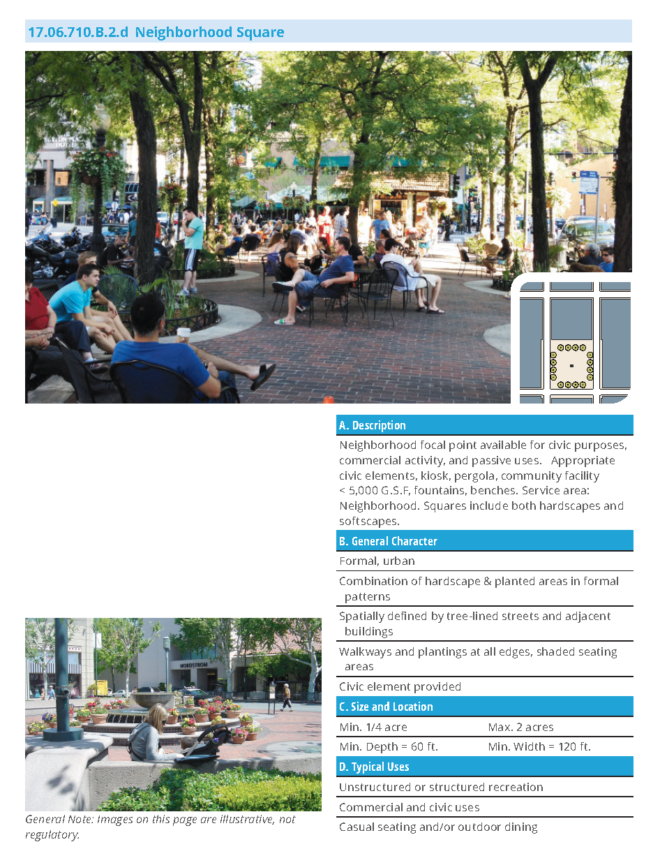
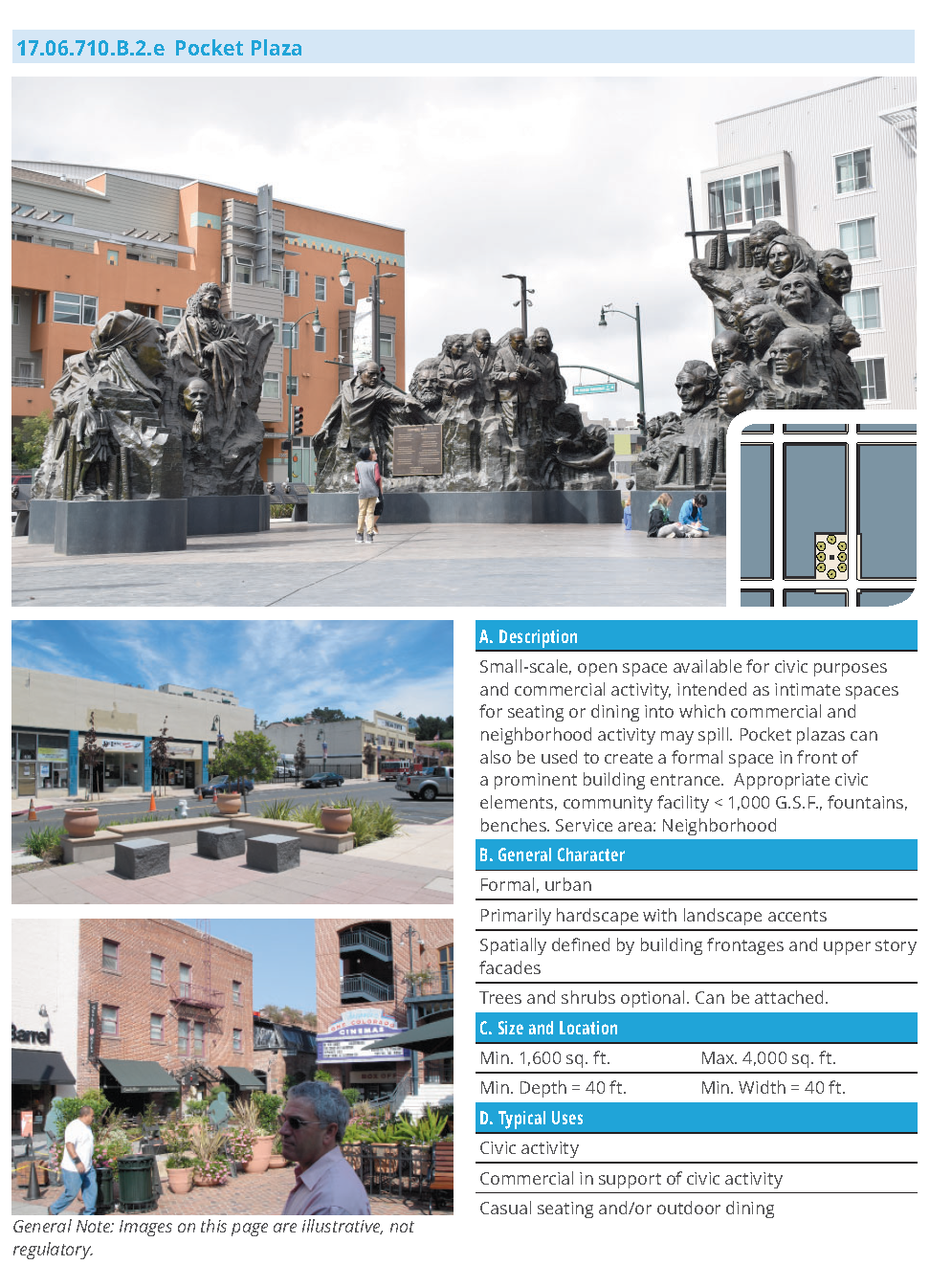
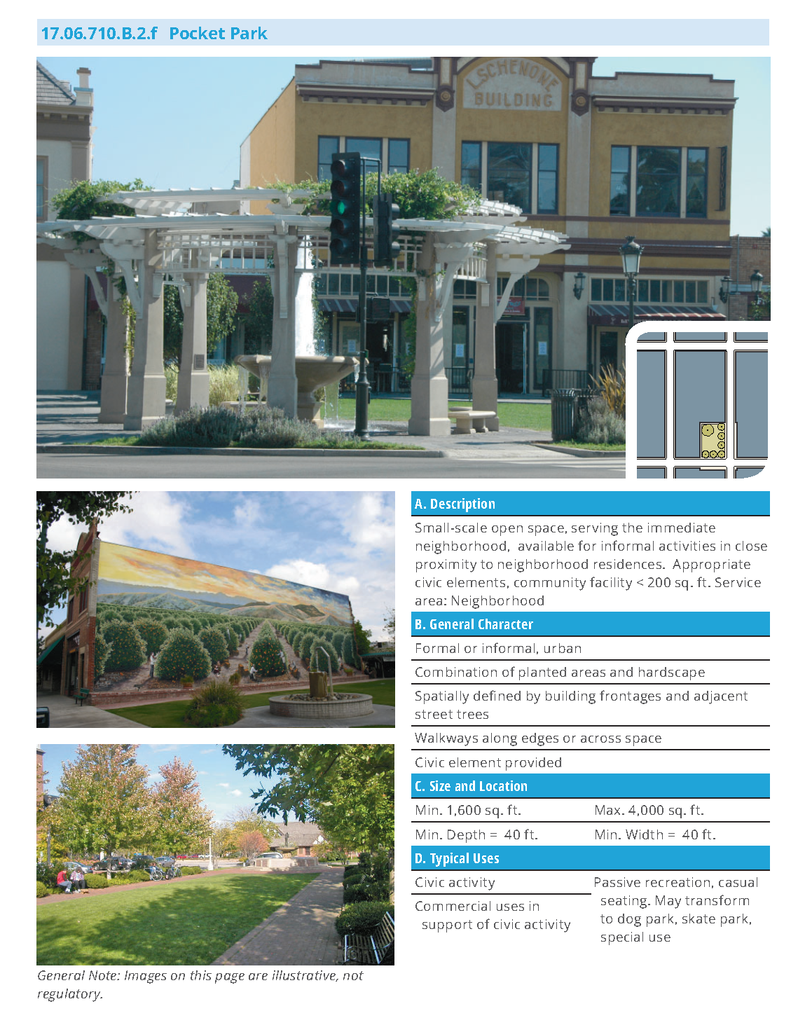
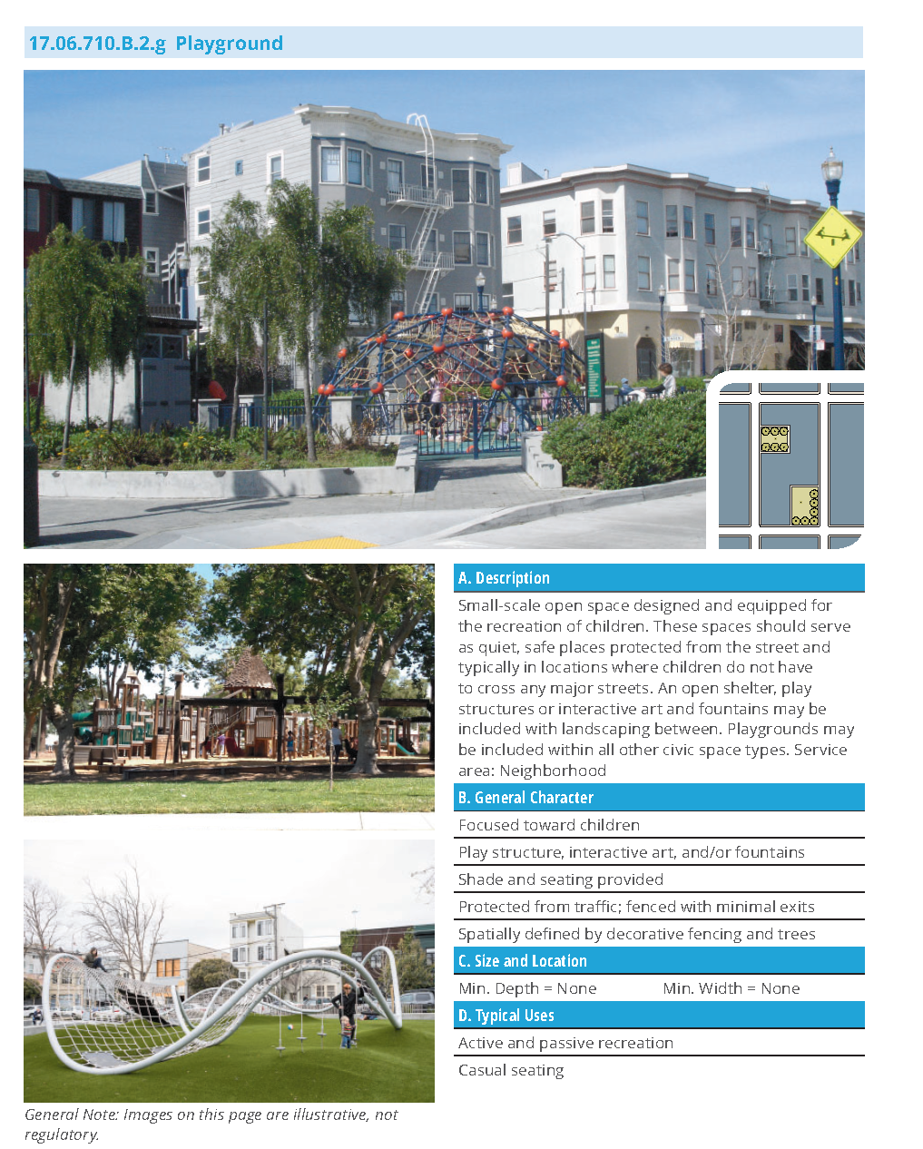
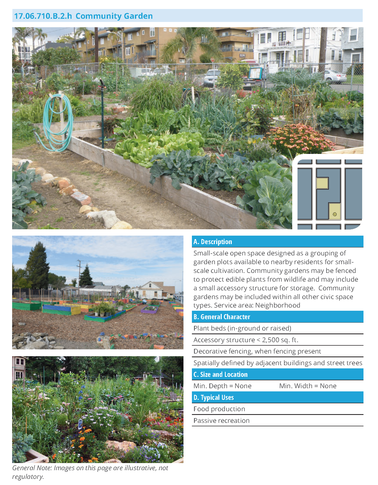
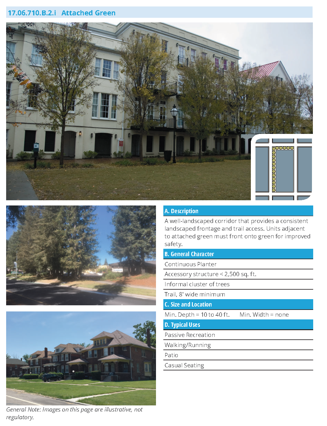
17.06.710.C Thoroughfare Standards
17.06.710.C.1 Purpose
a.
This Section sets forth the standards for streets appropriate for use within the DDAZ.
b.
Thoroughfares have been designed to balance the needs of pedestrians with vehicles and to establish a high-quality, pedestrian-friendly environment.
17.06.710.C.2 Applicability
a.
The standards of this section apply to the construction of a new thoroughfare in a transect zone and/or when an application for a site over 2 acres with new thoroughfares or modifications to existing thoroughfares is proposed.
b.
The standards of this section apply to existing thoroughfares as follows:
(1)
Improvement or modification to curb return, pedestrian crossing, landscaping, or sidewalk;
(2)
Improvement or modification to on-street parking, or lane striping;
(3)
Improvement or modification to right-of-way;
c.
The individual standards of each thoroughfare type in this section may be adjusted administratively by the City Engineer. Subject to the following considerations. The proposed adjustment:
(1)
Supports the intended physical character of the transect zone(s).
(2)
Maintains multiple modes of transportation (transit, pedestrian, bicycles, automobiles).
(3)
Predominantly maintains sidewalks of at least six feet wide, where feasible, on all residential streets and at least ten feet on commercial streets where possible.
(4)
Maintains on-street parking for a majority of each block face.
(5)
Maintains regularly spaced street trees.
d.
Additional thoroughfare types may be developed, subject to City review and approval, using the components and standards listed below:
17.06.710.C.3 Movement Types and Design Speed
Movement types are intended to assist in appropriate thoroughfare design for the necessary level of pedestrian and bicyclist safety and comfort at any given location. Design speed is the primary determinant of movement type. Anticipated movement types and design speeds (along with their assigned lane widths and curb radii) are provided for each thoroughfare type in Sub-Sections 17.06.710.C.7.a—m.
a.
The design criteria for Yield, Slow, and Low thoroughfares shall be commensurate with local thoroughfares. Design speeds higher than thirty-five miles per hour shall not be used in areas intended to support moderate or high levels of pedestrian or bicycle activity due to concerns with pedestrian safety and comfort.
17.06.710.C.4 Intersections
The following shall be applied in the design process to all thoroughfare types with the prefix "new" and to additional types that are designed. They are already integral to the thoroughfare types not containing the prefix "new".
a.
Street design of narrow streets and compact intersections requires designers to pay close attention to the operational needs of transit, fire and rescue, waste collection and delivery trucks. For this reason, early coordination with transit, fire and rescue, waste collection and other stakeholder groups is essential.
b.
More regular encroachment of turning vehicles into opposing lanes will occur at compact intersections. Therefore, frequency of access, traffic volumes and the speeds on intersecting streets at those intersections shall be considered when designing intersections. For fire and rescue, determination of the importance of that street for community access should be determined, (e.g. primary or secondary access).
c.
The designer shall use turning templates or software to evaluate intersections to ensure that adequate operation of vehicles can occur. Location of on-street parking around intersections may be evaluated during this analysis to identify potential conflicts between turning vehicles and on-street parking. Bike lanes and on-street parking will increase the effective curb return radius, when curb extensions are not applied, by providing more room for the wheel-tracking of turning vehicles.
d.
Table 17.06.710.C.4.a. provides standards for the curb radius when improving existing intersections or designing new intersections.
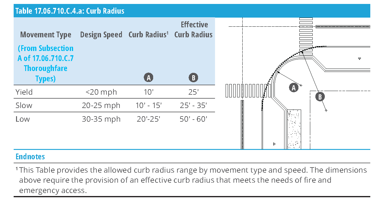
17.06.710.C.5 Pedestrian Crossings
The following shall be applied in the design process for improvements to existing streets in DDAZ zones and in the design of new streets for large sites as defined in Section 17.06.710.C.2 (Applicability).
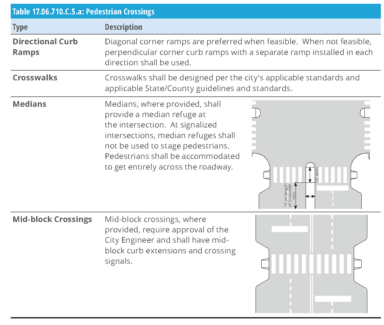
17.06.710.C.6 Supplemental Standards to Thoroughfares
a.
Tree grates are required in street tree wells and they are to match the existing tree grates on City Center Drive.
b.
Structural soil mix or Silva Cells are required underneath all street tree wells according to city standards. Size is to be minimum 2' depth by minimum six-inch square and the top twelve-inch edge of the pit is to be lined with a root barrier.
c.
Allowed street trees are listed in Table 6.2 of the PDA.
d.
Lighting shall be installed according to city standards or as otherwise approved by the City Engineer.
17.06.710.C.7 Thoroughfare Types
Sub-Sections 17.06.710.C.7.a through 17.06.710.C.7.m illustrate allowed thoroughfares for use in the DDAZ.
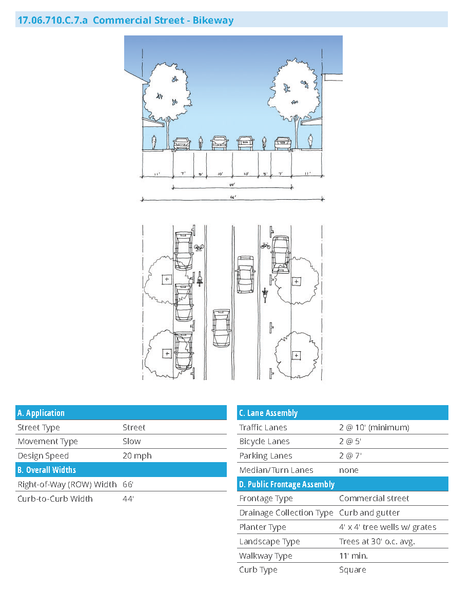
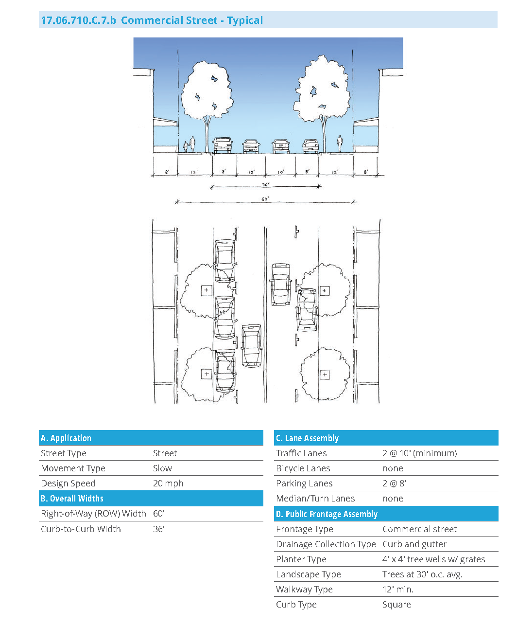
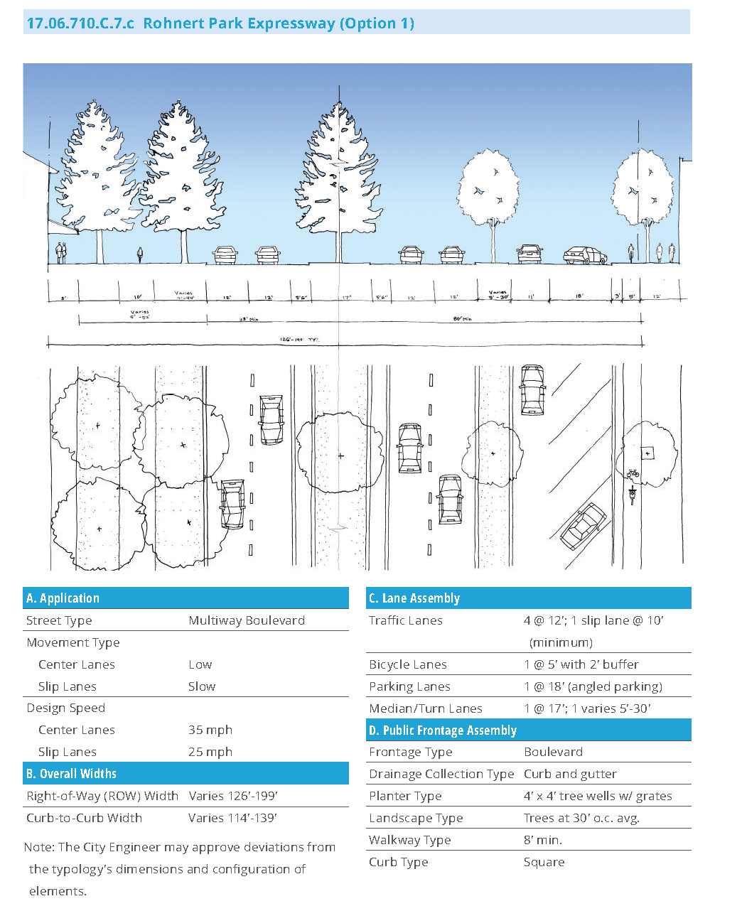
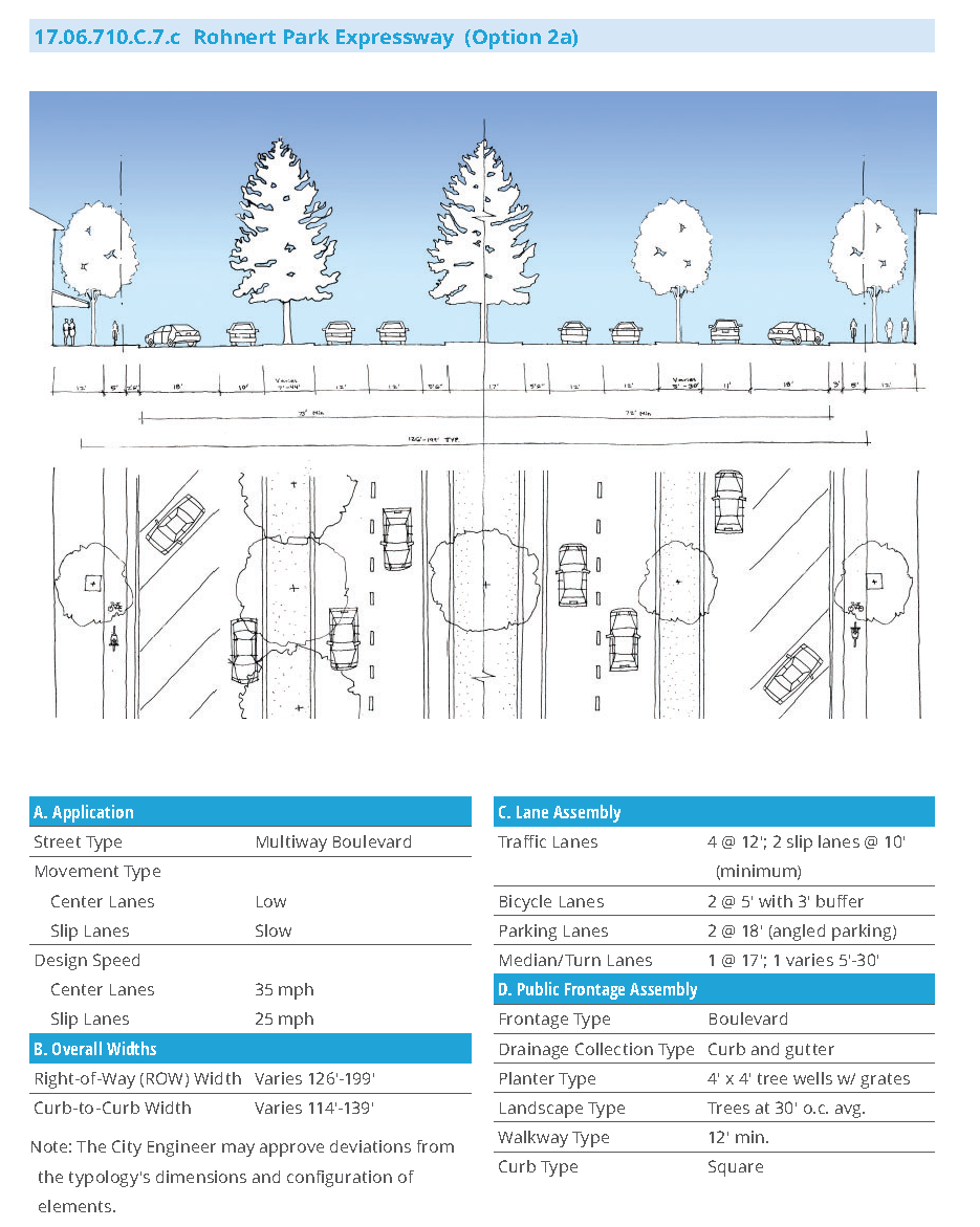
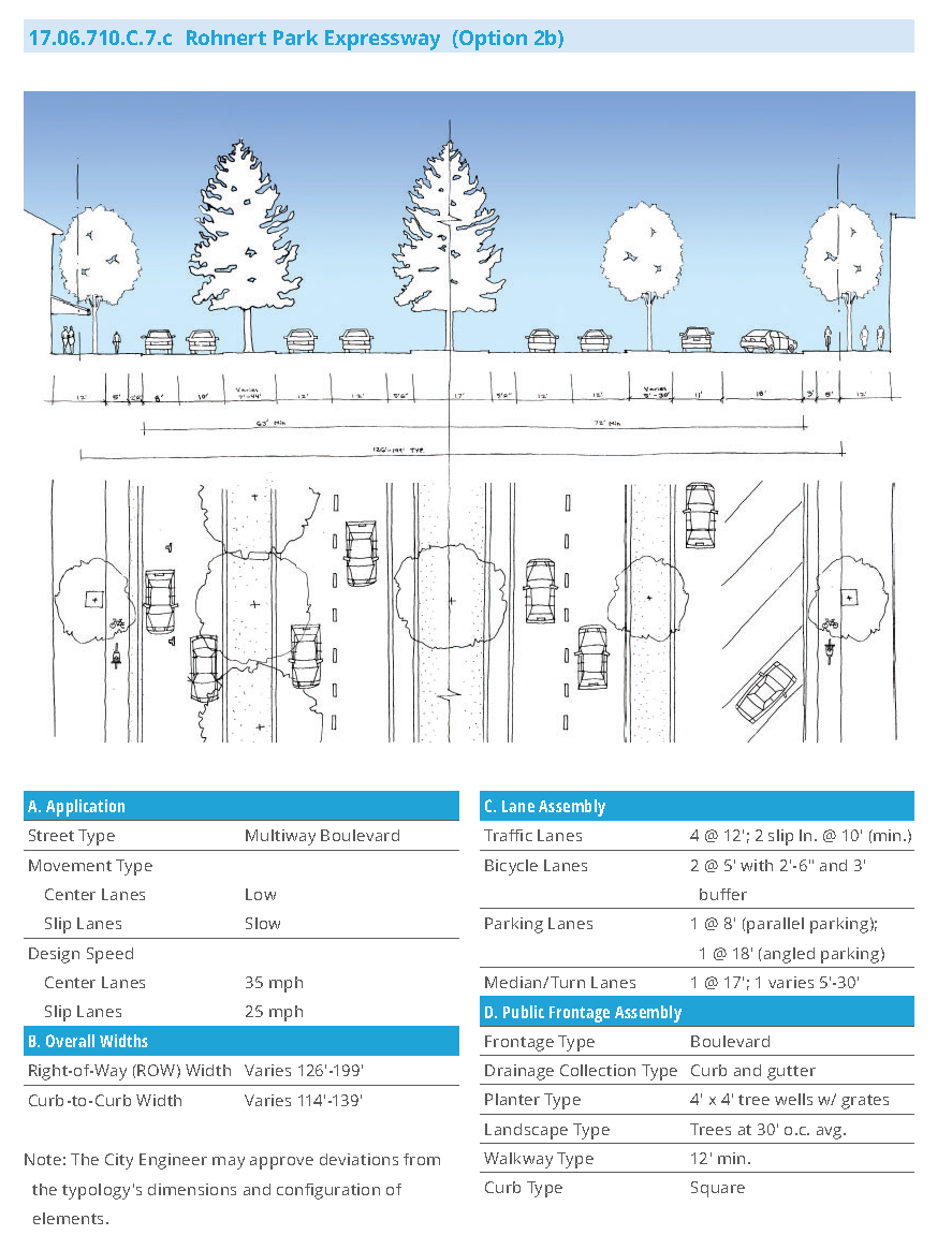
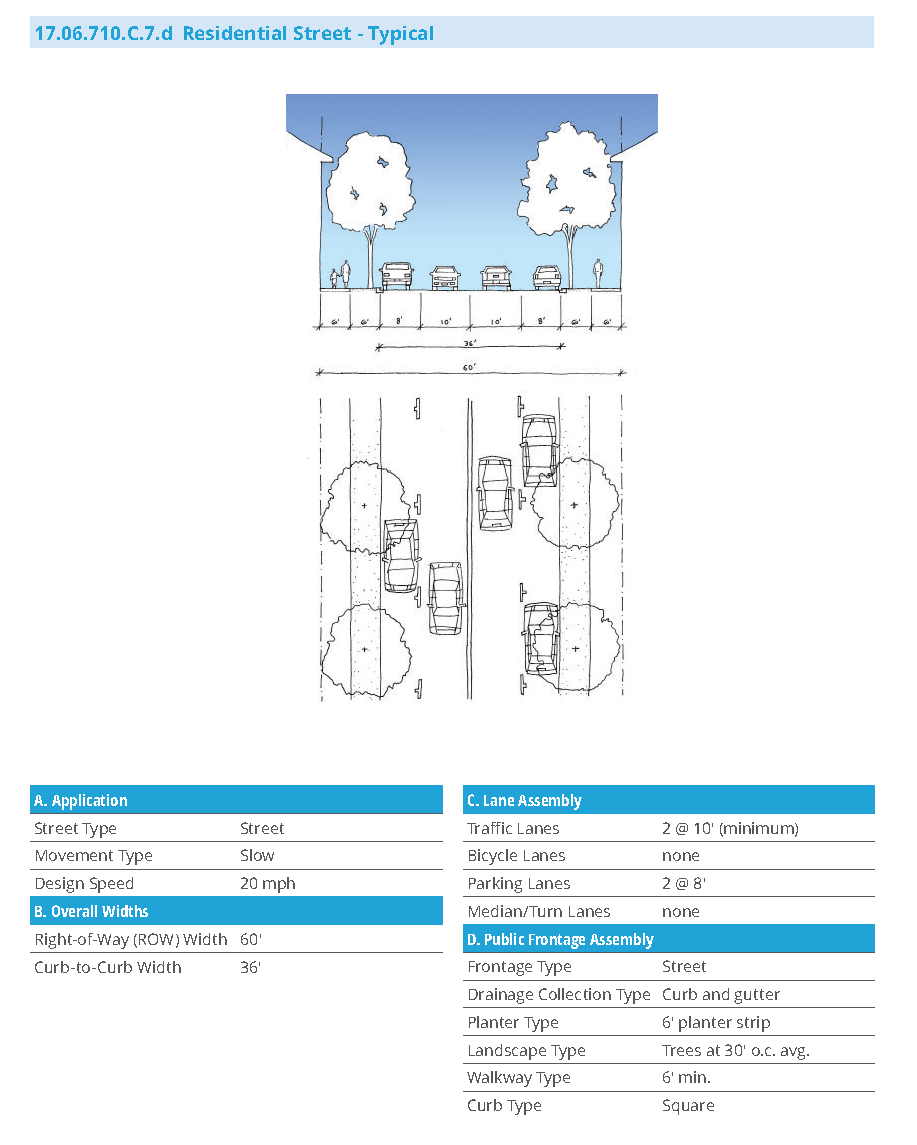
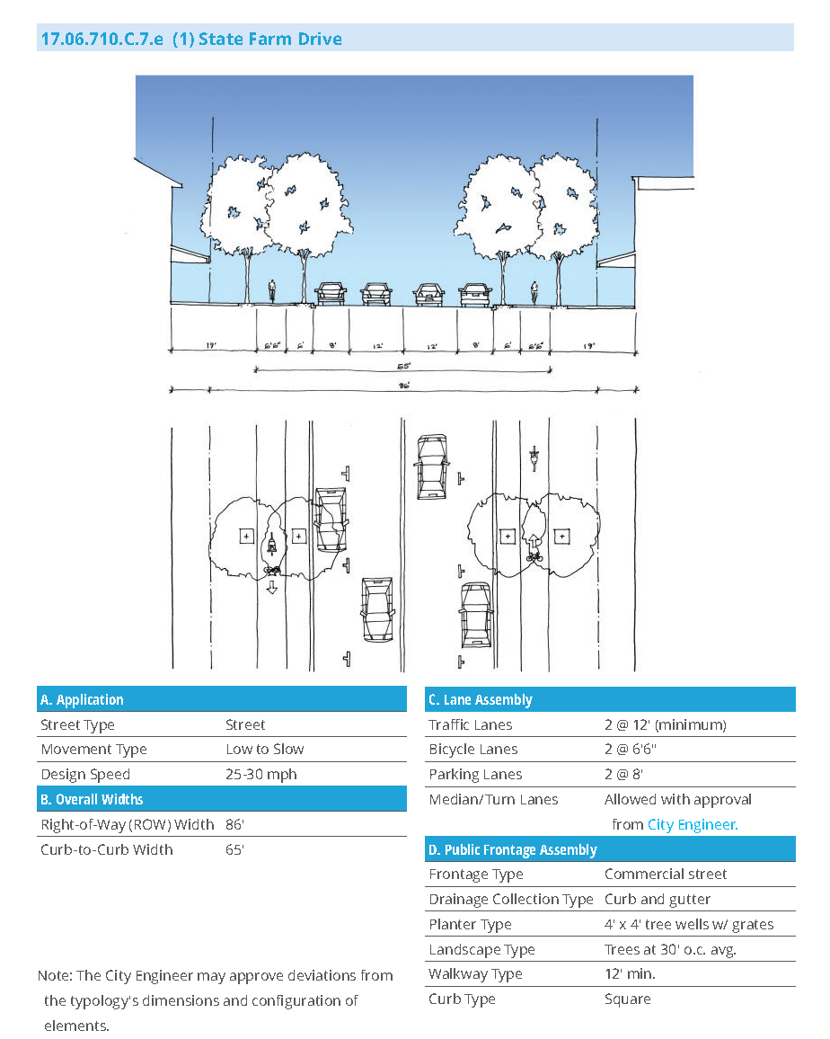
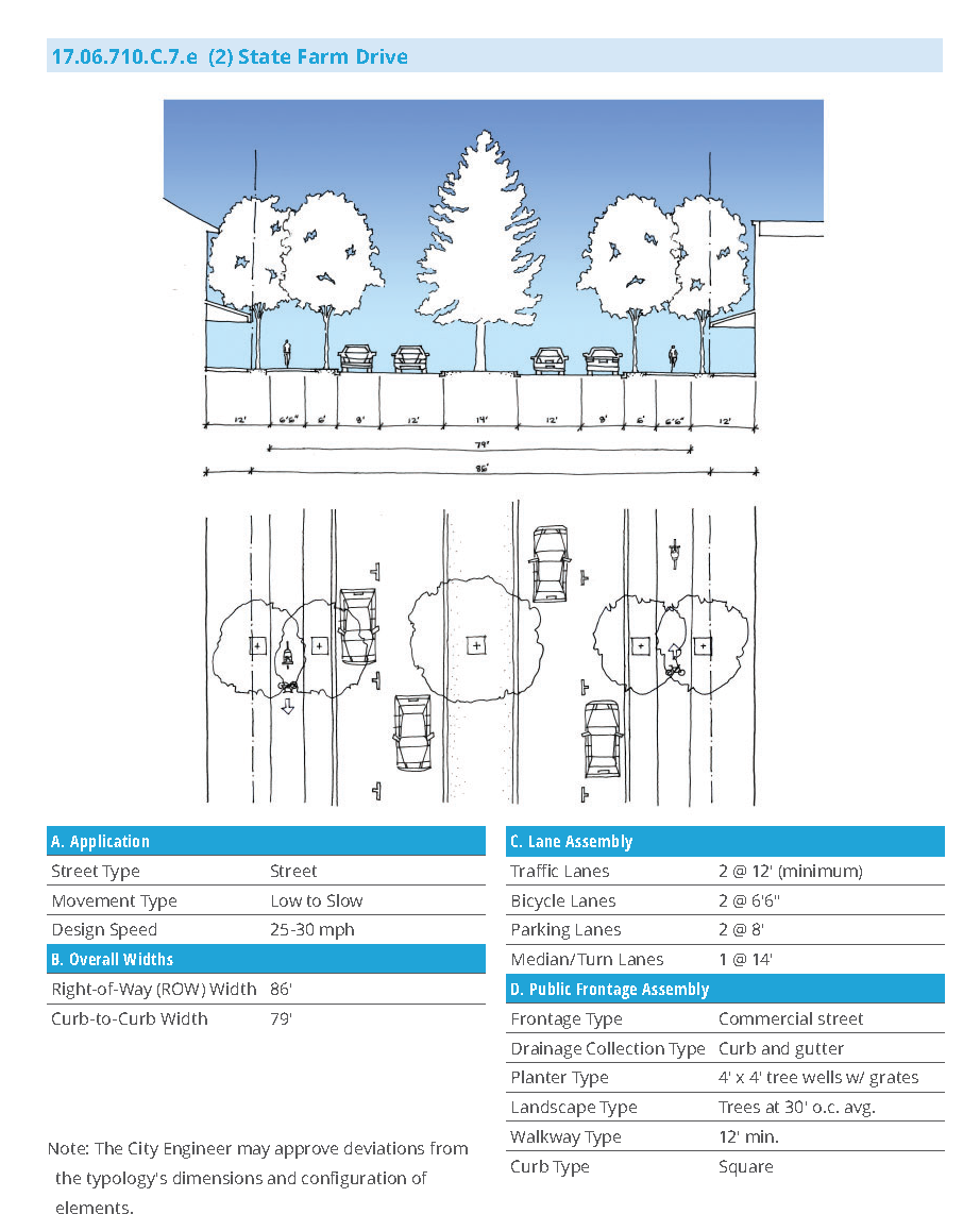
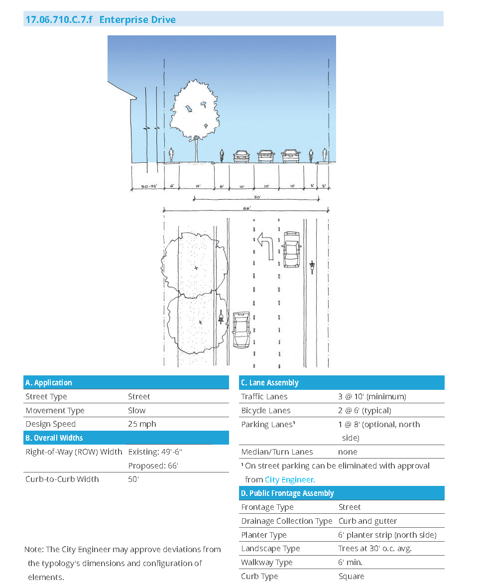
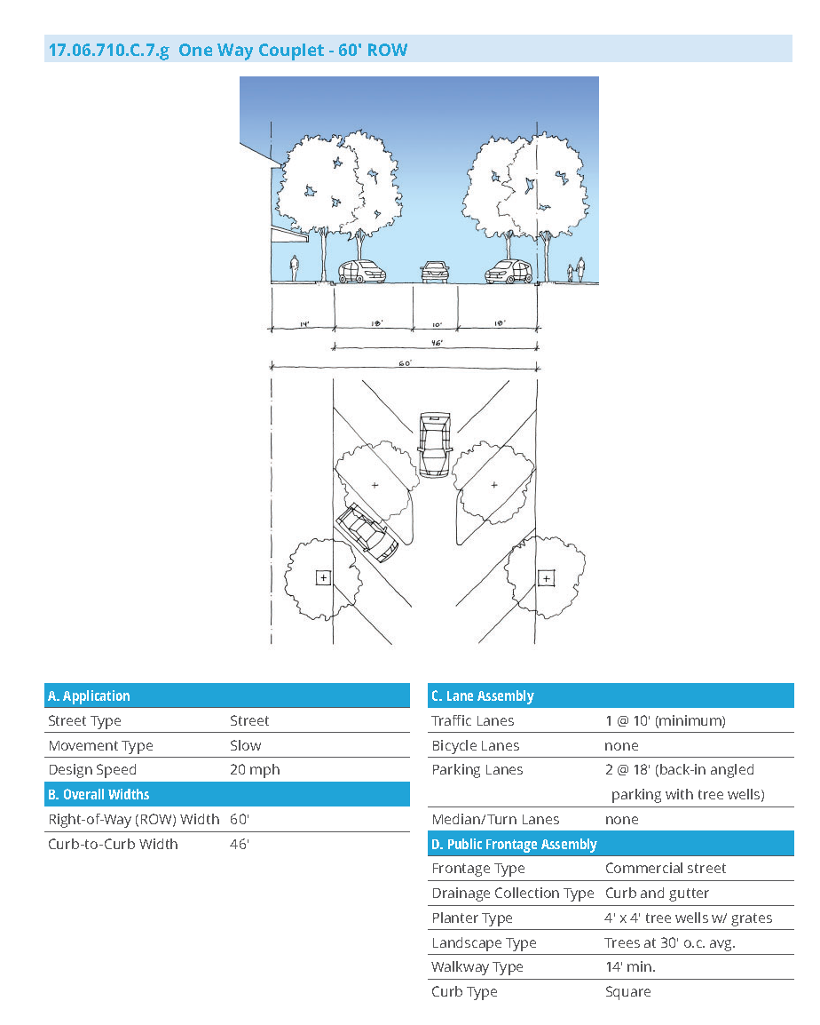
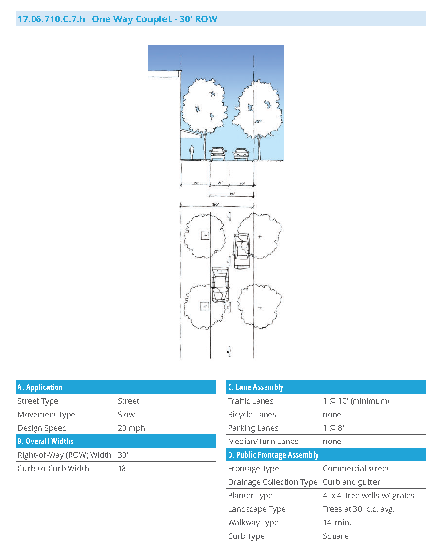
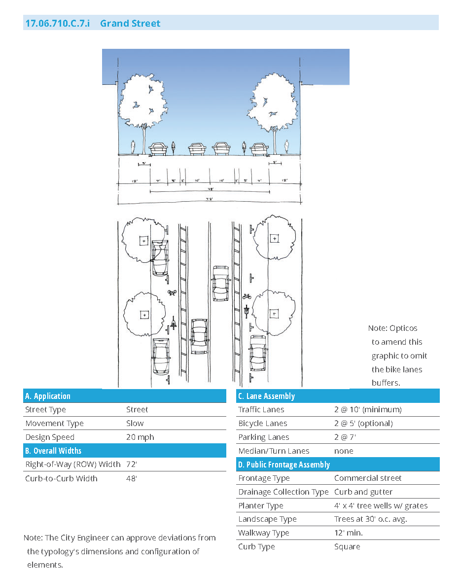
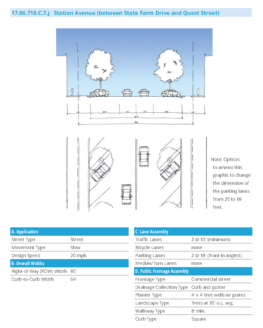
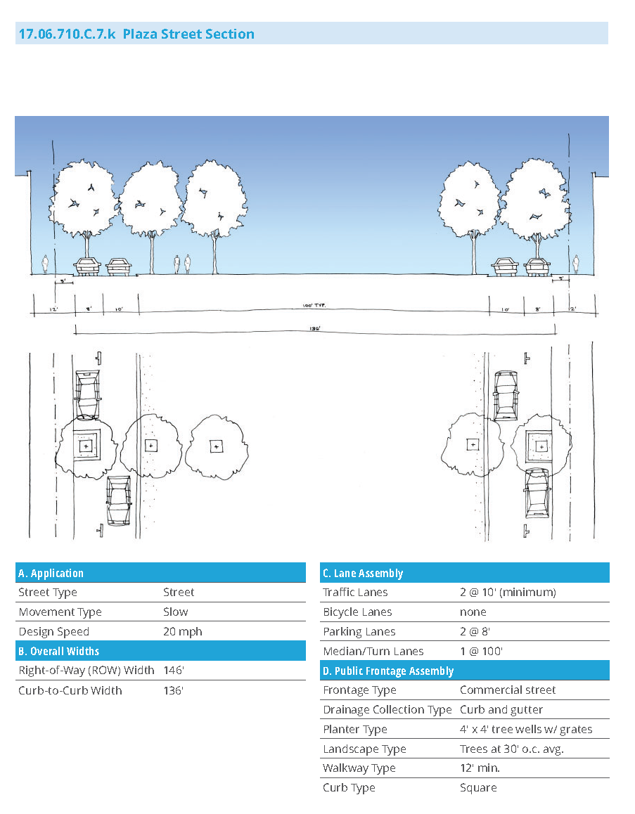
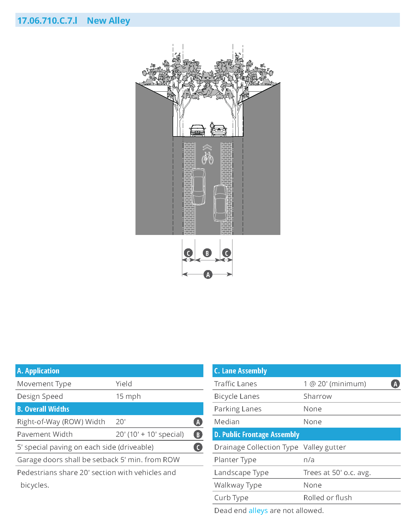
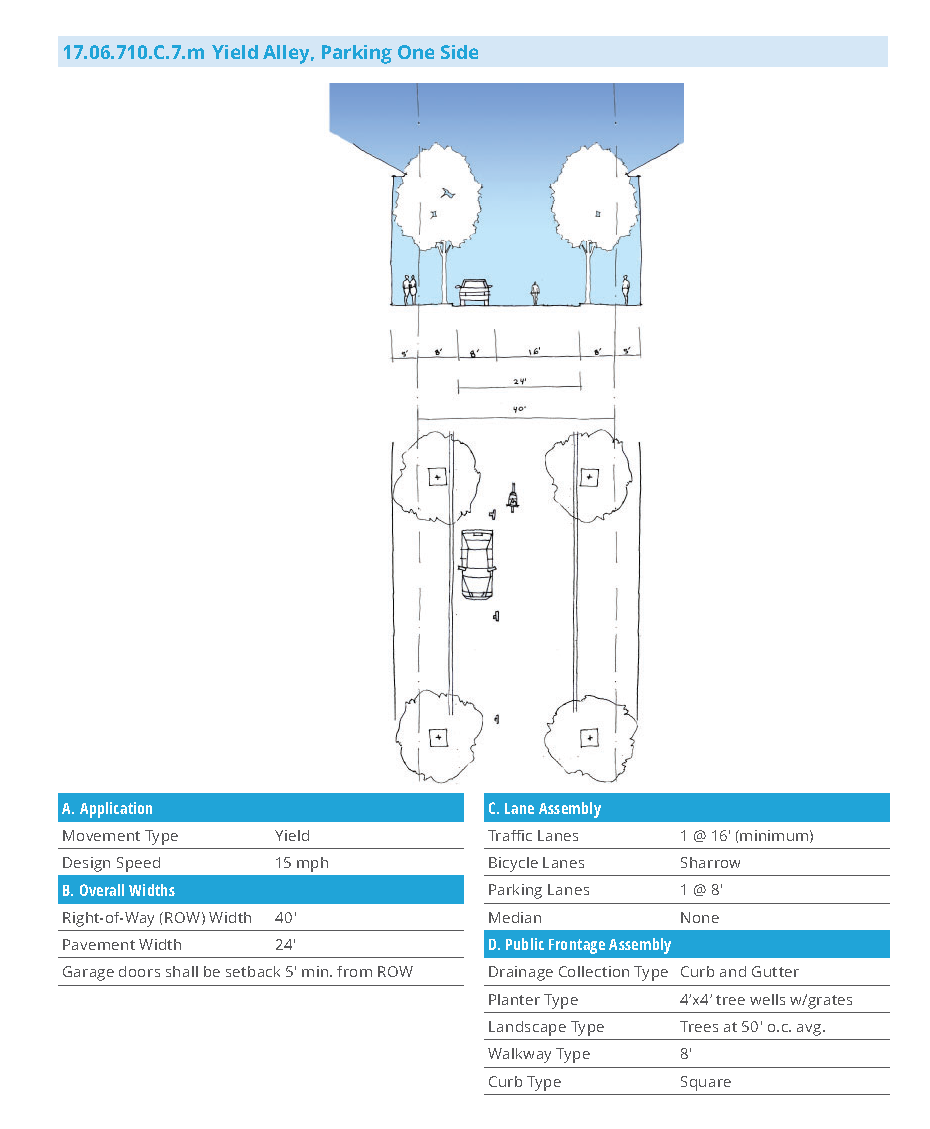
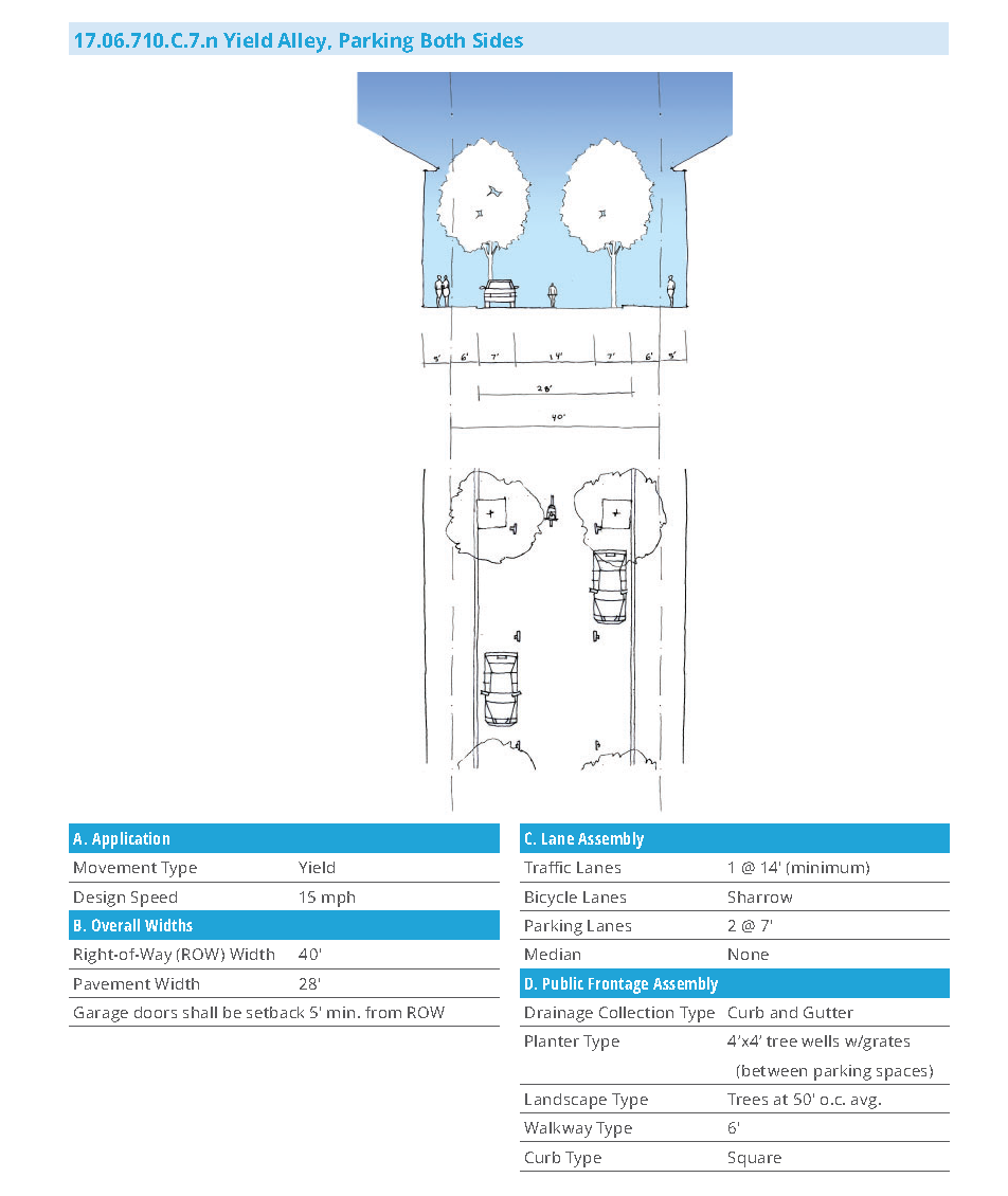
(Ord. No. 927, Exh. 2, 11-27-2018; Ord. No. 929, § 4 (Exh. 1), 2-12-2019)
17.06.720 - Specific to zones.
17.06.720.A: Downtown District Zones
17.06.720.A.1. Purpose
This Section provides regulatory standards governing building form and land use within the Downtown District Amenity Zone overlay.
17.06.720.A.2. Applicability
a.
The standards of this Section shall apply to all proposed development within the Downtown District Amenity Zone overlay, and shall be considered in combination with the standards in Section 17.06.730 (Supplemental to Zones) and Section 17.06.710 (Walkable Neighborhood Design). If there is a conflict between any standards, the more restrictive standards shall apply.
b.
Uses not listed in Section 17.06.720.B (Use Table) are not permitted in the zone.
17.06.720.A.3. Zones Overview
a.
The standards in this Section provide building form standards, use, and parking standards for each zone. Some zones have a sub-zone that allows the same built form but with either additional or limited ground floor and upper floor uses. Table 17.06.720.B.2.a provides an overview of the DDAZ Zones.
b.
Buildable Sites and Building Types.
i.
The term "Buildable Site" in this Section refers to a potential site boundary that may or may not equate to a legal parcel. Buildable sites expressed in this Section intend to accommodate one primary building type, accessory structures including one carriage house (when applicable), and private open space associated with the primary building type.
c.
At least one of each of the following, in compliance with the listed standards, must be selected for each Buildable Site:
i.
Building Type (17.06.730.B); and
ii.
Frontage Type (17.06.730.C)
d.
Accessory Buildings and Structures.
i.
Accessory buildings and structures are allowed and regulated in Section 17.10.060.
17.06.720.A.4. Regulating Plan
a.
The Zones in this section are mapped on Figure 17.06.720.A.4 (DDAZ Regulating Plan).
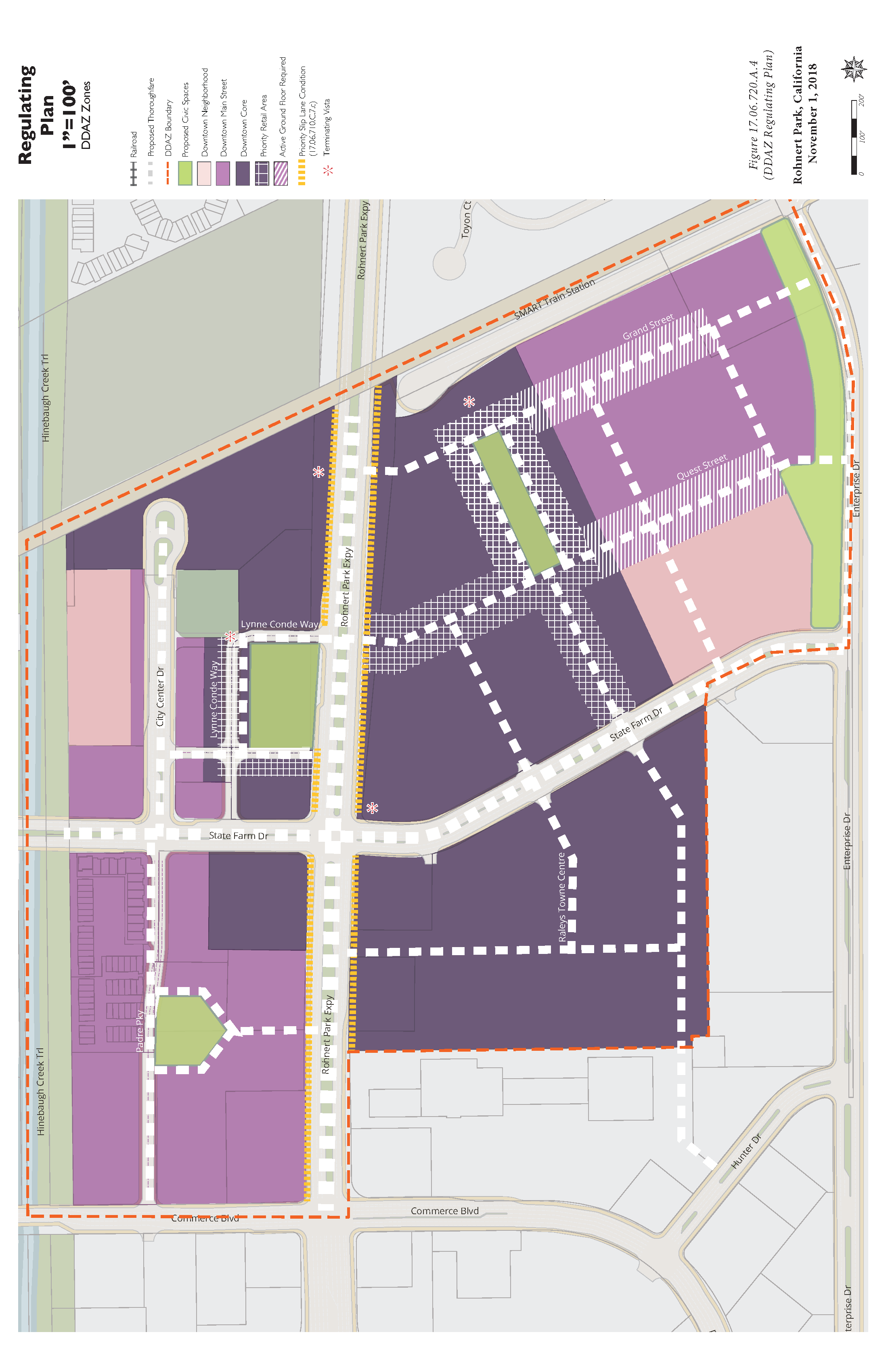
17.06.720.A.5 Development Standards Summary Table
| A. Intent | ||
|---|---|---|
| Downtown Core | Downtown Main Street | Downtown Neighborhood |
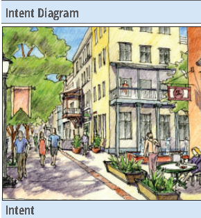 | 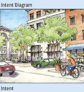 | 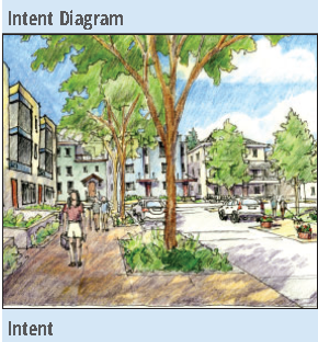 |
| A vibrant, walkable, urban main street serving the Rohnert Park community and the region with commercial, retail, entertainment, and civic uses, public transportation, and medium-to-large footprint, moderate-to-high intensity housing choices. | A walkable, vibrant urban main street serving multiple neighborhoods with commercial, retail, entertainment, and civic uses, public transportation, small-to medium footprint buildings with some moderate-to-high-intensity housing choices. | A walkable, urban neighborhood environment with small-to-medium footprint, lower-intensity housing choices, supporting and within short walking distance of neighborhood-serving retail and services. |
| Desired Form | Desired Form | Desired Form |
| Detached or Attached Buildings: Primarily Attached | Detached or Attached Buildings: Primarily Attached | Detached or Attached Buildings: Mix of Attached and Detached |
| Lot Width: Medium to Large | Lot Width: Small to Medium | Lot Width: Small to Medium |
| Footprint: Medium to Large | Footprint: Small to Medium | Footprint: Small to Medium |
| Setbacks: Buildings at back of sidewalk | Setbacks: Buildings at/near back of sidewalk | Setbacks: Buildings uniformly set back from sidewalk |
| Building Height Up to 5-7 stories | Building Height Up to 4.5 stories | Building Height: Up to 3.5 stories |
| Ground Floor: At ground level | Ground Floor: At or raised from ground level | Ground Floor: Raised from ground level |
| Frontages: Primarily Shopfronts, Galleries, and Arcades | Frontages: Primarily Shopfronts, Galleries, Dooryards, Terraces, and Forecourts | Frontages: Primarily Dooryards, Stoops, Porches, Forecourts |
| Streetscape: Street Trees in Tree Wells | Streetscape: Street Trees in Tree Wells | Streetscape: Street Trees in Tree Wells or planter strips |
17.06.720.B: Use Table
(Ord. No. 927, § 4 (Exh. 2), 11-27-2018; Ord. No. 991, § 4(Exh. A, §§ 21, 22), 1-27-2026)
17.06.730 - Supplemental to zones.
17.06.730.A: General Standards
17.06.730.A.1 Additional Height Regulations
a.
Introduction. This Sub-Section establishes the methodology used to measure the height of a building. The methodology applies to primary and accessory buildings and structures.
(1)
The DDAZ zones use several methods to regulate the building height, including regulating the overall building height, the height to the eave or parapet and the number of stories. These methods are used together to help ensure that new development is consistent in character and scale across the DDAZ. See Figure 17.06.730.A.1.a.
b.
Applicability. The standards in this Sub-Section are applicable to all development within the DDAZ. The maximum height of a building or structure is established in Section 17.06.720 (Specific to Zones).
c.
Overall Building Height. Overall building height shall be measured vertically from the finished grade adjacent to the building exterior to the building height plane.
(1)
Building Height Plane. The building height plane is an imaginary plane that is used to determine the height of the building. It is determined as follows:
(i)
The plane shall be parallel to the natural grade of the site; and
(ii)
The plane shall be set vertically at the highest point of the coping of a flat roof, the top of a mansard roof, or the highest point of the highest pitched roof.
d.
Building Height to Eave/Parapet. Building height to eave/parapet shall be measured vertically from the finished grade adjacent to the building exterior to the eave or top of the parapet.
e.
Building Height by Story. A story shall be measured as follows for purposes of regulating the height of the building:
(1)
A story that meets the height regulations in Table 17.06.730.A.1.a (Maximum Height of a Floor) shall be counted as one story. A story that exceeds the height regulations in Table 17.06.730.A.1.a shall be counted as two or more stories.
(2)
Basements with an exterior exposed wall greater than four feet shall count as a story. The height of the exterior wall shall be measured from the finished grade to the finished floor of the story above.
f.
Half-Story. Finished attics shall be measured as a knee wall maximum height of five feet and a finished floor to finished ceiling maximum height of nine feet.
g.
Knee Wall. A short wall, not necessarily high enough for a person to stand up next to, that supports rafters and encloses a finished attic or the top half-story of a building.
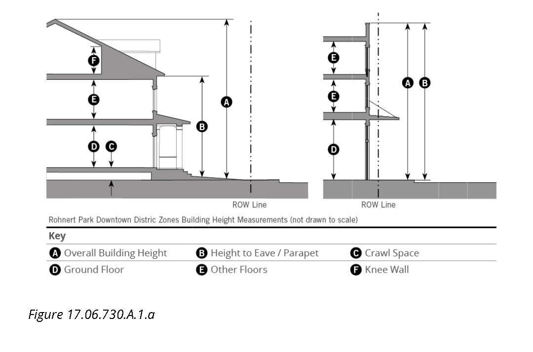
17.06.730.A.2 Additional Parking Regulations in the DDAZ
a.
Purpose. The purpose of this Sub-Section is to provide additional parking regulations for the DDAZ that supplement those found in Chapter 17.16 (Off-Street Parking Requirements). The Sub-Section provides options for adjusting parking requirements and providing parking alternatives. These standards ensure that the parking needs of new land uses and development are met, while being designed and located in a manner consistent with the desired character and development patterns of the DDAZ.
b.
Applicability. The parking standards of this Sub-Section shall apply to the following within the DDAZ area:
(1)
New development;
(2)
Changes in land use; and,
(3)
Changes made in intensity of buildings or structures of fifteen percent or more of:
(i)
Gross floor area;
(ii)
Seating capacity;
(iii)
Dwelling units;
(iv)
Parking spaces; and/or,
(v)
Other units of measurement listed in Table 17.06.730.A.2.a (Number of Motor Vehicle Parking Spaces Required).
(4)
Should any conflict arise between the regulations found in this Sub-Section and Chapter 17.16, the standards found in this Sub-Section shall apply.
(5)
All parking spaces provided shall meet the location, design, landscaping and improvement requirements in this Sub-Article.
c.
Bicycle Parking
(1)
See Section 17.16.140 (Bicycle Parking) for Bicycle Parking standards.
d.
Off-Site/Premises Parking
(1)
See Section 17.16.070 (Shared Parking)
e.
Number of Motor Vehicle Parking Spaces Required
(1)
Parking Requirements. The number of required motor vehicle spaces for residential, retail, and service uses are regulated in Section 17.06.720 (Specific to Zones). For those regulated uses, the requirements of Table 17.06.730.A.2.a (Number of Motor Vehicle Parking Spaces Required) shall not apply. For all other uses not listed in Section 17.06.720 (Specific to Zones), the requirements of Table 17.06.730.A.2.a (Number of Motor Vehicle Parking Spaces Required) shall apply.
(i)
Fractional parking requirements, when applicable, shall be rounded up to the next whole number.
(ii)
Parking may be covered or uncovered unless specified in Section 17.06.720 (Specific to Zones).
(iii)
Parking requirements for uses not addressed in Section 17.06.720 or not listed in Table 17.06.730.A.2.a shall be determined at the discretion of the Department Director.
(2)
Maximum Number of Parking Spaces. Developments over twenty thousand square feet shall not exceed the minimum number of parking spaces by more than five percent. The Department Director may allow an additional five percent increase in the number of parking spaces if an applicant can show through a parking demand study that additional parking spaces are required.
f.
Parking Adjustments
(1)
Recreation, Education, and Assembly Uses.
(i)
Parking requirements based on gross square feet may take a reduction of five thousand square feet; or
(ii)
Parking requirements not based on gross square feet may take a reduction of up to twelve spaces.
(iii)
The Department Director may require uses under five thousand square feet to provide parking in instances where that use is likely to generate significant parking demand.
(2)
Senior Citizen Housing. The minimum parking requirement provided for in Table 17.06.730.A.2.a (Number of Motor Vehicle Parking Spaces Required) shall be reduced by twenty-five percent for each passenger vehicle made available permanently for use by the residents of each 75 such units or fraction thereof, provided that not less than 0.5 space shall be provided for each Residential Dwelling Unit served.
(3)
Transit. A parking reduction of up to thirty percent may be approved by the Department Director for any use within one-quarter mile of an active bus stop or other transit stop.
(4)
On-Street Parking Spaces. Spaces adjacent to the lot may count towards the required residential guest parking, if applicable, and non-residential use parking requirements.
(5)
Bicycle Parking Substitution. Required vehicular parking spaces may be reduced at a rate of one vehicular parking space for every two bicycle parking spaces provided above the minimum required by Sub-Section 17.06.730.A.2.c (Bicycle Parking). Reduction in parking shall not exceed a maximum of twenty percent of the required motor vehicle parking spaces.
(6)
Shared Parking Simplified. For two use types, shared parking shall be calculated as follows. The sum of the required parking for the two use types shall be divided by the factor listed in the table below. If the use is not listed below, then the shared parking shall be based on Sub-Section 17.06.730.A.2.g. (Shared Parking Study).
g.
Shared Parking Study. When three or more use types share parking or a use type is not listed in Table 17.06.730.A.2.a (Number of Motor Vehicle Parking Spaces Required), the amount of required parking may be reduced as follows:
(1)
The Department Director, with a recommendation from the Planning Commission as appropriate, may grant a reduction in the parking requirements set forth in this Section in the following cases:
(i)
Where uses in the same or adjoining development, having different peak hour demand, seek to share parking. The applicant must submit to the Department Director an analysis and substantiated projections of peak parking demand for the entire development to justify the shared use of parking spaces for separate uses.
(ii)
Where the special nature of a certain development (e.g., special types of housing projects inhabited by persons with low or no automobile ownership) does not require the amount of parking listed in Table 17.06.730.A.2.a (Number of Motor Vehicle Parking Spaces Required) or Section 17.06.720 (Specific to Zones).
(iii)
Where fewer parking spaces are needed due to special designs and traffic mitigation measures incorporated in the parking lot design and circulation plan.
(2)
The Department Director, and Planning Commission as appropriate, shall consider the following in determining whether a reduction is warranted:
(i)
The likelihood that the reduced number of parking spaces can satisfy demand;
(ii)
The amount of time during the year when the number of spaces provided may be insufficient and the amount of resulting parking overflow;
(iii)
The impact of periodic overflows upon the public streets and other parking facilities; and
(iv)
The nature of surrounding land uses, character of surrounding road system, and nearby circulation pattern.
(3)
Unless requested by Department Director, the burden to demonstrate that a reduction in parking requirements is warranted shall rest with the applicant.
h.
Parking Spaces, Lot Design and Layout
(1)
Accessible Parking. All parking facilities that require accessible parking spaces shall ensure that a portion of the total number of required parking spaces shall be specifically designated, located, and reserved for use by persons with physical disabilities, in accordance with the standards in the federal American with Disabilities Act (ADA).
(2)
Dimensional Standards for Parking Spaces and Aisles
(i)
General. Standard car parking spaces and parking lot aisles shall comply with the minimum dimension standards established in Table 17.06.730.A.2.c.
(ii)
Vertical Clearance. All parking spaces shall have a minimum overhead clearance of seven feet.
(iii)
Reduction for Sidewalk and Planter Overhangs. When a parking space abuts a sidewalk or planter; the front two feet of the required parking space length may overhang the planter or sidewalk provided that wheel stops or curbing are provided and the remaining area outside of the overhang meets the minimum width requirements of the sidewalk or planter.
(iv)
Spaces near Obstructions
(a)
When the side of a parking space abuts a wall or other structure that is taller than six inches, the width of the parking space shall be increased by two feet.
(b)
This provision does not apply to parking spaces abutting support columns in a parking garage.
(v)
Dimensional Adjustments. Parking structures may be subject to dimensional adjustments based on utilization, but in no case shall the standard parking space width be less than eight feet. Reduction in design standards shall be subject to approval by the Department Director or City Engineer.
(3)
Location
(i)
Location of required on-site parking is regulated by setbacks set forth in Section 17.06.720 (Specific to Zones), and the following:
(a)
Parking lots with 20 or fewer spaces: all off-street parking areas shall be separated at least five feet from buildings in order to provide a sidewalk between the building and parking area.
(b)
Parking lots with more than twenty spaces: all off-street parking areas shall be separated at least ten feet from buildings in order to make room for a sidewalk, landscaping, and other planting between the building and the parking area.
(c)
This separation may be eliminated to the rear of buildings in areas designed for unloading and loading of materials.
(ii)
Required parking is not permitted in the required front yard setbacks.
(iii)
Required parking in the exterior side yard is allowed when the parking space is a minimum of twenty feet from the exterior side property line and the parking space is located behind the front of the building.
(4)
Access. The following standards are applicable to off-street parking lot access design:
(i)
Each required off-street parking space shall open directly onto an aisle or driveway as specified in Table 17.06.730.A.2.c (Minimum Dimensional Requirements for Off-Street Parking Spaces and Aisles). All off-street parking facilities shall be designed with an appropriate means of vehicular access to a street or to an alley to cause the least interference with traffic movements.
(ii)
Parking spaces in any parking lot or parking structure for any use other than single-family dwellings shall not be designed or located so as to permit a vehicle to enter or exit a parking space directly from a public thoroughfare and shall meet the following standards:
(a)
Ingress to and egress from parking spaces shall be from an on-site aisle or driveway.
(b)
Exception, parking spaces within lots of up to eight spaces may be designed or located so as to permit a vehicle to enter or exit a parking space directly from a public alley or rear lane.
(iii)
Driveways to the public thoroughfares shall be by forward motion of the vehicle.
(iv)
Driveways from a public thoroughfare to off-street parking areas in all residential zones shall meet the following:
(a)
Driveways shall be a minimum of ten feet wide; and
(b)
If a driveway serves more than two dwelling units or is longer than 150 feet, the driveway shall have a minimum width and turnaround that comply with Fire Department requirements and applicable Engineering standards.
(v)
Vehicular entrances to parking structures shall be a maximum of twenty feet wide so as not to dominate the street frontage of buildings.
(vi)
The design and construction of all off-street parking access drives shall meet the requirements of the Engineering Standards.
(5)
Materials
(i)
All off-street parking areas and driveways shall be surfaced with materials as approved by the Engineering Division and maintained in accordance with the Engineering Standards.
(ii)
Driveway materials shall extend and include the area between the property line and the street.
(iii)
The use of pervious or semi-pervious parking area surfacing materials-including, but not limited to "grasscrete," or recycled materials such as glass, rubber, used asphalt, brick, block and concrete-may be approved by the City Engineer for required vehicular surface area on a site, provided such areas are properly maintained. Where possible, such materials should be used in areas proximate to and in combination with on-site stormwater control devices. For additional parking lot landscaping requirements refer to Section 17.16.100.
(6)
Tandem Parking. Tandem parking is allowed in all zones for all residential uses as follows:
(i)
Two tandem parking spaces may satisfy the parking requirement of one residential unit; and
(ii)
Tandem parking spaces shall not be for required accessible parking spaces.
17.06.730.B: Specific to Building Types
17.06.730.B.1 Purpose
This Sub-Section sets forth the standards applicable to the development of each building type. These standards supplement the standards for each zone in which the building types are allowed. These standards are intended to provide a range of mixed-use, multifamily, and single-family prototypes that are compatible with neighboring development and with each other in creating a downtown center for Rohnert Park.
17.06.730.B.2 Applicability
a.
The requirements of this Sub-Section shall apply to all proposed development within the Rohnert Park Center zones, and shall be considered in combination with the standards for the applicable zone in Section 17.06.720 (Specific to Zones) and in the rest of this Sub-Section.
b.
Development with Civic and Agricultural land uses otherwise allowed in this Chapter shall comply with the standards for the applicable zone in Section 17.06.720 (Specific to Zones), but shall not be required to meet the standards of this Sub-Section.
17.06.730.B.3 Building Types
This Sub-Section provides an overview of the allowed building types. The names of the building types are not intended to limit uses within a building type. For example, a detached house may have non-residential uses within it, such as a restaurant or office as may be allowed within the zone. Table 17.06.730.B.3.a (Building Types General) provides an overview of building types and sets forth whether such types are allowed by right, by review or are not allowed within the DDAZ zones as identified in Section 17.06.720.A.4 (Regulating Plan).
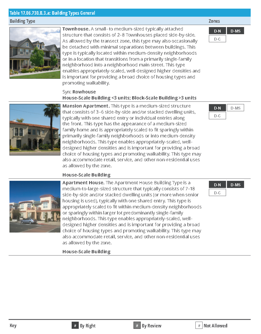
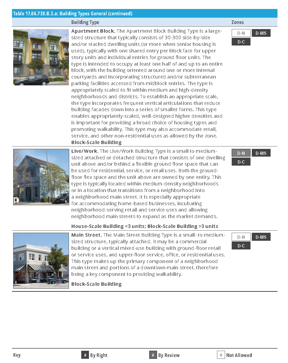
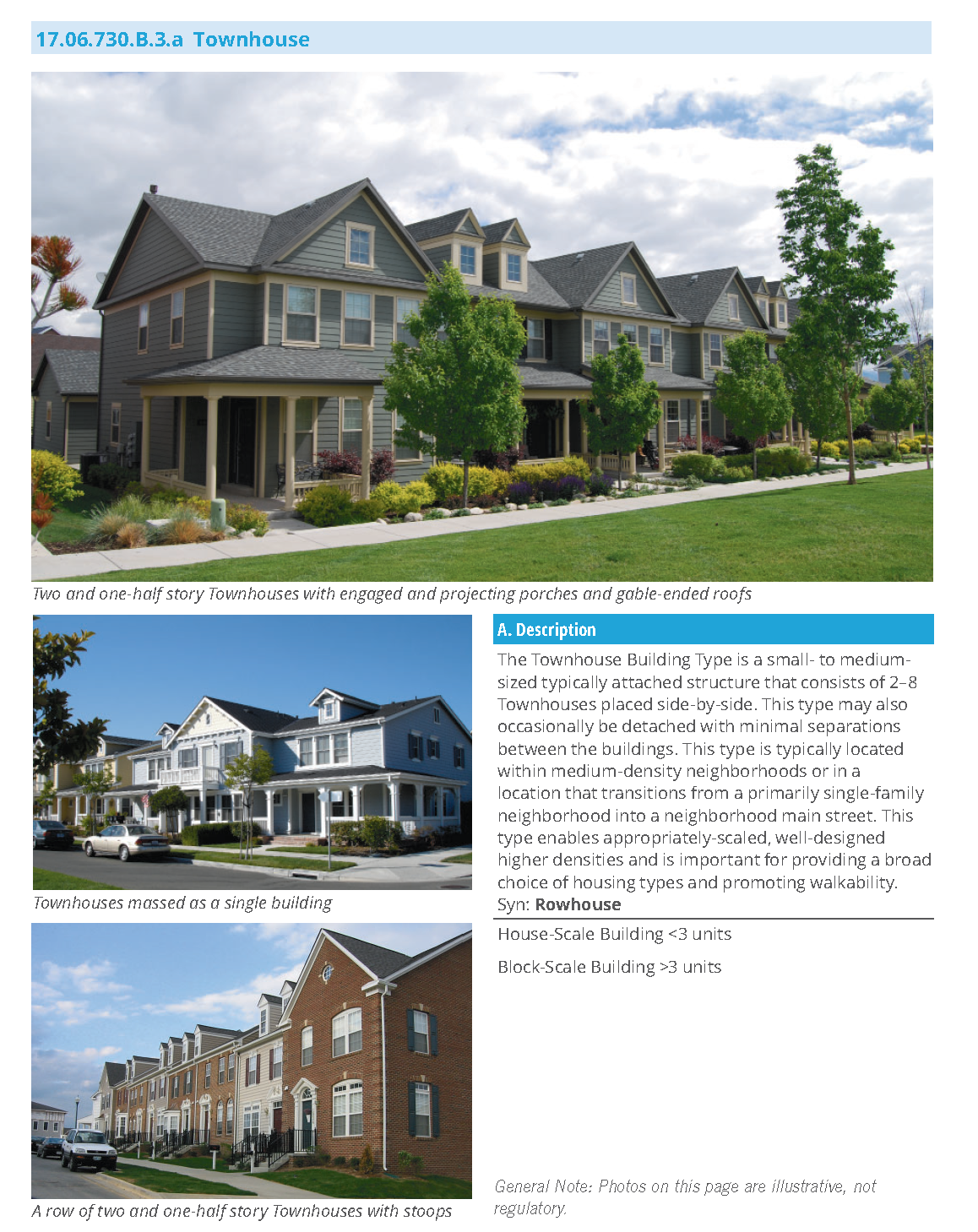
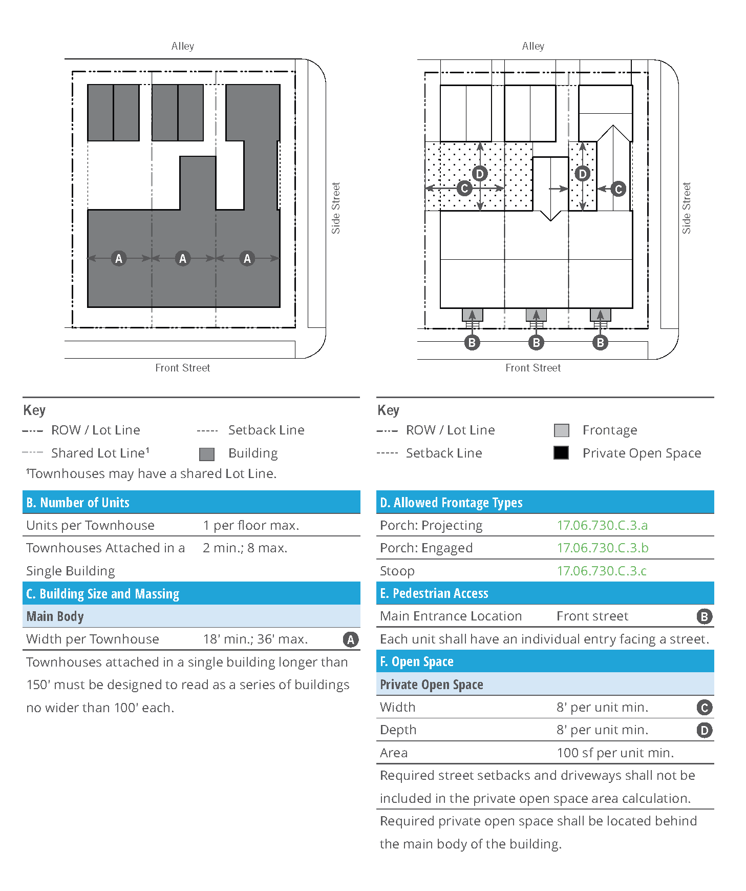
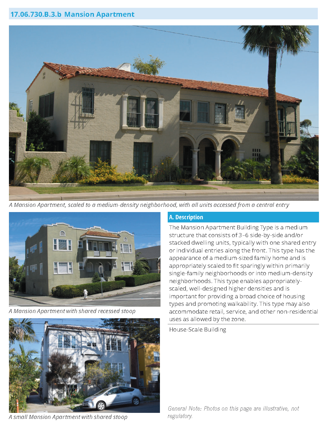
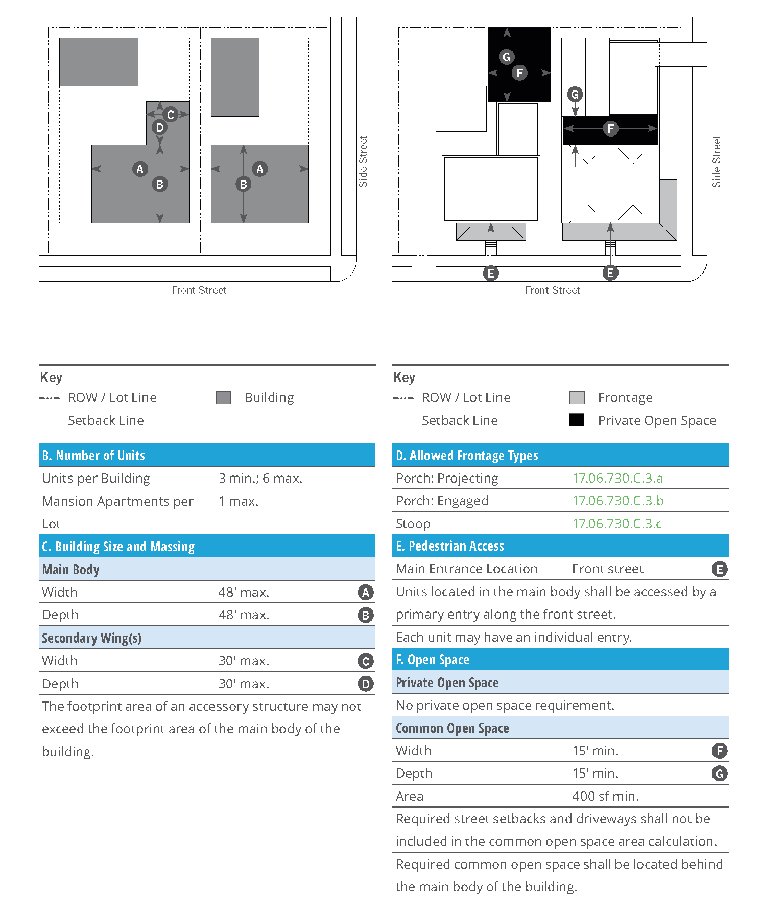
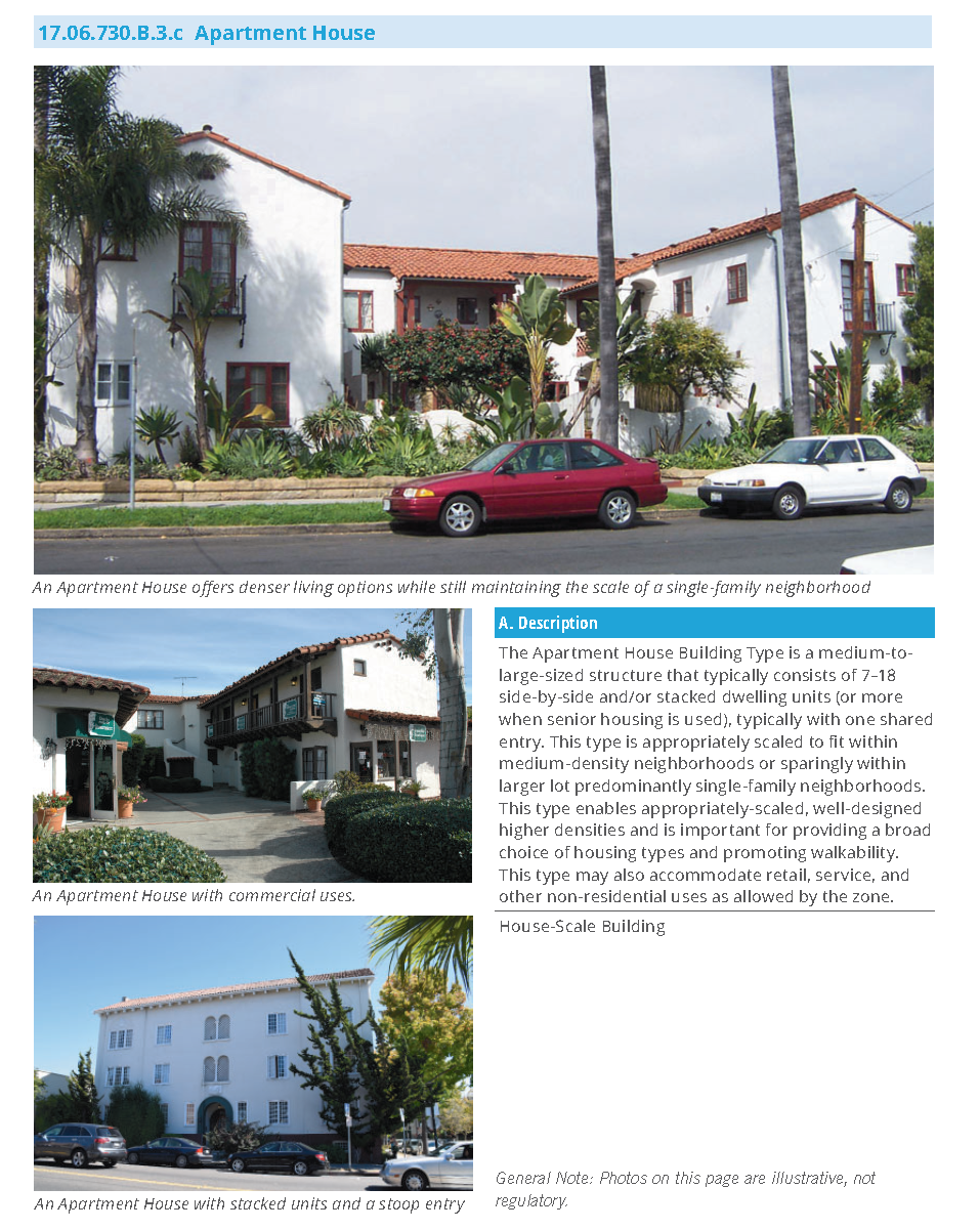
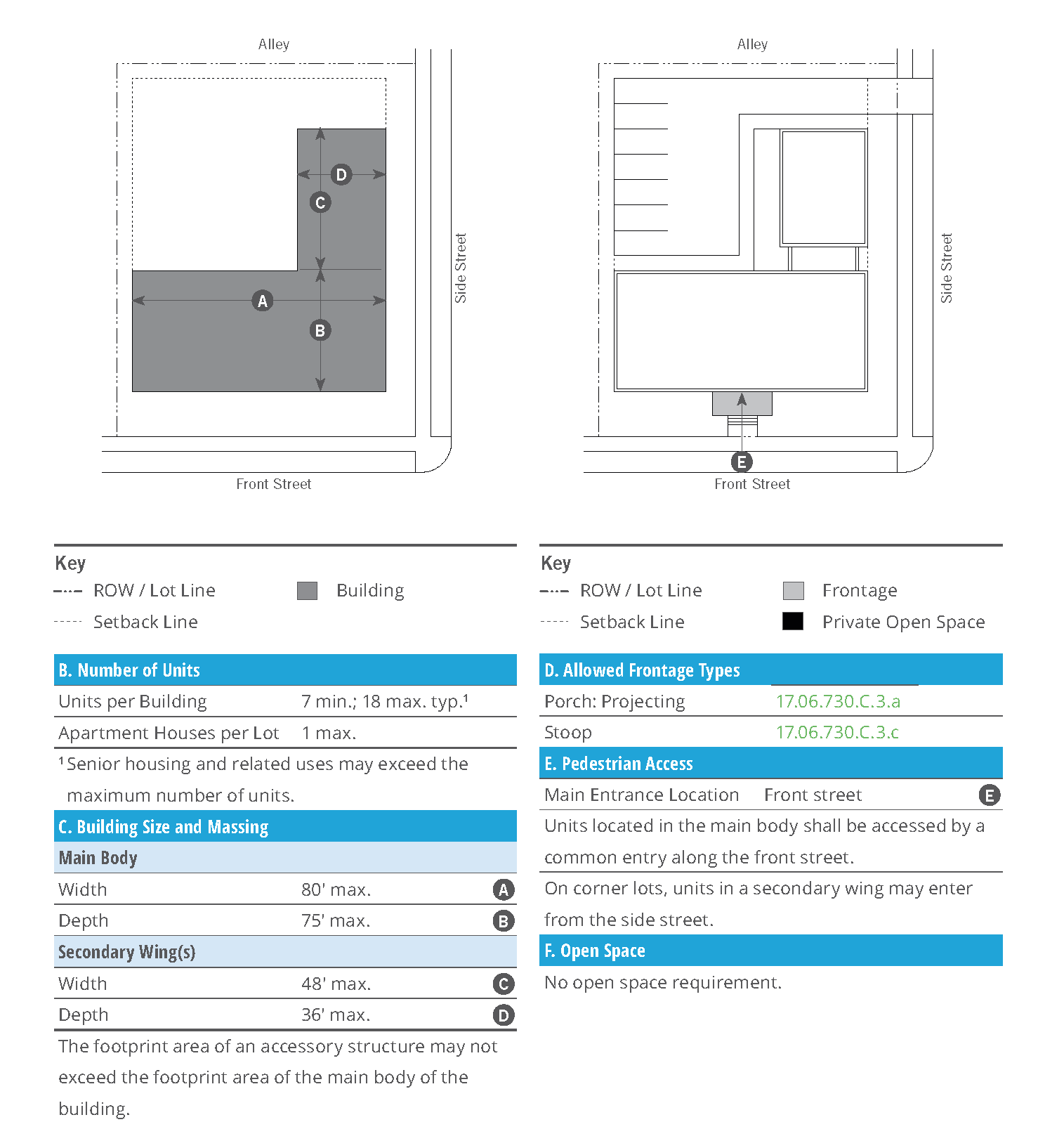
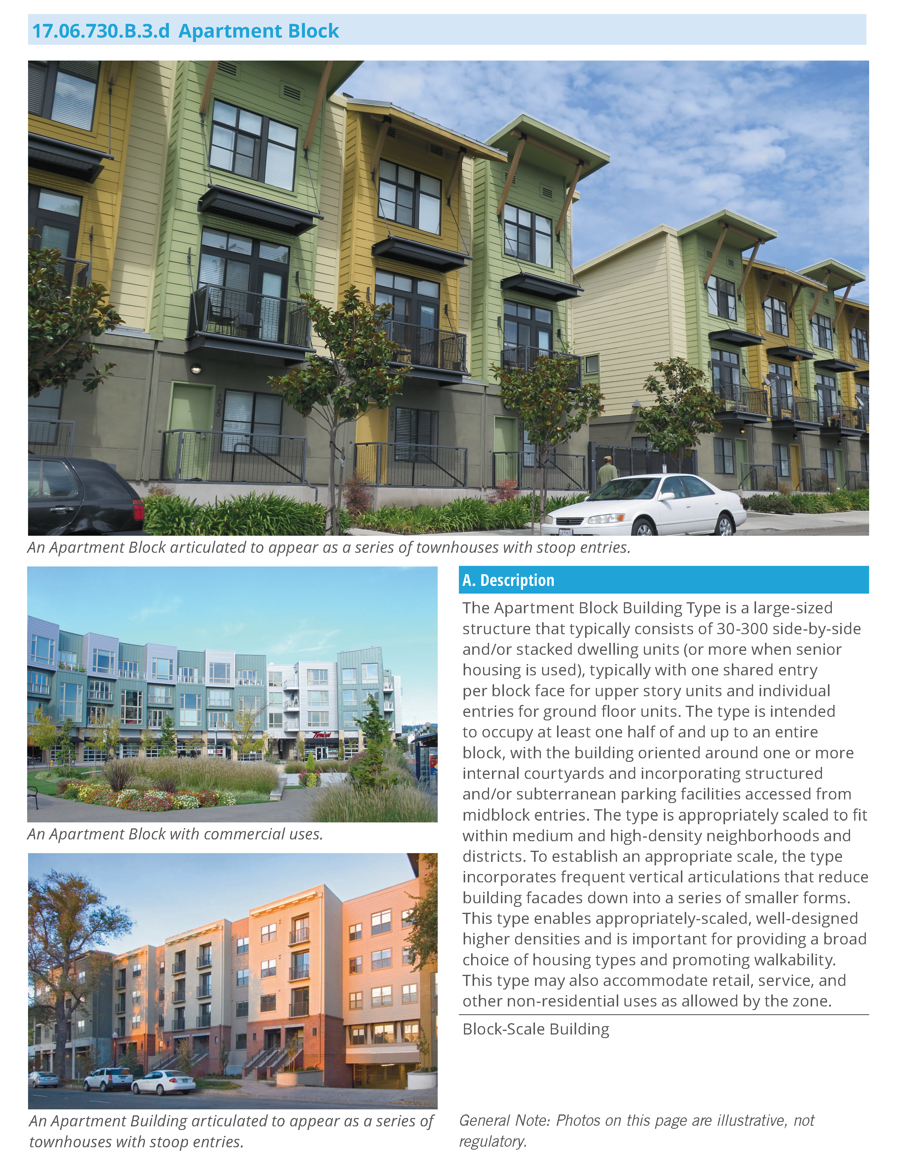
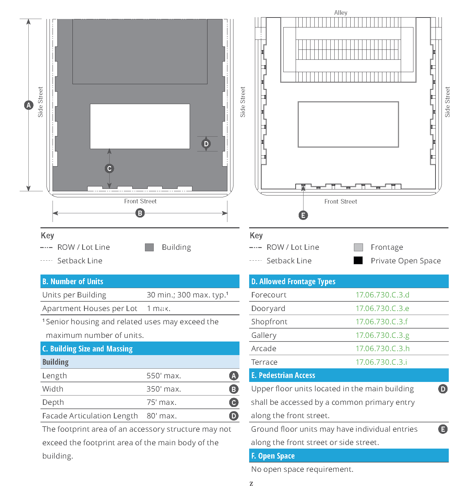
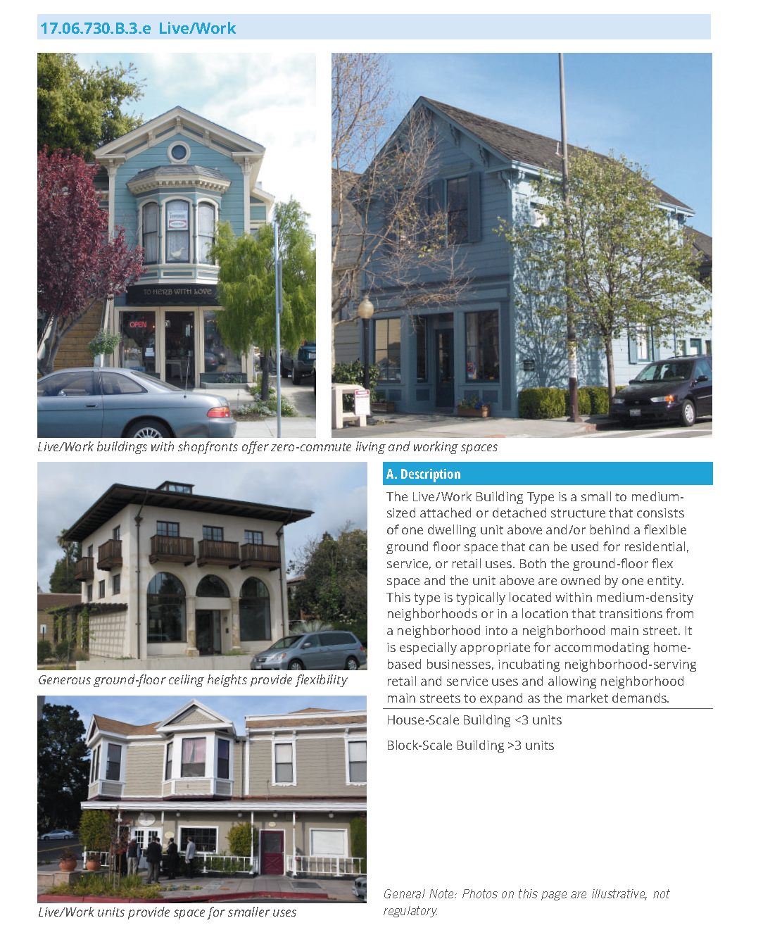
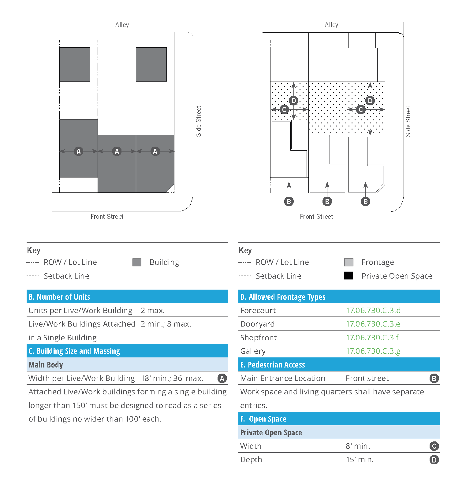
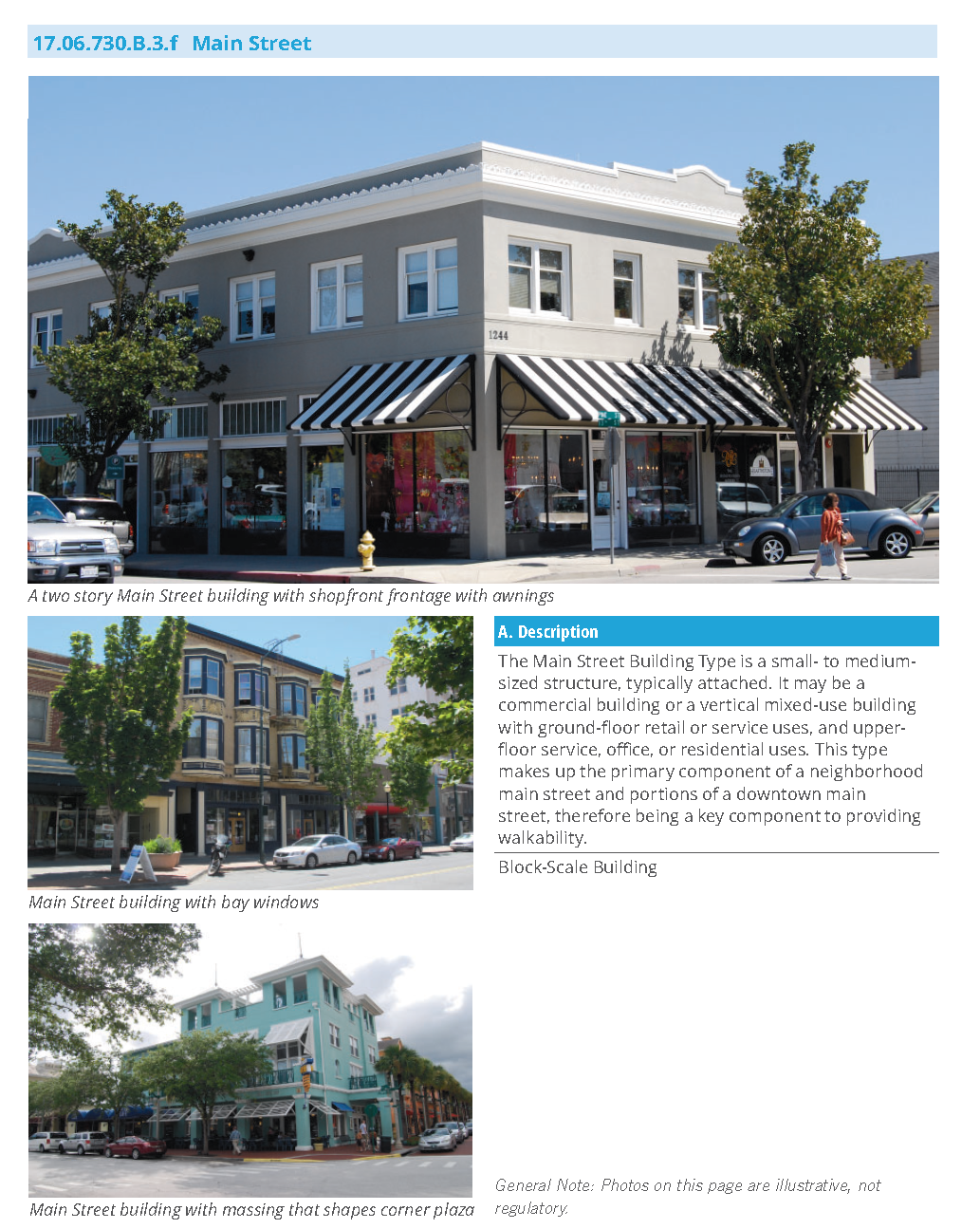
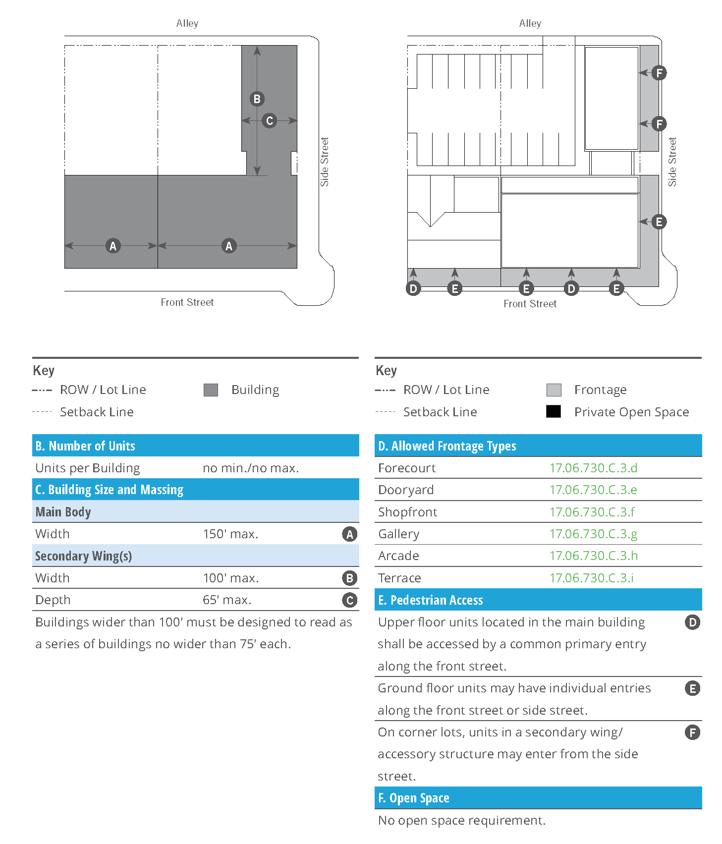
17.06.730.C: Specific to Private Frontages
17.06.730.C.1 Purpose
This Sub-Section sets forth the standards applicable to the development of private frontages. Private frontages are the components of a building that provide an important transition and interface between the public realm (street and sidewalk) and the private realm (yard or building). These standards supplement the standards for each transect zone in which the frontage types are allowed. For each frontage type, a description, a statement of the type's intent, and design standards are provided. These standards are intended to ensure development that establishes or reinforces the highly-valued character and scale of the downtown center for Rohnert Park.
17.06.730.C.2 Applicability
a.
The requirements of this Sub-Section shall apply to all proposed development within the Rohnert Park Center zones, and shall be considered in combination with the standards for the applicable zone in Section 17.06.720 (Specific to Zones) and in the rest of this Sub-Section.
b.
Development with Civic and Agricultural land uses otherwise allowed in this Chapter shall comply with the standards for the applicable zone in Section 17.06.720 (Specific to Zones), but shall not be required to meet the standards of this Sub-Section.
17.06.730.C.3 Frontage Types
Table 17.06.730.C.3.a (Frontage Types General) provides an overview of the allowed frontage types.
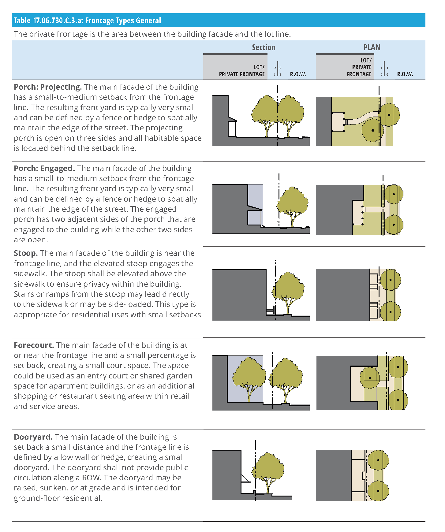
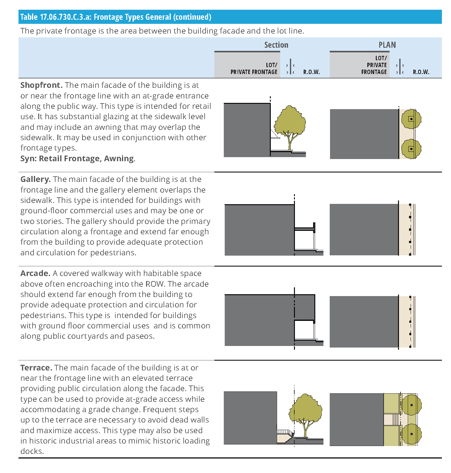
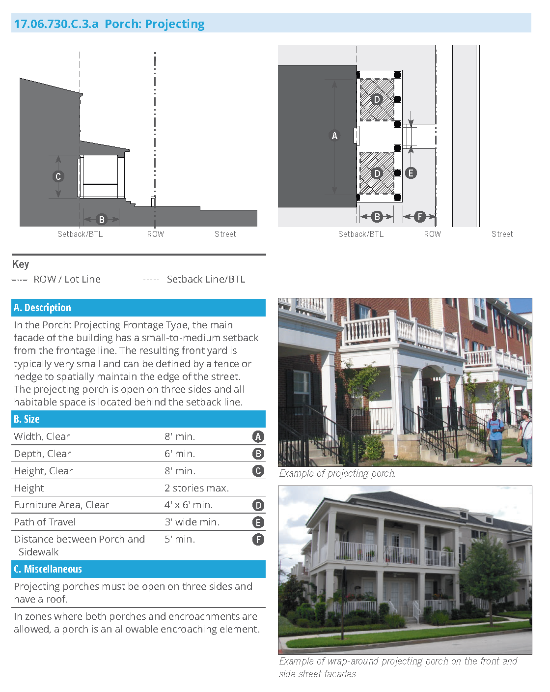
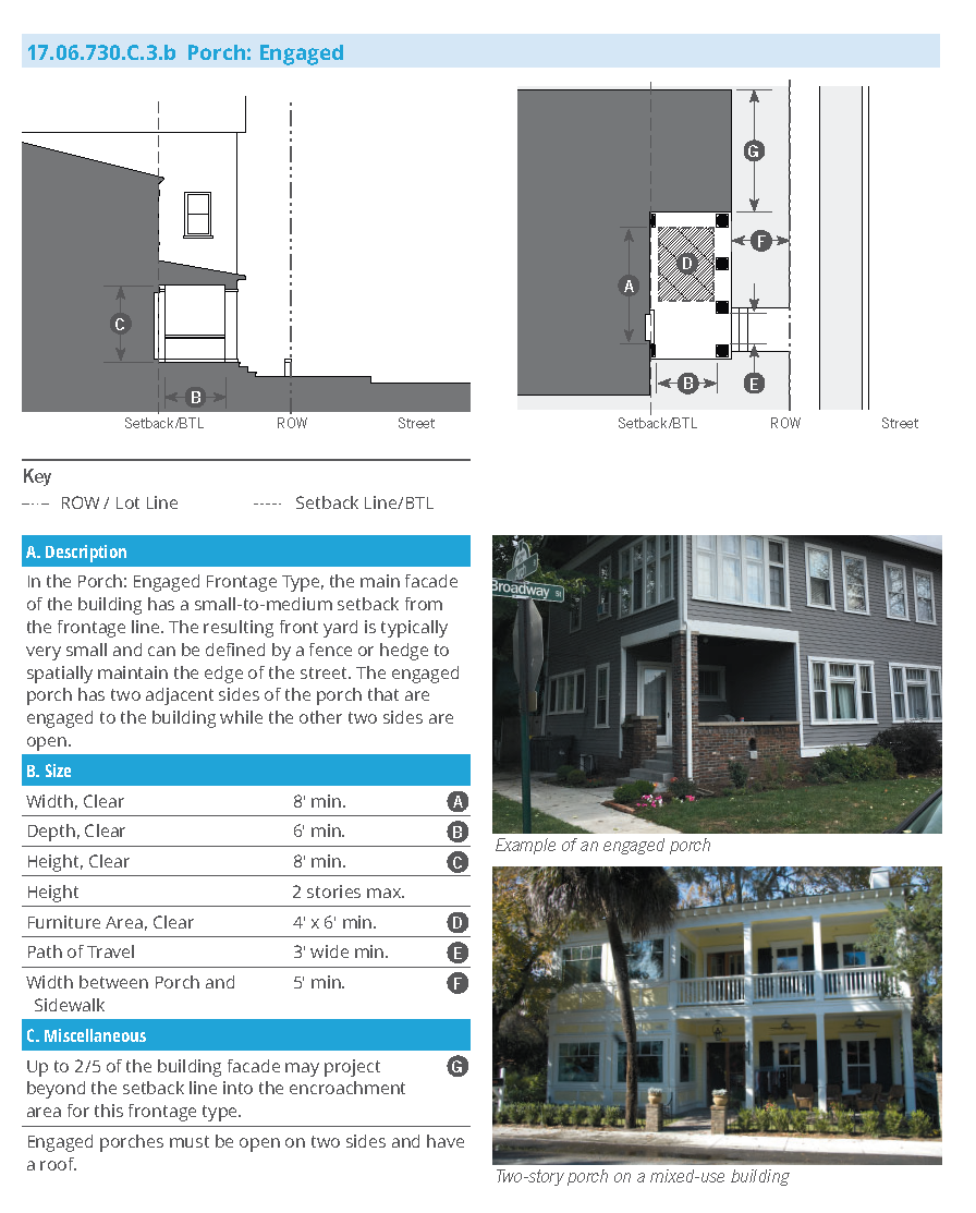
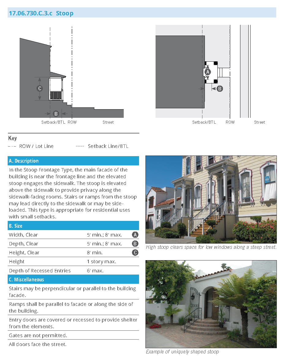
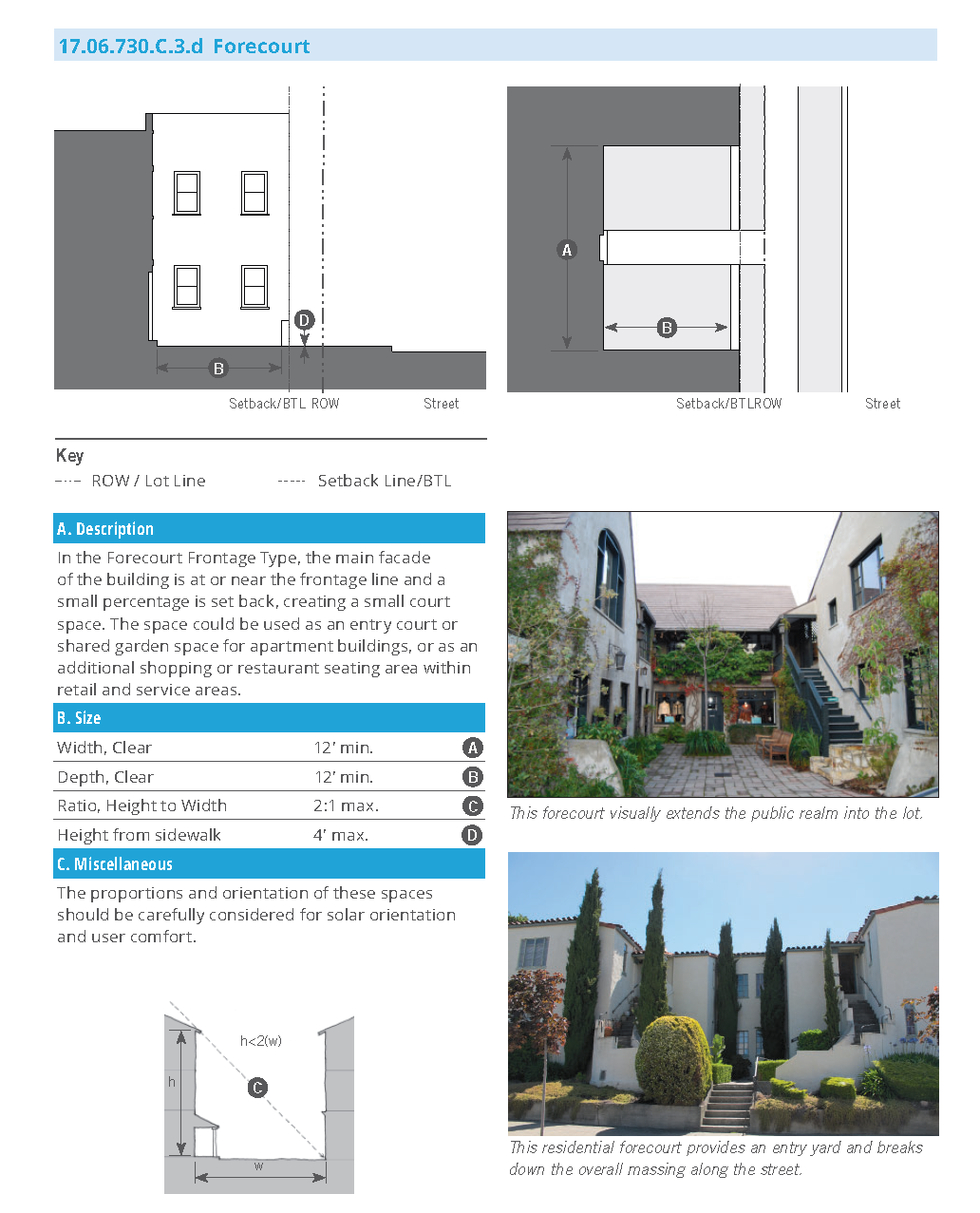
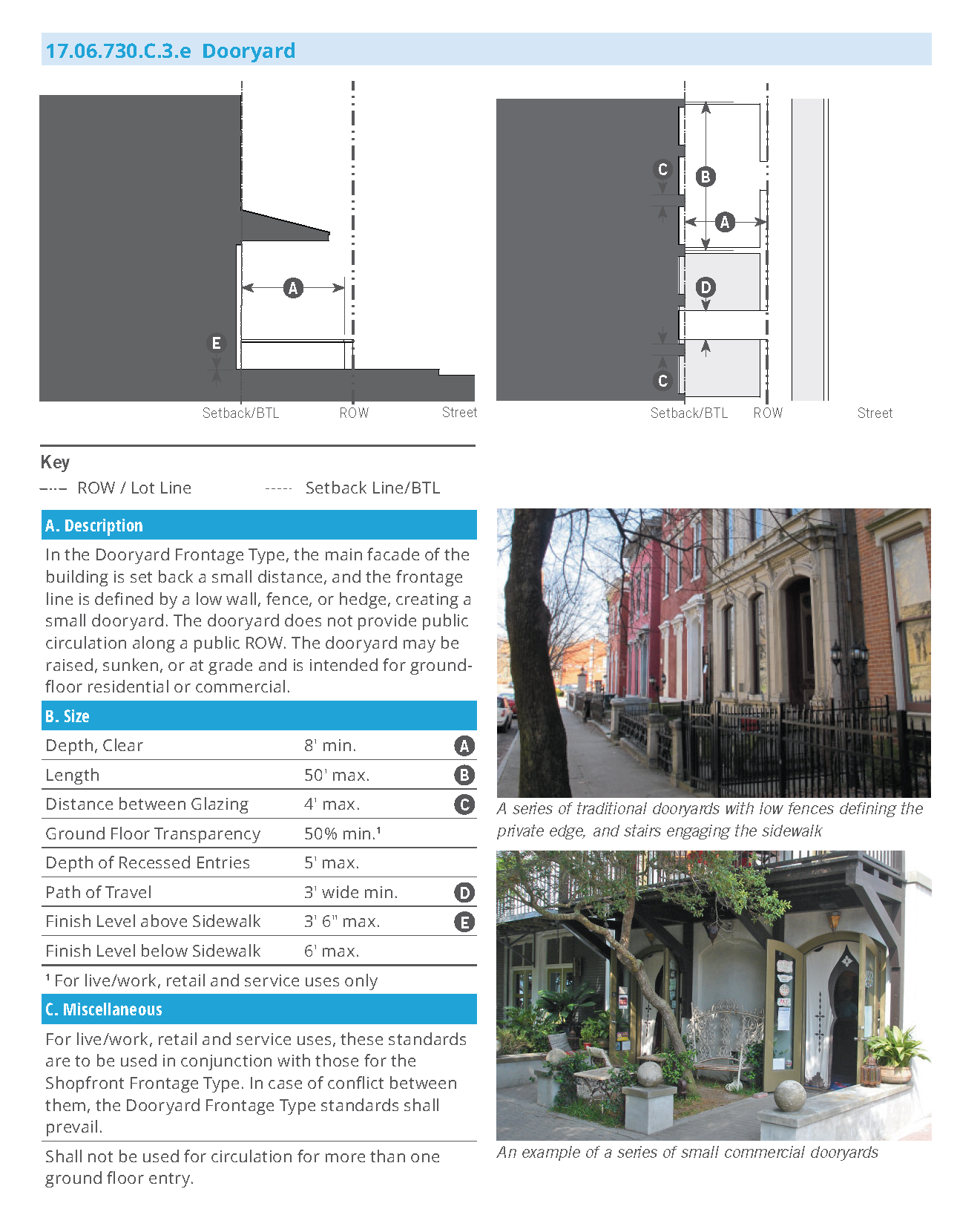
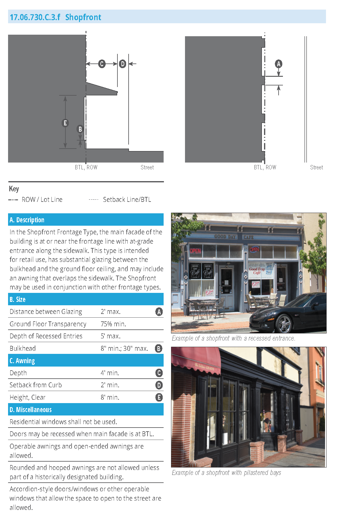
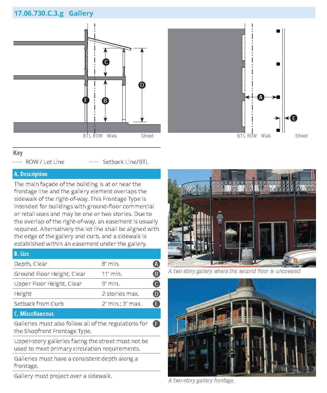
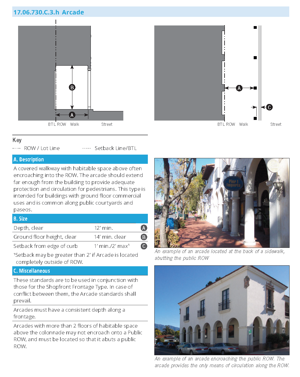
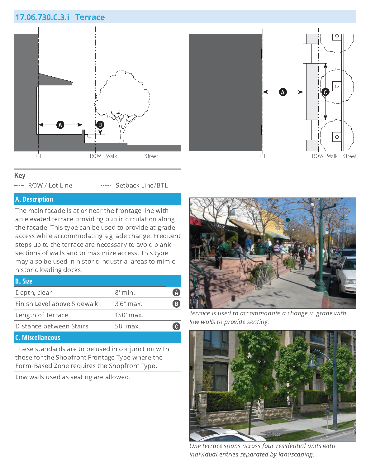
(Ord. No. 927, § 4 (Exh. 2), 11-27-2018)
17.06.740 - Permits and procedures.
17.06.740.A: Purpose and Applicability
1.
Purpose
a.
The purpose of this Section is to establish procedures for the preparation, filing, and processing of applications for development permits and other entitlements required by the Downtown District Amenity Zone Form-Based Code Overlay (DDAZ FBC Overlay) that are in addition to those established in Chapter 17.25 (Administrative and Enforcement Procedures) and enforced by the Department Director, Planning Commission, and City Council, as applicable.
2.
Applicability
The provisions of this Section are applied to any development within the DDAZ Overlay as provided in Subsection 17.06.700.A.2 (Applicability).
3.
Planning Approvals and Review Authority
a.
Planning Approvals. All development must be established, constructed, reconstructed, enlarged, altered, moved or replaced in compliance with the following requirements:
i.
Allowable land use. The land use must be allowed pursuant to Table 17.06.720.B (Use Table) and the standards in the Zone where the development is located.
ii.
Entitlements and Approvals. Any and all entitlements or other approvals required by this DDAZ FBC Overlay must be obtained before the issuance of any required grading, building, or other construction permits, and before the proposed use is established, constructed, or put into operation.
iii.
Development Standards. The regulation of lot sizes, setbacks, open space requirements, architectural and landscaping standards, maximum building height, lot coverage, and all other development standards are established in Sections 17.06.720 (Specific to Zones) and 17.06.730 (Supplemental to Zones).
iv.
Design Review. Prior to processing an application that is subject to the DDAZ FBC Overlay, pursuant to Section 17.06.740.D (Design Review) an applicant must obtain written approval from the Downtown Design Review Board (DDRB) confirming that the application meets all the applicable requirements of the DDAZ FBC Overlay standards.
v.
Permitted Uses. The regulation of permitted, conditionally-permitted, or administratively-permitted uses is provided in Section 17.06.720.B (Use Table).
vi.
Property zoned P-D or Station Center P-D is required to follow the application and approval procedures for Preliminary Development Plans and Final Development Plans as described in Section 17.06.250 (Procedure), except that approval of a Conditional Use Permit as required by Section 17.06.250.C is not required.
vii.
When not in conflict with the provisions of this Section, applications for property not zoned P-D or Station Center P-D within the DDAZ FBC Overlay are subject to all of the legislative, administrative, and permit procedures as established in the Rohnert Park Municipal Code, including:
a)
Conditional use permits (Chapter 17.25, Article I);
b)
Minor Modifications (Section 17.06.740.C)
c)
Variances (Chapter 17.25, Article II);
d)
Temporary conditional use permit (Chapter 17.25, Article IV);
e)
Administrative permit (Chapter 17.25, Article V);
f)
Certificate of Zoning Compliance (Chapter 17.25, Article VI);
g)
Amendments (Chapter 17.25, Article VII) - also refer to Section 17.06.740.D (Design Review);
h)
Appeals (Chapter 17.25, Article XII); and
i)
Subdivisions (Title 16).
b.
Review Authority
i.
Table 17.06.740.A.3.a (Review Authority) identifies the City official or body responsible for reviewing and making decisions on each type of application required by the DDAZ FBC Overlay.
ii.
All applications for property designated with the DDAZ FBC Overlay are subject to the review and approval of the review authority(s) identified in Table 17.06.740.A.3.a.
17.06.740.B: Application Requirements, Review, and Processing
1.
Application Requirements and Review. Applications for building permits, grading permits and any other land use entitlements submitted to the City shall be reviewed and processed pursuant to Chapter 17.25 (Administrative and Enforcement Procedures).
2.
Noticing Requirements. Noticing must comply with Chapter 17.25, Article XI (Notices).
17.06.740.C: Minor Modifications
1.
Purpose. The purpose of a minor modification is to enable the Department Director to approve minor deviations from DDAZ FBC Overlay standards when requests constitute a reasonable use of property but are not otherwise permissible under the strict application of the DDAZ FBC Overlay.
2.
Applicability
a.
This Subsection is applicable to all development standards of the DDAZ FBC Overlay.
b.
The Department Director may approve a minor modification only after first determining that the requested modification meets the findings specified in Subsection 4 (Findings for a Decision on a Minor Modification).
c.
A minor modification may be approved as specified in Table 17.06.740.C.2.a (Minor Modifications).
d.
An authorization to approve a minor modification does not extend to making any changes in the uses permitted in any zone.
3.
Application Filing and Processing. The application shall be filed with the Department Director and include the information and materials in the most current planning department publication for applications together with the required fee as specified in the City fee schedule (see Section 17.06.450, (Fees)). The applicant is responsible for providing evidence in support of the findings required by Subsection 4 (Findings for a Decision on a Minor Modification).
4.
Findings for a Decision on a Minor Modification. The Department Director may approve, conditionally approve, or deny a minor modification application, only after each of the following findings are made:
a.
There are special circumstances applicable to the property (e.g., size, shape, topography, location, surroundings, etc.) such that the strict application of the DDAZ FBC Overlay could deprive the property of privileges enjoyed by other property in the vicinity and under identical zoning classification;
b.
The special circumstances applicable to the property are not self-imposed by any person presently having an interest in the property;
c.
The requested minor modification will not allow the establishment of a use that is not otherwise allowed in the zone;
d.
Granting the minor modification will not be materially detrimental to the public health, safety, or welfare and will not impair an adequate supply of light and air to adjacent property;
e.
The development is consistent with the General Plan;
f.
The requested minor modification provides the minimal relief necessary to achieve the intent of the DDAZ FBC Overlay; and
g.
The development complies with all applicable standards of this Section and Chapter 17.25 (Administrative and Enforcement Procedures).
5.
Review and Decision
a.
Each minor modification application shall be reviewed on an individual case-by-case basis. The approval of a prior minor modification is not admissible evidence for the approval of a new minor modification.
b.
The decision of the Department Director may be made without the need for a public hearing. Unless appealed, a decision by the Department Director shall become final on the eleventh day following the day the decision is rendered.
c.
A decision on a minor modification may be appealed pursuant to Chapter 17.25, Article XII (Appeals).
6.
Lapse of Approval Extension and Renewal
a.
A minor modification shall lapse one year after the date of final approval or at an alternative date specified at the time of approval, unless:
i.
A building permit has been issued and construction has diligently commenced;
ii.
A certificate of occupancy has been issued;
iii.
The use is established; or
iv.
The minor modification is renewed in accordance with Subsection 6.b.
b.
A minor modification approval may be renewed for an additional period of one year, provided that prior to the expiration date, an application for renewal of the minor modification is filed with the planning and community director. The Department Director may grant the renewal if the original findings of approval remain satisfied. If the Department Director denies the renewal request, the applicant has ten calendar days to appeal the decision to the Planning Commission in compliance with Chapter 17.25, Article XII (Appeals).
17.06.740.D: Design Review
1.
Purpose. This Section establishes procedures for the review and approval or denial of Design Review with the intent to promote orderly development and an aesthetically and environmentally pleasing and economically viable community in compliance with the General Plan, and the standards specified in the DDAZ FBC Overlay.
2.
Applicability.
a.
Design Review applies to any permitted, conditionally permitted, or administratively permitted use listed in Section 17.06.720 (Specific to Zones).
b.
Design Review by the Downtown Design Review Board (DDRB) is required for all new buildings or structures and additions or alterations to existing structures.
c.
Prior to processing applications for building permits, grading permits and any other land use entitlements, an applicant must obtain written approval from the DDRB that the project meets the requirements of the DDAZ FBC Overlay.
3.
Design Review Board. The DDRB consists of a minimum of three members and a maximum of five members appointed by the Planning Commission. In lieu of creating a separate DDRB, the Planning Commission may serve as the DDRB.
4.
Application Filing and Processing. An application for Design Review must be filed with the Department Director. The applicant is responsible for providing evidence in support of the findings required by Subsection 6 (Findings for a Decision on a Design Review).
a.
Submittal Requirements. The following drawings shall be submitted to the DDRB with an application for any site plan review, conditional use permit, planned unit development, tentative subdivision map, tentative parcel map, or administrative approval permit;
i.
Architectural drawings, drawn to scale, showing all elevations of the proposed structures by point of compass, as they will appear upon completion of construction. All exterior surfacing materials and colors must be specified.
ii.
Scale drawings of all signs by point of compass that are subject to Design Review, showing size, location, material, colors and any proposed illumination.
iii.
The DDRB may require additional information from the applicant if necessary to carry out the purpose of the DDAZ FBC Overlay.
b.
Regulating Plan
i.
An application for development on a property that involves multiple DDAZ zones as defined in Section 17.06.700.B (Establishment and Designation of Zones) must submit a regulating plan as a part of the Design Review application.
ii.
Only the DDAZ zones established in Section 17.06.720 (Specific to Zones) may be used. The regulating plan for the property must include the following information:
a)
Project area boundaries;
b)
Existing and proposed blocks;
c)
Existing and proposed thoroughfares, including alleys;
d)
Existing and proposed civic space types; and
e)
Existing and proposed transect zone(s) conforming to the proposed blocks.
iii.
Properties located within only one transect zone as defined in Section 17.06.720 (Specific to Zones) do not need to submit a regulating plan as a part of the Design Review application.
iv.
The Department Director may approve a modification in the location of a transect zone boundary or the location of a proposed thoroughfare within or adjacent to property provided that the intent and purpose of the DDAZ FBC Overlay as established in Section 17.06.700.A.1 (Purpose and Intent) is maintained and supported.
c.
Administrative Options
i.
The DDRB may approve, conditionally approve, or disapprove a Design Review application.
ii.
The Department Director may refer a Design Review application to the Planning Commission with or without a recommendation when it is determined that unique or special circumstances exist. The Planning Commission shall then conduct a public hearing pursuant to Chapter 25, Article XI (Notices).
iii.
The review authority may approve or conditionally approve the application based on the findings listed in Subsection 6 (Findings for a Decision on a Design Review).
d.
Lapse of Submittals. If after applying for Design Review the applicant fails to provide changes or additional information necessary to enable the review authority to make a decision on the project, and there is no activity taking place in connection with the application for a period of six months, the application shall be revoked and the applicant so informed.
5.
Public Hearing and Notice. Applications for Design Review are not subject to a public hearing or noticing requirements unless the application is referred to the Planning Commission.
6.
Findings for a Decision on Design Review. The review authority shall approve, conditionally approve, or deny a Design Review application only after the following findings are made:
a.
The proposed development is consistent with the General Plan and any applicable specific plan;
b.
The proposed development is consistent with all the applicable standards of this Section and Chapter 17.25 (Administrative and Enforcement Procedures);
c.
The proposed development will not be detrimental to the public health, safety, or general welfare;
d.
The proposed development substantially complies with the City of Rohnert Park Design Guidelines (Design Guidelines) for Commercial, Mixed-Use and Multi-Family Buildings and the Central Rohnert Park Priority Development Area Plan (PDA Plan). In the event of a conflict between the Design Guidelines and the PDA Plan, the guidelines in the PDA Plan shall apply;
e.
The proposed development has an appropriate relationship to land use and development of adjacent properties, including topographic and other physical characteristics of the land; and
f.
The proposed development has a compatible architectural style with the character of the surrounding area, both to avoid repetition of identical design where not desired, and to ensure compatibility in design where desired.
7.
Decision and Appeals. The decision of the review authority is final ten calendar days after the decision is rendered, unless appealed to the City Council or Planning Commission pursuant to Section 17.25.034 (Decision/appeal) and Chapter 17.25, Article XII (Appeals).
8.
Lapse of Approval.
a.
Design Review approval will lapse one year after the date of final approval or at an alternative date specified at the time of approval, unless:
i.
A building permit has been issued and construction has diligently commenced;
ii.
A certificate of occupancy has been issued;
iii.
The use is established;
iv.
The Design Review approval is renewed in accordance with Subsection b. below; or
v.
The project is a residential development that does not require the approval of a tentative subdivision map, or otherwise not vested through a development agreement with the city, then the approval shall expire after a twenty-four-month period, unless extended for special circumstances by the City Council.
b.
A Design Review approval may be renewed for an additional period of one year, provided that prior to the expiration date, an application for renewal is filed with the Department Director. The Department Director may grant the renewal if the original findings of approval remain satisfied. If the Department Director denies the renewal request, the applicant has ten calendar days to appeal the decision to the Planning Commission pursuant to Chapter 17.25, Article XII (Appeals).
(Ord. No. 927, § 4 (Exh. 2), 11-27-2018)
17.06.750 - Definitions.
17.06.750.A Purpose.
The terms and phrases used in the DDAZ FBC Overlay are technical or specialized and may not reflect common usage. If a definition in this section conflicts with a definition in another provision of the Municipal Code, the definitions in this section shall control. If a word is not defined in this section, refer to Chapter 17.04 of the Zoning Ordinance. The development services director shall determine the meaning of terms when a definition is ambiguous or when a term is not defined in accordance with Section 17.02.090 of this code.
Editor's note— Ord. No. 991, § 4(Exh. A, § 23), adopted Jan. 27, 2026, amended the title of § 17.06.750.A to read as herein set out. The former § 17.06.750.A title pertained to definitions.
17.06.750.A.1 Definitions of Specialized Terms and Phrases
A. Definitions
Accessory building. A subordinate, detached building the use of which is incidental to that of a primary building on the same lot. Examples of accessory buildings include, but are not limited to, a garage, carport, tool house, home office or work studio, greenhouse, pool house, playhouse and shed.
Accessory structure. A subordinate structure the use of which is incidental to that of a primary building on the same lot. Examples of accessory structures include, but are not limited to, a pergola, trellis, open play structure, swimming pool, tennis court, play court, and deck.
Active Frontage. Ground floor frontages intended for non-residential uses and the primary living area of residential uses (living rooms, dining areas, etc.) ranging from Shopfront, Terrace, Gallery, Arcade to Dooryard.
Adjacent. Sharing a common lot line, or having lot lines separated only by an alley.
Adjacent Buildings. Two or more buildings located upon adjacent lots.
Apartment House. The Apartment House Building Type is a medium-to-large-sized structure that typically consists of seven to eighteen side-by-side and/or stacked dwelling units (or more when senior housing is used), typically with one shared entry. This type is appropriately scaled to fit within medium-density neighborhoods or sparingly within larger lot predominantly single-family neighborhoods. This type enables appropriately-scaled, well-designed higher densities and is important for providing a broad choice of housing types and promoting walkability. This type may also accommodate retail, service, and other non-residential uses as allowed by the zone. See 17.06.730.B.3.c (Apartment House).
Alley. A public or private way to be used primarily for vehicular access to the back or side of a parcel of real property that abuts a street.
B. Definitions
Bay, Bay Window. A window that projects from the main wall of a building that may begin on the ground floor and extend to upper floors.
Block Face. Dimension of one block side measured at the right-of-way or public frontage line along one side of a street.
Brewpub. A micro-brewery that brews beer primarily for on sale consumption and includes a tasting or restaurant component. A full commercial kitchen is not required, however food or snacks, available for purchase either through the brewpub or a third party, must be made available. This definition primarily encompasses CA ABC license types 23 (small beer manufacturer) and 75 (on sale general - brewpub). Brewpubs are primarily a retail operation, while breweries are primarily a production and wholesaling operation.
Block Perimeter. Dimension of the complete perimeter edge of a block measured at the right-of-way or public frontage line along one side of multiple streets.
Buildable Area. The area in which a building is permitted to be constructed; see "Building envelope" in 17.04.030 (Definitions of words and terms).
Building Entrance. A point of pedestrian ingress and egress to a building.
Building Form. The overall shape and dimensions of a building.
Building Type. A structure defined by its combination of configuration, disposition and function.
Build-to Line (BTL). A line parallel to a lot line or right-of-way where a building façade must be placed.
C. Definitions
Ceiling Height, Ground Floor. Height from finished floor to finished ceiling of primary rooms on the ground floor, not including secondary rooms such as bathrooms, closets, utility rooms and storage spaces.
Ceiling Height, Upper Floor(s). Height from finished floor to finished ceiling of primary rooms on the floor(s) above the ground floor, not including secondary rooms such as bathrooms, closets, utility rooms and storage spaces.
Chamfered Corner. An external wall of a building joining two perpendicular exterior walls, typically at a symmetrical, forty-five degree angle creating a beveled edge to the building rather than a ninety degree corner.
Civic. A term defining not-for-profit organizations that are dedicated to arts, culture, education, religious activities, recreation, government, transit, and public parking facilities.
Civic Building. A structure operated by governmental or not-for-profit organizations and limited to civic and related uses.
Civic Space. An outdoor area dedicated for civic activities. See 17.06.710.B (Civic Space Standards).
Common Areas. A portion of a residential development held in common and/or single ownership and not reserved for the exclusive use or benefit of an individual tenant or owner and is available for use by all persons who reside in a dwelling unit within the building or on the lot.
Construction. The performance of any act in connection with making an improvement to a lot, building or structure.
Corner Entry. An entrance located on the corner of a building.
D. Definitions
Depth, Ground-Floor Space. The distance from the street-facing façade to the rear interior wall of the ground-floor space available to an allowed use.
Detached. Separate or unconnected.
Detached House(s). Separate or disconnected building.
Development. See "Construction".
Director. Department Director or his or her duly appointed representative.
Distance Between Entries. The horizontal distance measured parallel to the façade between entrances to a building or buildings.
Dooryard. In the Dooryard Frontage Type, the main facade of the building is set back a small distance, and the frontage line is defined by a low wall, fence, or hedge, creating a small dooryard. The dooryard does not provide public circulation along a public ROW. The dooryard may be raised, sunken, or at grade and is intended for ground-floor residential or commercial. See 17.06.730.C.3.e (Dooryard).
Driveway. A vehicular lane within a lot, or shared between two lots, usually leading to a garage, other parking or loading area.
E. Definitions
Elevated Ground Floor. A ground floor situated above the grade plane at street-level.
Encroachment. Any architectural feature, structure or structural element, such as a gallery, fence, garden wall, porch, stoop, balcony, bay window, terrace or deck, that breaks the plane of a vertical or horizontal regulatory limit extending into a setback, beyond the build-to-line, into the public frontage, or above a height limit.
Entry. An opening, such as a door, passage, or gate, that allows access to a building.
F. Definitions
Façade. The vertical surface of a building.
Façade Zone. The area between the minimum and maximum setback lines along the front and side street of a parcel.
Facility. An improvement, structure or building that is designed and used for a particular purpose.
Fence. A structure made of wire, wood, metal, masonry or other material, and typically used as a screen or enclosure for a yard or open space or as a divider along a lot line.
Finish Level, Ground Floor. Height difference between the finished floor on the ground floor and the adjacent public walk. In the case of a loading dock frontage that serves as the public right-of-way, the floor finish level is the height of the walk above the adjacent street. Regulations for ground floor finish level for ground floor residential uses do not apply to ground floor lobbies and common areas in multi-unit buildings.
Footprint. The outline of the area of ground covered by a building or structure.
Footprint Area. The total square footage contained within a footprint.
Forecourt. In the Forecourt Frontage Type, the main facade of the building is at or near the frontage line and a small percentage is set back, creating a small court space. The space could be used as an entry court or shared garden space for apartment buildings, or as an additional shopping or restaurant seating area within retail and service areas. See 17.06.730.C.3.d (Forecourt).
Freestanding Wall. A wall that is separate from a building and supported by independent means.
Frontage. See "Building Frontage" and "Frontage" in 17.04.030.
(1)
Frontage, Private. The area between the building façade and the property line defining the public right-of-way and defined by a Frontage Type.
(2)
Frontage, Public. The area between the curb of the vehicular lanes and the edge of the right-of-way.
(3)
Frontage, Independent. The edge of a civic space not defined by adjacent building frontage along a frontage line.
(4)
Frontage, Building. The edge of a civic space defined by adjacent building frontage along a frontage line.
Frontage Line. The lot line(s) of a lot fronting a thoroughfare or other public way, or a civic space.
Frontage Type. The private frontage is the area between the building facade and the lot line.
Furniture Area. An area of space that allows for the placement of furniture without restricting the movement of pedestrians.
G. Definitions
Gable. A vertical wall in the shape of a triangle formed between the cornice or eave and the ridge of the roof.
Gallery. The main façade of the building is at or near the frontage line and the gallery element overlaps the sidewalk of the right-of-way. This Frontage Type is intended for buildings with ground-floor commercial or retail uses and may be one or two stories. Due to the overlap of the right-of-way, an easement is usually required. Alternatively the lot line shall be aligned with the edge of the gallery and curb, and a sidewalk is established within an easement under the gallery. See 17.06.730.C.3.g (Gallery).
Garage. A structure, or part thereof, used or intended to be used for the parking and storage of motor vehicles.
Glazing. Openings in a building in which glass is installed.
Gross Floor Area. The total floor area inside the building envelope, including the external walls, but not including the roof.
Ground Floor. The floor of a building located nearest to the level of the ground around the building.
H. Definitions
No specialized terms beginning with the letter H are defined at this time.
I. Definitions
Improvement. The product of any modification to a lot, structure or building.
J. Definitions
No specialized terms beginning with the letter J are defined at this time.
K. Definitions
No specialized terms beginning with the letter K are defined at this time.
L. Definitions
Landing. A level area at the top or bottom of a staircase or between one flight of stairs and another.
Live/Work (Building). The Live/Work Building Type is a small to medium-sized attached or detached structure that consists of one dwelling unit above and/or behind a flexible ground floor space that can be used for residential, service, or retail uses. Both the ground-floor flex space and the unit above are owned by one entity. This type is typically located within medium-density neighborhoods or in a location that transitions from a neighborhood into a neighborhood main street. It is especially appropriate for accommodating home-based businesses, incubating neighborhood-serving retail and service uses and allowing neighborhood main streets to expand as the market demands. See 17.06.730.B.3.d (Live/Work).
M. Definitions
Main Body. The primary massing of a building.
Main Building. The building that serves as the focal point for all activities related to the principal use of the lot.
Main Façade. The front façade of a Main Building.
Main Street Mixed-Use Building. The Main Street Building Type is a small- to medium-sized structure, typically attached. It may be a commercial building or a vertical mixed-use building with ground-floor retail or service uses, and upper-floor service, office, or residential uses. This type makes up the primary component of a neighborhood main street and portions of a downtown main street, therefore being a key component to providing walkability. See 17.06.730.B.3.e (Main Street).
Mansion Apartment. This type is a medium-sized structure that consists of 3-6 side-by-side and/or stacked dwelling units, typically with one shared entry or individual entries along the front. This type has the appearance of a medium-sized family home and is appropriately scaled to fit sparingly within primarily single-family neighborhoods or into medium-density neighborhoods. This type enables appropriately-scaled, well-designed higher densities and is important for providing a broad choice of housing types and promoting walkability. This type may also accommodate retail, service, and other non-residential uses as allowed by the zone. See 17.06.730.B.3.b (Mansion Apartment).
Major. Having a greater size, scope, effect, characteristic or quality relative to the other corresponding sizes, scopes, effects, characteristics or qualities; or being the greater of two or more.
Massing. The overall shape or arrangement of the bulk or volume of buildings and structures.
Minor. Having a lesser size, scope, effect, characteristic or quality relative to the average size, scope, effect, characteristic or qualities; or being the lesser of two or more.
Mixed-Use. Multiple functions within the same building or the same general area through superimposition or within the same area through adjacency.
Movement Type.
(1)
Low. Drivers generally expect to travel without delay at the appropriate design speed. Thoroughfare design supports safe pedestrian movement at the higher design speed. This movement type is appropriate for thoroughfares designed to traverse longer distances to connect with higher intensity locations. Design speed is 30-35 mph.
(2)
Slow. Drivers generally proceed carefully with an occasional stop to allow a pedestrian to cross or another car to park. The character of the thoroughfare should make drivers uncomfortable exceeding the design speed due to the presence of parked cars, sense of spatial enclosure from buildings and street trees, tight turning radii, and other design elements. Design speed is twenty to twenty-five miles per hour.
(3)
Yield. Drivers generally proceed slowly, with caution, and yield to approaching traffic when vehicles are parked on both sides of the thoroughfare creating essentially one through lane. A Yield thoroughfare is the functional equivalent of traffic calming. In addition to Yield movement use on normal thoroughfares, this movement is used for alleys and rear lanes. For these applications, the primary purpose is access to rear loaded driveways/access for residential and commercial property. The travel lane for Rear Lanes can be configured for one-way or two-way operation. When used for two-way travel, parking is required on both sides of street in order to facilitate the Yield movement type and drivers exiting garages or driveways will need to yield to those vehicles occupying the lane; therefore, the number of properties connected to the rear lane should be considered.
N. Definitions
No specialized terms beginning with the letter N are defined at this time.
O. Definitions
Open Space. See "Civic Space."
Open Zone. A sub-zone within a Zone that allows for a greater range of land uses within the zone's building form standards.
Overhead Doors. Doors constructed in horizontally hinged sections that are equipped with hardware that rolls the sections into an overhead position, clear of the opening.
P. Definitions
Parapet. A low wall along the edge of a roof or the portion of a wall that extends above the roof line.
Parking Driveway Width. The horizontal measurement of an access driveway to a parking area, measured perpendicular to the direction of travel.
Passive Recreation. See "Recreation, Passive."
Path of Travel. A continuous, unobstructed way of pedestrian passage.
Pedestrian Shed. An area centered on a major destination. Its size is limited by an average distance that may be traversed at an easy walking pace in a given amount of time from its center to its edge. Pedestrian sheds are used for planning walkable urban areas.
Planting Strips. A landscaped or grassy area located between a street and a sidewalk.
Porch. A covered shelter projecting in front of a building entrance.
(1)
Porch, Engaged. The main facade of the building has a small-to-medium setback from the frontage line. The resulting front yard is typically very small and can be defined by a fence or hedge to spatially maintain the edge of the street. The engaged porch has two adjacent sides of the porch that are engaged to the building while the other two sides are open. See 17.06.730.C.3.b (Porch: Engaged).
(2)
Porch, Projecting. The main facade of the building has a small-to-medium setback from the frontage line. The resulting front yard is typically very small and can be defined by a fence or hedge to spatially maintain the edge of the street. The projecting porch is open on three sides and all habitable space is located behind the setback line. See 17.06.730.C.3.a (Porch: Projecting).
Public Assembly. A gathering of members of the public.
Public Use. A use undertaken by a political subdivision, its agents or assigns.
Q. Definitions
No specialized terms beginning with the letter Q are defined at this time.
R. Definitions
Recessed Entry. An entrance to a building that is set back from the façade of the building.
Recreation, Active. Recreational pursuits usually performed with others and often requiring equipment which required physical alteration to the area in which they are performed. Such areas are intensively used, and include but are not limited to playgrounds, sport courts, baseball/softball and other field sports, and swimming pools.
Recreation, Passive. Recreational pursuits involving existing natural resources which can be carried out with little alteration or disruption to the area in which they are performed. This includes, but is not limited to, such activities as walking, hiking, bicycling, bird and animal watching, and picnicking.
Residential Mixed-Use. Residential uses within the same building as a commercial uses.
Right-of-Way. (R.O.W.) Land, property, or an interest therein, dedicated to transportation purposes.
(1)
Right-of-Way, Public. A right-of-way dedicated to use by the general public.
Rowhouse. See "Townhouse".
S. Definitions
Secondary Wings. A structure physically attached to, and secondary and incidental to, the Main Body of a Main Building.
Service Entries. Building access for service providers.
Setback, Building. The mandatory clear distance between a lot line and a structure.
Setback, Parking. The mandatory clear distance between a lot line and parking.
Shared Parking. Any parking spaces assigned to more than one user, where different persons utilizing the spaces are unlikely to need the spaces at the same time of day.
Shopfront. The main facade of the building is at or near the frontage line with an at-grade entrance along the public way. This type is intended for retail use. It has substantial glazing at the sidewalk level and may include an awning that may overlap the sidewalk. It may be used in conjunction with other frontage types. See 17.06.730.C.3.f (Shopfront).
Sidewalk. A paved right-of-way intended exclusively for pedestrian use and often installed between a street and lot frontages.
Street, Front. Street located along the front lot line of a lot.
Street, Side. Street located along a lot line of a lot that is not along the front lot line.
Stoop. The main facade of the building is near the frontage line, and the elevated stoop engages the sidewalk. The stoop shall be elevated above the sidewalk to ensure privacy within the building. Stairs or ramps from the stoop may lead directly to the sidewalk or may be side-loaded. This type is appropriate for residential uses with small setbacks. See 17.06.730.C.3.c (Stoop).
Storefront. The portion of a shopfront frontage composed of the display window and/or entrance and its components, including windows, doors, transoms and sill pane.
(1)
Story, Half. A conditioned space that rests primarily underneath the slope of the roof, usually having dormer windows.
Structure. An improvement permanently attached to real property.
T. Definitions
Tandem Parking. A parking space deep enough to allow two cars to park, one behind the other.
Terminated Vista: A location on the Regulating Plan at the axial conclusion of a Thoroughfare. A building located at a terminated vista is required to be designed in response to the axis.
Thoroughfare. A way for use by vehicular, pedestrian, and bicycle traffic that provides access to lots and open spaces, and that incorporates vehicular lanes and public frontages. See 17.06.710.C (Thoroughfare Standards).
Townhouse. The Townhouse Building Type is a small- to medium-sized typically attached structure that consists of 2-8 Townhouses placed side-by-side. This type may also occasionally be detached with minimal separations between the buildings. This type is typically located within medium-density neighborhoods or in a location that transitions from a primarily single-family neighborhood into a neighborhood main street. This type enables appropriately-scaled, well-designed higher densities and is important for providing a broad choice of housing types and promoting walkability. See 17.06.730.B.3.a (Townhouse).
Transit Stop. A location where buses stop to load and unload passengers. A transit stop sometimes includes a shelter or a dedicated platform along the sidewalk.
U. Definitions
Unit. A discrete portion of a building.
Upper Floor. A floor in a building containing habitable space that is located above the ground floor.
V. Definitions
No specialized terms beginning with the letter V are defined at this time.
W. Definitions
Walkable Urban Development Pattern. Refers to areas pedestrian-oriented in nature and that contain services, retail, or restaurants within a short walking distance, i.e. historic neighborhoods, Downtown.
Walkway. A paved way located on one or more lots, used for pedestrian traffic and used exclusively by the lot owner or owners, their guests and invitees.
(Ord. No. 927, § 4 (Exh. 2), 11-27-2018; Ord. No. 991, § 4(Exh. A, § 23), 1-27-2026)
(Ord. No. 927, § 4 (Exh. 3), 11-27-2018)
FORM-BASED ZONE SUMMARY TABLE
Downtown Rohnert Park Form-Based Code
Rohnert Park, California
July 2018
| A. Intent | ||
|---|---|---|
| Downtown Core | Downtown Main Street | Downtown Neighborhood |
| Intent Diagram | Intent Diagram | Intent Diagram |
 |  |  |
| Intent | Intent | Intent |
| A vibrant, walkable, urban main street serving the Rohnert Park community and the region with commercial, retail, entertainment, and civic uses, public transportation, and medium-to-large footprint, moderate-to-high intensity housing choices. | A walkable, vibrant urban main street serving multiple neighborhoods with commercial, retail, entertainment, and civic uses, public transportation, small-to medium footprint buildings with some moderate-to-high-intensity housing choices. | A walkable, urban neighborhood environment with small-to-medium footprint, lower-intensity housing choices, supporting and within short walking distance of neighborhood-serving retail and services. |
| Desired Form | Desired Form | Desired Form |
|
Detached or Attached Buildings:
Primarily Attached |
Detached or Attached Buildings:
Primarily Attached | Detached or Attached Buildings: Mix of Attached and Detached |
| Lot Width: Medium to Large | Lot Width: Small to Medium | Lot Width: Small to Medium |
| Footprint: Medium to Large | Footprint: Small to Medium | Footprint: Small to Medium |
| Setbacks: Buildings at back of sidewalk | Setbacks: Buildings at/near back of sidewalk | Setbacks: Buildings uniformly set back from sidewalk |
| Building Height Up to 5-7 stories | Building Height Up to 4.5 stories | Building Height: Up to 3.5 stories |
| Ground Floor: At ground level | Ground Floor: At or raised from ground level | Ground Floor: Raised from ground level |
|
Frontages: Primarily Shopfronts,
Galleries, and Arcades | Frontages: Primarily Shopfronts, Galleries, Dooryards, Terraces, and Forecourts | Frontages: Primarily Dooryards, Stoops, Porches, Forecourts |
| Streetscape: Street Trees in Tree Wells | Streetscape: Street Trees in Tree Wells | Streetscape: Street Trees in Tree Wells or planter strips |
| General Use | General Use | General Use |
| Primarily Ground Floor Commercial, Residential and/or Office on upper stories, Civic Vertical Mixed Use | Commercial and Service, Residential, Civic Vertical and Horizontal Mixed Use | Residential, Civic, with some Service Primarily Horizontal Mixed Use |
| Parking | Parking | Parking |
|
Low Parking Requirements/Parking Maximums
Shared Parking, Parking Reductions, On-Street Parking, Parking Lots |
Low Parking Requirements
Shared Parking, Parking Reductions | Low Parking Requirements |
(Ord. No. 927, § 4 (Exh. 4), 11-27-2018)
17.06.800 - General provisions.
A.
Intent and Purpose. The intent of this section is to continue implementation of the guiding objectives set forth in the Rohnert Park General Plan relating to compact urban form, increased connectivity between neighborhoods, designation of mixed-use and pedestrian-oriented centers, development of a variety of housing types within all neighborhoods, and development of a network of trails, parks and land use patterns that maximizes accessibility to parks and commercial centers.
B.
Definitions. For the purposes of any land use regulations adopted pursuant to this article, the following definitions apply:
"Development Code" means a set of land use regulations adopted in conformance with the general plan that provide the standards for development. All actions and undertakings necessary for project planning, land acquisition, demolition, or construction of a project must conform with the regulations of the development code before approval. A development code is also known as a zoning code.
"Form-based Code" means a code that uses physical form (rather than separation of land uses) as the organizing principle. A form-based code is an alternative to conventional zoning. Form-based codes address the relationship between building facades and the public realm, the form and mass of buildings in relation to one another, and the scale and types of streets and blocks. The regulations and standards in form-based codes, presented in both diagrams and words, correspond to a regulating plan that designates the appropriate form and scale (and therefore, character) of development rather than solely distinctions in land-use types.
"Regulating plan" means a zoning map or plan that delineate the boundaries of individual zones, transect zones, civic zones, special districts, and special requirements, if any, of areas subject to regulation by a form-based code.
"Transect zone (or T zone)" means one of several areas on a zoning map or regulating plan regulated by the form-based code. Transect zones are administratively similar to the land use zones in conventional codes, except that in addition to building use, density, height, and setback requirements, other elements are integrated, including without limitation private lot, building and public frontage.
C.
Establishment of Form-Based Codes. In order to further the goals and policies of the general plan, the city council may adopt and amend form-based codes for planned development or specific plan areas identified in the general plan, or for other geographically discrete areas within the Rohnert Park Planning Area (sphere of influence) as may be specified by the city council. Such codes may provide for, among other subjects, the establishment of building design, site design, and other design-related standards that, once adopted, shall apply to proposed development or in any areas of the city subject to the codes. The codes may utilize regulations such as transect-based, form-based coding, with regulating plans or similar mechanisms prescribing appropriate land uses. Regulations may also contain project and site design principles relating to appropriate building types, housing mix, integration of land uses, pedestrian orientation, streetscape, and public spaces in the subject area.
D.
Adoption or Amendment. The adoption or amendment of a form-based code, or the boundaries of any zones established by a form-based code or regulating plan, shall be carried out in accordance with the procedures outlined in Chapter 17.25, Article VII (commencing with Section 17.25.070) of this title.
E.
Applicability. After a form-based code is adopted for a particular planned development or specific plan area identified in the general plan, or for any other geographically discrete area of the Rohnert Park Planning Area as may be specified by the city council, the building design and site design standards and any and all other land use and development requirements, standards, regulations, or other provisions set forth in such code shall apply to all development within the geographic boundaries established by and for the code notwithstanding any other provision of this article to the contrary. Whenever the requirements, standards, regulations, or other provisions of a form-based code conflict with the requirements, standards, regulations or other provisions set forth in the Municipal Code, the requirements, standards, regulations, or other provisions in the form-based code shall govern.
F.
Operation and Enforcement of Form-Based Codes. Any failure to comply with a requirement, standard, regulation, or any other provision set forth in an adopted form-based code shall constitute a violation of the Municipal Code. All such violations shall be subject to the enforcement provisions of any applicable local or state law, including without limitation Chapter 17.25 Article XIII (commencing with 17.25.130).
(Ord. No. 823, § 2, 9-14-2010)
17.06.810 - General provisions.
A.
Authority. The adoption of the SOMO Village Planned Development Zoning District (SVPD) is authorized under the Zoning Ordinance of the City of Rohnert Park (Rohnert Park Municipal Code Title 17, the "Zoning Ordinance"). Specifically, the SVPD is adopted pursuant to the regulations set forth in Chapter 17.06, Article VII and Chapter 17.06 Article XV, to provide the "specific development standards designed for that particular district, including minimum lot sizes, setbacks and open space requirements, architectural and landscaping guidelines, and maximum building heights and lot coverage."
The SVPD is based on the authority vested in the City of Rohnert Park by the State of California, including but not limited to: The California Constitution (Article XI, Section 7, et seq.); the Planning and Zoning Law (California Government Code Sections 65000, et seq.); and the California Environmental Quality Act (California Public Resources Code Section 21000, et seq.; California Code of Regulations Title 14, Section 15000, et seq.).
B.
Purpose. The development code serving the SVPD is intended to create a well-designed, pedestrian-oriented, economically viable neighborhood, and to achieve the related goals below.
The development code describes the required urban and architectural design patterns, while also regulating the uses of the buildings and lots within the SV Planned Development area. The development code specifies the permitted residential densities and intensity of the development that may be achieved under the Planned Development. It also describes and regulates the design of the public space network that provides the framework and infrastructure for the SOMO Village property, focusing on a circulation network that balances the use of all travel modes, including automobiles, pedestrians, bicycles and public transit.
The development code in the SVPD is designed to be used both as a guide for builders, to allow them to understand from the outset the parameters that the community has set for development, and also as a regulating framework for the City as it plans its investment in capital projects and evaluates the design of proposed building projects. This will improve the quality of design proposals that the City receives, the speed and quality of the design review process, and the value of the City's cumulative reinvestment in the public realm.
(Ord. No. 952, § 4(Exh. A), 3-23-2021)
17.06.820 - Administration.
A.
Applicability.
1.
Applicable Area. All property within the boundaries of the SV Planned Development shall be subject to the provisions of this Chapter 17.06 Article XV.A. SV Planned Development boundaries comply with Section 17.02.070.C.2. of the Zoning Ordinance.
2.
Applicability Of Zoning Ordinance and Municipal Code. In conformance with Zoning Ordinance Section 17.06.210.B, the applicable general standards of the Zoning Ordinance shall apply to all portions of this Article for which no specific standards are proposed. Moreover, unless expressly addressed in this Article, provisions of the Municipal Code shall apply within SVPD boundaries.
3.
Applicability of Development Code. The SVPD applies to all land uses, subdivisions, and development within the SV Planned Development area, as follows:
a.
New land uses or structures and/or changes to land uses or structures. It shall be unlawful, and a violation of this development code for any person to establish, construct, reconstruct, enlarge, alter, or replace any use of land or structure, except in compliance with the Transect Zones and Development Standards in Sections 17.06.850 and 17.06.860, respectively. No Building Permit or Grading Permit shall be issued by the City unless the proposed construction complies with all applicable provisions of this development code.
b.
Minimum and exclusive standards. The requirements of this development code are minimum standards for the promotion of the public health, safety, and general welfare and may be made more restrictive through City review and entitlement processes, including Administrative Permits, Use Permits or subdivision review in accordance with Title 17 of the Municipal Code.
c.
Conflicting Requirements.
1.
Uniform Building Code. If a conflict occurs between a provision of the Uniform Building Code, as may be amended by the City, and a requirement of this development code, the Building Code shall control.
2.
California Fire Code. If a conflict occurs between a provision of the California Fire Code, as may be amended by the City, and a requirement of this development code, the California Fire Code shall control.
3.
Development Agreements. If conflicts occur between the requirements of this development code and standards adopted as part of any Development Agreement, the requirements of the Development Agreement shall apply.
d.
Other requirements may apply. Nothing in this development code eliminates the need for obtaining any other permits required by the City, or any permit, approval or entitlement required by any other local, State or Federal agency.
B.
Responsibility for Administration. The SVPD regulations shall be administered by the Development Services Director, referred as the "Director," and the other decision-making authorities as identified in the Municipal Code. All findings, approvals, determinations, or other exercises of discretionary judgment, including without limitation any delegation of authority by the Director or other decision-making authorities, shall be carried out in a manner consistent with the purposes of the SVPD, the Zoning Ordinance, the City's General Plan, and the orderly development of the City.
C.
Interpretation. In addition to the provisions governing interpretation of zoning districts provided at Section 17.2.40 of the Zoning Ordinance, the standards, requirements, densities, land use designations and other contents of this Article XV.A shall be interpreted in conformance with:
a.
The City of Rohnert Park General Plan (pursuant to Zoning Ordinance Section 17.06.230);
b.
The Zoning Ordinance, including all provisions applicable to Planned Development Zoning Districts (Chapter 17.06, Article VII), Form-Based Codes (Chapter 17.06, Article XV), and all other applicable provisions; and
c.
The Purpose described at Section 17.06.810 (B), above.
To the extent any standard, requirement, density, land use designation, or other content of this Article XV.A is ambiguous or may conflict with the Zoning Ordinance, the standard, requirement, density, land use designation, or other content of this Article shall prevail.
D.
Approval Requirements. Each structure and land use shall be established, constructed, reconstructed, enlarged, altered, moved or replaced in compliance with the following requirements:
1.
Allowable Use or Function. The land use or function must be allowed by the standards in the zone where the site is located.
2.
Entitlements and Approvals. Any and all entitlements or other approvals required by this development code shall be obtained before the issuance of any required grading, building, or other construction permit, and before the proposed use is constructed, otherwise established or put into operation.
3.
Development Standards. The regulation of lot sizes, setbacks, open space requirements, architectural and landscaping standards, maximum building height, lot coverage, and all other development standards are provided in Sections 17.06.850 and 17.06.860, (including all Tables referenced therein).
4.
Design Review. For a project requiring Design Review, prior to processing an application subject to the SVPD, an applicant must obtain written approval from the SOMO Village Design Review Board (SV DRB) that the project meets the requirements of the SV Design Standards. Design Review shall be required for all original construction within the SV Planned Development area and written approval of such construction by the SV DRB shall be provided with applications to the City.
Applications for building permits, grading permits and any other land use entitlements submitted to the City shall be accompanied by a form(s) completed by the SV DRB providing at a minimum: Detailed property and use information, transect zone use and development standard compliance, including Floor Area Ratios (FARs), densities, building disposition, setbacks, lot coverage, heights, parking, frontages, landscaping, fences, lighting, street widths and types. No application submitted to the City will be accepted without a completed SV DRB approval form.
5.
Permitted Uses. The regulation of permitted, conditionally-permitted, administratively-permitted, or otherwise limited or prohibited land uses are provided at Section 17.06.840 and are consistent with the land use requirements of SV's Final Development Plan. Applications for conditional use permits, administrative permits and any other type of land use permit shall be processed in accordance with Chapter 17.25 of the Municipal Code, Administrative and Enforcement Procedures.
6.
Zoning Compliance. A Certificate of Zoning Compliance shall be required for all development within SVPD boundaries, as provided at Chapter 17.25, Article VI, of the Municipal Code (commencing with Section 17.25.060). Applications shall be processed in accordance with relevant provisions of the Municipal Code, including without limitation, Sections 17.25.062, 17.25.063, 17.25.102 and 17.25.103.
7.
Exemption from Site Plan and Architectural Review. Site plan and architectural review are addressed in this Article XV.A, or the SV Design Standards. The provisions at Chapter 17.25, Article III, of the Municipal Code (commencing with Section 17.25.030) shall not apply to projects that are located entirely within SVPD boundaries.
E.
Design Review.
1.
Purposes and Application.
a.
The SV DRB shall ensure compliance with the SV Design Guidelines; produce a harmonious, pleasing and desirable appearance of sites, structures and signs through the review of the site and building design in the SVPD area including, but not limited to, materials, textures, colors and such other elements of construction which affect the exterior appearance of structures; and encourage originality in site design, building design, and construction in a manner which will enhance the physical appearance and attractiveness of the community.
b.
Site and architectural design review provisions shall apply to any permitted, conditionally permitted, administratively permitted or use listed within the SVPD.
2.
Design Review Board. The SV DRB shall consist of a total of three members, appointed as follows:
a.
One design professional selected by the City Manager;
b.
One staff member selected by the City Manager; and
c.
One member selected by SOMO Village, LLC or its successor-in-interest.
3.
Design Review Requirements.
a.
Some projects may qualify for Minor Design Review, a more expedited process for smaller buildings and minor remodels. See section F (Minor Design Review).
b.
Design review is required for the following:
1.
Any new building;
2.
Any new use or existing use or building for which exterior remodeling is proposed, including without limitation exterior surface improvement, such as painting, sand blasting, veneer and stucco surface;
c.
The establishment or remodeling of any on-premise sign or other advertising structures, shall be regulated under Chapter 17.27 of the Municipal Code;
d.
Architectural design parameters in the SV Design Standards shall consist of the following:
1.
Architecture and design principles related to building design, particularly in terms of scale, bulk, mass, color, texture and form;
2.
Review of proposed development in the context of the surrounding land use and structures.
e.
Site design standards shall consist of the following:
1.
SV development standards for circulation, parking, setbacks and landscape design issues;
2.
Site planning principles.
4.
Exemptions. The following structures and improvements are exempt from design review. However, such structures may require additional permits, such as a use permit or building permit, to ensure compliance with adopted building code standards and applicable zoning code provisions.
1.
Projects that qualify for Minor Design Review according to section F below.
2.
An addition to a single-family residential home that is consistent with existing zoning.
3.
Accessory structures consistent with relevant provisions of the Rohnert Park Municipal Code.
4.
Repairs and maintenance of site improvements or structures that do not add to, enlarge, or expand the area occupied by the land use or the floor area of the structure and do not significantly alter the appearance of site improvements or structures.
5.
Changes to site plan elements that are not specifically required by this code (e.g., decorative elements and landscaping that are not specifically required by code).
6.
Public art programs, projects, and improvements to existing sites, structures, utilities, and infrastructure authorized by City Council or designee.
7.
Changes to site plan elements that are specifically required by this code but do not significantly alter the design or function of the site plan.
8.
Interior alterations that do not increase the gross floor area within the structure or change/expand the permitted use of the structure.
9.
Accessory dwelling units subject to California Government Code Section 65583.1.
10.
Construction, alteration, or maintenance by a public utility or public agency of underground or overhead utilities intended to service existing or nearby approved developments (e.g., water, gas, electric, or telecommunication supply or disposal systems, including wires, mains, drains, sewers, pipes, conduits, cables, fire alarm boxes, police call boxes, traffic signals, hydrants, water tanks, and similar facilities and equipment).
5.
Drawings to be Submitted.
a.
Drawings shall be submitted to the SV DRB with an application for any site plan review, conditional use permit, planned unit development, tentative subdivision map, tentative parcel map, or administrative approval permit.
1.
Architectural drawings, drawn to scale, showing all elevations of the proposed structures by point of compass, as they will appear upon completion of construction. All exterior surfacing materials and colors shall be specified.
2.
Scale drawings of all signs by point of compass that are subject to architectural design review, showing size, location, material, colors and any proposed illumination.
3.
The SV DRB may require additional information of the applicant if necessary to carry out the purposes of this section.
6.
Referral and Action.
a.
The SV DRB shall act to approve, deny or require modifications of the drawings submitted for DRB review within thirty days of the determination by the SV DRB that the application for Design Review is deemed complete as specified in the SV Design Standards.
b.
The authority of the SV DRB with respect to site and building design shall extend to reviewing the plans and making recommendations to the appropriate City permitting authority or for all other discretionary entitlements. Any appeal of the SV DRB recommendations shall be in accordance with Chapter 17.25, Article XII.
F.
Minor Design Review.
1.
Purpose. The purpose of the minor design review process is to establish expedited limited discretionary review of development projects that require additional site and design considerations beyond the minimum standards of the zoning code.
2.
Applicability.
a.
Permit Required. Minor design review is required for the following, and applies to all modifications to site plans, building plans, facade changes, etc., when the visual appearance of site or building elements is altered:
1.
New construction or expansions of existing nonresidential buildings or structures equal to or less than one thousand five hundred square feet in all Transect Zones.
2.
Nonresidential facade renovations that involve less than two hundred linear feet of facade frontage of an existing building.
3.
The exterior remodel of multifamily residential buildings or structures.
3.
Approval Authority. A minor design review permit shall be issued based on a limited discretion decision by the Development Services Director.
4.
Approval Findings. The approval authority shall approve or conditionally approve an application for a minor design review permit after finding all of the following:
a.
The proposed project is consistent with the objectives of the General Plan, complies with applicable zoning regulations, Specific Plan provisions, and special planning area provisions, and is consistent with the applicable design guidelines.
b.
The proposed architecture, site design, and landscape are suitable for the purposes of the building and the site and will enhance the character of the neighborhood and community.
c.
The architecture, including the character, scale, and quality of the design, relationship with the site and other buildings, building materials, screening of exterior appurtenances, exterior lighting and signing, and similar elements, establishes a clear design concept and is compatible with the character of existing or anticipated buildings on adjoining and nearby properties.
d.
The proposed project will not create conflicts with vehicular, bicycle, or pedestrian transportation modes of circulation.
If the approval authority does not make all of the above findings, the minor design review shall not be approved.
5.
Conditions Of Approval. The Development Services Director may require modifications to plans in whole or in part and may condition the design review application to ensure specific design features, construction materials, and conformance with all applicable provisions of this chapter.
6.
Appeals. Appeals of a minor design review permit may be filed in accordance with procedures of the Development Services Division.
7.
Permit Expiration. Minor design review permits shall expire three years from the date of approval, unless:
a.
Substantial construction of the permitted use has commenced and is diligently pursued to completion; clear documentation is provided to establish that the permit holder has made a good faith effort to commence work upon the use; the permitted use has clearly been established; actual occupancy of an existing building or land occurs under the terms of the permitted use.
b.
An extension is filed for and approved in accordance with procedures of the Development Services Division. Notice of expiration of a minor design review permit shall be issued to permit holder in writing at least ten days prior to the expiration becoming final. The permit holder may make a written request for a hearing before the director to challenge the expiration. Such hearing must be held prior to the final expiration date, unless an extension is granted by the director. Director decisions following the hearing are final.
G.
Administrative Use Permit. An applicant seeking an administrative use permit will follow the procedures set forth in the City of Rohnert Park's Zoning Code, Chapter 17.25, Administrative and Enforcement Procedures, Article V, Administrative Permit.
H.
Minor Modifications.
1.
Purpose. The purpose of a minor modification is to enable the Department Director to approve minor deviations from the SMVPD standards when requests constitute a reasonable use of property but are not otherwise permissible under the strict application of the SMVPD.
2.
Applicability.
a.
This Subsection is applicable to all development standards of the SMVPD.
b.
The Department Director may approve a minor modification only after first determining that the requested modification meets the findings specified in Subsection 4 (Findings for a Decision on a Minor Modification).
c.
A minor modification may be approved as specified below in Table A (Minor Modifications).
d.
An authorization to approve a minor modification does not extend to making any changes in the uses permitted in any zone.
3.
Application Filing and Processing. The application shall be filed with the Department Director and include the information and materials in the most current planning department publication for applications together with the required fee as specified in the City fee schedule. The applicant is responsible for providing evidence in support of the findings required by Subsection 4 (Findings for a Decision on a Minor Modification).
4.
Findings for a Decision on a Minor Modification. The Department Director may approve, conditionally approve, or deny a minor modification application, only after each of the following findings are made:
a.
There are special circumstances applicable to the property (e.g., size, shape, topography, location, surroundings, etc.) such that the strict application of the SMV P-D could deprive the property of privileges enjoyed by other property in the vicinity and under identical zoning classification;
b.
The special circumstances applicable to the property are not self-imposed by any person presently having an interest in the property;
c.
The requested minor modification will not allow the establishment of a use that is not otherwise allowed in the zone;
d.
Granting the minor modification will not be materially detrimental to the public health, safety, or welfare and will not impair an adequate supply of light and air to adjacent property;
e.
The development is consistent with the General Plan;
f.
The requested minor modification provides the minimal relief necessary to achieve the intent of the SMVPD; and
g.
The development complies with all applicable standards of this Section and Chapter 17.25 (Administrative and Enforcement Procedures).
5.
Review and Decision.
a.
Each minor modification application shall be reviewed on an individual case-by-case basis. The approval of a prior minor modification is not admissible evidence for the approval of a new minor modification.
b.
The decision of the Department Director may be made without the need for a public hearing. Unless appealed, a decision by the Department Director shall become final on the eleventh day following the day the decision is rendered.
c.
A decision on a minor modification may be appealed pursuant to Chapter 17.25, Article XII (Appeals).
6.
Lapse of Approval Extension and Renewal.
a.
A minor modification shall lapse one year after the date of final approval or at an alternative date specified at the time of approval, unless:
i.
A building permit has been issued and construction has diligently commenced;
ii.
A certificate of occupancy has been issued;
iii.
The use is established; or
iv.
The minor modification is renewed in accordance with Subsection 6.b.
b.
A minor modification approval may be renewed for an additional period of one year, provided that prior to the expiration date, an application for renewal of the minor modification is filed with the planning and community director. The Department Director may grant the renewal if the original findings of approval remain satisfied. If the Department Director denies the renewal request, the applicant has ten calendar days to appeal the decision to the Planning Commission in compliance with Chapter 17.25, Article XII (Appeals).
(Ord. No. 952, § 4(Exh. A), 3-23-2021)
17.06.830 - Zoning and Regulating Plan.
The SV Zoning and Regulating Plan shows the zoning using "Transects," a term explained below. The Regulating Plan also shows zones for parks and other civic spaces, and the locations where shop fronts are permitted and required.
A.
Transect Zones. The term "Transect" is used in mixed-use planned developments to define zones in which a wide variety of uses may occur, but which have distinctly different levels of density, lighting, noise and development regulation. Figure 1 shows the progression of increasing density from left to right. The intensity increases from low in the T1 Natural Zone to high in T6 Urban Core. In addition to regulating such factors as building height, setbacks and road types, transects are also used to regulate allowed uses. For example, a detached single family home is allowed in the lower density T3 and T4 but not in the higher density T5 or T6, and a grocery store is allowed in T5 and T6 but not in T3 or T4.
The SVPD contains five of the seven transect zones depicted below: T3, T4, T5, T6 and T7.
Figure 1. Illustrated Definition of Mixed-Use Transects
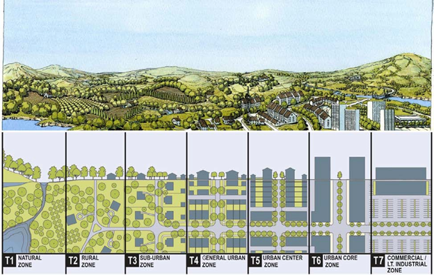
In addition to the transects described above, the SVPD has three additional zones for civic spaces, CB for civic buildings, CS for civic spaces (parks and recreational fields), and CP for civic parking (structured parking).
B.
Regulating Plan Map. The Zoning and Regulating Plan map is on the following page.
Figure 2. SVPD Zoning and Regulating Plan
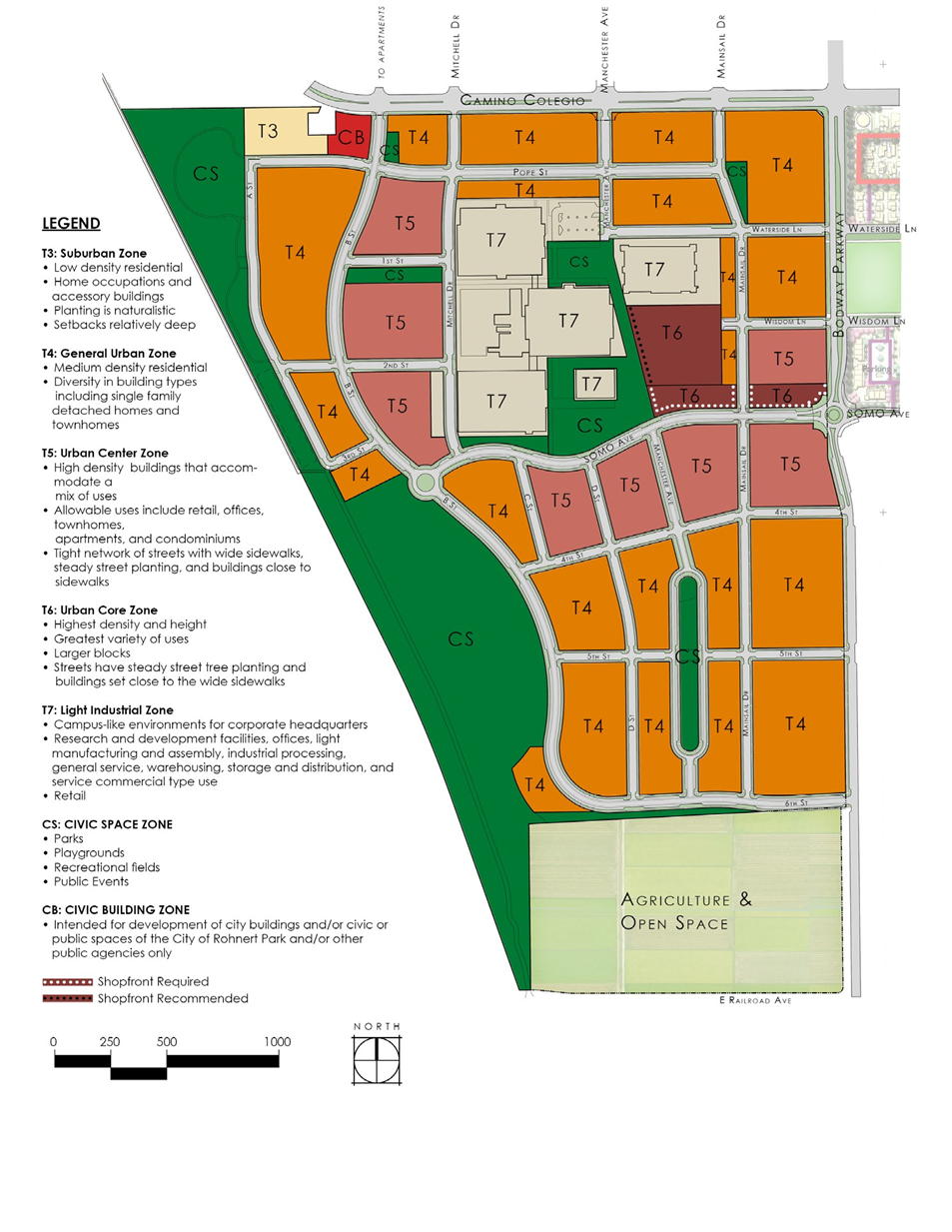
(Ord. No. 952, § 4(Exh. A), 3-23-2021)
17.06.840 - Permitted land uses.
Pursuant to Section 17.06.220 of the Municipal Code, this section describes the permitted uses in each transect and/or other zone within the SVPD and the circumstances under which such uses are allowed.
A.
Application. The uses listed in Table 1 shall be permitted by right, conditionally permitted, administratively permitted, or otherwise limited or prohibited as indicated therein. It is recognized that in the preparation of the development code, ambiguity may arise concerning the appropriate classification or permission of an unlisted particular use in each of the various transects. Uses that are not specifically listed on Table 1 or which are not otherwise designated as permitted, conditionally permitted or administratively permitted, are prohibited unless determined by the Planning Commission to be a similar and/or compatible use in accordance with Section 17.06.840(B) below.
B.
Approval of Uses Not Listed.
a.
Planning Commission Findings. The City's Planning Commission shall be responsible for determining whether an unlisted use is similar and/or compatible to a listed use and thus allowed within a particular transect. Similar and/or compatible uses which are not listed in Table 1 may be allowed if the applicant obtains written approval from the SV DRB and the Planning Commission is able to make all of the following findings:
1.
The characteristics of and activities associated with the proposed use is similar to one or more of the listed uses within the applicable transect;
2.
The proposed use will not involve a greater intensity than the use(s) listed in the applicable transect;
3.
The proposed use is consistent and compatible with the purposes of the applicable transect;
4.
The proposed use is consistent with the goals of the SVPD Article XV.A, the City of Rohnert Park General Plan, and all other applicable regulations;
5.
The proposed use will not cause substantial injury to the health, safety or welfare of the occupants or their property with the applicable transect.
b.
Applicable Standards and Permit Requirements. When the Planning Commission determines that a proposed use is similar and/or compatible to a listed use, the proposed use will be treated in the same manner as the listed use in determining where the use is allowed, what permits are required, and what other standards and requirements of this development code apply.
c.
Appeal. A similar and/or compatible use determination by the Planning Commission may be appealed to the City Council as set forth in Chapter 17.25, Article XII, of the Municipal Code (commencing with Section 17.25.120).
C.
Multiple Uses on Single Lot. Where a single lot is proposed to be simultaneously occupied by two or more uses listed Table 1, the overall project shall be subject to the most stringent permit level required for any individual use. (For example, a lot proposed for development or occupancy with a use listed as P (permitted), and also a use listed as CUP (conditionally permitted) shall require Conditional Use Permit approval for all development and uses.)
D.
Land Use Table. The follow terms are used in the Land Uses table. Note that an asterisk indicates that the use is subject to the applicable provisions of Chapter 17.07 of the Municipal Code.
a.
Permitted Uses ("P"). The use shall be permitted by right.
b.
Conditionally Permitted Uses ("CUP"). The use shall be permitted, subject to the issuance of a Conditional Use Permit pursuant to Chapter 17.25, Article I, of the Municipal Code (commencing with Section 17.25.010).
c.
Administratively Permitted Uses ("A"). The use shall be permitted, subject to the issuance of an Administrative Permit pursuant to Chapter 17.25, Article V, of the Municipal Code (commencing with Section 17.25.050).
Table 1. Land Uses
1 Only allowed on the ground floor where shop front or gallery is not required.
2 For live-work units, see the Residential category.
3 A single story building with a taller story of up to twenty-five feet is allowed for this use.
4 Paraphernalia stores are subject to Chapter 8.33 of this code.
5 Smoking/tobacco stores are subject to Chapter 8.32 of this code.
6 Permitted at Village Center Civic Space only. Requires CUP elsewhere.
7 Minimum twenty feet away from property line.
8 For residential greenhouse, see Accessory Building under Residential. Note that the minimum two-story requirement does not apply to the greenhouse use.
9 Only if and when subject to an effective development agreement. Otherwise, the use is prohibited.
(Ord. No. 952, § 4(Exh. A), 3-23-2021; Ord. No. 960, § 6, 3-22-2022; Ord. No. 991, § 4(Exh. A, § 24), 1-27-2026)
17.06.850 - Transect zones.
The SVPD zones are referred to as "Transect zones" or "T zones" as defined in Section 17.06.800.B. Pursuant to Section 17.06.210.B. of the Municipal Code, the following sections describe the specific development standards for each of the transect zones within the SVPD.
A.
Specific Requirements for T3—Sub-Urban Zone. T3 Sub-Urban Zone consists of low density residential areas, adjacent to higher density zones with limited mixed use. Home occupations and accessory buildings are allowed. Planting is naturalistic and setbacks are relatively deep. The standards in this section shall apply only to properties located in areas designated T3 on the Zoning and Regulating Plan. See the Land Uses table for details on the allowed uses.
1.
Density and Block Size.
a.
The residential density may range from two to nine units per gross acre.
b.
The maximum block perimeter is two thousand feet, measured at the Lot Line.
2.
Building Disposition.
a.
Lots may be sixty to one hundred twenty feet wide at the Principal Frontage.
b.
Allowed lot configurations:
1.
Edge yard.
2.
Courtyard.
c.
The front of the Principal Building shall be at least fifty percent as wide as the Principal Frontage.
d.
Buildings shall be set back from the frontages and centerline of the alley as shown.
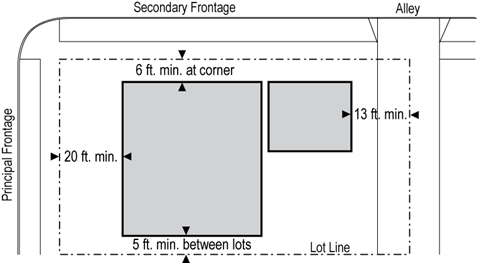
_____
e.
Accessory buildings must be set back a minimum of forty feet from the Principal Frontage.
f.
Encroachments:
1.
Stoops, bay windows and open porches may encroach on these setbacks up to fifty percent; a minimum of three feet clear must be maintained on three sides.
2.
Encroachments of up to three feet are allowed at the rear between garage driveways so long as twenty foot clear is maintained in the alley.
3.
Building Height.
a.
The maximum building height is one story for the principal building and for an accessory building.
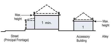
b.
The one story shall not exceed fourteen feet clear, floor to ceiling.
4.
Allowed Private Frontages.
a.
Common Yard.
b.
Porch and Fence.
5.
Fences.
a.
Fences must be setback from the Principal Frontage at least ten feet more than the front Facade, and may occupy no more than thirty percent of the Lot width on the Principal Frontage and no more than fifty percent of the Lot width on the Secondary Frontage.
6.
Landscaping.
a.
A minimum of one tree shall be planted within the setback from the Principal Frontage.
b.
Food gardens are allowed in Private Frontages, private yards, and Public Frontages.
c.
Turf area is limited to thirty percent of the landscaped area within the Principal and Secondary Frontages.
d.
Streets trees are required. See Section 17.06.870.F. for details.
B.
Specific Requirements for T4—General Urban Zone.
T4 General Urban Zone consists primarily of medium density residential. It has a diversity of building types including single family detached homes and townhomes. The standards in this section shall apply only to properties located in areas designated T4 on the Zoning and Regulating Plan.
1.
Density and Block Size.
a.
The residential density may range from six to thirty units per gross acre.
b.
The maximum block perimeter is two thousand feet, measured at the Lot Line.
2.
Building Disposition.
a.
Lots may be eighteen to ninety feet wide at the Principal Frontage
b.
Allowed lot configurations:
1.
Edge Yard.
2.
Zero Lot Line.
3.
Rear Yard.
4.
Courtyard.
c.
The front of the Principal Building shall be at least sixty percent as wide as the Principal Frontage.
d.
Buildings shall be set back from the frontages and centerline of the alley as shown.
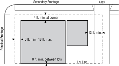
e.
Accessory buildings must be set back a minimum of thirty feet from the Principal Frontage.
f.
Encroachments:
1.
Stoops may encroach one hundred percent of the depth of a setback.
2.
Open porches and awnings may encroach up to fifty percent of the depth of the setback.
3.
Balconies and bay windows may encroach up to twenty-five of the depth of the setback.
4.
Encroachments of up to three feet are allowed at the rear between garage driveways so long as twenty foot clear is maintained in the alley.
3.
Building Height.
a.
The maximum building height is three stories for the principal building and two stories for an accessory building.
b.
The minimum building height is one story.
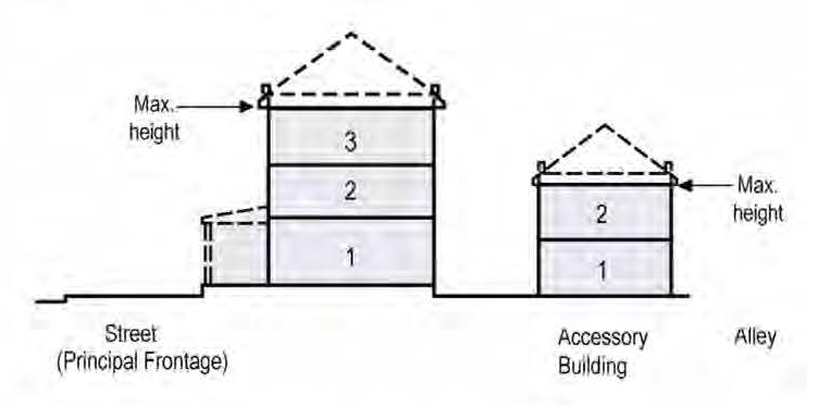
c.
Each story shall not exceed fourteen feet clear, floor to ceiling.
d.
For fire access, any building having a clear street width of less than twenty-six feet shall be limited to two stories or shall have other such provisions as to accommodate fire access to the roof. Roof access could be provided with a ladder access point at a maximum height of twenty-one feet or a continuous connection to an adjacent accessible roof.
4.
Allowed Private Frontages.
a.
Porch and Fence.
b.
Terrace.
c.
Forecourt.
d.
Stoop.
e.
Shopfront and Awning.
f.
Gallery.
5.
Fences.
a.
Fences must be setback from the Principal Frontage at least five feet more than the front Facade, and may occupy no more than thirty percent of the Lot width on the Principal Frontage and no more than fifty percent of the Lot width on the Secondary Frontage.
6.
Landscaping.
a.
A minimum of one tree shall be planted within the setback from the Principal Frontage.
b.
Food gardens are allowed in Private Frontages, private yards, and Public Frontages.
c.
Turf area is limited to thirty percent of the landscaped area within the Principal and Secondary Frontages.
d.
Streets trees are required. See Section 17.06.870.F. for details.
C.
Specific Requirements for T5—Urban Center Zone. T5 Urban Center Zone consists of higher density buildings that accommodate a mix of uses. Allowable uses include retail, office, townhomes and apartments. It has a tight network of streets, with wide sidewalks, steady street tree planting and buildings set close to the sidewalks. The standards in this section shall apply only to properties located in areas designated T5 on the Zoning and Regulating Plan.
1.
Density and Block Size.
a.
The residential density may range from fifteen to forty-five units per gross acre.
b.
The maximum block perimeter is two thousand one hundred feet, measured at the Lot Line.
2.
Building Disposition.
a.
Lots may be eighteen to two hundred fifty feet wide at the Principal Frontage.
b.
First story commercial is permitted throughout and is required at mandatory shop fronts per the Zoning and Regulating Plan.
c.
Allowed lot configurations:
1.
Zero Lot Line.
2.
Rear Yard.
3.
Courtyard.
d.
The front of the Principal Building shall be at least eighty percent as wide as the Principal Frontage.
e.
Buildings shall be set back from the frontages and centerline of the alley as shown.
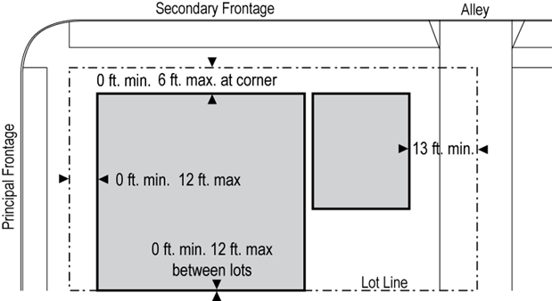
f.
Accessory buildings must be set back a minimum of thirty feet from the Principal Frontage.
g.
Encroachments:
1.
Stoops may encroach one hundred percent of the depth of a setback.
2.
Open porches may encroach up to fifty percent of the depth of the setback.
3.
Awnings may encroach up to one hundred percent of the depth of the setback, and may overhang the public sidewalk by up to six feet.
4.
Balconies and bay windows may encroach up to twenty-five percent of the depth of the setback.
5.
Encroachments of up to three feet are allowed at the rear between garage driveways so long as twenty foot clear is maintained in the alley.
3.
Building Height.
a.
The maximum building height is five stories for the principal building and two stories for an accessory building.
b.
The minimum building height is two stories for a residential principal building and two stories for a mixed-use or non-residential building except for special uses noted in Table 1, Land Uses.
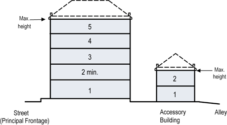
c.
Each story above the ground floor shall not exceed fourteen feet clear, floor to ceiling. All renovations to buildings constructed prior to January 1, 2010 are exempt from this ceiling height limit.
d.
For fire access, any building having a clear street width of less than twenty-six feet shall be limited to two stories or shall have other such provisions as to accommodate fire access to the roof. Roof access could be provided with a ladder access point at a maximum height of twenty-one feet or a continuous connection to an adjacent accessible roof.
e.
First floor residential or lodging shall be raised a minimum of two feet and a maximum of four feet above the average sidewalk grade.
4.
Expression Line.
a.
The street level facade of any building with a shopfront shall be distinguished from the remainder of the building with a horizontal expression line on the facade located between the highest point of the second floor and the bottom edge of the third floor windows. The purpose of this architectural feature is to create a comfortable and cohesive public space.
b.
The expression line shall be incorporated into the facade as a permanent design element and shall be created by a change in building material, architectural design, setback, recess, projection, cornices, belt courses, corbelling, molding, stringcourses or other sculptured design element. Where city staff determines that a consistent expression line has been established on adjacent buildings, it shall be continued on any new construction or expansion, or a transitional design element (such as columns, piers, bays or changes in facade materials) between the existing and proposed expression lines may be required.

5.
Allowed Private Frontages.
a.
Terrace.
b.
Forecourt.
c.
Stoop.
d.
Shopfront and Awning.
e.
Gallery.
6.
Fences.
a.
Fences are generally not allowed in the T5 transect zone on the Principal and Secondary Frontages, however, they may be approved in special circumstances.
7.
Landscaping.
a.
Trees are allowed but not required in the Private Frontage.
b.
Streets trees are required. See Section 17.06.870.F. for details.
c.
Food gardens are allowed in Private Frontages, private yards, and Public Frontages.
d.
Turf area is limited to thirty percent of the landscaped area within the Principal and Secondary Frontages.
D.
Specific Requirements for T6—Urban Core Zone. T6 Urban Core Zone consists of the highest density and height, with the greatest variety of uses. It may have larger blocks; streets have steady street tree planting and buildings set close to the wide sidewalks. The standards in this section shall apply only to properties located in areas designated T6 on the Zoning and Regulating Plan.
1.
Density and Block Size.
a.
The residential density may range from twenty-five to seventy units per gross acre.
b.
The maximum block perimeter is two thousand feet, measured at the Lot Line.
2.
Building Disposition.
a.
Lots may be eighteen to two hundred fifty feet wide at the Principal Frontage.
b.
First story commercial is permitted throughout and is required at mandatory shop fronts per the Zoning and Regulating Plan.
c.
Allowed lot configurations:
1.
Rear Yard - which includes buildings at the lot line on frontages and between buildings.
2.
Courtyard.
3.
Zero Lot Line.
d.
The front of the Principal Building shall be at least eighty percent as wide as the Principal Frontage.
e.
Buildings shall be set back from the frontages and centerline of the alley as shown.
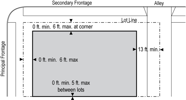
f.
Accessory buildings must be set back a minimum of thirty feet from the Principal Frontage.
g.
Encroachments:
1.
Stoops may encroach one hundred percent of the depth of a setback.
2.
Awnings may encroach up to one hundred percent of the depth of the setback, and may overhang the public sidewalk by up to ten feet.
3.
Balconies and bay windows may encroach up to twenty-five percent of the depth of the setback.
4.
Encroachments of up to three feet are allowed at the rear between garage driveways so long as twenty foot clear is maintained in the alley.
3.
Building Height.
a.
The maximum building height is seven stories for the principal building and two stories for an accessory building.
b.
The minimum height is three stories except for special uses noted in Table 1, Land Uses.
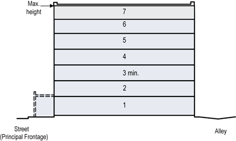
c.
Each story above the ground floor shall not exceed fourteen feet clear, floor to ceiling. All renovations to buildings constructed prior to January 1, 2010 are exempt from this ceiling height limit.
d.
For fire access, any building having a clear street width of less than twenty-six feet shall be limited to two stories or shall have other such provisions as to accommodate fire access to the roof. Roof access could be provided with a ladder access point at a maximum height of twenty-one feet or a continuous connection to an adjacent accessible roof.
e.
Residential and Office Uses.
1.
Residential and office uses are not allowed on the ground floor.
2.
Entryways to residential and office uses may be located on the ground floor, and are limited to eight feet of width at the Principal Frontage.
4.
Expression Line.
a.
The street level facade of any building with a shopfront shall be distinguished from the remainder of the building with a horizontal expression line on the facade located between the highest point of the second floor and the bottom edge of the third floor windows. The purpose of this architectural feature is to create a comfortable and cohesive public space.
b.
The expression line shall be incorporated into the facade as a permanent design element and shall be created by a change in building material, architectural design, setback, recess, projection, cornices, belt courses, corbelling, molding, stringcourses or other sculptured design element. Where city staff determines that a consistent expression line has been established on adjacent buildings, it shall be continued on any new construction or expansion, or a transitional design element (such as columns, piers, bays or changes in facade materials) between the existing and proposed expression lines may be required.
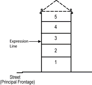
5.
Allowed Private Frontages.
a.
Forecourt.
b.
Stoop.
c.
Shopfront and Awning.
d.
Gallery.
6.
Fences.
a.
Fences are generally not allowed in the T6 transect zone on the Principal and Secondary Frontages, however they may be approved in special circumstances.
7.
Landscaping.
a.
Trees are allowed but not required in the Private Frontage.
b.
Streets trees are required. See Section 17.06.870.F. for details.
c.
Food gardens are allowed in Private Frontages, private yards, and Public Frontages.
d.
Turf is not allowed in T6.
E.
Specific Requirements For CS—Civic Space Zone. CS Civic Space Zone consists of parks, playgrounds, concert venues, recreational fields and similar uses. The standards in this section shall apply only to properties located in areas designated Civic Space Zone (CS).
1.
Absence Of Development Requirements. The CS Transect is intended for open space, parkland, and/or habitat preservation only. Thus, no specific design, architectural, or development requirements shall apply to properties located in areas designated Civic Space Zone (CS).
F.
Specific Requirements for CB—Civic Building Zone. CB Civic Building Zone consists of civic buildings appropriate to the location. The standards in this section shall apply only to properties located in areas designated Civic Building Zone (CB).
1.
Absence of Development Requirements.
a.
The CB Transect is intended for development of city buildings and/or civic or public spaces of the City of Rohnert Park and/or other public agencies only.
b.
Control over the design, architectural, and development features in such areas is therefore left to City of Rohnert Park and/or such agencies. Thus, no specific design, architectural, or development requirements shall apply to properties located in areas designated Civic Building Zone (CB).
G.
Specific Requirements for T7—Commercial/Limited Industrial Use. T7 Commercial/Limited Industrial Use consists of commercial/industrial buildings for corporate headquarters, research and development facilities, offices, light manufacturing and assembly, industrial processing, general service, warehousing, storage and distribution, and service commercial type use. Retail activities are generally limited to those that support the aforementioned uses. T7 zone also encompasses pedestrian walkways, open spaces and parking areas adjacent to commercial/industrial buildings. The standards in this section shall apply only to properties located in areas designated Commercial/Limited Industrial Use Zone (T7).
1.
Absence of Development Requirements.
a.
The T7 Zone is intended for commercial and limited industrial use consistent with historical and present uses of buildings at the SV Planned Development.
b.
Control over the design, architectural, and development features in the T7 Zone shall be governed by the development standards set forth in Chapter 17.10 for the C-O, C-N, C-R and I-L as most applicable for a proposed use within the T7 Zone, as reasonably determined by the City of Rohnert Park based. Thus, no separate design, architectural, or development requirements shall apply to buildings located in areas designated Commercial/Limited Industrial Use Zone (T7) except to the extent set forth in Chapter 17.10.
H.
Overlay Districts.
1.
Authority.
a.
The Planning Commission has the authority to establish overlay districts for the purpose of accommodating uses which support the goals of the SVPD but which may not meet the specific criteria of a particular transect zone.
b.
An overlay district may be combined with any other transect zone, which allows compatible densities, by a change in district to include the overlay in accordance with the provisions of Chapter 17.25, Article VII (commencing with Section 17.25.070).
2.
Process.
a.
Define the specific locations on the SVPD Zoning Map.
b.
Define the allowed uses for the overlay zone.
c.
Define special criteria which differ from the underlying transect zone for parking requirements, building disposition, building heights and other elements as needed.
(Ord. No. 952, § 4(Exh. A), 3-23-2021)
17.06.860 - Development standards.
A.
Application. The standards in this section shall apply to all transects within SVPD boundaries.
B.
Bicycle Parking Requirements.
1.
General Requirements.
a.
All the requirements of Municipal Code Section 17.16.140 apply within SVPD boundaries except for the numbers of required spaces which are given below in Section 17.06.860.B.2.
2.
Required Spaces.
a.
All transect zones. One publicly accessible bicycle parking space for every four multifamily dwelling units.
b.
T4 General Urban Zone. On block faces having an entry to a non-residential use, a minimum of one bicycle parking space is required in a highly visible location in the public or private frontage.
c.
T5 Urban Center Zone. On block faces having an entry to a non-residential use, a minimum of two bicycle parking spaces are required in highly visible locations in the public or private frontages.
d.
T6 Urban Core Zone. A minimum of two bicycle parking spaces are required per block face in highly visible locations in the public or private frontages.
e.
T7 Light Industrial Zone. A minimum of two bicycle parking spaces are required per block face in highly visible locations in the public or private frontages.
f.
CS Civic Space Zone. Any civic space of at least 0.25 acres must have a minimum of two bicycle parking spaces. Spaces designed for active play, such as sports fields and jogging tracks, require an additional four bicycle parking spaces per acre.
g.
Civic Building Zone. Provide a minimum of one bicycle parking space for every ten employees plus two for visitors in a highly visible location in the public or private frontage.
C.
Vehicle Parking Requirements. The off-street parking requirements contained in this section are intended to ensure that off-street parking facilities are provided for new land uses and for enlargements of existing uses. Off-street parking facilities may be designed for efficiency by utilizing shared parking criteria as set forth herein.
1.
General Requirements.
a.
On-street parking along the frontage lines of a lot shall be counted toward fulfilling the parking requirements.
b.
When the required number of parking spaces cannot be provided on-site or along the frontage lines of the lot, parking spaces may be provided within one-quarter mile of the lot. In such situations, the property owner of the lot requiring the parking shall enter into a written agreement with the property owner of the off-site location (if different from the property owner of the lot requiring parking). The agreement shall provide for the required number of parking spaces to serve the lot. The terms of any such agreement shall be approved by the Development Services Director or his or her designee.
c.
The standard on-street parallel parking space shall be twenty-three feet long by the width as shown as the Parking Lane on the Street and Alley Plan (Section 17.06.870).
d.
All surface parking shall be in the rear half of a lot.
e.
Parking lots shall be screened from the frontage by a building or street screen.
f.
The vehicle entrance of a parking lot or garage on a frontage shall be no wider than thirty feet. Pedestrian entrances to parking lots and garages shall be directly at a frontage and shall not require a pedestrian to pass through a building or enter through an alley.
g.
Loading docks and service areas are not permitted on the Principal or Secondary Frontages.
2.
Required Vehicle Spaces.
a.
Required Parking. The minimum parking required for a use is given in Table 2 when parking is not shared with another use.
Table 1. Required Vehicle Parking
b.
Shared Parking: When adjacent uses share parking, the required number of spaces is reduced by following this procedure:
1.
Base Parking. Add up the base required parking from Table 2.
2.
Look up the Shared Parking Factor from Table 3. If parking is shared between more than two uses, then select the largest Shared Parking Factor.
3.
Multiply the Base Parking with the Shared Parking Factor to get the actual required parking.
4.
The Shared Parking Factor for Civic and Other uses may be established by the Development Services Director or his or her designee.
Table 2. Shared Parking Factor
3.
Example Vehicle Parking Calculation. To illustrate how parking requirements are calculated, consider the situation in Figure 3. The block has a twelve thousand square foot retail use at A, and fifteen apartments at B. Parking for the block is located around its perimeter and also at the interior of the block. The block is located in transect zone T5.
Step 1. Find the Base Required Parking
From Table 2, the base parking requirements are:
For Use A: (3.0/1,000 square feet) x 12,000 square feet = 36 spaces
For Use B: (1.0/dwelling) x 15 units = 15 spaces
Total of A + B = 51 spaces.
Step 2. Find the Shared Parking Factor
From Table 3, the Shared Parking Factor is 0.8 for residential sharing parking with retail.
Step 3. Multiply to Obtain the Actual Required Parking
The total actual required parking is then 51 spaces x 0.8 = 41 spaces. These spaces may be located anywhere allowed by Section C, but would generally be located in areas similar to those shown in Figure 3.
Figure 3. Example Parking Calculation Scenario
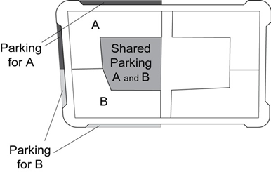
D.
Signage. Signage requirements for size, type, location, lighting and materials are contained in the SV DRB Design Standards.
E.
Exterior Lighting.
a.
Street lighting requirements are in Section 17.06.870.E.
b.
All other exterior lighting requirements are found in the SV-DRB Design Standards.
F.
Waste.
a.
Containers for recycling of green waste, compost and landfill shall be stored in the rear half of the lot and accessed from the alley.
b.
Provision must be made for recycling of at least aluminum, cardboard, mixed consumer container metals, mixed consumer container plastics, paper and green waste.
c.
If curbside food waste collection is available, containers must be provided.
(Ord. No. 952, § 4(Exh. A), 3-23-2021)
17.06.870 - Streets and public frontages.
A.
Street and Alley Plan. Street types and accompanying public amenities are identified on Figure 4 in this section. The color-coded map uses private alleys shown in grey and four street types: Neighborhood Streets, Minor Streets, Main Streets and Modified Main Streets. The details for these street types and the requirements for bicycle lanes, parking lanes, planter strips, sidewalks and street lights are detailed in. Details on the one-way streets and angled parking will be provided during preparation of Tentative Maps and will be included in the SVPD through the zoning amendment process as set forth in Chapter 17.25 Article VII (commencing at 17.25.070).
Figure 4. SVPD Street and Alley Plan
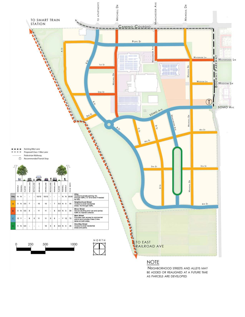
B.
Street Types.
Figure 5A. Street Types—Alley 'A'
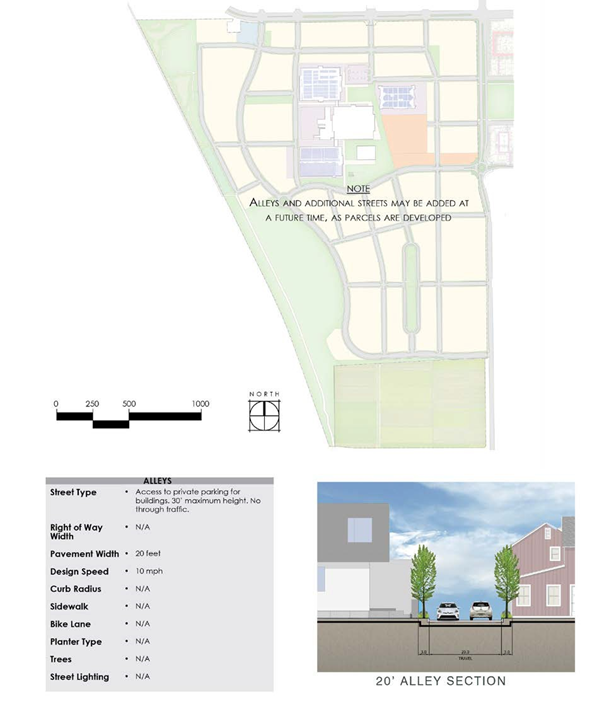
Figure 5B. Street Types—Alley 'A' Plan View
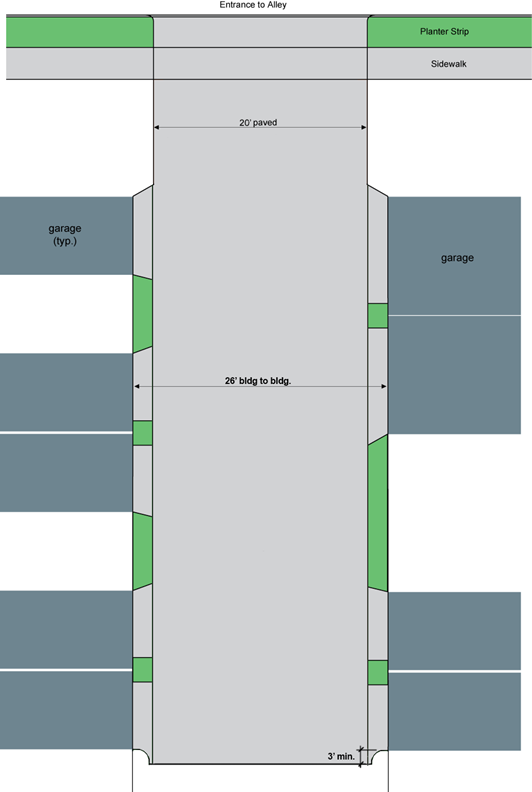
Figure 5C. Street Types—"Alley B"
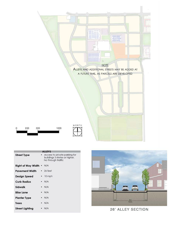
Figure 5D. Alley 'B' Plan View

Figure 6. Neighborhood Street
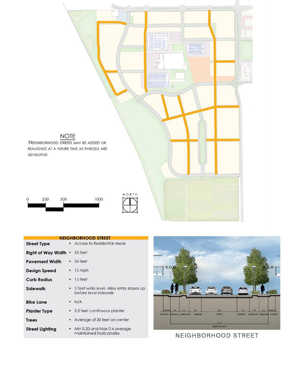
Figure 7. Main Street
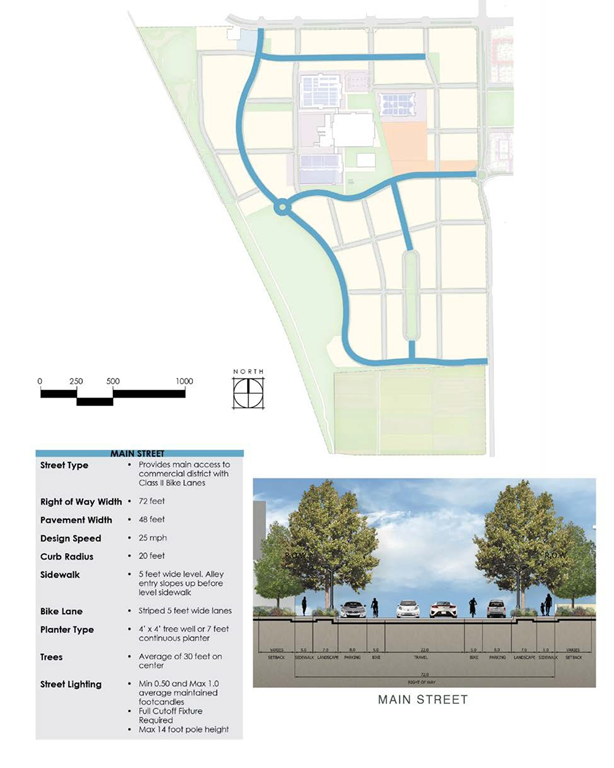
Figure 8. Minor Street
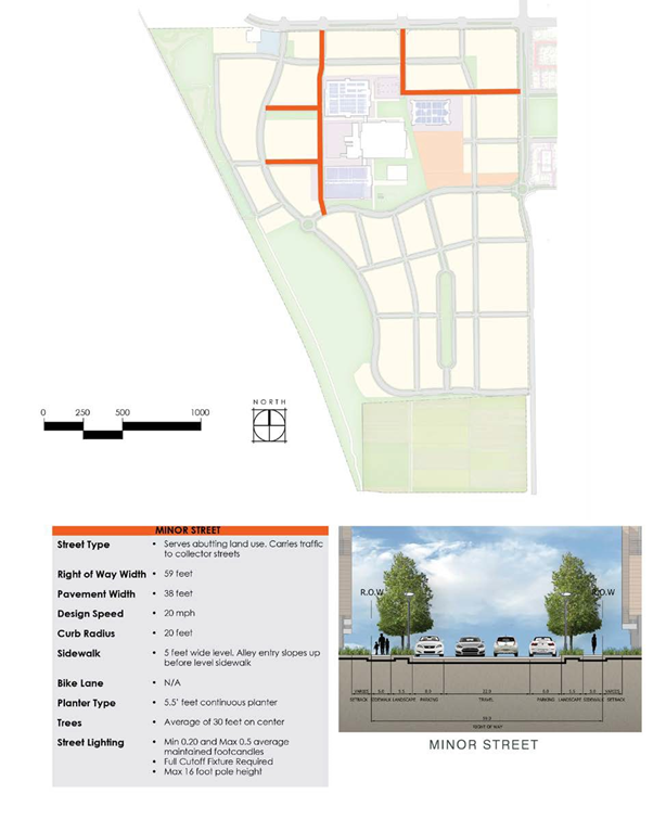
Figure 9. One-Way Street
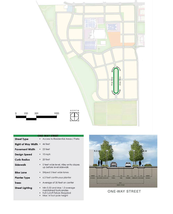
C.
Sidewalks.
a.
In the Public Frontage, a continuous level sidewalk is required around every block.
b.
The same sidewalk standards as defined in Figure 4 shall be applied on each side of the street within a block.
c.
The required width of a sidewalk is defined by the Street Type in Figure 4.
d.
Sidewalks shall not have railings, and therefore the site grading must be made to address proper drainage without the need for unusually elevated sidewalks.
e.
Sidewalks must comply with all relevant state and federal law.
D.
Planter Strips.
a.
Planter strips are required where indicated in Figure 4.
E.
Street Lighting.
a.
All public streets shall use the City's Street Lighting Design Standards.
b.
Lighting for private alleys and streets shall use the SVPD Street Lighting Design Standards and shall comply with the SV DRB Design Standards.
c.
Gallery frontage types preclude the use of typical street lighting. Therefore, decorative surface mounted lights are required on gallery soffits. This lighting needs to provide an appropriate amount of lighting for the sidewalk and adjacent parking lane, as determined by the current Illuminating Engineering Society (IES) Guidelines. The City may require these lights to be controlled by photocells and/or timers to assure appropriate lighting of the public way. Gallery lights are not intended to provide roadway lighting and must be coordinated with adjacent street lights to ensure safety.
F.
Street Trees. Table 5 gives the allowed species of street trees in the SVPD. Any tree which meets the following criteria may be proposed as an alternate and must be approved by the Director of Development Services or his or her designee:
•
Non-invasive
•
Has low potential for causing damage to adjacent sidewalks, curbs and roadway
•
Fruit does not cause damage to cars, clog storm drains or attract rats
•
Tree is hearty and disease resistant
•
Appropriate for clay-rich soil and seasonal rainfall
Table 3. Allowed Street Tree Species
* Trees having an asterisk require a minimum of ten-foot radius without concrete or asphalt
a.
Street tree spacing shall be an average of thirty feet on center for Principal and Secondary Frontages.
b.
Tree wells and root barriers are required for all street trees in T5 and T6 which are within five feet of publicly-maintained concrete or asphalt.
(Ord. No. 952, § 4(Exh. A), 3-23-2021)
Glossary.
A.
Purpose. The glossary of terms and phrases used in the SVPD are technical or specialized and may not reflect common usage. If a definition in this section conflicts with a definition in another provision of the Municipal Code, the definitions in this section shall control. If a word is not defined in this section, refer to Chapter 17.04 of the Zoning Ordinance. The Development Services Director shall determine the meaning of terms when a definition is ambiguous or when a term is not defined in accordance with Section 17.02.090 of the Municipal Code.
B.
Definitions of Specialized Terms and Phrases. The definitions provided in the Municipal Code shall apply to Article XV.A. If there is a conflict between the definitions in the Municipal Code and the definitions provided in the article, the definitions in this article shall control.
"Abut." Adjoin or border on. This term is used in several of the other definitions.
"Administrative Use Permit." A use permit which is granted by the City's Planning department without requiring the approval of the Planning Commission.
"Adult Day Program." Any community-based facility or program that provides care to persons eighteen years of age or older in need of personal services, supervision, or assistance essential for sustaining the activities of daily living or for the protection of these individuals on less than a twenty-four-hour basis.
"Alcoholic Beverage Establishment." A commercial and non-commercial establishment wherein alcoholic beverages are sold, served, or given away for consumption on the premises, excluding full-service restaurants. Typical alcoholic beverage establishments include but are not limited to the following recognized types of establishments: Bars, cocktail lounges, ballrooms, dance bars, piano bars, billiard or game parlors, bowling alleys and nightclubs.
"Alley." A public or private way which affords only secondary access to abutting property.
"Amphitheater." An outdoor venue for concerts, storytelling, plays and other related events with seating, a stage and which may include minor lighting of up to five thousand watts total, a concessions kiosk, ticket sales booth, storage, restrooms and other similar facilities. The venue may have raised seating, a sunken stage or both. Sunshades and wind screens are allowed, but the facility must have a general open quality without major roofs or enclosed spaces.
"Animal Rescue." A facility for taking in animals for placement in homes and shelters which may provide minor medical services and boarding facilities for up to one week.
"Auto and Vehicle Sales and Rental." A retail or wholesale establishment selling and/or renting automobiles, trucks and vans, trailers and motorcycles (bicycle sales are included under "General Retail"). May also include repair shops and the sales of parts and accessories, incidental to vehicle dealerships. Does not include: The sale of auto parts/accessories separate from a vehicle dealership (see "Auto Parts Sales"); mobile home, recreational vehicle, or watercraft sales (see "Mobile Home, RV and Boat Sales"); tire recapping establishments (see "Vehicle Services"); businesses dealing exclusively in used parts, (see "Recycling—Scrap and Dismantling Yards"); or "Gas Stations," which are separately defined.
"Automated Teller Machine (ATM)." Computerized, self-service machines used by banking customers for financial transactions, including deposits, withdrawals and fund transfers, without face-to-face contact with financial institution personnel. The machines may be located at or within banks, or in other locations.
"Balcony." A partially enclosed, habitable structure, usually cantilevered from a facade or an elevation, providing private outdoor space to an apartment. Balconies in great numbers with significant depth tend to dematerialize the vertical plane of a facade, interfering with its role of spatial definition. A better alternative to avoid this is to use a French balcony and the loggia.
"Balcony, French." A shallow balcony, almost flush with a facade, accessed by a single pair of inward-swinging doors. French balconies do not dematerialize the spatially-defining character of facades as does the "egg-crate" of conventional deep balconies. French balconies virtually transform the adjacent interior room into an outdoor space and are encouraged.
"Bank, Financial Services." Financial institutions including: Banks and trust companies, other investment companies, credit agencies, securities/commodity contract brokers and dealers, holding (but not primarily operating) companies, security and commodity exchanges, lending and thrift institutions, vehicle finance (equity) leasing agencies. See also, "Automated Teller Machine."
"Bar/Tavern/Night Club." A business where alcoholic beverages are sold for on-site consumption, which are not part of a larger restaurant. Includes bars, taverns, pubs, night clubs, live music and/or dancing, comedy and similar establishments where any food service is subordinate to the sale of alcoholic beverages. May also include beer brewing as part of a microbrewery. Requires compliance with Section 8.34.
"Bed & Breakfast Inn (B&B)." A residential structure with one household in permanent residence, with one or up to five bedrooms rented for overnight lodging, where meals may be provided subject to applicable Health Department regulations. Does not include room rental, which is separately defined (see "Rooming, Lodging, or Boarding House").
"Bedroom." Any space in the conditioned area of a dwelling unit or accessory structure located along an exterior wall, but not including the following: Hall; bathroom; kitchen; living room, dining room, family room, laundry room, closet/dressing room opening off of a bedroom. If a home office, library or similar room is proposed, it may be exempted from being considered a bedroom if there is no closet and at least one of the following is present: a) a minimum four-foot opening, without doors, into another room; or b) a half wall (four-foot maximum height) between the room and another room. A detached building which contains only a half bath will not routinely be considered as having a bedroom unless it is specifically identified and permitted as a guest house.
"Block Face." The aggregate of all the building facades on one side of a block. The Block Face provides the context for establishing architectural harmony.
"Block." The properties abutting on one side of a street and lying between the two nearest intersecting or intercepting streets, or nearest intersecting or intercepting street and railroad right-of-way, unsubdivided land, or watercourse.
"Building." See "Structure."
"Building Configuration." The form of a building, based on its massing, private frontage, and height.
"Building Disposition." the placement of a building on its lot. See Lot Configuration.
"Building Height." The vertical extent of a building is measured by number of stories, not including an inhabited attic. Heights are measured from the average finish grade of the frontage line to the eave of a pitched roof or to the surface of a flat roof. The maximum building height is determined by the clear street width at the Principal or Secondary Frontage.
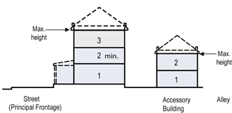
"Building Identification Sign." Any sign containing the name or address of a building and may include hours of operation and emergency information, such sign being located on the same site as the structure.
"Building and Landscape Materials Sales—Indoor." See "General Retail."
"Building and Landscape Materials Sales—Outdoor." See "Storage-Yard, Outdoor."
"Business Support Service." An establishment within a building that provides services to other businesses. Examples of these services include: Blueprinting, film processing and photo finishing (retail), computer related services (rental, repair), protective services, copying and quick printing services, and security systems service.
"Carshare/Bicycleshare Stations." An established location where cars, vans, scooters, bicycles or other vehicles are provided for use through a club or rental service, generally not staffed.
"Catering." A business that prepares and delivers food for consumption on the premises of a client. Does not include mobile food vendors.
"Cemetery." A park established for the purpose of providing a location for grieving, remembering and religious ceremony. Either human (cemetery) or animal (pet cemetery) remains are permanently stored on site. Tombstones, urns and other markers may be placed within designated burial and ash storage areas. A cemetery may be enclosed with a see-through iron fence, but must leave its gates open during daylight hours and allow unrestricted access without charge.
"Child Day Care." Facilities that provide care, protection and supervision of children, in the care giver's home or a separate commercial business, for periods of less than twenty-four hours per day, while the parents or authorized guardians are away. These facilities include the following, all of which are required to be licensed by the State of California Department of Social Services.
(1)
"Large Family." A home that provides family child care for up to twelve children. These capacities include children under age ten who live in the licensee's home and the assistant provider's children under age ten. A large family day care home is required to comply with the requirements of Section 7.060.
(2)
"Small Family." A home that provides family child care for up to six children, or for up to eight children. These capacities include children under age ten who live in the licensee's home.
"Childcare Center." Commercial child care facility for children ages zero to thirteen years in a commercial building or the commercial portion of a mixed-use building. Allowed as an accessory use.
"Cinema." For live performances, see Theater. A movie theater containing at least one and no more than ten screens. A window for selling tickets may open directly onto the Public Frontage. The building may include food, candy and drink concessions, and may also include a cafe or restaurant. In addition to showing films and serving food, the facility may host public lectures, meetings, educational courses and other similar functions. Parking is generally shared with another use in a public or private garage.
"Civic Building." A building designed specifically for a civic use such as a not-for-profit organization dedicated to arts, culture, education, recreation, government, transit, or for a use approved by the City of Rohnert Park or the County of Sonoma.
"Civic Space." Parks, Squares and other civic spaces are illustrated below.
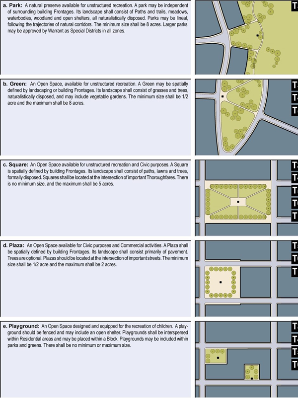
"Club, Lodge, Private Meeting Hall." Permanent, headquarters-type and meeting facilities for organizations operating on a membership basis for the promotion of the interests of the members, including facilities for: Business associations, political organizations, civic, social, and fraternal organizations, professional membership organizations, labor unions and similar organizations, other membership organizations.
"Commercial Recreation Indoor." Establishments providing indoor amusement and entertainment services for a fee or admission charge, including: Bowling alleys, electronic game arcades (video games, pinball, etc.), coin-operated amusement arcades, ice skating and roller skating, dance halls, clubs and ballrooms, pool and billiard rooms as primary uses. This use does not include adult oriented businesses, which are separately defined. Four or more electronic games or coin-operated amusements in any establishment, or a premise where fifty percent or more of the floor area is occupied by amusement devices, are considered an electronic game arcade as described above; three or fewer machines are not considered a land use separate from the primary use of the site.
"Commercial Recreation Outdoor." Facilities for various outdoor recreational activities, where a fee is charged for use. Examples include: Amusement and theme parks, miniature golf courses, go-cart tracks, water slides, golf driving ranges. May also include commercial facilities customarily associated with the above outdoor commercial recreational uses, including bars and restaurants, video game arcades, etc.
"Commercial." the term collectively defining workplace, Office, Retail, and Lodging Functions.
"Conference/Convention Facility." One or more structures accommodating multiple assembly, meeting, and/or exhibit rooms, and related support facilities (e.g., kitchens, offices, etc.).
"Coverage." The percent of the total site area covered by structures, open or enclosed, excluding uncovered steps, patios and terraces.
"Crop Production, Horticulture, Orchard, Vineyard." Commercial agricultural production field and orchard uses, including the production of the following, primarily in the soil on the site and not in containers, other than for initial propagation prior to planting in the soil on the site: Flowers and seeds, ornamental crops, tree nuts, field crops, trees and sod, melons, vegetables, grains, wine and table grapes, fruits.
Also includes associated crop preparation services and harvesting activities: Mechanical soil preparation; irrigation system construction; composting. Chemical sprays are not allowed. May also include the sale of products grown on site. See also Greenhouse (commercial).
"Disposition." See Building Disposition.
"Driveway, Residential." A vehicular lane within a Lot, often leading to a garage.
"Dwelling, Accessory/Second Unit." An attached or detached residential dwelling unit which provides complete independent living facilities for one or more persons with permanent provisions for living, sleeping, eating, cooking and sanitation on the same parcel as the single household dwelling.
"Dwelling, Attached." A building containing a single dwelling unit and having one or more walls in common with another such unit with each unit located on a separate lot.
"Dwelling, Detached." A building designed for and/or occupied exclusively by one household that has no walls in common with any other structure or dwelling unit.
"Dwelling, Multifamily." A building which includes residential use including two or more separate dwelling units, and which may include other uses as well. This definition includes but is not limited to duplexes, triplexes, apartments, and condominiums under a common ownership.
"Dwelling, Single Family." A freestanding building designed for and/or occupied by one household.
"Expression Line." The street level facade of any building with a shopfront shall be distinguished from the remainder of the building with a horizontal expression line on the facade located between the highest point of the second floor and the bottom edge of the third floor windows. The purpose of this architectural feature is to create a comfortable and cohesive public space.
The expression line shall be incorporated into the facade as a permanent design element and shall be created by a change in building material, architectural design, setback, recess, projection, cornices, belt courses, corbelling, molding, stringcourses or other sculptured design element. Where city staff determines that a consistent expression line has been established on adjacent buildings, it shall be continued on any new construction or expansion, or a transitional design element (such as columns, piers, bays or changes in facade materials) between the existing and proposed expression lines may be required.

"Farmer's Market." A market held in a Town Square, public park, or prominent building with highly visible entries from a Town Square or public park. The vendors may sell any items they have assembled, manufactured, grown or processed that are otherwise allowed by law, including but not limited to vegetables, fruits, jams, nuts, fish, meats, eggs, cheeses, juices, honey, soap, clothing, furniture, tools, seeds, plants and art. A minimum of one-third of all vendors must sell primarily food.
"Fence." A device or portion thereof designed to separate or screen property areas and not to carry any structural loads.
"Frontage, Line and related terms."
"Frontage Line." The portion of the property line along the Principal and Secondary Frontages.
"Lot Line." The portion of the property line between adjacent Lots.
"Facade." The faces of buildings which are visible from the Principal and Secondary Frontages.
"Elevation." The faces of a building which is visible from the rear of the Lot or from an adjacent Lot.
"Frontage, Principle and Secondary."
"Principal Frontage." The main point of access for pedestrians into a building. On corner Lots, the Private Frontage designated to bear the address and Principal Entrance to the building, and the measure of minimum Lot width.
"Secondary Frontage." The Private Frontage which does not have the main point of access for pedestrians into a building.
"Frontage, Private and Public."
"Private Frontage." The privately owned area between the Frontage Line and the Principal Building Facade. See Types of Private Frontages, below and the Land Use table for where each type is allowed.
"Public Frontage." The area between the Curb of the vehicular lanes and the Frontage Line.
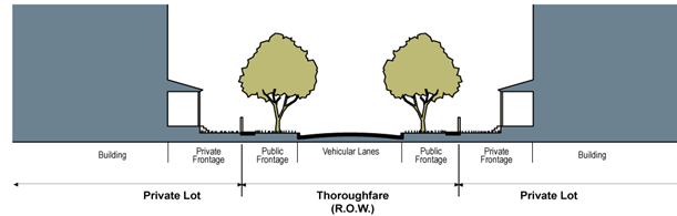
Types of Private Frontages. The following figures illustrate the types of Private Frontages. See the Land Use table for information about where each type is allowed.
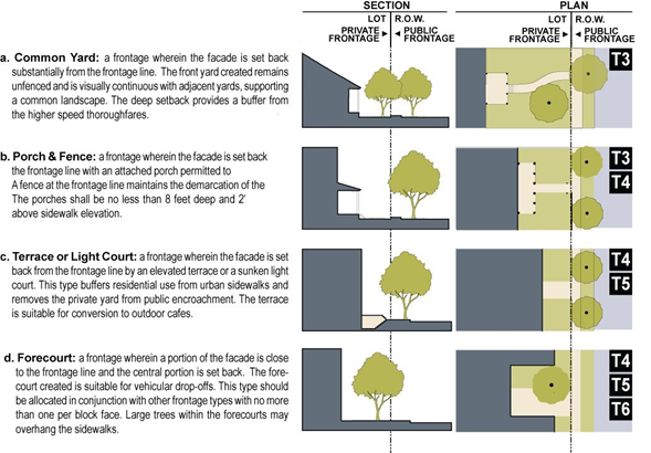
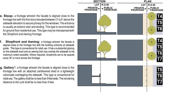
* An easement or encroachment permit for private use of the right-of-way is usually required. Alternatively, the City of Rohnert Park may require that the full width of the gallery be private with a public easement. Decorative surface mounted lights are required on soffit of gallery. This lighting needs to provide an appropriate amount of lighting for the sidewalk and adjacent parking lane. The City of Rohnert Park may require these lights to be controlled by photocells and/or timers to assure appropriate lighting of public way. The coordination of the gallery lights with the streetlights is required.
_____
"Fueling Station (alternative fuels only)." A retail business selling vehicle fuels, but not including gasoline, diesel, or other motor vehicle fuels for combustion engines, and related products. Hydrogen is an alternative fuel. A fueling station may also include a convenience store of less than four hundred square feet.
"Function." The use or uses accommodated by a building and its Lot, categorized as Permitted, Administratively Permitted or Conditionally Permitted.
"Furniture/Fixtures Manufacturing, Cabinet Shop." Manufacturers producing: Wood and metal household furniture and appliances; bedsprings and mattresses; all types of office furniture and public building furniture and partitions, shelving, lockers and store furniture; and miscellaneous drapery hardware, window blinds and shades. Includes furniture re-upholstering businesses, wood and cabinet shops, but not sawmills or planing mills, which are instead included under "Manufacturing—Heavy."
"Gallery." See Frontage Types.
"Garage or Carport." Parking space and shelter for automobiles or other vehicles, where the size of the parking space complies with the provisions of Section 11.070(I) (Parking Stall Size).
1.
A garage is a completely enclosed attached or detached accessory structure with an operational door.
2.
A carport is an attached or detached accessory structure enclosed on no more than two sides.
A garage or carport complies with the requirements of this Zoning Code for "covered" parking spaces.
"Garage Sale." A sale of articles belonging to one or more households, held for a period not to exceed three consecutive days, at a frequency not to exceed once every two months at any single location.
"General Retail." Stores and shops selling many lines of merchandise. Examples of these stores and lines of merchandise include: Antique stores, drug stores and pharmacies, art galleries, retail, furniture, furnishings, and appliances, artists' supplies, hobby materials, auction rooms, jewelry, auto parts sales, luggage and leather goods, bicycles, musical instruments, parts and accessories, books, magazines, and newspapers, orthopedic supplies, building and landscape materials indoor, religious goods, cameras and photographic supplies, second hand stores, clothing, shoes, and accessories, small wares, collectibles (cards, coins, comics, stamps, etc., specialty shops, convenience stores, sporting goods and equipment, department stores, stationery.
"Groceries, Specialty Foods." A retail business where the majority of the floor area open to the public is occupied by food products packaged for preparation and consumption away from the store.
"Guest House." A detached living quarters of permanent construction, without kitchen or cooking facilities, clearly subordinate and incidental to the main building on the same lot, and intended for use by occasional guests of the occupants of the main building.
"Health Care Facility." A facility which treats patients during normal office hours, offering advice, tests or minor medical procedures which do not require hospital support. Pharmacy services and the sale of medical equipment may be provided as an accessory use.
"Health Club." A public or private club providing fitness facilities and training. May include fitness machines, running tracks, swimming pools, spas, saunas, free weights, fitness classes, diet and nutrition counseling, stress relief/relaxation counseling and classes, showers and locker area, and other similar health and fitness services. The sale of drinks and food, fitness equipment or clothing is allowed as an accessory use.
"Home Occupation." A commercial activity conducted in a dwelling located in a Residential, Mixed Use, or Commercial zoning district, which is clearly incidental and secondary to the use of the dwelling for residential purposes and in accordance with the provisions of Section 7.050.
"Hotel." A facility with guest rooms or suites, with or without kitchen facilities, rented to the general public for transient lodging. Hotels typically include a variety of services in addition to lodging; for example, restaurants, meeting facilities, personal services, etc. Also includes accessory guest facilities such as swimming pools, tennis courts, indoor athletic facilities, accessory retail uses, etc.
"Household." A person or group of people who live together in a single dwelling unit, but not including the renting of rooms.
"Inn." A facility with up to twelve guest rooms or suites, with or without kitchen facilities, rented to the general public for transient lodging. Inns may include a variety of minor uses in addition to lodging; for example, a small restaurant, a swimming pool or spa, or a garden.
"Kennel, Animal Boarding." A commercial facility for the grooming, keeping, boarding or maintaining of four or more dogs (four months of age or older), or four dogs or cats for sale in pet shops or patients in animal hospitals. See also "Veterinary Clinic, Animal Hospital."
"Kiosk." A structure of two hundred fifty square feet or less in which information is provided or concessions are sold. May include such uses as flower sales, coffee, ice cream, bicycle rentals, transit or rideshare information.
"Laboratory—Animal Testing." A facility for testing and research which uses live animals. Such facilities are prohibited.
"Laboratory—Medical, Analytical and Research." A facility for testing, analysis, and/or research. Examples of this use include medical labs, soils and materials testing labs, and forensic labs.
"Laundry, Coin-Operated." A self-service laundry facility of between five and twenty washers and dryers. May include ancillary equipment such as a laundry centrifuge and vending for soaps and other laundry items.
"Laundry, Dry Cleaning Plant." A service establishment engaged primarily in high volume laundry and garment services, including: Carpet and upholstery cleaners; diaper services; dry cleaning and garment pressing; commercial laundries; linen supply. These facilities may include accessory customer pick-up facilities. These facilities do not include coin-operated laundries or dry cleaning pick-up stores without dry cleaning equipment; see "Personal Services."
"Library, Museum, Art Gallery." A public or quasi-public facility, examples of which include: Aquariums, arboretums, art galleries and exhibitions, botanical gardens, exhibits, libraries, museums and planetariums. May also include accessory retail uses such as a gift/book shop, restaurant, etc.
"Liquor Store." A retail establishment for the sale of alcoholic beverages, including specialty stores for wine or beer, and general sales of wine, beer and spirits.
"Live/Work Sign." A sign that identifies the location of a live/work unit within the SV-PD. A live work unit consists of a Mixed Use unit of Commercial and Residential Function. The Commercial Function may be anywhere in the unit. It is intended to be occupied by a business operator who lives in the same structure that contains the Commercial activity or industry.
"Lot." A parcel of land accommodating a building or buildings of unified design. The size of a Lot is controlled by its width in order to determine urban sensibility of the Block Face.
"Lot Area." Gross lot area is the total area included within the lot lines of a lot, exclusive of adjacent dedicated street rights-of-way. Net lot area is the gross area of the lot, exclusive of:
1.
Easements for streets or driveways that are not for the exclusive use of the lot on which the easement is located;
2.
The access strip required to serve a flag lot.
"Lot Configuration." Buildings may be situated on a Lot in different ways depending on the configurations allowed in the Land Use table. These illustrations approximate the location of the structure relative to the boundaries of each individual lot, establishing suitable basic building types for each Transect zone.
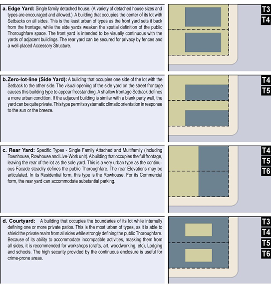
"Lot Frontage." The property line of a site abutting a street, other than the street side line of a corner lot.
"Lot Line or Property Line." Any recorded boundary of a lot. The types of lot lines are as follows:
1.
"Front Lot Line." On an interior lot, the property line separating the parcel from the street. The front line on a corner lot is the line with the shortest frontage. If the street fronting lot lines of a corner lot are equal in length, the front lot line shall be determined by the Development Services Director or his or her designee. On a double frontage lot, both lot lines are front lot lines and the lot is considered to have no rear lot line.
2.
"Interior Lot Line." Any lot line not abutting a street that is not a rear lot line.
3.
"Rear Lot Line." A property line that does not intersect the front lot line, which is most distant from and most closely parallel to the front lot line.
4.
"Side Lot Line." Any lot line that is not a front or a rear lot line.
5.
"Street Side Lot Line." On a corner lot, the lot line with the longest frontage.
"Lot or Parcel." A recorded lot or parcel of real property lawfully created as required by applicable Subdivision Map Act and City ordinance requirements, including this Zoning Ordinance. Types of lots include the following:
1.
"Corner Lot." A lot located at the intersection of two or more streets, where they intersect at an interior angle of not more than one hundred thirty-five degrees. If the intersection angle is more than one hundred thirty-five degrees, the lot is an interior lot.
2.
"Flag Lot." A lot having access from the building site to a public street by means of private right-of-way strip.
3.
"Interior Lot." A lot abutting only one street.
4.
"Reverse Corner Lot." A corner lot the side line of which is substantially a continuation of the front property line of the first lot to its rear.
5.
"Double Frontage Lot." An interior lot with frontage on two generally parallel streets.
"Lot, Depth." The average linear (or mean horizontal) distance between the front and rear lot line lines or between the front lot line and the intersection of the two side lot lines if there is no rear not line.
"Lot, Width." The horizontal distance between the side lot lines.
"Maintenance/Repair Service Client Site Services." Base facilities for various businesses that provide services on the premises of their clients. Includes gardening, janitorial, pest control, water and smoke damage recovery, and similar services; and maintenance/repair services for appliances, computers, electronics, elevators, equipment, HVAC, instrument, where the service is provided on the client site.
"Maintenance/Repair Service Equipment, Appliances." A business that provides repair and/or maintenance services for appliances, computers, electronics, and other types of non-vehicular related equipment that is brought to the facility by the client. These businesses do not operate on the same site as a retail establishment that sells the product being maintained or repaired. When these services operate from a retail establishment that sells the products being maintained or repaired, they are instead considered part of the retail use.
"Manufactured/Mobile Home." A structure, transportable in one or more sections, which, in the traveling mode, is eight body feet or more in width, or forty body feet or more in length, or, when erected on site, is three hundred twenty or more square feet, and which is built on a permanent chassis and designed to be used as a dwelling with or without a permanent foundation when connected to the required utilities, and includes the plumbing, heating, water heating, and electrical systems contained therein; except that such term shall include any structure which meets all the requirements of this paragraph except the size requirements and with respect to which the manufacturer voluntarily files a certification and complies with the standards established under this part. California Health and Safety Code Section 18007.
"Manufacturing/Processing Heavy." A facility accommodating processes that involve and/or produce basic metals, chemicals, hot-processed metals, glazing fabrication, paper products, machinery, textiles, and/or transportation equipment where the intensity and/or scale of operations may cause significant impacts on surrounding land uses or the community.
"Manufacturing/Processing Light." A facility accommodating manufacturing processes and establishments engaged in the assembly, fabrication, and conversion of already processed raw materials into products, where the operational characteristics of the manufacturing processes and the materials used are unlikely to cause significant impacts on surrounding land uses or the community. Examples of light manufacturing uses include the following: Clothing and fabric product manufacturing, metal products fabrication including of building materials, machine and welding shops, electronics, equipment, and appliance manufacturing, paper product manufacturing, food and beverage product manufacturing, photo/film processing lab (Does not include small-scale photo, handcraft industries, small-scale manufacturing, processing machines accessory to other retail businesses).
"Market Hall." An open hall that contains a minimum of three retail enterprises (no maximum) all sharing one large open area.
"Meals Assembly." A facility that provides a location for clients to assemble meals from ingredients and take them offsite for cooking and consumption. Meals may also be assembled onsite for clients to pickup at the facility. No eating facilities are provided.
"Media Production." Facilities for motion picture, television, video, sound, computer, and other communications media production.
"Medical Service Health Care Facility." A facility, place, or building that is maintained and operated to provide medical care. Includes nursing homes, intermediate care facilities, medical clinics, and home health agencies, all of which are licensed by the California State Department of Health Services, and defined in Health and Safety Code Section 1200 et seq.
"Medical Service—Major." Hospitals and similar facilities engaged primarily in providing diagnostic services, and extensive medical treatment, including surgical and other hospital services. These establishments have an organized medical staff, inpatient beds, and equipment and facilities to provide complete health care. May include on-site accessory clinics and laboratories, accessory retail uses and emergency heliports (see the separate definition of "Accessory Retail Uses").
"Medical Service—Minor." A facility other than a hospital where medical, dental, mental health, surgical, and/or other personal health care services are provided on an outpatient basis. Includes medical offices (for example offices for chiropractors, dentists, medical doctors, optometrists, prescription opticians, psychologists, etc.), outpatient facilities which may include surgery, urgent care facilities, dental laboratories, and medical laboratories. Counseling services by other than medical doctors or psychologists are included under "Offices—Professional."
"Mixed Use." Multiple Functions within the same building through superimposition or adjacency, or in multiple buildings by adjacency.
"Mobile Home, RV, and Boat Sales." Retail establishments selling mobile home dwelling units and/or various vehicles and watercraft for recreational uses. Includes the sales of boats, campers and camper shells, jet skis, mobile homes, motor homes, and travel trailers.
"Monument Sign." A ground sign having a horizontal dimension greater than its vertical dimension. This sign type is not allowed.
"Mortuary, Funeral Home." Funeral homes and parlors, where deceased are prepared for burial or cremation, funeral services may be conducted.
"Multifamily." See Dwelling, Multiple.
"Office." This Code distinguishes between the following types of offices. These do not include medical offices (see "Medical Service—Minor").
1.
"Accessory." An office facility incidental and accessory to another business or sales activity that is the primary use. These are permitted accessory to any other use allowed in all zones established by this code.
2.
"Business/Service." An establishment providing direct services to customers. Examples of these uses include employment agencies, insurance agent offices, real estate offices, travel agencies, utility company offices, etc. This use does not include "Bank, Financial Services," which is separately defined.
3.
"Government." An administrative, clerical, or public contact and/or service office of a local, state, or federal government agency. Includes post offices, but not bulk mailing distribution centers.
4.
"Processing." An office-type facility characterized by high employee densities, and occupied by businesses engaged in information processing, and other computer-dependent and/or telecommunications-based activities. Examples of these uses include: Reservation centers for airlines or rental cars, computer software and hardware design and development, consumer credit reporting, data processing services, health management organization (HMO) offices where no medical services are provided, insurance claim processing, mail order and electronic commerce transaction processing, telecommunications facility design and management, telemarketing.
5.
"Professional/Administrative." An office-type facility occupied by businesses that provide professional services and/or is engaged in the production of intellectual property. Examples of these uses include: Accounting, auditing and bookkeeping services, financial management and investment counseling, advertising agencies, literary and talent agencies, attorneys, management and public relations services, commercial art and design services, media production services, construction contractors (office facilities only), news services, counseling services, photographers and photography studios, court reporting services, psychologists, detective agencies and similar services, secretarial, stenographic, word processing, and design services including architecture, engineering, temporary clerical employee services, landscape architecture, urban planning, security and commodity brokers, educational, scientific and research organizations, writers' and artists' offices.
"Park." City owned land whose primary purpose is recreation, includes, but is not limited to, playfields and courts, swimming pools, recreational facilities, community gardens, playgrounds, trails, and nature preserves.
"Parking, Structured." Includes both day-use and long-term public and private commercial garages and structures.
"Parking, Surface Lot." Surface parking lots are allowed only in the rear half of a lot, except in Transect Civic Parking where it is allowed throughout the lot but must be screened from all Frontages.
"Personal Services—Restricted." Personal services that may tend to have a potentially offensive effect upon surrounding areas and which may need to be dispersed to minimize their adverse impacts. Examples of these uses include: Check cashing stores, soup kitchens, fortune tellers, spas and hot tubs for hourly rental, palm and card readers, tattoo and body piercing services, psychics.
"Personal Services." Establishments providing non-medical services to individuals as a primary use. Examples of these uses include: Barber and beauty shops, massage (licensed, therapeutic, non-sexual), clothing rental, pet grooming with no boarding, dry cleaning pick-up stores with limited equipment, shoe repair shops, home electronics and small appliance repair, tailors, laundromats (self service laundries), tanning salons, locksmiths. These uses may also include accessory retail sales of products related to the services provided.
"Plant Nursery." A commercial agricultural establishment engaged in the production of ornamental plants and other nursery products, grown under cover either in containers or in the soil on the site, or outdoors in containers. The outdoor production of ornamental plants in the soil on the site is instead included under "Crop Production, Horticulture, Orchard, Vineyard." Also includes establishments engaged in the sale of these products (e.g., wholesale and retail nurseries) and commercial-scale greenhouses. The sale of house plants or other nursery products entirely within a building is also included under "General Retail."
"Principal Frontage." See Frontage.
"Printing and Publishing." A small scale establishment engaged in printing by letterpress, lithography, gravure, screen, offset, or electrostatic (xerographic) copying; and other establishments serving the printing trade such as bookbinding, typesetting, engraving, photoengraving and electrotyping. This use also includes establishments that publish newspapers, books and periodicals; establishments manufacturing business forms and binding devices. "Quick printing" services are included in the definition of "Business Support Services."
"Private Frontage." See Frontage.
"Public Frontage." See Frontage.
"Public Safety Facility." A facility operated by a public agency including fire stations, other fire prevention and fire fighting facilities, police and sheriff substations and headquarters, including interim incarceration facilities.
"Push Cart." A non-motorized mobile vending cart on wheels no larger than ten feet by five feet which may be used for the purpose of selling food, clothing, jewelry, artwork, tools, and for providing services, including watch repair, shoe shine and repair, and bicycle maintenance.
"Rear Lane or Alley." A vehicular way located to the rear of Lots providing access to service areas, parking, and outbuildings.
"Recreational Facility (Indoor)." A fitness center, gymnasium, health and athletic club, which may include any of the following: Sauna, spa or hot tub facilities; indoor tennis, handball, racquetball, archery ranges and other indoor sports activities. Does not include adult entertainment businesses.
"Recycling Facility." This land use type includes a variety of facilities involved with the collection, sorting and processing of recyclable materials. Recyclable materials include reusable domestic containers and other materials which can be reconstituted, re-manufactured, or reused in an altered form, including glass, metals, paper and plastic. Recyclable material does not include refuse or hazardous materials.
"Religious Assembly." A permanent facility operated by a religious organization exclusively for worship, or the promotion of religious activities, including accessory uses on the same site. Examples of these types of facilities include churches, mosques, synagogues, and temples. Examples of allowable accessory uses on the same site include living quarters for ministers and staff, facilities for child day care and religious instruction operated at the same time as religious services (where authorized by the same type of land use permit required for the religious facility itself). May also include fund-raising sales, bazaars, dinners, parties, or other indoor and outdoor events on the same site. Other facilities maintained by religious organizations, including full-time day care centers, full-time educational institutions, hospitals and other potentially related operations (for example, a recreational camp) are defined in this Article according to their respective activities. Does not include the temporary use of an approved public assembly facility (for example, a private meeting hall, community center, theater, or auditorium) by a congregation for religious meetings, which is instead defined under the type of meeting facility hosting the congregation.
"Research and Development (R&D)." A facility for scientific research, and the design, development and testing components in advance of product manufacturing, and the assembly of related products from parts produced off-site, where the manufacturing activity is secondary to the research and development activities. Uses which may involve chemicals or processes listed by Greenseal Standards 11, 34, 36 and 47 or listed as a candidate chemical of High Concern by the EU Commission on Registration, Authorization and Evaluation of Chemicals (REACH) are designated as Laboratory—Medical, Analytical and Research.
"Residential Care Facilities for the Chronically Ill (RCFCI)." Facilities with a maximum licensed capacity of twenty-five. Care and supervision is provided to adults who have Acquired Immune Deficiency Syndrome (AIDS), the Human Immunodeficiency Virus (HIV) and other similar chronic illnesses.
"Residential Care Facilities for the Elderly (RCFE)." Provide care, supervision and assistance with activities of daily living, such as bathing and grooming. They may also provide incidental medical services under special care plans.
The facilities provide services to persons sixty years of age and over and persons under sixty with compatible needs. RCFEs may also be known as assisted living facilities, retirement homes and board and care homes. The facilities can range in size from six beds or less to over one hundred beds. The residents in these facilities require varying levels of personal care and protective supervision. Because of the wide range of services offered by RCFEs, consumers should look closely at the programs of each facility to see if the services will meet their needs.
"Residential." Characterizing premises available for long-term human dwelling.
"Restaurant, Cafe, Coffee Shop." A retail business selling ready-to-eat food and/or beverages for on- or off-premise consumption. These include eating establishments where customers are served from an ordering counter for either on- or off-premise consumption ("counter service"); establishments where customers are served food at their tables for on-premise consumption ("table service"), which may also provide food for take-out; and exclusively pedestrian-oriented facilities that serve from a walk-up ordering counter. This use does not include a mobile food vendor.
"Retail, General." This use category includes all retail establishments which are not otherwise listed in Table 1, Land Uses, or restricted elsewhere in the code. General retail includes establishments selling clothing, furniture, gifts, skin and hair products, tools, books, etc.
"School—Specialized Education and Training." A private academic educational institution, providing specialized education/training. Examples include the following: Art school, establishments providing courses by mail, ballet and other dance school, language school, business, secretarial and vocational, music school, computers and electronics school, professional school (law, medicine, etc.), drama school, seminaries/religious ministry training facility, driver education school.
Also includes facilities, institutions and conference centers that offer specialized programs in personal growth and development, such as fitness, environmental awareness, arts, communications, and management. Does not include pre-schools and child day care facilities (see "Child Day Care Facilities"). See also the definition of "Studios—Art, Dance, Martial Arts, Music, etc." for smaller-scale facilities offering specialized instruction.
"Secondary Frontage." See Frontage.
"Setback, Front." The required area extending across the full width of a site measured from the front property line, street plan line, or access easement to the primary structure. The depth of the front setback is measured as the minimum horizontal distance between the front property line, street plan line, or access easement and a line parallel thereto with the required minimum distance determined by the development standards for the applicable zoning district.
"Setback, Rear." The required area extending across the full width of a site measured from the rear lot line and a structure. The depth of a rear setback is measured as the minimum horizontal distance between the rear property line and a line parallel thereto with the required minimum distance determined by the development standards for the applicable zoning district.
"Setback, Side." The required area extending from the front property line, street plan line, or access easement to the rear property line. The width of a side setback is the minimum horizontal distance between an interior side property line and a line parallel thereto with the required minimum distance determined by the development standards for the applicable zoning district.
"Setback, Street Side." The required area extending from the front property line, street plan line, or access easement to the rear property line. The width of a street side setback is the minimum horizontal distance between the street side property line and a line parallel thereto with the required minimum distance determined by the development standards for the applicable zoning district for a corner or reverse corner lot.
"Setback." The area of a Lot measured from the Lot line to a building Facade or Elevation that is maintained clear of permanent structures, with the exception of encroachments.
"Shopfront." See Storefront/Shopfront.
"Special Event Sign." A sign authorized through the SV-PD Design Review Board for the purposes of a special event or activity.
"Sports and Entertainment Assembly Facility." A large-scale indoor or outdoor facility accommodating spectator-oriented sports, concerts, and other entertainment activities. Examples of this land use include amphitheaters, race tracks, stadiums and coliseums. May also include commercial facilities customarily associated with the above uses, including bars and restaurants, gift shops, video game arcades, etc.
"Stoop." A Private Frontage wherein the Facade is aligned close to the Frontage Line with the first Story elevated from the Sidewalk for privacy, with an exterior stair and landing at the entrance.
"Storage—Outdoor Storage Yard." The open storage of various materials outside of a structure other then fencing, either as an accessory or principal use.
"Storage—Warehouse, Indoor Storage." Facilities for the storage of commercial goods of any nature. Includes cold storage. Does not include storage or mini-storage facilities offered for rent or lease to the general public (see also "Wholesaling and Distribution" and "Truck or Freight Terminal").
"Storefront/Shopfront." A Private Frontage for Retail use, with no less than seventy percent of the width of the Facade glazed in clear glass, having an awning overhanging the sidewalk, and wherein the Facade is aligned close to the Frontage Line with the building entrance at Sidewalk grade. The first floor shall be confined to Retail use through the first thirty feet in depth.
"Story." A habitable level within a building, excluding an Attic or raised basement.
"Street." A public or private right-of-way which provides a public means of access to abutting property. The term "street" shall include avenue, drive, circle, road, parkway, boulevard, highway, thoroughfare, or any other similar term, but not alley. The term shall include the total width of the dedicated right-of-way.
"Street Screen." An artistic wall with plants, murals or other decorative artwork, and is used to improve the quality of pedestrian life by partially obscuring a parking lot in the rear.
"Structure, Accessory Detached." An accessory building or structure with a minimum separation from a primary structure or building of at least three feet. For purposes of measurement, roof eaves and overhangs, bays, balconies, and other projections shall be considered points of reference. For the purposes of this code, any structure not meeting the separation requirement is considered attached to the primary structure and is subject to the development standards for the primary structure.
"Structure, Accessory." A building or structure normally subordinate, and the use of which is incidental, to the primary use of the site.
"Structure." Anything constructed or erected which requires location on the ground or which is attached to something having location on the ground, excluding vehicles designed and used only for the transportation of people or goods, a swimming pool or spa, a fence, or a wall used as a fence.
"Studio Art, Dance, Martial Arts, Music, etc." Small scale facilities, typically accommodating one group of students at a time, in no more than one instructional space. Larger facilities are included under the definition of "Schools—Specialized education and training." Examples of these facilities include: Individual and group instruction and training in the arts; production rehearsal; photography, and the processing of photographs produced only by users of the studio facilities; martial arts training studios; gymnastics, yoga and similar instruction; and aerobics and gymnastics studios with no other fitness facilities or equipment.
"Swimming Pool." A pool, pond, land, or open tank intended for swimming or recreational bathing that contains water over eighteen inches deep. "Swimming pool" includes in-ground and above ground pools, hot tubs and spas and portable spas, non-portable wading pools and interactive spray parks.
"Telecommunication Facility." A facility that transmits and/or receives electromagnetic signals. Includes antennas, microwave dishes, horns, and other types of equipment for the transmission or receipt of such signals, telecommunication towers or similar structures supporting said equipment, equipment buildings, parking area, and other accessory development. Private, residential telecommunication equipment is not a part of this use.
"Theater." See also Cinema. An indoor facility for public assembly and group entertainment, other than sporting events. Examples of these facilities include: Civic theaters, and facilities for live theater and concerts, similar public assembly facilities.
"Thoroughfare." An assembly of sidewalks, planters, parking lanes, bicycle lanes, and driving lanes. See Section 5.
"Townhome." A single family dwelling of two or three stories which is attached to at least two other similar dwellings in a row.
"Transect Zone." One of several areas on a Zoning Map within the SVPD. Transect Zones are administratively similar to the land use zones in conventional codes, except that in addition to the usual building use, density, height, and setback requirements, other elements of the intended habitat are integrated, including those of the private lot and building and public frontage.
"Transitional Housing." A facility for residence and care of people moving out of Homeless Shelters or other care facilities who are not yet able to live on their own. May include minor accessory uses of related services such as counseling, job placement and training. Usual tenure is less than three years. Further restrictions in locating Transition Housing may be made on the basis of proximity to schools, daycare, playgrounds and other sensitive uses.
"Use, Accessory." A use customarily incidental to, related and clearly subordinate to a primary use on the same parcel, which does not alter the primary use nor serve property other than the parcel where the primary use is located. See also "Primary Use."
"Use, Conditional." A use of a site for which application for and approval of a Conditional Use Permit is required.
"Use, Permitted." For the purpose of this article, a permitted use in any district shall include any use listed as a Permitted Principal Use or Accessory Use.
"Use, Primary." The main purpose for which a site is developed or occupied, including the activities that are conducted on the site a majority of the hours during which the activities occur.
"Vehicle Services." The repair, servicing, alteration, restoration, towing, or cleaning of personal vehicles no greater than eighteen feet in length as a primary use, including the incidental wholesale and retail sale of vehicle parts as an accessory use. Painting and finishing is prohibited except for minor applications of touch-up paint. This use is limited to minor maintenance and repair such as car stereo and alarm installers and detailing services, and specifically excludes painting (except for minor application of touch-up paint), finishing, tires, car wash structures, collision repair and other body work, quick-lube services or dismantling.
"Veterinary Clinic, Animal Hospital." Office and indoor medical treatment facilities used by veterinarians, including large and small animal veterinary clinics, and animal hospitals.
"Wall Sign." Any sign attached to or painted on the wall of a building or structure in a plane parallel or approximately parallel to the plane of said wall.
"Water Cistern." A container storing rainwater collected from a building's roof or containing fully treated greywater. A Water Cistern must be placed within ten feet of a building. It may be up to twenty feet tall, but in no case may it exceed the height of the adjacent building. Structural support for the slab it sits on and to ensure seismic safety will be reviewed and approved by engineering on a case-by-case basis.
"Wayfinding/Directional Sign." Sign that is designed and erected for the sole purpose of directing vehicular, bicycle and/or pedestrian traffic within a project.
"Wholesaling and Distribution." Establishments engaged in selling merchandise to retailers; to contractors, industrial, commercial, institutional, farm, or professional business users; to other wholesalers; or acting as agents or brokers in buying merchandise for or selling merchandise to such persons or companies. Examples of these include: Agents, merchandise or commodity brokers, and commission merchants, assemblers, buyers and associations engaged in the cooperative marketing of farm products, merchant wholesalers, stores primarily selling electrical, plumbing, heating and air conditioning supplies and equipment.
"Yard." An open space on the same site as a structure, unoccupied and unobstructed from the ground upward.
"Zoning District." Any of the residential, commercial, public, or overlay districts established by this Zoning Code (Zoning Districts, Allowable Land Uses and Permit Requirements), within which certain land uses are allowed or prohibited, and certain site planning and development standards are established (e.g., setbacks, height limits, site coverage requirements, etc.).
"Zoning." The act of regulating the use of land and the size of and location of buildings on the land, such regulations are designed to assure the health, safety and general welfare of a community.
"Zoning/Regulating Plan." The official map or maps that are part of the zoning ordinance and delineate the boundaries of individual zones and districts. See Figure 2. SVPD Zoning and Regulating Plan.
(Ord. No. 952, § 4(Exh. A), 3-23-2021; Ord. No. 960, § 7, 3-22-2022; Ord. No. 991, § 4(Exh. A, § 3), 1-27-2026)