
Rolling Hills Estates
City Zoning Code
City Zoning Code
CHAPTER 17
07 - GRADING IN RESIDENTIAL DISTRICTS
17.07.010 - Purpose.
A.
The purpose of this chapter is to preserve and promote the city's rural character through development that protects the hillsides and topography and the public health, safety and general welfare of residents of the city.
B.
This purpose shall be accomplished by establishing grading standards to encourage a sensitive form of development, while still allowing for reasonable economic enjoyment of properties, and uses that complement the natural and visual character of the city and its hillsides. Further, it is the intent of this chapter to discourage mass grading of large pads, excessive terracing, severe cutting, scarring, soil erosion, slide damage, and flooding problems.
(Ord. 557 § 1 (part), 1993)
17.07.020 - Definitions.
In addition to the definitions listed in Section 17.02.020, the following words shall have the following meanings:
"Building official" means the city engineer of the county of Los Angeles building and safety department.
"Civil engineer" means a professional engineer in the branch of civil engineering holding a valid certificate of registration issued by the state of California.
"Fill" means deposits of soil, rock or other similar irreducible materials placed by man.
"Finished grade" means the elevation of the ground surface established by grading that establishes the final elevation shown on the approved design.
"Geologist" means a person holding a valid certificate of registration as a geologist in the specialty of engineering geology issued by the state of California under provisions of the Geologist and Geophysicists Act of the Business and Professions Code.
"Grade" means any excavation or fill or combination thereof. The rate of rise or descent of a sloping surface usually expressed in degrees or percent.
"Natural grade" means the vertical location of the ground surface prior to any excavation or fill.
"Site" means any lot or parcel of land or contiguous combination thereof, under the same ownership, where grading is proposed or performed.
"Slope" means an inclined ground surface, the inclination of which is expressed as a ratio of horizontal distance to vertical distance.
"Soil" means all earth material of whatever origin that overlies bedrock.
"Soils engineer" means a civil engineer experienced in soil mechanics who investigates and reports on the stability of existing or proposed slopes, controls the installation and compaction of fills, recommends soil bearing values and calculations for special earth structures such as buttress fills.
(Ord. 557 § 1 (part), 1993)
17.07.030 - Grading approval requirements.
A.
Grading approval shall be required by the planning director for any of the following:
1.
An excavation or fill of earth materials greater than one foot and less than or equal to three feet in vertical height at its deepest point;
2.
Any importation or exportation of earth materials greater than ten and less than or equal to twenty cubic yards.
B.
Grading approval shall be required by the planning commission for any of the following:
1.
Any excavation or fill of earth materials greater than three feet in vertical height at its deepest point;
2.
Any importation or exportation of earth materials greater than twenty cubic yards;
3.
Any grading on a slope equal to or greater than thirty-five percent.
(Ord. 557 § 1 (part), 1993)
17.07.040 - Grading approval exceptions.
Grading approval shall not be required for the following:
A.
An excavation or fill less than one foot in vertical height at its deepest point and/or an exportation or importation of earth materials less than ten cubic yards.
B.
An excavation below finished grade for basements and footings or structures, swimming pools and sewers authorized by a valid building permit or any excavation specifically authorized by any ordinance, or an excavation in any public way or street.
C.
Any cut or fill associated with repairing or replacing existing driveways providing that there is no change to the location and elevation of the driveway.
D.
The depositing of solid waste or other material at any refuse disposal facility operated under a permit granted according to the terms of Division 4, entitled "Solid Waste," of Title 20 of the Los Angeles County Code.
E.
An excavation, fill and/or measures approved by the Solid Conservation District or cooperative agency of the Department of Agriculture.
F.
Any cut or fill associated with repairing or replacing existing landscaping providing there is no significant change in finished grade(s).
G.
Any cut or fill by the road department in connection with and necessary to the support, construction, or maintenance of a public road when such is located within an easement granted to the city for road or slope purposes.
H.
Exploratory excavations under the direction of soils engineers or engineering geologists.
(Ord. 629 § 12, 2005; Ord. 557 § 1 (part), 1993)
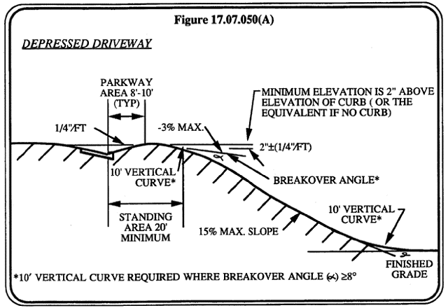
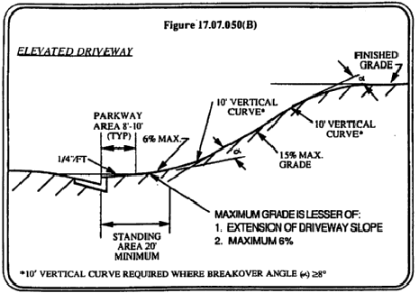
17.07.050 - Driveways.
The following standards for newly constructed driveways shall apply:
A.
Driveways shall not be permitted which exceed a fifteen percent slope. Driveways shall have a minimum standing area of twenty feet at point of access.
B.
Retaining walls not exceeding two feet in front setbacks and five feet behind the front setback shall be permitted for soil stabilization adjacent to a driveway.
(Ord. 557 § 1 (part), 1993)
17.07.060 - Application process.
A separate approval is required for each site. A single approval shall include both a cut and a fill on the same site. An application shall be submitted to the city for any grading requiring planning director and/or planning commission approval. The planning director may waive any of the requirements listed below for projects not requiring planning commission and building and safety approval.
A.
Application. To obtain grading approval, the applicant must first file an application in writing on a form furnished for that purpose. Every application shall:
1.
Describe the land on which the proposed work is to be performed by lot, block, tract, and by a street address or by similar description sufficient to readily identify and definitely locate the site;
2.
State the name and address of the following persons:
a.
Owner of said land,
b.
Person performing the work,
c.
Field engineer, if applicable;
3.
Be accompanied by plans, specifications and calculations as required (refer to "Plans and Specifications" in subsection B of this section);
4.
State the volume of the material to be handled;
5.
Provide the property owner's or authorized agent's signature. An agent may be required to submit evidence of his or her authority;
6.
Give other information, as may be required, by the city and/or building official.
B.
Plans and Specifications. With each application for grading approval, three sets of plans and specifications shall be submitted. Additional sets of plans may be required for planning commission and city council. The plans shall be prepared and signed by a civil engineer and shall include the following information:
1.
A vicinity sketch or other means of adequately indicating the site location;
2.
Boundary lines of the property on which the work is to be performed;
3.
Each lot or parcel of land into which the site is proposed to be divided;
4.
All of the proposed uses of the site and, if the site is to be divided, the proposed use of each lot or parcel of land;
5.
Location of any existing buildings or structures on the property where the work is to be performed, and the location of any buildings or structures on adjacent land which are within fifteen feet of the property line;
6.
Accurate contours showing the topography of the existing ground;
7.
Elevations, location, extent and slope of all proposed grading shown by contours, cross sections or other means, drainage information and location of any rock disposal areas, buttress fills or other special features, if such are proposed to be included in the work;
8.
Any additional information as deemed necessary by the planning director.
(Ord. 557 § 1 (part), 1993)
17.07.070 - Fees.
Each application for grading approval filed with the city shall be accompanied by a fee, as established by resolution of the city council. Such fee shall be collected at the time the completed application is submitted to the city for review.
(Ord. 557 § 1 (part), 1993)
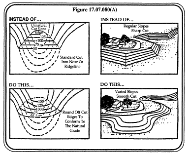
17.07.080 - Grading standards and design criteria for all zoning districts.
Grading of any site, based upon the percent of the natural slope, shall conform to the following standards:
A.
Zero to fifteen percent. Redistribution of earth over large areas may be permitted.
B.
Fifteen to twenty-five percent. Some grading may occur, but landforms shall retain their natural character.
C.
Twenty-five to thirty percent. Limited grading may occur, but landforms and major topographic features shall retain their natural character.
D.
Greater than thirty percent. Limited grading may be permitted if it can be clearly demonstrated that safety, environmental and aesthetic impacts will be avoided.
E.
Grading shall be designed to:
1.
Conserve natural topographic features and appearances by means of land sculpturing to blend graded slopes and benches with natural topography;
2.
Retain major natural topographic features such as canyons and prominent landmarks.
F.
Grading Setbacks. Cut and fill slopes shall be set back from site boundaries in accordance with this section. Setback dimensions shall be horizontal distances measured perpendicular to the site boundary.
1.
Top of Cut Slope. The top of cut slopes shall not be made nearer to a site boundary line than one-fifth of the height of cut with a minimum of two feet and a maximum of ten feet. The setback may need to be increased for any required interceptor drains;
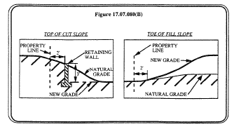
2.
Toe of Fill Slope. The toe of the fill slope shall not be made nearer to the site boundary line than one-half the height of the slope with a minimum of two feet and maximum of twenty feet. Where a fill slope is to be located near the site boundary and the adjacent off-site property is developed to such grading, special precautions shall be incorporated in the work as the building official deems necessary to protect the adjoining property from damage as a result of such grading. These precautions may include, but are not limited to:
a.
Additional setbacks,
b.
Provision for retaining or slough walls,
c.
Mechanical or chemical treatment of the fill slope surface to minimize erosion,
d.
Provisions for the control of surface waters;
3.
Modification of Slope Location. The setback and other restrictions imposed by this section may be increased where unusual soil or geologic conditions make such increase necessary for safety and stability or may be modified upon investigation and recommendation by a soil engineer or geologist where such modification will provide equivalent safety, stability and protection and the building official so finds.
(Ord. 557 § 1 (part), 1993)
17.07.090 - Criteria for evaluation.
The planning director and/or the planning commission shall use but not be limited to the following criteria in assessing an application for grading approval:
A.
The grading is not excessive beyond that necessary for the permitted primary use of the lot.
B.
The grading and/or construction does not significantly adversely affect the visual relationships with, nor the views from, neighboring sites.
C.
The nature of the grading minimizes disturbance to the natural contours; finished contours are reasonably natural.
D.
The nature of the grading is in conformance with the neighborhood compatibility ordinance as set forth in Section 17.62.010.
E.
The proposed grading meets the grading standards and design criteria as set forth in Section 17.07.080.
(Ord. 557 § 1 (part), 1993)
17.07.100 - Conditions upon issuance.
In granting any grading approval, the planning director and/or the planning commission may attach such conditions thereto as may be reasonably necessary to prevent danger to public or private property, to prevent the operation from being conducted in a manner likely to create a nuisance, or to preserve any intent of any goal or policy of the general plan. Such conditions may include, but shall not be limited to:
A.
Limitations on the hours of operation in which work may be performed.
B.
Designation of routes upon which materials may be transported and means of access to the site.
C.
The place and manner of disposal of excavated materials and/or acquisition and stockpiling of fill materials.
D.
Requirements as to the mitigation of dust and dirt, the prevention of noises and other results offensive or injurious to the neighborhood, the general public or any portion thereof, including due consideration, care and respect for the property rights, convenience and reasonable desires and needs of said neighborhood or any portion thereof.
E.
Designation of maximum or minimum slopes to be used.
F.
Regulations as to the use of public streets and places in the course of the work.
G.
Landscaping, in addition to the minimum required by Chapter 70 of the County Uniform Building Laws.
H.
A performance bond to cover landscaping or other conditions under this chapter.
(Ord. 557 § 1 (part), 1993)
17.07.110 - Grounds for denial.
Whenever, in the judgment of the planning director and/or planning commission, the proposed work is determined to not be in conformance with the criteria listed in Section 17.07.090, the application may be denied.
(Ord. 557 § 1 (part), 1993)
17.07.120 - Appeal.
The petitioner or any other interested person may appeal any decision or condition of the planning director to the planning commission and any decision of the planning commission to the city council by filing a written request, together with an appeal fee as established by resolution of the city council, with the city within twenty days after the decision is made.
(Ord. 557 § 1 (part), 1993)
17.07.130 - Reserved.
Editor's note— Ord. No. 668, § 1, adopted Oct. 12, 2010, repealed § 17.07.130, which pertained to expiration and derived from Ord. No. 557, § 1 (part), adopted 1993.