
Saint Louis County Unincorporated
City Zoning Code
City Zoning Code
1003.162
Landscaping and Screening Regulations.
—1. Scope of provisions. This section contains the landscaping and screening regulations that apply to all zoning districts. Developments subject to the conditional use permit procedure or planned district approval process may be required to exceed the requirements of this section. Single-family residential units on platted lots are not subject to the requirements of this section. The intent is to preserve and enhance the landscape character of St. Louis County; improve the aesthetic quality of the built environment; promote retention and protection of existing vegetation; reduce the impacts of development on wetlands, streams and the natural environment; and enhance the value of current and future development.
2.
General regulations—Landscaping and buffering. This section lays out the process for determining the landscaping and buffering requirements on a development site. Landscaping in the front yard, abutting a roadway is based on the zoning and use of the property. For the side and rear property lines, there are two (2) buffer zones or levels of landscaped area setback and number of plant materials. These buffer zones are determined by the use or zoning of the proposed site compared to the use or zoning of the adjacent site.
(1)
Front yard.
(a)
A twenty-foot landscape buffer shall be required in all R residence districts, NU non-urban district and KP karst preservation district, planted with a minimum of one (1) canopy tree and four (4) shrubs, or one (1) evergreen tree and four (4) shrubs per twenty (20) linear feet, rounded upward.
(b)
A fifteen (15) foot setback shall be required in all C commercial districts and M industrial districts, planted with a minimum of one (1) canopy tree and four (4) shrubs, or one (1) evergreen tree and four (4) shrubs per twenty (20) linear feet, rounded upward.
(2)
Side and rear yard. Landscaping at the side and rear property lines shall be provided as follows:
(a)
Buffer zone 1. Fifteen-foot minimum width along the property line with two (2) canopy trees and four (4) shrubs, or one (1) canopy tree and one (1) evergreen tree with four (4) shrubs per twenty (20) linear feet, rounded upward.
(b)
Buffer zone 2. Ten-foot minimum width along the property line with one (1) canopy tree and four (4) shrubs, or one (1) evergreen tree and, four (4) shrubs per twenty (20) linear feet, rounded upward.
(i)
Landscaping requirements may be reduced on infill lots and parcels with setbacks less than the required at the perimeter.
(ii)
Landscaping for form based or mixed-use districts shall be determined by the district development standards; however, parking lot perimeter landscaping may be required.
(c)
Alternative landscape plan. In lieu of these requirements, a developer can submit an alternative landscape plan for review and approval by the Department of Planning.
3.
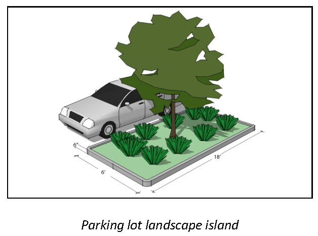
Parking lot landscaping.
(1)
New parking lots. All new surface parking lots containing twenty (20) or more off-street parking spaces shall meet the standards of this section.
(2)
Parking lot expansion. Existing surface parking lots that are expanded by twenty (20) or more spaces, shall be required to meet the standards of this section only with respect to the expanded portion of the lot.
(3)
Interior parking area landscaping.
(a)
Required landscape area. All surface parking lots shall incorporate the following minimum interior landscaping:
(i)
Landscape islands of not less than eight (8) feet by eighteen (18) feet at the terminus of each row of parking that contain one (1) tree and at least fifty (50) percent vegetative cover other than turf grass (see figure to right);
(ii)
Within the parking rows, one (1) landscaped island of not less than eight (8) feet by eighteen (18) feet for each ten (10) parking spaces or fraction thereof that contains one (1) tree and at least fifty (50) percent vegetative cover other than turf grass.
(iii)
A landscape median strip with a minimum width of six (6) feet incorporated into the parking lot design to delineate the driveway entrance into the parking lot. One (1) tree minimum shall be planted for every forty (40) feet of median.
(b)
Landscape island design.
(i)
Required landscape islands shall not be separated by more than ten (10) parking spaces. For purposes of determining tree spacing, parking spaces may be counted in any rational sequence.
(ii)
Curbs used to protect landscape islands shall have eighteen (18) inch wide curb notches at frequent intervals to allow stormwater infiltration.
(c)
Landscape strips and/or swales. Continuous landscape strips may be used in place of individual landscaped islands if they comply with the following standards:
(i)
The minimum width of a landscape strip shall be six (6) feet and the minimum length shall be seventy-two (72) feet.
(ii)
The landscape strip shall contain a minimum of one (1) tree every eighteen (18) feet and at least fifty (50) percent vegetative cover other than turf grass.
(iii)
If the size of the parking space is reduced due to use of curb notches and wheel stops allowing vehicles to overhang into the landscape strip, the width of the landscape strip shall be increased by at least fifty (50) percent of the reduction in the parking space paved area (example, if two (2) rows of parking spaces seventeen (17) feet long abut a landscape swale, the swale shall be a minimum of eight (8) feet in width).
(d)
Sidewalks as median strips. A landscaped median strip within a parking lot that separates either parking rows or parking lots shall be allowed to count a sidewalk located within the median strip toward a part of the required off-street parking lot landscaping. The intent of this sidewalk is to help facilitate safe pedestrian movement. This sidewalk must meet the following criteria if it is to be counted toward the required landscaping:
(i)
The sidewalk has a four-foot wide walking path and shall add two (2) feet for vehicle overhang for each abutting parking stall or shall include wheel stops for each parking space, set two and one-half (2½) feet from the end of the parking space.
(ii)
The sidewalk runs the entire length of the divider strip.
(iii)
The sidewalk is bordered on at least one (1) side by landscaping, of which the sidewalk cannot account for more than fifty (50) percent of the area of the median strip.
(4)
Exceptions.
(a)
These requirements shall not apply to parking structures. Landscape and buffer requirements may be applicable to these uses.
(b)
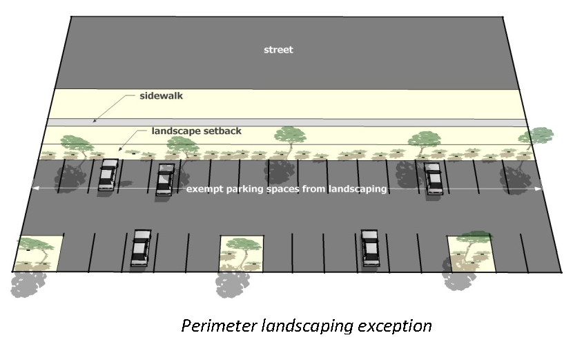
Parking spaces directly abutting a public street right-of-way are not required to have interior landscaping where the abutting landscaping meets the requirements of the perimeter landscape setback (see figure following this subsection). The remainder of the parking rows in the lot shall be landscaped pursuant to this section.
5.
Plant materials and native vegetation. This section requires the use of native landscaping for at least one-half (½) of the landscaping on site.
(1)
Plant selection and design.
(a)
The overall landscape plan shall not contain more than thirty-three (33) percent of any one (1) plant species.
(b)
Tree and plant materials shall be selected for: energy efficiency and water efficiency; adaptability and relationship to the native environment; color, form and pattern; ability to provide shade; soil retention; and resistance to fire.
(2)
Native plants.
(a)
All landscape plans must use at least fifty (50) percent native and/or drought tolerant plant materials for landscaping to be installed, as appropriate for their location. A detailed plant list shall be included with all plans.
(b)
Use of invasive plants and noxious weeds for new landscaping is prohibited. Invasive plants are listed in the Missouri Department of Conservation's Missouri Vegetation Manual. Noxious weeds are listed in the Missouri Department of Agriculture's Missouri State Noxious Weed List.
(3)
Turf grass. If turf areas are included in landscaping, they must use a sod or seed mix specifically cultivated to thrive in the conditions present at the particular site. The use of non-native and/or high water consumptive turf such as Kentucky Blue Grass is discouraged. The applicant must provide information regarding the composition of a sod or seed mix.
6.
Stream buffer setbacks. All land development activity requiring a site plan or site development plan approved by the Department of Planning or the Planning Commission, except land used for agricultural or farming purposes, or regional pedestrian/bike trails, shall meet the following minimum standards for vegetated buffers for stream protection. Stream buffers in residential subdivisions containing five (5) lots or more shall be in common ground. In large lot residential developments, single lot developments, and all other subdivisions the stream buffer may be in an easement.
(1)
For all natural waterways having a one hundred-year flood plain as depicted on the St. Louis County zoning maps, an undisturbed natural vegetative buffer shall be maintained for fifty (50) feet, measured horizontally, on both banks (as applicable) of the stream as measured from the top of the stream bank. For all other natural waterways, an undisturbed natural vegetative buffer shall be maintained for twenty-five (25) feet, measured horizontally, on both banks (as applicable) of the stream as measured from the top of the stream bank.
(2)
An additional twenty-five (25) foot building setback, measured horizontally beyond the stream buffer, shall be required.
(3)
If any waterway is required or permitted to be enclosed, the requirements for buffers or additional building setbacks may be waived by the director of planning.
(4)
All plans and plats shall, clearly show the boundaries of any stream buffers on a subject property and clearly indicate the types of natural vegetation to be retained, restored or removed from the buffer area.
(5)
The following structures, practices and activities are permitted in the stream buffer, with specific design or maintenance features, subject to review by the director of planning:
(a)
Roads, bridges and utilities (including sanitary and storm sewers). The right-of-way shall be the minimum width needed to allow for maintenance access and installation. The angle of the right-of-way or utility crossing shall be perpendicular as possible to the natural watercourse or stream buffer in order to minimize clearing requirements. Plats and site plans shall include only the minimum number possible of such crossings.
(b)
Foot trails and paths.
(6)
Stream bank stabilization and stream buffer restoration projects approved by the director of planning are permitted within the vegetated buffer.
(7)
Water quality monitoring and stream gauging are permitted within the stream buffer.
(8)
Trash and debris and individual trees within the stream buffer that are in danger of falling, causing damage to dwellings or other structures, or causing blockage of the natural watercourse may be removed.
7.
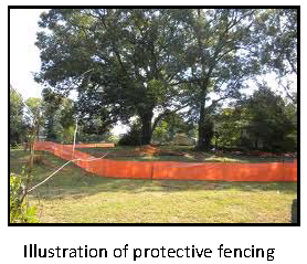
Tree protection during construction. Tree protection and retention is as approved on the site development plan. If free preservation is proposed, the developer shall take responsibility for protecting trees during construction.
(1)
Owner's responsibility. During development, the owner or developer shall be responsible for the erection of any and all barriers necessary to protect any existing or installed trees from damage both during and after construction in accordance with the standards of this subsection.
(2)
Tree protection fencing.
(a)
All significant trees intended for tree protection shall be fenced in accordance with this subsection before grading or other land-disturbing activity begins. Fencing shall extend at least one (1) foot in distance from the edge of the tree for each inch of diameter at breast height (DBH) to a maximum of ten (10) feet, but in no case closer than five (5) feet to the trunk. The director shall consider existing site conditions in determining the exact location of any tree protection fencing.
(b)
The developer shall erect a plastic mesh fence, chain link fence or similar product, a minimum of four (4) feet in height at the drip line around each tree or group of trees to prevent the placement of debris or fill within the drip line of any tree.
(c)
The tree protection fencing shall be clearly shown on the site plan or the sketch plan associated with the land disturbance permit. No construction, land disturbance, equipment or material storage, or any other activity shall be allowed within the fenced area.
8.
Fencing
(1)
General requirements.
(a)
No fence shall be greater than ten (10) feet in height.
(b)
Any fence greater than six (6) feet in height shall be subject to the setback requirements of the underlying zoning district.
(2)
"PS" Park and Scenic, "NU" Non-Urbanr"KP" Karst Preservation, and "R" Districts.
(a)
No barbed wire shall be permitted.
(3)
"C" Commercial Districts.
(a)
No barbed wire shall be permitted.
(b)
All fencing in any front yard shall be decorative.
(c)
A decorative, sight-proof fence shall be required along the property line adjacent to any parcel in the "PS" Park and Scenic, "NU" Non-Urban, "KP" Karst Preservation, "R" Residence Districts. Such fences shall be sited so that a minimum five-foot maintenance buffer is provided.
(4)
"M" Industrial Districts.
(a)
All fencing in any front yard shall be decorative. Barbed wire or chain link fence may be approved by the Director of Planning and shall be screened with dense landscaping, as directed.
(b)
Barbed wire fencing shall only be permitted adjacent to any parcel in the "PS" Park and Scenic, "NU" Non-Urban, "KP" Karst Preservation, or "R" Residence Districts if it is screened with dense landscaping as approved by the Director of Planning.
(c)
The lowest strand of barbed wire shall be seven (7) feet above the ground.
9.
Trash enclosures.
(1)
Outside storage of garbage and recycling for multiunit residential and nonresidential development shall be in suitable, covered containers and screened from view on all four (4) sides with a sight proof decorative fence and gate a minimum of six (6) feet tall. A trash enclosure shall be screened with shrubs and grasses. The location of the trash enclosure shall be approved by the Director of Planning in accordance with the following requirements:
(a)
Trash enclosures shall be located in the side or rear yard.
(b)
Trash enclosures shall be located such that trash and recycling pickup does not impede pedestrian or vehicular circulation or parking onsite.
(c)
Trash enclosures shall meet the minimum structure setbacks of the underlying zoning district.
(d)
Trash enclosures shall be located such that noise impacts upon adjoining residential development is minimized.
10.
Landscape escrow.
(1)
If the estimated cost of new landscaping indicated on the site development plan as required by this section exceeds ten thousand dollars ($10,000.00), as determined by a plant nursery, the developer shall furnish a two-year bond or escrow, or other instrument sufficient in amount to guarantee the installation of said landscaping.
(2)
This monetary guarantee shall be provided prior to approval of the site development plan.
(3)
The process for releasing landscaping funds held in escrow shall be as follows:
(a)
The developer shall provide a letter from a landscape professional stating the landscaping was installed in conformance with the approved plan and in a viable manner.
(b)
The Department of Planning will inspect landscaping upon installation, and release eighty (80) percent of the funds upon passing inspection.
(c)
The remaining twenty (20) percent of the funds shall be held for one (1) year after inspection to ensure the plants survive. The Department of Planning will re-inspect and release the remaining funds upon successful inspection.
(O. No. 29528, § 1, 2-12-26)