
Salida City Zoning Code
ARTICLE II
- ZONING DISTRICTS
Sec. 16-2-10. - General.
(a)
Base Zoning Districts Established. Table 2-A, below, lists the zoning districts established by the City. Zoning districts are established by the City's adoption of the Official Zoning Map pursuant to Subsection 16-2-10(b).
Table 2-A: Base Zoning Districts Established
(b)
Official Zoning Map.
(1)
Incorporation.
a.
The location and boundaries of the zoning districts established by this Code are shown on the "City of Salida Official Zoning Map" ("Official Zoning Map"), which is incorporated into this Code.
b.
The Official Zoning Map is filed and on display at City Hall and available for inspection during normal business hours.
(2)
Zoning District Boundaries.
a.
Except where otherwise indicated, zoning district boundaries shall follow the City's corporate limits, section lines, quarter-section lines, half-section lines, center lines of major rivers or tributaries, lot lines, center lines of City or County roads or highways, or right-of-way lines extensions of such lines.
b.
Where a zoning district boundary divides a lot or parcel, the location of such boundary, unless indicated by dimension, shall be determined by the scale of the Official Zoning Map by the Director, or via previously platted surveys.
c.
Where a zoning district boundary coincides with a right-of-way line and that right-of-way is abandoned, the zone district boundary shall then follow the centerline of the former right-of-way.
d.
Land that is not indicated as being in any zoning district shall be considered to be included in the most restrictive adjacent zoning district.
(3)
Boundary Clarification.
a.
If a zoning district boundary is unclear or disputed, the Director shall determine the location of the zoning district boundary.
b.
Any appeal of the Director's determination of the zoning district boundary shall be heard by the Planning Commission per Subsection 16-8-70(c), Appeals.
(4)
Amendment. A change to the boundary of any zoning district requires an amendment to the Official Zoning Map per Subsection 16-8-40(a), Rezoning.
(5)
Annexation. All territory annexed to the City shall be zoned within ninety (90) days as determined by the City Council, upon recommendation of the Planning Commission. The proposed zoning shall be established in accordance with applicable state statute.
(c)
Organization of this Article.
(1)
Base Zoning Districts.
a.
Content. Sections 16-2-40 through 16-2-60 of this Article follow a common structure and describe the purpose and intended character of the established zoning districts, the lot and building standards applying to development in the districts, and any district-specific development standards. The summary of key lot and building standards are illustrative and do not include the full range of requirements of this Code that may apply to a particular project. The entirety of this Code applies.
b.
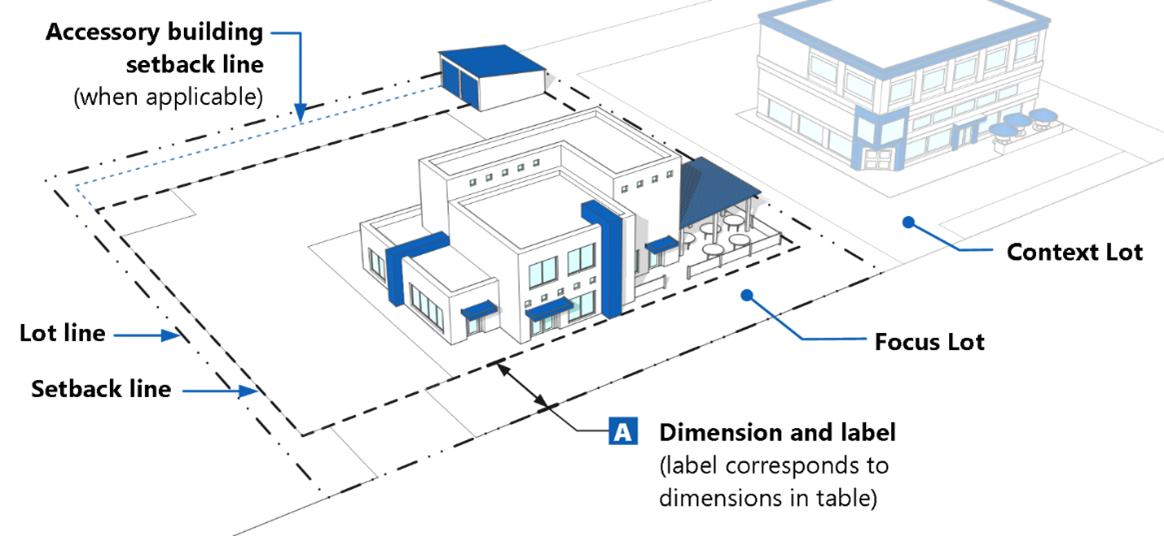
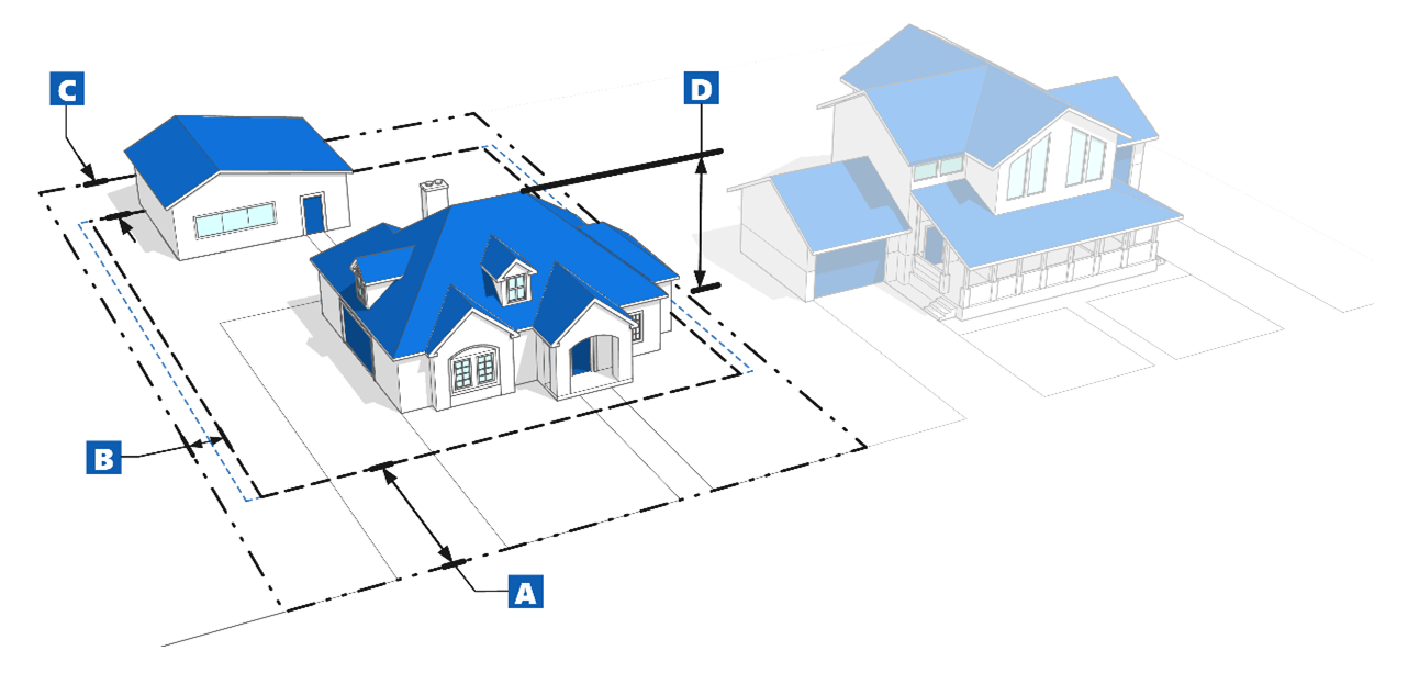
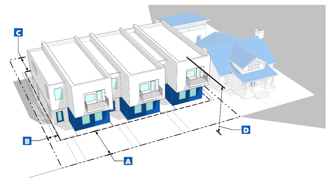
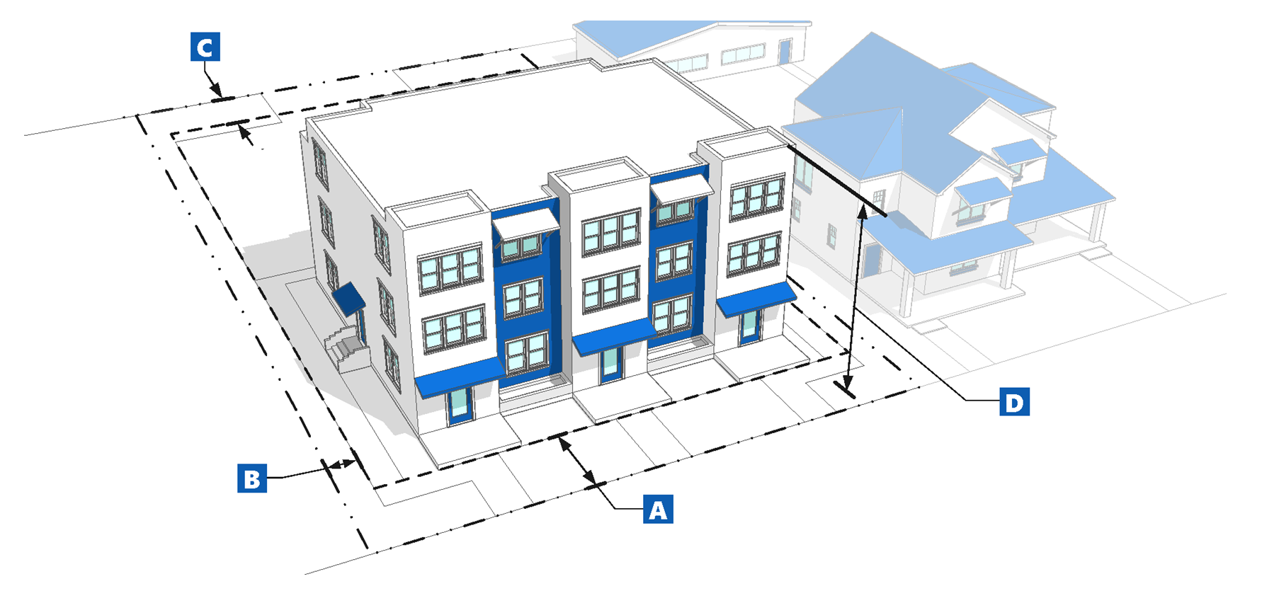
Graphics. For each base zoning district, this Article includes an illustration depicting how the district's lot and building standards apply to lots and typical building forms. Illustrations are intended to exemplify the general character of the district and do not show specific locations or buildings. Illustrations do not necessarily reflect all the standards that may apply to a particular development. If a standard shown in an illustration is inconsistent with the respective table of lot and building standards, the standards in the table shall govern.
(2)
Overlay Districts.
a.
Overlay zoning districts are superimposed over one (1) or more underlying base zoning districts. If the standards for an overlay district expressly conflict with those for an underlying base zoning district or another applicable overlay district, the more restrictive standards shall apply.
b.
Overlay zoning districts may also be superimposed over one (1) or more planned development (PD) districts. The applicability of the overlay shall be established by the planned development agreement.
c.
Section 16-2-70 identifies the overlay zoning districts and sets forth the purpose and the standards of the overlay districts that modify those of underlying zoning districts.
(Ord. No. 2025-17, § 2(Exh. A), 10-7-2025)
Sec. 16-2-20. - Summary of dimensional standards.
Table 2-B: Summary of Dimensional Standards
(Ord. No. 2025-17, § 2(Exh. A), 10-7-2025)
Sec. 16-2-30. - Measurements and exceptions.
(a)
Purpose. This Section is intended to provide uniform measures for Interpretation and enforcement of dimensional standards, and to list any exceptions to the dimensional standards in this Code.
(b)
Lots.
(1)
Lot Size.
a.
Every building or structure shall be located and maintained on a lot as defined in this Code.
b.
No lot shall be created, developed, used, or occupied that has less than the minimum lot area or frontage as required by the zoning district in which it is located. Pre-existing nonconforming lots shall follow the requirements of Section 16-1-60, Nonconformities.
c.
An existing legal lot that is unencumbered and nonconforming by virtue of the minimum lot area or frontage of the zoning district in which it is located may be developed with a primary structure and customary accessory buildings and structures, provided that any structures meet all other standards of this Code, including dimensional standards. A minor modification or variance or from those standards may be obtained pursuant to Subsection 16-8-70(a), Minor Modification, and Subsection 16-8-70(b), Variances.
(2)
Buildings on Multiple Lots. Where one (1) structure occupies two (2) or more lots:
a.
The lot coverage, minimum lot size, lot frontage, minimum and maximum density, and setback standards shall be determined as though the development is occupying one (1) consolidated lot; and
b.
The Director shall determine the front, side, and rear lot lines for the purpose of measuring setbacks.
(3)
Lot Coverage.
a.
Measurement.
1.
Lot coverage for structures is the maximum horizontal area within the outer perimeter of all structures, measured to the outside edge of walls, dividers, or columns at or above ground level, whichever is the greater area. Exterior stairways and decks greater than thirty (30) inches above natural grade shall be considered as part of lot coverage. Covered balconies, or balconies less than eight (8) feet above natural grade, shall count towards lot coverage.
2.
Lot coverage for uncovered parking is the maximum horizontal area of uncovered parking areas, vehicle loading and unloading, driveways, vehicle circulation, or other similar areas.
b.
Exceptions.
1.
Cantilevered balconies more than eight (8) feet above natural grade with no walls or roof, and exterior decks that are less than thirty (30) inches above natural grade, shall not count toward lot coverage.
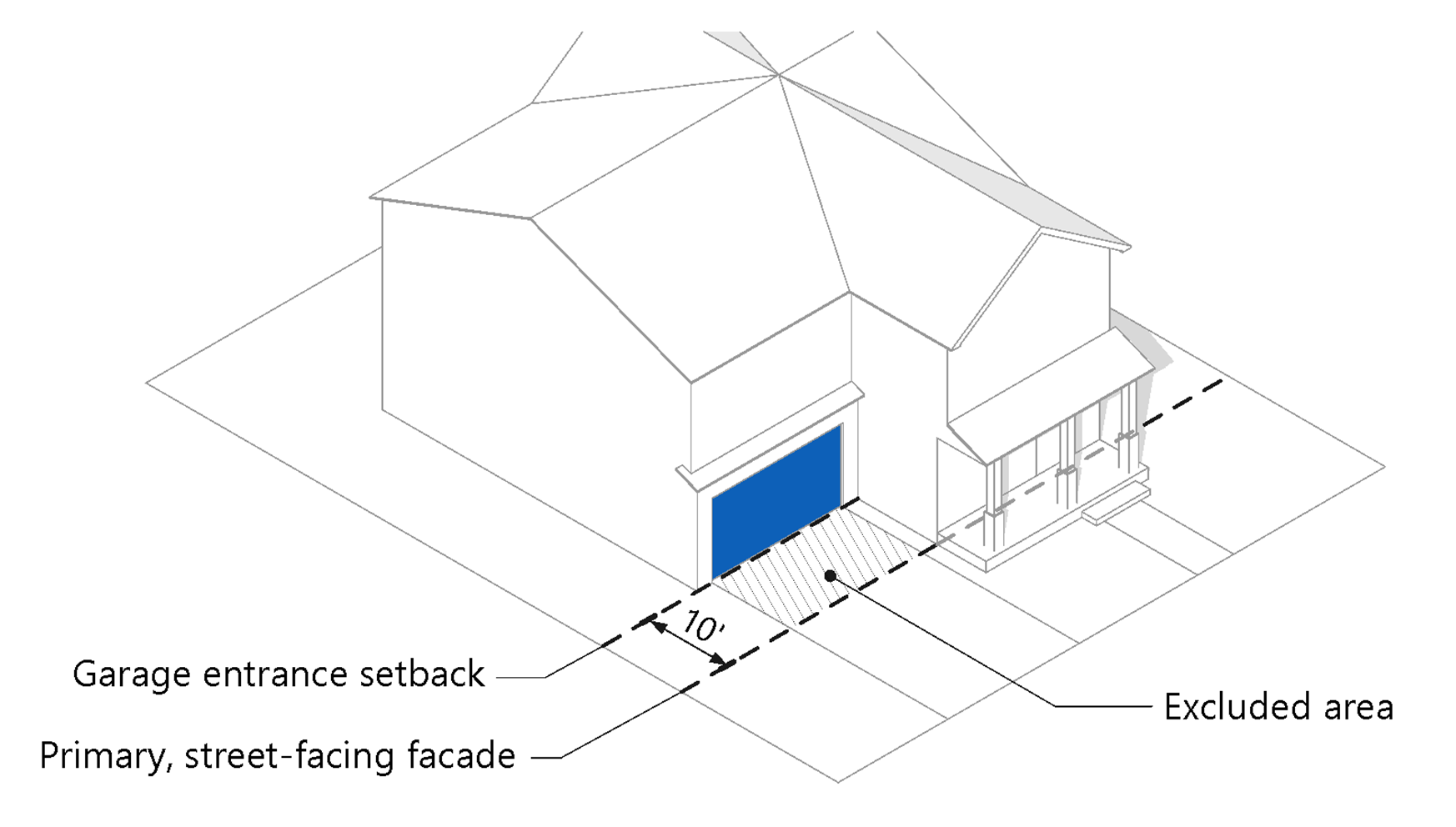
Figure 2-1: Measuring Lot Coverage with Front-Loaded Garage
2.
If a front-loaded garage is set back at least ten (10) feet behind the primary street-facing building facade, the lot coverage between the garage entrance and the primary, street-facing building facade may be excluded from uncovered parking coverage. See Figure 2-1.
3.
There is no maximum combined lot coverage in the Mixed-Use Downtown (MD) district.
(4)
Lot Frontage. Lot frontage shall be measured along a public street or approved private drive.
(c)
Setbacks.
(1)
Measurement.
a.
Front. The minimum horizontal distance that a structure must be setback from the front lot line. The front setback extends across the full width of the lot.
b.
Rear. The minimum horizontal distance that a structure must be setback from the rear lot line. The rear setback extends across the full width of the lot.
c.
Side. The minimum horizontal distance that a structure must be setback from a side lot line. The side setback extends the full depth of the lot from the front property line to the rear property line. Per Subsection 16-2-30(d), side setbacks may vary based on building or structure height in some districts.
d.
Special Lots.
1.
Double-Frontage Lots. In the case of lots that front more than one (1) street, but are not corner lots, front setbacks shall apply to all frontages.
2.
Corner Lots. In the case of corner lots, the required front setback shall be observed along the front lot line as determined by the Director. The front lot line is typically designated by the location of the primary entrance or the street upon which the address is assigned. The rear setback shall be that lot line most opposite the front lot line. A side setback shall be observed along the remaining street and any other remaining lot lines.
3.
Irregularly Shaped Lots.
a)
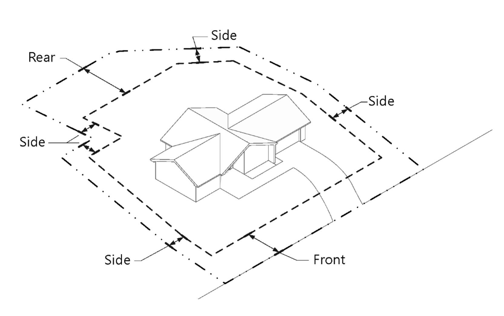
Lots with multiple side and/or rear lot lines not abutting a street shall comply with side setback requirements for all lot lines except that the front lot line, as determined by the Director, shall comply with the front setback and the lot line farthest from the front lot line, as determined by the Director, shall comply with the rear setback. See Figure 2-2.
Figure 2-2: Irregularly Shaped Lots
b)
The Director may establish alternative setbacks for properties with irregularly shaped lots based on unique site and/or lot conditions.
4.
Adjoining Lots. In the case of townhouse dwellings, multi-family dwellings, and nonresidential development on two (2) or more adjoining lots that are used in the same development, a zero-foot side setback may be applied on interior side lot lines within the development.
e.
Setback Averaging. The required front yard setback may be reduced for a principal structure on any lot if more than fifty percent (50%) of the principal buildings on the same block face or street face do not meet the required front yard setback. The setback for the adjacent buildings and other buildings on the block face shall be measured from the property line to the bulk of the building, excluding, without limitation, any unenclosed porches, decks, patios, or steps. The bulk of the building setback shall not be less than the average bulk of the building setback for the principal buildings on the two (2) adjacent lots. Where there is only one (1) adjacent lot, the front yard setback reduction shall be based on the average of the principal building setbacks on the two (2) closest lots on the same block face.
(2)
Exceptions. No building or part of a building shall be permitted to project into the required setbacks of the applicable zoning district unless authorized in Table 2-C, below, or elsewhere in this Code.
Table 2-C: Authorized Exceptions to Setback Standards
(d)
Height.
(1)
Measurement.
a.
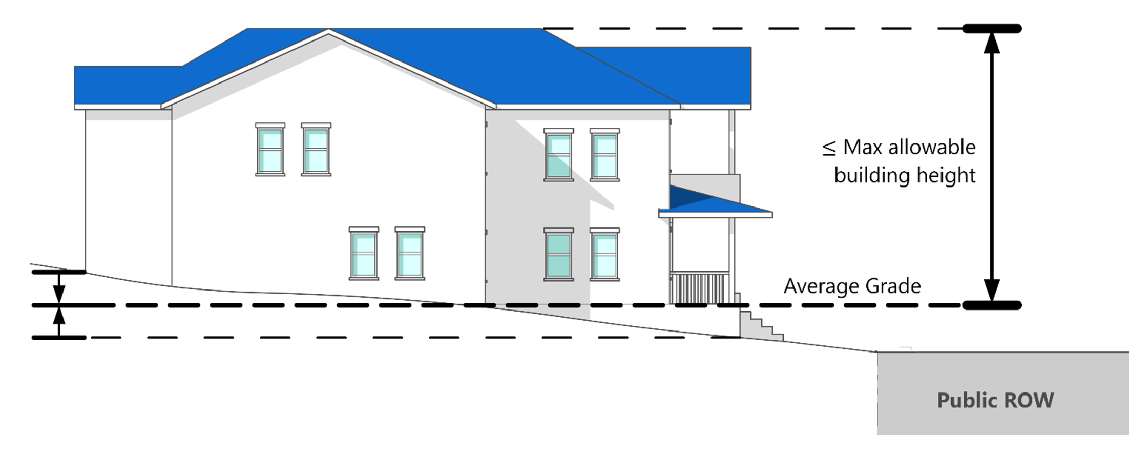
Generally. For a building or structure, height shall be measured as the vertical distance above the average preconstruction or post-construction grade around the perimeter foundation of a building or structure, whichever is lower, to the highest point on the roof surface of the building or structure.
b.
Uneven Lots. Buildings or structures on uneven lots shall have no vertical dimension that exceeds one hundred twenty-five percent (125%) of the maximum allowable building height. In no case shall the height be greater than the maximum allowable height when facing a public right-of-way. See Figure 2-3.
Figure 2-3: Measurement of Building Height on Uneven Lot
c.
Primary Structure.
1.
R1, R2, MN, and AG Districts.
a)
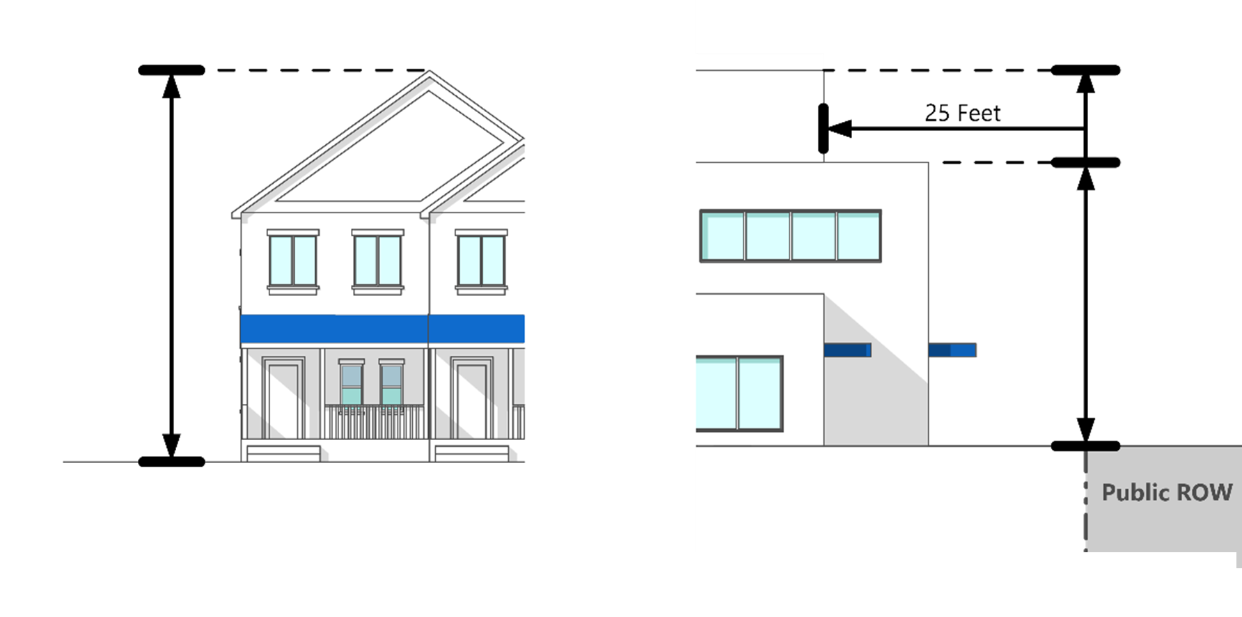
Any part of a structure above twenty-eight (28) feet shall be stepped back a minimum of twenty-five (25) feet from the front and rear lot lines. See figure below.
b)
The highest point of a roof shall not exceed thirty-five (35) feet.
c)
See exceptions in Table 2-D.
2.
All Other Districts. Refer to dimensional standards table.
d.
Accessory Structure.
1.
Residential and MN Districts. All ADUs shall be set back a minimum of five (5) feet from the property line. All other accessory structures fifteen (15) feet or below in height shall be set back a minimum of three (3) feet (five-foot minimum setback for structures fifteen (15) feet or higher).
2.
All Other Districts. Refer to dimensional standards table.
(2)
Exceptions. No building or part of a building shall exceed the maximum building height within any zoning district unless authorized in Table 2-D, below, or elsewhere in this Code.
Table 2-D: Authorized Exceptions to Height Standards
(e)
Density.
(1)
Measurement.
a.
Minimum Density. Minimum densities are established for some zoning districts to help ensure that development complies with the Future Land Use Map and to help ensure there is sufficient land supply for development that makes efficient use of City infrastructure.
1.
Minimum density shall be calculated by the maximum lot area per dwelling unit within a proposed development site, excluding public and private streets, rights-of-way, and public and private access easements that restrict the surface use of the property. Other areas deemed undevelopable due to extreme topography, presence of water, or other permanently constraining features may also be excluded from the calculation, as determined by the Director.
2.
A lot shall not be deemed nonconforming solely due to noncompliance with the minimum density or maximum lot size requirements of this Code. Future development on such lots shall comply with minimum density and maximum lot size requirements, which may require subdivision of lots in order to conform.
3.
Accessory dwelling units do not count towards minimum density requirements.
b.
Maximum Density.
1.
Maximum density shall be calculated by the minimum lot area per dwelling unit within a proposed development site, excluding public and private streets and rights-of-way, and including public and private access easements that restrict the surface use of the property.
2.
One (1) accessory dwelling unit per lot may be excluded from the maximum allowable density for the zoning district.
3.
Inclusionary housing developments may exceed the maximum allowable density for the zoning district where explicitly permitted by Table 2-B: Summary of Dimensional Standards.
(Ord. No. 2025-17, § 2(Exh. A), 10-7-2025)
Sec. 16-2-40. - Residential districts.
(a)
Lower-Density Residential (R1).
(1)
Purpose. The Lower-Density Residential (R1) district is intended to accommodate and preserve lower-density residential neighborhoods with a variety of one- and two-family dwelling forms and limited complementary community, educational, and accessory uses.
(2)
Dimensional Standards.
(b)
Medium-Density Residential (R2).
(1)
Purpose. The Medium-Density Residential (R2) district is intended to provide for medium-density residential neighborhoods with a variety of single-family dwelling forms and smaller multi-family residences. Limited complementary community and educational uses may be permitted along with incidental or accessory uses.
(c)
Higher-Density Residential (R3).
(1)
Purpose. The Higher-Density Residential (R3) district is intended to provide for higher-density single- and multi-family residential areas. Limited complementary community and educational land uses may occur alongside incidental or accessory uses.
(2)
Dimensional Standards.
(d)
Manufactured/Mobile Home Park (MMP).
(1)
Purpose. The Manufactured/Mobile Home Park (MMP) district is intended to provide for manufactured/mobile home parks. Complementary land uses include community, educational, and accessory uses.
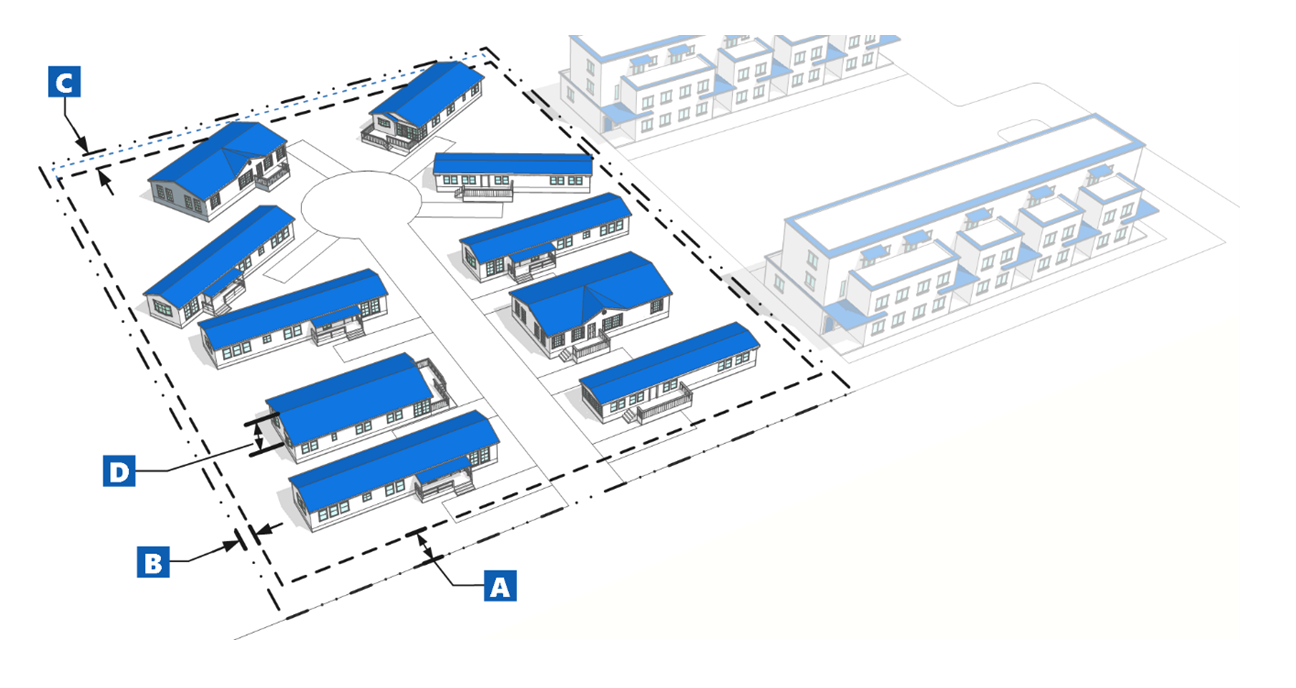
(2)
Dimensional Standards.
(Ord. No. 2025-17, § 2(Exh. A), 10-7-2025)
Sec. 16-2-50. - Mixed-use districts.
(a)
Mixed-Use Neighborhood (MN).
(1)
Purpose. The Mixed-Use Neighborhood (MN) district is intended to provide for a variety of housing choices and integration of complementary residential and commercial uses in a walkable neighborhood.
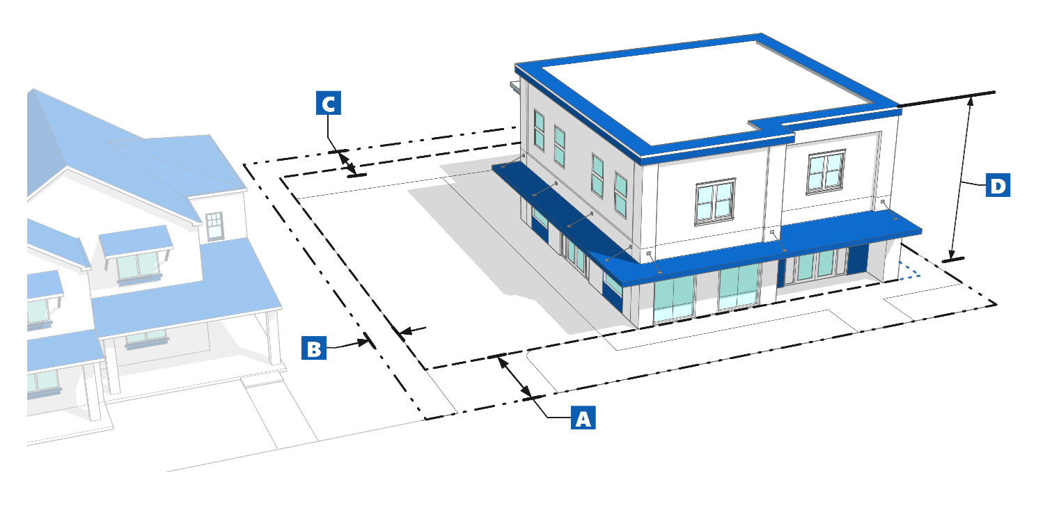
(2)
Dimensional Standards.
(3)
District-Specific Standards.
a.
Generally. These general MN district standards apply in addition to the other applicable standards of this Code:
1.
All mixed-use and nonresidential structures shall use two (2) or more materials on the building facade, excluding roofing and structural materials. Exposed tilt-up concrete is prohibited, and metal shall not exceed twenty-five percent (25%) of the surface area of exterior materials excluding roofs.
2.
For mixed-use or nonresidential structures, glazing shall comprise a minimum of twenty percent (20%) of any building facade adjacent to a public right-of-way unless the building containing the primary use is completely screened from view from the right-of-way.
b.
First Street Standards. On lots fronting 1st Street, between O Street and Wood Avenue, new structures shall be designed so that the primary building facade setback is within five (5) feet, forward or back, from the existing location of front facades of adjacent buildings, notwithstanding the minimum setback required by [Section] 16-2-20, Summary of Dimensional Standards.
c.
Historic Blocks. The following additional standards apply to blocks between 3rd and 4th, and from D to H Streets. In case of conflict with the general standards in paragraph a. above, the following standards shall apply:
1.
Setbacks. Historic settlement patterns often contribute to the distinct character of the district, and therefore they should be preserved. Setbacks shall follow the traditional building line.
2.
Mass and Scale. The traditional similarity in scale of the buildings within the area enhances the character of the street and visual continuity. The construction of a new building or addition shall be similar in mass and scale to those in the immediate area.
3.
Building Form. Use building forms that are similar to those seen traditionally on the block. Simple rectangular solids are typically appropriate.
4.
Facade Proportions. The overall proportion is the ratio of the width to height of the building and shall be similar to those of historic buildings in the immediate area.
5.
Roofs. Roof forms shall be similar to those seen traditionally in the block.
6.
Architecture. Architectural details contribute to the sense of character of the street. To enhance the distinction between old and new buildings, contemporary interpretations of traditional details are encouraged. Existing historical details shall be preserved.
7.
Materials. The principal materials used on building facades shall be indigenous to the Salida downtown, including brick or wood. Two (2) or more materials shall be used for exterior materials and architectural form, excluding roofing materials. Tilt-up concrete and cinder blocks are prohibited, and metal shall not exceed twenty-five percent (25%) of the surface area of exterior materials excluding roofs. The facades of buildings shall be articulated with architectural treatments; long blank walls shall be avoided.
8.
Windows. A new building or addition should maintain the basic window proportions and placement seen traditionally in the area. Windows with vertical emphasis are encouraged.
(b)
Mixed-Use Highway Center (MC).
(1)
Purpose. The Mixed-Use Highway Center (MC) district is intended to accommodate a mixture of residential, commercial, office, and other nonresidential uses at key nodes in Salida. The MC District provides for a variety of housing choices and integration of complementary neighborhood services with an emphasis on walkable and active streetscapes.
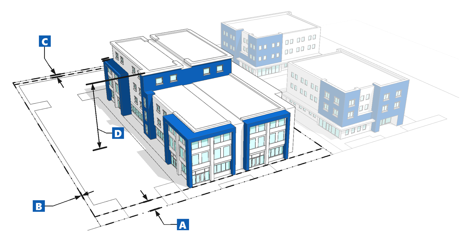
(2)
Dimensional Standards.
(3)
District-Specific Standards. The following standards shall apply in the MC district:
a.
Projects providing a minimum of twenty-five percent (25%) affordable housing, consistent with the requirements of Article 9, Inclusionary Housing, will be allowed a maximum height of forty-five (45) feet.
b.
The coverage maximum standards only apply to internal pads/lots of the overall site (e.g., Two Rivers Commons). Setbacks still apply to perimeter of site from adjacent ROW and non-MC properties.
c.
All structures shall use two (2) or more materials on the building facade, excluding roofing and structural materials. Exposed tilt-up concrete is prohibited, and metal shall not exceed twenty-five percent (25%) of the surface area of exterior materials excluding roofs.
d.
Blank facade walls greater than fifty (50) feet in length shall be avoided and broken up using different materials and architectural elements.
e.
Glazing shall comprise a minimum of twenty percent (20%) of any building facade adjacent to a public right-of-way unless the building containing the primary use is completely screened from view from the right-of-way.
(c)
Mixed-Use Highway (MH).
(1)
Purpose. The Mixed-Use Highway (MH) district is intended to accommodate a mix of general commercial and service uses as well as certain residential uses along Salida's Highway 50 corridor. Other light nonresidential uses may also be permitted. The intent of the MH district is to create attractive commercial and mixed-use development with safe access for all road users, sufficient parking area, and to buffer the impacts of these uses from surrounding residential areas.
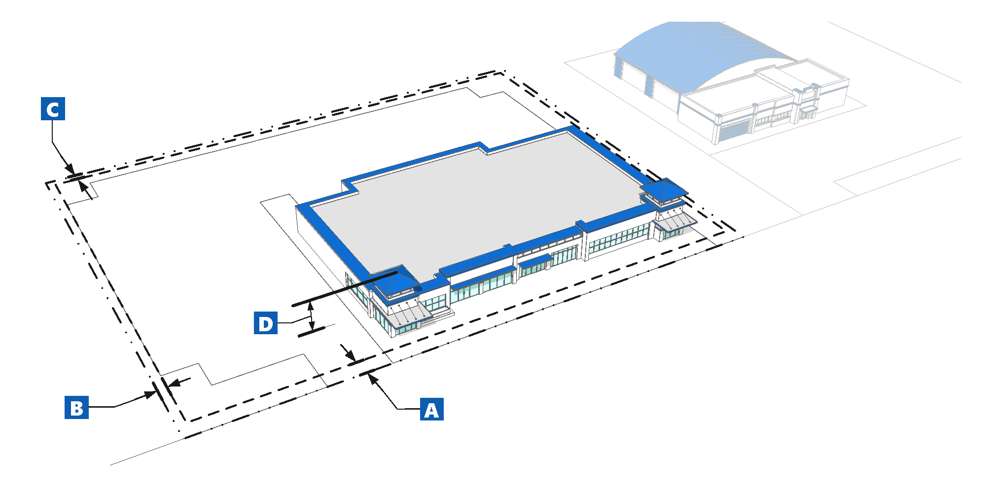
(2)
Dimensional Standards.
(3)
District-Specific Standards. The following standards shall apply in the MH district:
a.
All structures shall use two (2) or more materials on the building facade, excluding roofing and structural materials. Exposed tilt-up concrete is prohibited, and metal shall not exceed twenty-five percent (25%) of the surface area of all exterior materials excluding roofs but including glazing.
b.
Blank facade walls greater than fifty (50) feet in length shall be avoided and broken up using different materials and architectural elements.
c.
Glazing shall comprise a minimum of twenty percent (20%) of any building facade adjacent to a public right-of-way unless the building containing the primary use is completely screened from view from the right-of-way.
d.
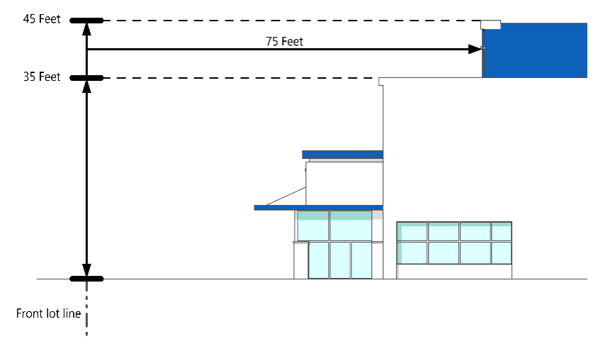
Projects providing a minimum of twenty-five percent (25%) affordable housing, consistent with the requirements of Article 9, Inclusionary Housing, will be allowed a maximum height of forty-five (45) feet in the MH zone district; however, any part of the building(s) over thirty-five (35) feet that are not specifically excepted from the height must be a minimum of seventy-five (75) feet from the front lot line.
Figure 2-4: 75-foot Stepback for Projects that Receive 45-foot Bonus
(e)
Mixed-Use Downtown (MD).
(1)
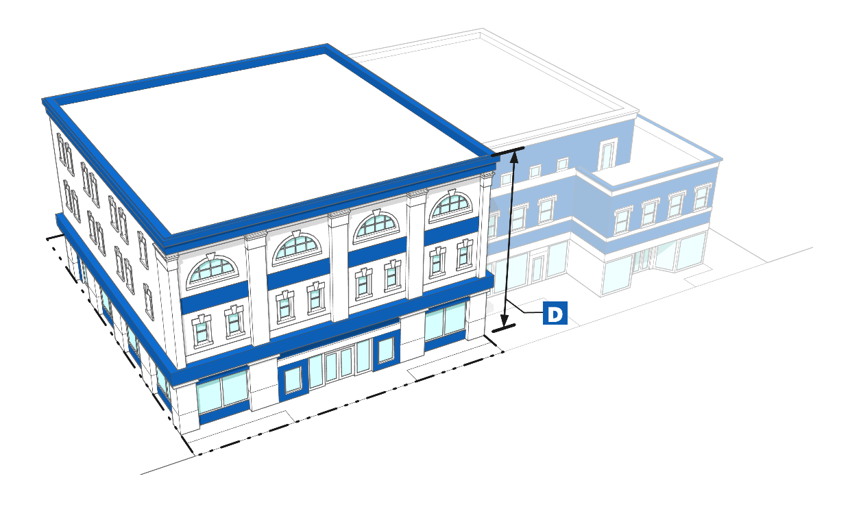
Purpose. The Mixed-Use Downtown (MD) district is intended to provide for the business and civic functions that make up the City's core and encourage a mix of commercial, office, and residential uses in a walkable and active downtown. Structures typically follow historic architectural styles with higher ceilings and ornamentation that increase building height. The MD District includes the most prominent areas of Salida and therefore places an emphasis on high-quality building, site, and streetscape design.
(2)
Dimensional Standards.
(3)
District-Specific Standards. To reflect historic settlement patterns, support the economic vitality of Downtown Salida, and encourage the development of structures that enhance the historic character of the MD district, the following standards shall apply to any construction in the MD district outside of the SDHD overlay district. There are additional requirements in the Salida Downtown Historic District Overlay.
a.
Front Setbacks. New structures shall be designed so that the primary building facade aligns with the facades of adjacent buildings. If the majority of structures on a block are at zero (0) front setback, then any new structures shall be at zero (0) front setback, with exceptions being allowed by approval of the Director.
b.
Building Form. Any construction shall be similar in form to existing development on the block that reflects traditional building form.
c.
Architectural Style and Historic Detail.
1.
Alterations and remodels shall preserve existing historical details.
2.
Structures shall use similar architectural details to existing development in the district to contribute to the sense of character of the street. However, to enhance the distinction between old and new buildings, contemporary interpretations of traditional details are encouraged.
3.
New structures shall use similar architectural features to existing development on the block, including, but not limited to:
a)
Articulated front facades, and side facade of a corner lot, with architectural treatments (no long, blank walls).
b)
Roof form.
c)
Window proportions and placement (vertical emphasis is encouraged).
d.
Building Materials. Structures shall use similar materials to existing development on the block, including, but not limited to:
1.
Primary use of brick or wood on building facades; and
2.
Two (2) or more materials on the building facade, excluding roofing and structural materials. Exposed tilt-up concrete is prohibited, and metal shall not exceed twenty-five percent (25%) of the surface area of exterior materials excluding roofs.
e.
Standards for Area of Central Business Economic Activity. Except for areas in the MD district between 3rd and 4th Street, and east of E Street:
1.
Limitation on Ground-Floor Uses.
a)
The ground-floor street frontage of buildings shall not be used for residential uses as defined by [Section] 16-10-20, Definitions of Use Categories and Use Types, and no more than fifty percent (50%) of the remaining area of the ground floor occupancy may be used for residential uses. The applicant may request conditional use approval to allow more than fifty percent (50%) of ground floor occupancy if the Director determines that the limitation on residential uses will create a significant economic hardship and subject property cannot be put to any other reasonably beneficial use.
b)
If the limitation on residential uses will create a significant economic hardship, an owner may apply for and receive conditional use approval if the following additional review standard is met: The amount of ground-floor residential uses may be increased above fifty percent (50%) if the approving authority makes the finding that the subject property cannot be put to any other reasonably beneficial use.
2.
Fee-in-lieu for Parking.
a)
With approval of the Director, a fee-in-lieu of providing required on-site parking for all development within the MD district may be paid by the applicant in an amount established and periodically amended by the City's fee schedule as the Business Occupier Fee.
b)
Fees accepted by the City in lieu of required parking shall be designated for the purposes of providing additional public parking in and around Downtown Salida or for the enforcement of parking regulations.
c)
Any off-street parking satisfied through this Section shall run with the land and any subsequent change of use that requires more parking shall require subsequent action to satisfy the additional parking requirement. No refund of such payment shall be made when there is a change to a use requiring less parking.
d)
The number of parking spaces required and used to calculate the fee in-lieu shall be determined according to the provisions of this Section 16-4-70 and any other applicable provisions of this Code.
e)
A change of ownership or the dividing or merging of properties shall not affect an obligation for parking fees in-lieu or a determination that parking requirements have been met according to fees paid for a particular use.
f.
Maximum Height with Inclusionary Housing. Projects providing a minimum of twenty-five percent (25%) affordable housing, consistent with the requirements of Article 9, Inclusionary Housing, will be allowed a maximum height of forty-five (45) feet in the MD zone district but only in areas outside of the SDHD and west of F Street.
(Ord. No. 2025-17, § 2(Exh. A), 10-7-2025)
Sec. 16-2-60. - Other districts.
(a)
Industrial (IN).
(1)
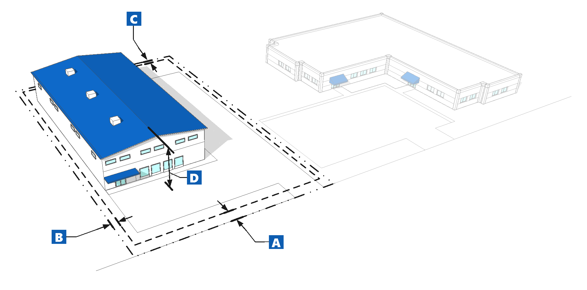
Purpose. The Industrial (IN) district is intended to provide for industrial, manufacturing, and other nonresidential activity, both general and light, in areas where conflicts with commercial, residential, and other land uses can be minimized.
(2)
Dimensional Standards.
(b)
Agriculture (AG).
(1)
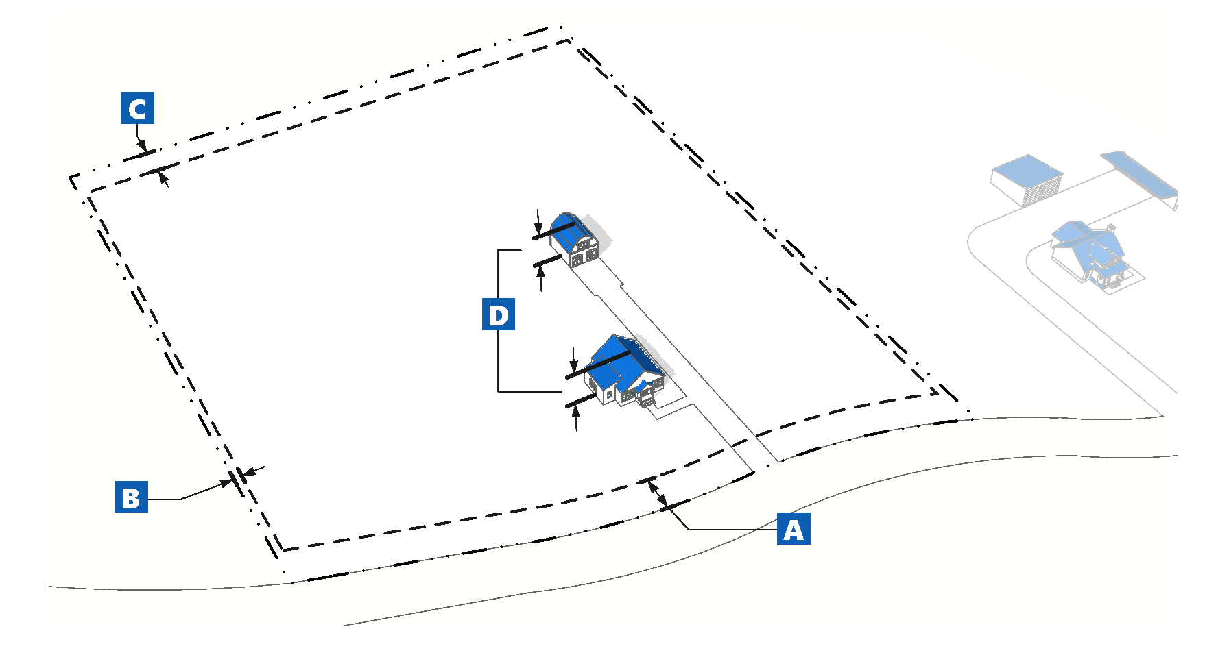
Purpose. The Agriculture (AG) district is intended to preserve the continuation of historic agricultural uses and very low-density single-family residential development in certain locations while allowing for limited agricultural and civic uses, including protection of sensitive environmental resources. The district may also be used to allow annexation of new land into the City prior to establishing detailed development plans, or to serve as a transition between surrounding agricultural or public lands and more urbanized areas within the City.
(2)
Dimensional Standards.
(c)
Parks and Open Space (OS).
(1)
Purpose. The Parks and Open Space (OS) district is intended to accommodate and preserve adequate lands for recreational use, open space, or landscape preservation. The district allows for the protection of public and quasi-public lands, along with compatible incidental and accessory uses, from being used for purposes other than parks or open space. The district may also be used for lands designated "Undeveloped Reserve" in the Future Land Use Map prior to conducting additional planning or establishing detailed development plans.
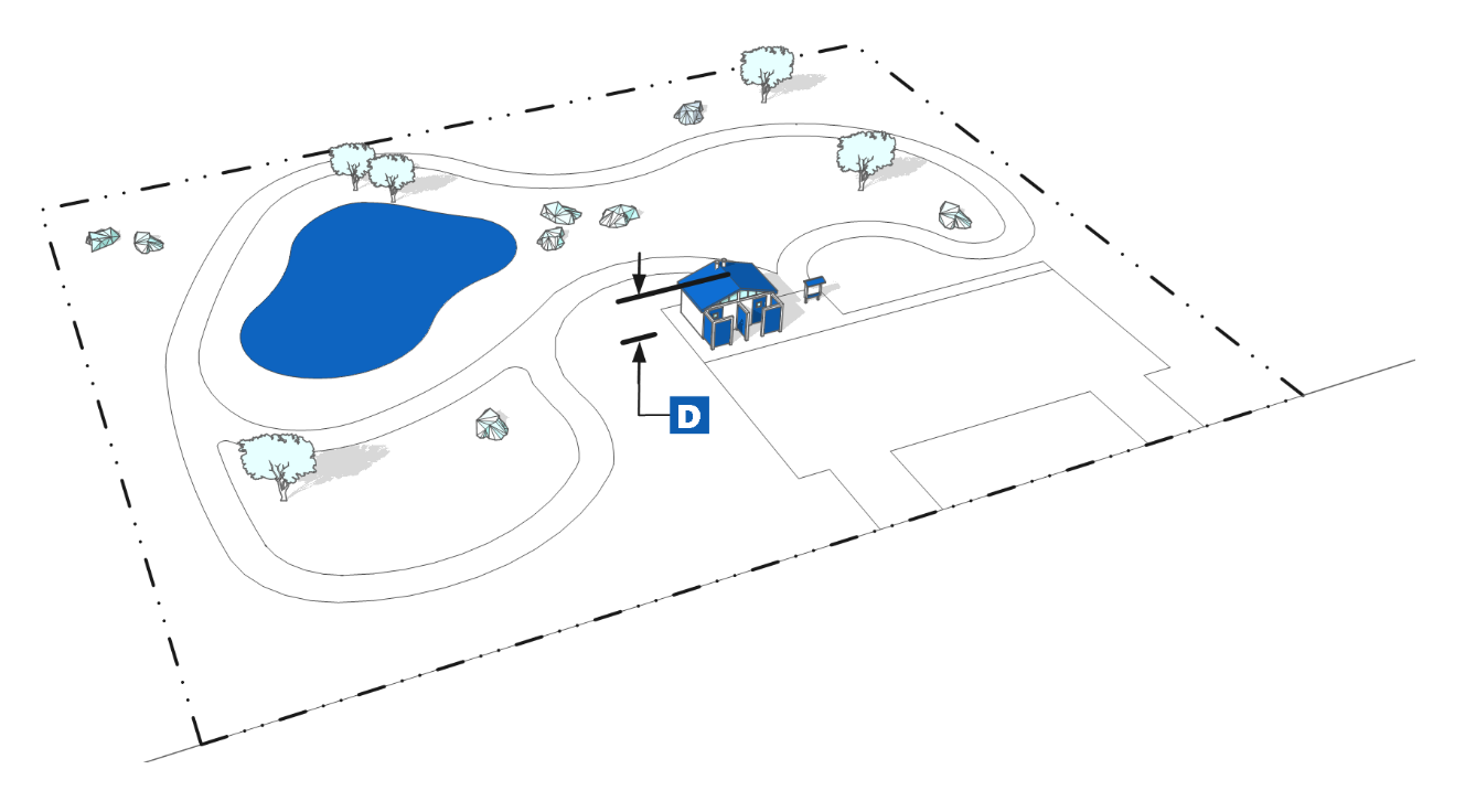
(2)
Dimensional Standards.
(d)
Community Facilities (CF).
(1)
Purpose. The Community Facilities (CF) district is intended to accommodate public and quasi-public uses and activities related to community services or activities such as community centers, libraries, public safety facilities, multi-family residential, hospitals, utilities, and municipal operations.
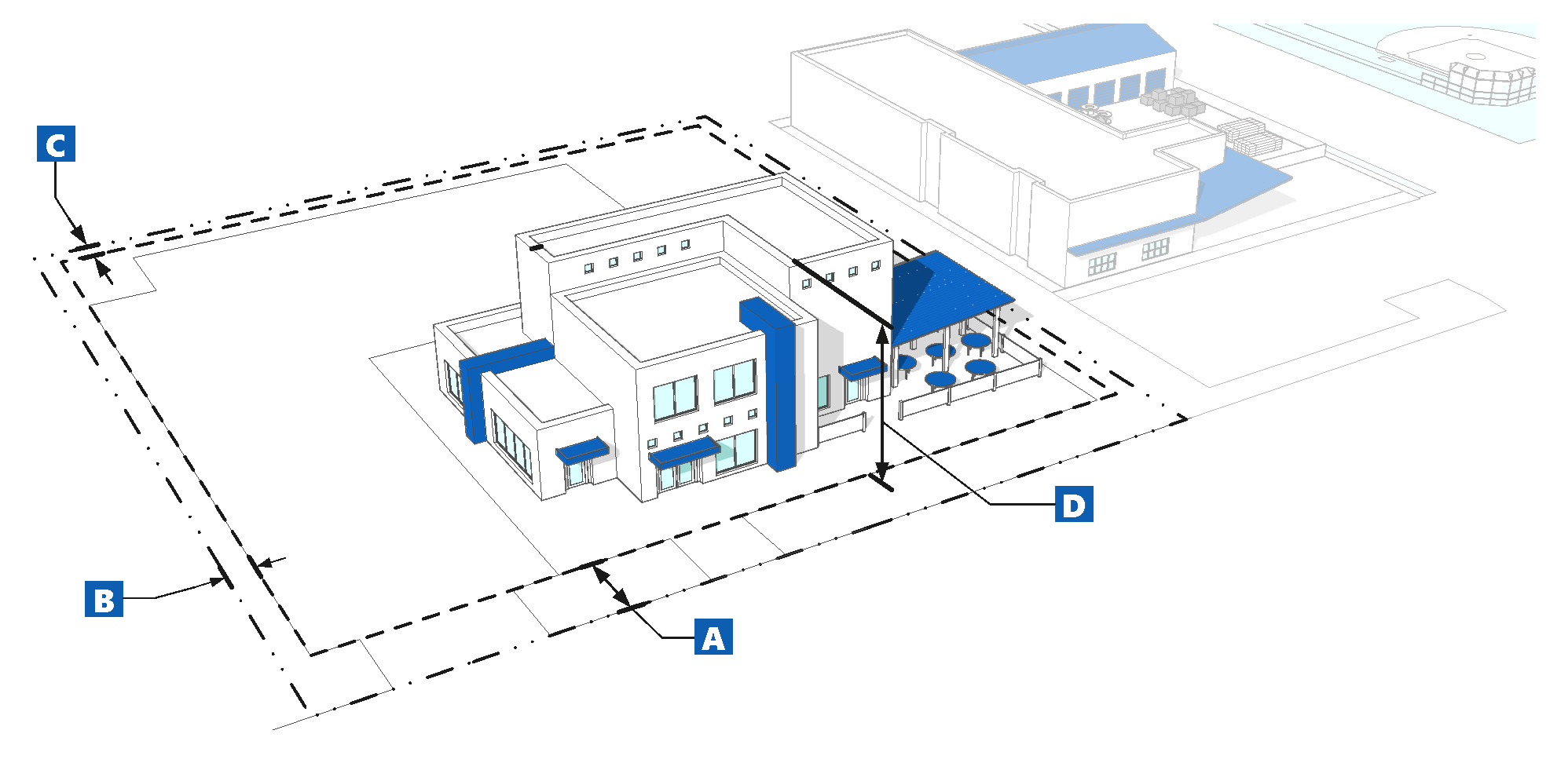
(2)
Dimensional Standards.
(Ord. No. 2025-17, § 2(Exh. A), 10-7-2025)
Sec. 16-2-70. - Overlay districts.
(a)
Purpose and Applicability.
(1)
To ensure the quality of development within overlay districts, this Section establishes design criteria and standards that will allow the City to review and direct the development and redevelopment of properties within the overlay districts.
(2)
The provisions of this Article shall be applied in addition to any other applicable regulations of this Code.
(b)
Overlay Districts Established. Table 2-E lists the overlay districts established by the City. Overlay districts are established by the City's adoption of the Official Zoning Map pursuant to Subsection 16-2-10(b), Official Zoning Map.
Table 2-E: Overlay Districts Established
(c)
Salida Downtown Historic District (SDHD) Overlay.
(1)
Purpose. The Salida Downtown Historic District (SDHD) Overlay is established for the purpose of protecting, preserving, stabilizing, enhancing, and perpetuating the buildings, sites, structures, and character of Salida's original historic downtown area.
(2)
Applicability. The standards for the SDHD Overlay ([Section] 16-7-20) shall apply to all development on parcels or lots located within the boundaries of the SDHD, as established and identified by the National Park Service of the U.S. Department of the Interior. All areas within the SDHD Overlay shall remain subject to the City's zoning, subdivision, and building regulations, in addition to the regulations contained within this Code.
(3)
Standards. See Section 16-7-60, Certificates of Approval.
(d)
Local Historic Landmark (LHLO) Overlay.
(1)
Purpose. The Local Historic Landmark (LHLO) Overlay is established for the purpose of protecting, preserving, stabilizing, enhancing, and perpetuating individual historic buildings, sites, and structures that exemplify the history of Salida.
(2)
Applicability. The standards for the LHLO Overlay ([Section] 16-7-30) shall apply to all development on parcels or lots that are designated as local historic landmarks. All areas within the LHLO Overlay shall remain subject to the City's zoning, subdivision, and building regulations, in addition to the regulations contained within Article 16-7, Historic Preservation.
(3)
Standards. See Section 16-7-60, Certificates of Approval.
(e)
Sackett's Addition (SA) Overlay.
(1)
Purpose. The purpose of the Sackett's Addition (SA) Overlay is to protect and preserve the character of the historic neighborhood by ensuring that future development, including the alteration of existing structures, be designed to be compatible with existing structures and neighborhood character.
(2)
Applicability.
a.
The standards of the SA Overlay shall apply to all development on parcels within the boundaries of the SA Overlay, as shown on the Official Zoning Map.
b.
This Section establishes the standards and criteria to be used in review of development applications proposed within the SA Overlay.
c.
The standards of this Section shall be in addition to those of the underlying zoning district and other applicable standards of this Code.
d.
This Section shall not be interpreted to require changes or renovation to existing properties or structures when no development applications are required to be submitted.
(3)
Standards. Development in the SA Overlay shall meet the following standards:
a.
Building Setbacks.
1.
The minimum front setback for new primary structures shall be the same as other primary structures on the same side of the block. If the front setbacks of other primary structures on the same side of the block are variable, the minimum front setback of the new structure must be within the established range of those seen on the same side of the block.
2.
Additions to existing primary structures shall be setback equal to or greater than the primary façade of the existing structure.
3.
The minimum side setback for new primary structures, or additions to existing primary structures, shall be five (5) feet unless a greater setback is required per Table 2-F, below.
Table 2-F: Sackett's Addition Overlay Setback Standards
4.
A roof pitch of 4:12 or less is considered to be a flat roof such that the height of the apex is projected to the edge of the roof adjacent to the side setbacks.
5.
Dormers projecting towards the side setbacks may not displace more than fifty percent (50%) of the roof area from which they project.
6.
Attached residential units on separate parcels are not subject to the height/setback relationship along the shared lot line between the two (2) structures. New attached residential units on separate parcels, or additions to such existing structures, shall be subject to height limitations derived from distance to foundations of neighboring structures or twenty-six (26) feet, whichever is less.
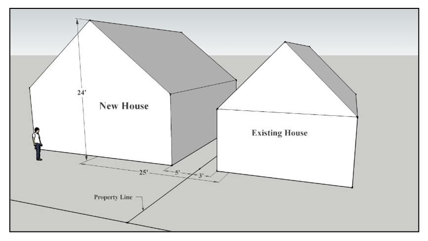
b.
Mass and Scale. New primary structures, and additions to existing primary structures, shall appear from the street to be similar in mass and scale to other single-family primary structures on the same side of the block.
1.
Height. The maximum height for a new primary structure or addition is twenty-six (26) feet. However, if an existing primary structure taller than twenty-six (26) feet should be completely destroyed by a natural cause such as fire, a new structure may be built to the height and square footage of the original structure. Any additional footprint must adhere to the design requirements. Within the overlay area, height is measured to the top of the ridge or parapet but does not include chimneys, solar installations, etc.
2.
Mass. Size of primary structures is limited as shown in Table 2-G. If more than one (1) primary structure is proposed, they must share the allotted floor area. If an existing primary structure greater in mass than what is allowed in the design requirements should be completely destroyed by a natural cause such as fire, a new structure may be built to the square footage of the structure prior to destruction.
Table 2-G: Sackett's Addition Overlay Mass and Scale Standards
c.
Accessory Structures.
1.
New accessory structures shall be subordinate in terms of mass, scale, and height to the primary structure.
2.
New accessory structures shall be no more than one and one-half (1½) stories.
3.
Garages must be detached from the primary structure.
4.
Where there is alley access, garages must be accessed from the alley.
d.
Alternative Compliance.
1.
Alternatives to these design guidelines may be permitted upon a finding by the Planning Commission that the proposed design solution is consistent with the existing mass and height of the block where the new structure or addition is proposed.
2.
In reviewing an application for an alternative, the Planning Commission may consider the unique challenges of a particular site or existing structures of the site. Such challenges may include, but are not limited to, narrow lot width, low foundation heights of adjacent structures, or unusual setbacks on existing or adjacent structures.
3.
If the restoration of an existing primary facade of an older structure is proposed to be restored to its original, historic appearance and the restoration will conflict with the minimum front setback standard, the Director may determine that an alternative compliance request will not be required.
4.
Applications for alternative compliance shall follow the procedures for major site plan review (Subsection 16-8-50(b)). However, if a variance is requested from other provisions of this Code, that application shall follow the procedures for a variance (Subsection 16-8-70(b)).
(4)
Design Recommendations.
a.
In addition to the development standards set forth this Section, the City strongly encourages compliance with the Sackett's Addition Design Recommendations, a copy of which is available for inspection at City Hall.
b.
The Sackett's Addition Design Recommendations ensure that new development or the alteration of existing structures will enhance the existing character and historic nature of the Sackett's Addition neighborhood.
(f)
Planned Development (PD) Overlay.
(1)
Purpose. The Planned Development (PD) overlay district is intended to achieve the following purposes:
a.
To implement the Salida Comprehensive Plan and other plans for particular areas or topics.
b.
To allow for greater flexibility and variety in the development of land than would otherwise be achieved through a base zoning district to improve the compatibility and quality of land uses; promote the more efficient use of land, infrastructure, and public services; and preserve open space and natural and scenic areas.
c.
To facilitate more innovative site planning and design concepts with a higher level of amenities and public benefits than is otherwise possible through a base zoning district.
(2)
Establishment.
a.
A PD district shall be established as an overlay district pursuant to the procedures in Subsection 16-8-40(b), Rezoning to Planned Development Overlay. Development in a PD District shall be subject to the standards of an approved PD plan.
b.
This district is only available to properties that are a minimum of two (2) acres.
c.
There are several existing PDs that were established prior to the effective date of this Code and function as base districts, not overlay districts. The specific dimensional standards for those developments can be found within their respective approved Planned Development development plans.
(Ord. No. 2025-17, § 2(Exh. A), 10-7-2025)

