
Salida City Zoning Code
ARTICLE V
- ZONING OVERLAYS
Sec. 16-5-10.- General.
This Article specifies the purpose and intent of zone district overlays established by this Chapter. It is the intent and purpose of this Article to ensure the quality of development in the zone district overlays by establishing design criteria and standards that will allow the City to review and direct the development and redevelopment of properties within the zone district overlays. Zone district overlays shall be designated on the City's Zoning Map. The provisions of this Article shall be applied in addition to any other applicable regulations of this Chapter.
(Ord. No. 2014-05, 5-6-2014)
Sec. 16-5-20. - Zone district overlays established.
The following zone district overlays are hereby established to carry out the purpose and provisions of this Article:
(1)
SDHD, Salida Downtown Historic District Overlay.
(2)
HPO, Historic Protection Overlay.
(3)
291 CO, SH 291 Corridor Overlay.
(4)
50 CO, Highway 50 Corridor Overlay.
(5)
LHLO, Local Historic Landmark Overlay.
(6)
Sackett's Addition Overlay.
(7)
PD, Planned Development District.
(8)
CBEO, Central Business Economic Overlay.
(Ord. No. 2014-05, 5-6-2014; Ord. No. 2018-20, § 2, 1-11-2019)
Sec. 16-5-30. - Salida Downtown Historic District Overlay (SDHD).
(a)
Purpose. The Salida Downtown Historic District is established for the purpose of protecting, preserving, stabilizing, enhancing and perpetuating the buildings, sites, structures and character of the City's original historic downtown area.
(b)
Applicability. The standards for the Salida Downtown Historic District Overlay, which are located in Article XII of this Chapter, shall apply to all development on parcels or lots which are located within the area falling within the boundaries of the Salida Downtown Historic District established and identified by the National Park Service of the U.S. Department of the Interior. All areas within the district shall remain subject to the City's zoning, subdivision and building regulations, in addition to the regulations contained within this Chapter.
(Ord. No. 2014-05, 5-6-2014)
Sec. 16-5-40. - Historic Protection Overlay (HPO).
(a)
Purpose. The purpose of the Historic Protection Overlay (HPO) is to provide for the protection of the historic character of the areas surrounding or in the vicinity of the Salida Downtown Historic District and to ensure that the planning and development of the downtown is compatible with and enhances the historic, cultural and architectural heritage of the City.
(b)
Applicability. The standards of the Historic Protection Overlay (HPO) shall apply to all development on parcels or lots which are located within the boundaries of the Central Business District (C-2) zoning district but are outside the Salida Downtown Historic District Overlay (SDHD). This Section establishes standards and criteria to be used in the review of development applications proposed within the Historic Protection Overlay District. In no instance shall this Chapter require renovation or changes to existing properties or structures when no development applications are required to be submitted. These regulations shall only be applicable when development is proposed by an applicant.
(c)
Areas. The boundaries of the Historic Protection Overlay (HPO) are congruent with those of the Central Business (C-2) zone district on the Official Zoning Map, excluding any structures or lots located in the Salida Downtown Historic District Overlay (SDHD).
(d)
Uses. The uses permitted in the Historic Protection Overlay (HPO) are those uses specified in the Central Business District (C-2) zoning district.
(e)
Standards. The standards listed below shall apply to development in the Historic Protection Overlay (HPO). These standards shall be in addition to those of the underlying zone district in which the property is located and in addition to the other applicable standards of this Chapter. No building or other development permit shall be issued for a structure in the Historic Protection Overlay (HPO) absent compliance of the structure with the following standards:
(1)
Setbacks. Historic settlement patterns often contribute to the distinct character of the district, and therefore they should be preserved. Setbacks shall follow the traditional building line.
(2)
Mass and Scale. The traditional similarity in scale of the buildings within the area enhances the character of the street and visual continuity. The construction of a new building or addition shall be similar in mass and scale to those in the immediate area.
(3)
Building Form. Use building forms that are similar to those seen traditionally on the block. Simple rectangular solids are typically appropriate.
(4)
Façade Proportions. The overall proportion is the ratio of the width to height of the building and shall be similar to those of historic buildings in the immediate area.
(5)
Roofs. Roof forms shall be similar to those seen traditionally in the block.
(6)
Architecture. Architectural details contribute to the sense of character of the street. To enhance the distinction between old and new buildings, contemporary interpretations of traditional details are encouraged. Existing historical details shall be preserved.
(i)
Materials. The principal materials used on building façades shall be indigenous to the Salida Downtown Historic District Overlay, including brick or wood. Two (2) or more materials shall be used for exterior materials and architectural form, excluding roofing materials. Tilt-up concrete and cinder blocks are prohibited, and metal shall not exceed twenty-five percent (25%) of the surface area of exterior materials excluding roofs. The façades of buildings shall be articulated with architectural treatments; long blank walls shall be avoided.
(ii)
Windows. A new building or addition should maintain the basic window proportions and placement seen traditionally in the area. Windows with vertical emphasis are encouraged.
(Ord. No. 2014-05, 5-6-2014)
Sec. 16-5-50. - SH 291 Corridor Overlay (291 CO).
(a)
Purpose. The purpose of the SH 291 Corridor Overlay (291 CO) is to establish standards for development along one (1) of the primary entrances to the City along the Highway 291 Corridor, and to provide for a transitional area between the City's commercial and residential uses, by allowing for relatively lower intensity commercial uses which are compatible with residential uses and which maintain the character of the existing residential neighborhood. This is accomplished by a combination of provisions for pedestrian and vehicular access and building setbacks which provide for attractive, functional development while allowing for the continued growth of the commercial and residential uses within this corridor.
(b)
Applicability. The standards of the SH 291 Corridor Overlay (291 CO) shall apply to all development on parcels which have frontage on S.H. 291 within the sub-areas described herein.
(c)
Areas. The boundaries of the SH 291 Corridor Overlay (291 CO) are shown on the Official Zoning Map. There are two (2) sub-areas within this district as follows:
(1)
Established Commercial. The Established Commercial sub-area establishes the initial entry image for the City on its northwestern and southern entrances. It extends from "O" Street to the northwestern City limits along S.H. 291 and from Wood Avenue in a southerly direction along S.H. 291 to U.S. 50.
(2)
Established Residential. The Established Residential sub-area continues the entry image for the City along S.H. 291 as the highway approaches the commercial core. It extends from "O" Street southeasterly along S.H. 291 to the boundary of the Salida Downtown Historic District Overlay; and from Wood Avenue in a northwesterly direction along S.H. 291 to the boundary of the Salida Downtown Historic District Overlay.
(d)
Standards. The standards listed below shall apply to development in the SH 291 Corridor Overlay (291 CO). These standards shall be in addition to those of the underlying zone district in which the property is located, in addition to the other applicable standards of this Chapter. No building or other development permit shall be issued for a structure in the SH 291 Corridor Overlay (291 CO) absent compliance of the structure with the following standards:
(1)
Building Setbacks.
(i)
Established Commercial. The Established Commercial sub-area shall meet the underlying zone district setback requirements.
(ii)
Established Residential. The Established Residential sub-area shall meet the underlying zone district setback requirements, except for the front yard setback. The front yard setback in Established Residential shall relate to those of existing adjacent structures. The building should be constructed at a distance not more than five (5) feet in front of or behind the existing front setbacks of adjacent buildings. When developing lots adjacent to buildings having significantly greater or lesser setbacks than the uniform historic setback of other buildings on S.H. 291, new buildings should be located in compatible relationships to the uniform setback provided by most structures on S.H. 291.
(2)
Parking and Access.
(i)
Established Commercial. The Established Commercial sub-area shall meet the off-street parking standards of Section 16-8-80. Shared access is encouraged.
(ii)
Established Residential. Required off-street parking in the Established Residential sub-area shall be located to the rear of the building. Curb cuts on S.H. 291 shall be discouraged. Off-street parking standards are located in Section 16-8-80.
(iii)
Highway access. Any access onto the highway requires approval from the Colorado Department of Transportation. Curb cuts shall meet the Colorado Department of Transportation's "Highway Access Code." The provisions of the Highway 291 Corridor Overlay District shall be complied with in addition to, and to the extent not in conflict with, the State Highway Access Law and Code.
(iv)
Pedestrian access. Sidewalks shall be provided within the 291 CO. Sidewalks along S.H. 291 are typically detached with a width of five (5) feet. The parkway located between the curb or travel lane shall be a minimum of four (4) feet wide. In areas where a sidewalk is being installed that will connect with an existing sidewalk, the placement and dimensions shall match the existing sidewalk. Installation of improvements within the Colorado Department of Transportation's right-of-way requires approval via a Utilities/Special Use permit from the Colorado Department of Transportation.
(3)
Mass and Scale for Established Residential. New infill development within the Established Residential sub-area shall be similar to the size and scale of buildings adjacent to the development. The design of buildings shall look appropriate to and compatible with their surroundings and shall not exceed two (2) stories.
(4)
Architectural Standards for Established Commercial. With new construction, including an addition, two (2) or more materials must be used for exterior materials within the 291 CO, excluding roofing and structural materials. Exposed tilt-up concrete is prohibited, and metal shall not exceed twenty-five percent (25%) of the surface area of exterior materials, excluding roofs. Specifically exempt from the requirement of using two (2) or more materials are single-family residences, duplex family residences and the accessory structures for single-family and duplex family development.
(5)
Uses by Right and Conditional Uses.
(i)
Residential development. Single-family, duplex dwelling and multifamily dwellings (three (3) units or less) are allowed uses by right in the SH 291 Corridor Overlay (291 CO). Multifamily dwelling units (four (4) units or greater) are a conditional use.
(ii)
Commercial development. Some of the commercial uses that are allowed in the underlying C-1 zone district are only allowed as a conditional use in the overlay districts. The uses that are conditional are indicated by an asterisk in Table 16-D, Schedule of Uses for Commercial/Industrial Zone Districts, contained in Article IV of this Chapter.
(6)
Other Standards. Other standards throughout this Chapter may apply to a particular development. Additional standards include Use and Dimensional Standards, Off-Street Parking Standards, Landscaping and Illumination Standards, Sign Standards and Improvement Standards. The Administrator can assist with any questions as to the applicability of a particular standard.
(Ord. No. 2014-05, 5-6-2014)
Sec. 16-5-60. - Highway 50 Corridor Overlay (50 CO).
(a)
Purpose. The purpose of the Highway 50 Corridor Overlay (50 CO) is to establish standards for the efficient, well-ordered and safe development of one (1) of the primary entrances to the City which is also one (1) of its major highways. A combination of landscape and architectural standards and provisions for pedestrian and vehicle access will provide for attractive and functional development while allowing continued commercial growth within this corridor.
(b)
Applicability. The standards of the Highway 50 Corridor Overlay (50 CO) shall apply to parcels which front Highway 50. In no instance shall this Chapter require changes or renovation to existing properties or structures when no development applications are required to be submitted. Interior renovations are not subject to these regulations; however, new construction, a change of use of the property or an expansion of use will be applicable. These regulations shall only be applicable when development is proposed by an applicant.
(c)
Standards. The standards listed below shall apply to development in the Highway 50 Corridor Overlay (50 CO). These standards shall be in addition to those of the underlying zone district in which the property is located and in addition to the other applicable standards of this Chapter. No building or other development permit shall be issued for a structure in the Highway 50 Corridor Overlay (50 CO) absent compliance of the structure with the following standards:
(1)
Access.
(i)
Vehicular access. Vehicular access to the property shall be obtained using curb cuts which are shared with other properties whenever feasible and provided for with appropriate easements. Curb cuts shall meet the Colorado Department of Transportation's "Highway Access Code." The provisions of Highway 50 Corridor Overlay (50 CO) shall be complied with in addition to, and to the extent not in conflict with, the State Highway Access Code. Any access onto the highway requires approval from the Colorado Department of Transportation.
(2)
Streetscape and Lighting.
(i)
Sidewalks. Sidewalks shall be provided within the Highway 50 Corridor Overlay (50 CO). Sidewalks fronting Highway 50 shall be detached sidewalks with a width of six (6) feet. The parkway located between the curb or travel lane and the sidewalk shall be four (4) feet wide. A sidewalk design may be modified, with approval from the Administrator, if attaching to an existing sidewalk that does not meet this standard or if the existing site development is such that the standard sidewalk and parkway width requirements would adversely affect existing required parking or would not fit between the road edge and front of an existing building. When extraordinary conditions prohibit the installation of the sidewalk, a fee-in-lieu may be allowed. Installation of improvements within the Colorado Department of Transportation's right-of-way requires approval via a Utilities/Special Use permit from the Colorado Department of Transportation.
(ii)
Parkways. The parkway located between the curb or travel lane and the sidewalk shall be four (4) feet in width. The parkway shall be stamped, colored concrete as proposed in the Highway Corridor Improvement Plan or as approved by the Public Works Director.
(iii)
Lighting. Streetlights shall be installed in the parkway. The streetlights shall meet the model and specifications identified in the Highway Corridor Improvement Plan. Approximate streetlight locations are shown in the Highway Corridor Improvement Plan. Exact locations will be subject to the approval of the Public Works Director.
(3)
Building Setbacks. To create a consistent image throughout the corridor, new construction should be developed in a manner that complements the historic pattern of buildings being located close to the highway.
(4)
Landscaping Standards. The minimum landscape area applicable to any property in the Highway 50 Corridor Overlay (50 CO) shall be that required in the underlying zone district. At a minimum, this landscaping shall be located along the road frontages identified herein and shall also be located within and around the parking areas, as described in Section 16-8-90 below.
(i)
Highway frontage buffer. There shall be an average of one (1) tree planted per thirty (30) feet of the property's highway frontage adjacent to the highway. These trees shall be planted on the subject property, along the property's frontage adjacent to the highway, and may be clustered.
(ii)
Side road buffer. If the subject property is a corner lot, there shall also be an average of one (1) tree planted per forty (40) feet of the property's side road frontage. These trees shall be planted in a minimum four-foot-wide landscape strip along either side of the pedestrian path. These trees shall be planted on the subject property, along the property's frontage adjacent to the side road and may be clustered.
(5)
Storage Areas. Storage areas shall be visually screened from pedestrian paths and the highway, using a fence, wall, trees or large shrubs. Storage areas include, but are not limited to, outside storage areas, open areas where machinery or heavy equipment is parked, loading docks and trash receptacles.
(6)
Architectural Standards.
(i)
Materials. With new construction, including an addition, two (2) or more materials must be used for exterior materials excluding roofing and structural materials. Exposed tilt-up concrete is prohibited and metal shall not exceed twenty-five percent (25%) of the surface area of exterior materials excluding roofs.
(ii)
Façade treatment. Long, blank walls must be avoided. The principal materials used on building façades should be wood (including siding), stone, brick or stucco. The façades of buildings must be broken up by the use of different materials or architectural treatments.
(iii)
Fenestration. A minimum of twenty percent (20%) of the front façade of a building which houses a principal use on the parcel shall be glass. When a building containing a principal use is completely screened from the view from the highway, the structure shall be exempt from the fenestration requirement.
(iv)
Building Height. Additional height may be considered through the Planned Development process if it results in achieving one (1) or more goals of the Comprehensive Plan regarding infill development, redevelopment, economic development or the provision of affordable housing. Approval of the additional height must meet the criteria contained in Section 16-7-40(8). For the purposes of this overlay, adverse visual impacts shall mean impacts greater than the underlying zoning would afford.
(7)
Other Standards. Other standards throughout this Chapter may apply to a particular development. Additional standards include Use and Dimensional Standards, Off-Street Parking Standards, Landscaping and Illumination Standards, Sign Standards and Improvement Standards. The Administrator can assist with any questions as to the applicability of a particular standard.
(Ord. No. 2014-05, 5-6-2014; Ord. No. 2018-05, § 2(Exh. A), 3-6-2018)
Sec. 16-5-70. - Local Historic Landmark Overlay (LHLO).
(a)
Purpose. The Local Historic Landmark Overlay is established for the purpose of protecting, preserving, stabilizing, enhancing and perpetuating individual historic buildings, sites and structures that exemplify the history of the City.
(b)
Applicability. The standards for the Local Historic Landmark Overlay, which are located in Article XII of this Chapter, shall apply to all development on parcels or lots which are designated as local historic landmarks in this Chapter. All areas within the Overlay shall remain subject to the City's zoning, subdivision and building regulations, in addition to the regulations contained within Article XII.
(Ord. No. 2014-05, 5-6-2014)
Sec. 16-5-80. - Sackett's Addition Overlay.
(a)
Purpose. The purpose of the Sackett's Addition Overlay is to ensure that future construction in this historic area, including the alteration of an existing structure and infill development, be designed in such a way that it will be compatible with existing structures and will protect and preserve the character of the neighborhood. This objective is accomplished through a variety of building standards complimented by recommended design elements.
(b)
Applicability. The standards of the Sackett's Addition Overlay shall apply to all development on parcels or lots located within the boundaries of the Sackett's Addition Overlay as established and identified by the City and shown on the map of the neighborhood prepared by the Planning Department and available for inspection at City Hall. Additionally, the boundaries of the Sackett's Addition Overlay are shown on the Official Zoning Map of the City. These regulations shall establish standards and criteria to be used in review of development applications proposed within the Sackett's Addition Overlay and shall be applicable only when development is proposed by an applicant. In no instance shall this Section require changes or renovation to existing properties or structures when no development applications are required to be submitted.
(c)
Standards. The standards listed below shall apply to development in the Sackett's Addition Overlay. These standards shall be in addition to those of the underlying zone district in which the property is located and to other applicable standards of this Chapter. No building or other development permit shall be issued for a structure in the Sackett's Addition Overlay absent compliance of the structure with the following standards:
(1)
Building Setbacks.
(i)
The front setback for new primary structures must be the same as that for other primary structures on that side of the block. If the front setbacks on the block are variable, the front setback of the new structure must be within the established range of those seen on that side of the block. The setback of an addition must be equal to or greater than the front setback of the primary façade of the existing structure.
(ii)
Recognizing the importance of preserving the existing scale and proportion to adjacent primary structures and the critical role that side setbacks play in the perception of mass, the required side setbacks are dependent on the maximum height of the roof line of a new primary structure or addition. The setback from each side lot line does not have to be equal; however, each side setback must be at least five (5) feet and meet or exceed the minimum horizontal distance from the roof apex to neighboring house foundation.
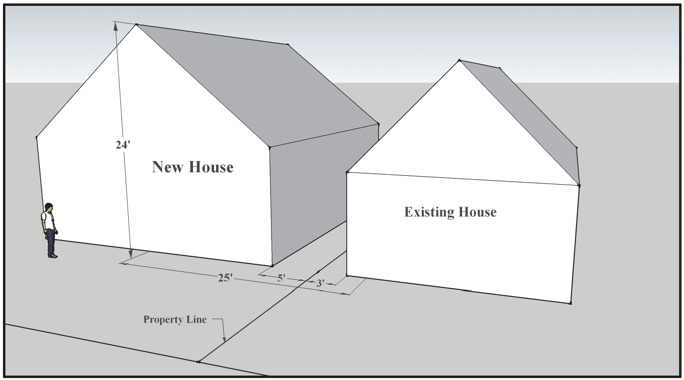
*If the actual side setback of the neighboring primary structure is less than five (5) feet, the property owner may use five (5) feet rather than the lesser amount in determining if the minimum horizontal distance between structures has been met. Example: the proposed house or addition is twenty-four (24) feet tall. The neighboring house is only three (3) feet from the property line. The apex of the proposed house needs to be at least twenty (20) feet off the property line (20+5=25) rather than twenty-two (22) feet off the property line (22+3=25) to meet the minimum horizontal distance.
(iii)
A roof pitch of 4:12 or less is considered to be a flat roof such that the height of the apex is projected to the edge of the roof adjacent to the side setbacks. Dormers projecting towards the side setbacks may not displace more than fifty percent (50%) of the roof area from which they project.
(iv)
Attached residential units on separate parcels are not subject to the height/setback relationship along the shared lot line between the two (2) structures. New attached residential units on separate parcels or additions to such existing structures shall be subject to height limitations derived from distance to foundations of neighboring structures or twenty-six (26) feet, whichever is less.
(2)
Mass and Scale. New single family structures and additions in the neighborhood must appear from the street to be similar in mass and scale to other single family structures on that side of the block. Multi-family structures must also appear to be similar in mass and scale to existing structures on that side of the block and complement the existing streetscape. Historically, square footage is "hidden" in the roof line or behind the front façade:
(i)
Height. Maximum height allowed for a new primary structure or addition is twenty-six (26) feet. However, if an existing primary structure taller than twenty-six (26) feet should be completely destroyed by a natural cause such as fire, a new structure may be built to the height and square footage of the original structure. Any additional footprint must adhere to the design requirements. Within the overlay area, height is measured to the top of the ridge or parapet but does not include chimneys, solar installations, etc.
(ii)
Mass. Size of primary structures is limited as shown in Table 16-H. If more than one (1) primary structure is proposed, they must share the allotted floor area. If an existing primary structure greater in mass than what is allowed in the design requirements should be completely destroyed by a natural cause such as fire, a new structure may be built to the square footage of the structure prior to destruction.
(3)
Accessory structures. New accessory structures must be subordinate in terms of mass, scale, and height to the primary structure.
(i)
The maximum height allowed for new accessory structures is one and one-half stories (1½). The height of a new accessory structure must be subordinate to the height of the primary structure.
(ii)
Garages must be detached from the primary structure and must be accessed from the alley where there is alley access.
(4)
Restorations. When the primary façade of an older structure is to be restored to its original, historic appearance, a deviation request pursuant to subsection (5) will not be required if the restoration will conflict with the front setback requirements.
(5)
Deviations. Deviations from the requirements of these design guidelines may be permitted upon a finding by the Planning Commission that the proposed design solution is consistent with the existing mass and height of the block where the new structure or addition is proposed. In reviewing an application for a deviation the Planning Commission may consider the unique challenges of a particular site or existing structures of the site. Such challenges may include but are not limited to, narrow lot width, low foundation heights of adjacent structures, or unusual setbacks on existing or adjacent structures. Deviations will follow the development review procedures of Article III of the Land Use Code for applications where the Planning Commission is the decision making body. If a variance is requested from other provisions of the code not addressed in these design guidelines, that variance will follow the normal procedure of Section 16-4-180 of the Land Use Code.
(d)
Design Recommendations. In addition to the Sackett's Addition Overlay building standards set forth in subsection (c) above, the City strongly encourages compliance with the Sackett's Addition Design Recommendations, a copy of which is available for inspection at City Hall. These design elements were created to ensure that new infill construction or the alteration of existing structures will enhance the existing character and historic nature of the Sackett's Addition neighborhood. Although compliance with the design recommendations is not mandatory, structures designed without considering these elements may be incompatible with the Sackett's Addition neighborhood.
(Ord. No. 2014-05, 5-6-2014)
Sec. 16-5-90. - Central Business Economic Overlay (CBEO).
(a)
Purpose. The purpose of the Central Business Economic Overlay (CBEO) is to establish standards to preserve and protect the downtown area as a viable commercial district, and to ensure that future development be designed and planned in a manner compatible with those goals.
(b)
Applicability. The standards of the Central Business Economic Overlay (CBEO) shall apply to all development on parcels within the CBEO.
(c)
Areas. The boundaries of the Central Business Economic Overlay (CBEO) are shown on the Official Zoning Map.
(d)
Standards. The standards listed below shall apply to development in the Central Business Economic Overlay (CBEO). These standards shall be in addition to those of the underlying zone district in which the property is located and in addition to the other applicable standards of this Chapter.
(1)
Street Frontage.
(i)
The street frontage on the street level of buildings shall not be used for residential uses as defined by Table 16-D, Schedule of Uses.
(ii)
No more than fifty percent (50%) of the remaining area of the ground floor occupancy may be used for residential uses.
(iii)
If the limitation on residential uses will create a significant economic hardship, an owner may apply for and receive conditional use approval if the additional review standard to Section 16-4-110(d) is met:
11.
Increase in Ground Floor Residential in CBEO. The amount of ground floor residential uses may be increased above 50 percent (50%) if the approving authority makes the finding that the subject property cannot be put to any other reasonably beneficial use.
(2)
Parking.
(i)
All parking standards pursuant to this Chapter apply, except that a commercial business applicant may seek an alternative to providing the required on-site parking by paying a fee in lieu of providing said on-site parking in an amount established and periodically amended by the City's fee schedule. Funds received by the City for the fee in lieu shall be designated for the purposes of providing additional public parking for City's downtown or for the enforcement of parking regulations.
(Ord. No. 2018-20, § 3, 1-11-2019)