
San Antonio City Zoning Code
DIVISION 5
SPECIAL DISTRICTS
Sec. 35-340.- Purpose.
STATEMENT OF PURPOSE
Special districts address unique situations. However, unlike overlay districts, special districts replace the standards and requirements of the base districts. In effect, they are a parallel code and an alternative to proceeding under conventional zoning.
Sec. 35-341. - "MXD" Mixed-Use District.
STATEMENT OF PURPOSE
To provide concentrated residential, retail, service, office, business park, and mixed uses. This district does not regulate land uses but, instead, permits any use to be established subject to an approved zoning site plan. Urban design standards are required in order to maintain a neighborhood commercial scale, to promote pedestrian activity, and to maintain the unique character of the center. Pedestrian circulation is required as are common parking areas.
The "MXD" district implements the following policies of the master plan:
• Neighborhoods, Policy 2b: Amend the Unified Development Code to create mixed-use districts.
• Urban Design, Policy 1c: Develop zoning regulations that would allow mixed-use development (i.e. residential and commercial) to be placed in the same building.
• Urban Design, Policy 1f: Encourage mixed-use zones around existing and new city facilities to foster a greater mix of activities and social interaction.
• Urban Design, Policy 5b: Encourage resident and employment growth within walking distance of the downtown area and neighborhood centers in order to support an inter-modal transportation system.
• Urban Design, Policy 5e: Promote public and private sector, ride-sharing, flexible working hours, parking management innovations, and mixed-use developments as means of reducing the demand for peak period vehicular trips.
(a)
Locational Criteria. An "MXD" district may be designated for any area within the city.
(b)
Use Regulations.
(1)
An "MXD" shall include both residential and commercial uses. The ordinance shall include an indication of gross density for all residential uses in units per acre; "O-1" and "O-2" office uses; and "NC," "C-1," "C-2," and "C-3" commercial uses as defined in this chapter, are specifically permitted in the "MXD" zoning base district.
(2)
In addition, business park uses shall be permitted in an "MXD" zoning base district, as follows:
• Wholesaling,
• Research and development,
• Manufacturing,
• Processing,
• Fabrication, and assembly,
• Testing,
• Repair,
• Servicing,
• Storage,
• Laboratory,
• Warehousing,
• Displaying, or
• Distribution of goods, materials or products.
(c)
Site Plan.
(1)
Simultaneous with the request for "MXD" zoning, an "MXD" site plan shall also be filed. An application for rezoning to an "MXD" shall not be deemed complete unless accompanied by a proposed "MXD" site plan.
(2)
The location of all uses and/or zoning districts shall be designated on the "MXD" site plan.
(3)
"MXD" site plans shall be reviewed by the zoning commission and approved by the city council concurrent with the application for rezoning to an "MXD." The zoning ordinance shall provide adherence to the "MXD" site plan, or the amended "MXD" site plan, however, a rezoning shall not be required for the approval of a minor change to the "MXD" site plan as defined in subsection (d)(3) of this section.
(d)
Amendments.
(1)
Revisions to a previously approved "MXD" master site plan shall be classified as a minor or major amendment. Within five (5) working days after filing the proposed revisions, required items and information, the director of development services shall provide a written response indicating whether or not the submitted revised "MXD" site plan has been accepted as a minor or major revision. If it is determined by the director of development services that the revised submittal is considered a minor change then said submittal shall be processed by the director of development services and shall not require review by the zoning commission or approval by the city council. If it is determined by the director of development services that the proposed revision is a major change then said proposed major revisions shall be processed in the same manner as the initial "MXD" site plan submittal described in subsection (c) of this section. Major amendments to an "MXD" site plan constitutes a new project with respect to the area of the project that is being modified.
(2)
A major amendment to an "MXD" site plan shall include:
A.
Any increase in the total number of residential units for the entire "MXD" greater than ten (10) percent of the original request.
B.
Any increase in the total commercial or office acreage within the "MXD" greater than ten (10) percent of the original request.
C.
Any increase in the total business park acreage within the "MXD" greater than ten (10) percent of the original request.
D.
Any decrease above ten (10) percent in the total open space acreage within the "MXD."
E.
Any change in a proposed land use node from residential to an office, commercial or light industrial use, if the property where the proposed change is to occur abuts existing property in which the principal use is a single-family residence.
F.
?An increase in the height if a height restriction was included on the approved "MXD" site plan.
(3)
Any other revision to an "MXD" site plan not described in subsection (2), above, shall be deemed a minor change.
(e)
Lot and Building Specifications. The Lot and Dimensions Table (Article III), including minimum area and frontage requirements, shall not apply to an approved mixed use development provided the following lot and building dimensions shall apply:
(1)
No new or existing building shall be erected, constructed or expanded to extend within the public right-of-way or within five (5) feet of the rear lot line.
(2)
Height shall be governed by the height indicated on the site plan for a "MXD" district.
(3)
If the "MXD" zoned property abuts a single-family use or zone then the structure shall be located at least twenty-five (25) feet from the single-family area.
(4)
If the "MXD" zoned property abuts a single-family use or zone then the structure shall not exceed two and one-half (2.5) stories or thirty-five (35) feet in height if the structure is fifty (50) feet or less from the single-family area.
(f)
Streets and Sidewalks. Streets within a "MXD" shall be publicly accessible. Gated streets and gated developments shall not be permitted. Streets shall conform to the transportation standards of this chapter unless an alternative street and sidewalk plan is approved as part of a rezoning to a "MXD."
(g)
Off-Street Parking Requirements. Off-street parking facilities shall be provided in accordance with Table 526-3b: Parking in Nonresidential Use Districts except that the following reduction to the minimum off-street parking requirements shall apply:
(1)
Minimum off-street parking requirement may be reduced one (1) space for each on-street parking space located adjacent to the property.
(h)
Bail bond agencies shall require approval of a specific use authorization, pursuant to section 35-423, to be allowed within mixed-use districts.
(i)
Applicability. Unless explicitly superseded or modified by this section, the provisions contained in Article V: Development Standards, of this chapter shall be applicable to a "MXD" development.
(Ord. No. 97568 § 2) (Ord. No. 2008-05-15-0401, § 2, 5-15-08) (Ord. No. 2009-01-15-0001, § 2, 1-15-09; Ord. No. 2015-12-17-1077, § 2, 12-17-15; Ord. No. 2018-11-15-0913, § 2, 11-1-18)
Sec. 35-342.01. - "TOD" Transit-Oriented Development District Complete Change of Zoning Applications Submitted Prior to January 1, 2025.
STATEMENT OF PURPOSE
The transit-oriented development district encourages a mixture of residential, commercial, and employment opportunities within identified light rail station or other high capacity transit areas. The district allows for a more intense and efficient use of land at increased densities for the mutual re-enforcement of public investments and private development. Uses and development are regulated to create a more intense built-up environment, oriented to pedestrians, to provide a density and intensity that is transit supportive. The development standards of the district also are designed to encourage a safe and pleasant pedestrian environment near transit stations by encouraging an intensive area of shops and activities, by encouraging amenities such as benches, kiosks, and outdoor cafes, and by limiting conflicts between vehicles and pedestrians. It is the intent of this section that a "TOD" district be restricted to areas within one-half (½) of a mile of a transit station, which area is equivalent to a typical ten-minute walking distance.
(a)
Locational Criteria. See subsection 35-208(d).
(b)
Development Standards. No application shall be approved within a "TOD" district unless it complies with the standards set forth in the "TOD" use patterns, section 35-208 of this chapter.
(Ord. No. 2009-01-15-0001, § 2, 1-15-09; Ord. No. 2024-12-19-1017, § 2, 12-19-24, eff. 1-1-25)
Editor's note— Ord. No. 2024-12-19-1017, § 2, adopted December 19, 2024 and effective January 1, 2025, redesignated the former section 35-342 as section 35-342.01, and changed the title from ""TOD" Transit-Oriented Development District" to ""TOD" Transit-Oriented Development District Complete Change of Zoning Applications Submitted Prior to January 1, 2025." The historical notation has been preserved for reference purposes.
Sec. 35-342.02. - "T-" Transit-Oriented Development Districts Complete Change of Zoning Applications Submitted After January 1, 2025.
STATEMENT OF PURPOSE
The purpose of the Transit-Oriented Development (T-) Districts is to implement the planning and design concepts embodied in transit corridors identified on the High-Capacity Transit Network Plan, as designated and adopted by VIA Metropolitan Transit. The standards defined for T- Districts enable a development pattern that encourages transit-supportive densities, improved access to jobs, housing, amenities, and educational opportunities, and offers an enhanced public realm along transit corridors. The following describes the intent and purpose of each of the T-Districts established in this section.
(a)
Applicability.
(1)
Designation Process and Applying a TOD District.
A.
TOD District applications shall follow the rezoning process in Sec. 35-421. Zoning Amendments. Applications for rezoning to a TOD District must meet the criteria below. All "TOD" designated corridors shall include a map illustrating the limitation of the boundaries eligible for "TOD" zoning applications. "TOD" zoning requests shall be limited to properties within the approved boundary in order to prevent the encroachment into the middle of an established residential blockface.
B.
Stakeholder Participation. The process of developing and adopting a map to illustrate the boundaries eligible for "TOD" zoning applications should involve key stakeholders within one-half (½) mile of a proposed corridor which may include property owners, residents, all impacted neighborhood associations, community organizations, non-profits, major employers, small, mid and large businesses, schools, hospitals, medical facilities, and technical team members with relevant transit, equity and housing experience as well as representatives from disability access organizations. The applicable city department should form a team comprised of the stakeholders and shall invite them to participate and assist with map development. Maps will undergo continuing city departmental review to clarify and identify any program or policy inconsistencies. The development of the maps shall go through a public input process.
C.
"TOD" Districts shall be limited to:
i.
Designated Advanced Rapid Transit "ART" corridors as designated and adopted by VIA Metropolitan Transit Board action; and
ii.
Properties within the map illustrated approved boundary referenced in Section (2) (A) for each designated corridor.
(2)
Locational Criteria and Zoning Authority.
A.
"TOD" District designation ordinances shall include a map illustrating the boundaries abutting the designated Advanced Rapid Transit corridor or how the property otherwise meets the designation criteria of Subsection (a) (1) above. For Corridors that lie within the city's original thirty-six (36) square miles, as referenced in the Community Revitalization Action Group (CRAG) Report of the Special Projects Office of the city, sensitivity should be given to the application of TOD adjacent to established residential neighborhoods. Individual TOD District designation shall be by separate ordinance, shall identify the designated boundaries, and shall include maps illustrating the boundaries. Adopted "ART" corridors referenced herein and date adopted are:
1.
Green Line ART as adopted and designated on June 25, 2024. TOD Map and Boundary Ordinance #2024-12-19-1017.
B.
In the event of a conflict between any of the provisions or standards of this section and the provisions or standards of any approved overlay district, the provisions or standards of the overlay district shall control over the Transit Oriented Development District.
C.
"TOD" Districts shall not be applied to property zoned single-family residential less than or equal to one-half (½) of an acre that is with a single-family residential use of four (4) units or less. "TOD" Districts shall not be applied to property within the CRAG, original thirty-six (36) square miles, zoned single-family residential that is with a single-family residential use of four (4) units or less. In this section, a "single-family residential use" includes any single-family dwelling, duplex, triplex, fourplex, or townhome.
D.
"TOD" Districts shall not be applied to property owned by the City of San Antonio and operated, managed or maintained by the City's Parks and Recreation Department as part of the official list of park real estate assets.
(b)
Introductory Provisions.
(1)
Establishment.
The following "TOD" districts are hereby established and referred to collectively herein as "TOD" districts: "TOD-MX-3"; "TOD-MX-6"; "TOD-MX-12"; "TOD-MX-U"; "TOD-HI-3"; "TOD-HI-6"; "TOD-TR-2.5". The general purpose of each district are described in Table 342.02-1 with the corresponding district designation. The design regulations for each district are included in Table 342.02-2 below.
Table 342.02-1
"TOD" Districts Established
Table 342.02-2
"TOD" Districts Design Regulations
(b)
Uses.
(1)
Permitted Uses.
A.
The use table on the following pages applies the requirements of Sec. 35-311. Use Regulations including any applicable Supplemental Use Regulations in Division 7.
B.
Generally. No use shall be permitted pursuant to this chapter, and no development permit authorizing a use may be authorized, issued, or approved by any officer, official, or agency of the city unless said use is listed as a permitted or specific use permit in the Use Matrix (Table 342-02-1) and all applicable permits and approvals have been issued by the official or agency with final decision making authority. (2) Use Categories and Specific Uses. The use categories listed in the first column of Table 342-02-1 are defined in this chapter, the LBCS, NAICS, or in other resources cross-referenced in this chapter.
C.
Permitted Uses. A "P" indicates that the listed use is permitted by right within the zoning district. Permitted uses are subject to all other applicable standards of this chapter. Additional development standards may be applicable (see supplemental use regulations, division 7 of this article).
D.
Specific Uses. An "S" indicates that the listed use is permitted within the respective zoning district only after review and approval of a specific use permit, in accordance with the review procedures of section 35-423 of this chapter. Specific use permits are subject to all other applicable standards of this chapter and those requirements that may reasonably be imposed by the city consistent with the criteria set forth in subsection 35-423(e) of this chapter and any supplemental use regulations which apply to said use. The site plan shall indicate the location of each "S" as per subsection 35-423(e) and in the event of a multistory development, vertical field notes shall be required and an indication of the floor shall be shown on the site plan.
E.
Prohibited Uses. A blank cell (" ") indicates that the listed use type is not allowed within the respective zoning district, unless it is otherwise expressly allowed by other regulations of this chapter.
TABLE 342.02-3
"TOD" Districts
Special Zoning Districts Use Matrix
(c)
Development Standards.
(1)
General Applicability.
A.
Unless explicitly superseded or modified by this section, the provisions contained in Article V, Development Standards apply to all TOD Districts.
B.
Traffic Impact Analysis and Roughly Proportionate Determination Study - Provisions contained in section 35-502 - Traffic Impact Analysis and Roughly Proportionate Determination Study, do not apply to an application for development approval within a TOD zoning district. Subsection 35-502(b)C.vii. Traffic Circulation Study shall apply for all existing and future schools (public, private, and charter).
C.
Transportation and Street Design - Provisions contained in section 35-506 - Transportation and Street Design, apply to all TOD Districts. Table 506-2 Traditional Street Design standards may be approved for developments within the TOD Districts.
D.
Buffers - Provisions contained in section 35-510 - Buffers, apply to all TOD Districts. Refer to Table 510-1 for requirements.
E.
Landscaping and Streetscape Planting Standards - Provisions contained in section 35-511 - Landscaping and section 35-512 - Streetscape Planting Standards, apply to all TOD Districts.
F.
Fences - Provisions contained in section 35-514 - Fences, apply to all TOD Districts, however, any front yard fencing shall not exceed three (3) feet in height with a transparency no greater than predominately open fencing. For purposes of this section only, properties developed with a density of five (5) or more units shall be considered as multi-family uses. Properties developed with a mix of both residential and non-residential uses, shall be considered as non-residential uses.
G.
Tree Preservation - Provisions contained in section 35-523 - Tree Preservation, apply to all TOD Districts. It is encouraged to provide tree canopy in or near right-of-way to provide maximum shade cover for the pedestrian experience.
H.
Storage Standards - Provisions contained in section 35-525 - Outdoor Storage Standards apply to all TOD Districts, however, there shall be no storage within the front yard.
I.
Parking - The minimum vehicle parking requirements in section 35-526 shall not apply in "TOD-MX" and "TOD-HI" districts. Within "TOD-TR" the minimum parking requirements may be reduced by fifty (50) percent. Where parking is provided, see subsection 35-526(e) for Size and Location. There shall be no parking in front yard or side yard in the "TOD-MX" and "TOD-HI" Districts. There shall be no parking in the front yard, with the exception for driveway parking (see section 35-526 for Driveways) in the "TOD-TR" district. Refer to Article A for Definitions and section 35-514 for illustrations of Yard.
J.
Driveways - Refer to subsection 35-515(d) for additional requirements for maximum impervious cover within front yard. The following standards shall apply to TOD districts as provided below:
Table 342.02-4
Driveway Standards
K.
Floodplain Development Requirements - Provision contained in Article F - Floodplains - Areas of Special Flood, apply to all TOD Districts.
(Ord. No. 2024-12-19-1017, § 2, 12-19-24, eff. 1-1-25)
Sec. 35-343. - "IDZ" Infill Development Zone Complete Change of Zoning Applications submitted prior to November 1, 2018.
STATEMENT OF PURPOSE
To provide flexible standards for the development and reuse of underutilized parcels. Urban design standards are required in order maintain a neighborhood commercial scale, to promote pedestrian activity, and to maintain the unique character of the center. Pedestrian circulation is required as are common parking areas. Any use may be permitted within an "IDZ" so long as it complies with the standards of this section.
The purpose of this section is to encourage and facilitate development on vacant, bypassed lands, or the redevelopment of underutilized buildings or structures, within existing built-up areas. The specific purposes of this section are:
• To provide a more flexible approach to design and development of infill projects.
• To use the objectives of smart growth as the basis for evaluating proposed infill projects.
• To encourage infill development by simplifying procedures for plan approval and public involvement.
• To encourage planning and design flexibility and innovations.
• To create a community environment that is enhanced by a mix of residential, commercial, recreational, open space, employment and institutional uses.
• To assure community compatibility through high standards of land planning, site and architectural design.
• To encourage efficient use of land and public services.
• To ensure adequate public facilities and other community amenities by simplifying and streamlining the approval of private development activities in areas with existing public facilities and infrastructure.
The provisions of this section apply to a geographic portion of the city adopted by city council to compliment the Community Revitalization Action Group (CRAG) Report of the Special Projects Office of the city.
The "IDZ" implements the following policies of the master plan:
• Growth Management, Policy 1g: Continue to make physical improvements in the inner city to encourage redevelopment and infill development.
• Economic Development, Goal 4: Provide economic opportunities in targeted areas, particularly within Loop 410 and the southern sector.
• Neighborhoods, Policy 1a: Rezone vacant or underutilized property in and around neighborhoods to encourage redevelopment that is compatible in use and intensity with the existing neighborhood.
• Neighborhoods, Policy 1d: Promote conversion or adaptive reuse of vacant or underutilized commercial buildings to provide affordable infill housing.
• Neighborhoods, Policy 1d: Provide incentives to the private sector to promote reuse of vacant or underutilized commercial buildings for affordable housing through such mechanisms as zoning and platting processing.
• Neighborhoods, Policy 2b: Amend the Unified Development Code to create mixed-use districts.
• Neighborhoods, Policy 4a: Preserve and revitalize housing and promote targeted infill housing in neighborhoods, particularly older neighborhoods located inside Loop 410.
• Urban Design, Policy 1c: Develop zoning regulations that would allow mixed-use development (i.e. residential and commercial) to be placed in the same building.
• Urban Design, Policy 1d: Develop criteria and procedures for infill development which will enhance the character of neighborhoods.
• Urban Design, Policy 1e: Permit zero setbacks for commercial and multi-family developments.
• Urban Design, Policy 4b: Use incentives to encourage development in underutilized urban areas.
• Urban Design, Policy 4b: Consider alternatives to existing setback, right-of-way, and other platting and zoning requirements to encourage development.
• Urban Design, Policy 4b: Consider rezoning underutilized areas to accommodate and promote appropriate redevelopment, while being cognizant of the surrounding areas' environment.
• Urban Design, Policy 5b: Encourage resident and employment growth within walking distance of the downtown area and neighborhood centers in order to support an inter-modal transportation system.
• Urban Design, Policy 5e: Promote public and private sector, ride-sharing, flexible working hours, parking management innovations, and mixed-use developments as means of reducing the demand for peak period vehicular trips.
(a)
Locational Criteria.
(1)
Generally.
A.
An "IDZ" may be located within Community Revitalization Action Group (CRAG) target area as defined in 35-A101, which area generally includes the territory located inside the corporate boundaries of the city as they existed in 1940.
B.
An "IDZ" may also be located in a census tract inside of Interstate Loop 410 in which at least two (2) of the following factors are present:
1.
At least ten (10) percent of the structures are abandoned; or
2.
At least ten (10) percent of the platted lots are vacant; or
3.
At least ten (10) percent of the lots or structures are subject to tax liens.
C.
An "IDZ" may also be designated for a location inside of Interstate Loop 410 that meets one (1) of the following:
1.
Within the boundaries of a community development reinvestment plan adopted by the city council;
2.
Within the boundaries of a neighborhood, community, perimeter, sector, or sub-area plan adopted by city council at a location designated by the plan that is suitable for "IDZ" designation;
3.
On properties currently owned by the federal, state, county or city government; or
4.
On properties previously owned by the federal, state, county or city government on or after June 4, 2001.
(2)
Mapping. The "IDZ" district may be considered by the city council as an amendment to the official zoning map when it meets one (1) of the location criteria established by subsection (1) above.
(b)
Use Regulations. The "IDZ" may be approved as either a base zoning district or an overlay zoning district. The standards provided in this section shall apply whether "IDZ" is requested as either a base district or as an overlay except where otherwise specifically stated.
(1)
Overlay District. When the ordinance designates the "IDZ" as an overlay zoning district:
A.
A proposed infill development with frontage on a local street may be approved for any use permitted in the base zoning district in which it is located.
B.
When "IDZ" is adopted as an overlay district, the base zoning district standards shall remain in effect.
(2)
Base District and Site Plan Requirements. When the ordinance designates the "IDZ" as a base zoning district it shall be accompanied by a list of permitted uses and a zoning site plan which shall be filed with the application for rezoning and be incorporated into the ordinance designating the "IDZ" as a base zoning district. The zoning site plan shall be reviewed by the zoning commission and approved by the city council concurrent with the approval of the "IDZ" district. A master development plan is not required where "IDZ" is established as a base zoning district that has filed the requisite site plan. A zoning site plan for an "IDZ" shall include:
A.
Legal description and exhibit of the property at appropriate scale showing the area to be zoned "IDZ."
B.
The location of all comprehensive land use categories as defined in section 35-A101. Multi-family uses shall include an indication of gross density as defined in sections 35-A101 in units per acre, provided there is no limit on the level of density. For example, a 2.5-acre site with a sixty-five thousand (65,000) square foot building footprint consisting of two hundred seventy-five (275) units in a three-story building with the balance of the site used for amenities and off-street loading facilities shall be considered one hundred ten (110) dwelling units per acre. (275/2.5 = 110)
C.
The location of all streets and, if applicable, ingress/egress facilities in accordance with subsection (c)(1) below.
D.
When "IDZ" is adopted as a base zoning district, the standards for conventional subdivision, in accordance with section 35-202, shall remain in effect where not specifically provided alternative standards within this section.
E.
A site plan shall not be required for city-initiated "IDZ" rezoning cases.
(3)
Amendments to "IDZ" Site Plan.
A.
Initiation. Revisions to a previously approved "IDZ" site plan shall be classified as minor or major changes. The applicant for site plan amendment shall submit a site plan that is consistent with the requirements of section 35-343(b)(2) above. The submittal shall include the site plan approved with the original application and a revised copy with annotation of the requested changes. The revised site plan shall be prepared to scale and shall include a block for a signature by the property owner and the development services director to indicate acceptance of the revised site plan and, if applicable, shall include appropriate signature and seals of the design professional (i.e. architect, engineer, surveyor) that prepared the site plan. The site plan shall be processed only upon payment of the plan amendment fee indicated in 35-C103.
B.
Completeness Review. Development services will conduct a completeness review within five (5) working days of submittal. Within five (5) working days after filing the proposed site plan amendment, including all required items and information, the director of development services shall provide a written response to the applicant indicating whether or not the submitted revised "IDZ" site plan has been accepted as a minor or major amendment.
C.
Major Amendments. A major amendment shall require a new application for rezoning pursuant to the procedures of 35-421. A major amendment to an "IDZ" site plan shall include:
1.
Any increase in the number of dwelling units per acre within the "IDZ" plan area.
2.
Any increase in the total commercial acreage within the "IDZ" plan area.
3.
Any increase in the total industrial acreage within the "IDZ" plan area.
4.
Any decrease above ten (10) percent in the total open space acreage within the "IDZ" plan area.
5.
Any decrease in perimeter buffers between the "IDZ" plan area and adjacent properties.
6.
Any amendment to the location previously identified in the "IDZ" site plan from residential to an office, commercial or industrial use, if the property where the proposed change is to occur abuts existing property in which the principal use is a single-family residence.
D.
Minor Amendments. Any other revision to an "IDZ" site plan not described in subsection 35-343(b)(3)C above, shall be deemed a minor change. After the five-day completeness review process, a site plan revision deemed by the director as a minor amendment shall undergo a technical review by staff not to exceed thirty-five (35) days and shall not require review by the zoning commission nor approval by the city council. If approved, the director shall sign the amendment indicating official acceptance in the required signature block.
(c)
Lot and Building Specifications.
(1)
Lot Layout.
A.
Minimum Lot Size. When "IDZ" is established as a base zoning district lots for the uses permitted on the zoning site plan may be platted without a minimum lot area requirement, provided that detached single-family uses shall have a minimum lot size of one thousand two hundred fifty (1,250) square feet.
B.
Frontage. When "IDZ" is established as a base zoning district lots may be platted without frontage on a public or private street, provided that lots without frontage on a public or private street shall be provided with vehicular and/or pedestrian traffic access by means indicated on the subdivision plat for the area with the "IDZ" designation. Approximate locations of ingress/egress facilities shall be shown on the zoning site plan. The provisions of this subsection regarding lots shall supersede the requirements of subsection 35-515(c)(4) titled "Frontage." Minimum fire access requirements shall apply.
C.
See section 35-515(d)(1), table 515-1 relative to front yard design.
(2)
Building Location. The requirements of this subsection shall apply to the construction of new buildings within the "IDZ" district used as a base district. The provisions of this subsection shall not apply to the reuse and/or rehabilitation of existing structures provided however that these requirements shall apply to any additions, expansion or enlargement of any existing buildings.
A.
Nonresidential. The side, front and rear setback provisions of the zoning regulations (article III) shall not apply to an approved infill development zone provided, however, that no new or existing building shall be erected, constructed or expanded to extend within the public right-of-way or within five (5) feet of the rear lot line. A 900 series lot, as defined in section 35-A101, may be provided in lieu of the required five-foot setback from the rear lot line provided that the 900 series lot provides a lot width at least equivalent to the required setback distance.
B.
Residential. On blocks where over fifty (50) percent of the blockface is occupied with existing single-family, duplex, triplex, and/or quadraplex residential units, the front setback within IDZ for uses zoned for single-family, duplex, triplex, and quadraplex uses shall be within ten (10) percent of the median setback of existing buildings on the block face. No new or existing building shall be erected, constructed or expanded to extend within the public right-of-way or within five (5) feet of the rear lot line. If there is a public street right-of-way, the front facade shall front the street. A 900 series lot, as defined in 35-A101, may be provided in lieu of the required front or rear setbacks provided that the 900 series lot provides a lot width at least equivalent to the minimum required setback distance.
On blocks where fifty (50) percent or less of the blockface is occupied with existing single-family, duplex, triplex, and/or quadraplex residential units, or the block is being redeveloped for over fifty (50) percent of the block face, the front, side and rear setback provisions of the zoning regulations (article III) shall not apply to an approved infill development zone provided, however, that no new or existing building shall be erected, constructed or expanded to extend within the public right-of-way or within five (5) feet of the rear lot line. A 900 series lot, as defined in section 35-A101, may be provided in lieu of the required five-foot setback from the rear lot line provided that the 900 series lot provides a lot width at least equivalent to the required setback distance.
(d)
Adequacy of Public Facilities. The traffic impact and roughly proportionate determination (section 35-502 of this chapter) do not apply to an application for development approval within an "IDZ" district.
(e)
Street Construction Standards.
(1)
Standards Not Applicable. The street construction standards shall not apply to infill development which involves the activities listed in subsections A and B below, except as provided in subsection (2) below. The street construction standards shall apply to all other infill development not listed below:
A.
The reuse of an existing building; or
B.
The development of an existing parcel or lot of less than twenty thousand (20,000) square feet.
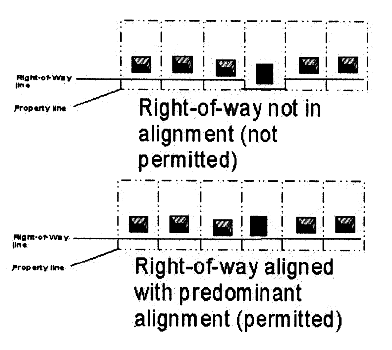
Figure 343-1
(2)
Standards Which Are Applicable. The following provisions of the street construction standards shall apply to all infill development, including that listed above:
A.
Standards relating to sidewalks, subsection 35-505(q) provided, however, that the applicant shall not be required to provide a sidewalk width exceeding that of any existing sidewalks adjoining the site, provided that minimum ADA standards shall be met in accordance with 35-506(d)(9)C. In single-family locations see also section 35-506(q)(2)F.
B.
If the lot adjoins a street in which the right-of-way is not aligned with the adjoining parcels, the standards relating to the dedication of right-of-way (subsection 35-505(g)) shall apply (see Figure 343-1).
(f)
Stormwater Management. Infill development shall comply with the stormwater management standards, section 35-504 of this chapter, except as otherwise provided herein. The stormwater management standards shall not apply to the following:
(1)
The reuse of an existing building; or
(2)
The development of an existing parcel or lot of less than ten thousand (10,000) square feet.
The stormwater management standards shall apply to all other infill development not listed above.
(g)
Utilities. The utilities standards shall apply to infill development.
(h)
Parks and Open Space. The parks and open space standards (section 35-503 of this chapter) shall not apply to infill development.
(i)
Reserved.
(j)
Buffers, Landscaping, and Streetscape Planting. The buffering standards (section 35-510) shall not apply to infill development. The landscaping standards (section 35-511) and streetscape planting standards (section 35-512) shall apply. Only twenty-five (25) points shall be required under subsection 35-511(d) (elective criteria), for landscaping on lots within the "IDZ" district, see also section 35-511(e)(7).
(k)
Parking. The minimum vehicle parking requirements in subsection 35-526(b) shall not apply to infill development. Where parking is provided, subsections 35-526(c) through 35-526(f) shall apply to infill development.
(l)
Outdoor Storage. The outdoor storage standards shall apply to infill development.
(m)
Urban Design.
(1)
Compatible Design. Any new building shall be compatible in massing to buildings on abutting lots and abutting block faces. Any extension or enlargement of an existing building shall be compatible in "massing" to the building from which it is being added onto. For purposes of this section, the term "massing" refers to the shape and form of a building provided by all, or a combination of, architectural elements such as roof configuration, spacing between buildings, setbacks from the street right-of-way, proportion of fenestration and entryways, building form, exterior building materials, building scale, architectural styles, and landscaping. For the purpose of this subsection only the term "abutting" refers to being located next to or bordering and "adjacent" refers to lying near or close. See Richard Hedman, Fundamentals of Urban Design (Chicago: American Planning Association, APA Planner's Press, 1985), at 11—19, for reference. A building or site plan shall be considered to be compatible in massing" to buildings on abutting lots and adjacent block faces, or uses if at least two (2) of the following five (5) elements are provided:
| SETBACKS AND SPACING BETWEEN BUILDINGS. A narrow side setback (not exceeding ten (10) feet) shall be provided between building facades facing the street public right-of-way in order to frame the structure and to provide spacing and rhythm between the structures. The side setback provisions of this section shall not apply to single-family detached dwellings or lots abutting a single-family detached dwelling. |   |
| PROPORTION OF WINDOWS, BAYS, AND DOORWAYS. Windows, doorways, bays, and pediments meet the following criteria: (1) windows, doorways, bays, and pediments do not vary more than ten percent (10%) in area from windows, doorways, bays, and pediments in the facade of abutting buildings on abutting lots or if the subject property is the only lot on a block, the windows, doorways, bays, and pediments do not vary more than ten percent (10%) in area from windows, doorways, bays, and pediments of buildings on adjacent block faces, and (2) vertical or horizontal elements tied together in bands across facade lengths. |  |
| PROPORTION OF PRIMARY FACADE. The size of facades facing the street public right-of-way are similar in area and height to width ratios to buildings on abutting and/or adjacent lots. The size of the facade shall be considered "similar" if the proposed facade does not vary by more than thirty percent (30%) in area from any facade on a building of an abutting lot or, if the subject property is the only lot on the block, the facade shall not vary by more than thirty percent (30%) in area from building facades on adjacent block faces. If this standard cannot be met because of the variation in size of two facades on abutting lots or facades on adjacent block faces in the case of a single lot on a block, the proposed building shall not vary by more than thirty percent (30%) from one of the facades on abutting lots or adjacent blocks, at the discretion of the applicant. | 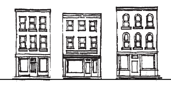 |
| LOCATION AND TREATMENT OF ENTRYWAY. At least one (1) entryway shall be provided along the front facade, which is the facade that faces the street public right-of-way. In order to create visual commonality between structures, the following criteria shall apply: (1) the size of entryways in building facades facing the street public right-of-way shall not vary by more than thirty percent (30%) in area from entryways on a building of an abutting lot or, if the subject property is the only lot on the block, the entryway shall not vary by more than thirty percent (30%) from entryways on building from adjacent block faces, and (2) the height of entryways for abutting buildings shall not vary more than thirty percent (30%) as measured from grade. | 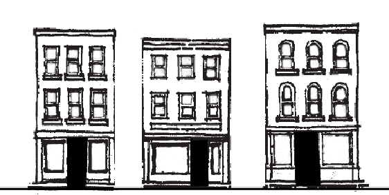 |
| BUILDING SCALE. Building height and footprint shall not vary by more than ten percent (10%), from buildings on abutting lots or, if the subject parcel is the only property on the block, the height shall not vary by more than ten percent (10%) from building heights on adjacent block faces. Building height may vary by more than ten percent (10%) only in order to maintain continuity between the ground floor elevations of adjoining buildings on the site. |  |
(2)
Alternative Designs.
A.
As an alternative to compatible design requirements in subsection (1) above, an applicant requesting "IDZ" designation as a base district on blockfaces that are not occupied by fifty (50) percent or greater residential uses as established in section 35-343(c)(2)B above may submit alternative building design plans that demonstrate substantial conformance to the requirements of section 35-204(o) for recommendation by the zoning commission and consideration by the city council as part of a request to rezone property to "IDZ" as a base district. Where properties are located within a historic district or a river improvement overlay districts building designs require approved of the office of historic preservation and historic and design review commission, as applicable.
B.
As an alternative to the compatible design requirements in subsection (1) above, an applicant, including the city for city-initiated large area rezoning cases, requesting "IDZ" designation as a base district may submit an alternative site and building design plan that conforms to the design guidelines from a physical master plan adopted as a component of the city's comprehensive plan as part of a request to rezone property to "IDZ" as a base district for recommendation by the zoning commission and consideration by the city council. To qualify under this provision, the alternative site and building design plan must at a minimum include building height, build-to-zone, percent of façade in build-to-zone, building and tenant entrance location, parking location, building material, and landscape standards that conform to the physical master plan guidelines that are applicable to the property subject to the rezoning request.
(Ord. No. 100126) (Ord. No. 2008-06-12-0532, § 2, 6-12-08) (Ord. No. 2009-01-15-0001, § 2, 1-15-09) (Ord. No. 2010-11-18-0985, § 2, 11-18-10) (Ord. No. 2012-10-18-0829, § 2, 10-18-12; Ord. No. 2015-12-17-1077, § 2, 12-17-15; Ord. No. 2018-11-15-0913, § 2, 11-1-18; Ord. No. 2022-11-03-0831, § 2, 11-3-22, eff. 1-1-23)
Sec. 35-343.01. - "IDZ" Infill Development Zone: Complete Change of Zoning Applications submitted after November 1, 2018.
STATEMENT OF PURPOSE
To provide flexible standards for the development and reuse of underutilized parcels. Urban design standards are required in order maintain a neighborhood commercial scale, to promote pedestrian activity, and to maintain the unique character of the center. Pedestrian circulation is required as are common parking areas. Any use may be permitted within an "IDZ" so long as it complies with the standards of this section.
The purpose of this section is to encourage and facilitate development on vacant, bypassed lands, or the redevelopment of underutilized buildings or structures, within existing built-up areas. The specific purposes of this section are:
• To provide a more flexible approach to design and development of infill projects.
• To use the objectives of smart growth as the basis for evaluating proposed infill projects.
• To encourage infill development by simplifying procedures for plan approval and public involvement.
• To encourage planning and design flexibility and innovations.
• To create a community environment that is enhanced by a mix of residential, commercial, recreational, open space, employment and institutional uses.
• To assure community compatibility through high standards of land planning, site and architectural design.
• To encourage efficient use of land and public services.
• To ensure adequate public facilities and other community amenities by simplifying and streamlining the approval of private development activities in areas with existing public facilities and infrastructure.
The provisions of this section apply to a geographic portion of the city adopted by city council to compliment the Community Revitalization Action Group (CRAG) Report of the Special Projects Office of the city.
The "IDZ" implements the following policies of the master plan:
• Growth Management, Policy 1g: Continue to make physical improvements in the inner city to encourage redevelopment and infill development.
• Economic Development, Goal 4: Provide economic opportunities in targeted areas, particularly within Loop 410 and the southern sector.
• Neighborhoods, Policy 1a: Rezone vacant or underutilized property in and around neighborhoods to encourage redevelopment that is compatible in use and intensity with the existing neighborhood.
• Neighborhoods, Policy 1d: Promote conversion or adaptive reuse of vacant or underutilized commercial buildings to provide affordable infill housing.
• Neighborhoods, Policy 1d: Provide incentives to the private sector to promote reuse of vacant or underutilized commercial buildings for affordable housing through such mechanisms as zoning and platting processing.
• Neighborhoods, Policy 2b: Amend the Unified Development Code to create mixed-use districts.
• Neighborhoods, Policy 4a: Preserve and revitalize housing and promote targeted infill housing in neighborhoods, particularly older neighborhoods located inside Loop 410.
• Urban Design, Policy 1c: Develop zoning regulations that would allow mixed-use development (i.e. residential and commercial) to be placed in the same building.
• Urban Design, Policy 1d: Develop criteria and procedures for infill development which will enhance the character of neighborhoods.
• Urban Design, Policy 1e: Permit zero setbacks for commercial and multi-family developments.
• Urban Design, Policy 4b: Use incentives to encourage development in underutilized urban areas.
• Urban Design, Policy 4b: Consider alternatives to existing setback, right-of-way, and other platting and zoning requirements to encourage development.
• Urban Design, Policy 4b: Consider rezoning underutilized areas to accommodate and promote appropriate redevelopment, while being cognizant of the surrounding areas' environment.
• Urban Design, Policy 5b: Encourage resident and employment growth within walking distance of the downtown area and neighborhood centers in order to support an inter-modal transportation system.
• Urban Design, Policy 5e: Promote public and private sector, ride-sharing, flexible working hours, parking management innovations, and mixed-use developments as means of reducing the demand for peak period vehicular trips.
(a)
Locational Criteria.
(1)
Generally.
A.
An "IDZ" may be located within Community Revitalization Action Group (CRAG) target area as defined in section 35-A101, which area generally includes the territory located inside the corporate boundaries of the city as they existed in 1940.
B.
An "IDZ" may also be located in a census tract inside of Interstate Loop 410 in which at least two (2) of the following factors are present:
1.
At least ten (10) percent of the structures are abandoned; or
2.
At least ten (10) percent of the platted lots are vacant; or
3.
At least ten (10) percent of the lots or structures are subject to tax liens.
C.
An "IDZ" may also be designated for a location inside of Interstate Loop 410 that meets one (1) of the following:
1.
Within the boundaries of a community development reinvestment plan adopted by the city council;
2.
Within the boundaries of a neighborhood, community, perimeter, sector, or sub-area plan adopted by city council at a location designated by the plan that is suitable for "IDZ" designation;
3.
On properties currently owned by the federal, state, county or city government; or
4.
On properties previously owned by the federal, state, county or city government on or after June 4, 2001.
(2)
Mapping. The "IDZ" district may be considered by the city council as an amendment to the official zoning map when it meets one (1) of the location criteria established by subsection (1) above.
(b)
Use Regulations. The "IDZ" may be approved as an overlay district. The "IDZ" may be approved as a base zoning district and must specify if the request is for "IDZ-1" Limited Intensity Infill Development Zone, "IDZ-2" Mid Intensity Infill Development Zone, or "IDZ-3" High Intensity Infill Development Zone, and the ordinance shall include an indication of gross density for all residential uses in units per acre, the list of zoning districts and/or permitted uses.
(1)
Overlay District. When the ordinance designates the "IDZ" as an overlay zoning district:
A.
When "IDZ" is adopted as an overlay district, the base zoning district standards shall remain in effect.
(2)
Base District. "IDZ-1" Limited Intensity Infill Development Zone
A.
"IDZ-1" shall be limited to no more than eighteen (18) dwelling units per acre.
B.
"IDZ-1" shall be limited to commercial uses consistent with the "NC" Neighborhood Commercial District or the "C-1" Light Commercial District. "IDZ-1" shall also be limited to office uses consistent with the "O-1" Light Office District
C.
"IDZ-1" shall not permit any industrial uses.
(3)
Base District. "IDZ-2" Medium Intensity Infill Development Zone
A.
"IDZ-2" shall be limited to no more than fifty (50) dwelling units per acre.
B.
"IDZ-2" shall be limited to commercial uses consistent with the "NC" Neighborhood Commercial, "C-1" Light Commercial, or "C-2" Commercial District. "IDZ-2" shall be limited to office uses consistent with the "O-1" Light Office District or the "O-1.5" Mid-Rise Office District.
C.
"IDZ-2" shall not permit any industrial uses.
(4)
Base District. "IDZ-3" High Intensity Infill Development Zone
A.
"IDZ-3" shall permit any residential density however, the density must be stated in the application and ordinance.
B.
"IDZ-3" shall be limited to commercial uses consistent with the "NC" Neighborhood Commercial District, "C-1" Light Commercial District, "C-2" Commercial District, or "C-3" Commercial District. "IDZ-3" shall be limited to office uses consistent with the "O-1" Light Office District "O-1.5" Mid-Rise Office District, or the "O-2" High-Rise Office District.
C.
"IDZ-3" shall be limited to industrial uses consistent with the "I-1" General Industrial base zoning district.
(5)
Base District Site Plan Requirements for all "IDZ-1" base district zoning requests and "IDZ-2" and "IDZ-3" base district zoning requests less than or equal to one (1) acre. Requests for "IDZ" as a base zoning district shall be accompanied by a list of permitted uses and a zoning site plan which shall be filed with the application for rezoning and be incorporated into the ordinance designating the "IDZ". Requests for "IDZ-1" as a base zoning district to permit only one (1) single-family dwelling shall not require a site plan. A site plan shall not be required for city-initiated "IDZ" rezoning cases. The zoning site plan shall be reviewed by the zoning commission and approved by the city council concurrent with the approval of the "IDZ" district. A zoning site plan for all "IDZ-1" base zoning requests and "IDZ-2" and "IDZ-3" base district zoning requests less than or equal to one (1) acre shall include:
A.
Tabulation of the number of acres in the proposed development, showing the total number of lots, and area of open space for the site including the following:
1)
Dimensions and square footage of all buildings and structures;
2)
For nonresidential uses, multi-family dwellings, the approximate location and area of impervious cover;
3)
Square footage of all paved or otherwise hard surfaced streets, parking facilities, including curb and gutters, walks, loading areas, and asphalt or concrete aprons for solid waste containers, signs or outdoor mechanical equipment, as applicable.
B.
All setbacks as required by the proposed and surrounding zoning districts/uses.
C.
All off-street parking and loading areas/structures, including the number of spaces, dimensions of spaces and aisles, ADA required spaces and loading areas, and landscaping for parking areas. For parking requirements, see section 35-526 of the Unified Development Code.
D.
The location, dimensions and type of all walls, fences (other than fences on private residential lots) and required landscaping buffer.
E.
All existing and proposed driveways, streets, sidewalks and other infrastructure above, at or below grade, showing the existing and proposed physical layout, dimensions, and other relevant characteristics of the subject property.
F.
The intended use of the property to which the current and proposed improvements relate.
G.
The following statement: "I, _________________, the property owner, acknowledge that this site plan submitted for the purpose of rezoning this property is in accordance with all applicable provisions of the Unified Development Code. Additionally, I understand that City Council approval of a site plan in conjunction with a rezoning case does not relieve me from adherence to any/all City-adopted Codes at the time of plan submittal for building permits."
(6)
Ground Plan Comparison Form.
A.
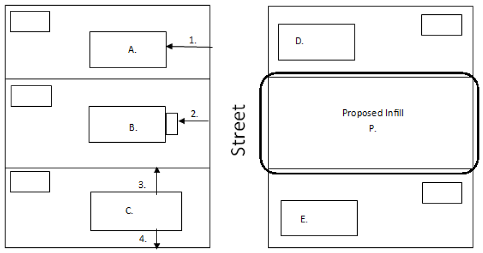
In addition to the site plan detailed above, applications for all "IDZ-1" base zoning requests, of any size, shall submit a ground plan comparison form. Also, any "IDZ-2" and "IDZ-3" base district zoning requests less than or equal to one (1) acre shall also include a ground plan comparison form. "IDZ-2" and "IDZ-3" base zoning district requests over one (1) acre are not required to submit a ground plan comparison form. This form is intended to provide context for the proposed project to determine if it is appropriate and compatible with adjacent lots. At a minimum, such study shall include the following for all applicable properties (subject property, abutting properties on the same blockface, and adjacent properties on the opposite blockface) as per the illustration below:
1.
The address of lots listed on the form.
2.
The setback to the front façade wall of each primary structure.
3.
The setback to the front porch of each primary structure, if applicable.
4.
The side setbacks of each primary structure.
5.
The height of each primary structure.
(7)
Base District Site Plan Requirements for "IDZ-2" and "IDZ-3" greater than one (1) acre.
A.
Requests for "IDZ" as a base zoning district shall be accompanied by a list of permitted uses and a zoning site plan which shall be filed with the application for rezoning and be incorporated into the ordinance designating the "IDZ" as a base zoning district. Requests for "IDZ" as a base zoning district to permit only one (1) single-family dwelling shall not require a site plan. The zoning site plan shall be reviewed by the zoning commission and approved by the city council concurrent with the approval of the "IDZ" district. A zoning site plan for "IDZ" base zoning request for projects greater than one (1) acre shall include:
1.
Legal description and exhibit of the property at appropriate scale showing the area to be zoned "IDZ-2" or "IDZ-3".
2.
The location of all proposed uses. Multi-Family uses shall include indication of gross density in units per acre.
3.
The location of the proposed buildable area on the property to include building setbacks.
4.
The location of all streets and if applicable, ingress/egress facilities.
(8)
Amendments to "IDZ" Site Plan.
A.
Initiation. Revisions to a previously approved "IDZ" site plan shall be classified as minor or major changes. The applicant for site plan amendment shall submit a site plan that is consistent with the requirements of subsection 35-343(b)(2) above. The submittal shall include the site plan approved with the original application and a revised copy with annotation of the requested changes. The revised site plan shall be prepared to scale and shall include a block for a signature by the property owner and the development services director to indicate acceptance of the revised site plan and, if applicable, shall include appropriate signature and seals of the design professional (i.e. architect, engineer, surveyor) that prepared the site plan. The site plan shall be processed only upon payment of the plan amendment fee indicated in section 35-C103.
B.
Completeness Review. Development services will conduct a completeness review within five (5) working days of submittal. Within five (5) working days after filing the proposed site plan amendment, including all required items and information, the director of development services shall provide a written response to the applicant indicating whether or not the submitted revised "IDZ" site plan has been accepted as a minor or major amendment.
C.
Major Amendments for all "IDZ-1" site plans, of any acreage, and all "IDZ-2" and "IDZ-3" site plans less than or equal to one (1) acre. A major amendment shall require a new application for rezoning pursuant to the procedures of section 35-421. A major amendment to an "IDZ" site plan shall include:
1.
Any increase in the number of dwelling units per acre within the "IDZ" plan area.
2.
Any increase in the total commercial acreage within the "IDZ" plan area.
3.
Any increase in the total industrial acreage within the "IDZ" plan area.
4.
Any decrease above ten (10) percent in the total open space acreage within the "IDZ" plan area.
5.
Any decrease in perimeter buffers between the "IDZ" plan area and adjacent properties.
6.
Any increase in the requested height above ten (10) percent of that approved in the original site plan.
7.
Any amendment to the location previously identified in the "IDZ" site plan from residential to an office, commercial or industrial use, if the property where the proposed change is to occur abuts existing property in which the principal use is a single-family residence.
8.
Any increase above ten (10) percent in the total floor area shown on the approved site plan.
9.
Any removal of a requirement, restriction or prohibition set forth on a site plan as approved by City Council.
D.
Major Amendments for all "IDZ-2" and "IDZ-3" site plans greater than one (1) acre. A major amendment shall require a new application for rezoning pursuant to the procedures of section 35-421. A major amendment to an "IDZ" site plan shall include:
1.
Any increase in the total number of residential units per acre for the entire "IDZ" greater than ten (10) percent of the original request.
2.
Any increase in the total commercial, office or industrial acreage within the "IDZ" greater than ten (10) percent of the original request.
3.
Any decrease above ten (10) percent in the total open space acreage within the "IDZ."
4.
Any increase in the requested height above ten (10) percent of that approved in the original site plan.
5.
Any change in a proposed land use from residential to an office, commercial or light industrial use, if the property where the proposed change is to occur abuts existing property in which the principal use is a single-family residence.
6.
Any increase above fifteen (15) percent in the total buildable area shown on the approved site plan.
7.
Any removal of a requirement, restriction or prohibition set forth on a site plan as approved by City Council.
E.
Minor Amendments. Any other revision to an "IDZ" site plan not described in subsection 35-343(b)(3)C above, shall be deemed a minor change. After the five-day completeness review process, a site plan revision deemed by the director as a minor amendment shall undergo a technical review by staff not to exceed thirty-five (35) days and shall not require review by the zoning commission nor approval by the city council. If approved, the director shall sign the amendment indicating official acceptance in the required signature block.
(c)
Lot and Building Specifications.
(1)
Lot Layout.
A.
Minimum Lot Size. When "IDZ" is established as a base zoning district, lots for the uses permitted on the zoning site plan may be platted without a minimum lot area requirement, provided that detached single-family uses shall have a minimum lot size of one thousand two hundred fifty (1,250) square feet.
B.
Frontage. When "IDZ" is established as a base zoning district, lots may be platted without frontage on a public or private street, provided that lots without frontage on a public or private street shall be provided with vehicular and/or pedestrian traffic access by means indicated on the subdivision plat for the area with the "IDZ" designation. Approximate locations of ingress/egress facilities shall be shown on the zoning site plan. The provisions of this subsection regarding lots shall supersede the requirements of subsection 35-515(c)(4) titled "Frontage." Minimum fire access requirements shall apply.
C.
See subsection 35-515(d)(1), table 515-1 relative to front yard design.
(2)
Building Location and Height. The requirements of this subsection shall apply to the construction of new buildings within the "IDZ" district used as a base district. The provisions of this subsection shall not apply to the reuse and/or rehabilitation of existing structures provided however that these requirements shall apply to any additions, expansion or enlargement of any existing buildings.
A.
Nonresidential. The side, front and rear setback provisions of the zoning regulations (article III) shall not apply to an approved infill development zone provided, however, that no new or existing building shall be erected, constructed or expanded to extend within the public right-of-way, within five (5) feet of the side lot line for the perimeter of the project, or within five (5) feet of the rear lot line nor may any development interfere with building fire codes. No side setbacks are required for non-residential interior lots provided the requirements of the current adopted International Building Code are met. A 900 series lot, as defined in section 35-A101, may be provided in lieu of the required five-foot setback from the perimeter side or rear lot line provided that the 900 series lot provides a lot width at least equivalent to the required setback distance.
1.
In "IDZ-1" building height shall be limited to two and one-half stories (2.5) and thirty-five (35) feet.
2.
In "IDZ-2" building height shall be limited to four (4) stories.
3.
In "IDZ-3" building height shall not be limited, but may be detailed in the site plan, approved by city council.
4.
If the "IDZ" zoned property abuts a single-family use or zone then the structure shall not exceed two and one-half (2.5) stories or thirty-five (35) feet in height if the structure is fifty (50) feet or less from the single-family use or zone.
B.
Residential. The front setback within "IDZ-1" shall be within ten (10) percent of the median setback of existing buildings on the block face. The front setback within "IDZ-2" and "IDZ-3" shall be shown on the site plan and approved by city council with zoning. No new or existing building shall be erected, constructed or expanded to extend within the public right-of-way or within five (5) feet of the rear lot line or within five (5) feet of a perimeter side lot line. No side setbacks are required for residential interior lots provided the requirements of the current adopted International Building Code are met. If there is a public street right-of-way, the front facade shall front the street. A 900 series lot, as defined in 35-A101, may be provided in lieu of the required front, perimeter side or rear setbacks provided that the 900 series lot provides a lot width at least equivalent to the minimum required setback distance.
1.
In "IDZ-1" building height shall be limited to two and one-half stories (2.5) and thirty-five (35) feet.
2.
In "IDZ-2" building height shall be limited to four (4) stories.
3.
In "IDZ-3" building height shall not be limited, but may be detailed in the site plan, approved by city council.
4.
If the "IDZ" zoned property abuts a single-family use or zone then the structure shall not exceed two and one-half (2.5) stories or thirty-five (35) feet in height if the structure is fifty (50) feet or less from the single-family use or zone.
(d)
Adequacy of Public Facilities. The traffic impact and roughly proportionate determination (section 35-502 of this chapter) do not apply to an application for development approval within an "IDZ" district.
(e)
Street Construction Standards.
(1)
Standards Not Applicable. The street construction standards shall not apply to infill development which involves the activities listed in subsections A and B below, except as provided in subsection (2) below. The street construction standards shall apply to all other infill development not listed below:
A.
The reuse of an existing building; or
B.
The development of an existing parcel or lot of less than twenty thousand (20,000) square feet.
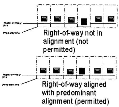
Figure 343-1
(2)
Standards Which Are Applicable. The following provisions of the street construction standards shall apply to all infill development, including that listed above:
A.
Standards relating to sidewalks, subsection 35-505(q) provided, however, that the applicant shall not be required to provide a sidewalk width exceeding that of any existing sidewalks adjoining the site, provided that minimum ADA standards shall be met in accordance with subsection 35-506(d)(9)C. In single-family locations see also subsection 35-506(q)(2)F.
B.
If the lot adjoins a street in which the right-of-way is not aligned with the adjoining parcels, the standards relating to the dedication of right-of-way (subsection 35-505(g)) shall apply (see Figure 343-1).
(f)
Stormwater Management. Infill development shall comply with the stormwater management standards, section 35-504 of this chapter, except as otherwise provided herein. The stormwater management standards shall not apply to the following:
(1)
The reuse of an existing building where there is not an increase in impervious cover; or
(2)
The development of an existing parcel or lot of less than ten thousand (10,000) square feet.
The stormwater management standards and engineering report shall apply to all other infill development not listed above.
(g)
Utilities. The utilities standards shall apply to infill development.
(h)
Parks and Open Space. The parks and open space standards (section 35-503 of this chapter) shall not apply to infill development.
(i)
Reserved.
(j)
Buffers, Landscaping, and Streetscape Planting. The buffering standards (section 35-510) shall not apply to infill development. The landscaping standards (section 35-511) and streetscape planting standards (section 35-512) shall apply. Only twenty-five (25) points shall be required under subsection 35-511(d) (elective criteria), for landscaping on lots within the "IDZ" district, see also subsection 35-511(e)(7).
(k)
Parking. The minimum vehicle parking requirements in subsection 35-526(b) shall not apply to IDZ-1". Minimum parking requirements are also not required for "IDZ" when used as an overlay district. Within "IDZ-2" and "IDZ-3" the minimum parking requirements in subsection 35-526(b) may be reduced by fifty (50) percent. Where parking is provided, subsections 35-526(c) through 35-526(f) shall apply to infill development.
(l)
Outdoor Storage. The outdoor storage standards shall apply to infill development.
(Ord. No. 2018-11-15-0913, § 2, 11-1-18; Ord. No. 2022-11-03-0831, § 2, 11-3-22, eff. 1-1-23)
Sec. 35-344.01. - "PUD" Planned Unit Development Districts Established Prior to January 1, 2016.
STATEMENT OF PURPOSE
The "PUD" planned unit development district is established for the following purposes:
• To provide flexibility in the planning and construction of development projects by allowing a combination of uses developed in accordance with an approved plan that protects adjacent properties.
• To encourage the preservation and enhancement of natural amenities and cultural resources; to protect the natural features of a site that relate to its topography, shape and size; and to provide for a minimum amount of open space.
• To provide for a more efficient arrangement of land uses, buildings, circulation systems and infrastructure.
• To encourage infill projects and the development of sites made difficult for conventionally designed development because of shape, size, abutting development, poor accessibility or topography.
• To allow for private streets and gated entrances for new subdivisions.
(a)
Applicability and Evaluation Criteria. This section shall apply to all planned unit development districts established prior to January 1, 2016. Planned unit development districts established subsequent to January 1, 2016, shall comply with section 35-344.02 of this chapter. In order to foster the attractiveness of a planned unit development and its surrounding neighborhoods and thereby preserve property values, and in order to provide an efficient road and utility network, ensure the movement of traffic, implement comprehensive planning, and better serve the public health, safety, and general welfare, the following criteria shall be utilized by the planning commission in reviewing PUD plans. These criteria shall neither be regarded as inflexible requirements nor are they intended to discourage creativity or innovation.
(1)
Insofar as practicable, the landscape shall be preserved in its natural state by minimizing tree and soil removal.
(2)
Proposed buildings shall be sited harmoniously to the terrain and to other buildings in the vicinity that have a visual relationship to the proposed buildings.
(3)
With respect to vehicular and pedestrian circulation and parking, special attention shall be given to the location and number of access points to public streets, width of interior drives and access points, general interior circulation, separation of pedestrian and vehicular traffic, and the arrangement of parking areas that are safe and convenient and, insofar as practicable, do not detract from the design of proposed structures and neighboring properties.
(4)
Private streets and gates shall conform to article V of this chapter.
(5)
Planned unit developments in the ETJ shall comply with the provisions contained in this section with the exception of subsections (c) related to density, (d) related to height and yard requirements, and (j) related to PUD plans. In addition, planned unit developments in the ETJ are exempt from the zoning procedures contained in this section.
(6)
The description "planned unit development" or "PUD" shall be prominently indicated in the subdivision plat name.
(b)
Minimum Size. There is no minimum size for a planned unit development.
(c)
Permitted Uses and Density.
(1)
Uses. A planned unit development may include residential, commercial and industrial uses; cluster housing; common areas; unusual arrangements of structures on-site; or other combinations of structures and uses that depart from standard development. The uses permitted in a "PUD" are those designated in the approved PUD plan. Density limits are used to determine the maximum number of permitted dwelling units.
Planned unit developments containing one (1) single zoning district shall be annotated with the zoning district (PUD "RE," PUD "R-20," etc.) and may be developed to the density indicated in the maximum density table in subsection (2) below.
Planned unit developments which contain more than one (1) zoning district shall have each zoning district annotated as (PUD "RE," PUD "R-20," etc.) and each individual district may be developed to the density indicated in the maximum density table in subsection (2) below.
(2)
Density Table. The PUD plan shall divide the PUD into land use categories and shall indicate the uses permitted in each category. For residential land use categories, the maximum number of dwelling units permitted per acre for each land use category is as follows:
Total allowable density is calculated by multiplying the amount of net usable acres times the appropriate number above. Floodplains (100-year), steep slopes, non-buildable areas and existing easements are not used to determine net acreage.
Example: On a twelve (12) acre tract with one and one-half (1½) acres of unusable space, with an "R-6" zoning district. Usable acreage ten and one-half (10½) times table number (5) allows fifty-two and one-half (52½) units. The maximum number of units that may be built may not be further increased by using the provisions of vivision 6 flexible zoning of this article.
(3)
Attached Dwelling Units. Dwelling units may be attached in all PUD districts except for land use categories designated "RE" and "R-20."
(4)
Lots. There is no minimum area requirement for lots and lots need not front onto a street. Lot boundaries may coincide with structure boundaries except where perimeter lot setbacks are required.
(d)
Height and Yard Requirements.
(1)
Height Limitation. The maximum height of structures shall be as prescribed below; however, any portion of a structure may exceed this limit provided such portion is set back from the side and rear lot lines, or setbacks if required, one (1) foot for each two (2) feet of height in excess of the maximum building height. Distance credit shall be permitted for space occupied by structures of conforming height extending from the lot lines or setbacks as applicable.
(2)
Fences.
A.
Along collector and arterial streets, fences or walls within a PUD may extend to a height of eight (8) feet subject to the clear vision area requirements for fences in section 35-514.
B.
No such fence or wall, or portion thereof, shall exceed one hundred (100) horizontal feet in length unless one (1) of the following architectural features visible from the paved surface of the street is provided as part of the fence:
1.
A column or pillar; or
2.
Articulation of the surface plane wall by incorporating plane projections or recesses having a depth of at least one (1) foot and extending a horizontal distance not less than three (3) or more than twenty (20) feet.
C.
The provisions of subsection B., above, shall not apply to a fence or wall constructed of brick, masonry, or wrought iron consisting of at least fifty (50) percent open voids. The square footage of the fence shall be measured by taking the total square footage of an area defined by the length of the fence and its average height. The percent of open voids shall then be derived by dividing the total square footage of the open voids by the total square footage of the area calculated above, and multiplying this figure by one hundred (100). The fence's framing (the vertical posts supporting the fence from the ground and no more than three (3) horizontal cross bars between the posts, or brick or stone pillars) shall not be included in the calculation of the total square footage, provided the framing posts and cross bars do not exceed a four-inch width and the posts are spaced at least eight (8) feet apart.
(e)
Required Setbacks.
(1)
Residential Including Multi-Family Uses. Required PUD perimeter setbacks shall be twenty (20) feet.
(2)
Nonresidential Uses. Required PUD perimeter setbacks shall be the same as for the applicable zoning district which the nonresidential use would be allowed in if it were not a PUD.
The PUD perimeter setback lines shall be indicated on the PUD plan prior to receiving approval of the PUD plan. The planning commission may approve lesser setbacks after considering physical features such as the location of trees, waterways, steep slopes, easements, other buffers and/or compatibility of the PUD with adjacent land uses provided such setbacks meet the requirements of the current adopted International Building Code.
No setbacks are required for residential or nonresidential interior lots provided the requirements of the current adopted International Building Code or the International Residential Code are met. Provisions of subsection 35-373(c) zero lot line development do not apply in a PUD.
(3)
If access to a garage is provided from the front or side of a lot, then the garage shall maintain a setback as indicated in subsection 35-516(g) of this chapter.
(f)
Infrastructure Requirements.
(1)
Streets and Sidewalks. Streets within a PUD may be public or private. Vehicular circulation may also be provided by internal private drives. Private drives must meet the requirements for fire lanes as per the International Fire Code Appendix D for width, lengths turnarounds, and parking requirements whether for a commercial or residential base zoning. A building permit must be obtained for private drives, and would include site plan review and inspection for flatwork/civil work within the public ROW. However, the planning commission may require dedication and construction of public streets through or into a PUD through the platting process. Public or private streets shall conform to the transportation standards of this chapter (see section 35-506 of this chapter).
(2)
Utilities. All utility systems shall comply with the utilities standards of this chapter. Water and sanitary sewer systems within a PUD may be publicly or privately owned; however, the maintenance of private systems shall be the responsibility of the PUD community association. Public utility systems shall be approved by the applicable agency or city department.
(3)
Easements. Publicly owned and/or maintained utilities shall be placed in public streets or easements which are a minimum of sixteen (16) feet in width unless a narrower width is approved by the applicable utility. Dead-end easements shall not be permitted unless a city approved vehicular turnaround is provided at the end of each such easement.
(4)
Garbage Collection. If in the opinion of the solid waste management director, private streets in a PUD are arranged so that garbage may be collected without creating a safety hazard, the city will collect the garbage provided proper indemnification is received from the community association or individual property owners. Garbage collection locations shall be subject to the approval of the solid waste management director. In the event the city does not collect garbage within a PUD, all units within the PUD may be exempted from payment of garbage fees upon furnishing of evidence ensuring acceptable removal of all garbage and refuse by private means. To receive such exemption, written application must be submitted to and approved by the finance director.
(g)
Parks/Open Space.
(1)
Residential. Each residential PUD plan shall provide for a minimum amount of parks/open space as required by the parks/open space standards (35-503) of this chapter. Residential PUDs may not use a fee in lieu for meeting parks/open space requirements.
(2)
Commercial. All commercial and industrial PUDs will contain a minimum of twenty (20) percent of parks/open space.
(3)
Mixed-Use. Mixed-use developments shall be divided into separate residential and commercial areas which must separately meet the requirements of this paragraph and subsection 35-344(c)(2). Mixed use buildings that include residential use shall meet the residential requirements of this subsection.
(4)
Reduction in Parks/Open Space. At its discretion, the planning commission may approve a decrease in the amount of required parks/open space when the PUD plan includes unique design features or amenities which achieve an especially attractive and desirable development such as, but not limited to, terraces, sculpture, water features, preservation and enhancement of unusual natural features, or landscape sculpture (areas which are intensely landscaped).
(h)
Parking Requirements. Off-street parking and truck loading facilities shall be provided in accordance with parking standards of this chapter. Parking shall be prohibited on any private street or private drive, excluding driveways on interior lots less than twenty-eight (28) feet in width, and if utilized on streets twenty-eight (28) feet or wider, the parking must be clearly distinguishable from the movement lanes.
(i)
Common Areas and Facilities. Provisions shall be made for a property owners' association that is designated as the representative of the owners of property in a residential subdivision. The property owners' association shall have the direct responsibility to provide for the operation and maintenance of all common areas and facilities, including private streets and sidewalks, which are a part of the PUD. The applicant shall submit the dedicatory instrument(s) covering the establishment, maintenance, and operation of a residential subdivision. The dedicatory instrument(s) shall establish a plan for the use and permanent maintenance of the common areas/facilities and demonstrate that the property owners' association is self-perpetuating and adequately funded by regular assessment and/or special assessment to accomplish its purposes. The dedicatory instrument(s) shall include provisions that provide the city with permission for access at any time without liability when on official business, and further, to permit the city to remove obstructions if necessary for emergency vehicle access and assess the cost of removal to the owner of the obstruction.
"Property owners' association" means an incorporated or unincorporated association that;
A.
Is designated as the representative of the owners of property in a residential subdivision;
B.
Has a membership primarily consisting of the owners of property covered by the dedicatory instrument for the residential subdivision; and
C.
Manages or regulates the residential subdivision for the benefit of the owners of property in the subdivision.
"Dedicatory instrument" means each governing instrument covering the establishment, maintenance, and operation of a residential subdivision. The term includes restrictions or other similar instruments that subject property to restrictive covenants, bylaws, or similar instruments governing the administration or operation of a property owners' association; allow for properly adopted rules and regulations of the property owners' association; and authorize enactment of lawful amendments to the covenants, bylaws, rules, or regulations.
"Property owners' association" means the designated representative of the owners of property in a subdivision and may be referred to as a "homeowners association," "community association," "civic association," "civic club," "association," " committee," or similar term contained in the dedicatory instrument.
"Regular assessment" means an assessment, a charge, a fee, or dues that each owner of property within a residential subdivision is required to pay to the property owners' association on a regular basis and that is designated for use by the property owners' association for the benefit of the residential subdivision as provided by the dedicatory instrument.
"Special assessment" means an assessment, a charge, a fee, or dues, other than a regular assessment, that each owner of property within a residential subdivision is required to pay to the property owners' association, according to the procedures required by the dedicatory instrument, for:
A.
Defraying, in whole or part, the cost whether incurred before or after the assessment, of any construction or reconstruction, unexpected repair, or replacement of a capital improvement in common areas owned by the property owners' association, including the necessary fixtures and personal property related to the common areas;
B.
Maintenance and improvement of common areas owned by the property owners' association; or
C.
Other purposes of the property owners' association as stated in its articles of incorporation or the dedicatory instrument for the residential subdivision.
(j)
PUD Plan. After the PUD zoning is granted, a PUD plan shall be submitted to and approved by the planning commission prior to approval of any plats or the issuance of any building permits or certificates of occupancy. The PUD plan shall incorporate any conditions imposed with the granting of the PUD zoning.
(1)
Public Hearing. Upon submission of the PUD plan, the director of development services shall distribute copies to appropriate city departments and agencies for review. Upon receipt of all required items and reviews, the director of development services shall schedule a public hearing by the planning commission on the proposed plan and shall provide written notice of the hearing to the owners of real property lying within two hundred (200) feet of the PUD boundaries. The notice shall be mailed at least ten (10) days prior to the public hearing date.
(2)
Plan Approval. After the public hearing the commission may approve the plan as submitted, amend and approve the plan as amended, or disapprove the plan. If approved, the plan with any amendments shall be signed by the chairman and secretary of the commission. A copy of the approved PUD plan shall be distributed to the development services director and other appropriate departments/agencies for use in issuing permits.
(3)
[Amendments.] Amendments for any PUD plan shall be consistent with subsection (k) below.
(k)
Amendments. Amendments may be classified as minor or major in accordance with the following:
(1)
Minor amendments to the previously approved PUD plan may be made without requiring resubmission of the entire application. For purposes of this subsection, "minor amendments" are amendments which:
A.
Permit equal or fewer dwelling units, floor area, lot coverage or impervious surface than that requested on the original application;
B.
Reduce the impact of the development; or
C.
Reduce the amount of land involved from that indicated in the notices of the hearing.
D.
A minor amendment shall not, in any case, permit:
i.
An increase in the overall density of the PUD by more than ten (10) percent;
ii.
A different land use than that requested in the original or amended PUD plan;
iii.
A larger land area than indicated in the original or amended PUD plan.
E.
A minor amendment shall not reduce or eliminate conditions adopted in this chapter or otherwise adopted by city council ordinance or planning commission approval for a PUD approval.
(2)
Amendments not classified as minor amendments above shall be classified as major amendments and shall require resubmission of the application to the planning commission.
(3)
Major amendments shall be considered by the planning commission following the same procedure required for the initial approval of the plan, including payment of the plan review fee.
(l)
Time Limit.
(1)
Applications. The director of development services shall provide a written response indicating whether or not the planned unit development application is complete within five (5) working days after submittal. The applicant shall file a written response to any staff comments or resolve outstanding issues prior to final approval of completeness. This response shall occur within thirty (30) days of the notification date of staff comments unless a time extension is requested and granted in writing. The maximum limit on an extension is six (6) months from the original staff comment date. The appellate agency for purposes of completeness review shall be the planning commission.
PUD plan application approval shall expire, and shall be void for all purposes if a PUD plan is not approved in accordance with this chapter within two (2) years from the date of acceptance of the complete application. Upon expiration of the PUD plan application, a new PUD plan number, application, and fee shall be required when PUD plan approval is still sought.
(2)
PUD Approval and Completion. A PUD plan, deemed complete and approved, shall remain valid for a period of six (6) years from the date of the last recorded plat or the date of planning commission approval if no plats are recorded. Time extensions for up to one (1) year may be granted by the planning commission if it finds that additional time is warranted. Failure to initiate development within the approved time period shall void the approved PUD plan and no building permits or utility connections shall be issued until a new application and plan have been submitted and approved.
(3)
Amendments. An approved/completed PUD may be amended in the future subject to any applicable criteria or requirements of this chapter.
(Ord. No. 95326 § 1, 2) (Ord. No. 98695 § 1) (Ord. No. 98697 § 1 and 6) (Ord. No. 100126) (Ord. No. 101816, § 2, 12-15-05) (Ord. No. 2009-01-15-0001, § 2, 1-15-09) (Ord. No. 2010-11-18-0985, § 2, 11-18-10; Ord. No. 2015-12-17-1077, § 2, 12-17-15)
Editor's note— Ord. No. 2015-12-17-1077, § 2, adopted Dec. 17, 2015, renumbered § 35-344 as 35-344.01 and changed the title from "'PUD' Planned Unit Development District" to "'PUD' Planned Unit Development Districts Established Prior to January 1, 2016." This historical notation has been preserved for reference purposes.
Sec. 35-344.02. - "PUD" Planned Unit Development Districts Established Subsequent to January 1, 2016.
(a)
Applicability. The provisions of this section apply to any application for rezoning of a tract, parcel or land area to a planned unit development district after January 1, 2016 with the exception of those planned unit development subdivisions established within the ETJ prior to January 1, 2016 and annexed into the city after January 1, 2016.
(b)
Initiation. A proceeding for approval of a planned unit development zoning district shall be initiated by filing an application with the director of development services. The application must meet the following minimum criteria:
(1)
The application shall include a site plan that is prepared to scale. The site plan must be drawn with dimensions and a graphic scale must be provided.
(2)
To provide adequate information for city council to make an informed decision on a request for a planned unit development zoning district, each site plan shall illustrate the following:
A.
PUD perimeter setback lines.
B.
Refer to appendix B: Application Submittal for PUD Plan for remaining requirements.
(c)
Completeness Review. The director of development services shall conduct a completeness review as set forth in section 35-402 of this chapter. The appellate agency for purposes of completeness review (see subsection 35-402(c) of this chapter) shall be the zoning commission.
(d)
Decision. The procedure for approving a planned unit development zoning district boundary shall be as required for a rezoning (subsection 35-421(d)) and as further provided herein.
(e)
Evaluation Criteria. In order to foster the attractiveness of a planned unit development and its surrounding neighborhoods and thereby preserve property values, and in order to provide an efficient road and utility network, ensure the movement of traffic, implement comprehensive planning, and better serve the public health, safety, and general welfare, the following criteria shall be utilized by the zoning commission and city council in reviewing PUD plans in conjunction with the request for PUD zoning. These criteria shall neither be regarded as inflexible requirements nor are they intended to discourage creativity or innovation.
(1)
Insofar as practicable, the landscape shall be preserved in its natural state by minimizing tree and soil removal.
(2)
Proposed buildings shall be sited harmoniously to the terrain and to other buildings in the vicinity that have a visual relationship to the proposed buildings.
(3)
With respect to vehicular and pedestrian circulation and parking, special attention shall be given to the location and number of access points to public streets, width of interior drives and access points, general interior circulation, separation of pedestrian and vehicular traffic, and the arrangement of parking areas that are safe and convenient and, insofar as practicable, do not detract from the design of proposed structures and neighboring properties.
(4)
Private streets and gates shall conform to article V of this chapter.
(f)
Minimum Size. There is no minimum size for a planned unit development.
(g)
Permitted Uses and Density.
(1)
Uses. A planned unit development may include residential, commercial and industrial uses; cluster housing; common areas; unusual arrangements of structures on site; or other combinations of structures and uses that depart from standard development. The uses permitted in a "PUD" are those designated in the approved PUD plan. Density limits are used to determine the maximum number of permitted dwelling units.
Planned unit developments containing one (1) single zoning district shall be annotated with the zoning district (PUD "RE," PUD "R-20," etc.) and may be developed to the density indicated in the maximum density table in subsection (2) below.
Planned unit developments which contain more than one (1) zoning district shall have each zoning district annotated as (PUD "RE," PUD "R-20," etc.) and each individual district may be developed to the density indicated in the maximum density table in subsection (2) below.
(2)
Density Table. The PUD plan shall divide the PUD into land use categories and shall indicate the uses permitted in each category. For residential land use categories, the maximum number of dwelling units permitted per acre for each land use category is as follows:
Total allowable density is calculated by multiplying the amount of net usable acres times the appropriate number above. Floodplains (100-year), steep slopes, non-buildable areas and existing easements are not used to determine net acreage.
Example: On a twelve (12) acre tract with one and one-half (1½) acres of unusable space, with an "R-6" zoning district. Usable acreage ten and one-half (10½) times table number (5) allows fifty-two and one-half (52½) units. The maximum number of units that may be built may not be further increased by using the provisions of division 6 flexible zoning of this article.
(3)
Attached Dwelling Units. Dwelling units may be attached in all PUD districts except for land use categories designated "RE" and "R-20."
(4)
Lots. There is no minimum area requirement for lots and lots need not front onto a street. Lot boundaries may coincide with structure boundaries except where perimeter lot setbacks are required.
(h)
Height and Yard Requirements.
(1)
Height Limitation. The maximum height of structures shall be as prescribed below; however, any portion of a structure may exceed this limit provided such portion is set back from the side and rear lot lines, or setbacks if required, one (1) foot for each two (2) feet of height in excess of the maximum building height. Distance credit shall be permitted for space occupied by structures of conforming height extending from the lot lines or setbacks as applicable.
(2)
Fences.
A.
Along collector and arterial streets, fences or walls within a PUD may extend to a height of eight (8) feet subject to the clear vision area requirements for fences in section 35-514.
B.
No such fence or wall, or portion thereof, shall exceed one hundred (100) horizontal feet in length unless one (1) of the following architectural features visible from the paved surface of the street is provided as part of the fence:
1.
A column or pillar; or
2.
Articulation of the surface plane wall by incorporating plane projections or recesses having a depth of at least one (1) foot and extending a horizontal distance not less than three (3) or more than twenty (20) feet.
C.
The provisions of subsection B., above, shall not apply to a fence or wall constructed of brick, masonry, or wrought iron consisting of at least fifty (50) percent open voids. The square footage of the fence shall be measured by taking the total square footage of an area defined by the length of the fence and its average height. The percent of open voids shall then be derived by dividing the total square footage of the open voids by the total square footage of the area calculated above, and multiplying this figure by one hundred (100). The fence's framing (the vertical posts supporting the fence from the ground and no more than three (3) horizontal cross bars between the posts, or brick or stone pillars) shall not be included in the calculation of the total square footage, provided the framing posts and cross bars do not exceed a four-inch width and the posts are spaced at least eight (8) feet apart.
(i)
Required Setbacks.
(1)
Residential Including Multi-Family Uses. Required PUD perimeter setbacks shall be twenty (20) feet.
(2)
Nonresidential Uses. Required PUD perimeter setbacks shall be the same as for the applicable zoning district which the nonresidential use would be allowed in if it were not a PUD.
The city council may approve lesser setbacks after considering physical features such as the location of trees, waterways, steep slopes, easements, other buffers and/or compatibility of the PUD with adjacent land uses provided such setbacks meet the requirements of the current adopted International Building Code.
No setbacks are required for residential or nonresidential interior lots provided the requirements of the current adopted International Building Code or the International Residential Code are met. Provisions of subsection 35-373(c) Zero Lot Line Development do not apply in a PUD.
(3)
If access to a garage is provided from the front or side of a lot, then the garage shall maintain a setback as indicated in subsection 35-516(g) of this chapter.
(j)
Infrastructure Requirements.
(1)
Streets and Sidewalks. Streets within a PUD may be public or private. Vehicular circulation may also be provided by internal private drives. Private drives must meet the requirements for fire lanes as per the International Fire Code Appendix D for width, lengths turnarounds, and parking requirements whether for a commercial or residential base zoning. A building permit must be obtained for private drives, and would include site plan review and inspection for flatwork/civil work within the public ROW. However, the planning commission may require dedication and construction of public streets through or into a PUD through the platting process. Public or private streets shall conform to the transportation standards of this chapter (see section 35-506 of this chapter).
(2)
Utilities. All utility systems shall comply with the utilities standards of this chapter. Water and sanitary sewer systems within a PUD may be publicly or privately owned; however, the maintenance of private systems shall be the responsibility of the PUD community association. Public utility systems shall be approved by the applicable agency or city department.
(3)
Easements. Publicly owned and/or maintained utilities shall be placed in public streets or easements which are a minimum of sixteen (16) feet in width unless a narrower width is approved by the applicable utility. Dead-end easements shall not be permitted unless a city approved vehicular turnaround is provided at the end of each such easement.
(4)
Solid Waste Collection Services. If in the opinion of the solid waste management director, private streets in a PUD are arranged so that solid waste may be collected without creating a safety hazard and the city has the capacity to provide services, the city will provide collection services, as determined by the solid waste management director, provided proper indemnification is received from the community association or individual property owners. Solid waste collection locations shall be subject to the approval of the solid waste management director. In the event the city does not provide services within a PUD, all units within the PUD may be exempted from payment of the city's solid waste fee upon furnishing of evidence ensuring acceptable removal of all garbage and refuse by private means. To receive such exemption, written application must be submitted to and approved by the solid waste management director. Units may still be required to pay any other fees, including the environmental fee, as described in Chapter 14 (Solid Waste) of the City Code.
(k)
Parks/Open Space.
(1)
Residential. Each residential PUD plan shall provide for a minimum amount of parks/open space as required by the parks/open space standards (section 35-503) of this chapter. Residential PUDs may not use a fee in lieu for meeting parks/open space requirements.
(2)
Commercial. All commercial and industrial PUDs will contain a minimum of twenty (20) percent of parks/open space.
(3)
Mixed-Use. Mixed-use developments shall be divided into separate residential and commercial areas which must separately meet the requirements of this paragraph and subsection 35-344(c)(2). Mixed use buildings that include residential use shall meet the residential requirements of this subsection.
(4)
Reduction in Parks/Open Space. At its discretion, the city council may approve a decrease in the amount of required parks/open space when the PUD plan includes unique design features or amenities which achieve an especially attractive and desirable development such as, but not limited to, terraces, sculpture, water features, preservation and enhancement of unusual natural features, or landscape sculpture (areas which are intensely landscaped).
(l)
Parking Requirements. Off-street parking and truck loading facilities shall be provided in accordance with parking standards of this chapter. Parking shall be prohibited on any private street or private drive, excluding driveways on interior lots less than twenty-eight (28) feet in width, and if utilized on streets twenty-eight (28) feet or wider, the parking must be clearly distinguishable from the movement lanes.
(m)
Common Areas and Facilities. Provisions shall be made for a property owners' association that is designated as the representative of the owners of property in a residential subdivision. The property owners' association shall have the direct responsibility to provide for the operation and maintenance of all common areas and facilities, including private streets and sidewalks, which are a part of the PUD. The applicant shall submit the dedicatory instrument(s) covering the establishment, maintenance, and operation of a residential subdivision. The dedicatory instrument(s) shall establish a plan for the use and permanent maintenance of the common areas/facilities and demonstrate that the property owners' association is self-perpetuating and adequately funded by regular assessment and/or special assessment to accomplish its purposes. The dedicatory instrument(s) shall include provisions that provide the city with permission for access at any time without liability when on official business, and further, to permit the city to remove obstructions if necessary for emergency vehicle access and assess the cost of removal to the owner of the obstruction.
"Property owners' association" means an incorporated or unincorporated association that;
A.
Is designated as the representative of the owners of property in a residential subdivision;
B.
Has a membership primarily consisting of the owners of property covered by the dedicatory instrument for the residential subdivision; and
C.
Manages or regulates the residential subdivision for the benefit of the owners of property in the subdivision.
"Dedicatory instrument" means each governing instrument covering the establishment, maintenance, and operation of a residential subdivision. The term includes restrictions or other similar instruments that subject property to restrictive covenants, bylaws, or similar instruments governing the administration or operation of a property owners' association; allow for properly adopted rules and regulations of the property owners' association; and authorize enactment of lawful amendments to the covenants, bylaws, rules, or regulations.
"Property owners' association" means the designated representative of the owners of property in a subdivision and may be referred to as a "homeowners' association," "community association," "civic association," "civic club," "association," "committee," or similar term contained in the dedicatory instrument.
"Regular assessment" means an assessment, a charge, a fee, or dues that each owner of property within a residential subdivision is required to pay to the property owners' association on a regular basis and that is designated for use by the property owners' association for the benefit of the residential subdivision as provided by the dedicatory instrument.
"Special assessment" means an assessment, a charge, a fee, or dues, other than a regular assessment, that each owner of property within a residential subdivision is required to pay to the property owners' association, according to the procedures required by the dedicatory instrument, for:
A.
Defraying, in whole or part, the cost whether incurred before or after the assessment, of any construction or reconstruction, unexpected repair, or replacement of a capital improvement in common areas owned by the property owners' association, including the necessary fixtures and personal property related to the common areas;
B.
Maintenance and improvement of common areas owned by the property owners' association; or
C.
Other purposes of the property owners' association as stated in its articles of incorporation or the dedicatory instrument for the residential subdivision.
(n)
Amendments. Alterations to a PUD plan shall be classified as either minor or major amendments. Minor amendments may be approved by the development services director. Major amendments shall be considered by the zoning commission and city council following the same procedure required for the initial approval of the plan, including payment of the application fee. The following criteria shall be used to identify a major amendment:
(1)
A change which would include a land use not previously permitted under the approved PUD zoning.
(2)
A change which would alter the land use type adjacent to a PUD boundary.
(3)
A change which would increase the overall density of the PUD by more than ten (10) percent. However, in no instance may the overall density of the PUD exceed that permitted by the base zoning district.
(4)
A change which the director of development services determines would significantly alter the general character or overall design of the plan.
(Ord. No. 2015-12-17-1077, § 2, 12-17-15; Ord. No. 2022-11-03-0831, § 2, 11-3-22, eff. 1-1-23)
Sec. 35-345.01. - "MPCD" Master Planned Community Districts adopted prior to January 1, 2023.
The master planned community district is a special district established to encourage the development of areas of mixed uses that are internally compatible in an effort to achieve well designed development and provide a more efficient arrangement of land uses, building and circulation systems.
(a)
Uses.
(1)
An "MPCD" may include both residential and commercial uses. In particular, all residential single-family (including gated communities) and multi-family uses; "O-1" and "O-2" office uses; and "NC," "C-1," "C-2," and "C-3" commercial uses as defined in this chapter, are specifically permitted in the "MPCD" zoning base district.
(2)
In addition, business park uses shall be permitted in an "MPCD" zoning base district, subject to the performance standards established in subsection (l) of this section, as follows:
• Wholesaling,
• Research and development,
• Manufacturing,
• Processing,
• Fabrication, and assembly,
• Testing,
• Repair,
• Servicing,
• Storage,
• Laboratory,
• Warehousing,
• Displaying, or
• Distribution of goods, materials or products.
(3)
Vehicular access to a business park use shall be permitted only from major thoroughfares as designated in the city's major thoroughfare plan.
(4)
The location of all land use categories shall be designated on the "MPCD" site plan as residential (single-family), attached residential (multi-family), office, commercial or light industry.
(b)
Size. An "MPCD" shall consist of at least twenty-five (25) contiguous acres.
(c)
Site Plan.
(1)
Simultaneous with the request for "MPCD" zoning, an "MPCD" site plan shall also be filed. An application for rezoning to an "MPCD" shall not be deemed complete unless accompanied by a proposed "MPCD" site plan. The "MPCD" site plan shall be governed by subsection 35-412(c), Completeness Review, and subsection 35-412(f), Approval Criteria, of this chapter. In addition to the applicable requirements of article V of this chapter, the "MPCD" site plan shall also be reviewed for compliance with the terms of this section.
(2)
"MPCD" site plans shall be reviewed by the zoning commission and approved by the city council concurrent with the application for rezoning to an "MPCD." The zoning ordinance shall provide that adherence to the "MPCD" site plan, or the amended "MPCD" site plan is required within the "MPCD" provided, however, that a rezoning shall not be required for the approval of a minor change to the "MPCD" site plan as defined in subsection (e)(3) of this section. The site plan shall include the proposed land uses by location, type (single-family, multi-family, office or commercial), density and size. Where single-family uses are designated, minimum lot size shall be included and major physical features such as easements, streams, floodplains, and significant vegetation shall be noted.
(3)
If a master planned community is proposed outside of the city's zoning jurisdiction, but within the city's extraterritorial jurisdiction, then the property owner may submit a master site plan that conforms with the provisions contained within the section. In addition, the property owner upon submittal of the master site plan may designate such site plan as a master planned community site plan. If the property which is the subject of the master planned community site plan is subsequently annexed into the city's zoning jurisdiction, then the city shall initiate a rezoning application for the subject tract to rezone the property to "MPCD." The rezoning request and the previously approved master site plan with master planned community designation shall then be reviewed for approval pursuant to the procedures contained herein.
(d)
Coordination with Independent School Districts. A copy of the site plan shall be provided to the independent school district or districts in which the "MPCD" is proposed to be located. The applicant shall coordinate with the independent school district(s) in order to address the educational needs that may arise with the development of the "MPCD."
(e)
Amendments to "MPCD" Master Site Plan.
(1)
Revisions to a previously approved "MPCD" master site plan shall be classified as minor or major changes. An application for a major or minor change to "MPCD" site plan shall be subject to subsection 35-412(c) completeness review provisions of this chapter. Within five (5) working days after filing the proposed revisions, required items and information, the director of development services shall provide a written response indicating whether or not the submitted revised "MPCD" site plan has been accepted as a minor or major revision. If it is determined by the director of development services that the revised submittal is considered a minor change then said submittal shall be processed by the director of development services and shall not require review by the zoning commission or approval by the city council. The applicant may appeal a conditional acceptance by the director of development services using the same process as the initial "MPCD" site plan submittal described in subsection (c) of this section. If it is determined by the director of development services that the proposed revision is a major change then said proposed major revisions shall be processed in the same manner as the initial "MPCD" site plan submittal described in subsection (c) of this section. Major amendments to an MPCD site plan constitutes a new project with respect to the area of the project that is being modified.
(2)
A major amendment to an "MPCD" site plan shall include:
A.
Any increase in the total number of residential units for the entire "MPCD."
B.
Any increase in the total commercial acreage within the "MPCD."
C.
Any increase in the total industrial acreage within the "MPCD."
D.
Any increase in the cumulative traffic impacts of the entire "MPCD" upon outlying transportation infrastructure.
E.
Any increase in the total sewer capacity required for the "MPCD" as measured in equivalent dwelling units.
F.
Any increase in the total water capacity required for the "MPCD" as measured in equivalent dwelling units.
G.
Any decrease above ten (10) percent in the total open space acreage within the "MPCD."
H.
Any decrease in perimeter buffers between the "MPCD" and adjacent properties.
I.
Any change in a proposed land use node from residential to an office, commercial or light industrial use, if the property where the proposed change is to occur abuts existing property in which the principal use is a single-family residence.
(3)
Any other revision to an "MPCD" site plan not described in subsection (2), above, shall be deemed a minor change.
(f)
Height and Yard Requirements.
(1)
Height Limitation. The maximum height of structures shall be governed by the MPCD site plan, however uses subject to subsection (k)(1) of this section shall comply with the compatibility standards set forth in subsection (k).
(2)
Minimum Yard. Single-family lots shall comply with the lot requirements of the zoning base district that requires a minimum lot square footage that is less than or equal to the lot square footage shown on the "MPCD" site plan. Multi-family, office and commercial shall comply with the setback requirements of the International Building Code.
(3)
Fences. Along collector and arterial streets, fences within an "MPCD" may extend to a height of eight (8) feet subject to the clear vision area requirements of subsection 35-505(f) of this chapter.
(g)
Required Natural Buffer. Unless the perimeter of the "MPCD" is bound by a street or roadway, any property located on the boundary of the "MPCD" shall maintain a twenty-foot natural buffer (trees, grass or other vegetation) when:
• The "MPCD" property, used (or proposed for use) for other than single-family purposes, abuts property outside the "MPCD" that is used (or is vacant and zoned) for single-family purposes; or
• The "MPCD" property, used (or proposed for use) for single-family purposes, abuts property outside the "MPCD" that is used (or is vacant and zoned) for other than single-family purposes.
(h)
Infrastructure Requirements.
(1)
Streets and Sidewalks.
A.
Streets within an "MPCD" may be public or private.
B.
The entrance to private streets may provide control access by gates or other means permitted by this chapter (see subsection 35-505(s)).
C.
Alternative street and sidewalk standards may be applied within an "MPCD." In order to be applicable to a particular "MPCD" the alternative street and sidewalk standards must be submitted as part of the "MPCD" site plan and the site plan must be approved by the city council. For purposes of this subsection, an "alternative street and sidewalk standard" means a standard which varies from the requirements of subsection 35-506(d) of this chapter.
D.
Whether public or private, streets and sidewalks shall conform to the transportation standards of this chapter, as applicable to streets, or alternative street and sidewalk standards" approved as part of an "MPCD" site plan.
(2)
Utilities. All utility systems shall comply with the utilities standards (section 35-506) of this chapter.
(3)
Easements. Publicly owned and/or maintained utilities shall be placed in public streets or easements which are a minimum of sixteen (16) feet in width unless a narrower width is approved by the applicable utility. Dead-end easements shall not be permitted unless a city approved vehicular turnaround is provided at the end of each such easement.
(i)
Open Space. Each "MPDC" plan shall provide for a minimum amount of parks/open space as required by subsection (1) below. Open space shall include yards, as well as any parks or open space areas which conform to the parks/open space standards of this chapter. Up to twenty (20) percent of the total open space requirement may be met by including one-half (½) of any accessible and contiguous parkland, unimproved floodplain, cemetery, or other beneficial open area which has a reasonable expectancy of perpetuity.
(1)
Open Space Percentages. The minimum open space percentage requirements are as indicated in the table below. They are calculated by dividing the total open space within the MPCD boundary by the gross site area. The land use category shall be determined by the base zoning district. For "MPCDs" which include both residential and nonresidential uses, the required open space shall be calculated by multiplying the open space percentage times the area of each use and adding the products thus obtained.
(2)
Reduction in Open Space. At its discretion, the zoning commission may recommend a decrease in the amount of required open space within the "MPCD" when the "MPCD" plan includes amenities in accordance with Table 503-4 Parks Facilities Credit of article V. The parks and recreation department may make a recommendation to the zoning commission and such amenities shall be clearly identified on the "MPCD" plan and the amount of credit given for each one.
(3)
All open space areas, boundaries and credit shall be identified within the "MPCD" plan boundary.
(j)
Parking Requirements. Off-street parking and truck loading facilities shall be provided in accordance with parking standards of this chapter.
(k)
Compatibility Standards.
(1)
Applicability. This section applies to any use within an "MPCD" which abuts property on which a single-family residential use is located. In this section, a "single-family residential use" includes any single-family dwelling, duplex, triplex, fourplex, townhome, or residential condominium. The abutting property on which a "single-family residential use" which is established, or is to be used, as evidence by notation on the "MPCD" site plan, is referred to in this subsection (k) as a "single-family area."
(2)
Height Limitations. A structure subject to subsection (k)(1) of this section:
A.
Shall be located at least twenty-five (25) feet from a single-family area;
B.
Shall not exceed two (2) stories or thirty (30) feet in height if the structure is fifty (50) feet or less from a single-family area;
C.
May exceed two (2) stories or thirty (30) feet in height, but shall not exceed three (3) stories or forty (40) feet in height, if the structure is one hundred (100) feet or less from a single-family area.
(3)
Increase in Height Limitations. The height of a structure subject to subsection (k)(1) of this section may increase by:
A.
One (1) foot for each feet of distance from property that triggers the compatibility standards if the structure is at least one hundred (100) feet but not more than three hundred (300) feet from an abutting tract which is used or is to be used, as evidenced by a notation on the "MPCD" site plan, for single-family residential purposes, and the increased height is permitted by in an "MPCD"; or
B.
One (1) foot for each four (4) feet of distance from property that triggers the compatibility standards if the structure is at least three hundred (300) feet, but not more than five hundred forty (540) feet, from property in an abutting tract which is being used or is to be used, as evidence by notation on the "MPCD" site plan, for single-family residential purposes; and the increased height is permitted by the applicable zoning district regulation.
(4)
Scale and Clustering Requirements. The massing of buildings and the appropriate scale relationship of a building to another building may be accomplished by:
• Avoiding the use of a continuous or unbroken wall plane; and
• Using an architectural feature or element that creates a variety of scale relationships, creates the appearance of a residential structure, or is consistent with the exterior form and materials of a structure on an adjoining property; and
• Using similar materials for all buildings within the designated land use category; and
• Using a design technique or element that creates a building scale which does not exceed single-family residential uses within the "MPCD," prevents the construction of a structure in close proximity to a single-family residence zoning district that is significantly more massive than a structure in a single-family residence zoning district; and allows the construction of a structure, including a multi-family structure, that exhibits a scale and massing that is consistent with a single-family residential use.
Except where the "MPCD" site plan specifically provides otherwise, the first block of buildings subject to this subsection must be clustered in a group that is not more than fifty (50) feet wide, as measured along the side of the buildings that are most parallel to the property line of the site. The depth of the first tier of buildings described under subsection (B) may not exceed:
• Two (2) units; or
• Sixty (60) feet.
A building must be at least ten (10) feet apart from another building, as measured from wall face to wall face.
(5)
Screening Requirements. Buildings shall be screened from the view of adjacent property single-family land use category if the use for the building to be constructed is intended for off-street parking, the placement of mechanical equipment, storage, refuse collection or any business park use. A person may comply with this subsection by providing a yard, fence, berm, or vegetation. If a fence is provided, the height of the fence may not exceed six (6) feet, except as provided within this chapter. The owner must maintain a fence, berm, or vegetation provided under this section.
(6)
Design Regulations.
A.
Exterior lighting must be hooded or shielded so that the light source is not directly visible from adjacent property which is being utilized for single-family residential purposes.
B.
The noise level of mechanical equipment may not exceed seventy (70) db at the property line.
C.
A permanently placed refuse receptacle, including a dumpster, shall not be located within twenty (20) feet of a single-family land use area.
D.
A highly reflective surface, including reflective glass and a reflective metal roof with a pitch that exceeds a run of seven (6) to a rise of twelve (12), may not be used, unless the reflective surface is a solar panel or copper or painted metal roof.
E.
An intensive recreational use, including a swimming pool, tennis court, ball court, or playground, may not be constructed fifty (50) feet or less from a single-family area.
(l)
Business Park Uses Performance Standards. In addition to this section's compatibility standards, set out in subsection (k) immediately above, business park uses shall conform to performance standards as follows:
(1)
Air Pollution. All uses within a business park district shall operate in compliance with the most current revision of the regulations of the Texas Air Control Board pertaining to the control of air pollution. The city hereby adopts by reference these regulations, a copy of which is on file in the offices of the city clerk and the department of planning and development services.
(2)
Noise. All uses shall comply with the provisions of chapter 21, article III of the City Code, Noise, and shall not create a noise nuisance as defined in said article III of chapter 21.
(3)
Glare and Heat. No direct or sky-reflected glare so as to be visible at the lot line shall be permitted. These regulations shall not apply to signs or floodlighting of parking areas otherwise permitted by this chapter. There shall be no emission or transmission of heat or heated air so as to be discernible at the boundary of the lot line.
(4)
Vibration. All machines shall be so mounted as to minimize vibration and no vibration shall be produced which is discernible without the aid of instruments at the boundary of the business park district.
(5)
Noxious Odors. The emission of any odors which are discernible without the aid of instruments shall be prohibited beyond the boundaries of the business park district.
(6)
Toxic and Liquid Wastes. The discharge of any toxic or liquid waste material into any outdoor watercourse or drainageway shall be prohibited.
(7)
Fire and Explosion. All activities and all storage of flammable and explosive materials shall be provided with adequate safety and fire fighting devices in accordance with the Uniform Fire Code as adopted by the city. The storage of petroleum and other flammable products is permitted only as an incidental use and is prohibited in aboveground tanks.
(8)
Radioactivity. No operation shall cause radioactivity at any lot line in violation of the regulations of the Nuclear Regulatory Commission as set forth in Title 10, Chapter 1, Part 20 of the Code of Federal Regulations, and all applicable regulations of the State of Texas.
(9)
Electromagnetic Radiation. No operation shall be conducted which shall adversely effect the performance of electromagnetic radiators or receptors other than those of the creator of the radiation.
(10)
Outside Storage. Outside storage shall be enclosed within a solid masonry wall or solid heavy timber fence (two (2) inches thick or greater) so as to completely screen all operations conducted within such wall from observation outside the business park district. The wall shall be at least six (6) feet, but not more than twelve (12) feet in height. No storage shall be higher than the height of the screening which shall be maintained in a safe and sightly condition at all times.
(11)
Other Structures. Structures other than buildings which are visible from view outside of the business park district shall be screened by plantings, landscaping, and/or a solid wall/fence at least six (6) feet in height.
Upon application for a certificate of occupancy for any use in a business park district, the director of planning and development services may require such evidence as may be necessary to determine whether or not the proposed use will conform to the performance standards set forth above in this section. The director of planning and development services shall provide verification of the proposed use(s) upon request from the director of planning and development services.
(m)
Rezoning of Property Within an "MPCD." No property within the boundaries of an "MPCD" may be rezoned unless and until the "MPCD" site plan is amended pursuant to the provisions contained herein. In particular, any such amendment or rezoning application must be justified in terms of impact to utility infrastructure, roadway infrastructure and goals and purposes of the original master planned community.
(n)
Development of an "MPCD" Within the City's Extraterritorial Jurisdiction. An "MPCD" may be developed within the city's extraterritorial jurisdiction provided that the "MPCD" is developed pursuant to an approved master site plan as provided in section 35-412 of this chapter and the "MPCD" is designated as such on the master site plan. The permanent zoning of any "MPCD," that is initially located within the extraterritorial jurisdiction and later becomes part of an annexation, shall be consistent with the "MPCD" master plan governing the "MPCD" as provided in section 35-307 of this chapter.
(o)
Copy of "MPCD" Shall be Made Available to the Public. The developer or landowner of an approved "MPCD" shall maintain a copy of the "MPCD" site plan within sales office(s) located within the "MPCD." The site plan shall be displayed in a prominent location within the office so that it is easily viewable by the public. In addition copies of the site plan shall be made available to members of the public upon request. This requirement shall continue until all single-family residential property within the "MPCD" is developed.
(p)
Rights Granted or Recognized by V.T.C.A. Local Government Code Ch. 245 and Ordinance No. 86715 Shall Benefit an Approved "MPCD."
(1)
It is hereby found and determined that V.T.C.A. Local Government Code Ch. 245 and City of San Antonio Ordinance No. 86715, passed and approved September 25, 1997 are applicable to an "MPCD" site plan which complies with this section. An "MPCD" site plan shall enjoy the protection afforded by the aforementioned provisions of state and municipal law any exception in such laws to zoning notwithstanding.
(2)
In each instance when an "MPCD" site plan obtains final approval from city council the director of planning and development services shall change the zoning records and maps in accordance with the provisions of the ordinance approving a master plan community.
(3)
Thereafter, staff review of subdivision plat applications, building permit applications or other permit applications necessary for the development of the "MPCD" shall be reviewed in context of the "MPCD" site plan. Should there be a conflict between the requirements of the City Code (excluding the city building code) and the particular "MPCD" site plan as to landscaping, buffering, open space or any other matter addressed in the "MPCD" site plans, the "MPCD" site plan shall control.
(Ord. No. 95236 § 1) (Ord. No. 98697 § 1, 4 and 6) (Ord. No. 2008-04-03-0266, § 2, 4-3-08) (Ord. No. 2009-01-15-0001, § 2, 1-15-09) (Ord. No. 2010-11-18-0985, § 2, 11-18-10; Ord. No. 2015-12-17-1077, § 2, 12-17-15; Ord. No. 2022-11-03-0831, § 2, 11-3-22, eff. 1-1-23)
Editor's note— Ord. No. 2022-11-03-0831, § 2, adopted November 3, 2022, redesignated the former section 35-345 as section 35-354.01, and changed the title from ""MPCD" Master Planned Community Districts" to ""MPCD" Master Planned Community Districts adopted prior to January 1, 2023." The historical notation has been preserved for reference purposes.
Sec. 35-345.02. - "MPCD" Master Planned Community Districts established subsequent to January 1, 2023.
The master planned community district is a special district established to encourage the development of areas of mixed uses that are internally compatible in an effort to achieve well designed development and provide a more efficient arrangement of land uses, building and circulation systems.
(a)
Uses.
(1)
An "MPCD" may include both residential and commercial uses. In particular, all residential single-family (including gated communities) and multi-family uses; "O-1" and "O-2" office uses; and "NC," "C-1," "C-2," and "C-3" commercial uses as defined in this chapter, are specifically permitted in the "MPCD" zoning base district.
(2)
In addition, business park uses shall be permitted in an "MPCD" zoning base district, subject to the performance standards established in subsection (l) of this section, as follows:
• Wholesaling,
• Research and development,
• Manufacturing,
• Processing,
• Fabrication, and assembly,
• Testing,
• Repair,
• Servicing,
• Storage,
• Laboratory,
• Warehousing,
• Displaying, or
• Distribution of goods, materials or products.
(3)
Vehicular access to a business park use shall be permitted only from a freeway, arterial, principal arterial, or non-residential collector street.
(4)
The location of all land use categories shall be designated on the "MPCD" site plan as residential (single-family), attached residential (multi-family), office, commercial or light industry.
(b)
Size. An "MPCD" shall consist of at least twenty-five (25) contiguous acres.
(c)
Initiation. A proceeding for approval of a master planned community zoning district shall be initiated by filing an application with the director of development services. The application must meet the following minimum criteria:
(1)
The application shall include a site plan that is prepared to scale. The site plan must be drawn with dimensions and a graphic scale must be provided.
(2)
"MPCD" site plans shall be reviewed by the zoning commission and approved by the city council concurrent with the application for rezoning to an "MPCD." The zoning ordinance shall provide that adherence to the "MPCD" site plan, or the amended "MPCD" site plan, is required within the "MPCD" provided, however, that a rezoning shall not be required for the approval of a minor change to the "MPCD" site plan as defined in subsection (e)(3) of this section. The site plan shall include the proposed land uses by location, type (single-family, multi-family, office or commercial), density and size. Where single-family uses are designated, minimum lot size shall be included.
(3)
If a master planned community is proposed outside of the city's zoning jurisdiction, but within the city's extraterritorial jurisdiction, then the property owner may submit a master site plan that conforms with the provisions contained within this section. In addition, the property owner upon submittal of the master site plan may designate such site plan as a master planned community site plan. If the property which is the subject of the master planned community site plan is subsequently annexed into the city's zoning jurisdiction, then the city shall initiate a rezoning application for the subject tract to rezone the property to "MPCD." The rezoning request and the previously approved master site plan with master planned community designation shall then be reviewed for approval pursuant to the procedures contained herein.
(d)
Coordination with Independent School Districts. A copy of the site plan shall be provided to the independent school district or districts in which the "MPCD" is proposed to be located. The applicant shall coordinate with the independent school district(s) in order to address the educational needs that may arise with the development of the "MPCD."
(e)
Amendments to "MPCD" Master Site Plan.
(1)
Alterations to a MPCD plan shall be classified as either minor or major amendments. Minor amendments may be approved by the development services director. Major amendments shall be considered by the zoning commission and city council following the same procedure required for the initial approval of the plan, including payment of the application fee. The following criteria in subsection (2) shall be used to identify a major amendment:
(2)
A major amendment to an "MPCD" site plan shall include:
A.
Any increase in the total number of residential units for the entire "MPCD."
B.
Any increase in the total commercial acreage within the "MPCD."
C.
Any increase in the total industrial acreage within the "MPCD."
D.
Any increase in the cumulative traffic impacts of the entire "MPCD" upon outlying transportation infrastructure.
E.
Any increase in the total sewer capacity required for the "MPCD" as measured in equivalent dwelling units.
F.
Any increase in the total water capacity required for the "MPCD" as measured in equivalent dwelling units.
G.
Any decrease above ten (10) percent in the total open space acreage within the "MPCD."
H.
Any decrease in perimeter buffers between the "MPCD" and adjacent properties.
I.
Any change in a proposed land use node from residential to an office, commercial or light industrial use, if the property where the proposed change is to occur abuts existing property in which the principal use is a single-family residence.
(3)
Any other revision to an "MPCD" site plan not described in subsection (2), above, shall be deemed a minor change.
(f)
Height and Yard Requirements.
(1)
Height Limitation. The maximum height of structures shall be governed by the MPCD site plan, however uses subject to subsection (k)(1) of this section shall comply with the compatibility standards set forth in subsection (k).
(2)
Minimum Yard. Single-family lots shall comply with the lot requirements of the base zoning district that requires a minimum lot square footage that is less than or equal to the lot square footage shown on the "MPCD" site plan. Multi-family, office and commercial shall comply with the setback requirements of the International Building Code.
(3)
Fences. Along collector and arterial streets, fences within an "MPCD" may extend to a height of eight (8) feet subject to the clear vision area requirements of subsection 35-505(f) of this chapter.
(g)
Required Natural Buffer. Unless the perimeter of the "MPCD" is bound by a street or roadway, any property located on the boundary of the "MPCD" shall maintain a 20-foot natural buffer (trees, grass or other vegetation) when:
• The "MPCD" property, used (or proposed for use) for other than single-family purposes, abuts property outside the "MPCD" that is used (or is vacant and zoned) for single-family purposes; or
• The "MPCD" property, used (or proposed for use) for single-family purposes, abuts property outside the "MPCD" that is used (or is vacant and zoned) for other than single-family purposes.
(h)
Infrastructure Requirements.
(1)
Streets and Sidewalks.
A.
Streets within an "MPCD" may be public or private.
B.
The entrance to private streets may provide controlled access by gates or other means permitted by this chapter (see subsection 35-505(s)).
C.
Alternative street and sidewalk standards may be applied within an "MPCD." In order to be applicable to a particular "MPCD" the alternative street and sidewalk standards must be submitted as part of the "MPCD" site plan and the site plan must be approved by the city council. For purposes of this subsection, an "alternative street and sidewalk standard" means a standard which varies from the requirements of subsection 35-506(d) of this chapter.
D.
Whether public or private, streets and sidewalks shall conform to the transportation standards of this chapter, as applicable to streets, or alternative street and sidewalk standards approved as part of an "MPCD" site plan.
(2)
Utilities. All utility systems shall comply with the utilities standards (section 35-506) of this chapter.
(3)
Easements. Publicly owned and/or maintained utilities shall be placed in public streets or easements which are a minimum of sixteen (16) feet in width unless a narrower width is approved by the applicable utility. Dead-end easements shall not be permitted unless a city approved vehicular turnaround is provided at the end of each such easement.
(i)
Open Space. Each "MPCD" plan shall provide for a minimum amount of parks/open space as required by subsection (1) below. Open space shall include yards, as well as any parks or open space areas which conform to the parks/open space standards of this chapter. Up to twenty (20) percent of the total open space requirement may be met by including one-half (½) of any accessible and contiguous parkland, unimproved floodplain, cemetery, or other beneficial open area which has a reasonable expectancy of perpetuity.
(1)
Open Space Percentages. The minimum open space percentage requirements are as indicated in the table below. They are calculated by dividing the total open space within the MPCD boundary by the gross site area. The land use category shall be determined by the base zoning district. For "MPCDs" which include both residential and nonresidential uses, the required open space shall be calculated by multiplying the open space percentage times the area of each use and adding the products thus obtained.
(2)
Reduction in Open Space. At its discretion, the zoning commission may recommend a decrease in the amount of required open space within the "MPCD" when the "MPCD" plan includes amenities in accordance with Table 503-4 Parks Facilities Credit of article V. The parks and recreation department may make a recommendation to the zoning commission and such amenities shall be clearly identified on the "MPCD" plan and the amount of credit given for each one.
(3)
All open space areas, boundaries and credit shall be identified within the "MPCD" plan boundary.
(j)
Parking Requirements. Off-street parking and truck loading facilities shall be provided in accordance with parking standards of this chapter.
(k)
Compatibility Standards.
(1)
Applicability. This section applies to any use within an "MPCD" which abuts property on which a single-family residential use is located. In this section, a "single-family residential use" includes any single-family dwelling, duplex, triplex, fourplex, townhome, or residential condominium. The abutting property on which a "single-family residential use" which is established, or is to be used, as evidence by notation on the "MPCD" site plan, is referred to in this subsection (k) as a "single-family area."
(2)
Height Limitations. A structure subject to subsection (k)(1) of this section:
A.
Shall be located at least twenty-five (25) feet from a single-family area;
B.
Shall not exceed two (2) stories or thirty (30) feet in height if the structure is fifty (50) feet or less from a single-family area;
C.
May exceed two (2) stories or thirty (30) feet in height, but shall not exceed three (3) stories or forty (40) feet in height, if the structure is one hundred (100) feet or less from a single-family area.
(3)
Increase in Height Limitations. The height of a structure subject to subsection (k)(1) of this section may increase by:
A.
One (1) foot for each foot of distance from property that triggers the compatibility standards if the structure is at least one hundred (100) feet but not more than three hundred (300) feet from an abutting tract which is used or is to be used, as evidenced by a notation on the "MPCD" site plan, for single-family residential purposes, and the increased height is permitted by in an "MPCD"; or
B.
One (1) foot for each four (4) feet of distance from property that triggers the compatibility standards if the structure is at least three hundred (300) feet, but not more than five hundred forty (540) feet, from property in an abutting tract which is being used or is to be used, as evidence by notation on the "MPCD" site plan, for single-family residential purposes; and the increased height is permitted by the applicable zoning district regulation.
(4)
Scale and Clustering Requirements. The massing of buildings and the appropriate scale relationship of a building to another building may be accomplished by:
• Avoiding the use of a continuous or unbroken wall plane; and
• Using an architectural feature or element that creates a variety of scale relationships, creates the appearance of a residential structure, or is consistent with the exterior form and materials of a structure on an adjoining property; and
• Using similar materials for all buildings within the designated land use category; and
• Using a design technique or element that creates a building scale which does not exceed single-family residential uses within the "MPCD," prevents the construction of a structure in close proximity to a single-family residence zoning district that is significantly more massive than a structure in a single-family residence zoning district; and allows the construction of a structure, including a multi-family structure, that exhibits a scale and massing that is consistent with a single-family residential use.
Except where the "MPCD" site plan specifically provides otherwise, the first block of buildings subject to this subsection must be clustered in a group that is not more than fifty (50) feet wide, as measured along the side of the buildings that are most parallel to the property line of the site. The depth of the first tier of buildings described under subsection (B) may not exceed:
• Two (2) units; or
• Sixty (60) feet.
A building must be at least ten (10) feet apart from another building, as measured from wall face to wall face.
(5)
Screening Requirements. Buildings shall be screened from the view of adjacent property with single-family land use category if the use for the building to be constructed is intended for off-street parking, the placement of mechanical equipment, storage, refuse collection or any business park use. A person may comply with this subsection by providing a yard, fence, berm, or vegetation. If a fence is provided, the height of the fence may not exceed six (6) feet, except as provided within this chapter. The owner must maintain a fence, berm, or vegetation provided under this section.
(6)
Design Regulations.
A.
Exterior lighting must be hooded or shielded so that the light source is not directly visible from adjacent property which is being utilized for single-family residential purposes.
B.
The noise level of mechanical equipment may not exceed seventy (70) db at the property line.
C.
A permanently placed refuse receptacle, including a dumpster, shall not be located within twenty (20) feet of a single-family land use area.
D.
A highly reflective surface, including reflective glass and a reflective metal roof with a pitch that exceeds a run of six (6) to a rise of twelve (12), may not be used, unless the reflective surface is a solar panel or copper or painted metal roof.
E.
An intensive recreational use, including a swimming pool, tennis court, ball court, or playground, may not be constructed fifty (50) feet or less from a single-family area.
(l)
Business Park Use Performance Standards. In addition to this section's compatibility standards, set out in subsection (k) immediately above, business park uses shall conform to performance standards as follows:
(1)
Air Pollution. All uses within a business park district shall operate in compliance with the most current revision of the regulations of the Texas Air Control Board pertaining to the control of air pollution. The city hereby adopts by reference these regulations, a copy of which is on file in the offices of the city clerk and the department of planning and development services.
(2)
Noise. All uses shall comply with the provisions of chapter 21, article III of the City Code, Noise, and shall not create a noise nuisance as defined in said article III of chapter 21.
(3)
Glare and Heat. No direct or sky-reflected glare so as to be visible at the lot line shall be permitted. These regulations shall not apply to signs or floodlighting of parking areas otherwise permitted by this chapter. There shall be no emission or transmission of heat or heated air so as to be discernible at the boundary of the lot line.
(4)
Vibration. All machines shall be so mounted as to minimize vibration and no vibration shall be produced which is discernible without the aid of instruments at the boundary of the business park district.
(5)
Noxious Odors. The emission of any odors which are discernible without the aid of instruments shall be prohibited beyond the boundaries of the business park district.
(6)
Toxic and Liquid Wastes. The discharge of any toxic or liquid waste material into any outdoor watercourse or drainageway shall be prohibited.
(7)
Fire and Explosion. All activities and all storage of flammable and explosive materials shall be provided with adequate safety and fire fighting devices in accordance with the Uniform Fire Code as adopted by the city. The storage of petroleum and other flammable products is permitted only as an incidental use and is prohibited in aboveground tanks.
(8)
Radioactivity. No operation shall cause radioactivity at any lot line in violation of the regulations of the Nuclear Regulatory Commission as set forth in Title 10, Chapter 1, Part 20 of the Code of Federal Regulations, and all applicable regulations of the State of Texas.
(9)
Electromagnetic Radiation. No operation shall be conducted which shall adversely effect the performance of electromagnetic radiators or receptors other than those of the creator of the radiation.
(10)
Outside Storage. Outside storage shall be enclosed within a solid masonry wall or solid heavy timber fence (two (2) inches thick or greater) so as to completely screen all operations conducted within such wall from observation outside the business park district. The wall shall be at least six (6) feet, but not more than twelve (12) feet in height. No storage shall be higher than the height of the screening which shall be maintained in a safe and sightly condition at all times.
(11)
Other Structures. Structures other than buildings which are visible from view outside of the business park district shall be screened by plantings, landscaping, and/or a solid wall/fence at least six (6) feet in height.
Upon application for a certificate of occupancy for any use in a business park district, the director of planning and development services may require such evidence as may be necessary to determine whether or not the proposed use will conform to the performance standards set forth above in this section. The director of development services shall provide verification of the proposed use(s) upon request from the director of planning and development services.
(m)
Rezoning of Property Within an "MPCD." No property within the boundaries of an "MPCD" may be rezoned unless and until the "MPCD" site plan is amended pursuant to the provisions contained herein. In particular, any such amendment or rezoning application must be justified in terms of impact to utility infrastructure, roadway infrastructure and goals and purposes of the original master planned community.
(n)
Development of an "MPCD" Within the City's Extraterritorial Jurisdiction. An "MPCD" may be developed within the city's extraterritorial jurisdiction provided that the "MPCD" is developed pursuant to an approved master site plan as provided in section 35-412 of this chapter and the "MPCD" is designated as such on the master site plan. The permanent zoning of any "MPCD," that is initially located within the extraterritorial jurisdiction and later becomes part of an annexation, shall be consistent with the "MPCD" master plan governing the "MPCD" as provided in section 35-307 of this chapter.
(o)
Copy of "MPCD" Shall be Made Available to the Public. The developer or landowner of an approved "MPCD" shall maintain a copy of the "MPCD" site plan within sales office(s) located within the "MPCD." The site plan shall be displayed in a prominent location within the office so that it is easily viewable by the public. In addition copies of the site plan shall be made available to members of the public upon request. This requirement shall continue until all single-family residential property within the "MPCD" is developed.
(p)
Rights Granted or Recognized by V.T.C.A. Local Government Code Ch. 245 and Ordinance No. 86715 Shall Benefit an Approved "MPCD."
(1)
It is hereby found and determined that V.T.C.A. Local Government Code Ch. 245 and City of San Antonio Ordinance No. 86715, passed and approved September 25, 1997 are applicable to an "MPCD" site plan which complies with this section. An "MPCD" site plan shall enjoy the protection afforded by the aforementioned provisions of state and municipal law any exception in such laws to zoning notwithstanding.
(2)
In each instance when an "MPCD" site plan obtains final approval from city council the director of planning and development services shall change the zoning records and maps in accordance with the provisions of the ordinance approving a master plan community.
(3)
Thereafter, staff review of subdivision plat applications, building permit applications or other permit applications necessary for the development of the "MPCD" shall be reviewed in context of the "MPCD" site plan. Should there be a conflict between the requirements of the City Code (excluding the city building code) and the particular "MPCD" site plan as to landscaping, buffering, open space or any other matter addressed in the "MPCD" site plans, the "MPCD" site plan shall control.
(Ord. No. 2022-11-03-0831, § 2, 11-3-22, eff. 1-1-23)
Sec. 35-346. - "G" Golf Course District.
STATEMENT OF PURPOSE
A golf course district "G" is a special zoning district permitting the operation of a private or public golf course, including accessory uses and activities. Golf courses can be "stand alone" or in association with a residential subdivision/community or a commercial, office or business park. Golf courses shall be allowed only within "G" golf course districts in order to achieve compatibility with adjacent uses through the provisions of this section.
(a)
Permitted Uses.
(1)
Golf courses, public or private. Accessory uses for a golf course may include the following:
a.
Clubhouse facilities which may include, but not be limited to a pro shop, administrative offices for the golf course, tavern, meeting rooms, and a food service establishment.
b.
Driving ranges.
c.
Maintenance facilities: Outdoor storage of equipment and materials shall be screened from any adjacent residential zoning districts.
(2)
Parks.
(3)
Conservation subdivisions, which shall meet the requirements of section 35-203. For a conservation subdivision within a "G" district, golf courses with accessory uses may serve as an alternative use to meet the parks and open space requirements set forth in subsection 35-203(j).
(4)
The following uses may be permitted within the "G" district only with approval of a specific use authorization by city council:
a.
Archery range.
b.
Athletic fields - noncommercial.
c.
Clubhouse - private including lodges and meeting halls.
d.
Golf driving range.
e.
Neighborhood recreational facility.
f.
Neighborhood swimming pool.
g.
Tennis, racquetball, handball, volleyball or basketball courts - noncommercial.
(b)
Setback Requirements.
(1)
The perimeter setback for all buildings and structures shall be twenty-five (25) feet when abutting a residentially developed tract or a residential zoning district.
(2)
No perimeter setback is required where the golf course does not abut a residentially developed tract or residential zoning district.
(3)
Internal to this district there are no zoning setback requirements, however building and fire code requirements must still be met.
(4)
For uses requiring a specific use authorization, stricter setbacks may be governed by the required site plan.
(c)
Height Requirements.
(1)
The height of buildings shall not exceed thirty-five (35) feet at the required perimeter setbacks as specified in subsection (b).
(2)
The height of buildings may be increased two (2) feet for each one (1) foot they are set back beyond the required perimeter setback.
(3)
For uses requiring a specific use authorization, stricter height limits may be governed by the required site plan.
(d)
Lighting.
(1)
Lights illuminating an accessory driving range shall be arranged so that the source of light is deflected away from and not directed toward any abutting residential uses or residential zoning districts, and shall meet the requirements of subsection 35-392(a).
(2)
All other lighting shall be in accordance with section 35-392.
(3)
For uses requiring a specific use authorization, stricter lighting standards may be governed by the required site plan.
(e)
Signs.
(1)
No sign, display or other exterior indications of accessory uses shall be visible from a public thoroughfare.
(2)
All other signage shall be in accordance with Chapter 28 of the City Code.
(3)
For uses requiring a specific use authorization, stricter sign standards may be governed by the required site plan.
(f)
Fences. Golf courses within the G District shall be permitted to have predominantly open fences up to eight (8) feet in height, and up to twelve (12) feet in height where the fence encloses a driving range, in accordance with section 6-2 of the Building Code.
(Ord. No. 2009-05-07-0355, § 2, 5-7-09) (Ord. No. 2010-11-18-0985, § 2, 11-18-10)
Sec. 35-347. - "BP" Business Park District.
(a)
Locational Criteria. A business park district may be located adjacent to any freeway, arterial, principal arterial or nonresidential collector street.
(b)
Development Standards. All uses and development activities within a business park district shall conform to the regulations for an office or institutional campus, section 35-205, excluding subsection 35-205(i) (parks and open space standards). (Applicants electing to seek approval of an office or institutional campus use pattern shall be subject to subsection 35-205(i).)
(Ord. No. 2010-11-18-0985, § 2, 11-18-10)
Sec. 35-348. - "ED" Entertainment District.
STATEMENT OF PURPOSE
An entertainment district must have within its boundaries as a primary use a theme park or destination resort that is developed as a regional tourist entertainment facility. This district is designed to protect and encourage the creation and development of commercial recreation, tourist, vacation, hospitality, entertainment, sports and leisure facilities and complexes, together with complementary and accessory support facilities, operations and services that are associated with the tourist, hospitality and entertainment industries. The district is specifically created in order to classify such commercial recreation, entertainment and related uses in a distinct zoning category that expressly encompasses such uses, as opposed to the other business districts which do not specifically embody such uses. It is a flexible zoning classification that is intended to allow for a broad range of uses that will create a controlled, favorable environment for the development of diverse commercial entertainment and amusement activities, including by way of example, theme parks, destination resorts, tourist attractions, and other recreation and leisure facilities. Such flexibility permits and encourages an appropriate balancing of land uses that promotes the development of adequate support facilities and services.
(a)
Permitted Uses. This district shall permit:
A.
Commercial entertainment, amusement, recreation and show parks or complexes that are developed as regional visitor tourist attractions and that are organized around a central theme or themes, such as, by way of example, music attractions, marine life attractions, water attractions, amusement rides and attractions, or tours and exhibitions. Such parks and complexes may include the following facilities: Indoor theaters, concert and entertainment facilities, rehearsal and production facilities, open air theaters, water attractions, amphitheaters, grandstand facilities, marine life facilities, guest attractions, rides, water activity areas, merchandise buildings and facilities (indoor and outdoor), playground facilities, arboretums and botanical gardens, food and beverage buildings and facilities (indoor and outdoor), games, arcades, picnic areas and grounds, parking areas, service buildings, administration and operations facilities, main entrance buildings and facilities, security facilities, first aid facilities, wardrobe and locker facilities, and other similar facilities, attractions and activities. Such parks and complexes may also include all related accessory uses, buildings, structures and facilities that are necessary or incidental to the operation of such parks and complexes, including maintenance and fabrication facilities; food, beverage, and ice production preparation; storage and distribution facilities; wardrobe production and assembly facilities; laundry and cleaning facilities; maintenance facilities; salt water production and manufacturing facilities and related filtering, pipe, and plumbing infrastructure; warehouses, open sided shelters, and outdoor storage facilities; craft shops; bakeries; horse stables and equestrian centers; kennels, animal shelter and care facilities, and veterinary medicine facilities; and similar accessory uses and functions.
B.
Destination resorts.
C.
Outdoor amusement and recreation facilities, including but not limited to, golf courses (including customary clubhouses and appurtenant facilities), miniature golf courses, golf driving ranges, picnic areas, parks and playgrounds, bicycle and motor scooter rental facilities outdoor festivals, hiking trails, swimming pools, equestrian trails, and sports facilities and stadiums.
D.
Indoor amusement and recreational facilities, including but not limited to, bowling alleys, arcades, skating rinks, commercial recreation clubs and facilities, health and exercise oriented facilities, and theaters.
E.
Convention and meeting facilities.
F.
Concert and entertainment facilities and rehearsal and production facilities related thereto.
G.
Television, film and radio studios; recording and production facilities; talent booking and entertainment management facilities; and all related services and activities.
H.
Hotel facilities or complexes, including integrated and complementary recreational and commercial uses and facilities; timeshares; and other lodging facilities such as motels, motor inns, motor hotels, including associated accessory uses.
I.
Campgrounds and recreational vehicle parks, including integrated and complementary recreational and commercial uses and facilities.
J.
Business establishments selling merchandise, food, and beverages.
K.
Personal service establishments, including, but not limited to, barber shops, beauty salons, car rental agencies, kennels, travel agencies, and day care facilities.
L.
Business, financial, governmental, medical, and professional offices, agencies and studios.
M.
Food service and beverage facilities, catering facilities, and related activities, including the sale of alcoholic beverages for on- or off-premises consumption.
N.
Warehousing and wholesale distribution of foods, wares, and merchandise related to the primary use.
O.
Transportation facilities, including bus, railroad and taxi stations and facilities; tour and travel operations and facilities (including local sightseeing and destination travel services); parking facilities; tram, monorail, skywalk and moving sidewalk facilities; and other people moving facilities.
P.
Religious, cultural, educational, governmental, and social facilities, including but not limited to churches, museums, libraries, auditoriums, and tourist information centers.
Q.
Uses permitted in the "MF," "NC," "C-1," "C-2," or "C-3" districts.
(b)
Height and Yard Requirements.
(1)
Height. The height of buildings and other improvements shall not exceed fifty (50) feet at the required perimeter setbacks as specified by subsection (b). The height of buildings and other improvements may be increased two (2) feet for each one (1) foot they are setback beyond the required perimeter setback.
(2)
Setbacks. No building or other structure, except streets, walks, and parking facilities, shall be erected within the following setbacks lines measured along the perimeter of an entertainment district:
A.
Forty-five (45) feet from any perimeter abutting a developed residential area.
B.
Twenty-five (25) feet from any perimeter abutting an undeveloped or nonresidential area.
C.
Internal to this district there are no setback requirements.
(c)
Parking and Security Lighting. Parking and security lighting facilities shall be arranged so that the source of light is deflected away from and not directed toward any existing residences abutting the district.
Sec. 35-349. - "SGD" Sand and Gravel District.
STATEMENT OF PURPOSE
A sand and gravel district "SGD" is a special zoning district permitting the operation of a sand or gravel extraction operation where soil, sand, gravel, and clay may be removed for commercial use on or off the property and those additional uses specifically noted in the following section, such as concrete and asphalt production (with city council approval required within the ERZD) and other uses. An "SGD" must have within its boundaries, as a primary use, a material extraction and materials processing operation that is designed to extract or process soil, sand, gravel or clay. This district is designed to protect the environmental character of a site and to promote compatible development with adjacent land uses and future redevelopment of the site. "SGD" is a zoning classification that is intended to create a controlled environment for materials extraction and processing related directly to sand or gravel pits.
(a)
Permitted Uses. Within an "SGD" only those uses directly related to the operation of the material extraction process shall be permitted. Such related uses are limited to the extraction, processing, storage, production of finished products, and shipment of such materials and products from within the property and are specifically limited to the following:
(1)
Testing for, or extraction of, raw materials such as sand, soil, clay, gravel, or other similar materials that are mined or removed without the use of blasting or explosives.
(2)
The processing and handling of extracted materials including, but not limited to, loading, screening, washing, sorting, stockpiling, and distribution by rolling equipment or conveyor systems.
(3)
Production of materials and finished products through processing plants, including, but not limited to, concrete, bulk or bagged sand, soil, clay and/or gravel.
(4)
Warehousing and storage of bulk or bagged sand, soil, clay, cement and/or gravel as well as exterior storage of sand, soil, clay and gravel in bulk form.
(5)
Laboratory, weighing, and testing facilities for conducting tests and chemical analysis of materials.
(6)
The administrative activities associated with such uses including, but not limited to, offices and associated uses.
(7)
Outdoor storage of materials, equipment, spare parts and supplies.
(8)
Aboveground fuel storage that meets all applicable government regulations.
(9)
Transportation related uses and facilities including, but not limited to the use of trucking and railroad vehicles for transporting materials and product, to and from the "SGD." This would include maintenance, repair, and storage of the equipment and vehicles utilized by the sand or gravel pit operator.
(10)
A preexisting sand or gravel pit in legal operation located in a temporary post-annexation zoning district, or an "RE" residential zoning district or in an "I-1" or "I-2" industrial zoning district, may continue after the adoption of these regulations or after the rezoning of the property on which the operation is located to "SGD."
(b)
Operating Standards. It is the intent of these regulations to allow the existence of sand, soil, clay and/or gravel extraction and processing in a manner which is sensitive to surrounding land uses and cognizant of the concerns of neighborhood and environmental interest with respect to protecting water quality, quality of life and ensuring protection of the environment. As such, the following operating standards are established to allow sand or gravel pit operations located within an "SGD" to be carried out in a manner that is compatible with surrounding land uses. All extraction, processing, and related operations performed in an "SGD" shall be done and shall operate in conformance with the standards set forth in each applicable subsection below.
(1)
Frontage Requirements. All property within an "SGD" shall have a minimum of sixty (60) feet of frontage on at least one (1) adjacent public right-of-way or recorded easement at least sixty (60) feet in width, which provides ingress or egress to public roads. Regardless of the frontage provided onto public roads an "SGD" shall comply with the provision of subsection (7), clear vision and queuing, below.
(2)
Natural Buffer. A natural area shall be maintained around the perimeter of the property within the district and no grading, removal, or disturbance of native plant material shall be allowed within fifty-five (55) feet of any perimeter property line of the property within the district or public right-of-way except as required for establishing fencing and berming as provided for herein and for permitting an eighteen-foot-wide access road for the purpose of establishing and maintaining fencing, landscaping, access and/or security patrol.
(3)
Screening Requirements. Notwithstanding subsection (2) above, greater visual screening shall be required at any point where the extraction is located within one hundred (100) feet of a public right-of-way carrying pedestrian or vehicular traffic. In such areas, the visual screen shall not be less than six (6) feet in height at or near the property line and shall be made up of any combination of the following materials: existing native plant materials, supplementary plant materials, existing grading, berming, and/or fencing.
(4)
Fencing Requirements. A fence shall be provided around the perimeter of the property or not less than twenty-five (25) feet from the outer edge of any excavation that is ten (10) feet or greater in depth.
(5)
Excavation Setbacks. No excavation or extraction of material (other than is required for the installation and maintenance of fences, landscape screen, access points, crossings, or clear vision zones at entry points) shall be permitted closer than fifty-five (55) feet from the property line of the "SGD" district or closer than fifty-five (55) feet from any public right-of-way, unless and except for any point at which the operations cross said public right-of-way. Due to the unique nature of sand and gravel operations and their related operations, article VI of this chapter shall not apply within an "SGD."
(6)
Facility Setbacks. For individual or grouped "SGD" districts greater than ten (10) acres in size, all facilities for the production of excavated and processed products shall be located at least one hundred (100) feet from the property line of any adjoining property that is developed and/or zoned for residential uses at the time the facilities are constructed or installed, and at least fifty-five (55) feet from any public right-of-way on which pedestrian or vehicular access is allowed except for at points of crossing said right-of-way. Such crossing shall not exceed the width limitations established by the governmental authority having jurisdiction over the applicable right-of-way.
(7)
Clear Vision and Queuing Requirements. For individual or grouped "SGD" districts greater than ten (10) acres in size, a triangular clear vision zone shall be provided on the subject property at the intersection of all access points with public roads to provide an area of clear vision of vehicles. The zone shall be defined by a triangle consisting of three hundred (300) feet parallel with the public road and fifty (50) feet along the access road or drive measured from the intersection point of the two (2) rights-of-way. A queuing area accommodating four (4) trucks of no less than two thousand four hundred (2,400) square feet shall be provided between the edge of the public right-of-way and the access point or gate station, whichever is nearest the public right-of-way.
(8)
Pit Walls and Slopes. All walls of the pit or excavated areas shall be maintained in compliance with applicable state and federal safety requirements.
(9)
Floodplain Protection. No building may be placed or excavation be conducted within one hundred fifty (150) feet from the outer limit of a 100-year floodplain. All NPDES and TEQC requirements must be met any time the sand or gravel pit operations come within one hundred fifty (150) feet of a 100-year floodplain to prohibit silt or sediment from entering the creek or stream. These restrictions will not apply in any case where the floodplain is located more than one hundred fifty (150) feet inside the property line of the "SGD." The buffer required by this provision shall in no case be wider than one hundred fifty (150) feet from the boundary line of the "SGD."
(10)
Water Quality Protection. Operations within an "SGD" shall comply with all applicable water quality standards set forth in chapter 34 of the City Code.
(11)
Industrial Waste Monitoring. Upon request of the city fire department and/or solid waste management department, any person operating an activity within an "SGD" shall provide, to the requesting agency's satisfaction, documentation evidencing the characterization, handling, and disposal of any industrial waste generated within the "SGD." Documentation which will satisfy the characterization inquiry includes process knowledge literature and/or waste analysis records.
(12)
Material Safety Data. Upon request of the city Fire department, independent of the Federal Emergency Planning and Community Right to Know Act, (EPCRA) any person operating an activity within an "SGD" shall provide copies of material safety data sheets (MSDS) for material maintained, stored, or used within the "SGD." The materials, subject of this section, are those materials whose properties for volatility, flammability, explosive potential, corrosiveness, radioactivity, or other toxic or hazardous property allow them to be listed in the North American Emergency Response Guidebook, current edition and as amended.
(c)
Identification of Boundaries and Surrounding Uses/ERZD Environmental Assessment Report.
(1)
Within twenty (20) days prior to the submission of a zoning case to the zoning commission for obtaining "SGD" zoning on a property, a boundary map and metes and bounds description shall be provided by the applicant showing the outer perimeter line of the property that is owned, leased, under contract, or optioned by the operator and which the operation is to utilize. This boundary description and drawing shall be submitted to the city department of planning and development services and shall be considered the official boundary description on which the "SGD" will be established and within which the permitted uses allowed in the district will be allowed. All setbacks and distance requirements shall be measured from the boundary lines identified on the boundary map provided under this section. If the applicant is not the owner of the property the applicant shall provide written authorization to act as agent on behalf of the owner in a form acceptable to the city attorney.
(2)
An application for rezoning to an "SGD" zoning designation shall include an environmental assessment report as required by section 35-471 when the subject property is within the Edwards Recharge overlay zoning district (ERZD). This requirement pertains to assessment of environmental impact by the city water system.
(d)
Site Plan Requirements. If an application for zoning as an "SGD" is submitted for a site greater than ten (10) acres in size a site plan shall be submitted at the time any property owner initiates a zoning case by filing a zoning application requesting the establishment of an "SGD." The site plan shall be submitted to the department of planning and development services and shall graphically depict, generally to scale, the location and size of all then existing permanent and affixed structures, buildings, and facilities, and the location of any proposed facilities or buildings (if known), in relation to the boundaries of the property. The site plan shall also illustrate the location of all then existing access points and their relationship to adjoining or crossing major thoroughfares. The information required by this section may be incorporated into the boundary map required by subsection (c) hereto and an aerial photo may be used as the base document for the site plan.
If requested by SAWS for consideration of an "SGD" zoning application within the ERZD, the applicant shall provide SAWS with a site plan, regardless of size of the area that has been requested to be zoned, if this information is necessary to perform the review required by section 35-471 of this chapter.
(e)
Signs. Signs surrounding or within an "SGD" may be used to provide the following:
(1)
To identify the extraction or manufacturing operation;
(2)
To inform customers of the facility with respect to access points and the existence of the facility;
(3)
To identify the occupants or operations within a specific building or area of the district; and
(4)
To provide directional, safety, and other information to the general public, occupants, employees, patrons, and visitors to the district.
(5)
Signs within an "SGD" shall be in conformity with chapter 28 of the City Code (Signs and Billboards) to the extent those regulations apply. Signs shall be posted at all exit points from a permitted district "QD" to a public road that reminds truckers that their loads must be covered in accordance with city and state regulations that impose fines if violated.
(f)
Blasting. No blasting or use of any explosive shall be permitted within an "SGD."
(g)
Asphaltic Concrete Production—Special Use. No asphaltic concrete production plants or storage of asphalt materials may be utilized within an "SGD" that is located in the ERZD, unless specific city council approval (CC) for such activity is granted for the "SGD." If such approval is granted, asphaltic concrete production may occur within the area(s) of an "SGD" located within the ERZD for which such city council approval is given provided such use complies with the applicable requirements of the TEQC, the EPA, and of this chapter.
(h)
Existing Uses Allowed. Any use such as, but not limited to, livestock grazing, ranching operations, residential structures, barns, offices, etc. that are in existence, allowed by lease, or that are otherwise nonconforming under article VII, division 1, of this chapter at the time the "SGD" is established on the sand or gravel pit(s) and reserve property may continue.
(Ord. No. 2010-11-18-0985, § 2, 11-18-10)
Sec. 35-350. - "QD" Quarry District.
STATEMENT OF PURPOSE
The quarry district "QD" is a special zoning district intended to allow for a quarry and related uses for the extraction of limestone and other raw materials and the processing of those materials into finished products. A "QD" must have within its boundaries, as a primary use, a material extraction and materials processing operation that is designed to extract limestone or any other similar materials which are mined on the property and/or which are processed on the property subsequent to mining. This district is designed to protect the environment and promote compatible land use relationships with adjoining properties and to allow for the safe development of commercial quarrying, cement, concrete products and lime manufacturing, and related industries, together with accessory support facilities that relate directly to the on-site quarrying, processing, and manufacturing operations. The district is specifically created in order to classify such materials extraction, processing and related uses in a district zoning category that expressly encompasses such uses, as opposed to the other ordinary districts within the permitted uses table, which do not specifically embody, collectively, such uses. "QD" is a zoning classification that is intended to allow for a broad range of directly related uses that would create a controlled environment for the development of diverse material extraction and processing activities, including by way of example but not limited to, mining, blasting, extraction, processing, handling, crushing, washing, screening, sorting, stockpiling, and the production, packaging, distribution, and transportation of: aggregate, ready-mix concrete, asphaltic concrete (with city council approval required within the ERZD), quicklime and hydrated lime, cement, concrete, precast and prestressed concrete products, Portland cement, concrete pipe, concrete blocks, and other concrete products within the district, including activities required for the support of such directly related operations, including but not limited to vehicle and rail maintenance and repair facilities, office and dispatch facilities, outdoor storage of materials, and other operations incidental to quarry operations.
(a)
Applicability. "QD" use regulations and operating standards set forth in this subdivision shall apply to all quarry and related processing uses within a "QD" district.
(b)
Permitted Uses. Within the district no building, structure, or land shall be used for any purpose other than the following, or any combination thereof, provided that such uses take place within the site specific boundaries of the district designated as "QD," or on which said activities are otherwise permitted by law, in accordance with the operating standards for this zoning district:
(1)
Testing for or extraction of raw materials such as limestone or other similar materials that are mined or removed without the use of blasting or explosives (or using blasting or explosives if approved under subsection (g) hereto).
(2)
The processing and handling of extracted materials including, but not limited to, loading, crushing, screening, washing, sorting, stockpiling, and distribution by rolling equipment or conveyor systems.
(3)
Production of materials and finished product through processing plants, including but not limited to cement plants, lime plants, ready-mix concrete plants, concrete batch plants, asphaltic concrete plants, pug mills and production facilities for precast and prestressed concrete, concrete blocks, packaged cement, packaged concrete, and concrete pipe.
(4)
Warehousing and distribution facilities for finished products and raw materials such as mined aggregate, raw cement in various stages of production (i.e., cement powder, clinker, gypsum, etc.).
(5)
Laboratory, weighing, and testing facilities for conducting tests and chemical analyses of materials.
(6)
The administrative activities associated with such uses including, but not limited to, offices and associated uses.
(7)
Outdoor storage of materials, equipment, spare parts and supplies.
(8)
Transportation related uses including, but not limited to the use of equipment, and trucking and railroad vehicles for transporting quarry materials and product to and from the particular site(s). This would include maintenance, repair, and storage of the equipment, and trucking and/or railroad vehicles utilized by the operator of the "QD."
(9)
Aboveground fuel storage that meets all applicable government regulations.
(10)
A preexisting quarry use in legal operation located in the "RP" or "RE" zoning districts or in an "I-1" or "I-2" industrial zoning districts may continue after the adoption of these regulations or after the rezoning of property to "QD."
(11)
Rail, vehicle and equipment maintenance facilities.
(c)
Operating Standards. It is the intent of these regulations to allow the existence of quarrying and processing operations which are sensitive to surrounding land uses and cognizant of the concerns of neighborhood interest and environmental interest with respect to protecting quality of life and ensuring protection of the environment. As such, the following operating standards are established to allow the quarry and processing operations to be carried out in a manner that is as compatible as possible with the surrounding land uses. All quarrying, processing, and related operations that are not the subject of nonconforming rights and that are performed in a quarry district "QD" shall be done and shall operate in conformance with the standards set forth in each applicable subsection below.
(1)
Frontage Requirements. All property within a "QD" shall have a minimum of sixty (60) feet of frontage on an adjacent public right-of-way or recorded easement, at least sixty (60) feet in width, which provides ingress or egress to public roads. Regardless of the frontage provided onto a public road a district shall comply with the provision of subsection (7), clear vision and queuing, below.
(2)
Natural Buffer. A natural area shall be maintained around the perimeter of the property within the district and no grading, removal, or disturbance of native plant material shall be allowed within fifty-five (55) feet of any perimeter property line of the property within the district or public right-of-way or proposed public right-of-way, except that such natural area may be maintained on an adjacent property in lieu of on the property within the district where the property owner adjacent to the perimeter of the property within the district grants a recorded irrevocable easement for non-development on such adjacent property equal to the buffer area that would otherwise be required, and where such easement is enforceable by both parties and the City of San Antonio. Notwithstanding the foregoing, the ability to maintain the natural area on adjacent property by easement shall not be allowed where the property adjacent to the property within the district is a public easement, right-of-way, or proposed right-of-way. Such easements may contain, as required, berms and fencing and an eighteen-foot-wide access road for the purpose of establishing and maintaining fencing, landscaping, access and/or security patrol.
(3)
Screening Requirements. Notwithstanding subsection (2) above, visual screening shall be required at any point where the active quarry pit is located within one hundred (100) feet of a public right-of-way carrying pedestrian or vehicular traffic. The visual screen in such areas shall not be less than six (6) feet in height at or near the property line and shall be made up of any combination of the following materials: existing native plant materials, supplementary plant materials, existing grading, berming, and/or fencing.
(4)
Fencing Requirements. A fence shall be provided around the perimeter of the property or not less than twenty-five (25) feet from the outer edge of any excavation that is ten (10) feet or greater in depth.
(5)
Excavation Setbacks. No excavation or extraction of material, other than is required for the installation and maintenance of fences, landscape screen, access points, crossings, or clear vision zones at entry points, shall be permitted closer than fifty-five (55) feet from the property line of any property adjoining the property located in the district that has been zoned for single-family residential use at the time such excavation or extraction has begun, or closer than fifty-five (55) feet from any public right-of-way, unless and except for any point at which a quarry or quarrying operations cross said public right-of-way. Such crossing shall not exceed the width limitations established by the governmental authority having jurisdiction of the applicable right-of-way. Due to the unique nature of quarries and their related operations, article V, division 3 of this chapter shall not apply within a "QD."
(6)
Facility Setbacks. All facilities for the production of finished products that are made from excavated materials (i.e., ready-mix concrete batch plants, lime plants, cement plants, concrete block plants, cement packaging plants, precast and prestressed yards, concrete pipe plants, and other similar facilities), which are constructed or installed after the effective date of this section, shall be located at least one hundred (100) feet from the property line of any adjoining property that is developed and/or zoned for residential uses at the time the facilities are constructed or installed, and at least fifty-five (55) feet from any public right-of-way on which pedestrian or vehicular access is allowed except for at points of crossing said right-of-way.
(7)
Clear Vision and Queuing Requirements. A triangular clear vision zone shall be provided at the intersection of all access points with public roads to provide an area of clear vision for vehicles. The zone shall be defined by a triangle consisting of three hundred (300) feet parallel with the public road and fifty (50) feet along the access road or drive measured from the intersection point of the two (2) rights-of-way. A queuing area sufficient to accommodate four (4) or more trucks of no less than two thousand four hundred (2,400) square feet shall be provided between the edge of the public right-of-way and the access point or gate station, whichever is nearest the public right-of-way.
(8)
Floodplain Protection. No building may be placed or excavation be conducted within one hundred fifty (150) feet from the outer limit of a 100-year floodplain. All NPDES and TEQC requirements must be met any time the quarry operations come within one hundred fifty (150) feet of a 100-year floodplain to prohibit silt or sediment from entering the creek or stream. These restrictions will not apply in any case where the floodplain is located more than one hundred fifty (150) feet inside the property line of the "QD." The buffer required by this provision shall in no case be wider than one hundred fifty (150) feet from the boundary line of the "QD."
(9)
Water Quality Protection. Operations within a "QD" shall comply with applicable water quality standards set forth in chapter 34 of the City Code.
(10)
Industrial Waste Monitoring. Upon request of the city fire department and/or solid waste management department, any person operating an activity within a "QD" shall provide, to the requesting agency's satisfaction, documentation evidencing the characterization, handling, and disposal of any industrial waste generated within the "QD." Documentation which will satisfy the characterization inquiry includes process knowledge literature and/or waste analysis records.
(11)
Material Safety Data. Upon request of the city fire department, independent of the Federal Emergency Planning and Community Right to Know Act (EPCRA), any person operating an activity within a "QD" shall provide copies of material safety data sheets (MSDS) for material maintained, stored, or used within the "QD." The materials, subject of this section, are those materials whose properties for volatility, flammability, explosive potential, corrosiveness, radioactivity, or other toxic or hazardous property allow them to be listed in the North American Emergency Response Guidebook, current edition and as amended.
(12)
Blasting Setback. Blasting shall not be allowed within three hundred (300) feet of a residential structure under construction or completed at the time the "QD" is established. This requirement shall not apply in any case were the owner of such a residential structure has consented in writing to blasting occurring within less than three hundred (300) feet of the structure.
(d)
Identification of Boundaries and Surrounding Uses/ERZD Environmental Assessment Report.
(1)
Prior to the submission of a zoning case to the zoning commission for obtaining "QD" zoning on a property, a boundary map and metes and bounds description shall be provided by the applicant showing the outer perimeter line of the property that is owned, leased, under contract, or optioned by the operator and which the operation is to utilize. This boundary description and drawing shall be submitted to the city department of planning and development services and shall be considered the official boundary description on which the "QD" will be established and within which the permitted uses allowed in "QD" will be allowed. All setbacks and distance requirements shall be measured from the boundary lines identified on the boundary map provided under this section. If the applicant is not the owner of the property the applicant shall provide written authorization to act as agent on behalf of the owner, in a form acceptable to the city attorney.
(2)
Additional site information shall be made available by the applicant upon request by SAWS when such information is found to be necessary to perform the environmental assessment report required by section 35-471.
(3)
Given the unique nature of quarries and quarrying operations, the city hereby adopts the policy that all residential lots within a subdivision plat located one thousand five hundred (1,500) feet or less from a "QD" at the time of platting, be required to have a notation stating that a permitted "QD" is located within one thousand five hundred (1,500) feet of the given lot. The distance shall be calculated as the shortest straight line from the closest point on the lot's property line to the closest point on the permitted quarry district boundary.
(4)
The processing of an application for a "QD" zoning designation shall comport with requirements of section 35-471 of this chapter when the subject property is within the Edwards Recharge overlay zoning district, "ERZD." This requirement pertains to assessment of environmental impact by the city water system.
(e)
Site Plan Requirements. A site plan shall be submitted at the time any property owner initiates a zoning case by filing a zoning application requesting the establishment of a "QD." The site plan shall be submitted to the city department of planning and development services and shall graphically depict, generally to scale, the location and size of all permanent and affixed structures, buildings, and facilities in existence at the time of submission, and the location of any proposed facilities of buildings (if known), in relation to the boundaries of the property. The site plan shall also illustrate the location of all access points and their relationship to adjoining or crossing major thoroughfares. The information required by this section may be incorporated into the boundary map required by subsection (d), and an aerial photo may be used as the base document for the site plan.
(f)
Signs. Signs surrounding or within a "QD" may be to provide the following:
(1)
To identify the quarrying or manufacturing operations located within the district;
(2)
To inform customers of the quarry facility with respect to access points and the existence of the facility;
(3)
To identify the occupants or operations within a specific building or area of the district; and
(4)
To provide directional, safety, and other information to the general public, occupants, employees, patrons, and visitors to the district.
(5)
Signs within a district shall be in conformity with chapter 28 of the City Code (Signs and Billboards) to the extent those regulations apply. Signs shall be posted at all exit points from a permitted "QD" to a public road that reminds truckers that their loads must be covered in accordance with city and state regulations that impose fines if violated.
(g)
Special Use—Blasting. No blasting or use of explosives shall be permitted within a "QD" established after December 31, 1998, unless a specific use permit for such activity is granted for the "QD." If such approval is granted, blasting may be used within the boundaries of the "QD" provided such use complies with the applicable requirements of the Uniform Fire Code (UFC), as amended and adopted by the city council, and with chapter 16, article XIV of the City Code.
(h)
Special Use—Asphaltic Concrete Production. No asphaltic concrete production plants or storage of asphalt materials may be utilized within a "QD" located in the ERZD unless a specific use permit for such activity is granted for the "QD." If such approval is granted, asphaltic concrete production may occur within the area(s) of the "QD" for which such approval is given provided such use complies with the applicable requirements of the TEQC, the EPA, and of this chapter.
(i)
Reuse of "QD" After Termination Concept. After the quarry and related uses have terminated within a "QD," the property shall not be redeveloped for any purpose until a beneficial reuse concept plan (BRCP) has been prepared and submitted in accordance with the regulations of chapter 16 of the City Code and a new permanent base zoning district (i.e., "R-6," "R-20") has been applied for and received though the required public process including, at a minimum, one (1) or more public hearings before the zoning commission and the city council. At the time the application for rezoning the property for the new permit base zoning district is submitted, SAWS shall file as part of the zoning case a report reflecting the results from the inspections made by SAWS of the property being rezoned. The SAWS report shall also indicate whether the quarry operation is in apparent compliance with all of its state and federal environmental permits.
(j)
Existing Uses Allowed. Any use such as, but not limited to, livestock grazing, ranching operations, residential structures barns, offices, etc. that are in existence, allowed by lease, or that are otherwise nonconforming under article III, division 4 of this chapter at the time "QD" is established on the quarry and reserve property may continue.
(Ord. No. 98697 § 6) (Ord. No. 2010-11-18-0985, § 2, 11-18-10; Ord. No. 2015-12-17-1077, § 2, 12-17-15)
Sec. 35-351. - "MR" Military Reservation District.
STATEMENT OF PURPOSE
These districts are used to designate federal and state military reservations within the city limits of San Antonio. In accordance with V.T.C.A. Local Government Code § 211.013, the city's zoning regulations do not apply to buildings, other structures, or land under the control, administration, or jurisdiction of a state or federal agency and uses within these districts are regulated solely by the responsible federal or state agency.
(a)
Purpose. The purpose of the military reservation "MR" zoning district is to provide a zoning classification for federal and state military reservations within the city limits of San Antonio. Interim development standards are set forth in this subsection in the event any land within this classification is sold, released, or otherwise conveyed to private ownership and shall be the basis for the issuance of any development approvals until the property is rezoned.
(b)
Development Restrictions Within "MR" Zoning Districts.
(1)
Uses permitted within a "MR" zoning district shall be the uses permitted in the "O-1" zoning district.
(2)
The development standards applicable to a "MR" zoning district shall be those required within the "O-1" zoning district.
(Ord. No. 98697 § 6) (Ord. No. 2010-11-18-0985, § 2, 11-18-10)
Sec. 35-352. - "DR" Development Reserve.
(a)
Purpose. The purpose of the development reserve "DR" zoning district is to provide a temporary zoning classification for newly-annexed property. While use restrictions are imposed pursuant to the "DR" district:
(1)
It is recognized that the annexed property may be compatible for a use permitted in any zoning district; and
(2)
It is the policy of the city to rezone the property to an appropriate zoning classification as soon as practicable.
(b)
Development Restrictions Within "DR" Zoning Districts.
(1)
Uses permitted within a "DR" zoning district shall be the uses permitted in the "R-6" zoning district unless and until the property is rezoned to another zoning district.
(2)
The development standards applicable to a "DR" zoning district shall be the those required within the "R-6" zoning district unless and until the property is rezoned to another zoning district.
Sec. 35-353. - "NP" Neighborhood Preservation Districts.
STATEMENT OF PURPOSE
The neighborhood preservation districts are designed to protect properties zoned "R-A," "R-1a," "R-1b," or "R-1c" prior to June 4, 2001 and existing platted subdivisions which are substantially developed with single-family detached dwelling units. It is the policy of the city that these districts will be applied only to properties zoned "R-A," "R-1a," "R-1b," or "R-1c" prior to June 4, 2001 or platted subdivisions which are recorded as of the effective date of this chapter, in order to prevent such subdivisions from being further subdivided in a manner in order to avoid congestion in the streets, prevent safety hazards, protect the health and general welfare of subdivision residents, provide adequate light and air, prevent the overcrowding of land, avoid undue concentration of population, and facilitate the adequate provision of public facilities. The "NP" districts are not appropriate for the down zoning of unsubdivided parcels or tracts.
(a)
Establishment. The following "NP" districts are hereby established and referred to collectively herein as "NP" districts:
"NP-8"
"NP-10"
"NP-15"
(b)
Permitted Uses. The uses permitted within an "NP" district are the same as the uses permitted within an "R-6" district.
(c)
Dimensional Regulations. The setback and height regulations for uses and structures within an "NP" district shall be as follows:
1 See 35-398.03 for regulations pertaining to Small Lot Single-Family development.
(d)
Nonconforming Lots. The rezoning of an existing subdivision to an "NP" district may at times result in lots which do not conform to the new zoning district lot sizes. In such cases, a single-family detached dwelling, and any uses accessory thereto, shall be permitted as provided in subsection 35-702(c) of this chapter.
(e)
Properties Zoned Prior to June 4, 2001. Properties zoned "R-A," "R-1a," "R-1b," or "R-1c" prior to June 4, 2001 whether platted or remaining undeveloped will be converted to new zoning districts as indicated in Appendix "D" - zoning district conversion matrix.
(Ord. No. 95326 § 7 and 8) (Ord. No. 2009-01-15-0001, § 2, 1-15-09; Ord. No. 2025-09-04-0580, § 2, 9-4-25)
Sec. 35-354. - "MH" Manufactured Housing District.
(a)
Purpose. The "MH" districts are composed of areas suitable for manufactured homes and compatible uses. The districts are intended to provide suitable locations for HUD-Code manufactured homes on individual lots.
(b)
Permitted Uses. The permitted uses within an "MH" district shall be those uses permitted in "RM-4" in Table 311-1 of this chapter.
(c)
Manufactured Homes on Individual Lots.
(1)
HUD-Code manufactured homes may be located on individual lots outside of a manufactured home park provided they are permanently installed and limited to one (1) home per lot. In addition they shall be subject to the following standards which are designed to ensure acceptable compatibility in exterior appearance between HUD-Code manufactured homes and site built dwellings that have been or may be constructed in adjacent or nearby locations.
(2)
HUD-Code manufactured homes shall be permanently affixed to a foundation with a visible foundation system and skirting acceptably similar in appearance to foundations of site built residences. The foundation shall form a complete enclosure under exterior walls. Wheels and axles shall be removed. All units must also have site built steps and porches.
(3)
Each HUD-Code manufactured home shall have a sloping roof with eave projections of at least six (6) inches, constructed with material generally acceptable for site built housing. The pitch of the main roof shall not be less than one (1) foot of rise for each four (4) feet of horizontal run.
(4)
Any materials that are generally acceptable for site built housing may be used for exterior finish if applied in such a manner as to be similar in appearance, provided, however, that reflection from such exterior shall not be greater than from siding coated with clean, white, semi-gloss enamel paint.
(d)
Dimensional Regulations. The dimensional regulations for an "MH" district are the same as those applicable to an "RM-4" district (see section 35-310 of this article).
(Ord. No. 97568 § 2; Ord. No. 2015-12-17-1077, § 2, 12-17-15)
Sec. 35-355. - "MHC" Manufactured Housing Conventional District.
(a)
Purpose. The "MHC" districts are intended to provide suitable locations for HUD-Code manufactured homes in manufactured housing conventional subdivisions.
(b)
Permitted Uses. The permitted uses within an "MHC" district shall be those uses permitted in an "RM-4" district, and manufactured homes and manufactured home parks.
(c)
Manufactured Homes Design and Installation Criteria.
(1)
HUD-Code manufactured homes shall be permanently installed and limited to one (1) home per lot. In addition they shall be subject to the following standards which are designed to ensure acceptable compatibility in exterior appearance between HUD-Code manufactured homes and site built dwellings that have been or may be constructed in adjacent or nearby locations.
(2)
HUD-Code manufactured homes shall be permanently affixed to a foundation with a visible foundation system and skirting acceptably similar in appearance to foundations of site built residences. The foundation shall form a complete enclosure under exterior walls. Wheels and axles shall be removed. All units must also have site built steps and porches.
(3)
Each HUD-Code manufactured home shall have a sloping roof with eave projections of at least six (6) inches, constructed with material generally acceptable for site built housing. The pitch of the main roof shall not be less than one (1) foot of rise for each four (4) feet of horizontal run.
(4)
Any materials that are generally acceptable for site built housing may be used for exterior finish if applied in such a manner as to be similar in appearance, provided, however, that reflection from such exterior shall not be greater than from siding coated with clean, white, semi-gloss enamel paint.
(d)
Dimensional Regulations. The dimensional regulations for an "MH" district are the same as those applicable to an "RM-4" district (see section 35-310 of this article).
(Ord. No. 97568 § 2; Ord. No. 2015-12-17-1077, § 2, 12-17-15)
Sec. 35-356. - "MHP" Manufactured Housing Park District.
(a)
Purpose. The manufactured housing park "MHP" district is composed of areas suitable for manufactured homes and compatible uses. The districts are intended to provide suitable locations for HUD-Code manufactured homes for manufactured home parks. The district regulations are designed to provide adequate protection both for the manufactured homes and for the surrounding development.
(b)
Permitted Uses. The permitted uses within an "MHP" district shall be those uses permitted in an "RM-4" district, and manufactured homes and manufactured home parks.
(c)
Manufactured Homes on Individual Lots.
(1)
HUD-Code manufactured homes may be located on individual lots in a manufactured home park. All manufactured homes in an "MHP" district shall be permanently installed and limited to one (1) home per lot. In addition they shall be subject to the following standards which are designed to ensure acceptable compatibility in exterior appearance between HUD-Code manufactured homes and site built dwellings that have been or may be constructed in adjacent or nearby locations.
(2)
HUD-Code manufactured homes shall be permanently affixed to a foundation with a visible foundation system and skirting acceptably similar in appearance to foundations of site built residences. The foundation shall form a complete enclosure under exterior walls. Wheels and axles shall be removed. All units must also have site built steps and porches.
(3)
Each HUD-Code manufactured home shall have a sloping roof with eave projections of at least six (6) inches, constructed with material generally acceptable for site built housing. The pitch of the main roof shall not be less than one (1) foot of rise for each four (4) feet of horizontal run.
(4)
Any materials that are generally acceptable for site built housing may be used for exterior finish if applied in such a manner as to be similar in appearance, provided, however, that reflection from such exterior shall not be greater than from siding coated with clean, white, semi-gloss enamel paint.
(d)
Dimensional Regulations. The dimensional regulations for an "MHP" district are the same as those applicable to an "RM-4" district (see section 35-310 of this article).
(e)
Manufactured Homes Developed within a Manufactured House and Recreational Vehicle Park. Manufactured homes within an "MHP" district not developed on individual lots per the above shall be developed in compliance with the provisions of section 35-379 manufactured homes and recreational vehicle parks.
(Ord. No. 97568 § 2) (Ord. No. 2009-01-15-0001, § 2, 1-15-09; Ord. No. 2015-12-17-1077, § 2, 12-17-15)
Sec. 35-357. - "FBZD" Form Based Zoning Development District.
Form Based Zoning Development is a compilation of various special transect districts established to encourage a sustainable pattern of development by concentrating growth in hamlets, villages and regional centers while preserving and protecting prime agricultural land, environmentally sensitive areas, important natural features and open space for large planned developments. Hamlets, villages and regional centers are compact, pedestrian-oriented and mixed-use with a focus on creating communities where the ordinary activities of daily living occur within walking distance of most dwellings. Lot and building standards including building disposition, building configuration, building function, parking standards, architectural standards, landscape standards and signage standards are governed by development pattern plans, the individual transect districts, and the calibrated transect districts, if applicable.
(a)
Development Standards. Development within an "FBZD" shall comply with the form based development use pattern in section 35-209. The remaining sections of chapter 35 continue to be applicable to issues not addressed by section 35-209 or this section. The provisions of section 35-209, when in conflict, shall take precedence over those other sections in chapter 35. Section 35-209 shall control for development standards including, but not limited to:
(1)
Lot and building layout and dimensions.
(2)
Transportation and stormwater management infrastructure.
(3)
Parks and open space.
(4)
Parking and loading.
(5)
Landscaping and buffering
(b)
Consolidated Review Committee.
(1)
The planning and community development department shall establish and coordinate a consolidated review committee (CRC) comprising a representative from each of the various regulatory agencies and staff that have jurisdiction over the permitting of a project. The CRC shall provide a single interface with the applicant.
(2)
The composition and jurisdiction of the CRC shall be as provided in subsection 35-209(a)(2) process.
(3)
Decisions rendered by the CRC may be appealed to the director of the planning and community development department.
(c)
Uses. An "FBZD" may include residential, commercial, industrial, civic, and other uses as permitted by Table 35-209-13A general function and Table 35-209-13B specific function.
(d)
Size. Minimum size requirements are based on development patterns (e.g. hamlets, villages, regional centers). Development patterns require a minimum acreage size specified in subsection 35-209(c)(3) development patterns.
(e)
Completeness Review.
(1)
For all applications for "FBZD" zoning, the director of the planning and community development department shall prepare a sector analysis. The sector analysis shall incorporate regional planning principles based on geographic characteristics (including, but not limited to, topography and transportation networks) and growth management priorities by utilizing the sector system described in subsection 35-209(b) sector analysis report. This analysis shall be used to determine the appropriateness of the zoning request within the context of a regional planning perspective. The applicant shall submit the request for analysis to the planning and community development department. The analysis shall be completed within fifteen (15) working days of the request. Projects over five hundred (500) acres shall be completed within twenty-five (25) working days. The zoning request shall not be deemed complete until this analysis has been completed by the department of planning and community development. If the sector analysis is not completed within the time allowed, the zoning request may be submitted by the applicant. Analysis submitted after the zoning application has been deemed complete shall continue to be a factor to determine the appropriateness of the zoning request and shall be included in staff report to zoning commission.
(2)
An application for "FBZD" zoning for an area that lies within the boundaries of an adopted neighborhood, community, perimeter, sector, or sub-area plan, or any other plan adopted pursuant to section 35-420, shall be subject to the completeness review criteria in subsection 35-421(c) completeness review. If the zoning commission makes a determination that the zoning request is inconsistent with the master plan policies or the land use element of the applicable neighborhood, community, perimeter, sector, or sub-area plan, then the application for rezoning shall not be deemed complete until a completed application for a master plan amendment is filed.
(f)
Zoning Site Plan.
(1)
A zoning site plan shall be filed with any request for "FBZ" zoning. An application for "FBZ" zoning shall not be deemed complete unless accompanied by a zoning site plan that designates the applicable standard transect zoning district boundaries as listed in table 209-18, and all calibrated transect zoning district boundaries, if any.
(2)
A zoning site plan shall include the following information:
A.
Legal description and exhibit of the property at appropriate scale showing the boundaries of the area to be zoned "FBZ."
B.
Location of development patterns (e.g. hamlets, villages and regional centers) and specialized districts. A metes and bounds description of each development pattern and specialized district (if applicable) and an exhibit showing the boundaries of the development pattern or specialized district shall be provided.
C.
Location of transect zones, uncalibrated and/or calibrated per 35-209(c)(2)(C) or 35-209(d). Transect zones shall be clearly identified and include a table with acreage notation (precise to 1/100th of an acre). A table that specifies the allocation of transect zones within each development pattern expressed in total acreage and as a percentage of the total acreage of the development pattern shall be provided. A Geographic Information System (GIS) shapefile shall be submitted that identifies the transect zones with x, y coordinates projected to the following coordinate system: NAD 1983 StatePlane Texas South Central FIPS 4204 Feet.
D.
Location of pedestrian sheds.
E.
Location of mandatory streets (avenues, boulevards, commercial streets and standard streets that provide connectivity between development patterns and/or provide connectivity to major regional arterials). Final review and approval of street classification and right-of-way width in accordance with tables 209-6A through 6G shall occur with the review of the master development pattern plan.
F.
Land use allocation table for each specialized district (if applicable). Land uses within each specialized district shall also be shown on the site plan.
G.
Trip generation worksheet that corresponds to traffic study required in subsection 35-209(a)(5).
H.
Location of specific designations per subsection 35-209(c)(10).
(3)
The zoning site plan shall be governed by subsection 35-421(c) completeness review and subsection 35-421(e) approval criteria of this chapter. The zoning site plan shall also be reviewed for compliance with the terms of this section and section 35-209.
(4)
A zoning site plan shall be reviewed by the zoning commission and approved by the city council concurrent with the application for rezoning to "FBZ." The zoning ordinance shall provide that adherence to the zoning site plan, or the amended zoning site plan, is required within the "FBZD" provided, however, that a rezoning shall not be required for the approval of a minor change to the zoning site plan as defined in subsection 35-357(g)(2).
(5)
The zoning site plan approved by city council shall accompany all subsequent development applications (including, but not limited to, master development pattern plans, plats and building plans). Approval of a zoning site plan shall not imply subsequent approval of a master development pattern plan, plat, or building plan.
(g)
Amendments to Zoning Site Plan.
(1)
Revisions to a previously approved zoning site plan shall be classified as minor or major changes. An application for a minor or major change to a zoning site plan shall be submitted to the planning and community development director and shall be subject to subsection 35-421(c) completeness review provisions of this chapter. Within fifteen (15) working days after filing the proposed revisions, required items and information, the consolidated review committee (CRC) shall provide a written response indicating whether or not the submitted revised zoning site plan has been accepted as a minor or major revision. If the CRC finds that the revised submittal is a minor change then said submittal shall be processed by the CRC and shall not require review by the zoning commission or approval by the city council. If the CRC finds that the proposed revision is a major change then said proposed major revision shall be processed in the same manner as the initial zoning site plan submittal described in subsection (f) of this section. If written response is not received from CRC within fifteen (15) working days, change shall be deemed a major change.
(2)
A minor amendment to a zoning site plan shall include:
A.
An accumulated deviation of five (5) percent or less of the total acreage of the development pattern. The deviation shall be in the size and/or location of a transect zone, subject to the following:
1.
A change to a transect zone shall maintain the overall allocation of transect zones within the permitted range for each development pattern as listed in table 209-18 transect zone summary.
2.
A transect zone shall only be changed to a lower transect zone or the next highest transect zone.
3.
Once the five (5) percent accumulated limit has been reached, further amendments shall be deemed a major amendment.
4.
Any change to a specialized district shall be deemed a major amendment.
B.
A deviation in the location of a mandatory street on the zoning site plan of less than three (3) maximum blocks length as defined for that transect zone. The deviation shall not prevent the connection of existing streets, streets on the major thoroughfare plan, or recorded streets on adjacent properties that are not within the FBZD.
C.
The addition of a street(s) to ensure adequate connectivity and capacity.
D.
An accumulated total deviation of five (5) percent or less, of the total acreage of the development pattern, in the size and location of the pedestrian shed.
E.
A change in the housing mix indicated for the sustainable design option as long as the change is in compliance with the housing mix and phasing requirements.
F.
A change in the specifics of a calibration as long as the change is in compliance with the calibration requirements of subsection 35-209(c)(2)(C) and/or subsection 35-209(d).
(3)
Any other revision to an "FBZD" site plan not described in subsection 35-357(g)(2) above shall be deemed a major change.
(h)
Master Development Pattern Plan Required.
(1)
A master development pattern plan shall be required for every form based development. A master development pattern plan shall include all areas within a form based development to include all development patterns and specialized districts. A master development pattern plan shall be approved through the master development plan (MDP) process in section 35-412 master development plan with coordination provided by the CRC.
(2)
A master development pattern plan application shall include the following information:
A.
The approved zoning site plan shall clearly identify the transect zoning district boundaries and all calibrated transect zoning district boundaries, and be accompanied by a table as described in subsection 35-357(h)(2)(C).
B.
A master development pattern site plan showing the location and extent of:
1.
Pedestrian sheds.
2.
Street designations, by type including description of thoroughfare design as referenced in table 209-6.
3.
Bicycle network.
4.
Transit network.
5.
Civic functions including civic spaces, civic building sites, and civic spaces for transit.
6.
School reserve (if applicable).
7.
Conservation easement boundaries (if applicable).
8.
B-Grid designations (if applicable).
9.
Mandatory and recommended frontage designations (if applicable).
10.
Cross block passage designations (if applicable).
11.
Terminated vista designations (if applicable).
12.
General distribution of residential and other (nonresidential) functions by transect zone.
C.
Master development pattern plan tables shall include:
1.
Allocation of transect zones within each development pattern expressed in acres (precise to 1/100 th of an acre) and as a percentage of the total acreage of the development pattern.
2.
Maximum block size within each transect zone.
3.
Civic space allocation by pedestrian shed.
4.
School area allocation by development pattern plan (if applicable).
5.
If B-Grids are designated, measurement ratio of B-Grid frontages to pedestrian shed frontages.
6.
Range of permitted private frontages, parks, lot occupation, building setbacks, building disposition, and building height by transect zone.
7.
Density calculations and exchange rates for housing units to other functions as prescribed by subsection 35-209(c)(4) density calculations. The following additional materials are required if using one of the bonus density options:
a.
For TDR option, identify receiving and sending areas in accordance with subsection 35-209(b)(2) and section 35-361 transfer of development rights.
b.
For sustainable design option, include sustainable design option point system matrix and housing mix phasing plan as detailed in subsection 35-209(c)(5) density bonus options.
D.
Public frontage definitions, including details of thoroughfare assemblies.
E.
Typical diagrams for each category of proposed functions to include lot occupation, building setbacks, building disposition, building height and parking spaces.
F.
Tree preservation master plan (refer to subsection 35-209(c)(7) tree preservation).
G.
The following general application requirements included on the site plan or as a separate exhibit as necessary:
1.
Identification.
a.
Proposed name of development if not within a previously platted subdivision. The proposed name shall not duplicate the name of any plat previously recorded in the county.
b.
City assigned ID number.
c.
Names and addresses of owner of record, developer and designer.
d.
The names of all adjacent property owners as shown on current tax records.
e.
Certificate of agency or power of attorney if other than owner.
f.
Signature blocks prepared for the dated signatures of the chairperson and secretary (director of planning and development services or assignee) of the authorized approval entity.
g.
Date of preparation.
2.
Location.
a.
Two (2) points identified by Texas Planes Coordinates.
b.
Basis of bearings used and a north arrow.
c.
A location map at a scale of not less than 1" = 2,000' indicating the location and distance in relation to adjacent streets and all surrounding major thoroughfares. The location map is to be located in the top left hand corner of the sheet.
d.
The exterior boundaries as indicated from deeds or other instruments of the development area giving lengths and bearings of the boundary lines. If the proposed development is bounded by a watercourse, a closing meander traverse of that boundary shall be made and shown on the site plan. Where curving boundaries are used, sufficient data to establish the boundary on the ground shall be given; including the curve's radius, central angle and arc length.
e.
Graphic and written scale and north arrow.
3.
Restrictions.
a.
Proposed covenants on the property, if any, including a map and legal description of area affected.
b.
Notation of any restrictions required by the city council in accordance with this ordinance.
c.
A development phasing schedule including the sequence for each phase; approximate size in area of each phase; and, proposed phasing of construction of public improvements, recreation and common open space areas.
4.
Site Conditions.
a.
Existing topography with maximum contour interval of two (2) feet, except where existing ground is on a slope of less than five (5) percent then either one-foot contours or spot elevation shall be provided where necessary.
b.
All existing easements or right-of-way with street names impacting the development area, their nature and width.
c.
The location of all entrances onto existing and/or proposed adjacent roadways, whether existing or proposed.
d.
A delineation of EARZ, wetlands, floodplains and woodlands.
e.
Utilities plan.
f.
A stormwater management plan.
H.
Form based parking plan, if applicable.
I.
Traffic study as required in subsection 35-209(a)(5).
(3)
The applicant may elect to omit certain eligible items from the initial master development pattern plan application. If these items are omitted from the initial application, they shall be submitted in a subsequent application or subsequent applications as an addendum to the master development pattern plan. The addenda shall not be considered an amendment to the MDPP. These items shall be submitted according to a phasing schedule included with the initial application and shall be approved through the process described in subsection 35-357(f)(1). The following items from subsection 35-357(f)(2) are eligible for deferred submittal:
A.
Mandatory and recommended frontage designations.
B.
Cross block passage designations.
C.
Terminated vista designations.
D.
Housing mix for sustainable development option.
(4)
An application for plat approval shall not be deemed complete until all items in subsection 35-357(f)(2) have been submitted and approved for the area that is the subject of the application for plat approval.
(5)
Approval Criteria. No master development pattern plan shall be approved unless it conforms to all applicable requirements in this section and section 35-209.
(6)
Minor amendments to master development pattern plan.
A.
The following shall be considered minor amendments to the master development pattern plan:
1.
Changes to the timing or phasing of the proposed development.
2.
Updating of ownership or consultant information.
3.
Master development plan or subdivision plat name change.
4.
Minor amendments to the zoning site plan as specified in subsection 35-357(g).
5.
Addition of or change to a form based parking plan, within the parameters defined in subsection 35-209(e)(2)(d)(3).
B.
Minor amendments shall be subject to review and approval of the CRC.
C.
All other revisions shall be classified as major amendments and shall be processed in the same manner as the initial master development pattern plan submittal.
(i)
Rezoning of Property Within an "FBZD." No property within the boundaries of an "FBZD" site may be rezoned unless and until the zoning site plan is amended pursuant to the provisions contained herein. In particular, any such amendment or rezoning application must be justified in terms of impact to utility infrastructure, roadway infrastructure and goals and purposes of the original form based development.
(j)
Development of a Form Based Development Within the City's Extraterritorial Jurisdiction. A form based development may be developed within the city's extraterritorial jurisdiction provided that the form based development is developed pursuant to an approved master development plan as provided in section 35-412 master development plan and the form based development is designated as such on the master development plan and meets the requirements set forth in this section and section 35-209. A master development plan that is designated as a form based development shall meet the requirements for a master development pattern plan and shall include a site plan that meets the requirements for a zoning site plan as outlined in this section. If the property which is the subject of the master development plan designated as a form based development is subsequently annexed into the city's zoning jurisdiction, then the city shall initiate a rezoning case for the subject tract to rezone the property to "FBZD." The permanent zoning of any form based development that is initially located within the extraterritorial jurisdiction and is later annexed shall be consistent with the master development plan governing the form based development as provided in section 35-307 newly annexed territory.
(k)
Copy of "FBZD" Shall Be Made Available to the Public. The developer or landowner of an approved "FBZD" shall maintain a copy of the master development pattern plan within the sales office(s) located within the "FBZD." The site plan shall be displayed in a prominent location within the office so that it is easily viewable by the public. Upon request to developer or landowner, copies of the master development pattern plan shall be made available at cost to members of the public. This requirement shall continue until all property within the "FBZD" is developed.
(Ord. No. 2007-12-06-1248, § 3, 12-6-07) (Ord. No. 2009-06-18-0522, § 2, 6-18-09) (Ord. No. 2010-04-01-0278, § 2, 4-1-10) (Ord. No. 2010-11-18-0985, § 2, 11-18-10) (Ord. No. 2012-10-18-0829, § 2, 10-18-12; Ord. No. 2022-11-03-0831, § 2, 11-3-22, eff. 1-1-23)
Sec. 35-358. - "AE-1," "AE-2," "AE-3," and "AE-4" Arts and Entertainment Districts.
STATEMENT OF PURPOSE
The arts and entertainment special zoning districts are designed to support existing arts and entertainment venues and promote the creation of additional venues and supporting uses. These special zoning districts are appropriate where existing arts and entertainment venues are adjacent to areas with high building and lot vacancy rates where infill development and redevelopment is desired. By creating a distinct area for arts and entertainment venues and supporting uses, this zoning district allows a community to capitalize on nearby venues and draw visitors into the community. The arts and entertainment districts facilitate infill development and redevelopment by creating a consistent pattern of zoning, creating certainty about the form and function of future development and creating an identity that may be utilized to attract investment. The arts and entertainment districts include four (4) unique districts designed to accommodate a range of existing conditions and desired outcomes. All of the arts and entertainment districts require quality building design and materials and a pedestrian-oriented, mixed-use environment.
The "AE" districts implement the following master plan policies:
• Growth Management, Policy 1b: Distribute land uses to meet the physical, social, cultural, economic and energy needs of present and future populations.
• Growth Management, Policy 1f: Encourage a balance of new development and redevelopment.
• Neighborhoods, Policy 1a: Rezone vacant or underutilized property in and around neighborhoods to encourage redevelopment that is compatible in use and intensity with the existing neighborhoods.
• Urban Design, Policy 1b: Develop urban design policies and standards which integrate and coordinate planning for historic and cultural resources, public facilities and services, and private development, infrastructure, transportation, arts and cultural resources, libraries, parks and recreation, health and human service facilities.
• Urban Design, Policy 1d: Develop criteria and procedures for infill development which will enhance the character of neighborhoods.
• Urban Design, Policy 1e: Apply strategies which will result in all existing and new streetscapes being accessible, safe and stimulating.
• Urban Design, Policy 4b: Use incentives to encourage development in underutilized urban areas.
• Urban Design, Policy 4c: Create streetscapes which emphasize both pedestrians and vehicles.
(a)
Applicability.
(1)
Property shall be located within one-half (½) mile of an existing primary arterial, secondary arterial or enhanced secondary arterial as delineated on the major thoroughfare plan and either:
A.
At least fifty (50) percent of the property subject to rezoning shall be located within one-quarter (¼) mile and at least ninety (90) percent of the property subject to rezoning shall be located within one-half (½) mile of an existing publicly owned arts and/or entertainment venue including stadiums, performing arts venues, museums, theaters, convention centers, locations and/or structures of historical and/or cultural significance, and competition grade athletic facilities for professional or amateur athletic events.
B.
Shall be located within the boundaries of a Neighborhood Commercial Revitalization (NCR) area designated by city council ordinance.
(2)
Unless explicitly superseded or modified by this section, the provisions contained in Article V: Development Standards, of this chapter shall be applicable to a property with AE-1, AE-2, AE-3 or AE-4 zoning.
(b)
Administration.
(1)
A site plan and building elevations for all properties within an arts and entertainment district shall be submitted in conjunction with an application for a building permit as required by the city's building code.
(2)
The site plan shall include the following:
A.
Street address, legal description, vicinity diagram, scale, north arrow, and perimeter boundaries;
B.
Location and dimensions of existing and/or proposed structures, easements, driveways, and parking areas;
C.
Location and height of required screening;
D.
Locations and dimensions of all signs and appurtenances; and
E.
Location of exterior lighting.
F.
Building elevations shall include:
1.
Building materials; and
2.
Building dimensions and details.
(3)
No building permit shall be issued by the development services department for new construction or an alteration or addition to an existing building or structure without the submission and approval of design plans submitted in conformance with the development and design standards established pursuant to subsection (f) above and the issuance of a certificate of compliance by the planning and community development director. However, a sign permit may be issued upon review of the applicable ordinance by the development services department without issuance of a certificate of compliance.
(4)
Upon receipt of all submittal materials required in subsection (1), the director of the planning and community development department shall issue or deny a certificate of compliance within ten (10) working days. If approved or disapproved the plan shall be so annotated.
(5)
If the plan is not approved, the applicant may appeal the staff decision to the board of adjustment.
(c)
General to All. The provisions contained within this section apply to all arts and entertainment districts. Additional regulations are contained under each district subheading.
(1)
Site.
A.
Exterior Lighting.
1.
Entryways, parking areas and other public spaces shall be adequately illuminated to serve as a deterrent to personal and property crime. Lighting fixtures shall be chosen and placed so as to minimize light spillover onto adjacent properties.
2.
Exterior lighting fixtures for parking lots and walkways shall be shielded with a cutoff angle of less than ninety (90) degrees. Any structural part of the fixture providing this cut-off angle shall be permanently affixed.
3.
The maximum permitted height for pole mounted exterior lighting fixtures is fifteen (15) feet.
4.
Lighting of building exteriors (uplighting or downlighting) that is positioned to highlight a building or outdoor artwork shall be aimed at the object to be illuminated, not pointed into the sky. Flood lamps shall be shielded so that the light sources are not visible from a public right-of-way or abutting properties.
5.
All canopy lighting shall be fully shielded. Indirect uplight is permitted under an opaque canopy provided that no lamp or vertical element of a lens or diffuser is visible from beyond the canopy and such that no direct up light is emitted beyond the opaque canopy.
B.
Fences.
1.
UDC standards for fences (35-514: Fences) shall apply except that the following materials are not permitted:
a.
Chain link (permitted in side and rear yards only).
b.
Barbed wire.
c.
Razor wire.
d.
Sheet metal.
e.
Unfinished concrete masonry units (i.e. cinderblock).
f.
Plywood.
g.
Cast-off, secondhand or other items not originally intended to be used for constructing or maintaining a fence or wall.
2.
Fences (including retaining walls) shall be designed to deter or facilitate the removal of graffiti.
C.
Screening.
1.
Outside storage, off-street loading areas, refuse storage areas, air conditioning and heating equipment, utility boxes, utility pillars, utility vaults, utility cabinets, microwave and satellite antennas and other mechanical equipment shall be located in the side or rear yards. If any of the elements listed above are required by utility providers to be located within the front yard or are located in the side or rear yards but are visible from the right-of-way, these elements shall be completely screened from public view. Screening may be achieved with a solid wall that matches the material and finish of the primary structure, dense native landscaping, or a combination of both.
2.
Off-street parking areas shall be screened from view from the right-of-way.
a.
Screening shall consist of dense native landscaping or a solid screen fence or wall. If a solid screen fence or wall is to be utilized, the fence or wall shall be set back from the sidewalk edge and the set back area shall be landscaped with native plants so as to discourage graffiti.
b.
Screenings consisting only of native landscaping are encouraged to vary in height, density and species but where installed shall average four (4) feet in height above the parking lot grade at maturity to form an opaque visual barrier.
3.
Roof-top mechanical equipment shall be screened from ground level view with a parapet or other architectural feature.
D.
Utility Lines.
1.
New utility lines within the front and side yards shall be located underground.
2.
Utility lines within new rights-of-way shall be located underground or to the rear of the property to the greatest extent possible
(2)
Building.
A.
Building Disposition.
1.
Facades shall be built parallel to the principal frontage line.
2.
Buildings shall have their principal entrance on a street frontage line unless they front a plaza, green or courtyard.
B.
Building Materials.
1.
The following building materials are permitted for use as the primary cladding material for elevations visible from a public right-of-way: Native stone, brick, tile, stucco, cultured stone or cast stone, architecturally finished block (i.e. burnished block, split faced concrete masonry units), architecturally finished pre-cast or poured in place concrete wall that is profiled, sculptured or otherwise provides three dimensional interest, EIFS (but not less than four (4) feet above grade), cement fiber siding, natural wood clapboard siding.
2.
The following building materials are prohibited for use as the primary cladding material or accent material for elevations visible from a public right-of-way.
a.
Pre-engineered metal building panels,
b.
Plastic siding.
c.
Exposed aggregate.
d.
Reflective glass.
3.
Materials not expressly permitted may be used as accent material for elevations visible from a public right-of-way. The total area of all accent materials shall not exceed twenty-five (25) percent of any single elevation.
4.
No building shall be constructed with a single material or color.
5.
The use of materials that deter or facilitate the removal of graffiti is encouraged.
6.
The use of security appurtenances on windows and doors is discouraged. If security appurtenances are utilized, they shall be located on the interior of the building, shall be constructed of materials that do not fully obscure vision and shall fully retract so as not to be visible during business hours.
C.
Roofs.
1.
Flat roofs shall include a parapet.
2.
If roofing material is painted or if color is added during the manufacturing process, paint or color shall be limited to earth tone colors.
D.
Alternative Energy Systems and Rainwater Harvesting. Alternative energy systems and components and rainwater harvesting collection and storage equipment may be constructed and located to maximize the efficiency of the system and shall be exempt from the screening and building material requirements
E.
Temporary Structures.
1.
Portable carports shall not be permitted if within view of the right-of-way.
2.
Tents may be used for special events but in no case shall remain on a lot for a period to exceed one (1) week.
(3)
Signage.
A.
Off-premises signs are prohibited.
B.
Portable signs are permitted subject to the following restrictions:
1.
One (1) portable sandwich board sign shall be permitted per tenant with an exterior public entrance.
2.
Portable sandwich board signs shall have a maximum area of eight (8) square feet and a maximum height of four (4) feet.
3.
Portable signs shall be located entirely on private property and must not present a physical or visual obstruction to pedestrians or motorists.
4.
Portable signs shall not be illuminated.
5.
Portable sandwich board signs shall not be displayed outside of the posted hours of operation.
(4)
Uses.
A.
Permitted Uses.
1.
Generally. No use shall be permitted pursuant to this chapter, and no development permit authorizing a use may be authorized, issued, or approved by any officer, official, or agency of the city unless said use is listed as a permitted or specific use permit in the arts and entertainment districts Use Matrix (Table 358-1)
2.
Permitted Uses. A "P" indicates that the listed use is permitted by right within the special zoning district. Permitted uses are subject to all other applicable standards of this chapter.
3.
Specific Uses. An "S" indicates that the listed use is permitted within the respective special zoning district only after review and approval of a specific use permit, in accordance with the review procedures of section 35-423 of this chapter. Specific use permits are subject to all other applicable standards of this chapter and those requirements that may reasonably be imposed by the city consistent with the criteria set forth in subsection 35-423(e) of this chapter and any supplemental use regulations which apply to said use.
4.
Prohibited Uses. A blank cell ("") indicates that the listed use type is not allowed within the respective zoning district, unless it is otherwise expressly allowed by other regulations of this chapter.
TABLE 358-1
ARTS AND ENTERTAINMENT SPECIAL ZONING DISTRICTS USE MATRIX
(d)
"AE-1" Arts and Entertainment District.
STATEMENT OF PURPOSE
The AE-1 district accommodates arts and entertainment venues and supporting uses in a higher density, pedestrian-oriented environment. This district supports infill development and the redevelopment of parcels along an existing arterial where lot and building vacancies are prevalent, but where nearby arts and entertainment venues bring people to the general area. The primary goal of this district is to create a mixed-use environment where arts and entertainment venues, commercial, residential and office uses harmoniously co-exist. The focus of design should be on the streetscape, with buildings located close to the front property line to form a street wall and street side public and private spaces adorned with pedestrian amenities.
(1)
Location. The AE-1 district zoning is appropriate along existing primary arterials, secondary arterials, or enhanced secondary arterials as delineated on the major thoroughfare plan. This district is appropriate for areas with high lot and building vacancy rates where the redevelopment of architecturally or historically significant structures and compatible infill development is desired. This district may be applied where the existing development pattern includes buildings with facades oriented to the street with zero to five-foot front setbacks creating a traditional main street pattern. The existing street pattern should be a grid pattern with short block lengths and shallow lots. This district is appropriate for areas where existing zoning is incompatible or does not reflect the existing or intended development pattern.
(2)
Minimum Size. An AE-1 district shall consist of at least one (1) block and include both opposing block faces.
(3)
Site.
A.
Building Setbacks.
1.
Minimum five-foot front building setback, maximum ten-foot front building setback.
a.
Subsection 35-358(d)(3)A.1. notwithstanding, the minimum front setback may be reduced to match the median front building setback of the existing buildings on the block face.
b.
Subsection 35-358(d)(3)A.1. notwithstanding, the maximum front setback may be extended to twenty (20) feet if the front yard is to function as an outdoor seating area for a nonresidential use.
c.
The minimum and maximum setbacks define a build-to area. At least fifty (50) percent of the lot width shall be occupied by a building located within this build-to area.
d.
Front yard areas are to be occupied by a landscaped yard, porch, terrace, stoop, shop front awning, gallery, arcade, seating area, sidewalk, bicycle facilities, and/or space for the display of artwork. Porch, terrace, stoop, shop front awning, gallery, and arcade may extend into the minimum five-foot front building setback area.
2.
No side or rear building setback required except that a minimum five-foot building setback shall be required where side or rear property line abuts a single-family residence or single-family zoning district.
B.
Driveway and Sidewalks.
1.
Driveway shall not exceed thirty (30) percent of the front yard.
2.
New sidewalks shall adhere to the traditional street design standards for a main street (Table 506-4: Traditional Street Design Standards) except that a planting strip shall not be required. Street trees shall be planted in tree wells. Single trees shall require a tree well of at least one hundred (100) square feet. Parts of the tree well may be capped with pervious or impervious materials as permitted by approval of the city arborist.
3.
An improved pedestrian walkway from the front property line to the main customer entrance shall be provided. The improved pedestrian walkway may be constructed of concrete, crushed granite, pavers, weather resistant boards or similar materials. The improved pedestrian walkway shall be separated from parking stalls and drives with landscaping consisting of plants included on the San Antonio Recommended Plant List (Section 35-E).
4.
All publicly accessible structures within the property shall be linked by an improved pedestrian walkway.
5.
Improved pedestrian walkways shall be shaded by tree canopies, awnings or other coverings except where crossing loading areas or driveways.
6.
The improved pedestrian walkway may cross loading areas or driveways but in such case shall include high visibility pavement markings.
C.
Parking Requirements.
1.
Parking shall not be permitted in the front yard.
2.
Off-street parking facilities shall be provided in accordance with Table 526-3b: Parking in Nonresidential Use Districts except that the following reductions to the minimum off-street parking requirements shall apply:
a.
Minimum off-street parking requirement may be reduced one (1) space for each on-street parking space located adjacent to the property.
b.
Minimum off-street parking requirement shall not apply if existing primary structure is to be substantially improved (see 35-A101 for definition of substantial improvement) even if the use of the structure is to be changed.
c.
Minimum off-street parking requirement may be reduced by up to fifty (50) percent if a cooperative parking plan is utilized pursuant to 35-526(g): Sharing Off-Street Parking Facilities - Cooperative Parking Plan.
d.
Minimum off-street parking requirements may be reduced by one (1) space for every five (5) bicycle parking spaces provided.
e.
Minimum off-street parking requirements may be reduced by utilizing the sharing factors in Table 358-2: Parking Sharing Factor Matrix when two (2) or more categories of uses will share parking facilities. The reduced minimum off-street parking requirement is calculated by adding the total number of spaces required for each separate category of uses and dividing the total by the appropriate factor from the parking sharing factor matrix.
TABLE 358-2: Parking Sharing Factor Matrix
D.
Landscape Buffer. A Type B buffer yard shall be required where AE-1 zoning abuts a single-family residential use or single-family residential zoning district. A six-foot solid-screen fence or wall may be utilized in lieu of the buffer yard.
E.
Outside Display and Storage.
1.
Merchandise such as artwork and pottery, plants or flowers, food products and handcrafted goods may be displayed within the front yard. This merchandise should be brought out in the morning and taken in at night and in no circumstances shall remain in the front yard for a period exceeding twenty-four (24) hours.
2.
Class 1 storage and class 2 storage are permitted in the rear yard subject to the restrictions in Section 35-525: Outdoor Storage Standards. Class 3, 4 and 5 storage shall not be permitted unless incidental to the activities of a conditionally approved use.
(4)
Building.
A.
Building Height.
1.
Buildings shall not exceed a height of four (4) stories.
2.
Section 35-517(d): "Setbacks for Height Increases" shall not apply.
3.
Maximum building height may be increased to six (6) stories for a mixed-use building provided any height above four (4) stories is stepped back at least ten (10) feet from the face of the building.
B.
Accent Features. In order to achieve a more finished appearance the use of architectural accent features is required. Architectural accent features may include overhang eaves, pilasters, cornices, string courses, window sills, lintels, banding, articulated parapets, columns, projecting windows, porches, recessed entryways, decorative kick plates, and marquees.
C.
Windows. At least fifty (50) percent of the total area of the first floor street frontage shall consist of non-reflective glass.
(5)
Signage.
A.
On-premises freestanding signs are prohibited.
B.
On-premises attached signs are permitted subject to the following restrictions:
1.
One (1) attached sign per tenant with an exterior public entrance is permitted provided the sign shall consist of the name of the tenant only. Attached signs including wall signs, canopy signs, awning signs, projecting blade signs and vertical projecting signs are permitted and shall be designed as integral elements of the building design.
2.
Attached signs that project beyond the face of a building shall be located a minimum of eight (8) feet above grade.
3.
Maximum attached sign message area (as a percentage of the area of each building elevation).
a.
Ten (10) percent cabinet sign.
b.
Fifteen (15) percent channel letters raised or incised.
c.
Fifteen (15) percent painted or flat sign.
(6)
Uses.
A.
Permitted Uses.
1.
See Table 358-1: Arts and Entertainment Special Zoning Districts Permitted Uses.
(e)
"AE-2" Arts and Entertainment District.
STATEMENT OF PURPOSE
The AE-2 district accommodates smaller scale arts and entertainment venues and supporting uses. This district supports infill development and the redevelopment of parcels along existing arterials where lot and building vacancies are prevalent, but where nearby arts and entertainment venues bring people to the general area. The primary goal of this district is to create space, in many cases within existing structures, for local artists to live, work, display and sell their artwork. Artists that locate within this district will benefit from the draw of other artists and the collective energy of the area. Corner lots may be utilized for neighborhood based commercial uses including cafes, bakeries, convenience stores and barber/beauty shops. This district is designed to harmoniously co-exist with adjacent single-family residential neighborhoods.
(1)
Location. The AE-2 district zoning is appropriate along existing primary arterials, secondary arterials, or enhanced secondary arterials as delineated on the major thoroughfare plan. This district is appropriate for areas with high lot and building vacancy rates where infill development and redevelopment is desired. This district may be applied where the existing development pattern includes a mix of residences and commercial establishments. The existing street pattern should be a grid pattern with shorter block lengths and smaller lots. This district is appropriate for areas where existing zoning is incompatible or does not reflect the existing or intended development pattern.
(2)
Minimum Size. An AE-2 district shall consist of at least one (1) block and include both opposing block faces.
(3)
Site.
A.
Building Setbacks.
1.
Minimum five-foot front building setback, maximum ten-foot front building setback.
a.
Section 35-358(e)(3)A.1. notwithstanding, the minimum front setback may be reduced to match the median front building setback of existing buildings on the block face.
b.
Section 35-358(e)(3)A.1. notwithstanding, for interior lots, the maximum front building setback may be extended to forty (40) feet if the front yard is to function as a semi-private space (i.e. outdoor seating area, plaza, landscaped yard).
c.
Section 35-358(e)(3)A.1. notwithstanding, for corner lots, the maximum front building setback may be extended to twenty (20) feet if the front yard is to function as an outdoor seating area for a nonresidential use.
d.
Front yard areas are to be occupied by landscaped yard, porch, terrace, stoop, shop front and awning, gallery, arcade, seating area, sidewalk, bicycle facilities and/or space for the display of artwork. Porch, terrace, stoop, shop front awning, gallery, and arcade may extend into the minimum five-foot front building setback area.
2.
Minimum five-foot side and rear building setbacks required.
B.
Driveway and Sidewalks.
1.
Driveway shall not exceed thirty (30) percent of the front yard
2.
New sidewalks shall be provided in accordance with the Traditional Street Design Standards for a Main Street (Table 506-4: Traditional Street Design Standards).
3.
An improved pedestrian walkway from the front property line to the main customer entrance shall be provided. The improved pedestrian walkway may be constructed of concrete, crushed granite, pavers, weather resistant boards or similar materials. The improved pedestrian walkway shall be separated from parking stalls and drives with landscaping consisting of plants included on the San Antonio Recommended Plant List (Section 35-E).
4.
All publicly accessible structures within the property shall be linked by an improved pedestrian walkway.
5.
Improved pedestrian walkways shall be shaded by tree canopies, awnings or other covering except where crossing loading areas or driveways.
6.
Improved pedestrian walkways may cross loading areas or driveways but in such case shall include high visibility pavement markings.
C.
Parking Requirements.
1.
Parking shall not be permitted in the front yard except on improved driveways.
2.
Off-street parking facilities shall be provided in accordance with Table 526-3b Parking in Nonresidential Use Districts except that the following reductions to the minimum off-street parking requirements shall apply:
a.
Minimum off-street parking requirement may be reduced one space for each on-street parking space located adjacent to the property.
b.
Minimum off-street parking requirements shall not apply if existing primary structure is to be substantially improved (see 35-A101 for definition of substantial improvement) even if the use of the structure is to be changed.
c.
Minimum off-street parking may be reduced by up to fifty (50) percent if a cooperative parking plan is utilized pursuant to 35-526(g): Sharing Off-Street Parking Facilities - Cooperative Parking Plan.
d.
Minimum off-street parking requirements may be reduced by one (1) space for every five (5) bicycle parking spaces provided.
e.
Minimum off-street parking requirements may be reduced by utilizing the sharing factors in Table 358-2: Parking Sharing Factor Matrix when two (2) or more categories of uses will share parking facilities. The reduced minimum off-street parking requirement is calculated by adding the total number of spaces required for each separate category of uses and dividing the total by the appropriate factor from the parking sharing factor matrix.
E.
Landscape Buffer. A type B buffer yard shall be required where AE-2 zoning abuts a single-family residential use or single-family residential zoning district. A six-foot solid-screen fence or wall may be utilized in lieu of the buffer yard.
F.
Outside Display and Storage.
1.
Merchandise such as artwork and pottery, plants or flowers, food products and handcrafted goods may be displayed within the front yard. This merchandise should be brought out in the morning and taken in at night and in no circumstances shall remain in the front yard for a period exceeding twenty-four hours.
2.
Class 1 and 2 storage is permitted in the rear yard subject to the restrictions in Section 35-525: Outdoor Storage Standards. Class 3, 4 and 5 storage shall not be permitted unless incidental to the activities of a conditionally approved use.
G.
Outside Activities. All work areas shall be located within a fully enclosed structure.
(4)
Building.
A.
Building Size.
1.
On corner lots, building footprint shall not exceed five thousand (5,000) square feet for a single building or fifteen thousand (15,000) square feet aggregate for multiple buildings
2.
On interior lots, building footprint shall not exceed three thousand (3,000) square feet for a single building or five thousand (5,000) square feet aggregate for multiple buildings.
B.
Building Height. Buildings shall not exceed a height of 2.5 stories.
C.
Building Disposition.
1.
Facades shall be built parallel to the principal frontage line.
2.
Buildings shall have their principal entrance on a street frontage line unless they front a plaza, green or courtyard.
D.
Accent Features. In order to achieve a more finished appearance the use of the following architectural accent features is encouraged. Architectural accent features may include overhang eaves, pilasters, cornices, string courses, window sills, lintels, banding, articulated parapets, columns, projecting windows, porches, recessed entryways, decorative kick plates and marquees.
E.
Windows. At least twenty-five (25) percent of the total area of the first floor street frontage shall consist of non-reflective glass.
(5)
Signage.
A.
On-premises freestanding signs are permitted subject to the following restrictions:
1.
One (1) on-premises, freestanding sign per platted lot is permitted.
a.
Maximum sign height is five (5) feet for single or dual tenant, eight (8) feet for multiple tenant.
b.
Maximum freestanding sign message area is thirty-two (32) square feet for a single or dual tenant, forty-eight (48) square feet for multiple tenant.
2.
Outdoor electric signs are prohibited (see definition in Chapter 28: Signs and Billboards). Signs may be illuminated by an external light source. External light source shall be positioned to illuminate the sign only.
B.
On-premises attached signs are permitted subject to the following restrictions:
1.
One (1) attached sign per tenant with an exterior public entrance is permitted provided the sign shall consist of the name of the tenant only.
2.
Maximum attached sign message area (as a percentage of the area of each building elevation).
a.
Fifteen (15) percent channel letters raised or incised.
b.
Fifteen (15) percent painted or flat sign.
3.
Outdoor electric signs are prohibited (see definition in Chapter 28: Signs and Billboards). Signs may be illuminated by an external light source. External light source shall be positioned to illuminate the sign only.
4.
One (1) indoor electric sign per tenant is permitted provided the electric sign is located within a building and visible through a window.
(6)
Uses.
A.
Permitted Uses.
1.
See Table 358-1: Arts and Entertainment Special Zoning Districts Permitted Uses.
(f)
"AE-3" Arts and Entertainment District.
STATEMENT OF PURPOSE
The AE-3 district accommodates arts and entertainment venues and supporting uses in a town center pattern. This district support infill development and the redevelopment of larger parcels with frontage along existing arterials. This district is appropriate where lot and building vacancies are prevalent, but where nearby arts and entertainment venues bring people to the general area. This district is designed to bring residential, commercial and office development within a town center located immediately adjacent to an existing large entertainment venue with a regional draw. The town center should offer event goers dining and shopping opportunities in a pedestrian-oriented town center accessible via a short walk or ride on a trolley or other form of public transit from the entertainment venue main parking areas. A healthy mix of residential, commercial and office space will ensure this town center continues to function even on nights when there are no events at the large entertainment venue.
(1)
Location. The AE-3 district zoning is appropriate along existing primary arterials, secondary arterials, or enhanced secondary arterials as delineated on the Major Thoroughfare Plan. This district is appropriate for areas with high lot and building vacancy rates where infill development and redevelopment is desired. This district may be applied where the existing development pattern includes larger lots that are undeveloped or occupied by warehouses or other industrial buildings that are vacant or underutilized. Existing uses may include industrial, commercial, office or public/institutional. This district should be directly adjacent to or include within its boundaries a large entertainment venue with a regional draw. The existing street pattern should include higher capacity streets that could be supplemented with new lower capacity streets to create a grid pattern and break-up super blocks. This district is appropriate for areas where existing zoning is incompatible or does not reflect the existing or intended development pattern.
(2)
Minimum Size. An AE-3 district shall consist of at least one (1) block.
(3)
Site.
A.
Building Setbacks.
1.
Minimum five-foot front building setback, maximum ten-foot front building setback.
a.
Section 35-358(f)A.1. notwithstanding, the maximum front setback may be extended to twenty (20) feet if the front yard is to function as a semi-private space (i.e. outdoor seating area, plaza, open landscaped area).
b.
The minimum and maximum setbacks define a build-to area. At least fifty (50) percent of the lot width shall be occupied by a building located within this build-to area.
c.
Front yard areas are to be occupied by landscaped yard, porch, terrace, stoop, shop front and awning, gallery, arcade, seating area, sidewalk, bicycle facilities, and/or space for the display of artwork. Porch, terrace, stoop, shop front awning, gallery, and arcade may extend into the minimum five-foot front building setback area.
d.
Maximum front setback shall not apply if existing primary structure is to be substantially improved (see 35-A101 for definition of substantial improvement) even if the use of the structure is to be changed.
2.
No side or rear building setback required except that a minimum five-foot building setback shall be required where side or rear property line abuts a single-family residence or single-family zoning district.
B.
Lot Size.
1.
Large sites shall be subdivided into blocks that shall not exceed five (5) acres.
a.
Blocks shall be defined by public streets.
b.
Lot size requirement does not apply to arts and entertainment venues, office or institutional campuses or contiguous open space.
c.
Lot size requirement shall not apply if existing primary structure is to be substantially improved (see 35-A101 for definition of substantial improvement) even if the use of the structure is to be changed.
C.
Streets shall be constructed in accordance with the Traditional Street Design Standards (Table 506-4: Traditional Street Design Standards).
D.
Driveways and Sidewalks.
1.
Driveway shall not exceed thirty (30) percent of the front yard.
2.
New sidewalks shall adhere to the Traditional Street Design Standards (Table 506-4: Traditional Street Design Standards).
3.
An improved pedestrian walkway from the front property line to the main customer entrance shall be provided. The improved pedestrian walkway may be constructed of concrete, crushed granite, pavers, weather resistant boards or similar materials. The improved pedestrian walkway shall be separated from parking stalls and drives with landscaping consisting of plants included on the San Antonio Recommended Plant List (Section 35-E).
4.
All publicly accessible structures within the property shall be linked by an improved pedestrian walkway.
5.
Improved pedestrian walkways shall be shaded by tree canopies, awnings or other covering except where crossing driveways or loading areas.
6.
Improved pedestrian walkways may cross loading areas or driveways but in such case shall include high visibility pavement markings.
E.
Parking Requirements.
1.
Parking shall not be permitted in the front yard.
2.
Structured parking is preferred to surface parking.
3.
Off-street parking facilities shall be provided in accordance with Table 526-3b Parking in Nonresidential Use Districts except that the following reductions to the minimum off-street parking requirements shall apply.
a.
Minimum off-street parking requirement may be reduced one (1) space for each on-street parking space located adjacent to the property.
b.
Minimum off-street parking requirements shall not apply if existing primary structure is to be substantially improved (see section 35-A101 for definition of substantial improvement) even if the use of the structure is to be changed.
c.
Minimum off-street parking may be reduced by up to fifty (50) percent if a Cooperative Parking Plan is utilized pursuant to subsection 35-526(g): Sharing Off-Street Parking Facilities - Cooperative Parking Plan.
d.
Minimum off-street parking requirements may be reduced by one (1) space for every five (5) bicycle parking spaces provided.
e.
Minimum off-street parking requirements may be reduced by utilizing the sharing factors in Table 358-2: Parking Sharing Factor Matrix when two (2) or more categories of uses will share parking facilities. The reduced minimum off-street parking requirement is calculated by adding the total number of spaces required for each separate category of uses and dividing the total by the appropriate factor from the parking sharing factor matrix.
F.
Landscape Buffer. A type B buffer yard shall be required where A & E zoning abuts a single-family residential use or single-family residential zoning district. A six-foot solid-screen fence or wall may be utilized in lieu of the buffer yard.
G.
Outside Display and Storage.
1.
Merchandise such as artwork and pottery, plants or flowers, food products and handcrafted goods may be displayed within the front yard. This merchandise should be brought out in the morning and taken in at night and in no circumstances shall remain in the front yard for a period exceeding twenty-four (24) hours.
2.
Class 1 and 2 storage is permitted in the rear yard subject to the restrictions in Section 35-525: Outdoor Storage Standards. Class 3, 4 and 5 storage shall not be permitted unless incidental to the activities of a conditionally approved use.
H.
Public Open Spaces. Projects of two (2) acres or greater shall include a green, plaza or other open space that is accessible to the public and the area of such shall not be less than five (5) percent of the total acreage of the development. The five (5) percent requirement shall include only those sidewalks and walkways that adjoin or are located within the open space.
(4)
Building.
A.
Building Height.
1.
Buildings shall not exceed a height of ten (10) stories.
2.
Section 35-517(d): Setbacks for Height Increases shall not apply.
3.
Maximum building height may be increased up to fifteen (15) stories for a mixed-use building provided any height above four (4) stories is stepped back ten (10) feet from the face of the building.
B.
Accent Features. In order to achieve a more finished appearance the use of architectural accent features is required. Architectural accent features may include overhang eaves, pilasters, cornices, string courses, window sills, lintels, banding, articulated parapets, columns, projecting windows, porches, recessed entryways, decorative kick plates and marquees.
C.
Windows. At least fifty (50) percent of the total area of the first floor street frontage shall consist of non-reflective glass.
(5)
Signage.
A.
On-premises freestanding signs are permitted subject to the following restrictions:
1.
One (1) on-premises freestanding monument sign per platted lot is permitted.
2.
Maximum sign height is ten (10) feet for single or dual tenant, fifteen (15) feet for multiple tenants.
3.
Maximum freestanding sign message area is sixty-four (64) square feet for a single or dual tenant, ninety-six (96) square feet for multiple tenants.
B.
On-premises attached signs are permitted subject to the following restrictions:
1.
One (1) attached sign per tenant with an exterior public entrance is permitted provided the sign shall consist of the name of the tenant only. Attached signs including wall signs, canopy signs, awning signs, projecting blade signs and vertical projecting signs are permitted and shall be designed as integral elements of the building design.
2.
Attached signs that project beyond the face of a building shall be located a minimum of eight (8) feet above grade.
3.
Maximum attached sign message area (as a percentage of the area of each building elevation).
a.
Ten (10) percent cabinet sign.
b.
Fifteen (15) percent channel letters raised or incised.
c.
Fifteen (15) percent painted or flat sign.
(6)
Uses.
A.
Permitted Uses.
1.
See Table 358-1: Arts and Entertainment Special Zoning Districts Permitted Uses.
(g)
"AE-4" Arts and Entertainment District.
STATEMENT OF PURPOSE
The AE-4 district accommodates light industrial uses that are located near existing arts and entertainment venues. This district allows for light industrial uses near existing arts and entertainment venues, but provides lot and building standards to ensure compatibility with adjacent uses and sensitivity to the high visibility of the area to visitors. Structures should be designed within a campus or park setting.
(1)
Location. The AE-4 district zoning is appropriate along existing primary arterials, secondary arterials, or enhanced secondary arterials as delineated on the major thoroughfare plan. It is appropriate for areas with established industrial uses that are in close proximity to existing arts and entertainment venues.
(2)
Minimum Size. An AE-4 district shall consist of at least one (1) block.
(3)
Site.
A.
Building Setbacks.
1.
Minimum thirty-foot front building setback.
2.
Minimum thirty-foot side building setback.
a.
Minimum side building setback shall not apply if lot abuts an industrial use or industrial zoning district.
3.
Minimum thirty-foot rear building setback.
a.
Minimum rear building setback shall not apply if lot abuts an industrial use or industrial zoning district.
B.
Streets. Newly constructed streets shall be constructed in accordance with the Traditional Street Design Standards (Table 506-4: Traditional Street Design Standards).
C.
Driveways and Sidewalks.
1.
Driveway shall not exceed thirty (30) percent of the front yard.
2.
New sidewalks shall be constructed in accordance with the Traditional Street Design Standards (Table 506-4: Traditional Street Design Standards).
3.
An improved pedestrian walkway from the front property line to the main customer entrance shall be provided. The improved pedestrian walkway may be constructed on concrete, crushed granite, pavers, weather resistant boards or similar materials. The improved pedestrian walkway shall be separated from parking stalls and drives with native landscaping.
4.
All publicly accessible structures within the property shall be linked by an improved pedestrian walkway.
5.
The improved pedestrian walkway may cross loading areas or driveways but in such case shall include high visibility pavement markings.
6.
Improved pedestrian walkways shall be shaded by tree canopies, awnings or other coverings except where crossing loading areas or driveways.
D.
Parking Requirements.
1.
Parking shall not be permitted in the front yard.
2.
Off-street parking facilities shall be provided in accordance with Table 526-3b Parking in Nonresidential Use Districts.
E.
Landscape Buffer.
1.
A Type E buffer yard shall be required where AE-4 zoning abuts a non-industrial use or non-industrial zoning district.
2.
A Type D buffer yard shall be required along all property lines abutting a street public right-of-way.
(4)
Building.
A.
Building Height.
1.
Buildings shall not exceed a height of sixty (60) feet.
2.
Section 35-517(d): Setbacks for Height Increases shall apply.
(5)
Signage.
A.
On-premises freestanding signs are permitted subject to the following restrictions:
1.
One (1) on-premises freestanding monument sign per platted lot is permitted.
a.
Maximum sign height is ten (10) feet for single or dual tenant, fifteen (15) feet for multiple tenants.
b.
Maximum freestanding sign message area is sixty-four (64) square feet for a single or dual tenant, ninety-six (96) square feet for multiple tenants.
B.
On-premises attached signs are permitted subject to the following restrictions:
1.
One (1) attached sign per tenant with an exterior public entrance is permitted provided the sign shall consist of the name of the tenant only. Attached signs including wall signs, canopy signs, awning signs, projecting blade signs and vertical projecting signs are permitted and shall be designed as integral elements of the building design.
2.
Attached signs that project beyond the face of a building shall be located a minimum of eight (8) feet above grade.
3.
Maximum attached sign message area (as a percentage of the area of each building elevation).
a.
Ten (10) percent cabinet sign.
b.
Fifteen (15) percent channel letters raised or incised.
c.
Fifteen (15) percent painted or flat sign.
(6)
Uses.
A.
Permitted Uses.
1.
See Table 358-1: Arts and Entertainment Special Zoning Districts Permitted Uses.
(Ord. No. 2008-12-04-1125, § 2, 12-4-08) (Ord. No. 2010-11-18-0985, § 2, 11-18-10) (Ord. No. 2012-12-13-0972, § 2, 12-13-12)
Sec. 35-359. - "AD" Airport District.
STATEMENT OF PURPOSE
The "AD" airport district accommodates the uses encompassed by a local or regional airport to serve the general public and industries that contribute to the operation of an airport or by which by nature of their operations need to locate on airport property.
Commentary: The airport district is a base zoning district intended for airport properties and immediately adjacent properties that relate to the uses of an airport. The Airport Zoning District does not replace or relieve any requirements of the "AHOD" Airport Hazard Overlay District.
(a)
Location. An airport district may be established on public property used for an airport or on a property adjacent to such an airport that is considered sensitive due to its relationship with the airport operations.
(b)
Permitted Uses. In an airport district the following are permitted uses:
(1)
Aviation facilities including passenger terminals, air cargo facilities, hangars, aircraft refueling, parking facilities and other uses integral to airport operations.
(2)
Commercial or industrial uses that are related to aviation and require direct access to an airport facility or aviation services, including assembly or sale of aircraft, air frames, aircraft engines, aircraft parts or associated components, radios or navigational equipment, and similar products or services.
(3)
Service establishments such as auto rental and travel agencies, commercial parking lots and garages, automobile service stations, car washes, banks, gift shops, newsstands, bookstores, restaurants, bars, medical offices, postal facilities, laundry services, and similar facilities available to airport users and airport employees.
(4)
Public and institutional uses that support the aviation industry such as aviation technical schools, security services, and inspection facilities.
(5)
Warehousing and storage facilities that support the aviation industry.
(6)
Public transportation and freight railroad facilities.
(7)
The following uses shall be allowed only upon first obtaining a recommendation for approval by the aviation director (and/or his designated agent) and then submission of a request for approval of a specific use authorization ("S") to the development services department. As a condition of the specific use authorization, sound attenuation may be required.
A.
Outdoor recreation facilities such as golf courses, tennis courts, driving.
B.
Ranges and swimming pools.
C.
Hotels and motels.
D.
Office buildings.
E.
Day care facilities.
F.
Resource extraction.
G.
Cemetery.
H.
Colleges or universities.
I.
Radio, television antennae and wireless communication systems.
J.
Bulk above ground fuel storage tanks or facilities.
K.
Bulk flammable or bulk compressed gas storage.
(c)
Prohibited Uses. Residential uses, primary or secondary schools (public or private), public assembly facilities (inclusive of but not limited to churches, party houses, libraries, stadiums, outdoor and indoor theaters and amphitheaters), feed lots, water reservoirs, transfer stations, landfills and water treatment plants.
(d)
Height and Yard Requirements.
(1)
All uses shall comply with Title 14 of the Code of Federal Regulations including but not limited to heights.
(2)
Setbacks and buffer requirements. Where an AD use abuts a residential use or a residential zoning district, a minimum setback of fifty (50) feet and Type F buffer shall be maintained. This setback and buffer shall not be required where the uses are separated by a public right-of-way of at least fifty (50) feet in width. The fifty-foot setback and Type F buffer shall not apply if the property with residential zoning is occupied by a nonresidential use such as a school, church, park or golf course.
(e)
Fencing. Fencing in excess of the maximum heights authorized by 35-514 shall be permitted where supported by a noise attenuation study or where required by the Department of Homeland Security.
(f)
International Airport Gateways. Within the AD district, land uses located on properties with frontage on Terminal Drive or Airport Boulevard shall include the following:
(1)
Landscaping.
A.
Elective criteria required for compliance with 35-511 shall be 85 points.
B.
All landscaping plans must be approved prior to permitting, construction and/or installation by the airport's wildlife hazard management officer.
(2)
Setbacks. Buildings shall be setback at least fifty (50) feet from the right-of-way of Terminal Drive or Airport Boulevard.
(3)
Signage.
A.
On-premises freestanding signs shall be limited to six (6) feet in height and thirty-two (32) square feet in area for single-tenant uses and eight (8) feet in height and fifty (50) square feet in area for multiple tenant uses.
B.
Off-premises signs shall be prohibited.
(g)
Completeness Review. No application submitted pursuant to this chapter for development within the AD district shall be deemed complete until reviewed by the City of San Antonio Aviation Department. Such review shall occur within ten (10) working days.
(h)
Precedence of Regulations. In no instance or case shall the above regulations take precedence and/or supersede any federal or Federal Aviation Authority regulations governing the operation and maintenance of a public airport.
(Ord. No. 2010-06-24-0639, § 2, 6-24-10)