
San Fernando City Zoning Code
ARTICLE II
BASE AND OVERLAY ZONES
Sec. 106-41. - Purpose.
The purpose of the Residential Zones (R) are to implement and provide appropriate regulations for general plan classifications of "Low Density Residential," "Medium Density Residential," and "High Density Residential."
Additional purposes of each [of the] residential zones are as follows:
(1)
R-1 Single-Family Residential Zone. The R-1 single-family residential zone is intended to provide for the development, protection and stability of single-family detached dwellings within relatively low density residential neighborhoods of the city.
(2)
R-2 Medium Multiple-Family Zone. The R-2 medium multiple-family zone is intended to provide an area for medium density residential development within the city.
(3)
R-3 High Multiple-Family Zone. The R-3 high multiple-family zone is intended to provide an area for high density residential development within the city.
(Ord. No. 1732, § 3(Exh. A), 5-5-2025)
Sec. 106-42. - Use regulations.
Table 106-42 prescribes the proposed land use regulations for residential zones subject to issuance of a building permit, business license or other required permit(s):
"P" designates permitted uses.
"C" designates uses that are permitted after review and approval of a Conditional Use Permit.
"(#)" numbers in parentheses refer to specific limitations listed at the end of the table.
"-" designates uses that are not permitted.
(Ord. No. 1732, § 3(Exh. A), 5-5-2025)
Sec. 106-43. - Density and massing development standards.
Tables 106-43.1 through 106.43.2 prescribe the development standards for the residential zones.
(Ord. No. 1732, § 3(Exh. A), 5-5-2025)
Sec. 106-44. - Residential zoned property development standards.
(a)
Residential accessory structures. Residential accessory structures shall be constructed in accordance with section 106-45.
(b)
Building colors and materials. Exterior structure colors and materials shall be reviewed in conjunction with a request for any type of discretionary review as required by this Code or as a result of any determination of non-conforming status. Exterior building elevation plans and color samples indicating proposed color schemes shall be provided as required by the director. Approval authority for colors on the exterior of all building shall be by the director or commission, as applicable.
(c)
Common area (recreation area). On each lot developed with more than four units there shall be a common area of no less than 1,000 square feet or 100 square per unit, whichever is greater. The minimum dimension for such an area shall be 25 feet.
(d)
Internal circulation. A residential dwelling shall have continuous internal access through the unit. Bedrooms shall be accessed by a hallway or common area only. A room identified as a den, study or the like shall be considered a bedroom unless it is constructed in a manner that 50 percent or more of one wall is open to an adjacent room or hallway.
(e)
Recreational vehicles. No recreational vehicles shall be permitted within the required front setback area for a period of time exceeding 72 hours.
(f)
Storage facilities. Each dwelling unit in a multiple-family dwelling shall have at least 100 cubic feet of enclosed storage space.
(g)
Trash areas. Trash areas shall be provided in accordance with division 8 of article III and in a form approved by the director.
(h)
Usable open space (balconies, patios). On each lot developed with more than four units, there shall be, in addition to other required yards and spaces, usable open space equal to 150 square feet per unit. Such space shall have a minimum dimension often feet.
(i)
Utilities. All utilities shall be underground.
(j)
Landscaping. Landscaping shall be provided in accordance with division 4 of article III.
(k)
Walls and fences. A six-foot wall shall be constructed where an R-2 or R-3 property abuts an R-1 zoned property and other treatment as approved by the director. Also see division 7 of article III pertaining to walls and fences.
(Ord. No. 1732, § 3(Exh. A), 5-5-2025)
Sec. 106-45. - Residential accessory structures.
Accessory buildings and structures such as a garage, workroom, storage shed, recreation room or cabana are permitted on the same lot as the principal residential use and shall be incidental to, and not alter, the residential character of the site. A covenant may be required to be executed and recorded to ensure the accessory use and structure is identified and maintained consistent with the city's approval.
(1)
All accessory structures. The following regulations apply to all accessory structures:
a.
With the exception of an attached or detached garage, an accessory structure shall not be located in front of the main building or directly between the main building and the street.
b.
The total square footage of all non-parking-related accessory structures on a lot shall, other than an accessory dwelling unit, not exceed the lesser of these three quantities:
1.
Five hundred square feet,
2.
Fifty percent of the ground floor of the main building, or
3.
Fifty percent of the rear yard area.
c.
Two story accessory residential structures, at a maximum of 26 feet high, will not be permitted unless only one store is the accessory residential structure and the other story is a garage and/or an accessory dwelling unit; and the second story satisfies the same setback requirements that would be applicable to a primary dwelling unit in the applicable zoning district, unless the second story is an accessory dwelling unit only.
d.
An exterior entrance to the second story of an accessory residential structure shall not project into any required minimum setback and shall be located to either face the primary dwelling unit and/or the side and/or rear property line that it is furthest away from.
e.
An accessory structure smaller than 250 square feet may be constructed of metal or similar material as approved by the planning division.
f.
All accessory structures shall be maintained in good condition. Any structure considered to be in disrepair, as determined by the director of community development, shall be repaired, replaced or removed from the site.
g.
An accessory structure shall be maintained as a single open building and not be divided into smaller size rooms and shall.
h.
Bathrooms, kitchen plumbing or fixtures or cooking facilities within accessory buildings or accessory structures are prohibited.
(2)
Detached accessory structures. The following regulations apply to detached accessory structures:
a.
Detached accessory structures shall be located at least six feet from the main building. A breezeway may span the space between the two structures.
b.
Detached accessory structures shall be located at least three feet from any property line.
(Ord. No. 1732, § 3(Exh. A), 5-5-2025)
Sec. 106-71. - Purpose.
The purpose of the Commercial Zones (C) are to implement and provide appropriate regulations for General Plan classifications of "Central Business District" and "Commercial."
Additional purposes of each [of the] commercial zones are as follows:
(1)
C-1 Limited Commercial Zone. The C-1 limited commercial zone is established to provide areas for limited commercial uses which offer retail and service facilities operative under development standards designed to create a compatible and harmonious setting.
(2)
C-2 Commercial Zone. The C-2 commercial zone is established to provide areas for commercial uses which offer a wide range of goods and services including facilities for shopping, convenience goods and services, professional offices and recreation for the community. It is intended to promote an environment which will encourage maximum efficiency of the commercial area with maximum protection for nearby property and property values by permitting only those uses which are necessary for the city and excluding those uses which are incompatible with this goal and which should be located elsewhere.
(3)
SC Service Commercial Zone. The SC service commercial zone is established to permit selected limited industrial (M-1) use activity along with commercial uses that reflect and complement existing development use pattern and yield no unacceptable impacts on noise, air quality, traffic and visual appearance.
(Ord. No. 1732, § 3(Exh. A), 5-5-2025)
Sec. 106-72. - Use regulations.
Table 106-72 prescribes the proposed land use regulations for commercial zones subject to issuance of a building permit, business license or other required permit(s):
"P" designates permitted uses.
"C" designates uses that are permitted after review and approval of a Conditional Use Permit.
"(#)" numbers in parentheses refer to specific limitations listed at the end of the table.
"-" designates uses that are not permitted.
(Ord. No. 1732, § 3(Exh. A), 5-5-2025)
Sec. 106-73. - Density and massing development standards.
Tables 106-73.1 through 106-73.2 prescribe the development standards for the commercial zones.
(Ord. No. 1732, § 3(Exh. A), 5-5-2025)
Sec. 106-74. - Commercial zoned property development standards.
Development standards for commercial zoned property shall be as follows:
(1)
Exterior building colors. All building exterior structure colors shall be reviewed in conjunction with a request for any type of discretionary review as required by this Code or as a result of any determination of non-conforming status. Exterior building elevation plans and color samples indicating proposed color schemes shall be provided as required by the director. Approval authority for colors on the exterior of all building shall be by the director or commission, as applicable.
(2)
Exterior lighting. All exterior lighting shall be 90 degrees cutoff downlight. The rays of any such lighting shall be confined to the property. No spillover shall be permitted.
(3)
Parking, loading, trash. Parking, loading, and trash shall be as required by division 3 and division 8 of article III.
(4)
Permanent buildings. All uses permitted in C-1 and C-2 zones shall be inside permanent buildings except those for on-site and off-site sale of alcoholic beverages, parking lot sales, and schools in C-1 and new automobile sales and displays and sales room or lot and nurseries in C-2.
(5)
Signs. Signs shall comply with division 9 of article III.
(6)
Storage. All storage must be confined to the interior of the permanent structure.
(7)
Utilities. All utilities shall be underground.
(8)
Landscaping. Landscaping shall be provided in accordance with division 4 of article III.
(9)
Walls and fences. A six-foot wall shall be constructed where the property abuts residential zoned property and other treatment as approved by the director. The wall shall not encroach into any future right-of-way. Also see division 7 of article III pertaining to walls and fences.
SC Service Commercial Zone shall be subject to the following additional development standards:
(1)
Walls and fences. A seven-foot wall shall be constructed where the property abuts residential zoned property; a six-foot wall or fencing shall be permitted along all other property lines except within the front setback. Also see division 7 of article III pertaining to walls and fences.
(2)
Outside display. All display in SC Zone shall be located within an enclosed building except for the following:
a.
Automobile sales, limited to automobiles and trucks under two tons held for sale or rental only.
b.
Christmas trees and wreaths, the sale of.
c.
Electric distribution substations.
d.
Gas metering and control stations, public utility.
e.
Nurseries.
f.
Parking lots.
(3)
Open storage. Outside storage of materials and equipment shall only be permitted when incidental to the use of an office, store or other commercial building located on the front portion of the same lot, and provided that:
a.
Such storage is located on the rear one-half of the lot and is confined to an area of not to exceed 3,000 square feet.
b.
No power-driven excavating or road building equipment is stored on the premises.
c.
The storage area is completely enclosed by a solid wall or fence, with necessary gates, not less than six feet in height.
d.
No material or equipment is stored to a height greater than the wall or fence enclosing the storage area.
e.
There shall be no rentals, storage or storage for rental purposes of a commercial vehicle which exceeds a registered net weight of 5,600 pounds.
(Ord. No. 1732, § 3(Exh. A), 5-5-2025)
Sec. 106-101. - Purpose.
The purpose of the Industrial Zones (M) is to implement and provide appropriate regulations for General Plan classifications of "Central Business District" and "Commercial."
Additional purposes of each [of the industrial] zones are as follows:
(1)
M-1 Limited Industrial Zone. The M-1 limited industrial zone is established to provide areas for the location and operation of light manufacturing and related services and uses. This division is designed to promote the effective operation of light manufacturing uses and to increase their compatibility within this district and with adjacent land uses. It is also intended to provide for those uses which are supportive of or provide a direct service to the permitted industrial uses.
(2)
M-2 Light Industrial Zone. The M-2 light industrial zone is intended to provide an area for a variety of industrial activities operating under development standards designed to limit impacts on surrounding land uses.
(Ord. No. 1732, § 3(Exh. A), 5-5-2025)
Sec. 106-102. - Use regulations.
Table 106-102 prescribes the proposed land use regulations for industrial zones subject to issuance of a building permit, business license or other required permit(s):
"P" designates permitted uses.
"C" designates uses that are permitted after review and approval of a Conditional Use Permit.
"(#)" numbers in parentheses refer to specific limitations listed at the end of the table.
"-" designates uses that are not permitted.
(Ord. No. 1732, § 3(Exh. A), 5-5-2025)
Sec. 106-103. - Density and massing development standards.
Tables 106-103.1 through 106-103.2 prescribe the development standards for the industrial zones.
(Ord. No. 1732, § 3(Exh. A), 5-5-2025)
Sec. 106-104. - Industrial zoned property development standards.
Development standards for industrial zoned property shall be as follows:
(1)
Exterior building colors. Exterior structure colors shall be reviewed in conjunction with a request for any type of discretionary review as required by this Code or as a result of any determination of non-conforming status. Exterior building elevation plans and color samples indicating proposed color schemes shall be provided as required by the director. Approval authority for colors on the exterior of all building shall be by the director or commission, as applicable.
(2)
Exterior lighting. All exterior lighting shall be 90 degrees cutoff downlight luminaires. The rays on all lighting shall be confined to the premises; no spillover shall be permitted.
(3)
Parking, loading, etc. Parking, loading, etc., shall be as required by division 3 of article III of this chapter.
(4)
Permanent buildings. All uses permitted in M-1 and M-2 zones shall be inside permanent buildings except those enumerated for these zones.
(5)
Required street frontage. The required street frontage shall be 75 feet.
(6)
Signs. Signs shall comply with division 9 of article III of this chapter.
(7)
Storage. No outside storage is permitted unless approved by conditional use permit.
(8)
Utilities. All utilities shall be underground.
(9)
Landscaping. Landscaping shall be provided in accordance with division 4 of article III of this chapter.
(10)
Walls and fences. A seven-foot wall shall be constructed where the property abuts residential zoned property; a six-foot wall or fencing shall be permitted along all other property lines except within the front setback. Also see division 7 of article III pertaining to walls and fences.
(Ord. No. 1732, § 3(Exh. A), 5-5-2025)
Sec. 106-131. - Intent and purpose.
The SP specific plan zones are established to acknowledge and make reference to specific plans that have been adopted by the City of San Fernando pursuant to Government Code § 65450 et seq. The specific plan zones provide for the flexible, creative and detailed planning and design of portions of the city which require a more comprehensive and coordinated approach than can be achieved through the conventional application of zoning regulations.
(Ord. No. 1732, § 3(Exh. A), 5-5-2025)
Sec. 106-132. - Municipal code and zoning map amendments.
(a)
The adoption of a specific plan shall be accompanied by an amendment to the San Fernando Municipal Code to acknowledge the approved specific plan and to establish a specific plan zone for the approved specific plan. A specific plan zone shall include the designation "SP," a reference number that corresponds to the particular specific plan, and the name of the specific plan.
(b)
The adoption of a specific plan shall be accompanied by an amendment to the City of San Fernando Zoning Map to change the zoning designation of the area covered by the specific plan to the designated specific plan zone. The specific plan zone shall be designated on the zoning map with the designation "SP," followed by a reference number that corresponds to the particular specific plan.
(Ord. No. 1732, § 3(Exh. A), 5-5-2025)
Sec. 106-133. - Specific plan zones and zoning map designations.
The following specific plans have been approved and are established as specific plan zones to be designated on the city zoning map as set forth herein.
(1)
Reserved.
(2)
Reserved.
(3)
Reserved.
(4)
Reserved.
(5)
San Fernando Corridors Specific Plan. The San Fernando Corridors Specific Plan (SP-5), a copy of which is on file in the office of the city clerk, has been prepared to implement development strategies for the revitalization of the city's primary commercial corridors, namely Truman Street, San Fernando Road, Maclay Avenue, and First Street. The San Fernando Corridors Specific Plan (SP-5) covers approximately 150 acres generally located along both sides of Maclay Avenue, from Pico Street to the northerly terminus of the city, along both sides of San Fernando Road and Truman Street from the city's westerly boundary line at Hubbard Street to the city's easterly boundary line along Fox Street (including properties on the south side of Celis Street from Kalisher Street to Fox Street), and along both sides of First Street and the south side of Second Street between Hubbard and Hagar Streets. The area covered by the San Fernando Corridors Specific Plan shall be established as the SP-5 San Fernando Corridors Specific Plan zone, and shall be designated on the zoning map by the designation "SP-5."
The purpose of the San Fernando Corridors Specific Plan (SP-5) is to put in place regulations and strategies to transform the city's downtown and adjacent supporting districts into attractive, livable, and economically vital places, preserving and enhancing existing industrial uses along First Street, and safeguarding existing, surrounding residential neighborhoods. The plan sets forth a policy framework, development standards, design guidelines, and an implementation program that includes capital improvements. The development standards are mandatory, while the design guidelines are recommendations that provide potential applicants and the city with a basis for proposing and reviewing development applications.
The provisions of the San Fernando Corridors Specific Plan (SP-5) are applicable to all properties within the specific plan area. The regulations, development standards, and design guidelines as contained in the San Fernando Corridors Specific Plan shall apply in their entirety to the review of development proposals. All other provisions of the Municipal Code continue to apply within the specific plan area except as expressly provided to the contrary in the San Fernando Specific Plan. Where San Fernando Corridors Specific Plan development standards and design guidelines do not provide adequate direction, the City of San Fernando Municipal Code shall prevail.
(Ord. No. 1732, § 3(Exh. A), 5-5-2025)
Sec. 106-134. - Amendments to specific plans.
Unless otherwise indicated in the applicable specific plan, all amendments to an adopted specific plan shall require planning and preservation commission review and recommendation and city council review and approval in accordance with the procedures specified by law.
(Ord. No. 1732, § 3(Exh. A), 5-5-2025)
Sec. 106-135. - Consistency with specific plan.
No application for a discretionary approval, including, but not limited to, a conditional use permit, site plan review, tentative map or parcel map, may be approved, adopted or amended within an area covered by a specific plan, unless found to be consistent with the adopted specific plan.
(Ord. No. 1732, § 3(Exh. A), 5-5-2025)
Sec. 106-136. - Relationship of specific plan to San Fernando Zoning Ordinance.
The provisions of any adopted specific plan shall control over duplicative and conflicting provisions of the San Fernando Zoning Ordinance. In the event the adopted specific plan is silent as to a development standard or procedure, the provisions of the San Fernando Zoning Ordinance shall control.
(Ord. No. 1732, § 3(Exh. A), 5-5-2025)
Subdivision III. - MUO Mixed Use Overlay[2]
Editor's note—Ord. No. 1728, § 3(Exh. A), adopted Feb. 11, 2025, repealed the former Subdiv. III, §§ 106-171—106-174, and enacted a new Subdiv. III as set out herein. The former Subdiv. III pertained to similar subject matter and derived from Ord. No. 1732, § 3(Exh. A), adopted May 5, 2025.
Sec. 106-163. - Intent and purpose.
The intent of this division is to:
(1)
Encourage within the density standards of the general plan and zoning ordinance the development of a more desirable living environment by application of modern site planning techniques and building groupings or arrangements that are not permitted through strict application of the present zoning and subdivision ordinances.
(2)
Encourage the preservation of greater open space for visual enjoyment and recreational use.
(3)
Encourage a more efficient, aesthetic and desirable use of land.
(4)
Encourage variety in the physical development patterns of the city.
(Ord. No. 1732, § 3(Exh. A), 5-5-2025)
Sec. 106-164. - Use regulations.
Only uses permitted in the residential zone to which this RPD residential planned development overlay zone is added shall be permitted conditions of this division and subject to a conditional use permit (i.e., application of this zone to an R-1 Zone is limited to the one single-family detached dwelling per lot in a permanent location).
(Ord. No. 1732, § 3(Exh. A), 5-5-2025)
Sec. 106-165. - Development standards.
Any project developed pursuant to this division shall comply with the following, and any permit issued shall be subject to such provisions established as conditions of approval:
Tables 106-165.1 through 106-165.2 prescribe the development standards for the RPD.
(1)
Density. The total number of dwelling units in any residential planned development shall not exceed the number of which would be allowed through development under the applicable land use designation in the general plan. Consideration shall be given to compatibility with surrounding land uses relative to proposed densities, housing types, and buffering.
(2)
Projections into required yards. Standards for projections into required yards shall be as follows:
a.
Balconies, decks, porches, terraces, and exterior steps in excess of 30 inches in height may project five feet into the minimum rear yard setback.
b.
Architectural projections such as eaves, cornices, canopies or cantilevered roofs shall maintain at least a seven and one-half-foot clearance with the ground. Such architectural projections may project into minimum yard setback as follows:
1.
Three feet into the minimum side yard setback provided that the minimum distance between the eave line or other projection shall not be less than six feet between any projection on an adjacent lot.
2.
Three feet into the minimum rear yard setback.
3.
Three feet into the minimum front yard setback.
c.
Chimneys, fireplaces, wing walls and other minor architectural features may project into the minimum setback a maximum of two feet.
(3)
Access. Each building site shall abut and have vehicular access from a dedicated public street.
(4)
Off-street parking. There shall be not less than two covered off-street parking spaces within a fully enclosed garage for each dwelling unit.
(5)
Walls, fences and landscaping. Walls, fences and landscaping shall conform to the following:
a.
The commission may require appropriate walls, fencing and landscaping around the project.
b.
A landscaping plan for all common open areas shall be submitted with the other plans. Approval of the landscape element shall include approval of an acceptable watering system, and assurance of continued maintenance.
6.
Signs. For signs, the provisions of the zone in which the project is located shall apply.
7.
Minimum dwelling unit floor area. The minimum floor area for each dwelling unit shall not be less than the requirements established by the zone.
8.
Common open space elements. The planning commission shall review and approve the location, intent, landscape treatment and method of maintaining each common open space or recreational elements proposed. The commission may require as a condition of approval such improvements, fencing, walls or landscaping necessary to protect abutting residential development.
9.
Other conditions. The planning commission may require other conditions of approval in keeping with the intent and purpose of this division and the principles of residential planned development.
(Ord. No. 1732, § 3(Exh. A), 5-5-2025)
Sec. 106-166. - Procedure.
(a) Concept plan review. Prior to the submission of an application for a conditional use permit for an RPD residential planned development, the applicant shall submit, for preliminary review by the director, a concept plan. The concept plan should include, but is not limited to, the following:
(1)
A schematic plan showing in general terms the uses proposed, densities, types of housing units, open spaces, streets, extent of grading, and landscaping.
(2)
Calculations of the site area, number of dwelling units, and open space area.
No decision will be made; however, the comments and suggestions of the Director may assist the applicant in developing more precise plans.
(b)
Conditional use permit application. An application for a conditional use permit to allow a residential planned development shall be filed by the applicant and acted upon by the commission, pursuant to division 7 of article V of this chapter. The application shall be accompanied by 15 copies of the general development proposal, including the following:
(1)
Architectural and topographical survey map of the site and the area within 100 feet of the site, including all existing structures, improvements, trees, natural features, waterways, elevations, and contour lines (intervals not more than five feet, except where authorized by the director). An aerial photograph may, with approval of the director, be accepted in lieu of the map.
(2)
General development plan showing the general location of all proposed structures and uses, types of housing, location and widths of streets, parking areas, pedestrian and bicycle circulation, recreation facilities, dedicated and commonly owned open space areas, extent of landscaping and grading (including two section drawings of the site, one generally north-south and one east-west, showing the existing contour and proposed graded contour of the site); geological and soil survey reports; method of drainage; an indication of the phasing of the development with each workable phase (see subsection (e) of this section) delineated; and a time schedule for the completion of each workable phase.
(3)
Computations of gross site area, number and sizes of units in various housing types, common open space area and number of covered and uncovered parking spaces. Where the development is to be completed in phases, these computations shall also be shown for each workable phase of the development.
(4)
Any of the requirements in subsections (b)(1) through (b)(3) of this section may be modified or waived by the director, upon the finding that such requirement is unreasonable or unnecessary for the particular proposal, and the director shall inform the commission of any such modification or waiver prior to the hearing of the application.
(5)
Three copies of rough drafts of proposed legal agreements and documents, including homeowners' association, deed restrictions, covenants, dedication of development rights, easements, and proposed method of maintenance and perpetuation of open space areas.
(6)
Full disclosure of governmental programs, if any, under which the housing will be developed.
(7)
Such other data or plans as may reasonably be required by the commission for a proper and complete consideration of the proposed development.
(8)
Where subdivision of land is intended, tentative maps may be processed concurrently with the conditional use permit application; such tentative maps shall be drawn and submitted pursuant to chapter 78 of this Code.
(c)
Revisions to plan. If, at the request of the applicant, revisions to the general development plans are desired, the following guidelines will be used by the director in determining the proper course of action:
(1)
For minor revisions not involving a change in use, increase in density or extent or general location of buildings, or reduction in area of open space, the plans need not be returned to the commission; however, approval of the director is required.
(2)
For revisions involving an increase in density, traffic flow or reduction of open space of no more than ten percent, and/or major change in location of building and open space, the revised plans must be reviewed by the commission and the conditional use permit amended as required.
(3)
For major revisions involving a change in use or a decrease in the area of open space exceeding ten percent, a new conditional use permit application must be filed, a new filing fee paid, and public hearing scheduled.
(d)
Bond for all common area and off-site improvements. Prior to issuance of a building or grading permit, and prior to approval of a final map where subdivision is involved, a bond or other acceptable security shall be posted to ensure the completion of all common area and off-site improvements within any phase of the development, including landscaping, recreational facilities, and other site features pursuant to approved plans.
(e)
Phase. No occupancy permit shall be granted for any structure and no parcels, lots or portion of a residential planned development site shall be separately sold or encumbered, until approval of the director, upon the finding that all of the common area and off-site improvements in the phase of which such structure, parcel, lot or portion is a part are completed to the extent that the dwelling units are accessible and livable, and all dwelling units in the workable phase are substantially developed (all building walls covered), pursuant to the approved plans. A bond or other guarantee of substantial completion of all dwelling units in a phase may be accepted by the city in lieu of substantial completion. The commission may waive this requirement for substantial completion of all dwelling units in a phase upon the finding that, in the particular residential planned development, it is unnecessary for the protection of the city's residents' interest. A workable phase shall consist of either an entire residential planned development or a portion of a residential planned development which, in itself, is functional and meets the density and open space requirements of this chapter. The division of any residential planned development into workable phases shall be approved by the commission during the general development plan review.
(f)
Time limit. If construction has not been completed to the point of foundation inspection for a unit within one year, or if the phase has not been completed within two years from the date of final approval of the final development proposal for the phase, the conditional use permit shall expire and be of no further effect, and any final map for the subdivision thereof shall become null and void, and the city, at its option, may cause the owner of the property to process, through the city, a subdivision to revert the property to acreage. A one-year extension may be granted by the commission for good cause and where conditions of the surrounding area have not changed to the extent that the general development proposal for the residential planned development or the final development proposal for any phase thereof no longer meets the conditional use permit or plan review criteria.
(g)
Review criteria. Developments constructed under this division shall be of a superior design and quality and may include common recreation facilities not normally provided in a standard residential development which would occur under the applicable development standards of this chapter. During the review of the general development plans at the conditional use permit hearing, the commission shall use the following criteria in evaluating the proposed development:
(1)
The proposed residential planned development conforms to the intent of the general plan and any specific plans adopted by the city.
(2)
The site and grading plans indicate proper consideration for the preservation of existing trees and native plant growth, watercourses and other natural features, and natural topography.
(3)
The plans for the proposed development show that proper and adequate consideration has been given to privacy at the individual, family and neighborhood levels, including visual and acoustical privacy, in terms of the separation and orientation of dwelling units and private outdoor living areas.
(4)
The plans indicate that proper consideration has been given to auto and pedestrian circulation discouraging through traffic on local streets, speed control, access, convenience, safety, and the recreational aspects of pedestrian and bicycle circulation, and that the design of any proposed streets that vary from city standards indicates that they will perform the function required and that the off-site improvements will not create maintenance costs to the city which greatly exceed the costs for standard off-site improvements.
(5)
The plans indicate that the common open space areas will be usable for recreation and/or valuable for views, conservation and/or separation of dwelling units.
(6)
The plans indicate that proper consideration has been given to the provision of common recreation areas and facilities, in relation to the size of the private lots and reduced recreation opportunities in private yards.
(7)
The plans indicate proper consideration for adjacent existing and future developments, and the extension of the circulation, open space, drainage and utility systems from one development to another.
(Ord. No. 1732, § 3(Exh. A), 5-5-2025)
Sec. 106-167. - Intent and purpose.
The PD precise development overlay zone may be applied as an additional zone classification to land zoned under any other zone classification of this chapter. Areas zoned PD shall be subject to compliance with an approved precise plan of development including any conditions established thereon by the commission.
(Ord. No. 1732, § 3(Exh. A), 5-5-2025)
Sec. 106-168. - Use regulations.
Only those uses permitted in the zone to which the PD Precise Development Overlay Zone is added shall be permitted under conditions of this division.
(Ord. No. 1732, § 3(Exh. A), 5-5-2025)
Sec. 106-169. - Development standards.
The provisions of the zone to which the PD Precise Development Overlay Zone is added shall apply. In addition, the development shall conform to any conditions established on the approved precise plan of development.
(Ord. No. 1732, § 3(Exh. A), 5-5-2025)
Sec. 106-170. - Special provisions.
(a)
Procedure. Development of land in a PD Precise Development Zone for any specific use shall be subject to the issuance of a certificate of use. The issuance of such a certificate of use shall not authorize the development or utilization of the land in question for any other use. All procedures regarding a certificate of use in a precise development zone, or the revocation or modification thereof, shall be governed by provisions establishing procedures related to conditional use permits as amended from time to time. The application for a certificate of use in a precise development shall include the following:
(1)
A boundary survey map of the property. A tentative subdivision map may be substituted for this requirement if the applicant proposes to subdivide the property.
(2)
Existing topography of the development area shall be shown with contours at not more than two-foot intervals.
(3)
The gross land area of the development, the present zoning classification thereof, and the zoning classification and existing land use on all adjacent properties, including the location of structures and other improvements thereon.
(4)
A general development plan with at least the following details shown to scale and dimensioned:
a.
Location and use proposed for each existing and each proposed structure in the development area, the number of stories, gross building area, and approximate location of entrances.
b.
All existing and proposed storage, curb cuts, driving lanes, parking areas and loading areas.
c.
All pedestrian walks and open areas for the use of occupants of the proposed development and the public.
d.
Types of surfacing proposed for all walks and driveways.
e.
A detailed plan for the landscaping of the development, including the location and heights of all proposed walls, fences and screen planting, and a statement setting forth the method by which such landscaping and fencing shall be preserved and maintained.
f.
A grading plan for the entire development.
g.
All existing or proposed physical features such as hydrants, utility facilities, floodlights, drainage facilities and recreation facilities, and a statement setting forth the method by where these features shall be preserved and maintained.
h.
Any additional drawings or information as may be required by the commission.
(5)
Plans and elevations of one or more structures to indicate architectural type and materials of construction.
(b)
Planning commission authority. The planning commission shall have the authority, as an administrative act, subject to the provisions of this section, to require conditions of development in addition to those required by the zone, where it is determined that such conditions are necessary to further the objectives of the general plan and are in harmony with the intent, purpose and spirit of this chapter and/or where such additional requirements are deemed essential to protect the public safety and general welfare of the community. All special conditions established by the commission in accordance with this section may be appealed to the council.
(Ord. No. 1732, § 3(Exh. A), 5-5-2025)
Sec. 106-173. - Intent and purpose.
The MUO mixed use overlay zone is established to provide development opportunities for integrated, complementary residential and commercial development on the same parcel or a contiguous group of parcels. The MUO zone may be applied as an additional zone classification to land zoned C-1 limited commercial zone or C-2 commercial zone.
(Ord. No. 1728, § 3(Exh. A), 2-11-2025)
Sec. 106-174. - Uses permitted.
(a)
Property may be developed solely for residential uses at a density range of 20—35 units per acre.
(b)
Property may be developed solely for uses permitted or conditionally permitted in accordance with the provisions of the underlying zoning district.
(c)
Uses mandated by state law to be permitted in mixed use zone districts are permitted in the Mixed Use Overlay (Transitional and Supportive Housing, Low Barrier Navigation Centers and Accessory Dwelling Units).
(d)
If property is developed with a mix of residential and non-residential uses within the same project area, the following are required:
(1)
For the commercial component, property may be developed with uses permitted or conditionally permitted in accordance with the provisions of the underlying zoning district, except for the specific limitation identified in section 106-673(3)j.
(2)
Commercial uses are required on the ground floor adjacent to arterial streets and at all corners adjacent to arterial streets.
(3)
On corner parcels, the non-residential use shall turn (wrap around) the corner for a distance of at least 30 feet, or at least 50 percent of the building façade, whichever is less. The termination of use shall occur at an architectural break in the building.
(4)
For buildings located within 20 feet of a public street, the non-residential component of a mixed-use project shall contain at least 60 percent pedestrian-oriented commercial uses intended to increase pedestrian activity on the adjacent streets. Other non-residential uses may be substituted for commercial uses, if authorized by a resolution of the planning and preservation commission, provided, it can be demonstrated that such non-residential use will increase pedestrian activity on the adjacent streets and is not a prohibited use listed below.
(5)
All commercial tenant spaces on the ground floor shall have a minimum depth of 30 feet.
(6)
Overall commercial floor area shall be a minimum of 25 percent of the project's total gross floor area.
(7)
Residential uses shall occupy a minimum of 50 percent of the project's total gross floor area.
(8)
The minimum residential density permitted is 20 units per acre.
(9)
The permitted residential component of the mixed-use project includes:
a.
Multiple-family dwellings;
(10)
A live-work unit, defined as a dwelling unit that combines residential and commercial or office space within the same space, shall be considered a residential unit or development in the Mixed Use Overlay. A live-work unit or development must comply with all building code requirements which may require size, separation and use requirements and limitations.
(11)
The following uses and activities shall not be permitted within the Mixed Use Overlay zone when a mixed use project is proposed:
a.
Vehicle maintenance or repair (e.g., body or mechanical work, including boats and recreational vehicles), vehicle detailing and painting, upholstery, or any similar use.
b.
Storage of flammable liquids or hazardous materials beyond that normally associated with a residential use.
c.
Manufacturing or industrial activities, including, but not limited to, welding, machining, or any open flame work.
d.
Any activity or use, as determined by the responsible review authority to not be compatible with residential activities and/or to have the possibility of affecting the health or safety of live/work unit residents due to the potential for the use to create dust, glare, heat, noise, noxious gases, odor, smoke, traffic, vibration or other impacts, or would be hazardous because of materials, processes, products, or wastes.
(12)
After approval, a mixed-use building shall not be converted to entirely residential use.
(13)
A city-approved covenant shall be executed by the owner of each residential unit within a mixed use development for recording in the land records of Los Angeles County, and shall include statements that the occupant(s) understand(s) and accept(s) the person is living in a mixed use development, and that commercial activities are permitted pursuant to the regulations in the SFMC. If the project includes rental residential units, the project owner shall execute such covenant and a copy of the recorded covenant shall be provide to each new occupant of the rental units.
(Ord. No. 1728, § 3(Exh. A), 2-11-2025)
Sec. 106-175. - Development standards.
Any project developed pursuant to this division shall comply with the following, and any permit issued shall be subject to such provisions established as conditions of approval. Please note if residential uses are not proposed, only the development standards of the underlying zone district apply:
(1)
General standards.
a.
Screening. When a multi-story building is proposed and the second story or above is located within 50 feet of the side or rear yard of a single-family lot, screening measures should be applied to provide a reasonable degree of privacy.
1.
Screening measures include, but are not limited to, landscaping, alternate window and balcony placements, placing windows at least six feet from the floor of the interior of the unit, incorporating wing walls or louvers, using glass block or other translucent material, and other such methods.
2.
Sufficiency of screening. The planning and preservation commission shall determine the sufficiency of the proposed screening measures and may require additional measures.
b.
Security barriers.
1.
Any security barriers installed on the windows or the doors of the premises shall be installed only on the interior of the building and in compliance with all city building, zoning, and fire codes.
2.
Security barriers shall meet the following criteria:
i.
Only open grill design security systems located on the inside of the building shall be permitted on elevations visible from the street.
ii.
Open grill design security systems shall be primarily transparent with not less than 75 percent visibility from the street.
iii.
Solid roll-down security doors are prohibited unless part of a vehicle loading bay.
iv.
Interior security gates shall be opened and fully retracted during the hours of operation.
(2)
Building standards.
a.
Façade modulation and articulation.
1.
Building length articulation. At least one projection or recess shall be provided for every 50 horizontal feet of wall in one of the following manners:
i.
Projections or recesses for buildings 50 feet wide or less shall be exempted from the building length articulation requirement; projections or recesses for buildings greater than 50 feet in width but less than 100 feet in width shall be no less than 12 inches in depth; or projections or recesses for buildings 100 feet wide or wider shall be no less than 24 inches in depth.
ii.
The depth and width of the projection or recess shall be proportionate to the overall mass of the building.
2.
Building height articulation. In order to maintain a human scale for multi-story buildings, the height of façades shall be broken into smaller increments as follows:
i.
Ground floor. A substantial horizontal articulation of the façade shall be applied at the top of the first story. This element shall be no less than 18 inches tall, and should project from the adjacent wall plane. It shall be designed as a cornice, belt course, or a similar architectural element which is appropriate to the style of the building.
ii.
Top floor. Buildings or portions of buildings which are three stories in height or taller shall also provide articulation for the top story of the building. This may be accomplished by a color change, material change, a cornice/belt course at the bottom of the uppermost story, by stepping the uppermost story back, or similar measures.
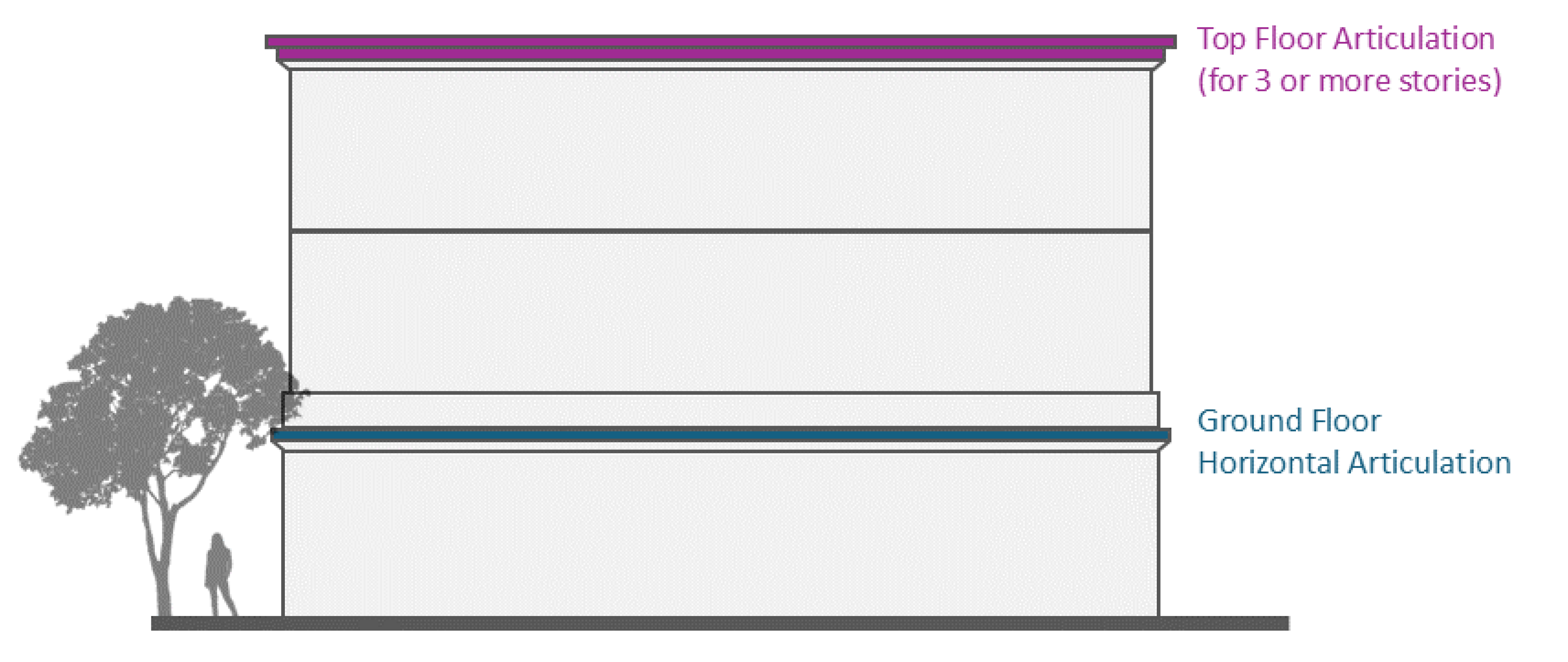
Figure. Building Height Articulation
3.
Blank building facades shall be prohibited. Building facades without the use of windows or doors shall not span a continuous horizontal length greater than 20 feet across any story.
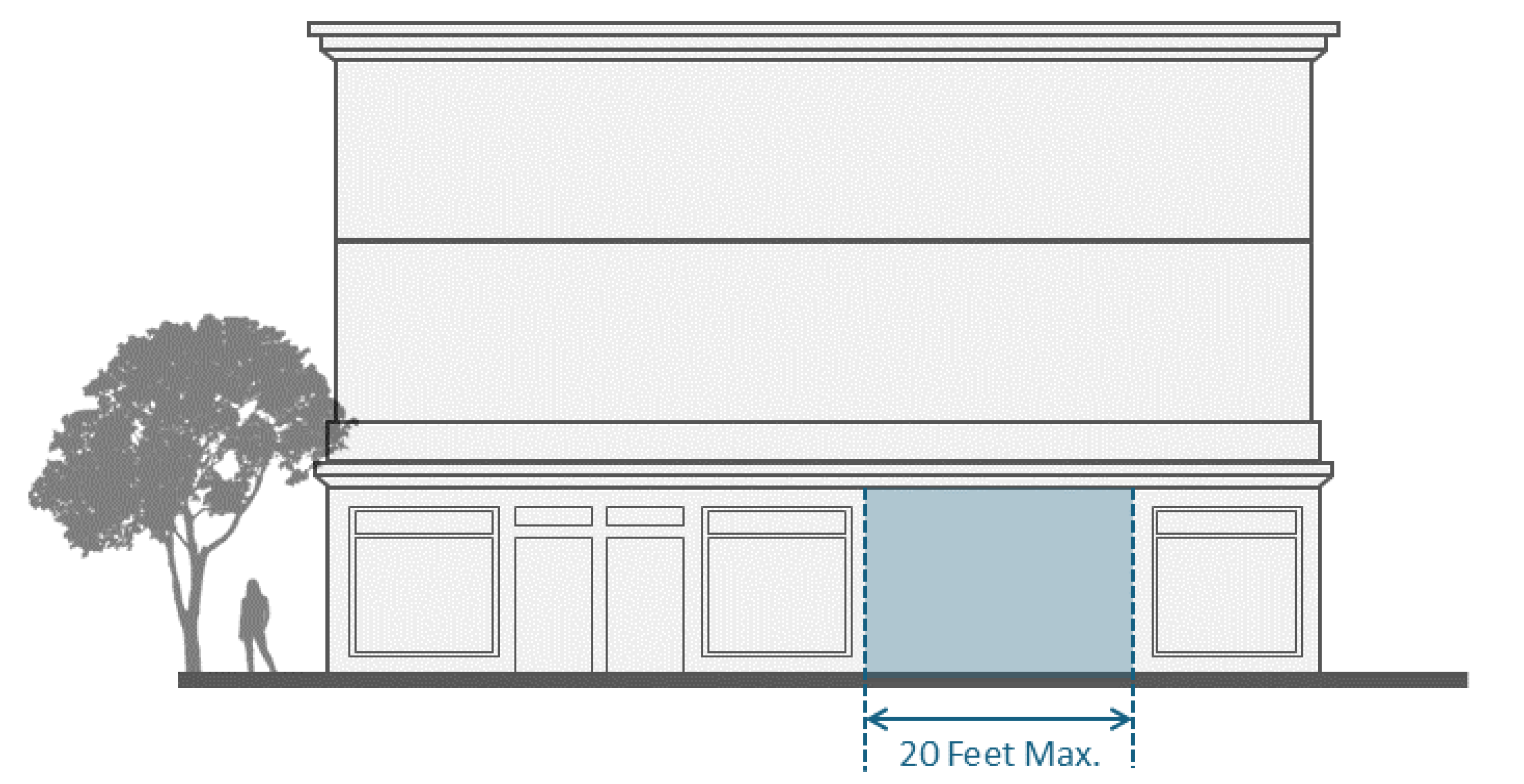
Figure. Blank Façade
b.
Materials and colors.
1.
The street-facing façade shall use at least two different façade materials and colors, each covering a minimum of 20 percent of the street-facing façade.
2.
All façade materials and colors, such as siding, window types, and architectural details, used on the street-facing façade shall be used on all other building façades.
c.
Transparency. Placement and orientation of doorways, windows, and landscape elements shall create strong, direct relationships with the street. Street-facing façades of all buildings shall incorporate windows and openings providing light to adjacent spaces, rooms, and uses.
1.
Commercial ground-floor uses. Windows and openings facing streets shall constitute a minimum of 50 percent of street-facing building faces. Windows shall provide a clear and transparent view into ground floor-uses or shall display merchandise to reinforce a pedestrian scale. Film may be provided to protect from the sun or as required to satisfy state or local energy efficiency requirements as long as some level of transparency is maintained.
2.
Commercial upper-floor uses. Windows and openings facing streets shall constitute a minimum of 40 percent of street-facing building faces.
3.
Residential ground-floor uses. Windows and openings facing streets shall constitute a minimum of 30 percent of street-facing building faces.
4.
Residential upper-floor uses. Windows and openings facing streets shall constitute a minimum of 20 percent of street-facing building faces.
(3)
Open space standards. Maintaining open space areas provides recreational opportunities, allows sunlight to enter into living spaces and provides a spacious and inviting feel. Open space requirements are as follows:
a.
Private open space(s) attached to residential units shall be designed to avoid direct visibility into the interiors of adjacent units.
b.
Any common open space shall measure at least 15 feet in length in any direction. A minimum of 25 percent of the total area of the common open space shall be landscaped.
c.
The following regulations apply to required residential open space areas within all mixed-use zoned lots.
1.
More than one open space area may be provided on a lot. The sum of square footages for all eligible open space areas on a lot shall comprise the total open space area for that lot.
2.
Required side or rear yard areas may be included in the calculated open space area but a required front yard area may not.
3.
All required open space shall be usable. Usable open space shall be improved to support residents' passive or active use. Such open space shall be located on the same parcel as the dwelling units for which it is required. The computation of such open space shall include no obstructions other than devices and structures designed to enhance its usability, such as swimming pools, changing facilities, fountains, planters, benches, and landscaping.
4.
Open space areas shall have no parking, driveway or right-of-way encroachments.
5.
Usable open space does not need to be located on the ground. Rooftop gardens and rooftop landscaping, including rooftops above parking structures, may be used to satisfy the open space requirement. Rooftop open space features and vertical projections such as sunshade and windscreen devices, open trellises, and landscaping shall not exceed 16 feet in height beyond the maximum permitted height.
d.
Landscaping. A landscaping plan for all common open areas shall be submitted with the other plans. Approval of the landscape element shall include approval of an acceptable watering system, and assurance of continued maintenance.
1.
All new development projects shall provide a minimum one 15-gallon, native canopy tree within a street facing setback when feasible, in accordance with division 4 of article III. If a street facing setback cannot contain a tree, the tree shall be provided on other areas of the site.
2.
The following standards shall apply to mixed use development with surface parking lots:
i.
A minimum of two percent of parking lot area shall be landscaped and shall be so arranged as to emphasize visual attractiveness as viewed by the public from surrounding streets and walkways.
ii.
A minimum five-foot landscape buffer strip shall be provided between a parking lot and public right-of-way.
iii.
Parking lot canopy trees shall be provided at the ratio of one tree for every four parking spaces.
iv.
The total area of any project not devoted to lot coverage and paving shall be landscaped, irrigated, and maintained in compliance with the requirements of this section.
v.
All areas of a project site not intended for a specific use, including pad sites held for future development, shall be landscaped, unless it is determined by the community development director that landscaping is not necessary to fulfill the purpose of this section.
e.
Fences, walls, and hedges.
1.
Whenever a mixed-use zoned lot shares a side or rear property line with a residentially zoned lot, and non-residential uses are located within 15 feet of that side or rear property line, a six-foot tall solid masonry wall shall be provided, along or adjacent to all such side and rear lot lines. The wall shall conform to the height regulations applicable to front yard areas of the residentially zoned lot having the common lot line. A landscape buffer shall also be provided along the shared lot lines.
2.
Roll down security gates or fencing may not be on the exterior of buildings.
(4)
Parking standards.
a.
Applicable standards. The applicable standards and requirements, including number of minimum parking stalls, required in division 3 of article V of this chapter shall apply, with the following additional standards in this subsection.
b.
Parking reduction in proximity to transit. Pursuant to Government Code § 65863.2, the required off-street vehicular parking may be waived for certain projects within one-half mile distance of public transit, as applicable.
c.
Parking reduction for mixed-use and residential projects. A reduction in off-street parking requirements may be granted pursuant to division 3 of article V.
d.
Screening.
1.
Screening. Any parking structure with at least one floor of parking at grade or above, and which contains primary property frontage along a primary street, shall incorporate wrapped residential uses or retail businesses with shopping windows viewable from the sidewalk along the ground floor, or two or more of the following features:
i.
Display or shopping windows;
ii.
Landscape material (e.g., foundation plantings, vertical trellis with vines, planter boxes with cascading landscape material) that results in the parking structure being adequately screened from adjoining parcels;
iii.
Architectural detailing and articulation that provides texture on the façade or structure openings and effectively integrates the parking structure into the basic building design.
2.
Surface parking. Surface parking shall be located on the interior side or rear of the site to the greatest extent practicable. Surface parking between the sidewalk and buildings shall be prohibited unless no alternatives are feasible.
(5)
Site standards.
a.
Access and circulation.
1.
Building entrances.
i.
Street-facing primary entrances for non-residential uses shall be accessible to the public during business hours. Residential and non-residential entries shall be clearly defined features of front façades, and of a scale that is in proportion to the size of the building and number of units being accessed. Larger buildings shall have a more prominent building entrance, while maintaining a pedestrian scale.
ii.
When non-residential and residential uses are located in the same building, separate exterior pedestrian entrances, elevators and lobbies shall be provided for each use. The entrances for non-residential uses shall be designed to be visually distinct from the entrances for residential uses.
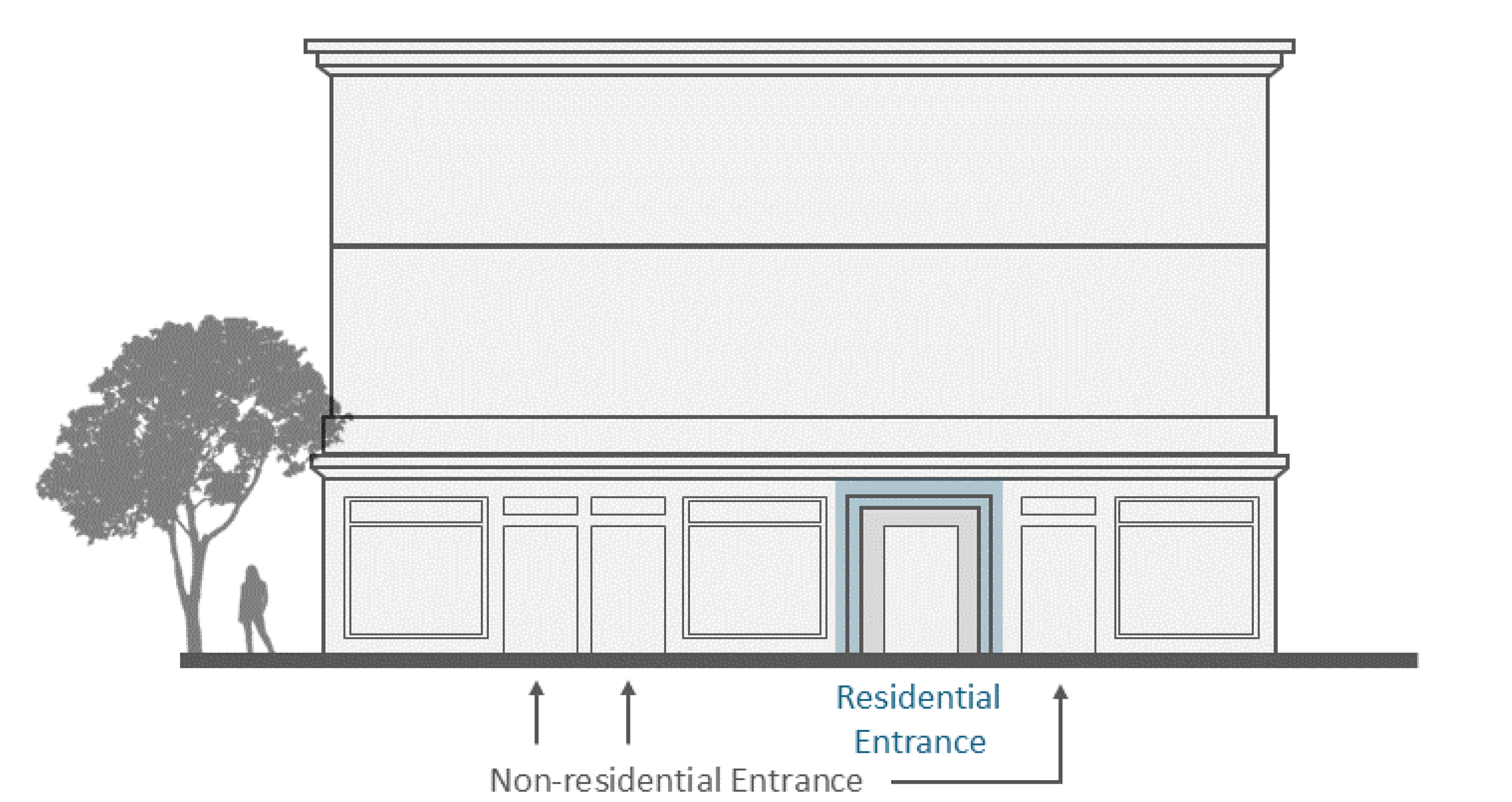
Figure. Building Entrances
2.
Pedestrian access. Pedestrian access from the adjacent street public right-of-way shall be incorporated into all ground floor uses within the MUO Zone.
3.
Development projects shall promote walkability and connectivity to include design and orientation standards including:
i.
A system of pedestrian walkways shall connect all buildings on a site to each other, to on-site automobile and bicycle parking areas, and to any on-site open space areas and pedestrian amenities.
ii.
Lighting shall be incorporated along sidewalks or other pedestrian walkways to enhance the pedestrian environment and provide for public safety. Lighting shall be low mounted and downward casting in a manner that reduces light trespass onto adjacent properties.
iii.
Connections between on-site walkways and the public sidewalk shall be provided. An on-site walkway shall connect the primary building entry or entries to a public sidewalk on each street frontage. Such walkway shall be the shortest practical distance between the primary entry and sidewalk, generally no more than 125 percent of the straight-line distance.
b.
Exterior lighting. Lighting for non-residential uses shall be appropriately designed, located, and shielded to ensure that they do not negatively impact the residential uses in the development nor any adjacent residential uses. All exterior lighting shall be 90 degrees cutoff downlight. The rays of any such lighting shall be confined to the property. No spillover shall be permitted.
c.
Trash and recycling. Recycling and refuse storage facilities for non-residential uses shall be separate from residential uses, clearly marked, located as far as possible from residential units and shall be completely screened from view from the residential portion of the development. Recycling and refuse storage facilities for non-residential uses shall be compatible in architectural design and details with the overall project. The location and design of trash enclosures shall mitigate nuisances from odors when residential uses might be impacted. Trash areas for food service and sales uses, when occupying the same building as residential uses, shall be refrigerated to control odor.
d.
Signs. The applicable provisions for signs of division 5, Signs, shall apply.
e.
Loading and unloading. Where applicable, the covenants, conditions, and restrictions of a mixed-use development shall indicate the times when the loading and unloading of goods may occur on the street, provided that, in no event, shall loading or unloading take place after 10:00 p.m. or before 7:00 a.m. on any day of the week.
f.
Uses restricted to indoor. All non-residential uses must be conducted wholly within an enclosed building. The following uses or businesses are exceptions to this rule:
1.
Outdoor dining and food service in conjunction with a cafeteria, café, restaurant or similar establishment;
2.
Other sales and display areas as approved through a conditional use permit or similar discretionary permit; and
3.
Other uses as approved by the planning and preservation commission through a conditional use permit process.
g.
Outdoor sale and display location. No outdoor sale or display area shall occupy any required parking spaces or required yard areas.
(Ord. No. 1728, § 3(Exh. A), 2-11-2025)
Sec. 106-176. - Procedure.
(a)
Development of land in a MUO mixed use overlay zone for mixed use development shall be approved with a site plan review procedure, unless proposed non-residential uses require a conditional use permit. In that case, a conditional use permit is required. Housing development projects with 20 percent affordable units shall be processed ministerially under the zone clearance, streamlined development process.
(b)
As part of the zone clearance, site plan review or conditional use permit submittal for residential development, the applicant shall submit a copy of a sewer and water capacity analysis prepared by a licensed engineer that shows that existing or proposed sewer and water infrastructure is adequate to support operations of the mixed use development.
(c)
As part of the site plan review or conditional use permit submittal, the applicant shall submit a copy of a fiscal analysis that provides a detailed evaluation of the potential financial impacts on municipal services, including any projected increase in costs of providing municipal services like police, fire, and code enforcement services.
(Ord. No. 1728, § 3(Exh. A), 2-11-2025)