
San Joaquin County Unincorporated
City Zoning Code
City Zoning Code
Series 100
- General Provisions
9-100.010 - TITLE AND AUTHORITY
The ordinance codified in this Title (Title 9) shall be known and cited as the "Development Title of San Joaquin County," the "Development Title" or the "Title." Reference to section numbers herein are to the sections of this Title.
This Title is adopted pursuant to the authority contained in the California Constitution, Article XI, Section 7, Section 65850 of the California Government Code and the Subdivision Map Act (Title 7, Division 2 of the California Government Code, as amended), the Surface Mining and Reclamation Act of 1975, California Public Resource Code, Division 2, Chapter 9, the California Environmental Quality Act, California Public Resource Code, Division 13 and the California Vehicle Code, Section 22660.
9-100.020 - PURPOSE
This Title is intended to serve as the basis for all land use regulations and development standards adopted by San Joaquin County. Its purposes is to protect and promote the public health, safety, and general welfare; implement the San Joaquin County 2035 General Plan; and achieve the following objectives:
(a)
Provide a precise guide for physical development in the County in a manner that will progressively achieve the arrangement of land uses depicted in the General Plan;
(b)
Support economic development and job creation, and provide housing for all segments of the community;
(c)
Promote a safe and efficient traffic circulation system;
(d)
Provide open spaces for light, air, and outdoor living;
(e)
Prevent overcrowding of land and the undue concentration of population;
(f)
Secure safety from fire, flooding, and other dangers;
(g)
Facilitate the provision of needed public services, community facilities, and recreational areas;
(h)
Conserve and stabilize the value of land and real property; and
(i)
Conserve the County's natural beauty, improve its appearance, and enhance its physical character.
9-100.030 - CONSISTENCY OF DEVELOPMENT TITLE WITH GENERAL PLAN
All actions, approvals, and procedures taken with respect to, or in accordance with, this Title shall be consistent with the 2035 General Plan. In the event this Title becomes inconsistent with the 2035 General Plan by reason of adoption of a new General Plan or by amendment of the existing General Plan or any of its elements, this Title shall be amended within a reasonable time, so that it is consistent with the newly adopted General Plan or remains consistent with the existing General Plan, as amended. Additionally, all Development Title amendments shall be consistent with the 2035 General Plan. The procedure for the amendment of this Title is contained in Chapter 9-807, General Plan Amendments.
(a)
The various zones contained in this Code shall each be geographically applied in a manner consistent with the land use categories or designations provided by the 2035 General Plan according to the statement of purpose or intent accompanying each zone.
(b)
Certain preexisting land uses are not consistent with the land use designations provided by the 2035 General Plan. These preexisting, inconsistent land uses shall nonetheless be subject to zone classifications which are consistent with the 2035 General Plan, thereby making them nonconforming uses as prescribed by the zoning code. Recognizing that consistency between the 2035 General Plan and zoning code must be balanced by practical considerations and the avoidance of undue hardships, the nonconforming use regulations contained in this Code are not intended to detract from or diminish the overall objective of ensuring consistency of the zoning code with the 2035 General Plan.
9-100.040 - STRUCTURE OF THE DEVELOPMENT TITLE
(a)
Organization of Regulations. The Development Title consist of nine series:
100 Series—General Provisions
200 Series—Base Zones
300 Series—Master Plans, Special Purpose Plans, Specific Plans, and Planned Development
400 Series—Additional Use and Development Regulations
500 Series—Subdivision Regulations
600 Series—Infrastructure Standards and Financing
700 Series—Supplemental Development Regulations
800 Series—Administration and Permits
900 Series—General Terms
(b)
Types of Regulations. The Development Title include three types of regulations that control the use and development of property:
(1)
Land Use Regulations. This Title specifies the land uses that are permitted, by right, or conditionally permitted within in each zone. This Title also provides any special requirements that are applicable to specific uses. Land use regulations for base zones and for overlay zones are located in the 200 and 300 Series. Additional land use regulations that apply countywide or to 'accessory dwelling unit, entertainment, home occupations, produce stands and agricultural stores, and wineries) are located in the 400 Series.
(2)
Development Regulations. This Title controls the height, density/intensity, location and form of structures on development sites. Development regulations for base zones are located in the 200 Series. Development regulations, applicable to some or all zones are located in the 400 Series; these include regulations for accessory buildings, fences, landscaping, lighting, nonconforming uses and structures, off-street parking and loading, signs, and wireless communications facilities. Standards for infrastructure and public improvements in subdivisions are in the 600 Series.
(3)
Administrative Regulations. This Title contains detailed procedures for the administration of this Title and includes common procedures, processes, and standards for discretionary entitlement applications and other permits. Administrative regulations are located in the 800 Series. Specific procedures for processing maps related to subdivisions, approving improvement agreements, and other approvals related to land divisions are located in the 500 Series. Authority for adopting and implementing Master Plans, Special Purpose Plans, Specific Plans and Planned Development is located in the 300 Series.
(c)
General Terms and Use Classifications. The 900 Series provides a list of terms and definitions of the terms used in the Development Title and a system of use type classifications used in the land use regulations for the base zones.
(d)
Permissive Code. Any use not specifically permitted by the provisions of this title is prohibited. All prohibited uses specified at any place within this title are examples only and are not to be construed as a complete listing of all prohibited uses.
9-100.050 - APPLICABILITY
(a)
General Rules for Applicability.
(1)
Applicability to Property. The Development Title applies, to the extent permitted by law, to all property within the unincorporated area of the County, including all uses, structures and land owned by any private person, firm, corporation or organization, or the County or other local, State, or federal agencies. Any governmental agency is exempt from this Title only to the extent that such land use or property may not be lawfully regulated by the County.
(A)
Interpretation as to Agricultural Use. Agriculture is a major industry in the county and the provisions of the Development Title shall be interpreted liberally in regards to valid agricultural uses and shall serve as a means of preventing undesirable encroachments of other land uses upon agricultural lands. Other reasonable and desirable land uses shall receive due consideration.
(2)
Regulations.
(A)
Compliance. Land must be used, and structures must be constructed, occupied, enlarged, altered, demolished, and moved in accordance with the provisions of this Title.
(B)
Minimum Requirements. In interpreting and applying the provisions of the Development Title, unless otherwise stated, the regulations shall be held to be the minimum requirements for the promotion and protection of the public safety, health, and general welfare.
(b)
Relation to Other Regulations.
(1)
General. The Development Title does not supersede any other regulations or requirements adopted or imposed by the Board of Supervisors, the State of California, or any federal agency that has jurisdiction over uses and development authorized by this Title. All uses and development authorized by this Title shall comply with all other such regulations and requirements. Where conflict occurs between the provisions of this Title and any other provision of the County Code, the more restrictive provisions control, unless otherwise specified.
(2)
Permit Streamlining Act. Development Projects applied for pursuant to this Title will be processed in compliance with the Government Code Section 65920 et seq. (California Permit Streamlining Act).
(3)
Relation to Private Agreements. The Development Title shall not interfere with or annul any recorded easement, covenant, or other agreement now in effect, provided that this Title controls where imposing a greater restriction than imposed by an easement, covenant, or agreement.
(4)
Application During Local Emergency. The Board of Supervisors may authorize a deviation from a provision of the Development Title during a local emergency that has been proclaimed and ratified under the County Code. This authorization may be made by resolution without notice or public hearing.
(c)
Effect on Previously Approved Projects and Projects in Progress. Any previously approved or in-progress building, structure, or use of land must be completed in accordance with the zoning, plans, specifications, and permits within the time frame originally permitted. If a previously approved or in-progress project cannot be completed within the original time frame, a Time Extension may be applied for under this Title. Additionally, a Revisions of Approved Actions or modification may be requested to change the previously approved conditions based on more permissive requirements in this Title. The Revisions of Approved Actions may be reviewed and approved by the Zoning Administrator or by the original Review Authority at the discretion of the Director.
(1)
Applications Filed Prior to and Approved After the Effective Date of the Development Title.
(A)
Applications Deemed Complete for Processing Prior to and Approved After the Effective Date of this Title. Complete applications filed prior to the effective date of this Title may be approved under the current provisions of this Title upon request of the applicant, with the exception of rezones. For a four-month period after the effective date of this Title, applicants may elect to develop under the provisions of the prior Development Title at the discretion of the Director, but in that case, the applicant shall comply with all provisions of the prior Title except where this Title is more permissive.
(i)
A time extension may be permitted under this Title upon submission of a completed application, fee, and documentation showing conditions have not substantially changed since the approval was granted.
(ii)
All requests for extensions shall be reviewed for compliance to the applicable development standards. Where the pre-existing Title is silent on any specific aspect of land use regulations and development standards, this Title controls. Extension requests may be denied or approved by the Zoning Administrator. The Zoning Administrator shall approve the extension request if the delay in obtaining a Building Permit was not caused by the applicant and has discretion to approve or deny the extension if the applicant failed to take steps towards obtaining a Building Permit. This decision is appealable to the Planning Commission, which may deny, approve, or approve with new conditions the extension request.
(B)
Applications for Rezoning Filed Prior to and Approved After the Effective Date of this Title. Rezoning applications filed prior to the effective date of this Title shall be governed by the provisions, standards, and conditions of approval established in this Title and shall follow the applicable procedures identified in the 800 Series, Administration and Permits, of this Title.
(2)
Applications Filed After the Effective Date of this Title and Not Covered by a Pre-Existing Development Agreement. All new applications filed after the effective date of this Title, including modifications and amendments to those new applications, shall conform to the current provisions of this Title.
9-100.060 - ZONING MAPS
A series of zoning maps, to be known collectively as the "Zoning Map of the County of San Joaquin" or "Zoning Map," shall be maintained by the Community Development Department.
(a)
Contents. The Zoning Map shall show the designations and boundaries of each zone and shall show any base data that the Director deems useful or that the Board of Supervisors directs.
(b)
Revisions. The Director shall revise the Zoning Map to show amendments, including changes in designations, rezoning of property, and clarification of zone boundaries.
(c)
Incorporation. The Zoning Map and all notations, references, data, and other information contained therein are made a part of this Title by reference herein.
(d)
Zone ..... Boundaries. Where uncertainty exists as to the boundaries of any zone shown on the Zoning Map, the following rules shall apply:
(1)
Where zone boundaries are indicated as approximately following street and alley lines or lot line, such lines shall be construed to be the boundary of the said zone, and the following shall apply:
(A)
When two zones are separated by a street or alley, the zone boundary shall be the centerline of the street or alley, unless otherwise specified, and
(B)
When a residential zone is separated from any other zone by a street or alley, the residential zone boundary shall include both sides of the street or alley.
(2)
Where any public street or alley is officially vacated or abandoned, the regulations applicable to abutting properties shall apply to the centerline of such vacated or abandoned street or alley, unless otherwise documented;
(3)
Where any private right-of-way or easement of any railroad, canal, transportation, or public utility company is vacated or abandoned, the regulations applicable to abutting property shall apply to the centerline of such vacated or abandoned property, unless otherwise documented;
(4)
For unsubdivided property, or in instances where a zone boundary divides a lot, the location of the zone boundary shall be determined by the Director unless the zone boundary is indicated by dimensions.
(e)
Creation of New Zones. The boundaries of a new zone shall be shown on the Zoning Map. The map together with all legends, symbols, notations, references, zoning district boundaries and other information on the map shall be incorporated into this Title by reference as though it were fully included.
9-100.070 - INTERPRETATION, CONSTITUTIONALITY, AND SEVERABILITY
(a)
Ambiguities. Unless otherwise provided, any ambiguity concerning the content or application of this Title shall be resolved by the Zoning Administrator, or their designee.
(b)
Invalidity; Severability. If any section, subsection, sentence, clause, or phrase of this Title is for any reason held to be unconstitutional or invalid, such decision shall not affect the validity of the remaining portions of this Title. The Board declares that it would have passed this Title and every section, subsection, clause, and phrase thereof, notwithstanding that one or more sections, subsections, sentences, clauses, or phrases be declared unconstitutional.
9-100.080 - NO RELIEF FROM OTHER PROVISIONS
Except as otherwise specifically provided, no provision of this Title shall be construed as relieving any party from any applicable provision of county, state, or federal law.
9-100.090 - INAPPLICABILITY OF FORMAL RULES OF EVIDENCE
(a)
Formal Rules of Evidence Do Not Apply. Except as otherwise expressly provided in this Chapter, formal rules of evidence or procedure which must be followed in a court of record in this state shall not apply to hearings conducted pursuant to this Title.
(b)
No Presumption Regarding Error. There shall be no presumption that error is prejudicial or that injury was done if error is shown.
9-100.100 - DEVELOPMENT TITLE REPEALS EXISTING ORDINANCES
The ordinance adopting this Title repeals the pre-existing Title 9 of the Ordinance Code of San Joaquin County, Ordinance No. 549, Ordinance No. 1862, Ordinance No. 441, Ordinance No. 3384, Ordinance No. 545, Ordinance No. 648, and Ordinance No. 3089. The adoption of the ordinance, however, shall not affect or prevent any pending or future prosecution of, or action to abate, any existing violation of Title 9 of the Ordinance Code of San Joaquin County or any existing illegal use or violation of the repealed ordinances listed in this section, if the violation is also a violation of the provisions of this ordinance.
9-100.110 - PERMITS AND LICENSES TO COMPLY WITH TITLE
All permits and licenses issued by the County pursuant to this Title shall be subject to the following requirements:
(a)
Issuance of Permit. All departments, officials, and employees of the County responsible for the issuance of such permit or license shall determine that the permit or license requested will not violate any of the provisions of this Title.
(b)
Invalid Permit. Any permit or license issued by said departments, officials, or employees that is issued in violation of the provisions of this Title shall be null and void at the Director's discretion.
(c)
Failure to Comply. Failure to comply with any conditions or requirements of such permit or license shall be considered a violation and be subject to enforcement action subject to Chapter 9-815 Enforcement.
(d)
Permits Run with the Land. All development permits shall run with the land; permits are not tied to individuals, including those persons who applied for the permit or who owned the property at the time the permit was issued. However, time limits may be established for certain permits.
9-101.010 - PURPOSE
The purpose of this Chapter is to provide precision in the interpretation of this Title. The meaning and construction of words and phrases defined in this article apply throughout the Development Title regulations, except where the context indicates a different meaning.
9-101.020 - RULES FOR CONSTRUCTION OF LANGUAGE
In interpreting the various provisions of the Development Title, the following rules of construction apply:
(a)
The ordinary or commonly understood meaning of terms applies.
(b)
In case of conflict between the text and a diagram or graphic, the text controls.
(c)
All references to public officials are to those of the County who perform the function referred to, and include designated deputies of such officials, unless otherwise indicated.
(d)
All references to "Director" mean the Director of the Community Development Department or their designee, unless otherwise indicated.
(e)
All references to days are to calendar days, unless otherwise indicated. If a deadline falls on a weekend or holiday, or a day when County offices are closed, the deadline will be extended to the next working day. The end of a time period is the close of business on the last day of the time period.
(f)
The words "shall," "will," "must," "has to," "is required to," and "is to" are always mandatory and not discretionary. The words "should" or "may" are permissive.
(g)
The words "activities" and "facilities" include any part thereof.
9-101.030 - RULES OF INTERPRETATION
The Zoning Administrator will interpret any definition not expressly identified in this Title and provide clarification and determinations, which shall be compiled and made available at the Community Development Department office.
9-102.010 - PURPOSE
The purpose of this Chapter is to explain how various measurements referred to in this Title are to be calculated.
9-102.020 - GENERAL PROVISIONS
For all calculations, the applicant is responsible for supplying drawings illustrating the measurements that apply to a project. These drawings must be drawn to scale and of sufficient detail to allow easy verification upon inspection by the Zoning Administrator.
9-102.030 - FRACTIONS
Whenever this Title requires consideration of multiple items or the physical environment expressed in numerical quantities, and the result of a calculation contains a fraction of a whole number, the results will be rounded as follows:
(a)
General Rounding. Fractions of one-half or greater must be rounded up to the nearest whole number, and fractions of less than one-half must be rounded down to the nearest whole number, except as otherwise provided. Rounding will occur after all calculations are complete.
(b)
Exception for State Affordable Housing Density Bonus. The calculation of fractions related to permitted bonus density units for projects eligible for bonus density pursuant to Government Code Section 65915 or any successor statute shall be done as provided by State law.
9-102.040 - MEASURING DISTANCES
(a)
Measurements are Shortest Distance. When measuring a required distance, such as the minimum distance between a structure and a lot line, the measurement is made at the closest or shortest distance between the two objects.
(b)
Distances are Measured Horizontally. When determining distances for setbacks and structure dimensions, all distances are measured along a horizontal plane from the appropriate line, edge of building, structure, storage area, parking area, or other object. These distances are not measured by following the topography or slope of the land.
(c)
Measurements Involving a Structure. Measurements involving a structure are made to the closest support element of the structure, unless otherwise specified. Structure height is measured at the peak of the roof. Structures or portions of structures that are entirely underground are not included in measuring required distances.
(d)
Measurement of Vehicle Stacking or Travel Areas. Measurement of a minimum travel distance for vehicles, such as garage entrance setbacks and stacking lane distances, are measured down the center of the vehicle travel area. For example, curving driveways and travel lanes are measured along the center arc of the driveway or traffic lane.
(e)
Measuring a Buffer or Radius. When a specified land use is required to be located a minimum distance from another land use, the minimum distance is measured in a straight line from all points along the lot line of the subject project, in all directions.
Figure 9-102.040: MEASURING
DISTANCES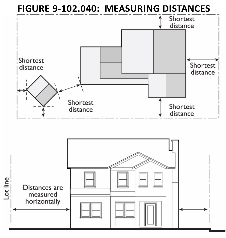
9-102.050 - MEASURING HEIGHT
(a)
Measuring Building Height. Building height shall be defined as the distance from finished grade to the highest point of the coping of a flat roof or to the deck line of a mansard roof or to the height of the highest gable of a pitched or hipped roof. The height of a stepped or terraced building is the maximum height of any segment of the building along the finished grade directly below. For structures projecting over water, height will be measured from highest grade at front (landward) property line. On lots with a grade change of 10 percent or more between the front and rear property lines, building height is measured from natural or finished grade, whichever is lower, as determined in the following subsection, and height shall be measured from the measure point at the top of the building, as determined above, to the grade.
FIGURE 9-102.050-A: MEASURING BUILDING HEIGHT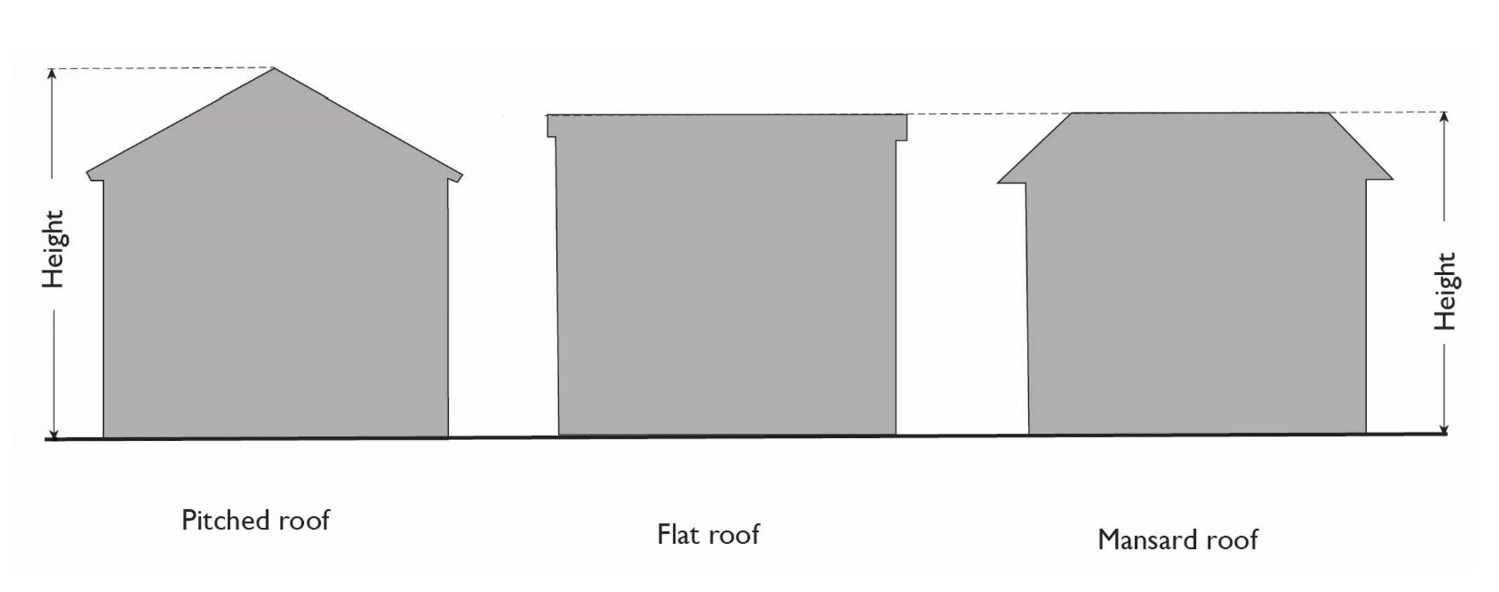
FIGURE 9-102.050-B: MEASURING BUILDING HEIGHT OF A TERRACED OR STEPPED BUILDING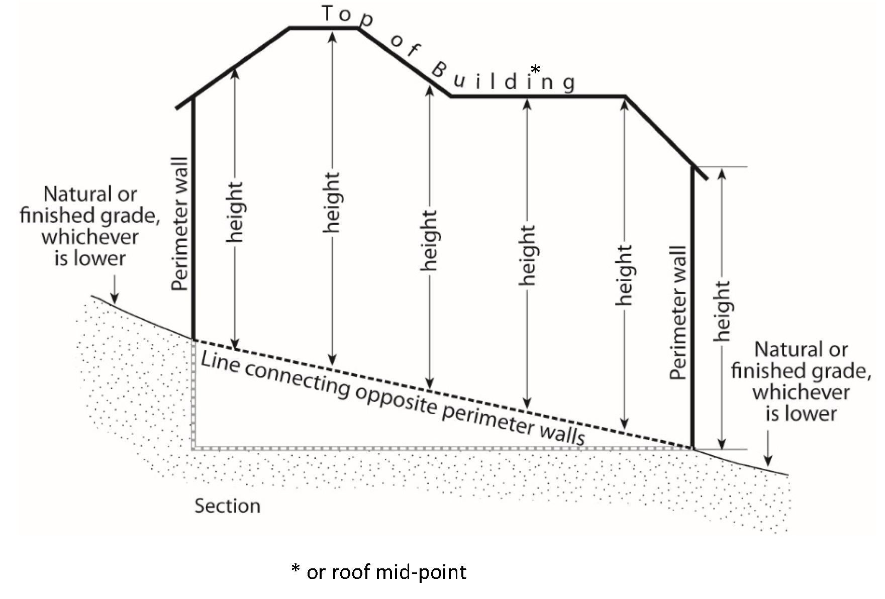
(1)
Measuring Building Height on Sloped Lots. On lots with a grade change of 10 percent or more between the front and rear lot lines, or between the front lot line and its most distant point when there is no rear lot line, building height is measured from the adjacent natural or finished grade, whichever is lower, to the coping of a flat roof or to the deck line of a mansard roof or to the average height of the highest gable of a pitched or hipped roof.
(2)
Exceptions. Antennas, belfries, chimneys, cooling towers, cupolas, domes, elevator bulkheads, flagpoles, ornamental towers, penthouses, solar collectors, spires and standpipes and necessary mechanical equipment may exceed the height limits pursuant to Section 9-400.050 (Exceptions to Height Limits).
(b)
Measuring the Number of Stories in a Building. In measuring the height of a building in stories, the following measurement rules apply:
(1)
A balcony or mezzanine shall be counted as a full story if its floor area exceeds one-third of the total area of the nearest full floor directly below it or if it is enclosed on more than two sides.
(2)
A basement shall be counted as a full story if the finished surface of the floor above the basement is:
(A)
More than six feet above grade plane; or
(B)
More than 12 feet above the finished grade at any point.
FIGURE 9-102.050-C: DETERMINING IF A BASEMENT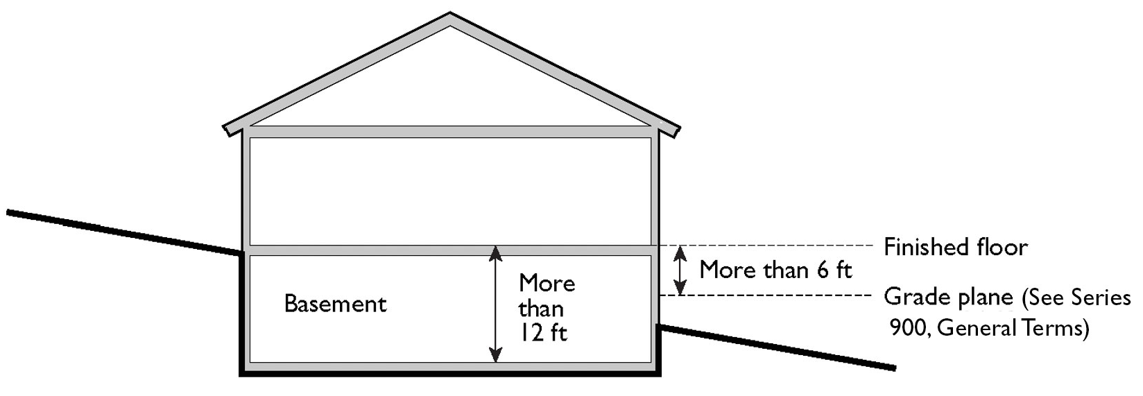
(3)
A story must meet the applicable Building Code requirements for height from the upper surface of the floor to the ceiling above.
(c)
Measuring Height of Fences or Walls. The height of any fence or wall shall be determined by measuring the vertical distance from the highest finished grade within a three-foot radius of any point on the fence or wall to the highest point of any portion of the fence or wall. In the case of fences or walls between the setback line and lot line, height shall be measured from highest finished grade adjacent to the fence or wall to the top of the fence or wall.
(1)
Measuring Height of Fences on Retaining Walls. The height of a fence that is on top of a retaining wall is measured from the highest finished grade point within a three-foot radius of any point on such fence to the highest point of the fence on the highest side of the wall. Any fence or railing required to comply with minimum height in applicable Building Code requirements is permitted.
FIGURE 9-102.050-D: MEASURING HEIGHT OF FENCES AND WALLS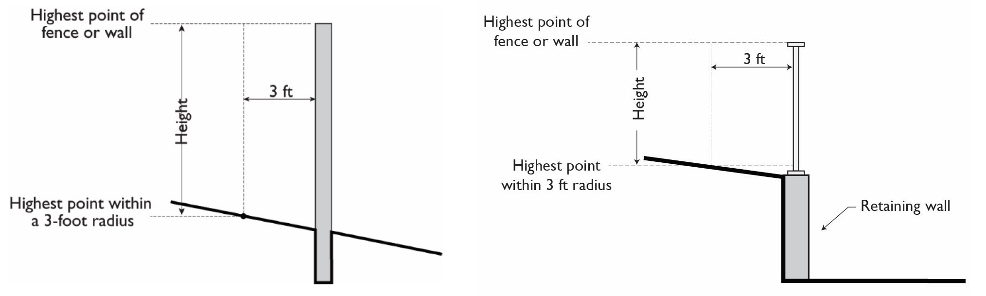
(d)
Measuring the Height of Decks. Deck height is the vertical distance from finished grade directly below the deck to the top of the floor of the deck.
FIGURE 9-102.050-E: MEASURING HEIGHT OF DECKS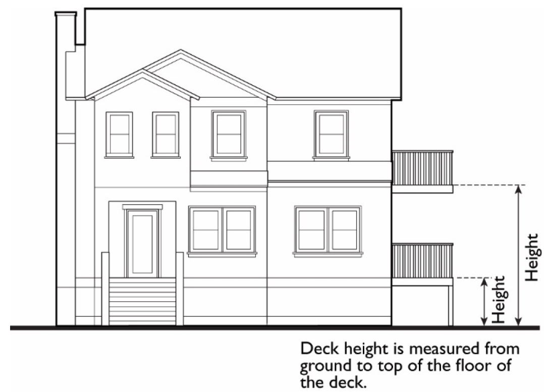
9-102.060 - DETERMINING GRADE
(a)
Determining Grade. Grade is the location of the ground surface. For purposes of this Chapter, the grade of a building used to determine building height shall be determined by one or more of the following:
(1)
Average Grade. A horizontal line approximating the ground elevation through each building on a site used for calculating the exterior volume of a building. Average grade is calculated separately for each building.
(2)
Existing Grade. The existing elevation of the ground at any point on a lot. Existing grade also may be referred to as natural grade.
(3)
Finished Grade. The lowest point of elevation of the finished surface of the ground, paving, or sidewalk within the area between the building and the lot line, or when the lot line is more than five feet from the building, between the building and a line five feet from the building.
(4)
Grade Plane. A reference plane representing the average of finished ground level adjoining the building at exterior walls. Where the finished ground level slopes away from the exterior walls, the reference plane shall be established by the lowest points within the area between the building and the lot line or, where the lot line is more than five feet from the building, between the building and a point five feet from the building.
FIGURE 9-102.060: GRADE PLANE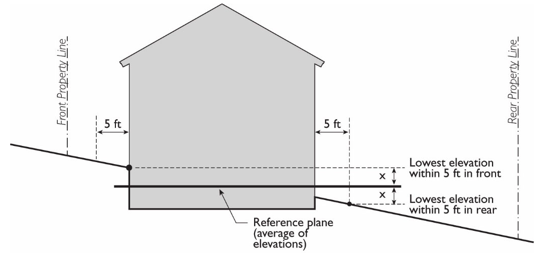
9-102.070 - MEASURING LOT WIDTH AND DEPTH
(a)
Lot Width. Lot width is the horizontal distance between the side lot lines, measured at the front setback line.
(b)
Lot Depth. Lot depth is measured along a straight line drawn from the midpoint of the front lot line to the midpoint of the rear lot line or to the most distant point on any other lot line where there is no rear lot line.
9-102.080 - DETERMINING FLOOR AREA
The floor area of a building is the sum of the gross horizontal areas of all floors of a building or other enclosed structure, measured from the outside perimeter of the exterior walls and/or the centerline of interior walls.
(a)
Included in Floor Area. Floor area includes, but is not limited to, all habitable space (as defined in the California Building Code as adopted by the County) that is below the roof and within the outer surface of the main walls of principal or accessory buildings, the centerlines of party walls separating such buildings or portions thereof, or lines drawn parallel to and two feet within the roof line of any building without walls. In the case of a multi-story building that has covered or enclosed stairways, stairwells, or elevator shafts, the horizontal area of such features shall be counted only once at the floor level of their greatest area of horizontal extent. The area of mezzanines and sleeping lofts shall not be counted if the space is between two floors.
(b)
Excluded from Floor Area. Floor area does not include the following: mechanical, electrical, and communication equipment rooms that do not exceed two percent of the building's gross floor area; bay windows or other architectural projections where the vertical distance between the lowest surface of the projection and the finished floor is 30 inches or greater; areas that qualify as usable open space; solar panels and solar structures. and, in non-residential buildings, areas used for off-street parking spaces or loading spaces, driveways, ramps between floors of a multi-level parking garage, and maneuvering aisles that are located below the finish grade of the property.
(c)
Non-Residential Uses. For non-residential uses, gross floor area includes interior walkways interior courtyards, walkways, paseos, and corridors covered by a roof or skylight. Non-residential gross floor area does not include arcades, porticoes, and similar open areas that are located at or near street level and are accessible to the general public but are not designed or used as sales, display, storage, service, or production areas.
9-102.090 - DETERMINING FLOOR AREA RATIO
The floor area ratio (FAR) is the ratio of the floor area, excluding the areas described below, of all principal and accessory buildings on a site to the site area. To calculate the FAR, floor area is divided by site area, and typically expressed as a decimal. For example, if the floor area of all buildings on a site totals 20,000 square feet, and the site area is 10,000 square feet, the FAR is expressed as 2.0. In single family homes and duplexes, any portion of a floor with a ceiling height greater than 12 feet is counted twice for purposes of calculating compliance with the maximum residential floor area allowed.
(a)
Excluded from Floor Area in Calculating FAR. The following are excluded from the floor area when calculating FAR.
(1)
Underground Areas. Floor area located below finished grade.
(2)
Parking. Parking areas located below finished grade or finished floor of habitable space where the vertical distance between finished grade and finished floor is five feet or less. Structured parking areas located above finished grade where the vertical distance between finished grade and the floor of the parking level is five feet or less.
(3)
Sideloaded or Detached Garages. Sideloaded or detached garages not exceeding 400 square feet, located to the rear of residential structures, a minimum of 40 feet away from the front lot line, and accessed by a driveway.
FIGURE 9-102.090: DETERMINING FLOOR AREA RATIO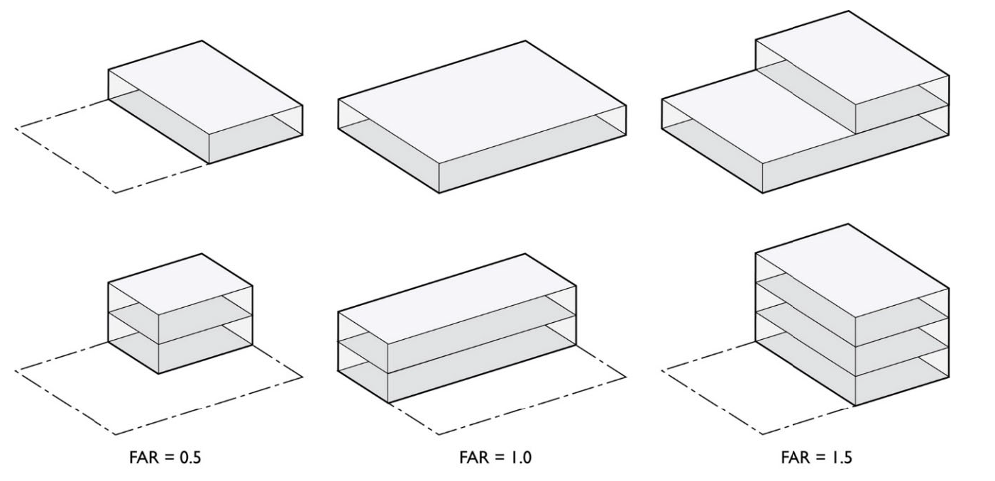
9-102.100 - DETERMINING LOT FRONTAGE AND BUILDING FRONTAGE
(a)
Corner Lot. The front of a lot is the narrowest dimension of the lot with street frontage.
(b)
Through Lot. The front yard of a through lot abuts the street that adjoining lots use to provide primary access into the dwelling.
(c)
Building Frontage. Building frontage is the building facade in which main customer access is provided to the business. For buildings with two or more frontages, the length of the wall shall be calculated separately for each building frontage.
9-102.110 - DETERMINING SETBACKS
A setback line defining a required yard is parallel to and at the specified distance from the corresponding front, side, or rear lot line. The following regulations for determining yards apply when a lot abuts a proposed street or alley.
(a)
Yards Abutting Planned Street Expansions. If a property abuts an existing or proposed street for which the existing right-of-way is narrower than the right-of-way ultimately required for the street, the required setback shall be established from the future right-of-way rather than the property line.
(b)
Yards on Alleys.
(1)
If a side lot line abuts an alley, the yard shall be considered an interior side yard rather than a corner side yard.
(2)
In computing the minimum yard for any lot where such yard abuts an alley, no part of the width of the alley may be considered as part of the required yard.
(c)
Measuring Setbacks. Setbacks shall be measured as the distance between the nearest lot line and the closest support element of the building or structure along a line at right angles to the lot line. Setbacks shall be unobstructed except where allowed pursuant to Section 9-400.020, Building Projections into Required Yards, subject to compliance with the Building Code.
FIGURE 9-102.110: DETERMINING SETBACKS (YARDS)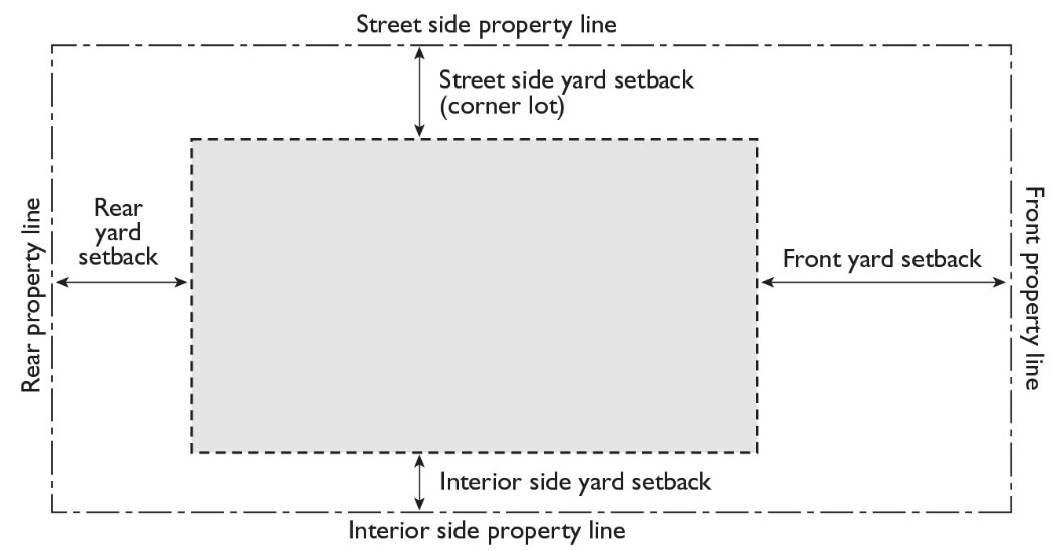
9-102.120 - DETERMINING NATURAL SLOPE
Natural slope, meaning the slope of the ground prior to any soil disturbance, shall be determined by measuring the horizontal distance between adjacent contours on a United State Geologic Survey (USGS) 7.5 minute quadrangle map or other topographic map acceptable to the Zoning Administrator with a scale of not less than 1:24000 (one inch = 2,000 feet) and contour intervals of not more than 20 feet, and then dividing the difference in elevation between the two contours by the measured horizontal distance. The horizontal distance shall be measured perpendicular to the contours.
9-102.130 - MEASURING SIGNS
The calculations of measurements related to signs are described in Chapter 9-408, Signs.
9-102.140 - MEASURING PARKING LOT LANDSCAPING
For the purpose of calculating required parking lot landscaping, parking lot areas are deemed to include parking and loading spaces as well as aisles, vehicle entry and exit areas, and any adjacent paved areas. Parking lot area does not include enclosed vehicle storage areas.
9-102.150 - MEASURING PEDESTRIAN CLEARANCE
The minimum distance shall be measured from the edge of any table, chair, bench, planter, or other appurtenance used as part of an outdoor dining area to any obstruction within the sidewalk area.
FIGURE 9-102.140: MEASURING PEDESTRIAN CLEARANCE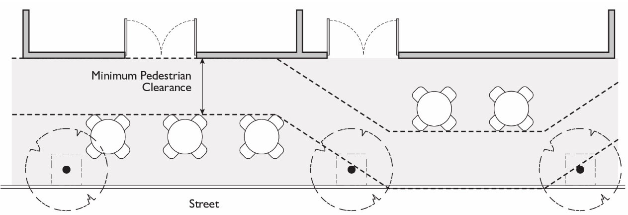
9-103.010 - PURPOSE
The purpose of this Chapter is to establish a procedure for persons with disabilities seeking fair access to housing to make requests for reasonable accommodation in the application of the Development Title pursuant to Section 3604(f)(3)(b) of Title 42 of the United States Code (the "Fair Housing Act") and Section 12955 et seq. of the California Government Code (the "California Fair Employment and Housing Act"), which prohibit local government from refusing to make reasonable accommodations in policies and practices when these accommodations are necessary to afford persons with disabilities equal opportunity to use and enjoy a dwelling.
9-103.020 - INTENT
The intent of this Chapter is to ensure that the County complies fully with the intent and purpose of fair housing laws and provides flexibility in the application of the Development Title for individuals with a disability, when flexibility is necessary to eliminate barriers to housing opportunities.
9-103.030 - APPLICABILITY
A request for reasonable accommodation may be made by any person with a disability or person associated with them, including providers, landlords, and developers of housing for people with disabilities. Reasonable accommodation may include a modification or exception to the rules, standards, and practices for the siting, development, and use of housing or housing-related facilities that would eliminate regulatory barriers and provide a person with a disability equal opportunity to use and enjoy a dwelling.
9-103.040 - DEFINITIONS
The following are definitions regarding the reasonable accommodations policy:
Acts. The "Fair Housing Act" (Section 3601 et seq. of Title 42 of the United States Code) and the "California Fair Employment and Housing Act" (Section 12955 et seq. of the California Government Code).
Person with a Disability. Any person who has been found to have or has a record of having a physical or mental impairment that limits one or more major life activities.
Request for Reasonable Accommodations. A request to modify the application of a section or sections of the Development Title or related procedures in order to give a person with a disability an equal opportunity to use and enjoy a dwelling.
9-103.050 - NOTICE TO THE PUBLIC
Notice of the availability of the reasonable accommodation policy and request forms shall be available at the Community Development Department public information counter and website.
9-103.060 - APPLICATION REQUIREMENTS
(a)
Any person with a disability seeking a reasonable accommodation, or their representative, shall make such a request in writing on a form provided by the Community Development Department that includes the following information:
(1)
Name of the requestor and name of the person with a disability if they are different;
(2)
Name and address of the property owner(s);
(3)
Address of the property for which accommodation is requested;
(4)
Description of the requested accommodation and the Development Title regulation(s), policy, or procedure for which the reasonable accommodation is sought;
(5)
Reason that the requested reasonable accommodation may be necessary for the person with the disability to use and enjoy the dwelling; and
(6)
Documentation supporting the request for reasonable accommodation, if any.
(b)
Any information submitted as part of a reasonable accommodations request shall be kept confidential and shall be retained in a manner so as to respect the privacy rights of the person with a disability and shall not be made available for public inspection.
(c)
A request for reasonable accommodation may be filed at any time that the accommodation may be necessary to ensure equal access to housing.
(d)
A reasonable accommodation does not affect an individual's obligations to comply with other applicable regulations not at issue in the requested accommodation.
(e)
If the request is related to a project that also requires discretionary approval(s), then to the extent feasible, the requestor shall file the request for reasonable accommodation together with any related application for discretionary approval.
(f)
If an individual needs assistance in making the request for reasonable accommodation Community Development Department staff will provide assistance to ensure that the process is accessible.
9-103.070 - REVIEW PROCEDURES
(a)
The Community Development Director, or their designee, shall be the review authority and shall consider and approve requests for reasonable accommodation when those accommodations may be necessary to afford persons with disabilities equal opportunities to use and enjoy the dwelling
(b)
The review authority shall issue a written determination within a timely manner but no later than 30 days of the date of receipt of a complete application form.
(c)
The written determination shall state in writing that they grant, grant with modifications, or deny a request for reasonable accommodation consistent with fair housing laws and based on the following factors:
(1)
Whether the housing, which is the subject of the request for reasonable accommodation, will be used by an individual with disabilities protected under fair housing laws;
(2)
Whether the requested accommodation is necessary to make housing available to an individual with disabilities protected under the fair housing laws;
(3)
Whether the requested accommodation would impose an undue financial or administrative burden on the County; and
(4)
Whether the requested accommodation would require a fundamental alteration the County's land use zoning, rules, policies, practices, or procedures.
(d)
None of the factors in 9-103.013(C) are intended to supersede any other findings which might also be required for a discretionary permit that is reviewed concurrently with the request for accommodation.
(e)
For requests for reasonable accommodations involving any applications for discretionary approval, the review authority shall process and consider the request for reasonable accommodation separately from any discretionary elements of the same proposal. Pursuant to 9-103.013(B) the review authority shall act on the request for reasonable accommodation within no later than 30 days of the date of receipt, if the request for a reasonable accommodation cannot be effectuated until a final decision is rendered on the related discretionary approvals, a "provisional written determination" can be provided within the 30 day time frame allowing the reasonable accommodation request to be implemented, or modified as needed to obtain the same goal, at the time of the final discretionary approval, and shall become final at the same time. The applications for discretionary approval shall be separately considered and shall be subject to the procedures for consideration specified in the Development Title. The appropriate decision-making body shall act on all discretionary permits, but not on the reasonable accommodation request.
(f)
While a request for reasonable accommodation is pending, all laws and regulations otherwise applicable to the property that is the subject of the request shall remain in full force and effect.
(g)
The written determination is final unless the requestor appeals the decision pursuant to Section 9-103.015.
(h)
The written determination shall be sent to the requestor by first class mail to the address provided on the reasonable accommodation form or in a format requested by the requestor.
9-103.080 - APPEALS
(a)
Within 30 days of the date of the reviewing authority's written determination, an application may appeal an adverse decision in writing on a form provided by the Community Development Department.
(b)
The appeal will be heard by a County hearing officer pursuant to County Ordinance Code Title 2, Division 3, Chapter 5.