
San Joaquin County Unincorporated
City Zoning Code
City Zoning Code
Series 500
- Subdivision Regulations
9-500.010 - TITLE, CITATION, AUTHORITY, AND INCORPORATION BY REFERENCE
The 500 Series shall be known and cited as the "Subdivision Ordinance of San Joaquin County," the "Subdivision Ordinance," or the "Subdivision Regulations." The Subdivision Map Act (Title 7, Division 2, of the California Government Code, as amended) is hereby adopted by reference and made a part of this Ordinance as though it was fully set forth herein. The provisions of this Ordinance are supplemental to the Subdivision Map Act.
9-500.020 - PURPOSE
The purpose of the Subdivision Regulations is to regulate and control the division of land within San Joaquin County. These provisions implement and supplement the requirements of the Subdivision Map Act concerning the design, improvement and survey data of subdivisions, the form and content of all maps provided for by the Subdivision Map Act and the procedure to be followed in securing the official approval of the Zoning Administrator, Planning Commission, Director of Public Works, County Surveyor, and Board of Supervisors regarding the maps.
To accomplish this purpose, these regulations are determined to be necessary for the preservation of the public health, safety, and general welfare, to promote orderly growth and development and to promote open space, conservation, protection, and proper use of land, and to ensure provision for adequate traffic circulation, utilities, and services. It is also the purpose of this Ordinance to ensure that the design and improvement of subdivisions is consistent with and promotes the goals and policies of the General Plan and any applicable Specific Plan, pre-existing Special Purpose Plan, or Master Plan. More specifically, these regulations are intended to:
(a)
Establish reasonable standards of design and reasonable procedures for subdivision and re-subdivision for the orderly layout and use of land; and
(b)
Ensure proper legal descriptions and documentation of subdivided land.
9-500.030 - STATEMENT OF POLICY
It is the policy of San Joaquin County that:
(a)
County Control. The subdivision and subsequent development of land shall conform to the General Plan, any applicable Special Purpose Plan, Specific Plan or Master Plan, and the other relevant provisions of this Title;
(b)
Safety of Development. All subdivided land should be of such character that it can be used safely for building purposes by future holders of title without unreasonable danger to health, or peril from fire, flooding, or other menace; and
(c)
Facilities and Services. Provision shall be made for drainage, sewage disposal, water, schools, parks, recreation, roads, lighting, bike paths, pedestrian connections, and other public facilities and services.
9-500.040 - APPLICABILITY; COMPLIANCE REQUIRED
The regulations set forth in this Series shall apply to all parts of subdivisions within the County and to the preparation of subdivision maps and to other maps provided for in the Subdivision Map Act. All subdivisions and parts of subdivisions lying within the County shall be made, and all subdivision maps shall be prepared and presented for approval, as provided for and required by this Series.
No land shall be used, nor any building be constructed, on any lot or parcel not in conformance with this Division. No permit for the construction of a building or the use of land shall be issued on a parcel of land that does not comply with the provisions of the General Plan, any applicable Special Purpose Plan, Specific Plan, this Division, and the Subdivision Map Act. At the time of issuance of a permit, the applicant shall submit evidence that the parcel of land complies with this Division and the mandatory provisions of the current Subdivision Map Act, and a certification shall be required from Environmental Health Department as to the adequacy of the parcel to meet sanitary requirements, if necessary.
This Series shall not apply to, affect, or modify any subdivision or part of a subdivision, lawfully created and recorded prior to the effective date of this Title, or to any approval or conditions of approval of any map approved prior to the effective date of this Title. This Series is also inapplicable to actions that the Subdivision Map Act specifically excludes from its provisions including, but not limited to, the following:
(a)
Financing or Leasing of Buildings. The financing or leasing of apartments, offices, stores, or similar space within apartment buildings, industrial buildings, commercial buildings, mobile home parks, or trailer parks.
(b)
Other Leases. Mineral, oil, or gas leases.
(c)
Cemeteries. Land dedicated for cemetery purposes under the California Health and Safety Code.
(d)
Secondary Residences. The construction, financing, or leasing of secondary residences and accessory dwelling units on a residential lot.
9-501.010 - RESPONSIBILITIES
(a)
Board of Supervisors. The Board of Supervisors shall have final jurisdiction in the approval of Final Maps and subdivision improvement agreements and the acceptance by the County of lands and/or improvements as may be proposed for dedication to the County for Major Subdivisions. The Board shall act as the final appeal board for hearing appeals of the approval, conditional approval or denial of tentative subdivision maps for Major Subdivisions.
(b)
County Counsel. The County Counsel or their designee shall be responsible for approving as to form all subdivision Public Improvement Agreements and improvement securities.
(c)
County Surveyor. The County Surveyor or their designee shall be responsible for technical review of Final Maps, Parcel Maps and reversions to acreage, issuing certificates of correction for maps, certificates of compliance, and Parcel Map waivers, and ensuring conformance with the Subdivision Map Act.
(d)
Director of Community Development. The Director of Community Development or his/her designee shall be responsible for:
(1)
Establishing procedures for the review and approval of subdivision applications, lot line adjustments, and mergers; and
(2)
Overseeing work of the Zoning Administrator and ensuring coordination of subdivision approvals with zoning approvals.
(e)
Director of Public Works. The Director of Public Works or his/her designee shall be responsible for:
(1)
Establishing design and construction details, standards, and specifications;
(2)
Processing of Final Maps, certificates of compliances, Parcel Map waivers, reversion to acreage maps, and amended maps;
(3)
Determining for the Director's areas of responsibility if proposed subdivision improvements comply with the provisions of this Series and the Subdivision Map Act and for reporting the findings together with any recommendations for approval or conditional approval of the Tentative Map for Major Subdivisions and Minor Subdivisions to the Zoning Administrator.
(4)
Processing and approval of subdivision improvement plans;
(5)
Inspecting and approving subdivision improvements.
(6)
Accepting dedications and improvements for subdivisions and offsite dedications lying outside a subdivision boundary that require a separate grant deed.
(7)
Collecting all required deposits and fees for applications for which the Director is responsible.
(f)
Zoning Administrator. The Zoning Administrator shall be responsible for the processing of Tentative Maps and tentative Parcel Maps, lot line adjustments, and mergers and for the collection of application fees. The Zoning Administrator also shall be responsible for investigating proposed subdivisions for conformity to the General Plan, Specific Plans, pre-existing Special Purpose Plans, Master Plans, and the Development Title.
(g)
Planning Commission. The Planning Commission shall be the body responsible for approving, conditionally approving, or denying Tentative Maps for Major Subdivisions and hearing appeals of Final Maps and Parcel Maps.
9-501.020 - INITIATION PROCEDURES
(a)
Initial Application. Prior to or accompanying the submittal of a preliminary plan, the subdivider must complete an application on a form supplied by the Planning Division. This form must officially identify the subdivider as that person or entity responsible for the requirements set forth in the Subdivision Regulations.
(b)
Preliminary Plan and Accompanying Data. The subdivider or the subdivider's representative must submit to the Planning Division a preliminary plan of the proposed subdivision, which may be in rough sketch form, together with general information of existing conditions of the site and the proposed development, including the following information:
(1)
Intended Land Use, such as residential, commercial, industrial or other purposes;
(2)
Location Map showing the relationship of the proposed subdivision to existing community facilities, existing water and sewer disposal services, storm drainage, flood zones, water channels and waterways, and other developments that serve or influence it;
(3)
Sketch Plan, which may be a freehand pencil sketch made directly on a print of a topographic survey, and must delineate in simple form the proposed layout of streets, lots and other features in relationship to existing conditions;
(4)
Map Details including the development name, if any, and location; main traffic arteries; proposed bicycle and pedestrian circulation; shopping centers; schools; parks and playgrounds; other community features such as hospitals; existing topography and unusual features of terrain such as tree masses and watercourses on and adjacent to the proposed subdivision; existing gas and electrical infrastructure; water systems, water wells, storm drains, existing street lighting, drainage channels, scale; north arrow; date; perimeter boundary line of proposed subdivision; existing public utility facilities and easements therefor; sanitary sewer facilities and railroads, if any; and
(5)
Photographs, such as site photographs to supplement the sketch plan (not mandatory).
(c)
Optional Subdivision Conference. After the submittal of the preliminary plan and accompanying data, and prior to the submittal of a Tentative Map or Tentative Parcel Map, the subdivider or his or her representative may submit a request for a Subdivision Conference accompanied by the required fee. At the Subdivision Conference, the subdivider will be advised if areas for park, playground, schools, fire stations, libraries, bicycle paths, and other public and semipublic uses are required, and suitable locations may be suggested for them. The subdivider or the subdivider's representatives will be fully informed of applicable General Plan and Special Purpose Plan, Specific Plan or Master Plan policies and any other adopted policies, standards and regulations affecting development in the area.
(d)
Written Copy of Comments and Recommendations Provided. A written copy of the comments and recommendations resulting from the Subdivision Conference shall be furnished to the subdivider.
9-501.030 - MAPS REQUIRED
The provisions for when Tentative Maps, Tentative Parcel Maps, Final Maps, and Parcel Maps are required are as follows:
(a)
Tentative Map and Final Map. A Tentative Map and Final Map are required for all divisions of land creating five or more parcels, five or more condominiums as defined by the Civil Code, a community apartment project containing five or more parcels, or for the conversion of a dwelling to a stock cooperative containing five or more dwelling units, except where any one of the following occurs:
(1)
The land before division contains less than five acres, each parcel created by the division abuts upon a maintained public street or highway, and no dedications are required by the legislative body;
(2)
Each parcel created by the division has a gross area of 20 acres or more and has an approved access to a maintained public street or highway;
(3)
The land consists of a parcel or parcels of land having approved access to a public street or highway which comprises part of a tract of land zoned for industrial or commercial development, and which has the approval of the governing body as to street alignments and widths; or
(4)
Each parcel created by the division has a gross area of not less than 40 acres or is not less than a quarter of a quarter section.
(b)
Tentative Parcel Map and Parcel Map. A Tentative Parcel Map and Parcel Map are required for all divisions of land into four or fewer parcels, and for those divisions of land described above in paragraphs (a)(1)—(4).
(c)
Exceptions. A Tentative Parcel Map and Parcel Map shall not be required for the following divisions of land:
(1)
Subdivisions of a portion of the operating right-of-way of a railroad corporation, defined by Section 230 of the Public Utilities Code, which are created by short-term leases terminable by either party on not more than 30 days' notice in writing; or
(2)
Land conveyed to or from a governmental agency, public entity, public utility, or for land conveyed to a subsidiary of a public utility for conveyance to that public utility for rights-of-way, unless a showing is made in individual cases, upon substantial evidence, that public policy necessitates a Parcel Map. For purposes of this subdivision, land conveyed to or from a governmental agency shall include a fee interest, a leasehold interest, an easement, or a license.
(d)
Vesting Tentative Map Alternative. Whenever a provision of the Subdivision Map Act or this Ordinance requires the filing of a Tentative Map, a Vesting Tentative Map may be filed instead in accordance with the provisions of this Series.
9-501.040 - URBAN LOT SPLITS
Notwithstanding any other provision of this Title, the Zoning Administrator shall ministerially approve a Parcel Map for an urban lot split under the authority of Government Code Section 66452.6 using the approval procedures for Minor Subdivisions only upon determining that the parcel map for the urban lot split meets all the following requirements:
(a)
General Requirements. The Parcel Map subdivides an existing parcel, which was not created by a prior urban lot split, to create no more than two new parcels of approximately equal lot area provided that one parcel shall not be smaller than 40 percent of the lot area of the original parcel proposed for subdivision.
(1)
Both newly created parcels are no smaller than 1,200 square feet.
(2)
The parcel being subdivided meets all the following requirements:
(A)
The parcel is located within a single-family residential zone.
(B)
The parcel subject to the proposed urban lot split is located within an urbanized area or urban cluster, as designated by the United States Census Bureau and shown in Figure 9-501.040.
(3)
The parcel satisfies the requirements specified in subparagraphs (B) to (K), inclusive, of paragraph (6) of subdivision (a) of Government Code Section 65913.4.
(4)
The proposed urban lot split would not require demolition or alteration of any of the following types of housing:
(A)
Housing that is subject to a recorded covenant, ordinance, or law that restricts rents to levels affordable to persons and families of moderate, low, or very low income;
(B)
Housing that is subject to any form of rent control or
(C)
Housing that has been occupied by a tenant in the last three years.
(5)
The parcel is not located within a historic district created under Chapter 9-70-5, Historic Districts and Landmarks, or included in the State Historic Resources Inventory.
(6)
Neither the owner of the parcel being subdivided nor any person acting in concert with the owner has previously subdivided an adjacent parcel using an urban lot split as provided for in this section.
FIGURE 9-501.040 2010 URBAN AREAS AND CLUSTERS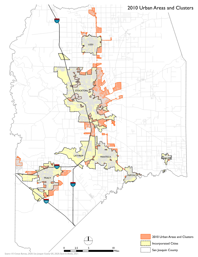
(b)
The Ministerial Approval Process. The Zoning Administrator shall approve an urban lot split only if it conforms to all applicable objective requirements of the Subdivision Map Act, except as otherwise expressly provided in this section, and no dedications of rights-of-way or the construction of offsite improvements shall be required as a condition of approval, nor can the correction of existing zoning nonconformities be required.
(1)
The Zoning Administrator may deny an urban lot split upon finding that: 1) the proposed housing development project would have a specific, adverse impact upon public health and safety or the physical environment that cannot be feasibly mitigated or avoided.
(2)
The Zoning Administrator shall not deny an application solely because it proposes adjacent or connected structures provided that the structures meet building code safety standards and are sufficient to allow separate conveyance.
(c)
Allowable Conditions of Approval. The Zoning Administrator may impose any of the following conditions of approval to ensure that a parcel map for an urban lot split complies with the General Plan and this Title.
(1)
Easements required for the provision of public services and facilities.
(2)
A requirement that the parcels have access to, provide access to, or adjoin the public right-of-way.
(3)
Off-street parking of up to one space per unit, except that a local agency shall not impose parking requirements in either of the following instances:
(A)
The parcel is located within one-half mile walking distance of either a high-quality transit corridor or a major transit stop; or
(B)
There is a car share vehicle located within one block of the parcel.
(4)
Only residential uses are allowed.
(5)
A signed affidavit must be provided prior to issuance of a building permit for a housing development on urban lot split lots stating that the applicant intends to occupy one of the housing units as their principal residence for a minimum of three years from the date of the approval of the urban lot split.
(A)
This requirement does not apply to an applicant that is a community land trust or is a qualified nonprofit corporation as described in Section 214.15 of the Revenue and Taxation Code.
(6)
Rental of any housing unit on an urban lot split lot shall be for a term longer than 30 days.
(d)
No Accessory Units are Allowed. Under Government Code Section 66452.6, the County is not required to permit more than two units on a parcel created through an urban lot split. This means that Accessory Dwelling Units and Junior Accessory Dwelling Units shall not be permitted on urban lot split lots.
9-501.050 - PARCEL MAP—WAIVER OF REQUIREMENT
(a)
Applicability. In the following cases, the subdivider or his or her representative may submit an "application for waiver of Parcel Map" to the Zoning Administrator:
(1)
A division of real property or interests therein created by probate, eminent domain procedures, partition, or other civil judgments or decrees;
(2)
A division of land where each parcel created has gross area of not less than 40 acres or is not less than a quarter of a quarter section; or
(3)
A division of property resulting from the conveyance of land, or interest therein, to a public agency for a public purpose, such as school sites, public building sites, or rights-of-way for streets, sewers, utilities, drainage, etc.
(b)
Procedure. This waiver shall only be granted after approval by the County Surveyor upon a finding that the proposed division of land complies with the requirements of this Ordinance or the Subdivision Map Act as to area, improvement and design, floodwater drainage control, appropriate improved public roads, wastewater disposal facilities, water supply availability, environmental protection, and other requirements of this Subdivision Ordinance, and upon a finding that the Subdivision Map Act does not prohibit such a waiver.
(c)
Tentative Parcel Map Required. Where the requirement for a Parcel Map is waived, a Tentative Parcel Map shall be required.
9-501.060 - REVIEW AND APPROVAL PROCEDURES
(a)
Review Tracks. The County has two tracks for the review and approval of subdivision applications: one for Major Subdivisions and another for Minor Subdivisions.
(b)
Types of Subdivisions.
(1)
Major Subdivision. A Major Subdivision is a subdivision of land creating five or more lots, five or more condominiums, or a community apartment project containing five or more units, unless otherwise excepted in the definition of a Minor Subdivision.
(2)
Minor Subdivision. A Minor Subdivision is a subdivision of land where:
(A)
The land before division contains less than five acres, each lot created by the division abuts upon a maintained public street or highway, and no dedications or improvements are required by the legislative body; or
(B)
Each parcel created by the division has a gross area of 20 acres or more and has an approved access to a County maintained road, street, or highway; or
(C)
The land consists of a parcel or parcels of land which have approved access to a public road, street, or highway and which compose part of a tract of land zoned for industrial or commercial development and which have the approval of the governing body as to street alignments and widths; or
(D)
The subdivision would create four lots or less, or condominiums or community apartments containing four units or less; or
(E)
Each parcel created by the division has a gross area of not less than forty (40) acres or is not less than a quarter of a quarter-section.
(c)
Review Procedure.
(1)
Major Subdivisions. Major Subdivisions are reviewed and approved by the Planning Commission after a duly-noticed public hearing. Appeals of the Commission's actions are to the Board of Supervisors.
(2)
Minor Subdivisions. Minor Subdivisions are reviewed and approved by the Zoning Administrator. No public hearing is required. Appeals of the Zoning Administrator's actions are to the Planning Commission.
(3)
Timing.
(A)
Action with No EIR. If an Environmental Impact Report is not required, the final action on the application shall be rendered within 50 days after it is accepted as complete unless specific technical studies have been requested that will take more time.
(B)
Action with EIR. If an Environmental Impact Report is required, the final action shall be rendered within 45 days after certification of the Environmental Impact Report unless the applicant and the Zoning Administrator mutually agree on a time extension.
(C)
Appeals. Appeals of any decision shall be heard by the appeal body within 30 days, or any mutually agreed upon extension thereof, after the date of filing the appeal. A final decision shall be rendered within ten days, or any authorized extension thereof, after the conclusion of the hearing.
9-501.070 - REQUIRED FINDINGS
A Tentative or Vesting Tentative Map or Parcel Map shall not be approved unless the decision-making body makes all of the following findings:
(a)
Consistency. The proposed subdivision, together with the provisions for its design and improvement, is consistent with the General Plan, any applicable Specific Plan, pre-existing Special Purpose Plan, or Master Plan, the Development Title, and other applicable provisions of the County Code.
(b)
Physically Suitable. The site is physically suitable for the type of development and the proposed density of the development.
(c)
No Environmental Damage. The proposed subdivision, together with the provisions for its design and improvement, are not likely to cause substantial environmental damage or substantially and avoidably injure fish or wildlife or their habitat, unless an Environmental Impact Report (EIR) was prepared and a finding was made that specific economic, social, or other considerations make the mitigation measures or project alternatives infeasible, pursuant to Section 21081(a)(3) of the Public Resources Code.
(d)
No Public Health Problems. The proposed subdivision, together with the provisions for its design and improvement, is not likely to cause serious public health problems.
(e)
No Conflict with Easements. The proposed subdivision, together with the provisions for its design and improvement, will not conflict with easements acquired by the public at large for access through or use of property within the proposed subdivision. The County may approve a map if it finds that alternate easements for access or for use will be provided and that these easements will be substantially equivalent to ones previously acquired by the public.
(f)
Availability of Water and Wastewater Disposal Service. Water and wastewater disposal services will be available and sufficient to serve a proposed subdivision. If the subdivision has more than 500 dwelling units, this finding must be in accordance with Section 66473.7 of the Subdivision Map Act.
(g)
Dedications. Any land or improvement to be dedicated to the County or other public agency is consistent with the General Plan, any applicable Specific Plan, pre-existing Special Purpose Plan, or Master Plan, and any other applicable plan adopted by the County.
(h)
Energy. The design of the subdivision provides, to the extent feasible, for future passive or natural heating or cooling opportunities in the subdivision.
9-501.080 - CONDITIONS OF APPROVAL
In approving a Tentative Map or a Tentative Parcel Map, the decision-maker may impose reasonable Conditions of Approval necessary to ensure that the subdivision will comply with the General Plan, any applicable Specific Plan, Special Purpose Plan, or Master Plan, and this Title.
9-501.090 - COORDINATION WITH ZONING APPROVAL
Subdivision review may be carried out concurrently with the review of any applications for zoning approval, including a Zoning Compliance Review, an Administrative Use Permit, and a Conditional Use Permit.
9-501.100 - NOTIFICATION PROCEDURES FOR PUBLIC HEARINGS
Notification for public hearings shall be provided according to the provisions for notification of public hearings in Chapter 9-802, Common Procedures.
9-501.110 - EXCEPTIONS
The approval authority may authorize exceptions to any of the requirements and regulations set forth in this Series. A request for an exception shall be made by the subdivider and filed with the application for a Tentative or Parcel Map. In order to approve an exception, the Zoning Administrator or the Commission shall make all of the following findings:
(a)
There are special circumstances or conditions affecting the property that make it impractical to conform to all of the provisions prescribed by this Series provided, however, that no exceptions may be granted to any requirements imposed by the Subdivision Map Act or any other applicable provision of State law;
(b)
The exception is necessary to preserve the subdivider's vested property rights pursuant to the Government Code provisions for a Vesting Tentative Map;
(c)
Granting the exception will not be detrimental to the public welfare or other property in the area where the subject property is located; and
(d)
Granting the exception will be consistent with the General Plan and any applicable Specific Plan or Master Plan.
9-501.120 - APPEALS
Decisions that are subject to appeal under the Subdivision Map Act or this Series shall be filed and processed in accordance with to the procedures for appeals provided in Chapter 9-802 and the procedures provided below.
(a)
Appeals to the Planning Commission. A decision by the Zoning Administrator, the Director of Community Development, or the Director of Public Works may be appealed to the Planning Commission within 10 days of the issuance of the Notice of Action by filing a written appeal with the Planning Division. The appeal shall identify the decision being appealed, clearly and concisely state the reason for the appeal, and be accompanied by the fee specified in the County's Fee Schedule.
(b)
Appeals to the Board of Supervisors. A decision by the Planning Commission may be appealed to the Board of Supervisors within 10 days of the issuance of the Notice of Action by filing a written appeal with the Planning Division. The appeal shall identify the decision being appealed, clearly and concisely state the reason for the appeal, and be accompanied by the fee specified in the County's Fee Schedule.
(c)
Procedures. The Director shall schedule the appeal for consideration by the authorized hearing body within a reasonable time after the date the appeal was filed and shall provide written notice to the appellant, the subdivider, and all other parties known to have interest in the matter as required by this Development Title and the Subdivision Map Act. The hearing body may sustain, modify, or reject the decision that is the subject of the appeal.
(d)
Appeal Stays All Proceedings. The timely filing of an appeal shall stay all proceedings in the matter appealed.
9-501.130 - FEES AND DEPOSITS
All persons submitting maps and other documents required by the Subdivision Regulations shall pay all fees and/or deposits as provided by the County's Fee Schedule, or the project shall not be deemed complete.
Fees shall be established by the County pursuant to Section 66451.2 of the Subdivision Map Act and the Mitigation Fee Act (Sections 66000 to 66025 of the Government Code).
9-502.010 - PURPOSE
This Chapter sets forth general requirements for mapping, monuments, and reports that apply throughout Series 500, Subdivision Regulations.
9-502.020 - REQUIRED MAPPING
All subdivisions shall be filed as either a Final Map or Parcel Map unless this requirement has been waived under Section 9-501.040. All major subdivisions shall be filed for recordation as a Final Map; all minor subdivisions shall be filed as a Parcel Map or a Final Map.
9-502.030 - LOT CORNERS AND MONUMENTS
(a)
Lot Corners. All lot corners shall be marked with iron pipe not less than three-quarters of an inch inside diameter and 24 inches long or marked by other monuments or reference crosses as approved by the County Surveyor.
(b)
Centerline Monuments. Centerline monuments shall be located as set forth in this section.
(1)
Location of Monuments. Road, street, alley, and way centerline monuments shall be set to mark the intersections of streets, intersections of streets with alleys or ways, intersections of alleys with alleys or ways, or at the intersection of any street, alley, or way with a tract boundary. Street centerline monuments shall also be set to mark the beginning and end of curves or the points of intersection of tangents thereof. Such centerline monuments shall be not less than a three-quarter inch diameter iron pin, at least 30 inches long, and set in the subgrade. A monument box and cover in conformance with the County's Improvement Standards shall be set above the monument, with the top of the box flush with the finished grade.
(2)
Alternative Locations. In the event that, due to the construction of subdivision improvements or the location of trees or other physical features, the monuments specified above cannot be located at the points specified, a reference monument or monuments shall be set subject to the approval of the County Surveyor. Notes as to the location of said monument or monuments with reference to the referenced point shall be furnished to the County Surveyor.
(c)
Section & Quarter-Section Corner Monuments. Whenever a section corner or quarter-section corner is to be used as a controlling element of a field survey, the engineer or surveyor responsible for the survey shall construct, reconstruct, or rehabilitate the monument of such corner, and accessories to such corner, so that the same shall be left by him in such physical condition that it remains as permanent a monument as is reasonably possible and so that the same may be reasonably expected to be located with facility at all times in the future. Such monuments shall be not less than a three-quarter inch diameter iron pin, 30 inches long, or other monuments as approved by the County Surveyor.
(d)
Monument Identification and Inspection. All monuments shall be permanently marked or tagged with the registration or license number of the engineer or surveyor under whose supervision the survey was made, and All monuments shall be subject to inspection and approval by the County Surveyor.
9-502.040 - LOT REQUIREMENTS
Lots shall comply with the following requirements:
(a)
Areas and Widths of Lots. The area and width of lots or parcels in a subdivision map shall conform to the zone in which the property is located;
(b)
Relation of Depth to Width. The depth to width ratio of a lot in a subdivision shall conform to the zone in which the lot is situated when new lots are created by subdivision, except where physical conditions make such limitation of depth to width ratio impractical or the width of the lot is 330 feet or greater;
(c)
Division of Jurisdiction. No lot or parcel shall be permitted to be divided by a city or County boundary line;
(d)
Angle of Lot Side Line. Lot or parcel side lines shall be approximately normal to the street right-of-way lines; and
(e)
Exception. This Section shall not apply to:
(1)
Any lot or parcel which the subdivider offers to dedicate to the County, or any public agency or district and the offer has been accepted, and
(2)
Any subdivision map that redesigns an existing subdivision in which the density of lots is not increased.
9-502.050 - SOILS REPORTS
Soils reports shall be provided as follows.
(a)
Major Subdivision. A preliminary soils report, prepared by a California-registered civil engineer, engineering geologist, or geotechnical engineer and based upon adequate test borings, shall be submitted to the Building Official for every major subdivision at the time of Tentative Map submittal.
(b)
Waiver of Report. A preliminary soils report may be waived if the Building Official finds that, due to the knowledge the County possesses relative to the quality of the soils in this subdivision, no preliminary analysis is necessary.
(c)
Soils Investigation. If the required preliminary soils report indicates the presence of critically expansive soils or other soil problems which, if not corrected, would lead to structural defects, the subdivider shall provide for and submit the findings of a soil investigation of each lot in the subdivision. The soil investigation shall be prepared by a California-registered civil engineer and shall recommend corrective action likely to prevent structural damage to each dwelling to be constructed. Prior to issuance of the building permit, any recommended action approved by the Building Official shall be incorporated into the construction plans for each dwelling.
9-502.060 - GEOTECHNICAL REPORTS
Geotechnical reports shall be provided to address geologic hazards as required by this Section.
(a)
Major Subdivision. A preliminary geotechnical report, prepared by a California-registered geotechnical engineer or California-registered geologist and based upon adequate test borings, shall be submitted to the Building Official for every major subdivision at the time of Tentative Map submittal. The preliminary geotechnical report shall include estimates of expected peak ground accelerations during maximum credible earthquake potentially affecting the site.
(b)
Waiver of Report. A preliminary geotechnical report may be waived if the Building Official finds that, due to the knowledge the County possesses relative to the quality of the soils in this subdivision, no preliminary analysis is necessary.
(c)
Geotechnical Investigation. If the required preliminary geotechnical report indicates the presence of geologic hazards (such as slope instability, subsidence, adverse soil conditions, seismic hazards) which, if not corrected, would lead to structural defects, the subdivider shall provide for and submit the findings of a geotechnical investigation for each lot in the subdivision. The geotechnical investigation shall be prepared by a California-registered geotechnical engineer or State-registered geologist and shall recommend corrective action likely to prevent structural damage to each dwelling to be constructed. Prior to issuance of the building permit, any recommended action approved by the Building Official shall be incorporated into site preparation and construction of each dwelling.
9-502.070 - SURFACE AND SUBSURFACE CONTAMINATION REPORT
(a)
Report. A surface and subsurface contamination report shall be required at the time of the Tentative Map submittal. The surface and subsurface contamination report shall be prepared by a qualified environmental professional and shall identify any potential source of surface or subsurface contamination caused by past or current land uses. The report shall include evaluation of nonpoint source of hazardous materials, including agricultural chemical residues, as well as potential point sources, such as fuel storage tanks, septic systems, or chemical storage areas.
(b)
Waiver of Report. The surface and subsurface contamination report may be waived if the Environmental Health Department finds that, due to the knowledge the County possesses relative to the possible contamination of the soils in this subdivision, no preliminary analysis is necessary.
(c)
Corrective Action. If the report indicates there are surface and subsurface contamination, corrective action shall be taken, as recommended in the report and concurred with by the Environmental Health Department prior to the issuance of the building permit.
9-502.080 - ENERGY CONSERVATION AND SOLAR ACCESS
(a)
A subdivision for which a Tentative Map is required shall provide, to the extent feasible, for future passive or natural heating or cooling opportunities in the subdivision. Examples of passive or natural heating opportunities in subdivision design include design of lot size and configuration to permit orientation of a structure in an east-west alignment for southern exposure.
(b)
Examples of passive or natural cooling opportunities include design of lot size and configuration to permit orientation of a structure to take advantage of shade or prevailing breezes.
(c)
Consideration shall be given to local climate, to contour, to configuration of the parcel to be divided, and to other design and improvement requirements, and such provision shall not result in reducing allowable densities or the percentage of a lot which may be occupied by a building or structure.
(d)
The requirements of this section do not apply to condominium projects that consist of the subdivision of airspace in an existing building when no new structures are added.
(e)
For the purposes of this section, "feasible" means capable of being accomplished in a successful manner within a reasonable period of time, taking into account economic, environmental, social and technological factors.
9-503.010 - PURPOSE
The purpose of this Chapter is to establish the form, contents, submittal, and procedures for approval of all Tentative Maps, including Tentative Maps for divisions of land into five or more parcels and Tentative Parcel Maps for divisions of land into four or fewer parcels or where a Tentative Map is not required.
9-503.020 - FILING FORM AND CONTENT OF REQUIRED MAPS
A subdivider shall file an application for a Tentative Map or Tentative Parcel Map with the Planning Division in a form determined by the Zoning Administrator. The application shall be accompanied by the materials specified below and any additional materials that the Zoning Administrator determines necessary to fulfill the requirements of this Ordinance and the Subdivision Map Act and the required fee.
(a)
Tentative Map or Tentative Parcel Map Requirements. The Tentative Map or Tentative Parcel Map shall be prepared by a by a California-registered civil engineer or California-licensed land surveyor duly licensed to practice land surveying and must contain the following information, unless waived by the Director of Public Works:
(1)
The subdivision name or number, date, north arrow, scale, and reference to the County datum with a sufficient legal description to define boundaries of the proposed subdivision and a vicinity map showing the location of the subdivision and County boundaries.
(2)
The name and address of the record owner, the subdivider, and the civil engineer or land surveyor under whose direction the map was prepared, including the registration or license number of the engineer or surveyor.
(3)
Topography, using contour intervals of one foot or less where ground slope is five percent or less, and contour intervals of five feet or less where ground slope is greater than five percent. Contours of adjacent land must also be shown whenever the surface features of such land affect the design and/or improvement of the proposed subdivision. The Tentative Map must contain a statement by the person preparing the map stating the source of contours shown on the map.
(4)
The location and outline to scale of each structure on the property proposed for division. Each structure that is to be retained must be so noted.
(5)
Approximate boundaries of areas subject to inundation or stormwater overflow, and the location, width and direction of flow of all watercourses with a reference to the sources of this information.
(6)
Approximate location of all trees and tree masses, 12 feet or more in height or with a diameter at breast height (DBH) of 12 inches of more, standing within the boundaries of the subdivision.
(7)
The locations, widths, grades and names of all existing or proposed streets, alleys, pedestrian ways, bicycle paths, transit facilities, railroad rights-of-way and grade crossing, and other rights-of-way within and adjacent to the subdivision, and the radius of each centerline curve. All streets and alleys intended to be private must be clearly so designated.
(8)
The location and dimension of all known existing easements and reserves and all proposed public easements.
(9)
The location of existing utilities, sewers, drainage ditches and other drainage facilities located in, or adjacent to, the proposed subdivision.
(10)
The approximate lot layout and the approximate dimensions of each lot and of each building site, the approximate finished grading of each lot, the preliminary design of all grading, the elevation of proposed building pads, and the top and toe of cut and fill slopes to scale.
(11)
Proposed plan and easements for drainage and for handling stormwater.
(12)
Statement of the present use, zoning district(s), and the proposed use(s), including areas to be reserved for public or semi-public use.
(13)
Proposed plans and easements for water, sewer, storm and provision for sewer disposal and storm drain handling.
(b)
Accompanying Information. The following information, data and reports shall be submitted with, but not on, the Tentative Map or tentative Parcel Map:
(1)
Construction grading and construction drainage permit applications, including all of the information required by Chapter 9-812, Grading and Drainage Permits.
(2)
A preliminary soils report.
(3)
Preliminary geologic and seismic safety reports for Tentative Maps that are within geologic or seismic hazard areas or in hillside areas.
(4)
A preliminary archaeological survey for Tentative Maps within an area of cultural significance, including but not limited to, prehistoric or historic archaeological sites, buildings, structures, objects, and unique cultural resources.
(5)
An acoustical analysis may be required by the Zoning Administrator to demonstrate compliance with the standards of the General Plan.
(6)
The characteristics of all proposed parks, open spaces and school facilities, including the methods of land acquisition, improvement and maintenance.
(c)
The Zoning Administrator may waive the submittal of any of the reports required by Subsection (b) upon determining that adequate information exists in County records regarding the area involved and that no additional analysis is necessary.
(d)
The Zoning Administrator may require additional development-related applications be filed concurrently with the submittal of a Tentative Map application.
9-503.030 - DEPARTMENT REVIEW AND REFERRAL
(a)
Determination of Complete Application. The Zoning Administrator shall determine whether the application for approval of a Tentative Map or Tentative Parcel Map is complete within 30 days from receipt of the application. The Tentative Map shall be accepted as complete only when the Zoning Administrator determines that:
(1)
All maps and information required by this Ordinance and the Subdivision Map Act have been submitted, checked and accepted as complete is determined to be consistent with the General Plan and any applicable Specific Plan;
(2)
All information required to conduct environmental review in compliance with the California Environmental Quality Act and the County's environmental review regulations has been submitted; and
(3)
The required fees and deposits have been paid.
(b)
Department Referral. The Zoning Administrator shall forward copies of the proposed map to all affected public agencies, including the Director of Public Works. The affected public agencies may, in turn, forward their findings and recommendations to the Zoning Administrator.
9-503.040 - REVIEW AND APPROVAL
Tentative maps and Tentative Parcel Maps shall be processed either as Minor Subdivisions or Major Subdivisions pursuant to Section 9-501.050, Review and Approval Procedures. The Zoning Administrator shall report the results of the action to the subdivider and transmit a copy of the Parcel Map or Tentative Parcel Map and a memorandum setting forth their decision to the Director of Public Works.
9-503.050 - EXPIRATION AND EXTENSIONS
(a)
Expiration. The approval or conditional approval of a Tentative Map or Tentative Parcel Map shall be valid for 24 months from the date of its approval within which time the Final Map may be presented to the Board of Supervisors for acceptance and recordation unless a 24-month extension is granted for a total of 48 months, as is allowed pursuant to the Subdivision Map Act. In addition, an extension to 48 months is allowed if certain funds are required to be expended or off-site improvements constructed, pursuant to Government Code Section 66452.6.
(b)
Effect of Expiration. The expiration of the approved or conditionally approved Tentative Map or Tentative Parcel Map shall terminate all proceedings and no Final Map of all or any portion of the real property included within the map shall be filed without first processing a new Tentative Map. Approval, processing and recording of the Tentative Map may occur after the expiration date if the signed Final Map and Public Improvement Agreement (if required) are submitted to the Director of Public Works prior to the expiration date.
(c)
Extensions.
(1)
Request for Extension. Prior to the expiration of the Tentative Map or tentative Parcel Map, the subdivider may request in writing to the Zoning Administrator an extension of the map's expiration date. Payment of applicable fees is also required. Upon such request, the map shall automatically be extended for 60 days or until the application for extension is approved, conditionally approved, or denied, whichever occurs first.
(2)
Zoning Administrator Action. The Zoning Administrator shall review the request for extension of the expiration date pursuant to this section, and shall either:
(A)
Approve,
(B)
Conditionally approve, or
(C)
Deny the request.
(3)
Limitations. The County cannot grant requests for extensions of time that exceed the period(s) of time allowed under the Subdivision Map Act.
9-504.010 - PURPOSE
The purpose of this Chapter is to establish the form, contents, submittal requirements, and approval process for Vesting Tentative Maps pursuant to the authority granted by Chapter 4.5 of the Subdivision Map Act.
9-504.020 - APPLICABILITY
Whenever a provision of the Subdivision Map Act or this Series requires the filing of a Tentative Map, a Vesting Tentative Map may be filed instead in accordance with the provisions of this Series. If a subdivider does not choose to seek the rights conferred by this Series, the filing of a Vesting Tentative Map shall not be a prerequisite to any approval for any proposed subdivision, permit for construction, or work preparatory to construction.
9-504.030 - FILING AND PROCESSING
A Vesting Tentative Map shall be filed in the same form and have the same contents, accompanying data and reports as a Tentative Map and shall be processed in the same manner as a Tentative Map, except as hereinafter provided:
(a)
Title. At the time a Vesting Tentative Map is filed it shall have printed conspicuously on its face the words "Vesting Tentative Map."
(b)
Required Information. The following information shall be submitted at the time a Vesting Tentative Map is filed:
(1)
Consistency with General Plan and Zoning. A statement that the Vesting Tentative Map shows a subdivision whose development is consistent with the General Plan and any applicable Specific Plan, Special Purpose Plan, and this Title, or that an application has been filed for a General Plan amendment, Specific Plan amendment, and/or rezoning the land that will be processed prior to, or concurrently with, the Vesting Tentative Map.
(2)
Public Improvement Plan, Engineering Calculations, and Cost Estimates. A Public Improvement Plan, meeting the requirements of Chapter 9-508 prepared by a California-registered professional engineer and indicating the location of all public utilities and facilities including, but not limited to, facilities for water, sewer, electric, gas, cable TV, internet, streets, storm drains, and street lighting to be installed to serve the subdivision and any facilities that currently exist within the boundary of the subdivision. Engineering calculations and estimated costs for all proposed improvements also shall be submitted in sufficient detail to bid the job for construction.
(3)
Building Information. The height, size, location, architectural plans, and use of all buildings to be constructed within the subdivision, if known.
(4)
Grading Plans. Proposed grading plans based on field surveys.
(5)
Soils Report. Prepared by a California-registered civil engineer, engineering geologist, or geotechnical engineer.
(6)
Approval Letters. Required approval letters from other agencies or service districts for public services, such as water and wastewater disposal, where applicable.
(7)
Landscaping Plans. Landscaping plans proposed for the subdivision, including a Landscape Documentation Package, Landscape Design Plan, and Water Efficient Landscape Calculations and Alternatives, if these are required by Chapter 9-402, Landscaping.
(8)
Discretionary Permit Applications. Applications for all required discretionary permits for development under a Vesting Tentative Map, including Administrative Use Permits, Conditional Use Permits, Public Improvement Plans, Variances, Waivers and Exceptions. No Vesting Tentative Map shall be approved with a condition that rezoning and discretionary approvals will be subsequently secured.
(9)
Other Studies. Any other studies required because of the peculiarities of the subdivision and as required by the County.
9-504.040 - RIGHTS OF A VESTING TENTATIVE MAP
(a)
Vested Rights. The approval or conditional approval of a Vesting Tentative Map shall confer a vested right to proceed with development in substantial compliance with the ordinances, policies, and standards described in Government Code Section 66474.2. However, if Section 66474.2 of the Government Code is repealed, the approval or conditional approval of a Vesting Tentative Map shall confer a vested right to proceed with development in substantial compliance with the ordinances, policies, and standards in effect at the time the Vesting Tentative Map is approved or conditionally approved.
(b)
Condition or Denial. Notwithstanding Subsection (a), a permit, approval, extension, or entitlement may be made conditional or denied if any of the following are determined:
(1)
A failure to do so would place the residents of the subdivision or the immediate community, or both, in a condition dangerous to their health or safety, or both.
(2)
The condition or denial is required in order to comply with state or federal law.
(c)
Expiration of Rights. Vested rights allowed under this Section shall expire pursuant to the Subdivision Map Act if a Final Map is not approved prior to the expiration of the Vesting Tentative Map. If the Final Map is approved, these rights shall last for the following periods of time:
(1)
Initially. An initial period of one year after recording of the Final Map. Where several Final Maps are recorded on various phases of a project covered by a single Vesting Tentative Map, this initial period shall begin for each phase when the Final Map for that phase is recorded.
(2)
Automatic Extension. The initial time period set forth in Subsection (c)(1) shall be automatically extended for any time used to process a complete application for a grading permit or for building permit review, if such processing exceeds 30 days from the date a complete application is filed.
(3)
Requested Extension. A subdivider may apply for a one-year extension at any time before the expiration of the initial time period set forth in Subsection (c)(1). The request for extension shall be submitted in writing to the Planning Commission. The Commission's decision may be appealed to the Board of Supervisors within 10 days. If the subdivider submits a complete application for a building permit during this time, the rights referred to herein shall continue until the expiration of that permit.
9-504.050 - EXPIRATION AND EXTENSIONS
The approval or conditional approval of a Vesting Tentative Map shall expire at the end of the same time period, and shall be subject to the same extensions, as a Tentative Map.
9-505.010 - PURPOSE
The purpose of this Chapter is to establish procedures for preparation and approval of Final Maps. The filing of a Final Map, in conformance with the Tentative Map or Vesting Tentative Map of an approved Major Subdivision Application, shall be a condition of approval of any Major Subdivision Application
9-505.020 - PRELIMINARY SUBMITTAL FOR COUNTY APPROVAL
Prior to the expiration of the Tentative Map or the Vesting Tentative Map of an approved major subdivision application, the subdivider shall submit two prints of the Final Map to the County Surveyor for checking. The preliminary prints shall bear both the acknowledged signatures of all parties having record title interest in the lands being subdivided and the engineer or surveyor responsible for the survey. The prints shall bear either original signatures or signatures reproduced from the signed original Final Map. The prints shall be accompanied by all of the following data, reports, and documents in a form approved by the County Surveyor and, where applicable, the County Counsel; these plans and reports, and the supporting calculations, may be submitted separately from the maps.
(a)
Public Improvement Plans and Specifications. Three complete sets of Public Improvement Plans, consistent with Chapter 9-508, including required specifications and engineer's preliminary estimates.
(b)
Reports. A complete set of reports as follows:
(1)
Preliminary soils reports, including R-values and structural sections calculations;
(2)
Preliminary geotechnical reports; and
(3)
Surface and subsurface contamination reports.
(c)
Hydrology and Hydraulic Calculations. Storm drain calculations (e.g., hydrology, sub-area map, pipeline, hydraulic design, ponding basin, pump system, etc., if applicable).
(d)
Water and Sewer Calculations. Water and sewer design data and supporting calculations, if applicable, related to distribution, collection and treatment appurtenances, pressure, and flow.
(e)
Guarantee of Title. A subdivision guarantee of title, in a form acceptable to the County Surveyor and County Counsel, issued by a competent title company to and for the benefit and protection of the County. Said guarantee of title shall be continued complete up to the instant of filing the Final Map with the County Recorder, guaranteeing that the names of all persons whose consent is necessary to pass a clear title to the land being subdivided, and all public easements being offered for dedication, and all acknowledgements thereto, appear on the proper statements and are correctly shown on the map, both as to contents as to the making thereof and affidavits of dedication where necessary.
(f)
Preliminary Title Report. A preliminary title report showing the legal owners at the time of the submittal of the Final Map.
(g)
Traverse Closures. Traverse closures for the boundary, blocks, lots, road centerlines, and rights-of-way, easements, and offset lines.
(h)
References. Copies of all deeds and unfiled surveys referenced on the Final Map and/or included in the current preliminary title report.
(i)
Tax Certificates. A copy of the tax certificate from the County Tax Collector stating that all taxes due have been paid or that a tax bond or other adequate form of security assuring payments of all taxes which are a lien but not yet payable has been filed with the County.
(j)
Deeds for Easements of Rights-of-Way. Deeds for off-site easements or rights-of-way required for road or drainage purposes which have not been dedicated on the Final Map. Written evidence shall be acceptable to the County in the form of rights of entry or permanent easements across private property outside of the subdivision permitting or granting access to perform necessary construction work and permitting the maintenance for the facility.
9-505.030 - REVIEW AND APPROVAL
(a)
County Surveyor Review. The County Surveyor shall review the Final Map and any other required information, and the subdivider shall make corrections and/or additions until acceptable to the County Surveyor.
(b)
County Surveyor Approval. The subdivider shall submit to the County Surveyor the original tracing of the map and any duplicates per County requirements, corrected to its final form and signed by all parties required to execute the statements on the map. Original signatures shall appear on the original map. Upon receipt of all required certificates and submittals, the County Surveyor shall sign the appropriate statement and transmit the original map to the Clerk of the Board.
(c)
Board Acceptance and Referral. At the meeting at which it receives the map, or at its next regular meeting following receipt, the Board shall refer the Final Map to the Director of Public Works to approve it after upon determining that both of the following are true:
(1)
Compliance with Tentative Map. The Final Map is in substantial compliance with the Tentative Map or Vesting Tentative Map of the approved Major Subdivision Application and all required conditions of approval of the Tentative Map or the Vesting Tentative Map have been satisficed; and
(2)
Conformance to Map Act. The Final Map conforms to the Subdivision Map Act.
9-505.040 - SURVEY PRACTICE AND PROCEDURE
All survey work done on any Final Map of a subdivision shall conform to the accepted standards of the surveying profession.
(a)
Allowable Error. The allowable error of closure on any portion of a Final Map shall be less than two one-hundredths of a foot or a ratio of 1:20,000, whichever is greater.
(b)
Centerlines of Adjoining Error. In the event the centerline of any street or road right-of-way in any adjoining subdivision has been established, the Final Map shall show said centerline, together with reference to a County field book or map of record showing such centerline and the monuments which determine its position. If the position of the centerline is determined by ties, that fact shall be stated on the Final Map. Only centerlines of streets pertinent to the subdivision need be shown.
9-505.050 - STATEMENT OF CONSENT
Subdividers shall submit with or on the Final Map a statement, signed and acknowledged by all parties having any record title interest in the real property to be subdivided, consenting to the preparation and filing of the Final Map. Evidence of signatories' record title interests shall be provided as set forth in Section 9-502.020(d).
9-505.060 - SIZE AND MATERIALS
The Final Map shall be prepared by or under the direction of a California-registered civil engineer, duly licensed to practice land surveying, or a California-licensed land surveyor; shall be based upon a field survey; and shall conform to the following provisions:
(a)
Legibility. It shall be legibly drawn, printed, or reproduced by a process guaranteeing a permanent record in black on tracing cloth or polyester base film. Certificates, statements, affidavits, and acknowledgements may be legibly stamped or printed upon the map with opaque ink. If ink is used on polyester base film, the ink surface shall be coated with a suitable substance to assure permanent legibility.
(b)
Format. The size of each sheet shall be 18 inches by 26 inches. A marginal line shall be drawn completely around each sheet, leaving an entirely blank margin of one inch. The scale of the map shall be large enough to show all details clearly and, wherever practicable, shall be at an engineer's scale where one inch equals 80 feet or less. One sheet or as many sheets as are necessary to accommodate the map may be used. Each sheet shall be numbered, the relation of one sheet to another shall be clearly shown, and the number of sheets used shall be set forth on each sheet. The tract number, scale, north point, and sheet number shall be shown on each sheet of the Final Map. Each sheet and the lettering thereon shall be so oriented that, with the north point directed away from the reader, the map may be read most conveniently from the bottom or lower right corner of such sheet on the 26-inch side.
9-505.070 - INFORMATION TO BE SHOWN ON FINAL MAPS
(a)
Title Sheet. The title sheet of each Final Map shall contain a title consisting of the number and name of the subdivision and a subtitle consisting of a geographic description of all property being subdivided by reference to such map or maps of the property shown thereon, as shall have been previously recorded or shall have been previously filed in the office of the County Recorder under authority of Chapter 3 (commencing at Section 11650) of Part 2, of Division 4 of the Business and Professions Code, or by reference to the plat of any United States survey. The title sheet shall also show, in a form acceptable to the County Surveyor, such appropriate certificates, statements, and acknowledgements as required in Title 7, Division 2 (commencing at Section 66410) of the Government Code.
(b)
Index Map and Boundary Line. If more than one map sheet is used in preparing the Final Map, there shall be included, either on the title sheet or the first map sheet, an index map showing the general plan of the subdivision, street names, lot numbers, and the portions of the subdivision included on each map sheet. The gross boundary line of a subdivision shall be indicated by a heavy line.
(c)
Determining Boundaries. On each Final Map there shall be fully and clearly shown and identified such stakes, monuments, or other evidence, including the record reference, determining the boundaries of the subdivision as were found on the ground, together with sufficient corners of adjoining subdivisions, whether by lot and tract number and place of record, by section, township, and range, or by proper legal description, as may be necessary to locate precisely the limits of the subdivision. Where a found monument has no record reference, "No Record' shall be indicated adjacent to the found monument on the Final Map.
(d)
Boundary Monuments.
(1)
Each Final Map shall show durable monuments of not less than three-quarters of an inch diameter iron pin, at least 30 inches long, set at each boundary corner and at intermediate points, approximately 1,000 feet apart, or at such lesser distance as may be made necessary by topography or culture to ensure accuracy in reestablishment of any point or line without unreasonable difficulty. The precise position and character of each monument, including the R.C.E./P.L.S. tag number, shall be shown on the Final Map.
(2)
In the event that some of the required interior monuments are to be set Subsection to the filing of the Final Map, the map shall show which monuments, or the furnishing of notes thereon, shall be agreed to be set and/or furnished by the subdivider. Such agreement shall be accompanied by a security per the Subdivision Map Act, Section 66496. The security shall be released only per the terms of Section 66497 of the Subdivision Map Act.
(e)
Bearings and Distances.
(1)
The bearing and length of each lot line, block line, and boundary line shall be shown on the Final Map. Each required bearing and distance shall be shown in full, and no ditto mark or other designation of repetition shall be used.
(2)
The basis of bearings shall appear on the first sheet after the title sheet. Reference shall be made to some filed Final Map, Parcel Map, record of survey map, County Surveyor's map, or other record acceptable to the County Surveyor. Such basis of bearings shall be derived from at least two found monuments of record on the same line.
(f)
Lot Areas, Lot Numbers, and Curve Data.
(1)
Lot Area. For lots containing one acre or more, Final Maps shall show net acreage to at least the nearest one-hundredth of an acre.
(2)
Lot Numbers. All lots, including utility lots, shall be numbered consecutively, commencing with the number "1," except as otherwise approved by the County Surveyor, with no omissions or duplications. Each numbered lot shall be shown to scale entirely on one sheet.
(3)
Curve Data. The following curve data shall be shown on the Final Map:
(A)
Radial Bearing. The arc length, chord length and bearing, radius, total central angle, and the radial bearing of each non-tangent curve, including overall curves;
(B)
Bearing. The bearing of each radial line to each lot corner on each curve; and
(C)
Central Angle. The central angle of each segment within each lot.
9-505.080 - EASEMENTS
Easements shall be incorporated into Final Maps as follows:
(a)
Easement Lines. The Final Map shall show the width of all easements, including the lengths and bearings of the lines thereof, to which the lots in the subdivision are subject. If the easement is not definitely locatable from record, a statement acknowledging the easement shall appear on the title sheet.
(b)
Designation and Identification. All existing and dedicated easements shall be clearly labeled and identified. Easements on existing lots of record shall be denoted by broken lines. Mapping of recorded easements shall include reference to the recording data. Easements being dedicated shall be so designated in a statement of dedication.
(c)
Bearings on Lot Lines. Distances and bearings on the side lines of lots cut by an easement shall be so shown as to indicate clearly the actual lengths of the lot lines.
(d)
Necessary Rights-of-Way. Final maps shall include the location and width of rights-of-way necessary for railroads, flood control, drainage, and the like, whether previously of record or currently offered for dedication.
9-505.090 - STREETS AND HIGHWAYS BEING DEDICATED
(a)
Areas to dedicated. On each Final Map, the centerline of each highway, street, or road right-of-way to be dedicated, the total width thereof, the width on each side of the centerline, and the width of the portion to be dedicated shall be shown. Curve data per Section 9-505.070 shall also be included, as appropriate. The boundary of the map shall be shown along the centerline of any street or highway where such centerline defines a limit of the parcel being subdivided.
(b)
Access Restrictions. When the vehicular access rights from any lot to appropriately designated roads are or will be restricted by a subdivision, such rights, if not already a matter of record, shall be offered for dedication to the County by an appropriate statement on the title sheet of the Final Map. Each lot shall be clearly marked with a distinctive symbol shown in a legend that clearly defines its extent and nature of the restriction.
9-505.100 - ADDITIONAL INFORMATION
(a)
Any city or County boundary line adjoining the subdivision shall be clearly designated and tied in upon the Final Map.
(b)
No other additional survey and map requirements shall be included on a Final Map which do not affect record title interests. However, the County Surveyor may require additional information, in the form of a separate document or an additional map sheet, to be filed or recorded simultaneously with the Final Map in accordance with Section 66434.2 of the Government Code.
(c)
Subdivision improvement agreements may be required to accompany submittal of Final Maps
9-505.110 - WAIVER OF INADVERTENT ERROR; AMENDMENTS
(a)
When, in the opinion of the County Surveyor, a defect or error of a technical or inadvertent nature has caused a Final Map to fail to meet or perform any of the conditions of this Chapter, the County Surveyor may waive such defect or error and process the Final Map as though none had occurred.
(b)
A Final Map may be amended pursuant to the provisions of Section 9-802.120, Modification of Approved Plans.
9-506.010 - PURPOSE AND APPLICABILITY
The purpose of this Chapter is to prescribe the requirements for, and waiver of, Parcel Maps. The filing of a Parcel Map, in conformance with the Tentative Map or Vesting Tentative Map of an approved Minor Subdivision Application, shall be a condition of approval of any Minor Subdivision Application.
9-506.020 - PREPARATION
The Parcel Map shall be prepared by, or under the direction of, a California-registered civil engineer, duly licensed to practice land surveying, or a California-licensed land surveyor; shall show the location of streets and property lines bounding the property; and shall conform to all of the following provisions:
(a)
Legibility. It shall be legibly drawn, printed, or reproduced by a process guaranteeing a permanent record in black on tracing cloth or polyester base film. Certificates, statements, affidavits, and acknowledgements may be legibly stamped or printed upon the map with opaque ink. If ink is used on polyester base film, the ink surface shall be coated with a suitable substance to assure permanent legibility.
(b)
Size and Scale. The size of each sheet shall be 18 by 26 inches. A marginal line shall be drawn completely around each sheet, leaving an entirely blank margin of one inch. The scale of the map shall be large enough to show all details clearly, and enough sheets shall be used to accomplish this end. The particular number of each sheet and the total number of sheets composing the map shall be stated on each of the sheets, and the relation of each adjoining sheet shall be clearly shown. Each sheet and the lettering thereon shall be so oriented that, with the north arrow directed away from the reader, the map may be read most conveniently from the bottom or lower right corner of each sheet on the 26-inch side.
(c)
Feature Identification. Each parcel shall be numbered, and each block may be numbered or lettered. Each road shall be named or otherwise designated.
(d)
Identification of Parcels. Parcels shall be identified as follows:
(1)
The exterior gross boundary of the land included within the subdivision shall be indicated by an extra heavy line and clearly designated.
(2)
The map shall show the location of each parcel and its relation to surrounding surveys. If the map includes a "designated remainder" parcel or similar parcel, and the gross area of the "designated remainder" parcel or similar parcel is five acres or more, that remainder parcel need not be shown on the map, and its location need not be indicated as a matter of survey but only by deed reference to the existing boundaries of the remainder parcel.
(3)
A parcel designated as "not a part" shall be deemed to be a "designated remainder" for purposes of this Section.
(e)
Statement of Consent. Subject to the provisions of Section 66436 of the Subdivision Map Act, a statement, signed and acknowledged by all parties having any record title interest in the real property subdivided, consenting to the preparation and filing of the Parcel Map is required.
(f)
Consent of Subdivider. With respect to a division of land into four or fewer parcels, where dedications or offers of dedications are not required; the statement shall be signed and acknowledged by the subdivider only. If the subdivider does not have a record title ownership interest in the property to be divided, the subdivider shall provide the County with satisfactory evidence that the persons with record title ownership have consented to the proposed division. For purposes of this Subsection, "record title ownership" shall mean fee title of record unless a leasehold interest is to be divided, in which case "record title ownership" shall mean ownership of record of the leasehold interest. "Record title ownership" does not include ownership of mineral rights or other subsurface interests which have been severed from ownership of the surface. Statements and acknowledgements required by this Subsection shall be recorded concurrently with the Parcel Map being filed for record.
(g)
Notation or Reference. No additional survey and map requirements shall be included on a Parcel Map which do not affect record title interests. However, the County Surveyor may require the map to contain a notation or reference to survey and map information pursuant to Section 66434.2 of the Government Code.
(h)
Reference to Separate Instrument. Whenever a certificate, statement, or acknowledgement is made by separate instrument, there shall appear on the Parcel Map a reference to the separately recorded document. This reference shall be completed by the County Recorder pursuant to Section 66468.1 of the Subdivision Map Act.
9-506.030 - INFORMATION TO BE SHOWN ON PARCEL MAPS
(a)
Monuments or Other Evidence to Determine Boundaries. On each Parcel Map there shall be fully and clearly shown and identified such stakes, monuments, or other evidence, including the record reference, determining the boundaries of the subdivision as were found on the ground, together with sufficient corners of adjoining subdivisions, whether by lot and tract number and place of record, by section, township, and range, or by proper legal description, as may be necessary to locate precisely the limits of the subdivision. Where a found monument has no record reference, "No Record" shall be indicated adjacent to the found monument on the Parcel Map.
(b)
Deferment of Monuments. In the event that some of the required interior monuments are to be set Subsection to the filing of the Parcel Map, the map shall show which monuments, or the furnishing of notes thereon shall be agreed to be set and/or furnished by the subdivider. Such agreement shall be accompanied by a security per Section 66496 of the Subdivision Map Act. The security shall be released only per the terms of Section 66497 of the Subdivision Map Act.
(c)
Bearings and Distances. The bearing and length of each parcel line, block line, and boundary line shall be shown on the Parcel Map. Each required bearing and distance shall be shown in full, and no ditto mark or other designation of repetition shall be used.
(d)
Parcel Areas. For parcels containing one acre or more, Parcel Maps shall show the acreage to at least the nearest one-hundredth of an acre.
9-506.040 - DEDICATIONS OR OFFERS
Dedications or offers of dedication shall conform to the provisions of this Section.
(a)
Required Dedications or Offers. If dedications or offers of dedication are required, they may be made either by a statement on the Parcel Map or by separate instrument, as determined by the County Surveyor. If dedications or offers of dedication are made by separate instrument, the dedications or offers of dedication shall be executed prior to the Parcel Map being filed for record.
(b)
Dedications or Offers Signed. The dedications or offers of dedication, whether by statement or separate instrument, shall be signed by the same parties and in the same manner as set forth in Section 66436 or 66439 of the Government Code for dedications by a Parcel Map.
9-506.050 - FIELD SURVEY AND NECESSARY STATEMENTS
In all cases where a Parcel Map is required, such map shall be based upon a field survey made in conformity with the Land Surveyors' Act. The following statements shall appear on a Parcel Map unless otherwise approved by the County Surveyor:
(a)
Engineer's (Surveyor's) Statement. An engineer's statement as follows:
"This map was prepared by me or under my direction and is based upon a field survey in conformance with the requirements of the Subdivision Map Act and local ordinance at the request of (name of person authorizing map) in (month, year). I hereby state that this Parcel Map substantially conforms to the approved or conditionally approved Tentative Map, if any. All monuments are of the character and occupy the positions indicated and are sufficient to enable the survey to be retraced.
Dated this _______ day of _______, 20___.
_______
(Engineer) (Surveyor) (License No.)"
(b)
County Surveyor's statement. A County Surveyor's statement as follows:
"I, (County Surveyor), hereby state that I have examined this Parcel Map and that the subdivision shown hereon is substantially the same as it appeared on the Tentative Map, if required, and any approved alterations thereof. I further state that this Parcel Map complies with all the provisions of Chapter 2 of the California Subdivision Map Act, as amended, and all applicable ordinances of San Joaquin County, applicable at the time of approval of the Tentative Map, if required, and that this Parcel Map is technically correct. *I hereby accept on behalf of the public for public use the offer of dedication of [all Public Utility Easements] the (width)-foot widening of right-of-way along [ Road Name] [the (size) road return] as shown on this Parcel Map.
Dated this _______ day of _______, 20___.
By: _______
(County Surveyor), County Surveyor L.S. (number),
County Surveyor of San Joaquin County, California"
* The part following this asterisk above is used only when offers of dedication are made for public utility easements or widenings of existing rights-of-way.
(c)
Recorder's Statement. A Recorder's statement as follows:
"Filed this _______day of_______, 20___, at_______.in Book _______of Parcel Maps, at Page_______, at the request of_______.
Fee: $_______
By: _______
Assessor-Recorder-County Clerk, Assistant/Deputy Recorder"
9-506.060 - REVIEW AND APPROVAL PROCESS
The subdivider shall submit prints of the Parcel Map to the County Surveyor for checking. Where applicable, the preliminary prints shall be accompanied by copies of the data, plans, reports, and documents as required for Final Maps by Section 9-505.070. Parcel maps shall be reviewed and approved as follows.
(a)
Preliminary Map Review. The County Surveyor shall review the preliminary Parcel Map and cause any changes to be made which are legally required for approval.
(b)
Final Map Submittal. The subdivider shall submit to the County Surveyor the original tracing of the map and any duplicates per County requirements, corrected to its final form, and signed by all parties required to execute the statements or certificates on the map.
(c)
Approval. The County Surveyor shall approve the map if it is acceptable.
(d)
Filing for Record. After approval, the County Surveyor or authorized agent shall transmit the approved Parcel Map directly to the County Recorder for filing.
(e)
Fees. Subdividers shall pay all required fees for plan checking as established by the Department of Public Works Fee schedule adopted by resolution of the Board of Supervisors.
9-506.070 - AMENDMENT OF PARCEL MAP
A Parcel Map may be amended pursuant to the provisions of Chapter 9-513, Revisions of Approved Actions.
9-507.010 - PURPOSE
The purpose of this Chapter is to establish the reservations and dedications the County may impose on a subdivider as a condition for approval of a Tentative Map or a Parcel Map.
9-507.020 - RESERVATIONS
(a)
General. As a Condition of Approval of a map, the subdivider shall reserve sites, appropriate in area and location, for parks, recreational facilities, transit access, bus stops, fire stations, libraries, or other public uses according to the standards and formula contained in this section.
(b)
Standards and Formula for Reservation of Land. Where a park, recreational facility, fire station, library or other public use is shown in the General Plan or any applicable Specific Plan, pre-existing Special Purpose Plan, or Master Plan, the subdivider may be required by the Planning Commission to reserve sites as so determined by the Planning Commission in accordance with the standards contained in the General Plan, Special Purpose Plan, Specific Plan or Master Plan. The reserved area must be of such size and shape as to permit the balance of the property within which the reservation is located to develop in an orderly and efficient manner. The amount of land to be reserved shall not make development of the remaining land held by the subdivider economically unfeasible. The reserved area shall conform to the General Plan or any Specific Plan, pre-existing Special Purpose Plan, or Master Plan and shall be in such multiples of streets and parcels as to permit an efficient division of the reserved area in the event that it is not acquired within the prescribed period.
(c)
Procedure. The public agency for whose benefit an area has been reserved shall, at the time of approval of the Final Map or Parcel Map, enter into a binding agreement, consistent with Government Code Section 66480, to acquire such reserved area within two years after the completion and acceptance of all improvements, unless such period of time is extended by mutual agreement.
(d)
Payment. The purchase price shall be the market value thereof at the time of the filing of the Tentative Map plus the taxes against such reserved area from the date of the reservation and any other costs incurred by the subdivider in the maintenance of such reserved area, including interest costs incurred on any loan covering such reserved area.
(e)
Termination. If the public agency for whose benefit an area has been reserved does not enter into such a binding agreement, the reservation of such area shall automatically terminate.
(f)
Release of Obligation. The Board of Supervisors may, after consideration by the Planning Commission, upon request of the subdivider, and after a public hearing by the Board of Supervisors, release the subdivider from the obligation of a reservation of land upon finding: 1) that to do otherwise would impose an undue hardship upon the subdivider due to physical conditions of the site or access to the site and 2) that there are alternative locations for the public facilities for which the land was provided. Such a release shall not constitute a grant of special privilege inconsistent with the obligations of other properties and similar development in the vicinity and in the same zone.
9-507.030 - DEDICATIONS AND FEES FOR PARK AND RECREATION FACILITIES
This section is enacted pursuant to the authority granted by Section 66477 of the Subdivision Map Act. The local park and recreation facilities for which dedication of land and/or payment of a fee is required by this section must be in accordance with the recreation portion of the General Plan.
(a)
General Requirement. For Tentative Maps or Tentative Parcel Maps, the subdivider must dedicate land, pay a fee in lieu thereof, or a combination of both at the option of the County, for park and recreational purposes according to the standards and formulas contained in this Chapter.
(b)
General Standard. In consideration of the public interest, convenience, health, welfare, and safety, the County standard for neighborhood and community parks ("local parks") and recreational purposes shall be three acres of property for each 1,000 persons, in accordance with the recreation portion of the General Plan and the Subdivision Map Act. For purposes of this standard, park and recreation purposes shall include land and facilities for the activity of "recreational community gardening," which activity consists of the cultivation by persons other than, or in addition to, the owner of the land, of plant material not for sale.
(c)
Standard and Formula for Dedication of Land. Where a park or recreational facility has been designated in the General Plan or a specific plan or master plan and is to be located in whole or in part within the proposed subdivision to serve the immediate and future needs of the residents of the subdivision, the subdivider shall dedicate land for a local park sufficient in size and topography to serve the residents of the subdivision. The minimum amount of land to be dedicated shall be determined using the general standard in the following formula:
U × P × S = Minimum acreage dedication
Where:
U = Number of potential dwelling units within the subdivision;
P = Average number of persons in the dwelling unit type (e.g., single-family, mobile home, multi-family units) based on the latest U.S. Census.
S = Parkland standard of three acres per 1,000 people (3/1000).
The following table of population density shall be used:
(1)
Formula for Determining Amount of Acreage. The formula for determining acreage to be dedicated per dwelling unit shall be as set out in Table 9-507.030 above.
(2)
Lots—Including Dwelling Unit Construction. For lots where dwelling units are to be constructed as part of the subdivision project, the actual type of dwelling unit to be constructed shall be used in the computation of the acreage of park land to be dedicated.
(3)
Lots—Not Including Dwelling Unit Construction. For lots where the construction of dwelling units is not a part of the subdivision project, the acreage of park land to be dedicated shall be computed on the basis of the maximum allowable density of dwelling units in the zone where the lot is located combined with the type of dwelling unit yielding the maximum acreage. If fees are paid in lieu of land dedication, and if dwelling units are constructed on lots within ten years after the date the final or Parcel Map was recorded which result in a lesser fee when computed pursuant to the provisions of this section, then the subdivider may request a refund of the excess fee previously paid.
(4)
Re-subdivision of Parcels. Whenever a parcel of land is resubdivided, full credit shall be given for the acreage of land dedicated or the amount of in-lieu fee paid at the time the parcel was originally subdivided.
(d)
Alternative Calculation Method for Dedication of Land.
(1)
This section specifies the alternative method to that specified above, in paragraph (e), for determining the factors used in calculating the area of land to be dedicated.
(2)
The Parks and Recreation Department of or any other local public agency or community services districts providing parks may apply to the Board of Supervisors for a determination of an alternative standard for existing neighborhood and community park acreage for a specific geographic area. In its application, the Department or agency or district shall present its calculations, reports and other evidence showing that the amount of existing neighborhood and community park area in a specified geographic area exceeds three acres of park area per 1,000 residents in the local parks service area.
(3)
The calculation shall be derived pursuant to Government Code Section 66477.
(4)
If the Board of Supervisors determines after a noticed public hearing that the standard for existing neighborhood and community park acreage in a specified geographic area served by a specific public agency or district exceeds three acres of parks for 1,000 residents in that area, this standard shall be added to this Title by a Code amendment, and the alternate standard shall be used to determine the amount of land to be dedicated or fees paid in lieu thereof as a condition for the approval of a Tentative Map or Parcel Map in the jurisdiction of the public agency providing parks for the specified geographic area.
(e)
Subdividers' Obligations. The subdivider may be required to:
(1)
Provide full street improvements and utility connections to dedicated land which is dedicated pursuant to this section;
(2)
Provide for fencing along the property line of that portion of the subdivision contiguous to the dedicated land; and
(3)
Provide other minimal improvements that the Director of Public Works determines to be essential to the acceptance of the land for recreational purposes.
(4)
The value of the above improvements shall be a credit against the dedication of land or the payment of fees required by this Chapter.
(f)
Acceptance by County. The land to be dedicated for local parks and recreation purposes, pursuant to this Chapter, shall be approved by the County Director of General Services and the public agency accepting the dedication or accepting the improvements, if other than the County.
(g)
Fee In Lieu of Land Dedication. If there is no park or recreation facility designated in the General Plan to be located in whole or in part within the proposed subdivision to serve the immediate and future needs of the residents of the subdivision, the subdivider shall, in lieu of dedicating land, pay a fee equal to the value of the land prescribed for dedication in this section and in an amount determined in accordance with the provisions of Subsection (c) above, such fee to be used for a local park that will serve the residents of the area being subdivided. More specifically, when a fee is to be paid in lieu of land dedication, the amount of such fee shall be based upon the following formula:
S × AC = Park fee per unit
Where:
S = Parkland standard of three acres per 1,000 persons (3/1000); and
AC = Acquisition Costs as determined by Subsection (g), below.
Fees to be collected pursuant to this section shall be approved by the County Director of General Services and the public agency accepting the fees, if other than the County.
(h)
Determination of Acquisition Costs. Acquisition costs, expressed as an estimated per acre value, shall be determined by the Director of Public Works based on a written appraisal report periodically prepared and signed by an appraiser designated by the County that evaluates the probable per acre acquisition cost of park land in the vicinity, taking into consideration the acquisition costs of real property which has an approved Tentative Map and is within urban and rural communities in the County.
(1)
Appraisals for acquisition costs shall be updated based upon cut-off dates for valuation of January 1 of each year.
(2)
The acquisition costs that shall be applied to a particular subdivision shall be that based upon the appraisal report of the latest update immediately preceding the date of application is considered complete by the Community Development Department.
(i)
Disposition of Land and Fees.
(1)
Agency Receiving Land or Fees. Land or fees required by this section shall be conveyed or paid directly to the public agency that provides or will provide park and recreational services to the community in which the subdivision is located.
(2)
Appropriation of Fees. Collected fees shall be appropriated for a specific project in a budgetary year within five years after payment or within five years after the issuance of building permits on one-half of the lots created by the subdivision, whichever occurs later.
(3)
Use of Fees. The fees collected under this Subsection shall be used only for the purpose of providing park or recreational facilities reasonably related to serving the subdivision by way of the purchase of necessary land or, if the Planning Commission deems that there is sufficient land available for the subdivision, for improving of such land for park and recreational purposes. The fees collected may be used for the purpose of developing new or rehabilitating existing park or recreational facilities in a neighborhood other than the neighborhood in which the subdivision for which fees were paid as a condition to the approval of a Tentative Map or Parcel Map is located, if all of the following requirements are met:
(A)
The neighborhood in which the subdivision for which the fees were paid has a park area that meets or exceeds three acres per 1,000 persons.
(B)
The Board of Supervisors holds a public hearing before using the fees pursuant to this subparagraph.
(C)
The Board of Supervisors makes a finding supported by substantial evidence that it is reasonably foreseeable that future inhabitants of the subdivision for which the fee is imposed will use the proposed park and recreational facilities in the neighborhood where the fees are used.
(D)
The fees are used within a specified radius that complies with this Chapter and are consistent with the General Plan and any applicable specific plan. For purposes of this clause, "specified radius" includes a planning area, zone of influence, or other geographic region designated by the County, that otherwise meets the requirements of this section.
(4)
Uncommitted Fees. Fees not committed within a reasonable period of time, as provided for by this Section, shall be distributed and paid to the then record owners of the subdivision in the same proportion that the size of their lot bears to the total area of all lots within the subdivision.
(j)
Choice and Method of Dedication of Land and/or Payment of Fees.
(1)
Determination of Land and/or Fees. When a Tentative Map is approved, the Review Authority shall determine whether to require dedication of land, the payment of a fee in lieu thereof, or a combination.
(2)
Basis for Determination. The above determination shall be consistent with the standards in this Chapter and shall be made upon consideration of the following factors:
(A)
The San Joaquin County General Plan;
(B)
The natural features, access, and location of the land available for dedication;
(C)
The size and shape of the subdivision and land available for dedication;
(D)
The location of existing or proposed recreation sites; and
(E)
For a subdivision of less than 50 lots, only the payment of fees is required. Subdivisions containing less than five parcels and not used for residential purposes are exempt from the fees of this Chapter unless a building permit is requested for construction of a residential structure(s) on one or more of the parcels within four years, in which case the owner of the parcel shall pay the fee required of this Chapter as a condition to issuance of a building permit for such parcel.
(3)
Criteria for Requiring Both Dedication and Fee. In subdivisions of more than 50 lots, the subdivider shall both dedicate land and pay a fee in lieu thereof in accordance with the following formula:
(A)
Where only a portion of the land to be subdivided is proposed in the General Plan, a specific plan or master plan as the site for a local park, such portion shall be dedicated for local park purposes and a fee computed pursuant to the fee formula of this section shall be paid for any additional land that would have been required to be dedicated pursuant to Subsection (c) of Section 9-507.030.
(B)
When a major part of the local park or recreational site has already been acquired by the County and only a small portion of land is needed from the subdivision to complete the site, such remaining portion shall be dedicated and a fee computed pursuant to the fee formula of this section shall be paid in an amount equal to the value of the land which would otherwise have been required to be dedicated, such fees to be used for the improvement of the existing park and recreational facility or for the improvement of other local parks and recreational facilities in the area serving the subdivision.
(k)
Time of Dedication or Payment of Fees.
(1)
Dedication of Land. Where the dedication of land is required, the transfer of land, or provisions thereof, shall be accomplished at the time of recording of the Final Map or Parcel Map.
(2)
Payment of Fee In-Lieu. Where the payment of a fee is required in lieu of land dedication, the fee shall be paid at the time of recording of the Final Map or Parcel Map, provided that:
(A)
The fees will be used to reimburse the public agency for expenditures previously made that will serve the subdivision; or
(B)
The fees will be collected for public improvements or facilities for which an account has been established.
(l)
Credit for Private Open Space.
(1)
Amount of Credit. The land or fees required may be reduced, at the discretion of the Review Authority, by an amount equivalent to 50 percent of the area of land in the subdivision which is to be used for private park and recreation facilities.
(2)
Standards for Grant of Credit. To grant up to 50 percent credit for private open space, the Review Authority shall determine that it is in the public interest to do so and that all of the following standards are met:
(A)
Yards, outdoor living area (private and common and open space), setbacks, and other open areas required to be provided by this Title shall not be included in the computation of such private open space;
(B)
The private park and recreation facilities shall be owned by a homeowners' association. If the homeowners' association is dissolved or no longer maintains the facilities, the County shall access the then property owners' records for fees in the amount that would be established at the time under the provisions of this Chapter. The County may accept land of equivalent value;
(C)
The use of the private open space shall be restricted for park and recreational purposes by recorded covenant which runs with the land in favor of the future owners of property and which cannot be defeated or eliminated without the consent of the County or its successor, i.e., a city after annexation;
(D)
The proposed private open space shall be reasonably adaptable for use for park and recreational purposes, taking into consideration such factors as size, shape, topography, geology, access, and location; and
(E)
Facilities proposed for the open space shall be in substantial accordance with the provisions of the recreation portion of the General Plan.
(m)
Exemptions. The provisions of this section shall not apply to:
(1)
Agricultural, commercial, and industrial subdivisions;
(2)
Condominium projects that consist of the subdivision of airspace in an existing apartment building more than five years old when no new dwelling units are added;
(3)
A tentative subdivision or tentative Parcel Map of existing multi-family residential units that are more than five years old when no new dwelling units are added; or
(4)
A lot or parcel, within a tentative subdivision or tentative Parcel Map, that contains a single family dwelling that is more than five years old when no new dwelling units are added to the lot or parcel.
(n)
Subdivision Development Agreements. Nothing contained within this section shall be construed to prohibit the entering into of a development agreement as authorized by the Government Code and this Title that addresses the issue of acquisition or dedication of park land provided, however, the dedication and acquisition as set out in this Title shall be considered the minimum standard, and no development agreement shall provide for less than the standards and the amounts provided for in this Section.
9-508.010 - PURPOSE
This Chapter provides a method for reviewing Public Improvement Plans for on-site and off-site public improvements within County right-of-way or County-maintained areas that are required for conformance with Chapter 9-600, Infrastructure Standards: General Provisions, the County's Improvement Standards, and/or conditions of approval for discretionary applications.
9-508.020 - WHEN REQUIRED
When building of a dwelling is part of a subdivision or when required by a discretionary permit approval for any other construction associated with a subdivision or other development, a Public Improvement Plan for required on-site and off-site public improvements shall be prepared. The subdivider shall submit the plan after approval of a Tentative Map or tentative Parcel Map prior to the approval of the Final Map or Parcel Map.
9-508.030 - PLAN PREPARATION
Public Improvement Plans shall be prepared, stamped, and signed by a California-registered civil engineer. Off-site and on-site improvements required by the County's Improvement Standards and conditions of approval for the application shall be incorporated into the Public Improvement Plan as they apply to on-site and off-site public improvements. The plan shall depict lot lines and the location of buildings and driveways, hardscape and landscaping in the public right-of-way, utilities, parking layout when more than three cars will be parked on a lot, the circulation and drainage system within the subdivision, including any privately maintained streets and water and sewer and drainage systems, and other information required by the County's application form.
9-508.040 - REVIEW PROCEDURES
Public Improvement Plans shall be reviewed by the Department of Public Works. Such review shall include whether any proposed private streets conform to the County's public street design requirements. The Zoning Administrator in consultation with the Department of Public Works also may waive specific requirements and approve amendments.
9-508.050 - COMPLIANCE WITH CONDITIONS OF APPROVAL
Public Improvement Plans shall incorporate all of the information required by the conditions of approval of a Tentative Map or tentative Parcel Map and other requirements of this Title that relate to on-site and off-site public improvements to ensure that off-site and on-site infrastructure meets the minimum requirements of the County's Improvement Standards. Unless otherwise specified in this Title, no use can be established on a lot for which a Public Improvement Plan is required until all conditions of approval have been complied with and the Zoning Administrator determines that the Public Improvement Plan is acceptable and complete. Public Improvement Plans approved under this Title are approved for a period of 18 months from the date of approval.
9-508.060 - EXPANSION OF AN EXISTING USE
(a)
Requirements Met. In those instances involving a use that requires the preparation of a Public Improvement Plan and a Public Improvement Plan has previously been approved, the Zoning Administrator may approve amendments to that Improvement Plan for the expansion or adjustment of an existing development if the expansion complies with all of the following requirements:
(1)
The existing Public Improvement Plan is adequate to determine the compliance of the proposed expansion with all required standards and conditions for on-site and off-site public improvements.
(2)
The building or use expansion is incidental to the existing use.
(3)
The building or use expansion does not result in a change of use.
(4)
The expansion does not involve an increase in facilities for truck parking
(5)
The building expansion involves less than 25 percent increase in floor area covered by the existing structures associated with the use.
(6)
A use involves less than ten percent increase in the overall site area covered by the existing use.
(7)
The building or use expansion complies with the existing requirements of the agencies having jurisdiction and any other appropriate agencies as determined by the Zoning Administrator.
(b)
Requirements Not Met. If the proposed expansion does not meet with all of the above requirements in paragraph (a), a new Public Improvement Plan shall be required.
9-509.010 - PURPOSE
The purpose of this Chapter is to provide procedures and standards for the merger of two or more existing, contiguous parcels or units of land under the same ownership in order to achieve orderly development, protect new development, and implement the General Plan as provided by the Subdivision Map Act.
9-509.020 - REQUIRED MERGERS
Pursuant to the Subdivision Map Act and this Title, the County may initiate the merger of two or more parcels are under the same ownership if one of the parcels or units has less area than the minimum parcel area or lot area required for new parcels or lots by this Title for the regulating zone where the parcel(s) are located and if the requirements of Subsection (a) and (b) are satisfied.
(a)
Status of Development. At least one of the affected parcels: 1) is undeveloped by any structure for which a building permit was issued, or for which a building permit was not required at the time of construction; 2) is developed only with an accessory structure or structures; or 3) is developed with a single structure, other than an accessory structure, that is also partially sited on a contiguous parcel or unit.
(b)
Substandard Conditions. With respect to any affected parcel, one or more of the following conditions exists:
(1)
The parcel comprises less than 5,000 square feet in area at the proposed time of merger;
(2)
The parcel was not created in compliance with applicable laws and ordinances in effect at the time of its creation;
(3)
The parcel does not meet current standards for sewage disposal and domestic water supply;
(4)
The parcel has no legal access that is adequate for vehicular and safety equipment and their maneuverability;
(5)
Development of the parcel would create health or safety hazards; or
(6)
The parcel does not have a viable building site because of slope stability standards.
(c)
Ownership. For purposes of determining whether contiguous parcels are held by the same owner, ownership shall be determined as of the date that the Notice of Intention to Determine Status is recorded pursuant to this Chapter.
(d)
Exceptions. This section shall not apply if any of the conditions stated in Sections 66451.11(b)(A), (B), (C), or (D) of the Subdivision Map Act exist.
9-509.030 - MERGERS INITIATED BY THE COUNTY
Mergers may be initiated by the Board of Supervisors, the Planning Commission, or the Zoning Administrator. The process for County-Initiated mergers shall be managed by the Zoning Administrator using the Common Procedures in Chapter 9-802, with the following modifications:
(a)
Notice of Intention to Determine Status. Prior to recording a Notice of Merger, the Zoning Administrator shall mail, by certified mail, a Notice of Intention to Determine Status to the current recorded owner of the property.
(1)
The Notice of Intention to Determine Status shall state that the affected parcels may be merged pursuant to this Chapter and that the owner may request a hearing before the Zoning Administrator to present evidence that the property does not meet the criteria for merger.
(2)
The Notice of Intention to Determine Status shall be filed for record with the County Recorder on the date the notice is mailed to the property owner.
(b)
Hearing on Determination of Status. The owner of the affected parcels may submit a written request to the Zoning Administrator at any time within 30 days after the recording of the Notice of Intention to Determine Status for a public hearing to determine whether his parcels should or should not be merged. When a public hearing is requested, the following procedures shall be followed:
(1)
Scheduling of Hearing. Upon receipt of the written request for a hearing, the Zoning Administrator shall set a time, date, and place for the hearing and notify the property owner of this information by certified mail. The hearing shall be conducted not more than 60 days following the filing of the property owner's request for a hearing, or the hearing may be postponed or continued by mutual consent of the Zoning Administrator and the property owner.
(2)
Presentation of Evidence. At the hearing, the property owner shall be given the opportunity to present any evidence that the affected property does not meet the requirements for merger specified in Section 9-508.020, Subsection (a) and (b).
(3)
Decision. At the conclusion of the hearing, the Zoning Administrator shall make a determination that the parcels are to be merged or are not to be merged, based on the standards for merger specified in Section 9-508.020, Subsection (a) and (b). The owner shall be notified of the Zoning Administrator's determination.
(4)
Appeal. The owner of the property may appeal the Zoning Administrator's determination to the Planning Commission pursuant to the procedures set forth in Chapter 9-802, Common Procedures.
(c)
Notice of Merger. If it is decided that the parcels are to be merged, the Zoning Administrator shall file a Notice of Merger with the County Recorder within the following time limits:
(1)
Within 30 days after the conclusion of the hearing specified by Subsection (b);
(2)
Within 30 days after the conclusion of any appeal hearing; or
(3)
Within 90 days after the mailing of the Notice of Intention to Determine Status specified in Subsection (a) if the owner of the affected parcels has not filed a Request for Hearing within the time period specified in Subsection (b).
(d)
Release of Notice of Intention to Determine Status. If it is decided that the parcels are not to be merged, the Zoning Administrator shall file a Release of Notice of Intention to Determine Status with the County Recorder and shall mail a clearance letter to the recorded owner of the affected parcels.
9-509.040 - MERGERS INITIATED BY PROPERTY OWNER
(a)
Voluntary Merger Applications. Request for a voluntary merger of contiguous parcels under common ownership may be initiated by the property owners or the property owner's authorized agent by submitting a Merger of Parcels application and all required documents to the Community Development Department. A fee, as specified by resolution of the Board of Supervisors, shall be required.
(b)
Permit Review Procedure. Merger of Parcels applications shall be reviewed ministerially by the Zoning Administrator pursuant to the procedures in Chapter 9-803, Zoning Compliance Review.
(c)
Development Standards. Mergers approved under the provisions of this Section shall be subject only to those conditions which ensure that the proposal meets the minimum area and width requirements of the regulating zone. All mergers shall be recorded with an instrument evidencing the merger, known as a Notice of Merger.
9-509.050 - UNMERGED PARCELS
A property owner may apply to the County for a determination that any parcels or units of land for which a Notice of Merger had not been recorded on or before January 1, 1984, are deemed not to have been merged under Section 66451.30 of the Subdivision Map Act. If the Zoning Administrator determines that the parcels meet the standards specified in Section 66451.30, the County shall issue the owner, and record with the County Recorder, a Notice of the Status of the parcels and a Declaration that the parcels are not merged.
9-510.010 - PURPOSE AND INITIATION
The purpose of this Chapter is to establish procedures under which subdivided property may be reverted to acreage. Applications for Reversion to Acreage may be initiated by petition of all of the owners of record of the parcels or by the owners of record authorized agent, or by the Board of Supervisors in a resolution initiating such proceedings. The application shall include a Tentative Map, evidence of title to the real property, and such other information as may be required by the Zoning Administrator.
9-510.020 - CONTENTS OF OWNERS' PETITION
The owners' petition for a reversion to acreage shall contain all of the following:
(a)
Evidence of title to the real property within the subdivision;
(b)
Evidence of the consent of all of the owners with an interest in the property;
(c)
Evidence that none of the improvements required to be made have been made within two years from the date the final or Parcel Map was filed for record, or within the time allowed by agreement for completion of the improvements, whichever is later;
(d)
Evidence that no lots shown on the final or Parcel Map have been sold within five years from the date such final or Parcel Map was filed for record;
(e)
A Tentative Map in the form required by this Series, and, if applicable, a final or Parcel Map in the form required by this Series, that delineates dedications that will not be vacated and dedications required as a condition to reversion. Final or Parcel Maps shall be conspicuously designated with the title, "The Purpose of this Map is a Reversion to Acreage";
(f)
The required fees; and
(g)
Any other information the Zoning Administrator may require.
9-510.030 - REVIEW PROCEDURES
A Reversion to Acreage Application shall be reviewed using the Common Procedures for discretionary review by the Planning Commission specified in Chapter 9-802, with modifications as follows:
(a)
Staff Review and Recommendation. The final or Parcel Map for the reversion together with all other data as required by this Chapter shall be submitted to the Zoning Administrator for review. Upon finding that the petition meets all the requirements of this Series and the Subdivision Map Act, the Director of Public Works shall submit the final or Parcel Map, together with a report and recommendations of approval or conditional approval of the reversion to acreage, to the Board of Supervisors for its consideration. If County staff denies the Reversion to Acreage application, the action is final unless appealed.
(b)
Board of Supervisors. The Board of Supervisors shall hold a Public Hearing to take final action if County staff has recommended approval or if the County Staff's denial was appealed.
9-510.040 - FINDINGS
The Board of Supervisors may approve a Reversion to Acreage Application only if it finds that any outstanding dedications or offers of dedication to be vacated or abandoned by the reversion to acreage are unnecessary for present or prospective public purposes, based on the General Plan, and that:
(a)
Consent. All owners of an interest in the real property within the subdivision have consented to reversion; and
(b)
Lack of Improvements. None of the improvements required to be made have been made within two years from the date the final or Parcel Map was filed for record, or within the time allowed by agreement for completion of the improvements, whichever is later; or
(c)
Lack of Lot Sales. No lots shown on the final or Parcel Map have been sold within five years from the date such map was filed for record.
9-510.050 - CONDITIONS
The Board of Supervisors shall require as conditions of the reversion:
(a)
Dedications. Dedications or offer to dedicate any needed streets or easements; and
(b)
Retentions. The retention of all or a portion of previously paid subdivision fees, deposits, or improvements securities if they are necessary to accomplish any of the provisions of this Title. All other fees and deposits shall be returned to the subdivider and all improvement securities shall be released by the Board following approval of a reversion to acreage
9-510.060 - RETURN OF FEES AND DEPOSITS
Except as provided in Section 9-510.050, upon filing of a Final Map for Reversion of Acreage with the County Recorder, all fees and deposits shall be returned to the subdivider, and all improvement securities shall be released by the Board of Supervisors.
9-510.070 - EFFECT OF FILING FINAL MAP
Reversion shall be effective upon the filing of the Final Map for record with the County Recorder. Upon filing, all dedications and offers of dedication not shown on the Final Map for reversion shall be of no further force and effect and shall be shown as such on the assessment roll.
9-510.080 - EFFECT OF FILING PARCEL MAP
If there are four or fewer parcels under the same ownership to be reverted to acreage, the recording of a Parcel Map shall constitute a legal reversion to acreage of the land, abandonment of all streets and easements not shown on the Parcel Map, and a merger of the separate parcels into one parcel, and these shall be shown as such on the assessment roll.
9-511.010 - PURPOSE AND APPLICABILITY
The purpose of this Chapter is to provide a method for approving lot line adjustments that meet the standards set forth of this Chapter and this Title.
(a)
Type of Decision. The tentative approval of lot line adjustments and subsequent review and approval of deeds are ministerial acts and not subject to CEQA; except when the lot line adjustment is processed concurrently with an application requiring discretionary approval. Under such circumstances,, the lot line adjustment application must be considered a reasonably foreseeable project under CEQA and the potential impacts resulting from approval of the lot line adjustment shall be evaluated as part of the cumulative analysis conducted on the underlying use permit or other discretionary approval. Evaluation of the environmental effects of the lot line adjustment application because it is a reasonably foreseeable project shall not, however, result in the approval of the lot line adjustment application becoming a discretionary act; it remains ministerial.
9-511.020 - APPLICATION: DETERMINATION OF COMPLETENESS
(a)
Initial Filing. An application for a lot line adjustment shall be filed with the Community Development Department.
(b)
Contents of Application. Each application for a lot line adjustment shall be accompanied by all of the following and the required fee on the application:
(1)
Copies of the document(s) that establish each of the parcels involved in the lot line adjustment as a legal lot of record.
(2)
As required by the lot line adjustment application the required copies of a tentative lot line adjustment site plan 18" x 26", and 8 ½ "x 11" accurately drawn to scale shall be submitted. Measurements shall be identified by feet, square feet or acres to the nearest tenth. The site plan shall contain and specifically conform to all of the following:
(A)
All exterior and interior lines of the involved parcels shall be shown and shall be identified by course and bearing description, based on survey data, calculated data, or information of record;
(B)
Proposed new lines and lines to be eliminated shall be so identified in written notation or by legend. Lines to be eliminated shall be dashed or otherwise drawn and shown to be merged so as to be clearly distinguished from and subordinate to the proposed new lines;
(C)
All existing structures shall be accurately located on the map identifying the original parcels, together with their current existing uses;
(D)
The distance from each existing structure to the nearest boundary line of the resulting parcel on which that structure will be located following the lot line adjustment shall be noted;
(E)
The distance from existing wells, septic tanks, leach fields, and special sewage disposal systems to the nearest proposed boundary line of the resulting parcels shall be noted;
(F)
The locations, purpose and width of all existing and proposed easements, streets and utilities shall be noted;
(G)
The approximate location of all watercourses and existing drainage structures, including the location of any floodway and the top of the bank, if discernible, shall be noted;
(H)
The recording information for any existing Williamson Act contract affecting any of the parcels involved in the lot line adjustment shall be noted on the site plan, and a copy of the contract shall be provided with the application; and
(I)
All assessor's parcel numbers currently assigned to each parcel involved in the application shall be noted. In the case of newly recognized parcels, a copy of the vesting instrument, deed, or certificate reference shall be provided;
(3)
The signed consent and mailing addresses of all owners of recorded fee title interests and of all lienholders of record of each parcel involved in the lot line adjustment. For Corporations, LLCs, LPs, Companies, Non-Profits, Associations, and Partnerships, consent shall be evidenced by a copy of a resolution of the Corporation's Board of Directors designating which corporate officer(s) shall have the power to execute on behalf of the corporation, or documentation showing which individual(s) in an LLC, LP, Company, Non-Profit, Association or Partnership has authority to make decisions affecting real estate. If such owners and/or lienholders change after the application has been filed and before the lot line adjustment has been consummated by recordation of deeds, the signed consent of such new owners and/or lienholders shall also be filed with the Zoning Administrator or the application shall be deemed withdrawn; and
(4)
An indemnification agreement together with a signed statement that the application is complete and accurate to the best of applicant's knowledge.
(5)
An acknowledgment, signed by the applicant, stating that the applicant understands that the lot line adjustment is not an entitlement to build and that the requirements of this Title for water systems, wastewater treatment and disposal, and private on-site wastewater disposal facilities in Chapters 9-602, 9-604, and 9-605 must be met before a building permit can be issued.
(c)
When an Application is Incomplete. If an application for a lot line adjustment fails to contain any of the foregoing information, or if it is determined not to be in compliance with the Subdivision Map Act (Government Code Section 66410 et seq., Section 66412(d)), the Zoning Administrator shall determine it to be incomplete and the applicant shall be notified within 30 days of the date the application was received.
9-511.030 - INITIAL REVIEW AND APPROVAL STANDARDS
(a)
Referral for Comment. Upon determining that an application is complete, the Community Development Department shall refer the application for comments to other public agencies as deemed necessary.
(b)
Denial or Approval. The denial or approval of the application by the Zoning Administrator shall take place no more than 60 days after the application was deemed complete.
(c)
Standards for Review. The Zoning Administrator shall approve the lot line adjustment if it meets the following standards at the time the filed application is deemed complete.
(1)
The lot line adjustment will result in the transfer of property between at least two, but no more than four, existing adjoining legal parcels. Parcels are adjoining only if each of the parcels proposed for adjustment abuts at least one of the other parcels involved;
(2)
The lot line adjustment will not create a greater number of parcels than originally existed.
(3)
The lot line adjustment should not increase the number of parcels that do not meet the minimum parcel size for their zone. Parcels that equal or exceed the minimum parcel size established by the applicable zone shall not be reduced by the lot line adjustment to below the minimum parcel size unless an equal number of parcels involved in the lot line adjustment that are (a) located within the same zone and (b) are smaller than such minimum parcel size prior to the lot line adjustment will be increased by the lot line adjustment to exceed the minimum parcel size;
(4)
No public utility easement shown on a Final Map or Parcel Map will be adversely affected by the lot line adjustment;
(5)
All parcels shall conform to the zone minimum of the parcel area before and after adjustment or at least not increase the number of existing, non-conforming parcels, unless compliance with such requirements is waived by variance in conjunction with the approval of the lot line adjustment. Nonconforming parcels shall not be transferred from one zone classification to another zone classification.
(6)
If the parcel(s) or a portion of the parcel(s) to be adjusted are under a Williamson Act Contract or Farmland Security Zone Contract, the property owner shall apply to rescind the current contracts and enter into new contracts prior to recording the Notice of Lot Line Adjustment. Lot line adjustments involving parcels that are all wholly under the same Williamson Act Contract or Farmland Security Zone Contract are exempt from this requirement.
(A)
The Notice of Lot Line Adjustment shall not be recorded until the Williamson Act Contract or Farmland Security Contract has been deemed complete for processing. Filing fees are required for this application. This requirement is pursuant to Government Code Section 51257.
(Ord. No. 4632, § 23, 9-26-2023
9-511.040 - WITHDRAWAL OF AN APPLICATION
(a)
Right to Withdraw. An applicant may withdraw the application for lot line adjustment at any time prior to recordation of the deeds by filing a written request for withdrawal with the Community Development Department or Designated Agent.
(b)
Failure to File and Record Deeds. Failure by the applicant to record the deeds consummating the lot line adjustment within one-year of the date of the recordation of the Notice of Lot Line Adjustment shall void all such approvals and be deemed a withdrawal of the application for the lot line adjustment.
(c)
Extension of Time. The Zoning Administrator may grant a one-year extension of time for recording the Notice of Lot Line Adjustment after approval of the lot line adjustment application. The request for the one-year time extension must be in writing to the Community Development Department prior to the expiration date of the approval and must state the reason for requesting the extension. A processing fee for this request shall be required.
9-511.050 - FINAL PROCESSING OF AN APPLICATION
(a)
Submission of Lot Line Adjustment and Legal Description(s). When a Lot Line Adjustment application has received approval from the Zoning Administrator, the applicant shall within 36 months from the date of approval provide the County Surveyor with legal description(s) and exhibit maps, wet stamped and signed by a California-licensed land surveyor or California-licensed civil engineer, consistent with the approval and demonstrating compliance with all approval standards for lot line adjustments in this Chapter. The legal description(s) shall clearly describe each of the resultant parcels and shall contain the express statement of intent by the grantor to eliminate any underlying boundary lines consistent with the requirements of Civil Code Section 1093. No record of survey has to be submitted unless required by Business and Professions Code Section 8762.
(b)
Notice of Lot Line Adjustment and Recording of Legal Descriptions. Upon receipt of the legal descriptions required by Subsection (a), the County Surveyor shall review them and authorize the deeds to be recorded if the County Surveyor finds that the legal descriptions are consistent with the tentative approval of the lot line adjustment, including compliance with all of the approval standards for lot line adjustments in this Chapter. The County Surveyor will forward the legal descriptions to the Community Development Department to record with a Notice of Lot Line Adjustment. The Notice of Lot Line Adjustment shall then be recorded by the Community Development Department at the expense of the applicant. The Notice of Lot Line Adjustment shall be deemed final only when the consummating deed(s) to perfect the lot line adjustment have been recorded by the County Recorder.
(c)
Legal Descriptions Inconsistent with Tentative Approval. If the County Surveyor determines that the final legal description(s) of the lot line adjustment submitted as required by Subsection (c) are not consistent with the tentative approval, including compliance with the approval standards of the tentative approval, the County Surveyor will provide corrections for the legal descriptions and notify the applicant of such corrections in writing. Upon receipt of notice of corrections of the legal descriptions, the applicant shall have the right to resubmit revised legal descriptions to the County Surveyor as long as such resubmission occurs before expiration of the period specified in Subsection (a), exclusive of any time between submission of the legal description(s) to the County Surveyor and notification of the applicant that the legal description(s), as submitted, has been rejected.
(d)
Required Statement on Legal Descriptions for Transfer. Each legal description for transfer required by Subsection (c) shall include the following language in the express written statement of intent immediately following the legal description: "This parcel was involved in a lot line adjustment pursuant to which the boundaries of [insert number of parcels adjusted] parcels comprising [insert total acreage of parcels] acres were adjusted and is therefore subject to the applicable provisions of the Development Title of the County of San Joaquin Code of Ordinances."
(Ord. No. 4632, § 24, 9-26-2023
9-511.060 - ZONING ADMINISTRATORS DECISION FINAL
The approval or denial by the Zoning Administrator of a lot line adjustment is a final act and not subject to appeal.
9-512.010 - PURPOSE AND INITIATION
The purpose of this Chapter is to provide a method of reviewing requests to determine the compliance of land with the Subdivision Map Act and this Title. A Certificate of Compliance shall be issued for any "real property which has been approved for development," as defined in Government Code Section 66499.34, upon request by the owner(s) of the real property or vendees of such owner(s) pursuant to a contract of sale of the property.
(a)
Who May Request a Certificate. An Application for a Certificate of Compliance may be made by any person owning real property subject to the provisions of this Title or a vendee of such person pursuant to a contract of sale of such property.
(b)
Information and Fee Required. Applications for Certificates of Compliance shall include a site plan and any other maps or documents required by the Zoning Administrator. A fee, as specified by resolution of the Board of Supervisors, shall be required.
9-512.020 - REVIEW PROCEDURES
If the application is complete, the Zoning Administrator, in consultation with the County Surveyor, shall review the application for a Certificate of Compliance and make one of the following determinations based on that review:
(a)
Issuance. If the parcel is found to comply with the Subdivision Map Act and this Title, a Certificate of Compliance shall be issued; or
(b)
Conditional Issuance. If the parcel does not comply with regulations in effect at the time of its creation or does not comply with this Title, the parcel shall be found not to comply with the Subdivision Map Act and these Subdivision Regulations, and a Conditional Certificate of Compliance stating the conditions required to bring the parcel into compliance shall be issued, pursuant to Section 66499.35(b) of the Government Code.
(1)
Only conditions that would have been applicable at the time the applicant acquired his or her interest in the property may be imposed.
(2)
Conditions may not exceed the requirements at the time the parcel was created. However, if an applicant was the owner of record at the time of the initial violation of the Subdivision Map Act or of local ordinances enacted pursuant to the Act, conditions may be imposed which are applicable to a current division of property.
(3)
Fulfillment of all conditions shall be required prior to issuance of any permit or grant of approval for development of the property.
9-512.030 - DOCUMENTS CONSTITUTING CERTIFICATES OF COMPLIANCE
A recorded Final Map or Parcel Map shall constitute a Certificate of Compliance declaring all parcels described therein to be in compliance with the Subdivision Map Act and these regulations.
9-512.040 - REAL PROPERTY APPROVED FOR DEVELOPMENT
A Certificate of Compliance shall be issued for any "real property which has been approved for development," as defined in Government Code Section 66499.34, upon request by the owner(s) or the real property or vendees of such owner9s) pursuant to a contract of sale of the property.
9-512.050 - NO GUARANTEE OF DEVELOPMENT
The granting of a Certificate of Compliance does not constitute a guarantee that the property may be built upon or developed.
9-513.010 - PURPOSE AND INITIATION
The purpose of this Chapter is to provide a method for allowing amendments to recorded maps as provided for in Section 66472.1 of the Government Code and to conditions of approved applications.
(a)
Limitations on Procedure. This procedure shall not be used for amendments to the face of a Tentative Map or a Vesting Tentative Map of an approved Major or Minor Subdivision Application. For such changes, a new Major or Minor Subdivision Application shall be filed.
(b)
Initiation. Applications for Revisions of Approved Actions may be initiated by the property owner or by the property owner's authorized agent. The application shall include such documents and other information required by the Zoning Administrator. A fee, as specified by resolution of the Board of Supervisors, shall be required.
9-513.020 - REVIEW PROCEDURES
Applications shall be reviewed and acted upon using the procedure specified below.
(a)
Minor Subdivision Applications. For amendments to conditions of a Tentative Parcel Map or a Vesting Tentative Parcel Map of an approved Minor Subdivision Application, the Zoning Administrator shall be the reviewing authority using the notice and hearing procedures for discretionary review in Chapter 9-802, Common Procedures.
(b)
Major Subdivision Applications. For amendments to conditions of a Tentative Map or a Vesting Tentative Map of an approved Major Subdivision Application, the Planning Commission shall be the reviewing authority using the notice and hearing procedures for discretionary review in Chapter 9-802, Common Procedures.
(c)
Other Discretionary Applications. For amendments to conditions of all other approved discretionary applications, the Review Authority for the original application shall be the reviewing authority using the notice and hearing procedures for discretionary review in Chapter 9-802, Common Procedures. Exceptions apply to projects that are normally reviewed by the Planning Commission, but were reviewed by the Board of Supervisors on appeal. In such cases, the Review Authority shall be the Planning Commission.
(d)
Parcel Maps or Final Maps. For amendments to a Parcel Map or a Final Map, the Planning Commission shall be the reviewing authority, using the notice and hearing procedures for discretionary review in Chapter 9-802, Common Procedures. The Commission shall confine its review to consideration of and action on the proposed amendment.
9-513.030 - FINDINGS
Prior to approving an application for Revisions of Approved Actions, the Zoning Administrator, Planning Commission, or Board of Supervisors, as the case may be, shall make the following findings:
(a)
Major or Minor Subdivisions. For amendments to conditions of a Tentative Map, Tentative Parcel Map, or a Vesting Tentative Map of an approved Major or Minor Subdivision Application:
(1)
There are changes in circumstances that make any or all of the conditions of the Tentative Map, Tentative Parcel Map, or the Vesting Tentative Map no longer appropriate or necessary; and
(2)
The revised conditions of the Tentative Map, Tentative Parcel Map, or the Vesting Tentative Map conform to the provisions of Chapters 9-503 and 9-504.
(b)
Other Discretionary Applications. For amendments to conditions of all other approved discretionary applications, the Review Authority shall find that all the findings required for the discretionary application under consideration shall continue to be true.
(c)
Parcel Maps or Final Maps. For amendments to a Parcel Map or a Final Map, the Planning Commission shall find that all of the following are true:
(1)
There are changes in circumstances that make any or all of the conditions of such map no longer appropriate or necessary;
(2)
The amendments do not impose any additional burden on the present fee owner of the property; and
(3)
The amendments do not alter any right, title, or interest in the real property reflected on the recorded map.
9-514.010 - PURPOSE AND INITIATION
The purpose of this Chapter is to provide a method for allowing time extensions for approved applications. Applications for Time Extensions may be initiated by the property owner or the property owner's authorized agent. The application shall include such documents and other information as required by the Zoning Administrator and shall be submitted prior to the expiration date of the original development application. A fee, as specified by resolution of the Board of Supervisors, shall be required.
9-514.020 - REVIEW PROCEDURES
Applications for Time Extensions shall be reviewed and acted upon by the Review Authority that approved the original development application. Time Extension Applications shall be reviewed using the review procedure required for the original development application, except for the modifications specified below:
(a)
Major or Minor Subdivisions. If an application for an extension of the expiration date of an approved Major or Minor Subdivision Application is denied, the applicant may appeal the decision within 10 days of the denial.
(b)
Vested Rights. If an application for an extension of the expiration date of the vested rights in effect after the filing of a Parcel Map or Final Map is denied, the applicant may appeal the decision within 10 days of the denial.
9-514.030 - TIME EXTENSIONS
(a)
Automatic Time Extension. Upon receipt of an application for Time Extension from the landowner (or the landowner's successor in interest) submitted prior to the expiration of the landowner's approved development application, the Zoning Administrator shall grant an automatic extension of the expiration date for a period of not to exceed 60 days, or until the application for Time Extension is approved, conditionally approved, or denied, whichever occurs first. The period of this automatic time extension shall be deducted from the time period for the Time Extension application that is subsequently submitted by the landowner for the development application.
(b)
Time Extensions for Major or Minor Subdivisions. Time Extensions for Major or Minor Subdivision Applications may be granted as follows:
(1)
An extension of the expiration of an approved Major or Minor Subdivision Application may be granted for a period or periods not to exceed six years. Upon receipt of an application for Time Extension, the approved Major or Minor Subdivision Application shall be automatically extended for 60 days, or until the application for Time Extension is approved, conditionally approved, or denied, whichever occurs first.
(2)
An extension of the expiration date of the vested rights in effect after the filing of a Parcel Map or a Final Map may be granted for a period or periods not to exceed one year.
(3)
An extension of the expiration date of an approved Major or Minor Subdivision application may be granted by the Zoning Administrator for period of time during which a lawsuit, involving the approval or conditional approval of the Tentative Map, is or was pending in a court of competent jurisdiction. The application for such an extension shall include documentation of the dates from when the lawsuit was filed with the court and when the case was dismissed, or a final judgment rendered by the court.
(c)
Time Extensions for Other Development Applications. Time Extensions for approved development applications may be granted by the Review Authority for a period or periods not to exceed two years.
9-515.010 - INTENT
The intent of this Chapter is to provide for notice of violations of provisions of this Series.
9-515.020 - TENTATIVE NOTICE OF VIOLATION
Pursuant to the Subdivision Map Act, whenever the Zoning Administrator finds that any real property has been divided, or any boundary line of any parcel relocated, in violation of this Series, he or she shall cause to be mailed, by certified mail to the then current owner of record of the property, a notice of intent to record a Notice of Violation. This tentative Notice of Violation shall contain the following:
(a)
Property Description. A description of the real property;
(b)
Record Owner. The name(s) and address(es) of the owner(s) of record;
(c)
Violations. A description of the violation(s) alleged;
(d)
Explanation. An explanation as to why the subject parcel is not lawful under the relevant provisions of this Series and the Subdivision Map Act; and
(e)
Notice of Meeting. A time, date, and place where the Zoning Administrator will conduct a meeting to consider said violation(s) of this Series.
9-515.030 - RESPONSE BY OWNER
Within 15 mailing days of receipt of the tentative Notice of Violation described in Section 9-515.020, the property owner of record shall inform the Zoning Administrator in writing of their objection to the recordation of a Notice of Violation and may request a meeting to present evidence as to why a Notice of Violation should not be recorded. Failure to so inform the Zoning Administrator within the 15 mailing days shall result in a Notice of Violation being recorded with the County Recorder pursuant to Section 9-515.050.
9-515.040 - OPPORTUNITY TO PRESENT EVIDENCE
A meeting, as required pursuant to Section 9-515.020, shall be conducted no less than 30 days and no more than 60 days after the mailing of the tentative Notice of Violation. At the meeting, the owners of the property shall be given the opportunity to present to the Zoning Administrator any evidence relevant to show why a Notice of Violation should not be recorded.
9-515.050 - ACTION BY ZONING ADMINISTRATOR
After the owner has had the opportunity to present evidence at the meeting, the Zoning Administrator shall take either of the following actions:
(a)
Clearance Letter. Determine that there has been no violation and mail a clearance letter to the then current owner of record; or
(b)
Notice of Violation. Determine that the property has in fact been illegally divided and record a Notice of Violation with the County Recorder.