
San Rafael City Zoning Code
Division II
BASE DISTRICT REGULATIONS
14.04.010 - Specific purposes.
In addition to the general purposes listed in Section 14.01.030, the specific purposes of the residential zoning districts include the following:
A.
To provide a wide variety of housing opportunities in terms of housing types, and neighborhoods with varying densities, lot sizes, and development standards;
B.
To protect and enhance existing residential neighborhoods through retention of existing land development patterns and retention of their varied design character;
C.
To promote new residential development compatible with environmental site constraints and nearby neighborhood development;
D.
To provide opportunities for churches, day care facilities, residential care facilities and other uses which are considered to be compatible and desirable land uses within residential neighborhoods;
E.
To provide outdoor recreational amenities for residents;
F.
To ensure the provision of public services and facilities needed to accommodate planned residential densities;
G.
To promote sensitive hillside residential design.
The additional purposes of each residential zoning district follow.
H.
Single-Family Residential Districts (R5, R7.5, R10, R20, R1a, R2a).
1.
The single-family residential districts provide opportunities for low-density, detached single-family residential development. Development densities are based on existing development patterns in the area and environmental site constraints. In hillside areas, development shall conform to the hillside development standards and review procedures established in Chapter 14.12, Hillside Development Overlay District.
2.
Single-family residential districts include hillside resource residential land use categories with minimum densities of two (2) or more acres for minimum lot sizes; hillside residential and residential estate categories with densities from twenty thousand (20,000) square foot to two (2) acre lot minimums; and low-density residential land use categories with densities ranging from five thousand (5,000) square foot to twenty thousand (20,000) square foot lot minimums.
I.
Duplex Residential District (DR).
1.
The duplex residential district provides opportunities for single-family and duplex residential development. As a transitional area between single-family and multifamily districts, an intent of the district is to maintain the design character of single-family districts.
2.
The duplex residential district is included in the medium-density residential land use category with a density of two thousand five hundred (2,500) square feet per dwelling unit.
J.
Multifamily Residential Districts: Medium-Density (MR2, MR2.5, MR3, MR5).
1.
The medium-density residential districts provide opportunities for a mixture of residential types, including detached single-family residences, duplexes and multifamily dwellings at medium densities. Desired styles of development within this district include garden apartments and condominiums.
2.
Medium-density multifamily residential districts are included in the medium-density residential land use category with densities ranging from two thousand (2,000) square feet to three thousand (3,000) square feet per dwelling unit.
K.
Multifamily Residential Districts: High-Density (HR1, HR1.5, HR1.8).
1.
The high-density residential districts provide opportunities for high-density multifamily residential development.
2.
High-density multifamily residential districts are included in the high-density residential land use category with densities ranging from one thousand (1,000) square feet to one thousand eight hundred (1,800) square feet per dwelling unit.
L.
Planned Development District (PD). Planned development districts on large residential lots promote clustering of residences to avoid sensitive portions of the site. Densities are consistent with the general plan and typically are low. See Chapter 14.07, Planned Development District, for additional information.
(Ord. 1625 § 1 (part), 1992).
14.04.020 - Land use regulations (R, DR, MR, HR, PD).
P: Permitted by right; C: Conditional use permit; A: Administrative use permit; Blank: Not allowed.
Table 14.04.020
(Ord. 1838 § 18, 2005; Ord. 1831 § 1 (part), 2004; Ord. 1802 § 2, 2003: Ord. 1663 § 1 (part), 1994; Ord. 1652 § 1, 1993; Ord. 1641 § 1 (part), 1993; Ord. 1625 § 1 (part), 1992).
(Ord. No. 1882, Exh. A, § 7, 6-21-2010; Ord. No. 1923, § 2(Exh. A), 6-16-2014; Ord. No. 1924, § 1, 9-15-2014; Ord. No. 1937, § 1, 1-19-2016; Ord. No. 1964, § 2(Exh. B) § 2, 11-19-2018; Ord. No. 2002, div. 5, 12-6-2021; Ord. No. 2013, § 4, 8-1-2022)
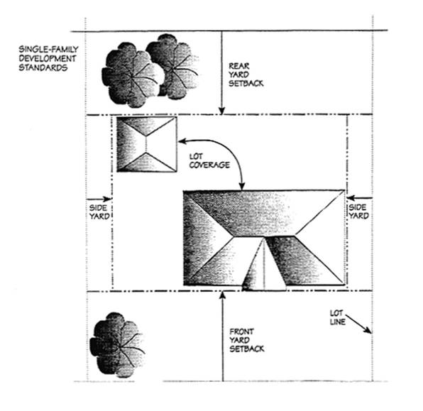
14.04.030 - Property development standards (R).
N.R.: Not required unless otherwise noted in Additional Standards. Note: See Chapter 14.16, Site and Use Regulations, for additional regulations pertaining to site development standards. See Chapter 14.23, Variances, and Chapter 14.24, Exceptions, for allowable adjustments to these standards. See Chapter 14.25, Environmental and Design Review Permits, a listing of improvements subject to review (including upper story additions), and design guidelines and criteria for development.
Table 14.04.030
(A)
Where two (2) or more lots in a block have been improved with buildings, the minimum required shall be the average of improved lots on both sides of the street for the length of the block. For purposes of determining average front setback on developed lots, setback should be measured from the property line to closest wall of any principal structure.
(B)
Where there is a driveway perpendicular to the street, any garage built after January 1, 1992, or carport built after January 1, 2006, shall be set back twenty feet (20′).
(C)
On a reverse corner lot, the rear twenty feet (20′) of the street side yard shall have a fifteen-foot (15′) setback.
(D)
In the R7.5, R10 and R20 districts, where two (2) or more lots in a block have been improved with buildings, the minimum required shall be the average of improved lots within the same district on both sides of the street for the length of the block.
(E)
In the -EA Combining District, maximum height of seventeen feet (17′) to peak, and one habitable floor.
(F)
For design criteria for upper-story construction, see Section 14.25.050(F)(6), Upper-Story Additions.
(G)
For lots less than five thousand (5,000) square feet, the maximum upper story shall be fifty percent (50%) of the maximum lot coverage calculation; for lots five thousand (5,000) square feet or larger, maximum upper story size shall be seventy-five percent (75%) of maximum lot coverage calculation.
(H)
See Section 14.16.282.C. for property development standard applicable to SB 9 Housing Developments.
(I)
Parcels created through Chapter 15.155 (Urban Lot Splits) are exempt from these standards.
Diagram for Section 14.04.030
(Ord. 1838 § 19, 2005; Ord. 1820 § 1, 2004; Ord. 1802 § 3, 2003; Ord. 1663 § 1 (part), 1994; Ord. 1625 § 1 (part), 1992).
(Ord. No. 1882, Exh. A, §§ 8, 9, 6-21-2010; Ord. No. 2002, div. 6, 12-6-2021; Ord. No. 2013, § 4, 8-1-2022)
14.04.040 - Property development standards—Duplex residential (DR), medium density residential (MR), high density residential (HR).
NA: Not applicable.
Note: See Chapter 14.16, Site and Use Regulations, for additional regulations pertaining to other site development standards, Chapter 14.23, Variances, Chapter 14.24, Exceptions, for allowable adjustments to these standards, and Chapter 14.25, Environmental and Design Review Permits, for a listing of improvements subject to review (including addition of new units or additions of floor area to existing units) and design guidelines and criteria for development.
(A)
Intentionally not used.
(B)
The minimum lot area for a boarding house is five hundred (500) square feet per guest room.
(C)
A density bonus may be granted, as provided for in Section 14.16.030 (Density bonus).
(D)
Where two (2) or more lots in a block have been improved with buildings, the minimum required shall be standard, or the average of improved lots on both sides of the street for the length of the block, whichever is less.
(E)
Where there is a driveway perpendicular to the street, any garage built after January 1, 1991, shall be set back twenty feet (20′).
(F)
Parking and maneuvering areas, excluding access driveways, shall be prohibited in all required yards, per Section 14.18.200 (Location of parking and maneuvering areas) of this title.
(G)
In the DR and MR district, on a reverse corner lot, the rear twenty feet (20′) of the street side shall have a fifteen-foot setback.
(H)
In the MR or HR districts, where development is adjacent to a single-family district, the rear yard setback shall be ten feet (10′).
(I)
In order to provide adequate privacy and sunlight, additional separation may be required through design review.
(J)
The height limit in the Latham Street neighborhood is specified in the Downtown San Rafael Precise Plan Form-Based Code adopted by separate ordinance.
(K)
A height bonus may be granted, as provided for in Section 14.16.190 (Height bonus).
(L)
Private yard areas shall have a minimum dimension of six feet (6′). In the HR districts, common indoor area suitable for recreational uses may be counted toward the usable outdoor area requirement.
(M)
Where a driveway is located in a side yard, a minimum of three feet (3′) of buffer landscaping shall be provided between the driveway and side property line. The required rear yard shall be landscaped to provide a buffer.
(N)
Setback distances apply to areas that provide a primary pedestrian access only.
(Ord. 1838 § 20, 2005; Ord. 1694 § 1 (Exh. A) (part), 1996; Ord. 1663 § 1 (part), 1994; Ord. 1625 § 1 (part), 1992).
(Ord. No. 1882, Exh. A, §§ 10, 11, 6-21-2010; Ord. No. 1990, div. 1.1, 3-1-2021; Ord. No. 1996, div. 2(Exh. A, 4.1), 8-16-2021)
14.05.010 - Specific purposes.
In addition to the general purposes listed in Section 14.01.030, the specific purposes of the commercial and office districts include the following:
A.
To promote specialized commercial environments which provide appropriately located areas for retail, service and office development, and provide the city with a wide range of neighborhood, local and regional serving uses;
B.
To promote appropriately located businesses which provide local employment opportunities and/or generate tax revenue for the city;
C.
To promote commercial and office projects at appropriate building intensities and trip-generation characteristics which will maintain acceptable traffic-operating standards;
D.
To promote high-quality design in new or remodeled commercial and office development consistent with design guidelines;
E.
To promote and encourage commercial and office sites and designs which are accessible by a variety of transportation means;
F.
To promote San Rafael's downtown area as a viable commercial and financial center, and as an urban center with a mixture of civic, social, entertainment, cultural and residential uses;
G.
To retain and enhance the Northgate Shopping Center and surrounding retail area as a regional shopping center;
H.
To provide housing opportunities by encouraging a variety of housing in mixed-use districts.
The additional purposes of each commercial district follow.
I.
General Commercial District (GC). The general commercial district promotes a full range of retail and service uses in major shopping centers and certain areas of the city which have freeway or major street access and visibility. Residential use is allowed with a use permit. Offices are a conditional secondary use, for example, on portions of sites with poor retail visibility. Floor area ratio (FAR), trip allocation and design criteria vary throughout the district in response to specialized conditions recognized in the general plan.
J.
Neighborhood Commercial District (NC).
1.
The neighborhood commercial district provides convenient shopping areas within residential neighborhoods for retail items and personal services which may be needed on a frequent basis for vicinity residents. Examples of convenience goods or services include supermarkets, pharmacies, dry cleaners and personal service establishments. Within this district, a limited amount of office and residential use may be allowed, only if in mixed-use developments. Office uses shall provide a service convenience to local residents. Neighborhood commercial areas are intended to reduce trips to more distant major commercial areas.
2.
Neighborhood commercial retail uses are limited in order to ensure compatibility with residential neighborhoods and to concentrate region-serving goods and services in locations outside of neighborhoods and in proximity with one another.
3.
Neighborhood commercial development is intended to be compatible with the surrounding residential neighborhood in terms of building height (typically one to two (2) stories, with up to three stories for a retail/residential mixed-use building), setbacks and landscaping.
K.
Office District (O). The office district provides opportunities for the siting of a variety of administrative, professional, medical and general business offices. This district also allows residential use, and limited convenience retail and service uses to support office uses and serve local employees. The office district is intended to provide an attractive, landscaped environment with outdoor amenities such as courtyards, plazas, benches, seating areas and pedestrian/bicycle paths. FAR, trip allocation and design criteria vary throughout the district in response to localized conditions recognized in the general plan.
L.
Downtown Mixed Use (DMU) District. The downtown mixed use district encompasses the 265-acre downtown area, which is the commerce and employment center of the city. Allowable uses, design intent, and development standards and regulations are defined and specified in the Downtown San Rafael Precise Plan and form-base code which is adopted by separate ordinance and incorporated herein by reference.
M.
Commercial/Office District (C/O). The commercial/office district promotes retail, office, mixed retail/office/residential uses, and cultural facilities. The commercial/office district is different from the downtown zoning districts in that it provides greater opportunity for office and financial uses in first-floor locations. Residential units are promoted to provide evening and weekend activity, increase the city's supply of housing units and support downtown activities and uses.
N.
Residential/Office Districts (R/O).
1.
The residential/office district is a transitional area between the downtown zoning districts and nearby residential areas. This district promotes residential, office, and mixed-use residential/office projects. This district also provides limited retail and personal service uses which support residential and office uses, and which are compatible with such uses. Gasoline service stations are allowed along major arterials such as Second Street.
2.
This district is characterized by lower development intensity than in the downtown zoning districts. The residential/office district is also intended to be less intense in terms of evening and weekend activity than the downtown zoning districts.
O.
Francisco Boulevard West Commercial District (FBWC).
1.
The Francisco Boulevard West commercial district provides a wide range of specialty retail uses with regional appeal, including sales of automobiles, bulk retail items, building materials and other region-serving goods. The Francisco Boulevard West district is intended to accommodate large-scale developments and shopping centers with specialty retail tenants. Assemblage of parcels shall be encouraged in this district in order to promote larger scale development projects. Residential use is also allowed in this district.
2.
This area is expected to be the focus of major redevelopment in the future. Until redevelopment occurs, it is recognized that there will be many nonconforming uses within the Francisco Boulevard West commercial district, and it is intended that existing legal nonconforming uses may remain as viable interim uses. Section 14.16.270, Nonconforming structures and uses, contains general provisions on nonconforming uses which apply in these instances. However, these types of interim uses are not permitted on any additional sites within the Francisco Boulevard West district.
(Ord. 1831 § 1 (part), 2004; Ord. 1757 § 1, 2000; Ord. 1694 § 1 (Exh. A) (part), 1996; Ord. 1625 § 1 (part), 1992).
(Ord. No. 1996, div. 2(Exh. A, 5.1), 8-16-2021)
14.05.020 - Land use regulations (GC, NC, O, C/O, R/O, FBWC).
A.
Francisco Boulevard West Commercial District (FBWC): Land use regulations for new development and/or redevelopment.
1.
New development and redevelopment within the Francisco Boulevard West commercial district shall be subject to initial use permit review by the planning
commission. Master use permits shall be required for multi-tenant shopping center developments, specifying the types of uses which may go into the center, approving an initial roster of tenants, and identifying procedures for subsequent review and approval of future tenants when changes in occupancy occur.
2.
Prerequisites for initiating the use permit review process are as follows:
a.
The proposed use is listed on the commercial matrix as requiring a conditional use permit and meets the review criteria specified in subsection (A)(3) of this section;
b.
In the event the proposed use is not listed on the commercial matrix as requiring a conditional use permit, but the proposed use meets the review criteria specified below, application for determination may be made to the planning commission. The planning commission shall determine whether the proposed use is consistent with the specified review criteria for the Francisco Boulevard West commercial district.
3.
Review criteria for evaluating proposed uses in new development and redevelopment projects in the Francisco Boulevard West commercial district are listed below. In order to initiate the use permit process as indicated in either subsection (A)(2)(a) or (A)(2)(b) of this section, the proposed project must meet one (1) or more of the following criteria:
a.
Generates high tax revenue;
b.
Constitutes a large-scale business;
c.
Constitutes a multi-tenant center with shops which provide related services or types of goods; and/or
d.
Has a regional market base.
P: Permitted by right; C: Conditional use permit; CZ: Conditional use permit/zoning administrator; A: Administrative use permit; Blank: Not allowed.
Table 14.05.020
(1) Reserved.
(2) Shall not be located within six hundred feet (600′) from schools (public and private), as measured from the property lines of each parcel.
(3) See Section 14.17.100 (Residential uses in commercial districts).
(Ord. 1838 § 21, 2005; Ord. 1831 § 1 (part), 2004; Ord. 1815 § 1, 2004; Ord. 1797 § 3, 2003; Ord. 1765 § 1 (part) (Exh. B (part)), 2001; Ord. 1751 § 2, 2000; Ord. 1742 § 2, 1999; Ord. 1694 § 1 (Exh. A) (part), 1996; Ord. 1693 § 1, 1996; Ord. 1689 § 1, 1995; Ord. 1663 § 1 (part), 1994; Ord. 1641 § 1 (part), 1993; Ord. 1625 § 1 (part), 1992).
(Ord. No. 1882, Exh. A, § 12, 6-21-2010; Ord. No. 1923, § 2(Exh. A), 6-16-2014; Ord. No. 1924, § 1, 9-15-2014; Ord. No. 1955, (Exh. A, §§ 3, 4), 3-19-2018; Ord. No. 1964, § 2(Exh. B) §§ 3, 4, 11-19-2018; Ord. No. 1996, div. 2(Exh. C, 2.1), 8-16-2021; Ord. No. 2002, div. 7, 12-6-2021; Ord. No. 2015, § 2, 9-6-2022; Ord. No. 2016, § 3, 10-3-2022)
14.05.022 - Land use regulations (DMU).
All land use regulations applicable to the DMU district are contained within the Downtown San Rafael Precise Plan Form-Based Code, which is adopted by separate ordinance and incorporated herein by reference.
(Ord. 1838 § 22, 2005; Ord. 1831 § 1 (part), 2004; Ord. 1815 § 2, 2004; Ord. 1797 § 4, 2003; Ord. 1765 § 1 (Exh. B (part)), 2001; Ord. 1763 § 1 (part), 2001; Ord. 1757 § 2 (Exh. Z-1), 2000: Ord. 1751 § 2, 2000; Ord. 1742 § 2, 1999; Ord. 1725 § 1 (Exh. A), 1998; Ord. 1694 § 1 (Exh. A) (part), 1996).
(Ord. No. 1882, Exh. A, § 13, 6-21-2010; Ord. No. 1923, § 2(Exh. A), 6-16-2014; Ord. No. 1924, § 1, 9-15-2014; Ord. No. 1996, div. 2(Exh. A, 5.2), 8-16-2021; Ord. No. 2002, div. 8, 12-6-2021)
14.05.030 - Property development standards (GC, NC, O, C/O, R/O, FBWC).
NR: Not required unless otherwise noted in additional standards. NA: Not applicable.
Note: See Chapter 14.16, Site and Use Regulations, for additional regulations pertaining to floor area ratio, and site development standards. See Chapter 14.23, Variances, and Chapter 14.24, Exceptions, for allowable adjustments to these standards, and Chapter 14.25, Environmental and Design Review Permits, for a listing of improvements subject to review and design guidelines and criteria for development.
(A)
There is no minimum lot area requirement for a boarding house.
(B)
Where the frontage of a block is partially in an R district, the front yard shall be the same as required for that R district, and when the side and/or rear of the lot(s) abuts an R district, the respective side and/or rear yard shall be ten feet (10′). Parking or maneuvering shall be permitted within the required side and rear yards provided that a minimum six-foot (6′) wide landscape buffer area, excluding curbs, is provided adjacent to the side and rear property lines.
(C)
Exceptions may be granted for a height above thirty-six feet (36′), subject to the provisions of Chapter 14.24, Exceptions.
(D)
Hotels have a four (4) story fifty-four-foot (54′) height limit. A one-story twelve-foot (12′) height bonus may be approved as part of a design review permit by the planning commission if it finds that the hotel will provide a significant community benefit, and the design is consistent with this title.
(E)
Repealed 3/18/96.
(F)
Buildings existing or approved as of January 1, 1987 which are more than three (3) stories in height shall not be considered nonconforming, and are listed in Section 14.16.040, Buildings over three (3) stories.
(G)
See general plan downtown height map for lot-specific height limits.
(H)
A height bonus may be permitted in residential development as provided for in Section 14.16.190, Height bonus.
(I)
Where the frontage of the lot(s) is adjacent to or across from an R district, fifty percent (50%) of the front yard shall be landscaped. Where the side yard abuts an R district, a minimum three feet (3′) of buffer landscaping must be provided. Where the rear of the lot abuts an R district, ten feet (10′) of buffer landscaping must be provided.
(J)
In the GC district, a minimum fifteen feet (15′) of the front setback must be landscaped. Landscaped portions of the public right-of-way may be included, subject to approval by the hearing body.
(K)
For parking lot landscaping, see Section 14.18.160, Parking lot screening and landscaping.
(L)
A landscaped amenity area for employees and the public is encouraged in office and commercial projects.
(M)
Provision of usable outdoor area is encouraged in residential development as part of a mixed-use project.
(N)
Intentionally not used.
(O)
A density bonus may be granted, as provided for in Section 14.16.030.
(P)
The maximum lot coverage restriction established for the office (O) district shall not apply to solar panels installed over existing paved parking spaces; consistent with Section 14.16.307.
(Ord. 1838 § 23, 2005; Ord. 1831 § 1 (part), 2004; Ord. 1782 Exh. A (part), 2002; Ord. 1694 § 1 (Exh. A) (part), 1996; Ord. 1625 § 1 (part), 1992).
(Ord. No. 1882, Exh. A, §§ 14, 15, 6-21-2010; Ord. No. 1923, § 2(Exh. A), 6-16-2014; Ord. No. 1964, § 2(Exh. B) § 5, 11-19-2018; Ord. No. 1990, div. 1.2, 3-1-2021)
14.05.032 - Property development standards (DMU).
All property development standards applicable to the DMU district are contained within the Downtown San Rafael Precise Plan Form-Based Code, which is adopted by separate ordinance and incorporated herein by reference.
(Ord. 1838 § 24, 2005; Ord. 1782 Exh. A (part), 2002; Ord. 1694 § 1 (Exh. A) (part), 1996).
(Ord. No. 1882, Exh. A, §§ 16, 17, 6-21-2010; Ord. No. 1996, div. 2(Exh. A, 5.3), 8-16-2021)
14.06.010 - Specific purposes.
In addition to the general purposes listed in Section 14.01.030, the specific purposes of the industrial districts include the following:
A.
To provide appropriately located areas for a range of light and heavy industrial uses, including the building trades and automotive service industries, which serve area residents and businesses;
B.
To preserve and expand the contribution of industrial, building trades and auto service uses to the overall economic base and employment opportunities of the city;
C.
To provide a suitable environment for industrial uses and minimize potential land use conflicts by limiting nonindustrial uses within the industrial districts;
D.
To minimize the impacts of industrial uses on adjacent nonindustrial districts;
E.
To upgrade appearance and parking conditions to a reasonable extent while maintaining the vitality of the industrial districts;
F.
To promote industrial development at appropriate building intensities and trip-generation characteristics which will maintain acceptable traffic operating standards.
The additional purposes of each industrial district follow.
G.
Industrial District (I). The industrial district provides opportunities for a full range of heavy and light industrial uses, including the building trades and automotive service industry. The industrial district protects general industrial uses from disruption and competition for space from unrelated retail, commercial and office uses that could be more appropriately located elsewhere in the city. However, ancillary office, small office and certain retail and service uses are allowed for the convenience of area businesses and employees.
H.
Light Industrial/Office District (LI/O). The light industrial/office district provides landscaped settings for light industrial uses, research and development facilities, warehousing, wholesale distributing and office uses. Incidental employee-serving retail and service uses are encouraged. Specialty retail uses consistent with light industrial or office uses, region-serving specialty retail and retail uses supportive of and related to industrial uses may be permitted provided the proposed use is consistent with floor area ratio (FAR) and trip allocation standards. FAR requirements, trip allocation standards and design criteria vary throughout the district in response to specialized conditions recognized in the general plan.
I.
Core Canal Industrial/Office District (CCI/O).
1.
The core canal industrial/office district provides sites for light industrial, automotive service and small-scale office uses. Specialty retail uses consistent with industrial uses may be allowed provided the proposed use complies with FAR requirements and trip allocation standards. Because this area suffers from severe parking congestion, and typically has small lot sizes and narrow street widths, high trip-generating uses such as general retail, personal service or food service establishments are restricted in this district. These types of uses are more appropriately located in nearby commercial districts.
2.
Within the core canal industrial/office district, new development and building remodels shall achieve upgraded design and reduce any adverse circulation and parking impacts. Fringe sites and buildings shall also provide an appropriate transition to adjacent residential and commercial districts.
J.
Lindaro Mixed-Use District (LMU). The Lindaro mixed-use district provides sites for a mix of industrial and light industrial uses. To facilitate the transition of this district to a more compatible use with the adjacent school, to encourage the development of a more attractive entryway to the neighborhoods to the south, and to help meet the housing needs of artists and other professionals who want to combine their work and residence, allow live/work uses in addition to the existing industrial and light industrial uses.
(Ord. 1831 § 1 (part), 2004; Ord. 1625 § 1 (part), 1992).
14.06.020 - Land use regulations (I, LI/O, CCI/O, LMU).
P: Permitted; C: Conditional use permit; CZ: Conditional use permit/zoning administrator; A: Administrative use permit; Blank: Not allowed.
Table 14.06.020
(1) Shall not be located within three hundred (300) feet from schools (public and private), as measured from the property lines of each parcel.
(Ord. 1838 § 25, 2005; Ord. 1831 § 1 (part), 2004; Ord. 1815 § 3, 2004; Ord. 1751 § 2, 2000; Ord. 1742 § 2, 1999; Ord. 1694 § 1 (Exh. A) (part), 1996; Ord. 1663 § 1 (part), 1994; Ord. 1641 § 1 (part), 1993; Ord. 1625 § 1 (part), 1992).
(Ord. No. 1882, Exh. A, § 19, 6-21-2010; Ord. No. 1923, § 2(Exh. A), 6-16-2014; Ord. No. 1955, (Exh. A, §§ 5, 6), 3-19-2018; Ord. No. 1964, § 2(Exh. B) §§ 6, 7, 11-19-2018; Ord. No. 1996, div. 2(Exh. C, 3.1), 8-6-2021; Ord. No. 2015, § 3, 9-6-2022; Ord. No. 2016, § 4, 10-3-2022)
14.06.030 - Property development standards (I, LI/O, CCI/O, LMU).
NR: Not required, unless otherwise noted in Additional Standards.
Note: See Chapter 14.16, Site and Use Regulations, for additional regulations pertaining to floor area ratio and site development standards. See Chapter 14.23, (Variances) and Chapter 14.24 (Exceptions) for allowable adjustments to these standards, and Chapter 14.25 (Environmental and design review permits) for a listing of improvements subject to review and design guidelines and criteria for development.
Table 14.06.030
(A)
Where the frontage of a block is partially in a residential district, the front yard shall be the same as required for that residential district, and when the side and/or rear of the lot(s) abuts a residential district, the respective side and/or rear shall be ten feet (10′).
(B)
Parking and maneuvering shall be permitted within the required side and rear yards provided that a minimum six-foot wide landscape buffer area, excluding curbs, is provided adjacent to the side and rear property lines.
(C)
Buildings existing or approved as of January 1, 1987, which are more than three (3) stories in height shall not be considered nonconforming, and are listed in Section 14.16.040, Buildings over three (3) stories.
(D)
In the LI/O and CCI/O districts, street trees shall be included in landscaping plans for development fronting Harbor Street, Medway Road, and Bellam Blvd.; in the LMU district, for development facing Lindaro Street, and in the I district, for development fronting Woodland Avenue, Irwin Street, Lincoln Avenue, Andersen Drive and DuBois Street.
(E)
Where the frontage of the lot(s) is adjacent to or across from a residential district, fifty percent (50%) of the front yard shall be landscaped. Where the side yard abuts a residential district, a minimum three feet (3′) of buffer landscaping must be provided. Where the rear of the lot abuts a residential district, ten feet (10′) of buffer landscaping must be provided.
(F)
For parking lot landscaping, see Section 14.18.160, Parking lot screening and landscaping.
(G)
Landscaping is encouraged along entryways to neighborhoods, including Irwin Street, Harbor Street, Medway Road, Bellam Boulevard, Lindaro Street and Woodland Avenue.
(H)
Exception may be granted for required minimum landscaping standards, subject to the provisions of Chapter 14.24, Exceptions.
(I)
In the LI/O district, a minimum twenty feet (20′) of the front setback must be landscaped.
(Ord. 1831 § 1 (part), 2004; Ord. 1663 § 1 (part), 1994; Ord. 1625 § 1 (part), 1992).
(Ord. No. 1882, Exh. A, §§ 20, 21, 6-21-2010)
14.07.010 - Specific purposes.
The specific purposes of the planned development (PD) district are to:
A.
Promote and encourage cluster development on large sites to avoid sensitive areas of property;
B.
Encourage innovative design on large sites by allowing flexibility in property development standards;
C.
Encourage the establishment of open areas in land development;
D.
Encourage the assembly of properties that might otherwise be developed in unrelated increments to the detriment of surrounding neighborhoods;
E.
Establish a procedure for the development of large lots of land in order to reduce or eliminate the rigidity, delays and conflicts that otherwise would result from application of zoning standards and procedures designed primarily for small lots;
F.
Accommodate various types of large-scale, complex, mixed-use, phased developments;
G.
Enable affected governmental bodies to receive information and provide an integrated response to both the immediate and long-range impacts of such proposed developments.
(Ord. 1625 § 1 (part), 1992).
14.07.020 - Land use regulations.
A.
No use other than an existing use or a temporary use approved pursuant to section D, below, shall be permitted in a PD district except in accord with a valid development plan. Any permitted or conditional use authorized by this title may be included in an approved development plan, consistent with the general plan land use designation(s) and intensities for land within the PD district. The PD zoning approval shall establish the range of allowable land uses for the development.
B.
A master use permit or individual use permits may be required to establish specific uses on the property consistent with general plan land uses and parking standards. A master use permit shall be required for nonresidential, phased and/or multi-tenant development.
C.
A development plan is not required for existing school sites located in the PD district. A use permit shall be required for any nonpublic school uses of the site, or for reuse of any existing school facilities, per Section 14.09.020, land use regulations (P/QP). A development plan shall be required when such property redevelops.
D.
Temporary uses may be permitted within a PD district, with or without an approved or valid development plan. The performance standards and provisions of Section 14.17.130 of this Title shall apply to temporary uses, and shall be administered through a use permit (zoning administrator).
(Ord. 1838 § 26, 2005; Ord. 1625 § 1 (part), 1992).
(Ord. No. 1882, Exh. A, § 22, 6-21-2010)
14.07.030 - Property development regulations.
A.
Minimum Area. The minimum net area of a PD district shall be 2.5 acres, provided that a PD district may be subdivided in accord with a valid PD plan; exceptions to this provision are lots over 0.5 acres in size where developed to provide affordable housing and hillside residential lots over one acre in size where unusual site characteristics exist.
B.
Residential Unit Density. The total number of dwelling units in a PD plan shall not exceed the maximum number permitted by the general plan density for the total site area. Density bonuses for senior housing development and affordable housing development may be considered consistent with general plan policies and state law.
C.
Nonresidential Intensity. Nonresidential development shall not exceed floor area ratios, as specified in the general plan, except in the downtown where a one-time ten percent (10%) bonus may apply for business expansion.
D.
Building Height Limits. Building heights shall be consistent with height standards contained in the general plan.
E.
Other Development Regulations. Other development regulations shall be as prescribed by the development plan.
(Ord. 1838 § 27, 2005; Ord. 1831 § 1 (part), 2004; Ord. 1625 § 1 (part), 1992).
14.07.035 - Established PD district containing no development standards or regulations.
When an established PD district does not contain or include site-specific regulations or spatial standards necessary to guide and approve building additions, modifications or property improvements, the following shall apply:
A.
For proposed additions and modifications to principal structures and primary uses, the community development director shall determine, based on development characteristics, use and density, and the contiguous zoning districts, a zoning district adopted within this title that is most compatible to the PD district. The regulations and spatial standards of the most compatible zoning district shall be applied, subject to the approval of an environmental and design review permit.
B.
For accessory structures, fences and other ancillary improvements, the regulations of Chapter 14.16 of this Title shall apply.
C.
The community development director shall determine if the improvements proposed per A and B above are major or minor. Improvements determined to be major shall require an amendment to the PD zoning per Section 14.07.150 of this chapter. Improvements determined to be minor shall not require an amendment to the PD zoning.
(Ord. No. 1882, Exh. A, § 23, 6-21-2010)
14.07.040 - Authority.
The planning commission shall recommend approval, conditional approval or denial of applications to reclassify property to the PD district and/or applications for development plans to the city council. The city council shall have the authority to approve, conditionally approve or deny rezonings and/or development plan applications.
(Ord. 1625 § 1 (part), 1992).
14.07.050 - Application.
A.
An application to reclassify property to PD shall be initiated by a property owner or authorized agent, the planning commission or the city council. If the property is not under single ownership, all owners shall join in an application initiated by property owners, and a map showing the extent of ownerships shall be submitted with application materials. Applications to rezone property to PD shall be filed and processed in accordance with Chapter 14.27, Amendments. If property is already zoned PD, an approved development plan is required to develop the property.
B.
Applications for development plans shall be initiated by submitting the following information to the planning department: a completed application form, signed by the property owner(s) or authorized agent, accompanied by the required fee, and any other information, plans or maps prescribed by the planning director. Standard information required for a development plan application is listed below in Section 14.07.060. Application procedures and processing timeframes shall be in accordance with state law and procedural guidelines established by the planning director.
(Ord. 1625 § 1 (part), 1992).
14.07.060 - Required plans and materials.
In addition to the plans and materials required to accompany an application for a zoning map amendment as per Chapter 14.27, Amendments, an application for rezoning to a PD district shall include a development plan incorporating the information described below:
A.
A map showing proposed district boundaries and the relationship of the district to uses and structures within a three hundred foot (300′) radius of the district boundaries;
B.
A map or aerial photo of the proposed district and three hundred feet (300′) beyond its boundary showing sufficient topographic data to indicate clearly the character of the terrain; ridgelines and creeks; the type, location and condition of mature trees and other natural vegetation; and the location of existing development;
C.
The proposed pattern of land use, with acreage, residential density or commercial intensity calculations. This shall include the total square footage of each type of nonresidential use proposed in order to assess parking and traffic impacts;
D.
A site plan showing proposed street and lot patterns, and the location of all proposed buildings, structures, and other general site improvements;
E.
A description of proposed setbacks, yard areas and height limits;
F.
A plan showing location, grades, and widths of all streets; location and size of all utilities; drainage structures; parking areas; walkways; and other improvements;
G.
Parking plan showing proposed parking layout and provisions for bicycle parking/storage;
H.
A topographical map with average site slopes, or slopes of proposed lots, if applicable, and slopes of proposed streets;
I.
Geotechnical data (preliminary geologic report, geotechnical investigation report, and/or hazardous waste investigation report, as per general plan appendices, geotechnical review matrix);
J.
Traffic study;
K.
Description of all open space and/or undeveloped areas and a statement indicating their intended disposition (i.e., deeded to property owners, dedicated to city, etc.);
L.
Proposed subdivision map if property is proposed to be divided;
M.
An enumeration of deviations between typical zoning ordinance standards for such uses and the proposed plan;
N.
Phasing plan, if any;
O.
Other information as may be prescribed by the planning director, depending on the type, location and potential impacts of the proposed development.
An application for development plan may be accompanied by an application for environmental and design review. If the development plan application is not accompanied by the environmental and design review application, the following preliminary design review information shall also be submitted as part of the development plan application:
P.
Preliminary architectural elevations of all proposed buildings and structures;
Q.
Conceptual landscape plans;
R.
Preliminary grading plan;
S.
Site photographs showing site and adjacent properties;
T.
Other information as may be prescribed by the planning director.
(Ord. 1625 § 1 (part), 1992).
14.07.070 - Initial consultation—Concept plan review.
14.07.080 - Public notice and hearing.
A.
The planning commission and city council shall hold public hearings to consider applications to rezone property to the PD district and/or a development plan application.
B.
Notice of public hearings shall be given consistent with Chapter 14.29, Public Notice.
(Ord. 1824 § 1 (Exh. A) (part), 2004: Ord. 1625 § 1 (part), 1992).
14.07.090 - Findings.
A recommendation by the planning commission to the city council or a decision by the city council to reclassify property to the PD district and/or to approve a development plan shall be based on the following set of required findings:
A.
The development plan is consistent with the general plan, adopted neighborhood plans and other applicable city plans or policies;
B.
Any residential development shall constitute a residential environment of sustained desirability and stability in harmony with the character of the surrounding neighborhood, and where applicable, adequate open space shall be provided;
C.
Any nonresidential uses shall be appropriate in area, location and overall planning for the purpose intended, and the design and development standards shall create a nonresidential environment of sustained desirability and stability, and where applicable, adequate open space shall be provided;
D.
The applicant demonstrates that public facilities are provided to serve the anticipated population;
E.
The development is improved by deviations from typical zoning ordinance property development and parking standards; and
F.
The auto, bicycle and pedestrian traffic system is adequately designed for circulation needs and public safety. Emergency vehicle access is provided to serve the proposed development.
(Ord. 1625 § 1 (part), 1992).
14.07.100 - Contents of PD zoning approvals.
A.
PD zoning approvals shall include a text summary of the approved development plan, including the range of allowable land uses, residential density, number and type(s) of residential units, commercial/industrial intensity, building square footage devoted to each type of nonresidential land use, site development standards including setbacks, building envelopes, lot coverage and height limits, parking, open space areas, outdoor amenities and any other critical components of development approval.
B.
A master use permit or individual use permit(s) may be required as per Section 14.07.020 to establish specific use approvals and to evaluate compliance with trip allocations and parking standards.
(Ord. 1625 § 1 (part), 1992).
14.07.110 - Notice of decision.
The planning commission or city council shall prepare a written decision which shall contain the findings of fact upon which such decision is based and conditions of approval, if any. The decision shall be mailed to the applicant(s).
(Ord. 1625 § 1 (part), 1992).
14.07.120 - Effect of failure to give notice.
No action, inaction or recommendation regarding any development by the planning commission or city council shall be held void or invalid or be set aside by any court by reason of error or omission pertaining to the notices, including the failure to give any notice required by this section, unless the court after an examination of the entire case shall be of the opinion that the error or omission complained of was prejudicial, and that by reason of such error or omission the party complaining or appealing sustained and suffered substantial injury, and that a different result would have been probable if such error or omission had not occurred or existed. There shall be no presumption that the error or omission is prejudicial or that injury was done if error or omission is shown.
(Ord. 1625 § 1 (part), 1992).
14.07.130 - Effective date—Status of development plan.
PD zone designations without development plans are effective upon adoption of this zoning ordinance. Development plans for these PD districts, and any other PD districts with development plans, shall be effective on the same date as the ordinance for which they were or are approved. PD ordinances shall expire only upon rezoning to another zoning district. If no action has been taken on an approved development plan within five (5) years of its approval (or other timeframes specified by the approval) the city may initiate rezoning of the property.
(Ord. 1625 § 1 (part), 1992).
14.07.140 - Zoning map designation.
A planned development district shall be noted by the designation "PD." PD districts with approved development plans shall be noted by the designation "PD," followed by the ordinance number approving the development plan.
(Ord. 1625 § 1 (part), 1992).
14.07.150 - Amendments to PD zoning and development plans—New application.
Requests for changes in the contents of approval of a PD zoning and development plan shall be treated as a zoning amendment (rezoning). Rezonings shall be heard and decided by the city council. The procedures for filing and processing a rezoning shall be the same as those established for an initial PD zoning and development plan application.
(Ord. 1625 § 1 (part), 1992).
14.07.160 - Revocation.
Any violation of a condition of approval of a development plan or a provision of this title shall be grounds for permit revocation, as provided in Chapter 14.29, Enforcement.
(Ord. 1625 § 1 (part), 1992).
14.07.170 - New applications following denial or revocation.
If an application for a development plan is denied or revoked, no new application for the same, or substantially the same, development plan shall be filed within one year of the date of denial or revocation of the initial application, unless the denial is made without prejudice.
(Ord. 1625 § 1 (part), 1992).
14.08.010 - Specific purposes.
In addition to the general purposes listed in Section 14.01.030, the specific purposes of the marine district (M) include the following:
A.
To promote the canal as a navigable waterway and viable boating/maritime district;
B.
To preserve limited canal-front sites for water-frontage-dependent uses in order to maintain the canal as a viable maritime/boating district;
C.
To provide site opportunities for marine-related businesses which may benefit from proximity to water-frontage-dependent businesses and contribute to the maritime character of the district;
D.
To provide site opportunities for canal-front parks and marine-related recreation;
E.
To allow residential and nonmarine related office uses on the second floor or above of a mixed-use project;
F.
To promote building design sensitive to waterfront locations;
G.
To promote public access along the waterfront.
H.
To allow site opportunities for retail, hotels and restaurants which promote public access to the canal.
(Ord. 1831 § 1 (part), 2004: Ord. 1625 § 1 (part), 1992).
14.08.020 - Land use regulations (M).
P: Permitted by right; C: Conditional use permit; CZ: Conditional use permit/zoning administrator; A: Administrative use permit; Blank: Not allowed.
Table 14.08.020
(Ord. 1838 § 28, 2005; Ord. 1831 § 1 (part), 2004; Ord. 1694 § 1 (Exh. A) (part), 1996; Ord. 1625 § 1 (part), 1992).
(Ord. No. 1882, Exh. A, §§ 25, 26, 6-21-2010; Ord. No. 1923, § 2(Exh. A), 6-16-2014; Ord. No. 2016, § 5, 10-3-2022)
14.08.030 - Property development standards (M).
NR: Not required unless otherwise noted in Additional Standards.
Note: See Chapter 14.16, Site and Use Regulations, for additional regulations pertaining to floor area ratio and site development standards. See Chapters 14.23, Variances, and 14.24, Exceptions, for allowable adjustments to these standards. See Chapter 14.25, Environmental and Design Review Permits, for a listing of improvements subject to review and design guidelines and criteria for development.
Table 14.08.030
(A)
Where the frontage of a block is partially in a residential district, the front yard shall be the same as required for that residenti14al district, and when the side and/or rear of the lot(s) abuts a residential district, the respective side and/or rear yard shall be ten feet (10′).
(B)
Exceptions may be granted for a height above thirty-six feet (36′), subject to the provisions of Chapter 14.24, Exceptions. Lower height may be required consistent with the canalfront review overlay district, Chapter 14.15.
(C)
Buildings existing or approved as of January 1, 1987, which are more than three (3) stories in height shall not be considered nonconforming, and are listed in Section 14.16.040, Buildings over three (3) stories.
(D)
Hotels have a four-story height limit. A five-story height may be approved as part of an environmental and design review permit by the planning commission if it finds that the hotel will provide a significant community benefit, and the design is consistent with this title.
(E)
For parking lot landscaping, see Section 14.18.160, Parking lot screening and landscaping.
(F)
Provision of usable outdoor area is encouraged in residential development as part
of a mixed-use project.
(G)
A density bonus may be granted, as provided for in Section 14.16.090.
(Ord. 1831 § 1 (part), 2004; Ord. 1663 § 1 (part), 1994; Ord. 1625 § 1 (part), 1992).
(Ord. No. 1882, Exh. A, §§ 27, 28, 6-21-2010)
14.09.010 - Specific purposes.
In addition to the general purposes listed in Section 14.01.030, the specific purposes of the public/quasi-public district include the following:
A.
To provide sites for governmental, educational, public safety, public utility, residential and public transportation facilities.
B.
To provide site opportunities for recreation and nonprofit community service facilities.
(Ord. 1831 § 1 (part), 2004; Ord. 1625 § 1 (part), 1992).
14.09.020 - Land use regulations (P/QP).
P: Permitted by right; C: Conditional use permit; CZ: Conditional use permit/zoning administrator; A: Administrative use permit; Blank: Not allowed.
Table 14.09.020
(Ord. 1831 § 1 (part), 2004; Ord. 1694 § 1 (Exh. A) (part), 1996; Ord. 1641 § 1 (part), 1993; Ord. 1625 § 1 (part), 1992).
(Ord. No. 1923, § 2(Exh. A), 6-16-2014; Ord. No. 1964, § 2(Exh. B) § 8, 11-19-2018)
14.09.030 - Property development standards (P/QP).
NR: Not required unless otherwise noted in Additional Standards.
Note: See Chapter 14.16, Site and Use Regulations, for additional regulations pertaining to floor area ratio and site development standards. See Chapters 14.23, Variances, and 14.24, Exceptions, for allowable adjustments to these standards. See Chapter 14.25, Environmental and Design Review Permits, for a listing of improvements subject to review and design guidelines and criteria for development.
Table 14.09.030
(A)
Where the frontage of a block is partially in a residential district, the front yard shall be the same as required for that residential district, and when the side and/or rear of the lot(s) abuts a residential district, the respective side and/or rear yard shall be ten feet (10′).
(B)
Exceptions may be granted for a height above thirty-six feet (36′), subject to the provisions of Chapter 14.24, Exceptions.
(C)
Buildings existing or approved as of January 1, 1987 which are more than three (3) stories in height shall not be considered nonconforming, and are listed in Section 14.16.040, Buildings over three (3) stories.
(D)
For parking lot landscaping, see Section 14.18.160, Parking lot screening and landscaping.
(Ord. 1831 § 1 (part), 2004; Ord. 1663 § 1 (part), 1994; Ord. 1625 § 1 (part), 1992).
(Ord. No. 1882, Exh. A, §§ 29, 30, 6-21-2010)
14.10.010 - Specific purposes.
In addition to the general purposes listed in Section 14.01.030, the specific purposes of the parks/open space district include the following:
A.
To provide appropriately located land throughout the city for public parks;
B.
To provide opportunity for recreational uses in public parks;
C.
To promote an integrated pattern of open space areas within the city to serve as visual greenbelts and community separators and to protect environmental resources;
D.
To protect the public health and safety by limiting lands subject to flooding, slides or other hazards to open space use;
E.
To preserve baylands, waterways and wetlands as open space;
F.
To retain open space land in a natural open state;
G.
To discourage public utility facilities in open space areas to minimize harm to the area's visual quality;
H.
To allow low-intensity, passive recreational uses within open space areas and provide opportunity in appropriate locations for more intensive uses of open space which are consistent with the preservation of open space natural values and have minimal impacts on the environment.
(Ord. 1625 § 1 (part), 1992).
14.10.020 - Land use regulations (P/OS).
P: Permitted by right; C: Conditional use permit; A: Administrative use permit; Blank: Not allowed.
Table 14.10.020
(Ord. 1625 § 1 (part), 1992).
(Ord. No. 1964, § 2(Exh. B) § 9, 11-19-2018)
14.10.030 - Property development standards (P/OS).
NR: Not required, unless otherwise noted in Additional Standards.
Note: See Chapter 14.16, Site and Use Regulations, for additional regulations pertaining to floor area ratio and site development standards. See Chapters 14.23, Variances, and 14.24, Exceptions, for allowable adjustments to these standards. See Chapter 14.25, Environmental and Design Review Permits, for a listing of improvements subject to review and design guidelines and criteria for development.
Table 14.10.030
(A)
Exceptions may be granted for a height above thirty-six feet (36′), subject to the provisions of Chapter 14.24, Exceptions.
(Ord. 1663 § 1 (part), 1994; Ord. 1625 § 1 (part), 1992).
(Ord. No. 1882, Exh. A, §§ 31, 32, 6-21-2010)
14.11.010 - Specific purposes.
In addition to the general purposes listed in Section 14.01.030, the purposes of the water district include the following:
A.
To promote the waters of San Rafael as a navigable waterway and viable boating/maritime district;
B.
To provide opportunities for limited water-dependent uses which require access to the water as a central element of its basic function, and which contribute to the maritime character of the district;
C.
To provide opportunities for marine-related recreation;
D.
To protect property from erosion from storms and high tides;
E.
To improve water quality by preventing or reducing pollution caused by any means;
F.
To protect and enhance wildlife habitat;
G.
To provide opportunities for education and scientific research.
(Ord. 1625 § 1 (part), 1992).
14.11.020 - Land use regulations (W).
P: Permitted by right; C: Conditional use permit: A: Administrative use permit; Blank: Not allowed.
Table 14.11.020
(Ord. 1625 § 1 (part), 1992).
14.11.030 - Property development standards (W).
NR: Not required, unless otherwise noted in Additional Standards.
Note: See Chapter 14.16, Site and Use Regulations, for additional regulations pertaining to floor area ratio and site development standards. See Chapters 14.23, Variances, and 14.24, Exceptions, for allowable adjustments to these standards. See Chapter 14.25, Environmental and Design Review Permits, for a listing of improvements subject to review and design guidelines and criteria for development.
Table 14.11.030
(A)
Loss of open waters due to filling shall be strictly avoided. Fill is subject to the provisions of Section 14.13.040(G), Fill. A use permit shall be required consistent with Sections 14.13.050, Application for a use permit, and 14.13.070, Findings. (Note: Fill in open waters is also subject to issuance of a tidelands permit from the department of public works, and any other permit required by local, state or federal law.)
(B)
Development should not encroach into sensitive wildlife habitat areas, limit normal range areas or create barriers which cut off access to food or shelter.
(C)
Other proposed activities, such as dredging within tidelands and/or open waters, requires a tidelands permit from the department of public works and may require other permits.
(D)
Public access to the water or shoreline should be provided as identified on the recreation plan and the canal land use and access map of the general plan, and is encouraged elsewhere where appropriate.
(E)
Views of the water shall be provided as identified on community design map A of the general plan, and is encouraged elsewhere through project design.
(F)
For setbacks from creeks, the San Rafael Canal and drainageways, see Section 14.16.080, Creeks and other watercourses. For setbacks from wetlands, see Section 14.13.040(B), Wetland Setbacks.
(Ord. 1663 § 1 (part), 1994; Ord. 1625 § 1 (part), 1992).
(Ord. No. 1882, Exh. A, §§ 33, 34, 6-21-2010)