
San Rafael City Zoning Code
Division III
OVERLAY DISTRICT REGULATIONS
14.12.010 - Specific purposes.
In addition to the general purposes listed in Section 14.01.030, the purposes of the hillside development overlay district include the following:
A.
To protect public health and safety by minimizing hazards, including seismic and landslide risks, soil erosion and fire danger associated with development on steep and/or unstable slopes;
B.
To encourage preservation of natural hillside features;
C.
To ensure adequate emergency access by providing on-site parking;
D.
To implement the residential site design policies of the general plan and the Hillside Residential Design Guidelines Manual.
(Ord. 1625 § 1 (part), 1992).
14.12.020 - Criteria for establishment of hillside development overlay district.
A.
These regulations shall apply to all lots with an average slope of twenty-five percent (25%) or greater, or located in the hillside resource residential or hillside residential general plan land use designations. The hillside development overlay district on the zoning map is placed on those lots which are in the hillside resource residential or hillside residential general plan land use districts.
B.
Lots with an average slope greater than twenty-five percent (25%) not shown in the hillside development overlay district are presumed to exist in the city and are protected under all of the terms and provisions of this chapter. Development on such lots requires compliance with the requirements of the hillside development overlay district, except that such lots need not be rezoned to the hillside development overlay designations.
(Ord. 1625 § 1 (part), 1992).
(Ord. No. 1882, Exh. A, § 35, 6-21-2010; Ord. No. 1923, § 2(Exh. A), 6-16-2014)
14.12.030 - Property development standards (-H).
Development standards shall be those of the underlying zoning district with which a hillside development overlay district is combined, provided that the following shall be in addition and shall govern where conflicts arise, except for subsection G, lot standards, where the lot size standard of the underlying zoning district applies when more restrictive than the subdivision ordinance. Subsections B, F, G, and I shall not apply to SB 9 Housing Developments (regulated by Section 14.15.282) or urban lot splits (regulated by Chapter 15.155—Urban Lot Splits).
A.
Building Stepback. A building stepback is established to limit the height of structures to avoid excessive building bulk. The required stepback shall be follows:
1.
On any downhill slope a twenty-foot (20′) height limit measured from existing grade shall be observed. This height limit shall be construed to mean that wall planes shall be broken into single wall heights of no more than twenty feet (20′) beyond which a stepback of at least five feet (5′) is required, unless otherwise determined through the environmental and design review permit process. Regardless, the maximum overall building height shall not exceed the height allowed by the zoning district.
2.
On non-downhill slope, walls facing front and side property lines shall have a twenty-foot (20′) height limit measured from existing grade shall be observed within all areas within fifteen feet (15′) of the maximum building envelope limit. To allow for design flexibility on non-downhill slopes, an encroachment into the street front, street side and interior side stepback is permitted along twenty-five percent (25%) of the building length.
Note: Please refer to the San Rafael Hillside Design Guidelines for examples.
B.
Setbacks. Structures may encroach into a required yard or setback for a distance of not more than one-half (½) of the required yard or setback provided that the decrease minimizes the impact of hillside development and grading, subject to approval by the hearing body of an environmental and design review permit. If such a reduction is granted, a compensating increase in setback is required in the opposing setback, i.e., a five-foot reduction in a front yard setback would increase the rear yard setback by five feet (5').
C.
Natural State. A minimum area of twenty-five percent (25%) of the lot area plus the percentage figure of average slope, not to exceed a maximum of eighty-five percent (85%), must remain in its natural state. This standard may be waived or reduced for lots zoned PD (planned district) or developed with clustered development, subject to approval by the hearing body. This requirement does not apply to properties where the general plan has adopted a medium density residential or high density residential land use designation.
D.
Gross Building Square Footage. The maximum permitted gross building square footage of all structures (including garages and accessory structures over one hundred twenty (120) square feet) is limited to two thousand five hundred (2,500) square feet plus ten percent (10%) of the lot area with the maximum gross square footage set at six thousand five hundred (6,500) square feet. This requirement does not apply to properties where the general plan has adopted a medium density residential or high density residential land use designation.
E.
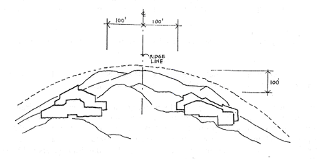
Ridgeline Development. Development of new structures within one hundred (100) vertical feet of a visually significant ridgeline, as shown on the community design map of the general plan, is prohibited unless this restriction precludes all reasonable economic use of the property. Exception: an exception to the ridgeline regulation may be granted if the decision-making body makes the findings that:
1.
There are no site development alternatives which avoid ridgeline development;
2.
The density has been reduced to the minimum allowed by the general plan land use designation density range;
3.
No new subdivision lots are created which will result in ridgeline development; and
4.
The proposed development will not have significant adverse visual impacts due to modifications for height, bulk, design, size, location, siting and landscaping which avoid or minimize the visual impacts of the development, as viewed from all public viewing areas.
ILLUSTRATION 14.12.030
F.
Parking Requirements. On streets less than twenty-six feet (26') wide, a minimum of two (2) additional on-site parking spaces shall be provided (not on the driveway apron) for single-family residential development. These spaces should be conveniently placed relative to the dwelling unit which they predominately serve. This requirement may be waived or reduced by the hearing body when deemed appropriate or necessary to reduce the need for excessive grading or tree removal, and suitable off-site parking is determined to be available. Further, vehicles should not be allowed to back-out onto a street less than twenty-six feet (26') wide unless approved by the hearing body as necessary to reduce the need for excessive grading or tree removal, or lessen driveway slope, and adequate sight distance, maneuvering area, driveway area, and backup space (which may include paved right-of-way) are provided to facilitate safe and efficient vehicle ingress/egress, as recommended by the public works department, fire marshal and community development director. Driveway and maneuvering areas shall consist of suitable all-weather pavement or permeable hardscape surface approved by the city.
G.
Lot Standards. Minimum lot sizes and widths for lots created after November 21, 1991 are subject to the slope tables established under Chapter 15.07 of the subdivision ordinance.
H.
Street and Driveways. New street and driveway grades shall not exceed eighteen percent (18%) unless an exception has been granted by the hearing body, and the design has been recommended by the public works director and fire marshal to allow a driveway or street slope up to a maximum twenty-five percent (25%) grade. Streets and driveways with slopes over fifteen percent (15%) shall be a permanent, durable, non-asphalt hardscape surface. Streets and driveways with slopes over eighteen percent (18%) shall have grooves/scoring for traction. A suitable transition shall be provided at the street and driveway apron to allow vehicles to safely transition to/from roadways and parking areas, as recommended by the department of public works. Further, the design of the driveway apron at the garage shall be subject to review and recommendation from the department of public works to ensure safe and efficient vehicle ingress and egress.
I.
Design Review Requirement. An environmental and design review permit may be required, consistent with the requirements of Chapter 14.25, Environmental and Design Review Permits. All applications shall be evaluated for conformity with the Hillside Residential Design Guidelines Manual.
(Ord. 1838 § 29, 2005; Ord. 1625 § 1 (part), 1992).
(Ord. No. 1882, Exh. A, §§ 36—38, 6-21-2010; Ord. No. 1923, § 2(Exh. A), 6-16-2014; Ord. No. 1964, § 2(Exh. B) § 10, 11-19-2018; Ord. No. 2013, § 4, 8-1-2022; Ord. No. 2039, § 3(Exh. B), 7-15-2024)
14.12.040 - Exceptions to property development standards.
City Council Exception Required. Exceptions to the property development standards of this chapter may be approved by the city council when the applicant has demonstrated that alternative design concepts carry out the objectives of this chapter and are consistent with the general plan based on the following criteria:
A.
The project design alternative meets the stated objectives of the hillside design guidelines to preserve the inherent characteristics of hillside sites, display sensitivity to the natural hillside setting and compatibility with nearby hillside neighborhoods, and maintain a strong relationship to the natural setting; and
B.
Alternative design solutions which minimize grading, retain more of the project site in its natural state, minimize visual impacts, protect significant trees, or protect natural resources result in a demonstrably superior project with greater sensitivity to the natural setting and compatibility with and sensitivity to nearby structures.
This section shall not apply to SB 9 Housing Developments (regulated by Section 14.15.282) or urban lot splits (regulated by Chapter 15.155—Urban Lot Splits).
(Ord. 1663 § 1 (part), 1994).
(Ord. No. 1882, Exh. A, § 39, 6-21-2010; Ord. No. 2013, § 4, 8-1-2022; Ord. No. 2039, § 3(Exh. B), 7-15-2024)
14.13.010 - Specific purposes.
Wetlands are indispensable and fragile natural resources subject to flooding, erosion, soil-bearing capacity limitations and other hazards. Destruction of or damage to wetlands threatens public safety and the general welfare. In addition to the general purposes listed in Section 14.01.030 and the purposes of the underlying zoning district, the purposes of the wetland overlay district include the following:
A.
To preserve and enhance the remaining wetlands in San Rafael by encouraging their use only for purposes compatible with their natural functions and environmental benefits;
B.
To prohibit in wetlands and discourage at adjacent upland sites those development activities that may adversely affect wetlands;
C.
To design development to avoid or minimize adverse impacts on wetland habitat;
D.
To encourage restoration of wetland sites;
E.
To prevent loss of life, property damage and other losses and risks associated with flooding by providing floodwater passage for stormwater runoff and floodwaters that coincide with high tides;
F.
To protect property values by preventing damage from erosion from storms and high tides;
G.
To contribute to improved water quality by preventing or reducing increases in pollution caused by any means;
H.
To protect and enhance wildlife habitat, including that of rare, threatened and endangered plant and animal species;
I.
To provide sites for education and scientific research;
J.
To provide opportunities for recreational activities compatible with wetland habitat.
(Ord. 1625 § 1 (part), 1992).
14.13.020 - Criteria for establishment of wetland overlay (-WO) district for identified and unidentified wetlands.
A.
These regulations shall apply to all properties located within the city of San Rafael that contain wetlands. The wetland overlay district that is classified on the city's zoning map is applied and adopted on those properties which contain wetlands that have been identified and confirmed by the U.S. Army Corps of Engineers. An inventory of properties that contain known and confirmed wetlands is available in the community development department.
B.
Wetlands are known to exist throughout the community that are not identified or shown in the wetland overlay district, as they are typically discovered and confirmed as part of a site-specific assessment. Nonetheless, all wetlands are protected under all of the terms and provisions of this chapter. A property containing wetlands that have been confirmed by the U.S. Army Corps of Engineers shall be rezoned to combine the wetland overlay district with the base zoning adopted for the property.
C.
Submerged properties and tidelands lots that are located within the Water (W) District require compliance with the provisions of the -WO District, except that such properties need not be rezoned to the -WO District.
(Ord. 1625 § 1 (part), 1992).
(Ord. No. 1923, § 2(Exh. A), 6-16-2014)
14.13.030 - Land use regulations (-WO).
P: Permitted by right; C: Conditional use permit; Blank: Not allowed.
Table 14.13.030
(A)
In wetlands, the only uses allowed are the construction and maintenance of water-related structures such as piers, docks, walkways, observation decks and shelters, fences, wildlife management shelters, stormwater pumps and bridges.
(B)
Provided that any and all necessary permits or approvals required by local, state or federal law shall be obtained.
(C)
Uses in or near wetland areas shall be controlled or designed to have minimal adverse impact on wetland habitat.
(D)
Recreation/scientific activities in or near wetlands should be low intensity uses, such as bird watching, fishing, nature photography and study, wildlife observation and scientific research and education.
(Ord. 1625 § 1 (part), 1992).
(Ord. No. 1955, (Exh. A, § 7), 3-19-2018)
14.13.040 - Property development regulations (-WO).
The required and applied development standards shall be those standards adopted for the underlying zoning district with which a -WO District is combined, provided that the following additional requirements shall apply and shall govern where conflicts arise.
A.
Structures in Wetlands. Any structures that are allowed to be placed in wetland areas (per Section 14.13.030(A)) must be designed and constructed to minimize adverse impacts on wetlands through construction on pilings to allow unobstructed flow of water, so as to preserve the natural contour of the wetland and to minimize impairment, alteration or loss of wetlands.
B.
Wetland Setbacks.
1.
A wetland setback shall be measured from the edge of a wetland, as determined through application of the procedures in Section 14.13.05(A), Determination of wetland boundaries. The setback from a creek or drainage way wetland, or from the San Rafael Canal, shall be established and measured consistent with the provisions of Section 14.16.080, Creeks and other watercourses of this title.
2.
For wetlands which are neither creeks nor drainage ways, a development-free setback of fifty feet (50'), including but not limited to paving and structures, shall be required. A wetland setback of greater than fifty feet (50') in width may be required on properties larger than two (2) acres in size, as determined through the site development review process.
3.
An exception to the minimum wetland setback requirement may be granted by the planning commission for minor encroachments, which would permit a setback reduction of no more than ten percent (10%) of the minimum setback requirement. A minor encroachment may be granted provided that the following can be demonstrated by a qualified wetland expert to the satisfaction of the city:
a.
The reduced setback or minor encroachment adequately protects the functions of the wetland to the maximum extent feasible; and the environmental values of the wetland will not be impacted by the reduced setback or minor encroachment.
City review of an exception from the minimum wetland setback requirement shall include consultation with, and consideration of, comments from the appropriate resource agencies such as the State of California Department of Fish and Wildlife.
C.
Buffer Measures within Wetland Setback. Within the wetland setback, appropriate measures, such as fencing and screening, landscaping, and natural habitat areas are required to minimize adverse impacts on wetlands and wetland habitat.
D.
Landscaping and Vegetation within Wetland Setback. Landscaping and vegetation installed within the wetland setback shall be native plant species that are indigenous to the area and selected to enhance and/or protect habitat for the present wildlife species.
E.
Erosion and Sedimentation Control. During construction, every precaution shall be taken to prevent the disruption or degradation of adjacent wetlands. Best-management practices shall be required to minimize siltation, sedimentation and erosion, subject to approval by the department of public works. To ensure that sediment remains on the site and is not transported into wetlands, erosion and sediment controls shall be left in place until the site is stabilized with permanent vegetation.
F.
Stormwater Runoff. Stormwater runoff systems shall be designed to:
1)
Maintain adequate water flows to the wetland so as to maintain its integrity; and
2)
Ensure that stormwater runoff is substantially free of debris, pollutants and silt. Stormwater runoff management proposals shall be submitted and are subject to approval by the community development department, planning division and the department of public works.
G.
Fill. Loss of wetlands due to filling shall be strictly avoided, unless it is not possible or practical. Filling of wetlands is permitted only when it is demonstrated and determined that, due to site constraints and unique site conditions, wetland fill cannot be avoided by reducing the size, scope, configuration, intensity or density of the development, or by changing the design of the development in a way that would avoid or result in fewer adverse effects on the wetland.
1.
Mitigation for fill. If it is demonstrated that wetland fill cannot be avoided, the planning commission may approve a use permit to authorize this fill, provided that the filled wetland is replaced, in-kind and on-site at a minimum ratio of 2:1 (two (2) acres of new wetland for every one (1) acre of wetland that is filled). If it is not possible or practical to create new, on-site wetland, off-site, in-kind replacement shall be required at a minimum ratio of 3:1. All wetland fill and replacement shall be reviewed and authorized consistent with the provisions of Section 14.13.080(C), Required wetland restoration or creation, and Section 14.13.070, Findings.
2.
Waiver. A waiver to the fill regulations may be granted by the planning commission for fill of small wetlands that are 0.1-acre in size provided that:
a.
the wetland is isolated meaning that it is not within, a part of, directly connected with or hydrologically-linked by natural flow to a creek, drainageway, wetland or submerged tidelands;
b.
it is demonstrated by a qualified wetland expert the preservation of the wetland is not practical as it would not result in a functioning, biological resources because of its isolation;
c.
the city has determined that filling will result in a more appropriate and desirable site plan for the project; and
d.
the city consults with and considers comments received from the appropriate resource agencies with wetland oversight (e.g., California Department of Fish and Wildlife and/or California Regional Water Quality Control Board).
H.
Incentives for Wetland Creation. To encourage the creation of new wetland areas, an exception to the property development regulations of the underlying zoning district pertaining to setbacks, height, landscaping and useable outdoor area may be granted consistent with Section 14.13.080(A), Incentives for wetland creation.
I.
Wetland Vegetation. Removal of wetland vegetation or changing of drainage characteristics by private parties which adversely affects wetlands shall be avoided and requires a use permit (see Section 14.13.070, Findings).
(Ord. 1625 § 1 (part), 1992).
(Ord. No. 1923, § 2(Exh. A), 6-16-2014)
14.13.050 - Application for a use permit.
A.
Determination of Wetland Boundaries. The specific boundaries of a wetland shall be determined by one (1) of the following methods:
1.
The U.S. Army Corps of Engineers will, at the request of the applicant, make a jurisdictional determination delineating wetland boundaries; or,
2.
A qualified wetland expert, at the request of the applicant, may identify the wetland boundary in accordance with the procedures specified in the Federal Manual for Identifying and Delineating Jurisdictional Wetlands, as most recently adopted. The Corps shall verify the accuracy of, and may render adjustments to, the boundary delineation. The wetland boundaries shall be those with which the Corps concurs. Corps concurrence shall occur prior to issuance of a building and/or grading permit. Should there be an adjustment by the Corps to a wetland boundary which affects wetland setbacks or a use permit for fill, a use permit amendment shall be required, consistent with Chapter 14.22, Use Permits.
3.
For development where no fill of wetlands is proposed, a qualified wetland expert, at the expense of the applicant, may identify the wetland boundary in accordance with the procedures specified in the Federal Manual for Identifying and Delineating Jurisdictional Wetlands, as most recently adopted. In lieu of Corps verification of the delineation, the applicant may pay the city for the hiring of an independent, qualified wetlands biologist to verify and, if necessary, modify the wetland boundaries.
B.
Agency/Organization Consultations. The applicant for a use permit is strongly encouraged to consult with the U.S. Army Corps of Engineers, as well as the U.S. Environmental Protection Agency, U.S. Fish and Wildlife Service, California Department of Fish and Game, California Coastal Conservancy, California State Lands Commission, San Francisco Bay conservation and development commission, San Francisco Bay regional water quality control board, Marin-Sonoma mosquito abatement district and any other appropriate agencies or organizations early in the planning process. The application for a use permit should include a record of the persons consulted in each of the appropriate agencies or organizations.
C.
Required Information. In addition to the above requirements, the following information shall be submitted by an applicant for a use permit in the wetland overlay district.
1.
Project description with an assessment of impacts of the proposed use and development on wetlands and associated wildlife, including adjacent wetlands and adjacent uplands. For development which proposes a wetland setback less than one hundred feet (100′) on a lot larger than two (two) acres in size, and/or a setback from a drainageway, include a description of how the proposed setback adequately protects the value of the wetland habitat. For development which proposes fill in a wetland, include the following:
a.
An explanation of why the proposed development cannot be accomplished by a reduction in the size, scope, configuration or density of a development,
b.
A biological assessment of the current habitat values of any wetlands proposed to be lost including local and regional habitat values,
c.
Identify mitigation site(s) and how it would be permanently protected;
2.
Project purpose, stating the general function and objectives of the development, and showing that, if achieved, the proposed avoidance or mitigation measures would result in no net loss of wetlands;
3.
Wetland map drawn to scale, delineating the extent of the wetland(s) on the site; indicating the jurisdictional boundaries of the Corps and other public agencies; mapping soil and vegetation types according to the classification system outlined in the Federal Manual for Identifying and Delineating Jurisdictional Wetlands as most recently adopted; and, showing water sources with a general characterization of the wildlife habitat;
4.
Site plan showing the location and dimensions of all existing and proposed structures, roads and other installations within two hundred feet (200′) of the wetland boundaries, both on-site and off-site; and the relationship of the proposed activity and any potentially affected wetland to the entire site owned by the applicant;
5.
Grading and drainage plan showing elevations of the site and adjacent lands within a minimum of two hundred feet (200′) of the wetland boundaries, both on-site and off-site, at one (1) foot contour intervals; water sources; the location and specifications for all proposed filling, grading and vegetation removal, including the amounts and methods; and drainage patterns. Demonstrate acceptable erosion and sedimentation control, appropriate stormwater runoff management and adequate wildlife habitat protection during the construction period;
6.
Construction schedule of the proposed construction sequence, showing when each stage of the development will be completed, including the total area of soil surface to be disturbed during each stage and estimated starting and completion dates. In no case shall the existing natural vegetation be destroyed, removed or disturbed more than fifteen (15) days prior to initiation of the construction activities.
D.
Modifications to List of Required Information. The planning director may, prior to determination of completeness date, waive the submission of listed information, or may require additional information when necessary to verify compliance with the provisions of this chapter, or to evaluate the proposed use.
(Ord. 1625 § 1 (part), 1992).
14.13.060 - Conditions of approval.
In approving a use permit, the planning commission may impose reasonable conditions. If a use adversely affects existing wetlands, such as altering hydrological conditions, the use permit application may be denied, or mitigation measures may be required. Where fill is proposed, wetland restoration or creation shall be required, accordant with Section 14.13.080(C), Required wetland restoration or creation. Where applicable, and as a condition of approval prior to issuance of a building permit, the following may be required by the planning department:
A.
Verification of Corps concurrence with the applicant's determination of wetland boundaries; and/or,
B.
A Section 404 or Section 10 permit (or its equivalent successor) from the U.S. Army Corps of Engineers; and/or,
C.
A letter from the California State Department of Fish and Game stating compliance with its Wetlands Policy; and/or,
D.
A Certificate of Conformance With Water Quality Standards issued by the State Water Resources Control Board; and/or,
E.
A permit from the bay conservation and development commission.
(Ord. 1625 § 1 (part), 1992).
14.13.070 - Findings.
A.
Uses Within a Wetland. The planning commission may approve an application for a use permit for a proposed use within a wetland as allowed in Section 14.13.030, Land use regulations, if it is found that the proposed use is consistent with the purposes of Section 14.13.010, Specific purposes, and that the proposed use:
1.
Is a water-related structure as identified in Section 14.13.030, Land use regulations; and,
2.
Minimizes impairment to the wetland's functional characteristics, existing contour and wildlife habitat; and,
3.
Complies with all wetland regulations contained herein; and,
4.
Cannot be accomplished by a reduction in the size, scope, configuration or density of the development as proposed, or by changing the design of the development in a way that would avoid or result in fewer adverse effects on the wetland.
B.
Uses Outside of a Wetland. The planning commission may approve an application for a use permit for a proposed use outside a wetland as allowed in Section 14.13.030, Land use regulations, if it is found that the proposed use is consistent with the purposes of the base district, and:
1.
Minimizes impairment to the adjacent wetland's functional characteristics and wildlife habitat; and,
2.
Complies with all wetland regulations contained herein.
(Ord. 1625 § 1 (part), 1992).
14.13.080 - Wetland restoration and creation.
A.
Incentives for Wetland Creation. Where a property owner proposes to expand an existing on-site wetland, and where no fill in an existing wetland is proposed, the planning commission may grant an exception to the property development standards of the underlying base district. An exception shall not be granted for wetlands created as a condition of approval for fill in a wetland, and is limited to the following site development regulations:
1.
Setbacks. The minimum setbacks from the lot lines of the underlying zoning district may be decreased where the proposed setback is in character with the surrounding development, and where such decrease will not unreasonably affect abutting sites nor reduce wetland setbacks.
2.
Height. The maximum allowed building height for a residential structure may be increased to no greater than thirty-six (36′) feet where scenic views or solar access on surrounding properties are not affected, and where the proposed height is in character with the surrounding development.
3.
Landscaping. Wetlands may be included as fulfilling part of the landscaping requirements, except that the requirement for parking lot landscaping shall be met.
4.
Usable Outdoor Area. Wetlands may be included as fulfilling part of the usable outdoor area requirements of this title where the building and landscape design is such that the residents of the building may participate in passive outdoor recreational activities such as bird watching, fishing and nature photography.
B.
The planning commission may approve an exception to the property development standards of the underlying base district, if it finds that:
1.
The proposed development is consistent with the intent of the provisions of the underlying zoning district development regulations and with other applicable provisions of this title;
2.
The proposed development adequately protects the value of the wetland habitat; and,
3.
There is a net gain in wetland quality and no fill in or damage to existing wetlands on the site.
C.
Required Wetland Restoration or Creation. The purpose of this section is to prevent a loss of wetlands by ensuring new wetlands when fill is proposed. Wetland restoration or creation shall be required for fill in a wetland, per Section 14.13.040(G), Fill. Wetland restoration or creation shall meet the following minimum standards and shall occur pursuant to an approved wetland management plan (Section 14.13.090):
1.
On-Site Wetland Restoration or Creation. The restoration or creation of wetlands shall be of at least equal quality and of a similar type to that of the existing wetlands, and on or adjacent to the site, where possible.
2.
Off-Site Wetland Restoration or Creation. Where the applicant has demonstrated to the planning commission that restoration or creation on-site or adjacent to the site is infeasible due to technical constraints, such as lot or wetland size or wetland type, or that a wetland of a different type or location is strongly justified based on regional needs or the functional value of the impacted wetland, the planning commission may accept or recommend an alternative proposal for restoration or creation of a wetland off-site.
3.
Timing of Wetland Restoration or Creation. Restoration or creation of wetlands should be completed prior to construction of the development. Where implementation of a development would adversely affect mitigation efforts, construction activities may be started prior to restoration or creation of wetlands.
(Ord. 1625 § 1 (part), 1992).
14.13.090 - Wetland management plan.
An applicant for a use permit for fill shall be required to submit a wetland management plan prepared by a qualified wetlands expert. An applicant for a use permit for a conditional use in a wetland, or as part of environmental review under the California Environmental Quality Act may be required to prepare a wetland management plan.
A.
Required Information. A wetland management plan shall include any or all of the following items as deemed necessary by the planning director:
1.
Goals and objectives, including a description of the functional relationships sought in the new wetland, such as habitat areas, topography and soil characteristics, water flow patterns and water levels, and upland buffers;
2.
Wetland preservation, restoration, and creation techniques and standards, identifying the location and size of wetland areas to be preserved, restored or created, and including:
a.
Water-quality parameters, water source, water depths, water-control structures and water-level maintenance practices needed to achieve the necessary ambient water conditions and characteristics,
b.
Planting plans (identifying target wildlife species) specifying plant species, quantities, locations, size, spacing or density; source of plant materials or seeds; timing, season, water and nutrient requirements for planting; and, plant protection measures,
c.
Site preparation specifications for, if needed, soil amendments, removal of unsuitable fill and weed control,
d.
Wetland protection measures for minimizing impacts during grading and construction, and for minimizing disturbances to wildlife habitat,
e.
Mosquito management, demonstrating ecological mosquito control developed in consultation with the Marin-Sonoma mosquito abatement district, and
f.
For wetland creation, identification of disposal area for any dredged material;
3.
Implementation and monitoring plan, providing:
a.
Specific criteria for evaluating whether or not the goals of the wetland management plan are being achieved at various stages in the development,
b.
Specifications for irrigation as needed, removal of exotic and nuisance vegetation, and maintenance,
c.
Responsibility for monitoring the hydrology, vegetation and wildlife of the wetland with a specified monitoring time frame (five (5) years recommended for tidal marshes and ten (10) years recommended for other wetlands),
d.
Provision for correction of design defects in the plan and any needed plant replacement,
e.
Identification of method(s) used to ensure that the wetland will be protected in perpetuity;
4.
Management organization, demonstrating fiscal, administrative and technical competence of sufficient standing to successfully execute the overall development;
5.
Cost estimate, sufficient to cover the cost of implementing and maintaining the wetland. In addition, bonds ensuring fulfillment of the development may be required.
B.
Approval of a Wetland Management Plan. A wetland management plan may be approved, approved with conditions or disapproved by the planning commission, with the commission's decision appealable to the city council, upon finding that it is consistent with the purposes of this chapter.
(Ord. 1625 § 1 (part), 1992).
14.13.100 - Enforcement.
In the event of illegal fill or similar activity, such as grading, dredging, removal of wetland vegetation by private parties or changing of drainage characteristics by private parties which adversely impacts a wetland, the city council shall have the power to order wetland restoration and creation measures for the damaged or destroyed wetland area by the person or agent responsible for the violation, consistent with the fill regulations in Section 14.13.040(G), Fill. If the responsible person or agent does not complete such measures within a reasonable time following the order, the city may undertake to restore the affected wetland to its prior condition and/or create or restore other wetlands for the purpose of offsetting losses sustained as a result of the violation at the expense of the property owner and/or the person or agent responsible for the violation. Covered expenses include all wetland restoration or creation costs as well as administration and enforcement costs. To guide restoration and creation actions, the planning department shall have the power to order the property owner and/or the person or agent responsible for the violation to develop a plan as described in Section 14.13.090, Wetland management plan.
(Ord. 1625 § 1 (part), 1992).
14.14.010 - Specific purposes.
The Eichler and Alliance Homes overlay district is intended to modify the site development regulations of the R residential districts to preserve and maintain the predominately single-story and unique design character of neighborhoods composed exclusively of Eichler and Alliance homes.
(Ord. 1819 § 1 (part), 2004).
14.14.020 - Property development standards.
For sites within the Eichler and Alliance Homes overlay district, the following site development regulations shall apply in lieu of the otherwise applicable site development regulations of Section 14.04.030:
a.
Height. The maximum height shall be seventeen feet (17′), as measured from grade to the peak of the roof.
b.
Habitable Floor Limitations. There shall be a limit of one habitable floor. Habitable floors include lofts, mezzanines and similar areas.
(Ord. 1819 § 1 (part), 2004).
14.14.030 - Design review of roof modifications.
Modifications which increase the height of roof structures by more than six inches (6") or change the roof pitch, including the creation of raised or sloping roofs, covered atriums that exceed the existing roof height, clerestories or exposed exterior ducting, but excluding the addition of solar collectors, shall be subject to design review as set forth in Section 14.25.040(C) of this title. The measurement of the increase in roof height for building additions shall be made from the immediately adjacent roof elevations.
(Ord. 1838 § 30, 2005: Ord. 1819 § 1 (part), 2004).
14.15.010 - Specific purposes.
In addition to the general purposes listed in Section 14.01.030, Purposes, and the purposes of the underlying zoning district, the specific purposes of the canalfront review overlay district include the following:
A.
Protect the unique physical and social characteristics of the canalfront area;
B.
Enhance the canalfront orientation of existing structures;
C.
Insure canalfront-oriented design in new development;
D.
Improve public views and access to the canalfront;
E.
Promote design excellence by encouraging creative development project design and the innovative use of materials and methods and techniques.
(Ord. 1625 § 1 (part), 1992).
14.15.020 - Authority.
The planning commission, zoning administrator or planning director may approve, conditionally approve or deny applications for an environmental and design review permit in the canalfront review overlay district. The authority for determination on major, minor and administrative environmental and design review permits in the canalfront review overlay district is identified in Section 14.25.020, Authority.
(Ord. 1625 § 1 (part), 1992).
14.15.030 - Application.
An application for an environmental and design review permit in the canalfront review overlay district shall be initiated by submitting to the planning department a completed application form, signed by the property owner or authorized agent, accompanied by the required fee and information as required by Section 14.25.030, Application.
(Ord. 1625 § 1 (part), 1992).
14.15.040 - Improvements subject to review.
No improvement subject to review in Section 14.25.040, Improvements subject to review, shall hereafter be constructed, located, repaired, altered, expanded or thereafter maintained, except in accordance with a design approved as consistent with the canalfront design review guidelines.
(Ord. 1625 § 1 (part), 1992).
14.15.050 - Canalfront design criteria.
Development standards shall be those of the underlying zoning district with which the canalfront review overlay district is combined, provided that the following mandatory requirements shall be in addition and shall govern where conflicts arise. The discretionary guidelines are intended to assist the designer in understanding city design policies for development in the canalfront area. The following criteria shall be in addition to the design criteria of Section 14.25.050, Review criteria.
A.
Site Design. Design factors which must be considered include the development of the canal as an attractive amenity; orientation of the development to the canalfront; pedestrian and bicycle access and linkages where appropriate; and canal view protection and enhancement. Setbacks along the canal are required to preserve and enhance wildlife habitat, to provide public access and/or to provide for levee maintenance.
B.
Architecture. Low-scale buildings that protect public views of the water and which do not dominate the canal shall be required. High quality waterfront-oriented design as viewed from the canal as well as the street is encouraged.
C.
Colors/Materials. Colors and materials shall be consistent with Section 14.25.050(F)(2), Materials and Colors.
(Ord. 1625 § 1 (part), 1992).
14.15.060 - Processing.
The application for a canalfront review overlay district design review permit shall be processed consistent with the provisions of Chapter 14.25, Environmental and Design Review Permits.
(Ord. 1625 § 1 (part), 1992).